appendix k: landscape and visual...
TRANSCRIPT

Land Use, NES and Discharge Application 1974 Great South Road, Steven and Rosemary Allen Bombay
APPENDIX K: LANDSCAPE AND VISUAL ASSESSMENT
PE KE DESIGN
LANDSCAPE ARCHITECTURE URBAN DESIGN PROJECT MANAGEMENT
PO Box 104086, Lincoln North, Auckland 0654 Phone: 09 838 4143 Fax: 09 838 4146 Email: [email protected]
Landscape and Visual Assessment For 1974 Great South Road, Ramarama Prepared for: Steven Allen Bombay c/o Birch Surveyors Ltd PO Box 13185 Tauranga 3141 Prepared by: Sally Peake Principal, Peake Design Ltd Registered NZILA Landscape Architect
CONTENTS
Page No.
1. INTRODUCTION ............................................................................................ 2
2. STATUTORY CONTEXT ............................................................................... 2
2.1 Resource Management Act ................................................. 2
2.2 Local planning provisions .................................................... 3
3. EXISTING LANDSCAPE CHARACTER AND CONTEXT......................... 4
4. THE PROPOSAL ........................................................................................... 6
5. LANDSCAPE AND VISUAL ASSESSMENT .............................................. 7
5.1 Introduction ......................................................................... 7
5.2 Biophysical effects ............................................................... 7
5.3 Landscape character effects................................................ 9
5.4 Visual amenity effects........................................................ 10
7. CONCLUSIONS ...........................................................................................16
1974 GREAT SOUTH ROAD
12.02.16 PEAKE DESIGN LTD
2
1. INTRODUCTION
Peake Design Ltd was requested by Birch Surveyors Ltd, on behalf of Steven Allen, to
undertake an evaluation of the potential landscape and visual effects of a proposed storage
facility at 1974 Great South Road, Bombay.
In order to undertake the evaluation a site visit was made to the site and surrounding context
on 11th October 2015. The assessment is based on the Plan prepared by Tiaki Engineering
Consultants ref. 23031/03 revision B, dated Jan 2016 and building design drawings prepared
by Kiwi Sheds.
The purpose of the landscape and visual assessment is to gain a thorough understanding of
the existing landscape and how the proposed development will potentially affect that
landscape, its character and also the visual amenity of local communities.
Specifically, this landscape and visual assessment report considers the effects of the proposed facility in relation to three groups of effects: biophysical, visual amenity and landscape character.
2. STATUTORY CONTEXT
The landscape planning objectives and policies applicable to the site are outlined in the
Application Report prepared by Birch Surveyors Ltd. The following provides a summary of the
planning provisions relevant to the assessment of landscape and visual effects.
2.1 Resource Management Act With regard to the Resource Management Act 1991 (RMA) provisions, this assessment
considers the landscape and visual effects in terms of three interrelated assessment
categories; biophysical and landscape quality, visual amenity, and landscape character,
(explained further in Section of this report). The table below shows the relationship
between the relevant RMA provisions and the assessment categories used in this
report.
RMA Provision Landscape and visual assessment category
s 6(a);Effects on the natural character of the coastal environment, wetlands and rivers and their margins
Biophysical/Landscape Quality
Landscape Character
6(b) Effects on outstanding natural features and landscapes
Biophysical/Landscape Quality
Landscape Character
Visual Amenity
1974 GREAT SOUTH ROAD
12.02.16 PEAKE DESIGN LTD
3
s 7(c) Effects on amenity values; and Visual amenity
s 7(f) Effects on the quality of the environment
Biophysical/Landscape Quality
2.2 Local planning provisions Relevant local planning documents are the Auckland Council District Plan (Franklin Section)
and the Proposed Unitary Plan. Provisions most relevant to the landscape and visual
assessment of this project are summarised below.
Under the Operative Plan (formerly Franklin District), the site is zoned Rural and located
within the Central Rural Management Area. Part 17 contains the objectives and policies
for the rural and coastal areas and villages of the District. Objectives and policies for the
zone in relation to landscape seek to manage impacts on rural and coastal character
and amenity, and to address conflicts that may arise in relation to growth and non-rural
development within this wider rural area.
The Central Management Area objectives and policies are concerned with protecting
rural and production activity and avoiding land fragmentation, inappropriate subdivision,
use or development, and rural/amenity conflicts.
Under the Proposed Auckland Unitary Plan the site is zoned Rural Production with the
key characteristic of rural character and amenity values being:
a.a predominance of rural working environments
b.land in pastures, trees, crops or indigenous vegetation, and with a degree of
naturalness
c.a low density of buildings and structures
d.land tenure with a diversity of site sizes and shapes
e.few buildings and activities of an urban scale, nature and design, other than residential
buildings, greenhouses and other approved rural production and rural commercial
services
f.a general absence of urban scale or type of infrastructure, such as roads with full kerb
and channel, sealed footpaths and vehicle crossings, streetlights, bus shelters, sealed
and demarcated car parking areas
g.generally narrow roads with open drains, some unsealed, with low speed geometry
and low traffic volumes, except for state highways and arterial roads
h.the intensity of the activity, including the number of people using the site, hours of
operation and number of vehicle trips generated, is compatible with the purpose of the
zone in which it is located and avoids reverse sensitivity effects.
1974 GREAT SOUTH ROAD
12.02.16 PEAKE DESIGN LTD
4
Specific objectives and policies are provided for rural industries, services and non-
residential activities within rural areas (6.1.3). The objectives and policies of the Rural
Production zone provide for a diverse range of existing and new rural production
activities while avoiding buildings and structures in sensitive areas.
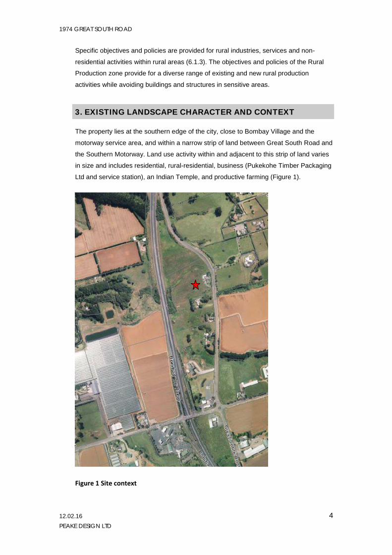
3. EXISTING LANDSCAPE CHARACTER AND CONTEXT
The property lies at the southern edge of the city, close to Bombay Village and the
motorway service area, and within a narrow strip of land between Great South Road and
the Southern Motorway. Land use activity within and adjacent to this strip of land varies
in size and includes residential, rural-residential, business (Pukekohe Timber Packaging
Ltd and service station), an Indian Temple, and productive farming (Figure 1).
Figure 1 Site context
1974 GREAT SOUTH ROAD
12.02.16 PEAKE DESIGN LTD
5
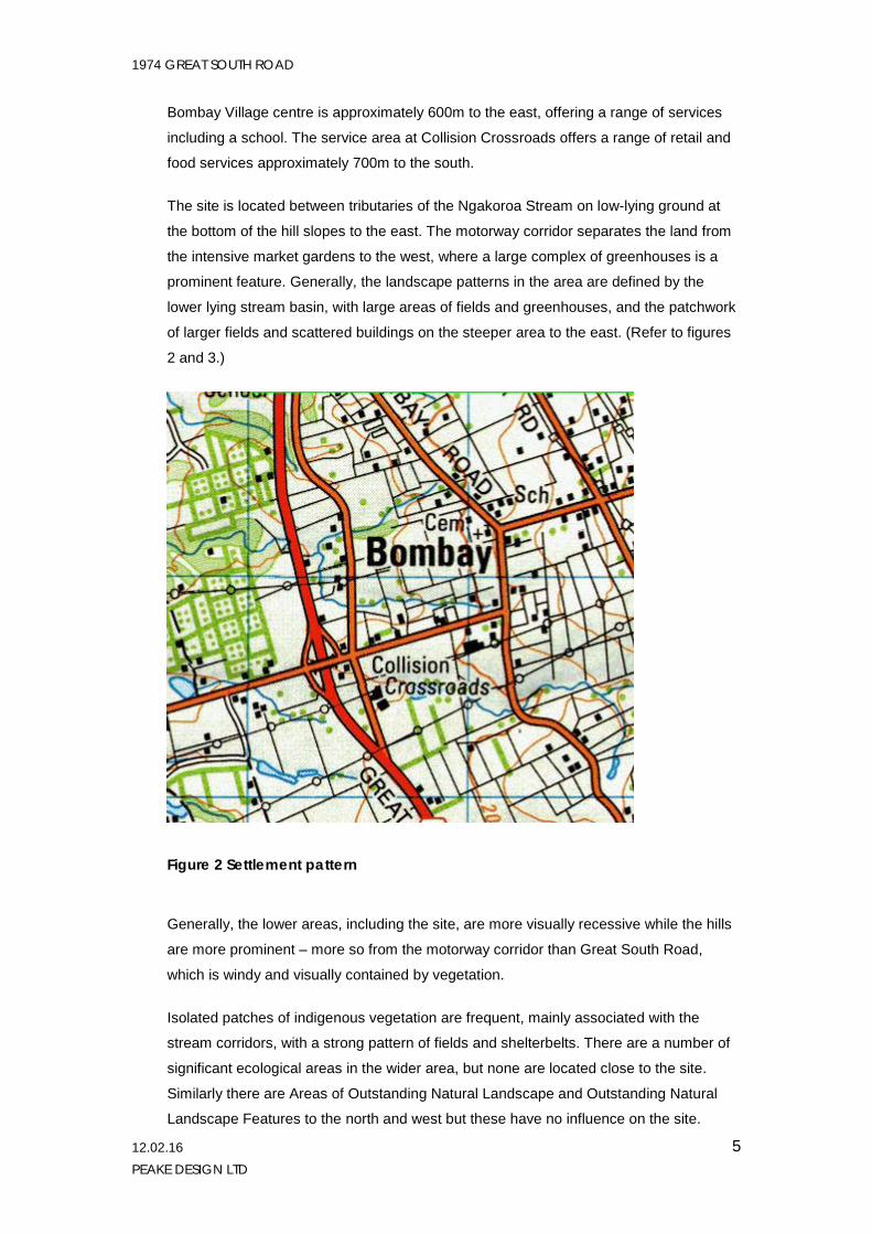
Bombay Village centre is approximately 600m to the east, offering a range of services
including a school. The service area at Collision Crossroads offers a range of retail and
food services approximately 700m to the south.
The site is located between tributaries of the Ngakoroa Stream on low-lying ground at
the bottom of the hill slopes to the east. The motorway corridor separates the land from
the intensive market gardens to the west, where a large complex of greenhouses is a
prominent feature. Generally, the landscape patterns in the area are defined by the
lower lying stream basin, with large areas of fields and greenhouses, and the patchwork
of larger fields and scattered buildings on the steeper area to the east. (Refer to figures
2 and 3.)
Figure 2 Settlement pattern
Generally, the lower areas, including the site, are more visually recessive while the hills
are more prominent – more so from the motorway corridor than Great South Road,
which is windy and visually contained by vegetation.
Isolated patches of indigenous vegetation are frequent, mainly associated with the
stream corridors, with a strong pattern of fields and shelterbelts. There are a number of
significant ecological areas in the wider area, but none are located close to the site.
Similarly there are Areas of Outstanding Natural Landscape and Outstanding Natural
Landscape Features to the north and west but these have no influence on the site.

1974 GREAT SOUTH ROAD
12.02.16 PEAKE DESIGN LTD
6
Figure 3 Topography and landscape pattern
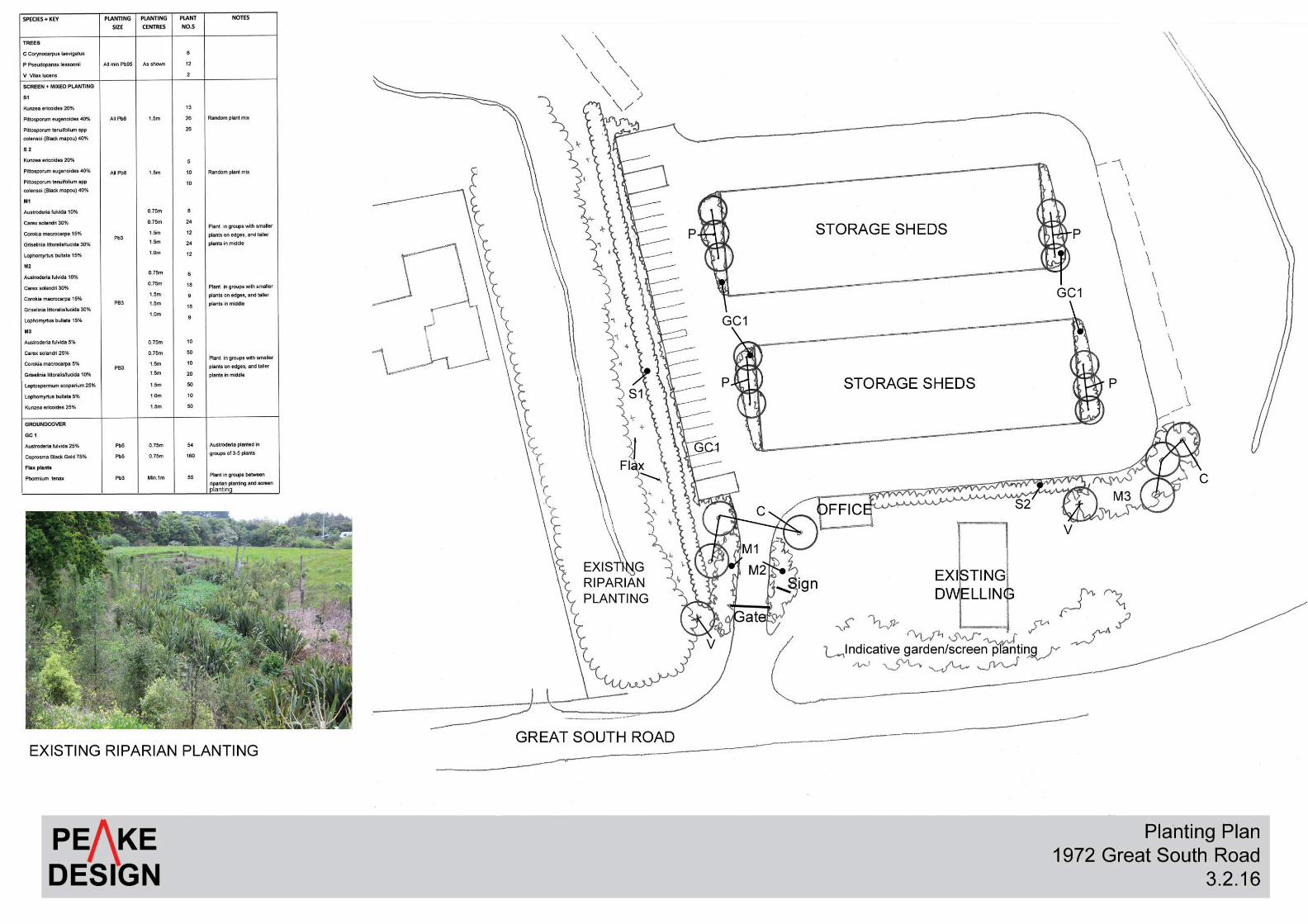
4. THE PROPOSAL
The site contains an existing dwelling that is currently screened from Great South Road
by a tall hedge, a portion of which will need to be removed to obtain sight lines for turning
traffic. The proposed facility will share the existing site entry with the existing dwelling but
will otherwise be on a separate site. A new driveway and carpark will be formed, with a
security gate (refer to landscape plan). A 5m high x 1.2m wide perforated metal plinth
and sign will be located close to the entry incorporating the name of the facility.
The facility consists of two buildings containing storage sheds side by side in a roughly
north south orientation and surrounded by an access road. A parking area for 36 vehicles
(boats/cars/trucks) is located to the south, with a planted screen between the facility and
riparian area to the south. A planting screen is also proposed along the eastern edge of
the access road to replace the roadside planting to be removed.
Each end of the building will also be planted with groundcover and shrubs.
1974 GREAT SOUTH ROAD
12.02.16 PEAKE DESIGN LTD
7
The buildings are proposed to have light-mid grey cladding and if practicable it is
recommended that the roofs be a darker grey in order to ‘ground’ the buildings.
5. LANDSCAPE AND VISUAL ASSESSMENT
5.1 Introduction The assessment of landscape effects for this project is primarily concerned with effects on
(rural) landscape character and visual amenity values for neighbours. For the assessment,
effects in terms of three interrelated categories are considered: biophysical and landscape
quality; landscape character; and visual amenity. (Refer to the table in section 2.1 that shows
the relationship between the relevant RMA provisions the assessment categories.)
These categories combine to create the relationship between a development and its
landscape context or setting, which is directly responsible for the impacts of the development.
In this regard, there are three main sets of values that can generally be attributed to the
setting. These are:
1. the degree of builtness or naturalness of the surrounding landscape, i.e. the degree
of modification in terms of development and buildings
2. the landscape vulnerability or fragility of the environment to absorb development or
change, and
3. the nature of the development itself
The first two define the “fitness” of the landscape to accept the new development, and allow
decisions to be made regarding the impact of a development on the receiving environment,
while the third defines how well equipped the design of the development is to “fit” the
landscape, taking account of physical and cultural values as well as from an aesthetic point of
view. The landscape character and nature of the landform and vegetation also determines the
available views of the development, depending on the exact location and disposition of
elements.
5.2 Biophysical effects The assessment of biophysical effects has considered the extent and significance of
modifications to landform, the river and vegetation and, in particular, any landscape
features identified with regional or local significance.
The scale for assessing biophysical change used is set out below:
Extreme - Loss of key feature/attributes
Very high - Fundamental alteration to key feature/attributes
1974 GREAT SOUTH ROAD
12.02.16 PEAKE DESIGN LTD
8
High – Major alteration to key feature/attributes
Moderate – Noticeable alteration to key feature/attributes (partially changed)
Low - Minor change to landscape, with no noticeable change to key feature/attribute (i.e. similar to before)
Very low - Slight change, with no change to any key feature/attribute and change barely distinguishable
Negligible - No discernable change
The biophysical change is rated very low. The physical change as a result of the
development will be limited to the construction of the buildings and earthworks. Only a
small part of the property will be modified and the natural features of the site will be
retained.
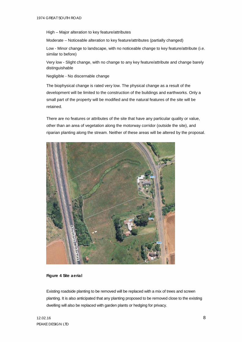
There are no features or attributes of the site that have any particular quality or value,
other than an area of vegetation along the motorway corridor (outside the site), and
riparian planting along the stream. Neither of these areas will be altered by the proposal.
Figure 4 Site aerial
Existing roadside planting to be removed will be replaced with a mix of trees and screen
planting. It is also anticipated that any planting proposed to be removed close to the existing
dwelling will also be replaced with garden plants or hedging for privacy.
1974 GREAT SOUTH ROAD
12.02.16 PEAKE DESIGN LTD
9
A copy of the proposed planting plan is attached to this report.
5.3 Landscape character effects Landscape character is the distinctive combination of landscape attributes that gives an area
its identity, and is derived from a combination of landform, land cover and land use. The
effects on landscape character relate to changes in land use, (new or different activities);
changes to existing patterns and elements in the landscape such as vegetation, waterbodies,
landform, and building patterns; and the introduction of new elements and patterns including
structures and paving and the various associated processes such as earthworks.
The natural character of an area is the natural qualities and features of that area (as opposed
to artificial features such as roads and buildings). It is therefore linked to landscape character
and may also be linked to landscape quality, as Outstanding Natural Landscapes and
Features may have a strong relationship with s6a of the RMA in relation to natural character
both in terms of the coastal environment and within the context of wetlands, rivers lakes and
their margins.
The scale used to determine landscape character change is set out below.
Extreme - Significant change affecting the overall landscape character
Very high - Fundamental alteration to key features/ attributes, character largely changed (with little ability to mitigate effects)
High - Alteration to several key elements or features/ attributes, major change to character and composition.
Moderate - Readily noticeable alteration to key element/s, feature/s or attribute/s, with character and composition partially changed
Low – Small amount of change to underlying character and composition, similar to before
Very low - Very slight change to landscape character, change barely distinguishable
Negligible - No discernible change of character
The site is not identified as having high natural character, and is strongly influenced by
the utilitarian character of the motorway corridor. Notwithstanding this, it retains a rural
character as a result of the high proportion of open space, the amount of vegetated
cover (as opposed to hard surfacing) and the small area of development.
The proposal will change the degree of “ruralness” as it will introduce more buildings
and paved area, as well as the intensity of use or number of people using the site. With
regard to the characteristics of rural character and amenity values described in section
2.2, however, it is considered that the site will retain a rural character for the following
reasons:
1974 GREAT SOUTH ROAD
12.02.16 PEAKE DESIGN LTD
10
• The activity is considered appropriate in this location as it will service a local
community and is an activity that may not fit comfortably within an urban or village
setting.
• The buildings will have a similar scale and appearance to large rural production
buildings such as packing sheds and greenhouses, and will not be dissimilar to
the scale of the adjacent timber packing facility and the Indian Temple close by.
• The majority of the land will be retained as open space - either in pasture or
planted stream corridor and will contain a mix of grass, trees and shrubs,
including proposed new planting.
• Although the buildings will cover a large area, they will not be particularly tall and
will have a low density (being smaller than what is permitted on the site) ; the
scale of the facility is not considered out of scale with reference to the surrounding
environment eg motorway corridor and commercial/retail development at nearby
Collision Corner.
• The buildings will be painted a neutral colour in order to integrate into the
landscape as far as possible and planting will provide further integration.
• The development will not have an overtly urban form or scale and it is proposed
that the design details be controlled to retain a rural appearance eg limiting kerbs
and channels, avoiding pole lighting, and selection of appropriate materials and
colours.
As a result, the rating for landscape character change is low-moderate with some
noticeable alteration of elements and composition but a small amount of change, similar
to existing.
5.4 Visual amenity effects Visual amenity is a component of the overall amenity of a place and therefore
contributes to peoples’ appreciation of the pleasantness and aesthetic coherence of the
environment. This aspect considered the effects of the visual change for the viewing
audience.
Contributing factors that affect the relative magnitude of effect include:
Physical catchment and character that would be exposed to visual change
Nature of the audience who would experience that change
Type/size of view (orientation; elevation; peripheral/central)
Scale, type and intensity of change
The scale used to determine the magnitude of change to visual amenity is set out below.
1974 GREAT SOUTH ROAD
12.02.16 PEAKE DESIGN LTD
11
Extreme - Proposal may dominate/ obscure views for large viewing audience.
Very high - Proposal is prominent and would be a focus of views for a large viewing audience
or within close proximity of residences (e.g. 100m)
High - Proposal is likely to be a major element of view for a large number of people and/or be
a focus of view for residents
Moderate - Proposal is likely to form a visible and recognizable new element within the overall
scene
Low - Proposal is likely to be either a limited component of a wider scene, and/or make little
difference to the overall scene (i.e. may be missed by casual observer)
Very low - Proposal will form a very limited component of the wider scene and/or be viewed
from a considerable distance
Negligible - Proposal will not be identifiable within available views
Visual impacts result from natural or induced change in the components, character or quality
of landscape. Usually these are the result of vegetation or landform modification or the
introduction of new structures, activities or facilities in to the landscape. The process of
change itself, that is the implementation or construction process, may also carry its own visual
impacts separate from the completed development.
The visual catchment of the property and proposed development site is largely constrained by
its relative elevation and visual separation (separation from neighbours by roading and
intervening vegetation).
The viewing audience has therefore been divided into two groups – drivers on roads and
neighbouring residents.
View for drivers Views from the motorway have not been captured for safety reasons, but the Google
streetscape views below indicate available views and show that vegetation and landform
partially obstruct views. In addition, as travel speeds are high on the motorway, views of
areas close to the motorway are fleeting and the focus of attention tends towards more
distant places. The building will be set back from the motorway boundary and will be
approximately 130 m from the road. There is also an area of bush adjacent to the boundary
that would provide some screening (refer to Figure 4), while buildings (including large
buildings) are not unusual in this environment. As noted above, the buildings are considerably
smaller than what could be permitted as of right on the site and the height is less than the
height of adjacent dwellings. I also note that under a permitted baseline scenario there would
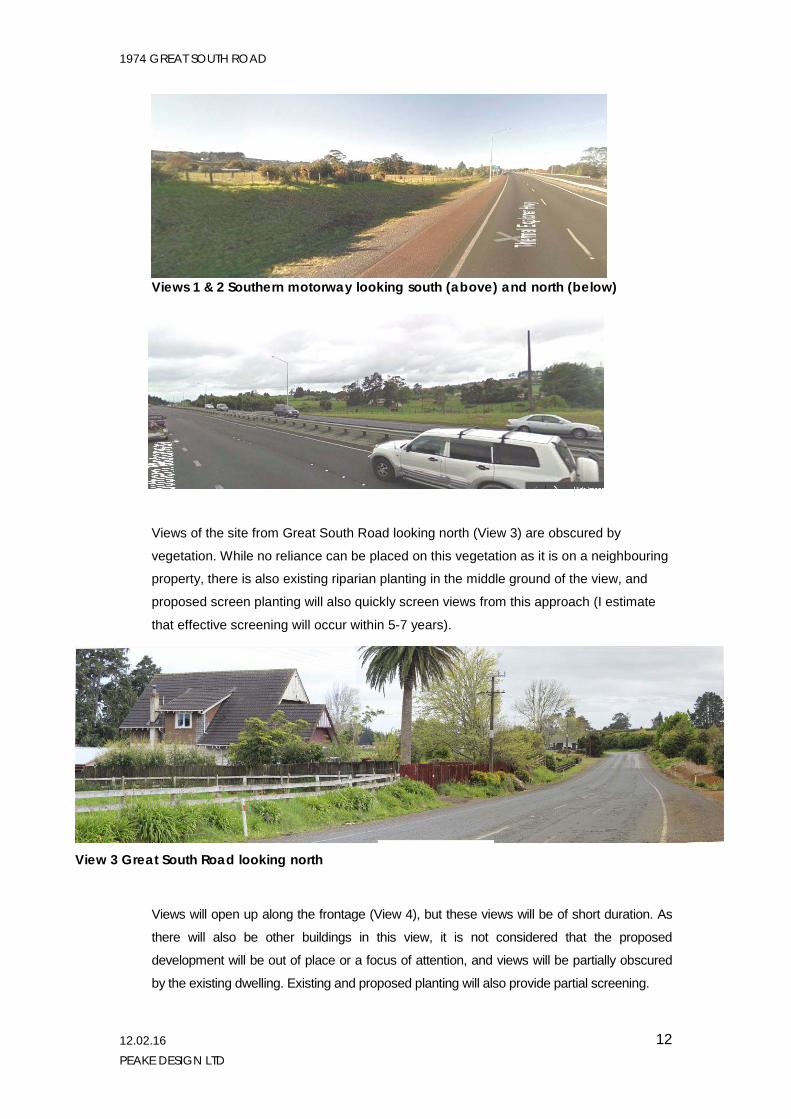
be no requirement to provide mitigation planting. Effects for drivers from the motorway are
therefore rated very low.
1974 GREAT SOUTH ROAD
12.02.16 PEAKE DESIGN LTD
12
Views 1 & 2 Southern motorway looking south (above) and north (below)
Views of the site from Great South Road looking north (View 3) are obscured by
vegetation. While no reliance can be placed on this vegetation as it is on a neighbouring
property, there is also existing riparian planting in the middle ground of the view, and
proposed screen planting will also quickly screen views from this approach (I estimate
that effective screening will occur within 5-7 years).
Views will open up along the frontage (View 4), but these views will be of short duration. As
there will also be other buildings in this view, it is not considered that the proposed
development will be out of place or a focus of attention, and views will be partially obscured
by the existing dwelling. Existing and proposed planting will also provide partial screening.
View 3 Great South Road looking north
1974 GREAT SOUTH ROAD
12.02.16 PEAKE DESIGN LTD
13
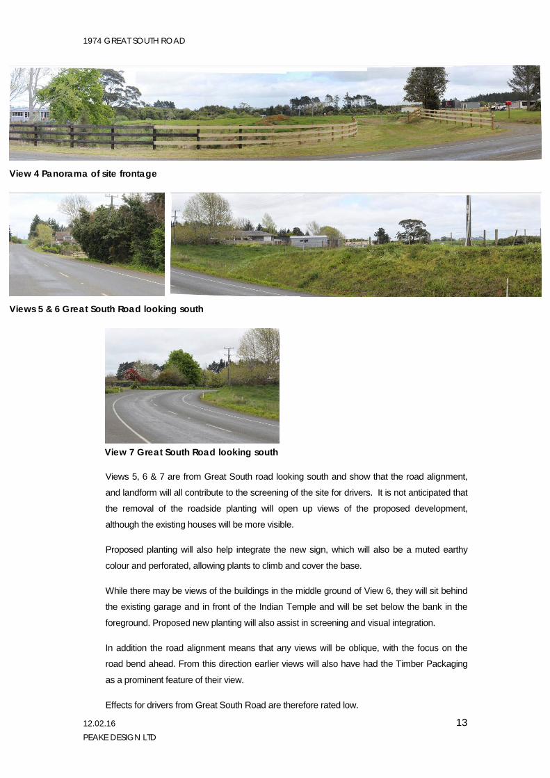
Views 5, 6 & 7 are from Great South road looking south and show that the road alignment,
and landform will all contribute to the screening of the site for drivers. It is not anticipated that
the removal of the roadside planting will open up views of the proposed development,
although the existing houses will be more visible.
Proposed planting will also help integrate the new sign, which will also be a muted earthy
colour and perforated, allowing plants to climb and cover the base.
While there may be views of the buildings in the middle ground of View 6, they will sit behind
the existing garage and in front of the Indian Temple and will be set below the bank in the
foreground. Proposed new planting will also assist in screening and visual integration.
In addition the road alignment means that any views will be oblique, with the focus on the
road bend ahead. From this direction earlier views will also have had the Timber Packaging
as a prominent feature of their view.
Effects for drivers from Great South Road are therefore rated low.
View 4 Panorama of site frontage
Views 5 & 6 Great South Road looking south
View 7 Great South Road looking south
1974 GREAT SOUTH ROAD
12.02.16 PEAKE DESIGN LTD
14
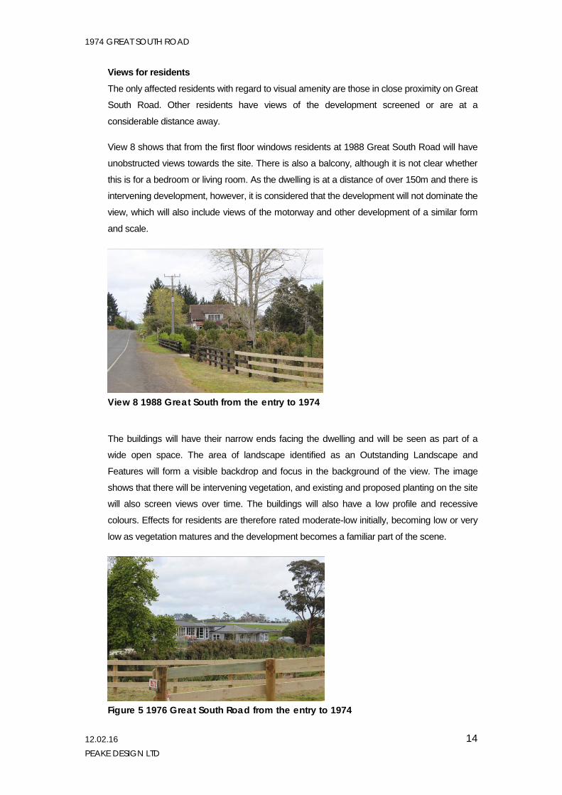
Views for residents
The only affected residents with regard to visual amenity are those in close proximity on Great
South Road. Other residents have views of the development screened or are at a
considerable distance away.
View 8 shows that from the first floor windows residents at 1988 Great South Road will have
unobstructed views towards the site. There is also a balcony, although it is not clear whether
this is for a bedroom or living room. As the dwelling is at a distance of over 150m and there is
intervening development, however, it is considered that the development will not dominate the
view, which will also include views of the motorway and other development of a similar form
and scale.
View 8 1988 Great South from the entry to 1974
The buildings will have their narrow ends facing the dwelling and will be seen as part of a
wide open space. The area of landscape identified as an Outstanding Landscape and
Features will form a visible backdrop and focus in the background of the view. The image
shows that there will be intervening vegetation, and existing and proposed planting on the site
will also screen views over time. The buildings will also have a low profile and recessive
colours. Effects for residents are therefore rated moderate-low initially, becoming low or very
low as vegetation matures and the development becomes a familiar part of the scene.
Figure 5 1976 Great South Road from the entry to 1974
1974 GREAT SOUTH ROAD
12.02.16 PEAKE DESIGN LTD
15
1976 Great South Road is the closest dwelling to the site (excluding the dwelling on the site)
and will have clear views of the buildings from indoor and outdoor living areas. Similar to 1988
the narrow end of the buildings will present to the dwelling and will have intervening
vegetation. Unlike 1988, however, 1976 is at a lower relative elevation and is also single
storey so that screening with planting will be more effective and quicker to achieve.
Due to the proximity and orientation, impacts arising from the proposed development are
considered greater than for 1988. At a distance of approximately 46m between the dwelling
and closest building, it is not considered that the buildings will dominate the view or be
overbearing, but they will form a prominent part of the view initially, before the existing riparian
planting and proposed screen planting matures. They will also be at a slightly higher elevation
although the low profile of the buildings means that tall planting is not needed for screening,
with planting to a height of approximately 5m required to screen views. It is therefore
estimated that effective screening could be obtained within 5-7 years and full screening within
10 years.
A condition of consent for a detailed planting plan is recommended:
Prior to construction, the consent holder shall submit for written approval by the Team leader, Resource Consents, a detailed planting plan, implementation and maintenance plan.
The planting plan shall be in accordance with the Peake Design planting plan, including the requirement for dense screening on the south and east sides of the facility. The planting plan shall include:
i. The number, position, spacing, stock size and species comprising locally appropriate
native species eco-sourced from the local Ecological District.
ii. A planting programme / timeframe.
iii. Proposed planting techniques including soil/planting medium, staking, and mulch, where appropriate.
iv. Proposed on-going maintenance of plantings, including replacement protocols for a period of not less than five (3) years from the date of issue of the Section 224 (c) certificate.
v. A cost estimate for proposed works, for bond purposes.
It is not expected that there will be any shading effects over and above shading from existing
planting, and the proposed bund, together with existing boundary planting, will avoid
overlooking or loss of privacy.
The proposed sign will not be particularly visible in the location proposed and only oblique
views would be available from the house and deck. Planting will largely screen views and it
would be seen in front of the existing dwelling so that no adverse visual amenity effects are
anticipated.
1974 GREAT SOUTH ROAD
12.02.16 PEAKE DESIGN LTD
16
Overall, therefore, visual amenity effects are therefore rated moderate-high without mitigation,
reducing to moderate-low within 5-7 years with mitigation (when proposed planting will reach
3.5-4.0m), and low within 10 years.
7. CONCLUSIONS
The assessment of landscape and visual effects determines that effects on biophysical and
landscape quality will be very low and that effects for landscape (rural) character change will
be low-moderate. Although the proposed development is considered appropriate within the
setting, and the rural character is able to be maintained, there will be a small amount of
noticeable change to the existing character.
With regard to visual amenity effects, effects for drivers are rated very low overall, with low
effects limited to the immediate vicinity of the property frontage. Two dwellings have been
identified as having potential adverse amenity effects.The first is at 1988 Great South Road
where effects are rated moderate-low initially becoming low or very low over time as existing
and proposed planting matures. The second is the immediate neighbour (at 1976 Great
South Road) where effects are rated moderate-high without mitigation, reducing to moderate-
low within 5-7 years with mitigation, and low within 10 years.
It is also noted that the buildings have a low profile and are considerably smaller than what
could be permitted as of right on the site. In addition, under a permitted baseline scenario
there would be no requirement to provide mitigation planting.
Sally Peake
Registered FNZILA Landscape Architect