appendix k water framework directive compliance assessment k - water... · water framework...
TRANSCRIPT
Appendix K
Water Framework Directive compliance assessment
North Norfolk SMP2 - Ki - Appendix K – WFD assessment Final plan October 2010

North Norfolk SMP2 - Kii - Appendix K – WFD assessment Final plan October 2010
Appendix K Contents Page
K1 Introduction 1 K1.1 Purpose of report 1 K1.2 Background 1 K1.2.1 Preventing deterioration in ecological status or potential 2 K1.2.2 Achieving objectives for EU protected sites 2
K2 Assessment of method 3 K2.1 Scoping the SMP2 – data collation 4 K2.2 Defining features and issues 5 K2.3 Assessing the SMP2 policy against the environmental
objectives 5
K3 Results 6 K3.1 Scoping the SMP2 – data collation 6 K3.1.1 Transitional and coastal water bodies (TraC) 6 K3.1.2 Freshwater bodies (FWBs) 7 K3.1.3 Groundwater bodies (GWBs) 13 K3.1.4 Boundary issues 13 K3.2 Defining features and issues 19 K3.3 Assessing the SMP2 policy against the environmental
objectives 27 K3.3.1 Environmental objective WFD1 56 K3.3.2 Environmental objective WFD2 56 K3.3.3 Environmental objective WFD3 56 K3.3.4 Environmental objective WFD4 57 K3.3.5 Water Framework Directive summary statements 59
K4 Discussion and conclusions 80
References 82 List of figures K2.1 Water Framework Directive assessment process for SMPs 3 K3.1 TraC water bodies in the North Norfolk SMP2 area 8 K3.2 TraC water bodies in the North Norfolk SMP2 super-frontage 1: Old Hunstanton to Thornham 9 K3.3 TraC water bodies in the North Norfolk SMP2 PDZs 2A to 2F) super-frontage 2: Thornham to Stiffkey 10 K3.4 TraC water bodies in the North Norfolk SMP2 PDZs 2G to 2M) super-frontage 2: Thornham to Stiffkey 11
North Norfolk SMP2 - Kiii - Appendix K – WFD assessment Final plan October 2010

K3.5 TraC water bodies in the North Norfolk SMP2 super-frontage 3: Stiffkey to Kelling Hard 12 K3.6 Groundwater bodies in the North Norfolk SMP2 area 14 K3.7 Groundwater body risk characterisation in the North Norfolk SMP2 area 15 K3.8 Potential boundary movement – Outer Wash 17 K3.9 Potential boundary movement – North Norfolk 18 List of tables K1.1 Environmental objectives in the directive 2
K3.1 Inland FWBs that have the potential to be affected by policies in the North Norfolk SMP2 7
K1 BQEs within TraC water bodies that could be affected by changes to hydromorphology as a result of relevant SMP policies 20 K2 Water Framework Directive features and issues
for TraC water bodies in the North Norfolk SMP2 area 21 K3 WFD assessment of SMP policy for the North Norfolk SMP2 29
K3.2 Policy development zones with managed realignment and/or no active intervention policies 57 K4 Summary of achievement of WFD environmental objectives for each water body in the North Norfolk
SMP2 area 59 K5a WFD summary statement for the North Norfolk
water body 60 K5b WFD summary statement for the North Norfolk water body 63
K5c WFD summary statement for the Blakeney Spit Lagoon water body 68 K5d WFD summary statement for the Burn, Mow, Overy and Norton water body 70
K5e WFD summary statement for the Stiffkey/Glaven water body 73
North Norfolk SMP2 - Kiv - Appendix K – WFD assessment Final plan October 2010

List of abbreviations AA Appropriate Assessment
AtL Advance the line
AWB Artificial water body
BQE Biological quality element
CFMP Catchment Flood Management Plan
EU European Union
FWB Freshwater body
GWB Groundwater body
HMWB Heavily modified water body
cHMWB Candidate heavily modified water body
HtL Hold the line
MR Managed realignment
NAI No active intervention
PDZ Policy development zone
PU Policy unit
RBD River basin district
RBMP River Basin Management Plan
ROPI Reasons of overriding public interest
SEA Strategic Environmental Assessment
SMP Shoreline Management Plan
SPZ Source protection zone
TraC water bodies Transitional and Coastal water bodies
UKBAP United Kingdom Biodiversity Action Plan
WFD Water Framework Directive
WPM With present management
North Norfolk SMP2 - Kv - Appendix K – WFD assessment Final plan October 2010
K1 Introduction
K1.1 Purpose of report
The Water Framework Directive (WFD - referred to in this report as the directive) came into force in 2000 and is the most substantial piece of EC water legislation to date. The directive needs to be taken into account in planning all new activities in the water environment. The Environment Agency (the competent authority in England and Wales responsible for delivering the directive) has therefore recommended that decisions setting policy, including large-scale plans like Shoreline Management Plans (SMPs), take account of the requirements of the directive. This assessment has been undertaken according to ‘Water Framework Directive: Guidance for Assessment of SMPs under WFD’, which was recently developed for the Environment Agency (Royal Haskoning, 2009a). The guidance describes the methods for assessing the potential hydromorphological change and consequent ecological impact of SMP policies and making sure that setting SMP policies takes account of the directive. The North Norfolk SMP2 policy options were completed in February 2009 so it is not possible for the Water Framework Directive assessment to influence policy development. This is therefore a retrospective assessment of the policies defined under the North Norfolk SMP2 to highlight future issues to consider when implementing the policies.
K1.2 Background
The EU Water Framework Directive was made into law in England and Wales by the Water Environment (Water Framework Directive) (England and Wales) Regulations 2003. The requirements of the directive need to be considered at all stages of the river and coastal planning and development process. For the purposes of large-scale plans such as SMPs, considering the requirements of the directive when setting and selecting policies must be necessarily high level. However, it sets the framework for future delivery of smaller-scale strategies or schemes. The directive requires that environmental objectives be set for all surface and groundwater bodies in each EU member state. The default environmental objectives relevant to the SMP2 are shown in table K1.1. Specific mitigation measures will be set for each river basin district (RBD) to achieve the environmental objectives of the directive. These measures are to mitigate effects that have been, or are being, caused by human activity. In other words, measures to enhance and restore the quality of the existing environment. These mitigation measures will be delivered through the River Basin Management Plan (RBMP) process and listed in a programme of measures in the RBMP. The RBMPs underwent public consultation in 2009 and the final plans were produced in December 2009.
North Norfolk SMP2 Appendix K – WFD assessment Final plan October 2010
K1
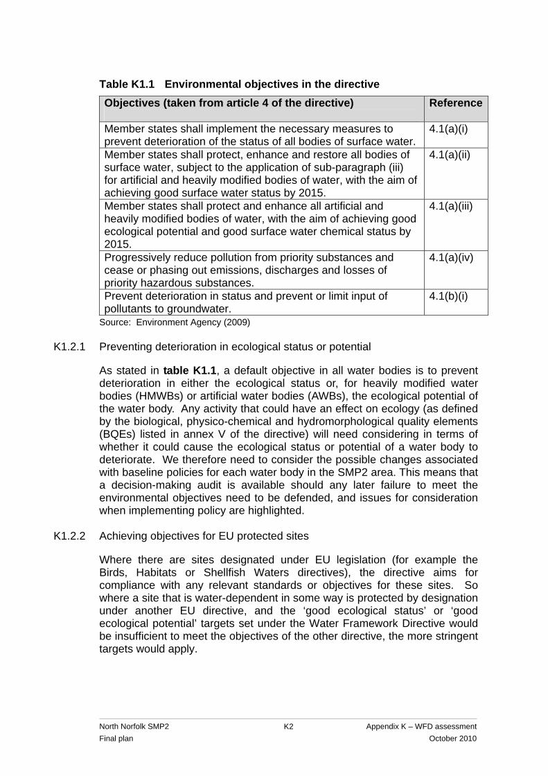
Table K1.1 Environmental objectives in the directive Objectives (taken from article 4 of the directive)
Reference
Member states shall implement the necessary measures to prevent deterioration of the status of all bodies of surface water.
4.1(a)(i)
Member states shall protect, enhance and restore all bodies of surface water, subject to the application of sub-paragraph (iii) for artificial and heavily modified bodies of water, with the aim of achieving good surface water status by 2015.
4.1(a)(ii)
Member states shall protect and enhance all artificial and heavily modified bodies of water, with the aim of achieving good ecological potential and good surface water chemical status by 2015.
4.1(a)(iii)
Progressively reduce pollution from priority substances and cease or phasing out emissions, discharges and losses of priority hazardous substances.
4.1(a)(iv)
Prevent deterioration in status and prevent or limit input of pollutants to groundwater.
4.1(b)(i)
Source: Environment Agency (2009)
K1.2.1 Preventing deterioration in ecological status or potential
As stated in table K1.1, a default objective in all water bodies is to prevent deterioration in either the ecological status or, for heavily modified water bodies (HMWBs) or artificial water bodies (AWBs), the ecological potential of the water body. Any activity that could have an effect on ecology (as defined by the biological, physico-chemical and hydromorphological quality elements (BQEs) listed in annex V of the directive) will need considering in terms of whether it could cause the ecological status or potential of a water body to deteriorate. We therefore need to consider the possible changes associated with baseline policies for each water body in the SMP2 area. This means that a decision-making audit is available should any later failure to meet the environmental objectives need to be defended, and issues for consideration when implementing policy are highlighted.
K1.2.2 Achieving objectives for EU protected sites
Where there are sites designated under EU legislation (for example the Birds, Habitats or Shellfish Waters directives), the directive aims for compliance with any relevant standards or objectives for these sites. So where a site that is water-dependent in some way is protected by designation under another EU directive, and the ‘good ecological status’ or ‘good ecological potential’ targets set under the Water Framework Directive would be insufficient to meet the objectives of the other directive, the more stringent targets would apply.
North Norfolk SMP2 Appendix K – WFD assessment Final plan October 2010
K2
K2 Assessment method
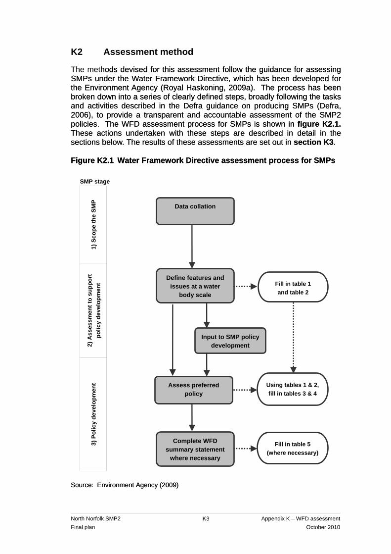
The methods devised for this assessment follow the guidance for assessing SMPs under the Water Framework Directive, which has been developed for the Environment Agency (Royal Haskoning, 2009a). The process has been broken down into a series of clearly defined steps, broadly following the tasks and activities described in the Defra guidance on producing SMPs (Defra, 2006), to provide a transparent and accountable assessment of the SMP2 policies. The WFD assessment process for SMPs is shown in figure K2.1. These actions undertaken with these steps are described in detail in the sections below. The results of these assessments are set out in section K3.
hods devised for this assessment follow the guidance for assessing SMPs under the Water Framework Directive, which has been developed for the Environment Agency (Royal Haskoning, 2009a). The process has been broken down into a series of clearly defined steps, broadly following the tasks and activities described in the Defra guidance on producing SMPs (Defra, 2006), to provide a transparent and accountable assessment of the SMP2 policies. The WFD assessment process for SMPs is shown in figure K2.1. These actions undertaken with these steps are described in detail in the sections below. The results of these assessments are set out in section K3. Figure K2.1 Water Framework Directive assessment process for SMPs Figure K2.1 Water Framework Directive assessment process for SMPs
Source: Environment Agency (2009) Source: Environment Agency (2009)
SMP stage
Define features and issues at a water
body scale
Data collation
Assess preferred policy
Complete WFD summary statement
where necessary
Fill in table 1 and table 2
Fill in table 5 (where necessary)
Input to SMP policy development
Using tables 1 & 2, fill in tables 3 & 4
2) A
sses
smen
t to
supp
ort
polic
y de
velo
pmen
t 3)
Pol
icy
deve
lopm
ent
1) S
cope
the
SMP
North Norfolk SMP2 Appendix K – WFD assessment Final plan October 2010
K3
North Norfolk SMP2 Appendix K – WFD assessment Final plan October 2010
K4
As the policy options have already been determined for this SMP2, a retrospective assessment of the policies in relation to the directive has been undertaken. It has not therefore been possible to influence the SMP2 policy development.
K2.1 Scoping the SMP2 – data collation
All the transitional and coastal (TraC) water bodies in the North Norfolk SMP2 area were identified and their ID numbers, designation and draft classification details obtained from the Environment Agency. The generic environmental objectives set out below (based on article 4.1 of the directive and as described in table K1.1) have been used to assess the SMP.
• WFD1: No changes affecting high status sites.
• WFD2: No changes that will cause failure to meet surface water good ecological status or potential or result in a deterioration of surface water ecological status or potential.
• WFD3: No changes that will permanently prevent or compromise the environmental objectives being met in other water bodies.
• WFD4: No changes that will cause failure to meet good groundwater status or result in a deterioration of groundwater status.
The specific objectives for the water bodies within the North Norfolk SMP2 area were also identified from the RBMP for the Anglian RBD, which was obtained from the Environment Agency’s website1. However, for some water bodies in the SMP2 area, the current overall status and objectives have not yet been assessed. The Environment Agency web-based ‘Flood Map’2 was used to assess whether there are any inland freshwater bodies (FWBs) that have the potential to be influenced by SMP2 policies and should, therefore, be covered by this assessment. The names, ID numbers, designation and classification details for any such FWBs were obtained from the Environment Agency. Groundwater bodies (GWBs) that could potentially be affected by SMP2 policies were also identified by reviewing the WFD compliance mapping for groundwater risk (known as River Basin Characterisation 2 (RBC2) and status assessment). Using the RBC2 mapping and the WFD status maps for saline intrusion obtained from the Environment Agency, the GWBs designated as being ‘at risk’, ‘probably at risk’ or at ‘poor status’ in the SMP2
1 The draft RBMP is available at http://www.environment-agency.gov.uk/research/planning/33106.aspx 2 The Environment Agency’s flood map is available at http://maps.environment-agency.gov.uk/ wiyby/wiybyController?x=357683.0&y=355134.0&scale=1&layerGroups=default&ep=map&lang=_e&textonly=off&topic=floodmap
area were identified. The locations of groundwater abstractions with source protection zones (SPZs) in the SMP2 area were also obtained from the Environment Agency’s website. Any discrepancies between water body boundaries and SMP2 boundaries were examined. Any locations where changes of the SMP2 boundary would be recommended to attain consistency with water body boundaries were identified. It was also determined at this stage whether there were any additional investigations that could be recommended for the next round of SMPs to inform the WFD assessment, such as studies to address the zone of influence in terms of biological quality elements (BQEs).
K2.2 Defining features and issues
In the SMP2 report, for each super-frontage (within which there were a number of policy development zones (PDZs)), there are summaries of the SMP policy and how this differs from present management. These were used to identify how the SMP2 policies could affect the WFD features (that is, BQEs of each water body). The physical parameters that could potentially be affected by SMP2 policies, and the BQEs present within each water body that depend on these parameters, were identified and are illustrated in assessment table K1 (section K3.2) for each water body. The key features and issues identified in assessment table K1 were then transferred into assessment table K2. The water body classification and environmental objectives set out in section K2.1 were used to populate the final column of assessment table K2.
K2.3 Assessing the SMP2 policy against the environmental objectives
The assessment of SMP2 policies against the environmental objectives was supported by a tabulated account based on an adaptation of the policy summary tables for each policy development zone (PDZ) in the SMP2 report. Using the information on the water body features and issues defined in assessment tables K1 and K2, the potential effects of the SMP policy for each PDZ was assessed and recorded in assessment table K3. For each PDZ, the potential changes to the relevant physical and hydromorphological parameters that might occur as a result of the SMP policy were identified. The effects of climate change on baseline processes were also taken into account when assessing all epochs. The assessment of deterioration with respect to the directive considered the effect of any changes to the surface water body features (BQEs) that were identified in assessment table K2. The assessment of SMP2 policies also included considering the potential for effects on the inland FWBs identified during the data collation phase as having the potential to be influenced by SMP2 policies (see section K2.1). These could potentially be affected where the SMP2 policy for a PDZ is no active intervention (NAI) or managed realignment (MR). These policy options could result in saline inundation of freshwater habitats and could therefore potentially affect the freshwater biology.
North Norfolk SMP2 Appendix K – WFD assessment Final plan October 2010
K5
Also, the assessment of the SMP2 policies in assessment table K3 included consideration of the potential to affect GWBs. Particular attention was paid to PDZs where the SMP2 policy is NAI or MR, as these policies could potentially result in the saltwater-freshwater interface moving towards land. Coupled with abstraction pressures, this could cause saltwater intrusion and deterioration of the GWB. For these PDZs, the extent of groundwater abstractions was identified by using zone 3 (total catchment of the groundwater abstraction) of the SPZ. Where zone 3 of an abstraction was found to extend to the coastline, or where it extended to the long term (100 years) predicted shoreline, it was considered that a SMP2 policy could potentially cause deterioration in the quality of the abstraction due to saline intrusion. The potential for SMP2 policies to lead to deterioration in status or potential of the TraC water bodies as a result of groundwater pollution was also considered. The outcomes of the assessment for each PDZ were then checked against the environmental objectives (as set out in section K2.1). For each PDZ, assessment table K3 records whether the SMP2 policy has the potential to meet or contribute to the potential failure of the environmental objectives. Following the assessment of SMP2 policies for each PDZ, a summary of the achievement (or otherwise) of the environmental objectives was completed at the water body scale (assessment table K4). Where it was identified that the environmental objectives would either not be met for one or more PDZs within a water body, or that there would be potential for deterioration in a water body, the need for a Water Framework Directive ‘summary statement’ was recorded in the final column of assessment table 4. The summary statements were then completed for each of those relevant water bodies in assessment table 5.
K3 Results
K2.4 Scoping the SMP2 – data collation
K2.4.1 Transitional and coastal water bodies (TraC)
There are five TraC water bodies in the North Norfolk SMP2 area (figures K3.1 to K3.5). These include three coastal water bodies (Wash Outer, North Norfolk and Blakeney Spit Lagoons) and two transitional water bodies (Burn, Mow, Overy and Norton and Stiffkey/Glaven). Wash Outer, North Norfolk and Burn, Mow, Overy and Norton are all yet to be assessed. However, their hydromorphological status is deemed to be candidate HMWB (cHMWB). Blakeney Spit Lagoons is yet to be assessed and has no candidate status. The only water body that has been assessed is Stiffkey/Glaven, which has a moderate ecological status.
North Norfolk SMP2 Appendix K – WFD assessment Final plan October 2010
K6
North Norfolk SMP2 Appendix K – WFD assessment Final plan October 2010
K7
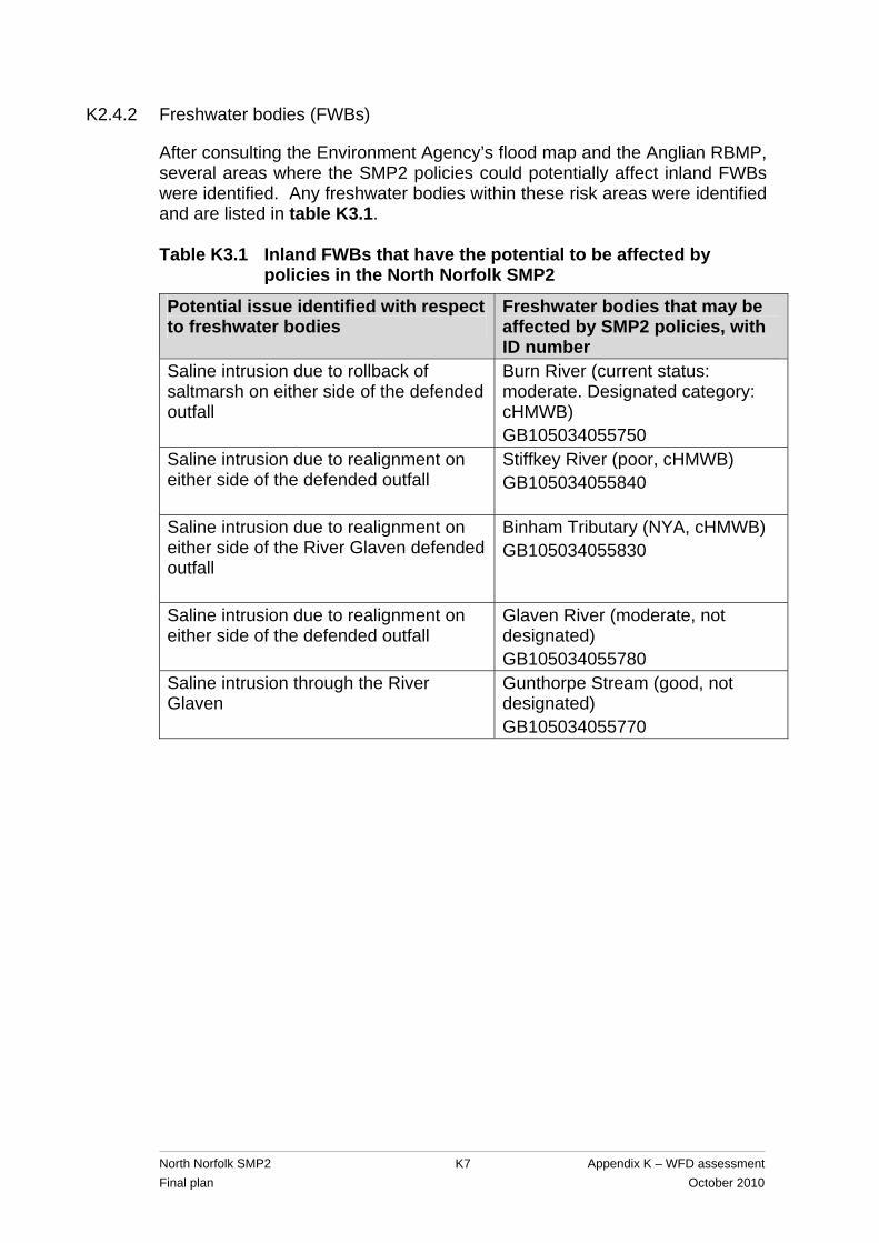
K2.4.2 Freshwater bodies (FWBs)
After consulting the Environment Agency’s flood map and the Anglian RBMP, several areas where the SMP2 policies could potentially affect inland FWBs were identified. Any freshwater bodies within these risk areas were identified and are listed in table K3.1. Table K3.1 Inland FWBs that have the potential to be affected by
policies in the North Norfolk SMP2
Potential issue identified with respect to freshwater bodies
Freshwater bodies that may be affected by SMP2 policies, with ID number
Saline intrusion due to rollback of saltmarsh on either side of the defended outfall
Burn River (current status: moderate. Designated category: cHMWB) GB105034055750
Saline intrusion due to realignment on either side of the defended outfall
Stiffkey River (poor, cHMWB) GB105034055840
Saline intrusion due to realignment on either side of the River Glaven defended outfall
Binham Tributary (NYA, cHMWB) GB105034055830
Saline intrusion due to realignment on either side of the defended outfall
Glaven River (moderate, not designated) GB105034055780
Saline intrusion through the River Glaven
Gunthorpe Stream (good, not designated) GB105034055770
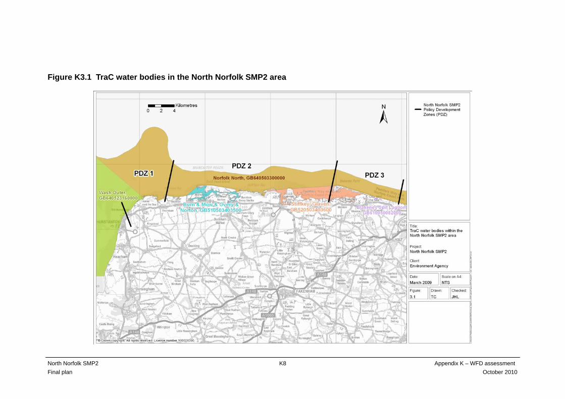
Figure K3.1 TraC water bodies in the North Norfolk SMP2 area
North Norfolk SMP2 Appendix K – WFD assessment Final plan October 2010
K8
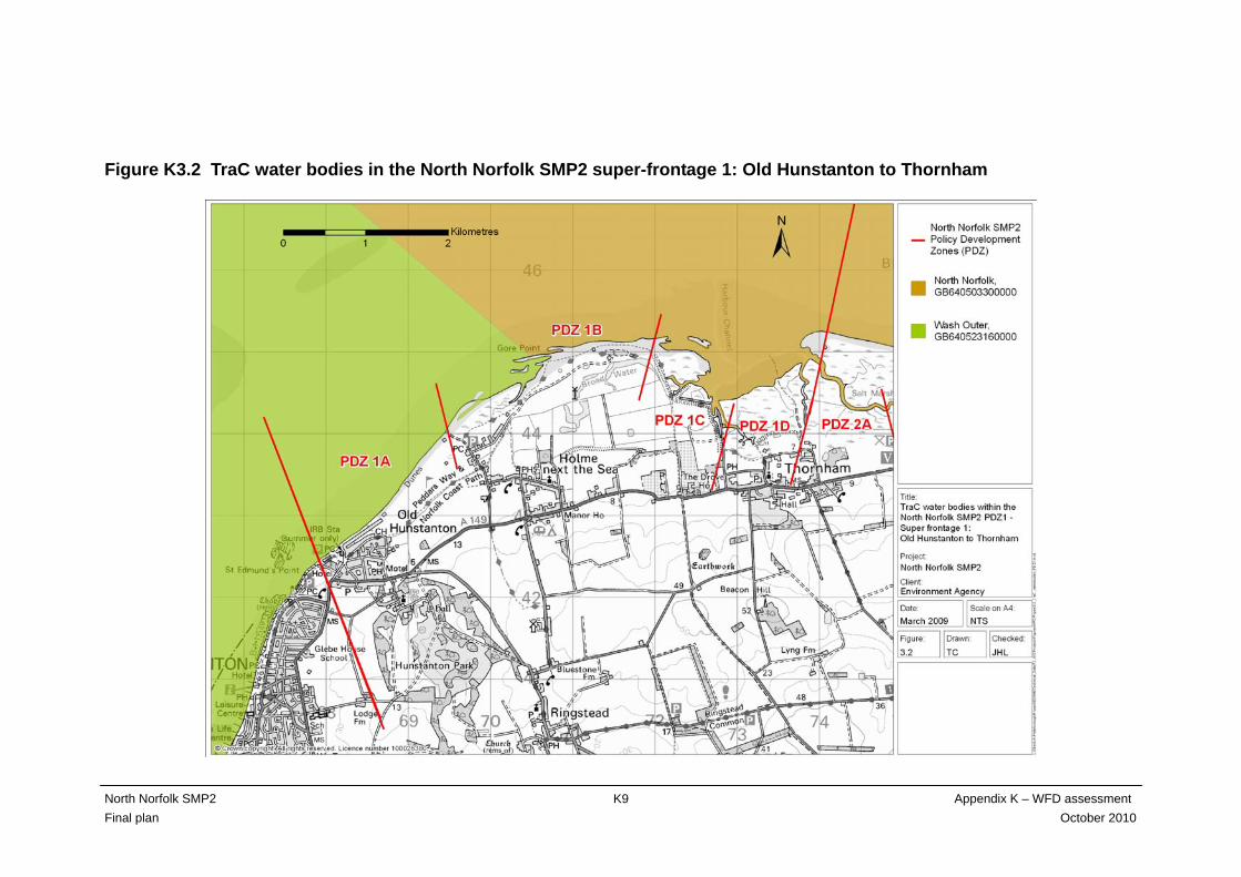
Figure K3.2 TraC water bodies in the North Norfolk SMP2 super-frontage 1: Old Hunstanton to Thornham
North Norfolk SMP2 Appendix K – WFD assessment Final plan October 2010
K9

Figure K3.3 TraC water bodies in the North Norfolk SMP2 PDZs 2A to 2F super-frontage 2: Thornham to Stiffkey
North Norfolk SMP2 Appendix K – WFD assessment Final plan October 2010
K10

Figure K3.4 TraC water bodies in the North Norfolk SMP2 PDZs 2G to 2M super-frontage 2: Thornham to Stiffkey
North Norfolk SMP2 Appendix K – WFD assessment Final plan October 2010
K11
North Norfolk SMP2 Appendix K – WFD assessment Final plan October 2010
K12
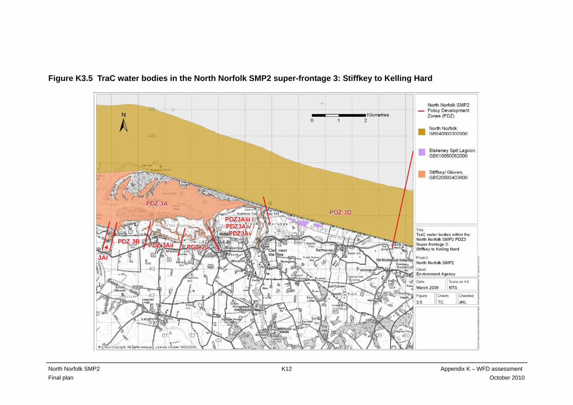
Figure K3.5 TraC water bodies in the North Norfolk SMP2 super-frontage 3: Stiffkey to Kelling Hard

North Norfolk SMP2 Appendix K – WFD assessment Final plan October 2010
K13
K2.4.3 Groundwater bodies (GWBs)
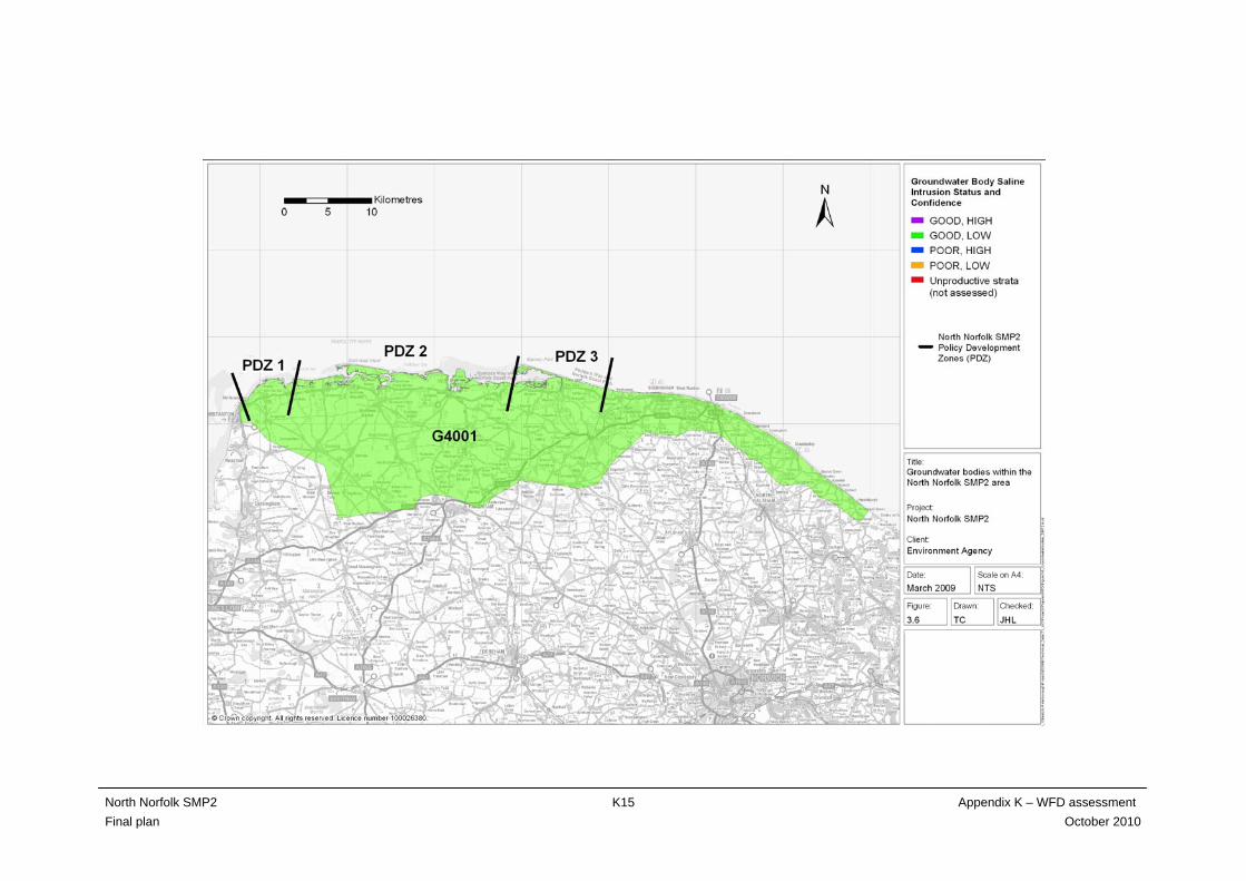
The North Norfolk SMP is contained within one groundwater body (GWB), the North Norfolk Chalk GWB (ID GB40501G400100), as illustrated in figures K3.6 and K3.7. Although this GWB was classified as being at good status (low confidence) under WFD (figure K3.6), it has been categorised as being ‘probably at risk’ for saline intrusion under RBC2 (figure K3.7). The potential therefore exists for the SMP policies to cause deterioration in groundwater. MR and NAI policies could potentially result in the saltwater-freshwater interface moving towards land. Coupled with abstraction pressures, this could result in saltwater intrusion and status deterioration of the GWB. Within the assessment however, these two policies have been examined further to find out if the MR policy will simply allow the natural rollback of the system or whether the MR is a larger scale realignment with more movement towards land. The NAI policy is also examined in terms of the actual movement of the coast towards land. Lastly, within these three scenarios, the location of the FWBs will be examined as saline waters could be transported further inland by rivers. This approach should therefore identify those policies that would appear to present the greatest threat to the GWB.
K2.4.4 Boundary issues
Two boundary issues between the North Norfolk SMP2 PDZs and the WFD water body boundaries have been identified. These could be reconciled after further investigation of the coastal processes and the geomorphology of the coastline in those specific areas. The first inconsistent boundary is between the Outer Wash water body boundary and the North Norfolk SMP2 super-frontage 1 boundary (see figure K3.8). There could be potential for the movement of the SMP2 boundary northwards, with super-frontage 1 beginning where the North Norfolk water body begins. This would mean that the Wash SMP would be extended as far as the Outer Wash water body in its entirety and would include those policy development zones currently known as PDZ1A and part of PDZ1B. These two units would therefore be lost from the North Norfolk SMP and gained by the Wash SMP. Further investigation is recommended. Secondly, at the eastern end of the North Norfolk SMP2, the PDZ3D policy development zone could be extended around 1.7 kilometres eastwards along the coast which would then align it with the eastern limit of the North Norfolk water body (see figure K3.9). This would remove this area from the neighbouring SMP frontage and has potential for further investigation.
Figure K3.6 Groundwater bodies in the North Norfolk SMP2 area
North Norfolk SMP2 Appendix K – WFD assessment Final plan October 2010
K14
North Norfolk SMP2 Appendix K – WFD assessment Final plan October 2010
K15
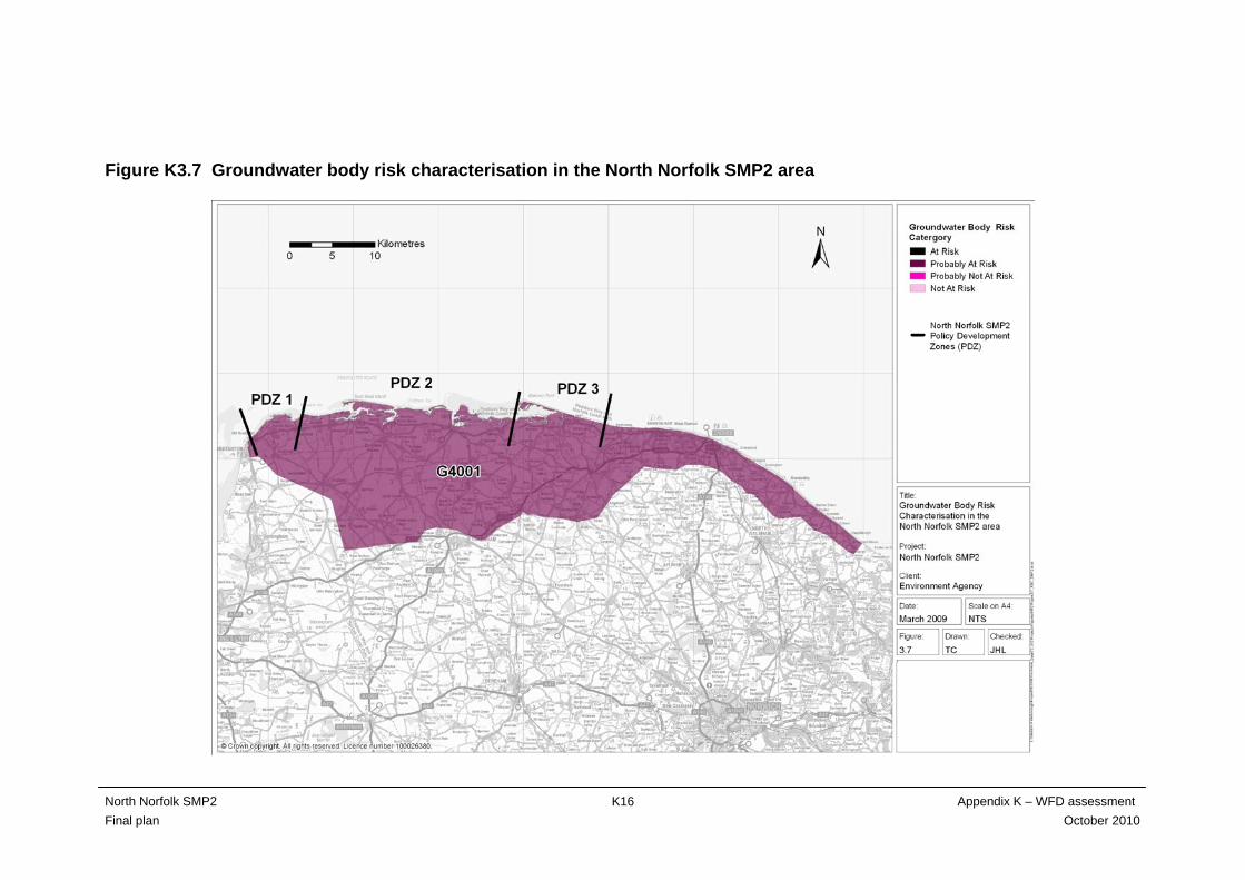
Figure K3.7 Groundwater body risk characterisation in the North Norfolk SMP2 area
North Norfolk SMP2 Appendix K – WFD assessment Final plan October 2010
K16

Figure K3.8 Potential boundary movement – Outer Wash
North Norfolk SMP2 Appendix K – WFD assessment Final plan October 2010
K17

North Norfolk SMP2 Appendix K – WFD assessment Final plan October 2010
K18
Figure K3.9 Potential boundary movement – North Norfolk

K2.5 Defining features and issues
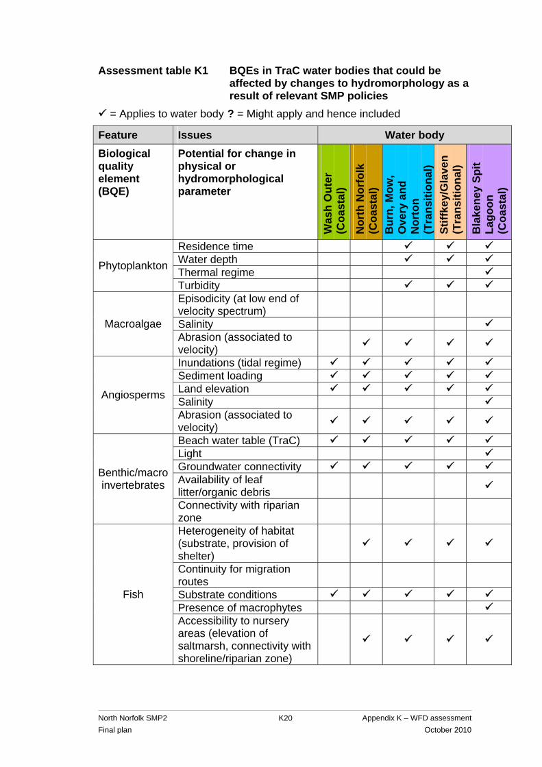
For the TraC water bodies in the North Norfolk SMP2 area, the hydromorphological parameters that could potentially be affected by SMP2 policies and the BQEs that depend on these are shown in assessment table K1. The key features and issues for each water body in the SMP2 area are then summarised in assessment table K2, together with the classification and environmental objectives for each TraC water body. The features vary along the coast and range from undefended marshland to natural dune systems. The issues range from realignment to create intertidal habitat to the need to maintain hard defences. Blakeney Spit Lagoons water body is different again as it comprises small, brackish lagoons behind a shingle ridge. This water body therefore has the potential to be affected by changes in its salinity gradient and turbidity as a result of SMP2 policies, as well as the potential changes identified for the other coastal water bodies. There are no high status water bodies in the North Norfolk SMP2 area.
North Norfolk SMP2 Appendix K – WFD assessment Final plan October 2010
K19
North Norfolk SMP2 Appendix K – WFD assessment Final plan October 2010
K20
Assessment table K1 BQEs in TraC water bodies that could be affected by changes to hydromorphology as a result of relevant SMP policies
= Applies to water body ? = Might apply and hence included
Feature Issues Water body
Biological quality element (BQE)
Potential for change in physical or hydromorphological parameter
Was
h O
uter
(C
oast
al)
Nor
th N
orfo
lk
(Coa
stal
) B
urn,
Mow
, O
very
and
N
orto
n (T
rans
ition
al)
Stiff
key/
Gla
ven
(Tra
nsiti
onal
)
Bla
kene
y Sp
it La
goon
(C
oast
al)
Residence time Water depth Thermal regime Phytoplankton
Turbidity Episodicity (at low end of velocity spectrum)
Salinity Macroalgae Abrasion (associated to velocity)
Inundations (tidal regime) Sediment loading Land elevation Salinity Angiosperms
Abrasion (associated to velocity)
Beach water table (TraC) Light Groundwater connectivity Availability of leaf litter/organic debris
Benthic/macro invertebrates
Connectivity with riparian zone
Heterogeneity of habitat (substrate, provision of shelter)
Continuity for migration routes
Substrate conditions Presence of macrophytes
Fish
Accessibility to nursery areas (elevation of saltmarsh, connectivity with shoreline/riparian zone)
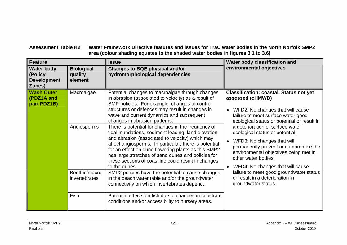
Assessment Table K2 Water Framework Directive features and issues for TraC water bodies in the North Norfolk SMP2 area (colour shading equates to the shaded water bodies in figures 3.1 to 3.6)
Feature Issue Water body (Policy Development Zones)
Biological quality element
Changes to BQE physical and/or hydromorphological dependencies
Water body classification and environmental objectives
Macroalgae Potential changes to macroalgae through changes in abrasion (associated to velocity) as a result of SMP policies. For example, changes to control structures or defences may result in changes in wave and current dynamics and subsequent changes in abrasion patterns.
Angiosperms There is potential for changes in the frequency of tidal inundations, sediment loading, land elevation and abrasion (associated to velocity) which may affect angiosperms. In particular, there is potential for an effect on dune flowering plants as this SMP2 has large stretches of sand dunes and policies for these sections of coastline could result in changes to the dunes.
Benthic/macro- invertebrates
SMP2 policies have the potential to cause changes in the beach water table and/or the groundwater connectivity on which invertebrates depend.
Wash Outer (PDZ1A and part PDZ1B)
Fish Potential effects on fish due to changes in substrate conditions and/or accessibility to nursery areas.
Classification: coastal. Status not yet assessed (cHMWB) • WFD2: No changes that will cause
failure to meet surface water good ecological status or potential or result in a deterioration of surface water ecological status or potential.
• WFD3: No changes that will permanently prevent or compromise the environmental objectives being met in other water bodies.
• WFD4: No changes that will cause failure to meet good groundwater status or result in a deterioration in groundwater status.
North Norfolk SMP2 Appendix K – WFD assessment Final plan October 2010
K21
North Norfolk SMP2 Appendix K – WFD assessment Final plan October 2010
K22
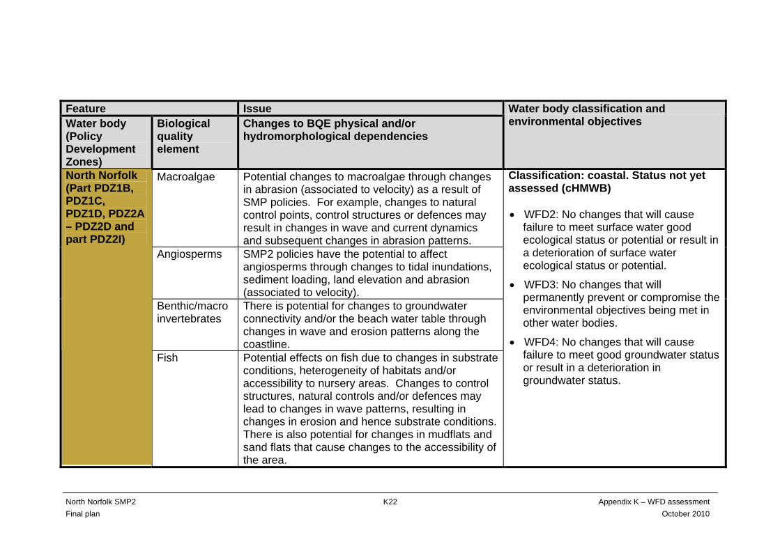
Feature Issue Water body (Policy Development Zones)
Biological quality element
Changes to BQE physical and/or hydromorphological dependencies
Water body classification and environmental objectives
Macroalgae Potential changes to macroalgae through changes in abrasion (associated to velocity) as a result of SMP policies. For example, changes to natural control points, control structures or defences may result in changes in wave and current dynamics and subsequent changes in abrasion patterns.
Angiosperms SMP2 policies have the potential to affect angiosperms through changes to tidal inundations, sediment loading, land elevation and abrasion (associated to velocity).
Benthic/macro invertebrates
There is potential for changes to groundwater connectivity and/or the beach water table through changes in wave and erosion patterns along the coastline.
North Norfolk (Part PDZ1B, PDZ1C, PDZ1D, PDZ2A – PDZ2D and part PDZ2I)
Fish Potential effects on fish due to changes in substrate conditions, heterogeneity of habitats and/or accessibility to nursery areas. Changes to control structures, natural controls and/or defences may lead to changes in wave patterns, resulting in changes in erosion and hence substrate conditions. There is also potential for changes in mudflats and sand flats that cause changes to the accessibility of the area.
Classification: coastal. Status not yet assessed (cHMWB) • WFD2: No changes that will cause
failure to meet surface water good ecological status or potential or result in a deterioration of surface water ecological status or potential.
• WFD3: No changes that will permanently prevent or compromise the environmental objectives being met in other water bodies.
• WFD4: No changes that will cause failure to meet good groundwater status or result in a deterioration in groundwater status.
North Norfolk SMP2 Appendix K – WFD assessment Final plan October 2010
K23
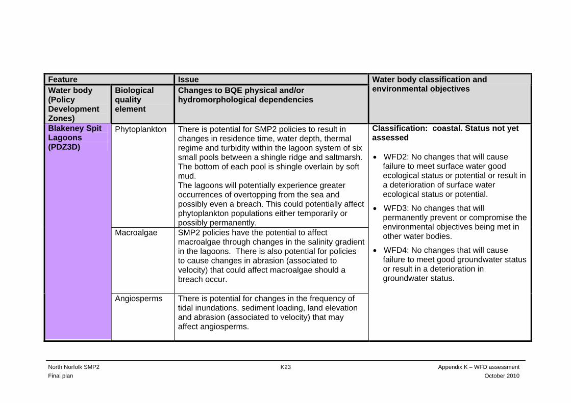
Feature Issue Water body (Policy Development Zones)
Biological quality element
Changes to BQE physical and/or hydromorphological dependencies
Water body classification and environmental objectives
Phytoplankton There is potential for SMP2 policies to result in changes in residence time, water depth, thermal regime and turbidity within the lagoon system of six small pools between a shingle ridge and saltmarsh. The bottom of each pool is shingle overlain by soft mud. The lagoons will potentially experience greater occurrences of overtopping from the sea and possibly even a breach. This could potentially affect phytoplankton populations either temporarily or possibly permanently.
Macroalgae SMP2 policies have the potential to affect macroalgae through changes in the salinity gradient in the lagoons. There is also potential for policies to cause changes in abrasion (associated to velocity) that could affect macroalgae should a breach occur.
Blakeney Spit Lagoons (PDZ3D)
Angiosperms There is potential for changes in the frequency of tidal inundations, sediment loading, land elevation and abrasion (associated to velocity) that may affect angiosperms.
Classification: coastal. Status not yet assessed • WFD2: No changes that will cause
failure to meet surface water good ecological status or potential or result in a deterioration of surface water ecological status or potential.
• WFD3: No changes that will permanently prevent or compromise the environmental objectives being met in other water bodies.
• WFD4: No changes that will cause failure to meet good groundwater status or result in a deterioration in groundwater status.
North Norfolk SMP2 Appendix K – WFD assessment Final plan October 2010
K24
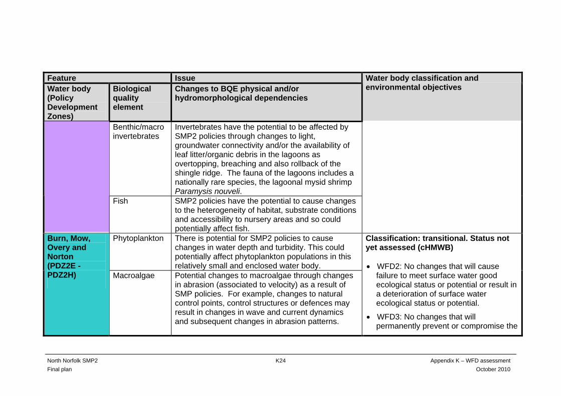
Feature Issue Water body (Policy Development Zones)
Biological quality element
Changes to BQE physical and/or hydromorphological dependencies
Water body classification and environmental objectives
Benthic/macro invertebrates
Invertebrates have the potential to be affected by SMP2 policies through changes to light, groundwater connectivity and/or the availability of leaf litter/organic debris in the lagoons as overtopping, breaching and also rollback of the shingle ridge. The fauna of the lagoons includes a nationally rare species, the lagoonal mysid shrimp Paramysis nouveli.
Fish SMP2 policies have the potential to cause changes to the heterogeneity of habitat, substrate conditions and accessibility to nursery areas and so could potentially affect fish.
Phytoplankton There is potential for SMP2 policies to cause changes in water depth and turbidity. This could potentially affect phytoplankton populations in this relatively small and enclosed water body.
Burn, Mow, Overy and Norton (PDZ2E - PDZ2H)
Macroalgae Potential changes to macroalgae through changes in abrasion (associated to velocity) as a result of SMP policies. For example, changes to natural control points, control structures or defences may result in changes in wave and current dynamics and subsequent changes in abrasion patterns.
Classification: transitional. Status not yet assessed (cHMWB) • WFD2: No changes that will cause
failure to meet surface water good ecological status or potential or result in a deterioration of surface water ecological status or potential.
• WFD3: No changes that will permanently prevent or compromise the
North Norfolk SMP2 Appendix K – WFD assessment Final plan October 2010
K25
Feature Issue Water body (Policy Development Zones)
Biological quality element
Changes to BQE physical and/or hydromorphological dependencies
Water body classification and environmental objectives
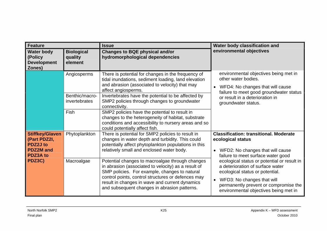
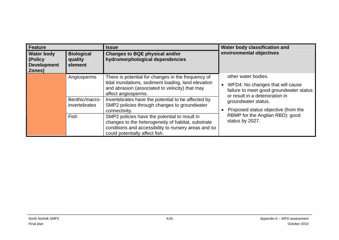
Angiosperms There is potential for changes in the frequency of tidal inundations, sediment loading, land elevation and abrasion (associated to velocity) that may affect angiosperms.
Benthic/macro- invertebrates
Invertebrates have the potential to be affected by SMP2 policies through changes to groundwater connectivity.
Fish SMP2 policies have the potential to result in changes to the heterogeneity of habitat, substrate conditions and accessibility to nursery areas and so could potentially affect fish.
environmental objectives being met in other water bodies.
• WFD4: No changes that will cause failure to meet good groundwater status or result in a deterioration in groundwater status.
Phytoplankton There is potential for SMP2 policies to result in changes in water depth and turbidity. This could potentially affect phytoplankton populations in this relatively small and enclosed water body.
Stiffkey/Glaven(Part PDZ2I, PDZ2J to PDZ2M and PDZ3A to PDZ3C) Macroalgae Potential changes to macroalgae through changes
in abrasion (associated to velocity) as a result of SMP policies. For example, changes to natural control points, control structures or defences may result in changes in wave and current dynamics and subsequent changes in abrasion patterns.
Classification: transitional. Moderate ecological status • WFD2: No changes that will cause
failure to meet surface water good ecological status or potential or result in a deterioration of surface water ecological status or potential.
• WFD3: No changes that will permanently prevent or compromise the environmental objectives being met in
North Norfolk SMP2 Appendix K – WFD assessment Final plan October 2010
K26
Feature Issue Water body (Policy Development Zones)
Biological quality element
Changes to BQE physical and/or hydromorphological dependencies
Water body classification and environmental objectives
Angiosperms There is potential for changes in the frequency of tidal inundations, sediment loading, land elevation and abrasion (associated to velocity) that may affect angiosperms.
Benthic/macro- invertebrates
Invertebrates have the potential to be affected by SMP2 policies through changes to groundwater connectivity.
Fish SMP2 policies have the potential to result in changes to the heterogeneity of habitat, substrate conditions and accessibility to nursery areas and so could potentially affect fish.
other water bodies.
• WFD4: No changes that will cause failure to meet good groundwater status or result in a deterioration in groundwater status.
• Proposed status objective (from the RBMP for the Anglian RBD): good status by 2027.
North Norfolk SMP2 K27 Appendix K – WFD assessment Final plan October 2010
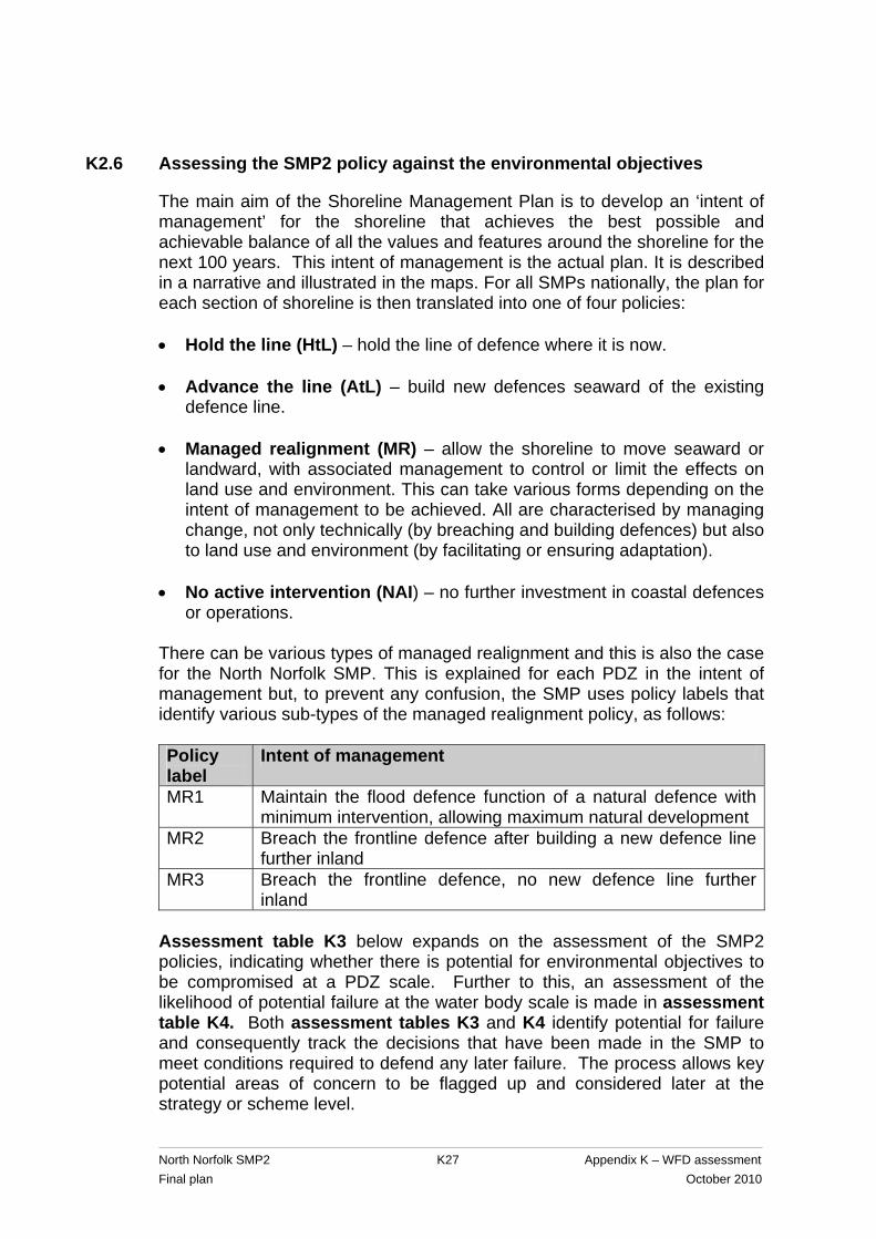
K2.6 Assessing the SMP2 policy against the environmental objectives
The main aim of the Shoreline Management Plan is to develop an ‘intent of management’ for the shoreline that achieves the best possible and achievable balance of all the values and features around the shoreline for the next 100 years. This intent of management is the actual plan. It is described in a narrative and illustrated in the maps. For all SMPs nationally, the plan for each section of shoreline is then translated into one of four policies: • Hold the line (HtL) – hold the line of defence where it is now. • Advance the line (AtL) – build new defences seaward of the existing
defence line. • Managed realignment (MR) – allow the shoreline to move seaward or
landward, with associated management to control or limit the effects on land use and environment. This can take various forms depending on the intent of management to be achieved. All are characterised by managing change, not only technically (by breaching and building defences) but also to land use and environment (by facilitating or ensuring adaptation).
• No active intervention (NAI) – no further investment in coastal defences
or operations. There can be various types of managed realignment and this is also the case for the North Norfolk SMP. This is explained for each PDZ in the intent of management but, to prevent any confusion, the SMP uses policy labels that identify various sub-types of the managed realignment policy, as follows: Policy label
Intent of management
MR1 Maintain the flood defence function of a natural defence with minimum intervention, allowing maximum natural development
MR2 Breach the frontline defence after building a new defence line further inland
MR3 Breach the frontline defence, no new defence line further inland
Assessment table K3 below expands on the assessment of the SMP2 policies, indicating whether there is potential for environmental objectives to be compromised at a PDZ scale. Further to this, an assessment of the likelihood of potential failure at the water body scale is made in assessment table K4. Both assessment tables K3 and K4 identify potential for failure and consequently track the decisions that have been made in the SMP to meet conditions required to defend any later failure. The process allows key potential areas of concern to be flagged up and considered later at the strategy or scheme level.

North Norfolk SMP2 K28 Appendix K – WFD assessment Final plan October 2010
The potential for the policies to affect freshwater bodies (both designated as FWBs or not) should highlight the possible issues in defending those FWBs from tidal inundation and flooding through sea level rise.

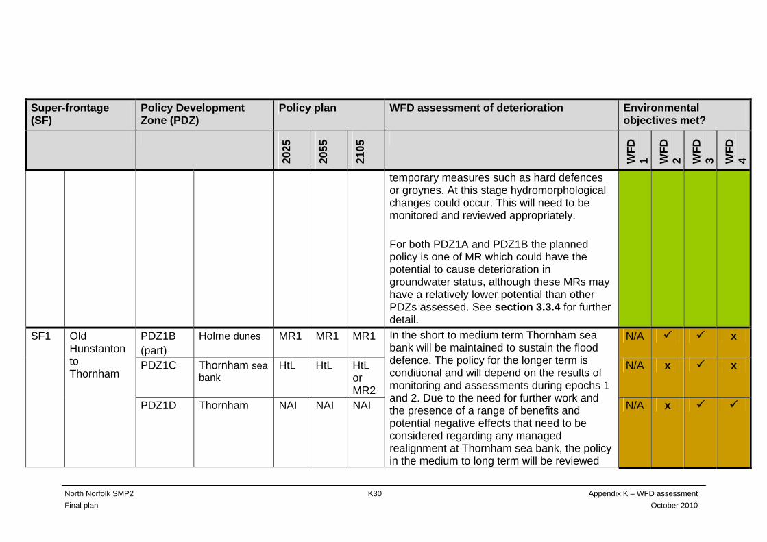
Assessment Table K3 WFD assessment of SMP policy for the North Norfolk SMP2 (colour shading equates to the shaded water bodies in figures 3.1 to 3.6)
Super-frontage (SF)
Policy Development Zone (PDZ)
Policy plan WFD assessment of deterioration Environmental objectives met?
2025
2055
2105
WFD
1 WFD
2 WFD
3 WFD
4
PDZ1A Old Hunstanton dunes
HtL MR1 MR1 N/A x x SF1 Old Hunstanton to Thornham PDZ1B
(part) Holme dunes MR1 MR1 MR1
For this frontage the planned policy will be one of allowing natural dune development while continuing to provide flood defence to houses and the A149. In the short term there will be no change in policy. This will be a period of adaptation of land use and increased understanding in long-term dune development. There is the potential for removing man-made dune protection at Old Hunstanton dunes in epoch 2. As the dunes roll back new intertidal area will replace any loss of intertidal area due to sea level rise. There is a degree of uncertainty about later epochs in terms of the interventions needed to sustain the flood defence function that may have the potential to affect the BQEs as set out in assessment table 1. This could occur if the flood defence function has to be maintained by permanent rather than
N/A x x
North Norfolk SMP2 K29 Appendix K – WFD assessment Final plan October 2010
North Norfolk SMP2 K30 Appendix K – WFD assessment Final plan October 2010
Super-frontage (SF)
Policy Development Zone (PDZ)
Policy plan WFD assessment of deterioration Environmental objectives met?
2025
2055
2105
WFD
1 WFD
2 WFD
3 WFD
4
temporary measures such as hard defences or groynes. At this stage hydromorphological changes could occur. This will need to be monitored and reviewed appropriately. For both PDZ1A and PDZ1B the planned policy is one of MR which could have the potential to cause deterioration in groundwater status, although these MRs may have a relatively lower potential than other PDZs assessed. See section 3.3.4 for further detail.
PDZ1B (part)
Holme dunes MR1 MR1 MR1 N/A x
PDZ1C Thornham sea bank
HtL HtL HtL or MR2
N/A x x
SF1 Old Hunstanton to Thornham
PDZ1D Thornham
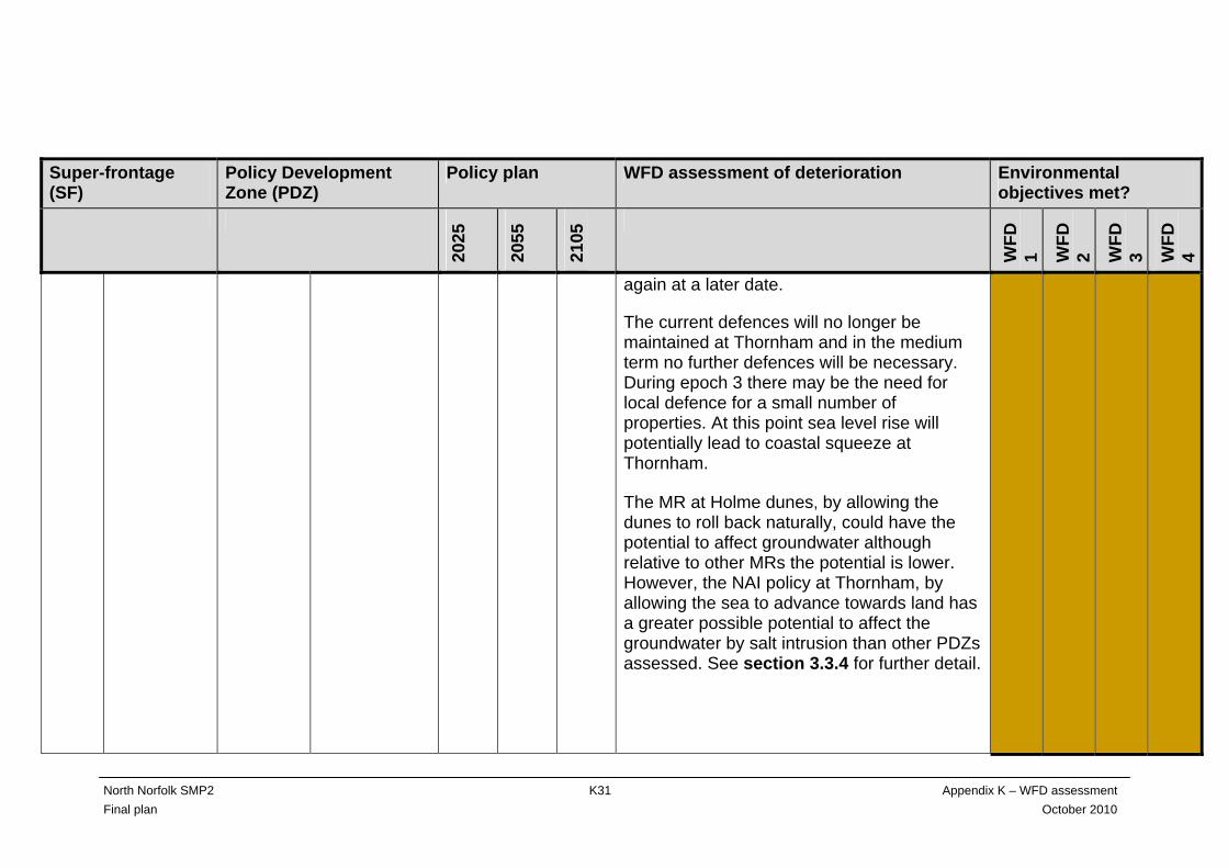
NAI NAI NAI
In the short to medium term Thornham sea bank will be maintained to sustain the flood defence. The policy for the longer term is conditional and will depend on the results of monitoring and assessments during epochs 1 and 2. Due to the need for further work and the presence of a range of benefits and potential negative effects that need to be considered regarding any managed realignment at Thornham sea bank, the policy in the medium to long term will be reviewed
N/A x
North Norfolk SMP2 K31 Appendix K – WFD assessment Final plan October 2010
Super-frontage (SF)
Policy Development Zone (PDZ)
Policy plan WFD assessment of deterioration Environmental objectives met?
2025
2055
2105
WFD
1 WFD
2 WFD
3 WFD
4
again at a later date.
The current defences will no longer be maintained at Thornham and in the medium term no further defences will be necessary. During epoch 3 there may be the need for local defence for a small number of properties. At this point sea level rise will potentially lead to coastal squeeze at Thornham.
The MR at Holme dunes, by allowing the dunes to roll back naturally, could have the potential to affect groundwater although relative to other MRs the potential is lower. However, the NAI policy at Thornham, by allowing the sea to advance towards land has a greater possible potential to affect the groundwater by salt intrusion than other PDZs assessed. See section 3.3.4 for further detail.

North Norfolk SMP2 K32 Appendix K – WFD assessment Final plan October 2010
Super-frontage (SF)
Policy Development Zone (PDZ)
Policy plan WFD assessment of deterioration Environmental objectives met?
2025
2055
2105
WFD
1 WFD
2 WFD
3 WFD
4
PDZ2A Thornham to Titchwell
NAI NAI NAI N/A
PDZ2B Titchwell RSPB reserve
HtL HtL HtL N/A
PDZ2C Titchwell village
NAI NAI NAI N/A
SF2 Thornham to Stiffkey
PDZ2D Brancaster west grazing marsh
HtL HtL or MR2
HtL or MR2
The frontage between Thornham and Titchwell will remain undefended with the dunes expected to continue to roll back and the saltmarsh to continue accrete vertically. Coastal squeeze could have a potential effect on the BQEs for this water body by changes over time to tidal inundation, turbidity and suspended sediment levels. The foreshore will diminish and sub-tidal area will increase. At Titchwell RSPB reserve the policy of the RSPB (who own the defences here) is HtL at the newly-realigned position. RSPB has designed the planned realignment for a 50- year period, after which it expects further landward realignment will be needed in response to coastal processes. The pressure on these defences strongly depends on coastal processes and on policy decisions taken in the area of Scolt Head Island and the golf course at Brancaster. The policy for Titchwell RSPB reserve will therefore need to be reviewed over time as coastal processes
N/A x

North Norfolk SMP2 K33 Appendix K – WFD assessment Final plan October 2010
Super-frontage (SF)
Policy Development Zone (PDZ)
Policy plan WFD assessment of deterioration Environmental objectives met?
2025
2055
2105
WFD
1 WFD
2 WFD
3 WFD
4
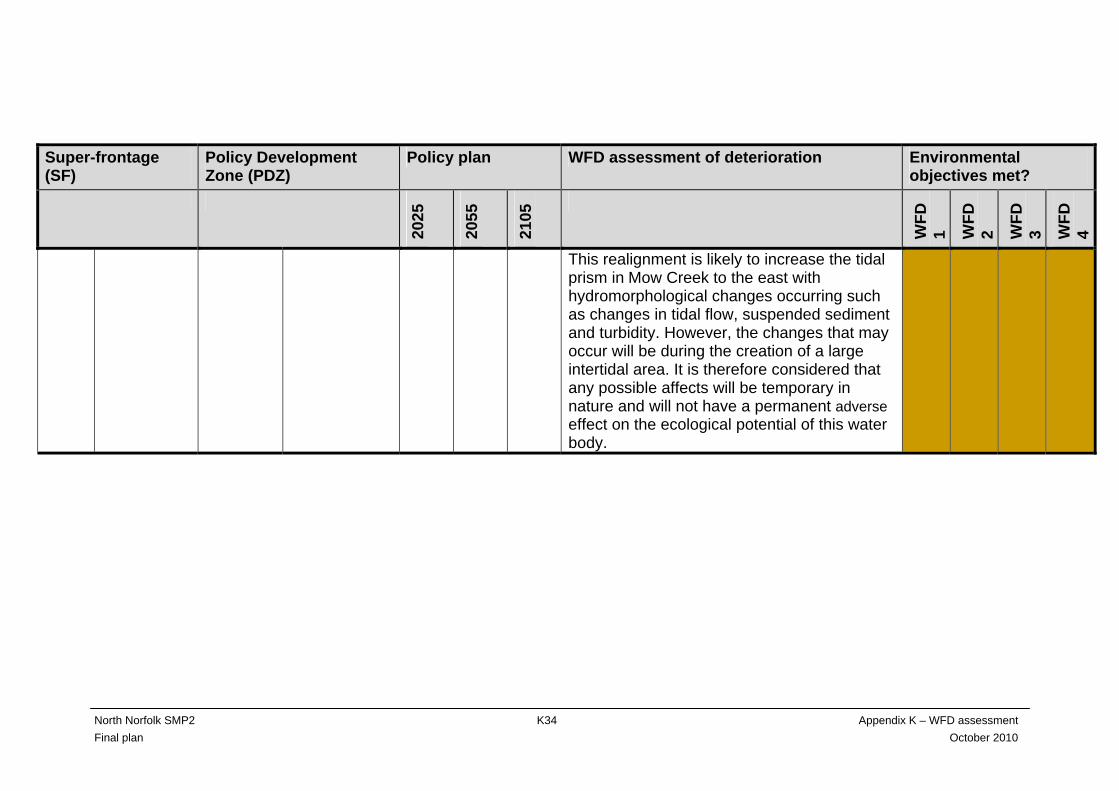
respond to other policy decisions and also to sea level rise. At Titchwell village the frontage will remain undefended. The dunes are expected to continue to roll back and the saltmarsh to continue to accrete vertically although in epoch 3 horizontal erosion at the seaward edge is expected. As for PDZ2B, large-scale processes at Brancaster bay in relation to policy decisions around Scolt Head Island and the golf course will influence the progression of both the dunes and the saltmarsh. The marshes at Brancaster comprise around 40 hectares of freshwater grazing meadows. The site is flanked by earth flood embankments with its frontage protected by defences strengthening the natural dunes. The preferred policy package would be HtL in epoch 1 but to investigate realignment in epoch 2. Should this occur, the freshwater habitats would become intertidal.
North Norfolk SMP2 K34 Appendix K – WFD assessment Final plan October 2010
Super-frontage (SF)
Policy Development Zone (PDZ)
Policy plan WFD assessment of deterioration Environmental objectives met?
2025
2055
2105
WFD
1 WFD
2 WFD
3 WFD
4
This realignment is likely to increase the tidal prism in Mow Creek to the east with hydromorphological changes occurring such as changes in tidal flow, suspended sediment and turbidity. However, the changes that may occur will be during the creation of a large intertidal area. It is therefore considered that any possible affects will be temporary in nature and will not have a permanent adverse effect on the ecological potential of this water body.
North Norfolk SMP2 K35 Appendix K – WFD assessment Final plan October 2010
Super-frontage (SF)
Policy Development Zone (PDZ)
Policy plan WFD assessment of deterioration Environmental objectives met?
2025
2055
2105
WFD
1 WFD
2 WFD
3 WFD
4
SF2 Thornham to Stiffkey
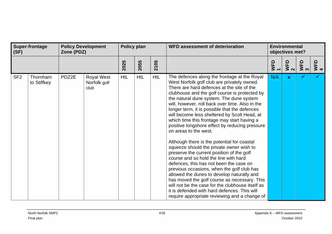
PDZ2E Royal West Norfolk golf club
HtL HtL HtL The defences along the frontage at the Royal West Norfolk golf club are privately owned. There are hard defences at the site of the clubhouse and the golf course is protected by the natural dune system. The dune system will, however, roll back over time. Also in the longer term, it is possible that the defences will become less sheltered by Scolt Head, at which time this frontage may start having a positive longshore effect by reducing pressure on areas to the west. Although there is the potential for coastal squeeze should the private owner wish to preserve the current position of the golf course and so hold the line with hard defences, this has not been the case on previous occasions, when the golf club has allowed the dunes to develop naturally and has moved the golf course as necessary. This will not be the case for the clubhouse itself as it is defended with hard defences. This will require appropriate reviewing and a change of
N/A x
North Norfolk SMP2 K36 Appendix K – WFD assessment Final plan October 2010
Super-frontage (SF)
Policy Development Zone (PDZ)
Policy plan WFD assessment of deterioration Environmental objectives met?
2025
2055
2105
WFD
1 WFD
2 WFD
3 WFD
4
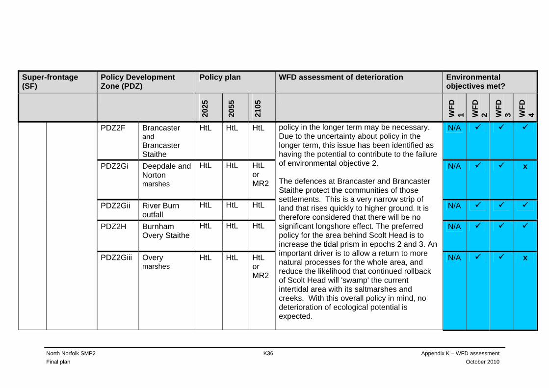
PDZ2F Brancaster and Brancaster Staithe
HtL HtL HtL N/A
PDZ2Gi Deepdale and Norton marshes
HtL HtL HtL or MR2
N/A x
PDZ2Gii River Burn outfall
HtL HtL HtL N/A
PDZ2H Burnham Overy Staithe
HtL HtL HtL N/A
PDZ2Giii Overy marshes
HtL HtL HtL or MR2
policy in the longer term may be necessary. Due to the uncertainty about policy in the longer term, this issue has been identified as having the potential to contribute to the failure of environmental objective 2. The defences at Brancaster and Brancaster Staithe protect the communities of those settlements. This is a very narrow strip of land that rises quickly to higher ground. It is therefore considered that there will be no significant longshore effect. The preferred policy for the area behind Scolt Head is to increase the tidal prism in epochs 2 and 3. An important driver is to allow a return to more natural processes for the whole area, and reduce the likelihood that continued rollback of Scolt Head will 'swamp' the current intertidal area with its saltmarshes and creeks. With this overall policy in mind, no deterioration of ecological potential is expected.
N/A x
North Norfolk SMP2 K37 Appendix K – WFD assessment Final plan October 2010
Super-frontage (SF)
Policy Development Zone (PDZ)
Policy plan WFD assessment of deterioration Environmental objectives met?
2025
2055
2105
WFD
1 WFD
2 WFD
3 WFD
4
The intent of the plan for frontage PDZ2G is to sustain flood defence to all properties and infrastructure together with gradually increasing tidal exchange by realigning the reclaimed Deepdale, Norton and Overy marshes. This increase in tidal exchange is likely to benefit navigation in the tidal channels and the outer estuaries and, by enhancing the outer estuaries, strengthen the role of Scolt Head Island as a control point for Brancaster bay and Holkham bay. Also, the realignments will create intertidal habitat. However, Deepdale marsh, Norton marsh and Overy marsh together form the largest area of freshwater grazing marsh on the north Norfolk coast. Part of this would be lost if the realignment proceeds. The SMP has identified that more knowledge is needed to assess the effects of realignment and confirm the intent to realign. If this is confirmed, management would only be changed in the longer term and there is a
North Norfolk SMP2 K38 Appendix K – WFD assessment Final plan October 2010
Super-frontage (SF)
Policy Development Zone (PDZ)
Policy plan WFD assessment of deterioration Environmental objectives met?
2025
2055
2105
WFD
1 WFD
2 WFD
3 WFD
4
likely need for land use in the currently reclaimed area to adapt. The intent is to sustain the tidal flood defence function of the River Burn outfall. The River Burn valley beyond the tidal sluice will therefore remain fresh water. The likelihood of the river valley flooding from the sea will increase over the three epochs due to sea level rise and increased storminess. However, if the realignments at Deepdale and Overy marshes go ahead, the funnelling effect of the old line of defence will be removed and a line of saltmarsh created instead which may help to protect the valley to some degree. If the realignment proceeds, hydromorphological change will occur as the tidal prism increases, tidal flow, suspended sediment and turbidity are expected to change. However, these changes will occur as the previous grazing marsh becomes intertidal and saltmarsh habitat. The
North Norfolk SMP2 K39 Appendix K – WFD assessment Final plan October 2010
Super-frontage (SF)
Policy Development Zone (PDZ)
Policy plan WFD assessment of deterioration Environmental objectives met?
2025
2055
2105
WFD
1 WFD
2 WFD
3 WFD
4
reasoning behind the realignment is to try to prevent Scolt Head rolling back and swamping the existing intertidal habitat. It is therefore considered that, although change will occur and the BQE may be affected temporarily, this will be unlikely to contribute to the deterioration of the ecological potential of the water body. At Burnham Overy Staithe (PDZ2H), the intention is to HtL for all three epochs. There is some uncertainty about predicted changes to coastal processes over time. Scolt Head is in front of PDZ2H and this will continue to roll back and may even possibly join the land so changing the local coastal processes. Also, there is the possibility that PDZ2G may be deliberately breached in epochs 2 and 3 in conjunction with managed realignment. This area is situated on either side of PDZ2H so again local coastal processes could change along this frontage. Although the combination and timings of these factors make the future
North Norfolk SMP2 K40 Appendix K – WFD assessment Final plan October 2010
Super-frontage (SF)
Policy Development Zone (PDZ)
Policy plan WFD assessment of deterioration Environmental objectives met?
2025
2055
2105
WFD
1 WFD
2 WFD
3 WFD
4
of PDZ2H uncertain in terms of change, there is the overall potential to create a larger area of continuous saltmarsh along frontages PDZ2G and PDZ2H over time which could be considered as contributing to the overarching aim to allow a return to more natural processes for the whole area. For both PDZGi and PDZGiii, the policy in epoch 3 will either be HtL or MR2. If it is MR2, this could have the potential to cause deterioration in groundwater status as the planned MR is to breach existing defences and create new intertidal habitat, so allowing salt intrusion landwards. As well as the realignment there is also a FWB in the area – the River Burn. These two factors would suggest that the policy in this area has a relatively greater potential to affect groundwater status than in other parts of the north Norfolk frontage. See section 3.3.4 for further detail.
North Norfolk SMP2 K41 Appendix K – WFD assessment Final plan October 2010
Super-frontage (SF)
Policy Development Zone (PDZ)
Policy plan WFD assessment of deterioration Environmental objectives met?
2025
2055
2105
WFD
1 WFD
2 WFD
3 WFD
4
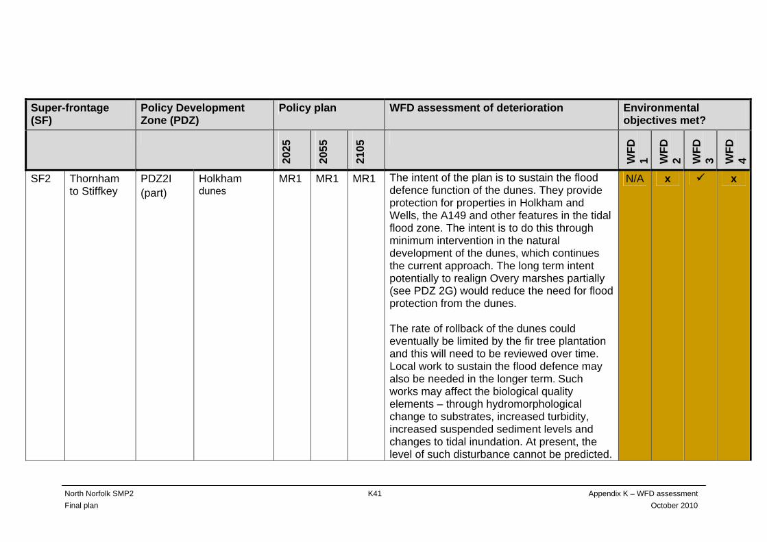
SF2 Thornham to Stiffkey
PDZ2I (part)
Holkham dunes
MR1 MR1 MR1
The intent of the plan is to sustain the flood defence function of the dunes. They provide protection for properties in Holkham and Wells, the A149 and other features in the tidal flood zone. The intent is to do this through minimum intervention in the natural development of the dunes, which continues the current approach. The long term intent potentially to realign Overy marshes partially (see PDZ 2G) would reduce the need for flood protection from the dunes. The rate of rollback of the dunes could eventually be limited by the fir tree plantation and this will need to be reviewed over time. Local work to sustain the flood defence may also be needed in the longer term. Such works may affect the biological quality elements – through hydromorphological change to substrates, increased turbidity, increased suspended sediment levels and changes to tidal inundation. At present, the level of such disturbance cannot be predicted.
N/A x x
North Norfolk SMP2 K42 Appendix K – WFD assessment Final plan October 2010
Super-frontage (SF)
Policy Development Zone (PDZ)
Policy plan WFD assessment of deterioration Environmental objectives met?
2025
2055
2105
WFD
1 WFD
2 WFD
3 WFD
4
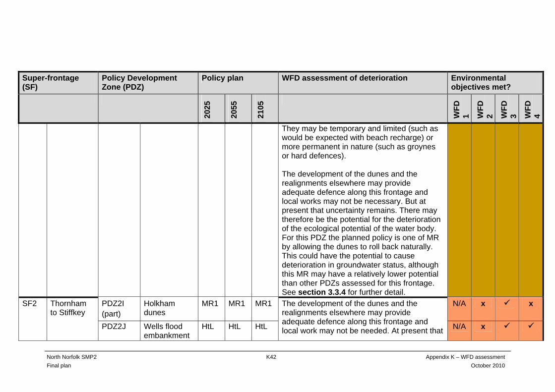
They may be temporary and limited (such as would be expected with beach recharge) or more permanent in nature (such as groynes or hard defences). The development of the dunes and the realignments elsewhere may provide adequate defence along this frontage and local works may not be necessary. But at present that uncertainty remains. There may therefore be the potential for the deterioration of the ecological potential of the water body. For this PDZ the planned policy is one of MR by allowing the dunes to roll back naturally. This could have the potential to cause deterioration in groundwater status, although this MR may have a relatively lower potential than other PDZs assessed for this frontage. See section 3.3.4 for further detail.
PDZ2I (part)
Holkham dunes
MR1 MR1 MR1
N/A x x SF2 Thornham to Stiffkey
PDZ2J Wells flood embankment
HtL HtL HtL
The development of the dunes and the realignments elsewhere may provide adequate defence along this frontage and local work may not be needed. At present that N/A x
North Norfolk SMP2 K43 Appendix K – WFD assessment Final plan October 2010
Super-frontage (SF)
Policy Development Zone (PDZ)
Policy plan WFD assessment of deterioration Environmental objectives met?
2025
2055
2105
WFD
1 WFD
2 WFD
3 WFD
4
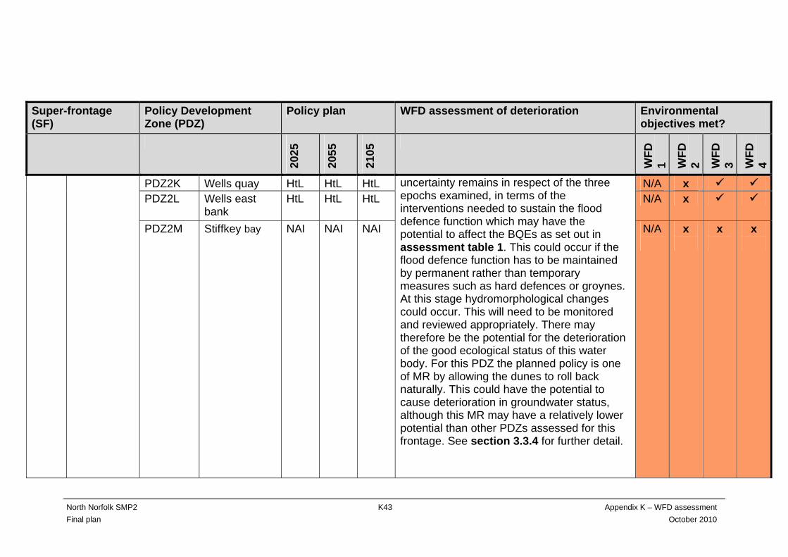
PDZ2K Wells quay HtL HtL HtL N/A x PDZ2L Wells east
bank HtL HtL HtL
N/A x
PDZ2M
Stiffkey bay NAI
NAI
NAI
uncertainty remains in respect of the three epochs examined, in terms of the interventions needed to sustain the flood defence function which may have the potential to affect the BQEs as set out in assessment table 1. This could occur if the flood defence function has to be maintained by permanent rather than temporary measures such as hard defences or groynes. At this stage hydromorphological changes could occur. This will need to be monitored and reviewed appropriately. There may therefore be the potential for the deterioration of the good ecological status of this water body. For this PDZ the planned policy is one of MR by allowing the dunes to roll back naturally. This could have the potential to cause deterioration in groundwater status, although this MR may have a relatively lower potential than other PDZs assessed for this frontage. See section 3.3.4 for further detail.
N/A
x
x
x

North Norfolk SMP2 K44 Appendix K – WFD assessment Final plan October 2010
Super-frontage (SF)
Policy Development Zone (PDZ)
Policy plan WFD assessment of deterioration Environmental objectives met?
2025
2055
2105
WFD
1 WFD
2 WFD
3 WFD
4
There are economic drivers that have influenced the HtL position through all three epochs for Wells flood embankment and Wells quay. Ultimately this will lead to loss of intertidal and saltmarsh habitat through coastal squeeze in epoch 3, with the potential to affect the biological quality elements described in assessment table 1. As well as sustaining flood defence to all houses and infrastructure, the SMP has identified that a managed realignment at Wells east bank and the associated increase in the tidal exchange in Wells harbour channel could have a range of benefits. This increase in tidal exchange is likely to benefit navigation in the harbour channel and, by enhancing the outer estuary, reduce pressure on Holkham dunes. Also, the realignments would create intertidal habitat, but at the loss of current agricultural land use. The increased tidal prism in the channel could initially affect benthic communities and potentially

North Norfolk SMP2 K45 Appendix K – WFD assessment Final plan October 2010
Super-frontage (SF)
Policy Development Zone (PDZ)
Policy plan WFD assessment of deterioration Environmental objectives met?
2025
2055
2105
WFD
1 WFD
2 WFD
3 WFD
4
jeopardise the environmental objective. However, over time, the area would re-adjust as the new intertidal and saltmarsh area develops. However, some of these positive effects at Wells east bank are uncertain and they are currently outweighed by a number of direct negative effects such as the loss of agricultural land and possible de-stabilising of the Wells flood embankment. The advantages and disadvantages of this realignment will therefore need to be studied more closely and future SMPs will re-evaluate the HtL position. The HtL position has the potential for coastal squeeze as sea levels rise in the future, leading to loss of intertidal areas and an increase in sub-tidal habitat. BQEs could therefore be affected by the HtL policy should it remain. The intent of the plan at Stiffkey bay is to continue the current situation where the frontage is allowed to develop naturally. At the moment it is not defended and no reasons
North Norfolk SMP2 K46 Appendix K – WFD assessment Final plan October 2010
Super-frontage (SF)
Policy Development Zone (PDZ)
Policy plan WFD assessment of deterioration Environmental objectives met?
2025
2055
2105
WFD
1 WFD
2 WFD
3 WFD
4
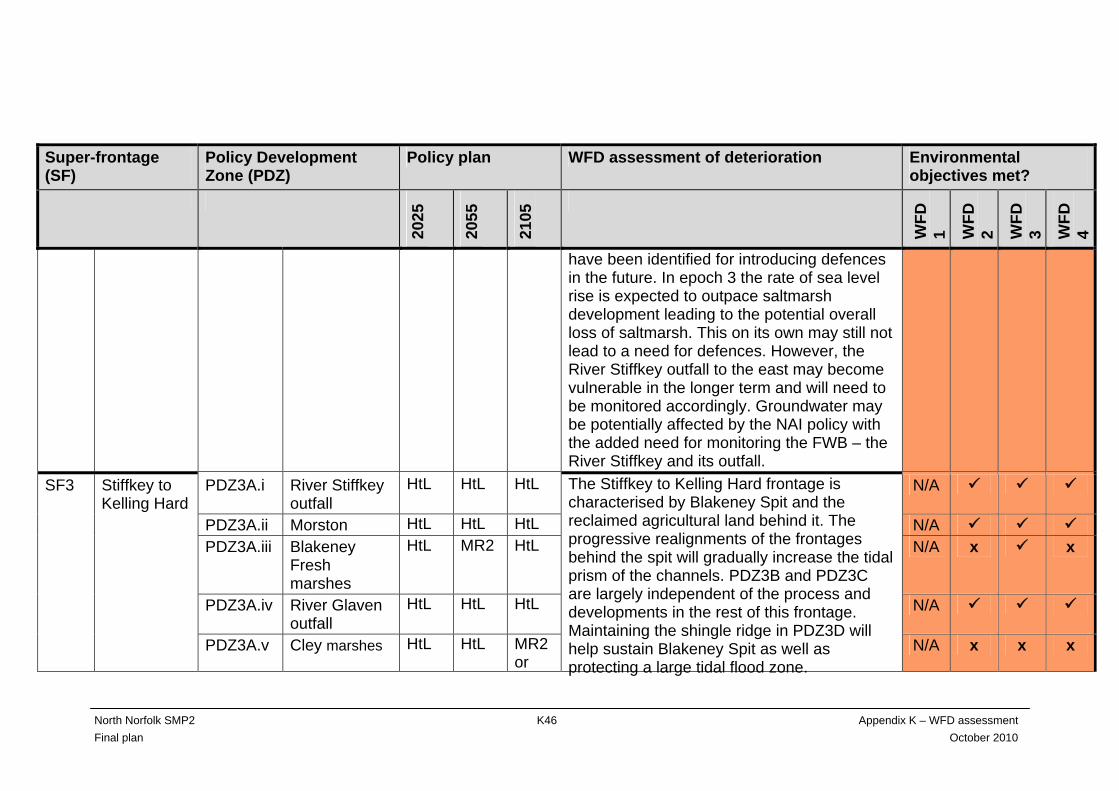
have been identified for introducing defences in the future. In epoch 3 the rate of sea level rise is expected to outpace saltmarsh development leading to the potential overall loss of saltmarsh. This on its own may still not lead to a need for defences. However, the River Stiffkey outfall to the east may become vulnerable in the longer term and will need to be monitored accordingly. Groundwater may be potentially affected by the NAI policy with the added need for monitoring the FWB – the River Stiffkey and its outfall.
PDZ3A.i River Stiffkey outfall
HtL HtL HtL N/A
PDZ3A.ii Morston HtL HtL HtL N/A PDZ3A.iii Blakeney
Fresh marshes
HtL MR2 HtL N/A x x
PDZ3A.iv River Glaven outfall
HtL HtL HtL N/A
SF3 Stiffkey to Kelling Hard
PDZ3A.v Cley marshes HtL HtL MR2 or
The Stiffkey to Kelling Hard frontage is characterised by Blakeney Spit and the reclaimed agricultural land behind it. The progressive realignments of the frontages behind the spit will gradually increase the tidal prism of the channels. PDZ3B and PDZ3C are largely independent of the process and developments in the rest of this frontage. Maintaining the shingle ridge in PDZ3D will help sustain Blakeney Spit as well as protecting a large tidal flood zone.
N/A x x x

North Norfolk SMP2 K47 Appendix K – WFD assessment Final plan October 2010
Super-frontage (SF)
Policy Development Zone (PDZ)
Policy plan WFD assessment of deterioration Environmental objectives met?
2025
2055
2105
WFD
1 WFD
2 WFD
3 WFD
4
HtL PDZ3B Stiffkey to
Morston NAI NAI NAI
N/A x x
PDZ3C
Blakeney
HtL
HtL
HtL
The policy at Morston is one of HtL which will sustain current agricultural use and the partly designated freshwater habitats along this frontage. The intent of the plan is to sustain flood defence to all properties and infrastructure together with gradually increasing tidal exchange by realigning the reclaimed area at Blakeney Freshes in epoch 2 and potentially at Cley marshes in epoch 3. This increase in tidal exchange is likely to benefit navigation in the tidal channels and the outer estuaries and, by enhancing the outer estuaries, strengthen the role of Scolt Head Island as a control point for Stiffkey bay. Also, the realignments will create intertidal habitat so there will be a loss of freshwater habitats and current agricultural land. During epoch 2 the sea banks around Blakeney Freshes will be breached which will open up the marshes to tidal influence. A
N/A
x
North Norfolk SMP2 K48 Appendix K – WFD assessment Final plan October 2010
Super-frontage (SF)
Policy Development Zone (PDZ)
Policy plan WFD assessment of deterioration Environmental objectives met?
2025
2055
2105
WFD
1 WFD
2 WFD
3 WFD
4
further and much greater increase in the tidal prism and flows into Blakeney harbour is expected and will further sustain the navigable channels. Any silt scoured out will be deposited in the currently-defended areas. Intertidal habitat is expected to increase by 136 hectares. Changes to sediment load, turbidity, light and substrates will potentially occur and the BQEs will again be affected temporarily. As more intertidal habitat develops the BQEs will move into the new areas. There are mussel lays in the area of the realignment and changes to the sediment load, turbidity and substrate may negatively affect these. Also, it is uncertain whether this would be temporary or permanent. Freshwater habitat is likely to be lost. All potential effects of the Blakeney Freshes realignment will be taken into account during project appraisal and scheme development. The process will need to include full involvement by local people and also

North Norfolk SMP2 K49 Appendix K – WFD assessment Final plan October 2010
Super-frontage (SF)
Policy Development Zone (PDZ)
Policy plan WFD assessment of deterioration Environmental objectives met?
2025
2055
2105
WFD
1 WFD
2 WFD
3 WFD
4
landowner agreement and show that any negative effects are acceptable and manageable. The River Stiffkey and River Glaven outfalls will continue to be defended so they remain as FWBs inland of their tidal sluices. The Stiffkey outfall ties into higher ground on both sides. However, in PDZ2M and PDZ3B (to either side) a policy of NAI is planned. As sea levels rise, storminess increases and these two units roll back, the defence of the outfall may need to be reviewed, especially on the Morston side, to avoid possible deterioration of the Stiffkey’s (and Binham tributary’s) ecological potential. The likelihood of the River Glaven flood plain flooding from the sea will increase over the three epochs due to sea level rise and increased storminess. However, if the realignments at Blakeney Freshes and Cley
North Norfolk SMP2 K50 Appendix K – WFD assessment Final plan October 2010
Super-frontage (SF)
Policy Development Zone (PDZ)
Policy plan WFD assessment of deterioration Environmental objectives met?
2025
2055
2105
WFD
1 WFD
2 WFD
3 WFD
4
marshes go ahead, the funnelling effect of the old line of defence will be removed and a line of saltmarsh created instead, which may help to protect the flood plain to some degree. At present there is no specific policy within this water body that could lead directly to the possibility of saline intrusion into the River Glaven flood plain. However, whether the realignments proceed or not, this policy will need to be monitored to make sure that the Glaven remains freshwater inland of its tidal sluice if its good ecological status (not yet assessed) is to be maintained. Decisions will need to be made over time about this FWB. These will include whether the tidal sluice can remain where it is or if it will need to be moved further inland as rollback along this frontage continues as sea levels rise. At Cley marshes the west bank would be breached in epoch 3. This will have a similar
North Norfolk SMP2 K51 Appendix K – WFD assessment Final plan October 2010
Super-frontage (SF)
Policy Development Zone (PDZ)
Policy plan WFD assessment of deterioration Environmental objectives met?
2025
2055
2105
WFD
1 WFD
2 WFD
3 WFD
4
effect on the area as for the earlier breach at Blakeney Fresh marshes. Intertidal habitat will be extended by a further 150 hectares. Freshwater/brackish habitat is likely to be lost from within this water body. This breach would also potentially cause the loss of some of the freshwater habitat and saline lagoons in the neighbouring water body - the Blakeney Spit Lagoon system. The frontage between Stiffkey and Morston is not currently defended and the intention is that it remains so – allowing the frontage to develop naturally. This may create cause for concern over time with regard to the Stiffkey outfall as mentioned above. The current intention at Blakeney is to continue to maintain the defences where they are now to protect current use of the quayside and associated features in Blakeney. This policy has the potential for coastal squeeze in the future. However, policy decisions taken
North Norfolk SMP2 K52 Appendix K – WFD assessment Final plan October 2010
Super-frontage (SF)
Policy Development Zone (PDZ)
Policy plan WFD assessment of deterioration Environmental objectives met?
2025
2055
2105
WFD
1 WFD
2 WFD
3 WFD
4
elsewhere, for example at Blakeney Freshes, will also influence how this frontage develops. The intended policies for this frontage will have the potential to cause hydromorphological changes to the water body. The breaches and realignments are expected to increase the tidal prism dramatically with possible effects occurring in tidal flows, suspended sediment, turbidity, tidal inundation and possibly changes in salinity. There could be an adverse effect on the biological quality elements as a result. The breaches are intended to happen over a period of time. The reasoning behind the policy as outlined above, together with the stepped approach to any realignment, could be considered to be contributing to the overarching aim to allow a return to more natural processes for the whole area. So, although the BQEs may be affected, this should only be of a temporary nature and over time this frontage will benefit from the policies.

North Norfolk SMP2 K53 Appendix K – WFD assessment Final plan October 2010
Super-frontage (SF)
Policy Development Zone (PDZ)
Policy plan WFD assessment of deterioration Environmental objectives met?
2025
2055
2105
WFD
1 WFD
2 WFD
3 WFD
4
SF3 Stiffkey to Kelling Hard
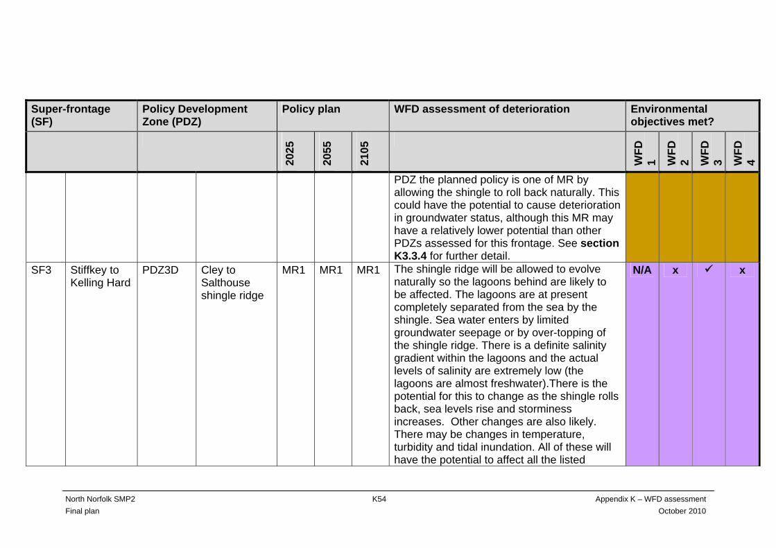
PDZ3D
Cley to Salthouse shingle ridge
MR1
MR1
MR1
The flood defence function of the shingle ridge will be sustained through the minimum amount of intervention to allow natural processes to occur as far as possible. This continues the current approach. The shingle ridge provides protection for properties at Cley and Salthouse, the A149 and other features in the tidal flood zone. The long term intent potentially to realign Cley west bank (PDZ3A) partially would reduce the need for flood protection from the shingle ridge. Allowing the shingle ridge to develop naturally is very likely to have an effect on the Blakeney Spit Lagoons in the area behind. Hydromorphological changes will occur as the ridge rolls back. There may be changes in salinity, temperature, turbidity and tidal inundation. All of these will have the potential to effect all the listed biological quality elements in assessment table K1. For this
N/A x x
North Norfolk SMP2 K54 Appendix K – WFD assessment Final plan October 2010
Super-frontage (SF)
Policy Development Zone (PDZ)
Policy plan WFD assessment of deterioration Environmental objectives met?
2025
2055
2105
WFD
1 WFD
2 WFD
3 WFD
4
PDZ the planned policy is one of MR by allowing the shingle to roll back naturally. This could have the potential to cause deterioration in groundwater status, although this MR may have a relatively lower potential than other PDZs assessed for this frontage. See section K3.3.4 for further detail.
SF3 Stiffkey to Kelling Hard
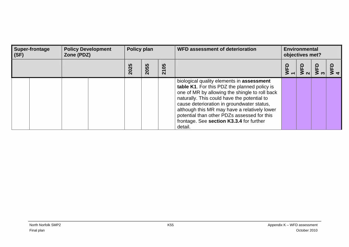
PDZ3D Cley to Salthouse shingle ridge
MR1 MR1 MR1 The shingle ridge will be allowed to evolve naturally so the lagoons behind are likely to be affected. The lagoons are at present completely separated from the sea by the shingle. Sea water enters by limited groundwater seepage or by over-topping of the shingle ridge. There is a definite salinity gradient within the lagoons and the actual levels of salinity are extremely low (the lagoons are almost freshwater).There is the potential for this to change as the shingle rolls back, sea levels rise and storminess increases. Other changes are also likely. There may be changes in temperature, turbidity and tidal inundation. All of these will have the potential to affect all the listed
N/A x x
North Norfolk SMP2 K55 Appendix K – WFD assessment Final plan October 2010
Super-frontage (SF)
Policy Development Zone (PDZ)
Policy plan WFD assessment of deterioration Environmental objectives met?
2025
2055
2105
WFD
1 WFD
2 WFD
3 WFD
4
biological quality elements in assessment table K1. For this PDZ the planned policy is one of MR by allowing the shingle to roll back naturally. This could have the potential to cause deterioration in groundwater status, although this MR may have a relatively lower potential than other PDZs assessed for this frontage. See section K3.3.4 for further detail.
North Norfolk SMP2 - K56 - Appendix K – WFD assessment Final plan October 2010
K2.6.1 Environmental objective WFD1
WFD1 only applies to high status water bodies. There are no high status water bodies in the North Norfolk SMP area.
K2.6.2 Environmental objective WFD2
Most of the policy development zones were identified as having the potential to contribute to a failure to meet environmental objective WFD2 (no changes that will cause failure to meet surface water good ecological status or potential or result in a deterioration of surface water ecological status or potential). These include 10 policy development zones (PDZ2B, PDZ2E, PDZ2F, PDZ2Gi, PDZ2Giii, PDZ2H, PDZ2J, PDZ2K, PDZ2L and PDZ3C) where the SMP2 policy of HtL for the defence of property or assets could result in loss of sand foreshore and/or dunes or intertidal saltmarsh/mudflats. This may potentially affect angiosperms, benthic/macro-invertebrates and fish. There are also a number of policy development zones where a policy of managed realignment relies on a natural development of the system, but with the caveat that flood defence would be maintained by intervention if necessary. This could also lead to failure to meet environmental objective 2. For another group of policy development zones a common approach develops in the potential use of realignment to create intertidal habitat (examples of this are found in policy development zones PDZ2Gi, PDZ2Giii, PDZ3Aiii and PDZ3Av). In all cases there will be the potential for the loss of freshwater/brackish habitat, almost all of which have nature conservation designations attached to them. In these cases, there would be an initial phase of adjustment for the areas seaward of the realignment, as changes to the tidal prism, suspended sediments, turbidity and tidal flows occur. However, once this phase has passed it is expected that the BQEs that may have been affected temporarily will adjust accordingly and any potential for failure of objective 2 will be temporary.
K2.6.3 Environmental objective WFD3
The SMP2 policies for four of the PDZs have the potential to contribute to a failure of WFD3 (no changes that permanently prevent the environmental objectives of other water bodies being met). Two of the policy development zones (PDZ2M and PDZ3B) have the potential to fail this objective because they are very close to the River Stiffkey outfall and freshwater river valley behind the Stiffkey’s tidal sluice. Both these PDZs currently have a NAI policy. With rising sea levels and increased storminess this could jeopardise the River Stiffkey FWB due to the potential for saline intrusion caused by seepage, overtopping, tidal inundation or flooding. The other two PDZs that have the potential to fail this objective are PDZ3Av (Cley marshes) and PDZ3D (part of the Cley to Salthouse shingle ridge). These PDZs are in the Stiffkey/Glaven water body. Both are linked to the adjoining PDZ3D (part), which is in the Blakeney Spit Lagoons water body.
North Norfolk SMP2 - K57 - Appendix K – WFD assessment Final plan October 2010
The policy plan to breach the defences at Cley marshes will include an area that is actually part of the Blakeney Spit Lagoons. Those lagoons that will be inundated by the breach will be lost as the habitat becomes intertidal mudflats and saltmarsh. Such a change would be expected to be permanent. The policy plan at Cley and Salthouse to allow the shingle ridge to develop naturally is highly likely to have an effect on the Blakeney Spit Lagoons in the area behind. Hydromorphological changes will occur as the ridge rolls back. There may be increases in salinity, turbidity and tidal inundation.
K2.6.4 Environmental objective WFD4
There is potential for any PDZ that has the policy of MR or NAI to cause deterioration in groundwater status as such policies could result in the saltwater-freshwater interface moving towards land. When combined with abstraction pressures, this could result in salt water intrusion and consequent deterioration in the status of the North Norfolk Chalk GWB (ID GB40501G400100). Although this GWB was classified as being at good status (low confidence) under WFD (figure K3.6), it has been assigned as being ‘probably at risk’ for saline intrusion under RBC2 (figure K3.7). Within the assessment, these two policies (MR and NAI) have been examined further. The MR policy has been investigated in terms of whether the policy will allow the natural rollback of the system (MR1) or whether the MR will actively realign the defences further inland (MR2). The NAI policy is examined in terms of the likely actual movement of the coast towards land. Lastly, the location of the FWBs will be examined as salt intrusion could be transported further inland by rivers. This approach should therefore identify those policies that would appear to present the greatest threat to the GWB. The summary findings in each relevant PDZ are shown in table K3.2. Table K3.2 highlights those PDZs where the potential for the policy to cause deterioration in the groundwater body is possibly higher. Those with MR policies that breach the current defences and create new intertidal habitat will move the saltwater-freshwater interface towards land more rapidly than those where natural coastal processes are allowed to evolve (roll back). Where there are FWBs in the area, this could also increase the risk of groundwater deterioration. To assess the effect on groundwater status, the locations of groundwater abstractions in Source Protection Zones (SPZs) within this ‘probably at risk’ GWB were obtained from the Environment Agency’s website. These abstraction boreholes are located at a reasonable distance from the coast and the zone 3 extends south away from the coast. Nevertheless, it is understood that these SPZs are currently under review by the Environment Agency and the abstraction boreholes are currently being monitored for the potential effects of saline intrusion.
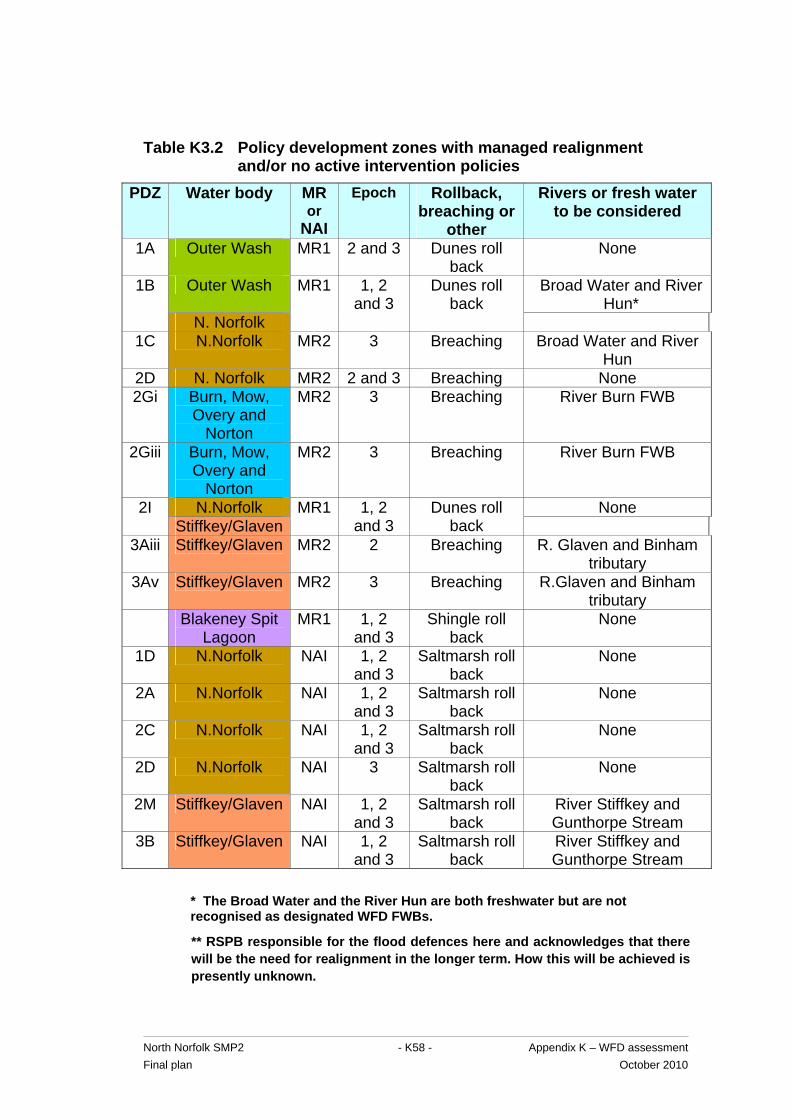
North Norfolk SMP2 - K58 - Appendix K – WFD assessment Final plan October 2010
Table K3.2 Policy development zones with managed realignment and/or no active intervention policies
PDZ Water body MR or
NAI
Epoch Rollback, breaching or
other
Rivers or fresh water to be considered
1A Outer Wash MR1 2 and 3 Dunes roll back
None
Outer Wash Broad Water and River Hun*
1B
N. Norfolk
MR1 1, 2 and 3
Dunes roll back
1C N.Norfolk MR2 3 Breaching Broad Water and River
Hun 2D N. Norfolk MR2 2 and 3 Breaching None 2Gi Burn, Mow,
Overy and Norton
MR2 3 Breaching River Burn FWB
2Giii Burn, Mow, Overy and
Norton
MR2 3 Breaching River Burn FWB
N.Norfolk None 2I Stiffkey/Glaven
MR1 1, 2 and 3
Dunes roll back
3Aiii Stiffkey/Glaven MR2 2 Breaching R. Glaven and Binham tributary
3Av Stiffkey/Glaven MR2 3 Breaching R.Glaven and Binham tributary
Blakeney Spit Lagoon
MR1 1, 2 and 3
Shingle roll back
None
1D N.Norfolk NAI 1, 2 and 3
Saltmarsh roll back
None
2A N.Norfolk NAI 1, 2 and 3
Saltmarsh roll back
None
2C N.Norfolk NAI 1, 2 and 3
Saltmarsh roll back
None
2D N.Norfolk NAI 3 Saltmarsh roll back
None
2M Stiffkey/Glaven NAI 1, 2 and 3
Saltmarsh roll back
River Stiffkey and Gunthorpe Stream
3B Stiffkey/Glaven NAI 1, 2 and 3
Saltmarsh roll back
River Stiffkey and Gunthorpe Stream
* The Broad Water and the River Hun are both freshwater but are not recognised as designated WFD FWBs.
** RSPB responsible for the flood defences here and acknowledges that there will be the need for realignment in the longer term. How this will be achieved is presently unknown.

North Norfolk SMP2 - K59 - Appendix K – WFD assessment Final plan October 2010
So the risk of deterioration in status as a result of the saltwater-freshwater interface can not be ruled out. Although there is a risk of saline intrusion into the chalk aquifer, it is considered to be a low risk as the chalk is characterised by a steep hydraulic gradient and high permeability, driving groundwater to the coast via springs, freshwater marshes or directly to the sea. In order to assess fully the potential effects on groundwater status as a result of MR and NAI in the North Norfolk SMP area, the existing Groundwater Model for East Anglia (developed by the Environment Agency) could be manipulated to predict the effect on the saltwater-freshwater interface as a result of SMP policies. On the basis of the model runs, the potential effect on licensed groundwater abstractions will be assessed. This recommendation will be presented in the discussion and conclusion for the next cycle of planning.
K2.6.5 Water Framework Directive summary statements
A water body by water body summary of achievement (or otherwise) of the environmental objectives for the SMP2 policies is shown in assessment table K4. This table indicates that a Water Framework Directive summary statement is necessary for all five water bodies. These summary statements can be found in tables K5a – K5e.
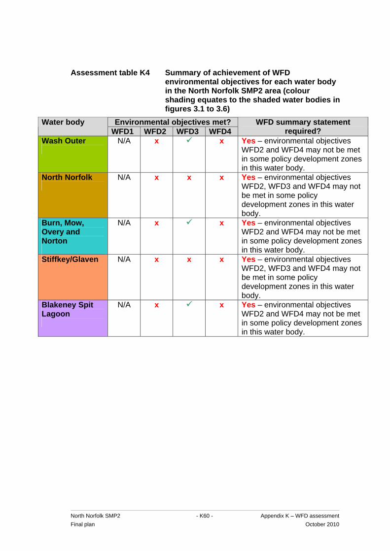
North Norfolk SMP2 - K60 - Appendix K – WFD assessment Final plan October 2010
Assessment table K4 Summary of achievement of WFD environmental objectives for each water body in the North Norfolk SMP2 area (colour shading equates to the shaded water bodies in figures 3.1 to 3.6)
Environmental objectives met? Water body WFD1 WFD2 WFD3 WFD4
WFD summary statement required?
Wash Outer
N/A x x Yes – environmental objectives WFD2 and WFD4 may not be met in some policy development zones in this water body.
North Norfolk
N/A x x x Yes – environmental objectives WFD2, WFD3 and WFD4 may not be met in some policy development zones in this water body.
Burn, Mow, Overy and Norton
N/A x x Yes – environmental objectives WFD2 and WFD4 may not be met in some policy development zones in this water body.
Stiffkey/Glaven N/A x x x Yes – environmental objectives WFD2, WFD3 and WFD4 may not be met in some policy development zones in this water body.
Blakeney Spit Lagoon
N/A x x Yes – environmental objectives WFD2 and WFD4 may not be met in some policy development zones in this water body.
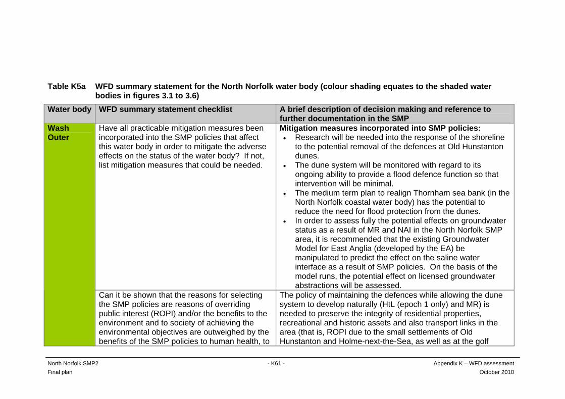
Table K5a WFD summary statement for the North Norfolk water body (colour shading equates to the shaded water
bodies in figures 3.1 to 3.6) Water body WFD summary statement checklist A brief description of decision making and reference to
further documentation in the SMP Have all practicable mitigation measures been incorporated into the SMP policies that affect this water body in order to mitigate the adverse effects on the status of the water body? If not, list mitigation measures that could be needed.
Mitigation measures incorporated into SMP policies: • Research will be needed into the response of the shoreline
to the potential removal of the defences at Old Hunstanton dunes.
• The dune system will be monitored with regard to its ongoing ability to provide a flood defence function so that intervention will be minimal.
• The medium term plan to realign Thornham sea bank (in the North Norfolk coastal water body) has the potential to reduce the need for flood protection from the dunes.
• In order to assess fully the potential effects on groundwater status as a result of MR and NAI in the North Norfolk SMP area, it is recommended that the existing Groundwater Model for East Anglia (developed by the EA) be manipulated to predict the effect on the saline water interface as a result of SMP policies. On the basis of the model runs, the potential effect on licensed groundwater abstractions will be assessed.
Wash Outer
Can it be shown that the reasons for selecting the SMP policies are reasons of overriding public interest (ROPI) and/or the benefits to the environment and to society of achieving the environmental objectives are outweighed by the benefits of the SMP policies to human health, to
The policy of maintaining the defences while allowing the dune system to develop naturally (HtL (epoch 1 only) and MR) is needed to preserve the integrity of residential properties, recreational and historic assets and also transport links in the area (that is, ROPI due to the small settlements of Old Hunstanton and Holme-next-the-Sea, as well as at the golf
North Norfolk SMP2 - K61 - Appendix K – WFD assessment Final plan October 2010
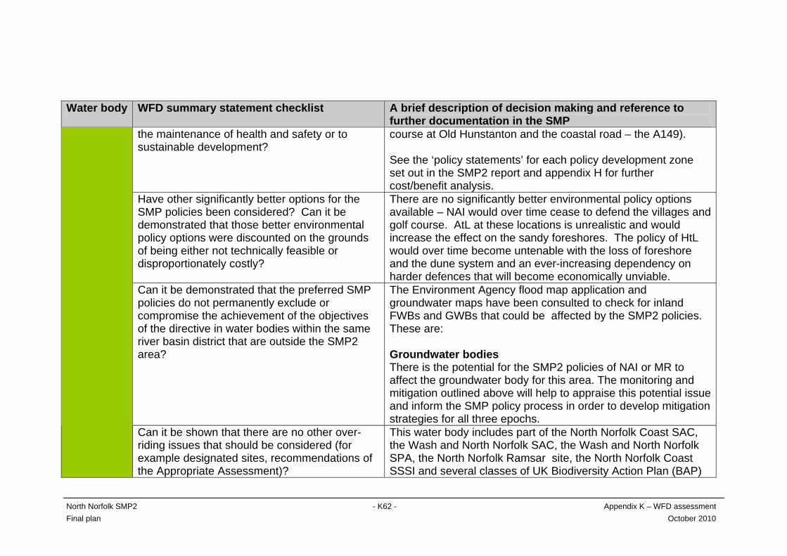
North Norfolk SMP2 - K62 - Appendix K – WFD assessment Final plan October 2010
Water body WFD summary statement checklist A brief description of decision making and reference to further documentation in the SMP
the maintenance of health and safety or to sustainable development?
course at Old Hunstanton and the coastal road – the A149). See the ‘policy statements’ for each policy development zone set out in the SMP2 report and appendix H for further cost/benefit analysis.
Have other significantly better options for the SMP policies been considered? Can it be demonstrated that those better environmental policy options were discounted on the grounds of being either not technically feasible or disproportionately costly?
There are no significantly better environmental policy options available – NAI would over time cease to defend the villages and golf course. AtL at these locations is unrealistic and would increase the effect on the sandy foreshores. The policy of HtL would over time become untenable with the loss of foreshore and the dune system and an ever-increasing dependency on harder defences that will become economically unviable.
Can it be demonstrated that the preferred SMP policies do not permanently exclude or compromise the achievement of the objectives of the directive in water bodies within the same river basin district that are outside the SMP2 area?
The Environment Agency flood map application and groundwater maps have been consulted to check for inland FWBs and GWBs that could be affected by the SMP2 policies. These are: Groundwater bodies There is the potential for the SMP2 policies of NAI or MR to affect the groundwater body for this area. The monitoring and mitigation outlined above will help to appraise this potential issue and inform the SMP policy process in order to develop mitigation strategies for all three epochs.
Can it be shown that there are no other over-riding issues that should be considered (for example designated sites, recommendations of the Appropriate Assessment)?
This water body includes part of the North Norfolk Coast SAC, the Wash and North Norfolk SAC, the Wash and North Norfolk SPA, the North Norfolk Ramsar site, the North Norfolk Coast SSSI and several classes of UK Biodiversity Action Plan (BAP)
North Norfolk SMP2 - K63 - Appendix K – WFD assessment Final plan October 2010
Water body WFD summary statement checklist A brief description of decision making and reference to further documentation in the SMP habitat. The intent of the SMP2 policy is to allow the coastline to develop naturally while defending the integrity of settlements, golf club etc. There may be losses and gains of designated habitat as a result and this has been considered in the Appropriate Assessment.
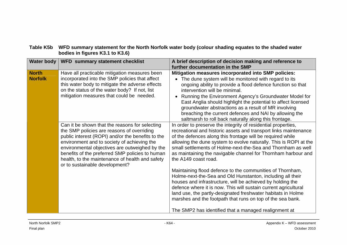
Table K5b WFD summary statement for the North Norfolk water body (colour shading equates to the shaded water bodies in figures K3.1 to K3.6) Water body WFD summary statement checklist A brief description of decision making and reference to
further documentation in the SMP Have all practicable mitigation measures been incorporated into the SMP policies that affect this water body to mitigate the adverse effects on the status of the water body? If not, list mitigation measures that could be needed.
Mitigation measures incorporated into SMP policies: • The dune system will be monitored with regard to its
ongoing ability to provide a flood defence function so that intervention will be minimal.
• Running the Environment Agency’s Groundwater Model for East Anglia should highlight the potential to affect licensed groundwater abstractions as a result of MR involving breaching the current defences and NAI by allowing the saltmarsh to roll back naturally along this frontage.
North Norfolk
Can it be shown that the reasons for selecting the SMP policies are reasons of overriding public interest (ROPI) and/or the benefits to the environment and to society of achieving the environmental objectives are outweighed by the benefits of the preferred SMP policies to human health, to the maintenance of health and safety or to sustainable development?
In order to preserve the integrity of residential properties, recreational and historic assets and transport links maintenance of the defences along this frontage will be required while allowing the dune system to evolve naturally. This is ROPI at the small settlements of Holme-next-the-Sea and Thornham as well as maintaining the navigable channel for Thornham harbour and the A149 coast road. Maintaining flood defence to the communities of Thornham, Holme-next-the-Sea and Old Hunstanton, including all their houses and infrastructure, will be achieved by holding the defence where it is now. This will sustain current agricultural land use, the partly-designated freshwater habitats in Holme marshes and the footpath that runs on top of the sea bank. The SMP2 has identified that a managed realignment at
North Norfolk SMP2 - K64 - Appendix K – WFD assessment Final plan October 2010

North Norfolk SMP2 - K65 - Appendix K – WFD assessment Final plan October 2010
Water body WFD summary statement checklist A brief description of decision making and reference to further documentation in the SMP Thornham sea bank, and the associated increase in tidal prism, could have a range of benefits. It could reduce pressure on the neighbouring bays, provide more sustainable local flood defence, create intertidal habitats and could support navigation in Thornham harbour channel. Based on the current condition and height of the sea bank, major improvement works would be needed around 2075. This may not be affordable and so require a change in flood risk management policy. However, some of these potential benefits are uncertain and they are outweighed by the direct negative effects, leading to a HtL policy. The SMP’s action plan contains a programme of actions (monitoring, consultation and assessments, including a review of historic attempts to increase the tidal prism in Thornham harbour) to investigate the potential positive and negative effects described above. Based on this, the next SMP will review the medium- and long-term policies for this PDZ. The policy at Holkham dunes to allow the dunes to develop naturally while maintaining the defences is needed to preserve the integrity of residential properties at Holkham and Wells-next -the-Sea, recreational and historic assets such as the camping and caravan park on Holkham estate and transport links. The planned policy at the Cley to Salthouse ridge to allow the shingle ridge to roll back naturally over time with the minimum of intervention for flood defence will continue to protect the villages
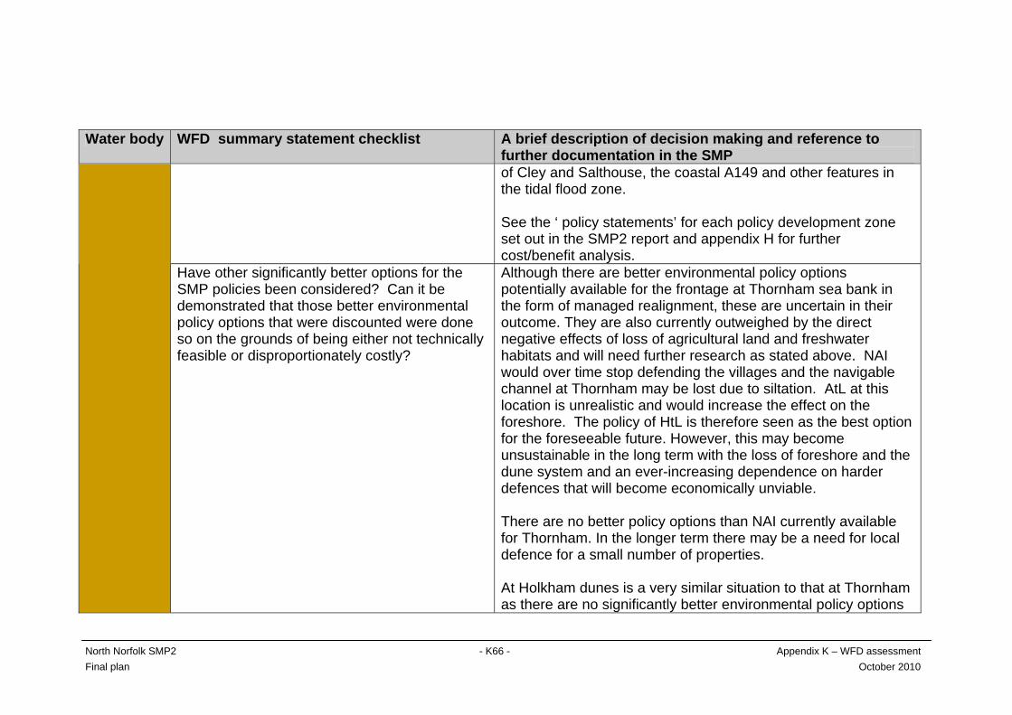
North Norfolk SMP2 - K66 - Appendix K – WFD assessment Final plan October 2010
Water body WFD summary statement checklist A brief description of decision making and reference to further documentation in the SMP of Cley and Salthouse, the coastal A149 and other features in the tidal flood zone. See the ‘ policy statements’ for each policy development zone set out in the SMP2 report and appendix H for further cost/benefit analysis.
Have other significantly better options for the SMP policies been considered? Can it be demonstrated that those better environmental policy options that were discounted were done so on the grounds of being either not technically feasible or disproportionately costly?
Although there are better environmental policy options potentially available for the frontage at Thornham sea bank in the form of managed realignment, these are uncertain in their outcome. They are also currently outweighed by the direct negative effects of loss of agricultural land and freshwater habitats and will need further research as stated above. NAI would over time stop defending the villages and the navigable channel at Thornham may be lost due to siltation. AtL at this location is unrealistic and would increase the effect on the foreshore. The policy of HtL is therefore seen as the best option for the foreseeable future. However, this may become unsustainable in the long term with the loss of foreshore and the dune system and an ever-increasing dependence on harder defences that will become economically unviable. There are no better policy options than NAI currently available for Thornham. In the longer term there may be a need for local defence for a small number of properties. At Holkham dunes is a very similar situation to that at Thornham as there are no significantly better environmental policy options

North Norfolk SMP2 - K67 - Appendix K – WFD assessment Final plan October 2010
Water body WFD summary statement checklist A brief description of decision making and reference to further documentation in the SMP available for this frontage. NAI would over time stop defending the villages and other assets mentioned above. AtL at this location is unrealistic and would increase the effect on the foreshore. The policy of HtL would over time become unsustainable with the loss of foreshore and the dune system and an ever-increasing dependence on harder defences that will become economically unviable. At the Cley to Salthouse shingle ridge there are no significantly better environmental policy options available. NAI would stop defending the villages of Cley and Salthouse over time. AtL at this location is unrealistic as it would be working against the natural processes along this stretch of the coastline. The policy of HtL would become unsustainable over time with the loss of the shingle predicted and an ever-increasing dependence on harder defences that will become economically unviable.
Can it be demonstrated that the SMP policies do not permanently exclude or compromise achieving the objectives of the directive in water bodies within the same river basin district that are outside the SMP2 area?
The Environment Agency flood map application and groundwater maps have been consulted to check for inland freshwater and groundwater bodies that could be affected by the SMP2 policies. These are: Groundwater bodies There is the potential for any SMP2 policy of NAI or MR to affect the GWB for this area. The monitoring and mitigation outlined above will help to appraise this potential issue and inform the SMP policy process in order to develop mitigation strategies for all three epochs.
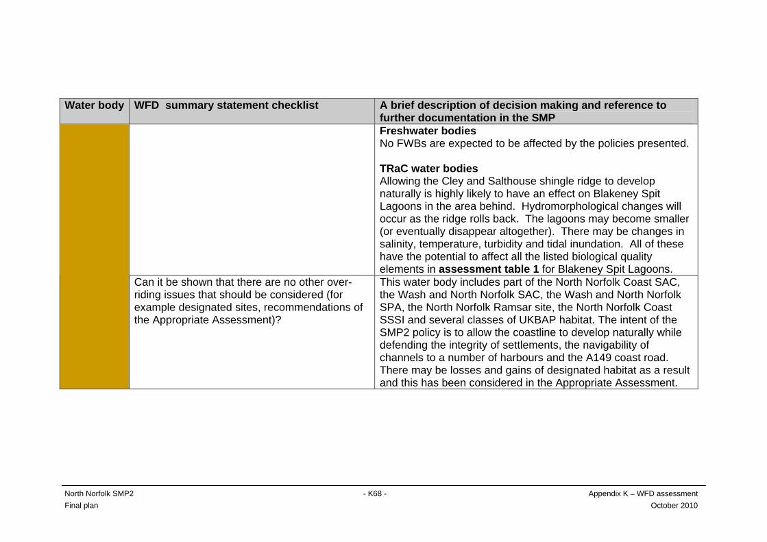
North Norfolk SMP2 - K68 - Appendix K – WFD assessment Final plan October 2010
Water body WFD summary statement checklist A brief description of decision making and reference to further documentation in the SMP Freshwater bodies No FWBs are expected to be affected by the policies presented. TRaC water bodies Allowing the Cley and Salthouse shingle ridge to develop naturally is highly likely to have an effect on Blakeney Spit Lagoons in the area behind. Hydromorphological changes will occur as the ridge rolls back. The lagoons may become smaller (or eventually disappear altogether). There may be changes in salinity, temperature, turbidity and tidal inundation. All of these have the potential to affect all the listed biological quality elements in assessment table 1 for Blakeney Spit Lagoons.
Can it be shown that there are no other over-riding issues that should be considered (for example designated sites, recommendations of the Appropriate Assessment)?
This water body includes part of the North Norfolk Coast SAC, the Wash and North Norfolk SAC, the Wash and North Norfolk SPA, the North Norfolk Ramsar site, the North Norfolk Coast SSSI and several classes of UKBAP habitat. The intent of the SMP2 policy is to allow the coastline to develop naturally while defending the integrity of settlements, the navigability of channels to a number of harbours and the A149 coast road. There may be losses and gains of designated habitat as a result and this has been considered in the Appropriate Assessment.
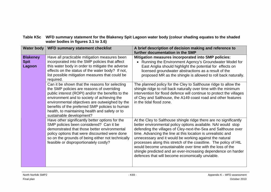
Table K5c WFD summary statement for the Blakeney Spit Lagoon water body (colour shading equates to the shaded water bodies in figures 3.1 to 3.6) Water body WFD summary statement checklist A brief description of decision making and reference to
further documentation in the SMP Have all practicable mitigation measures been incorporated into the SMP policies that affect this water body in order to mitigate the adverse effects on the status of the water body? If not, list possible mitigation measures that could be required.
Mitigation measures incorporated into SMP policies: • Running the Environment Agency’s Groundwater Model for
East Anglia should highlight the potential for effects on licensed groundwater abstractions as a result of the proposed MR as the shingle is allowed to roll back naturally. .
Can it be shown that the reasons for selecting the SMP policies are reasons of overriding public interest (ROPI) and/or the benefits to the environment and to society of achieving the environmental objectives are outweighed by the benefits of the preferred SMP policies to human health, to maintaining health and safety or to sustainable development?
The planned policy for the Cley to Salthouse ridge to allow the shingle ridge to roll back naturally over time with the minimum intervention for flood defence will continue to protect the villages of Cley and Salthouse, the A149 coast road and other features in the tidal flood zone.
Blakeney Spit Lagoon
Have other significantly better options for the SMP policies been considered? Can it be demonstrated that those better environmental policy options that were discounted were done so on the grounds of being either not technically feasible or disproportionately costly?
At the Cley to Salthouse shingle ridge there are no significantly better environmental policy options available. NAI would stop defending the villages of Cley-next-the-Sea and Salthouse over time. Advancing the line at this location is unrealistic and unnecessary and it would be working against the natural processes along this stretch of the coastline. The policy of HtL would become unsustainable over time with the loss of the shingle predicted and an ever-increasing dependence on harder defences that will become economically unviable.
North Norfolk SMP2 - K69 - Appendix K – WFD assessment Final plan October 2010
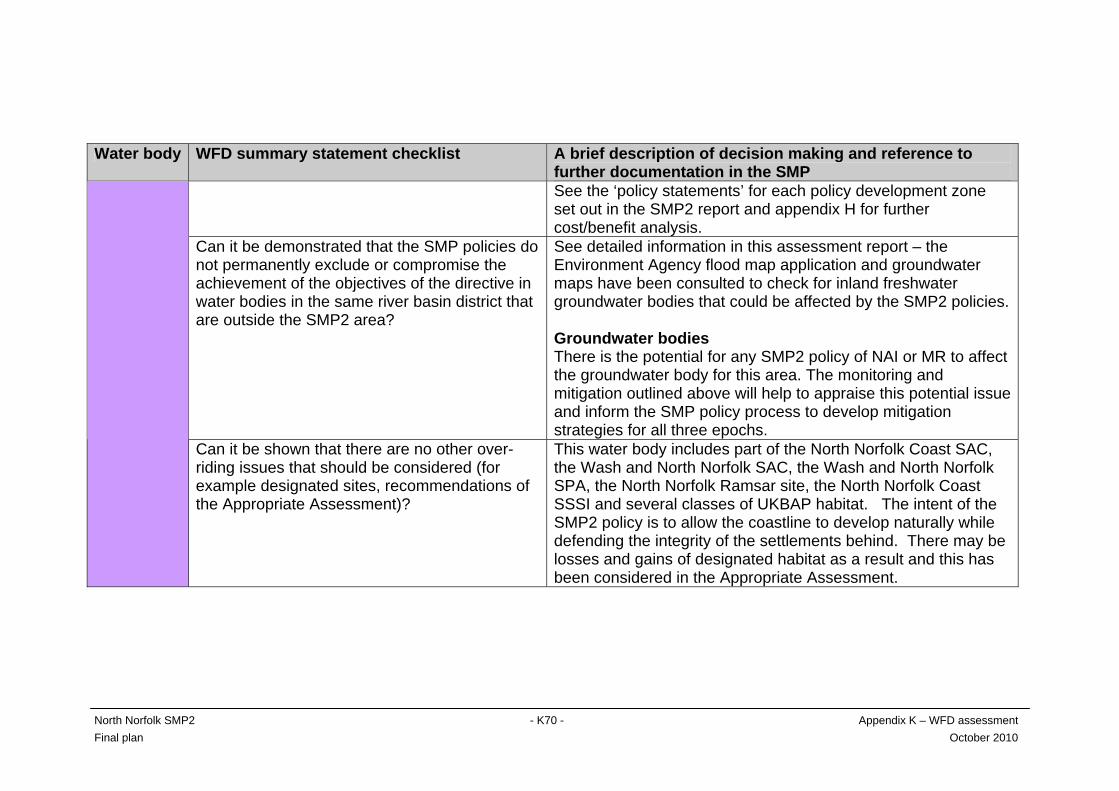
North Norfolk SMP2 - K70 - Appendix K – WFD assessment Final plan October 2010
Water body WFD summary statement checklist A brief description of decision making and reference to further documentation in the SMP See the ‘policy statements’ for each policy development zone set out in the SMP2 report and appendix H for further cost/benefit analysis.
Can it be demonstrated that the SMP policies do not permanently exclude or compromise the achievement of the objectives of the directive in water bodies in the same river basin district that are outside the SMP2 area?
See detailed information in this assessment report – the Environment Agency flood map application and groundwater maps have been consulted to check for inland freshwater groundwater bodies that could be affected by the SMP2 policies. Groundwater bodies There is the potential for any SMP2 policy of NAI or MR to affect the groundwater body for this area. The monitoring and mitigation outlined above will help to appraise this potential issue and inform the SMP policy process to develop mitigation strategies for all three epochs.
Can it be shown that there are no other over-riding issues that should be considered (for example designated sites, recommendations of the Appropriate Assessment)?
This water body includes part of the North Norfolk Coast SAC, the Wash and North Norfolk SAC, the Wash and North Norfolk SPA, the North Norfolk Ramsar site, the North Norfolk Coast SSSI and several classes of UKBAP habitat. The intent of the SMP2 policy is to allow the coastline to develop naturally while defending the integrity of the settlements behind. There may be losses and gains of designated habitat as a result and this has been considered in the Appropriate Assessment.
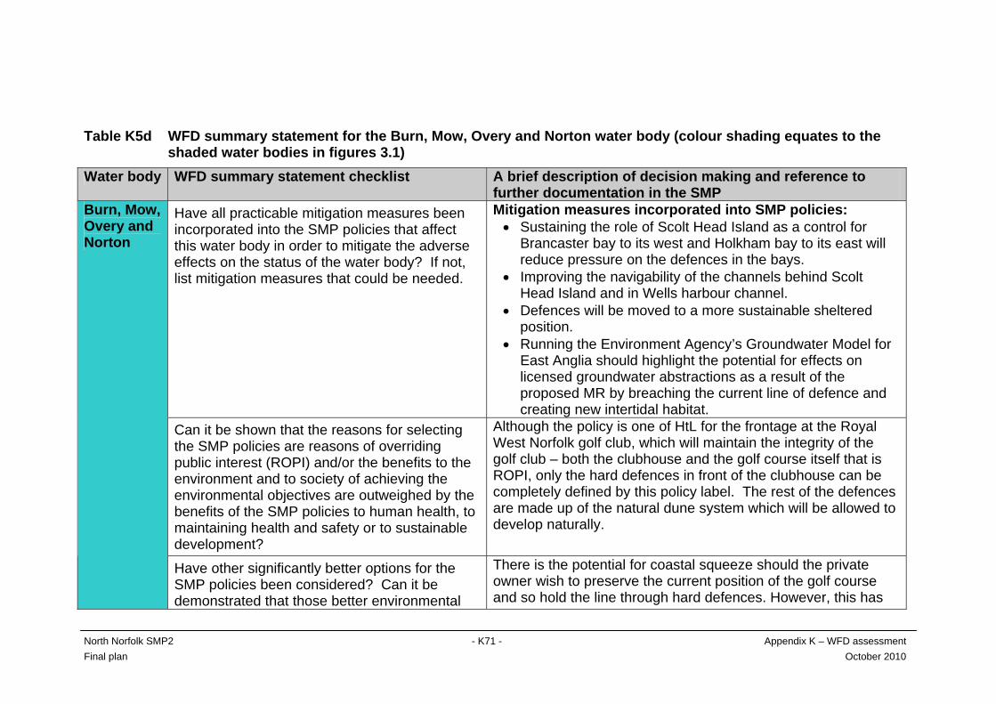
Table K5d WFD summary statement for the Burn, Mow, Overy and Norton water body (colour shading equates to the shaded water bodies in figures 3.1) Water body WFD summary statement checklist A brief description of decision making and reference to
further documentation in the SMP Have all practicable mitigation measures been incorporated into the SMP policies that affect this water body in order to mitigate the adverse effects on the status of the water body? If not, list mitigation measures that could be needed.
Mitigation measures incorporated into SMP policies: • Sustaining the role of Scolt Head Island as a control for
Brancaster bay to its west and Holkham bay to its east will reduce pressure on the defences in the bays.
• Improving the navigability of the channels behind Scolt Head Island and in Wells harbour channel.
• Defences will be moved to a more sustainable sheltered position.
• Running the Environment Agency’s Groundwater Model for East Anglia should highlight the potential for effects on licensed groundwater abstractions as a result of the proposed MR by breaching the current line of defence and creating new intertidal habitat.
Can it be shown that the reasons for selecting the SMP policies are reasons of overriding public interest (ROPI) and/or the benefits to the environment and to society of achieving the environmental objectives are outweighed by the benefits of the SMP policies to human health, to maintaining health and safety or to sustainable development?
Although the policy is one of HtL for the frontage at the Royal West Norfolk golf club, which will maintain the integrity of the golf club – both the clubhouse and the golf course itself that is ROPI, only the hard defences in front of the clubhouse can be completely defined by this policy label. The rest of the defences are made up of the natural dune system which will be allowed to develop naturally.
Burn, Mow, Overy and Norton
Have other significantly better options for the SMP policies been considered? Can it be demonstrated that those better environmental
There is the potential for coastal squeeze should the private owner wish to preserve the current position of the golf course and so hold the line through hard defences. However, this has
North Norfolk SMP2 - K71 - Appendix K – WFD assessment Final plan October 2010

North Norfolk SMP2 - K72 - Appendix K – WFD assessment Final plan October 2010
Water body WFD summary statement checklist A brief description of decision making and reference to further documentation in the SMP
policy options that were discounted were done so on the grounds of being either technically unfeasible or disproportionately costly?
not been the case on previous occasions when the golf club has allowed the dunes to develop naturally and has moved the course as necessary. This scenario cannot, however, be applied to the clubhouse itself as this is defended with hard defences. This will require review and discussions with the private owner as a change of policy in the longer term may be needed to prevent the potential for deterioration in ecological potential for this water body. See the ‘policy statements’ for each policy development zone set out in the SMP2 report and appendix H for further cost/benefit analysis.
Can it be demonstrated that the SMP policies do not permanently exclude or compromise the achievement of the objectives of the directive in water bodies in the same river basin district that are outside the SMP2 area?
The Environment Agency flood map application and groundwater maps have been consulted to check for inland freshwater and groundwater bodies that could be affected by the SMP2 policies. These are: Groundwater bodies There is the potential for any SMP2 policy of NAI or MR to affect the groundwater body for this area. The monitoring and mitigation outlined above will help to appraise this potential issue and inform the SMP policy process to develop mitigation strategies for all three epochs. Freshwater bodies The policy intention is that the River Burn valley beyond the tidal sluice will remain fresh water. The likelihood of the river valley
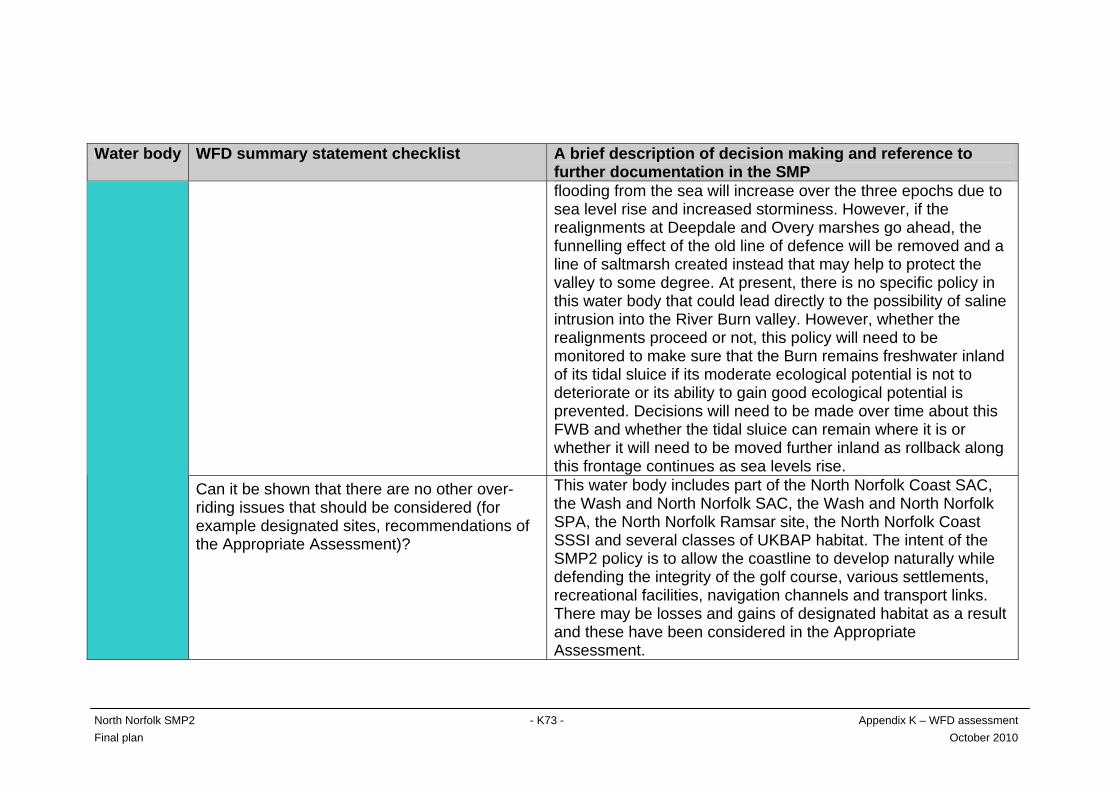
North Norfolk SMP2 - K73 - Appendix K – WFD assessment Final plan October 2010
Water body WFD summary statement checklist A brief description of decision making and reference to further documentation in the SMP flooding from the sea will increase over the three epochs due to sea level rise and increased storminess. However, if the realignments at Deepdale and Overy marshes go ahead, the funnelling effect of the old line of defence will be removed and a line of saltmarsh created instead that may help to protect the valley to some degree. At present, there is no specific policy in this water body that could lead directly to the possibility of saline intrusion into the River Burn valley. However, whether the realignments proceed or not, this policy will need to be monitored to make sure that the Burn remains freshwater inland of its tidal sluice if its moderate ecological potential is not to deteriorate or its ability to gain good ecological potential is prevented. Decisions will need to be made over time about this FWB and whether the tidal sluice can remain where it is or whether it will need to be moved further inland as rollback along this frontage continues as sea levels rise.
Can it be shown that there are no other over-riding issues that should be considered (for example designated sites, recommendations of the Appropriate Assessment)?
This water body includes part of the North Norfolk Coast SAC, the Wash and North Norfolk SAC, the Wash and North Norfolk SPA, the North Norfolk Ramsar site, the North Norfolk Coast SSSI and several classes of UKBAP habitat. The intent of the SMP2 policy is to allow the coastline to develop naturally while defending the integrity of the golf course, various settlements, recreational facilities, navigation channels and transport links. There may be losses and gains of designated habitat as a result and these have been considered in the Appropriate Assessment.
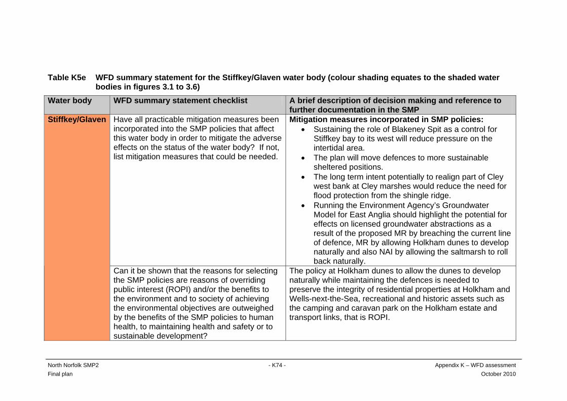
Table K5e WFD summary statement for the Stiffkey/Glaven water body (colour shading equates to the shaded water bodies in figures 3.1 to 3.6) Water body WFD summary statement checklist A brief description of decision making and reference to
further documentation in the SMP Have all practicable mitigation measures been incorporated into the SMP policies that affect this water body in order to mitigate the adverse effects on the status of the water body? If not, list mitigation measures that could be needed.
Mitigation measures incorporated in SMP policies: • Sustaining the role of Blakeney Spit as a control for
Stiffkey bay to its west will reduce pressure on the intertidal area.
• The plan will move defences to more sustainable sheltered positions.
• The long term intent potentially to realign part of Cley west bank at Cley marshes would reduce the need for flood protection from the shingle ridge.
• Running the Environment Agency’s Groundwater Model for East Anglia should highlight the potential for effects on licensed groundwater abstractions as a result of the proposed MR by breaching the current line of defence, MR by allowing Holkham dunes to develop naturally and also NAI by allowing the saltmarsh to roll back naturally.
Stiffkey/Glaven
Can it be shown that the reasons for selecting the SMP policies are reasons of overriding public interest (ROPI) and/or the benefits to the environment and to society of achieving the environmental objectives are outweighed by the benefits of the SMP policies to human health, to maintaining health and safety or to sustainable development?
The policy at Holkham dunes to allow the dunes to develop naturally while maintaining the defences is needed to preserve the integrity of residential properties at Holkham and Wells-next-the-Sea, recreational and historic assets such as the camping and caravan park on the Holkham estate and transport links, that is ROPI.
North Norfolk SMP2 - K74 - Appendix K – WFD assessment Final plan October 2010
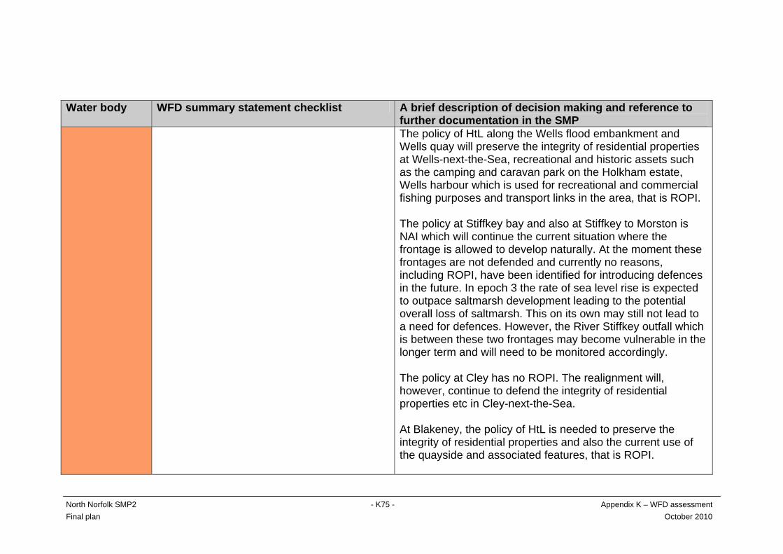
North Norfolk SMP2 - K75 - Appendix K – WFD assessment Final plan October 2010
Water body WFD summary statement checklist A brief description of decision making and reference to further documentation in the SMP The policy of HtL along the Wells flood embankment and Wells quay will preserve the integrity of residential properties at Wells-next-the-Sea, recreational and historic assets such as the camping and caravan park on the Holkham estate, Wells harbour which is used for recreational and commercial fishing purposes and transport links in the area, that is ROPI. The policy at Stiffkey bay and also at Stiffkey to Morston is NAI which will continue the current situation where the frontage is allowed to develop naturally. At the moment these frontages are not defended and currently no reasons, including ROPI, have been identified for introducing defences in the future. In epoch 3 the rate of sea level rise is expected to outpace saltmarsh development leading to the potential overall loss of saltmarsh. This on its own may still not lead to a need for defences. However, the River Stiffkey outfall which is between these two frontages may become vulnerable in the longer term and will need to be monitored accordingly. The policy at Cley has no ROPI. The realignment will, however, continue to defend the integrity of residential properties etc in Cley-next-the-Sea. At Blakeney, the policy of HtL is needed to preserve the integrity of residential properties and also the current use of the quayside and associated features, that is ROPI.
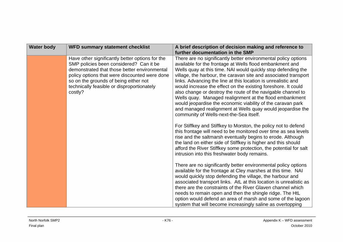
North Norfolk SMP2 - K76 - Appendix K – WFD assessment Final plan October 2010
Water body WFD summary statement checklist A brief description of decision making and reference to further documentation in the SMP
Have other significantly better options for the SMP policies been considered? Can it be demonstrated that those better environmental policy options that were discounted were done so on the grounds of being either not technically feasible or disproportionately costly?
There are no significantly better environmental policy options available for the frontage at Wells flood embankment and Wells quay at this time. NAI would quickly stop defending the village, the harbour, the caravan site and associated transport links. Advancing the line at this location is unrealistic and would increase the effect on the existing foreshore. It could also change or destroy the route of the navigable channel to Wells quay. Managed realignment at the flood embankment would jeopardise the economic viability of the caravan park and managed realignment at Wells quay would jeopardise the community of Wells-next-the-Sea itself. For Stiffkey and Stiffkey to Morston, the policy not to defend this frontage will need to be monitored over time as sea levels rise and the saltmarsh eventually begins to erode. Although the land on either side of Stiffkey is higher and this should afford the River Stiffkey some protection, the potential for salt intrusion into this freshwater body remains. There are no significantly better environmental policy options available for the frontage at Cley marshes at this time. NAI would quickly stop defending the village, the harbour and associated transport links. AtL at this location is unrealistic as there are the constraints of the River Glaven channel which needs to remain open and then the shingle ridge. The HtL option would defend an area of marsh and some of the lagoon system that will become increasingly saline as overtopping
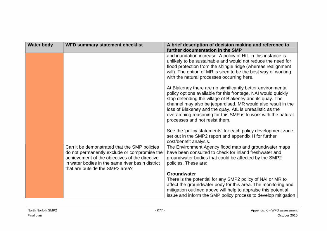
North Norfolk SMP2 - K77 - Appendix K – WFD assessment Final plan October 2010
Water body WFD summary statement checklist A brief description of decision making and reference to further documentation in the SMP and inundation increase. A policy of HtL in this instance is unlikely to be sustainable and would not reduce the need for flood protection from the shingle ridge (whereas realignment will). The option of MR is seen to be the best way of working with the natural processes occurring here. At Blakeney there are no significantly better environmental policy options available for this frontage. NAI would quickly stop defending the village of Blakeney and its quay. The channel may also be jeopardised. MR would also result in the loss of Blakeney and the quay. AtL is unrealistic as the overarching reasoning for this SMP is to work with the natural processes and not resist them. See the ‘policy statements’ for each policy development zone set out in the SMP2 report and appendix H for further cost/benefit analysis.
Can it be demonstrated that the SMP policies do not permanently exclude or compromise the achievement of the objectives of the directive in water bodies in the same river basin district that are outside the SMP2 area?
The Environment Agency flood map and groundwater maps have been consulted to check for inland freshwater and groundwater bodies that could be affected by the SMP2 policies. These are: Groundwater There is the potential for any SMP2 policy of NAI or MR to affect the groundwater body for this area. The monitoring and mitigation outlined above will help to appraise this potential issue and inform the SMP policy process to develop mitigation
North Norfolk SMP2 - K78 - Appendix K – WFD assessment Final plan October 2010
Water body WFD summary statement checklist A brief description of decision making and reference to further documentation in the SMP strategies for all three epochs. Freshwater Both the River Stiffkey and the River Glaven FWBs are in this water body. The Stiffkey outfall ties into higher ground on both sides. However in PDZ2M and PDZ3B (to either side), a policy of NAI is planned. As sea levels rise, storminess increases and these two units roll back, the defence of the outfall may need to be reviewed, especially on the Morston side, to avoid possible deterioration of the Stiffkey’s (and Binham tributary’s) ecological potential. The likelihood of the River Glaven flood plain flooding from the sea will increase over the three epochs due to sea level rise and increased storminess. However, if the realignments at Blakeney Freshes and Cley marshes go ahead to either side of the defended outfall, the funnelling effect of the old line of defence will be removed and a line of saltmarsh created instead. This may help to protect the defences at the outfall and the flood plain behind to some degree. At present there is no specific policy in this water body that could lead directly to the possibility of saline intrusion into the River Glaven flood plain. However, whether the realignments proceed or not, this policy will need to be monitored to make sure that the Glaven remains freshwater inland of its tidal sluice if its good ecological status (not yet assessed) is to be maintained.
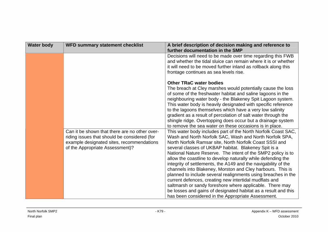
North Norfolk SMP2 - K79 - Appendix K – WFD assessment Final plan October 2010
Water body WFD summary statement checklist A brief description of decision making and reference to further documentation in the SMP Decisions will need to be made over time regarding this FWB and whether the tidal sluice can remain where it is or whether it will need to be moved further inland as rollback along this frontage continues as sea levels rise. Other TRaC water bodies The breach at Cley marshes would potentially cause the loss of some of the freshwater habitat and saline lagoons in the neighbouring water body - the Blakeney Spit Lagoon system. This water body is heavily designated with specific reference to the lagoons themselves which have a very low salinity gradient as a result of percolation of salt water through the shingle ridge. Overtopping does occur but a drainage system to remove the sea water on these occasions is in place.
Can it be shown that there are no other over-riding issues that should be considered (for example designated sites, recommendations of the Appropriate Assessment)?
This water body includes part of the North Norfolk Coast SAC, Wash and North Norfolk SAC, Wash and North Norfolk SPA, North Norfolk Ramsar site, North Norfolk Coast SSSI and several classes of UKBAP habitat. Blakeney Spit is a National Nature Reserve. The intent of the SMP2 policy is to allow the coastline to develop naturally while defending the integrity of settlements, the A149 and the navigability of the channels into Blakeney, Morston and Cley harbours. This is planned to include several realignments using breaches in the current defences, creating new intertidal mudflats and saltmarsh or sandy foreshore where applicable. There may be losses and gains of designated habitat as a result and this has been considered in the Appropriate Assessment.
North Norfolk SMP2 - K80 - Appendix K – WFD assessment Final plan October 2010
K3 Discussion and conclusions
Water Framework Directive summary statements have been completed for those relevant water bodies where there is potential for failure. The summary statements outline the reasons behind selecting the SMP2 policy and any mitigation measures that have been incorporated into the policies. There are no high status water bodies in the North Norfolk SMP2 area so this objective did not apply to the assessment. For most of the policy development zones, it is considered unlikely that the policies in the North Norfolk SMP2 will affect the current or target ecological status or potential of water bodies so the policies meet the environmental objectives. However, there are some policy development zones where the SMP2 policies have the potential to contribute to failure of environmental objectives WFD2 and WFD3 (as identified by ‘x’ under the ‘environmental objectives met?’ column in assessment table K3). The potential for failure of these objectives has been identified on a precautionary basis where possible concerns have been flagged up for further consideration. The three water bodies that have the greatest potential to fail their environmental objectives are the North Norfolk, Stiffkey/Glaven and the Blakeney Spit Lagoon water bodies. The lagoon system is made up of several very low salinity lagoons. The planned realignment at Cley marshes would encroach on this habitat and would potentially contribute to the loss of some of the lagoon system as the area of encroachment would become intertidal habitat. As well as this, the shingle ridge in front of the Blakeney Spit Lagoons would be allowed to roll back over time through natural processes. The rate of rollback is not expected to be great and the shingle ridge is therefore not expected to destroy the lagoon system by smothering it. However, with sea level rise and increased storminess, overtopping events are expected to become more frequent as is the potential for a breach in the ridge. Percolation of saltwater through the ridge is also expected to increase. These factors have the potential to contribute to an increase in the salinity of the lagoons which in turn could possibly change the BQEs for this water body on a permanent basis. The environmental objective WFD4 (no deterioration of groundwater status) may not be met for those water bodies affected by PDZs where managed realignment is planned, or where there is a policy of no active intervention. In particular, this applies those PDZs where planned realignment is by breaching the current defences and creating new intertidal habitat and/or where there is a FWB (not necessarily a WFD FWB) nearby. In order to assess fully the potential effects on groundwater status as a result of MR and NAI in the North Norfolk SMP area, it is recommended that the existing Groundwater Model for East Anglia (developed by the Environment Agency) be manipulated to predict the effects on the saline water interface and licensed groundwater abstractions.
North Norfolk SMP2 - K81 - Appendix K – WFD assessment Final plan October 2010
Mitigation measures are currently focussed on research and monitoring of the early stages of the planned policies to inform the policies for later epochs. The overall plan for the North Norfolk SMP is one of moving towards more sustainable shoreline management by increasing the role of natural processes. This recognition of the need to work with the coast, though not a tangible measure, could in itself be seen as mitigation as the overall aim is to work with, instead of against, natural processes. Significant areas of designated habitat could be affected by the policy plans in this SMP2. This has been addressed in the Habitats Regulations assessment. There may be potential for realigning the boundaries at each end of the North Norfolk SMP frontage. The eastern-most boundary of the SMP would appear to be the more promising of the two but further investigation, especially with regard to coastal processes, will be necessary. The opportunity to deliver the programme of measures has not been included in this retrospective assessment, as policies have already been set.
North Norfolk SMP2 - K82 - Appendix K – WFD assessment Final plan October 2010
References
Defra (2006) Shoreline Management Plan guidance volume 2: Procedures. Department for Environment, Food and Rural Affairs, March 2006, 77pp. Environment Agency (2009) Anglian River Basin Management Plan. Royal Haskoning (2008) Water Framework Directive: Retrospective assessment for the River Tyne to Flamborough Head SMP2. December 2008. Royal Haskoning (2009a) Water Framework Directive: Guidance for assessment of SMPs under WFD. January 2009. Royal Haskoning (2010) North Norfolk Shoreline Management Plan 2. Websites Environment Agency flood map [Accessed 25/02/09] http://maps.environment-agency.gov.uk/wiyby/mapController Environment Agency: ‘What’s in your backyard?’ for WFD [Accessed 28/02/09]
http://www.environment-agency.gov.uk/homeandleisure/37793.aspx