appendix l policy analysis pdf - placer county, ca
TRANSCRIPT

APPENDIX L POLICY ANALYSIS

Appendix L
AES 1 Amoruso Ranch Specific Plan
February 2016 Draft EIR
Appendix L
Policy Analyses
Appendix L
AES 2 Amoruso Ranch Specific Plan
February 2016 Draft EIR
Amoruso Ranch Specific Plan
Consistency with Placer County
LAFCO Policies
An Environmental Impact Report (EIR) must discuss “any inconsistencies between the proposed project and the applicable general plans.” CEQA
Guidelines §15125(d). For the Amoruso Ranch Specific Plan (ARSP or Proposed Project), the applicable plan is the City of Roseville General
Plan. The focus of this appendix is the identification of policies in the plans that apply to the proposed land uses of this particular project. This
appendix does not discuss policies that apply to the City itself or policies that apply only to some other type of land use not included in the
Proposed Project. Policies that are not applicable to the Proposed Project for either reason have not been included in the following discussion.
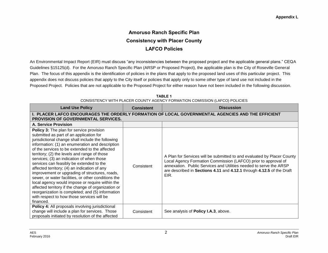
TABLE 1
CONSISTENCY WITH PLACER COUNTY AGENCY FORMATION COMISSION (LAFCO) POLICIES
Land Use Policy Consistent Discussion
I. PLACER LAFCO ENCOURAGES THE ORDERLY FORMATION OF LOCAL GOVERNMENTAL AGENCIES AND THE EFFICIENT PROVISION OF GOVERNMENTAL SERVICES.
A. Service Provision
Policy 3: The plan for service provision submitted as part of an application for jurisdictional change shall include the following information: (1) an enumeration and description of the services to be extended to the affected territory; (2) the levels and range of those services; (3) an indication of when those services can feasibly be extended to the affected territory; (4) an indication of any improvement or upgrading of structures, roads, sewer, or water facilities, or other conditions the local agency would impose or require within the affected territory if the change of organization or reorganization is completed; and (5) information with respect to how those services will be financed.
Consistent
A Plan for Services will be submitted to and evaluated by Placer County Local Agency Formation Commission (LAFCO) prior to approval of annexation. Public Services and Utilities needed to serve the ARSP are described in Sections 4.11 and 4.12.1 through 4.12.5 of the Draft EIR.
Policy 4: All proposals involving jurisdictional change will include a plan for services. Those proposals initiated by resolution of the affected
Consistent See analysis of Policy I.A.3, above.

Appendix L
AES 3 Amoruso Ranch Specific Plan
February 2016 Draft EIR
Land Use Policy Consistent Discussion
agency shall include the plan for service with the application. When proposals are initiated by petition, the Commission’s staff shall notify the affected agency and request a plan for service. In cases where the proposed jurisdictional change involves reorganization, the plan for service shall address all of the affected agencies.
II. PLACER LAFCO ENCOURAGES THE PRESERVATION OF AGRICULTURAL LAND AND OPEN SPACE RESOURCES
Policy 1: The Commission encourages all agencies within the County to adopt and exercise development policies that promote orderly development and logical boundaries and protect productive agricultural lands and significant open space areas, including riparian areas.
Consistent
The ARSP Area (project site) has historically been utilized to graze cattle. A total of 145.5 acres would remain in open space, preserving riparian areas onsite. No land within the project area is under a Williamson Act Contract. The California Department of Conservation Farmland Mapping and Monitoring Program (FMMP) classifies the project site as Farmland of Local Importance. The soils are generally unsuitable for many agricultural uses beyond grazing for the following reasons: (1) relatively low value of the property for agricultural purposes as defined by the FMMP, and (2) its historically poor ability to produce agricultural crops. The soil's slow permeability might be conducive to rice production, however, the high water consumption needed to grow this crop makes it infeasible and contrary to the City's water management goals. The Proposed Project will mitigate for the loss of agricultural land through preservation of 636 acres of open space on off-site lands within Placer County. See Mitigation Measure 4.1-1 in the Draft EIR.
Policy 2: Unless the subject area is substantially developed to its ultimate use, annexation to a city or special district will be linked to a proposal to develop and not be speculative in nature. Development plans, including a timetable, will be required as part of the LAFCO application for annexation.
Consistent
Annexation of the project site to the City of Roseville is requested in order to facilitate development of the proposed land use plan analyzed in the Draft EIR. The proposed plan for phasing of development is identified in Section 2 of the Draft EIR, Project Description.
Policy 3: Generally annexation of farmlands shall not be permitted when significant areas of non-productive farmland are already available. Development of vacant land within a city or
Consistent
See analysis of Policy II.1, above, regarding the project site’s suitability for agricultural uses. Land designated and zoned for residential development within the existing City of Roseville boundaries is fully entitled for future development, and according to development projections is anticipated to be built out by 2025. Since the early

Appendix L
AES 4 Amoruso Ranch Specific Plan
February 2016 Draft EIR
Land Use Policy Consistent Discussion
district should be developed prior to fringe areas.
1980s, the City has adopted several specific plans. These plans address growth issues and the unique constraints and opportunities found within each area, and provide a context within which implementation of the land use plan and associated public facilities can be successfully accomplished.
Policy 4: The Commission may set spheres of influence for unincorporated preserves for specified reasons such as to preserve the agricultural and open space areas or areas of possible future incorporation. Annexation of these areas by adjacent cities shall be discouraged. Annexation of these areas to special districts shall be approved only when the district’s purposes are consistent with the sphere in question.
Consistent See analysis of Policy II.3, immediately above.
III. Encourage logical patterns of growth and discourage urban sprawl.
A. Orderly Growth
Policy 1: The Commission encourages the urbanization of certain lands over others and hereby establishes a priority list for urbanization: (a) vacant or undeveloped land within the existing boundaries of a city; (b) vacant or underdeveloped land within the adopted sphere of influence of a city; (c) vacant or underdeveloped land outside the adopted sphere of influence of a city.
Consistent See analysis of Agricultural Land Policy II.3 above.
Policy 2: The commission will consider the following factors in determining logical growth patterns in reviewing proposals for annexation to a city or expansion of a city’s sphere of influence: (a) adjacency with existing and planned growth patterns of the city; (b) projected growth demand and relationship to remaining lands to be developed within the city and its existing sphere; (c) ability of the city to provide and fund needed services (utilities, transportation, public safety, recreation, libraries) to the levels defined by the city’s
Consistent
See analysis of Agricultural Land Policy II.3 above. The project site is contiguous to the approved Creekview Specific Plan (CSP) Area on the south, and the City-owned Al Johnson Wildlife Area lies to the west. As described in the Draft EIR, the City will be able to provide necessary public services and utilities to the project site in a logical fashion.

Appendix L
AES 5 Amoruso Ranch Specific Plan
February 2016 Draft EIR
Land Use Policy Consistent Discussion
general plan; (d) pending or anticipated development applications to the County for areas within a city’s existing sphere
Policy 5: The Commission discourages urban level development in unincorporated areas adjacent to city boundaries
Consistent Annexation of the project site to the City of Roseville has been proposed. See analysis of Orderly Growth Policy III.A.1, above.
C. Annexation
Policy 1: To allow for the evaluation of projected growth demand and its relationship to remaining lands to be developed within the city, proposals for annexations to a city or reorganizations including annexation to a city (except unincorporated islands and minor adjustments) shall be accompanied by the following:
(a) A market absorption study analyzing proposed uses in relation to similar uses within the city. The study shall:
I. cover a 15 to 20 year planning horizon,
II. include all major land use categories proposed within annexation (residential, commercial, office and industrial),
III. identify project and citywide buildout capacities for the proposed land uses,
IV. provide an analysis of the competitive strength of the affected city land uses within the regional market, and the proposed project land uses within the anticipated city capture of that regional market,
V. contain a breakdown of projected absorption and supply margins over time by both land use and by geographic planning area within
See analysis of Agricultural Land Policy II.3, above. A market absorption study will be submitted to and evaluated by LAFCO prior to approval of annexation. Alternatives considered but dismissed from detailed consideration, including off-site alternatives, are addressed in the Draft EIR, Section 6.

Appendix L
AES 6 Amoruso Ranch Specific Plan
February 2016 Draft EIR
Land Use Policy Consistent Discussion
the city. At a minimum, the analysis should distinguish projected absorption between the proposed annexation area and the existing (infill) portion of the city, and
VI. include a summary of key assumptions and methodologies used in generating the absorption projections.
(b) Analysis of alternative project sites located elsewhere within the city or its existing sphere. This analysis shall be included as an alternative in the environmental document prepared for the proposed annexation or reorganization including annexation. If such alternative sites are determined not to be feasible as defined by CEQA, the environmental document shall include a discussion of the reasons and relevant data used to make determinations. LAFCO staff shall be afforded the opportunity to comment on the adequacy of the alternatives analysis prior to certification of the environmental document.
Policy 2: Unless special circumstances can be demonstrated, city annexations or reorganizations including city annexations shall be discouraged if there are feasible alternative sites for the annexation proposal already within the city.
Consistent
See analysis of Agricultural Land Policy II.3, above. Land designated and zoned for residential development within the existing City of Roseville boundaries is fully entitled for future development, and according to development projections is anticipated to be built out by 2035. The feasibility of alternative sites to accommodate growth proposed by the project is assessed in the Draft EIR, Section 6.
Policy 3: Large development proposals that are proposed to be developed in phases may be annexed in phases, ensuring that growth occurs in a logical pattern.
Consistent
The project site is approximately 694.4 acres, and will be adjacent to the City of Roseville along the southern and southwest boundaries. It is proposed that the area be annexed in its entirety in a single proceeding to allow the City to comprehensively plan development of the site, rather than using a piecemeal approach.

Appendix L
AES 7 Amoruso Ranch Specific Plan
February 2016 Draft EIR
Land Use Policy Consistent Discussion
Policy 4: All city annexations shall be pre-zoned. No subsequent change may be made to the general plan or zoning for the annexed territory that is not in conformance to the pre-zoning designations for a period of two years after the completion of the annexation.
Consistent
Upon approval of the Proposed Project by the City, the property will be pre-zoned in accordance with the land use designations identified in the ARSP.
Amoroso Ranch Specific Plan
Consistency with Roseville
General Plan Policies
An EIR must discuss "any inconsistencies between the proposed project and the applicable general plans." CEQA Guidelines,§15125(d). For the
proposed project, the applicable plan is the City of Roseville General Plan. The focus of this appendix is the identification of policies in the
General Plan that apply to the proposed land uses of this particular project. This appendix does not discuss policies that apply to the City itself or
policies that apply only to some other type of land use not included in the proposed project. Policies that are not applicable to the proposed
project for either reason have not been included in the following discussion.
Although not required under CEQA, this Appendix discusses consistencies as well as inconsistencies between the proposed project and the
relevant policies of the General Plan. If an inconsistency has been identified, the analysis in this EIR focuses on whether that inconsistency may
contribute to some direct or reasonably foreseeable indirect environmental impact. An inconsistency between the proposed project and a policy in
the General Plan does not in itself mandate a finding of significance. Rather, like social and economic effects, a planning inconsistency is a factor
to be considered in determining the significance of changes in the physical environment caused by the proposed project. Finally, while this EIR
analyzes the proposed project's consistency with applicable policies, it is the City Council who will make the ultimate determination in regard to the
proposed project's consistency with the General Plan.

Appendix L
AES 8 Amoruso Ranch Specific Plan
February 2016 Draft EIR
TABLE 2 CONSISTENCY WITH CITY OF ROSEVILLE GENERAL PLAN
Policy Consistency Discussion
Land Use Element
Community Form General Policies
Policy 1: Ensure high quality development in new and existing development areas as defined through specific plans, the development review process and community design guidelines.
Consistent
Future land uses and development within the project site will be governed by the adopted ARSP, as well as development standards and design guidelines, ensuring high quality development through the implementation of the ARSP.
Policy 3: Continue to provide a full range of public services and maintain high levels of service, as specified in other elements of this Plan, including Public Facilities, Open Space and Conservation, Safety, Circulation and Parks and Recreation Elements.
Consistent
The Proposed Project will contribute toward the provision of necessary public services, and will include areas dedicated for parks, open space, and school purposes.
Policy 4 – Promote a diversity of residential living options (e.g. density ranges, housing types, affordability ranges), while ensuring community compatibility and well-designed residential development.
Consistent
The ARSP will provide for residential development at a variety of densities, ranging from low- to high density. In addition, the ARSP will provide affordable housing consistent with City requirements. The City requires that 10 percent of all new housing units be affordable. The Proposed Project would add 2,827 dwelling units to the City’s housing stock, of which 283 (10 percent) would be affordable units. In addition, 542 units would be zoned medium density residential (MDR) and 873 units would be zoned high-density residential (HDR) within the residential neighborhood, and another 109 HDR units would be located within the Community Commercial – Village District.
Policy 5: Promote land use patterns that result in the efficient use of urban lands and preservation of open space as specified in the Open Space and Conservation Element.
Consistent
Approximately 145.5 acres of the ARSP is proposed as open space, comprising nearly 21 percent of the total project site acreage. The ARSP represents an efficient use of land, combining residential development at a range of densities with commercial uses, open space, and parks and recreational opportunities.
Community Form – Relationship to Transit, Pedestrian, Air Quality (RTPAQ) Policies
Policy 1: Promote land use patterns that support a variety of transportation modes and accommodate pedestrian mobility.
Consistent
The ARSP circulation system includes a hierarchy of roadways, a pedestrian and bikeway network, and public transit linkages that are designed to connect with the existing City of Roseville and regional systems. The planned circulation system provides for connectivity of streets to adjacent land uses within, as well as outside, the project site with

Appendix L
AES 9 Amoruso Ranch Specific Plan
February 2016 Draft EIR
Policy Consistency Discussion
the extension of Westbrook Boulevard from the CSP Area to the south. Further, a comprehensive system of pedestrian and bikeway paths is proposed throughout the project site. This system of pedestrian paths and bikeways provides off-street linkages throughout the community, connecting to City of Roseville's existing and planned facilities to the south and east of the project site.
Policy 2 – Allow for land use patterns and mixed use development that integrate residential and non-residential land uses, such that residents may easily walk or bike to shopping, services, employment and leisure activities.
Consistent
The ARSP land use plan provides for an integration of residential uses with non-residential uses such as commercial areas, parks, open space, and an elementary school. As described above under RTPAQ Policy 1, these uses are connected by roadways, bicycle and pedestrian linkages.
Policy 3 – Concentrate higher intensity uses and appropriate support uses within close proximity of transit and bikeway corridors as identified in the Bicycle Master Plan. In addition, some component of public use such as parks, plazas, public buildings, community centers and/or libraries should be located within the corridors.
Consistent
Commercial and HDR uses within the project site are generally located along Westbrook Boulevard, which is a planned 6-lane arterial with transit and bicycle corridors. The planned park facilities and elementary school are readily accessible from cross streets of Westbrook Boulevard.
Policy 4 – Promote and encourage the location of employee services such as childcare, restaurants, banking facilities, convenient markets, etc., within major employment centers for the purpose of reducing midday service-related vehicle trips.
Consistent
The Community Commercial – Village District and Community Commercial areas within the ARSP would provide for a myriad of commercial services within concentrated areas of the project site, which would reduce midday service-related vehicle trips.
Policy 6 – Through City land use planning and development approvals, require that neighborhood serving uses (e.g. neighborhood commercial uses, day care, parks, schools, and other community facilities) be physically linked with adjacent residential neighborhoods.
Consistent
Parks and school facilities within the project site are linked by adjacent residential uses. See Figures 2-4 and 2-5 of the Draft EIR within Section 2, Project Description.
Community Form – Relationship of New Development (RND) Policies
Policy 1 – Require that new development areas and associated community-wide facilities (open space resources, parks, and libraries, etc.) be linked and oriented to existing development areas of the community through road networks, public transit systems, open space systems, bike way and pedestrian systems, and other physical connections.
Consistent See analysis of RTPAQ Policies 1 through 6 above.

Appendix L
AES 10 Amoruso Ranch Specific Plan
February 2016 Draft EIR
Policy Consistency Discussion
Community Form – Jobs/Housing and Economic Development (JH&ED)
Policy 1 – Strive for a land use mix and pattern of development that provides linkages between jobs and employment uses, will provide a reasonable jobs/housing balance, and will maintain the fiscal viability of the City.
Consistent
See Analysis of RTPAQ Policies above. Overall, the Proposed Project is projected to add more housing than jobs. This will cause a decrease in the City’s overall jobs/housing ratio, provide additional housing opportunities, and result in a slightly more balanced jobs to housing ratio. As a result, over time the increase in housing within the project site will help the City to achieve the environmental benefits associated with an improved jobs/housing ratio (such as reduced commuter mileage).
Policy 3 – Establish a standard process to analyzed the fiscal impacts of proposed development and require a fiscal impact analysis of all projects proposing a significant General Plan land use change as defined through the Economic Development Study/Plan.
Consistent A fiscal analysis will be prepared for the ARSP.
Policy 4 – The City may approve a project that is identified as having a negative fiscal impact on the City if overriding findings are made that the project benefits outweigh its impacts. Such benefits may relate to the provision of affordable housing, significant open space or recreation facilities, job creation, or other public benefits.
Consistent
The Proposed Project will provide a number of significant benefits to the City, including housing opportunities (both market-rate and affordable), and an improvement to the City’s existing job/housing ratio. Should the fiscal impact analysis to be prepared for the Proposed Project identify an operating deficit, and the City finds that the project benefits outweigh the impacts, the City’s findings will reflect this decision.
Policy 5 – Maintain land use patterns, intensities and densities that promote a positive business climate (e.g. supply of business professional, commercial and industrial lands).
Consistent The ARSP includes commercial uses. The development of these uses is anticipated to increase employment within the project site.
Community Design Policies
Policy 1 – Through the design review process, apply design standards that promote the use of high quality building materials, architectural and site designs, landscaping signage, and amenities
Consistent
Future land uses and development within the project site will be governed by the ARSP, as well as development standards and design guidelines, ensuring high quality development.
Policy 2 – Continue to develop and apply design standards that result in efficient site and building designs, pedestrian friendly projects that stimulate the use of alternative modes of transportation, and the
Consistent
Future land uses and development within the project site will be governed by the ARSP, as well as development standards and design guidelines, ensuring high quality development. The ARSP land use plan provides for an integration of residential uses with

Appendix L
AES 11 Amoruso Ranch Specific Plan
February 2016 Draft EIR
Policy Consistency Discussion
establishment of a functional relationship between adjacent developments.
non-residential uses such as commercial areas, parks, open space, and an elementary school. The Proposed Project would be designed to be compatible to the adjacent City of Roseville and CSP. As described above under RTPAQ Policy 1, these uses are connected by roadways and bicycle and pedestrian linkages both within the project site and to surrounding planning communities that are located within the City of Roseville.
Policy 3 – Encourage designs that strike a balance between the incorporation of aesthetic and development requirements, and the economic considerations associated with development.
Consistent See analysis under Community Design Policy 1.
Policy 4 – Promote flexibility in the design review process to achieve design objectives, and encourage projects with innovative, unique and creative architectural style and design.
Consistent See analysis under Community Design Policy 1.
Policy 6 – Through the design review process, encourage site and building designs that are in scale and compatible with adjacent development with respect to height, bulk, form mass, and community character.
Consistent
Development within the Proposed Project will be compatible with similar residential and community development areas adjacent to the project site and elsewhere within the City of Roseville.
Policy 7 – Encourage project designs that place a high priority and value on open space, and the preservation, enhancement and incorporation of natural resources and other features including consideration of topography, vegetation, wetlands, and water courses. Consistent
Approximately 145.5 acres of the ARSP are proposed as open space (OS), comprising nearly 21 percent of the total site acreage. OS land use and zoning are generally applied to lands that are environmentally sensitive or otherwise significant due to habitat, natural features, or man-made features. OS corridors provide for passive recreation opportunities, preservation of significant resources, viewsheds, potential flood water conveyance and retention, resource mitigation, wildlife movement corridors, and can function to improve the interface between uses.
Policy 8 – Encourage and promote the preservation of historic and/or unique, culturally and architecturally significant buildings, features and visual environments.
Consistent
There are no resources listed on or eligible for listing on the California Register of Historic Resources (CRHR) or the National Register of Historic Places (NRHP) within the 694.4-acre area of the project site proposed for development. The Proposed Project will result in demolition of the rural residence and dilapidated barn located within the project site; however, these structures do not qualify as historical resources under CEQA or historic properties under National Historic Preservation Act (NHPA).
Policy 9 – The location and preservation of native oak trees and oak woodlands shall be a primary factor in determining site design, building location, grading,
Consistent
The majority of the site is treeless. 28 oak trees are located within the proposed open space preserve in the southern portion of the project site. No oak trees would be removed.

Appendix L
AES 12 Amoruso Ranch Specific Plan
February 2016 Draft EIR
Policy Consistency Discussion
construction and landscaping, and in establishing the character of projects through their use as a unifying element in both new and existing development.
Growth Management General Policies
Policy 1 – Growth must provide a strong diversified economic base and a reasonable balance between employment and affordable housing.
Consistent See analysis under JH&ED Policy 4, above.
Policy 2 – Growth should occur on the basis that projected revenue should be sufficient to meet public costs.
Consistent See analysis under JH&ED Policy 4, above
Policy 3 – The City shall encourage a development pattern that is contiguous with existing development areas of the City.
Consistent
The development patterns of the Proposed Project will integrate with existing adjacent development areas that have recently been annexed by the City.
Policy 4 – Growth shall be managed to ensure that adequate public facilities and services, as defined in the Public Facilities Element, are planned and provided and the public health, safety and welfare is protected.
Consistent
As described in the Draft EIR, the Proposed Project will provide for adequate public services to serve project residents, and to protect public health, safety, and welfare. See Sections 4.11 and 4.12.1 through 4.12.5 of the Draft EIR. The Proposed Project would include public facilities and services required to serve the Plan Area in accordance with the City of Roseville’s General Plan. The utility infrastructure system would be designed to accommodate buildout of the project site and would be constructed in phases. Easements and dedications of improvements would be provided consistent with the ARSP, the project development agreement, and other applicable standards and requirements by the City of Roseville.
Policy 5 – The City shall accommodate projected population and employment growth in areas where the appropriate level of public infrastructure and services are planned or will be made available concurrent with development.
Consistent
The Proposed Project will provide infrastructure as needed to serve site development. See analysis of Growth Management Policy 4, above.
Policy 6 – The City shall use the specific plan process to ensure a comprehensive, logical growth process for new development areas (e.g., annexations) or any areas where significant land use changes are considered.
Consistent
The specific plan process applied to development of the project site is intended to satisfy the requirements of this policy. The specific plan is utilized to satisfy the City’s development standards and criteria prior to annexation.
Policy 7 – The City shall oppose urban density residential, commercial or industrial development in unincorporated areas unless adequate public facilities
Consistent
The project is currently unincorporated, but would be annexed into the City as a condition of development. The Proposed Project would include public facilities and services required to serve the
Appendix L
AES 13 Amoruso Ranch Specific Plan
February 2016 Draft EIR
Policy Consistency Discussion
and services can be provided and mechanisms to ensure their availability and provisions are secured during the land use entitlement process. It is the City’s preference that urban development occur within incorporated area.
project site in accordance with the City of Roseville’s General Plan. The utility infrastructure system would be designed to accommodate buildout consistent with the ARSP, the project development agreement, and other applicable standards and requirements of the City of Roseville.
Policy 8 – Manage growth in such a way to ensure that significant open space areas will be preserved.
Consistent Approximately 145.5 acres of the ARSP are proposed as open space, comprising nearly 21 percent of the total Plan Area acreage.
Policy 9 – Retain and enhance Roseville’s identity and character to ensure that Roseville, even as it grows, remains consistent with the Growth Management Visioning Committee’s Vision Statement.
Consistent
The project site is within an area that was identified by the City’s Growth Management Visioning Committee in 2005 as the next logical growth area. Development of the Proposed Project would be consistent with the City of Roseville’s Growth Management Visioning Committee’s Vision Statement.
Policy 10 – Work aggressively to address traffic generated outside of Roseville by working in collaboration with neighboring jurisdictions, regional, state, and federal entities to ensure traffic through Roseville is mitigated by regional solutions. Ensure that transportation solutions are supported by land-use and design policies that promote walking, biking, and transit, consistent with the Growth management Visioning Committee’s Vision Statement.
Consistent
Traffic impacts associated with the development of the Proposed Project are analyzed in Section 4.3, Transportation and Circulation, of the EIR. As identified, the Proposed Project will participate in a number of fee programs adopted by both the City and other regional entities to address future infrastructure improvement needs. The proposed circulation system includes a hierarchy of roadways, a pedestrian and bikeway network, and public transit linkages that are designed to connect with existing city and regional systems. The planned circulation system provides for connectivity of streets to adjacent land uses within, as well as outside, the project site with the extension of Westbrook Blvd. Furthermore, a comprehensive system of pedestrian and bikeway paths is proposed throughout the project site. This system of pedestrian and bikeway paths provides off-street linkages throughout the community, connecting to Roseville’s existing and planned facilities to the south and east of the project site.
Growth Management – Growth Areas Policies
Policy 1 – The City may consider modification to the General Plan land use allocation where adequate public services and facilities and preservation and conservation of natural resources can be provided in conjunction with the following:
a. Additional land to accommodate demand for housing or employment uses
Consistent
As described in the Draft EIR, adequate public services and facilities can be provided to serve the project site. The ARSP will also be subject to a Community Service Assessment (CSA) that will provide funding for public services and to achieve fiscal neutrality to the City. The Proposed Project will provide a number of significant benefits to the City, including housing opportunities (both market-rate and affordable), and an improvement to the City’s existing job/housing ratio.

Appendix L
AES 14 Amoruso Ranch Specific Plan
February 2016 Draft EIR
Policy Consistency Discussion
b. Projects that will provide public benefit to the City, including the provisions of public transit services
c. Ensure that growth provides benefits to the Community as a whole and weigh community benefits against fiscal costs
Policy 2 – Prior to the consideration of any General Plan amendment to modify the land use allocation or expand the City’s boundaries or sphere of influence, the City shall complete or cause to be completed the following City-wide studies/plans:
a. Long-Range Transit Plan b. Economic Development Studies c. Public Facilities and Services Capacity Study d. Transportation System Capacity Study
The studies shall define overall holding capacities and identify additional performance standards that will need to be met to ensure the achievement of the goals and policies of the General Plan.
Consistent
These studies have been, or will be completed prior to the City Council consideration. Impacts of the Proposed Project on public services, public facilities, and transportation and circulation have been analyzed within Section 4.3, Transportation and Circulation, of the Draft EIR.
Policy 3 – The City shall require the submittal of a specific plan for the consideration of new development areas or any areas where a significantly modification to the General Plan land use allocation is proposed. The specific plan process shall, at a minimum, include the following:
a. General Plan Amendment b. Development Agreement c. Zoning Entitlements d. Environmental Impact Report e. Phasing, Financing, Capital Improvement Plan f. Fiscal Impact Analysis
Consistent These studies have been, or will be, completed prior to or in conjunction with the City Council’s consideration of the ARSP.
Policy 4 – Specific plans will be evaluated based on the following minimum criteria:
a. Government Code requirements for specific plans
b. Demonstrated consistency with General Plan goals and policies
Consistent
This document serves as the EIR analyzing the potential impacts of the implementation of the ARSP, including the annexation of the project site, into the City of Roseville. The policies set forth in the City of Roseville General Plan are analyzed contingent to the resources being discussed in Section 4 of the Draft EIR. The consistency of the Proposed Project with the General Plan is discussed in this appendix, in relation to specifically applicable policies.

Appendix L
AES 15 Amoruso Ranch Specific Plan
February 2016 Draft EIR
Policy Consistency Discussion
c. Demonstrated consistency with the identified City-wide studies and holding capacity analysis
d. Justification for proposed specific plan boundaries
e. Community benefit f. Ability to mitigate impacts g. Impact on the City’s growth pattern
Each specific plan proposal shall include, with its initial submittal, a full analysis, of how the plan complies with and relates to the above factors. The specific plans’ consistency with the General Plan, and its relation to other identified criteria, will be a primary factor in determining whether the proposal will or will not be considered by the City.
Policy 5 – Apply the City’s adopted Guiding Principles to any new development proposed in and out of the City’s corporate boundaries, which his not already part of an adopted Specific Plan or within the infill area:
1. Any development proposal west of Roseville shall, on a stand-alone basis, have an overall natural or positive fiscal impact on the City’s General Fund Services.
2. Any development proposal west of Roseville shall include logical growth/plan boundaries and an east to west growth pattern
3. Any development proposal west of Roseville shall not conflict with the Pleasant Grove Wastewater Treatment Plan and future Power Generation Facility.
4. Any development proposal west of Roseville shall maintain the integrity of existing neighborhoods and create a sense of place in new neighborhoods.
5. Any development proposal west of Roseville shall include a plan to ensure full funding and maintenance of improvements and services at no cost to existing residents (including increased utility rates). A proposal shall not
Consistent
Consistency with the Guiding Principals is discussed in Section 7 of the Draft EIR. The ARSP will complement the adjacent specific plans designed for integration into the City. The Proposed Project does not conflict either with the Pleasant Grove Wastewater Treatment Plant (PGWWTP) or the Roseville Energy Park (REP). The ARSP will contribute CIP and fair-share funds for improvements to City and regional roadways. As described in Section 4.11.1 Public Utilities – Water Supply of the Draft EIR, with mitigation, adequate water supplies exist to serve the Proposed Project. The project site lies within the City/County Memorandum of Understanding (MOU) area. The Proposed Project will provide on-site flood control improvement, and will contribute fees towards City improvements to the regional retention facility proposed for the Al Johnson Wildlife Area. The Proposed Project includes development of an elementary school, and will provide fee funding under terms of the proposed development agreement. The Proposed Project will maintain the University Creek corridor as connecting open space throughout the project site.

Appendix L
AES 16 Amoruso Ranch Specific Plan
February 2016 Draft EIR
Policy Consistency Discussion
burden/increase the cost, or diminish the supply and reliability of services.
6. Any development proposal west of Roseville shall aid in regional traffic solutions and in right of way preservation.
7. Any development proposal west of Roseville that does not have sufficient supply of surface water shall secure additional supplies above what the City currently has available. Development proposals shall also provide financial assistance to incorporate the new source of supply into the City’s water supply portfolio (surface water, groundwater and recycled water); and development proposals shall include measures to reduce water demand by implementing the use of conservation best management practices, recycled water and other off-sets.
8. Any development proposal west of Roseville shall consider development potential within the entire City/County MOU Transition Area in the design and sizing of infrastructure improvements.
9. Any development proposal west of Roseville shall aid in resolution of regional storm water retention.
10. Any development proposal west of Roseville shall incorporate mechanisms to ensure new schools are available to serve the residents and shall not impact existing schools.
11. Any development proposal west of Roseville shall include a significant interconnected public open space component/conservation plan in coordination with the City of Roseville/U.S. Fish and Wildlife Service MOU.
12. Any development proposal west of Roseville shall include a public participation component to keep the public informed and solicit feedback throughout the specific plan process.

Appendix L
AES 17 Amoruso Ranch Specific Plan
February 2016 Draft EIR
Policy Consistency Discussion
13. Any development proposal west of Roseville shall provide a “public benefit” to the city and residents.
Policy 6 – As new development is proposed in the City’s Sphere of Influence to the west of Fiddyment Road, require project proponents to provide a transitional area between City and County lands, through a system of interconnecting Open Space land areas.
Consistent
The project site is adjacent to the City’s Al Johnson’s Wildlife Area property to the west, which will provide an open space transition to the rural areas remaining in the County jurisdiction.
Policy 8 – New development proposals to the west of Fiddyment Road within the County/City Memorandum of Understanding Transition Area shall meet the objectives and terms of the Memorandum of Understanding between the City of Roseville and the County of Placer.
Consistent
Forty acres of the project site is located within the Transition Area MOU. The Proposed Project would meet the objectives of the Transition Area MOU in addition to all City of Roseville design standards as necessary for annexation into the City.
Policy 9 – Development proposed on the western edge of the City shall provide a distinctive open space transition to create a physical and visual buffer between the City and County to assure that the identity and uniqueness of the City and County will be maintained.
Consistent See the analysis of Growth Areas Policy 6.
Policy 10 – Consistent with the County/City MOU Transition Area, the City shall continue to support and endorse the maintenance of the one-mile buffer zone around landfill operations, as set forth in Policy No. 4.G.11 of the Placer County General Plan, adopted in August 1994.
Consistent
The project site is located beyond the one-mile buffer zone identified by the Placer County General Plan as protective of existing landfill operations.
Growth Management Policies
Policy 1 – the City may determine, in accordance with the goals and policies of this element, that it is appropriate to amend its General Plan land use allocation and expand. Under such circumstances, a specific plan will be required to comprehensively plan each of the areas.
Consistent They City has determined that development within the project site must occur pursuant to an adopted Specific Plan.
Policy 2 – In addition to being consistent with the other goals and policies of the General Plan, specific plans shall comply with the following:
Consistent
The Proposed Project will provide a series of parks as community focal points, along with a commercial center. The preserved University Creek corridor will also provide a focal amenity. The Proposed Project will complement the adjacent CSP to the south

Appendix L
AES 18 Amoruso Ranch Specific Plan
February 2016 Draft EIR
Policy Consistency Discussion
a. Provide a public focal point, community, and/or theme feature. These features shall be specific to each area and be designed to contribute to the promotion and enhancement of community character. A special feature may include, but is not limited to, a community plaza, central park, or some other type of gathering area; outdoor amphitheatre; community garden; regional park with special facilities; sports complex; or cultural facilities.
b. Provide entryways at entrances to the City in accordance with the Community-wide Design Guidelines. Where possible, the entryways shall take advantage of and incorporate existing natural resources into the entry treatment. The specific plans shall identify the location and treatment of entryways, and shall consider the use of open space, oak regeneration areas, signage and/or special landscaping to create a visual edge or buffer that provides a strong definition to the entryways into the City.
c. The specific plan areas shall be planned and oriented to be an integral part of the City consistent with the policies of the Community Form Component of this element.
d. Develop design guidelines, specifying screening and a transition between public utilities (e.g. substations, pump stations) and other uses, in conjunction with the public utility departments and agencies. In addition, development along power line and pipeline easements shall incorporate design treatment to insure compatibility and safety. Design guidelines and treatment may include minimum setbacks, buildings and landscaping design standards and possible limitations on certain type of uses and activities.
and West Roseville Specific Plan (WRSP) to the east. The Proposed Project will be subject to design guidelines that will, among other things, address compatibility between on-site land uses and public utility infrastructure. The Proposed Project will provide for mitigation of impacts to sensitive habitat and for the preservation of open space and agricultural land resources on- and off-site.

Appendix L
AES 19 Amoruso Ranch Specific Plan
February 2016 Draft EIR
Policy Consistency Discussion
e. Preserve natural resource areas where they exist, and where feasible, along new roadways. Such roadways may create a public a public boundary between the resource area and other uses. The specific plans shall identify locations and standards for the preservation of natural resources along roadways, and shall identify sources of financing for such road segments.
f. The specific plans shall include a resource mitigation/banking plan to be developed in accordance with the provisions of the Open Space and Conservation Element.
Growth Management – Annexations and Sphere of Influence (ASI)
Policy 1 – The City may initiate studies to investigate the potential of (1) annexing areas within its sphere of influence; and (2) expanding its sphere of influence boundaries. These studies should be focused on those areas that, both long and short term, may affect General Plan goals and policies and would be logically served and planned by the City. The studies shall include the identification, availability and funding of public services, as well as the costs and impacts to the City and other Service providers. Issues to be analyzed include, but are not limited to, present and planned land uses, water, sewer, electric, library, parks, schools, circulation and affordable housing. Based on these studies, and resident and property owner input, the City may take steps to annex or expand its sphere of influence.
Consistent
The project site is partially within the existing Sphere of Influence for the City of Roseville. The project site would be annexed to the City of Roseville. This EIR provides analysis of issues including (but not limited to): air quality, biological resources, greenhouse gases (GHGs), water supply, water quality, public services and utilities, land use, traffic, noise, and cultural resources. This appendix is included as part of the EIR analysis, and provides all necessary studies and analysis for the City of Roseville to determine to whether to annex the project site into the City.
Policy 2 – The City may consider annexations that: a. Are contiguous with City boundaries and
provide for a logical expansion of the City; b. Create clear and reasonable boundaries; c. Are beneficial from a fiscal standpoint to the
City and its residents; d. Are consistent with State law and Placer
County LAFCO standards and criteria;
Consistent
The project site is located in unincorporated Placer County, adjacent to the western boundary of the City of Roseville. Lands located within the City of Roseville include the WRSP Area, the City-owned 1,700 acre Reason Farms Stormwater Retention Basin Plan Area to the southwest, and the CSP Area located immediately south. These areas, together with the project site once annexed, create a clear and reasonable boundary for the City. As described under the analysis of the Growth Management Policies above, the annexation and development of the Proposed Project would be

Appendix L
AES 20 Amoruso Ranch Specific Plan
February 2016 Draft EIR
Policy Consistency Discussion
e. Ensure the preservation of open space and agricultural lands; and
f. Are consistent with the General Plan.
beneficial to the City and its residents. Annexation would be required to be consistent with State Law and LAFCO requirements. Approximately 145.5 acres of the project site are proposed as open space, comprising nearly 21 percent of the total project site acreage. As described throughout this policy analysis, the development of the ARSP as proposed is consistent with the General Plan, upon the adoption of the requested General Plan Amendments.
Policy 3 – The City may consider expanding its sphere of influence to incorporate areas that, in the future, should be logically planned and serviced by Roseville. The City shall consider the following factors, as identified by LAFCO, when making determinations involving sphere of influence boundaries:
a. Present and planned land uses in the area; b. Present and probable need for public facilities
and services in the area; c. Present capacity of public facilities and
adequacy of public services; d. Existence of any social or economical
communities of interest in the area; and Open space and agricultural lands.
Consistent
Approximately 40 acres of the project site is located within the existing Sphere of Influence for the City of Roseville. The project site would be annexed into the City of Roseville and will comply with all City of Roseville General Plan requirements including public service and utility needs, adequate supply and capacity of public services that could serve the project site, and compatibility and consistency of land use with surrounding properties.
Circulation Element
Level of Service Policies
Policy 1 – Maintain a level of service (LOS) “C” standard at a minimum of 70 percent of all signalized intersections and roadway segments in the City during the p.m. peak hours. Exceptions to the LOS “C” standard may be considered for intersections where the City finds that the required improvements are unacceptable based on established criteria identified in the implementation measures. In addition, Pedestrian Districts may be exempt from the LOS standard.
Consistent
As described in Section 4.3 Transportation and Circulation, of the Draft EIR, development within the project site would include mitigation measures to meet City level of service (LOS) standards.
Policy 2 – Strive to meet the level of service standards through a balanced transportation system that reduces the auto emissions that contribute to climate change by providing alternatives to the automobile and avoiding excessive vehicle congestion through roadway
Consistent
The Proposed Project provides for a balanced transportation system that promotes the use of transit, bicycle and pedestrian travel along with automobiles. The on-site roadways are designed to accommodate expected future traffic volumes under cumulative growth conditions, and thus will minimize vehicle congestion. As

Appendix L
AES 21 Amoruso Ranch Specific Plan
February 2016 Draft EIR
Policy Consistency Discussion
improvements, Intelligent Transportation Systems, and transit improvements.
described in Section 4.5 Climate Change and Greenhouse Gas Emissions, of the Draft EIR, the ARSP will implement numerous measures to reduce emissions of GHGs that contribute to climate change.
Transit Polices
Policy 1 – Pursue and support transit services within the community and region and pursue land use, design, and other mechanisms that promote the use of such services.
Consistent
Public transit in the project site would utilize bus service systems for Roseville Transit and Placer County Transit. These services would use the ARSP’s circulation systems to provide local and regional transit connections for community residents. Multiple transit stops would be located within the project site. A number of parking spaces within the commercial uses of Parcel AR-31 will be designated for park and ride users. Roseville Transit provides fixed route and Dial-A-Ride services within the City, as well as fixed route commuter services between Roseville and downtown Sacramento. A proposed Bus Rapid Transit (BRT) route may extend from Sacramento Regional Transit’s Light Rail Station at Watt Avenue/I-80 north along Watt Avenue through the Sierra Vista Specific Plan (SVSP) Area and CSP Area, to the project site along Westbrook Boulevard and then east on Road A within the project site.
Bikeways/Trails Policies
Policy 1 – Develop a comprehensive and safe system of recreational and commuter bicycle routes and trails that provides connections between the City’s major employment and housing areas and between its existing and planned bikeways.
Consistent
A comprehensive system of pedestrian and bikeway paths is proposed throughout the project site. This system of pedestrian paths and bikeways provides off-street linkages throughout the community, connecting to Roseville’s existing and planned facilities to the south and east of the ARSP. The pedestrian and bikeway network includes: Class 1 Bike Trails adjacent to open space; Class 1A sidewalks within a landscaped paseo along key roads; Class 2 Bike Lanes located on arterial streets and are connected to the greater City of Roseville bike lane network; and Class 3 bike routes that are designated on roads that provide key connections between destinations within the project site.
Air Quality and Climate Change Element
Air Quality General Policies
Policy 4 – As part of the development review process, develop mitigation measures to minimize stationary and area source emissions.
Consistent
As identified in Section 4.4, Air Quality, and Section 4.5, Climate Change and Greenhouse Gas Emissions, of the Draft EIR, the Proposed Project will implement numerous mitigation measures

Appendix L
AES 22 Amoruso Ranch Specific Plan
February 2016 Draft EIR
Policy Consistency Discussion
and project design features to reduce emissions to the extent feasible.
Air Quality – Transportation and Circulation Related Policies
Policy 5 – Develop transportation systems that minimize vehicle delay and air pollution.
Consistent
The Proposed Project provides for a balanced transportation system that promotes the use of transit, bicycle and pedestrian travel along with automobiles. The on-site roadways are designed to accommodate expected future traffic volumes under cumulative growth conditions, and thus will minimize vehicle congestion. Implementation of Mitigation Measure 4.4-2 and 4.4-3 from Section 4.4, Air Quality (as discussed in Section 4.5) will implement numerous measures to reduce emissions of GHGs that contribute to climate change.
Policy 6 – Develop consistent and accurate procedures for mitigating transportation emissions from new and existing projects.
Consistent See analysis for Air Quality Policy 4.
Policy 7 – Encourage alternative modes of transportation including pedestrian, bicycle, and transit usage.
Consistent See analysis of Transit Policy 1 and Bikeways and Trails Policy 1, above.
Policy 8 – Separate air pollution-sensitive land uses from sources of air pollution.
Consistent
The Proposed Project would not contain any significant stationary sources of air pollution, and thus would not place sensitive receptors adjacent to such uses within the project site. The REP represents the largest potential source of Toxic Air Contaminants (TACs) upwind of project site. The REP is an energy facility that generates TACs from natural gas combustion and from diesel emergency generator testing. The California Energy Commission conducted a screening level health risk assessment (HRA) for the REP prior to its construction. That analysis found that the REP would not cause significant acute, chronic or carcinogenic health risks to existing or future residences in the vicinity. As discussed in Section 4.4, Air Quality, proposed land uses that may emit TACs must demonstrate the applicable health risk thresholds will not be exceeded by submitting an application for Authority to Construct permit to the Placer County Air Pollution Control District (PCAPCD). The PCAPCD will review each use and if it is determined that there are potential risks, a risk assessment and menu of site specific measures that would lesson impacts associated with TACs would be required. With the mitigation

Appendix L
AES 23 Amoruso Ranch Specific Plan
February 2016 Draft EIR
Policy Consistency Discussion
identified in the Draft EIR, this impact would be less than significant.
Policy 9 – Encourage land use policies that maintain and improve air quality.
Consistent
The proposed land use plan provides for an integration of residential uses with non-residential uses such as commercial areas, parks, open space, and an elementary school. As described above under RTPAQ Policy 1, these uses are connected by roadways, bicycle, and pedestrian linkages. These project design features, along with the mitigation measures and requirements described in the Draft EIR, Section 4.4, Air Quality, and Section 4.5, Climate Change and Greenhouse Gas Emissions, would substantially reduce emissions associated with project buildout, in addition to controlling short- and long-term air quality standards.
Air Quality – Energy Conservation Related Policies
Policy 10 – Conserve energy and reduce air emission by encouraging energy efficient building designs and transportation systems.
Consistent
The Proposed Project will implement efficient building designs, in accordance with City and State requirements, including the California Green Building Code. The Proposed Project provides for a balanced transportation system that promotes the use of transit, bicycle and pedestrian travel along with automobiles. The on-site roadways are designed to accommodate expected future traffic volumes under cumulative growth conditions, and thus will minimize vehicle congestion. As described in Section 4.5, Climate Change and Greenhouse Gas Emissions, of the Draft EIR, the Proposed Project will implement numerous measures to reduce emissions of GHGs that contribute to climate change.
Air Quality – Hazardous Materials Related Policies
Policy 11 – Protect City residents from the risks involved in the transport, distribution, storage, use, and disposal of hazardous materials.
Consistent
The potential for the Proposed Project to expose City residents to hazardous materials is considered low, due to the mix of proposed land uses. This is addressed in Section 4.10, Hazardous Materials and Public Safety, of the Draft EIR.
Open Space and Conservation Element
Open Space System Policies
Policy 1 – Provide an interconnecting system of open space corridors that, where feasible, incorporate bikeways and pedestrian paths.
Consistent
The Proposed Project provides substantial open space within the Plan Area. A total of 145.5 acres of the project site (nearly 21 percent) is designated as open space. Open space lands include the street-side paseo network that provides pedestrian/bike paths that link the neighborhoods and community amenities together. Additionally, open space within the project site provides

Appendix L
AES 24 Amoruso Ranch Specific Plan
February 2016 Draft EIR
Policy Consistency Discussion
preservation of key wildlife habitat located within and adjacent to University Creek and its riparian habitat.
Policy 2 – Provide interconnected open space corridors between open space and habitat resources, recreation areas, schools, employment, commercial service and residential areas.
Consistent See analysis under Open Space System Policy 1, above.
Policy 4 – Require all new development to provide linkages to existing and planned open space systems. Where such access cannot be provided through the creation of open space connections, identify alternative linkages.
Consistent See analysis under Open Space System Policy 1, above.
Policy 6 – Take into account consideration of natural habitat areas in developing linkages and in preserving open space areas. Identify alternate sites for linkages where sensitive habitat areas have the potential to be adversely impacted.
Consistent See analysis under Open Space System Policy 1, above.
Policy 7 – Maximize opportunities for preservation and maintenance of open space resources, including establishment of private open space areas. Consider coordination with non-profit organizations and investigate the potential for conservancy ownership and/or management of open space areas.
Consistent
See analysis under Open Space System Policy 1, above. Provisions for management of dedicated preserved open space areas within the project site are described in Section 4.8, Vegetation and Wildlife, of the Draft EIR.
Policy 10 – Consider the use of open space for the location of flood control facilities where such facilities allow compatible passive recreational use and resource preservation.
Consistent
The Proposed Project includes stormwater outfall detention basins located within the open space corridors at the south and western portions of the project site. ARSP open space areas are intended to serve a variety of functions including floodwater conveyance, aesthetic amenities, recreational facilities (trails) and habitat preservation (seasonal wetlands, vernal pool complexes). Open space includes recreation and pedestrian linkages to nearby parts of the City and would include active management criteria for the dual purpose of protection of natural resources/recreational opportunities.
Vegetation and Wildlife Policies
Policy 1 – Incorporate existing trees into development projects, and where preservation is not feasible, continue to require mitigation for the loss of removed trees. Particular emphasis shall be placed on avoiding the removal of groupings or groves of trees.
Consistent
The majority of the project site is treeless. A total of 28 valley oak trees occur along the intermittent drainage located in the southern portion of the project site, and would be preserved within the open space designation of the project site.

Appendix L
AES 25 Amoruso Ranch Specific Plan
February 2016 Draft EIR
Policy Consistency Discussion
Policy 2 – Preserve and rehabilitate continuous riparian corridors and adjacent habitat along the City’s creeks and waterways.
Consistent
The Proposed Project provides an open space area along University Creek and for adjacent riparian vegetation communities and wildlife habitat.
Policy 3 – Require dedication of the 100-year flood plain or comparable mechanism to protect habitat and wildlife values in perpetuity.
Consistent See analysis under Vegetation and Wildlife Policy 1 and 2 above, and Section 4.8, Vegetation and Wildlife, of the Draft EIR.
Policy 4 – Require preservation of contiguous areas in excess of the 100-year flood plain as merited by special resources or circumstances. Special circumstances may include, but are not limited to, sensitive wildlife or vegetation, wetland habitat, oak woodland areas, grassland connections in association with other habitat areas, slope or topographical considerations, recreation opportunities, and maintenance access requirements.
Consistent See analysis under Vegetation and Wildlife Policy 1 and 2, and Section 4.8, Vegetation and Wildlife, of the Draft EIR.
Policy 5 – Limit recreation activities within the 100-year flood plain and require additional setback areas for trails and other public recreation uses so that natural resources areas are not adversely impacted.
Consistent Trails located within designated open space near University Creek would be setback so as to not adversely impact the creek..
Policy 7 – Require cumulative mitigation plans for wetlands, where feasible, in association with specific plans.
Consistent
Development within the project site will adhere to mitigation to achieve a “no net loss” standard in accordance with federal Section 404 Permit requirements. The goal of the ARSP conservation strategy is to achieve no net loss of wetlands through a combination of onsite avoidance and preservation, onsite enhancement and creation of wetlands, offsite acquisition and preservation of existing vernal pool complexes, and purchase of vernal pool credits at an agency approved mitigation bank. These wetlands, both onsite and offsite, would be preserved and managed in perpetuity to provide for the long-term viability of the protected wetlands. Measures under Mitigation Measure 4.8-1, as related to wetland management are described in Section 4.8, Vegetation and Wildlife, of the Draft EIR.
Policy 8 – Consider substitute site mitigation for federally non-regulated wetlands, provided that such mitigation will provide comparable habitat values.
Consistent
As described in Section 4.8, Vegetation and Wildlife, of the Draft EIR, there are approximately 38.519 acres of potential waters of the U.S. that have been mapped for the plan area that include: vernal pool, seasonal wetland, seasonal wetland swales, marsh, farmed wetland, ephemeral and intermittent drainages, seasonal creek/streams, and stock pond. No non-jurisdictional wetlands are

Appendix L
AES 26 Amoruso Ranch Specific Plan
February 2016 Draft EIR
Policy Consistency Discussion
present. The Proposed Project includes several mitigation measures specific to wetlands that would ensure no net loss of wetlands would occur, as well as a wetland avoidance/mitigation plan.
Policy 9 – Limit access of pedestrians and cyclists to vernal pool and wetland areas so that access is compatible with long-term protection of these natural resource areas.
Consistent
Mitigation measures listed in Section 4.8, Vegetation and Wildlife, of the Draft EIR, would include a Wetland Avoidance/Mitigation Plan for any wetlands to be restored or created outside of the approved wetland mitigation bank.
Policy 10 – Manage public lands with special-status species to encourage propagation of the species and discourage non-indigenous, invasive species.
Consistent
Mitigation measures discussed in Section 4.8, Vegetation and Wildlife, are included to protect special status species habitat and movement within the project site and surrounding parcels.
Policy 11 – Habitat preservation and mitigation for woodlands, creeks, riparian and seasonal wetlands areas should occur within the defined boundaries of the impacting projects where long-term resource viability is feasible and desirable.
Consistent
Approximately 15.294 acres of wetland habitat would be avoided and/or preserved as part of the Proposed Project, within areas designated as Open Space. The Applicant has indicated that offsite mitigation areas could be secured such as acquiring offsite property, providing conservation easements, and/or participating in approved mitigation/conservation banks, to satisfy the off-site mitigation. The wetlands within the preservation areas that are considered to be occupied by vernal pool fairy shrimp shall be located a minimum of 250 feet from all project development. The onsite preservation areas were identified during consultation with the U.S. Fish and Wildlife Service (USFWS), U.S. Army Corps of Engineers (USACE), and California Department of Fish and Wildlife (CDFW), and these areas were selected to preserve the highest quality wetland resources present within the project site. The preserved areas will be preserved with a Conservation Easement and resources would be managed according to the City’s Preserve Area Overarching Management Plan.
Groundwater Recharge and Water Quality Policies
Policy 1 – Utilize cost-effective urban run-off controls, including Best Management Practices, to limit urban pollutants from entering the watercourses.
Consistent
As discussed in Section 2, Project Description, storm drainage from the ARSP will be directed to low impact development (LID) features to improve the water quality before entering the traditional underground storm drain network. This storm drain system will have a network of underground storm drainage pipes ranging in size from 18 inches to 472 inches in diameter. The proposed stormwater drainage system collects runoff from the developed
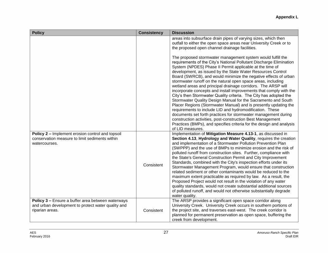
Appendix L
AES 27 Amoruso Ranch Specific Plan
February 2016 Draft EIR
Policy Consistency Discussion
areas into subsurface drain pipes of varying sizes, which then outfall to either the open space areas near University Creek or to the proposed open channel drainage facilities. The proposed stormwater management system would fulfill the requirements of the City’s National Pollutant Discharge Elimination System (NPDES) Phase II Permit applicable at the time of development, as issued by the State Water Resources Control Board (SWRCB), and would minimize the negative effects of urban stormwater runoff on the natural open space areas, including wetland areas and principal drainage corridors. The ARSP will incorporate concepts and install improvements that comply with the City’s then Stormwater Quality criteria. The City has adopted the Stormwater Quality Design Manual for the Sacramento and South Placer Regions (Stormwater Manual) and is presently updating the requirements to include LID and hydromodification. These documents set forth practices for stormwater management during construction activities, post-construction Best Management Practices (BMPs), and specifies criteria for the design and analysis of LID measures.
Policy 2 – Implement erosion control and topsoil conservation measure to limit sediments within watercourses.
Consistent
Implementation of Mitigation Measure 4.13-1, as discussed in Section 4.13, Hydrology and Water Quality, requires the creation and implementation of a Stormwater Pollution Prevention Plan (SWPPP) and the use of BMPs to minimize erosion and the risk of polluted runoff from construction sites. Further, compliance with the State's General Construction Permit and City Improvement Standards, combined with the City's inspection efforts under its Stormwater Management Program, would ensure that construction related sediment or other contaminants would be reduced to the maximum extent practicable as required by law. As a result, the Proposed Project would not result in the violation of any water quality standards, would not create substantial additional sources of polluted runoff, and would not otherwise substantially degrade water quality.
Policy 3 – Ensure a buffer area between waterways and urban development to protect water quality and riparian areas. Consistent
The ARSP provides a significant open space corridor along University Creek. University Creek occurs in southern portions of the project site, and traverses east-west. The creek corridor is planned for permanent preservation as open space, buffering the creek from development.

Appendix L
AES 28 Amoruso Ranch Specific Plan
February 2016 Draft EIR
Policy Consistency Discussion
Policy 5 – Continue to monitor groundwater resources and investigate strategies for enhanced sustainable use. Areas where recharge potential is determined to be high shall be considered for designation as open space.
Consistent
Groundwater recharge in the project site occurs primarily along stream channels such as University Creek. Soils that are impermeable or underlain by hardpan comprise most of the project area. In these areas, infiltration is low, thereby limiting groundwater recharge. Although there would be new impervious surfaces created by development of the Proposed Project, recharge is already limited under existing conditions. It is expected the retained wetlands and riparian corridor within the project site will allow for the storage and infiltration of waters for long periods of time. While infiltration rates are very small, over long periods of time these areas can provide a measurable contribution to the groundwater basin. In addition, the stormwater retention basins in the Al Johnson Wildlife Area will provide groundwater recharge to the basin. As discussed in Section 4.12.1, Public Utilities – Water Supply, of the Draft EIR, 150,570 acre-feet (AF) would remain in the groundwater basin after subtracting both the amount of groundwater used for emergency backup recycled water supply and the amount used in dry years from the amount of banked groundwater. The Proposed Project would not have a significant impact on groundwater resources.
Policy 6 – Where feasible, locate stormwater retention ponds in areas where subsoil is suitable for groundwater recharge.
Consistent See analysis under Policy 5, above.
Archeological, Historical and Cultural Resources Policies
Policy 1 – When items of historical, cultural, or archeological significance are discovered within the City, a qualified archeologist or historian shall be called to evaluate the find and to recommend proper action.
Consistent
Under Section 4.9, Cultural and Paleontological Resources, of the Draft EIR, Mitigation Measure 4.9-2 requires that should any cultural resources, such as wells, foundations, or debris, or unusual amounts of bone, stone or shell, artifacts, burned or baked soils, charcoal or human remains be encountered during subsurface excavation or construction activities, work shall be suspended within 100 feet of discovery. The City would be immediately notified. And the City would retain a qualified professional archaeologist to assess the resource and provide recommendation for treatment as appropriate.
Policy 2 – When feasible, incorporate significant archaeological sites into open space areas.
Consistent The project site does not contain any known historic or cultural resources listed or eligible for listing on the CRHR or the NRHP.

Appendix L
AES 29 Amoruso Ranch Specific Plan
February 2016 Draft EIR
Policy Consistency Discussion
Policy 3 – Subject to approval by the appropriate federal, state, local agencies, and Native American Most Likely Descendant (MLD), artifacts that are discovered and subsequently determined to be “removable” should be offered for dedication to the Maidu Interpretive Center.
Consistent
See response to Archaeological, Historical, and Cultural Resources Policy 1. Any inadvertent discovery of cultural resources would follow appropriate protocol as discussed under Mitigation Measure 4.9-2 of Section 4.9, Cultural and Paleontological Resources, of the Draft EIR.
Parks and Recreation Element
Policies – Parks and Recreation
Policy 1 – The city shall ensure the provision of 9 acres of park land per 1,000 residents, except in certain instances in the Riverside and Downtown Specific Plan areas.
Consistent The Proposed Project will satisfy this requirement through a combination of land dedication and in-lieu fees.
Policy 8 – Require that parks and recreational facilities be phased or fully completed so as to be available as adjacent residential uses are developed.
Consistent Park and recreation facilities within the project site will be phased concurrently with development
Policy 12 – Ensure that new public parks and recreational facilities, open space, paseos, landscape areas and greenways provide adequate funding for initial development, as well as ongoing maintenance and operation.
Consistent
As discussed in Section 4.11, Public Services, the Applicant would pay in-lieu fee pursuant to General Plan policy that will be utilized to construct the proposed city-wide parks. Additional neighborhood and City Wide Park Fees would be collected from all residential units. The Proposed Project developers would be required to dedicate the required parkland, to pay park development fees, and to pay any identified in-lieu fees. Furthermore, per the ARSP Development Agreement, Community Facilities Districts (CFDs) will pay for ongoing maintenance of the ARSP parks.
Public Facilities Element
Public Library System Policies
Policy 3 – Provide libraries throughout the City to service residents within a five-mile radius of each facility. Consistent
Development of the Proposed Project would contribute to the General Fund that finances libraries, such as the Riley Library at Mahany Park, which is approximately four miles to the project site. Adequate capacity is available at this library. The project site would be adequately served by existing libraries.
Schools Policies
Policy 2 – Adequate facilities must be shown to be available in a timely manner before approval will be granted to new residential development.
Consistent
The Proposed Project would generate approximately 676 elementary school children; and as a result, would require construction of one elementary school. All high school students would attend high school outside the project site. High school

Appendix L
AES 30 Amoruso Ranch Specific Plan
February 2016 Draft EIR
Policy Consistency Discussion
students would attend either Oakmont or Roseville High Schools, or a future high school located to the south in the WRSP Area. The high school district has adequate capacity to serve the high school student population. Middle school capacity is available at schools outside of the project site, such as Cooley Middle School or Chilton Middle school. Middle school students (grades 6-8) will attend school in the WRSP Area. Elementary (K-5) school students will attend the elementary school planned within the project site. Consistent with City policy, the project Applicant will voluntarily enter into mutual benefit impact fee agreements with the school districts to fully mitigate school impacts in accordance with the ARSP Development Agreement and the funding agreements with the respective school districts.
Policy 3 – Financing for new school facilities will be identified and secured before new development is approved. Consistent
The ARSP will fully mitigate school impacts in accordance with the ARSP Development Agreement and funding agreements with respective school districts. These measures are voluntary measures taken by the Applicants that go beyond what state law typically requires.
Policy 7 – Designate public/quasi-public land uses in clusters so that the use of schools, parks, open space, libraries, child care, and community activity and service centers create a community or activity focus.
Consistent
Several public/quasi-public land uses within the ARSP are located in the same vicinity or near designated near parks and open space areas.
Policy 8 – Schools, where feasible, shall be located away from hazards or sensitive resource conservation areas, except where the proximity of resources may be of educational value and the protection of the resource is reasonably assured.
Consistent
The proposed school site is acceptable under State Department of Education siting criteria. See discussion under in Section 4.10, Hazardous Materials and Public Safety, of the Draft EIR.
Electric and Privately-Owned Utilities – Electric Utility Policies
Policy 3 – Develop siting and land use compatibility standard for energy facilities.
Consistent
The Proposed Project does not propose any new energy facilities within the project site. The REP, located south of the project site and the CSP, represents the largest potential source of TACs upwind of the project site. The REP is an energy facility that generates TACs from natural gas combustion and from diesel emergency generator testing. The California Energy Commission conducted a screening level HRA for the REP prior to its construction. That analysis found that the REP would not cause

Appendix L
AES 31 Amoruso Ranch Specific Plan
February 2016 Draft EIR
Policy Consistency Discussion
significant acute, chronic or carcinogenic health risks to existing or future residences in the vicinity. New sensitive land uses within the project site, including the elementary school, would meet the siting recommendations within the California Air Resources Board (CARB) Land Use Planning Handbook. Mitigation Measure 4.4-4 in Section 4.4, Air Quality requires that any large gas station (defined as a facility with a throughput of 3.6 million gallons per year or greater) to be established within the project site be located more than 300 feet from proposed sensitive receptors in accordance with the CARB Land Use Planning Handbook recommendations. Additionally, any future proposed facility or equipment that may emit pollutants from a stationary source into the atmosphere must first obtain an Authority to Construct permit from the PCAPCD. With the mitigation identified in the Draft EIR, this impact would be less than significant.
Policy 10 – Require new development to pay a fair share of the cost of new sub-transmission and distribution needed to serve the development and to dedicate sites and easements needed for substations, transmissions, sub-transmissions, and distribution.
Consistent
The Applicant would be responsible to pay the fair-share cost of the electrical distribution systems prior to construction of the Proposed Project. As discussed in Section 2, Project Description, the Proposed Project includes easements for future overhead transmission lines.
Water System Policies
Policy 1 – Secure sufficient sources of water to meet the needs of the existing community and planned growth.
Consistent
As described in Section 4.12-1, Public Utilities – Water, of the Draft EIR, adequate water supply will be available to serve the Proposed Project with implementation of mitigation.
Policy 2 – Provide sufficient water treatment capacity and infrastructure to meet projected water demand.
Consistent
The average daily water demand for buildout of the ARSP is 658 gallons per minute (gpm). The City does not currently have adequate surface water supplies to meet the additional demands of the Proposed Project. Placer County Water Agency (PCWA) treatment plant and transmission capacity is limited, but a capital improvement plan has been developed that includes the timeline and budget necessary to construct system wide facilities. As the City has not reached build out, existing infrastructure has interim capacity for available use at the project site. The City’s unused water supply may be used to supply the Proposed Project in the interim period between the execution of the agreement between

Appendix L
AES 32 Amoruso Ranch Specific Plan
February 2016 Draft EIR
Policy Consistency Discussion
the City and PCWA and the completion of the necessary infrastructure improvements
Policy 4 – Establish a process for monitoring growth trends to anticipate water consumption needs.
Consistent
The City prepared and adopted a 2010 Urban Water Management Plan (UWMP). This plan was prepared to comply with the Urban Water Management Planning Act of the California Water Code. UWMPs must be developed by urban water providers supplying more than 3,000 customers or supplying more than 3,000 AF of water annually and submitted to the California Department of Water Resources (DWR) every 5 years. The UWMP describes the availability of water and discusses water use, recycled water use and water conservation. Under Senate Bill (SB) 610, the City is required to assess the availability of water supplies to serve future growth on a 20-year horizon. As described in Section 4.12.1 of the Draft EIR, Public Utilities – Water, adequate water supply will be available after mitigation to serve development within the project site.
Policy 5 – Ensure all development provides for and pays a fair share of the cost for adequate water distribution, including line extensions, easements, and plant expansions.
Consistent
The ARSP will construct or contribute funding for the costs of necessary water supply infrastructure, and will participate in existing City fee programs that include water infrastructure.
Wastewater and Recycled Water Systems Policies
Policy 3 – Initiate upon 75 percent utilization of treatment plant capacity, expansion studies to determine necessary improvements to meet projected wastewater treatment demands.
Consistent See response to Water System Policy 2, above.
Policy 5 – Explore potential alternatives to treatment and discharge. Consistent
The Proposed Project will utilize recycled water from the City for landscaping and other non-potable purposes. See Section 4.12-2, Public Utilities – Recycled Water, of the Draft EIR.
Policy 6 – Develop, plan, and provide incentives for use of recycling water by the public and private sectors.
Consistent See response to Wastewater and Recycled Water Systems Policy 5.
Solid Waste Collection and Disposal, Source Reduction and Recycling Policies
Policy 2 – Comply with the source reduction and recycling standards mandated by the State by reducing the projected quantity of solid waste disposed at the regional landfill by 50%, as well as any mandated future reductions.
Consistent
The ARSP will comply with Assembly Bill (AB) 939 requirements. See Section 4-12-4, Public Utilities – Solid Waste, of the Draft EIR.

Appendix L
AES 33 Amoruso Ranch Specific Plan
February 2016 Draft EIR
Policy Consistency Discussion
Water and Energy Conservation Policies
Policy 1 – Develop and implement water conservation standards.
Consistent
The City has an overall conservation goal of 20 percent for potable and irrigation water usage throughout the City. The ARSP Water Conservation Plan provides various water conservation measures that would reduce overall water demand for the Proposed Project. Further, the ARSP proposes to use recycled water for irrigation demands of non-single family residential units, with the exception of residential units that have common area landscaping (limited to HDR parcels).
Policy 3 – Explore potential uses of treated wastewater.
Consistent See response to Wastewater and Recycled Water Systems Policy 5.
Policy 4 – Protect the quality and quantity of the City’s groundwater and consider designating areas as open space where recharge potential is high.
Consistent
The ARSP proposes to primarily utilize surface water resources. The proposed groundwater well located within the project site is being considered to provide potable water supply from the groundwater storage aquifer during emergency events. The ARSP provides a significant open space corridor along University Creek. The creek corridor is planned for permanent preservation as open space.
Policy 8 – Enforce energy requirements and encourage development and construction standards that promote energy efficiency and conservation.
Consistent
Development within the Proposed Project is designed to promote energy efficiency and conservation. Mitigation Measure 4.4.3 in Section 4.4, Air Quality, provides a list of measures to be implemented that would reduce emissions during operation of the Proposed Project. These measures would also promote energy efficiency and conservation in developments on the project site.
Safety Element
Seismic and Geological Hazards Policies
Policy 3 – Minimize soil erosion and sedimentation by maintaining compatible land uses, suitable building designs, and appropriate construction techniques. Consistent
Development within the project site will adhere to all building code and water quality requirements, including the implementation of BMPs during construction, to minimize soil erosion and sedimentation. See Section 4.7, Geology, Soils and Hydrology, and Section 4.13, Hydrology and Water Quality, of the Draft EIR.
Flood Protection Policies
Policy 1 – Continue to regulate, through land use, zoning, and other restrictions, all uses and development in areas subject to potential flooding and require new development to comply with the State Plan of Flood Control.
Consistent
The Proposed Project would not place development within the 100-year flood elevation, nor would the project significantly increase floodwater elevations outside the project site. See Section 4.13, Hydrology and Water Quality, of the Draft EIR.

Appendix L
AES 34 Amoruso Ranch Specific Plan
February 2016 Draft EIR
Policy Consistency Discussion
Policy 5 – Minimize the potential for flood damage to public and emergency facilities, utilities, roadways, and other infrastructure.
Consistent See Policy 1, immediately above.
Policy 6 – Require new developments to provide mitigation to ensure that the cumulative rate of peak run-off is maintained at pre-development levels. Consistent
Mitigation in Section 4.13, Hydrology and Water Quality, ensures that the post-development peak flow rates are equal to pre-development rates. The Proposed Project would also contribute towards the construction of the City’s Pleasant Grove Retention Basin located west of the project site.
Policy 8 – Establish flood control assessment districts or consider other funding mechanisms to mitigate flooding impacts.
Consistent
Under Mitigation Measure 4.13-3, the Applicant will pay the City’s Pleasant Grove Drainage fee prior to the approval of each building permit, which would cover the cost of retention for that development’s portion of the Pleasant Grove Retention Basin Project at the Al Johnson Wildlife Area. See Section 4.13, Hydrology for analysis and mitigation. The majority of the flow generated by the Proposed Project will be routed into University Creek downstream of the existing berm at the southwestern corner of the project site. The ARSP proposes to drain the majority of the project site into channels on the western and southern borders of the project site. This concept for drainage, also referred to as the “storm drain system”, avoids the necessity of piping to University Creek south of the site. Piping drainage to University Creek causes extreme amounts of grading and land disturbance. To avoid this, the channel concept was developed.
Policy 9 – Where feasible, maintain natural stream courses and adjacent habitat and combine flood control, recreation, water quality, and open space functions.
Consistent
University Creek, a tributary to the Pleasant Grove Creek, meanders westerly near the southern boundary of the project site, crossing both the southeast and southwest corners of the project site before and after passing through the proposed southerly adjacent CSP. The 100-year floodplain within the project site would be preserved by open-space and recreational opportunities. Additionally, the ARSP will include site grading such that the base building pad elevation will exceed the 100-year flood elevation by a minimum of two feet See Policy 8 above for a discussion of onsite drainage. Additionally, stormwater runoff quality will be controlled during construction and operations with BMPs and stipulations of the
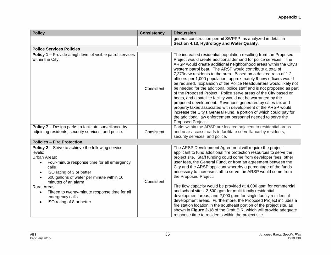
Appendix L
AES 35 Amoruso Ranch Specific Plan
February 2016 Draft EIR
Policy Consistency Discussion
general construction permit SWPPP, as analyzed in detail in Section 4.13, Hydrology and Water Quality.
Police Services Policies
Policy 1 – Provide a high level of visible patrol services within the City.
Consistent
The increased residential population resulting from the Proposed Project would create additional demand for police services. The ARSP would create additional neighborhood areas within the City's western patrol beat. The ARSP would contribute a total of 7,379new residents to the area. Based on a desired ratio of 1.2 officers per 1,000 population, approximately 9 new officers would be required. Expansion of the Police Headquarters would likely not be needed for the additional police staff and is not proposed as part of the Proposed Project. Police serve areas of the City based on beats, and a satellite facility would not be warranted by the proposed development. Revenues generated by sales tax and property taxes associated with development of the ARSP would increase the City's General Fund, a portion of which could pay for the additional law enforcement personnel needed to serve the Proposed Project.
Policy 7 – Design parks to facilitate surveillance by adjoining residents, security services, and police. Consistent
Parks within the ARSP are located adjacent to residential areas and near access roads to facilitate surveillance by residents, security services, and police.
Policies – Fire Protection
Policy 2 – Strive to achieve the following service levels: Urban Areas:
Four-minute response time for all emergency calls
ISO rating of 3 or better
500 gallons of water per minute within 10 minutes of an alarm
Rural Areas:
Fifteen to twenty-minute response time for all emergency calls
ISO rating of 8 or better
Consistent
The ARSP Development Agreement will require the project applicant to fund additional fire protection resources to serve the project site. Staff funding could come from developer fees, other user fees, the General Fund, or from an agreement between the City and the ARSP applicant whereby a percentage of the funds necessary to increase staff to serve the ARSP would come from the Proposed Project. Fire flow capacity would be provided at 4,000 gpm for commercial and school sites, 2,500 gpm for multi-family residential development areas, and 2,000 gpm for single family residential development areas. Furthermore, the Proposed Project includes a fire station location in the southeast portion of the project site, as shown in Figure 2-18 of the Draft EIR, which will provide adequate response time to residents within the project site.

Appendix L
AES 36 Amoruso Ranch Specific Plan
February 2016 Draft EIR
Policy Consistency Discussion
Policy 6 – Phase the timing of the construction of fire stations to be available to serve the surrounding service area.
Consistent See analysis under Policy 2, above.
Electromagnetic Fields Policies
Policy 2 – Limit public use within electrical power line easements to parking and low-density recreational activities such as undeveloped nature areas, bicycle, or jogging paths.
Consistent The ARSP would not allow for the development of sensitive uses within electrical powerline corridors.
Noise Element
Noise– Transportation Noise Sources Policies
Policy 1 – Allow the development of new noise-sensitive land uses (which include but are not limited to residential, schools, and hospitals) only in areas exposed to existing or projected levels of noise from transportation noise sources which satisfy the levels specified in Table IX-1. Noise mitigation measures may be required to reduce noise in outdoor activity areas and interior spaces to the levels specified in Table IX-1. Recognizing that in increasingly urban areas it is difficult to maintain suburban noise standards, and in order to facilitate the City’s goals to encourage reinvestment and economic development in the Riverside and Downtown Specific Plan areas, the City may elect to allow new noise-sensitive land uses on a case by case basis in proximity to transportation sources. Noise mitigation, including an acoustical analysis, would be required to reduce interior space noise levels to the standards specified in Table IX-1. Exterior noise levels would require mitigation to the extend feasible using building orientation, construction and design features; however, ultimately, noise levels may exceed the noise standards identified in Table IX-1.
Consistent
Some noise sensitive receptors located along the project-area roadways within the City of Roseville would exposed to exterior traffic noise levels exceeding the City of Roseville 60 dB Ldn exterior noise level standard for residential uses under Existing and 2035 Cumulative Conditions without the Proposed Project. These receptors would continue to experience elevated exterior noise levels with implementation of the Proposed Project. However, no sensitive receptors are predicted to be exposed to exterior noise levels exceeding the City’s 75 dB Ldn conditionally acceptable noise level standard. Under the City’s Noise Ordinance, a project cannot cause the exterior sound level when measured at the property line of any affected sensitive receptor to exceed the ambient sound level by 3.0 dBA or exceed the sound level standards as set forth in the General Plan by 3.0 dBA, whichever is greater. Project-related traffic would not cause a 3.0 dB increase over allowable General Plan standards at sensitive receptors under Existing Plus Project or 2035 Cumulative Plus Project conditions. Therefore, impacts associated with exceedance of standards established in the City’s General Plan or Noise Ordinance, or applicable standards of other agencies, were determined to be less than significant. Mitigation is included in Section 4.6, Noise, requiring traffic noise attenuation at future residences in the project site to ensure that exterior and interior noise levels at residences within the project site are below applicable thresholds.

Appendix L
AES 37 Amoruso Ranch Specific Plan
February 2016 Draft EIR
Policy Consistency Discussion
The Proposed Project would result in a substantial permanent increase in noise levels (>3 dB) on some roadways in the vicinity of the project site within Placer County. Mitigation is proposed within Section 4.6, Noise, that would reduce these impacts. However, since these roadways are not within the responsibility and jurisdiction of the City of Roseville, they were considered significant and unavoidable in the Draft EIR.
Policy 2 – Require new roadway improvement projects to be mitigated so as not to exceed the noise levels specified in Table IX-1 at outdoor activity areas or interior spaces of existing noise-sensitive land uses.
Consistent See analysis under Policy 1 above.
Policy 4 – Require an acoustical analysis where: a. Noise sensitive land uses are proposed in
areas exposed to existing or projected noise levels exceeding the levels specified in Table IX-1;
b. Proposed transportation noise source project are likely to produce noise levels exceeding the levels specified in Table IX-1 at existing or planned noise-sensitive uses.
An acoustical analysis shall be required as part of the environmental review process so that noise mitigation may be considered in the project design.
Consistent See analysis under Policy 1 above.
Noise – Fixed Noise Sources Policies
Policy 6 – Allow the development of new noise-sensitive uses (which include, but are not limited to, residential, school, and hospitals) only where the noise level due to fixed (non-transportation) noise sources satisfies the noise level standards of Table IX-3. Noise mitigation may be required to meet Table IX-3 performance standards. Recognizing that in increasingly urban areas it is difficult to maintain suburban noise standards, and in order to facilitate the City’s goals to encourage reinvestment and economic development in the Riverside and Downtown Specific Plan areas, the City may elect to allow new noise-sensitive land uses on a
Consistent
Commercial land uses within the project site would be primarily generator of noise, potentially impacting nearby residential uses. Mitigation Measure 4.6-2 requires the ARSP to implement measures such as shielding (e.g., berms, masonry walls, landscaping), restriction of delivery hours, and screening of heating, ventilation, and air conditioning (HVAC) equipment, to be used to reduce noise levels at residences within 500 feet of commercial uses. With implementation of these or other effective design measures identified in site specific acoustical analyses in the commercial developments, noise levels associated with commercial uses are expected to meet the acceptable noise level criteria. Mitigation Measure 4.6-2 further requires that individual noise studies be prepared for conditionally permitted uses in commercial areas that include more substantial exterior noise

Appendix L
AES 38 Amoruso Ranch Specific Plan
February 2016 Draft EIR
Policy Consistency Discussion
case by case basis in a mixed-use environment. Noise levels would require mitigation to the extent feasible using building orientation, construction and design features; however, ultimately, noise levels may exceed noise standards identified in Table IX-1.
sources and measures are implemented as necessary to achieve compliance with the City of Roseville Noise Level Performance Standards at the nearest sensitive receptors.
Policy 8 – Require an acoustical analysis where: Noise-sensitive land uses are proposed in areas where existing or anticipated future fixed noise sources may
a. Proposed non-residential or other fixed noise sources are likely to produce noise levels exceeding the performance standards of Table IX-3 at existing or planned noise-sensitive uses.
An acoustical analysis shall be required as part of the environment review process so that noise mitigation may be considered during project design.
Consistent See analysis under Policy 6, above.
Noise – General Policies
Policy 9 – Where noise mitigation measures are required to achieve the standards of Tables IX-1 and IX-3, the emphasis of such measures should be placed on site planning and project design. These measures may include, but are not limited to, building orientation, setbacks, landscaping, and building construction practices. The use of noise barriers, such as soundwalls, should be considered as a means of achieving the noise standards only after all other practical design-related noise mitigation measures have been integrated into the project.
Consistent See analysis of Policies 1 and 6 above.
Policy 10 – Regulate construction-related noise to reduce impacts on adjacent uses consistent with the City’s Noise Ordinance.
Consistent
Mitigation is included in the project to reduce impacts resulting from construction noise, including Mitigation Measure 4.6-1, which restrict construction hours consistent with the City of Roseville Noise Ordinance and requires that fixed construction equipment be located as far as possible from sensitive receptors. Mitigation also requires that a disturbance coordinator be designated to receive all public complaints about construction noise.

Appendix L
AES 39 Amoruso Ranch Specific Plan
February 2016 Draft EIR
Policy Consistency Discussion
Housing Element
Housing Plan – Affordable Housing Policies
Policy 1 – The City shall pursue programs which can provide a range of purchase and rental units affordable to all income categories.
Consistent
The Proposed Project would add 2,827 new residential units. The Proposed Project would comply with the General Plan Housing Element by designating 10 percent of the total proposed housing stock for participation in the affordable housing program defined in this section. Affordable housing would consist of 283 affordable housing units available as rentals; of which 113 units would be provided for low-income, and 170 units would be made available for very low-income.
Policy 2 – Efforts to develop affordable units will be focused on multi-family rental units, with an emphasis on units affordable to the lowest income categories. Multi-family rental units provide the most cost efficient way to provide affordable housing opportunities to extremely low, very low, and low income households.
Consistent See analysis under Policy 1, above.
Policy 3 – The 10% Affordable Housing Goal Shall apply to all new residential properties planned for 4+ units.
Consistent See analysis under Policy 1, above.
Policy 8 – Encourage construction of affordable housing units to be intermixed with market rate units to minimize low income pocket areas.
Consistent See analysis under Policy 1, above.
Policy 10 – Promote efficient and cost effective development types, such as mixed use project and small lot subdivisions, as a means of achieving housing affordability and carrying out the provisions of the Land Use Element.
Consistent See analysis under Policy 1, above.