applanix products and solutions for hydrographic survey ... · applanix products and solutions for...
TRANSCRIPT

Applanix Products and Solutions for Hydrographic Survey & Marine Applications…Maximize Your Productivity!Applanix technology and support gives you the advantage: lower costs of deployment, faster times to completion, and improved quality of data.
Why Applanix?
• Applanix delivers increased productivity with:
• High reliability in all dynamic conditions • Immunity to GNSS outages • Robust centimetric positioning • Post-processing capabilities • Faster, simpler, less costly deployment • Streamlined data workflows
• Applanix offers a complete portfolio of products and solutions to support hydrographic surveying
Applanix leads the industry in robust, reliable, and repeatable positioning and motion compensation solutions for marine applications. Proven in even the most adverse conditions, Applanix products integrate easily with multibeam sonar and 3rd party software packages, making it the right solution for any hydrographic survey.
• The Applanix Marine Team – experienced, highly qualified experts ensure your success
When you purchase an Applanix Marine solution, you’re buying into the wealth of knowledge and expertise that has gone into the development of that solution. Our experienced team of hydrographic surveyors, geospatial experts, and quality assurance personnel means you get the highest quality solution and the highest level of performance. Every Applanix product comes with a company commitment to world-class support. Applanix is here to ensure your success.
Applanix Products and Solutions for Hydrographic Survey & Marine Applications...Maximize Your ProductivityApplanix technology and support gives you the advantage: lower costs of deployment, faster times to completion, and improved quality of data.
Applanix’ POS Technology
Applanix' POS™ (Position and Orientation System) technology was originally developed and rigorously tested as part of an extensive military project. This proven technology has been enhanced, customised and packaged to yield an off-the-shelf commercial product, uniquely suited to the requirements of precision marine motion sensing, hydrographic surveying and charting called the POS MV.
Applanix Customer Care
The goal of the Applanix Marine Customer Support department is to provide the industry’s best technical support to our worldwide customer base. Whatever the time of day, wherever you are in the world, our team of hydrographic surveyors and engineers is available to assist you. From installation to training and on-goingproduct support, we're here to help.
Page 2
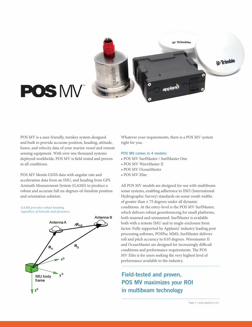
POS MV is a user-friendly, turnkey system designed and built to provide accurate position, heading, attitude, heave, and velocity data of your marine vessel and remote sensing equipment. With over one thousand systems deployed worldwide, POS MV is fi eld-tested and proven in all conditions.
POS MV blends GNSS data with angular rate and acceleration data from an IMU, and heading from GPS Azimuth Measurement System (GAMS) to produce a robust and accurate full six degrees-of-freedom position and orientation solution.
Whatever your requirements, there is a POS MV system right for you.
POS MV comes in 4 models:• POS MV SurfMaster / SurfMaster One• POS MV WaveMaster II• POS MV OceanMaster• POS MV Elite
All POS MV models are designed for use with multibeamsonar systems, enabling adherence to IHO (InternationalHydrographic Survey) standards on sonar swath widthsof greater than ± 75 degrees under all dynamic conditions. At the entry-level is the POS MV SurfMaster, which delivers robust georeferencing for small platforms, both manned and unmanned. SurfMaster is available both with a remote IMU and in single-enclosure form factor. Fully supported by Applanix’ industry leading post processing soft ware, POSPac MMS, SurfMaster delivers roll and pitch accuracy to 0.03 degrees. Wavemaster II and OceanMaster are designed for increasingly diffi cult conditions and performance requirements. Th e POS MV Elite is for users seeking the very highest level of performance available to the industry.
Field-tested and proven, POS MV maximizes your ROI in multibeam technology
Page 3 | www.applanix.com
GAMS provides robust heading regardless of latitude and dynamics.
Page 4
• Applanix “TrueHeave™” software improves productivity and accuracyTo improve the performance of real-time heave filters in long period swells, Applanix developed the TrueHeave processor. TrueHeave users reap the double benefits of significantly improved accuracy and productivity by eliminating the need for run-in time. TrueHeave also provides a unique and useful quality control tool for real-time heave during survey data collection.
• Post-processing ensures high-quality results in difficult sea conditionsWith the ability to log raw GNSS and inertial observables for later processing in POSPac MMS – Applanix’ powerful GNSS aided inertial post processing package – an optimal positioning and orientation solution can be obtained even under the most demanding sea conditions. Post-processing benefits include:
• Improved Accuracy – Post-processed kinematic processing and an advanced smoothing algorithm drastically improves position and orientation accuracy.
• Improved Reliability – Setup errors can be corrected in post-processing. In addition, alternative differential GNSS sources can be found if the primary source proves unreliable.
• Optimally aided architecture ensures a high-quality solution if GNSS outages occur. POS MV uses accurate inertial data aided by observables from as few as one satellite to compute a robust navigation solution. This ensures continuity of data, including position and heading, in areas where GNSS reception is compromised. This is vital for surveying under bridges, around structures (e.g. offshore platforms), or close to mountainous terrain where GNSS shading can occur. In addition, due to the high quality of the inertial components used in POS MV, short-term loss of GNSS does not significantly degrade the POS MV roll, pitch or heading solution.
POS MV is designed and built specifically for marine applications
• Full GNSS Support – ensures robust solution in any environment POS MV uses both GPS and GLONASS observables to produce the most robust solution possible in any given environment. POS MV uses high performance GNSS components for excellent carrier phase tracking capability even in high multipath environments.
• Decimetric positioning anywherePOS MV provides support for the Fugro Marinestar™ GPS and GNSS services. With this integrated functionality there are significant benefits for the user including:
• Larger area of operations: no geographical limitations• Ease of use: no additional hardware to purchase,
integrate and maintain• High accuracy: position data is accurate to less than
1 decimetre• Efficiency: data is produced in real-time
Marinestar is available via subscription from Fugro.
• Applanix’ Inertially Aided RTK ensures more robust solution than standalone RTK.Standalone RTK suffers from dropouts of both the GNSS signal and the telemetry from the base station. These dropouts can be caused by other vessels, bridges, topography, buildings or other obstructions. Re-acquisition of a centimetric level accuracy solution can and does take several minutes following a dropout. Applanix proprietary Inertially Aided RTK (IARTK) algorithms enable the rapid re-acquisition of fixed integer RTK positioning. Difficult GNSS environments are often encountered where accuracy requirements are at their most stringent (e.g. port areas). In these conditions POS MV with IARTK affords a significantly more robust and accurate position solution than can be achieved with standalone RTK.
• Upgradeability – your investment is protected!POS MV uses the latest Trimble 220 channel GNSS receivers with the best available GNSS antenna technology. POS MV affords a low cost upgrade path to the latest technology ensuring your investment is protected.
Benefits
Page 5 | www.applanix.com
Performance you can rely on:
• Accurate under all dynamic conditions• Heading accuracy maintained in high
multipath environments and in areas of poor GNSS availability
• Continuous sensor monitoring to ensure optimum performance
• Almost instantaneous reacquisition of RTK following any GNSS signal loss
• Automatic initialization upon power-up following a one-time calibration
• Very low noise L1 and L2 carrier phase measurements
• Superior low-elevation tracking performance regardless of latitude
Applications
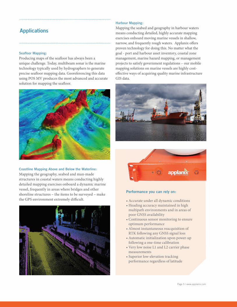
Seafl oor Mapping: Producing maps of the seafl oor has always been a unique challenge. Today, multibeam sonar is the marine technology typically used by hydrographers to generate precise seafl oor mapping data. Georeferencing this data using POS MV produces the most advanced and accurate solution for mapping the seafl oor.
Harbour Mapping: Mapping the seabed and geography in harbour waters means conducting detailed, highly accurate mapping exercises onboard moving marine vessels in shallow, narrow, and frequently rough waters. Applanix off ers proven technology for doing this. No matter what the goal - port and harbour asset inventory, coastal zone management, marine hazard mapping, or management projects to satisfy government regulations – our mobile mapping solutions on marine vessels are highly cost-eff ective ways of acquiring quality marine infrastructure GIS data.
Coastline Mapping Above and Below the Waterline: Mapping the geography, seabed and man-made structures in coastal waters means conducting highly detailed mapping exercises onboard a dynamic marine vessel, frequently in areas where bridges and other shoreline structures – the items to be surveyed – make the GPS environment extremely diffi cult.
Page 6
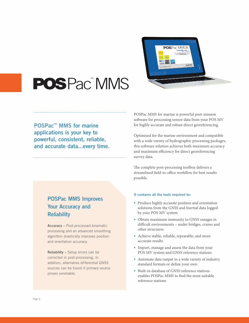
POSPac MMS for marine is powerful post-mission soft ware for processing sensor data from your POS MV for highly accurate and robust direct georeferencing.
Optimised for the marine environment and compatible with a wide variety of hydrographic processing packages, this soft ware solution achieves both maximum accuracy and maximum effi ciency for direct georeferencing survey data.
Th e complete post-processing toolbox delivers a streamlined fi eld-to-offi ce workfl ow for best results possible.
• Produce highly accurate position and orientation solutions from the GNSS and Inertial data logged by your POS MV system
• Obtain maximum immunity to GNSS outages in diffi cult environments – under bridges, cranes and other structures
• Achieve stable, reliable, repeatable, and more accurate results
• Import, manage and assess the data from your POS MV system and GNSS reference stations
• Automate data output in a wide variety of industry standard formats or defi ne your own
• Built-in database of GNSS reference stations enables POSPac MMS to fi nd the most suitable reference stations
It contains all the tools required to:
POSPac™ MMS for marine applications is your key to powerful, consistent, reliable, and accurate data...every time.
POSPac MMS Improves Your Accuracy and Reliability
Accuracy – Post-processed kinematic processing and an advanced smoothing algorithm drastically improves position and orientation accuracy.
Reliability – Setup errors can be corrected in post-processing. In addition, alternative differential GNSS sources can be found if primary source proves unreliable.
Page 7 | www.applanix.com
POSPac MMS is industry-leading software for Direct Georeferencing.
Only POSPac MMS features Applanix SmartBase™ and IN-Fusion™ Technology
POSPac MMS for Marine includes the Applanix SmartBase™ software module with Applanix IN-Fusion™ technology. These tools are designed to significantly increase the efficiency, accuracy, and robustness of mapping and surveying using GNSS on marine platforms. GNSS network and inertial post-processing methods work in direct cooperation, reducing and in some cases eliminating the restrictions associated with high accuracy GNSS positioning in a marine-based environment. Reliable centimetric accuracy can be obtained from existing reference station networks, even if the nearest reference station is 70 km or more away. In many scenarios, this completely eliminates the expense and logistical headaches associated with deploying a dedicated station close to the project area.
The Applanix SmartBase™ module uses the data logged from a network of GNSS reference stations to create a model of the atmospheric and other geometric errors across the survey area, and thus generate a set of GNSS observables at a “virtual” location close to the vessel. These and the remote receiver observables are then post-processed along with data from the Inertial Measurement Unit using the Applanix IN-Fusion technology, to simultaneously solve for the GNSS ambiguities and position and orientation of the vessel. The Applanix SmartBase approach ensures errors due to atmospheric delays are accurately modelled anywhere within the network of receivers, meaning the correct integer ambiguities are quickly and reliably computed. Tight integration with inertial data improves accuracy and robustness through cycle slips or full outages.
Applanix SmartBase™ and IN-Fusion™ Technology Deliver High Accuracy, Productivity
The combination of the Applanix SmartBase and the Applanix IN-Fusion technologies provides important new benefits over standard GNSS Kinematic Ambiguity Resolution (KAR). Because there is no need to set up dedicated stations close to the project area, and because the time spent in the office post-processing results is less, the overall expenditure associated with high-accuracy surveying is significantly reduced. The robustness of the solution however is increased, ensuring the data is captured first time, every time.
Rigorous Quality Assurance and Control
Included in SmartBase is the ability to perform a quality check on the reference station data. Using rigorous GNSS surveying adjustment algorithms, 18 to 24 hours of reference station data is processed to check the quality of both the network coordinates and the raw observations against a control you specify. Bad reference station data, antenna heights, or reference station coordinates, are detected and corrected with the SmartBase module before the remote GNSS data from the vessel is touched.
MARINE AIRBORNE LAND
© 2018, Applanix Corporation. All Rights Reserved. Applanix, and the Applanix logo are trademarks of Applanix Corporation registered in the Canadian Patent and Trademark Office and other countries. POS AV, POS LV, POS MV, InFusion, SmartBase and POSPac are registered trademarks of Applanix Corporation. All other trademarks are the property of their respective owners. Information subject to change without notice. Rev 4.
Headquarters: 85 Leek Crescent Richmond Hill, ON Canada L4B 3B3 T +1.905.709.4600
United Kingdom: Forester’s House, Old Racecourse Oswestry UK SY10 7PW T +44 1691 700500
USA: 9633 Zaka Rd,Houston TX USA 77064T +1.713.936.2990
[email protected] www.applanix.com