application boundary 01 land etween astwick road and
TRANSCRIPT
1:25,000 @ A3 SJD / SLS May 2016
Astwick Road & Taylors RoadStotfold
Gladman Developments Ltd
scale drawn issue date
project
client
drawing / figure number rev -
Figure 1 -
LOCATION PLANdrawing title
N
fpcr
FPCR Environment and Design Ltd, Lockington Hall, Lockington, Derby, DE74 2RH t: 01509 672772 f: 01509 674565 e: [email protected] w: www.fpcr.co.uk masterplanning environmental assessment landscape design urban design ecology architecture arboriculture
J:\7100\7146\LANDS\LVIA\7146 - FIGURE 1 - LOCATION PLAN.indd
This drawing is the property of FPCR Environment and Design Ltd and is issued on the condition it is not reproduced, retained or disclosed to any unauthorised person, either wholly or in part without written consent of FPCR Environment and Design Ltd.
Ordnance Survey material - Crown Copyright. All rights reserved. Licence Number: 100019980 (Centremapslive.com)
Application Boundary
Context plan
N
Land between Astwick Road and Taylor’s Road, Stotfold 01
Housing NeedEvery Council is required by the Government to boost significantly the supply of housing and to make planning decisions in the light of a presumption in favour of sustainable development. Central Bedfordshire District Council is required to provide enough housing land to meet its full future housing needs. Approval of this development will help towards meeting the housing need within the local authority area.
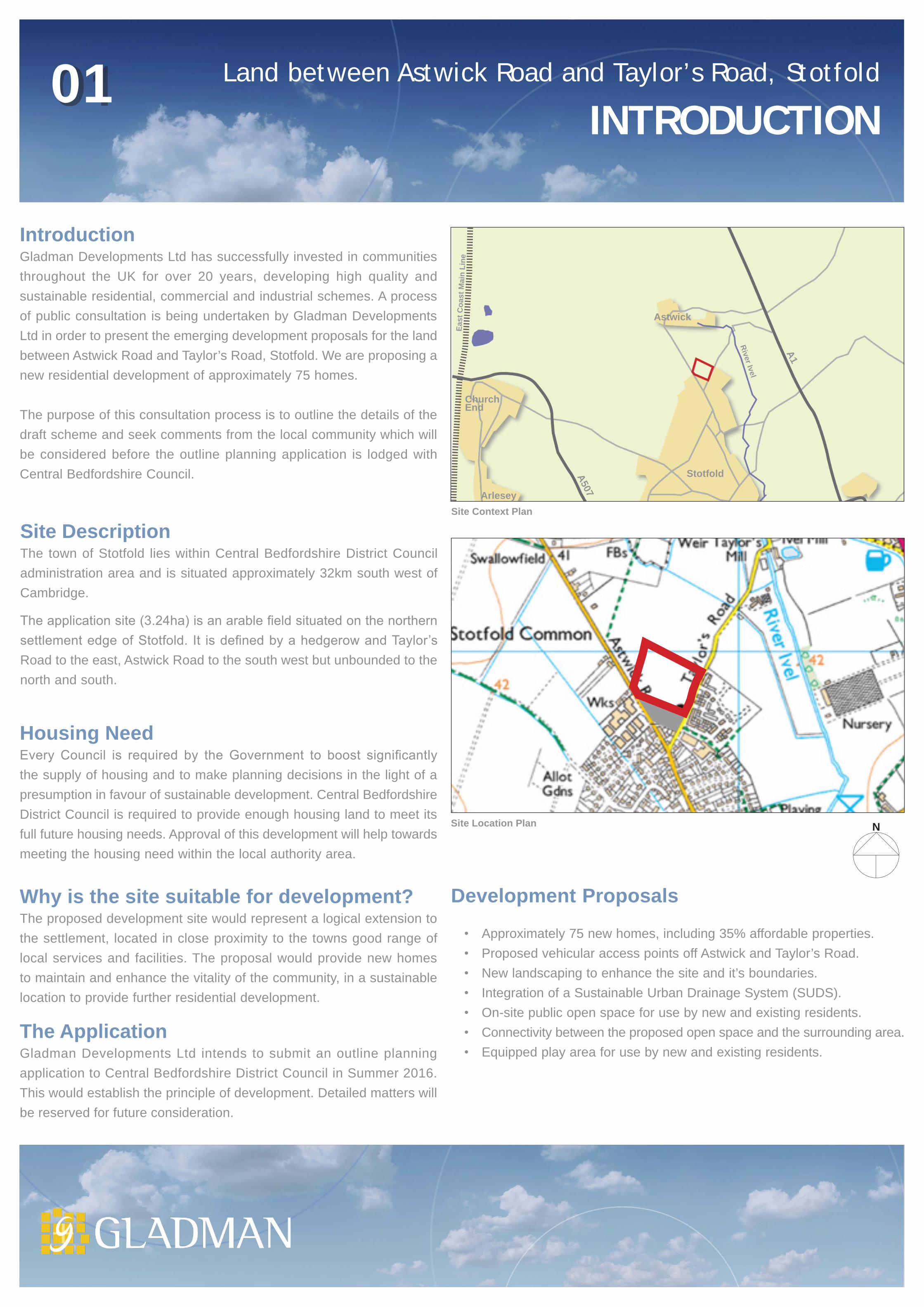
IntroductionGladman Developments Ltd has successfully invested in communities throughout the UK for over 20 years, developing high quality and sustainable residential, commercial and industrial schemes. A process of public consultation is being undertaken by Gladman Developments Ltd in order to present the emerging development proposals for the land between Astwick Road and Taylor’s Road, Stotfold. We are proposing a new residential development of approximately 75 homes.
The purpose of this consultation process is to outline the details of the draft scheme and seek comments from the local community which will be considered before the outline planning application is lodged with Central Bedfordshire Council.
Site DescriptionThe town of Stotfold lies within Central Bedfordshire District Council administration area and is situated approximately 32km south west of Cambridge.
The application site (3.24ha) is an arable field situated on the northern settlement edge of Stotfold. It is defined by a hedgerow and Taylor’s Road to the east, Astwick Road to the south west but unbounded to the north and south.
INTRODUCTION
The ApplicationGladman Developments Ltd intends to submit an outline planning application to Central Bedfordshire District Council in Summer 2016. This would establish the principle of development. Detailed matters will be reserved for future consideration.
Why is the site suitable for development?The proposed development site would represent a logical extension to the settlement, located in close proximity to the towns good range of local services and facilities. The proposal would provide new homes to maintain and enhance the vitality of the community, in a sustainable location to provide further residential development.
Development Proposals
• Approximately 75 new homes, including 35% affordable properties.• Proposed vehicular access points off Astwick and Taylor’s Road.• New landscaping to enhance the site and it’s boundaries.• Integration of a Sustainable Urban Drainage System (SUDS).• On-site public open space for use by new and existing residents.• Connectivity between the proposed open space and the surrounding area.• Equipped play area for use by new and existing residents.
Site Context Plan
Stotfold
Astwick
East
Coa
st M
ain
Line
A1
A507
River Ivel
Church End
Arlesey
Site Location Plan

1884-1887
1901-1902
1925
1960
1986
2015
Land between Astwick Road and Taylor’s Road, Stotfold 02
Order Details
Site DetailsAstwick Road, Stotfold, Hitchin, SG5 4AU
Order Number:Customer Ref:National Grid Reference:Slice:Site Area (Ha):Search Buffer (m):
78515156_1_16044521760, 237910A3.231000
Tel:Fax:Web:
0844 844 99520844 844 9951www.envirocheck.co.uk
Page 16 of 16A Landmark Information Group Service v47.0 20-Jan-2016
VectorMap LocalPublished 2015Source map scale - 1:10,000VectorMap Local (Raster) is Ordnance Survey's highest detailed 'backdrop' mapping product. These maps are produced from OS's VectorMap Local, a simple vector dataset at a nominal scale of 1:10,000, covering the whole of Great Britain, that has been designed for creating graphical mapping. OS VectorMap Local is derived from large-scale information surveyed at 1:1250 scale (covering major towns and cities),1:2500 scale (smaller towns, villages and developed rural areas), and 1:10 000 scale (mountain, moorland and river estuary areas).
Historical Map - Slice A
Map Name(s) and Date(s)
Order Details
Site DetailsAstwick Road, Stotfold, Hitchin, SG5 4AU
Order Number:Customer Ref:National Grid Reference:Slice:Site Area (Ha):Search Buffer (m):
78515156_1_16044521760, 237910A3.231000
Tel:Fax:Web:
0844 844 99520844 844 9951www.envirocheck.co.uk
Page 14 of 16A Landmark Information Group Service v47.0 20-Jan-2016
Ordnance Survey PlanPublished 1986Source map scale - 1:10,000The historical maps shown were reproduced from maps predominantly held at the scale adopted for England, Wales and Scotland in the 1840`s. In 1854 the 1:2,500 scale was adopted for mapping urban areas; these maps were used to update the 1:10,560 maps. The published date given therefore is often some years later than the surveyed date. Before 1938, all OS maps were based on the Cassini Projection, with independent surveys of a single county or group of counties, giving rise to significant inaccuracies in outlying areas. In the late 1940`s, a Provisional Edition was produced, which updated the 1:10,560 mapping from a number of sources. The maps appear unfinished - with all military camps and other strategic sites removed. These maps were initially overprinted with the National Grid. In 1970, the first 1:10,000 maps were produced using the Transverse Mercator Projection. Therevision process continued until recently, with new editions appearing every 10 years or so for urban areas.
Historical Map - Slice A
Map Name(s) and Date(s)
Order Details
Site DetailsAstwick Road, Stotfold, Hitchin, SG5 4AU
Order Number:Customer Ref:National Grid Reference:Slice:Site Area (Ha):Search Buffer (m):
78515156_1_16044521760, 237910A3.231000
Tel:Fax:Web:
0844 844 99520844 844 9951www.envirocheck.co.uk
Page 11 of 16A Landmark Information Group Service v47.0 20-Jan-2016
Ordnance Survey PlanPublished 1960Source map scale - 1:10,000The historical maps shown were reproduced from maps predominantly held at the scale adopted for England, Wales and Scotland in the 1840`s. In 1854 the 1:2,500 scale was adopted for mapping urban areas; these maps were used to update the 1:10,560 maps. The published date given therefore is often some years later than the surveyed date. Before 1938, all OS maps were based on the Cassini Projection, with independent surveys of a single county or group of counties, giving rise to significant inaccuracies in outlying areas. In the late 1940`s, a Provisional Edition was produced, which updated the 1:10,560 mapping from a number of sources. The maps appear unfinished - with all military camps and other strategic sites removed. These maps were initially overprinted with the National Grid. In 1970, the first 1:10,000 maps were produced using the Transverse Mercator Projection. Therevision process continued until recently, with new editions appearing every 10 years or so for urban areas.
Historical Map - Slice A
Map Name(s) and Date(s)
Order Details
Site DetailsAstwick Road, Stotfold, Hitchin, SG5 4AU
Order Number:Customer Ref:National Grid Reference:Slice:Site Area (Ha):Search Buffer (m):
78515156_1_16044521760, 237910A3.231000
Tel:Fax:Web:
0844 844 99520844 844 9951www.envirocheck.co.uk
Page 8 of 16A Landmark Information Group Service v47.0 20-Jan-2016
BedfordshirePublished 1925Source map scale - 1:10,560The historical maps shown were reproduced from maps predominantly held at the scale adopted for England, Wales and Scotland in the 1840`s. In 1854 the 1:2,500 scale was adopted for mapping urban areas; these maps were used to update the 1:10,560 maps. The published date given therefore is often some years later than the surveyed date. Before 1938, all OS maps were based on the Cassini Projection, with independent surveys of a single county or group of counties, giving rise to significant inaccuracies in outlying areas. In the late 1940`s, a Provisional Edition was produced, which updated the 1:10,560 mapping from a number of sources. The maps appear unfinished - with all military camps and other strategic sites removed. These maps were initially overprinted with the National Grid. In 1970, the first 1:10,000 maps were produced using the Transverse Mercator Projection. Therevision process continued until recently, with new editions appearing every 10 years or so for urban areas.
Historical Map - Slice A
Map Name(s) and Date(s)
Order Details
Site DetailsAstwick Road, Stotfold, Hitchin, SG5 4AU
Order Number:Customer Ref:National Grid Reference:Slice:Site Area (Ha):Search Buffer (m):
78515156_1_16044521760, 237910A3.231000
Tel:Fax:Web:
0844 844 99520844 844 9951www.envirocheck.co.uk
Page 6 of 16A Landmark Information Group Service v47.0 20-Jan-2016
BedfordshirePublished 1901 - 1902Source map scale - 1:10,560The historical maps shown were reproduced from maps predominantly held at the scale adopted for England, Wales and Scotland in the 1840`s. In 1854 the 1:2,500 scale was adopted for mapping urban areas; these maps were used to update the 1:10,560 maps. The published date given therefore is often some years later than the surveyed date. Before 1938, all OS maps were based on the Cassini Projection, with independent surveys of a single county or group of counties, giving rise to significant inaccuracies in outlying areas. In the late 1940`s, a Provisional Edition was produced, which updated the 1:10,560 mapping from a number of sources. The maps appear unfinished - with all military camps and other strategic sites removed. These maps were initially overprinted with the National Grid. In 1970, the first 1:10,000 maps were produced using the Transverse Mercator Projection. Therevision process continued until recently, with new editions appearing every 10 years or so for urban areas.
Historical Map - Slice A
Map Name(s) and Date(s)
Order Details
Site DetailsAstwick Road, Stotfold, Hitchin, SG5 4AU
Order Number:Customer Ref:National Grid Reference:Slice:Site Area (Ha):Search Buffer (m):
78515156_1_16044521760, 237910A3.231000
Tel:Fax:Web:
0844 844 99520844 844 9951www.envirocheck.co.uk
Page 3 of 16A Landmark Information Group Service v47.0 20-Jan-2016
BedfordshirePublished 1884 - 1887Source map scale - 1:10,560The historical maps shown were reproduced from maps predominantly held at the scale adopted for England, Wales and Scotland in the 1840`s. In 1854 the 1:2,500 scale was adopted for mapping urban areas; these maps were used to update the 1:10,560 maps. The published date given therefore is often some years later than the surveyed date. Before 1938, all OS maps were based on the Cassini Projection, with independent surveys of a single county or group of counties, giving rise to significant inaccuracies in outlying areas. In the late 1940`s, a Provisional Edition was produced, which updated the 1:10,560 mapping from a number of sources. The maps appear unfinished - with all military camps and other strategic sites removed. These maps were initially overprinted with the National Grid. In 1970, the first 1:10,000 maps were produced using the Transverse Mercator Projection. Therevision process continued until recently, with new editions appearing every 10 years or so for urban areas.
Historical Map - Slice A
Map Name(s) and Date(s)
HISTORIC CONTEXT
Historic MapsThe historic Ordnance Survey (OS) mapping shows the growth of Stotfold over the last 132 years. During 1884 to 1887, the primary use of the land was agriculture, with the two settlements of Astwick and Stotfold being the only concentration of dwellings in the area. There was a strong road connection between the two settlements with most of the remaining land comprising arable fields. The village of Astwick was originally wooded but post 1901 to 1902 the vegetation was removed to make way for more development. By 1925 Stotfold had increased slightly in density, but the outlying field pattern remained the same. However by 1960 the settlement density rapidly increased and Stotfold expanded outwards. Small parcels of woodland have been retained around Astwick. By 1986 Stotfold had become a dense settlement, contrasting with neighbouring Astwick which maintained it’s open and rural character. By 2015 the maps show that the small town of Stotfold had expanded out in all directions, although the openess of the surrounding land and road network maintains it’s historic pattern.

Land between Astwick Road and Taylor’s Road, Stotfold 03LANDSCAPE AND SETTLEMENT CHARACTER
Settlement Character
The site is located near to a new housing development off Taylor’s Road to the south and to the east of the site. The properties within Stotfold are a mix of detached or semi-detached 20th Century houses, as well as period properties. Most of the houses have front gardens lined with hedges and trees, but houses in higher density areas towards the south of Stotfold have smaller frontages. There are few properties north of the site in Astwick and these are generally sparsely scattered with large gardens.
Landscape CharacterThe site comprises a large arable field with native hedgerows adjoining the settlement edge of Stotfold. Aside from the boundary hedgerows the site is open with only field lines defining the extents of the site. Directly north of the site the land continues as arable fields until it reaches the River Ivel and the village of Astwick. The river meanders down the east of the site, passing through large expanses of fields and skirting the south eastern settlement edge of Stotfold. Further east, the A1 dual carriageway passes from Biggleswade to Letchworth Garden City. To the south of the site an area of land with permission for development lies, demarcating the settlement edge of Stotfold. Both the east and west of the site are bounded by roads, Astwick and Taylor’s Road. Towards the west the land opens up and forms a complex pattern of fields and hedgerows before meeting Arlesey Road. A Landscape Character Assessment was undertaken in 2015 for Central Bedfordshire District Council. The site and Stotfold falls within the Landscpe Character Type 4: Clay Valleys and Landscape Character Area 4C: Upper Ivel Clay Valley.
A few of the key characteristics of the LCA 4C are:• Mixed land use predominantly of arable farmland
with some pasture along the river courses plus substantial areas of settlement.
• A level wide river valley founded on Gault Clay, Chalk and Alluvium with deposits of Glacial Gravel and Valley Gravel.
• Dense settlement of medium and large scale villages often expanded along roads, plus a few scattered farmsteads.
Guidlines for Development Considerations Include:• Safeguard the distinctive character of Astwick, with
its historic pattern of small fields.• Resist development that will result in further loss/
fragmentation of hedgerows and hedgerow trees. Enhance hedgerows by replanting.
• Avoid the coalescence of towns and villages (e.g. the linear merging of Shefford and Clifton along the road).
• Enhance landscape boundaries at exposed urban edges.
• Safeguard the rural character and qualities of the Ivel corridor. Plant further woodlands (in particular wet woodlands) that will create a more rural edge to development on the margins of villages.
Traditional housing within Stotfold Modern housing within Stotfold
Landscape Character Plan

Land between Astwick Road and Taylor’s Road, Stotfold 04VISUAL ANALYSIS
VP1: View from Astwick Road on the edge of Stotfold facing north towards the site1
VP2: View from public right of way looking south directly into the site2
VP3: View north towards the site from public right of way near the A1 3
Approximate site extentsProperties off Astwick Road
Western site boundary hedgerow
Astwick Road
Properties off Astwick RoadRecent housing development to south of sitePastoral field to north of site Approximate site extents
Arable fieldsCemetry
Approximate site location
There are close views of the site from public rights of way, roads and properties immediately surrounding the site due to the relatively flat landscape and lack of tree cover immediately adjacent to the site. Distant views are limited due to the relatively flat topography combined with the existing built development within Stotfold to the south and tree cover along the River Ivel to the north. Views from Astwick Road to the south of the site are partial due to the hedgerow along Astwick Road, which filters views into the site.
Public Right of Way
Stotfold Town
Recent housing development to south of site
1
3
2
Site Boundary Allotments Play Area Healthcare Local Shops
Distance from Site-500m/1000m/2000m Religious Centre Park Pre-school/Nursery Town Hall
Bus Stops Sports Centre School Public House
Land between Astwick Road and Taylor’s Road, Stotfold 05FACILITIES
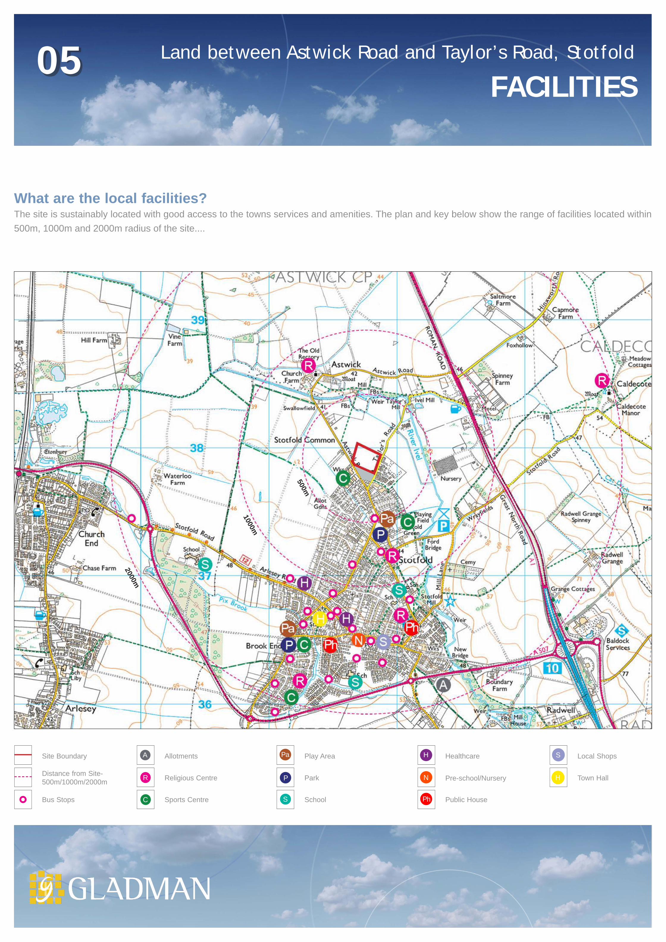
What are the local facilities?The site is sustainably located with good access to the towns services and amenities. The plan and key below show the range of facilities located within 500m, 1000m and 2000m radius of the site....
S
H
S
R P
Pa
PhC
N
HA
2000m
1000m
500m

N
+42.5m AOD
Site Boundary
Existing Surveyed Trees and HedgerowsTopography
Existing Settlement Existing Public Rights of Way
Properties to front on to Taylor’s Road
Potential Location for AttenuationSwale
Potential Vehicular Access
Potential Emergency Access
Adjacent Land with Permission for Residential Development
Landscape buffer to be created tosite boundary (10 meters width)
Approximate Environment AgencyFlood Zone 3
Approximate Environment Agency Flood Zone 2
Land between Astwick Road and Taylor’s Road, Stotfold 06CONSTRAINTS & OPPORTUNITIES
The assessment of the site and its surroundings has identified a number of features which should be protected, retained and enhanced, wherever possible as part of the development proposals for the site. These considerations provide the opportunities and constraints for development and have been used to inform the preparation of the Development Framework Plan.

Site Boundary
Proposed Residential Area 2.50ha [up to 75 dwellings @ 30dph]
Proposed Vehicular Access
Proposed Emergency Vehicle Access
Proposed Indicative Primary Road
Proposed Informal Recreational Footpath
Existing Trees and Hedgerows (Retained)
Existing Trees and Hedgerows (Removed)
Proposed Tree and Hedgerow Planting
Play Area
Seating / Provision for Young People
Potential Indicative Swale
N
Land between Astwick Road and Taylor’s Road, Stotfold 07THE FRAMEWORK
Design Principles: The Development Framework Plan below addresses the identified constraints and opportunities. Areas of green infrastructure wrap around the proposed development area and will provide informal recreational footpaths, public open space, tree planting, a detention basin (SuDS) and new grassland. This will provide a soft green edge to the settlement as recommended by Natural England. It is proposed that the development will be designed to use a selection of locally characteristic building materials and be of a layout and density range that reflects the character of the town.

Potential Residential Development
Land west of Astwick Road, Stotfold
& Land off Taylor’s Road, Stotfold
PUBLIC CONSULTATION
Land between Astwick Road and Taylor’s Road, Stotfold 08THANK YOU
Thank you for taking time to view this information.
Comments can be sent via the website, email or posted to the address below.You can keep up to date on progress using our dedicated website which provides further information:
www.your-views.co.uk/Stotfold-Taylors
How do I comment?
You can respond by email:[email protected](using “Stotfold-Taylor’s” on the subject line)
or by post:
Your Views Stotfold-Taylor’sGladman Developments Ltd.Gladman HouseAlexandria Way CongletonCW12 1LB
This is your opportunity to tell us what is important to you and what you would wish to see as part of this development should it be built.Things we would like to hear about include;
Have your say
• Are you or anyone you know, in need of affordable housing in Stotfold?
• Is there a need for housing for first time buyers and/or housing for young professionals in Stotfold?
• Are there any particular house types that Stotfold is currently lacking?
• Are there any community facilities that you would like to see improved or developed as part of this scheme?