application for new license · ferc issued a new license to sce on january 31, 1992 for the project...
TRANSCRIPT

Application for New License
Southern California Edison Company i
Kaweah Project, FERC Project No. 298
TABLE OF CONTENTS
Page
Introduction ..................................................................................................................... 1
LIST OF ACRONYMS
CFR Code of Federal Regulations
FERC or Commission Federal Energy Regulatory Commission
PAD Pre-Application Document
Project Kaweah Project
SCE Southern California Edison Company

Application for New License
ii Southern California Edison Company
Kaweah Project, FERC Project No. 298
This Page Intentionally Left Blank

Application for New License
Southern California Edison Company 1
Kaweah Project, FERC Project No. 298
INTRODUCTION
This Exhibit E – Environmental Exhibit (Exhibit E) is being filed with the Federal Energy Regulatory Commission (FERC or Commission) by Southern California Edison Company (SCE or Licensee) as part of the Application for New License (License Application) for the Kaweah Project (Project) (FERC Project No. 298).
Pursuant to the Commission’s regulations at Title 18 of the Code of Federal Regulations (CFR) §5.16, SCE is required to file a preliminary licensing proposal no later than 150 days prior to the deadline for filing a license application. As allowed under §5.16(c), SCE elected to file a draft license application which includes the contents of a license application required by §5.18 instead of the preliminary licensing proposal. The regulation at §5.16(c) states that if an applicant elects to file a draft license application, a notice of its intent should be included in the updated study report.
The deadline to file a draft license application for the Kaweah Project was August 3, 2019. The updated study report was not due to be filed until October 24, 2019. Due to this disparity in the relicensing process schedule, and to satisfy the notification requirement under §5.16(c), SCE filed a notice of its intent to prepare a draft license application with the Commission on February 5, 2019. In addition, the notice went to the Project’s distribution list.
On July 26, 2019, SCE filed its Draft Application for New License with FERC and requested comments from interested parties prior to the comment period closing date of November 1, 2019. All comments received on the Draft Application for New License are addressed in this License Application (refer to Section 14, Appendix 14-A).
As specified in the Commission’s regulations in 18 CFR §5.18(b), this Exhibit E addresses the resources listed in the Pre-Application Document (PAD) provided for in 18 CFR §5.6; follows the Commission’s guidelines in “Preparing Environmental Documents: Guidelines for Applicants, Contractors, and Staff”; and meets the format and content requirements specified by the Commission.
This Exhibit E provides the necessary technical information and analyses to identify and evaluate potential impacts of operation and maintenance of the Project under the Proposed Action compared to the No-Action Alternative. In addition, the Exhibit E specifies new measures under the Proposed Action to protect and enhance environmental and cultural resources. The Proposed Action in this Exhibit E considers input from state and federal resource agencies, Native American Tribes, non-governmental organizations, and members of the public (collectively referred to as stakeholders) acquired during consultation activities completed for the relicensing of the Project.
To date, no formal alternatives have been proposed by stakeholders for consideration in the Application for New License.

Application for New License
2 Southern California Edison Company
Kaweah Project, FERC Project No. 298
This Page Intentionally Left Blank

Application for New License
Southern California Edison Company 1-i
Kaweah Project, FERC Project No. 298
TABLE OF CONTENTS
Page
1.0 Application ........................................................................................................... 1-1
LIST OF MAPS
Map 1-1. Project Facilities and Land Jurisdictions ............................................ 1-3
LIST OF ACRONYMS
CFR Code of Federal Regulations
FERC or Commission Federal Energy Regulatory Commission
Project Kaweah Project
SCE Southern California Edison Company

Application for New License
1-ii Southern California Edison Company
Kaweah Project, FERC Project No. 298
This Page Intentionally Left Blank

Application for New License
Southern California Edison Company 1-1
Kaweah Project, FERC Project No. 298
1.0 APPLICATION
Southern California Edison Company (SCE or Licensee) is applying to the Federal Energy Regulatory Commission (FERC or Commission) for a new license for the existing Kaweah Project (Project). This Application for New License for Major Project – Existing Dam (License Application) was filed on December 23, 2019, pursuant to the Commission’s regulations at Title 18 of the Code of Federal Regulations (CFR) §5.18. This Exhibit E – Environmental Exhibit was prepared by SCE in support of this License Application. SCE used the Commission’s Integrated Licensing Process to develop this License Application.
The existing Kaweah Project is designated as Project No. 298 in the records of the Commission, pursuant to a License issued by the Commission on January 31, 1992, and effective on January 1, 1992, for a period of 30 years and terminating on December 31, 2021. Through submittal of this License Application, SCE is requesting renewal of its license to continue operation and maintenance of the Project with a license term of 50 years.
The Project is located on the Kaweah River and East Fork Kaweah River near the community of Three Rivers in Tulare County, California, on the western slope of the Sierra Nevada. An overview of the major Project facilities and land jurisdictions in the vicinity of the Project are shown on Map 1-1.
The Project consists of three developments: Kaweah No. 1, Kaweah No. 2, and Kaweah No. 3, which commenced operation in June 1899, February 1905, and May 1913, respectively. The Project has limited storage capacity and is operated in a “run-of-river” mode. The Project has a total dependable generating capacity of 8.85 megawatts and an average annual energy production of 39,124 megawatt hours1. Water captured at diversion structures is transported through a connecting flowline and penstock to the powerhouse and then returned to the river through the powerhouse tailrace.
Under the existing Project, the FERC Project boundary encompasses 320.80 acres, including 176.26 acres of public lands administered by the Bureau of Land Management and 144.54 acres of SCE-owned or private land. SCE does not propose any Project enhancements to increase Project capacity nor does it propose any new construction.
The exact name and business address of SCE is as follows:
Southern California Edison Company 2244 Walnut Grove Avenue Rosemead, CA 91770 Telephone: (626) 302-9741
1 Average annual generation for the combined Kaweah No. 1, Kaweah No. 2, and Kaweah No. 3
powerhouses from 1992–2018.
Application for New License
1-2 Southern California Edison Company
Kaweah Project, FERC Project No. 298
The exact name and business address of the person authorized to act as agent for SCE in this application is:
Wayne P. Allen Principal Manager, Regulatory Support Services Southern California Edison Company 2244 Walnut Grove Avenue Rosemead, CA 91770 Telephone: (626) 302-9741

$+$+
$+
î
î
î
î
#*#*
#*
O
")")
")
")
LakeKaweah
!. THREERIVERS
198
Mi ddle Fork Kaweah River
Marb
leFo
rkKa
weah
Rive
r
East Fo rk Kaweah River
Kaweah No. 3 Flowline(Non-FERC Facility)
Kaweah No. 1 Flowline
Kaweah No. 2 FlowlineNorth
Fork Kawea
h Ri ve
r
South Fork Kaweah River
Three Rivers Substation(Non-FERC Facility)
Kaweah No. 3 Powerhouse
Kaweah No. 1 PowerhouseKaweah No. 2 Powerhouse K2
Forebay
K1 Forebay Tank
K3 Forebay
S. Fork Dr.
Mineral King Rd.
N. ForkDr
.
K aweah
R. Dr.
198
Kaweah No. 3 Flowline
EagleLake
UpperMonarch
Lake
CrystalLake
LadyFranklin
Lake
Kawe
ahR ive
r
USACE Terminus Dam(Non-FERC Facility)
Kaweah No. 3 PH toThree Rivers Substation
Transmission Line
SEQUOIA - KINGS CANYONWILDERNESS
SEQUOIANATIONAL PARK
KaweahRive
r
JOHN KREBSWILDERNESS
")
Middle Fork Diversion Dam(Non-FERC Facility)
Kaweah No. 1Diversion Dam
Marble Fork Diversion Dam(Non-FERC Facility)
Kaweah No. 2Diversion Dam
Eagle Lake Dam(Non-FERC Facility)
Lady Franklin Lake Dam(Non-FERC Facility)
Crystal Lake Dam(Non-FERC Facility)
Upper Monarch Lake Dam(Non-FERC Facility)
Copyright 2019 by Southern California Edison Company
Southern California Edison (SCE) has no reason to believe that there are any inaccuraciesor defects with information incorporated in this work and make no representations of anykind, including, but not limited to, the warranties of merchantability or fitness for a particularuse, nor are any such warranties tobe implied, with respect to the information or data,furnished herein. No part of this map may be reproduced ortransmitted in any form or byany means, electronic or mechanical, including photocopying and recording system,except as expressly permitted in writing by SCE.
Date: 3/28/2019Projection: UTM Zone 11
Datum: NAD 835
Z:\30735240_SCE_EasternHydro\map\Kaweah\SCE_Eastern_KAWEAH_Juris_OtherDams_17i11i_01.mxd
0 1 20.5Miles
|ÿ99
SEQUOIANATIONAL
PARK
Kaweah Project - FERC Project No. 298
Dam")
Highway/Road
Other Features
WatercourseWater Body
City/Town!.
Bureau of Land Management
National Park Service
Land Jurisdiction*
Private (Blank)*SOURCE: BLM 2016
National Wilderness AreaLand Management
U. S. Forest Service
U.S. Army Corps of Engineers
NOTE: The Marble and Middle Fork DiversionDams are not in designated Wilderness
Transmission Line
SCE FacilitiesPowerhouse
Flowline
Forebay
#*
Diversion
Utility$+
O
Penstock
î
Gage!́
Project FERC Boundary
State Of California
Dam")
Project Facilities and Land Jurisdictions
Map 1-1

Application for New License
1-4 Southern California Edison Company
Kaweah Project, FERC Project No. 298
This Page Intentionally Left Blank
Application for New License
Southern California Edison Company 2-i
Kaweah Project, FERC Project No. 298
TABLE OF CONTENTS
Page
2.0 Purpose of Action and Need for Power ................................................................ 2-1
2.1 Purpose of Action .......................................................................................... 2-1
2.2 Need for Power ............................................................................................. 2-1
2.2.1 Power Demand ................................................................................... 2-2
2.2.2 California Legislation .......................................................................... 2-2
2.3 Literature Cited .............................................................................................. 2-3
LIST OF ACRONYMS
AB Assembly Bill
CEC California Energy Commission
FERC or Commission Federal Energy Regulatory Commission
FPA Federal Power Act
GHG greenhouse gas
IRP Integrated Resource Plans
MW megawatt
MWh megawatt hours
NERC North American Reliability Corporation
Project Kaweah Project
SB Senate Bill
SCE Southern California Edison Company
WECC Western Electricity Coordinating Council

Application for New License
2-ii Southern California Edison Company
Kaweah Project, FERC Project No. 298
This Page Intentionally Left Blank

Application for New License
Southern California Edison Company 2-1
Kaweah Project, FERC Project No. 298
2.0 PURPOSE OF ACTION AND NEED FOR POWER
2.1 PURPOSE OF ACTION
The Federal Action to be considered by the Federal Energy Regulatory Commission (FERC or Commission) is the issuance of a new license to Southern California Edison Company (SCE) for continued operation and maintenance of the Kaweah Project (Project) or some other disposition of the Project under the Federal Power Act (FPA). If the Commission issues a new license, a key component is the conditions placed in the Project license to ensure compliance with the FPA and other applicable laws. Ultimately, the Commission must determine that the Project, as licensed, in the judgment of the Commission, be best adapted to a comprehensive plan for improving or developing the waterway for beneficial public purposes. In addition to the power and development purposes for which licenses are issued, the Commission must give equal consideration to the purposes of energy conservation; protection, mitigation of damage to, and enhancement of fish and wildlife; protection of recreational opportunities; and preservation of other aspects of environmental quality.
This Exhibit E – Environmental Exhibit (Exhibit E) provides the information necessary for the Commission to develop new license conditions for the Project. The Exhibit E presents a description and analysis of the environmental and economic effects of the Proposed Action and the No-Action Alternative. Several other alternatives were considered in Exhibit E, but eliminated from detailed analysis because they are not considered reasonable, including: Federal government takeover; issuance of a non-power license; and retirement of the Project (refer to Section 5.0 – Other Alternatives).
2.2 NEED FOR POWER
SCE is a publicly regulated utility that supplies electricity to approximately 15 million people in a 50,000 square mile service area covering portions of coastal, central, and southern California. SCE serves all customers through a diverse transmission system and has a generation mix based on several different resources, such as gas, nuclear, and hydroelectric; and purchases from other utilities or non-utility power producers.
Hydroelectric power from the Project is produced at three powerhouses with a total installed capacity of 8.85 megawatts (MW). The Project produces an annual average of 39,124 megawatt-hours1 (MWh). The amount and timing of flow diverted is a function of inflow (runoff); FERC License requirements for minimum instream flow and ramping rates; flowline capacities; and the minimum flow required to maintain sufficient head in the flowline to meet pre-1914 water delivery contractual obligations.2
1 Average annual generation calculated from SCE power generation records at all three Project
powerhouses from 1992–2018. 2 Refer to Section 3.5 for additional information on SCE’s pre-1914 water delivery contractual obligations.

Application for New License
2-2 Southern California Edison Company
Kaweah Project, FERC Project No. 298
2.2.1 Power Demand
The North American Electric Reliability Corporation (NERC) is a regulatory authority whose mission is to assure the effective and efficient reduction of risks to the reliability and security of the power grid. NERC develops and enforces Reliability Standards; annually assesses seasonal and long‐term reliability; monitors the bulk power system through system awareness; and educates, trains, and certifies industry personnel (NERC 2019).
There are seven regional entities given authority by the NERC. Of those entities, the Western Electricity Coordinating Council (WECC) is responsible for coordinating and promoting Bulk Electric System reliability in the Western Interconnection. The Western Interconnection includes all or portions of 14 western states, two Canadian provinces, and a portion of Baja California in Mexico. SCE’s service area is within the California/Mexico sub region of the Western Interconnection.
According to WECC forecasts for the Western Interconnection, the annual energy consumed is expected to increase by 9.6% from 2015 to 2026 (compound annual increase of 0.8%), and the summer peak demand is expected to increase by 9.1% during that same period (compound annual increase of 0.8%) (WECC 2018).
The region has a need for power over the near term and power from the Project could continue to help meet that need in the future. In addition to underlying demand growth, uncertainty surrounds projections of future energy demand and planned capacity due to ongoing changes in the electric industry’s governing regulatory structure, changes in the resource mix (i.e., environmental regulations driving development of clean energy sources and increased reliance on natural gas), and in some years, climatic conditions such as higher temperatures, drought and extreme weather.
2.2.2 California Legislation
Regulation of greenhouse gas (GHG) emissions in the United States and California is relatively recent, beginning early in the 2000s. In the absence of major federal efforts, California’s former governor, Arnold Schwarzenegger, and the legislature took the initiative to establish goals for reductions of GHG emissions in California and to prescribe a regulatory approach to ensure that the goals would be achieved. The federal government, primarily through actions of the U.S. Environmental Protection Agency, also regulates GHG emissions, although not as comprehensively.
Most recently, on September 8, 2016, former governor Jerry Brown signed Senate Bill (SB) 32 that extends the state’s target to reduce GHG emissions. The bill mandates a 40% reduction in GHG emissions below 1990 levels by 2030 and essentially builds upon the Assembly Bill (AB) 32 GHG reduction target to reduce GHG to 1990 levels by 2020. To achieve the SB 32 reductions the plan is to increase renewable energy use, improve energy efficiency, get more zero emissions vehicles on California’s roadways, and curb emissions from key industries (State of California 2019).

Application for New License
Southern California Edison Company 2-3
Kaweah Project, FERC Project No. 298
In addition, SB 350 increases California's renewable electricity procurement goal from 33% by 2020 to 50% by 2030. This will increase the use of Renewables Portfolio Standard eligible resources, including solar, wind, biomass, geothermal, and others. SB 350 requires the state to double statewide energy efficiency savings in electricity and natural gas end uses by 2030. To help ensure these goals are met and GHG emission reductions are realized, large utilities will be required to develop and submit Integrated Resource Plans (IRP). These IRPs will detail how each utility will meet their customers resource needs, reduce greenhouse gas emissions and ramp up the deployment of clean energy resources (CEC 2019).
Energy generated by the Project displaces energy that would otherwise be generated by gas-fired units. Currently, aside from power generated by its own sources, SCE purchases the power needed to serve its customers from qualifying facilities, independent power producers, the California Independent System Operator, the California Department of Water Resources (under contracts with other third parties), and other utilities. If the Project is not relicensed, SCE would need to obtain replacement low-GHG emitting energy supplies to comply with SB 32. SCE is already attempting to purchase more energy from clean renewable resources to meet state of California renewable portfolio standards.
In summary, energy produced from the Project is used by SCE to: (1) meet current demand for energy in its service area; (2) meet renewable energy goals; and (3) provide a source of energy with low-GHG emissions.
2.3 LITERATURE CITED
CEC (California Energy Commission). 2019. Available at: https://www.energy.ca.gov/sb350/.
NERC (North American Electric Reliability Corporation). 2019. Available at: https://www.nerc.com/Pages/default.aspx.
State of California. 2019. California Climate Change Legislation. Available at: https://www.climatechange.ca.gov/state/legislation.html.
WECC (Western Electricity Coordinating Council). 2018. Summary of Observations—2016–2017 Study Program. System Adequacy Planning Department. October.

Application for New License
2-4 Southern California Edison Company
Kaweah Project, FERC Project No. 298
This Page Intentionally Left Blank

Application for New License
Southern California Edison Company 3-i
Kaweah Project, FERC Project No. 298
TABLE OF CONTENTS
Page
3.0 No-Action Alternative ........................................................................................... 3-1
3.1 Project Overview ........................................................................................... 3-1
3.2 Existing Project Facilities ............................................................................... 3-2
3.2.1 Diversion Dams and Pools ................................................................. 3-2
3.2.1.1 Kaweah No. 1 Diversion Dam and Pool ............................... 3-2
3.2.1.2 Kaweah No. 2 Diversion Dam and Pool ............................... 3-2
3.2.2 Flowlines ............................................................................................ 3-3
3.2.2.1 Kaweah No. 1 Flowline ........................................................ 3-3
3.2.2.2 Kaweah No. 2 Flowline ........................................................ 3-3
3.2.2.3 Kaweah No. 3 Flowline ........................................................ 3-3
3.2.3 Forebays ............................................................................................ 3-3
3.2.3.1 Kaweah No. 1 Forebay Tank ............................................... 3-3
3.2.3.2 Kaweah No. 2 Forebay ........................................................ 3-4
3.2.3.3 Kaweah No. 3 Forebay ........................................................ 3-4
3.2.4 Penstocks ........................................................................................... 3-5
3.2.4.1 Kaweah No. 1 Penstock ....................................................... 3-5
3.2.4.2 Kaweah No. 2 Penstock ....................................................... 3-5
3.2.4.3 Kaweah No. 3 Penstock ....................................................... 3-5
3.2.5 Powerhouses and Switchyards ........................................................... 3-5
3.2.5.1 Kaweah No. 1 Powerhouse and Switchyard ........................ 3-5
3.2.5.2 Kaweah No. 2 Powerhouse and Switchyard ........................ 3-6
3.2.5.3 Kaweah No. 3 Powerhouse and Switchyard ........................ 3-6
3.2.6 Transmission, Power, and Communication Lines ............................... 3-7
3.2.7 Gages ................................................................................................. 3-7
3.2.7.1 East Fork Kaweah River ...................................................... 3-7
3.2.7.2 Kaweah River ....................................................................... 3-8
3.2.8 Access Roads and Trails .................................................................... 3-8
3.2.9 Ancillary and Support Facilities ........................................................... 3-8
3.2.9.1 Kaweah No. 1 Powerhouse Campus ................................... 3-9
3.2.9.2 Kaweah No. 2 Powerhouse River Access Parking ............... 3-9
3.2.9.3 Wildlife Bridges and Escape Ramps .................................... 3-9
3.2.9.4 Footbridges .......................................................................... 3-9
3.2.9.5 Kaweah No. 1 Diversion Solar Panel ................................... 3-9
3.2.9.6 Satellite Repeaters ............................................................... 3-9
3.2.9.7 Gaging Cableways ............................................................. 3-10

Application for New License
3-ii Southern California Edison Company
Kaweah Project, FERC Project No. 298
3.2.9.8 Project Fences ................................................................... 3-10
3.3 FERC Project Boundary .............................................................................. 3-10
3.4 Project Maintenance .................................................................................... 3-10
3.4.1 Maintenance Outage ........................................................................ 3-10
3.4.2 Powerhouse Inspections and Maintenance ...................................... 3-11
3.4.3 Flowline Inspections and Maintenance ............................................. 3-11
3.4.4 Vegetation Management .................................................................. 3-11
3.4.4.1 Trimming by Hand .............................................................. 3-12
3.4.4.2 Herbicide Use .................................................................... 3-12
3.4.4.3 Hazard Tree Removal ........................................................ 3-12
3.4.4.4 Pest Management .............................................................. 3-12
3.4.5 Sediment Management .................................................................... 3-12
3.4.6 Road Maintenance ........................................................................... 3-13
3.4.7 Trail Maintenance ............................................................................. 3-14
3.4.8 Transmission, Power, and Communication Line Maintenance ......... 3-14
3.5 Project Operations ....................................................................................... 3-14
3.5.1 Regulatory Requirements ................................................................. 3-14
3.5.1.1 Existing FERC License Articles .......................................... 3-14
3.5.1.2 Water Rights ...................................................................... 3-15
3.5.2 Operating and Water Delivery Agreements ...................................... 3-18
3.5.2.1 National Park Service Special Use Permit ......................... 3-18
3.5.2.2 Water Delivery Agreements ............................................... 3-18
3.5.3 Water Management .......................................................................... 3-21
3.6 Project Generation and Outflow Records .................................................... 3-23
3.7 Existing Environmental Measures ............................................................... 3-23
3.7.1 Water Resources .............................................................................. 3-24
3.7.1.1 Ramping Requirements ..................................................... 3-24
3.7.1.2 Minimum Instream Flow Requirements .............................. 3-24
3.7.1.3 Erosion Protection and Remediation Plan ......................... 3-24
3.7.1.4 Stream Gaging Plan ........................................................... 3-24
3.7.2 Cultural Resources ........................................................................... 3-25
3.7.2.1 Cultural Resources Management Plan .............................. 3-25
3.7.2.2 Ground-disturbing Activities Consultation .......................... 3-25
3.7.3 Terrestrial Resources ....................................................................... 3-25
3.7.3.1 Wildlife Protection and Monitoring ...................................... 3-25
3.7.3.2 Avian Mortality Reporting Plan ........................................... 3-26
3.7.4 Land Management ............................................................................ 3-26
3.7.4.1 Land Clearance Requirements .......................................... 3-26

Application for New License
Southern California Edison Company 3-iii
Kaweah Project, FERC Project No. 298
3.8 Other SCE Company-wide Environmental Programs .................................. 3-26
3.8.1 Environmental Training Program ...................................................... 3-26
3.8.2 Transmission, Power, and Communication Line Maintenance Program ........................................................................................... 3-26
3.9 Project Safety .............................................................................................. 3-27
3.9.1 Part 12 Dam Safety Inspections ....................................................... 3-27
3.9.2 Project Safety Features .................................................................... 3-27
3.10 Literature Cited ............................................................................................ 3-28
LIST OF TABLES
Table 3-1. Kaweah Project History ......................................................................... 3-33
Table 3-2. No-Action Alternative – Existing Project Facilities ................................. 3-34
Table 3-3. Project Facility Specifications ............................................................... 3-38
Table 3-4. Description of Project Transmission, Power, and Communication Lines ..................................................................................................... 3-43
Table 3-5. Description of Project Access Roads and Trails ................................... 3-45
Table 3-6. Description of Current Maintenance Activities at Project Facilities ....... 3-49
Table 3-7. Area Around Project Facilities Where Vegetation Management is Implemented ......................................................................................... 3-55
Table 3-8. Minimum Instream Flow Requirements1, 2 ............................................. 3-56
Table 3-9. Historic Water Year Types for the Kaweah River at Terminus Reservoir Based on Department of Water Resources Bulletin 120 May 1 Runoff Forecast (1994–2018)1 ................................................... 3-57
Table 3-10. Recent History of Temporary Flow Modifications Requested by SCE and Approved by Resource Agencies (2002–2018) ..................... 3-58
Table 3-11. Summary of Kaweah Project Generation (1992–2018)1 ....................... 3-59
Table 3-12. Summary of License Article Compliance .............................................. 3-61
LIST OF FIGURES
Figure 3-1. Elevation Profile .................................................................................... 3-65
Figure 3-2. Distribution of the April 1 to July 1 Forecast of Runoff in the Kaweah River at Terminus Reservoir based on the Bulletin 120 May 1 Forecast (1994–2018)........................................................................... 3-66
Figure 3-3. Annual Inflow to the Kaweah Project (WY 1994–2018) ........................ 3-67

Application for New License
3-iv Southern California Edison Company
Kaweah Project, FERC Project No. 298
Figure 3-4a. Monthly Average Flows in a Representative Dry Year (2014), Normal Year (2006), and “Drier” Normal Year (2009) in the East Fork Kaweah River Bypass Reach and Kaweah No. 1 Flowline/Kaweah No. 1 Powerhouse .................................................... 3-68
Figure 3-4b. Monthly Average Flows in a Representative Dry Year (2014), Normal Year (2006), and “Drier” Normal Year (2009) in the Kaweah River Bypass Reach and Kaweah No. 2 Flowline/Kaweah No. 2 Powerhouse .......................................................................................... 3-69
Figure 3-4c. Monthly Average Flows in a Representative Dry Year (2014), Normal Year (2006), and “Drier” Normal Year (2009) at the Kaweah No. 3 Powerhouse ................................................................................ 3-70
Figure 3-5a. Monthly Exceedance Flows (10%, 20%, 50%, 80%, and 90%) in the East Fork Kaweah River Bypass Reach and Kaweah No. 1 Flowline, and at the Kaweah No. 1 Powerhouse (WY 1994–2018) ...... 3-71
Figure 3-5b. Monthly Exceedance Flows (10%, 20%, 50%, 80%, and 90%) in the Kaweah River Bypass Reach and Kaweah No. 2 Flowline, and at the Kaweah No. 2 Powerhouse (WY 1994–2018)........................................ 3-72
Figure 3-5c. Monthly Exceedance Flows (10%, 20%, 50%, 80%, and 90%) at the Kaweah No. 3 Powerhouse (WY 2002–2018) ................................ 3-73
Figure 3-6. East Fork Kaweah River Inflow and Kaweah No. 1 Diversion Dam in Relation to Minimum Instream Flow Requirements and Water Supply Commitments in Dry (top) and Normal (bottom) Years (May 1994–February 2019) .................................................................. 3-74
Figure 3-7. Kaweah River Inflow at Kaweah No. 2 Diversion Dam in Relation to Minimum Instream Flow Requirements and Water Supply Commitments in Dry (top) and Normal (bottom) Years (May 1994–February 2019) ..................................................................................... 3-75
LIST OF MAPS
Map 3-1. Project Facilities and Land Jurisdictions ............................................... 3-79
Map 3-2a-h. Project Facilities .................................................................................... 3-81
Map 3-3a-h. Land Jurisdictions in the Vicinity of the Project ..................................... 3-83
LIST OF APPENDICES
Appendix 3-A Description of Non-FERC Project Facilities
Application for New License
Southern California Edison Company 3-v
Kaweah Project, FERC Project No. 298
LIST OF ACRONYMS
ac-ft acre-feet
ADCP Acoustic Doppler Current Profiler
APLIC Avian Power Line Interaction Committee
AVM Acoustic Velocity Meter
BLM Bureau of Land Management
CDF California Department of Forestry
CDFW California Department of Fish and Wildlife
CFR Code of Federal Regulations
cfs cubic feet per second
CRMP Cultural Resources Management Plan
DWR Department of Water Resources
EAP Emergency Action Plan
FERC or Commission Federal Energy Regulatory Commission
GIS Geographic Information System
Hz hertz
kV kilovolt
MIF minimum instream flow
MVA mega volt amp
MW megawatt
MWh megawatt hours
NPS National Park Service
NRHP National Register of Historic Places
OA oil-air
Project Kaweah Project
SCE Southern California Edison Company
SNP Sequoia National Park
State Water Board State Water Resources Control Board
SUP special use permit
USFWS U.S. Fish and Wildlife Service
USGS U.S. Geological Survey
WUD water user diversion
WY water year

Application for New License
3-vi Southern California Edison Company
Kaweah Project, FERC Project No. 298
This Page Intentionally Left Blank

Application for New License
Southern California Edison Company 3-1
Kaweah Project, FERC Project No. 298
3.0 NO-ACTION ALTERNATIVE
The following section summarizes the No-Action Alternative for Southern California Edison Company’s (SCE) Kaweah Project (Project). Under the No-Action Alternative, the Project will continue to operate and be maintained under the terms and conditions of the current Federal Energy Regulatory Commission (FERC or Commission) license.
This section was developed to meet the requirements for the description of the existing project as specified in Title 18 of the Code of Federal Regulations (CFR) §5.18(b)(4). The description of the No-Action Alternative has been organized into the following major subsections:
Project Overview
Existing Project Facilities
FERC Project Boundary
Project Maintenance
Project Operations
Project Generation and Outflow Records
Existing Environmental Measures
Other SCE Company-wide Environmental Programs
Project Safety
3.1 PROJECT OVERVIEW
The Project consists of three developments: Kaweah No. 1, Kaweah No. 2, and Kaweah No. 3, which commenced operation in June 1899, February 1905, and May 1913, respectively (Map 3-1). Table 3-1 provides a brief overview of the development history of the Project and its operations. The Project has limited storage capacity (11.93 acre-feet [ac-ft]) and is operated in a “run-of-river” mode. The total dependable generating capacity is 8.85 megawatts (MW). Water captured at diversion structures is transported through a connecting flowline and penstock to the powerhouse and then returned to the river through the powerhouse tailrace. Project facilities are shown on Maps 3-2a-h.
Portions of the Kaweah No. 1 and No. 3 developments are located within the Sequoia National Park (SNP) and are, therefore, not under FERC jurisdiction (Map 3-1). All Project facilities located within the SNP are currently operated under a Special Use Permit (SUP) (Permit No. PWR-SEKI-6000-2016-015) issued to SCE by the National Park Service (NPS) (NPS 2016). The current SUP expires on September 8, 2026. Appendix 3-A includes a description of the non-FERC portions of the Kaweah No. 1 and No. 3

Application for New License
3-2 Southern California Edison Company
Kaweah Project, FERC Project No. 298
developments. Since these facilities are not under FERC jurisdiction they are not subject to relicensing and are not further discussed in this document.
3.2 EXISTING PROJECT FACILITIES
This section describes existing Project facilities, including diversions; flowlines; forebays; penstocks; powerhouses and switchyards; transmission lines; power lines; communication lines; gages; access roads and trails; and ancillary and support facilities under FERC jurisdiction. A list of these Project facilities is provided in Table 3-2. The physical characteristics and facility specifications of the primary Project facilities is provided in Table 3-3. Map 3-1 provides a geographic overview of the Project. Maps 3-2a-h provide a detailed geographic depiction of Project facilities. The general elevation profile of the Project is shown on Figure 3-1.
3.2.1 Diversion Dams and Pools
3.2.1.1 Kaweah No. 1 Diversion Dam and Pool
The Kaweah No. 1 Diversion is located on the East Fork Kaweah River. The diversion structure is a 6-foot high overflow concrete gravity dam, with a crest length of 20 feet at an elevation of 2,583 feet. The Kaweah No. 1 Diversion Pool has a design and current capacity of approximately 0.03 ac-ft. The dam’s outlet works is a 6-foot high, 3-foot wide, unlined tunnel controlled by a manually operated slide gate. The outlet works has a maximum capacity of 24 cubic feet per second (cfs). The tunnel extends approximately 50 feet and empties into a sandbox (sediment trap) at the downstream end. The sandbox has a spillway crest elevation of 2,580 feet. Water leaving the sandbox flows through a trash rack and a 36-inch by 36-inch slide gate into the Kaweah No. 1 Flowline (24 cfs capacity).
3.2.1.2 Kaweah No. 2 Diversion Dam and Pool
The Kaweah No. 2 Diversion is located on the Kaweah River. The diversion structure is a 7-foot high masonry overflow gravity dam, with an overall crest length of 161 feet at an elevation of 1,365 feet. The Kaweah No. 2 Diversion Pool has a design capacity of approximately 1–2 ac-ft. Over time, the diversion pool has filled in with sediment and it currently has a capacity of approximately 0.2 ac-ft. The outlet works has a maximum capacity of 100 cfs. A trash rack protects the intake at the upstream dam face. The concrete tunnel discharges into a 54-inch diameter by 42-foot long steel pipe, through a 54-inch square manually operated wooden slide gate and a fishwheel, and into the Kaweah No. 2 Flowline (87 cfs capacity). The minimum instream flow (MIF) release pipe comes off of the concrete tunnel and releases into the Kaweah River before entering the Kaweah No. 2 Flowline.

Application for New License
Southern California Edison Company 3-3
Kaweah Project, FERC Project No. 298
3.2.2 Flowlines
3.2.2.1 Kaweah No. 1 Flowline
The Kaweah No. 1 Flowline consists of an elevated steel flume supported by a wooden support structure. The flowline traverses 30,723 feet along the south side of East Fork Kaweah River Canyon from Kaweah No. 1 Diversion slide gate to the Kaweah No. 1 Forebay Tank. The flowline has a maximum diversion capacity of approximately 24 cfs. There are two water user diversions (WUD) off of the Kaweah No. 1 Flowline (Bear WUD and Summit WUD). A description of WUDs along the Kaweah No. 1 Flowline is provided in Section 3.5 Project Operations.
3.2.2.2 Kaweah No. 2 Flowline
The Kaweah No. 2 Flowline is approximately 21,607 feet in length, including 16,738 feet of concrete ditch; 3,822 feet of steel flume comprised of 19 segments; and 1,047 feet of 50-inch diameter steel pipe. The flowline generally parallels the north side of the Kaweah River extending from the Kaweah No. 2 Diversion Dam to the Kaweah No. 2 Forebay. The flowline has a maximum diversion capacity of approximately 87 cfs. There are four WUDs on the Kaweah No. 2 Flowline (Flume 5 WUD, Flume 6 WUD, Canal 9 WUD, and Flume 14 WUD). A description of WUDs along the Kaweah No. 2 Flowline is provided in Section 3.5 Project Operations.
3.2.2.3 Kaweah No. 3 Flowline
The short segment of the Kaweah No. 3 Flowline is under FERC jurisdiction and consists of a 2,975-foot long concrete box flume that conveys water to the Kaweah No. 3 Forebay. The flowline has a maximum diversion capacity of approximately 97 cfs.
3.2.3 Forebays
3.2.3.1 Kaweah No. 1 Forebay Tank
The Kaweah No. 1 Forebay consists of a 24-foot diameter steel tank with a capacity of 0.18 ac-ft. Water enters the forebay tank from the Kaweah No. 1 Flowline and exits via the Kaweah No. 1 Penstock.
Overflow from the Kaweah No. 1 Forebay Tank is directed through a short spillway flume (Project facility) into a natural channel1 located adjacent to the penstock. Once in the natural channel, the water travels approximately 0.72 mile downslope before flowing into the Kaweah River just south of the Kaweah No. 1 Powerhouse Campus.
In addition, a low-level outlet in the forebay tank is routinely opened during normal operations to flush sand and fine sediment from the bottom of the tank into the adjacent natural channel.
1 Natural channels that receive water from spillways associated with the Project are not Project facilities.

Application for New License
3-4 Southern California Edison Company
Kaweah Project, FERC Project No. 298
3.2.3.2 Kaweah No. 2 Forebay
The Kaweah No. 2 Forebay is an enlargement of the Kaweah No. 2 Flowline. The forebay extends for a distance of 180 feet and has a cross section 13-feet wide by 14-feet deep and a capacity of 0.75 ac-ft. From the forebay, flow is conveyed to the Kaweah No. 2 Powerhouse through the Kaweah No. 2 Penstock.
At the Kaweah No. 2 Forebay, up to 87 cfs can overflow into three concrete-lined spillways (Project facilities). The primary spillway chute is located adjacent to the forebay and receives spill flows up to 40 cfs. Water from the spillway chute enters a natural channel and flows approximately 0.23 mile downslope before converging with the Kaweah No. 2 Powerhouse Tailrace prior to entering the Kaweah River. The other two spillways are located along the flowline, approximately 300 feet and 500 feet upstream of the forebay and can receive spills up to a combined 47 cfs. Spillway flows enter two natural channels that converge approximately 220 feet downslope from the flowline. After converging, the natural channel extends 0.3 mile before discharging into the Kaweah River, approximately 0.16 mile upstream of the Kaweah No. 2 Powerhouse.
In addition, the forebay has several low-level outlets which are routinely opened during normal operations to flush small accumulation of sand and fine sediment from the bottom of the forebay into natural channels.
3.2.3.3 Kaweah No. 3 Forebay
The Kaweah No. 3 Forebay is an embankment concrete forebay with a capacity of approximately 11 ac-ft. At the downstream end of the forebay, water is released into a 42-inch steel pipe which connects to the Kaweah No. 3 Penstock.
At the Kaweah No. 3 Forebay, up to 97 cfs of flow can enter into an approximately 75-foot long concrete-lined spillway chute (Project facility) that begins at the upstream end of the forebay. The spillway chute discharges into an adjacent natural channel that flows approximately 0.3 mile downslope into the Kaweah River (within the SNP boundary).
In addition, a low-level outlet is used to drain the forebay to conduct sediment management and Project maintenance activities. Water released from the low-level outlet enters a short concrete chute. The chute discharges into an adjacent natural channel that flows approximately 0.5 mile into the Kaweah River (upstream of the Kaweah No. 2 Diversion Dam and within the SNP boundary).

Application for New License
Southern California Edison Company 3-5
Kaweah Project, FERC Project No. 298
3.2.4 Penstocks
3.2.4.1 Kaweah No. 1 Penstock
The Kaweah No. 1 Penstock is a 3,340-foot long buried steel pipe varying in diameter from 48–19 inches. Water from the forebay tank enters the penstock and is conveyed to the Kaweah No. 1 Powerhouse.
3.2.4.2 Kaweah No. 2 Penstock
The Kaweah No. 2 Penstock is a 1,012-foot long buried steel pipe varying in diameter from 60–34 inches. Water from the forebay enters the penstock and is conveyed to the Kaweah No. 2 Powerhouse.
3.2.4.3 Kaweah No. 3 Penstock
The Kaweah No. 3 Penstock is a 3,151-foot long buried steel pipe varying in diameter from 42–36 inches. Water from the forebay is released into a short steel pipe prior to flowing into the penstock. The penstock conveys water to the Kaweah No. 3 Powerhouse.
3.2.5 Powerhouses and Switchyards
3.2.5.1 Kaweah No. 1 Powerhouse and Switchyard
The Kaweah No. 1 Powerhouse contains a single-jet, single-overhung impulse turbine with an installed capacity of 2.25 MW. The maximum estimated hydraulic capacity of the Kaweah No. 1 Powerhouse is 24 cfs. The above-grade portion of the powerhouse includes an approximately 22.5-foot by 26.3-foot reinforced concrete structure. The powerhouse is equipped with an 8-ton hand-operated traveling crane that provides hoisting facilities for all major equipment. From the powerhouse, a short tailrace canal returns the diverted water to the Kaweah River.
The Kaweah No. 1 Switchyard is located adjacent to the powerhouse. A galvanized structural steel switchrack supports the 66 kilovolt (kV) bus bar.2 The switchgear consists of one remotely operated, 3-pole, 1,200 amp, 69 kV oil circuit breaker. The switchyard also includes a transformer bank consisting of a single three phase, 3 mega volt amp (MVA), 39.9/64-2.4 kV, oil-air3 (OA), 60 hertz (Hz) transformer. Disconnect switches, grounding switches, single phase lightning arresters, and other related equipment are also located in the switchyard.
2 In electrical power distribution, a busbar is a metallic strip or bar (typically copper, brass or aluminum)
that conducts electricity within a switchboard, distribution board, substation, battery bank, or other electrical apparatus. Its main purpose is to conduct a substantial current of electricity, and not to function as a structural member.
3 Oil-Air, a cooling classification for transformers now classified as ONAN. Oil type, Natural convection flow through cooling equipment and in windings, & Air external cooling medium.

Application for New License
3-6 Southern California Edison Company
Kaweah Project, FERC Project No. 298
The powerhouse provides its own station light and power via the 2.4 kV bus that is energized by the generator when the unit is online and back fed from the 66 kV transmission line when the unit is offline. When the 66 kV line is not available, the station light and power is fed from the Salt Creek 12 kV line (non-Project) via a manual switch at the powerhouse/switchyard.
3.2.5.2 Kaweah No. 2 Powerhouse and Switchyard
The Kaweah No. 2 Powerhouse contains a single Francis-type turbine and electrical generator with an installed generating capacity of 1.8 MW. The maximum estimated hydraulic capacity of the Kaweah No. 2 Powerhouse is 82 cfs. The above-grade portion of the powerhouse includes an approximately 34-foot by 62-foot wood frame structure. The powerhouse is equipped with an 8-ton hand-operated traveling crane that provides hoisting facilities for all major equipment. From the powerhouse, a 0.3-mile long tailrace canal returns the diverted water to the Kaweah River.
The Kaweah No. 2 Switchyard is located adjacent to the powerhouse. A galvanized structural steel switchrack supports the 66 kV bus bar. The switchgear consists of one remotely operated, 3-pole, 1,200 amp, 69 kV oil circuit breaker. The switchyard also includes a transformer bank consisting of a single three phase, 2.25 MVA, 39.8/69-2.3 kV, OA, 60 Hz transformer. Disconnect switches, grounding switches, single phase lightning arresters, and other related equipment are also located in the switchyard.
The powerhouse provides its own station light and power via the 2.4 kV bus that is energized by the generator when the unit is online and back fed from the 66 kV transmission line when the unit is offline. When the 66 kV line is not available, the station light and power is fed from the Salt Creek 12 kV line (non-Project) via a manual switch at the powerhouse/switchyard.
3.2.5.3 Kaweah No. 3 Powerhouse and Switchyard
The Kaweah No. 3 Powerhouse contains two single-jet, single-overhung impulse turbines with a combined installed generating capacity of 4.8 MW. The maximum estimated hydraulic capacity of the Kaweah No. 2 Powerhouse is 92 cfs. The above-grade portion of the powerhouse includes an approximately 52-foot by 52-foot concrete structure. The powerhouse is equipped with a 13-ton hand-operated traveling crane that provides hoisting facilities for all major equipment. From the powerhouse, a short tailrace canal returns the diverted water to the Kaweah River.
A switchyard is located adjacent to the powerhouse. A galvanized structural steel switchrack supports the 66 kV bus bar. The switchgear consists of one remotely operated, 3-pole, 1,200 amp, 69 kV oil circuit breaker. The switchyard also includes a transformer bank consisting of four single phase, 1.25 MVA, 41.6/72-2.4 kV, OA, 60 Hz transformers. One of the four transformers serves as a spare. Disconnect switches, grounding switches, single phase lightning arresters, and other related equipment are also located in the switchyard.

Application for New License
Southern California Edison Company 3-7
Kaweah Project, FERC Project No. 298
The powerhouse provides its own station light and power via the 2.4 kV bus that is energized by the generator when the unit is online and back fed from the 66 kV transmission line when the unit is offline. When the 66 kV line is not available, the station light and power is fed from the Salt Creek 12 kV line (non-Project) via a manual switch at the powerhouse/switchyard.
3.2.6 Transmission, Power, and Communication Lines
There are three transmission lines associated with the Project—the primary line and two tap lines. The primary Project transmission line extends approximately 4.09 miles from the Kaweah No. 3 Powerhouse to the Three Rivers Substation.4 The line is a 66 kV, 3-phase, single circuit line construction on a combination of wooden and steel poles with suspension-type insulators. The primary transmission line connects to the Kaweah No. 1 Switchyard via a 66 kV, 120-foot long tap line, and to the Kaweah No. 2 Switchyard via a 66 kV, 0.4-mile long tap line.
Various power and communication lines are used to operate Project equipment and allow communication between Project facilities. Table 3-4 provides detailed information on each transmission, power, and communication line. Maps 3-2a-h show the location of all transmission, power, and communication lines.
3.2.7 Gages
SCE currently maintains a network of gaging stations to monitor and record water flow. The following identifies Project gages by river reach and includes the corresponding U.S. Geological Survey (USGS) and SCE Gage Number and defines the purpose of the gage. Refer Maps 3-2a-h for the location of these facilities. SCE maintains a contract with USGS to annually review Project gage streamflow records at USGS gages to satisfy license requirements. The following provides a brief description of each gaging station.
3.2.7.1 East Fork Kaweah River
Gages associated with Project operations on the East Fork Kaweah River include:
East Fork Kaweah River Conduit 1 at Power Plant near Hammond CA (USGS Gage No. 11208800) (SCE Gage No. 200a) – Acoustic Velocity Meter (AVM) located on the penstock to the Kaweah No. 1 Powerhouse that measures flow into the powerhouse.
East Fork Kaweah River near Three Rivers CA (USGS Gage No. 11208730) (SCE Gage No. 201) – Traditional stage-discharge stream gage located on the southwest bank of the East Fork Kaweah River that measures streamflow downstream of the Kaweah No. 1 Diversion Dam.
4 The Three Rivers Substation is not part of the Kaweah Project.

Application for New License
3-8 Southern California Edison Company
Kaweah Project, FERC Project No. 298
Kaweah No. 1 Minimum Instream Flow Release (SCE Gage No. 201a) – Operational AVM located on a release pipe that comes out of the Kaweah No. 1 Sandbox and measures minimum instream flow releases.
East Fork Kaweah River Conduit 1 near Three Rivers CA (SCE Gage No. 202) – Operational AVM just downstream from the Kaweah No. 1 Flowline intake that measures flow in the flowline.
3.2.7.2 Kaweah River
Gages associated with Project operations on the Kaweah River include:
Kaweah River below Conduit No. 2 near Hammond CA (USGS Gage No. 11208600) (SCE Gage No. 203) – Traditional stage-discharge stream gage located on the west bank of the Kaweah River that measures streamflow approximately 500 feet downstream of the Kaweah No. 2 Diversion Dam.
Kaweah River Conduit No. 2 near Hammond CA (SCE Gage No. 204a) – Operational Acoustic Doppler Current Profiler (ADCP) located on the Kaweah No. 2 Flowline that measures flow from the Kaweah No. 2 Intake into the flowline.
Kaweah River Conduit No. 2 at Power Plant near Hammond CA (USGS Gage No. 11208818) (SCE Gage No. 205a) – AVM located on the penstock to the Kaweah No. 2 Powerhouse that measures flow into the powerhouse.
Middle Fork Kaweah River Conduit No. 3 at Power Plant near Hammond CA (USGS Gage No. 11208565) (SCE Gage No. 206a) – AVM located on the penstock to the Kaweah No. 3 Powerhouse that measures flow into the powerhouse.
3.2.8 Access Roads and Trails
Various roads and trails are used for routine operation and maintenance of the Project (Maps 3-2a-h). Descriptive information on each access road and trail is provided in Table 3-5.
3.2.9 Ancillary and Support Facilities
Project ancillary and support facilities consist of office, maintenance, and storage buildings at the Kaweah No. 1 Powerhouse Campus; Kaweah No. 2 Powerhouse River Access Parking; wildlife bridges and escape ramps along Project flowlines; footbridges along Project flowlines; solar panels; satellite repeaters; gaging cableways; and fences. Each of these facilities is described below and depicted on Maps 3-2a-h.
Application for New License
Southern California Edison Company 3-9
Kaweah Project, FERC Project No. 298
3.2.9.1 Kaweah No. 1 Powerhouse Campus
The Kaweah No. 1 Powerhouse Campus includes office, maintenance, and storage buildings (located adjacent to the Kaweah No. 1 Powerhouse). The office building includes space for supervisory and operations personnel and contains a lunch area, meeting area, and a restroom facility. The single maintenance building includes a machine, carpenter, and electrical shop areas, a restroom, warehouse, tool room, and office space for maintenance personnel.
3.2.9.2 Kaweah No. 2 Powerhouse River Access Parking
Adjacent to the Kaweah No. 2 Powerhouse, SCE provides five regular and one handicapped parking spots near a public access point to the Kaweah River. Due to concerns from local residents, SCE only provides parking Monday – Thursday between the hours of 8:00 am and 7:00 pm. When the parking area is closed, an A-frame sign is posted at the entrance providing hours of operation and entry is blocked by a barrier. Additional signage is provided at the parking area that specifies risks associated with usage of the property; rules and restrictions; prohibited activities; and emergency contact information.
3.2.9.3 Wildlife Bridges and Escape Ramps
To reduce wildlife mortality (drownings) in Project flowlines, SCE installed various wildlife protection measures along the Kaweah No. 2 and No. 3 flowlines, including wildlife bridges, escape ramps, deer outs (chain link fencing attached to the side of the flowline), and hazers (log and cable booms crossing the flowline at an angle, to direct a swimming deer to an escape ramp). Wildlife protection measures for the Kaweah No. 1 Flowline are not provided due to its elevated construction, which allows wildlife to pass under the flowline in most places, and the steep terrain that receives little wildlife use.
3.2.9.4 Footbridges
Footbridges are installed at various intervals along the Kaweah No. 2 and No. 3 flowlines to allow SCE personnel to cross the flowline. The footbridges include signage that they are to be used by SCE personnel only and the public is cautioned to keep off.
3.2.9.5 Kaweah No. 1 Diversion Solar Panel
Approximately 500 feet west of the Kaweah No. 1 Diversion Dam is the Kaweah No. 1 Diversion Solar Panel that provides power for equipment and facility operation at the Kaweah No. 1 Diversion Dam.
3.2.9.6 Satellite Repeaters
The Project includes two satellite repeaters – Kaweah No. 1 Solar Yard Satellite Repeater located just north of the Kaweah No. 1 Diversion Solar Panel, and the Kaweah No. 1 Grapevine Repeater located at the terminus of the Kaweah No. 1 Flowline Access Road – Grapevine. These repeaters allow improved communication between facilities by

Application for New License
3-10 Southern California Edison Company
Kaweah Project, FERC Project No. 298
receiving a signal and retransmitting it at a higher level/power, or onto the other side of an obstruction, so that the signal can cover longer distances.
3.2.9.7 Gaging Cableways
The Project includes two gaging cableways, one located in the East Fork Kaweah River downstream of the Kaweah No. 1 Diversion Dam and another located in the Kaweah River downstream of the Kaweah No. 2 Diversion Dam. Cableways are used primarily to take hydrological measurements during high flows to calibrate the stream gages (develop accurate stage-discharge relationship).
3.2.9.8 Project Fences
The Project includes 15 fences, which were erected by SCE specifically to protect public safety and to secure the Project facilities. Project fences are located around select Project facilities such as powerhouses, switchyards, tailraces, and forebays. SCE regularly inspects and maintains the Project fences.
3.3 FERC PROJECT BOUNDARY
A list of Project facilities necessary for operation and maintenance of the Project is provided in Table 3-2. Geographic Information System (GIS) maps illustrating the location of existing Project facilities in relationship to the current FERC Project boundary and land ownership data is provided in Maps 3-3a-h.
Under the existing Project (No-Action Alternative), the FERC Project boundary encompasses 320.80 acres, including 176.26 acres of public lands administered by the Bureau of Land Management (BLM) and 144.54 acres of SCE-owned or private land. No federal or tribal lands are within the Project boundary.
3.4 PROJECT MAINTENANCE
This section describes routine inspection and maintenance activities conducted at the Project. Routine inspections are conducted at Project facilities to verify the structural and/or functional integrity of the facilities, and to identify conditions that might disrupt operation or threaten public safety. Routine maintenance activities are conducted to maintain Project facilities in safe and operational conditions. A description of each activity is provided in the following subsections. Table 3-6 includes detailed information on the location and frequency of these activities.
3.4.1 Maintenance Outage
SCE conducts annual maintenance outages at the Kaweah No. 1, No. 2, and No. 3 powerhouses, typically during low-flow periods (late summer/fall) when there is not enough water available for generation. The maintenance outages typically lasts up to three weeks. During the outages, SCE conducts mechanical and electrical inspections, and maintenance of Project powerhouse appurtenances. In conjunction with the maintenance outages, SCE also makes repairs to Project diversions and flowlines, as appropriate.

Application for New License
Southern California Edison Company 3-11
Kaweah Project, FERC Project No. 298
In the event of an unplanned powerhouse outage (i.e., unit trips), water in the flowlines continues to flow (drain) into the forebays until the diversion is turned out (closed). Water entering the forebays can either be: (1) passed through the generating units at the powerhouse (if operational); (2) released through the powerhouse bypass valve (if present); or (3) released from each forebay via Project spillways/spillway chutes that direct the overflow into natural channels for conveyance to the Kaweah River.
3.4.2 Powerhouse Inspections and Maintenance
SCE inspects all powerhouse appurtenances on a daily basis to ensure they are operating properly. Minor maintenance and repairs to powerhouse appurtenances, including the fences that surround the powerhouses and switchyards, are made on an as-needed basis.
3.4.3 Flowline Inspections and Maintenance
SCE conducts physical structure inspections of all flowlines up to three times per year (spring, summer, and fall) and after large storm events. Operational inspections are completed monthly to look for leakage and debris build-up (i.e., large woody debris and algae). Flowline maintenance and repairs are made on an as-needed basis and include the following:
Hand patching of concrete intakes, flumes, and canals
Removal of large woody debris
Brush machine removal of algae on Kaweah No. 1 Flowline
Algae can build-up in the flowline causing water to be displaced and damage the facility. The brush machine is inserted at the top of the flowline (or other appropriate location along the flowline depending on build-up) and removed at the forebay tank. Algae sticks to the brush as it moves through the flowline. The brush is power washed following removal and reused, as needed.
Repair of wildlife bridges and escape ramps
Repair of support structures
Inspection and repair of Project fences that surround select flowline features
3.4.4 Vegetation Management
Vegetation management at Project facilities is conducted under agreements (including Pesticide Use Proposals) with BLM and Tulare County. Vegetation management includes vegetation trimming by hand and herbicide use. In general, vegetation management activities occur during the spring and early summer to avoid work during periods of high-fire danger. Vegetation management is implemented within the area necessary to provide access and protect Project facilities; and provide for worker/public health and safety. A description of each vegetation management activity implemented for the Project is

Application for New License
3-12 Southern California Edison Company
Kaweah Project, FERC Project No. 298
provided below and the area around Project facilities where vegetation management is implemented is included in Table 3-7.
3.4.4.1 Trimming by Hand
Vegetation trimming includes trimming of grasses and forbs with a weed eater; and trimming of shrubs and trees with a chain saw, other handheld saw, or pruners. These activities are implemented on an as-needed basis.
3.4.4.2 Herbicide Use
Herbicide use on BLM-owned lands is conducted by SCE under Pesticide Use Proposal No. 2018-CA-160-1. The approved BLM pesticide use proposal includes application of herbicides to cut stumps and branches and foliar applications, annually for a period of three years (current permit expires in 2020). The permit specifies pesticide type, species to be treated, treatment methods, treatment sites, and rates of application. Vegetation management on privately-owned land is conducted by SCE under Pesticide Use Proposal No. 5460929-2019-V1 with Tulare County (current permit expires 12-31-2020). Use of herbicides is conducted on an infrequent basis.
3.4.4.3 Hazard Tree Removal
Hazard trees, generally defined as trees with defects that may cause a failure resulting in property damage, personal injury, or death, are removed on an as-needed basis. Removal is conducted with a chainsaw, handheld saw, or other equipment, as necessary.
3.4.4.4 Pest Management
Management of rodent populations at Project facilities is accomplished with the application of rodenticides. The purpose of rodent control is to prevent infestations in building interiors, thereby, protecting worker and public health and safety, and maintaining system reliability. SCE contracts with a commercial pest control company to apply rodenticide around the powerhouses, switchyards, and at the Kaweah No. 1 Powerhouse Campus facilities. Use of rodenticides is conducted on an infrequent basis.
3.4.5 Sediment Management
SCE conducts sediment management activities at the Kaweah No. 1 Sandbox (flushing) and Forebay Tank (flushing and physical removal with equipment); Kaweah No. 2 Forebay (flushing and physical removal with equipment); and Kaweah No. 3 Forebay (physical removal with equipment). Each are briefly described below:
Kaweah No. 1 Intake. The low-level outlet at the sandbox is routinely opened during high flows to flush sand and fine sediment into the active stream channel. If larger substrate becomes trapped in the sandbox, it is typically removed and placed back into the active channel during the fall maintenance outage.

Application for New License
Southern California Edison Company 3-13
Kaweah Project, FERC Project No. 298
Kaweah No. 1 Forebay Tank. A low-level outlet in the forebay tank is routinely opened during normal operations to flush sand and fine sediment from the bottom of the tank into an adjacent natural channel. Any large material remaining in the bottom of the tank is removed during the fall maintenance outage.
Kaweah No. 2 Forebay. The forebay has several low-level outlets which are routinely opened during normal operations to flush small accumulation of sand and fine sediment from the bottom of the forebay into natural channels. Any large build-up of material is removed during the fall maintenance outage.
Kaweah No. 2 Intake. During high-flow events, large boulders and rocks accumulate against the intake grate obstructing flow into the intake and allowing sediment to build up. This rock debris is occasionally removed to improve flow into the intake and prevent facility damage.
Kaweah No. 3 Forebay. Active sediment removal in the forebay with heavy equipment occurs approximately every five years. The majority of the sediment removed is composed of sand and silt. Prior to sediment removal, water in the forebay is lowered, first by passing water via the penstock through the Kaweah No. 3 Powerhouse. As the forebay water level approaches the elevation of the intake structure, diversion through the powerhouse is discontinued and the remainder of the water is released through the forebay’s low-level outlet. Water released from the low-level outlet enters a short concrete chute. The chute discharges into an adjacent natural channel that flows approximately 0.5 mile into the Kaweah River (upstream of the Kaweah No. 2 Diversion Dam). Sediment removal with heavy equipment occurs once the sediment in the bottom of the forebay dries. Most recently, in the summer of 2018, approximately 2,500 cubic yards of sediment was removed from the forebay. The forebay is located on lands managed by the BLM. SCE consults with BLM on the disposition of the material prior to initiation of sediment removal activities.
3.4.6 Road Maintenance
Project access roads are regularly inspected during normal Project activities. Minor repairs are conducted on an as-needed basis and major repairs are implemented annually during late summer/fall. Minor Project road maintenance generally includes, but is not limited to, the following types of activities: debris removal; basic repairs, including filing of potholes; maintenance of erosion control features such as culverts, drains, ditches, and water bars; repair, replacement, or installation of access control structures such as posts, cables, rails, gates, and barrier rock; and repair and replacement of signage. Major Project road maintenance generally includes, but is not limited to, the following types of activities: placement or replacement of culverts and other drainage features; bridge deck replacement; grading; sealing; resurfacing; and road replacement. Vegetation management may be conducted concurrently with road and trail maintenance on an as-needed basis.

Application for New License
3-14 Southern California Edison Company
Kaweah Project, FERC Project No. 298
3.4.7 Trail Maintenance
Project access trails are regularly inspected during normal Project activities. Repairs are conducted on an as-needed basis typically during late summer/fall. Trail maintenance generally includes, but is not limited to, the following types of activities: debris removal; basic repairs including minor brushing; maintenance of erosion control features such as water bars; repair, replacement, or installation of access control structures such as barrier rock; and repair and replacement of signage. Vegetation management may be conducted concurrently with trail maintenance on an as-needed basis.
3.4.8 Transmission, Power, and Communication Line Maintenance
Transmission, power, and communication line maintenance includes replacement of damaged poles on an as-needed basis. New poles are placed in, or immediately adjacent to previously existing holes, using line trucks. Vegetation management is also conducted along transmission, power, and communication line corridors, and at repeaters.
3.5 PROJECT OPERATIONS
The Project is operated consistent with existing regulatory requirements (existing FERC license articles and water rights), and operating and water delivery agreements to generate power for SCE customers and deliver consumptive water to local users. The following first describes operational constraints (regulatory requirements, and operating and water delivery agreements) associated with the Project followed by a description of water management.
3.5.1 Regulatory Requirements
Regulatory requirements associated with operation of the Project include: (1) articles in the existing FERC License pertaining to MIF and ramping rates; and (2) stipulations in existing water rights held by SCE.
3.5.1.1 Existing FERC License Articles
The MIF requirements, as specified in License Article 405 of the existing FERC License, for the bypass reaches5 associated with the Project are presented in Table 3-8. MIF release requirements at the Project diversions are based on water year type. In the existing FERC License, water year types for the Project are defined as either “Normal” or “Dry” based on the April 1 through July 1 forecast of runoff in the Kaweah River at Terminus Reservoir as published by the Department of Water Resources (DWR) in its May 1 forecast. A Dry Year is defined as a year when the forecast is equal to or less than 172,000 ac-ft of runoff. A Normal Year is defined as a year when the forecast is greater than 172,000 ac-ft of runoff. The MIF release schedules take effect on May 10 following the May 1 forecast and extend through May 9 of the following calendar year.
5 A bypass reach is a segment of a river downstream of a diversion facility where Project operations result
in the diversion of a portion of the water from that reach.

Application for New License
Southern California Edison Company 3-15
Kaweah Project, FERC Project No. 298
A summary of water year types from 1994–2018, based on the definition of Normal and Dry in the existing FERC license are provided in Table 3-9. This time period (1994–2018) is representative of recent runoff patterns and climatic conditions in the Kaweah River Watershed since issuance of the existing FERC license. Between 1994 and 2018, 68% of the years were classified as Normal and 32% were classified as Dry. The distribution of DWR runoff forecasts in the Kaweah River at Terminus Reservoir from 1994–2018 is shown in Figure 3-2.
In addition to MIF requirements, License Article 404 specifies that the “Licensee shall operate the project such that flows below Diversion Dams and Powerhouses Nos. 1 and 2 are not altered at a rate greater than 30% of the existing streamflow per hour” (i.e., ramping rates).
3.5.1.2 Water Rights
SCE operates the Project consistent with stipulations in its existing water rights. SCE holds several water rights associated with the Project for the diversion, use, and storage of water. The majority of the water rights are for non-consumptive uses associated with the generation of hydroelectric power. However, SCE does hold consumptive rights for incidental water use near the Project powerhouses. The water rights described in this section are limited to SCE’s rights associated with operation of the Project. Water rights held by other parties associated with delivery of consumptive water by SCE to local water users through the Kaweah No. 1 and Kaweah No. 2 flowlines are described in Section 3.5.2.
Kaweah No. 1 Development
Water for the Kaweah No. 1 Development is diverted from the East Fork Kaweah River at the Kaweah No. 1 Diversion Dam and conveyed to the Kaweah No. 1 Powerhouse. The Kaweah No. 1 Development also utilizes water stored in four small reservoirs located on tributaries to the East Fork Kaweah River, upstream of the Kaweah No. 1 Diversion Dam within the SNP (Map 3-1). These reservoirs are operated under a SUP with the SNP and are, therefore, not under FERC jurisdiction. However, the water rights associated with these reservoirs influence the operation of the Kaweah No. 1 Powerhouse, which is under FERC jurisdiction. The following describes SCE’s water rights associated with the Kaweah No. 1 Development.
DIRECT DIVERSION
Operation of the Kaweah No. 1 Development began on June 26, 1899. SCE’s right to divert water from the East Fork Kaweah River at the Kaweah No. 1 Diversion is based on: (1) notices of appropriation posted prior to 1914; (2) grants from owners of prior rights; and (3) actual diversion and use. These rights were acquired by the Mt. Whitney Power Company in 1900, conveyed to the Mt. Whitney Power and Electric Company in 1909, and then obtained by SCE through a deed dated June 15, 1920. By this chain of title, SCE acquired the water rights necessary to operate the Kaweah No. 1 Development at full capacity. These water rights are subject to the rights of other parties discussed in Section 3.5.2.

Application for New License
3-16 Southern California Edison Company
Kaweah Project, FERC Project No. 298
SCE filed a Statement of Diversion and Use with the State Water Resources Control Board (State Water Board) identifying a pre-1914 water right to divert 30 cfs of water from the East Fork Kaweah River for the purpose of hydroelectric power generation. The original statement was accepted by the State Water Board on January 1, 1971, and is identified as S007760. Pursuant to Water Code section 5100, SCE has filed Supplemental Statements of Water Diversion and Use with the State Water Board. These reports document the amount of water SCE has put to beneficial use annually in association with the Kaweah No. 1 Development since the original statement was filed.
DIVERSION FOR STORAGE
SCE has an appropriative right, acquired by actual use on public lands prior to 1914, to divert and store water in four reservoirs and to release the water from the reservoirs to better facilitate the timing of hydroelectric generation. The four reservoirs were constructed between 1903 and 1905 and are identified as Eagle Lake, Lady Franklin Lake, Crystal Lake, and Upper Monarch Lake (collectively referred to as the Mineral King Lakes). The right to this stored water is in addition to the direct diversion rights discussed previously.
SCE’s water right related to the four reservoirs was confirmed by judgment of the Superior Court of the County of Tulare, State of California, in the case of Lakeside Ditch Company vs. Mt. Whitney Power Company, dated, and entered January 26, 1909. The judgment states that the Mt. Whitney Power Company (SCE’s predecessor) could impound and store water in the Mineral King Lakes and could use the water stored in these reservoirs for “generation of electricity or electric power, and for irrigation, domestic, and livestock purposes in and about any power plant premises of the defendant…”
Kaweah No. 2 Development
Water for the Kaweah No. 2 Development is diverted from the Kaweah River at the Kaweah No. 2 Diversion Dam and conveyed to the Kaweah No. 2 Powerhouse. SCE has water rights for the direct diversion of water for power generation and incidental consumptive use of water at the powerhouse. The following describes SCE’s water rights associated with the Kaweah No. 2 Development.
DIRECT DIVERSION
Operation of the Kaweah No. 2 Development began in February 1905. SCE’s right to divert water from the Kaweah River at the Kaweah No. 2 Diversion is based on: (1) notices of appropriation posted by the Mt. Whitney Power Company on February 16, 1902, March 3, 1902, and October 7, 1902; (2) land and water right purchases made by the Mt. Whitney Power Company between 1901 and 1904; and (3) actual diversion and use. These rights were conveyed to the Mt. Whitney Power and Electric Company in 1909, and then obtained by SCE in a deed dated June 15, 1920. By this chain of title, SCE acquired the water rights necessary to operate the Kaweah No. 2 Development at full capacity. These water rights are subject to the rights of other parties discussed in Section 3.5.2.

Application for New License
Southern California Edison Company 3-17
Kaweah Project, FERC Project No. 298
SCE filed a Statement of Diversion and Use claiming a pre-1914 right to divert 88 cfs of water from the Kaweah River for the purpose of hydroelectric generation. The original statement was accepted by the State Water Board on January 1, 1971, and is identified as S007767. Pursuant to Water Code section 5100, SCE has filed Supplemental Statements of Water Diversion and Use with the State Water Board. These reports document the amount of water SCE has put to beneficial use annually in association with the Kaweah No. 2 Development since the original statement was filed.
Kaweah No. 3 Development
Water for the Kaweah No. 3 Development is diverted at two locations: (1) the Middle Fork Diversion Dam located on the Middle Fork Kaweah River; and (2) the Marble Fork Diversion Dam located on the Marble Fork Kaweah River. Both of these diversions are located within the SNP and are operated under a SUP and are, therefore, not under FERC jurisdiction. However, the water rights associated with these diversions directly influences the operation of the Kaweah No. 3 Powerhouse, which is under FERC jurisdiction. SCE has water rights for the direct diversion of water for power generation in the Kaweah No. 3 Development and incidental consumptive use of water at the powerhouse. The following describes SCE’s water rights associated with the Kaweah No. 3 Development.
DIRECT DIVERSION
Operation of the Kaweah No. 3 Development began on May 18, 1913. SCE’s right to divert water for generation at the Kaweah No. 3 Powerhouse is based on: (1) notices of appropriation posted by the Mt. Whitney Power Company and the Mt. Whitney Power and Electric Company between January 2, 1902 and February 18, 1911; and (2) actual diversion and use. Early records do not separately list the amounts associated with each diversion. SCE’s pre-1914 appropriative right is, therefore, based on the total amount of both diversions. These rights were conveyed from the Mt. Whitney Power and Electric Company to SCE through a deed dated June 15, 1920. Operation of the Middle Fork and Marble Fork diversions is subject to specific requirements identified in a SUP issued by the NPS.
SCE filed Statements of Diversion and Use with the State Water Board identifying pre-1914 water rights to divert 68 cfs of water from the Middle Fork Kaweah River and 90 cfs of water from the Marble Fork Kaweah River for the purpose of power generation. The original statements were accepted by the State Water Board on January 1, 1971. The Middle Fork Diversion statement is identified as S007768 and the Marble Fork Diversion statement is identified as S007765. Pursuant to Water Code section 5100, SCE has filed Supplemental Statements of Water Diversion and Use with the State Water Board. These reports document the amount of water SCE has put to beneficial use annually in association with the Kaweah No. 3 Development since the original statements were filed.

Application for New License
3-18 Southern California Edison Company
Kaweah Project, FERC Project No. 298
3.5.2 Operating and Water Delivery Agreements
In addition to regulatory requirements, operation of the Project must be consistent with existing operating and water delivery agreements. Specifically, the Project must be operated consistent with stipulations in: (1) the SUP issued by the NPS associated with the Kaweah No. 1 and Kaweah No. 3 developments; (2) water supply agreements (indentures) between SCE and local water users associated with the delivery of consumptive water from the Kaweah No. 1 and Kaweah No. 2 flowlines; and (3) a water supply agreement between SCE and the California Division of Forestry (CDF) associated with the delivery of water to Hammond Fire Station from the Kaweah No. 1 Penstock. The following describes each of the operating and water delivery agreements.
3.5.2.1 National Park Service Special Use Permit
The Project makes use of several non-FERC facilities located in the SNP, including portions of the Kaweah No. 1 Development (Mineral King Lakes) and portions of the Kaweah No. 3 Development (upper flowline and diversions) (Map 3-1). All Project facilities located within the SNP are currently operated and maintained under a SUP (Permit No. PWR-SEKI-6000-2016-015) issued to SCE by the NPS. The current SUP expires on September 8, 2026.
The SUP contains MIF requirements below the Middle Fork and Marble Fork diversions. Although these MIF requirements are related to operation of non-FERC facilities, the requirements directly influence the amount of water available for generation at the Kaweah No. 3 Powerhouse (FERC Project facility). The SUP also allows for the storage of water in Crystal Lake, Eagle Lake, Upper Monarch Lake, and Lady Franklin Lake (collectively referred to as the Mineral King Lakes). Water stored in these reservoirs is used to meet instream flow requirements and/or augment generation at the Kaweah No. 1 Powerhouse during periods of low river flows.
3.5.2.2 Water Delivery Agreements
Operation of the Project is subject to reservations made in various deeds and indentures (agreements) as summarized below, by development.
Kaweah No. 1 Development
AGREEMENT WITH LOCAL WATER USERS
SCE must maintain a continuous flow up to a maximum of 1 cfs in the Kaweah No. 1 Flowline to deliver water to local users consistent with existing agreements that date back to 1898 (pre-1914 consumptive water rights). According to these agreements, SCE is required to deliver up to two (2) miner’s inches of water to local users via the Kaweah No. 1 Flowline. As shown in Map 3-2e, water is delivered by SCE to local users at two delivery points along the Kaweah No. 1 Flowline, designated as WUD – Summit and WUD – Bear. SCE conveys water from the flowline through a short tap line to a valve/manifold. The short tap line and valve/manifold are not under FERC jurisdiction. Local water users take delivery of the water at the valve/manifold. From the valve/manifold, water users have

Application for New License
Southern California Edison Company 3-19
Kaweah Project, FERC Project No. 298
established their own distribution system made up of individual valves to regulate water taken by each water user consistent with their water rights. The water users self-regulate the quantity of water taken by individual water user at the delivery point. Water users are also responsible for maintaining the water distribution system from the valve/manifold to their respective property. SCE does not have the responsibility or authority to govern individual use by the water users or to maintain the water distribution system. SCE only has the authority to operate and maintain the flowline, short tap line, and valve/manifold such that the total volume of water available to the local water users at each delivery point is consistent with the commitments made in the original deed.
The origin of these deliveries dates back to reservations made in a deed executed between Jacob and Mary Trauger and William Hammond on October 11, 1898 and recorded on February 9, 1899 (Vol. 89 of Deeds, Page 471). This deed transferred property located on the East Fork Kaweah River and associated water rights from the Trauger’s to William Hammond. In 1900, the property and a portion of the water rights held by Hammond was subsequently conveyed to the Mt. Whitney Power Company, then to the Mt. Whitney Power and Electric Company in 1909, and to SCE in 1920. As a condition of the original sale of the property and transfer of the water rights to Mt. Whitney Power Company, Hammond retained the rights to two miner’s inches6 of water to be made available at any point along the Kaweah No. 1 Flowline. The Mt. Whitney Power Company and all subsequent owners of the Kaweah No. 1 Development (currently SCE) are required to deliver water from the Kaweah No.1 Flowline consistent with the terms of the agreement. The original Trauger deed, including the associated water rights, was upheld in the 1909 Lakeside Ditch Company vs. Mt. Whitney Power Company judgment.
AGREEMENT WITH CALIFORNIA DIVISION OF FORESTRY
In 1935, SCE agreed to deliver water to the CDF from the Kaweah No. 1 Flowline for domestic use at the Hammond Fire Station. Currently, water is delivered to the CDF Hammond Fire Station via a 0.75-inch pipeline tapping the Kaweah No. 1 Penstock.
Kaweah No. 2 Development
AGREEMENT WITH LOCAL WATER USERS
SCE must maintain a continuous flow up to a maximum of 3 cfs in the Kaweah No. 2 Flowline to deliver water to local users consistent with existing water supply agreements that date back to 1903 (pre-1914 consumptive water rights). According to these agreements, SCE is required to deliver up to 32 miner’s inches of water to local users via the Kaweah No. 2 Flowline.
6 In Southern California, one miner’s inch is equal to 0.020 cubic feet per second (cfs).

Application for New License
3-20 Southern California Edison Company
Kaweah Project, FERC Project No. 298
As shown in Maps 3-2a and 3-2b, water is delivered by SCE to local users at four delivery points along the Kaweah No. 2 Flowline, as follows:
Flume 5 and Flume 6 – 4.0 miner’s inches
Canal 9 – 2.0 miner’s inches
Flume 14 – 26 miner’s inches
SCE conveys water from the flowline through a short tap line to a valve/manifold. The short tap line and valve/manifold are not under FERC jurisdiction. Local water users take delivery of the water at the valve/manifold. From the valve/manifold, water users have established their own distribution system made up of individual valves to regulate water taken by each water user consistent with their water rights. The water users self-regulate the quantity of water taken by individual water user at the delivery point. Water users are also responsible for maintaining the water distribution system from the valve/manifold to their respective property. SCE does not have the responsibility or authority to govern individual use by the water users or maintain the water distribution system. SCE only has the authority to operate and to maintain the flowline, short tap line, and valve/manifold such that the total volume of water available to the local water users at each delivery point is consistent with the commitments made in the original 1903 indenture.
The origin of these deliveries dates back to reservations made in a deed between W.F. Dean and the Mt. Whitney Power Company dated March 21, 1903, and recorded March 23, 1903 (Vol. 111 of Deeds, Page 255). In this deed, Dean granted certain property and water rights to the Mt. Whitney Power Company, including title and interest to an existing ditch referred to as the Lovelace and Dean Ditch. As specified in the deed, Dean reserved the right to: (1) 25 miner’s inches of water from the Kaweah River; and (2) sufficient water to irrigate 12 acres of land located on the south side of the Kaweah River. It was later agreed with a Dean successor (I.E. Clark) that 7 miner inches, measured under a four-inch pressure, was a sufficient supply for irrigation of 12 acres (see indenture dated December 3, 1934 and recorded May 23, 1945, Vol. 1124 of Tulare County Official Records, page 226).
Over time, the rights to the 7 miner inches and 25 miner inches of water was conveyed to numerous parties. In 1934, after many years of costly and time consuming attempts to bypass sufficient water at the Kaweah No. 2 Flowline Intake, and to satisfy the complicating claims and demands of all the individuals holding various partitions of the Dean reservation, SCE entered into an agreement with the owners of the Dean reservation. This agreement provided that all but one of the water rights holders (Chester) would take their respective entitlements at Flume 14 where SCE would provide a flume tap and diversion facility to assure continuous delivery of 31 miner’s inches of water in accordance with the individual rights. SCE concurrently agreed to provide 1 miner’s inch of water to Chester via a tap located on Flume 12. This substantially reduced water losses due to seepage, evapotranspiration, and individual ditch diversion problems and provided a single central location for delivery and monitoring purposes. Subsequent amendatory agreements resulted in the removal of the tap on Flume 12 and the addition of three taps,

Application for New License
Southern California Edison Company 3-21
Kaweah Project, FERC Project No. 298
one on Flume 5, one on Flume 6, and one on Canal 9. Today water is delivered to the local users by SCE through taps that provide a stable head over individually valved and calibrated orifices, thus assuring delivery of all, but no more than, the entitlement reserved under the 1903 Dean deed. The original Dean deed, including the associated water rights, was upheld in the 1909 Lakeside Ditch Company vs. Mt. Whitney Power Company judgment.
3.5.3 Water Management
The Project is operated in a run-of-river mode. The Project diverts water from the East Fork Kaweah River at the Kaweah No. 1 Diversion Dam and from the Kaweah River at the Kaweah No. 2 Diversion Dam for power generation and to meet contractual obligations with pre-1914 water users. These diversions alter the volume of water in the rivers downstream of the Project diversions (bypass reaches), with minimal to no change in the annual seasonal flow pattern. The bypass reaches associated with the Project include:
East Fork Kaweah River, from the Kaweah No. 1 Diversion to the confluence with the Kaweah River (4.7 miles); and
Kaweah River, from the Kaweah No. 2 Diversion to the confluence of the Kaweah No. 2 Powerhouse Tailrace and the Kaweah River (4.1 miles).
The amount and timing of flow diverted is a function of inflow (runoff), FERC License requirements for MIF and ramping rates, flowline and powerhouse capacities, water rights, and the minimum flow required to maintain sufficient head in the flowline to meet water delivery contractual obligations. Total annual inflow into the Project (combined inflow at the Kaweah No. 1 and No. 2 diversions) between water years 1994–2018 ranged from approximately 78,000 ac-ft (2015) to more than 668,000 ac-ft (2017). The median total annual inflow was approximately 229,000 ac-ft during this period (Figure 3-3).
The Kaweah No. 1 Flowline (East Fork Kaweah River) can divert up to 24 cfs, and the Kaweah No. 2 Flowline (Kaweah River) can divert up to 87 cfs. To maintain sufficient head pressure to meet pre-1914 consumptive water delivery contractual obligations along the flowlines, SCE must maintain a continuous flow up to a maximum of 1 cfs in the Kaweah No. 1 Flowline and up to a maximum of 3 cfs in the Kaweah No. 2 Flowline. The flow is diverted along the flowline by pre-1914 consumptive water rights users. Water diverted into the flowlines at Project diversions for power generation passes through Project powerhouses generating electricity prior to returning to the Kaweah River downstream of Project tailraces. Regulatory requirements associated with the Project are provided in Section 3.5.1.
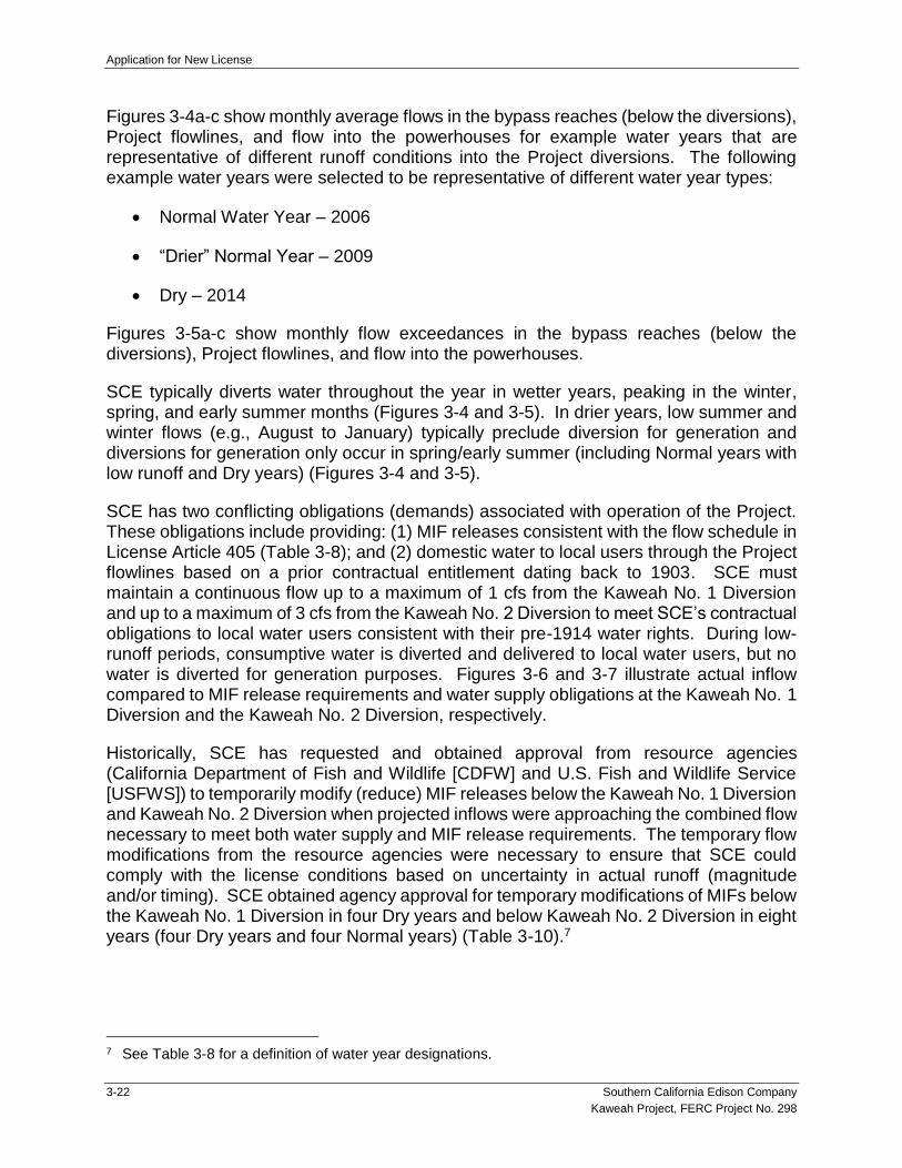
Application for New License
3-22 Southern California Edison Company
Kaweah Project, FERC Project No. 298
Figures 3-4a-c show monthly average flows in the bypass reaches (below the diversions), Project flowlines, and flow into the powerhouses for example water years that are representative of different runoff conditions into the Project diversions. The following example water years were selected to be representative of different water year types:
Normal Water Year – 2006
“Drier” Normal Year – 2009
Dry – 2014
Figures 3-5a-c show monthly flow exceedances in the bypass reaches (below the diversions), Project flowlines, and flow into the powerhouses.
SCE typically diverts water throughout the year in wetter years, peaking in the winter, spring, and early summer months (Figures 3-4 and 3-5). In drier years, low summer and winter flows (e.g., August to January) typically preclude diversion for generation and diversions for generation only occur in spring/early summer (including Normal years with low runoff and Dry years) (Figures 3-4 and 3-5).
SCE has two conflicting obligations (demands) associated with operation of the Project. These obligations include providing: (1) MIF releases consistent with the flow schedule in License Article 405 (Table 3-8); and (2) domestic water to local users through the Project flowlines based on a prior contractual entitlement dating back to 1903. SCE must maintain a continuous flow up to a maximum of 1 cfs from the Kaweah No. 1 Diversion and up to a maximum of 3 cfs from the Kaweah No. 2 Diversion to meet SCE’s contractual obligations to local water users consistent with their pre-1914 water rights. During low-runoff periods, consumptive water is diverted and delivered to local water users, but no water is diverted for generation purposes. Figures 3-6 and 3-7 illustrate actual inflow compared to MIF release requirements and water supply obligations at the Kaweah No. 1 Diversion and the Kaweah No. 2 Diversion, respectively.
Historically, SCE has requested and obtained approval from resource agencies (California Department of Fish and Wildlife [CDFW] and U.S. Fish and Wildlife Service [USFWS]) to temporarily modify (reduce) MIF releases below the Kaweah No. 1 Diversion and Kaweah No. 2 Diversion when projected inflows were approaching the combined flow necessary to meet both water supply and MIF release requirements. The temporary flow modifications from the resource agencies were necessary to ensure that SCE could comply with the license conditions based on uncertainty in actual runoff (magnitude and/or timing). SCE obtained agency approval for temporary modifications of MIFs below the Kaweah No. 1 Diversion in four Dry years and below Kaweah No. 2 Diversion in eight years (four Dry years and four Normal years) (Table 3-10).7
7 See Table 3-8 for a definition of water year designations.

Application for New License
Southern California Edison Company 3-23
Kaweah Project, FERC Project No. 298
Although, SCE obtained agency approval for temporary modifications of MIFs when inflows were projected to not meet both the MIF requirements and the water supply commitments, the approved reductions in MIF were only implemented at the Kaweah No. 2 Diversion in 2002, 2012, 2015, and 2016 (Table 3-10). In 2002, SCE implemented the flow modifications, reducing the MIF release by 1.5 cfs on average for 13 days. In 2012, SCE reduced the MIF release by 1 cfs on average for three days. In 2015, SCE reduced the MIF release by 0.35 cfs on average for four days. In 2016, SCE’s original request for a temporary flow modification (through August 31) needed to be extended as runoff in the Kaweah Watershed was projected to remain low, due to drought conditions in the region. On August 30, 2016, SCE requested a temporary flow variance through December 31, 2016. SCE’s temporary flow variance request was approved by FERC on September 8, 2016. During the entire flow modification period, SCE reduced the MIF release by 2.68 cfs on average for 25 days.
In the East Fork Kaweah River, stream flows were sufficient to meet both the MIF requirements and the water supply commitments in all years despite requests for flow modifications based on projected inflow.
3.6 PROJECT GENERATION AND OUTFLOW RECORDS
The timing and number of hours of generation in a given year is a function of inflow (runoff), FERC License requirements for MIF and ramping rates, flowline and powerhouse capacities, water rights, and the minimum flow required to maintain sufficient head in the flowline to meet water delivery contractual obligations.
Annual net generation for the Project since issuance of the current license (1992–2018) is summarized in Table 3-11 (SCE 2018). During this period, all Project powerhouses experienced periods of no generation. Lack of generation at a powerhouse is generally the result of: (1) routine maintenance outage; (2) outages caused by the powerhouse tripping; (3) facility repairs necessitating a powerhouse be offline; or (4) periods of low runoff when SCE is required to meet contractual entitlements to deliver water to local water users consistent with their pre-1914 water rights and there is not enough water remaining for generation. From 1992–2018, annual generation ranged from 14,762 megawatt hours (MWh) (2014) to 60,725 MWh (1998). The Project’s annual average generation is 39,124 MWh. The estimated dependable generating capacity of the Project by calendar year is 14,762 MWh based on generation records from 2014 (critical dry year).
3.7 EXISTING ENVIRONMENTAL MEASURES
FERC issued a new license to SCE on January 31, 1992 for the Project (FERC 1991, 1992). The license has subsequently been amended by FERC at various times over the term of the license, including revisions to license articles and deletion of license articles (FERC 1992–2015). FERC has also issued various administrative Orders approving management and monitoring plans, and design drawings that were required as part of the current license, effectively completing the requirement of the license article. Table 3-12 provides a summary of the status of each original license article and reference to any

Application for New License
3-24 Southern California Edison Company
Kaweah Project, FERC Project No. 298
associated FERC Order. In addition, more detailed information is provided below for those license articles and requirements that are currently ongoing.
3.7.1 Water Resources
3.7.1.1 Ramping Requirements
SCE meets ramping rate requirements downstream of diversion dams and the Kaweah No. 1 and No. 2 powerhouses in accordance with FERC License Article 404, as described below.
Article 404. The licensee shall operate the project such that flows below Diversion Dams and Powerhouses Nos. 1 and 2 are not altered at a rate greater than 30 percent of the existing streamflow per hour.
As required by FERC in letters dated March 13, 2003, and June 13, 2005, SCE files an annual report with FERC documenting compliance with ramping requirements by April 1 of each year.
3.7.1.2 Minimum Instream Flow Requirements
SCE provides MIF releases in accordance with FERC License Article 405, as amended (Table 3-8). License Article 405 was amended on April 20, 1994 to include a definition for dry and normal years and to clarify minimum flow requirements for May that were previously omitted. As required by FERC in letters dated March 13, 2003, and June 13, 2005, SCE files an annual report with FERC documenting compliance with MIF requirements by April 1 of each year.
3.7.1.3 Erosion Protection and Remediation Plan
License Article 401 approved the Erosion Protection and Remediation Plan prepared by SCE for the Project (SCE 1992a). The plan was subsequently revised and FERC approved the revised plan in an Order issued January 19, 1993. The plan required the implementation of erosion protection and remediation measures along Kaweah No. 1 Flowline and Project access roads that were completed by SCE. In addition, the plan includes erosion protection measures that SCE is required to implement in the event of a future flowline break.
3.7.1.4 Stream Gaging Plan
As required by License Article 407, SCE prepared a Stream Gaging Plan that detailed installation, operation, and maintenance of stream gages in the East Fork Kaweah River and the mainstem Kaweah River. The stream gaging network was designed to be capable of effectively monitoring the requirements of License Articles 404 (ramping rates) and 405 (minimum instream flow). SCE submits annual reports to FERC documenting compliance with License Articles 404 and 405 using the data obtained from Project gages in accordance with the Stream Gaging Plan. In addition, should a violation associated

Application for New License
Southern California Edison Company 3-25
Kaweah Project, FERC Project No. 298
with License Articles 404 or 405 occur, SCE is required to file a report with FERC detailing the nature of the violation and any measures implemented to correct the violation.
3.7.2 Cultural Resources
3.7.2.1 Cultural Resources Management Plan
As required by License Article 414, SCE prepared a Cultural Resources Management Plan (CRMP) (SCE 1992b) that identifies specific measures that SCE undertakes to avoid adverse impacts to four National Register of Historic Places (NRHP) eligible properties located within the FERC Project boundary, including three archaeological sites associated with Project transmission lines and contributing elements of the Kaweah No. 3 Historic District.
The CRMP identifies various programmatic measures that SCE is required to implement, as well as resource monitoring and recordation. The CRMP states that if impacts to NRHP-eligible properties cannot be avoided with implementation of protective and avoidance measures, SCE, in consultation with State Historic Preservation Officer and FERC, shall develop a site-specific treatment plan in accordance with 36 CFR Part 800.4-800.6. Resource monitoring and recordation is required to occur in three-year increments to determine the success of current measures and to evaluate the need for additional treatment.
3.7.2.2 Ground-disturbing Activities Consultation
In accordance with License Article 415, prior to any land-clearing, land-disturbing, or spoil-producing activities associated with the Project, SCE is required to consult with resource agencies. In addition, SCE is required to conduct a cultural resource survey of the affected area and file a survey report and a cultural resource management plan should any significant archaeological or historic resource be identified.
3.7.3 Terrestrial Resources
3.7.3.1 Wildlife Protection and Monitoring
As required by License Article 408, SCE implemented measures to minimize wildlife drowning in the Kaweah No. 2 Flowline. The measures ranged from the installation of hazers and flashers at existing escape ramps to the replacement of existing bridges. Required improvements were implemented between 1992 and 1996.
As required by License Article 409, SCE developed a plan to protect deer and other wildlife from drowning in the Kaweah No. 3 Flowline. The plan included widening existing foot and wildlife bridges, moving existing footbridges, converting footbridges to wildlife bridges, constructing new wildlife bridges, and a plan for improving and maintaining the facilities. These improvements were implemented between 1994 and 1996.

Application for New License
3-26 Southern California Edison Company
Kaweah Project, FERC Project No. 298
In accordance with License Article 410, SCE conducts monitoring to determine whether the measures implemented at Kaweah No. 2 and No. 3 flowlines were successful in minimizing wildlife drownings, and to inspect wildlife protection facilities to determine any required maintenance/upgrade actions. SCE files an annual report with FERC that documents mortality and observed wildlife use on or near the bridges.
3.7.3.2 Avian Mortality Reporting Plan
As required by License Article 412, SCE developed the Avian Mortality Reporting Plan that includes methods for monitoring Project transmission lines for injury or electrocution of raptors and other birds. SCE files a report with FERC every five years that documents monitoring results.
3.7.4 Land Management
3.7.4.1 Land Clearance Requirements
In accordance with License Article 203, SCE keeps all lands along open flowlines clear to an adequate width and disposes of all temporary structures. This includes removal of unused timber, hazard trees, brush, refuse, or other material unnecessary for the purpose of the Project. All clearing of lands and disposal of unnecessary material is conducted in accordance with appropriate federal, state, and local statutes and regulations.
3.8 OTHER SCE COMPANY-WIDE ENVIRONMENTAL PROGRAMS
In addition to the above license articles, the following programs are also implemented for the Kaweah Project.
3.8.1 Environmental Training Program
Kaweah Project personnel receive annual environmental awareness training on an as-needed basis. Annual training covers avian protection, nesting birds, special-status species, and cultural resources, and includes information on recognizing biological and cultural sensitivities, avoiding impacts to resources, and contact information for engaging SCE’s Environmental Services Department for support. Project-specific trainings may be conducted in the field as tailboards on an activity-specific basis to review appropriate avoidance and resource protection measures in environmentally sensitive areas. This environmental program is administered under SCE’s corporate-wide Environmental Awareness Training Program.
3.8.2 Transmission, Power, and Communication Line Maintenance Program
Kaweah Project transmission, power, and communication line poles that require maintenance are evaluated for compliance with the Avian Power Line Interaction Committee (APLIC) Guidelines. Depending on the results of the evaluation, SCE either retrofits with raptor-safe equipment or replaces with a raptor-safe pole configuration. Raptor-safe powerline design configurations described in Suggested Practices for Avian Protection on Power Lines: The State of the Art in 2006 (APLIC 2006) are used when

Application for New License
Southern California Edison Company 3-27
Kaweah Project, FERC Project No. 298
replacing existing towers, poles, phase conductors, and associated equipment. This program is administered under SCE’s corporate-wide Avian Protection Program.
3.9 PROJECT SAFETY
3.9.1 Part 12 Dam Safety Inspections
The existing Project dams are classified as a “low hazard” since no reasonably foreseeable project emergency would endanger life, health, or property. Accordingly, the Project is exempt from the Independent Consultants Dam Safety Inspection that is typically required under the 18 CFR Part 12, Subpart D. However, over the term of the existing license, SCE has participated in FERC dam safety and environmental inspections. Any subsequent FERC directives and items identified during these inspections as requiring attention were timely addressed by SCE and written documentation filed with FERC.
Pursuant to 18 CFR §12.20(a), FERC requires licensees to develop and file an Emergency Action Plan (EAP) with the Regional Engineer, unless granted a written exemption in accordance with §12.21(a) of the regulations. Since April 1981, SCE has been exempted from filing an EAP for the Project diversions since it demonstrated that no reasonably foreseeable Project emergency would endanger life, health, or property. As required in 18 CFR §12.21(c)(1), SCE continues to review the conditions that allow them the exemption by conducting field reconnaissance of areas downstream of all exempt diversions to confirm that no new downstream development has occurred. During the current license term, SCE has filed annual requests with FERC for a continuation of the exemption from EAP requirements for the Project since no downstream hazard exists should any of the diversions fail. To date, FERC has agreed with SCE’s annual requests and determined that an EAP is not required for the Project. Per 18 CFR §12.21(c)(2), if there are any changes to the Project that might cause an emergency endangering life, health, or property, SCE would promptly notify FERC to determine the necessity to prepare an EAP.
3.9.2 Project Safety Features
SCE maintains several features aimed at protecting public health and safety, and wildlife, including:
Signage: SCE utilizes signage to warn the public of hazardous areas and potentially dangerous conditions. For example, danger and warning signs are located near facilities that may pose a danger to the public (e.g., flowlines, powerhouses, and switchyards).
Physical Restraining Devices: SCE uses various devices to restrict public access to hazardous areas, including:
Fences around powerhouses, switchyards, forebays, and select flowline features;

Application for New License
3-28 Southern California Edison Company
Kaweah Project, FERC Project No. 298
Gates limiting access onto Project facilities;
Grates and debris catchers on intake structures; and
Flowline Safety Features: SCE has installed various features to allow people and wildlife to safely cross the flowline and other features that provide a mechanism for escape, should a person or animal fall into the water. These features are briefly described below.
Footbridges and Crossings: Footbridges and wildlife crossings are present at various intervals along the Kaweah No. 2 and Kaweah No. 3 flowlines to allow SCE personnel and wildlife to cross safely. The footbridges include signage that they are to be used by SCE personnel only and the public is cautioned to keep off.
Escape Features: SCE installed various features to reduce wildlife mortality (drownings) in the Kaweah No. 2 and Kaweah No. 3 flowlines. These include: escape ramps; escape fencing (chain link fencing attached to the side of the flowline); and flashers/hazers. While these features are intended for use by wildlife, they also provide a mechanism for the public and SCE personnel to exit the flowline in the event of an accidental fall into the water.
Handrails: Hand rails are installed in elevated areas, including along bridges and flowline walkways. These features protect the health and safety of SCE employees and subcontractors who operate and maintain the Project facilities.
River Safety Measures: A horizontal safety cable is strung across the Kaweah River, just upstream of the Kaweah No. 2 intake facility. This cable is intended to function as a grab line to facilitate exiting the river prior to the Kaweah No. 2 Diversion Dam.
3.10 LITERATURE CITED
FERC (Federal Energy Regulatory Commission). 1991. Environmental Assessment. Federal Energy Regulatory Commission, Office of Hydropower Licensing, Division of Project Review. Kaweah Project. FERC Project No. 298-000 – California. August 16, 1991.FERC. 1992. Order Issuing New License (Major) for Southern California Edison’s Project No. 298. Issued January 31, 1992.
FERC. 1992–2015. Various Orders and Amendments issued by FERC for the Kaweah Project (FERC Project No. 298).
NPS (National Park Service). 2016. Sequoia and Kings Canyon National Parks. Special Use Permit for Southern California Edison. Permit No. PWR-SEKI-6000-2016-015.

Application for New License
Southern California Edison Company 3-29
Kaweah Project, FERC Project No. 298
SCE (Southern California Edison Company). 1992a. Cultural Resources Management Plan for Southern California Edison Company’s Kaweah Hydroelectric Project Tulare County, California, FERC Project No. 298. November.
SCE. 1992b. Final Erosion Protection and Remediation Plan. Kaweah Hydroelectric Project. Tulare County, California. November.
SCE. 2001. Kaweah Project, Exhibit A, As-Built General Description and Specifications of Mechanical, Electrical, Transmission Equipment. November.
SCE. 2018. Project generation records for 1992 through 2018.

Application for New License
3-30 Southern California Edison Company
Kaweah Project, FERC Project No. 298
This Page Intentionally Left Blank

Application for New License
Southern California Edison Company 3.10-31
Kaweah Project, FERC Project No. 298
TABLES

Application for New License
3.10-32 Southern California Edison Company
Kaweah Project, FERC Project No. 298
This Page Intentionally Left Blank

Application for New License
Southern California Edison Company 3-33
Kaweah Project, FERC Project No. 298
Table 3-1. Kaweah Project History
Year Development Activity
1898–1899 Construction of the Kaweah No. 1 Development
June 1899 Kaweah No. 1 Powerhouse commenced operation
1904–1905 Construction of the Kaweah No. 2 Development
February 1905 Kaweah No. 2 Powerhouse commenced operation
1909–1913 Construction of the Kaweah No. 3 Development
May 1913 Kaweah No. 3 Powerhouse commenced operation
1920s Upgrades to all powerhouses that allowed for semi-automatic operation, thus allowing for generation without full-time station operators at each powerhouse.
1929 Demolition of original 1899 Kaweah No. 1 Powerhouse and appurtenances, and relocation/upgrade of the powerhouse several hundred feet upstream.
1930s All powerhouses were fully automated, with all functions centrally managed.
1930s Removal of the original wood pole transmission lines, with the entire system upgraded to 66 kV lines and much of it carried by new steel cross-arm structures.
1947 Entirety of the 6-mile Kaweah No. 1 Flowline was dismantled and reconstructed.
1948 Wood portions of the Kaweah No. 2 Flowline replaced.
1986 Handrails added to the Kaweah No. 1 Flowline. The handrails have been serviced and replaced over time.
1989–1991 Much of the wood framing along the Kaweah No. 1 Flowline was rebuilt along the entirety of the alignment, with new stringers, legs, bracing, and pony bents.
2012–2013 Kaweah No. 2 Diversion Dam Intake structure rebuilt with new concrete and new intake structure.
2018 Kaweah No. 3 horizontal penstock replaced.

Application for New License
3-34 Southern California Edison Company
Kaweah Project, FERC Project No. 298
Table 3-2. No-Action Alternative – Existing Project Facilities
Diversion Dams and Pools
Kaweah No. 1 Diversion Dam and Pool (East Fork Kaweah River)
Kaweah No. 2 Diversion Dam and Pool (Kaweah River)
Flowlines
Kaweah No. 1 Flowline
Kaweah No. 2 Flowline
Kaweah No. 3 Flowline
Forebays
Kaweah No. 1 Forebay Tank
Kaweah No. 2 Forebay
Kaweah No. 3 Forebay
Penstocks
Kaweah No. 1 Penstock
Kaweah No. 2 Penstock
Kaweah No. 3 Penstock
Powerhouses and Switchyards
Kaweah No. 1 Powerhouse and Switchyard
Kaweah No. 2 Powerhouse and Switchyard
Kaweah No. 3 Powerhouse and Switchyard
Transmission Lines and Transmission Tap Lines
Kaweah No. 1 Powerhouse Transmission Tap Line
Kaweah No. 2 Powerhouse Transmission Tap Line
Kaweah No. 3 Powerhouse to Three Rivers Substation Transmission Line
Power Lines
Kaweah No. 1 Diversion Solar Panel to Kaweah No. 1 Diversion Dam Power Line
Kaweah No. 1 Office Building to Kaweah No. 1 Forebay Tank Power Line
Kaweah No. 1 Powerhouse Campus Alternate Power Line
Kaweah No. 1 Switchyard to Kaweah No. 1 Maintenance Building Power Line
Kaweah No. 1 Switchyard to Kaweah No. 1 Office Building Power Line
Kaweah No. 1 Switchyard to Kaweah No. 1 Operator’s Office Power Line
Kaweah No. 1 Switchyard to Kaweah No. 1 Workshop Power Line
Kaweah No. 2 Diversion/Flowline Gage and Kaweah No. 3 Powerhouse Alternate Power Line
Kaweah No. 2 Powerhouse Alternate Power Line
Kaweah No. 2 Powerhouse to Kaweah No. 2 Forebay Power Line
Kaweah No. 3 Powerhouse to Kaweah No. 2 Diversion Power Line
Kaweah No. 3 Powerhouse to Kaweah No. 2 Flowline Gage Power Line
Kaweah No. 3 Powerhouse to Kaweah No. 3 Forebay Power Line

Application for New License
Southern California Edison Company 3-35
Kaweah Project, FERC Project No. 298
Communication Lines
Kaweah No. 1 Office Building to Kaweah No. 1 Forebay Tank Fiber Optic Communication Line
Kaweah No. 1 Powerhouse to Kaweah No. 1 Office Building Fiber Optic Communication Line
Kaweah No. 2 Diversion Dam to Kaweah No. 3 Powerhouse Fiber Optic Communication Line
Kaweah No. 2 Powerhouse to Kaweah No. 2 Forebay Fiber Optic Communication Line
Kaweah No. 3 Forebay to Kaweah No. 3 Forebay Inlet Fiber Optic Communication Line
Kaweah No. 3 Powerhouse to Kaweah No. 3 Forebay Fiber Optic Communication Line
Stream Gages
East Fork Kaweah River Conduit 1 at Power Plant near Hammond CA (USGS Gage No. 11208800) (SCE Gage No. 200a)
East Fork Kaweah River near Three Rivers CA (USGS Gage No. 11208730) (SCE Gage No. 201)
Kaweah No. 1 Minimum Instream Flow Release (SCE Gage No. 201a)
East Fork Kaweah River Conduit 1 near Three Rivers CA (SCE Gage No. 202)
Kaweah River below Conduit No. 2 near Hammond CA (USGS Gage No. 11208600) (SCE Gage No. 203)
Kaweah River Conduit No. 2 near Hammond CA (SCE Gage No. 204a)
Kaweah River Conduit No. 2 at Power Plant near Hammond CA (USGS Gage No. 11208818) (SCE Gage No. 205a)
Middle Fork Kaweah River Conduit No. 3 at Power Plant near Hammond CA (USGS Gage No. 11208565) (SCE Gage No. 206a)
Project Access Roads
Kaweah No. 1 Flowline Access Road – Bear Canyon
Kaweah No. 1 Flowline Access Road – Grapevine
Kaweah No. 1 Flowline Access Road – Lower Pine
Kaweah No. 1 Flowline Access Road – Lower Pine (spur)
Kaweah No. 1 Flowline Access Road – Lumberyard
Kaweah No. 1 Flowline Access Road – Lumberyard (spur)
Kaweah No. 1 Flowline Access Road – Slick Rock
Kaweah No. 1 Flowline Access Road – Summit
Kaweah No. 1 Flowline Access Road – Unnamed
Kaweah No. 1 Flowline Access Road – Upper Pine
Kaweah No. 1 Forebay Road
Kaweah No. 2 Flowline Access Road – Canal 2 Brushout Grid
Kaweah No. 2 Flowline Access Road – Canal 4 East
Kaweah No. 2 Flowline Access Road – Canal 4 West
Kaweah No. 2 Flowline Access Road – Canal 5
Kaweah No. 2 Flowline Access Road – Canal 6 East
Kaweah No. 2 Flowline Access Road – Canal 6 West
Kaweah No. 2 Flowline Access Road – Flume 8
Kaweah No. 2 Flowline Access Road – Flume 11
Kaweah No. 2 Flowline Access Road – Open Siphon Grids

Application for New License
3-36 Southern California Edison Company
Kaweah Project, FERC Project No. 298
Project Access Roads (continued)
Kaweah No. 2 Flowline Access Road – Red Barn
Kaweah No. 2 Flowline Center Access Road
Kaweah No. 2 Flowline East Access Road
Kaweah No. 2 Flowline West Access Road
Kaweah No. 2 Forebay Road
Kaweah No. 2 Intake Road
Kaweah No. 2 Penstock Road
Kaweah No. 3 Forebay Road
Kaweah No. 3 Powerhouse Road
Project Trails
Kaweah No. 1 Flowline Access Trail – Unnamed
Kaweah No. 2 Flowline Access Trail – Canal 2
Kaweah No. 2 Flowline Access Trail – Canal 4 East
Kaweah No. 2 Flowline Access Trail – Canal 4 West
Kaweah No. 2 Flowline Access Trail – Canal 5
Kaweah No. 2 Flowline Access Trail – Canal 6
Kaweah No. 2 Flowline Access Trail – Canal 11
Kaweah No. 2 Flowline Access Trail – Canal 13
Kaweah No. 2 Flowline Access Trail – Canal 15
Kaweah No. 2 Flowline Access Trail – Open Siphon
Kaweah No. 2 Flowline Access Trail – Water User 9
Kaweah No. 2 Flowline Access Trail – Water User 14
Kaweah No. 2 Flowline Access Trail – Wildlife Crossing 2
Kaweah No. 3 Flowline Access Trail
Ancillary and Support Facilities
Kaweah No. 1 Diversion Solar Panel
Kaweah No. 1 Gaging Cableway
Kaweah No. 1 Grapevine Satellite Repeater
Kaweah No. 1 Powerhouse Campus
Kaweah No. 1 Solar Yard Satellite Repeater
Kaweah No. 2 Flowline Footbridges
Kaweah No. 2 Flowline Wildlife Bridges
Kaweah No. 2 Flowline Wildlife Escape Ramps
Kaweah No. 2 Gaging Cableway
Kaweah No. 2 Powerhouse River Access Parking
Kaweah No. 3 Flowline Footbridges
Kaweah No. 3 Flowline Wildlife Bridges
Kaweah No. 3 Flowline Wildlife Escape Ramps
Kaweah No. 1 Fish Wheel Fence

Application for New License
Southern California Edison Company 3-37
Kaweah Project, FERC Project No. 298
Kaweah No. 1 Flowline Control Gate Fence
Kaweah No. 1 Switchyard Perimeter Fence
Kaweah No. 1 Powerhouse Campus Fence
Kaweah No. 2 Intake Fence
Kaweah No. 2 Forebay Fence
Kaweah No. 2 Powerhouse Perimeter Fence
Kaweah No. 2 Switchyard Perimeter Fence
Kaweah No. 2 Tailrace Channel Fence
Kaweah No. 2 Flowline Control Gate Fence
Kaweah No. 2 Flowline Access Road Bridge Fence
Kaweah No. 3 Forebay Fence
Kaweah No. 3 Forebay Inlet Trash Rack Fence
Kaweah No. 3 Switchyard Perimeter Fence
Kaweah No. 3 Tailrace Channel Fence

Application for New License
3-38 Southern California Edison Company
Kaweah Project, FERC Project No. 298
Table 3-3. Project Facility Specifications
Kaweah No. 1 Development
Diversion
Dam
Type overflow concrete gravity dam
Height of Dam Crest above Streambed 6 feet
Dam Crest Length 20 feet
Volume 80 cubic feet
Elevation of Dam Crest 2,583 feet
Elevation of Streambed 2,577 feet
Pool
Capacity (approx. design/current) 0.03 ac-ft/0.03 ac-ft
Outlet Works
Type unlined tunnel
Dimensions 50-feet long x 3-feet wide x 6-feet high
Control manually operated slide gate
Maximum Capacity 24 cfs
Sandbox (Sediment Trap)
Elevation of Spillway Crest 2,580 feet
Control 36-inch x 36-inch slide gate
Spillway
Type overflow concrete
Width 30 feet
Capacity 50 cfs
Flowline
Type steel flume
Length 30,723 feet
Maximum Capacity 24 cfs
Invert Gradient 29 feet/mile
Forebay Tank
Type steel
Diameter 24 feet
Capacity 0.18 ac-ft
Discharge directly into penstock
Penstock
Type buried steel
Length 3,340 feet
Diameter varies from 48–19 inches

Application for New License
Southern California Edison Company 3-39
Kaweah Project, FERC Project No. 298
Powerhouse
Installed Capacity, Generator 2.25 MW
Type of Turbine Allis-Chalmers impulse turbine
Horsepower 3,790
Design Head 1,260 feet
R.P.M. 600
Minimum Load 150 kW with 2.5 cfs
Maximum Hydraulic Capacity 24 cfs
Maximum Tail Water Surface 60 square feet
Minimum Tail Water Surface 60 square feet
Elevation Runner 1,166 feet
Tailrace Structure/Length rectangular flume 10 feet x 6 feet
Kaweah No. 2 Development
Diversion
Dam
Type overflow masonry gravity dam
Height of Dam Crest above Streambed 7 feet
Dam Crest Length 161 feet
Volume 2,500 cubic feet
Elevation of Dam Crest 1,365 feet
Elevation of Streambed 1,358 feet
Pool
Capacity (approx. design/current) 1–2 ac-ft/0.2 ac-ft
Outlet Works
Type concrete tunnel
Dimensions 12.5-feet long x 10-feet wide x 10-feet high
Control dual 48-inch motor operated slide gates
Tunnel Discharge Pipe:
Type steel
Length 42 feet
Diameter 54 inches
Control manually operated slide gate
Maximum Capacity 100 cfs

Application for New License
3-40 Southern California Edison Company
Kaweah Project, FERC Project No. 298
Flowline
Type:
Segment 1 steel flume
Segment 2 steel pipe
Segment 3 concrete ditch
Length:
Segment 1 3,822 feet x 7-feet wide
Segment 2 1,047-feet long x 50-inch diameter
Segment 3 16,738-feet long x 12-feet wide
Maximum Capacity 87 cfs
Invert Gradient 11.5 feet/mile
Forebay
Type concrete-lined
Dimensions 180-feet long x 13-feet wide x 14-feet deep
Capacity 0.75 ac-ft
Discharge directly into penstock
Penstock
Type buried steel
Length 1,012 feet
Diameter varies from 60–34 inches
Powerhouse
Installed Capacity, Generator 1.8 MW
Type of Turbine Francis
Horsepower 2,900
Design Head 344 feet
R.P.M. 720
Minimum Load 150 kW with 13 cfs
Maximum Hydraulic Capacity 82 cfs
Maximum Tail Water Surface 1,600 square feet
Minimum Tail Water Surface 1,600 square feet
Elevation Runner 978 feet
Tailrace Structure/Length rectangular flume 20 feet x 80 feet
Kaweah No. 3 Development
Flowline
Type concrete box flume
Length 2,975 feet
Maximum Capacity 97 cfs
Invert Gradient 6.6 feet/mile

Application for New License
Southern California Edison Company 3-41
Kaweah Project, FERC Project No. 298
Forebay
Type embankment
Capacity 11 ac-ft
Discharge steel pipe leading to penstock
Penstock
Type buried steel
Length 3,151 feet
Diameter varies from 42–36 inches
Powerhouse
Installed Capacity, Generators:
Unit 1 2.4 MW
Unit 2 2.4 MW
Type of Turbine:
Unit 1 Pelton – double impulse turbine
Unit 2 Pelton – double impulse turbine
Horsepower:
Unit 1 3,000
Unit 2 3,000
Design Head:
Unit 1 750
Unit 2 750
R.P.M.:
Unit 1 300
Unit 2 300
Minimum Load:
Unit 1 150 kW with 4 cfs
Unit 2 150 kW with 5 cfs
Maximum Hydraulic Capacity 92 cfs
Maximum Tail Water Surface 1,500 square feet
Minimum Tail Water Surface 1,500 square feet
Elevation Runner 1,428 feet
Tailrace Structure/Length rectangular flume 10 feet x 150 feet
Source: SCE 2001
Notes:
ac-ft = acre-feet
cfs = cubic feet per second
kW = kilowatt
MW = megawatt
R.P.M. = rotations per minute

Application for New License
3-42 Southern California Edison Company
Kaweah Project, FERC Project No. 298
This Page Intentionally Left Blank

Application for New License
Southern California Edison Company 3-43
Kaweah Project, FERC Project No. 298
Table 3-4. Description of Project Transmission, Power, and Communication Lines
Name Start End
Length (approx. miles)
Length (approx.
feet) Voltage Purpose
Transmission Line
Kaweah No. 3 Powerhouse to Three Rivers Substation Transmission Line
Kaweah No. 3 Powerhouse Three Rivers Substation1 4.00 21,094 66 kV
When powerhouse is generating, provide power to Three Rivers Substation
When powerhouse is not generating, provide power for equipment and facility operation
Transmission Tap Lines
Kaweah No. 1 Powerhouse Transmission Tap Line Kaweah No. 1 Switchyard Primary Transmission Line 0.03 147 66 kV
When powerhouse is generating, provide power to Three Rivers Substation
When powerhouse is not generating, provide power for equipment and facility operation
Kaweah No. 2 Powerhouse Transmission Tap Line Kaweah No. 2 Switchyard Primary Transmission Line 0.41 2,159 66 kV
When powerhouse is generating, provide power to Three Rivers Substation
When powerhouse is not generating, provide power for equipment and facility operation
Power Lines
Kaweah No. 1 Diversion Solar Panel to Kaweah No. 1 Diversion Dam Power Line
Kaweah No. 1 Diversion Solar Panel Kaweah No. 1 Diversion Dam 0.10 544 120 V Power for equipment and facility operation
Kaweah No. 1 Office Building to Kaweah No. 1 Forebay Tank Power Line
Kaweah No. 1 Office Building Kaweah No. 1 Forebay Tank 0.57 3,008 2.4 kV Power for equipment and facility operation
Kaweah No. 1 Powerhouse Campus Alternate Power Line Non-Project Distribution Line (near Hwy 198)
Kaweah No. 1 Switchyard 0.38 2,018 12 kV Alternate power source for equipment and facility operation
Kaweah No. 1 Switchyard to Kaweah No. 1 Maintenance Building Power Line
Kaweah No. 1 Switchyard Kaweah No. 1 Maintenance Building 0.05 281 2.4 kV Power for equipment and facility operation
Kaweah No. 1 Switchyard to Kaweah No. 1 Office Building Power Line
Kaweah No. 1 Switchyard Kaweah No. 1 Office Building 0.01 64 2.4 kV Power for equipment and facility operation
Kaweah No. 1 Switchyard to Kaweah No. 1 Operator’s Office Power Line
Kaweah No. 1 Switchyard Kaweah No. 1 Operator’s Office 0.01 74 2.4 kV Power for equipment and facility operation
Kaweah No. 1 Switchyard to Kaweah No. 1 Workshop Power Line
Kaweah No. 1 Switchyard Kaweah No. 1 Workshop 0.03 150 2.4 kV Power for equipment and facility operation
Kaweah No. 2 Diversion/Flowline Gage and Kaweah No. 3 Powerhouse Alternate Power Line
Non-Project Distribution Line (near Hwy 198)
SCE Project Pole 0.12 626 12 kV Alternate power source for equipment and facility operation
Kaweah No. 2 Powerhouse Alternate Power Line Non-Project Distribution Line (near Hwy 198)
Kaweah No. 2 Switchyard 0.04 206 12 kV Alternate power source for equipment and facility operation
Kaweah No. 2 Powerhouse to Kaweah No. 2 Forebay Power Line
Kaweah No. 2 Powerhouse Kaweah No. 2 Forebay 0.22 1,185 2.4 kV Power for equipment and facility operation
Kaweah No. 3 Powerhouse to Kaweah No. 2 Diversion Power Line
Kaweah No. 3 Powerhouse Kaweah No. 2 Diversion Dam 0.12 653 2.4 kV Power for equipment and facility operation
Kaweah No. 3 Powerhouse to Kaweah No. 2 Flowline Gage Power Line
Kaweah No. 3 Powerhouse Kaweah No. 2 Flowline Gage 0.10 546 2.4 kV Power for equipment and facility operation
Kaweah No. 3 Powerhouse to Kaweah No. 3 Forebay Power Line
Kaweah No. 3 Powerhouse Kaweah No. 3 Forebay 0.46 2,439 2.4 kV Power for equipment and facility operation

Application for New License
3-44 Southern California Edison Company
Kaweah Project, FERC Project No. 298
Name Start End
Length (approx. miles)
Length (approx.
feet) Voltage Purpose
Communication Lines
Kaweah No. 1 Office Building to Kaweah No. 1 Forebay Tank Fiber Optic Communication Line
Kaweah No. 1 Office Building Kaweah No. 1 Forebay Tank 0.56 2,960 – Communication between Project facilities
Kaweah No. 1 Powerhouse to Kaweah No. 1 Office Building Fiber Optic Communication Line
Kaweah No. 1 Powerhouse Kaweah No. 1 Office Building 0.03 134 – Communication between Project facilities
Kaweah No. 2 Diversion Dam to Kaweah No. 3 Powerhouse Fiber Optic Communication Line
Kaweah No. 2 Diversion Dam Kaweah No. 3 Powerhouse 0.06 295 – Communication between Project facilities
Kaweah No. 2 Powerhouse to Kaweah No. 2 Forebay Fiber Optic Communication Line
Kaweah No. 2 Powerhouse Kaweah No. 2 Forebay 0.17 900 – Communication between Project facilities
Kaweah No. 3 Forebay to Kaweah No. 3 Forebay Inlet Fiber Optic Communication Line
Kaweah No. 3 Forebay Kaweah No. 3 Forebay Inlet 0.11 592 – Communication between Project facilities
Kaweah No. 3 Powerhouse to Kaweah No. 3 Forebay Fiber Optic Communication Line
Kaweah No. 3 Powerhouse Kaweah No. 3 Forebay 0.46 2,445 – Communication between Project facilities
Sources: FERC Order amending license (August 7, 2001); SCE Communication (August 2015); Field Observations (2018)
Notes: 1 The Three Rivers Substation is not part of the Kaweah Project.

Application for New License
Southern California Edison Company 3-45
Kaweah Project, FERC Project No. 298
Table 3-5. Description of Project Access Roads and Trails
Project Facility Start End
Overall Length Width (feet)
Surface Treatment
Overall Condition
Gated and/or Vehicular Access
Blocked Feet Mile
Project Access Roads
Kaweah No. 1 Development
Kaweah No. 1 Flowline Access Road - Bear Canyon Mineral King Road Kaweah No. 1 Flowline 130 0.025 8-12 Native Good
Kaweah No. 1 Flowline Access Road - Grapevine Mineral King Road Kaweah No. 1 Flowline 1,591 0.301 8-12 Aggregate Poor Yes
Kaweah No. 1 Flowline Access Road - Lower Pine Mineral King Road Kaweah No. 1 Flowline 841 0.159 8-12 Aggregate Good Yes
Kaweah No. 1 Flowline Access Road - Lower Pine (spur) Kaweah No. 1 Flowline Access Road - Lower Pine
Kaweah No. 1 Flowline 129 0.024 8-12 Aggregate Good Yes
Kaweah No. 1 Flowline Access Road - Lumberyard Mineral King Road Kaweah No. 1 Flowline 216 0.041 8-12 Native Good
Kaweah No. 1 Flowline Access Road - Lumberyard (spur) Kaweah No. 1 Flowline Access Road - Lumberyard
Kaweah No. 1 Flowline 63 0.012 8-12 Native Good
Kaweah No. 1 Flowline Access Road - Slick Rock Mineral King Road Kaweah No. 1 Flowline 378 0.072 8-12 Native Good Yes
Kaweah No. 1 Flowline Access Road - Summit Mineral King Road Kaweah No. 1 Flowline 2,525 0.478 8-12 Aggregate, Paved, Native
Poor Yes
Kaweah No. 1 Flowline Access Road - Unnamed Mineral King Road Kaweah No. 1 Flowline 113 0.021 8-12 Native Poor Yes
Kaweah No. 1 Flowline Access Road - Upper Pine Mineral King Road Kaweah No. 1 Flowline 767 0.145 8-12 Aggregate Good Yes
Kaweah No. 1 Forebay Road Craig Ranch Road Kaweah No. 1 Flowline 14,250 2.699 8-12 Native Fair to Good Yes
Kaweah No. 2 Development
Kaweah No. 2 Flowline Access Road - Canal 2 Brushout Grid Canyon View Drive Spur Kaweah No. 2 Flowline 77 0.015 8-12 Native Good Yes
Kaweah No. 2 Flowline Access Road - Canal 4 East Kaweah No. 2 Flowline East Access Road
Kaweah No. 2 Flowline 378 0.072 8-12 Native Good
Kaweah No. 2 Flowline Access Road - Canal 4 West Kaweah No. 2 Flowline East Access Road
Kaweah No. 2 Flowline 682 0.129 8-12 Native Fair to Poor
Kaweah No. 2 Flowline Access Road - Canal 5 Kaweah No. 2 Flowline East Access Road
Kaweah No. 2 Flowline 1,204 0.228 8-12 Native Good
Kaweah No. 2 Flowline Access Road - Canal 6 East Kaweah No. 2 Flowline East Access Road
Kaweah No. 2 Flowline 354 0.067 8 Native Good
Kaweah No. 2 Flowline Access Road - Canal 6 West Kaweah No. 2 Flowline East Access Road
Kaweah No. 2 Flowline 186 0.035 8-12 Native Fair
Kaweah No. 2 Flowline Access Road - Flume 8 Kaweah No. 2 Flowline Center Access Road
Kaweah No. 2 Flowline 259 0.049 8 Native Poor Yes
Kaweah No. 2 Flowline Access Road - Flume 11 Kaweah No. 2 Flowline West Access Road
Kaweah No. 2 Flowline 158 0.030 12-16 Native Good
Kaweah No. 2 Flowline Access Road - Open Siphon Grids Kaweah No. 3 Powerhouse Road Kaweah No. 2 Flowline 287 0.054 8-12 Aggregate Good
Vehicular access blocked via gate located on Kaweah No. 3 Powerhouse Road
Kaweah No. 2 Flowline Access Road - Red Barn Dinely Road Kaweah No. 2 Flowline 726 0.138 8-12 Aggregate Good

Application for New License
3-46 Southern California Edison Company
Kaweah Project, FERC Project No. 298
Project Facility Start End
Overall Length Width (feet)
Surface Treatment
Overall Condition
Gated and/or Vehicular Access
Blocked Feet Mile
Kaweah No. 2 Flowline Center Access Road Dinely Road Dinely Road 4,640 0.879 8 Paved to Native
Poor Yes
Kaweah No. 2 Flowline East Access Road Dinely Road Canyon View Drive 8,259 1.564 8-12 Paved to Aggregate
Good
Two gates present between Flume 5 and 6 but unlocked / open.
Gated on eastern-most end at the SNP boundary.
Kaweah No. 2 Flowline West Access Road Kaweah River Drive Kaweah No. 2 Flowline Access Road - Flume 11
6,359 1.204 8-12 Paved to Aggregate
Good Yes
Kaweah No. 2 Forebay Road Kaweah No. 2 Flowline West Access Road
Kaweah No. 2 Forebay 1,568 0.297 8-12 Native Fair
Vehicular access blocked via gate located on Kaweah No. 2 Flowline West Access Road
Kaweah No. 2 Intake Road Kaweah No. 3 Powerhouse Road Kaweah No. 2 Intake 571 0.108 8-12 Paved Good
Vehicular access blocked via gate located on Kaweah No. 3 Powerhouse Road
Kaweah No. 2 Penstock Road Kaweah No. 2 Flowline West Access Road
Kaweah No. 2 Penstock 413 0.078 8-12 Native Fair
Kaweah No. 3 Development
Kaweah No. 3 Forebay Road Kaweah No. 3 Powerhouse Road Kaweah No. 3 Forebay 9,227 1.748 8-12 Native Good Yes
Kaweah No. 3 Powerhouse Road State Highway 198 Kaweah No. 3 Powerhouse 1,035 0.196 8-12 Paved Good Yes
Project Trails
Kaweah No. 1 Development
Kaweah No. 1 Flowline Access Trail - Unnamed Mineral King Road Kaweah No. 1 Flowline 95 0.018 NA Native Fair
Kaweah No. 2 Development
Kaweah No. 2 Flowline Access Trail - Canal 2 Canyon View Drive Spur Kaweah No. 2 Flowline 44 0.008 NA Native Good
Kaweah No. 2 Flowline Access Trail - Canal 4 East Kaweah No. 2 Flowline Access Road - Canal 4 East
Kaweah No. 2 Flowline 42 0.008 NA Native Good
Kaweah No. 2 Flowline Access Trail - Canal 4 West Kaweah No. 2 Flowline Access Road - Canal 4 West
Kaweah No. 2 Flowline 40 0.008 NA Native Good
Kaweah No. 2 Flowline Access Trail - Canal 5 Kaweah No. 2 Flowline Access Road - Canal 5
Kaweah No. 2 Flowline 42 0.008 NA Native Good
Kaweah No. 2 Flowline Access Trail - Canal 6 Kaweah No. 2 Flowline Access Road - Canal 6 East
Kaweah No. 2 Flowline 46 0.009 NA Native Good
Kaweah No. 2 Flowline Access Trail - Canal 11 Kaweah No. 2 Flowline West Access Road
Kaweah No. 2 Flowline 77 0.015 NA Native Good
Kaweah No. 2 Flowline Access Trail - Canal 13 Kaweah No. 2 Flowline West Access Road
Kaweah No. 2 Flowline 53 0.010 NA Native Good
Kaweah No. 2 Flowline Access Trail - Canal 15 Kaweah No. 2 Flowline West Access Road
Kaweah No. 2 Flowline 116 0.022 NA Native Good

Application for New License
Southern California Edison Company 3-47
Kaweah Project, FERC Project No. 298
Project Facility Start End
Overall Length Width (feet)
Surface Treatment
Overall Condition
Gated and/or Vehicular Access
Blocked Feet Mile
Kaweah No. 2 Flowline Access Trail - Open Siphon State Highway 198 Kaweah No. 2 Flowline 90 0.017 NA Native Good
Kaweah No. 2 Flowline Access Trail - Water User 9 Kaweah No. 2 Flowline Center Access Road
Kaweah No. 2 Flowline 106 0.020 NA Native Fair
Kaweah No. 2 Flowline Access Trail - Water User 14 Kaweah No. 2 Flowline West Access Road
Kaweah No. 2 Flowline 37 0.007 NA Native Good
Kaweah No. 2 Flowline Access Trail - Wildlife Crossing 2 Kaweah No. 2 Flowline Access Road - Open Siphon Grids
Kaweah No. 2 Flowline 41 0.008 NA Native Good
Kaweah No. 3 Development
Kaweah No. 3 Flowline Access Trail Kaweah No. 3 Forebay Sequoia National Park Boundary 2,975 0.563 NA Native Good Yes; gated at Kaweah No. 3 Forebay

Application for New License
3-48 Southern California Edison Company
Kaweah Project, FERC Project No. 298
This Page Intentionally Left Blank
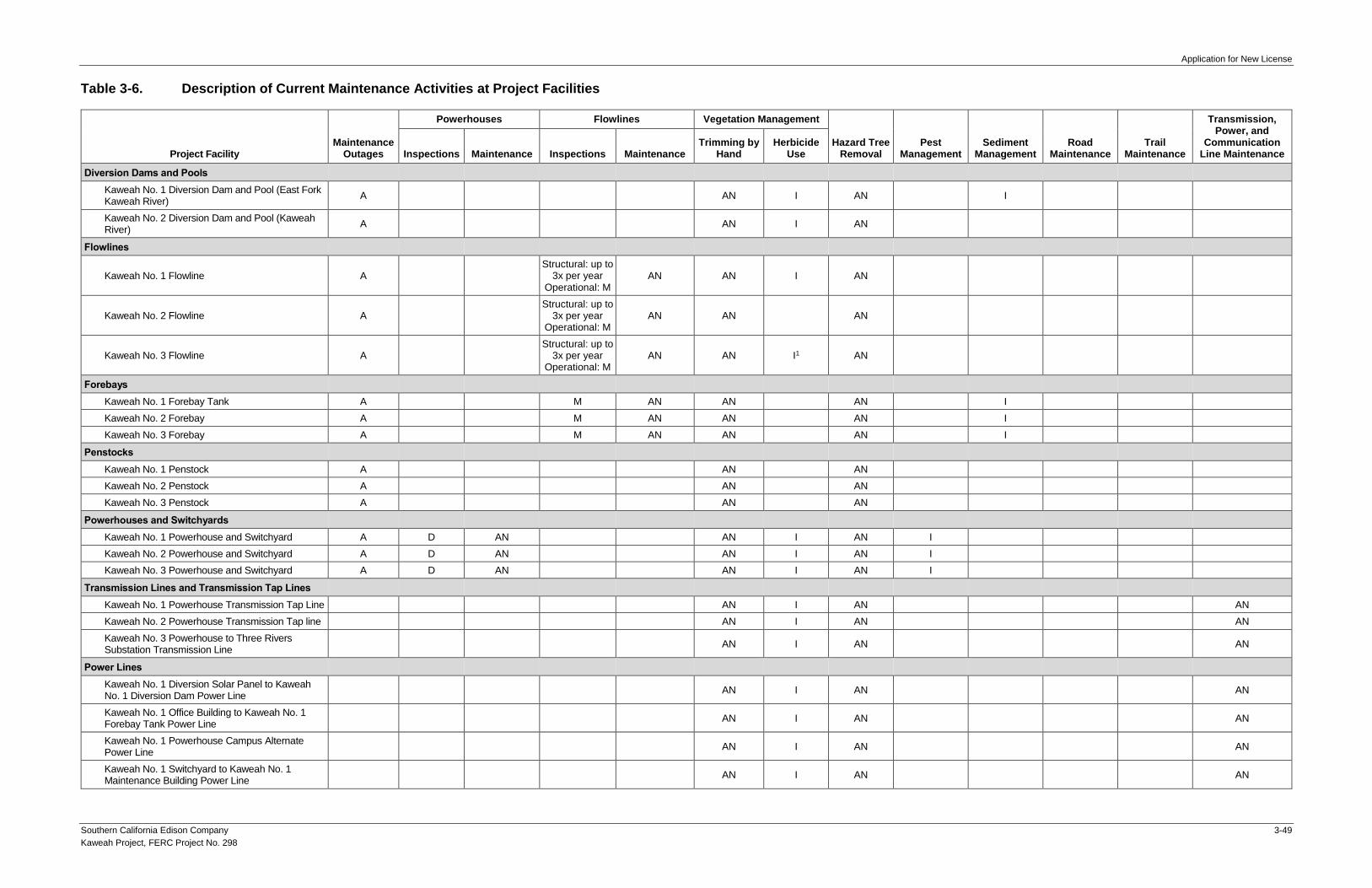
Application for New License
Southern California Edison Company 3-49
Kaweah Project, FERC Project No. 298
Table 3-6. Description of Current Maintenance Activities at Project Facilities
Project Facility Maintenance
Outages
Powerhouses Flowlines Vegetation Management
Hazard Tree Removal
Pest Management
Sediment Management
Road Maintenance
Trail Maintenance
Transmission, Power, and
Communication Line Maintenance Inspections Maintenance Inspections Maintenance
Trimming by Hand
Herbicide Use
Diversion Dams and Pools
Kaweah No. 1 Diversion Dam and Pool (East Fork Kaweah River)
A AN I AN I
Kaweah No. 2 Diversion Dam and Pool (Kaweah River)
A AN I AN
Flowlines
Kaweah No. 1 Flowline A Structural: up to
3x per year Operational: M
AN AN I AN
Kaweah No. 2 Flowline A Structural: up to
3x per year Operational: M
AN AN AN
Kaweah No. 3 Flowline A Structural: up to
3x per year Operational: M
AN AN I1 AN
Forebays
Kaweah No. 1 Forebay Tank A M AN AN AN I
Kaweah No. 2 Forebay A M AN AN AN I
Kaweah No. 3 Forebay A M AN AN AN I
Penstocks
Kaweah No. 1 Penstock A AN AN
Kaweah No. 2 Penstock A AN AN
Kaweah No. 3 Penstock A AN AN
Powerhouses and Switchyards
Kaweah No. 1 Powerhouse and Switchyard A D AN AN I AN I
Kaweah No. 2 Powerhouse and Switchyard A D AN AN I AN I
Kaweah No. 3 Powerhouse and Switchyard A D AN AN I AN I
Transmission Lines and Transmission Tap Lines
Kaweah No. 1 Powerhouse Transmission Tap Line AN I AN AN
Kaweah No. 2 Powerhouse Transmission Tap line AN I AN AN
Kaweah No. 3 Powerhouse to Three Rivers Substation Transmission Line
AN I AN AN
Power Lines
Kaweah No. 1 Diversion Solar Panel to Kaweah No. 1 Diversion Dam Power Line
AN I AN AN
Kaweah No. 1 Office Building to Kaweah No. 1 Forebay Tank Power Line
AN I AN AN
Kaweah No. 1 Powerhouse Campus Alternate Power Line
AN I AN AN
Kaweah No. 1 Switchyard to Kaweah No. 1 Maintenance Building Power Line
AN I AN AN
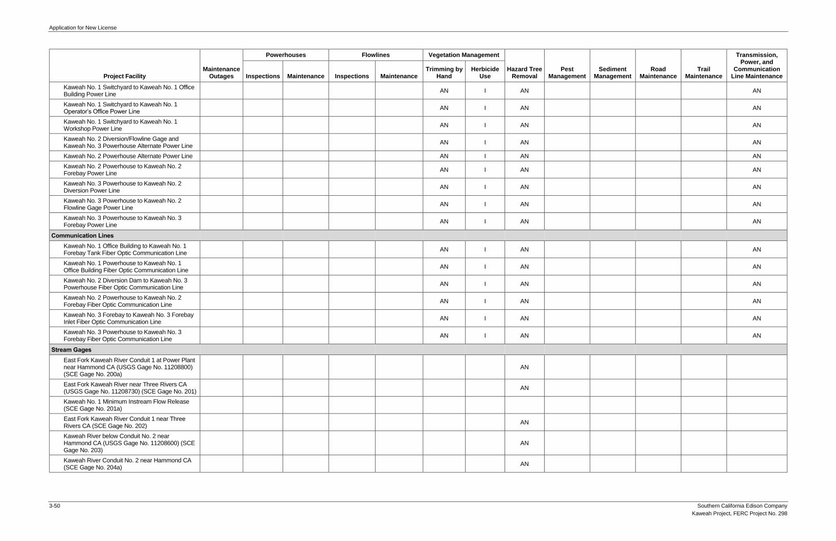
Application for New License
3-50 Southern California Edison Company
Kaweah Project, FERC Project No. 298
Project Facility Maintenance
Outages
Powerhouses Flowlines Vegetation Management
Hazard Tree Removal
Pest Management
Sediment Management
Road Maintenance
Trail Maintenance
Transmission, Power, and
Communication Line Maintenance Inspections Maintenance Inspections Maintenance
Trimming by Hand
Herbicide Use
Kaweah No. 1 Switchyard to Kaweah No. 1 Office Building Power Line
AN I AN AN
Kaweah No. 1 Switchyard to Kaweah No. 1 Operator’s Office Power Line
AN I AN AN
Kaweah No. 1 Switchyard to Kaweah No. 1 Workshop Power Line
AN I AN AN
Kaweah No. 2 Diversion/Flowline Gage and Kaweah No. 3 Powerhouse Alternate Power Line
AN I AN AN
Kaweah No. 2 Powerhouse Alternate Power Line AN I AN AN
Kaweah No. 2 Powerhouse to Kaweah No. 2 Forebay Power Line
AN I AN AN
Kaweah No. 3 Powerhouse to Kaweah No. 2 Diversion Power Line
AN I AN AN
Kaweah No. 3 Powerhouse to Kaweah No. 2 Flowline Gage Power Line
AN I AN AN
Kaweah No. 3 Powerhouse to Kaweah No. 3 Forebay Power Line
AN I AN AN
Communication Lines
Kaweah No. 1 Office Building to Kaweah No. 1 Forebay Tank Fiber Optic Communication Line
AN I AN AN
Kaweah No. 1 Powerhouse to Kaweah No. 1 Office Building Fiber Optic Communication Line
AN I AN AN
Kaweah No. 2 Diversion Dam to Kaweah No. 3 Powerhouse Fiber Optic Communication Line
AN I AN AN
Kaweah No. 2 Powerhouse to Kaweah No. 2 Forebay Fiber Optic Communication Line
AN I AN AN
Kaweah No. 3 Forebay to Kaweah No. 3 Forebay Inlet Fiber Optic Communication Line
AN I AN AN
Kaweah No. 3 Powerhouse to Kaweah No. 3 Forebay Fiber Optic Communication Line
AN I AN AN
Stream Gages
East Fork Kaweah River Conduit 1 at Power Plant near Hammond CA (USGS Gage No. 11208800) (SCE Gage No. 200a)
AN
East Fork Kaweah River near Three Rivers CA (USGS Gage No. 11208730) (SCE Gage No. 201)
AN
Kaweah No. 1 Minimum Instream Flow Release (SCE Gage No. 201a)
East Fork Kaweah River Conduit 1 near Three Rivers CA (SCE Gage No. 202)
AN
Kaweah River below Conduit No. 2 near Hammond CA (USGS Gage No. 11208600) (SCE Gage No. 203)
AN
Kaweah River Conduit No. 2 near Hammond CA (SCE Gage No. 204a)
AN

Application for New License
Southern California Edison Company 3-51
Kaweah Project, FERC Project No. 298
Project Facility Maintenance
Outages
Powerhouses Flowlines Vegetation Management
Hazard Tree Removal
Pest Management
Sediment Management
Road Maintenance
Trail Maintenance
Transmission, Power, and
Communication Line Maintenance Inspections Maintenance Inspections Maintenance
Trimming by Hand
Herbicide Use
Kaweah River Conduit No. 2 at Power Plant near Hammond CA (USGS Gage No. 11208818) (SCE Gage No. 205a)
Middle Fork Kaweah River Conduit No. 3 at Power Plant near Hammond CA (USGS Gage No. 11208565) (SCE Gage No. 206a)
AN
Project Access Roads
Kaweah No. 1 Development
Kaweah No. 1 Flowline Access Road – Bear Canyon
AN I AN AN
Kaweah No. 1 Flowline Access Road – Grapevine AN I AN AN
Kaweah No. 1 Flowline Access Road – Lower Pine AN I AN AN
Kaweah No. 1 Flowline Access Road – Lower Pine (spur)
AN I AN AN
Kaweah No. 1 Flowline Access Road – Lumberyard
AN I AN AN
Kaweah No. 1 Flowline Access Road – Lumberyard (spur)
AN I AN AN
Kaweah No. 1 Flowline Access Road – Slick Rock AN I AN AN
Kaweah No. 1 Flowline Access Road – Summit AN I AN AN
Kaweah No. 1 Flowline Access Road – Unnamed AN I AN AN
Kaweah No. 1 Flowline Access Road – Upper Pine AN I AN AN
Kaweah No. 1 Forebay Road AN I AN AN
Kaweah No. 2 Development
Kaweah No. 2 Flowline Access Road – Canal 2 Brushout Grid
AN I AN AN
Kaweah No. 2 Flowline Access Road – Canal 4 East
AN I AN AN
Kaweah No. 2 Flowline Access Road – Canal 4 West
AN I AN AN
Kaweah No. 2 Flowline Access Road – Canal 5 AN I AN AN
Kaweah No. 2 Flowline Access Road – Canal 6 East
AN I AN AN
Kaweah No. 2 Flowline Access Road – Canal 6 West
AN I AN AN
Kaweah No. 2 Flowline Access Road – Flume 8 AN I AN AN
Kaweah No. 2 Flowline Access Road – Flume 11 AN I AN AN
Kaweah No. 2 Flowline Access Road – Open Siphon Grids
AN I AN AN
Kaweah No. 2 Flowline Access Road – Red Barn AN I AN AN
Kaweah No. 2 Flowline Center Access Road AN I AN AN
Kaweah No. 2 Flowline East Access Road AN I AN AN
Kaweah No. 2 Flowline West Access Road AN I AN AN
Kaweah No. 2 Forebay Road AN I AN AN

Application for New License
3-52 Southern California Edison Company
Kaweah Project, FERC Project No. 298
Project Facility Maintenance
Outages
Powerhouses Flowlines Vegetation Management
Hazard Tree Removal
Pest Management
Sediment Management
Road Maintenance
Trail Maintenance
Transmission, Power, and
Communication Line Maintenance Inspections Maintenance Inspections Maintenance
Trimming by Hand
Herbicide Use
Kaweah No. 2 Intake Road AN I AN AN
Kaweah No. 2 Penstock Road AN I AN AN
Kaweah No. 3 Development
Kaweah No. 3 Forebay Road AN I AN AN
Kaweah No. 3 Powerhouse Road AN I AN AN
Project Trails
Kaweah No. 1 Development
Kaweah No. 1 Flowline Access Trail – Unnamed AN AN AN
Kaweah No. 2 Development
Kaweah No. 2 Flowline Access Trail – Canal 2 AN AN AN
Kaweah No. 2 Flowline Access Trail – Canal 4 East
AN AN AN
Kaweah No. 2 Flowline Access Trail – Canal 4 West
AN AN AN
Kaweah No. 2 Flowline Access Trail – Canal 5 AN AN AN
Kaweah No. 2 Flowline Access Trail – Canal 6 AN AN AN
Kaweah No. 2 Flowline Access Trail – Canal 11 AN AN AN
Kaweah No. 2 Flowline Access Trail – Canal 13 AN AN AN
Kaweah No. 2 Flowline Access Trail – Canal 15 AN AN AN
Kaweah No. 2 Flowline Access Trail – Open Siphon
AN AN AN
Kaweah No. 2 Flowline Access Trail – Water User 9
AN AN AN
Kaweah No. 2 Flowline Access Trail – Water User 14
AN AN AN
Kaweah No. 2 Flowline Access Trail – Wildlife Crossing 2
AN AN AN
Kaweah No. 3 Development
Kaweah No. 3 Flowline Access Trail AN AN AN
Ancillary and Support Facilities
Kaweah No. 1 Diversion Solar Panel AN
Kaweah No. 1 Gaging Cableway AN AN
Kaweah No. 1 Grapevine Satellite Repeater AN
Kaweah No. 1 Powerhouse Campus AN I AN AN AN
Kaweah No. 1 Solar Yard Satellite Repeater AN
Kaweah No. 2 Flowline Footbridges M AN AN
Kaweah No. 2 Flowline Wildlife Bridges M AN AN
Kaweah No. 2 Flowline Wildlife Escape Ramps M AN AN
Kaweah No. 2 Gaging Cableway AN AN
Kaweah No. 2 Powerhouse River Access Parking AN I AN
Kaweah No. 3 Flowline Footbridges M AN AN
Kaweah No. 3 Flowline Wildlife Bridges M AN AN

Application for New License
Southern California Edison Company 3-53
Kaweah Project, FERC Project No. 298
Project Facility Maintenance
Outages
Powerhouses Flowlines Vegetation Management
Hazard Tree Removal
Pest Management
Sediment Management
Road Maintenance
Trail Maintenance
Transmission, Power, and
Communication Line Maintenance Inspections Maintenance Inspections Maintenance
Trimming by Hand
Herbicide Use
Kaweah No. 3 Flowline Wildlife Escape Ramps M AN AN
Kaweah No. 1 Fish Wheel Fence M AN
Kaweah No. 1 Flowline Control Gate Fence M AN
Kaweah No. 1 Switchyard Perimeter Fence M AN
Kaweah No. 1 Powerhouse Campus Fence M AN
Kaweah No. 2 Intake Fence M AN
Kaweah No. 2 Forebay Fence M AN
Kaweah No. 2 Powerhouse Perimeter Fence M AN
Kaweah No. 2 Switchyard Perimeter Fence M AN
Kaweah No. 2 Tailrace Channel Fence M AN
Kaweah No. 2 Flowline Gate Fence M AN
Kaweah No. 2 Flowline Access Road Bridge Fence
M AN
Kaweah No. 3 Forebay Fence M AN
Kaweah No. 3 Forebay Inlet Trash Rack Fence M AN
Kaweah No. 3 Switchyard Perimeter Fence M AN
Kaweah No. 3 Tailrace Channel Fence M AN
Notes: 1 Herbicide use is allowed only up to the Sequoia National Park boundary.
A = Activity occurs on an annual basis
AN = Activity occurs on an as-needed basis
D = Activity occurs on a daily basis
I = Activity occurs on an infrequent basis
M = Activity occurs on a monthly basis
W = Activity occurs on a weekly basis

Application for New License
3-54 Southern California Edison Company
Kaweah Project, FERC Project No. 298
This Page Intentionally Left Blank

Application for New License
Southern California Edison Company 3-55
Kaweah Project, FERC Project No. 298
Table 3-7. Area Around Project Facilities Where Vegetation Management is Implemented
Project Facility Vegetation Management
Diversion Dams and Pools 5 feet around the perimeter
Flowlines 10 feet on either side
Forebays/Forebay Tank 10 feet around the perimeter
Penstocks 5 feet on either side
Powerhouses Within and up to 5 feet around the perimeter fence
Switchyards Within and up to 5 feet around the perimeter fence
Transmission, Power, and Communication Lines 15 feet on either side
Repeaters 5 feet around the perimeter
Roads 10 feet on either side
Trails 5 feet on either side
Kaweah No. 1 Powerhouse Campus Within the developed campus

Application for New License
3-56 Southern California Edison Company
Kaweah Project, FERC Project No. 298
Table 3-8. Minimum Instream Flow Requirements1, 2
Month
Kaweah No. 1 Diversion Kaweah No. 2 Diversion
Normal Year
(cfs)
Dry Year
(cfs)
Normal Year
(cfs)
Dry Year
(cfs)
October 5 5 11 5
November 5 5 11 5
December 5 5 11 5
January 5 5 20 10
February 5 5 20 10
March 10 10 30 20
April 10 10 30 30
May 10 10 30 30
June 10 10 30 30
July 10 10 20 10
August 5 5 20 10
September 5 5 11 5
Source: FERC License Article 405, as amended on April 20, 1994.
Notes: 1 Runoff of Kaweah River at Terminus Reservoir for April 1 through July 31, for the current year, as estimated by the California
Department of Water Resources (DWR) on or about May 1 of each such calendar year shall be used to distinguish between a normal water year and a dry water year for the purpose of this article. A "Normal Year" is defined as a forecasted runoff of greater than 172,000 acre-feet. A "Dry Year" is defined as a forecasted runoff of equal to or less than 172,000 acre-feet. The determination of either a normal water year or a dry water year shall then be used in maintaining the appropriate minimum flow release for the period May 10 of each calendar year through May 9 of the succeeding calendar year.
2 This flow schedule may be temporarily modified if required by operating emergencies beyond the control of the licensee or for short periods on mutual agreement between the licensee, the U.S. Fish and Wildlife Service, and the California Department of Fish and Wildlife. If the flow is so modified, the licensee shall notify the Commission as soon as possible, but no later than 10 days after each such incident.

Application for New License
Southern California Edison Company 3-57
Kaweah Project, FERC Project No. 298
Table 3-9. Historic Water Year Types for the Kaweah River at Terminus Reservoir Based on Department of Water Resources Bulletin 120 May 1 Runoff Forecast (1994–2018)1
Year April through July
Runoff Forecast (TAF) Water Year Type Classification2
1994 135 Dry
1995 500 Normal
1996 320 Normal
1997 320 Normal
1998 540 Normal
1999 160 Dry
2000 240 Normal
2001 190 Normal
2002 195 Normal
2003 225 Normal
2004 160 Dry
2005 380 Normal
2006 480 Normal
2007 95 Dry
2008 230 Normal
2009 195 Normal
2010 380 Normal
2011 490 Normal
2012 175 Normal
2013 83 Dry
2014 72 Dry
2015 38 Dry
2016 210 Normal
2017 550 Normal
2018 165 Dry
Notes:
TAF = thousand acre-feet 1 Data obtained from: DWR Bulletin 120. Available at: http://cdec.water.ca.gov/snow/bulletin120/. Water Year Types for April 1
through July 1 Forecast of Runoff in the Kaweah River at Terminus Reservoir based on Bulletin 120 May 1 Forecast. 2 Pursuant to License Article 405, as amended on April 20, 1994, runoff of Kaweah River at Terminus Reservoir for April 1 through
July 31, for the current year, as estimated by the California Department of Water Resources (DWR) on or about May 1 of each such calendar year shall be used to distinguish between a normal water year and a dry water year for the purpose of this article. A "Normal Year" is defined as a forecasted runoff of greater than 172,000 acre-feet. A "Dry Year" is defined as a forecasted runoff of equal to or less than 172,000 acre-feet.
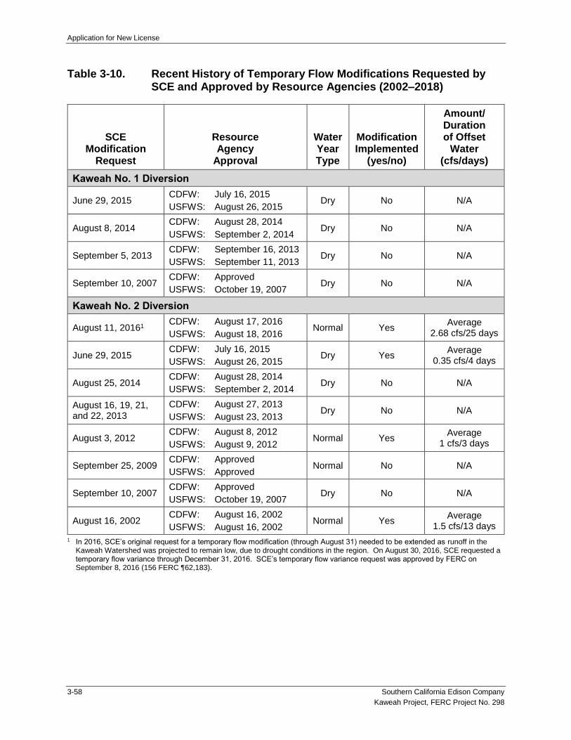
Application for New License
3-58 Southern California Edison Company
Kaweah Project, FERC Project No. 298
Table 3-10. Recent History of Temporary Flow Modifications Requested by SCE and Approved by Resource Agencies (2002–2018)
SCE Modification
Request
Resource Agency
Approval
Water Year Type
Modification Implemented
(yes/no)
Amount/ Duration of Offset
Water (cfs/days)
Kaweah No. 1 Diversion
June 29, 2015 CDFW: July 16, 2015
USFWS: August 26, 2015 Dry No N/A
August 8, 2014 CDFW: August 28, 2014
USFWS: September 2, 2014 Dry No N/A
September 5, 2013 CDFW: September 16, 2013
USFWS: September 11, 2013 Dry No N/A
September 10, 2007 CDFW: Approved
USFWS: October 19, 2007 Dry No N/A
Kaweah No. 2 Diversion
August 11, 20161 CDFW: August 17, 2016
USFWS: August 18, 2016 Normal Yes
Average 2.68 cfs/25 days
June 29, 2015 CDFW: July 16, 2015
USFWS: August 26, 2015 Dry Yes
Average 0.35 cfs/4 days
August 25, 2014 CDFW: August 28, 2014
USFWS: September 2, 2014 Dry No N/A
August 16, 19, 21, and 22, 2013
CDFW: August 27, 2013
USFWS: August 23, 2013 Dry No N/A
August 3, 2012 CDFW: August 8, 2012
USFWS: August 9, 2012 Normal Yes
Average 1 cfs/3 days
September 25, 2009 CDFW: Approved
USFWS: Approved Normal No N/A
September 10, 2007 CDFW: Approved
USFWS: October 19, 2007 Dry No N/A
August 16, 2002 CDFW: August 16, 2002
USFWS: August 16, 2002 Normal Yes
Average 1.5 cfs/13 days
1 In 2016, SCE’s original request for a temporary flow modification (through August 31) needed to be extended as runoff in the Kaweah Watershed was projected to remain low, due to drought conditions in the region. On August 30, 2016, SCE requested a temporary flow variance through December 31, 2016. SCE’s temporary flow variance request was approved by FERC on September 8, 2016 (156 FERC ¶62,183).

Application for New License
Southern California Edison Company 3-59
Kaweah Project, FERC Project No. 298
Table 3-11. Summary of Kaweah Project Generation (1992–2018)1
Year
Net Generation (MWh)
Powerhouse
Project Total Kaweah No. 1 Kaweah No. 2 Kaweah No. 3
2018 4,511 5,278 11,819 21,608
2017 7,537 7,158 19,807 34,502
2016 6,987 5,758 18,989 31,734
2015 6,529 6,430 12,275 25,233
2014 3,566 4,436 6,761 14,762
2013 7,221 6,712 11,118 25,051
2012 7,583 9,863 9,510 26,956
2011 10,838 13,849 4,149 28,836
2010 7,925 12,555 27,855 48,336
2009 7,101 11,402 23,298 41,801
2008 8,973 10,969 18,288 38,231
2007 6,626 7,036 15,215 28,877
2006 10,401 11,116 20,620 42,137
2005 11,150 12,870 28,639 52,658
2004 10,212 11,705 22,626 44,543
2003 12,512 11,732 26,434 50,677
2002 11,498 11,686 25,015 48,198
2001 10,400 9,297 20,557 40,254
2000 10,746 10,243 21,447 42,436
1999 11,066 8,974 13,388 33,428
1998 14,696 12,519 33,511 60,725
1997 9,294 12,665 6,362 28,321
1996 12,920 13,063 27,946 53,929
1995 14,912 14,930 30,487 60,329
1994 11,343 11,222 19,302 41,868
1993 13,762 12,966 25,146 51,874
1992 12,461 9,927 16,657 39,044
Total Annual Generation 262,770 276,359 517,221 1,056,350
Average Annual Generation, 1992–2018 9,732 10,236 19,156 39,124
Notes:
MWh = megawatt hours 1 All Project powerhouses experienced periods of no generation between 1992 and 2018. Lack of generation at a powerhouse is
generally the result of: (1) routine maintenance outage; (2) outages caused by the powerhouse tripping; (3) facility repairs necessitating a powerhouse be offline; or (4) periods of low runoff when SCE is required to meet contractual entitlements to deliver water to local water users consistent with their pre-1914 water rights and there is not enough water remaining for generation.

Application for New License
3-60 Southern California Edison Company
Kaweah Project, FERC Project No. 298
This Page Intentionally Left Blank

Application for New License
Southern California Edison Company 3-61
Kaweah Project, FERC Project No. 298
Table 3-12. Summary of License Article Compliance
License Article Topic
FERC Actions Taken
Status Current Compliance Efforts Implemented by SCE Date Summary
201 Annual Payment August 7, 2001 Order Amending License in Part, Approving Revised Exhibits, and Revising Annual Charges
Ongoing Administration
Annually reimburses FERC for administrative costs and recompensing for use and occupancy of Federal lands
202 Amortization Reserve Account Ongoing Administration
Annually determines reasonable rate of return
203 Land Clearance Ongoing Routine operation and maintenance
Keeps lands along open flowlines clear and disposes of unnecessary materials
301 Revised Exhibit F and G September 15, 1992 Order approving revised Exhibits F and G filed on July 29, 1992 Complete
401 Erosion Protection and Remediation Plan
January 19, 1993 Order approving the revised Erosion Protection and Remediation Plan filed on November 18, 1992
Ongoing Routine operation and maintenance
Implements measures in the plan in the event of a future flowline break
402 Erosion Protection and Remediation Plan Monitoring
June 29, 1993 Order approving Erosion Protection Monitoring Plan filed January 29, 1993 Complete In accordance with the plan, SCE inspected Flowline No. 1 and Marble Fork Canal erosion control areas annually each spring from 1995 to 1999 and reported results to FERC, Soil Conservation Service, and National Park Service by August 1 of each year. Following the initial five-year monitoring period, it was determined that no further measures were necessary and monitoring was deemed complete
403 Recreation Plan June 30, 1993 Order deleting Article 403 Deleted
404 Ramping Rates Ongoing Routine operation and maintenance
Implements ramping requirements downstream of Kaweah No. 1 and No. 2 diversion dams
Annual reporting of compliance with ramping rates
405 Minimum Instream Flows April 20, 1994 Order amending Article 405 to include a definition distinguishing normal from dry years for the purposes of releasing minimum flows, and amended minimum instream flow table to correct a typographical error (omission of minimum flow requirements for the month of May)
Ongoing Routine operation and maintenance
Implements minimum instream flow requirements downstream of Kaweah No. 1 and No. 2 diversion dams
Annual reporting of compliance with minimum instream flows
406 Diversion Dam Functional Design Drawings
June 2, 1993 Order approving functional design drawings and plans for the minimum flow release structures filed on April 30, 1993
Complete
407 Stream Gaging Plan June 10, 1993 Order approving and modifying the Stream Gaging Plan filed on April 30, 1993, as modified by paragraph B of the Order
Ongoing Routine operation and maintenance
Annual reporting of compliance with ramping rates and minimum instream flows
Reporting, as necessary, associated with violations with ramping rates and minimum instream flow requirements
408 Measures to Minimize Wildlife Drownings in Kaweah No. 2 Flowline
June 30, 1993 Order approving request to delete Measure No. 8 from Article 408, filed on January 29, 1993 and supplemented on April 12, 1993
Complete Measures to minimize wildlife drownings in Kaweah No. 2 Flowline implemented between 1992 and 1996
409 Wildlife Protection Plan June 30, 1993 Order approving Wildlife Protection Plan filed on January 29, 1993 and supplemented on March 19, 1993
Complete Measures identified in plan were implemented between 1994 and 1996

Application for New License
3-62 Southern California Edison Company
Kaweah Project, FERC Project No. 298
License Article Topic
FERC Actions Taken
Status Current Compliance Efforts Implemented by SCE Date Summary
410 Wildlife Mortality Monitoring Plan
July 8, 1993 Order approving Wildlife Mortality Monitoring Plan filed on January 29, 1993 Ongoing Routine operation and maintenance
Weekly monitoring of Kaweah No. 2 and No. 3 flowlines to determine success of wildlife protection measures included in the Wildlife Protection Plan and to inspect wildlife protection facilities
Annual reporting of monitoring results
411 Wildlife Management Plan for Transmission Line Right-of-Way
January 18, 2000 Order deleting Article 411 Deleted
412 Transmission Line Avian Monitoring
July 23, 1993 Order approving Avian Mortality Reporting Plan filed on January 29, 1993 Ongoing Routine operation and maintenance
Annual monitoring and five-year reporting of monitoring results
413 Cultural Repair Plan at Kaweah No. 3 Historic District1
Ongoing Routine operation and maintenance
Implements measures included in the Cultural Resources Management Plan to repair and protect the Kaweah No. 3 Historic District
414 Cultural Resources Management Plan
August 7, 1995 Order approving Report on Implementation of the Cultural Resources Management Plan filed May 22, 1995
Ongoing Routine operation and maintenance
Implements measures included in the Cultural Resources Management Plan related to future maintenance work or any other work be projected for the area where the identified archaeological sites are located
Three-year reporting on NRHP-eligible sites
415 Cultural Resources Surveys, Reporting, and Consultation
August 7, 1995 Order approving Report on Implementation of the Cultural Resources Management Plan filed May 22, 1995
Ongoing Routine operation and maintenance
Implements measures included in the Cultural Resources Management Plan, related to ground-disturbing activities, including conducting cultural surveys, reporting, and agency consultation, as required, prior to implementation
416 Occupancy and Conveyance of Project Lands
Ongoing Administration
Implement procedures related to occupancy and conveyance of Project lands
Notes: 1 Non-Project facility.

Application for New License
Southern California Edison Company 3-63
Kaweah Project, FERC Project No. 298
FIGURES

Application for New License
3-64 Southern California Edison Company
Kaweah Project, FERC Project No. 298
This Page Intentionally Left Blank

Application for New License
Southern California Edison Company 3-65
Kaweah Project, FERC Project No. 298
Figure 3-1. Elevation Profile
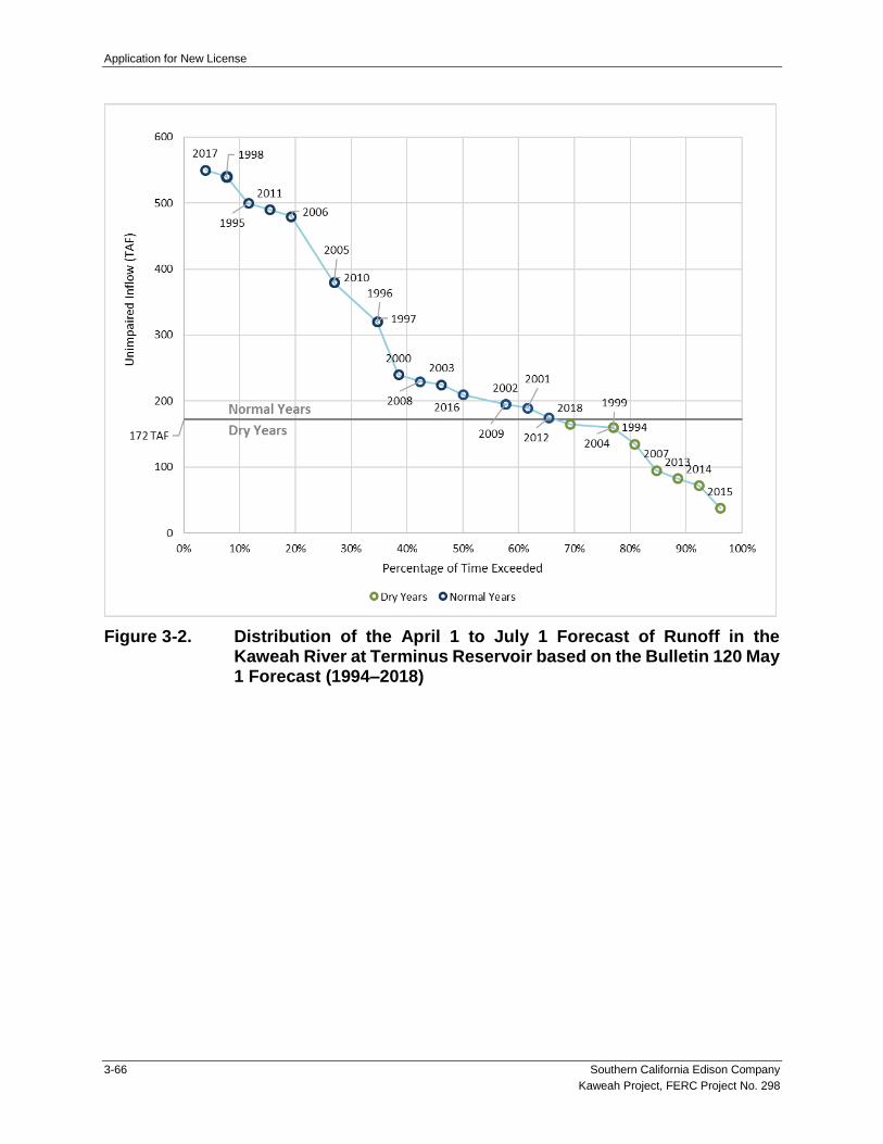
Application for New License
3-66 Southern California Edison Company
Kaweah Project, FERC Project No. 298
Figure 3-2. Distribution of the April 1 to July 1 Forecast of Runoff in the Kaweah River at Terminus Reservoir based on the Bulletin 120 May 1 Forecast (1994–2018)

Application for New License
Southern California Edison Company 3-67
Kaweah Project, FERC Project No. 298
Figure 3-3. Annual Inflow to the Kaweah Project (WY 1994–2018)1
1 The period of record (POR) used to characterize recent historical flows in the Kaweah River and East
Fork Kaweah River extends from water year 1994 through 2018. This time period best represents Project operations since issuance of the FERC license and recent climatic conditions.
0
100,000
200,000
300,000
400,000
500,000
600,000
700,000
800,000
199
4
199
5
199
6
199
7
199
8
199
9
200
0
200
1
200
2
200
3
200
4
200
5
200
6
200
7
200
8
200
9
201
0
201
1
201
2
201
3
201
4
201
5
201
6
201
7
201
8
To
tal In
flow
(ac-f
t p
er
ye
ar)
Year
Total Annual Project Inflow (ac-ft) Median
Median AnnualInflow

Application for New License
3-68 Southern California Edison Company
Kaweah Project, FERC Project No. 298
Figure 3-4a. Monthly Average Flows in a Representative Dry Year (2014), Normal Year (2006), and “Drier” Normal Year (2009) in the East Fork Kaweah River Bypass Reach and Kaweah No. 1 Flowline/Kaweah No. 1 Powerhouse

Application for New License
Southern California Edison Company 3-69
Kaweah Project, FERC Project No. 298
Figure 3-4b. Monthly Average Flows in a Representative Dry Year (2014), Normal Year (2006), and “Drier” Normal Year (2009) in the Kaweah River Bypass Reach and Kaweah No. 2 Flowline/Kaweah No. 2 Powerhouse

Application for New License
3-70 Southern California Edison Company
Kaweah Project, FERC Project No. 298
Figure 3-4c. Monthly Average Flows in a Representative Dry Year (2014), Normal Year (2006), and “Drier” Normal Year (2009) at the Kaweah No. 3 Powerhouse

Application for New License
Southern California Edison Company 3-71
Kaweah Project, FERC Project No. 298
Figure 3-5a. Monthly Exceedance Flows (10%, 20%, 50%, 80%, and 90%) in the East Fork Kaweah River Bypass Reach and Kaweah No. 1 Flowline, and at the Kaweah No. 1 Powerhouse (WY 1994–2018)2
2 Kaweah No. 1 Powerhouse period of record is from 2002–2018.

Application for New License
3-72 Southern California Edison Company
Kaweah Project, FERC Project No. 298
Figure 3-5b. Monthly Exceedance Flows (10%, 20%, 50%, 80%, and 90%) in the Kaweah River Bypass Reach and Kaweah No. 2 Flowline, and at the Kaweah No. 2 Powerhouse (WY 1994–2018)3
3 Kaweah No. 2 Powerhouse period of record is from 2002–2018.

Application for New License
Southern California Edison Company 3-73
Kaweah Project, FERC Project No. 298
Figure 3-5c. Monthly Exceedance Flows (10%, 20%, 50%, 80%, and 90%) at the Kaweah No. 3 Powerhouse (WY 2002–2018)4
4 Kaweah No. 3 Powerhouse period of record is from 2002–2018. Extended outages at the powerhouse
occurred in April–July 2011 and April–May 2012. These months were not included in the analysis.

Application for New License
3-74 Southern California Edison Company
Kaweah Project, FERC Project No. 298
Figure 3-6. East Fork Kaweah River Inflow and Kaweah No. 1 Diversion Dam in Relation to Minimum Instream Flow Requirements and Water Supply Commitments in Dry (top) and Normal (bottom) Years (May 1994–February 2019)

Application for New License
Southern California Edison Company 3-75
Kaweah Project, FERC Project No. 298
Figure 3-7. Kaweah River Inflow at Kaweah No. 2 Diversion Dam in Relation to Minimum Instream Flow Requirements and Water Supply Commitments in Dry (top) and Normal (bottom) Years (May 1994–February 2019)

Application for New License
3-76 Southern California Edison Company
Kaweah Project, FERC Project No. 298
This Page Intentionally Left Blank

Application for New License
Southern California Edison Company 3-77
Kaweah Project, FERC Project No. 298
MAPS

Application for New License
3-78 Southern California Edison Company
Kaweah Project, FERC Project No. 298
This Page Intentionally Left Blank
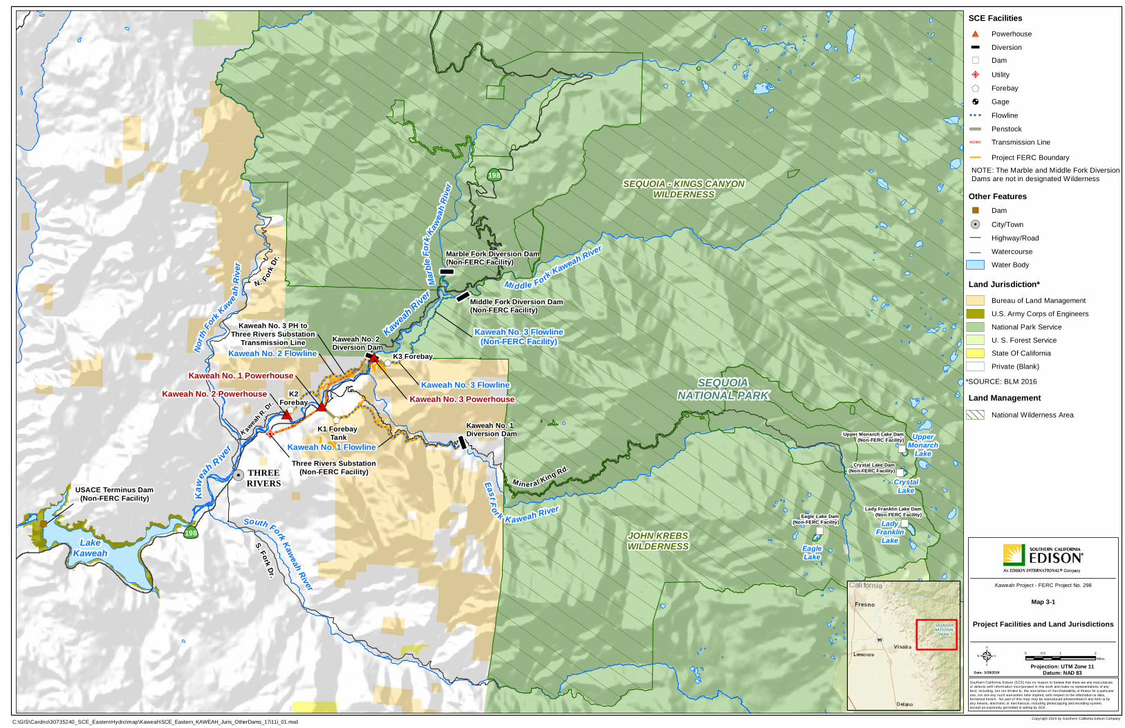
$+$+
$+
î
î
î
î
#*#*
#*
O
")")
")
")
LakeKaweah
!. THREERIVERS
198
Mi ddle Fork Kaweah River
Marb
leFo
rkKa
weah
Rive
r
East F ork Kaweah River
Kaweah No. 3 Flowline(Non-FERC Facility)
Kaweah No. 1 Flowline
Kaweah No. 2 FlowlineNorth
Fork Kawe ah
Rive
r
South Fork Kaweah River
Three Rivers Substation(Non-FERC Facility)
Kaweah No. 3 Powerhouse
Kaweah No. 1 PowerhouseKaweah No. 2 Powerhouse K2
Forebay
K1 Forebay Tank
K3 Forebay
S. Fork Dr.
M ineral King Rd.
N. ForkDr
.
K aweah
R. Dr.
198
Kaweah No. 3 Flowline
EagleLake
UpperMonarch
Lake
CrystalLake
LadyFranklin
Lake
Kawe
ahR ive
r
USACE Terminus Dam(Non-FERC Facility)
Kaweah No. 3 PH toThree Rivers Substation
Transmission Line
SEQUOIA - KINGS CANYONWILDERNESS
SEQUOIANATIONAL PARK
KaweahRive
r
JOHN KREBSWILDERNESS
")
Middle Fork Diversion Dam(Non-FERC Facility)
Kaweah No. 1Diversion Dam
Marble Fork Diversion Dam(Non-FERC Facility)
Kaweah No. 2Diversion Dam
Eagle Lake Dam(Non-FERC Facility)
Lady Franklin Lake Dam(Non-FERC Facility)
Crystal Lake Dam(Non-FERC Facility)
Upper Monarch Lake Dam(Non-FERC Facility)
Copyright 2019 by Southern California Edison Company
Southern California Edison (SCE) has no reason to believe that there are any inaccuraciesor defects with information incorporated in this work and make no representations of anykind, including, but not limited to, the warranties of merchantability or fitness for a particularuse, nor are any such warranties tobe implied, with respect to the information or data,furnished herein. No part of this map may be reproduced ortransmitted in any form or byany means, electronic or mechanical, including photocopying and recording system,except as expressly permitted in writing by SCE.
Date: 3/28/2019Projection: UTM Zone 11
Datum: NAD 835
C:\GIS\Cardno\30735240_SCE_EasternHydro\map\Kaweah\SCE_Eastern_KAWEAH_Juris_OtherDams_17i11i_01.mxd
0 1 20.5Miles
|ÿ99
SEQUOIANATIONAL
PARK
Kaweah Project - FERC Project No. 298
Dam")
Highway/Road
Other Features
WatercourseWater Body
City/Town!.
Bureau of Land Management
National Park Service
Land Jurisdiction*
Private (Blank)*SOURCE: BLM 2016
National Wilderness AreaLand Management
U. S. Forest Service
U.S. Army Corps of Engineers
NOTE: The Marble and Middle Fork DiversionDams are not in designated Wilderness
Transmission Line
SCE FacilitiesPowerhouse
Flowline
Forebay
#*
Diversion
Utility$+
O
Penstock
î
Gage!́
Project FERC Boundary
State Of California
Project Facilities and Land Jurisdictions
Map 3-1
Dam")


!(
!(
!(
!(
!(
!(
!(
!(
!(
!(
!(
!(
!(!(
!(
!(
!(
!(
!(
!(
!(
"D
"D
#*
#*
O
")
")
")
")
")
")
")
")
")
")
")
")
")
! A
! A
! A
")
")
!́
Flume 15
¬«198
K2Switchyard
Kaweah No. 2 PowerhouseTransmission Tap Line
Kaweah No. 3 Powerhouse to ThreeRivers Substation Transmission Line
K2 Powerhouse toK2 Forebay Power Line
K2 Powerhouse to K2 ForebayFiber Optic Communication Line
K2 PowerhouseAlternate Power Line
Three Rivers Substation(Non-FERC)
Kaweah
No.2
Foreba
yRoad
Kaweah
No.2F
lowline
WestA
ccess
Road
Kaweah No. 2 FlowlineAccess Trail -Water User 14
Kaweah No. 2 FlowlineAccess Trail - Canal 15
Kaweah No. 2Penstock Road
Kaweah No. 2Powerhouse
11208818
K2 Pens
tock
Kaweah
River Drive
DinelyRoad
Kaweah No. 2 Flowl
ine
K2 ForebayWUD-FLUME 14
KAWE
AHRIV
ER
3.5
3.6
3.7
3.8
3.9
4.1
4.2
4.3
4.4
4.5
4.6
4.7
4.8
4.9
5.1
5.25.3 5.4
5.5
4
5
Copyright 2019 by Southern California Edison Company
Southern California Edison (SCE) has no reason to believe that there are any inaccuraciesor defects with information incorporated in this work and make no representations of anykind, including, but not limited to, the warranties of merchantability or fitness for a particularuse, nor are any such warranties tobe implied, with respect to the information or data,furnished herein. No part of this map may be reproduced ortransmitted in any form or byany means, electronic or mechanical, including photocopying and recording system,except as expressly permitted in writing by SCE.
Date: 11/21/2019Projection: UTM Zone 11
Datum: NAD 835
Z:\30735240_SCE_EasternHydro\map\Kaweah\SCE_Eastern_KAWEAH_6K_17i11i_04.mxd
0 500250Feet
Map bMap c
Map d
Map e
Map fMap g
Map hMap a
Kaweah Project - FERC Project No. 298
Map 3-2aProject Facilities
Transmission Line
FacilitiesPowerhouse
Flowline
Flume Segment
#*
Diversion
")
Penstock
Other FeaturesWatercourseWater Body
î
FERC Boundary
Ancillary Facility")
! A Water User Diversion
Gage!́
"D
TransportationProject Road
Non-Project General Access RoadGate
Project Trail
!( River Mile / 10th Mile
Power LineCommunication Line
!(
Spillway Channel or Pipe
National Park Boundary
Fence


!(
!(
!(
!(
!(
!(
!(
!(
!(
!(
!(
!(!(
!(!(
!(
!(
!(
!(
!(
!(
!(
!(
"D
"D
"D
"D "D
"D
#*
#*
")
")
")
")
")
")
")
")
")
")
")
")
")
")
")
")
! A
! A
! A
! A
")
")")")
")
")
")
")
!́
!́
¬«198
¬«198
Flume 15
Flume9.75Flume 11
Flume 12
Flume 9
Dinely
Road
Kaweah No. 3 Powerhouse to ThreeRivers Substation Transmission Line
K2Switchyard
Kaweah No. 2 PowerhouseTransmission Tap Line
K2 Powerhouse toK2 Forebay Power Line
K2 Powerhouse to K2 ForebayFiber Optic Communication Line
K2 PowerhouseAlternate Power Line
K1 SwitchyardK1 Powerhouse Campus Power Lines
K1 Office Building toK1 Forebay Tank Power Line
K1 Office Building to K1 Forebay TankFiber Optic Communication Line
K1 Powerhouse CampusAlternate Power Line
K1 Powerhouse to K1 Office BuildingFiber Optic Communication Line
K1 MaintenanceBuilding
K1 Operators Office
K1 Workshop K1 Office
Kaweah
No.2
Foreba
yRoad
Kawe
ahNo
.2Flo
wline
Cente
rAcce
ssRo
ad
Kaweah
No. 2
Flowlin
eWe
stAcce
ssRoa
d
Kaweah No. 2 FlowlineAccess Trail -Water User 14
Kaweah No. 2 FlowlineAccess Trail - Canal 11
Kaweah No. 2 FlowlineAccess Trail - Canal 13
Kaweah No. 2 FlowlineAccess Trail - Canal 15
Kaweah No. 2 FlowlineAccess Road - Flume 11
Kaweah No. 2Penstock Road
Kaweah No. 1Powerhouse
Kaweah No. 2Powerhouse
Flume 14
Flume 13
Flume 10Flume9.5
Kaweah No. 1 PowerhouseTransmission Tap Line
Kaweah No. 3 Powerhouse to ThreeRivers Substation Transmission Line
11208818
11208800
K1 Penstock
K2 Pens
tock
Kaweah
River Drive
DinelyRoad
Kaweah No. 2 Flowline
K2 Forebay
WUD-FLUME 14KAWEAH RIVER
4.9
5.1
5.25.3
5.45.5
5.6
5.7
5.8
5.9
6.1
6.2 6.3
6.4 6.5
6.6
6.7
6.8
6.9
7.1
5
6
7
Copyright 2019 by Southern California Edison Company
Southern California Edison (SCE) has no reason to believe that there are any inaccuraciesor defects with information incorporated in this work and make no representations of anykind, including, but not limited to, the warranties of merchantability or fitness for a particularuse, nor are any such warranties tobe implied, with respect to the information or data,furnished herein. No part of this map may be reproduced ortransmitted in any form or byany means, electronic or mechanical, including photocopying and recording system,except as expressly permitted in writing by SCE.
Date: 11/21/2019Projection: UTM Zone 11
Datum: NAD 835
Z:\30735240_SCE_EasternHydro\map\Kaweah\SCE_Eastern_KAWEAH_6K_17i11i_04.mxd
0 500250Feet
Map bMap c
Map d
Map e
Map fMap g
Map hMap a
Kaweah Project - FERC Project No. 298
Map 3-2bProject Facilities
Transmission Line
FacilitiesPowerhouse
Flowline
Flume Segment
#*
Diversion
")
Penstock
Other FeaturesWatercourseWater Body
î
FERC Boundary
Ancillary Facility")
! A Water User Diversion
Gage!́
"D
TransportationProject Road
Non-Project General Access RoadGate
Project Trail
!( River Mile / 10th Mile
Power LineCommunication Line
!(
Spillway Channel or Pipe
National Park Boundary
Fence


!(
!(
!(
!(
!(
!(
!(
!(
!(
!(!(
!(
!(
!( !(
!(
!(
"D
"D
"D
"D
"D
"D
"D
"D
"D
"D
"D
#*
#*
#*
")
")
")
")
")
")
")
")
")
")
")
")
")
")
")
")
")
")
! A
! A
! A
! A
! A
! A
")
")")")
")
")
")
")
")
")
!́
!́
!́
!́
¬«198
Flume6
Flume 4
Kaweah No. 3 Powerhouse to ThreeRivers Substation Transmission Line
Kaweah No. 2 FlowlineAccess Road & Trail
Canal 4 West
Kaweah No. 2 Flowline
East Access RoadKaweah No. 2 Flowline
Access Road - Red Barn
Dinely
Road
Kaweah No. 2 FlowlineAccess Trail - Canal 6
Kaweah No. 2 FlowlineAccess Road - Canal 6 East
Kaweah No. 2 FlowlineAccess Road - Flume 8
Kaweah
No.2F
lowline
Access
Road-
Canal 5
Kaweah
No.1Flowline
Access
Road-Sum
mit
Kawe
ahNo
.2Flo
wline
Cente
r Acce
ssRo
adKaweah No. 2 FlowlineAccess Trail - Canal 5 Kaweah No. 2 Flowline
Access Road & Trail Canal 4 East
Kaweah No. 2 FlowlineAccess Trail-Water User 9
Kaweah No. 2 FlowlineAccess Road - Canal 2
Brushout Grid
Kaweah No. 2Flowline Access
Road - Canal 6 West
Flume 7
Flume6.5
Flume 5
Flume3.5
Flume 3
Flume 2
Flume 8
Park Service Access Road
Mineral King Road
Kaweah No. 2 Flowline
WUD-CANAL 9
WUD-FLUME 6
WUD-FLUME 5
KAWEAH RIVER
6.7
6.8
6.9
7.1
7.2
7.3
7.47.5
7.67.7
7.87.9
8.1
8.2 8.3
7
8
Copyright 2019 by Southern California Edison Company
Southern California Edison (SCE) has no reason to believe that there are any inaccuraciesor defects with information incorporated in this work and make no representations of anykind, including, but not limited to, the warranties of merchantability or fitness for a particularuse, nor are any such warranties tobe implied, with respect to the information or data,furnished herein. No part of this map may be reproduced ortransmitted in any form or byany means, electronic or mechanical, including photocopying and recording system,except as expressly permitted in writing by SCE.
Date: 11/21/2019Projection: UTM Zone 11
Datum: NAD 835
Z:\30735240_SCE_EasternHydro\map\Kaweah\SCE_Eastern_KAWEAH_6K_17i11i_04.mxd
0 500250Feet
Map bMap c
Map d
Map e
Map fMap g
Map hMap a
Kaweah Project - FERC Project No. 298
Map 3-2cProject Facilities
Transmission Line
FacilitiesPowerhouse
Flowline
Flume Segment
#*
Diversion
")
Penstock
Other FeaturesWatercourseWater Body
î
FERC Boundary
Ancillary Facility")
! A Water User Diversion
Gage!́
"D
TransportationProject Road
Non-Project General Access RoadGate
Project Trail
!( River Mile / 10th Mile
Power LineCommunication Line
!(
Spillway Channel or Pipe
National Park Boundary
Fence


!(
!( !(!(
!(
!(
!(
!(
!(
!(
!(!(
!( !(
!(
!(
!(
!(
!(
!(
!(
!(
!(
"D
"D
"D
"D
"D
"D
"D
#*î
")
")
")
")
")
! A
! A
! A
")
")
")
")
")
!́
!́
!́
SEQUOIA NATIONAL PARK
Kaweah No. 3 Powerhouse to ThreeRivers Substation Transmission Line
11208565
204a
Kaweah No. 3 Flowline Access Trail
¬«198
K2 GagingCableway
K3 Powerhouse to K3 Forebay Power LineK3 Powerhouse to K3 Forebay Fiber Optic Communication Line
K2 Diversion/Flowline Gage andK3 Powerhouse Alternate Power Line
K3 Powerhouse to K2 Flowline Gage Power Line
K2 Diversion Dam to K3 PowerhouseFiber Optic Communication Line
K3 Powerhouse toK2 Diversion Power Line
K3 Forebay to K3 Forebay InletFiber Optic Communication Line
K3 Switchyard
Kaweah No. 2Diversion Dam
Kaw
eahNo. 3
Powerho
useRoad
Kaweah
No. 3
Foreba
yRoad
Kaweah No. 2Flowline Access
Trail - Canal 2
Kaweah No. 2Flowline Access Trail- Wildlife Crossing 2
Kaweah No. 2Flowline Access
Trail - Open Siphon
Kaweah No. 2 FlowlineAccess Road - Canal 2
Brushout Grid
Kaweah No.2Flowline Access Road -
Open Siphon Grids
Kaweah No. 2Intake Road
WER
Kaweah No. 3 Powerhouse
Flume 3
Flume 2
11208600
Park Service Access RoadKaweah No. 2 Flowline
Kaweah No. 3 Flowline
K3 Forebay
EAST FORK KAWEAH RIVER
KAWEAH RIVER
8.1
8.2 8.38.4
8.5
8.6
8.7
8.8
8.9
9.1
9.2 9.3
9.4 9.5
9.69.7
9.8
9.9
0.1
0.2
0.3
0.4
9
Copyright 2019 by Southern California Edison Company
Southern California Edison (SCE) has no reason to believe that there are any inaccuraciesor defects with information incorporated in this work and make no representations of anykind, including, but not limited to, the warranties of merchantability or fitness for a particularuse, nor are any such warranties tobe implied, with respect to the information or data,furnished herein. No part of this map may be reproduced ortransmitted in any form or byany means, electronic or mechanical, including photocopying and recording system,except as expressly permitted in writing by SCE.
Date: 11/21/2019Projection: UTM Zone 11
Datum: NAD 835
Z:\30735240_SCE_EasternHydro\map\Kaweah\SCE_Eastern_KAWEAH_6K_17i11i_04.mxd
0 500250Feet
Map bMap c
Map d
Map e
Map fMap g
Map hMap a
Kaweah Project - FERC Project No. 298
Map 3-2dProject Facilities
Transmission Line
FacilitiesPowerhouse
Flowline
Flume Segment
#*
Diversion
")
Penstock
Other FeaturesWatercourseWater Body
î
FERC Boundary
Ancillary Facility")
! A Water User Diversion
Gage!́
"D
TransportationProject Road
Non-Project General Access RoadGate
Project Trail
!( River Mile / 10th Mile
Power LineCommunication Line
!(
Spillway Channel or Pipe
National Park Boundary
Fence


!(
!(
"D
"D
#*
#*
")
")
")
")
")
")
")
")
")
")
")
")
")
")
")
")
")
")
! A
! A
! A
! A
! A
! A
")")")
")
")
")
")
!́
Craig Ranch Road
Kaweah No. 1 Forebay Road
Kaweah No. 3 Powerhouse to ThreeRivers Substation Transmission Line
Kaweah No. 1 Flowline
K1 ForebayTank
KAWEAH RIVER
5.5
5.6
Copyright 2019 by Southern California Edison Company
Southern California Edison (SCE) has no reason to believe that there are any inaccuraciesor defects with information incorporated in this work and make no representations of anykind, including, but not limited to, the warranties of merchantability or fitness for a particularuse, nor are any such warranties tobe implied, with respect to the information or data,furnished herein. No part of this map may be reproduced ortransmitted in any form or byany means, electronic or mechanical, including photocopying and recording system,except as expressly permitted in writing by SCE.
Date: 11/21/2019Projection: UTM Zone 11
Datum: NAD 835
Z:\30735240_SCE_EasternHydro\map\Kaweah\SCE_Eastern_KAWEAH_6K_17i11i_04.mxd
0 500250Feet
Map bMap c
Map d
Map e
Map fMap g
Map hMap a
Kaweah Project - FERC Project No. 298
Map 3-2eProject Facilities
Transmission Line
FacilitiesPowerhouse
Flowline
Flume Segment
#*
Diversion
")
Penstock
Other FeaturesWatercourseWater Body
î
FERC Boundary
Ancillary Facility")
! A Water User Diversion
Gage!́
"D
TransportationProject Road
Non-Project General Access RoadGate
Project Trail
!( River Mile / 10th Mile
Power LineCommunication Line
!(
Spillway Channel or Pipe
National Park Boundary
Fence

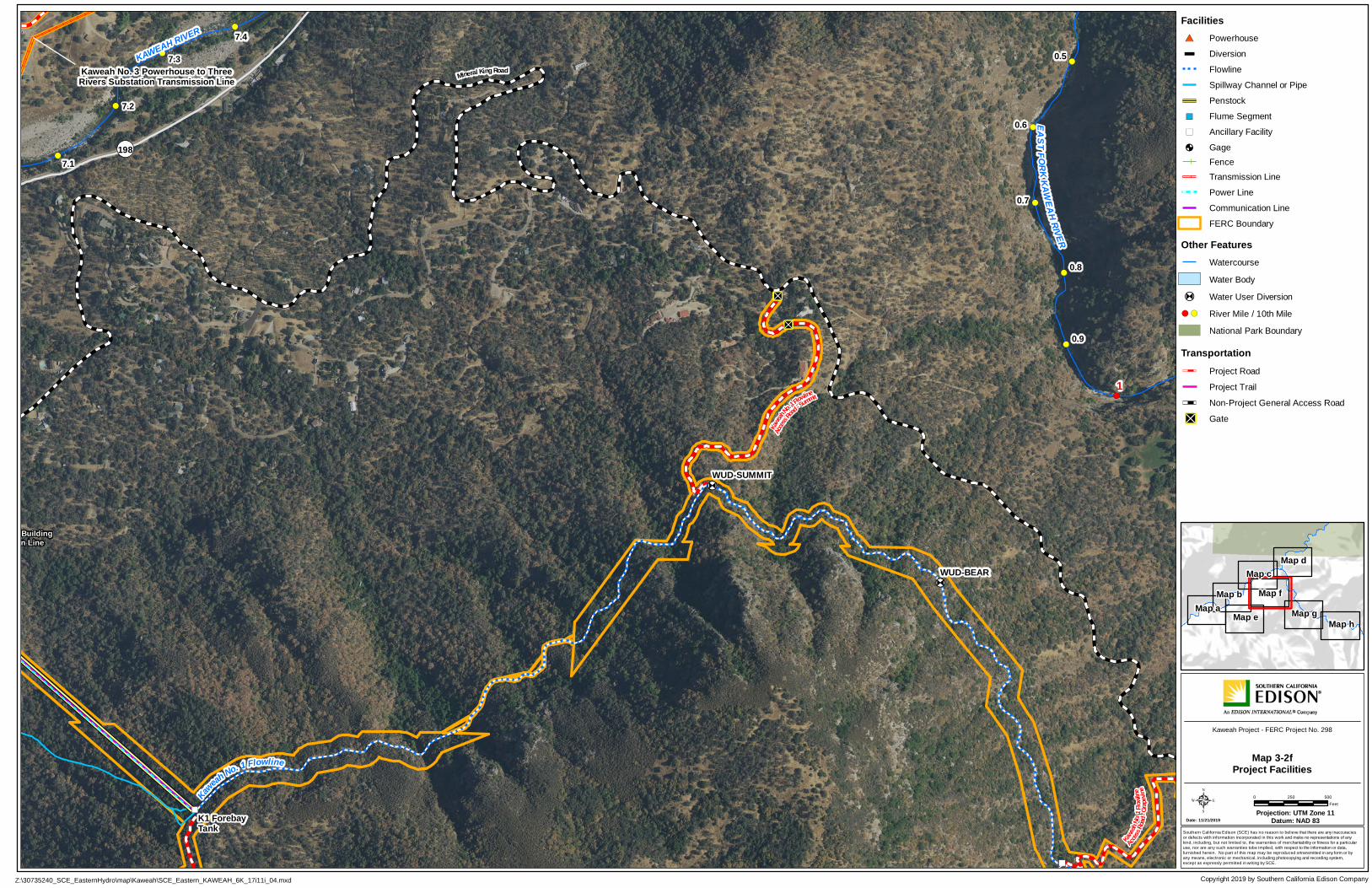
!(
!(
!(
!(
!(
!(
!(
!(
!(
!(
"D
"D
"D
#*
#*î
")
")
")
")
")
")
")
")
")
")
")
")
")
")
")
")
! A
! A
! A
! A
! A
")
")")
")
")
")
")
")
")
")
")
!́
!́
!́
!́
¬«198
Kaweah No. 3 Powerhouse to ThreeRivers Substation Transmission Line
K1 GrapevineSatellite Repeater
K1 Powerhouse to K1 Office BuildingFiber Optic Communication Line
Kaweah
No. 1
Flowli
neAcc
essRo
ad-G
rapevi
ne
Kaweah
No.1Flowline
Access
Road-Sum
mit
Mineral King Road
KaweahNo. 1 Flowline
K1 ForebayTank
WUD-SUMMIT
WUD-BEAR
KAWEAH RIVER
EASTF ORKKAW
EAHRIVER
7.1
7.2
7.3
7.40.5
0.6
0.7
0.8
0.9
1
Copyright 2019 by Southern California Edison Company
Southern California Edison (SCE) has no reason to believe that there are any inaccuraciesor defects with information incorporated in this work and make no representations of anykind, including, but not limited to, the warranties of merchantability or fitness for a particularuse, nor are any such warranties tobe implied, with respect to the information or data,furnished herein. No part of this map may be reproduced ortransmitted in any form or byany means, electronic or mechanical, including photocopying and recording system,except as expressly permitted in writing by SCE.
Date: 11/21/2019Projection: UTM Zone 11
Datum: NAD 835
Z:\30735240_SCE_EasternHydro\map\Kaweah\SCE_Eastern_KAWEAH_6K_17i11i_04.mxd
0 500250Feet
Map bMap c
Map d
Map e
Map fMap g
Map hMap a
Kaweah Project - FERC Project No. 298
Map 3-2fProject Facilities
Transmission Line
FacilitiesPowerhouse
Flowline
Flume Segment
#*
Diversion
")
Penstock
Other FeaturesWatercourseWater Body
î
FERC Boundary
Ancillary Facility")
! A Water User Diversion
Gage!́
"D
TransportationProject Road
Non-Project General Access RoadGate
Project Trail
!( River Mile / 10th Mile
Power LineCommunication Line
!(
Spillway Channel or Pipe
National Park Boundary
Fence


!(
!(
!(
!(
!(
!( !( !(
!(
!(
!(
!(
!(
!(
!("D
"D
"D
#*
")
")
")
")
")
! A
! A
! A
")
K1 GrapevineSatellite Repeater
Kaweah No. 1 FlowlineAccess Road & Spur -
Lower Pine
Kaweah
No.1
Flowli
neAcc
essRo
ad- G
rapevi
ne
Kaweah No. 1 FlowlineAccess Road & Spur -
Lumberyard
Kaweah No. 1 FlowlineAccess Road - Upper Pine
Mine
ral K
in gR o
ad
Kaweah No. 1 Flowline
EAST FORK KAWEAH RIVER
1.6
1.7
1.8
1.9
2.12.2 2.3 2.4
2.5
2.6
2.72.8
2.9
2
3
Copyright 2019 by Southern California Edison Company
Southern California Edison (SCE) has no reason to believe that there are any inaccuraciesor defects with information incorporated in this work and make no representations of anykind, including, but not limited to, the warranties of merchantability or fitness for a particularuse, nor are any such warranties tobe implied, with respect to the information or data,furnished herein. No part of this map may be reproduced ortransmitted in any form or byany means, electronic or mechanical, including photocopying and recording system,except as expressly permitted in writing by SCE.
Date: 11/21/2019Projection: UTM Zone 11
Datum: NAD 835
Z:\30735240_SCE_EasternHydro\map\Kaweah\SCE_Eastern_KAWEAH_6K_17i11i_04.mxd
0 500250Feet
Map bMap c
Map d
Map e
Map fMap g
Map hMap a
Kaweah Project - FERC Project No. 298
Map 3-2gProject Facilities
Transmission Line
FacilitiesPowerhouse
Flowline
Flume Segment
#*
Diversion
")
Penstock
Other FeaturesWatercourseWater Body
î
FERC Boundary
Ancillary Facility")
! A Water User Diversion
Gage!́
"D
TransportationProject Road
Non-Project General Access RoadGate
Project Trail
!( River Mile / 10th Mile
Power LineCommunication Line
!(
Spillway Channel or Pipe
National Park Boundary
Fence


!(
!(
!(
!(
!( !(!( !(
!(
!(
!(
!(
!( !(
!(
!(
!(
!(
!(
"D
"D
"D
"D
"D
"D
"D
"D
"D
î
")")
")")
!́
!́!́202
11208730
Kaweah No. 1 FlowlineAccess Road - Slick Rock
201a
K1 Solar YardSatellite Repeater
K1 GagingCableway
K1 Diversion Solar Panel toK1 Diversion Dam Power Line
Kaweah No. 1 FlowlineAccess Road & Trail - Unnamed
Kaweah No. 1 FlowlineAccess Road - Bear Canyon
Kaweah No. 1 FlowlineAccess Road & Spur -
Lumberyard
Kaweah No. 1Intake Road
K1 DiversionSolar Panel Kaweah No. 1
Diversion Dam
Kaweah No. 1 Flowline
EAST FORK KAWEAH RIVER
3.1
3.2
3.3
3.4
3.5 3.6 3.7 3.8
3.9
4.1
4.2
4.3
4.44.5
4.6
4.7
4.8
3
4
Copyright 2019 by Southern California Edison Company
Southern California Edison (SCE) has no reason to believe that there are any inaccuraciesor defects with information incorporated in this work and make no representations of anykind, including, but not limited to, the warranties of merchantability or fitness for a particularuse, nor are any such warranties tobe implied, with respect to the information or data,furnished herein. No part of this map may be reproduced ortransmitted in any form or byany means, electronic or mechanical, including photocopying and recording system,except as expressly permitted in writing by SCE.
Date: 11/21/2019Projection: UTM Zone 11
Datum: NAD 835
Z:\30735240_SCE_EasternHydro\map\Kaweah\SCE_Eastern_KAWEAH_6K_17i11i_04.mxd
0 500250Feet
Map bMap c
Map d
Map e
Map fMap g
Map hMap a
Kaweah Project - FERC Project No. 298
Map 3-2hProject Facilities
Transmission Line
FacilitiesPowerhouse
Flowline
Flume Segment
#*
Diversion
")
Penstock
Other FeaturesWatercourseWater Body
î
FERC Boundary
Ancillary Facility")
! A Water User Diversion
Gage!́
"D
TransportationProject Road
Non-Project General Access RoadGate
Project Trail
!( River Mile / 10th Mile
Power LineCommunication Line
!(
Spillway Channel or Pipe
National Park Boundary
Fence


!(
!(
!(
!(
!(
!(
!(
!(
!(
!(
!(
!(
!(!(
!(
!(
!(
!(
!(
!(
!(
"D
"D
#*
#*
O
")
")
")
")
")
")
")
")
")
")
")
")
")
! A
! A
! A
")
")
!́
Flume 15
¬«198
Kaweah No. 2 PowerhouseTransmission Tap Line
Kaweah No. 3 Powerhouse to ThreeRivers Substation Transmission Line
K2 Powerhouse toK2 Forebay Power Line
K2 Powerhouse to K2 ForebayFiber Optic Communication Line
K2 PowerhouseAlternate Power Line
Three Rivers Substation(Non-FERC)
Kaweah
No.2
Foreba
yRoad
Kaweah
No.2F
lowline
WestA
ccess
Road
Kaweah No. 2 FlowlineAccess Trail -Water User 14
Kaweah No. 2 FlowlineAccess Trail - Canal 15
Kaweah No. 2Penstock Road
K2Switchyard
Kaweah No. 2Powerhouse
11208818
K2 Pens
tock
Kaweah
River Drive
DinelyRoad
Kaweah No. 2 Flowl
ine
K2 ForebayWUD-FLUME 14
KAWE
AHRIV
ER
3.5
3.6
3.7
3.8
3.9
4.1
4.2
4.3
4.4
4.5
4.6
4.7
4.8
4.9
5.1
5.25.3 5.4
5.5
4
5
Copyright 2019 by Southern California Edison Company
Southern California Edison (SCE) has no reason to believe that there are any inaccuraciesor defects with information incorporated in this work and make no representations of anykind, including, but not limited to, the warranties of merchantability or fitness for a particularuse, nor are any such warranties tobe implied, with respect to the information or data,furnished herein. No part of this map may be reproduced ortransmitted in any form or byany means, electronic or mechanical, including photocopying and recording system,except as expressly permitted in writing by SCE.
Date: 11/21/2019Projection: UTM Zone 11
Datum: NAD 835
Z:\30735240_SCE_EasternHydro\map\Kaweah\SCE_Eastern_KAWEAH_6K_17i11i_04_Juris.mxd
0 500250Feet
Map bMap c
Map d
Map e
Map fMap g
Map hMap a
Kaweah Project - FERC Project No. 298
Map 3-3aLand Jurisdiction
Transmission Line
FacilitiesPowerhouse
Flowline
Flume Segment
#*
Diversion
")
Penstock
Other FeaturesWatercourseWater Body
î
FERC Boundary
Ancillary Facility")
! A Water User Diversion
Gage!́
!( River Mile / 10th Mile
Power LineCommunication Line
!(
Spillway Channel or Pipe
Land Jurisdiction*Bureau of Land ManagementWilderness AreaNational Park Service
*SOURCE: BLM 2016Kaweah Project entirely within Tulare County
"D
TransportationProject Road
Non-Project General Access RoadGate
Project Trail
Private (Includes SCE Lands)
Fence


!(
!(
!(
!(
!(
!(
!(
!(
!(
!(
!(
!(!(
!(!(
!(
!(
!(
!(
!(
!(
!(
!(
"D
"D
"D
"D "D
"D
#*
#*
")
")
")
")
")
")
")
")
")
")
")
")
")
")
")
")
! A
! A
! A
! A
")
")")")
")
")
")
")
!́
!́
¬«198
¬«198
Flume 15
Flume9.75Flume 11
Flume 12
Flume 9
Dinely
Road
Kaweah No. 3 Powerhouse to ThreeRivers Substation Transmission Line
Kaweah No. 2 PowerhouseTransmission Tap Line
K2 Powerhouse toK2 Forebay Power Line
K2 Powerhouse to K2 ForebayFiber Optic Communication Line
K2 PowerhouseAlternate Power Line
K1 SwitchyardK1 Powerhouse Campus Power Lines
K1 Office Building toK1 Forebay Tank Power Line
K1 Office Building to K1 Forebay TankFiber Optic Communication Line
K1 Powerhouse CampusAlternate Power Line
K1 Powerhouse to K1 Office BuildingFiber Optic Communication Line
K1 MaintenanceBuilding
K1 Operators Office
K1 Workshop K1 Office
Kaweah
No.2
Foreba
yRoad
Kawe
ahNo
.2Flo
wline
Cente
rAcce
ssRo
ad
Kaweah
No. 2
Flowlin
eWe
stAcce
ssRoa
d
Kaweah No. 2 FlowlineAccess Trail -Water User 14
Kaweah No. 2 FlowlineAccess Trail - Canal 11
Kaweah No. 2 FlowlineAccess Trail - Canal 13
Kaweah No. 2 FlowlineAccess Trail - Canal 15
Kaweah No. 2 FlowlineAccess Road - Flume 11
Kaweah No. 2Penstock Road
K2Switchyard
Kaweah No. 1Powerhouse
Kaweah No. 2Powerhouse
Flume 14
Flume 13
Flume 10Flume9.5
Kaweah No. 1 PowerhouseTransmission Tap Line
Kaweah No. 3 Powerhouse to ThreeRivers Substation Transmission Line
11208818
11208800
K1 Penstock
K2 Pens
tock
Kaweah
River Drive
DinelyRoad
Kaweah No. 2 Flowline
K2 Forebay
WUD-FLUME 14KAWEAH RIVER
4.9
5.1
5.25.3
5.45.5
5.6
5.7
5.8
5.9
6.1
6.2 6.3
6.4 6.5
6.6
6.7
6.8
6.9
7.1
5
6
7
Copyright 2019 by Southern California Edison Company
Southern California Edison (SCE) has no reason to believe that there are any inaccuraciesor defects with information incorporated in this work and make no representations of anykind, including, but not limited to, the warranties of merchantability or fitness for a particularuse, nor are any such warranties tobe implied, with respect to the information or data,furnished herein. No part of this map may be reproduced ortransmitted in any form or byany means, electronic or mechanical, including photocopying and recording system,except as expressly permitted in writing by SCE.
Date: 11/21/2019Projection: UTM Zone 11
Datum: NAD 835
Z:\30735240_SCE_EasternHydro\map\Kaweah\SCE_Eastern_KAWEAH_6K_17i11i_04_Juris.mxd
0 500250Feet
Map bMap c
Map d
Map e
Map fMap g
Map hMap a
Kaweah Project - FERC Project No. 298
Map 3-3bLand Jurisdiction
Transmission Line
FacilitiesPowerhouse
Flowline
Flume Segment
#*
Diversion
")
Penstock
Other FeaturesWatercourseWater Body
î
FERC Boundary
Ancillary Facility")
! A Water User Diversion
Gage!́
!( River Mile / 10th Mile
Power LineCommunication Line
!(
Spillway Channel or Pipe
Land Jurisdiction*Bureau of Land ManagementWilderness AreaNational Park Service
*SOURCE: BLM 2016Kaweah Project entirely within Tulare County
"D
TransportationProject Road
Non-Project General Access RoadGate
Project Trail
Private (Includes SCE Lands)
Fence


!(
!(
!(
!(
!(
!(
!(
!(
!(
!(!(
!(
!(
!( !(
!(
!(
"D
"D
"D
"D
"D
"D
"D
"D
"D
"D
"D
#*
#*
#*
")
")
")
")
")
")
")
")
")
")
")
")
")
")
")
")
")
")
! A
! A
! A
! A
! A
! A
")
")")")
")
")
")
")
")
")
!́
!́
!́
!́
¬«198
Flume6
Flume 4
Kaweah No. 3 Powerhouse to ThreeRivers Substation Transmission Line
Kaweah No. 2 FlowlineAccess Road & Trail
Canal 4 West
Kaweah No. 2 Flowline
East Access RoadKaweah No. 2 Flowline
Access Road - Red Barn
Dinely
Road
Kaweah No. 2 FlowlineAccess Trail - Canal 6
Kaweah No. 2 FlowlineAccess Road - Canal 6 East
Kaweah No. 2 FlowlineAccess Road - Flume 8
Kaweah
No.2F
lowline
Access
Road-
Canal 5
Kaweah
No.1Flowline
Access
Road-Sum
mit
Kawe
ahNo
.2Flo
wline
Cente
r Acce
ssRo
adKaweah No. 2 FlowlineAccess Trail - Canal 5 Kaweah No. 2 Flowline
Access Road & Trail Canal 4 East
Kaweah No. 2 FlowlineAccess Trail-Water User 9
Kaweah No. 2 FlowlineAccess Road - Canal 2
Brushout Grid
Kaweah No. 2Flowline Access
Road - Canal 6 West
Flume 7
Flume6.5
Flume 5
Flume3.5
Flume 3
Flume 2
Flume 8
Park Service Access Road
Mineral King Road
Kaweah No. 2 Flowline
WUD-CANAL 9
WUD-FLUME 6
WUD-FLUME 5
KAWEAH RIVER
6.7
6.8
6.9
7.1
7.2
7.3
7.47.5
7.67.7
7.87.9
8.1
8.2 8.3
7
8
Copyright 2019 by Southern California Edison Company
Southern California Edison (SCE) has no reason to believe that there are any inaccuraciesor defects with information incorporated in this work and make no representations of anykind, including, but not limited to, the warranties of merchantability or fitness for a particularuse, nor are any such warranties tobe implied, with respect to the information or data,furnished herein. No part of this map may be reproduced ortransmitted in any form or byany means, electronic or mechanical, including photocopying and recording system,except as expressly permitted in writing by SCE.
Date: 11/21/2019Projection: UTM Zone 11
Datum: NAD 835
Z:\30735240_SCE_EasternHydro\map\Kaweah\SCE_Eastern_KAWEAH_6K_17i11i_04_Juris.mxd
0 500250Feet
Map bMap c
Map d
Map e
Map fMap g
Map hMap a
Kaweah Project - FERC Project No. 298
Map 3-3cLand Jurisdiction
Transmission Line
FacilitiesPowerhouse
Flowline
Flume Segment
#*
Diversion
")
Penstock
Other FeaturesWatercourseWater Body
î
FERC Boundary
Ancillary Facility")
! A Water User Diversion
Gage!́
!( River Mile / 10th Mile
Power LineCommunication Line
!(
Spillway Channel or Pipe
Land Jurisdiction*Bureau of Land ManagementWilderness AreaNational Park Service
*SOURCE: BLM 2016Kaweah Project entirely within Tulare County
"D
TransportationProject Road
Non-Project General Access RoadGate
Project Trail
Private (Includes SCE Lands)
Fence

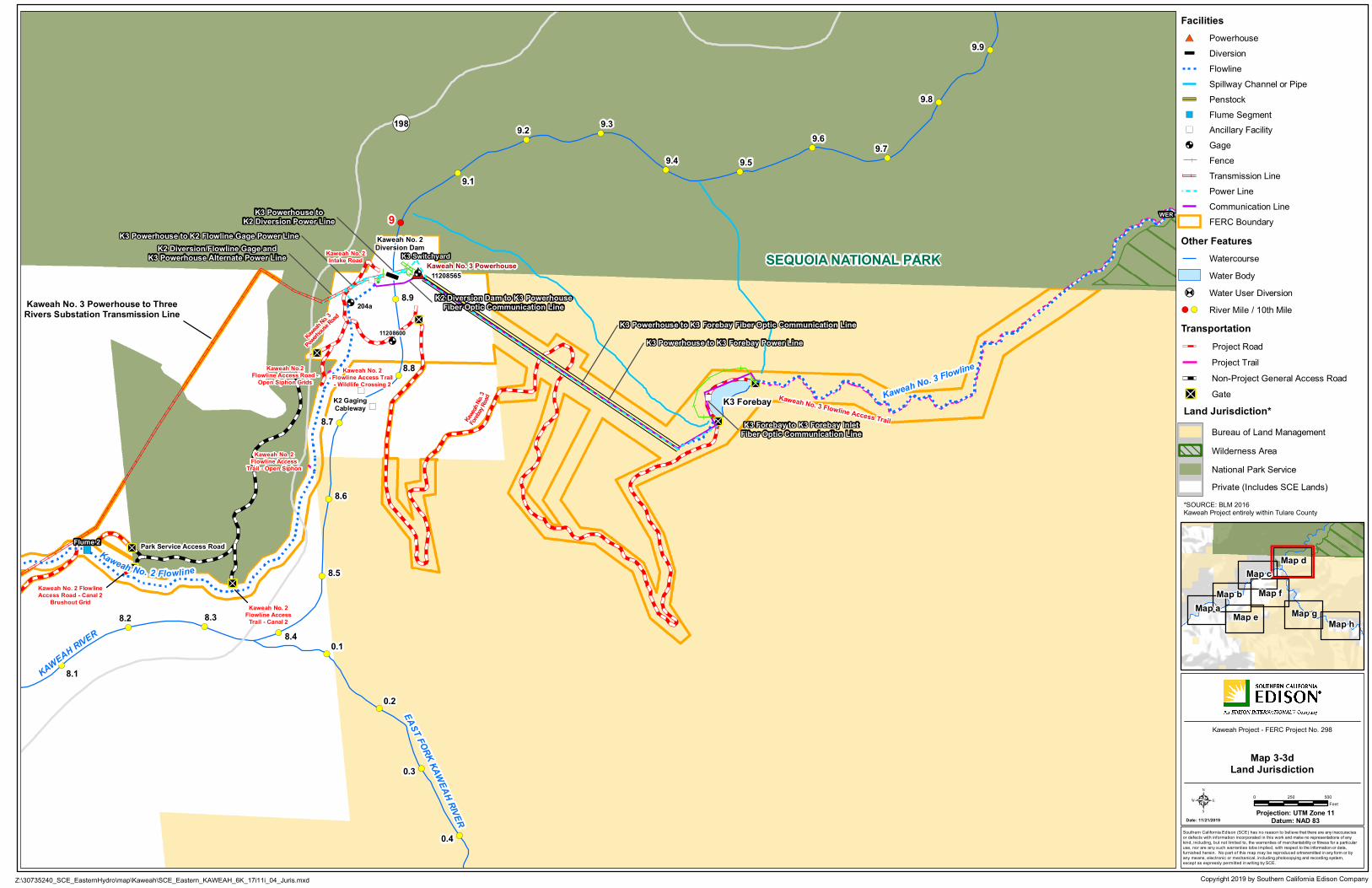
!(
!( !(!(
!(
!(
!(
!(
!(
!(
!(!(
!( !(
!(
!(
!(
!(
!(
!(
!(
!(
!(
"D
"D
"D
"D
"D
"D
"D
#*î
")
")
")
")
")
! A
! A
! A
")
")
")
")
")
!́
!́
!́
SEQUOIA NATIONAL PARK
Kaweah No. 3 Powerhouse to ThreeRivers Substation Transmission Line
11208565
204a
Kaweah No. 3 Flowline Access Trail
¬«198
K2 GagingCableway
K3 Powerhouse to K3 Forebay Power LineK3 Powerhouse to K3 Forebay Fiber Optic Communication Line
K2 Diversion/Flowline Gage andK3 Powerhouse Alternate Power Line
K3 Powerhouse to K2 Flowline Gage Power Line
K2 Diversion Dam to K3 PowerhouseFiber Optic Communication Line
K3 Powerhouse toK2 Diversion Power Line
K3 Forebay to K3 Forebay InletFiber Optic Communication Line
Kaw
eahNo. 3
Powerho
useRoad
Kaweah
No. 3
Foreba
yRoad
Kaweah No. 2Flowline Access
Trail - Canal 2
Kaweah No. 2Flowline Access Trail- Wildlife Crossing 2
Kaweah No. 2Flowline Access
Trail - Open Siphon
Kaweah No. 2 FlowlineAccess Road - Canal 2
Brushout Grid
Kaweah No.2Flowline Access Road -
Open Siphon Grids
Kaweah No. 2Intake Road K3 Switchyard
WER
Kaweah No. 3 Powerhouse
Flume 3
Flume 2
Kaweah No. 2Diversion Dam
11208600
Park Service Access RoadKaweah No. 2 Flowline
Kaweah No. 3 Flowline
K3 Forebay
EAST FORK KAWEAH RIVER
KAWEAH RIVER
8.1
8.2 8.38.4
8.5
8.6
8.7
8.8
8.9
9.1
9.2 9.3
9.4 9.5
9.69.7
9.8
9.9
0.1
0.2
0.3
0.4
9
Copyright 2019 by Southern California Edison Company
Southern California Edison (SCE) has no reason to believe that there are any inaccuraciesor defects with information incorporated in this work and make no representations of anykind, including, but not limited to, the warranties of merchantability or fitness for a particularuse, nor are any such warranties tobe implied, with respect to the information or data,furnished herein. No part of this map may be reproduced ortransmitted in any form or byany means, electronic or mechanical, including photocopying and recording system,except as expressly permitted in writing by SCE.
Date: 11/21/2019Projection: UTM Zone 11
Datum: NAD 835
Z:\30735240_SCE_EasternHydro\map\Kaweah\SCE_Eastern_KAWEAH_6K_17i11i_04_Juris.mxd
0 500250Feet
Map bMap c
Map d
Map e
Map fMap g
Map hMap a
Kaweah Project - FERC Project No. 298
Map 3-3dLand Jurisdiction
Transmission Line
FacilitiesPowerhouse
Flowline
Flume Segment
#*
Diversion
")
Penstock
Other FeaturesWatercourseWater Body
î
FERC Boundary
Ancillary Facility")
! A Water User Diversion
Gage!́
!( River Mile / 10th Mile
Power LineCommunication Line
!(
Spillway Channel or Pipe
Land Jurisdiction*Bureau of Land ManagementWilderness AreaNational Park Service
*SOURCE: BLM 2016Kaweah Project entirely within Tulare County
"D
TransportationProject Road
Non-Project General Access RoadGate
Project Trail
Private (Includes SCE Lands)
Fence


!(
!(
"D
"D
#*
#*
")
")
")
")
")
")
")
")
")
")
")
")
")
")
")
")
")
")
! A
! A
! A
! A
! A
! A
")")")
")
")
")
")
!́
Craig Ranch Road
Kaweah No. 1 Forebay Road
Kaweah No. 3 Powerhouse to ThreeRivers Substation Transmission Line
Kaweah No. 1 Flowline
K1 ForebayTank
KAWEAH RIVER
5.5
5.6
Copyright 2019 by Southern California Edison Company
Southern California Edison (SCE) has no reason to believe that there are any inaccuraciesor defects with information incorporated in this work and make no representations of anykind, including, but not limited to, the warranties of merchantability or fitness for a particularuse, nor are any such warranties tobe implied, with respect to the information or data,furnished herein. No part of this map may be reproduced ortransmitted in any form or byany means, electronic or mechanical, including photocopying and recording system,except as expressly permitted in writing by SCE.
Date: 11/21/2019Projection: UTM Zone 11
Datum: NAD 835
Z:\30735240_SCE_EasternHydro\map\Kaweah\SCE_Eastern_KAWEAH_6K_17i11i_04_Juris.mxd
0 500250Feet
Map bMap c
Map d
Map e
Map fMap g
Map hMap a
Kaweah Project - FERC Project No. 298
Map 3-3eLand Jurisdiction
Transmission Line
FacilitiesPowerhouse
Flowline
Flume Segment
#*
Diversion
")
Penstock
Other FeaturesWatercourseWater Body
î
FERC Boundary
Ancillary Facility")
! A Water User Diversion
Gage!́
!( River Mile / 10th Mile
Power LineCommunication Line
!(
Spillway Channel or Pipe
Land Jurisdiction*Bureau of Land ManagementWilderness AreaNational Park Service
*SOURCE: BLM 2016Kaweah Project entirely within Tulare County
"D
TransportationProject Road
Non-Project General Access RoadGate
Project Trail
Private (Includes SCE Lands)
Fence


!(
!(
!(
!(
!(
!(
!(
!(
!(
!(
"D
"D
"D
#*
#*î
")
")
")
")
")
")
")
")
")
")
")
")
")
")
")
")
! A
! A
! A
! A
! A
")
")")
")
")
")
")
")
")
")
")
!́
!́
!́
!́
¬«198
Kaweah No. 3 Powerhouse to ThreeRivers Substation Transmission Line
K1 GrapevineSatellite Repeater
K1 Powerhouse to K1 Office BuildingFiber Optic Communication Line
Kaweah
No. 1
Flowli
neAcc
essRo
ad-G
rapevi
ne
Kaweah
No.1Flowline
Access
Road-Sum
mit
Mineral King Road
KaweahNo. 1 Flowline
K1 ForebayTank
WUD-SUMMIT
WUD-BEAR
KAWEAH RIVER
EASTF ORKKAW
EAHRIVER
7.1
7.2
7.3
7.40.5
0.6
0.7
0.8
0.9
1
Copyright 2019 by Southern California Edison Company
Southern California Edison (SCE) has no reason to believe that there are any inaccuraciesor defects with information incorporated in this work and make no representations of anykind, including, but not limited to, the warranties of merchantability or fitness for a particularuse, nor are any such warranties tobe implied, with respect to the information or data,furnished herein. No part of this map may be reproduced ortransmitted in any form or byany means, electronic or mechanical, including photocopying and recording system,except as expressly permitted in writing by SCE.
Date: 11/21/2019Projection: UTM Zone 11
Datum: NAD 835
Z:\30735240_SCE_EasternHydro\map\Kaweah\SCE_Eastern_KAWEAH_6K_17i11i_04_Juris.mxd
0 500250Feet
Map bMap c
Map d
Map e
Map fMap g
Map hMap a
Kaweah Project - FERC Project No. 298
Map 3-3fLand Jurisdiction
Transmission Line
FacilitiesPowerhouse
Flowline
Flume Segment
#*
Diversion
")
Penstock
Other FeaturesWatercourseWater Body
î
FERC Boundary
Ancillary Facility")
! A Water User Diversion
Gage!́
!( River Mile / 10th Mile
Power LineCommunication Line
!(
Spillway Channel or Pipe
Land Jurisdiction*Bureau of Land ManagementWilderness AreaNational Park Service
*SOURCE: BLM 2016Kaweah Project entirely within Tulare County
"D
TransportationProject Road
Non-Project General Access RoadGate
Project Trail
Private (Includes SCE Lands)
Fence


!(
!(
!(
!(
!(
!( !( !(
!(
!(
!(
!(
!(
!(
!("D
"D
"D
#*
")
")
")
")
")
! A
! A
! A
")
K1 GrapevineSatellite Repeater
Kaweah No. 1 FlowlineAccess Road & Spur -
Lower Pine
Kaweah
No.1
Flowli
neAcc
essRo
ad- G
rapevi
ne
Kaweah No. 1 FlowlineAccess Road & Spur -
Lumberyard
Kaweah No. 1 FlowlineAccess Road - Upper Pine
Mine
ral K
in gR o
ad
Kaweah No. 1 Flowline
EAST FORK KAWEAH RIVER
1.6
1.7
1.8
1.9
2.12.2 2.3 2.4
2.5
2.6
2.72.8
2.9
2
3
Copyright 2019 by Southern California Edison Company
Southern California Edison (SCE) has no reason to believe that there are any inaccuraciesor defects with information incorporated in this work and make no representations of anykind, including, but not limited to, the warranties of merchantability or fitness for a particularuse, nor are any such warranties tobe implied, with respect to the information or data,furnished herein. No part of this map may be reproduced ortransmitted in any form or byany means, electronic or mechanical, including photocopying and recording system,except as expressly permitted in writing by SCE.
Date: 11/21/2019Projection: UTM Zone 11
Datum: NAD 835
Z:\30735240_SCE_EasternHydro\map\Kaweah\SCE_Eastern_KAWEAH_6K_17i11i_04_Juris.mxd
0 500250Feet
Map bMap c
Map d
Map e
Map fMap g
Map hMap a
Kaweah Project - FERC Project No. 298
Map 3-3gLand Jurisdiction
Transmission Line
FacilitiesPowerhouse
Flowline
Flume Segment
#*
Diversion
")
Penstock
Other FeaturesWatercourseWater Body
î
FERC Boundary
Ancillary Facility")
! A Water User Diversion
Gage!́
!( River Mile / 10th Mile
Power LineCommunication Line
!(
Spillway Channel or Pipe
Land Jurisdiction*Bureau of Land ManagementWilderness AreaNational Park Service
*SOURCE: BLM 2016Kaweah Project entirely within Tulare County
"D
TransportationProject Road
Non-Project General Access RoadGate
Project Trail
Private (Includes SCE Lands)
Fence


!(
!(
!(
!(
!( !(!( !(
!(
!(
!(
!(
!( !(
!(
!(
!(
!(
!(
"D
"D
"D
"D
î
")")
")")
!́
!́!́202
11208730
Kaweah No. 1 FlowlineAccess Road - Slick Rock
201a
K1 Solar YardSatellite Repeater
K1 GagingCableway
K1 Diversion Solar Panel toK1 Diversion Dam Power Line
Kaweah No. 1 FlowlineAccess Road & Trail - Unnamed
Kaweah No. 1 FlowlineAccess Road - Bear Canyon
Kaweah No. 1 FlowlineAccess Road & Spur -
Lumberyard
Kaweah No. 1Intake Road
K1 DiversionSolar Panel Kaweah No. 1
Diversion Dam
Kaweah No. 1 Flowline
EAST FORK KAWEAH RIVER
3.1
3.2
3.3
3.4
3.5 3.6 3.7 3.8
3.9
4.1
4.2
4.3
4.44.5
4.6
4.7
4.8
3
4
Copyright 2019 by Southern California Edison Company
Southern California Edison (SCE) has no reason to believe that there are any inaccuraciesor defects with information incorporated in this work and make no representations of anykind, including, but not limited to, the warranties of merchantability or fitness for a particularuse, nor are any such warranties tobe implied, with respect to the information or data,furnished herein. No part of this map may be reproduced ortransmitted in any form or byany means, electronic or mechanical, including photocopying and recording system,except as expressly permitted in writing by SCE.
Date: 11/21/2019Projection: UTM Zone 11
Datum: NAD 835
Z:\30735240_SCE_EasternHydro\map\Kaweah\SCE_Eastern_KAWEAH_6K_17i11i_04_Juris.mxd
0 500250Feet
Map bMap c
Map d
Map e
Map fMap g
Map hMap a
Kaweah Project - FERC Project No. 298
Map 3-3hLand Jurisdiction
Transmission Line
FacilitiesPowerhouse
Flowline
Flume Segment
#*
Diversion
")
Penstock
Other FeaturesWatercourseWater Body
î
FERC Boundary
Ancillary Facility")
! A Water User Diversion
Gage!́
!( River Mile / 10th Mile
Power LineCommunication Line
!(
Spillway Channel or Pipe
Land Jurisdiction*Bureau of Land ManagementWilderness AreaNational Park Service
*SOURCE: BLM 2016Kaweah Project entirely within Tulare County
"D
TransportationProject Road
Non-Project General Access RoadGate
Project Trail
Private (Includes SCE Lands)
Fence


Application for New License
Southern California Edison Company 3-85
Kaweah Project, FERC Project No. 298
APPENDIX 3-A
Description of Non-FERC Facilities

Application for New License
3-86 Southern California Edison Company
Kaweah Project, FERC Project No. 298
This Page Intentionally Left Blank
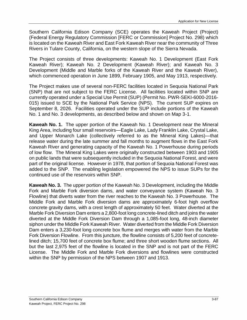
Application for New License
Southern California Edison Company 3-87
Kaweah Project, FERC Project No. 298
Southern California Edison Company (SCE) operates the Kaweah Project (Project) (Federal Energy Regulatory Commission [FERC or Commission] Project No. 298) which is located on the Kaweah River and East Fork Kaweah River near the community of Three Rivers in Tulare County, California, on the western slope of the Sierra Nevada.
The Project consists of three developments: Kaweah No. 1 Development (East Fork Kaweah River); Kaweah No. 2 Development (Kaweah River); and Kaweah No. 3 Development (Middle and Marble forks of the Kaweah River and the Kaweah River), which commenced operation in June 1899, February 1905, and May 1913, respectively.
The Project makes use of several non-FERC facilities located in Sequoia National Park (SNP) that are not subject to the FERC License. All facilities located within SNP are currently operated under a Special Use Permit (SUP) (Permit No. PWR-SEKI-6000-2016-015) issued to SCE by the National Park Service (NPS). The current SUP expires on September 8, 2026. Facilities operated under the SUP include portions of the Kaweah No. 1 and No. 3 developments, as described below and shown on Map 3-1.
Kaweah No. 1. The upper portion of the Kaweah No. 1 Development near the Mineral King Area, including four small reservoirs—Eagle Lake, Lady Franklin Lake, Crystal Lake, and Upper Monarch Lake (collectively referred to as the Mineral King Lakes)—that release water during the late summer and fall months to augment flows in the East Fork Kaweah River and generating capacity of the Kaweah No. 1 Powerhouse during periods of low flow. The Mineral King Lakes were originally constructed between 1903 and 1905 on public lands that were subsequently included in the Sequoia National Forest, and were part of the original license. However in 1978, that portion of Sequoia National Forest was added to the SNP. The enabling legislation empowered the NPS to issue SUPs for the continued use of the reservoirs within SNP.
Kaweah No. 3. The upper portion of the Kaweah No. 3 Development, including the Middle Fork and Marble Fork diversion dams, and water conveyance system (Kaweah No. 3 Flowline) that diverts water from the river reaches to the Kaweah No. 3 Powerhouse. The Middle Fork and Marble Fork diversion dams are approximately 6-foot high overflow concrete gravity dams, with a crest length of approximately 50 feet. Water diverted at the Marble Fork Diversion Dam enters a 2,800-foot long concrete-lined ditch and joins the water diverted at the Middle Fork Diversion Dam through a 1,085-foot long, 48-inch diameter siphon under the Middle Fork Kaweah River. Water diverted from the Middle Fork Diversion Dam enters a 3,230-foot long concrete box flume and merges with water from the Marble Fork Diversion Flowline. From this juncture, the flowline consists of 5,200 feet of concrete-lined ditch; 15,700 feet of concrete box flume; and three short wooden flume sections. All but the last 2,975 feet of the flowline is located in the SNP and is not part of the FERC License. The Middle Fork and Marble Fork diversions and flowlines were constructed within the SNP by permission of the NPS between 1907 and 1913.

Application for New License
3-88 Southern California Edison Company
Kaweah Project, FERC Project No. 298
This Page Intentionally Left Blank

Application for New License
Southern California Edison Company 4-i
Kaweah Project, FERC Project No. 298
TABLE OF CONTENTS
Page
4.0 Proposed Action .................................................................................................. 4-1
4.1 FERC Project Boundary Modifications .......................................................... 4-1
4.1.1 Boundary Increases ............................................................................ 4-2
4.1.2 Boundary Decreases .......................................................................... 4-2
4.1.3 Boundary Corrections ......................................................................... 4-4
4.1.4 FERC Boundary Acreage Change ...................................................... 4-4
4.2 Project Facilities ............................................................................................ 4-4
4.3 Project Maintenance ...................................................................................... 4-4
4.4 Project Operations ......................................................................................... 4-5
4.4.1 Project Generation .............................................................................. 4-6
4.5 New Environmental Measures, Management and Monitoring Plans, and Programs.............................................................................................. 4-6
LIST OF TABLES
Table 4-1. Proposed Action – Project Facilities ................................................. 4-11
LIST OF MAPS
Maps 4-1a–h. FERC Project Boundary Revisions .................................................. 4-17
LIST OF APPENDICES
Appendix 4-A New Environmental Measures, Management and Monitoring Plans, and Programs

Application for New License
4-ii Southern California Edison Company
Kaweah Project, FERC Project No. 298
LIST OF ACRONYMS
APE Area of Potential Effects
AWPMP Avian and Wildlife Protection and Monitoring Plan
BLM U.S. Bureau of Land Management
CDFW California Department of Fish and Wildlife
FERC or Commission Federal Energy Regulatory Commission
FPMP Fish Population Monitoring Plan
FSGMP Flow and Stream Gaging Monitoring Plan
GIS Geographic Information System
GPS Global Positioning System
GRMP Geomorphology/Riparian Monitoring Plan
HPMP Historic Properties Management Plan
NRHP National Register of Historic Places
Project Kaweah Project
SCE Southern California Edison Company
SMECP Sediment Management and Erosion Control Plan
TSMP Transportation System Management Plan
VIPMP Vegetation and Integrated Pest Management Plan
WQMP Water Quality Monitoring Plan
WTMP Water Temperature Monitoring Plan
USFWS U.S. Fish and Wildlife Service
Application for New License
Southern California Edison Company 4-1
Kaweah Project, FERC Project No. 298
4.0 PROPOSED ACTION
This section describes the Proposed Action analyzed in this Application for New License (License Application). The Proposed Action represents Southern California Edison Company’s (SCE) recommendations for continued operation and maintenance of the Kaweah Project (Project), including new environmental measures, management and monitoring plans, and programs.
Under the Proposed Action, the Project will continue to operate in run-of-river mode. There are no new facilities under the Proposed Action. Project facilities included under the Proposed Action are identified in Table 4-1 and their location and surrounding land jurisdiction depicted on Maps 4-1a–h.
Using the No-Action Alternative described in Section 3.0 as a baseline, this section identifies changes that will occur to the Project under the Proposed Action, including:
Modification to the existing Federal Energy Regulatory Commission (FERC or Commission) Project boundary;
Project facility enhancements at the Kaweah No. 2 Powerhouse River Access Parking Area;
Additional Project maintenance activities; and
Modification to Project operations;
New environmental measures, management and monitoring plans, and programs designed to protect, maintain, or enhance environmental and cultural resources.
The following describes each of these changes to the Project under the Proposed Action.
4.1 FERC PROJECT BOUNDARY MODIFICATIONS
The FERC Project boundary will be modified under the Proposed Action to: (1) include all lands necessary for operation and maintenance of the Project; (2) remove lands no longer necessary for operation and maintenance of the Project; and (3) correct known errors in the current Exhibit G for the Project. These revisions are depicted on Maps 4-1a–h.
SCE is currently working with landowners that are affected by the Project boundary modifications to obtain approval to conduct surveys and reach agreement on terms of the modifications. Accurate survey information for the proposed new FERC Project boundary is not available at this time. A tentative boundary is depicted on Maps 4-1a–h. Once complete or within 45 days of the date of issuance of the license, whichever occurs first, SCE will file a complete set of revised Exhibit G drawings in accordance with the regulations at 18 CFR §4.39 and §4.41(h).

Application for New License
4-2 Southern California Edison Company
Kaweah Project, FERC Project No. 298
4.1.1 Boundary Increases
The FERC Project boundary will be increased to include the following existing Project facilities that are currently outside the boundary:
Kaweah No. 1 Development
Kaweah No. 1 Gaging Cableway (Map 4-1h)
Kaweah No. 1 Diversion Solar Panel (Map 4-1h)
Kaweah No. 1 Solar Yard Satellite Repeater (Map 4-1h)
Kaweah No. 1 Flowline Access Road – Unnamed (portion) (Map 4-1h)
Kaweah No. 1 Flowline Access Road - Bear Canyon (portion) (Map 4-1h)
Kaweah No. 1 Flowline Access Road - Slick Rock (portion) (Map 4-1h)
Kaweah No. 2 Development
Kaweah No. 2 Gaging Cableway (Map 4-1d)
Kaweah No. 2 Flowline – West Access Road (portion) (Map 4-1b)
Kaweah No. 2 Flowline – Center Access Road (portion) (Map 4-1b)
Kaweah No. 2 Flowline Access Road – Canal 6 West (Map 4-1c)
Kaweah No. 2 Flowline Access Road – Canal 6 East (Map 4-1c)
Kaweah No. 2 Flowline Access Road – Canal 5 (portion) (Map 4-1c)
Kaweah No. 2 Flowline Access Road – Canal 4 West (Map 4-1c)
Kaweah No. 2 Flowline Access Road – Canal 4 East (Map 4-1c)
Kaweah No. 2 Flowline Access Road – Canal 2 Brushout Grid (portion) (Map 4-1c)
4.1.2 Boundary Decreases
The FERC Project boundary will be decreased to remove communication line and road corridors that are no longer necessary for operation and maintenance of the Project. The following communication line corridors will be removed as they are remnants of the original Project which have been removed and/or replaced by newer technology and are no longer in existence.

Application for New License
Southern California Edison Company 4-3
Kaweah Project, FERC Project No. 298
Kaweah No. 1 Development
Communication line corridor along Kaweah No. 1 Flowline in the vicinity of Kaweah No. 1 Diversion Dam (Map 4-1h)
Communication line corridor along Kaweah No. 1 Flowline in the vicinity of Kaweah No. 1 Forebay Tank (Map 4-1f)
Communication line corridor between Kaweah No. 1 Powerhouse and Kaweah No. 2 Flowline (Map 4-1b)
Kaweah No. 2 Development
Communication line corridor along the Kaweah No. 2 Flowline in the vicinity of Flume 9 / Flume 10 (Map 4-1b)
Communication line corridor along the Kaweah No. 2 Flowline in the vicinity of Canal 9 (Map 4-1b)
Communication line corridor along the Kaweah No. 2 Flowline in the vicinity of Canal 6 (Map 4-1c)
Communication line corridor along the Kaweah No. 2 Flowline in the vicinity of Flume 5 (Map 4-1c)
Communication line corridor along the Kaweah No. 2 Flowline in the vicinity of Flume 2 (Map 4-1c)
The following road corridors will be removed as they are remnants of the original Project which have been removed and are no longer in existence.
Kaweah No. 2 Development
Road corridor along the Kaweah No. 2 Flowline in the vicinity of Canal 9 (Map 4-1b)
Road corridor from Kaweah No. 2 Flowline – East Access Road to Kaweah No. 2 Flowline (Map 4-1c)
Kaweah No. 3 Development
Road corridor from Kaweah No. 3 Forebay Road to Kaweah No. 3 Penstock (Map 4-1d)

Application for New License
4-4 Southern California Edison Company
Kaweah Project, FERC Project No. 298
4.1.3 Boundary Corrections
In addition, advancements in technology such as Global Positioning Systems (GPS), LiDAR and improved aerial imagery have allowed for greater accuracy in the depiction of Project facilities both on the exhibits and in the electronic Geographic Information System (GIS) files to be submitted to FERC. A review of the existing Project boundary against the latest data sources available for the Project resulted in some corrections to the FERC boundary currently approved by the Commission. These specific instances of boundary corrections will be included in the revised Exhibit G.
4.1.4 FERC Boundary Acreage Change
The existing FERC Project boundary encompasses 320.80 acres, including 176.26 acres of public lands administered by the U.S. Bureau of Land Management (BLM) and 144.54 acres of SCE-owned or private land.
The proposed FERC Project boundary (tentative) will encompass 314.82 acres, including 171.29 acres of public lands administered by the BLM and 143.53 acres of SCE-owned or private land.
4.2 PROJECT FACILITIES
Under the Proposed Action, the list and description of existing Project facilities provided in the No-Action Alternative (Section 3.2) remains unchanged. However, at the Kaweah No. 2 Powerhouse River Access Parking Area, two recreation enhancements are included in the Proposed Action namely, the addition of a trash receptacle and Porta-Potty within the footprint of the existing parking area. No changes to existing storage/generation capacity is included in the Proposed Action. Project facilities included under the Proposed Action are included on Table 4-1.
4.3 PROJECT MAINTENANCE
Under the Proposed Action, routine inspection and maintenance activities will continue to be implemented as described in the No-Action Alternative (Section 3.4) with the following exceptions:
Road and Trail Maintenance: The Proposed Action includes additional agency consultation and annual reporting requirements with BLM, Tulare County, and FERC, as appropriate, associated with road and trail maintenance activities (refer to Appendix 4-A, Section 4.3.1 – Project Road and Trail Management Plan).
Ancillary Facility Maintenance: The Proposed Action includes installation of a trash receptacle and Porta-Potty at the Kaweah No. 2 Powerhouse River Access Parking Area. These two features will require additional maintenance at the parking area (refer to Appendix 4-A, Section 4.4.1 – Recreation Enhancement Measures).

Application for New License
Southern California Edison Company 4-5
Kaweah Project, FERC Project No. 298
Powerhouse Maintenance: The Proposed Action includes implementation of measures to protect day-roosting special-status bats in the Kaweah No. 2 Powerhouse, Kaweah No. 3 Powerhouse, and the Kaweah No. 1 Campus maintenance building if painting or power washing the interior walls occurs at or near the roost site (refer to Appendix 4-A, Section 4.5.1 – Special-status Bat Protection Measure).
Vegetation Management: The Proposed Action includes implementation of measures to reduce the spread or introduction of noxious weeds, measures to protect special-status plants, and additional consultation and annual reporting requirements with BLM, Tulare County, and FERC, as appropriate (refer to Appendix 4-A, Section 4.5.2 – Vegetation and Integrated Pest Management Plan).
4.4 PROJECT OPERATIONS
Under the Proposed Action, the Project will continue to operate to generate power for SCE customers and deliver consumptive water to pre-1914 water users consistent with: (1) regulatory requirements (i.e., existing FERC license articles as modified by conditions included in the Proposed Action and existing water rights held by SCE), and (2) existing operating and water delivery agreements. Section 3.5 of the No-Action Alternative describes existing regulatory requirements, water rights, and operating and water delivery agreements.
Under the Proposed Action, operations will continue in a run-of-river mode generally consistent with water management practices described in Section 3.5.3 of the No-Action Alternative. However, minimum instream flows and ramping rates will be modified under the Proposed Action which will change Project operations, as follows:
Minimum Instream Flow: Under the Proposed Action, minimum instream flow will be increased in select months and water years to enhance habitat for aquatic species and better simulate a more natural hydrograph. In addition, there will be a prioritization of water deliveries from the Project flowlines to local water users consistent with pre-1914 water right agreements when Project inflows cannot meet the combined flow necessary to meet both water supply deliveries and minimum instream flow releases below Project diversions. This modification would eliminate the need for SCE to seek temporary modification/variance of minimum instream flow in the future (refer to Appendix 4-A, Section 4.1.1 – Instream Flow Measures).
Ramping Rates: Under the Proposed Action, the ramping rate for instream flows downstream of the Kaweah No. 1 Diversion (as a result of diversion changes) shall not decrease at a rate (cubic feet per second/hour [cfs/hr]) greater than 30% of existing streamflow per hour (down ramping). There is not an up-ramping rate requirement, however, as a natural consequence of the maximum capacity of the diversion (24 cfs), up ramping will not increase greater than 24 cfs per hour. The ramping rate for instream flows downstream of the Kaweah No. 2 Diversion (as a result of diversion changes) shall not decrease at a rate greater than 30% of existing streamflow per hour (down ramping) or increase greater than 25 cfs per

Application for New License
4-6 Southern California Edison Company
Kaweah Project, FERC Project No. 298
hour when the existing streamflow is <40 cfs. There is not an up-ramping rate requirement when the streamflow is ≥40 cfs, however, as a natural consequence of the maximum capacity of the diversion (87 cfs), ramping will not increase greater than 87 cfs per hour when the existing streamflow is ≥40 cfs (refer to Appendix 4-A, Section 4.1.1 – Instream Flow Measures).
4.4.1 Project Generation
Overall Project generation will be reduced by 6.0% at the Kaweah No. 1 Powerhouse and 0.8% at the Kaweah No. 2 Powerhouse under the Proposed Action compared to the No-Action Alternative as a result of implementation of the new minimum instream flow measure. The instream flow measure affects generation at the Kaweah No. 1 and No. 2 powerhouses only. Under the No-Action Alternative, the Project’s annual average generation (1992–2018) is 39,124 MWh. Under the Proposed Action, the Project will have an annual average generation of 38,460 MWh (a reduction of 664 MWh).
Year
Net Generation (MWh)
Kaweah No. 1 Powerhouse
Kaweah No. 2 Powerhouse
Kaweah No. 3 Powerhouse
Project Total
Average Annual Generation, No-Action (1992–2018)
9,732 10,236 19,156 39,124
Average Annual Generation, Proposed Action
9,149 10,155 19,156 38,460
Generation Loss -583 (6.0%) -81 (0.8%) 0 (0%) -664 (1.7%)
4.5 NEW ENVIRONMENTAL MEASURES, MANAGEMENT AND MONITORING PLANS, AND PROGRAMS
Appendix 4-A contains a detailed description of environmental measures; management and monitoring plans; and programs implemented under the Proposed Action by SCE for the Kaweah Project (Project). They memorialize ongoing Project operation and maintenance activities and incorporate additional protection measures as identified in Sections 4.3 and 4.4. The environmental measures; management and monitoring plans; and programs are designed to protect, maintain, or enhance environmental and cultural resources over the term of the new license. The environmental measures; management and monitoring plans; and programs included in the Proposed Action, by resource area, are summarized below.
Environmental Measures / Management and Monitoring Plans
Aquatic Resources
Instream Flow Measures (modified)
Stream Gaging Monitoring Plan (modified)
Application for New License
Southern California Edison Company 4-7
Kaweah Project, FERC Project No. 298
Sediment Management and Erosion Control Plan (ongoing)
Fish Population Monitoring Plan (new)
Entrainment Study Measure (new)
Water Temperature Monitoring Plan (new)
Water Quality Monitoring Plan (new)
Cultural Resources
Historic Properties Management Plan (HPMP) (modified) (Volume 6; Privileged Information)
Land Resources
Project Road and Trail Management Plan (modified)
Recreation Resources
Recreation Enhancement Measures (new)
Terrestrial Resources
Special-Status Bat Protection Measure (ongoing)
Vegetation and Integrated Pest Management Plan (modified)
Special-Status Plant Protection and Monitoring Plan (new)
Avian Mortality Monitoring Plan (ongoing)
Wildlife Mortality Monitoring Plan (ongoing)
Transmission, Power, and Communication Line Maintenance Measure (ongoing)
Environmental Programs
Environmental Training Program (ongoing)

Application for New License
4-8 Southern California Edison Company
Kaweah Project, FERC Project No. 298
This Page Intentionally Left Blank

Application for New License
Southern California Edison Company 4-9
Kaweah Project, FERC Project No. 298
TABLES

Application for New License
4-10 Southern California Edison Company
Kaweah Project, FERC Project No. 298
This Page Intentionally Left Blank

Application for New License
Southern California Edison Company 4-11
Kaweah Project, FERC Project No. 298
Table 4-1. Proposed Action – Project Facilities
Diversion Dams and Pools
Kaweah No. 1 Diversion Dam and Pool (East Fork Kaweah River)
Kaweah No. 2 Diversion Dam and Pool (Kaweah River)
Flowlines
Kaweah No. 1 Flowline
Kaweah No. 2 Flowline
Kaweah No. 3 Flowline
Forebays
Kaweah No. 1 Forebay Tank
Kaweah No. 2 Forebay
Kaweah No. 3 Forebay
Penstocks
Kaweah No. 1 Penstock
Kaweah No. 2 Penstock
Kaweah No. 3 Penstock
Powerhouses and Switchyards
Kaweah No. 1 Powerhouse and Switchyard
Kaweah No. 2 Powerhouse and Switchyard
Kaweah No. 3 Powerhouse and Switchyard
Transmission Lines and Transmission Tap Lines
Kaweah No. 1 Powerhouse Transmission Tap Line
Kaweah No. 2 Powerhouse Transmission Tap Line
Kaweah No. 3 Powerhouse to Three Rivers Substation Transmission Line
Power Lines
Kaweah No. 1 Diversion Solar Panel to Kaweah No. 1 Diversion Dam Power Line
Kaweah No. 1 Office Building to Kaweah No. 1 Forebay Tank Power Line
Kaweah No. 1 Powerhouse Campus Alternate Power Line
Kaweah No. 1 Switchyard to Kaweah No. 1 Maintenance Building Power Line
Kaweah No. 1 Switchyard to Kaweah No. 1 Office Building Power Line
Kaweah No. 1 Switchyard to Kaweah No. 1 Operator’s Office Power Line
Kaweah No. 1 Switchyard to Kaweah No. 1 Workshop Power Line
Kaweah No. 2 Diversion/Flowline Gage and Kaweah No. 3 Powerhouse Alternate Power Line
Kaweah No. 2 Powerhouse Alternate Power Line
Kaweah No. 2 Powerhouse to Kaweah No. 2 Forebay Power Line
Kaweah No. 3 Powerhouse to Kaweah No. 2 Diversion Power Line
Kaweah No. 3 Powerhouse to Kaweah No. 2 Flowline Gage Power Line
Kaweah No. 3 Powerhouse to Kaweah No. 3 Forebay Power Line

Application for New License
4-12 Southern California Edison Company
Kaweah Project, FERC Project No. 298
Communication Lines
Kaweah No. 1 Office Building to Kaweah No. 1 Forebay Tank Fiber Optic Communication Line
Kaweah No. 1 Powerhouse to Kaweah No. 1 Office Building Fiber Optic Communication Line
Kaweah No. 2 Diversion Dam to Kaweah No. 3 Powerhouse Fiber Optic Communication Line
Kaweah No. 2 Powerhouse to Kaweah No. 2 Forebay Fiber Optic Communication Line
Kaweah No. 3 Forebay to Kaweah No. 3 Forebay Inlet Fiber Optic Communication Line
Kaweah No. 3 Powerhouse to Kaweah No. 3 Forebay Fiber Optic Communication Line
Stream Gages
East Fork Kaweah River Conduit 1 at Power Plant near Hammond CA (USGS Gage No. 11208800) (SCE Gage No. 200a)
East Fork Kaweah River near Three Rivers CA (USGS Gage No. 11208730) (SCE Gage No. 201)
Kaweah No. 1 Minimum Instream Flow Release (SCE Gage No. 201a)
East Fork Kaweah River Conduit 1 near Three Rivers CA (SCE Gage No. 202)
Kaweah River below Conduit No. 2 near Hammond CA (USGS Gage No. 11208600) (SCE Gage No. 203)
Kaweah River Conduit No. 2 near Hammond CA (SCE Gage No. 204a)
Kaweah River Conduit No. 2 at Power Plant near Hammond CA (USGS Gage No. 11208818) (SCE Gage No. 205a)
Middle Fork Kaweah River Conduit No. 3 at Power Plant near Hammond CA (USGS Gage No. 11208565) (SCE Gage No. 206a)
Project Access Roads
Kaweah No. 1 Flowline Access Road – Bear Canyon
Kaweah No. 1 Flowline Access Road – Grapevine
Kaweah No. 1 Flowline Access Road – Lower Pine
Kaweah No. 1 Flowline Access Road – Lower Pine (spur)
Kaweah No. 1 Flowline Access Road – Lumberyard
Kaweah No. 1 Flowline Access Road – Lumberyard (spur)
Kaweah No. 1 Flowline Access Road – Slick Rock
Kaweah No. 1 Flowline Access Road – Summit
Kaweah No. 1 Flowline Access Road – Unnamed
Kaweah No. 1 Flowline Access Road – Upper Pine
Kaweah No. 1 Forebay Road
Kaweah No. 2 Flowline Access Road – Canal 2 Brushout Grid
Kaweah No. 2 Flowline Access Road – Canal 4 East
Kaweah No. 2 Flowline Access Road – Canal 4 West
Kaweah No. 2 Flowline Access Road – Canal 5
Kaweah No. 2 Flowline Access Road – Canal 6 East
Kaweah No. 2 Flowline Access Road – Canal 6 West
Kaweah No. 2 Flowline Access Road – Flume 8
Kaweah No. 2 Flowline Access Road – Flume 11
Kaweah No. 2 Flowline Access Road – Open Siphon Grids

Application for New License
Southern California Edison Company 4-13
Kaweah Project, FERC Project No. 298
Project Access Roads (continued)
Kaweah No. 2 Flowline Access Road – Red Barn
Kaweah No. 2 Flowline Center Access Road
Kaweah No. 2 Flowline East Access Road
Kaweah No. 2 Flowline West Access Road
Kaweah No. 2 Forebay Road
Kaweah No. 2 Intake Road
Kaweah No. 2 Penstock Road
Kaweah No. 3 Forebay Road
Kaweah No. 3 Powerhouse Road
Project Trails
Kaweah No. 1 Flowline Access Trail – Unnamed
Kaweah No. 2 Flowline Access Trail – Canal 2
Kaweah No. 2 Flowline Access Trail – Canal 4 East
Kaweah No. 2 Flowline Access Trail – Canal 4 West
Kaweah No. 2 Flowline Access Trail – Canal 5
Kaweah No. 2 Flowline Access Trail – Canal 6
Kaweah No. 2 Flowline Access Trail – Canal 11
Kaweah No. 2 Flowline Access Trail – Canal 13
Kaweah No. 2 Flowline Access Trail – Canal 15
Kaweah No. 2 Flowline Access Trail – Open Siphon
Kaweah No. 2 Flowline Access Trail – Water User 9
Kaweah No. 2 Flowline Access Trail – Water User 14
Kaweah No. 2 Flowline Access Trail – Wildlife Crossing 2
Kaweah No. 3 Flowline Access Trail
Ancillary and Support Facilities
Kaweah No. 1 Diversion Solar Panel
Kaweah No. 1 Gaging Cableway
Kaweah No. 1 Grapevine Satellite Repeater
Kaweah No. 1 Powerhouse Campus
Kaweah No. 1 Solar Panel Satellite Repeater
Kaweah No. 2 Flowline Footbridges
Kaweah No. 2 Flowline Wildlife Bridges
Kaweah No. 2 Flowline Wildlife Escape Ramps
Kaweah No. 2 Gaging Cableway
Kaweah No. 2 Powerhouse River Access Parking Area
Kaweah No. 3 Flowline Footbridges
Kaweah No. 3 Flowline Wildlife Bridges
Kaweah No. 3 Flowline Wildlife Escape Ramps
Kaweah No. 1 Fish Wheel Fence

Application for New License
4-14 Southern California Edison Company
Kaweah Project, FERC Project No. 298
Ancillary and Support Facilities (continued)
Kaweah No. 1 Flowline Control Gate Fence
Kaweah No. 1 Switchyard Perimeter Fence
Kaweah No. 1 Powerhouse Campus Fence
Kaweah No. 2 Intake Fence
Kaweah No. 2 Forebay Fence
Kaweah No. 2 Powerhouse Perimeter Fence
Kaweah No. 2 Switchyard Perimeter Fence
Kaweah No. 2 Tailrace Channel Fence
Kaweah No. 2 Flowline Control Gate Fence
Kaweah No. 2 Flowline Access Road Bridge Fence
Kaweah No. 3 Forebay Fence
Kaweah No. 3 Forebay Inlet Trash Rack Fence
Kaweah No. 3 Switchyard Perimeter Fence
Kaweah No. 3 Tailrace Channel Fence

Application for New License
Southern California Edison Company 4-15
Kaweah Project, FERC Project No. 298
MAPS

Application for New License
4-16 Southern California Edison Company
Kaweah Project, FERC Project No. 298
This Page Intentionally Left Blank


Application for New License
4-18 Southern California Edison Company
Kaweah Project, FERC Project No. 298
This Page Intentionally Left Blank


Application for New License
4-20 Southern California Edison Company
Kaweah Project, FERC Project No. 298
This Page Intentionally Left Blank

198
Flum e6
Flum e 4
Kaweah No. 3 Powe rh ouse to Th re eR iv e rs Substation Transm ission Line
Kaweah No. 2 FlowlineAccess R oad & TrailCanal 4 We st
Kawe ah No. 2
Flowline
East Access
R oadKawe ah No. 2 FlowlineAccess R oad - R ed Barn
DinelyR oad
Kawe ah No. 2 FlowlineAccess Trail - Canal 6
Kawe ah No. 2 FlowlineAccess R oad - Canal 6 East
Com m unication line corridor along KaweahNo. 2 Flowline in th e v icinity of Flum e 5
R oad corridor along Kaweah No. 2Flowline in th e v icinity of Canal 9
Com m unication line corridor along KaweahNo. 2 Flowline in th e v icinity of Canal 9
Com m unication line corridor betwe e n KaweahNo. 1 Powerh ouse and Kaweah No. 2 Flowline
Com m unication line corridoralong Kaweah No. 2 Flowlinein th e v icinity of Flum e 2
Kaweah No. 2Access R oad– Canal 2
Brush out Grid
Kaweah No. 2 AccessR oad – Canal 4 West
Kaweah No. 2 FlowlineAcce ss R oad - Flum e 8
KaweahNo.2Flowline
AccessR oad-Canal5
KaweahNo.
1Flowline
AccessR oa
d-Summ it
KaweahNo.2Flowline
Cen terAccessRoad
Kaweah No. 2 FlowlineAcce ss Trail - Canal 5
Kaweah No. 2 FlowlineAcce ss R oad & Trail
Canal 4 East
Kaweah No. 2 FlowlineAcce ss Trail-Wate r Use r 9
Kaweah No. 2 FlowlineAcce ss R oad - Canal 2
Brush out Grid
Kaweah No. 2Flowline Acce ssR oad - Canal 6 We st
Flum e 7
Flum e6.5
Flum e 5
Flum e3.5
Flum e 3
Flum e 2
Flum e 8
Park Se rv ice Access R oad
Mine ralKingR oad
Kaweah No. 2 FlowlineAccess R oad – Canal 6 West
Kaweah No. 2 FlowlineAccess R oad – Canal 6 East
Kaweah No. 2 FlowlineAccess R oad – Canal 5
Kaweah No. 2 Access R oad– Canal 4 East
Com m unication line corridor along KaweahNo. 2 Flowline in th e v icinity of Canal 6
R oad corridor from Kaweah No. 2 Flowline -East Access R oad to Kaweah No. 2 Flowline Kaweah No.
2 Flowline
7
8
6.7
6.8
6.9
7.1
7.2
7.3
7.4
7.5
7.67.7
7.87.9
8.1
8.2 8.3
WUD-CANAL 9
WUD-FLUME 6
WUD-FLUME 5
Kaweah River
Copyright 2019 by Southern California Edison Company
Southern California Edison (SCE) has no reason to believe that there are any inaccuraciesor defects with information incorporated in this work and make no representations of anykind, including, but not limited to, the warranties of merchantability or fitness for a particularuse, nor are any such warranties tobe implied, with respect to the information or data,furnished herein. No part of this map may be reproduced ortransmitted in any form or byany means, electronic or mechanical, including photocopying and recording system,except as expressly permitted in writing by SCE.
Date: 12/9/2019Projection: UTM Zone 11
Datum : NAD 83
C:\GIS\Cardno\30735240_SCE_EasternHydro\map\Kaweah\FERCBoundaryMaps\SCE_Eastern_KAWEAH_6K_17i11i_04_FERCBndyMods.mxd
0 500250Feet
Map bMap c
Map d
Map e
Map fMap g
Map hMap a
Kaweah Project - FERC Project No. 298
Map 4-1cFER C Project Boundary R e v isions
Transmission Line
SCE Facilitie sPowerhouse
Flowline
Flume Segment
Diversion
Penstock
Oth e r Feature sWatercourseWater Body
FERC Boundary
Ancillary Facility
Water User Diversion
Gage
River Mile / 10th Mile
Power LineCommunication Line
Spillway Channel or Pipe
FER C Boundary R e v isionsAdditionRemoval
TransportationProject Road
Non-Project General Access RoadGate
Project Trail
Land Jurisdiction*Bureau of Land ManagementWilderness AreaNational Park Service
*SOURCE: BLM 2016Kaweah Project entirely within Tulare County
Private (Includes SCE Lands)
Application for New License
4-22 Southern California Edison Company
Kaweah Project, FERC Project No. 298
This Page Intentionally Left Blank


Application for New License
4-24 Southern California Edison Company
Kaweah Project, FERC Project No. 298
This Page Intentionally Left Blank

Craig Ranch Road
Kaweah No. 1 Forebay Road
Kaweah No. 3 Powerhouse to ThreeRivers Substation Transmission Line
Kaweah No.1 Flowline
5.5
5.6
K1 ForebayTank
Kaweah River
Copyright 2019 by Southern California Edison Company
Southern California Edison (SCE) has no reason to believe that there are any inaccuraciesor defects with information incorporated in this work and make no representations of anykind, including, but not limited to, the warranties of merchantability or fitness for a particularuse, nor are any such warranties tobe implied, with respect to the information or data,furnished herein. No part of this map may be reproduced ortransmitted in any form or byany means, electronic or mechanical, including photocopying and recording system,except as expressly permitted in writing by SCE.
Date: 12/9/2019Projection: UTM Zone 11
Datum: NAD 83
C:\GIS\Cardno\30735240_SCE_EasternHydro\map\Kaweah\FERCBoundaryMaps\SCE_Eastern_KAWEAH_6K_17i11i_04_FERCBndyMods.mxd
0 500250Feet
Map bMap c
Map d
Map e
Map fMap g
Map hMap a
Kaweah Project - FERC Project No. 298
Map 4-1eFERC Project Boundary Revisions
Transmission Line
SCE FacilitiesPowerhouse
Flowline
Flume Segment
Diversion
Penstock
Other FeaturesWatercourseWater Body
FERC Boundary
Ancillary Facility
Water User Diversion
Gage
River Mile / 10th Mile
Power LineCommunication Line
Spillway Channel or Pipe
FERC Boundary RevisionsAdditionRemoval
TransportationProject Road
Non-Project General Access RoadGate
Project Trail
Land Jurisdiction*Bureau of Land ManagementWilderness AreaNational Park Service
*SOURCE: BLM 2016Kaweah Project entirely within Tulare County
Private (Includes SCE Lands)
NOTE: There are no FERC Boundary Revisions on this Sheet

Application for New License
4-26 Southern California Edison Company
Kaweah Project, FERC Project No. 298
This Page Intentionally Left Blank

198
Kaweah No. 3 Powerhouse to ThreeRivers Substation Transmission Line
K1 GrapevineSatellite Repeater
Kaweah
No. 1
F lowli
neAcc
essRo
ad- G
rapevi
ne
Kaweah
No.1Flowline
Access
Road-Sum
mit
Mineral King Road
Communication line corridor along Kaweah No. 1Flowline in the vicinity of Kaweah No. 1 Forebay Tank
Kawe
ahNo
.1 Flo
wline
1
7.1
7.2
7.3
7.4
0.5
0.6
0.7
0.8
0.9
K1 ForebayTank
WUD-SUMMIT
WUD-BEAR
Kaweah River
East F ork Kaweah River
Copyright 2019 by Southern California Edison Company
Southern California Edison (SCE) has no reason to believe that there are any inaccuraciesor defects with information incorporated in this work and make no representations of anykind, including, but not limited to, the warranties of merchantability or fitness for a particularuse, nor are any such warranties tobe implied, with respect to the information or data,furnished herein. No part of this map may be reproduced ortransmitted in any form or byany means, electronic or mechanical, including photocopying and recording system,except as expressly permitted in writing by SCE.
Date: 12/9/2019Projection: UTM Zone 11
Datum: NAD 83
C:\GIS\Cardno\30735240_SCE_EasternHydro\map\Kaweah\FERCBoundaryMaps\SCE_Eastern_KAWEAH_6K_17i11i_04_FERCBndyMods.mxd
0 500250Feet
Map bMap c
Map d
Map e
Map fMap g
Map hMap a
Kaweah Project - FERC Project No. 298
Map 4-1fFERC Project Boundary Revisions
Transmission Line
SCE FacilitiesPowerhouse
Flowline
Flume Segment
Diversion
Penstock
Other FeaturesWatercourseWater Body
FERC Boundary
Ancillary Facility
Water User Diversion
Gage
River Mile / 10th Mile
Power LineCommunication Line
Spillway Channel or Pipe
FERC Boundary RevisionsAdditionRemoval
TransportationProject Road
Non-Project General Access RoadGate
Project Trail
Land Jurisdiction*Bureau of Land ManagementWilderness AreaNational Park Service
*SOURCE: BLM 2016Kaweah Project entirely within Tulare County
Private (Includes SCE Lands)

Application for New License
4-28 Southern California Edison Company
Kaweah Project, FERC Project No. 298
This Page Intentionally Left Blank

K1 GrapevineSatellite Repeater
Kaweah No. 1 FlowlineAccess Road & Spur -
Lower Pine
Kaweah
No. 1
F lowli
neAcc
essRo
ad- G
rapevi
ne
Kaweah No. 1 FlowlineAccess Road & Spur -
Lumberyard
Kaweah No. 1 FlowlineAccess Road - Upper Pine
Mine
ral K
ingRo
a d
Kaweah No.1 Flowline
2
3
1.6
1.7
1.8
1.9
2.1
2.22.3 2.4
2.5
2.6
2.7
2.8
2.9
East Fork Kaweah River
Copyright 2019 by Southern California Edison Company
Southern California Edison (SCE) has no reason to believe that there are any inaccuraciesor defects with information incorporated in this work and make no representations of anykind, including, but not limited to, the warranties of merchantability or fitness for a particularuse, nor are any such warranties tobe implied, with respect to the information or data,furnished herein. No part of this map may be reproduced ortransmitted in any form or byany means, electronic or mechanical, including photocopying and recording system,except as expressly permitted in writing by SCE.
Date: 12/9/2019Projection: UTM Zone 11
Datum: NAD 83
C:\GIS\Cardno\30735240_SCE_EasternHydro\map\Kaweah\FERCBoundaryMaps\SCE_Eastern_KAWEAH_6K_17i11i_04_FERCBndyMods.mxd
0 500250Feet
Map bMap c
Map d
Map e
Map fMap g
Map hMap a
Kaweah Project - FERC Project No. 298
Map 4-1gFERC Project Boundary Revisions
Transmission Line
SCE FacilitiesPowerhouse
Flowline
Flume Segment
Diversion
Penstock
Other FeaturesWatercourseWater Body
FERC Boundary
Ancillary Facility
Water User Diversion
Gage
River Mile / 10th Mile
Power LineCommunication Line
Spillway Channel or Pipe
FERC Boundary RevisionsAdditionRemoval
TransportationProject Road
Non-Project General Access RoadGate
Project Trail
Land Jurisdiction*Bureau of Land ManagementWilderness AreaNational Park Service
*SOURCE: BLM 2016Kaweah Project entirely within Tulare County
Private (Includes SCE Lands)
NOTE: There are no FERC Boundary Revisions on this Sheet

Application for New License
4-30 Southern California Edison Company
Kaweah Project, FERC Project No. 298
This Page Intentionally Left Blank

20211208730
Kaweah No. 1 FlowlineAccess Road - Slick Rock
201a
K1 Solar YardSatellite Repeater
K1 Gag ingCableway
Kaweah No. 1 FlowlineAccess Road & Trail - Unnam ed
Kaweah No. 1 FlowlineAccess Road - Bear Canyon
Kaweah No. 1 FlowlineAccess Road & Spu r -
Lu m beryard
Kaweah No. 1Intake Road
K1 DiversionSolar P anel
Kaweah No. 1Diversion Dam
K1 Diversion Solar P anel toK1 Diversion Dam P ower Line
Kaweah No. 1Gag ing Cableway
Kaweah No. 1 Diversion Solar P aneland Solar Yard Satellite Repeater
Com m u nication line corrid or along Kaweah No. 1Flowline in th e vicinity of Kaweah No. 1 Diversion Dam
Kaweah No. 1 FlowlineAccess Road – Unnam ed
Kaweah No. 1 FlowlineAccess Road - Bear Canyon
Kaweah No. 1 FlowlineAccess Road - Slick Rock Kaweah No.
1 Flowline
3
4
3.1
3.2
3.3
3.4
3.73.8
3.9
4.1
4.2
4.3
4.4 4.5
4.6
4.8
East Fork Kaweah River
Copyright 2019 by Southern California Edison Company
Southern California Edison (SCE) has no reason to believe that there are any inaccuraciesor defects with information incorporated in this work and make no representations of anykind, including, but not limited to, the warranties of merchantability or fitness for a particularuse, nor are any such warranties tobe implied, with respect to the information or data,furnished herein. No part of this map may be reproduced ortransmitted in any form or byany means, electronic or mechanical, including photocopying and recording system,except as expressly permitted in writing by SCE.
Date: 12/9/2019P rojection: UTM Zone 11
Datu m : NAD 83
C:\GIS\Cardno\30735240_SCE_EasternHydro\map\Kaweah\FERCBoundaryMaps\SCE_Eastern_KAWEAH_6K_17i11i_04_FERCBndyMods.mxd
0 500250Feet
Map bMap c
Map d
Map e
Map fMap g
Map hMap a
Kaweah Project - FERC Project No. 298
Map 4-1hFERC P roject Bou nd ary Revisions
Transmission Line
SCE FacilitiesPowerhouse
Flowline
Flume Segment
Diversion
Penstock
Oth er Featu resWatercourseWater Body
FERC Boundary
Ancillary Facility
Water User Diversion
Gage
River Mile / 10th Mile
Power LineCommunication Line
Spillway Channel or Pipe
FERC Bou nd ary RevisionsAdditionRemoval
TransportationProject Road
Non-Project General Access RoadGate
Project Trail
Land Ju risd iction*Bureau of Land ManagementWilderness AreaNational Park Service
*SOURCE: BLM 2016Kaweah Project entirely within Tulare County
Private (Includes SCE Lands)

Application for New License
4-32 Southern California Edison Company
Kaweah Project, FERC Project No. 298
This Page Intentionally Left Blank

Application for New License
Southern California Edison Company
Kaweah Project, FERC Project No. 298
APPENDIX 4-A
New Environmental Measures, Management and Monitoring Plans, and Programs

Application for New License
Southern California Edison Company
Kaweah Project, FERC Project No. 298
This Page Intentionally Left Blank

Application for New License
Southern California Edison Company Appendix 4-A-1
Kaweah Project, FERC Project No. 298
Appendix 4-A contains environmental measures; management and monitoring plans; and programs implemented under the Proposed Action by Southern California Edison Company (SCE) for the Kaweah Project (Project). The environmental measures; management and monitoring plans; and programs are designed to protect, maintain, or enhance environmental and cultural resources over the term of the new license. The environmental measures; management and monitoring plans; and programs included in the Proposed Action by resource area are documented in the following:
Environmental Measures / Management and Monitoring Plans
Aquatic Resources
Instream Flow Measures (modified)
Stream Gaging Monitoring Plan (modified)
Sediment Management and Erosion Control Plan (ongoing)
Fish Population Monitoring Plan (new)
Entrainment Study Measure (new)
Water Temperature Monitoring Plan (new)
Water Quality Monitoring Plan (new)
Cultural Resources
Historic Properties Management Plan (modified) (Volume 6, Privileged Information)
Land Resources
Project Road and Trail Management Plan (modified)
Recreation Resources
Recreation Enhancement Measures (new)
Terrestrial Resources
Special-Status Bat Protection Measure (ongoing)
Vegetation and Integrated Pest Management Plan (modified)
Special-Status Plant Protection and Monitoring Plan (new)
Avian Mortality Monitoring Plan (ongoing)

Application for New License
Appendix 4-A-2 Southern California Edison Company
Kaweah Project, FERC Project 298
Wildlife Mortality Monitoring Plan (ongoing)
Transmission, Power, and Communication Line Maintenance Measure (ongoing)
Environmental Program
Environmental Training Program (ongoing)
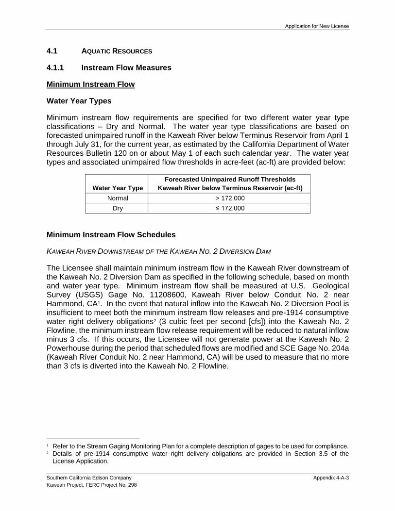
Application for New License
Southern California Edison Company Appendix 4-A-3
Kaweah Project, FERC Project No. 298
4.1 AQUATIC RESOURCES
4.1.1 Instream Flow Measures
Minimum Instream Flow
Water Year Types
Minimum instream flow requirements are specified for two different water year type classifications – Dry and Normal. The water year type classifications are based on forecasted unimpaired runoff in the Kaweah River below Terminus Reservoir from April 1 through July 31, for the current year, as estimated by the California Department of Water Resources Bulletin 120 on or about May 1 of each such calendar year. The water year types and associated unimpaired flow thresholds in acre-feet (ac-ft) are provided below:
Water Year Type
Forecasted Unimpaired Runoff Thresholds
Kaweah River below Terminus Reservoir (ac-ft)
Normal > 172,000
Dry ≤ 172,000
Minimum Instream Flow Schedules
KAWEAH RIVER DOWNSTREAM OF THE KAWEAH NO. 2 DIVERSION DAM
The Licensee shall maintain minimum instream flow in the Kaweah River downstream of the Kaweah No. 2 Diversion Dam as specified in the following schedule, based on month and water year type. Minimum instream flow shall be measured at U.S. Geological Survey (USGS) Gage No. 11208600, Kaweah River below Conduit No. 2 near Hammond, CA1. In the event that natural inflow into the Kaweah No. 2 Diversion Pool is insufficient to meet both the minimum instream flow releases and pre-1914 consumptive water right delivery obligations2 (3 cubic feet per second [cfs]) into the Kaweah No. 2 Flowline, the minimum instream flow release requirement will be reduced to natural inflow minus 3 cfs. If this occurs, the Licensee will not generate power at the Kaweah No. 2 Powerhouse during the period that scheduled flows are modified and SCE Gage No. 204a (Kaweah River Conduit No. 2 near Hammond, CA) will be used to measure that no more than 3 cfs is diverted into the Kaweah No. 2 Flowline.
1 Refer to the Stream Gaging Monitoring Plan for a complete description of gages to be used for compliance. 2 Details of pre-1914 consumptive water right delivery obligations are provided in Section 3.5 of the
License Application.

Application for New License
Appendix 4-A-4 Southern California Edison Company
Kaweah Project, FERC Project 298
Kaweah River Downstream of Kaweah No. 2 Diversion Dam
Month
Minimum Instream Flow by Water Year Type (cfs)1
Dry Normal
Jan 20 or NF - 3 cfs 20 or NF - 3 cfs
Feb 20 or NF - 3 cfs 20 or NF - 3 cfs
Mar 20 or NF - 3 cfs 30 or NF - 3 cfs
Apr 30 or NF - 3 cfs 30 or NF - 3 cfs
May 30 or NF - 3 cfs 30 or NF - 3 cfs
Jun 30 or NF - 3 cfs 30 or NF - 3 cfs
Jul 20 or NF - 3 cfs 20 or NF - 3 cfs
Aug 10 or NF - 3 cfs 20 or NF - 3 cfs
Sept 5 or NF - 3 cfs 20 or NF - 3 cfs
Oct 5 or NF - 3 cfs 11 or NF - 3 cfs
Nov 5 or NF - 3 cfs 11 or NF - 3 cfs
Dec 10 or NF - 3 cfs 11 or NF - 3 cfs
1. NF - 3 cfs: Natural flow to the Kaweah No. 2 Diversion Pool minus the pre-1914 consumptive water right delivery obligation of 3 cfs.
EAST FORK KAWEAH RIVER DOWNSTREAM OF THE KAWEAH NO. 1 DIVERSION DAM
The Licensee shall maintain minimum instream flow in the East Fork Kaweah River downstream of the Kaweah No. 1 Diversion Dam as specified in the following schedule, based on month and water year type. Minimum instream flow shall be measured at USGS Gage No. 11208730, East Fork Kaweah River near Three Rivers, CA. In the event that natural inflow into the Kaweah No. 1 Diversion Pool is insufficient to meet both the minimum instream flow releases and pre-1914 consumptive water right delivery obligations (1 cfs) into the Kaweah No. 1 Flowline, the minimum instream flow release requirement will be reduced to natural inflow minus 1 cfs. If this occurs, the Licensee will not generate power at the Kaweah No. 1 Powerhouse during the period that scheduled flows are modified and SCE Gage No. 202 (East Fork Kaweah River Conduit 1 near Three Rivers, CA) will be used to measure that no more than 1 cfs is diverted into the Kaweah No. 1 Flowline.
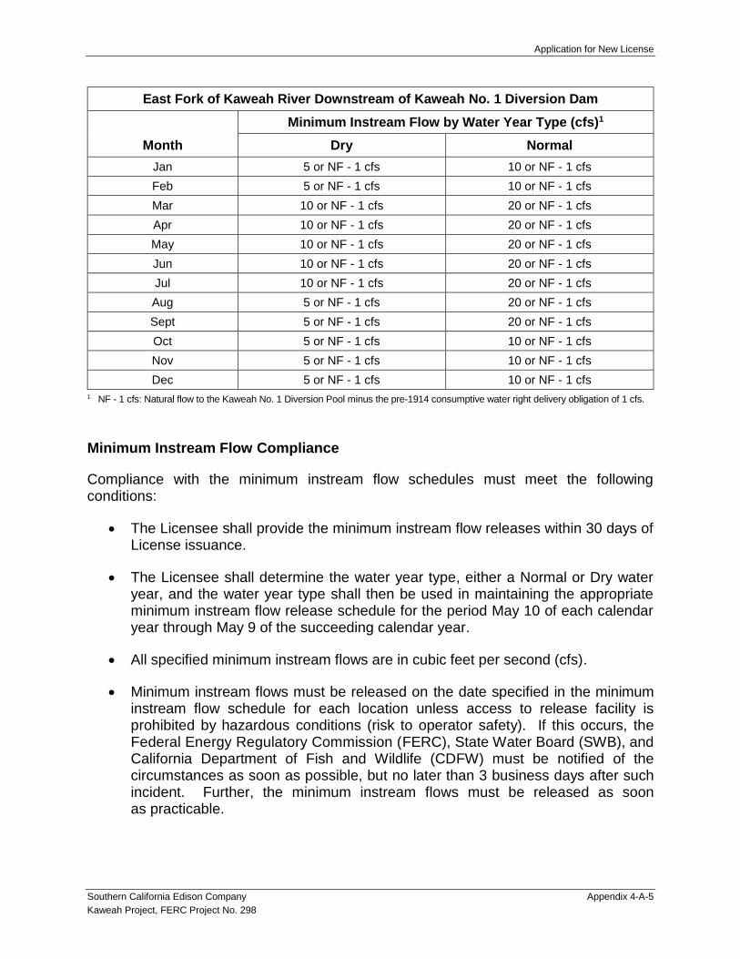
Application for New License
Southern California Edison Company Appendix 4-A-5
Kaweah Project, FERC Project No. 298
East Fork of Kaweah River Downstream of Kaweah No. 1 Diversion Dam
Month
Minimum Instream Flow by Water Year Type (cfs)1
Dry Normal
Jan 5 or NF - 1 cfs 10 or NF - 1 cfs
Feb 5 or NF - 1 cfs 10 or NF - 1 cfs
Mar 10 or NF - 1 cfs 20 or NF - 1 cfs
Apr 10 or NF - 1 cfs 20 or NF - 1 cfs
May 10 or NF - 1 cfs 20 or NF - 1 cfs
Jun 10 or NF - 1 cfs 20 or NF - 1 cfs
Jul 10 or NF - 1 cfs 20 or NF - 1 cfs
Aug 5 or NF - 1 cfs 20 or NF - 1 cfs
Sept 5 or NF - 1 cfs 20 or NF - 1 cfs
Oct 5 or NF - 1 cfs 10 or NF - 1 cfs
Nov 5 or NF - 1 cfs 10 or NF - 1 cfs
Dec 5 or NF - 1 cfs 10 or NF - 1 cfs
1 NF - 1 cfs: Natural flow to the Kaweah No. 1 Diversion Pool minus the pre-1914 consumptive water right delivery obligation of 1 cfs.
Minimum Instream Flow Compliance
Compliance with the minimum instream flow schedules must meet the following conditions:
The Licensee shall provide the minimum instream flow releases within 30 days of License issuance.
The Licensee shall determine the water year type, either a Normal or Dry water year, and the water year type shall then be used in maintaining the appropriate minimum instream flow release schedule for the period May 10 of each calendar year through May 9 of the succeeding calendar year.
All specified minimum instream flows are in cubic feet per second (cfs).
Minimum instream flows must be released on the date specified in the minimum instream flow schedule for each location unless access to release facility is prohibited by hazardous conditions (risk to operator safety). If this occurs, the Federal Energy Regulatory Commission (FERC), State Water Board (SWB), and California Department of Fish and Wildlife (CDFW) must be notified of the circumstances as soon as possible, but no later than 3 business days after such incident. Further, the minimum instream flows must be released as soon as practicable.

Application for New License
Appendix 4-A-6 Southern California Edison Company
Kaweah Project, FERC Project 298
The minimum instream flow release will be based on daily and hourly average flow measurements (based on flow measured in ≤15-minute time increments). The daily average flow shall never be less than the thresholds specified in the minimum instream flow schedule for each location and the hourly average flow shall never be less than 80% of the thresholds specified in the minimum instream flow schedule for each location, except as authorized in the following:
The minimum instream flow may be temporarily modified for short periods (up to 14 days) upon mutual agreement between the Licensee, SWB, and CDFW with notification to FERC.
The flow schedule may be temporarily modified if required by operating emergencies or equipment failures beyond the control of the Licensee. If the flow is so modified, the Licensee shall notify the FERC, SWB, and CDFW, as soon as possible, but no later than 10 business days.
In the event that natural inflow into the Kaweah No. 1 Diversion Pool or Kaweah No. 2 Diversion Pool is insufficient to meet both the minimum instream flow releases and pre-1914 consumptive water right delivery obligations, the daily average flow into the respective flowlines (pre-1914 consumptive water delivery) shall never be greater than 1 cfs in the Kaweah No. 1 Flowline and 3 cfs in the Kaweah No. 2 Flowline as specified in the instream flow schedule for each location. The hourly average flow shall never be greater than 120% of the pre-1914 consumptive water delivery requirement for each location.
If a deviation occurs regarding compliance with minimum instream flow, the Licensee shall file a report with the FERC within 30 days from the date that the data becomes available indicating the deviation. The report shall, to the extent possible, identify the cause, severity, and duration of the deviation, any environmental impacts resulting from the deviation, a description of the measures implemented to correct the deviation, and the measures the Licensee implemented or proposed to ensure deviations do not reoccur. The associated gaging data from the Project shall be available to the resource agencies within 30 days of a request.
Ramping Rates
Ramping Rate Requirement
The Licensee shall operate the Kaweah No. 1 Diversion such that a change in the flowline diversion amount will not cause instream flows downstream of the diversion, at the time of the diversion change, to decrease at a rate (cfs/hr) greater than the following:
Down Ramping – Instream flows, as measured at the beginning of a diversion change, shall not decrease at a rate greater than 30% of the existing streamflow per hour as a result of changes in the flowline diversion amount.

Application for New License
Southern California Edison Company Appendix 4-A-7
Kaweah Project, FERC Project No. 298
Ramping rates in the East Fork Kaweah River downstream of the Kaweah No. 1 Diversion Dam shall be measured using the USGS Gage 11208730, East Fork Kaweah River near Three Rivers, CA (instream flow) at the beginning of a diversion change and SCE Gage No. 202 for the amount of diversion.
The Licensee shall operate the Kaweah No. 2 Diversion such that instream flows downstream of the diversion are not decreased or increased at a rate (cfs/hr) greater than the following:
Down Ramping – Instream flows, as measured at the beginning of a diversion change, shall not decrease at a rate greater than 30% of the existing streamflow per hour as a result of changes in the flowline diversion amount.
Up Ramping – Instream flows, as measured at the beginning of a diversion change, shall not increase greater than 25 cfs per hour when the existing streamflow is ≤40 cfs. When flows are ≥40 cfs, there is no up ramping requirement.
Ramping rates in the Kaweah River downstream of the Kaweah No. 2 Diversion Dam shall be measured using the USGS Gage 11208600, Kaweah River below Conduit No. 2 near Hammond, CA (instream flow) at the beginning of a diversion change and SCE Gage No. 204 for the amount of diversion.
Ramping Rate Compliance
Compliance with the ramping rate must meet the following conditions:
The Licensee shall implement ramping rate requirements within 30 days of License issuance.
All specified ramping rates are in cfs per hour (cfs/hr), where the change in cfs/hr over any hourly time period shall not exceed the specified ramping rate.
The ramping requirements will be based on the hourly average flow measurement in the stream immediately prior to implementing a flowline diversion change (based on flow measured in ≤15-minute time increments) and the calculated stream ramping rate (cfs/hr), based on the flowline diversion change (based on flow measured in ≤15-minute time increments), shall never be more than the thresholds specified for each location (e.g., hourly average stream flow at the beginning of a flow change ± the subsequent hourly average flowline change(s)), except as authorized in the following:
The ramping rates may be temporarily modified for short periods (up to 14 days) upon mutual agreement between the Licensee, SWB, and CDFW with notification to FERC.
The ramping rate may be temporarily modified if required by operating emergencies or equipment failures beyond the control of the Licensee. If

Application for New License
Appendix 4-A-8 Southern California Edison Company
Kaweah Project, FERC Project 298
ramping rates are modified, the Licensee shall notify the FERC, SWB, and CDFW, as soon as possible, but no later than 10 business days.
If a deviation occurs regarding compliance with ramping rate, the Licensee shall file a report with the FERC within 30 days from the date that the data becomes available indicating the deviation. The report shall, to the extent possible, identify the cause, severity, and duration of the deviation, any environmental impacts resulting from the deviation, a description of the measures implemented to correct the deviation, and the measures the Licensee implemented or proposed to ensure deviations do not recur. The associated gaging data from the Project shall be available to the resource agencies within 30 days of a request.
4.1.2 Stream Gaging Monitoring Plan
This objective of the Stream Gaging Plan (SGP) is to:
Identify and describe Project gages used to document compliance with minimum instream flow and ramping rate requirements, pre-1914 consumptive water right delivery obligations, and dissemination of real-time flow information to the public;
Operation and maintenance of the gages; and
Reporting of compliance.
Compliance Gages
The gages used to document compliance with minimum instream flow and ramping rate requirements are identified in Table SGP-1. This table also identifies the gages used to comply with pre-1914 consumptive water right delivery obligations and for dissemination of real-time flow information to the public. The locations of the compliance gages are depicted on Map SGP-1.
Operations and Maintenance of Gages
All the gages will record at a time increment of ≤15 minutes. The gages will be maintained and operated by the Licensee. The Licensee will implement current USGS gaging standards for the type of measurement system specific to each location (e.g., bubble gage, acoustic Doppler current profiler, acoustic velocity meter).
Reporting
The Licensee will prepare a brief annual report to document compliance with minimum instream flow and ramping rate requirements for each calendar year. The report will also summarize dissemination of real-time flow information to the public. The annual report will be filed with the FERC within the first quarter of each year and distributed to the State Water Board and CDFW. Upon completion of the QA/QC process and upon request, flow data will be provided to FERC, State Water Board, and CDFW.

Application for New License
Southern California Edison Company Appendix 4-A-9
Kaweah Project, FERC Project No. 298
If a deviation occurs regarding compliance with minimum instream flow and ramping rate requirements, the Licensee shall file a report with the FERC within 30 days from the date that the data becomes available indicating the deviation. The report shall, to the extent possible, identify the cause, severity, and duration of the deviation, any environmental impacts resulting from the deviation, a description of the measures implemented to correct the deviation, and the measures the Licensee implemented or proposed to ensure deviations do not recur. The gaging data from the Project shall be available to the resource agencies within 30 days of a request.
4.1.3 Sediment Management and Erosion Control Plan
The Licensee will implement the following Sediment Management and Erosion Control Plan (SMECP) to maintain and protect system reliability and protect environmental resources. The objectives of the SMECP are to:
Establish methods for the removal and disposition of sediment that has accumulated in Project flowlines and forebays, and around intake structures; and
Establish inspection protocols at the Kaweah No. 1 and Kaweah No. 2 flowlines and measures to implement in the event of a flowline failure.
Sediment Management
The Licensee will conduct sediment management activities at the Kaweah No. 1 Intake, Kaweah No. 1 Forebay Tank, Kaweah No. 2 Intake, Kaweah No. 2 Forebay, and Kaweah No. 3 Forebay. Methods for sediment removal and disposition are designed to be protective of water quality and downstream aquatic resources. Sediment management will comply with turbidity and sediment (suspended sediment load and suspended sediment discharge) criteria in the Water Quality Control Plan for the Tulare Lake Basin. Sediment management activities at each location are described below:
Kaweah No. 1 Intake. The low-level outlet at the sandbox will be routinely opened during high flows to reduce accumulation of sand/fine sediment and transport it back into the active stream channel. If larger substrate becomes trapped in the sandbox, it will be removed and placed along the margin of the active channel during the fall maintenance outage where it can be entrained into the channel during high-flow events.
Kaweah No. 1 Forebay Tank. A low-level outlet in the forebay tank will be routinely opened during normal operations to reduce accumulations of sand/fine sediment in the bottom of the tank and transport it into an adjacent natural drainage channel. Any large materials remaining in the bottom of the tank will be removed during the fall maintenance outage and placed in the adjacent natural drainage channel where it will be transported during storm events.

Application for New License
Appendix 4-A-10 Southern California Edison Company
Kaweah Project, FERC Project 298
Kaweah No. 2 Intake. During high-flow events, large boulders and rocks often accumulate on the intake grate obstructing flow into the intake and, at times, allowing sediment to build up near the intake. When necessary, this rock debris will be removed and placed downstream of the diversion structure to improve flow into the intake and prevent facility damage.
Kaweah No. 2 Forebay. Several low-level outlets in the forebay will be routinely opened during normal operations to reduce accumulation of sand/fine sediment from the bottom of the forebay and transport it into natural drainages. Any large build-up of material will be removed during the fall maintenance outage and placed in the adjacent natural drainage channel where it will be transported during storm events.
Kaweah No. 3 Forebay. Accumulated sediment in the Kaweah No. 3 Forebay will be removed with heavy equipment approximately every five years, or as needed. The majority of the sediment removed is typically composed of sand/silt. Prior to sediment removal, water in the forebay will be lowered, first by passing water via the penstock through the Kaweah No. 3 Powerhouse. As the forebay water level approaches the elevation of the intake structure, diversion through the powerhouse will be discontinued and the remainder of the water will be released through the forebay’s low-level outlet. The outlet will be opened no more 15% of its range to allow water to slowly drain from the forebay and reduce entrainment of the sediment deposit near the low-level outlet. The water released from the low-level outlet enters a short concrete chute that discharges into an adjacent natural drainage. Sediment removal with heavy equipment will occur once the sediment in the bottom of the forebay dries. Disposition of removed sediment will be identified in consultation with BLM.
Erosion Control
The Licensee will implement the following measures to: (1) reduce the potential for a failure in Project flowlines, and (2) reduce impacts in the event of a flowline failure.
Flowlines will be inspected routinely to identify potential maintenance issues. Any maintenance issues identified will be addressed in a timely manner.
In the event of flowline failure, flow will be shut off, as soon as possible, and diversions will be discontinued until repairs are completed.
Licensee will repair the flowline, as soon as practicable, considering engineering constraints, site conditions, and environmental protection.

Application for New License
Southern California Edison Company Appendix 4-A-11
Kaweah Project, FERC Project No. 298
Reporting and Consultation
The Licensee will prepare a brief annual report to document sediment management and erosion control activities implemented during the previous calendar year. The annual report will be filed with the FERC within the first quarter of each year and distributed to the BLM, State Water Board, and CDFW.
4.1.4 Fish Population Monitoring Plan
The purpose of the Fish Population Monitoring Plan (FPMP) is to obtain, for comparative purposes, periodic information on fish populations in bypass and comparative reaches associated with the Project under the flow regimes specified in the new license. This information will be compared to historical fish population data collected during relicensing study (AQ 2 – Fish Population Technical Study Report (TSR); Supporting Document A of the License Application).
Specific objectives of FPMP are to:
Document fish species composition, distribution, and abundance in the bypass and comparison reaches3,
Characterize fish growth, condition factor, and population age structure in the bypass and comparison reaches.
Implementation Schedule
Fish population monitoring will be implemented in Year 2 following license issuance and every 10 years thereafter.
Sampling Locations
The sampling locations include the bypass reaches associated with the Project and the comparison reaches upstream or downstream of the Project. Specific sampling locations are identified in Table FPMP-1 and Map FPMP-1 and are consistent with those sampled during relicensing of the Project. Some portions of the East Fork Kaweah River downstream of Kaweah No. 1 Diversion are inaccessible due to the rugged terrain (see Map FPMP-1). Field data will only be collected in portions of the river that are accessible.
It should be noted that the majority of lands along the bypass reaches are privately owned and outside the FERC Project boundary. For the purposes of fish population monitoring, the Licensee will take the following steps to obtain approval to conduct field studies on private property:
3 A bypass reach is a segment of a river downstream of a diversion facility where Project operations result
in the diversion of a portion of the water from that reach. Typically, the diverted water re-enters the river through a powerhouse at the downstream end of the bypass reach.
Application for New License
Appendix 4-A-12 Southern California Edison Company
Kaweah Project, FERC Project 298
Licensee will provide notification to landowners about fish population monitoring and request authorization to enter property to conduct the field studies.
If authorization is obtained, Licensee will complete field studies at the location as described in the Table FPMP-1, otherwise, the nearest location within the reach where permission is granted will be sampled.
River sampling sites (electrofishing and/or snorkeling) are generally 100 meters (m) long or longer (one site is 83 m). Some of the larger river sites (e.g., Kaweah River) require sampling sites up to 260 m to include multiple habitat types. Sampling sites were chosen far enough upstream or downstream of access locations to reduce the effects of fishing on fish population results, where applicable. Where comparisons are to be made between locations upstream and downstream of Project facilities, comparison study sites are, to the extent possible, located in sections of river with similar habitat types and similar sampling methods will be used.
Survey Approach
The study sites will be sampled to identify the spatial distribution and abundance of fish species. Quantitative sampling will be conducted during the late summer/early fall base flow period using a combination of electrofishing (shallow water) and snorkeling (deep water) at each representative reach study site (Table FPMP-1). Multi-pass electrofishing (e.g., Reynolds 1996; Van Deventer and Platts 1989; Rexstad and Burnham 1992) will be used to sample and estimate fish populations in shallow stream habitats (<1.5 m) at each study site. The study sites will be partitioned into mesohabitat types for sampling using block nets. Captured fish from each pass will be kept in separate live wells or buckets. Fish will be anesthetized (CO2), enumerated, identified to species, and measured (fork length and weight), and scale samples will be obtained. Fish will be returned to the study site when the sampling is completed. Sampling protocols and field data forms will be consistent with those in Flosi et al. 1998 and the previous relicensing study. The lengths and widths of the habitat units sampled will be recorded to calculate fish abundance by length and area (density) of stream sampled. Very small, post-larval hardhead or Sacramento pikeminnow that cannot be identified to species will be recorded as unidentified juvenile mixed minnow.
Snorkeling (Dolloff et al. 1996) will be used to assess fish populations in deep water habitats (≥ 1.5 m) at each representative reach study site (Table FPMP-1). Snorkelers will survey in lanes along the river to identify, count, and estimate the length of each fish observed. Fish data will be recorded by habitat unit type. Snorkeling protocols and field data forms will be consistent with those in Flosi et al. 1998 and the previous relicensing study. Juvenile hardhead and Sacramento pikeminnow (less than approximately 3 inches) will be recorded as a single category, unidentified juvenile mixed minnow, where identification is uncertain.

Application for New License
Southern California Edison Company Appendix 4-A-13
Kaweah Project, FERC Project No. 298
Data Analysis
The following data analyses will be completed:
Fish standing crop will be estimated for each species at each study site including density (e.g., fish/mile and fish/acre) and biomass (lbs/mile and lbs/acre. For each mesohabitat sampled in each study reach, the number and weight of fish will be divided by mesohabitat length to obtain fish/mile and lbs/mile and by mesohabitat area to obtain fish/acre and lbs/acre. The fish density and biomass for each mesohabitat type sampled within each study reach will be averaged and then multiplied by (weighted by) the proportion of the mesohabitat type in the study reach. The weighted mesohabitat densities will then be summed to obtain fish density and biomass for each study reach. Because cascade habitat is not safe to sample, cascade habitat will be excluded from the analysis.
A distribution map for each species in the study area will be created using the quantitative abundance estimates.
Length frequency histograms of fish data will be generated to examine distribution modality and, in conjunction with scale data, to determine the age structure of fish populations.
Fish growth and age data will be summarized using length frequency and scale analysis. The scale analysis will use the narrower growth rings (circuli) during the cold water season compared to other times of the year to identify the number of growth years (i.e., number of annuli).
Fish condition will be calculated using Fulton’s condition factor (K) (ratio of body weight to body length). A formula attributed to Fulton (Nash et. al 2006) will be used to calculate the condition factor of individual fish (Ricker 1975):
K = weight (g) x 105 / (fork length [mm])3
The fish population data will be compared to historical data collected as part of the relicensing study as well as any subsequent monitoring sampling effort.
Consultation and Reporting
A Fish Population Monitoring Report will be prepared by the Licensee and distributed to the BLM, State Water Board, and CDFW for review and comment within 90 days following the completion of each monitoring year. The report, where appropriate, will follow the general presentation layout for fish sampling data provided in the AQ 2 – Fish Population TSR (Supporting Document A of the License Application). An electronic database (Excel spreadsheet) of the fish sampling data (date, location, fish species, fish size, and fish sampling techniques) will be developed and made available upon request. A 60-day review period will be provided to the agencies. Based on the results of the monitoring and/or comments received during the review process, the Licensee and the agencies may

Application for New License
Appendix 4-A-14 Southern California Edison Company
Kaweah Project, FERC Project 298
call a meeting to discuss the results. Within 60 days of the end of the comment period, comments will be addressed, and the final report will be distributed by the Licensee to the agencies (BLM, State Water Board, and CDFW) and filed with FERC.
4.1.5 Entrainment Study Measure
The Entrainment Study Measure (ESM) requires the Licensee to complete the Revised AQ 9 – Entrainment Technical Study Plan (TSP) as filed with the Federal Energy Regulatory Commission (FERC or Commission) on December 11, 20184.
Background
During relicensing of the Kaweah Project, the FERC issued study plan determination on Southern California Edison Company’s (SCE) study plan package (including the AQ – 9 Entrainment TSP) on October 24, 20175. On November 1, 2018, SCE conducted the Initial Study Report Meeting for the Kaweah Project including describing variances that have occurred during study implementation and proposed study modifications with the AQ 9 – Entrainment TSP. Prior to the meeting, SCE distributed the proposed modifications to stakeholders for review on October 26, 2018. As suggested by the FERC representative during the Initial Study Report Meeting, SCE conducted Aquatic Technical Working Group webinars on November 15 and December 4, 2018 to further review and discuss the proposed modifications to the AQ 9 – Entrainment TSP. During the December 4, 2018 meeting, SCE obtained concurrence from stakeholders on the proposed modifications. The Revised AQ 9 – Entrainment TSP, including the proposed modifications, was finalized on December 5, 2018 and filed electronically with FERC on December 11, 2018.
Implementation of the Revised AQ 9 – Entrainment TSP
KAWEAH NO. 1 FLOWLINE SAMPLING
As identified in the Revised AQ 9 – Entrainment TSP, a landslide damaged the Kaweah No. 1 Flowline such that the Project is not diverting water from the East Fork Kaweah River for generation purposes. Repairs to the flowline cannot be completed until the hillside is stabilized and the area deemed safe for maintenance crews to initiate repairs. The flowline repairs are not anticipated to be complete until the summer of 2020. Therefore, sampling cannot be initiated until January/February 2021, at the earliest, pending successful completion of hill stabilization and flowline repair activities.
KAWEAH NO. 2 AND 3 FLOWLINE SAMPLING
The Revised AQ 9 – Entrainment TSP includes four representative time periods when sampling would occur. The timing of sampling on the Kaweah No. 2 and 3 flowlines was delayed due to infrastructure and environmental concerns; unsafe weather conditions;
4 FERC Accession No.: 20181212-5130; Available online at: https://www.ferc.gov/docs-filing/elibrary.asp. 5 FERC Accession No.: 20171024-3021; Available online at: https://www.ferc.gov/docs-filing/elibrary.asp.

Application for New License
Southern California Edison Company Appendix 4-A-15
Kaweah Project, FERC Project No. 298
and operating constraints. As a result, sampling was completed for only two of the four time periods prior to submittal of the License Application (Table ESM-1).
ADDITIONAL AGENCY CONSULTATION
During the Updated Study Report Meeting conducted on November 6, 2019, SCE discussed progress on the entrainment study. The discussions were focused on identifying options for completion of the entrainment study which would allow timely processing of the License Application by FERC. As suggested during the meeting, SCE conducted additional consultation with interested resource agencies – State Water Resources Control Board (State Water Board) and California Department of Fish and Wildlife (CDFW) – to further explore options for completion of the entrainment study. A Draft AQ 9 – Entrainment Technical Study Report (TSR) documenting work completed to date was distributed to State Water Board and CDFW for review on December 3, 2019. Two Aquatic Technical Working Group conference calls/webinars were held on December 3 and December 10, 2019 to explore sampling and process options. Based on consultation with resource agencies on December 10, 2019, drift net sampling in the Kaweah No. 3 Flowline was deemed complete at this time6.
The group reached consensus on the following commitment to complete entrainment sampling at the Kaweah No. 2 Flowline and a proposed measure to complete entrainment sampling at the Kaweah No. 1 Flowline. All parties agreed that timely processing of the License Application by FERC was a key consideration in their recommendations.
Commitment – Kaweah No. 2 and Kaweah No. 3 Flowline
The Licensee shall complete sampling at the Kaweah No. 2 Flowline consistent with the Revised AQ 9 – Entrainment TSP (filed with FERC on December 11, 2018) by April 2020. Table ESM-1 identifies the proposed sampling schedule for the Kaweah No. 2 Flowline.
The Draft AQ 9 – Entrainment TSR included in the License Application will be updated to include results of the entrainment sampling completed in the Kaweah No. 2 Flowline in early 2020. The Licensee will distribute an Updated Draft AQ 9 – Entrainment TSR to the State Water Board and CDFW for review and comment within 30 days following the completion of the entrainment sampling. A 45-day review period will be provided to the agencies. Based on results of the entrainment and/or comments received during the review process, the Licensee and the agencies may call a meeting to discuss the study results and associated recommendations. Within 30 days following the close of the comment period, the Licensee will address any comments and file the Final AQ 9 – Entrainment TSR with FERC and concurrently distribute to agencies (State Water Board and CDFW).
Further, the Licensee shall consult with State Water Board and CDFW no later than 45 days following distribution of the Final AQ 9 – Entrainment TSR to identify whether additional drift net sampling at the Kaweah No. 3 Flowline or mitigation measures
6 The need for any additional drift net sampling in the Kaweah No. 3 Flowline will be determined based on
interpretation of drift net sampling results from the Kaweah No. 2 Flowline.

Application for New License
Appendix 4-A-16 Southern California Edison Company
Kaweah Project, FERC Project 298
(i.e., aquatic habitat enhancement or fish screening) for the Kaweah No. 2 Flowline and Kaweah No. 3 Flowline is appropriate. Recommendations by the parties will be filed by the Licensee with FERC within 30 days following completion of the consultation. The filing will identify whether consensus was reached on the recommendation(s).
Measure – Kaweah No. 1 Flowline Sampling
Entrainment sampling at the Kaweah No. 1 Flowline will be completed as a condition of the new license. Specifically, within 18 months of license issuance, the Licensee shall complete entrainment sampling at the Kaweah No. 1 Flowline consistent with the approach described in the Revised AQ 9 – Entrainment TSP (filed with FERC on December 11, 2018). A Draft Supplemental AQ 9 – Entrainment TSR summarizing results of sampling at the Kaweah No. 1 Flowline will be prepared by the Licensee and distributed to State Water Board and CDFW for review and comment within 30 days following completion of the entrainment sampling. A 45-day review period will be provided to the agencies. Based on results of the entrainment and/or comments received during the review process, the Licensee and the agencies may call a meeting to discuss the study results and associated recommendations. Within 30 days following the close of the comment period, the Licensee will address any comments and file the Final Supplemental AQ 9 – Entrainment TSR with FERC and concurrently distribute to agencies (State Water Board and CDFW).
Further, the Licensee shall consult with State Water Board and CDFW no later than 45 days following distribution of the Final Supplemental AQ 9 – Entrainment TSR to identify whether additional sampling in the Kaweah No. 1 Flowline or mitigation measures (i.e., aquatic habitat enhancement or fish screening) is appropriate. Recommendations by the parties will be filed by the Licensee with FERC within 30 days following completion of the consultation. The filing will identify whether consensus was reached on the recommendation(s).
4.1.6 Water Temperature Monitoring Plan
The purpose of the Water Temperature Monitoring Plan (WTMP) is to periodically document water temperature and meteorological conditions in the bypass reaches7 and comparison reaches. This information will be compared to historical water temperature data collected during the relicensing study (AQ 4 – Water Temperature Technical Study Report (TSR); Supporting Document A of the License Application).
Implementation Schedule
Water temperature monitoring will be implemented in Year 2 following license issuance and every 10 years thereafter.
7 A bypass reach is a segment of a river downstream of a diversion facility where Project operations result
in the diversion of a portion of the water from that reach. Typically, the diverted water re-enters the river through a powerhouse at the downstream end of the bypass reach.

Application for New License
Southern California Edison Company Appendix 4-A-17
Kaweah Project, FERC Project No. 298
Sampling Locations
The sampling locations include the bypass reaches associated with the Project. Specific sampling locations are identified in Table WTMP-1 and Map WTMP-1 and are consistent with a subset of those sampled during relicensing of the Project.
It should be noted that the majority of lands along the bypass reaches are privately owned and outside the FERC Project boundary. For the purposes of water temperature monitoring, the Licensee will take the following steps to obtain approval to conduct field studies on private property:
Licensee will provide notification to landowners about water temperature monitoring and request authorization to enter property to conduct the field studies.
If authorization is obtained, Licensee will complete field studies at the location as described in the Table WTMP-1, otherwise, the nearest location within the reach where permission is granted will be sampled.
Water temperature will be monitored at 13 monitoring sites on the bypass reaches. Additionally, two air temperature monitoring sites and one weather station monitoring site will also be monitored. All monitoring sites are identified in Table WTMP-1 and Map WTMP-1. Temperature loggers will be re-located in the same locations as the relicensing study to the extent possible.
Survey Approach
Water Temperature Monitoring
Water temperature monitoring will occur from April 1 through October 31 to coincide with spring runoff and summer months when water temperatures are of most concern to aquatic species. The water temperature monitoring sites will be visited and data downloaded after high flows have declined, approximately June, and in October at the end of the monitoring period.
Each water temperature monitoring site will be equipped with two temperature loggers set to record data at 15-minute intervals. The purpose of the redundant loggers is to reduce the probability that water temperature data at any particular site will be lost. Each water temperature logger will be installed in a non-descript metal pipe housing that requires specialized tools (e.g., key or wrench) to open, or equivalent. The logger and housing will be secured to an anchor point (tree trunk, large boulder, etc.) using a 1/8-inch-diameter steel cable wire, or equivalent. The loggers will be placed in the thalweg of the channel to decrease the probability that the loggers could become dewatered during low-flow conditions.
During the time the data are downloaded a National Institute of Standards and Technology (NIST) traceable digital thermometer will be used to measure the water temperature at each logger site. Measured water temperature and other observations will be noted on the data download data sheet. After the logger is removed from the

Application for New License
Appendix 4-A-18 Southern California Edison Company
Kaweah Project, FERC Project 298
water, it will be cleaned and visually inspected. The data will be downloaded into an optic shuttle and then later to a personal computer. Raw water temperature data files will be backed up prior to data analysis.
The water temperature reading from the NIST-traceable thermometer will then be compared to the last logger reading to evaluate potential drift of the logger measurements. To reduce the potential for error in data collection, care will be taken to record the time when each temperature logger is deployed, removed, and, if appropriate, re-deployed in the water.
The equipment necessary to replace or fix an installation will be in the possession of the technicians downloading the data. Should a logger need to be replaced because of failure or vandalism, the technicians will be able to do so immediately to reduce the potential for additional data loss. Any loggers or optic shuttles that fail to download will be returned to the manufacturer in an attempt to recover the data.
Following download, the data from each of the water temperature loggers will be visually and graphically inspected for anomalies. The data from the two loggers at each monitoring site will be compared to provide additional information on potential anomalies. Spurious data will be removed from the database. The raw data files will be retained in their unaltered state for future availability.
Flow data will also be obtained from SCE gages or from the United States Geological Survey (USGS) gage located closest to each water temperature monitoring station.
Meteorological Monitoring
Meteorological data will also be collected. Two air temperature monitoring sites and a weather station monitoring site will be installed to collect air temperature, wind speed, relative humidity, and solar radiation. Meteorological monitoring sites will be established, visited, and downloaded on the same schedule as the water temperature monitoring sites and will utilize the same data backup methodologies.
Data Analysis
Following Quality Assurance/ Quality Control (QA/QC), daily average maximum, and minimum water temperature will be determined from the 15-minute data. The daily average temperature and range for each monitoring station will be plotted with data from previous monitoring efforts for comparison. Hydrologic and meteorological data will be used to help interpret the water temperature data. The flow data will be summarized in graphs and tables illustrating daily average flow during the water temperature monitoring period.
Consultation and Reporting
A Water Temperature Monitoring Report will be prepared by the Licensee and distributed to the BLM, State Water Board, and CDFW for review and comment within 90 days following the completion of each monitoring year. The report, where appropriate, will follow the general presentation layout for water quality data provided in the AQ 4 – Water

Application for New License
Southern California Edison Company Appendix 4-A-19
Kaweah Project, FERC Project No. 298
Temperature TSR (Supporting Document A of the License Application). The report will document temperature conditions at the sampling locations and compare the data to historical data. A 60-day review period will be provided to the agencies. Based on the results of the monitoring and/or comments received during the review process, the Licensee and the agencies may call a meeting to discuss the results. Within 60 days of the end of the comment period, comments will be addressed, and the final report will be distributed by the Licensee to the agencies (BLM, State Water Board, and CDFW) and filed with FERC.
4.1.7 Water Quality Monitoring Plan
The purpose of the Water Quality Monitoring Plan (WQMP) is to:
Periodically characterize physical, chemical, and bacterial water quality conditions in the bypass reaches8 and comparison reaches, and compare to the current Water Quality Control Plan for the Tulare Lake Basin (Basin Plan) objectives and water quality standards and other applicable Environmental Protection Agency (EPA) national or California Toxics Rule (CTR) standards.
This information will be compared to historical water quality data collected during the relicensing study (AQ 6 – Water Quality Technical Study Report (TSR); Supporting Document A of the License Application).
Implementation Schedule
Water quality monitoring will be implemented in Year 2 following license issuance and every 10 years thereafter.
Sampling Locations
The sampling locations include the bypass reaches associated with the Project and the
comparison reaches upstream or downstream of the Project. Specific sampling
locations are identified in Table WQMP-1 and Map WQMP-1 and are consistent with a
subset of those sampled during relicensing of the Project.
It should be noted that the majority of lands along the bypass reaches are privately owned and outside the FERC Project boundary. For the purposes of water quality monitoring, the Licensee will take the following steps to obtain approval to conduct field studies on private property:
Licensee will provide notification to landowners about water quality monitoring and request authorization to enter property to conduct the field studies.
8 A bypass reach is a segment of a river downstream of a diversion facility where Project operations result
in the diversion of a portion of the water from that reach. Typically the diverted water re-enters the river through a powerhouse at the downstream end of the bypass reach.

Application for New License
Appendix 4-A-20 Southern California Edison Company
Kaweah Project, FERC Project 298
If authorization is obtained, Licensee will complete field studies at the location as described in the Table WQMP-1, otherwise, the nearest location within the reach where permission is granted will be sampled.
Survey Approach
The water quality sampling program includes in-situ water quality measurements, general water quality sampling, coliform sampling, laboratory analysis and reporting, and Quality Assurance/Quality Control (QA/QC) procedures. Each are described below.
In-situ Field Measurements
In-situ water quality measurements (water temperature, dissolved oxygen [DO], turbidity, conductivity, and pH) will be collected at sampling locations listed in Table WQMP-1 using
a YSI meter. Samples will be collected during the spring runoff (May), and during the summer low-flow or base-flow period (August). Pre- and post-sampling calibration of in-situ instrumentation will be conducted following the manufacturer’s instructions.
The results of the in-situ monitoring will be documented on field data sheets and then entered into Excel spreadsheets. QA/QC of the data entry will be subsequently performed by a separate individual.
General Water Quality Sampling
General water quality samples (e.g., calcium, chloride, hardness, dissolved metals, etc.) will be collected at sampling locations listed in Table WQMP-1 and depicted on Map WQMP-1. Samples will be collected twice: once during the spring runoff (May) and once during the summer low-flow period (August) to screen for potential water quality issues. Samples will be collected using methods consistent with the EPA 1669 sampling protocol Sampling Ambient Water for Trace Metals at EPA Water Quality Criteria (EPA 1996) and the previous relicensing study. The water quality samples will be collected just below the water surface in areas of steady flow.
Water quality samples will be decanted into laboratory-supplied sample containers. The sample containers will be labeled with the date and time that the sample was collected and the sampling site or identification label. The sample container will be preserved (as appropriate), stored, and delivered to a State-certified water quality laboratory for analyses in accordance with maximum holding periods. A chain-of-custody record will be maintained with the samples at all times. The sampling site locations will be recorded using a Global Positioning System (GPS) unit and the coordinates will be recorded on field data sheets.
Water quality samples collected will be analyzed for the parameters listed in Table WQMP-2, which include general parameters, a suite of dissolved metals, total mercury, and bacteria. The results of the analyses will be provided by the laboratory in either Portable Document Format (PDF) files or Excel spreadsheets. The PDF results will then entered into an Excel spreadsheet and QA/QC of the data entry will be performed by a separate individual.

Application for New License
Southern California Edison Company Appendix 4-A-21
Kaweah Project, FERC Project No. 298
Coliform Sampling
Total and fecal coliform, specifically Escherichia coli (E. coli), sampling will be conducted to determine if study waters met objectives for contact recreational activities identified by EPA (2012). Samples will be collected at a near-shore location immediately above and below the river access area near Kaweah No. 2 Powerhouse (“Edison Beach”) where contact recreation (e.g., swimming) occurs. Coliform samples will be collected five times between July 1 and July 31 which is within the thirty-day period mandated by the Basin Plan. Samples will generally collected in the afternoon when the access area is open to the public (Monday – Thursday; 8 am – 7 pm).
Samples will be decanted into laboratory supplied sample vials that contain preservative. Each sample will be immediately labeled with the date and time and logged on a chain-of-custody form. The samples will be placed on ice and delivered to the laboratory immediately after sampling.
The results of the analyses will be provided by the laboratory in PDF files. The PDF results will then be entered into an Excel spreadsheet and QA/QC of the data entry will be performed by a separate individual.
Laboratory Analysis and Reporting
Water quality samples collected during the field program will be analyzed by State-certified laboratories approved by the State Water Resources Control Board for chemical analysis. Standard quality assurance (QA) procedures will be performed by the laboratories during analyses of water samples. These included matrix and laboratory spikes and spike duplicates, matrix duplicates, and method blanks as appropriate. A summary of the QA measures will be included with each certified laboratory report. A QA/QC screening level review will be conducted on laboratory analytical reports.
The laboratories will attempt to attain reporting and detection limits that are at or below the applicable regulatory criteria. The parameters analyzed by the laboratories are provided in Table WQMP-2. The laboratories will report each chemical parameter with an associated method detection limit (MDL), method reporting limit (MRL or RL), and/or practical quantitation limit (PQL). The MDL is the minimum measured concentration of a substance that can be reported with 99% confidence that the measured concentration is distinguishable from method blank result (EPA 2016). MRL and PQL are laboratory specific measures of the lowest concentration the laboratory could reliably reproduce (usually 3 to 10 times the MDL).
Data Analysis
The results from the water quality sampling will be documented in tables and then compared to the current Basin Plan water quality objectives, the CTR, and applicable EPA national water quality criteria. The water quality data will also be compared to historical data collected as part of the relicensing study as well as any subsequent monitoring sampling effort.

Application for New License
Appendix 4-A-22 Southern California Edison Company
Kaweah Project, FERC Project 298
Consultation and Reporting
A Water Quality Monitoring Report will be prepared by the Licensee and distributed to the BLM, State Water Board, and CDFW for review and comment within 120 days following the completion of each monitoring year. The report, where appropriate, will follow the general presentation layout for water quality data provided in the AQ 6 – Water Quality TSR (Supporting Document A of the License Application). A 60-day review period will be provided to the agencies. Based on the results of the monitoring and/or comments received during the review process, the Licensee and the agencies may call a meeting to discuss the results. Within 60 days of the end of the comment period, comments will be addressed and the final report will be distributed by the Licensee to the agencies (BLM, State Water Board, and CDFW) and filed with FERC.

Application for New License
Southern California Edison Company Appendix 4-A-23
Kaweah Project, FERC Project No. 298
4.2 CULTURAL RESOURCES
4.2.1 Historic Properties Management Plan
The Historic Properties Management Plan (HPMP) addresses the management and treatment of historic properties that have been determined eligible for inclusion in the National Register of Historic Places (NRHP) and unevaluated cultural resources within the Kaweah Project Area of Potential Effect (APE) over the term of the new license. The HPMP serves as an update to the existing Cultural Resources Management Plan (CRMP). Specifically, the HPMP:
Defines the APE;
Describes cultural resource inventory studies and NRHP-eligibility studies conducted for the Project and their results;
Describes the statutes, regulations, and executive orders that pertain to cultural resources management;
Identifies potential Project-related effects on cultural resources located within the APE;
Identifies measures to manage Project-related activities in the vicinity of cultural resources located within the APE;
Describes the methodology and approach for evaluating unevaluated cultural resources for the NRHP, documented in an NRHP Evaluation Plan appended to the HPMP;
Describes specific classifications of exempt and screened Project activities in relation to cultural resources and describes consultation requirements regarding activities that have the potential to cause adverse effects to historic properties or unevaluated cultural resources; and
Describes HPMP reporting requirements.
The HPMP is provided in Volume 6 (privileged information). Volume 6 is only distributed to the Federal Energy Regulatory Commission (FERC or Commission), select resource agencies, and Tribal representatives to protect the location of sensitive resources.

Application for New License
Appendix 4-A-24 Southern California Edison Company
Kaweah Project, FERC Project 298
4.3 LAND RESOURCES
4.3.1 Project Road and Trail Management Plan
The Licensee will implement a Project Road and Trail Management Plan (RTMP) to maintain access to Project facilities, protect worker/public health and safety, and control erosion and sedimentation.
Refer to Table RTMP-1 for a list of Project access roads and trails. The following provides a description of Project road and trail maintenance and defines measures that will be implemented when conducting these activities.
Project road maintenance includes:
Inspection of Project roads during routine operation and maintenance of Project facilities to identify the need for minor or major road maintenance.
Minor road maintenance includes debris removal; basic repairs, including filing of potholes; maintenance of erosion control features such as culverts, drains, ditches, and water bars; repair, replacement, or installation of access control features such as posts, cables, rails, gates, and barrier rock; bridge deck replacement; and repair and replacement of signage. Minor repairs will be completed during the course of normal operation and maintenance activities.
Major road maintenance includes installation or replacement of culverts and other drainage features; grading; sealing; and resurfacing. Major repairs will be completed in consultation with Tulare County or BLM (depending upon jurisdiction).
The Licensee will implement the following measures when conducting major Project road maintenance:
Major road maintenance will be implemented in accordance with either Tulare County or BLM standards, as applicable, with consideration to the type and level of use that occurs along the road. Roads that are used exclusively by Licensee will be maintained at a level that can be safely travelled using high clearance vehicles. Roads used by the public will be maintained at a level that can be safely travelled in a standard passenger vehicle at legal speed limits, as applicable.
Consult with the BLM or Tulare County, as appropriate, at least 60 days prior to implementation of any major road maintenance, to review/modify proposed BMPs and environmental measures, as appropriate, for protection of environmental and cultural resources.
Obtain all necessary permits and approvals prior to implementation of major road maintenance (e.g., USACE 404 Permit, State Water Board 401 Water Quality Certification, and CDFW Streambed Alteration Agreement).

Application for New License
Southern California Edison Company Appendix 4-A-25
Kaweah Project, FERC Project No. 298
Reporting
All implemented major Project road maintenance activities, including consultation, will be summarized in an annual Project Road Maintenance Summary Report that will be distributed to the BLM and/or Tulare County for review and comment. A 60-day review period will be provided to the agencies. Within 60 days of the end comment period, comments will be addressed, and the final report will be distributed by the Licensee to the agencies (BLM and/or Tulare County) and filed with FERC.
Project Trails
Project trail maintenance includes:
Inspection of Project trails during routine operation and maintenance of Project facilities to identify maintenance needs.9
Trail maintenance includes debris removal; repairs of the trail surface, minor brushing; maintenance of erosion control features; repair, replacement, or installation of access control structures; and repair and replacement of signage.
Implementation of repairs during the course of normal operation and maintenance activities.
Emergency Road and Trail Repairs
In the event of an emergency incident that blocks road/trail access to Project facilities and/or threatens public safety, the Licensee will notify the appropriate land management agency (i.e., BLM or Tulare County) and implement the actions necessary to restore access as soon as possible. Once the potential safety risk has been addressed and access is reestablished, the Licensee will follow-up with the appropriate land management agency and determine if additional actions are necessary.
9 The Project does not include any trails that have been formally developed for public use.

Application for New License
Appendix 4-A-26 Southern California Edison Company
Kaweah Project, FERC Project 298
4.4 RECREATION RESOURCES
4.4.1 Recreation Enhancement Measures
Kaweah No. 2 Powerhouse River Access Parking Area Enhancements
The Kaweah No. 2 Powerhouse River Access Parking Area Measure requires the Licensee to maintain the existing paved parking area (6 spaces, one of which is designated as accessible) for recreational use. In addition, to enhance recreation experience and to protect environmental resources, this measure requires the Licensee to install a portable restroom (also known as a Porta-Potty) and a trash receptacle at the Kaweah No. 2 Powerhouse River Access Parking Area within one year of license issuance. The portable restroom will be American’s with Disabilities Act (ADA) compliant. The trash receptacle will be an animal resistant 64-gallon container with two enclosures (doors), one for trash, and one for recyclables. Both the restroom and the trash receptacle will be painted brown, tan, or green to blend with the surrounding environment. To ensure that these features are clean and in good working order, the Licensee will inspect and maintain the portable bathroom and the garbage receptacle once weekly, or more frequently if use levels warrant.
Dissemination of Real-time Flow Information
The Dissemination of Real-time Flow Information Measure (RTFM) requires the Licensee to provide real-time flow information to the public on the East Fork Kaweah River and Kaweah River downstream of Project diversions in 1-hour time intervals using data available from two U.S. Geological Survey (USGS) stream gages, which are shown on Map RTFM-1 and identified as follows:
East Fork Kaweah River near Three Rivers CA (USGS Gage No. 11208730) (SCE Gage No. 201). Traditional stage-discharge stream gage located on the southwest bank of the East Fork Kaweah River that measures stream flow downstream of the Kaweah No. 1 Diversion Dam. (36°27'05”, 118°47'15")
Kaweah River below Conduit No. 2 near Hammond CA (USGS Gage No. 11208600) (SCE Gage No. 203). Traditional stage-discharge stream gage located on the west bank of the Kaweah River that measures stream flow approximately 500 feet downstream of the Kaweah No. 2 Diversion Dam. (36°29'04", 118°50'06")
The Licensee will provide real-time 1-hour flow data for each of these sites on a website to be developed and maintained by Licensee. The data provided on the Licensee’s website will show the most recent 7 days of flow information in 1-hour increments. It is important to note that this data may not have been checked for accuracy by the Licensee or the USGS before posting. Therefore, the data should be considered provisional and may be subject to change. All stream flow values may be rounded to the nearest cubic foot per second (cfs), and any plots or tables showing these data may be labeled with the following or similar language: “These provisional stream flow data have not been reviewed or edited for accuracy and may be subject to significant change.”
Application for New License
Southern California Edison Company Appendix 4-A-27
Kaweah Project, FERC Project No. 298
4.5 TERRESTRIAL RESOURCES
4.5.1 Special-Status Bat Protection Measure
The purpose of the Special-Status Bat Protection Measure is to protect day-roosting special-status bats10 in the Kaweah No. 2 Powerhouse, Kaweah No. 3 Powerhouse, and the Kaweah No. 1 Campus maintenance building if painting or power washing of the interior walls at or near the day-roost occurs.
The Licensee will implement the following measures during maintenance activities (painting or power washing of interior walls) at the day-roost sites:
In locations with day roosts, maintenance activities at the roost site will be conducted after dusk.
In locations with night roosts, maintenance activities at the roost site will be conducted in the daylight hours.
If it is necessary to implement the maintenance during restricted time periods (identified above), the Licensee will inspect the site prior to conducting the work. If no bats are present and the roost areas are unoccupied, the maintenance activities will proceed as planned. If bats are present, a qualified biologist will temporarily exclude the bats (using passive exclusion methods) until the maintenance work has been completed. The Licensee will consult with BLM and CDFW and obtain approval of the proposed exclusion method.
Consultation and Reporting
The Licensee will document the results of the exclusion (if required) in a brief Special-Status Bat Protection Letter Report and will distribute the report to BLM and CDFW for a 30-day review and comment period. Within 30 days of the end of the comment period, comments will be addressed, and the final letter report will be distributed by the Licensee to the agencies (BLM and CDFW) and filed with FERC.
4.5.2 Vegetation and Integrated Pest Management Plan
The Licensee will implement a Vegetation and Integrated Pest Management Plan (VIPMP) to maintain access to and protect Project facilities; and provide for worker/public health and safety. Refer to Table VIPMP-1 for the location around Project facilities where vegetation and pest management activities will be implemented. The following provides a description of vegetation and pest management and defines measures that will be implemented when conducting these activities.
10 During extensive surveys conducted as part of relicensing, only special-status bat day roosts were
observed in these Project facilities.

Application for New License
Appendix 4-A-28 Southern California Edison Company
Kaweah Project, FERC Project 298
Vegetation management includes:
Vegetation Trimming by Hand and with Equipment: Trimming of grasses and forbs with a weed eater; and trimming of shrubs and trees with a chain saw, other handheld saw, or pruners.
Herbicide Use: Application of herbicides to control vegetation.
Hazard Tree Removal: Removal of hazard trees with a chainsaw, handheld saw, or other equipment.
The Licensee will implement the following measures when conducting vegetation management:
No riparian vegetation will be removed. If it is determined that riparian vegetation must be removed to protect worker/public health and safety and Project facilities, the Licensee will consult with resources agencies and obtain approvals prior to removal.
Herbicide application on BLM lands will be conducted in accordance with a BLM-approved Pesticide Use Permit (PUP). Herbicide application on private lands will be implemented in accordance with a Tulare County-approved PUP.
Each PUP will define the herbicides that can be used, species to be treated, treatment methods, treatments sites, and rates of application.
To reduce the risk of herbicides inadvertently entering waters, no herbicides will be applied within 50 feet of streams or drainages.
Herbicide applications shall not occur when weather parameters exceed label requirements, during precipitation, or when there is a forecast of greater than a 50% chance of precipitation in the next 48 hours.
Herbicide use will be limited to days when measured wind conditions are less than 5 miles per hour and shall be applied in a downwind direction from adjacent trees or shrubs.
The Licensee will implement the following measure to reduce the spread or introduction of noxious weeds:
Licensee will wash heavy equipment previously used on non-paved surfaces, outside of the watershed, with power or high-pressure washers to remove soil, seeds, vegetation, or other seed-bearing material before using on Project operation and maintenance activities.

Application for New License
Southern California Edison Company Appendix 4-A-29
Kaweah Project, FERC Project No. 298
Pest management includes:
Rodenticide Use: Application of rodenticides to control pests on the interior of/within perimeter fencing at Project powerhouses, switchyards, and at the Kaweah No. 1 Powerhouse Campus facilities.
The Licensee will implement the following measures when conducting pest management:
Rodenticide application will be implemented by a licensed pest control advisor (PCA).
Consultation and Reporting
The Licensee will schedule an annual consultation meeting with BLM and/or Tulare County. The focus of the meeting will be to inform BLM and/or Tulare County of proposed vegetation management activities, including the method, location, and timing of activities to be implemented. As part of the coordination meeting, BLM and/or Tulare County and the Licensee will review proposed BMPs and measures and modify/update, as appropriate, for the protection of environmental and cultural resources.
At least 30 days prior to the annual consultation meeting, the Licensee will provide BLM and/or Tulare County with the proposed vegetation management activities, BMPs, and environmental and cultural measures. Within 30 days following the consultation meeting, a meeting summary will be prepared and the proposed vegetation management activities and associated BMPs and measures will be updated and provided to BLM and/or Tulare County for a 30-day review and comment. Within 30 days of the end comment period, comments will be addressed, and a final meeting summary will be distributed by the Licensee to BLM and/or Tulare County and filed with FERC.
4.5.3 Special-Status Plant Protection and Monitoring Plan
The purpose of the Special-status Plant Protection and Monitoring Plan (SPPMP) is to obtain information on the location of special-status plants and mosses to allow protection during ongoing operation and maintenance of Project facilities.
Specific objectives of the SPMP are to:
Document special-status plants and mosses within the FERC Project boundaries where operations and maintenance activities are conducted.
Implementation Schedule
Special-status plant surveys will be implemented in Year 2 following license issuance and every 10 years thereafter.

Application for New License
Appendix 4-A-30 Southern California Edison Company
Kaweah Project, FERC Project 298
Survey Locations
The survey area will include lands within the FERC Project boundaries where operations and/or maintenance activities are conducted, plus a protective buffer. Refer to Table SPMP-1 for the survey area by facility type.
In the event that access to the survey area requires crossing private property, the Licensee will take the following steps to obtain approval prior to implementation of field surveys:
Provide notification to landowner regarding the surveys and request authorization to enter property to conduct the field studies.
If authorization is obtained, the Licensee will complete surveys.
If authorization is not obtained, the Licensee will not complete surveys at these locations.
Survey Approach
Surveys will be conducted in accordance with Protocols for Surveying and Evaluating Impacts to Special Status Native Plant Populations and Sensitive Natural Communities (CDFW 2018), or updated CDFW-approved protocols, as appropriate. Surveys will be conducted as follows:
Field surveys will be conducted at the proper time of year when rare, threatened, or endangered species are both evident and identifiable. Generally, this is when the plants are flowering. Based on the blooming periods for plants known or potentially occurring within the Project vicinity, two surveys will be conducted, one in April and one in June.
Timing of surveys will be verified based on reference population monitoring. Agencies will be notified of survey population monitoring results and proposed survey dates prior to implementation of surveys.
Systematic field techniques will be implemented (e.g., zigzag patterns, random meandering, and linear transects) in the study area.
If a special-status plant species population are identified on the perimeter of the study area, the study area will be expanded to document the full extent of the population.
Surveys will be floristic in nature and taxonomy will be based on The Jepson Manual (Baldwin et al. 2012). A comprehensive list of species observed during field surveys will be compiled.

Application for New License
Southern California Edison Company Appendix 4-A-31
Kaweah Project, FERC Project No. 298
Digital photographs, Global Positioning System (GPS) information, an estimate of the number of individuals present, and a description of associated vegetation alliance will be collected for each special-status plant population observed.
Moss specimens will be collected and labeled with the date and collection location. Moss specimens will later be identified to species by a qualified bryologist.
Develop a GIS map of special-status plant populations and overlay information on Project facilities.
Prepare and submit California Native Species Field Survey Forms for all special-status plant populations recorded to California Natural Diversity Database (CNDDB).
Avoidance and Protection of Known Populations of Munz’s Iris
The Licensee will observe a minimum 5-foot protective buffer around known populations of Munz’s iris. If vegetation management or other maintenance activities within 5 feet of these populations is necessary for public health and safety, the work will be implemented June through February, outside the plant’s sensitive period.
Avoidance and Protection of Other Special-Status Plant Populations
A minimum 5-foot protective buffer will be established around any special-status plant populations identified during surveys. No Project maintenance activities that may potentially impact the plants will be implemented within the protective buffer (e.g., vegetation management, road and trail maintenance, and vegetation clearance associated with transmission, power, and communication line maintenance). If Project maintenance activities are necessary within the buffer to protect public health and safety, alternate measures will be developed in consultation with resource agencies considering the species, location, and nature of work to be implemented.
Consultation and Reporting
The Licensee will consult with USFWS, BLM, and CDFW to identify reference populations and to verify the appropriate timing of special-status plant surveys. Within two weeks following completion of the reference population monitoring, the results will be provided to USFWS, BLM, and CDFW along with the proposed timing for completion of surveys. USFWS, BLM, and CDFW will have the opportunity to review the information and provide the Licensee with any comments within two weeks of receipt of the information.
Following completion of surveys, a report summarizing the methods, results, and proposed avoidance and protection measures will be prepared and submitted to USFWS, BLM, and CDFW. A 60-day review period will be provided to the agencies. Within 60 days of the end

Application for New License
Appendix 4-A-32 Southern California Edison Company
Kaweah Project, FERC Project 298
comment period, comments will be addressed, and the final report will be distributed by the Licensee to the agencies (USFWS, BLM, and CDFW) and filed with FERC.
4.5.4 Avian Mortality Monitoring Plan
The Licensee will implement the Avian Mortality Monitoring Plan (AMMP) to document injury or electrocution of raptors and other birds on Project transmission lines, transmission tap lines, and power lines. Table AMMP-1 provides a list of Project transmission lines, transmission tap lines, and power lines with one or more design elements that pose a risk for avian electrocution.
The following measures will be implemented to monitor avian mortality:
The Licensee will monitor for avian mortality on Project transmission lines, transmission tap lines, and power lines in conjunction with routine operation and maintenance of the Project.
If an avian mortality is identified, the following data will be obtained and provided to the Licensee’s Avian Protection Specialist:
Location and date
Avian species affected
Photographs of the pole and adjacent poles, and associated structure numbers.
The Licensee’s Avian Protection Specialist will provide notification within 5 days of the mortality discovery to the following agencies:
CDFW
USFWS, if the species is federally listed.
BLM, if the species is a BLM sensitive species and is found on BLM lands
Consultation and Reporting
The Licensee will prepare an annual Avian Mortality Monitoring Report that documents instances of bird electrocution and injury. The Avian Mortality Monitoring Report will be prepared by the Licensee and distributed to USFWS, BLM, and CDFW by March 1 each year and will allow 30 days for agency review and comment. Within 30 days of the end of the comment period, comments will be addressed, and the final report will be distributed by the Licensee to the agencies (USFWS, BLM, and CDFW) and filed with FERC.

Application for New License
Southern California Edison Company Appendix 4-A-33
Kaweah Project, FERC Project No. 298
4.5.5 Wildlife Mortality Monitoring Plan
The purpose of the Wildlife Mortality Monitoring Measure is to monitor wildlife mortality in the Kaweah No. 2 and Kaweah No. 3 flowlines, provide for regular maintenance of wildlife protection features, and define a reporting process.
Specifically, monitoring will include:
Recording wildlife mortality during regular inspections of the Kaweah No. 2 and No. 3 flowlines and their associated forebays; and
Documenting the condition of wildlife bridges, escape ramps, and escape fencing, hazers/flashers during routine operation and maintenance activities and implementing required maintenance activities.
Consultation and Reporting
The Licensee will prepare an annual Wildlife Mortality Monitoring Report that documents monitoring results. The Wildlife Mortality Monitoring Report will be prepared by the Licensee and distributed to the USFWS and CDFW by March 1 of the year following the annual monitoring period and allow 30 days for agency review and comment. The final Wildlife Mortality Monitoring Report documenting monitoring results, agency comments, and the Licensee's response to the comments will be filed with the FERC by May 1 each year.
4.5.6 Transmission, Power, and Communication Line Maintenance Measure
The purpose of the Transmission, Power, and Communication Line Maintenance Measure (TPCLMM) is to: (1) define measures to be implemented during pole replacement to reduce the potential for avian electrocution; and (2) specify vegetation clearance activities implemented around Project lines to maintain system reliability. The Transmission, Power, and Communication Line Maintenance Measures includes:
Evaluation of any Project primary transmission line, transmission tap line, or power line involved in the electrocution of a protected raptor to determine the most feasible approach to eliminate the specified mortality risk through retrofitting the structure with raptor-safe equipment or replacing the structure with a raptor-safe pole configuration. The evaluation will be completed in consultation with the appropriate resource agencies (e.g., CDFW, USFWS, and BLM) and agreed upon measures will be implemented by the Licensee.
Use of raptor-safe power line design configurations described in Suggested Practices for Avian Protection on Power Lines: The State of the Art in 2006 (APLIC 2006) when replacing existing towers, poles, phase conductors, and associated equipment of Project transmission lines. Table TPCLMM-1 provides a list of Project transmission lines, transmission tap lines, and power lines with one or more design elements that pose a risk for avian electrocution.

Application for New License
Appendix 4-A-34 Southern California Edison Company
Kaweah Project, FERC Project 298
Conducting vegetation management within 15 feet on either side of Project transmission, power, and communication lines. Vegetation clearance, which consists of vegetation trimming by hand and with equipment, herbicide use, and hazard tree removal, will be conducted consistent with the Vegetation and Integrated Pest Management Plan (Section 4.5.2).

Application for New License
Southern California Edison Company Appendix 4-A-35
Kaweah Project, FERC Project No. 298
4.6 ENVIRONMENTAL PROGRAM
4.6.1 Environmental Training Program
The purpose of the Environmental Training Program is to educate Licensee personnel and contractors (as appropriate) about special-status biological species, avian protection, nesting birds, and cultural resources in the vicinity of the Kaweah Project. The Environmental Training Program will be administered annually and includes discussion of the following:
Photographs, habitat, and life history information for special-status plant and wildlife species that are known to occur or may potentially occur in the vicinity of the Kaweah Project;
Measures to protect special-status plant and wildlife species and their habitats during routine Project maintenance activities;
Photographs and life history information for noxious weeds that are known to occur or may potentially occur in the vicinity of the Kaweah Project.
Reporting procedures for discovery of raptor or other bird nests in the vicinity of the Kaweah Project;
Information on cultural resources known or potentially occurring in the Project area; and
Measures to protect cultural resources during routine Project maintenance activities.
The Licensee will review and update the Environmental Training Program annually, prior to March 1st each year, to account for any changes in resources status.

Application for New License
Appendix 4-A-36 Southern California Edison Company
Kaweah Project, FERC Project 298
4.7 LITERATURE CITED
APLIC (Avian Power Line Interaction Committee). 2006. Suggested Practices for Avian Protection on Power Lines: The State of the Art in 2006. Edison Electric Institute, APLIC, and the California Energy Commission. Washington, DC, and Sacramento, California.
Baldwin, Bruce G. (Editor), Douglas Goldman (Editor), David J. Keil (Editor), Robert Patterson (Editor), Thomas J. Rosatti (Editor). 2012. The Jepson Manual, Vascular Plants of California. Second Edition.
CDFW (California Department of Fish and Wildlife). 2018. State of California, California Natural Resources Agency Department of Fish and Wildlife. Protocols for Surveying and Evaluating Impacts to Special Status Native Plant Populations and Sensitive Natural Communities. Accessed March 20, 2018.
Dolloff, A., J. Kershner, and R. Thurow. 1996. Underwater Observation. Pages 533-554 in B.R. Murphy and D.W. Willis, editors. Fisheries techniques, 2nd edition. American Fisheries Society, Bethesda, Maryland.
EPA (Environmental Protection Agency). 1996. Method 1669: Sampling Ambient Water for Trace Metals at EPA Water Quality Criteria Levels.
EPA. 2012. Recreational Water Quality Criteria.
EPA. 2016. Definition and Procedure for the Determination of the Method Detection Limit, Revision 2. December 2016.
Flosi, G., S. Downie, J. Hopelain, M. Bird, R. Coey, and B. Collins. 1998. California Salmonid Steam Restoration Manual, Third Edition. State of California, The Resources Agency, California Department of Fish and Game, Inland Fisheries Division, Sacramento, California.
Nash, R.D.M., A.H. Valencia, and A.J. Geffen. 2006. The Origin of Fulton’s Condition Factor—Setting the Record Straight. Fisheries. Vol 31 No 5. May 2006.
Rexstad, E., and K. Burnham. 1992. User’s Guide for Interactive Program CAPTURE. Colorado Cooperative Fish and Wildlife Research Unit, Colorado State University, Fort Collins, Colorado.
Reynolds, J.B. 1996. Electrofishing. Pages 83-120 in B.R. Murphy and D.W. Willis, editors. Fisheries techniques, 2nd edition. American Fisheries Society, Bethesda, Maryland.
Application for New License
Southern California Edison Company Appendix 4-A-37
Kaweah Project, FERC Project No. 298
Ricker, W.E. 1975. Computation and interpretation of biological statistics of fish populations. Bulletin of the Fisheries Research Board of Canada 191:1-382.
Van Deventer, J.S., and W.S. Platts. 1989. Microcomputer software system for generating population statistics from electrofishing data-User’s guide for MicroFish 3.0. U.S. Department of Agriculture, Forest Service. Intermountain Research Station, General Technical Report INT-254.

Application for New License
Appendix 4-A-38 Southern California Edison Company
Kaweah Project, FERC Project 298
This Page Intentionally Left Blank

Application for New License
Southern California Edison Company Appendix 4-A-39
Kaweah Project, FERC Project No. 298
TABLES

Application for New License
Appendix 4-A-40 Southern California Edison Company
Kaweah Project, FERC Project 298
This Page Intentionally Left Blank

Application for New License
Southern California Edison Company Appendix 4-A-41
Kaweah Project, FERC Project No. 298
Table SGP-1. Description of Project Gages Used for Compliance
Gage Name
SCE Gage
Number USGS Station
Number Lat, Long Description Minimum
Instream Flow Ramping
Rates
Dissemination of Real-time Flow
Information
Pre-1914 Consumptive Water Right Deliveries
East Fork Kaweah River
East Fork Kaweah River near Three Rivers, CA
201 USGS 11208730 36°27'05”, 118°47'15"
Traditional stage-discharge stream gage located on the south-west bank of the East Fork Kaweah River. Gage measures streamflow between the intake dam and the gage pool weir.
X X X
East Fork Kaweah River Conduit 1 near Three Rivers, CA
202 36°27'05", 118°47'19" Operational AVM just downstream from the flowline intake that measures flow in the flowline.
X
Kaweah River
Kaweah River below Conduit No. 2 near Hammond, CA
203 USGS 11208600 36°29'04", 118°50'06"
Traditional stage-discharge stream gage located on the west bank of the Kaweah River that measures stream flow approximately 500 feet downstream of the Kaweah No. 2 Diversion Dam.
X X X
Kaweah River Conduit No. 2 near Hammond, CA
204a 36°29'10", 118°50'09"
Operational Acoustic Doppler Current Profiler (ADCP) located on the Kaweah No. 2 Flowline that measures flow from the Kaweah No. 2 Intake into the flowline.
X

Application for New License
Appendix 4-A-42 Southern California Edison Company
Kaweah Project, FERC Project 298
This Page Intentionally Left Blank
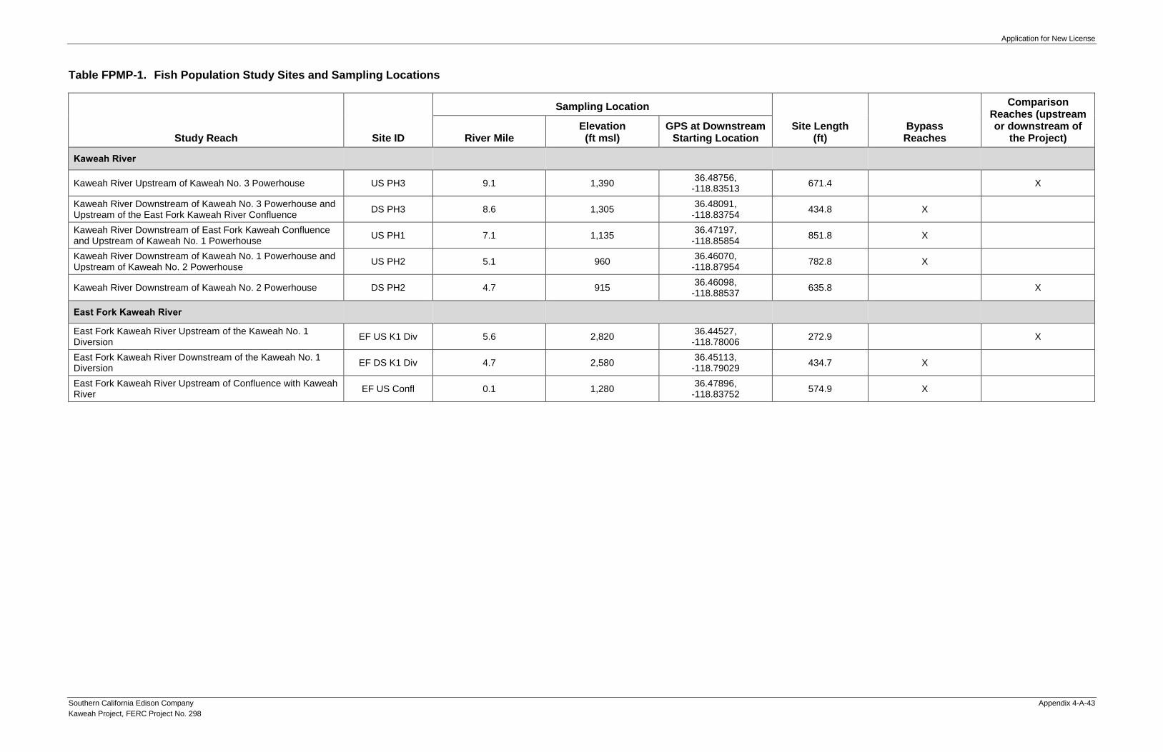
Application for New License
Southern California Edison Company Appendix 4-A-43
Kaweah Project, FERC Project No. 298
Table FPMP-1. Fish Population Study Sites and Sampling Locations
Study Reach Site ID
Sampling Location
Site Length (ft)
Bypass Reaches
Comparison Reaches (upstream or downstream of
the Project) River Mile Elevation (ft msl)
GPS at Downstream Starting Location
Kaweah River
Kaweah River Upstream of Kaweah No. 3 Powerhouse US PH3 9.1 1,390 36.48756,
-118.83513 671.4 X
Kaweah River Downstream of Kaweah No. 3 Powerhouse and Upstream of the East Fork Kaweah River Confluence
DS PH3 8.6 1,305 36.48091,
-118.83754 434.8 X
Kaweah River Downstream of East Fork Kaweah Confluence and Upstream of Kaweah No. 1 Powerhouse
US PH1 7.1 1,135 36.47197,
-118.85854 851.8 X
Kaweah River Downstream of Kaweah No. 1 Powerhouse and Upstream of Kaweah No. 2 Powerhouse
US PH2 5.1 960 36.46070,
-118.87954 782.8 X
Kaweah River Downstream of Kaweah No. 2 Powerhouse DS PH2 4.7 915 36.46098,
-118.88537 635.8 X
East Fork Kaweah River
East Fork Kaweah River Upstream of the Kaweah No. 1 Diversion
EF US K1 Div 5.6 2,820 36.44527,
-118.78006 272.9 X
East Fork Kaweah River Downstream of the Kaweah No. 1 Diversion
EF DS K1 Div 4.7 2,580 36.45113,
-118.79029 434.7 X
East Fork Kaweah River Upstream of Confluence with Kaweah River
EF US Confl 0.1 1,280 36.47896,
-118.83752 574.9 X

Application for New License
Appendix 4-A-44 Southern California Edison Company
Kaweah Project, FERC Project 298
This Page Intentionally Left Blank

Application for New License
Southern California Edison Company Appendix 4-A-45
Kaweah Project, FERC Project No. 298
Table ESM-1. Proposed Entrainment Sampling Schedule for Kaweah No. 2 Flowline
Location Representative Time
Periods Sampling Dates
Sampling Type
Drift Netting Fyke Trapping
Kaweah No. 2 Flowline
May/June 2019 May 7-9, 2019 Completed Completed
July 2019 July 9-11, 2019 Completed Completed
January/February 2020 TBD Pending Pending
March/April 2020 TBD Pending Pending
TBD = To Be Determined

Application for New License
Appendix 4-A-46 Southern California Edison Company
Kaweah Project, FERC Project 298
Table WTMP-1. Water Temperature Monitoring Sites
Monitoring Sites
Number of Monitoring
Loggers
Sampling Location
Bypass Reaches
Comparison Reaches
(upstream or downstream
of the Project) River Mile
GPS Location
Water Temperature Monitoring Sites
Kaweah River
Kaweah River Upstream of Kaweah No. 3 Powerhouse
2 8.96 36.48635136, -118.8361886 X
Kaweah River Downstream of Kaweah No. 3 Powerhouse
2 8.79
8.82
36.48439526, -118.8357774 36.48405746, -118.8359942 X
Kaweah No. 3 Powerhouse Tailrace 2 8.95 36.48620181, -118.8357265 X
Kaweah River Upstream of the Confluence with East Fork Kaweah River
2 8.44 36.47956494, -118.8380172 X
Kaweah River Downstream of the Confluence with East Fork Kaweah River
2 8.30 36.4794382, -118.8402536 X
Kaweah River Upstream of Kaweah No. 1 Powerhouse
2 6.51
6.52
36.46579943, -118.862146 36.46593544, -118.8620571 X
Kaweah River Downstream of Kaweah No. 1 Powerhouse
2 6.45 36.46562639, -118.863133 X
Kaweah No. 1 Powerhouse Tailrace 2 6.49 36.4653658, -118.8620713 X
Kaweah River Upstream of Kaweah No. 2 Powerhouse
2 5.04 36.46071055, -118.8796395 X
Kaweah River Downstream of Kaweah No. 2 Powerhouse
3 4.81 36.4613941, -118.8834057 X
Kaweah No. 2 Powerhouse Tailrace 2 4.95 36.46186337, -118.8806466 X

Application for New License
Southern California Edison Company Appendix 4-A-47
Kaweah Project, FERC Project No. 298
Monitoring Sites
Number of Monitoring
Loggers
Sampling Location
Bypass Reaches
Comparison Reaches
(upstream or downstream
of the Project) River Mile
GPS Location
East Fork Kaweah River
East Fork Kaweah River Downstream of the Kaweah No. 1 Diversion Dam
2 4.68 36.45138042, -118.7899557 X
East Fork Kaweah River Upstream of the Confluence with Kaweah River
2 0.09 36.47896325, -118.8374857 X
Air Temperature Monitoring Sites
Kaweah No. 3 Powerhouse Air Temp 2 8.93 36.48592359, -118.8364717
Kaweah No. 1 Diversion Dam Air Temp 2 4.48 36.44906467, -118.7916033
Weather Station Monitoring Sites
Kaweah No. 1 Powerhouse Weather Station 1 6.49 36.465126, -118.861466

Application for New License
Appendix 4-A-48 Southern California Edison Company
Kaweah Project, FERC Project 298
Table WQMP-1. Water Quality Monitoring Sites
Monitoring Sites
Sampling Location
Bypass Reaches
Comparison Reaches
(upstream or downstream
of the Project) River Mile
GPS Location
Kaweah River
Kaweah River Upstream of Kaweah No. 3 Powerhouse 8.96 36.48633707,
-118.83617117 X
Kaweah River Downstream of Kaweah No. 3 Powerhouse 8.80 36.48413378,
-118.83584010 X
Kaweah No. 3 Powerhouse Tailrace 8.95 36.48620181,
-118.8357265 X
Kaweah River Upstream of the Confluence with East Fork Kaweah River 8.49 36.48022153,
-118.83761179 X
Kaweah River Downstream of the Confluence with East Fork Kaweah River 8.30 36.47938158,
-118.84005867 X
Kaweah River Upstream of Kaweah No. 1 Powerhouse 6.51 36.46577795,
-118.86224606 X
Kaweah River Downstream of Kaweah No. 1 Powerhouse 6.45 36.46559921,
-118.86330195 X
Kaweah No. 1 Powerhouse Tailrace 6.49 36.4653658,
-118.8620713 X
Kaweah River Upstream of Kaweah No. 2 Powerhouse 5.04 36.46066806,
-118.87943125 X
Kaweah River Downstream of Kaweah No. 2 Powerhouse 4.81 36.46135383,
-118.88338692 X
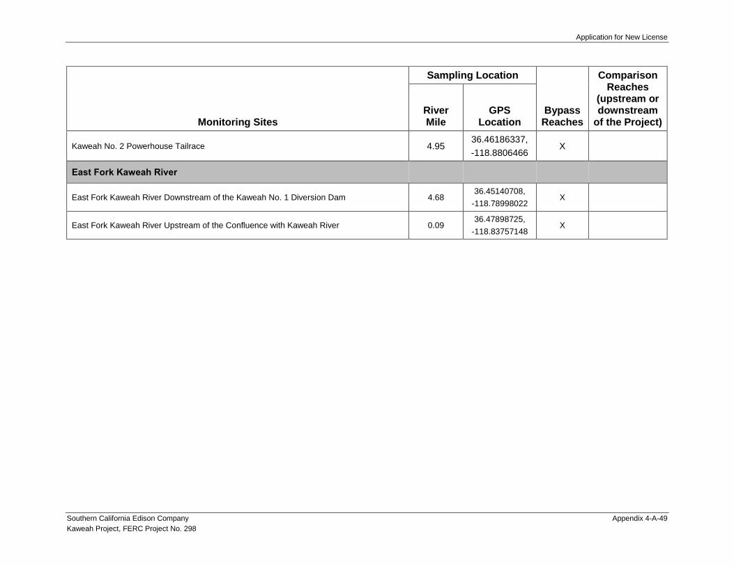
Application for New License
Southern California Edison Company Appendix 4-A-49
Kaweah Project, FERC Project No. 298
Monitoring Sites
Sampling Location
Bypass Reaches
Comparison Reaches
(upstream or downstream
of the Project) River Mile
GPS Location
Kaweah No. 2 Powerhouse Tailrace 4.95 36.46186337,
-118.8806466 X
East Fork Kaweah River
East Fork Kaweah River Downstream of the Kaweah No. 1 Diversion Dam 4.68 36.45140708,
-118.78998022 X
East Fork Kaweah River Upstream of the Confluence with Kaweah River 0.09 36.47898725,
-118.83757148 X

Application for New License
Appendix 4-A-50 Southern California Edison Company
Kaweah Project, FERC Project 298
Table WQMP-2. Parameters for Water Quality Monitoring and Laboratory Analysis
Parameter Analysis Method Sample Holding Times
Water Quality Monitoring Parameter
In-Situ Measurements
Dissolved Oxygen (DO) Water Quality Meter Not Applicable
Secchi Depth Secchi Disk Not Applicable
PH Water Quality Meter Not Applicable
Water Temperature Water Quality Meter Not Applicable
Specific Conductance Water Quality Meter Not Applicable
Laboratory Analysis Parameter
General Parameters
Calcium EPA - 200.7 180 days
Chloride EPA - 300.0 28 days
Hardness EPA - 130.2 180 days
Magnesium EPA - 200.7 180 days
Nitrate/Nitrite EPA - 353.2 48 hours
Ammonia as N EPA - 350.1 28 days
Total Kjeldahl Nitrogen EPA - 351.2 28 days
Total Phosphorus EPA - 365.2 28 days
Ortho-phosphate EPA - 365.1 48 hours
Potassium EPA - 200.7 180 days
Sodium EPA - 200.7 180 days
Sulfate EPA - 300.0 180 days
Total Dissolved Solids EPA - 160.1 7 days

Application for New License
Southern California Edison Company Appendix 4-A-51
Kaweah Project, FERC Project No. 298
Parameter Analysis Method Sample Holding Times
Total Suspended Solids EPA - 160.2 7 days
Turbidity EPA - 180.1
TOC EPA - 415.1 28 days
Total Alkalinity EPA - 310.1 14 days
Metals – Dissolved
Arsenic EPA - 1638 48 hours
Cadmium EPA - 1638 48 hours
Copper EPA - 1638 48 hours
Iron EPA -1638 48 hours
Lead EPA - 1638 48 hours
Manganese EPA - 1638 48 hours
Nickel EPA - 1638 48 hours
Chromium EPA - 1638 48 hours
Metals – Total
Mercury EPA - 1631e 48 hours
Hydrocarbons
Methyl-tertiary Butyl Ether (MtBE) EPA - 8260 14 days
Total Petroleum Hydrocarbons EPA - 8020 14 days
Oil and Grease EPA - 1664 48 hours
Bacteria
Total Coliform EPA - SM9222B 24 hours
Fecal Coliform EPA - SM922B 24 hours

Application for New License
Appendix 4-A-52 Southern California Edison Company
Kaweah Project, FERC Project 298
Table RTMP-1. Project Access Roads and Trails
Project Access Roads
Kaweah No. 1 Development
Kaweah No. 1 Flowline Access Road – Bear Canyon
Kaweah No. 1 Flowline Access Road – Grapevine
Kaweah No. 1 Flowline Access Road – Lower Pine
Kaweah No. 1 Flowline Access Road – Lower Pine (spur)
Kaweah No. 1 Flowline Access Road – Lumberyard
Kaweah No. 1 Flowline Access Road – Lumberyard (spur)
Kaweah No. 1 Flowline Access Road – Slick Rock
Kaweah No. 1 Flowline Access Road – Summit
Kaweah No. 1 Flowline Access Road – Unnamed
Kaweah No. 1 Flowline Access Road – Upper Pine
Kaweah No. 1 Forebay Road
Kaweah No. 2 Development
Kaweah No. 2 Flowline Access Road – Canal 2 Brushout Grid
Kaweah No. 2 Flowline Access Road – Canal 4 East
Kaweah No. 2 Flowline Access Road – Canal 4 West
Kaweah No. 2 Flowline Access Road – Canal 5
Kaweah No. 2 Flowline Access Road – Canal 6 East
Kaweah No. 2 Flowline Access Road – Canal 6 West
Kaweah No. 2 Flowline Access Road – Flume 8
Kaweah No. 2 Flowline Access Road – Flume 11
Kaweah No. 2 Flowline Access Road – Open Siphon Grids
Kaweah No. 2 Flowline Access Road – Red Barn
Kaweah No. 2 Flowline Center Access Road
Kaweah No. 2 Flowline East Access Road
Kaweah No. 2 Flowline West Access Road
Kaweah No. 2 Forebay Road
Kaweah No. 2 Intake Road
Kaweah No. 2 Penstock Road
Kaweah No. 3 Development
Kaweah No. 3 Forebay Road
Kaweah No. 3 Powerhouse Road

Application for New License
Southern California Edison Company Appendix 4-A-53
Kaweah Project, FERC Project No. 298
Project Trails
Kaweah No. 1 Development
Kaweah No. 1 Flowline Access Trail – Unnamed
Kaweah No. 2 Development
Kaweah No. 2 Flowline Access Trail – Canal 2
Kaweah No. 2 Flowline Access Trail – Canal 4 East
Kaweah No. 2 Flowline Access Trail – Canal 4 West
Kaweah No. 2 Flowline Access Trail – Canal 5
Kaweah No. 2 Flowline Access Trail – Canal 6
Kaweah No. 2 Flowline Access Trail – Canal 11
Kaweah No. 2 Flowline Access Trail – Canal 13
Kaweah No. 2 Flowline Access Trail – Canal 15
Kaweah No. 2 Flowline Access Trail – Open Siphon
Kaweah No. 2 Flowline Access Trail – Water User 9
Kaweah No. 2 Flowline Access Trail – Water User 14
Kaweah No. 2 Flowline Access Trail – Wildlife Crossing 2
Kaweah No. 3 Development
Kaweah No. 3 Flowline Access Trail

Application for New License
Appendix 4-A-54 Southern California Edison Company
Kaweah Project, FERC Project 298
Table VIPMP-1. Location around Project Facilities where Vegetation and Pest Management will be Implemented
Project Facility
Vegetation Management
Hazard Tree Removal
Pest Management (Rodenticide
Use) Trimming by Hand
Herbicide Use
Diversion Dams and Pools 5 feet around perimeter
Conducted, as needed, to
protect Project facilities and operations.
—
Flowlines 10 feet on either side —
Forebays/Forebay Tank 10 feet around
perimeter — —
Penstocks 5 feet on
either side — —
Powerhouses Within and up to 5 feet around
perimeter fence
Interior of facility and within
perimeter fence
Switchyards Within and up to 5 feet around
perimeter fence Within perimeter
fence
Transmission, Power, and Communication Lines
15 feet on either side —
Repeaters 5 feet around
perimeter — —
Roads 10 feet on either side —
Trails 5 feet on
either side — —
Kaweah No. 1 Powerhouse Campus
Within developed campus Interior of facility
and within perimeter fence

Application for New License
Southern California Edison Company Appendix 4-A-55
Kaweah Project, FERC Project No. 298
Table SPMP-1. Special-Status Plant Survey Area
Project Facility Survey Area1
Diversion Dams and Pools 15 feet around the perimeter
Flowlines2 20 feet on either side
Forebays/Forebay Tank 20 feet around the perimeter
Penstocks 15 feet on either side
Powerhouses and Switchyards Within and up to 15 feet around the perimeter fence
Transmission, Power, and Communication Lines
25 feet on either side
Gages 10 feet around gages
Project Access Roads 20 feet on either side
Project Trails 15 feet on either side
Ancillary and Support Facilities
Kaweah No. 1 Powerhouse Campus Within the developed campus
Repeaters and Solar Panels 15 feet around the perimeter
River Access Parking 10 feet around parking area and beach 1 Survey areas represent locations where potential operation and maintenance activities occur. 2 Footbridges, wildlife bridges, and wildlife escape ramps are located on Project flowlines and will be surveyed concurrently with the
flowlines.

Application for New License
Appendix 4-A-56 Southern California Edison Company
Kaweah Project, FERC Project 298
Table AMMP-1. Project Transmission Lines, Transmission Tap Lines, and Power Lines that Pose Risk for Avian Electrocution
Transmission Lines and Transmission Tap Lines
Kaweah No. 1 Powerhouse Transmission Tap Line
Kaweah No. 2 Powerhouse Transmission Tap Line
Kaweah No. 3 Powerhouse to Three Rivers Substation Transmission Line
Power Lines
Kaweah No. 1 Diversion Solar Panel to Kaweah No. 1 Diversion Dam Power Line
Kaweah No. 1 Office Building to Kaweah No. 1 Forebay Tank Power Line
Kaweah No. 1 Powerhouse Campus Alternate Power Line
Kaweah No. 1 Switchyard to Kaweah No. 1 Maintenance Building Power Line
Kaweah No. 1 Switchyard to Kaweah No. 1 Office Building Power Line
Kaweah No. 1 Switchyard to Kaweah No. 1 Operator’s Office Power Line
Kaweah No. 1 Switchyard to Kaweah No. 1 Workshop Power Line
Kaweah No. 2 Diversion/Flowline Gage and Kaweah No. 3 Powerhouse Alternate Power Line
Kaweah No. 2 Powerhouse Alternate Power Line
Kaweah No. 2 Powerhouse to Kaweah No. 2 Forebay Power Line
Kaweah No. 3 Powerhouse to Kaweah No. 2 Diversion Power Line
Kaweah No. 3 Powerhouse to Kaweah No. 2 Flowline Gage Power Line
Kaweah No. 3 Powerhouse to Kaweah No. 3 Forebay Power Line
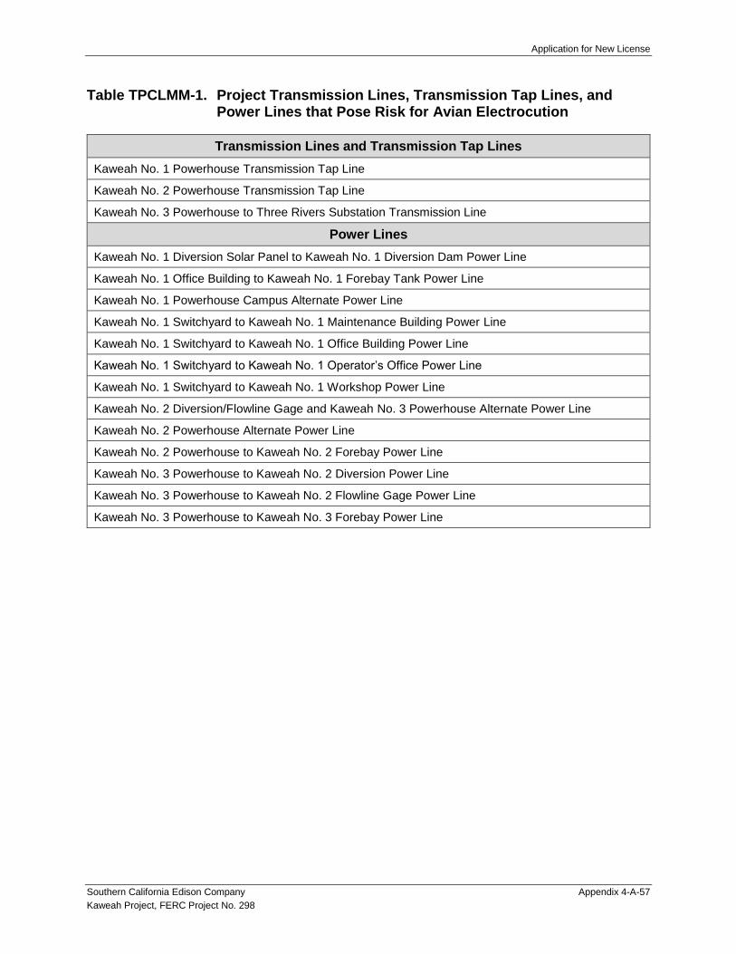
Application for New License
Southern California Edison Company Appendix 4-A-57
Kaweah Project, FERC Project No. 298
Table TPCLMM-1. Project Transmission Lines, Transmission Tap Lines, and Power Lines that Pose Risk for Avian Electrocution
Transmission Lines and Transmission Tap Lines
Kaweah No. 1 Powerhouse Transmission Tap Line
Kaweah No. 2 Powerhouse Transmission Tap Line
Kaweah No. 3 Powerhouse to Three Rivers Substation Transmission Line
Power Lines
Kaweah No. 1 Diversion Solar Panel to Kaweah No. 1 Diversion Dam Power Line
Kaweah No. 1 Office Building to Kaweah No. 1 Forebay Tank Power Line
Kaweah No. 1 Powerhouse Campus Alternate Power Line
Kaweah No. 1 Switchyard to Kaweah No. 1 Maintenance Building Power Line
Kaweah No. 1 Switchyard to Kaweah No. 1 Office Building Power Line
Kaweah No. 1 Switchyard to Kaweah No. 1 Operator’s Office Power Line
Kaweah No. 1 Switchyard to Kaweah No. 1 Workshop Power Line
Kaweah No. 2 Diversion/Flowline Gage and Kaweah No. 3 Powerhouse Alternate Power Line
Kaweah No. 2 Powerhouse Alternate Power Line
Kaweah No. 2 Powerhouse to Kaweah No. 2 Forebay Power Line
Kaweah No. 3 Powerhouse to Kaweah No. 2 Diversion Power Line
Kaweah No. 3 Powerhouse to Kaweah No. 2 Flowline Gage Power Line
Kaweah No. 3 Powerhouse to Kaweah No. 3 Forebay Power Line

Application for New License
Appendix 4-A-58 Southern California Edison Company
Kaweah Project, FERC Project 298
This Page Intentionally Left Blank

Application for New License
Southern California Edison Company Appendix 4-A-59
Kaweah Project, FERC Project No. 298
MAPS

Application for New License
Appendix 4-A-60 Southern California Edison Company
Kaweah Project, FERC Project 298
This Page Intentionally Left Blank

198
SEQUOIA - KINGS CANYONWILDERNESS
SEQUOIANATIONAL PARK
KaweahRiver
Middle Fork Kaweah River
Marb
leFo
rkKa
w eah
Rive
r
East ForkKaw eah River
North
Fork
Kaweah
River
THREERIVERS
Kaweah No. 3 Flowline(Non-FERC Facility)
Kaweah No. 1 Flowline
Kaweah No. 2 Flowline
Kaweah No. 1Diversion Dam
Marble ForkDiversion Dam
(Non-FERC Facility)
Middle ForkDiversion Dam
(Non-FERC Facility)
Kaweah No. 3 Flowline
JOHN KREBSWILDERNESS
Kaweah No. 3Powerhouse
Kaweah No. 1Powerhouse
Kaweah No. 2 Powerhouse
South Fork Kaweah River
Kaweah No. 2Diversion Dam
(SCE 202)11208730(SCE 201)
11208600(SCE 203)
(SCE 204a)
1
2
3
45
6
78
910
11
12
1
1
2
34
1
2
3
4 5
6
7
89
Copyright 2019 by Southe rn California Ed ison Com pany
Southe rn Ca lifornia Ed ison (SCE) has no re ason to be lie ve that the re a re any ina c c ura c ie sor d e fe cts with inform a tion inc orporate d in this work and m ake no re pre se ntations of anykind , inc lud ing, but not lim ite d to, the wa rra ntie s of m e r c ha ntability or fitne ss for a pa rtic ula ruse , nor a r e a ny suc h wa rra ntie s tobe im plie d, with re spe c t to the inform ation or d ata,furnishe d he re in. N o pa rt of this m a p m a y be re prod uc e d ortransm itte d in any form or byany m e a ns, e le c tronic or m e c ha nic a l, inc lud ing photoc opying and re c ord ing syste m ,e xc e pt as e xpre ssly pe rm itte d in writing by SCE.
Date: 7/11/2019Projection: UTM Zone 11
Datum: NAD 83
C:\GIS\Ca rd no\30735240_ SCE_Easte rnHyd ro\m a p\Kawe a h\Hyd roMaps\SCE_Easte rn_ KAWEAH_Gage s_Com plia nc e _ 17i11i_01.mxd
0 0.5 10.25Mile s
SCE FacilitiesPowe rhouse
FlowlineFore bayDive rsion
Pe nstoc k
Highway/Roa d
Other Features
Wate rc ourseWate r Bod y
City/Town
Rive r Mile
Bure au of La nd Mana ge m e ntU.S. Arm y Corps of Engine e rsN ationa l Pa rk Se rvic e
Land Jurisdiction*
Private *SOURCE: BLM 2016
N ationa l Wild e rne ss Are aLand Management
Proje c t Com plia nc e Gage (Se e be low)
N on-Proje c t Gage (historic )
Kaweah Project Compliance Gages
Kawe a h Proje c t – FERC Proje c t N o. 298
Map SGP-1
Kaweah No. 2Flowline
Kaweah No. 2Diversion Dam
Kaweah River
9
11208600(SCE 203)
(SCE 204a)
Kaweah No. 3Powerhouse
Kaweah No. 1 Flowline
(SCE 202)
11208730(SCE 201)
Kaweah No. 1Diversion Dam
East Fork Kaweah River
SCE Gage Numberand Compliance Use:201: MIF, Ra m ping, Disse m ination of Re al-tim e Flow Inform ation202: Pre -1914 Wate r Right De live rie s203: MIF, Ra m ping, Disse m ination of Re al-tim e Flow Inform ation204a: Pre -1914 Wate r Right De live rie s

Application for New License
Appendix 4-A-62 Southern California Edison Company
Kaweah Project, FERC Project 298
This Page Intentionally Left Blank
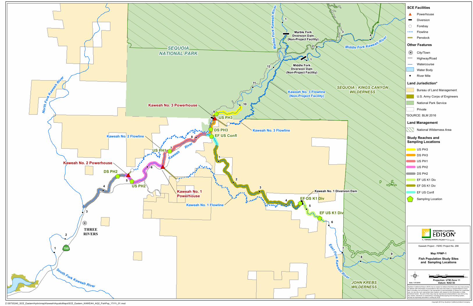
é
é
é
é
#*
#*
#*
$+
$+
$+
$+
$+
$+
$+$+
$+
$+
198
!.
SEQUOIA - KINGS CANYONWILDERNESS
SEQUOIANATIONAL PARK
KaweahRiver
Middle Fork Kaweah River
Marb
leFo
rkKa
w eah
Rive
r
East ForkKaweah River
North
Fork
Kaweah
River
THREERIVERS
Kaweah No. 3 Flowline(Non-Project Facility)
Kaweah No. 1 Flowline
Kaweah No. 2 Flowline
Kaweah No. 1 Diversion Dam
Marble ForkDiversion Dam
(Non-Project Facility)
Middle ForkDiversion Dam
(Non-Project Facility)
Kaweah No. 3 Flowline
JOHN KREBSWILDERNESS
Kaweah No. 3 Powerhouse
Kaweah No. 1Powerhouse
Kaweah No. 2 Powerhouse
South Fork Kaweah River
US PH3
DS PH3
US PH1
US PH2
DS PH2
EF US K1 Div$+
EF DS K1 Div
EF US Confl
1
2
3
45
6
7
8
9
10
11
12
1
1
2
34
1
2
3
45
6
7
89
Copyright 2019 by Southern California Edison Company
Southern California Edison (SCE) has no reason to believe that there are any inaccuraciesor defects with information incorporated in this work and make no representations of anykind, including, but not limited to, the warranties of merchantability or fitness for a particularuse, nor are any such warranties tobe implied, with respect to the information or data,furnished herein. No part of this map may be reproduced ortransmitted in any form or byany means, electronic or mechanical, including photocopying and recording system,except as expressly permitted in writing by SCE.
Date: 1/31/2019Projection: UTM Zone 11
Datum: NAD 835
Z:\30735240_SCE_EasternHydro\map\Kaweah\AquaticMaps\SCE_Eastern_KAWEAH_AQ2_FishPop_17i11i_01.mxd
0 0.5 10.25Miles
SCE FacilitiesPowerhouse
FlowlineForebay
#*
Diversion$+
Penstock
Highway/Road
Other Features
WatercourseWater Body
City/Town!.
î
US PH3DS PH3US PH1US PH2DS PH2
Study Reaches andSampling Locations
$+ Sampling Location
River Mile
Bureau of Land ManagementU.S. Army Corps of EngineersNational Park Service
Land Jurisdiction*
Private *SOURCE: BLM 2016
National Wilderness AreaLand Management
EF US K1 Div
EF DS K1 Div
EF US Confl
Kaweah Project - FERC Project No. 298
Map FPMP-1Fish Population Study Sites
and Sampling Locations

Application for New License
Appendix 4-A-64 Southern California Edison Company
Kaweah Project, FERC Project 298
This Page Intentionally Left Blank

î
îî
î
$+
$+
$+!(
!(!(
!(
!(
!(
!(
!(!(
!(!(
!(
!(
!(
!(
!.#*
#*
#*
LakeKaweah
198
Middle Fork Kaweah RiverMarb
leFo
rkKa
weah
River
East ForkKaweah River
Kaweah No. 3 Flowline(Non-FERC Facility)
Kaweah No. 1 Flowline
Kaweah No. 2 Flowline
North
Fork
Kaweah
River
South Fork Kaweah River
Kaweah No. 3 Powerhouse
Kaweah No. 1Powerhouse
Kaweah No. 2 Powerhouse
Kaweah No. 2 Diversion Dam
Kaweah No. 1 Diversion Dam
Marble Fork Diversion Dam(Non-FERC Facility)
Middle Fork Diversion Dam(Non-FERC Facility)
Kaweah No. 3 Flowline
SEQUOIA - KINGS CANYONWILDERNESS
SEQUOIANATIONAL PARK
JOHN KREBSWILDERNESS
KR Upstream of PH2
PH2 Tailrace
KR Upstream of PH1
PH1 Tailrace
KR Upstream of PH3
KR Upstream of the Conf. with EF
PH3 Tailrace
KR Downstream of PH1
KR Downstream of PH2
KR Downstream of PH3
EF Downstream of PH1 Div.
KR Downstream of the Conf. with EFEF Upstream of the Conf. with KR
!.THREERIVERS
PH3 Air Temp
PH1 Div. Air Temp
PH1 Weather Station
1
2
3
45
6
7
8
9
10
11
12
1
2
3
12
3 4
1
23
45
6
78 9
10
Copyright 2019 by Southe rn California Edison Com pany
Southe rn Ca lifornia Edison (SCE) has no re ason to be lie ve that the re are any ina c c ura c ie sor de fe cts with inform ation inc orporate d in this work and m ake no re pre se ntations of anykind, inc luding, but not lim ite d to, the warrantie s of m e rc hantability or fitne ss for a partic ularuse , nor are a ny suc h warra ntie s tobe im plie d, with re spe c t to the inform ation or data,furnishe d he re in. No part of this m a p m a y be re produc e d ortransm itte d in any form or byany m e a ns, e le c tronic or m e c ha nic a l, inc luding photoc opying and re c ording syste m ,e xc e pt as e xpre ssly pe rm itte d in writing by SCE.
Date: 6/11/2019Projection: UTM Zone 11
Datum: NAD 835
C:\GIS\Cardno\30735240_ SCE_Easte rnHydro\m a p\Kawe a h\Aq uatic Ma ps\SCE_Easte rn_KAWEAH_AQ4_Wate r_Te m p_ Qual_MonPlan_ 17i11i_01.m xd
0 0.5 10.25Mile s
|ÿ99
SEQUOIANATIONAL
PARK
!( Air Te m pe rature Monitoring Loc ation
Wate r Te m pe rature / Wate r QualityMonitoring Loc ations!(
Monitoring Locations
Water Temperature Monitoring Locations
Kawe a h Proje c t – FERC Proje c t No. 298
Map WTMP-1
SCE FacilitiesPowe rhouse
FlowlineFore bay
#*
Dive rsion$+
Pe nstoc k
Highway/Road
Other Features
Wate rc ourseWate r Body
City/Town!.
î
Rive r Mile
Bure au of La nd Mana ge m e ntU.S. Arm y Corps of Engine e rsNationa l Park Se rvic e
Land Jurisdiction*
Private *SO URCE: BLM 2016
Nationa l Wilde rne ss Are aLand Management
!. We athe r Station Monitoring Loc ation

Application for New License
Appendix 4-A-66 Southern California Edison Company
Kaweah Project, FERC Project 298
This Page Intentionally Left Blank

î
îî
î
$+
$+
$+!(
!(!(
!(
!(
!(
!(
!(!(
!(!(
!(
!(
!(
!(
!.#*
#*
#*
LakeKaweah
198
Middle Fork Kaweah RiverMarb
leFo
rkKa
weah
River
East ForkKaweah River
Kaweah No. 3 Flowline(Non-FERC Facility)
Kaweah No. 1 Flowline
Kaweah No. 2 Flowline
North
Fork
Kaweah
River
South Fork Kaweah River
Kaweah No. 3 Powerhouse
Kaweah No. 1Powerhouse
Kaweah No. 2 Powerhouse
Kaweah No. 2 Diversion Dam
Kaweah No. 1 Diversion Dam
Marble Fork Diversion Dam(Non-FERC Facility)
Middle Fork Diversion Dam(Non-FERC Facility)
Kaweah No. 3 Flowline
SEQUOIA - KINGS CANYONWILDERNESS
SEQUOIANATIONAL PARK
JOHN KREBSWILDERNESS
KR Upstream of PH2
PH2 Tailrace
KR Upstream of PH1
PH1 Tailrace
KR Upstream of PH3
KR Upstream of the Conf. with EF
PH3 Tailrace
KR Downstream of PH1
KR Downstream of PH2
KR Downstream of PH3
EF Downstream of PH1 Div.
KR Downstream of the Conf. with EFEF Upstream of the Conf. with KR
!.THREERIVERS
PH3 Air Temp
PH1 Div. Air Temp
PH1 Weather Station
1
2
3
45
6
7
8
9
10
11
12
1
2
3
12
3 4
1
23
45
6
78 9
10
Copyright 2019 by Southe rn California Edison Com pany
Southe rn Ca lifornia Edison (SCE) has no re ason to be lie ve that the re are any ina c c ura c ie sor de fe cts with inform ation inc orporate d in this work and m ake no re pre se ntations of anykind, inc luding, but not lim ite d to, the warrantie s of m e rc hantability or fitne ss for a partic ularuse , nor are a ny suc h warra ntie s tobe im plie d, with re spe c t to the inform ation or data,furnishe d he re in. No part of this m a p m a y be re produc e d ortransm itte d in any form or byany m e a ns, e le c tronic or m e c ha nic a l, inc luding photoc opying and re c ording syste m ,e xc e pt as e xpre ssly pe rm itte d in writing by SCE.
Date: 6/11/2019Projection: UTM Zone 11
Datum: NAD 835
C:\GIS\Cardno\30735240_ SCE_Easte rnHydro\m a p\Kawe a h\Aq uatic Ma ps\SCE_Easte rn_KAWEAH_AQ4_Wate r_Te m p_ Qual_MonPlan_ 17i11i_01.m xd
0 0.5 10.25Mile s
|ÿ99
SEQUOIANATIONAL
PARK
!( Air Te m pe rature Monitoring Loc ation
Wate r Te m pe rature / Wate r QualityMonitoring Loc ations!(
Monitoring Locations
Kawe a h Proje c t – FERC Proje c t No. 298
SCE FacilitiesPowe rhouse
FlowlineFore bay
#*
Dive rsion$+
Pe nstoc k
Highway/Road
Other Features
Wate rc ourseWate r Body
City/Town!.
î
Rive r Mile
Bure au of La nd Mana ge m e ntU.S. Arm y Corps of Engine e rsNationa l Park Se rvic e
Land Jurisdiction*
Private *SO URCE: BLM 2016
Nationa l Wilde rne ss Are aLand Management
!. We athe r Station Monitoring Loc ation
Water Quality Monitoring Locations
Map WQMP-1

Application for New License
Appendix 4-A-68 Southern California Edison Company
Kaweah Project, FERC Project 298
This Page Intentionally Left Blank

é
é
é
é
#*
#*
#*
$+
$+
$+
!́!́
!́!́
198
!.
SEQUOIA - KINGS CANYONWILDERNESS
SEQUOIANATIONAL PARK
KaweahRiver
Middle Fork Kaweah River
Marb
leFo
rkKa
w eah
Rive
r
East ForkKaw eah River
North
Fork
Kaweah
River
THREERIVERS
Kaweah No. 3 Flowline(Non-FERC Facility)
Kaweah No. 1 Flowline
Kaweah No. 2 Flowline
Kaweah No. 1Diversion Dam
Marble ForkDiversion Dam
(Non-FERC Facility)
Middle ForkDiversion Dam
(Non-FERC Facility)
Kaweah No. 3 Flowline
JOHN KREBSWILDERNESS
Kaweah No. 3Powerhouse
Kaweah No. 1Powerhouse
Kaweah No. 2 Powerhouse
South Fork Kaweah River
Kaweah No. 2Diversion Dam
11208720(SCE 202)
11208730(SCE 201)
11208600(SCE 203)
(SCE 204a)
1
2
3
45
6
78
910
11
12
1
1
2
34
1
2
3
4 5
6
7
89
Copyright 2019 by Southe rn California Ed ison Com pany
Southe rn Ca lifornia Ed ison (SCE) has no re ason to be lie ve that the re a re any ina c c ura c ie sor d e fe cts with inform a tion inc orporate d in this work and m ake no re pre se ntations of anykind , inc lud ing, but not lim ite d to, the wa rra ntie s of m e r c ha ntability or fitne ss for a pa rtic ula ruse , nor a r e a ny suc h wa rra ntie s tobe im plie d, with re spe c t to the inform ation or d ata,furnishe d he re in. N o pa rt of this m a p m a y be re prod uc e d ortransm itte d in any form or byany m e a ns, e le c tronic or m e c ha nic a l, inc lud ing photoc opying and re c ord ing syste m ,e xc e pt as e xpre ssly pe rm itte d in writing by SCE.
Date: 6/13/2019Projection: UTM Zone 11
Datum: NAD 835
C:\GIS\Ca rd no\30735240_ SCE_Easte rnHyd ro\m a p\Kawe a h\Hyd roMaps\SCE_Easte rn_ KAWEAH_Gage s_Com plia nc e _ 17i11i_01.mxd
0 0.5 10.25Mile s
SCE FacilitiesPowe rhouse
FlowlineFore bay
#*
Dive rsion$+
Pe nstoc k
Highway/Roa d
Other Features
Wate rc ourseWate r Bod y
City/Town!.
î
Rive r Mile
Bure au of La nd Mana ge m e ntU.S. Arm y Corps of Engine e rsN ationa l Pa rk Se rvic e
Land Jurisdiction*
Private *SOURCE: BLM 2016
N ationa l Wild e rne ss Are aLand Management
!́ Proje c t Com plia nc e Gage (Se e be low)
!́ N on-Proje c t Gage (historic )
Kaweah Project Compliance Gages
Kawe a h Proje c t – FERC Proje c t N o. 298
Map RTFM-1
é#*
$+
$+
!́
!́
Kaweah No. 2Flowline
Kaweah No. 2Diversion Dam
Kaweah River
9
11208600(SCE 203)
(SCE 204a)
Kaweah No. 3Powerhouse
é
!́
!́
Kaweah No. 1 Flowline
Kaweah No. 1Diversion Dam
East Fork Kaweah River
11208720(SCE 202)
11208730(SCE 201)
SCE Gage Numberand Compliance Use:201: MIF, Ra m ping, Disse m ination of Re al-tim e Flow Inform ation202: Pre -1914 Wate r Right De live rie s203: MIF, Ra m ping, Disse m ination of Re al-tim e Flow Inform ation204a: Pre -1914 Wate r Right De live rie s

Application for New License
Appendix 4-A-70 Southern California Edison Company
Kaweah Project, FERC Project 298
This Page Intentionally Left Blank

Application for New License
Southern California Edison Company 5-i
Kaweah Project, FERC Project No. 298
TABLE OF CONTENTS
Page
5.0 Other Alternatives ................................................................................................ 5-1
5.1 Alternatives Considered but Eliminated from Detailed Study ........................ 5-1
5.1.1 Federal Government Takeover ........................................................... 5-1
5.1.2 Issuing a Non-power License ............................................................. 5-1
5.1.3 Retirement of the Project .................................................................... 5-1
LIST OF ACRONYMS
FERC or Commission Federal Energy Regulatory Commission
Project Kaweah Project
SCE Southern California Edison Company

Application for New License
5-ii Southern California Edison Company
Kaweah Project, FERC Project No. 298
This Page Intentionally Left Blank

Application for New License
Southern California Edison Company 5-1
Kaweah Project, FERC Project No. 298
5.0 OTHER ALTERNATIVES
5.1 ALTERNATIVES CONSIDERED BUT ELIMINATED FROM DETAILED STUDY
As part of the analysis of alternatives, several licensing alternatives were considered but eliminated from detailed study in Southern California Edison Company’s (SCE or Licensee) Application for New License (License Application). These alternatives include:
Federal Government Takeover;
Issuing a Non-power License; and
Retirement of the Project.
A summary of the review of each of these alternatives for the Kaweah Project (Project) is provided in the following subsections.
5.1.1 Federal Government Takeover
Federal government takeover of the Project is not considered a reasonable alternative. Federal takeover and operation of the Project would require Congressional approval. While that fact alone would not preclude further consideration of this alternative, there is no evidence to indicate that federal takeover should be recommended to Congress. No party has suggested federal takeover would be appropriate, and no federal agency has expressed an interest in operating the Project. Therefore, this alternative is deemed unreasonable and eliminated from further detailed study.
5.1.2 Issuing a Non-power License
Issuance of a non-power license for the Project is not considered a reasonable alternative. A non-power license is a temporary license that the Federal Energy Regulatory Commission (FERC or Commission) would terminate if it determines that another government agency is authorized and willing to assume authority and supervision over the lands and facilities covered by the non-power license.
There is no evidence that a government agency has suggested a desire or ability to take over the Project. No other party has sought a non-power license. Further, the Project facilities are fully capable of continuing to generate power under the ownership, management, and oversight of SCE. Therefore, this alternative is deemed unreasonable, and eliminated from further detailed study.
5.1.3 Retirement of the Project
Retirement of the Project is not considered a reasonable alternative. Project retirement requires the Commission deny SCE’s License Application and requires surrender and termination of the existing license along with implementation of any associated conditions. The Project would no longer be authorized to generate power.

Application for New License
5-2 Southern California Edison Company
Kaweah Project, FERC Project No. 298
Retirement of the Project would result in loss of generation; substantial costs associated with removal of Project facilities; and lost revenue for the local community associated with ongoing operations and maintenance of the Project. No government agency, tribal interest, non-governmental organization, or individual has recommended retirement of the Project. SCE intends to continue operation and maintenance of the Project over the term of the new FERC license. Therefore, this alternative is deemed unreasonable and is eliminated from further detailed study.

Application for New License
Southern California Edison Company 6-i
Kaweah Project, FERC Project No. 298
TABLE OF CONTENTS
Page
6.0 Statutory and Regulatory Requirements .............................................................. 6-1
6.1 Federal Power Act ......................................................................................... 6-1
6.1.1 Section 10(a) Recommendations ....................................................... 6-1
6.1.2 Section 10(j) Recommendations ......................................................... 6-1
6.1.3 Section 18 Conditions ......................................................................... 6-1
6.2 Clean Water Act – Section 401 ..................................................................... 6-1
6.3 Endangered Species Act – Section 7 ............................................................ 6-2
6.4 Magnuson-Stevens Fishery Conservation and Management Act .................. 6-2
6.5 Coastal Zone Management Act ..................................................................... 6-2
6.6 National Historic Preservation Act – Section 106 .......................................... 6-3
6.7 Pacific Northwest Power Planning and Conservation Act .............................. 6-3
6.8 Wild and Scenic Rivers and Wilderness Acts ................................................ 6-3
6.9 Literature Cited .............................................................................................. 6-4

Application for New License
6-ii Southern California Edison Company
Kaweah Project, FERC Project No. 298
LIST OF ACRONYMS
BLM Bureau of Land Management
CCC California Coastal Commission
CFR Code of Federal Regulations
CWA Clean Water Act
CZMA Coastal Zone Management Act
ESA Endangered Species Act
FERC or Commission Federal Energy Regulatory Commission
FPA Federal Power Act
NHPA National Historic Preservation Act
NMFS National Marine Fisheries Service
Project Kaweah Project
SCE Southern California Edison Company
SNP Sequoia National Park
USFWS U.S. Fish and Wildlife Service
W&SR Wild and Scenic River
WSA Wilderness Study Area
WSRA Wild and Scenic Rivers Act

Application for New License
Southern California Edison Company 6-1
Kaweah Project, FERC Project No. 298
6.0 STATUTORY AND REGULATORY REQUIREMENTS
The Federal Energy Regulatory Commission (FERC or Commission) license for the Kaweah Project (Project) is subject to requirements under the Federal Power Act (FPA) and other applicable statutes, including: Clean Water Act (CWA), Endangered Species Act (ESA), Magnuson-Stevens Fishery Conservation and Management Act, Coastal Zone Management Act (CZMA), National Historic Preservation Act (NHPA), Pacific Northwest Power Planning and Conservation Act, and Wild and Scenic Rivers (WSRA) and Wilderness Acts. In accordance with Title 18 of the Code of Federal Regulations (CFR) §5.18(b)(3), compliance with and applicability of each requirement/statute is described below.
6.1 FEDERAL POWER ACT
The FPA gives FERC legal authority to issue licenses to non-federal hydropower projects. The following sections of the FPA are applicable to the Project. Following FERC’s issuance of the Notice of Acceptance and Notice of Ready for Environmental Analysis, FERC will request that resource agencies provide conditions and recommendations related to the following FPA sections.
6.1.1 Section 10(a) Recommendations
Under Section 10(a) of the FPA, FERC must consider a project’s consistency with federal and state comprehensive plans for improving, developing, or conserving a waterway. Specifically, Section 10(a) instructs FERC to solicit recommendations from resource agencies and Indian tribes (if affected by the project) on how to make a project more consistent with federal or state comprehensive plans.
6.1.2 Section 10(j) Recommendations
Section 10(j) of the FPA requires FERC to consider resource agency recommendations pursuant to the Fish and Wildlife Coordination Act to protect, mitigate damages to, and enhance fish and wildlife resources (including related spawning grounds and habitat) affected by the development, operation, and management of a project.
6.1.3 Section 18 Conditions
Section 18 of the FPA applies to any hydropower project that may affect the passage of fish species present in the project area (or species planned for introduction in the area). In terms of the Project, Section 18 of the FPA authorizes the U.S. Fish and Wildlife Service (USFWS) to prescribe upstream and downstream fishway passage requirements.
6.2 CLEAN WATER ACT – SECTION 401
Under Section 401(a)(1) of the CWA, every applicant for a federal permit or license for any activity which may result in a discharge to a water body must obtain State Water Quality Certification that the proposed activity will comply with state water quality standards. The State Water Resources Control Board was designated by the U.S.

Application for New License
6-2 Southern California Edison Company
Kaweah Project, FERC Project No. 298
Environmental Protection Agency as the water pollution control agency with authority to implement the CWA in California. In accordance with 18 CFR §5.23, Southern California Edison Company (SCE) will request a water quality certification, including proof of the date on which the certifying agency received the request, no later than 60 days following FERC’s issuance of the Notice of Acceptance and Notice of Ready for Environmental Analysis.
6.3 ENDANGERED SPECIES ACT – SECTION 7
Section 7 of the ESA requires federal agencies to ensure that their actions are not likely to jeopardize the continued existence of endangered or threatened species or result in the destruction or adverse modification of the critical habitat of such species.
In a letter dated December 14, 2016, in accordance with 50 CFR §402.08, SCE requested that FERC authorize SCE to initiate informal consultation on behalf of FERC, with the USFWS regarding the relicensing of the Project. In response, FERC designated SCE as a non-federal representative for the purposes of conducting informal Section 7 consultation under the ESA on February 10, 2017. Refer to Section 14.0 – Consultation Documentation for a description of ESA Section 7 consultation completed for the Project.
Analyses of potential Project effects on aquatic and terrestrial resources (including threatened and endangered species and critical habitat) are included in Section 8.4 – Fish and Aquatic Resources Environmental Effects and Section 8.5 – Botanical and Wildlife Resources Environmental Effects. Refer to Section 12.0 – Conclusions and Recommendations for a comprehensive analysis of the preferred alternative, including proposed protection, mitigation, and enhancement measures to be included over the term of the new license.
6.4 MAGNUSON-STEVENS FISHERY CONSERVATION AND MANAGEMENT ACT
The Magnuson-Stevens Fishery Conservation and Management Act governs fisheries management in the United States, including the designation of essential fish habitat. The National Marine Fisheries Service (NMFS) has not identified any essential fish habitat within the Project vicinity. Therefore, the Magnuson-Stevens Fishery Conservation and Management Act does not apply to the Project.
6.5 COASTAL ZONE MANAGEMENT ACT
Section 307(c)(3) of the CZMA requires that all federally licensed and permitted activities be consistent with approved state Coastal Zone Management Programs. Coastal Zone Program Officer concurrence that the Project is outside and would not affect the coastal zone was received on January 25, 2019 (CCC 2019). Therefore, the CZMA does not apply to the Project.

Application for New License
Southern California Edison Company 6-3
Kaweah Project, FERC Project No. 298
6.6 NATIONAL HISTORIC PRESERVATION ACT – SECTION 106
Section 106 of the NHPA of 1966, as amended, requires federal agencies to consider the potential effects of agency undertakings on historic properties and, if appropriate, afford the Advisory Council on Historic Preservation an opportunity to comment on such undertakings. The issuance of a license for the Project by FERC constitutes an undertaking as defined at 36 CFR §800.16(y).
In a letter dated December 14, 2016, in accordance with 36 CFR §800.2(c)(4), SCE requested that FERC authorize SCE to initiate informal consultation on behalf of FERC, with the California State Historic Preservation Officer and others regarding the relicensing of the Project. In response, FERC designated SCE as a non-federal representative for the purposes of conducting informal Section 106 consultation under the NHPA on February 10, 2017. Refer to Section 14.0 – Consultation Documentation for a description of NHPA Section 106 consultation completed for the Project.
Analyses of potential Project effects on cultural and tribal resources are included in Section 8.12 – Cultural Resources Environmental Effects and Section 8.13 – Tribal Resources Environmental Effects. Refer to Section 12.0 – Conclusions and Recommendations for a comprehensive analysis of the preferred alternative, including proposed protection, mitigation, and enhancement measures to be included over the term of the new license.
6.7 PACIFIC NORTHWEST POWER PLANNING AND CONSERVATION ACT
The Pacific Northwest Power Planning and Conservation Act only applies to projects that occur within the Columbia River Basin. The Project is located in Tulare County, California. Therefore, the Pacific Northwest Power Planning and Conservation Act does not apply to the Project.
6.8 WILD AND SCENIC RIVERS AND WILDERNESS ACTS
Section 7(a) of the WSRA requires federal agencies to make a determination as to whether the operation of a project under a new license will invade the area or unreasonably diminish the scenic, recreational, and fish and wildlife values present in a designated river corridor. The bypass reaches associated with the Project are not designated as Wild and Scenic Rivers in the Wild and Scenic River (W&SR) System. The National Park Service and the Bureau of Land Management (BLM) have conducted studies in the Watershed to determine if segments of the Kaweah River and its tributaries under their jurisdiction are eligible or suitable for inclusion in the National W&SR System. Details regarding these studies and their results are included in Section 7.9 – Land Use Affected Environment.
Section 4(c) of the Wilderness Act states that there shall be no commercial enterprise and no permanent road within any Wilderness Area designated by the Act and no structure or installation within any such area. There are no Project facilities located within a Wilderness Area. Two designated Wilderness Areas, the Sequoia Kings Canyon Wilderness Area and the John Krebs Wilderness Area, are located in the vicinity of the

Application for New License
6-4 Southern California Edison Company
Kaweah Project, FERC Project No. 298
Project. The Sequoia Kings Canyon Wilderness Area is located north and east of the Project within the Sequoia National Park (SNP). The boundaries of this Wilderness Area are located near the Kaweah No. 1 Diversion and the Kaweah No. 2 Diversion. The John Krebs Wilderness Area is located east of the Project within the SNP. The nearest Project facility is the Kaweah No. 1 Diversion Dam, which is located approximately 2.3 river miles downstream of the John Krebs Wilderness boundary.
In addition, two BLM Wilderness Study Areas (WSA), the Milk Ranch/Case Mountain WSA and Sheep Ridge WSA, are located in the vicinity of the Project. The Milk Ranch/Case Mountain WSA (divided across four parcels) is in the vicinity of the Kaweah No. 2 Diversion and the Kaweah No. 3 Flowline. The parcel closest to the Project facilities is called Milk Ranch and is bound by the Mineral King Road on the southwest and the SNP on the east. Located south of the Mineral King Road, the Kaweah No. 1 Flowline is within one-quarter mile of the WSA. The BLM Sheep Ranch WSA is located on the North Fork Kaweah River on land under BLM jurisdiction. This WSA is not located in the immediate vicinity of any Project facilities.
Details regarding wilderness areas and WSAs in the vicinity of the Project are included in Section 7.9 – Land Use Affected Environment. Analyses of potential Project effects on these resources is included in Section 8.9 – Land Use Environmental Effects. Refer to Section 12.0 – Conclusions and Recommendations for a comprehensive analysis of the preferred alternative, including proposed protection, mitigation, and enhancement measures to be included over the term of the new license.
6.9 LITERATURE CITED
CCC (California Coastal Commission). 2019. California Coastal Commission staff concurrence letter for the Kaweah Project. January 25.