applications of geospatial technologies for practitioners ... · applications of geospatial...
TRANSCRIPT
1
Applications of Geospatial Technologies for Practitioners: An Emerging Perspective
of Geospatial Education
Yusuf Adedoyin Aina Geomatics Technologies Department, Yanbu Industrial College, Yanbu
Saudi Arabia
1. Introduction
Geospatial technology (also known as geomatics) is a multidisciplinary field that includes disciplines such as surveying, photogrammetry, remote sensing, mapping, geographic information systems (GIS), geodesy and global navigation satellite system (GNSS) (Pun-Cheng, 2001). According to the U.S. Department of Labour, geospatial industry can be regarded as “an information technology field of practise that acquires, manages, interprets, integrates, displays, analyzes, or otherwise uses data focusing on the geographic, temporal, and spatial context” (Klinkenberg, 2007). It is a new integrated academic field that has a diverse range of applications (Konecny, 2002). The applications of geomatics are in the fields of precision farming, urban planning, facilities management, business geographics, security and intelligence, automated mapping, real estate management, environmental management, land administration, telecommunication, automated machine control, civil engineering and so on. Even applications of some devices such as cellular phones, RFID (radio frequency identification) tags and video surveillance cameras can be regarded as part of geospatial technologies, since they use location information (Klinkenberg, 2007). So, graduates of geospatial technologies have the opportunity to pursue varying and challenging careers. Apart from offering graduates challenging career paths (both indoor and outdoor); geomatics exposes them to modern, cutting edge and innovative information system and technologies.
The connection between geospatial technologies and information and communication system and technology runs deep. Geomatics fields, especially GIS, have used information and communication technologies such as database management, data sharing, networking, computer graphics and visualization. Thus, some authors (Klinkenberg, 2007; Goodchild, 2011) regard geospatial technologies as part of information technology. Even geospatial technology has had its own free and open source software movement in the open source geospatial foundation (OSGeo) which organizes the free and open source software for geospatial (FOSS4G) conferences. The foundation also support a number of geospatial projects for web mapping, desktop applications, geospatial libraries and metadata catalogue. This relationship has led to further development of geospatial techniques and applications.
There has been a significant growth in geospatial technologies applications in recent years. There is a major increase in the availability of remote sensing imagery with increasing
www.intechopen.com
Emerging Informatics – Innovative Concepts and Applications
4
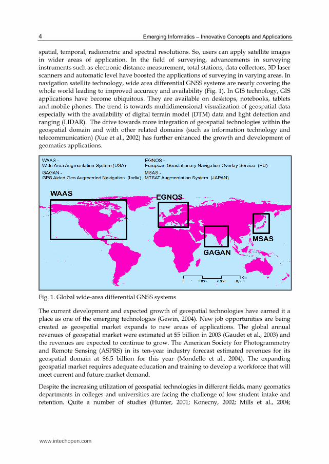
spatial, temporal, radiometric and spectral resolutions. So, users can apply satellite images in wider areas of application. In the field of surveying, advancements in surveying instruments such as electronic distance measurement, total stations, data collectors, 3D laser scanners and automatic level have boosted the applications of surveying in varying areas. In navigation satellite technology, wide area differential GNSS systems are nearly covering the whole world leading to improved accuracy and availability (Fig. 1). In GIS technology, GIS applications have become ubiquitous. They are available on desktops, notebooks, tablets and mobile phones. The trend is towards multidimensional visualization of geospatial data especially with the availability of digital terrain model (DTM) data and light detection and ranging (LIDAR). The drive towards more integration of geospatial technologies within the geospatial domain and with other related domains (such as information technology and telecommunication) (Xue et al., 2002) has further enhanced the growth and development of geomatics applications.
Fig. 1. Global wide-area differential GNSS systems
The current development and expected growth of geospatial technologies have earned it a
place as one of the emerging technologies (Gewin, 2004). New job opportunities are being
created as geospatial market expands to new areas of applications. The global annual
revenues of geospatial market were estimated at $5 billion in 2003 (Gaudet et al., 2003) and
the revenues are expected to continue to grow. The American Society for Photogrammetry
and Remote Sensing (ASPRS) in its ten-year industry forecast estimated revenues for its
geospatial domain at $6.5 billion for this year (Mondello et al., 2004). The expanding
geospatial market requires adequate education and training to develop a workforce that will
meet current and future market demand.
Despite the increasing utilization of geospatial technologies in different fields, many geomatics departments in colleges and universities are facing the challenge of low student intake and retention. Quite a number of studies (Hunter, 2001; Konecny, 2002; Mills et al., 2004;
www.intechopen.com
Applications of Geospatial Technologies for Practitioners: An Emerging Perspective of Geospatial Education
5
McDougall et al., 2006; Hannah et al., 2009; Aina, 2009) have discussed the problem and part of the suggested mitigations is revamping the curriculum and improving the learning experience of the students. Emerging pedagogical methods such as problem-based learning, cooperative learning, student-centred inquiry and active learning could be relevant in achieving effective learning and enhancing learning experience. This article examines the adoption of active learning method as one of the strategies of improving student enrolment and retention in geospatial education. It presents the results of a case study of the active learning approach. It also discusses the emerging trends in geospatial applications, the global challenges of geospatial education and the different strategies to improve geospatial education.
2. Methodology
The sections of the article that discuss the trend in geospatial applications, importance of
geospatial technology for higher education and the challenges of geospatial education are
based on review of literature. The final section on the adoption of active learning method is
based on questionnaire survey, course assessment and teacher’s observations. The
questionnaire survey was completed by 16 students that enrolled in Geographic Information
System and Remote Sensing courses. The questions were aimed at getting feedback from
students on the adoption of active learning method. The questionnaire contained seven
items with a five-point Likert scale (Highly Agree to Highly Disagree). The questionnaire
was composed of the following items:
There has been a remarkable change in the teaching method of this course The current teaching method helps me in learning better I am more motivated to learn than before The group discussions make me a better learner Teaching other members of the class by making presentations helps me in my learning I am encouraged to search for more information about the subject
There is no difference between how I learn now and how I have been learning before
The course assessment is based on students’ grades for each of the courses. The course assessment for the semester was compared with the previous semester when active learning method had not been vigorously adopted. Also, teacher’s observations on changes in the performance of students were documented.
3. Recent and emerging trends in geospatial applications
It is difficult to exhaustively outline the recent applications of geomatics in an article as the list continues to expand and there are already vast areas of application. “Comprehensive lists of the capabilities of GIS are notoriously difficult to construct” (Goodchild, 2008). However, notable applications can still be highlighted to show what geospatial technologies are capable of and the possible future uses. The development of new applications in geospatial technology is linked with recent development in electronic and information and communication technology (ICT). Geospatial technologies adopt innovative information and communication system concepts and this is evident in the current and emerging geospatial applications highlighted in the following sections. The different domains of geomatics have benefited from these technological developments.
www.intechopen.com
Emerging Informatics – Innovative Concepts and Applications
6
3.1 Geographic information system – Towards multidimensional visualization
GIS is one of the most evolving aspects of geospatial technology. It evolved from desktop application in the 1980s into enterprise GIS in the 1990s and into distributed GIS. Even the technology of distributed GIS is evolving. It has changed from mobile GIS to web GIS and it is currently developing into cloud GIS. The development of cyberinfrastructure has facilitated the distribution of geospatial information as web service and the advancement in visualizing geospatial data. The synergy between cyberinfrastructure and GIS has not only increased the availability and use of geoinformation, but has also enabled members of the public to become publishers of geoinformation (Goodchild, 2011). Map mashups and crowd-sourcing or volunteered geographic information (VGI) (Goodchild, 2007; Batty et al., 2010) and ambient geographic information (AGI) (Stefanidis et al., forthcoming) are being developed by non-expert users to disseminate geoinformation on the web. These emerging sources of geospatial information have become valuable to different societal and governmental applications such as geospatial intelligence (Stefanidis et al., in press), disaster management, real time data collection and tracking and property and services search.
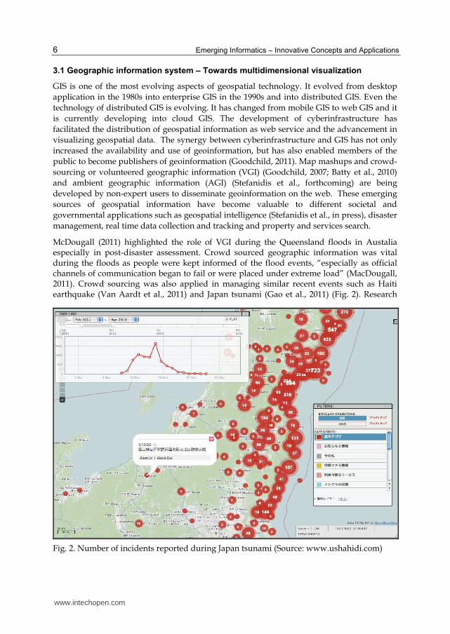
McDougall (2011) highlighted the role of VGI during the Queensland floods in Austalia especially in post-disaster assessment. Crowd sourced geographic information was vital during the floods as people were kept informed of the flood events, “especially as official channels of communication began to fail or were placed under extreme load” (MacDougall, 2011). Crowd sourcing was also applied in managing similar recent events such as Haiti earthquake (Van Aardt et al., 2011) and Japan tsunami (Gao et al., 2011) (Fig. 2). Research
Fig. 2. Number of incidents reported during Japan tsunami (Source: www.ushahidi.com)
www.intechopen.com
Applications of Geospatial Technologies for Practitioners: An Emerging Perspective of Geospatial Education
7
studies on varying issues of global concern such as global warming and sea level rise,
urbanization, environmental management, global security have also been taking advantage
of the emerging opportunities of increased data availability and improvement in
visualization techniques. An example of such studies is the work of Li et al. (2009) on global
impacts of sea level rise. They used GIS to delineate areas that could be inundated due to the
projected sea level rises basing their analysis on readily available DEM data. Alshuwaikhat
& Aina (2006) applied GIS in assessing the urban sustainability of Dammam, Saudi Arabia
and they concluded that GIS is a veritable tool for promoting urban sustainability.
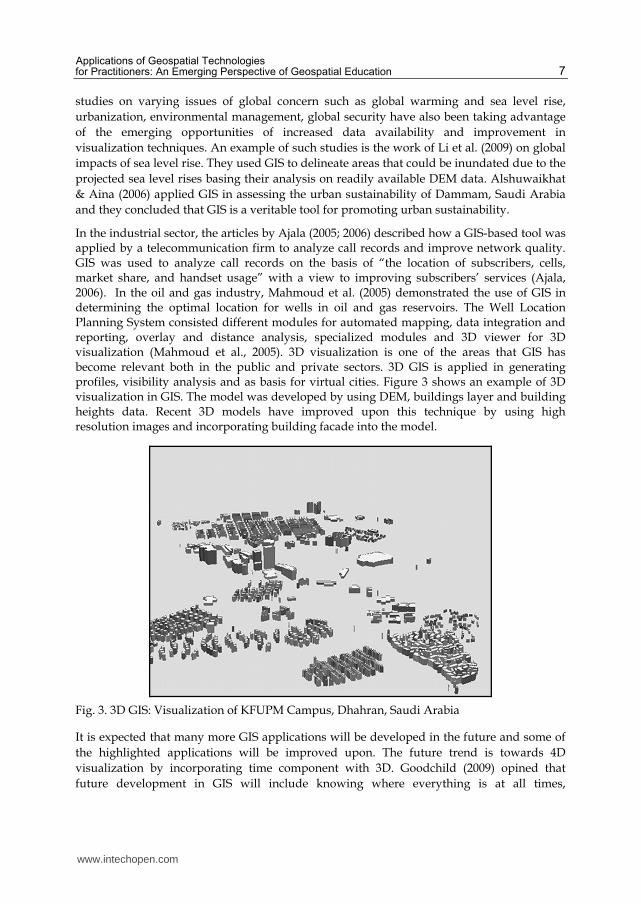
In the industrial sector, the articles by Ajala (2005; 2006) described how a GIS-based tool was applied by a telecommunication firm to analyze call records and improve network quality. GIS was used to analyze call records on the basis of “the location of subscribers, cells, market share, and handset usage” with a view to improving subscribers’ services (Ajala, 2006). In the oil and gas industry, Mahmoud et al. (2005) demonstrated the use of GIS in determining the optimal location for wells in oil and gas reservoirs. The Well Location Planning System consisted different modules for automated mapping, data integration and reporting, overlay and distance analysis, specialized modules and 3D viewer for 3D visualization (Mahmoud et al., 2005). 3D visualization is one of the areas that GIS has become relevant both in the public and private sectors. 3D GIS is applied in generating profiles, visibility analysis and as basis for virtual cities. Figure 3 shows an example of 3D visualization in GIS. The model was developed by using DEM, buildings layer and building heights data. Recent 3D models have improved upon this technique by using high resolution images and incorporating building facade into the model.
Fig. 3. 3D GIS: Visualization of KFUPM Campus, Dhahran, Saudi Arabia
It is expected that many more GIS applications will be developed in the future and some of
the highlighted applications will be improved upon. The future trend is towards 4D
visualization by incorporating time component with 3D. Goodchild (2009) opined that
future development in GIS will include knowing where everything is at all times,
www.intechopen.com
Emerging Informatics – Innovative Concepts and Applications
8
improvement in third spatial dimension, providing real time dynamic information, more
access to geographic information and improvement in the role of citizen. These
developments indicate that geospatial technologies will be more integrated in the future. For
example, the technologies for knowing where everything is at all times will most likely
include RFID, GPS, internet, geo-visualization and probably satellite imagery.
3.2 Surveying and GNSS – Towards accurate and timely data collection
The advancements in modern surveying instruments have not only led to improvement in
accuracy, but also increasing integration of digital survey data with other technologies. In
Olaleye et al. (2011), this development was referred to as “Digital Surveying”. Most of the
data collected through surveying are now in digital formats that are interchangeable with
other geospatial data formats. Even in some instances, survey data can be streamed through
bluetooth or wifi to other hardware or software. Another development that has impacted
surveying is the proliferation of laser technology. 3D laser scanners are now being used in
surveying to collect quick and accurate data, captured as thousands of survey points, known
as point cloud. The point cloud can be processed to produce accurate 3D geometry of
structures. The use of unmanned aircraft has also made an inroad into surveying
(Mohamed, 2010). Using unmanned aircraft in aerial mapping provides opportunity for
collecting cheap, fast and high-resolution geospatial data.
GNSS technology has been very crucial to most geospatial technology applications from in-
vehicle navigation to civil aviation and automated machine control. GNSS is a component of
the unmanned aircraft technology mentioned above. As stated above, the technology is
applied in aerial mapping and even in military operations such as US military drones
(Chapman, 2003). The trend in GNSS is towards consistent availability and improved
accuracy. With the inauguration of Russia’s GLONASS and other GNSS systems such as
Japan’s QZSS, EU’s GALILEO and China’s Beidou; accuracy and availability will continue
to improve.
3.3 Remote sensing and photogrammetry – Prying eyes from above
Remote sensing and photogrammetric technology have been undergoing dramatic changes
since the launching of Landsat in the 1970s. Then, it was only United States that was
involved in planning and launching remote sensing satellite missions. Now, there are more
than 20 countries that own remote sensing satellites. This development has made users to
have more access to satellite images. Free image programmes like the Global Land Cover
Facility (GLCF) and USGS free landsat archive and OrbView3 data have also improved the
availability of images. Users have recently got the opportunity of accessing satellite data
through geospatial portals such as Google Earth and Microsoft Virtual Earth. Apart from the
improvement in data availability, the quality of satellite imagery has also improved in terms
of resolutions. Currently, the image with the highest spatial resolution is GeoEye (0.5m) but
there is a plan to launch GeoEye-2 (0.25m) within the next two years. High resolution
satellite imagery is valuable to applications in disaster management, feature extraction and
analysis, mapping and monitoring changes in urban landscape, infrastructure management,
health (Kalluri et al., 2007) and 3D visualization.
www.intechopen.com
Applications of Geospatial Technologies for Practitioners: An Emerging Perspective of Geospatial Education
9
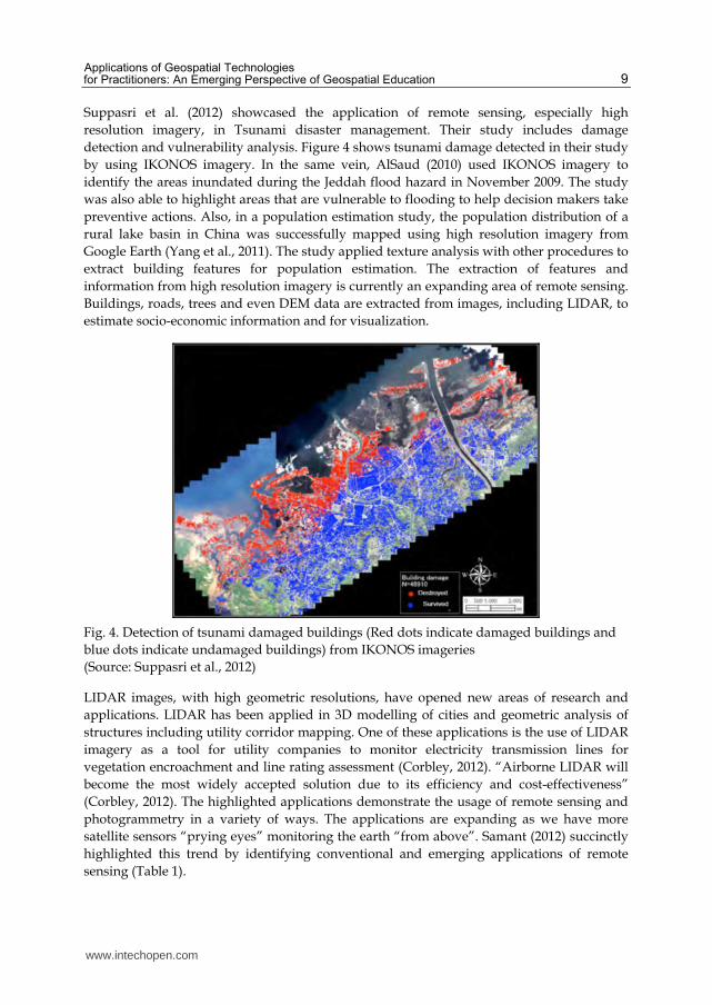
Suppasri et al. (2012) showcased the application of remote sensing, especially high
resolution imagery, in Tsunami disaster management. Their study includes damage
detection and vulnerability analysis. Figure 4 shows tsunami damage detected in their study
by using IKONOS imagery. In the same vein, AlSaud (2010) used IKONOS imagery to
identify the areas inundated during the Jeddah flood hazard in November 2009. The study
was also able to highlight areas that are vulnerable to flooding to help decision makers take
preventive actions. Also, in a population estimation study, the population distribution of a
rural lake basin in China was successfully mapped using high resolution imagery from
Google Earth (Yang et al., 2011). The study applied texture analysis with other procedures to
extract building features for population estimation. The extraction of features and
information from high resolution imagery is currently an expanding area of remote sensing.
Buildings, roads, trees and even DEM data are extracted from images, including LIDAR, to
estimate socio-economic information and for visualization.
Fig. 4. Detection of tsunami damaged buildings (Red dots indicate damaged buildings and
blue dots indicate undamaged buildings) from IKONOS imageries
(Source: Suppasri et al., 2012)
LIDAR images, with high geometric resolutions, have opened new areas of research and
applications. LIDAR has been applied in 3D modelling of cities and geometric analysis of
structures including utility corridor mapping. One of these applications is the use of LIDAR
imagery as a tool for utility companies to monitor electricity transmission lines for
vegetation encroachment and line rating assessment (Corbley, 2012). “Airborne LIDAR will
become the most widely accepted solution due to its efficiency and cost-effectiveness”
(Corbley, 2012). The highlighted applications demonstrate the usage of remote sensing and
photogrammetry in a variety of ways. The applications are expanding as we have more
satellite sensors “prying eyes” monitoring the earth “from above”. Samant (2012) succinctly
highlighted this trend by identifying conventional and emerging applications of remote
sensing (Table 1).
www.intechopen.com
Emerging Informatics – Innovative Concepts and Applications
10
Application environment Coventional applications Emerging applications
Terrestrial
Hydrological
Atmospheric
Biodiversity Health
Defence Infrastructure Monitoring
Disaster management Cadastral mapping
Energy Oil and gas
Climate Mineral exploration
Water Location based service
Weather Insurance
Ecosystem Property registration
Forest Emergency and accident
monitoring
Agriculture Environmental monitoring
Table 1. Conventional and emerging applications of remote sensing (Source: Samant, 2012)
3.4 Integration of geospatial technologies – Towards a synergy
As mentioned in section 3.1, the current trend is towards the integration of different
geospatial technologies. There is hardly any recent geospatial application that does not have
components from two or more domains of geospatial technology. The idea of integration
started with the use of remote sensing data in GIS and data from GIS serving as ancillary
data in satellite image classification. In recent times, the integration has included computer-
aided design (CAD), GPS, survey data, internet, RFID, geosensor and telecommunication.
Even concepts such as space syntax, cellular automata and agent based modelling (ABM)
have been integrated into geospatial technologies (Jiang & Claramunt, 2002; Beneson et al.,
2006; Sullivan et al., 2010). Likewise, software vendors have started integrating GIS, GPS
and remote sensing functionalities in their packages. The trend towards synergy has been
driving emerging applications in geospatial technologies and this might probably continue
into the future.
In one of the early study on the integration of geospatial data with wireless communication,
Tsou (2004) presented a prototype mobile GIS that “allows multiple resource managers and
park rangers to access large-size remotely sensed images and GIS layers from a portable
web server mounted in a vehicle”. The mobile GIS application was developed for habitat
conservation and environmental monitoring. A similar application, geared towards crowd
management and pilgrim mobility in the city of Makkah, used location based services and
augmented reality technologies to provide Hajj pilgrims with timely information on mobile
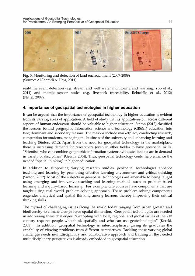
phone (Alnuaim & Almasre, 2010). In Saud Aramco, (AlGhamdi & Haja, 2011) developed an
integrated system, based on mobile GIS technology and high precision surveying process, to
monitor land encroachments on land reservations and pipeline corridors. The system
generated and propagated encroachment data (to GIS database) based on a change detection
process (Fig. 5).
The emerging applications that integrate geospatial technologies with ICT are based on wireless network of spatially-aware sensors “geosensor networks” that “detect, monitor and track environmental phenomena and processes” (Nittel, 2009). Geosensor networks are used in three streams of applications; continuous monitoring (e.g. measuring geophysical processes),
www.intechopen.com
Applications of Geospatial Technologies for Practitioners: An Emerging Perspective of Geospatial Education
11
Fig. 5. Monitoring and detection of land encroachment (2007-2009) (Source: AlGhamdi & Haja, 2011)
real-time event detection (e.g. stream and well water monitoring and warning, Yoo et al., 2011) and mobile sensor nodes (e.g. livestock traceability, Rebufello et al., 2012) (Nittel, 2009).
4. Importance of geospatial technologies in higher education
It can be argued that the importance of geospatial technology in higher education is evident from its varying areas of application. A field of study that its applications cut across different aspects of human endeavour should be valuable to higher education. Sinton (2012) classified the reasons behind geographic information science and technology (GIS&T) education into two; dominant and secondary reasons. The reasons include marketplace, conducting research, competition for students, managing the business of the university and enhancing learning and teaching (Sinton, 2012). Apart from the need for geospatial technology in the marketplace, there is increasing demand for researchers (even in other fields) to have geospatial skills. “Scientists who can combine geographic information systems with satellite data are in demand in variety of disciplines” (Gewin, 2004). Thus, geospatial technology could help enhance the needed “spatial thinking” in higher education.
In addition to supporting varying research studies, geospatial technologies enhance teaching and learning by promoting effective learning environment and critical thinking (Sinton, 2012). Most of the subjects in geospatial technologies are amenable to being taught using emerging and innovative teaching and learning methods such as problem-based learning and inquiry-based learning. For example, GIS courses have components that are taught using real world problem-solving approach. These problem-solving components engender analytical and spatial thinking among learners thereby improving their critical thinking skills.
The myriad of challenging issues facing the world today ranging from urban growth and biodiversity to climate change have spatial dimension. Geospatial technologies are needed in addressing these challenges. “Grappling with local, regional and global issues of the 21st century requires people who think spatially and who can use geotechnologies” (Kerski, 2008). In addition, geospatial technology is interdisciplinary giving its graduates the capability of viewing problems from different perspectives. Tackling these varying global challenges needs multidisciplinary and collaborative approach and training in the needed multidisciplinary perspectives is already embedded in geospatial education.
www.intechopen.com
Emerging Informatics – Innovative Concepts and Applications
12
5. Geospatial education at crossroad: Can active learning help?
5.1 The challenge of low student enrolment
One of the major challenges facing some geomatics and other related departments is low student enrolment. It has been a global issue (Mills et al., 2004; Hannah et al., 2009) and even affects schools in the United Stated (Mohamed et al., 2011) where geospatial market is rapidly expanding (Gewin, 2004). Bennett et al. (2009) in their study on spatial science education in Australia referred to the phenomenon as a “paradox”; there is a steady increase in demand for graduates but no increase in student enrolment. The same trend has been observed in the UK and New Zealand (Hannah et al., 2009), Sub-Saharan Africa (Ruther, 2003) and Saudi Arabia (Aina, 2009). Some of the reasons for low student intake are lack of awareness, weak financial support, misconception that only training is needed not education and being a relatively new field (Mills et al., 2004; AlGarni, 2005; Aina, 2009).
The problem of low student intake is compounded by the fact that geospatial technologies are evolving and schools have to grapple with developing effective method of teaching an ever changing field. In addition, the curriculum has to be designed in a way that will inculcate self-learning in the students to prepare them for self-directed continuous learning after graduation. So, the challenge is not only about student enrolment but also presenting a fulfilling learning experience to the students. Apart from raising public awareness of geomatics, changing the teaching and learning method could help in attracting and retaining students by enhancing their learning experience. There is a “need to identify new paradigms as a basis for developing more resilient and responsive educational programs” (Barnes, 2009).
5.2 Active learning to the rescue?
Active learning is a departure from the traditional teaching method that is teacher-focused, to student-focused approach. It emphasizes active engagement of the students rather than the traditional passive learning. Students should not be like vessels into which the teachers pour ideas and information. The students need to reflect on given information and understand the underlying concepts. Effective learning is not achieved if students are relegated to the “role of passive ‘spectactors’ in the college classrooms” (Matmti and Delany, 2011). “Effective learners are active, strategic, thoughtful and constructive in linking new information to prior knowledge” (Lipton & Wellman, 1999). A plethora of research about learning indicated that active learning method improves student engagement, learning and retention and enhances learning experience.
Active learning and its variants, such as problem-based learning, are increasingly adopted in teaching geospatial technologies (Shortis et al., 2000; Meitner et al., 2005; Drennon, 2005; Harvey & Kotting, 2011; Schultz, 2012). ESRI, one of the notable GIS vendors, has also adopted active learning methods in its GIS training courses (Wheeler, 2010). Active learning is being embraced to deal with changing geospatial body of knowledge, stimulate critical thinking, improve student engagement and enhance learning experience. Shortis et al. (2000) were able to transform the teaching and learning of plane survey from the traditional passive method to active learning based on web technology. They got positive feedback from students and staff. Likewise, Harvey and Kotting (2011) presented an active learning model for teaching cartography that enabled students to reflect on the “concepts and
www.intechopen.com
Applications of Geospatial Technologies for Practitioners: An Emerging Perspective of Geospatial Education
13
techniques of modern cartography”. Meitner et al. (2005) also reported a successful adoption of active learning in teaching GIS. However, they noted that instructors should be cautious of turning student-focused classroom into “free-for-all” chaos or drifting back to teacher-led classroom. It is not all the activities of the students that will necessarily translate to active learning. Even Prince (2004), had raised a cautionary note on reported result since it is difficult to measure whether active learning works. Shortis et al. (2000) also noted this difficulty when they acknowledged that comparison of examination results might be misleading as the capability of different cohorts are different.
6. From global to local: The case of geomatics at Yanbu Industrial College
The Geomatics Technologies Department at Yanbu Industrial College is facing the problem of low student enrolment. Since the department was created in 2003, student enrolment has not been more than 24 in a year. In addition, the department has not been able to attract high quality students. This poses a challenge of identifying the learning and teaching approach that will increase student motivation, retention and performance. The situation is similar to that of some other geomatics department around the world experiencing low patronage or even closure. The department has taken some measures to reverse this trend. One of the measures is to take the opportunity of the college’s drive towards student-centred learning (Matmti and Delany, 2011; Delany, 2011) to reinvigorate the department and transform student learning experience.
The active learning case study that is presented in this article was implemented in teaching two geomatics courses in remote sensing and GIS. There were ten and six students in the remote sensing and GIS classes respectively. Two methods, group discussion and learning by teaching, were adopted in infusing active learning in the courses. In the group discussion, the study material was given to the student to study before the class. In the class, the students were paired into groups and each group was asked to discuss the material and write down two important ideas they understand from the material and two ideas they do not fully understand. Thereafter, a student from each group was asked to explain to the class the ideas they understand and other ideas (difficult to understand) were thrown open for discussion.
The learning by teaching method was based on presentations by the students. The students were divided into groups. Each group was given a topic from the course module to prepare a presentation on. Each group made presentation on the assigned topic in class and other class members had to take note of important points in the presentation. The teacher served as a facilitator in these two approaches by clearing misconceptions about the subject matter, guiding the students on the concepts to focus on and getting feedback from the students. The following sections present the results of the assessment of the methods (as mentioned in the methodology section).
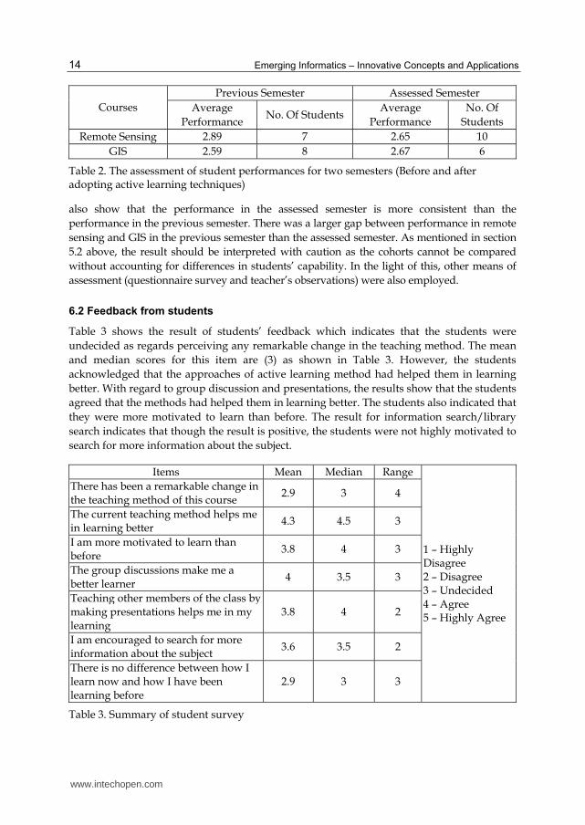
6.1 Comparison of grades
The comparison of grades of the students with the grades from previous semester shows a mixed result as depicted in Table 2. The average class performance for remote sensing and GIS in the previous semester was 2.89 and 2.59 respectively. For the assessed semester, the average grade was 2.65 for remote sensing and 2.67 for GIS. The results show a slight improvement in performance in GIS and a lower performance in remote sensing. The results
www.intechopen.com
Emerging Informatics – Innovative Concepts and Applications
14
Courses
Previous Semester Assessed Semester
Average
Performance No. Of Students
Average
Performance
No. Of
Students
Remote Sensing 2.89 7 2.65 10
GIS 2.59 8 2.67 6
Table 2. The assessment of student performances for two semesters (Before and after adopting active learning techniques)
also show that the performance in the assessed semester is more consistent than the
performance in the previous semester. There was a larger gap between performance in remote
sensing and GIS in the previous semester than the assessed semester. As mentioned in section
5.2 above, the result should be interpreted with caution as the cohorts cannot be compared
without accounting for differences in students’ capability. In the light of this, other means of
assessment (questionnaire survey and teacher’s observations) were also employed.
6.2 Feedback from students
Table 3 shows the result of students’ feedback which indicates that the students were
undecided as regards perceiving any remarkable change in the teaching method. The mean
and median scores for this item are (3) as shown in Table 3. However, the students
acknowledged that the approaches of active learning method had helped them in learning
better. With regard to group discussion and presentations, the results show that the students
agreed that the methods had helped them in learning better. The students also indicated that
they were more motivated to learn than before. The result for information search/library
search indicates that though the result is positive, the students were not highly motivated to
search for more information about the subject.
Items Mean Median Range
1 – Highly Disagree 2 – Disagree 3 – Undecided 4 – Agree 5 – Highly Agree
There has been a remarkable change in the teaching method of this course
2.9 3 4
The current teaching method helps me in learning better
4.3 4.5 3
I am more motivated to learn than before
3.8 4 3
The group discussions make me a better learner
4 3.5 3
Teaching other members of the class by making presentations helps me in my learning
3.8 4 2
I am encouraged to search for more information about the subject
3.6 3.5 2
There is no difference between how I learn now and how I have been learning before
2.9 3 3
Table 3. Summary of student survey
www.intechopen.com
Applications of Geospatial Technologies for Practitioners: An Emerging Perspective of Geospatial Education
15
6.3 Teacher’s observations
There were two changes noted after the introduction of the active learning approaches.
Some of the students developed keen interest in searching for additional information
that could enrich their presentations and understanding of the subject. And some of
them became passionate about the given topic that they felt they were the experts in the
topics so others should just accept their findings. So, the presentation exercises also
taught the student how to accommodate classmates with different views about the
subject. Another noted change was in the answers provided by the students to
examination questions. Previously, students responded to exam question by virtually
regurgitating the information in the course material. During the assessed semester,
responses from students showed that some of them had started explaining issues in their
own words different from the expressions in the given material. This indicates that they
were able to understand the material better than before. The new approaches did not
really affect student attendance. And this is an important issue in the department. The
goal of the department is to nurture the students to a level that they can be self-
motivated to attend classes and to search for additional information about their subjects.
It might be too early for the department to fully assess the impact of the transformation
since the method has just been implemented for a semester. The results from the
assessment are promising enough to encourage the department to continue on the active
learning path.
7. Conclusion
This article has dwelt on three issues that are very important to geospatial technologies. First
is the justification for teaching geospatial technologies in higher education by highlighting
its growing applications and future trend. Second is the paradoxical issue of low student
enrolment at some geomatics departments around the world despite the growing need for
geospatial technologies in varying fields of application. Third is the adoption of active
learning technique to improve teaching and learning and thereby attract more students. The
highlight on the expanding applications of geospatial technologies has shown that different
domains of geospatial technologies are continuously evolving and the market demand for
geomatics researchers and practitioners is expanding. And this leads us to the justification
for having geospatial technologies in any college or university. Apart from the demand for
geospatial technologies, other justifications include research, its use by the society and the
promotion of emerging learning techniques. The emerging learning techniques could help in
solving the problem of enrolment.
A case study of the adoption of emerging teaching techniques at Yanbu Industrial College is
presented in this article to show that these techniques could transform geomatics education.
Though the implementation is still at an early stage, its effect on student intake is yet to be
determined, it has shown promising results. The students were keen to search for additional
material on the courses and they answered exam questions from what they understood not
what they crammed. If the techniques could not result in an increase in student intake, they
might lead to an increase in retention of students once the students realise that geomatics
can offer a fulfilling learning environment.
www.intechopen.com
Emerging Informatics – Innovative Concepts and Applications
16
8. Acknowledgments
The author is grateful to the remote sensing and GIS students for participating in this study. The author acknowledges the assistance of Yanbu Industrial College in carrying out this work especially the sponsorship of his participation in an active learning workshop. The author is also grateful to the Editorial Board for its valuable comments. The views expressed in this work are not necessarily that of the college.
9. References
Aina, Y. A. (2009). Geomatics education in Saudi Arabia: Status, challenges and prospects. International Research in Geographical and Environmental Education, Vol.18, No.2, pp. 111-119, ISSN 1038-2046
Ajala, I. (2005). GIS and GSM network quality monitoring : A Nigerian case study. Directions Magazine, Available from http://www.directionsmag.com/articles/gis-and-gsm-network-quality-monitoring-a-nigerian-case-study/123278
Ajala, I. (2006). Spatial analysis of GSM subscriber call data records. Directions Magazine, Available from http://www.directionsmag.com/articles/spatial-analysis-of-gsm-subscriber-call-data-records/123196
AlGarni, A. M. (2005). Future of geo-sciences can be seen everywhere in the Kingdom. GIS Development, Vol.1, No.1, pp. 32-34, Available from
AlGhamdi, Y. & Haja, S. (2011). Implementation of a land encroachment survey process in Saudi Aramco based on high precision mobile GIS technology. Proceedings of the Sixth National GIS Symposium in Saudi Arabia (Online), Khobar, Saudi Arabia, 24-26 April, 2011, Available from
http://www.saudigis.org/FCKFiles/File/6thSaudiGIS_Papers/T2_3.docx Alnuaim, H. & Almasre, M. (2010). The use of mobile technology for crowd management in
cities: The case of safe pilgrim mobility in the city of Makkah. Proceedings of The 3rd Knoowledge Cities World Summit, pp. 1373-1395, ISBN 978-0-646-54655-1, Melbourne, Australia, 16-19 November, 2010
AlSaud, M. (2010). Assessment of flood hazard of Jeddah area 2009, Saudi Arabia. Journal of Water Resource and Protection, Vol.2, No.9, pp. 839-847, ISSN 1945-3108
Alshuwaikhat, H. M. & Aina, Y. A. (2006). GIS-based urban sustainability assessment: The case of Dammam city, Saudi Arabia. Local Environment, Vol.11, No.2, pp. 141-161, ISSN 1469-6711
Barnes, G. (2009). Geomatics at the crossroads: Time for a new paradigm in geomatics education? Surveying and Land Information Science, Vol.69, No.2, pp. 81-88, ISSN 1538-1242
Batty, M.; Hudson-Smith, A.; Milton, R. & Crooks, A. (2010). Map mashups, web 2.0 and the GIS revolution. Annals of GIS, Vol.16, No.1, pp. 1-13, ISSN 1947-5691
Beneson, I.; Birfur, S. & Kharbash, V. (2006). Geographic automata systems and the OBEUS software for their implementation. In: Complex Artificial Environments: Simulation, cognition and VR in the study and planning of cities, J. Portugali, (Ed.), pp. 137-153, Springer, Netherlands, ISBN 978-3-540-25917-6
Bennett, R.; Ogleby, C. & Bishop, I. (2009). One strategy for repositioning spatial sciences education in Australia. Journal of Spatial Science, Vol.54, No.1, pp. 93-104, ISSN 1836-5655
www.intechopen.com
Applications of Geospatial Technologies for Practitioners: An Emerging Perspective of Geospatial Education
17
Chapman, G. (2003). An introduction to the revolution in military affairs. XV Amaldi Conference on Problems in Global Security, Helsinki, Finland, 25-27 September, 2003, Available from
http://www.accademianazionaledeilincei.it/rapporti/amaldi/papers/XV-Chapman.pdf
Corbley, K. (2012). Why LIDAR has become the “Go To”technology for utility corridor mapping. Directions Magazine, Available from
http://www.directionsmag.com/articles/why-lidar-has-become-the-go-to-technology-for-utility-corridor-mapping/228168
Delany, J. (2011). Active learning: How do we know it works? YIC Campus Times, No.3, Available from http://www.calameo.com/read/000335779577c886d8dd1
Drennon, C. (2005). Teaching Geographic Information Systems in a problem-based learning environment. Journal of Geography in Higher Education, Vol.29, No.3, pp. 385-402, ISSN 1466-1845
Gao, H.; Barbier, G. & Goolsby, R. (2011). Harnessing the crowdsourcing power of social media for disaster relief. IEEE Intelligent Systems, Vol.26, No.3, pp. 1541–1672, ISSN 1541-1672
Gaudet, C. H.; Annulis, H. M. & Carr, J. C. (2003). Building the geospatial workforce. URISA Journal, Vol.15, No.1, pp. 21-30, ISSN 1045-8077
Gewin, V. (2004). Mapping opportunities. Nature, Vol.427, No.6972, pp. 376-377, ISSN 0028-0836
Goodchild, M. F. (2007). Citizens as sensors: The world of volunteered geography. Geojournal, Vol.69, No.4, pp. 211-221, ISSN 1572-9893
Goodchild, M. F. (2008). The use cases of digital earth. International Journal of Digital Earth, Vol.1, No.1, pp. 31-42, ISSN 1753-8955
Goodchild, M. F. (2009). Goegraphic information systems and science: today and tomorrow. Annals of GIS, Vol.15, No.1, pp. 3-9, ISSN 1947-5691
Goodchild, M. F. (2011). Information technology as megaengineering: The impact of GIS, In: Engineering earth: The impacts of megaengineering projects, S. D. Brunn, (Ed.), Vol.1, pp. 37-47, Springer, ISBN 978-90-481-9919-8, Dordrecht, Netherlands
Hannah, J.; Kavanagh, J.; Mahoney, R. & Plimmer, F. (2009). Surveying: A profession facing a global crisis ? Survey Review, Vol.41, No.313, pp. 268-278, ISSN 1752-2706
Harvey, F. & Kotting, J. (2011). Teaching mapping for digital natives: New pedagogical ideas for undergraduate cartography education. Cartography and Geographic Information Science, Vol.38, No.3, pp. 269-277, ISSN 1545-0465
Hunter, G. J. (2001). Ensuring the survival of geomatics engineering at the University of Melbourne. Surveying and Land Information Science, Vol.61, No.4, pp. 255-262, ISSN 1538-1242
Jiang, B. & Claramunt, C. (2002). Integration of space syntax into GIS: New perspectives for urban morphology. Transactions in GIS, Vol.6, No.3, pp. 295-309, ISSN 1467-9671
Kalluri, S.; Gilruth, P.; Rogers, D. & Szczur, M. (2007). Surveillance of anthropod vector-borne infectious diseases using remote sensing techniques: A review. PLOS Pathogens, Vol.3, No.10, pp. 1361-1371, ISSN 1553-7374
Kerski, J. J. (2008). The role of GIS in Digital Earth education. International Journal of Digital Earth, Vol.1, No.4, pp. 326-346, ISSN 1753-8955
www.intechopen.com
Emerging Informatics – Innovative Concepts and Applications
18
Klinkenberg, B. (2007). Geospatial technologies and the geographies of hope and fear. Annals of the Association of American Geographers, Vol.97, No.2, pp. 350-360, ISSN 0004-5608
Konecny, G. (2002). Recent global changes in geomatics education. Proceedings of ISPRS Commission VI Symposium (CD-ROM), ISSN 1682-1750, Sao Jose’ dos Compos, Brazil, 16-18 September, 2002
Li, X.; Rowley, R. J.; Kostelnick, J. C.; Braaten, D.; Meisel, J. & Hulbutta, K. (2009). GIS analysis of global impacts from sea level rise. Photogrammetric Engineering and Remote Sensing, Vol.75, No.7, pp. 807-818, ISSN 0099-1112
Lipton, L. & Wellman, B. M. (1999). Pathways to understanding: Patterns and Practices in the Learning-Focused Classroom. Hawker Brownlow Education Pty Ltd, Victoria, Australia, ISBN 1864018135
Mahmoud, W. H.; Ahmed, I.; Krinis, D. & Al-Marri, H. M. (2005). Well placement optimization using GIS. Proceedings of the First National GIS Symposium in Saudi Arabia (Online), Khobar, Saudi Arabia, 21-23 November, 2005, Available from
http://www.saudigis.org/FCKFiles/File/SaudiGISArchive/1stGIS/Papers/2.pdf Matmti, R. & Delany, J. (2011). Active learning: Going beyong just telling them information !
YIC Campus Times, No.2, Available from http://www.calameo.com/read/000335779577c886d8dd1 McDougall, K.; Williamson, I.; Bellman, C. & Rizos, C. (2006). Challenges facing spatial
information and geomatics education in the higher education sector. Combined 5th Trans Tasman Survey Conference & 2nd Queensland Spatial Industry Conference, Cairns, Australia, 18–26 September, 2006
MacDougall, K. (2011). Understanding the impact of volunteered geographic information during the Queensland floods. Proceedings of 7th International Symposium on Digital Earth, Perth, Australia, 23-25 August, 2011
Meitner, M. J.; Gonzales, J.; Gandy, R. & Maedel, J. (2005). Critical thinking, knowledge retention and strife: Reflections on active-learning techniques. Proceedings of ESRI Education Users Conference, San Diego, California, 23-26 July, 2005, Available from
http://proceedings.esri.com/library/userconf/educ05/abstracts/a1081.html Mills, J. P.; Parker, D. & Edwards, S. J. (2004). Geomatics.org.uk: A UK response to a global
awareness problem. Proceedings 20th ISPRS Congress Commission VI, pp. 1-6, ISSN 1682-1750, Istanbul, Turkey, 12–23 July, 2004
Mohamed, A. H. (2010). Editorial - Unmanned aerial vehicles for surveyors. Surveying and Land Information Science, Vol.70, No.3, pp. 107-109, ISSN 1538-1242
Mohamed, A.; Grenville, B.; Sowmya, S.; Benjamin, W. & Adam, B. (2011). A comparative study of geomatics education at select Canadian and American universities. Surveying and Land Information Science, Vol.71, No.1, pp. 21-31, ISSN 1538-1242
Mondello, C. M.; Hepner, G. F. & Williamson, R. A. (2004). 10-Year Industry Forecast: Phases I-III – Study Documentation, ASPRS, USA, Available from
www.asprs.org/a/news/forecast/10-year-ind-forecast.pdf Nittel, S. (2009). A survey of geosensor networks: Advances in dynamic environmental
monitoring. Sensors, Vol.9, pp. 5664-5678, ISSN 1424-8220 Olaleye, J. B.; Abiodun, O. E.; Olusina, J. O. & Alademomi, A. S. (2011). Surveyors and the
challenges of digital surveying and mapping technology. Surveying and Land Information Science, Vol.71, No.1, pp. 3-11, ISSN 1538-1242
www.intechopen.com
Applications of Geospatial Technologies for Practitioners: An Emerging Perspective of Geospatial Education
19
Prince, M. (2004). Does active learning work? A review of the research. Journal of Engineering Education, Vol.93, No.3, pp. 223-231, ISSN 1069-4730
Pun-Cheng, L. S. C. (2001). Knowing our customers: A quantitative analysis of geomatics students. International Research in Geographical and Environmental Education, Vol.10, No.3, pp. 322-341, ISSN 1038-2046
Rebufello, P.; Piperno, P. & Drets, G. (2012). Uruguay streamlines livestock traceability. ArcNews, Winter 2011/2012, Vol.33, No.4, pp. 32, Available from
www.esri.com/news/arcnews/winter1112articles/files/arcnews33_4/arcnews-winter1112.pdf
Ruther, H. (2003). The situation of geomatics education in Africa – An endagered profession. Keynote Paper at 2nd FIG Regional Conference (Online), Marrakech, Morocco, 2-5 December, 2003, Available from
www.fig.net/pub/monthly%5Farticles/november_2003/Heinz_Ruther_November_2003.pdf
Samant, H. (2012). Applications : Here, there, every where. Geospatial World, January, 2012, pp. 46-53, Available from
http://geospatialworld.net/index.php?option=com_content&view=article&id=23930
Schultz, R. B. (2012). Active pedagogy leading to deeper learning: fostering metacognition and infusing active learning into the GIS&T classroom, In: Teaching geographic information science and technology in higher education, D. Unwin, N. Tate, K. Foote & D. Dibiase, (Ed.), pp. 17-36, Wiley, Chichester, UK, ISBN 978-0-470-74856-5
Shortis, M.; Ogleby, C. & Kealy, A. (2000). Self-paced learning of plane surveying concepts and field procedures. International IT Conference on Geospatial Education, Hong Kong, 6-8 July, 2000, Available from
www.geomsoft.com/markss/papers/Shortis_etal_PS_CTMM.pdf Sinton, D. S. (2012). Making the case for GIS&T in higher education, In: Teaching geographic
information science and technology in higher education, D. Unwin, N. Tate, K. Foote & D. Dibiase, (Ed.), pp. 17-36, Wiley, Chichester, UK, ISBN 978-0-470-74856-5
Stefanidis, A.; Crooks, A.; Radzikowski, J.; Croitoru, A. & Rice, M. (in press). Social media and the emergence of open-source geospatial intelligence, In: Social-cultural dynamics and global security: Interdisciplinary perspectives on human geography in era of persistent conflict, C. Tucker & R. Tomes, (Ed.), US Geospatial Intelligence Foundation (USGIF)
Stefanidis, A.; Crooks, A. & Radzikowski, J. (forthcoming). Harvesting ambient geospatial information from social media feeds. Geojournal, DOI: 10.1007/s10708-011-9438-2, ISSN 1572-9893
Sullivan, K.; Coletti, M. & Luke, S. (2010). GeoMason: Geospatial support for MASON. Technical Report GMU-CS-TR-2010-16, Department of Computer Science, George Mason University, Virginia, USA, Available from
cs.gmu.edu/~tr-admin/papers/GMU-CS-TR-2010-16.pdf Suppasri, A.; Koshimura, S.; Matsuoka, M.; Gokon, H. & Kamthonkiat, D. (2012).
Application of remote sensing for tsunami disaster, In: Remote sensing of planet earth, Y. Chemin, (Ed.), pp. 143-168, InTech, ISBN 978-953-307-919-6
www.intechopen.com
Emerging Informatics – Innovative Concepts and Applications
20
Tsou, M. (2004). Integrated mobile GIS and wireless internet map servers for environmental monitoring and management. Cartography and Geographic Information Science, Vol.31, No.3, pp. 153-165, ISSN 1545-0465
Van Aardt, J. A. N.; Mckeown, D.; Faulring, J. ; Raqueno, N.; Casterline, M.; Renschler, C.; Eguchi, R.; Messinger, D.; Krzaczek, R.; Cavillia, S.; Antalovich, J.; Philips, N.; Barlett, B.; Salvaggio, C.; Ontiveros, E. & Gill, S. (2011). Geospatial disaster response during the haiti earthquake: A case study spanning airborne deployment, data collection, transfer, processing, and dissemination. Photogrammetric Engineering and Remote Sensing, Vol.77, No.9, pp. 943-952, ISSN 0099-1112
Wheeler, C. (2010). ESRI charts a new direction in training. ArcWatch, December, 2010, Available from http://www.esri.com/news/arcwatch/1210/feature.html
Xue, Y.; Cracknell, A. P. & Guo, H. D. (2002). Telegeoprocessing: The integration of remote sensing, geographic information system (GIS), global positioning system (GPS) and telecommunication. International Journal of Remote Sensing, Vol.23, No.9, pp. 1851-1893, ISSN 0141-1161
Yang, X.; Jiang, G.; Luo, X. & Zheng, Z. (2011). Preliminary mapping of high-resolution rural population distribution based on imagery from Google Earth: A case study in the Lake Tai Basin, Eastern China. Applied Gogeraphy, Vol.32, pp. 221-227, ISSN 0143-6228
Yoo, J.; Jazzar, A. B.; Jeong, K. J. & Lee, K. W. (2011). Development of real-time monitoring system integrated with GIS. Proceedings of the Sixth National GIS Symposium in Saudi Arabia (Online), Khobar, Saudi Arabia, 24-26 April, 2011, Available from www.saudigis.org/FCKFiles/File/6thSaudiGIS_Papers/T1_3.doc
www.intechopen.com

Emerging Informatics - Innovative Concepts and ApplicationsEdited by Prof. Shah Jahan Miah
ISBN 978-953-51-0514-5Hard cover, 274 pagesPublisher InTechPublished online 20, April, 2012Published in print edition April, 2012
InTech EuropeUniversity Campus STeP Ri Slavka Krautzeka 83/A 51000 Rijeka, Croatia Phone: +385 (51) 770 447 Fax: +385 (51) 686 166www.intechopen.com
InTech ChinaUnit 405, Office Block, Hotel Equatorial Shanghai No.65, Yan An Road (West), Shanghai, 200040, China
Phone: +86-21-62489820 Fax: +86-21-62489821
The book on emerging informatics brings together the new concepts and applications that will help define andoutline problem solving methods and features in designing business and human systems. It coversinternational aspects of information systems design in which many relevant technologies are introduced for thewelfare of human and business systems. This initiative can be viewed as an emergent area of informatics thathelps better conceptualise and design new world-class solutions. The book provides four flexible sections thataccommodate total of fourteen chapters. The section specifies learning contexts in emerging fields. Eachchapter presents a clear basis through the problem conception and its applicable technological solutions. Ihope this will help further exploration of knowledge in the informatics discipline.
How to referenceIn order to correctly reference this scholarly work, feel free to copy and paste the following:
Yusuf Adedoyin Aina (2012). Applications of Geospatial Technologies for Practitioners: An EmergingPerspective of Geospatial Education, Emerging Informatics - Innovative Concepts and Applications, Prof. ShahJahan Miah (Ed.), ISBN: 978-953-51-0514-5, InTech, Available from:http://www.intechopen.com/books/emerging-informatics-innovative-concepts-and-applications/applications-of-geospatial-technologies-for-practitioners-an-emerging-perspective-of-geospatial-educ

© 2012 The Author(s). Licensee IntechOpen. This is an open access articledistributed under the terms of the Creative Commons Attribution 3.0License, which permits unrestricted use, distribution, and reproduction inany medium, provided the original work is properly cited.