applications of sea ice and weather modeling data in
TRANSCRIPT

Applications of sea ice and weather modeling data in Search and Rescue (SAR) operations in the Arctic Case study in Utqiaġvik, Alaska
Fall2017–Spring2018
Final Report
DinaAbdel-FattahUniversityofAlaskaFairbanksADACWorkforceDevelopmentFellow
Suggested Citation: Abdel-Fattah, D. 2018. Application of sea ice and weather modeling data in Search and Rescue (SAR) operations in the Arctic: Case Study in Utqiagvik, Alaska. The Alaska Center for Climate Assessment and Policy (ACCAP) and The Arctic Domain Awareness Center. Fairbanks, AK.

2
Thisresearchinvestigatedthepotentialuseandapplicationofradar,satellite,andothertrackingdatafor sea iceandweatherconditions inmaritime-relatedSearchandResearch (SAR)operations in theArctic. Specifically, this study analyzed a SAR event for a missing small vessel due into Utqiaġvik(formerly, Barrow), Alaska in July 2017. This study feeds into theArctic DomainAwareness Center(ADAC) funded project - Developing sea ice and weather forecasting tools to improve situationalawarenessandcrisis response in theArctic -whichseeks tocreateaprototypesea iceandweatherforecastingmoduleforhazardplanninginUtqiaġvik.AnarchivalanalysisofemailcommunicationsregardingtheSAReventandtheU.S.CoastGuard(USCG)casefile)wasconducted,inadditiontosemi-structuredinterviews(n=17)withrelevantstakeholderstounderstandhowthisSAReventunfolded,thedifferenttypesofinformationthatwereusedduringtheSARevent,andchallengestodataaccessibilityandavailabilityintheArctic.Thisresearchfoundthatdata availability and accessibility, particularly in low bandwidth and further offshore areas, arechallenges to data uptake during a SAR event. Nonetheless, this specific SAR incident helped toilluminatethereisabreadthoftoolsthatcanbeappliedandusedinaSARcontext-traditionalandknowledge, modeling data, and USCG operational data. Specifically, modeling data from toolsdevelopedbytheArcticDomainAwarenessCenter(ADAC),theUniversityofAlaskaFairbanks(UAF)andother research institutions was generated during this event to help support the local SAR effort.However,alevelofpre-orpost-processingwasnecessaryinmanycases,whichcanbeachallengeforwhendataisneededimmediately.ThisresearchholdsimplicationsforfutureuseanduptakeofmodelingdatainlocalSARoperationsinUtqiaġvik specifically and potentially across Arctic Alaska. Given that local SAR operators arepredominantlythefirstlineofresponsetomaritimeemergenciesintheNorthSlope,theabilitytoshareand provide a set of resources to support SAR operators can be beneficial, particularly in a rapidlychangingArctic.AmoretargetedandsystematicwaytoutilizeanddrawuponscientificresearchforSARoperationscanpotentiallysupportthelocalSARcommunity,especiallywhenimmediateinformationisnecessary. In particular, leveraging different products to validate, interpolate, and extrapolateinformationagainstoneanother,canhelpcreatemorecomprehensivesituationalawareness,especiallyforfurtheroffshoreSARevents.FurtherresearchisthereforenecessarytoseehowsuchinformationcanbeadaptedtobeSAR-ready,tohelpmaximizetime.Lastly,furtherresearchtounderstanddifferentSARcontextscanbeofusetohelpidentifywhichinformationresourcescouldbeusefulandforwhatpurpose.AreviewofotherSAReventsisonepotentialwaytoexpandunderstandingofSARinformationneeds,helpingtosupportthedevelopmentandrefinementofSAR-relevantinformationproducts.
EXECUTIVE SUMMARY

3
WeatherandseaicearemajorhazardsforArcticmarineoperatorsandresponders(Bridges2017). This is especially the case for the waters surrounding Utqiaġvik (formerly Barrow),Alaska, where ice pressure, landfast ice detachment (break-out) and sea ice convergenceeventshaveledtoseveralmaritimehazards(Eickenetal.2018;seeFigure1).Thesetypesofseaiceeventscanposesignificanthazardstomaritimeoperators,particularlysmallvessels.Search,rescue,andresponsetotheseeventscanalsobechallenging,dependingonweatherandmaritimeconditions. ImprovingArcticmarinesituationalawarenessisakeypriorityforsubsistence hunters, local search and rescue, and the USCG (USCG, 2015). One potentialapproachtomeetthisdemand isresearchinghowwecan improvescienceandtechnologytoolsusedintheArctic,tobetteraddresssituationalawarenesschallenges(ADAC,2018).
Figure1.SeaiceconvergenceandbreakouteventsinUtqiaġvikbetweenSeptember2006andSeptember2017.AnanalysisofUniversityofAlaskaFairbanks(UAF)UtqiaġvikSeaIceRadardatafound245seaiceconvergence
eventsand147landfasticebreak-outeventsduringthistimeperiod(Kettleetal.2018).
At~2:30amonJuly19,2017,a14-footopeneggtopshellboat,poweredbya90-horsepowerYamahamotor,wentdeadinthewaterapproximately10milesNorthofPointBarrow,Alaskaamongadrift icepack.Theboathadonboard1adultand4childrenundertheageof13.Volunteers, theNorthSlopeBoroughSearchandRescue team,and theUSCGconductedasearch to find the missing vessel and persons. Their efforts were supported by severaluniversity scientists who helped determine the vessel’s drift from its point of last knownlocation.All5personsaboardweresafelyfoundat12:00amJuly20,2017.The combination of local knowledge, USCG support, and information from the academiccommunity in this SAR event presented an opportunity to understand the challenges andlessons learned regarding information use in SAR in the Arctic. This project sought tounderstandthevariousdataandresourcesusedduringtheJuly19,2017SearchandRescue(SAR)event,inordertohelpfurtherunderstandingonSARneedsintheArctic.
BACKGROUND
4
Twostepswereusedtoachievetheresearchobjectives:1. archivalanalysisoftheSARcommunicationemailthreadsandofficialcasefilesassociatedwith
theSARevent2. interviewswithindividualsinvolvedintheSARevent
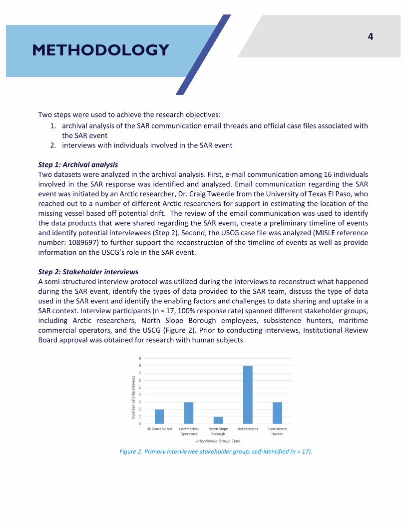
Step1:ArchivalanalysisTwodatasetswereanalyzedinthearchivalanalysis.First,e-mailcommunicationamong16individualsinvolved in theSARresponsewas identifiedandanalyzed.Email communication regarding theSAReventwasinitiatedbyanArcticresearcher,Dr.CraigTweediefromtheUniversityofTexasElPaso,whoreachedouttoanumberofdifferentArcticresearchersforsupportinestimatingthelocationofthemissingvesselbasedoffpotentialdrift.ThereviewoftheemailcommunicationwasusedtoidentifythedataproductsthatweresharedregardingtheSARevent,createapreliminarytimelineofeventsandidentifypotentialinterviewees(Step2).Second,theUSCGcasefilewasanalyzed(MISLEreferencenumber:1089697)tofurthersupportthereconstructionofthetimelineofeventsaswellasprovideinformationontheUSCG’sroleintheSARevent.Step2:StakeholderinterviewsAsemi-structuredinterviewprotocolwasutilizedduringtheinterviewstoreconstructwhathappenedduringtheSARevent, identifythetypesofdataprovidedtotheSARteam,discussthetypeofdatausedintheSAReventandidentifytheenablingfactorsandchallengestodatasharinganduptakeinaSARcontext.Interviewparticipants(n=17,100%responserate)spanneddifferentstakeholdergroups,including Arctic researchers, North Slope Borough employees, subsistence hunters, maritimecommercialoperators,andtheUSCG(Figure2).Priortoconductinginterviews, InstitutionalReviewBoardapprovalwasobtainedforresearchwithhumansubjects.
Figure2.Primaryintervieweestakeholdergroup,self-identified(n=17).
METHODOLOGY

5
SummarytimelineofSARincidentAnumberofpivotaleventstookplaceduringthisSARincident,eachplayingaroleinultimatelyfindingthemissingvessel(Figure3).Thevesselwentdeadinthewateraround2:30amonJuly19andthesearchbeganearlythenextmorningwhenthemissinggentlemandidnotshowupforwork.AteamoflocalSARwentouttothelastknownlocationareatobeginthesearch.TheUSCGwasnotifiedinthelateafternoonandtheydeployedanaerialsearchtohelpsearchforthemissingvessel.However,aheavy fog as well as some technical malfunctionsmade an aerial search challenging. In the earlyevening, Dr. Craig Tweedie, a university researcher from University of Texas El Paso who wasconducting research at the time inUtqiaġvik, sent out an email to other university, Arctic-focusedresearchersrequestingtheirhelpinestimatingthepotentialdriftofthemissingvesselbasedoffthepointof last known location. Shortly thereafter, themissingvesselwasable toget in contactwithanotherboatviaVHFradio,andwasabletoprovideanapproximatelocation.EstimatedlocationsfromtheuniversitycommunityweresentthroughouttheeveningandsharedwiththelocalSARteam.ThemissingvesselwasultimatelyfoundaroundmidnightonJuly20,whenare-fuelvesselfortheSARboatspassedthemissingvesselonitswaytothelocalSARteam.IdentifiedweatherandoceancurrentinformationforlocatingthemissingvesselAvarietyofinformation—traditionalandlocalknowledge,scientificinformation,andoperationalSARinformation—wasprovidedduringthiseventtoSARoperatorstohelplocatethemissingvessel(Table1).TraditionalknowledgeoflocalwindandoceanconditionshelpedidentifytheinitialsearchradiusforthevolunteerandNorthSlopeBoroughSAReffortthatbeganthemorningofJuly19.Informationfromwindy.com(awindandweatherforecastapplication)wasalsousedbythelocalSARteamtohelpdeterminewinddirection.Furthermore,informationfrommodelingtoolswereprovidedtothelocalSARteamoverthecourseoftheSARevent,oncethegroupofArcticresearcherswasnotifiedoftheincident.TheUSCGSearchandRescueOptimalPlanningSystem(SAROPS)wasalsousedtoplanUSCG’sSARresponsetoidentifyapotentialsearchareafortheUSCGaerialsearchcampaignthatwasdeployedaspartoftheSARevent.
FINDINGS
Figure3.SummaryofmaineventsduringJuly192017SARevent,asidentifiedfromarchivalandinterviewanalysis.

6
Figure4showstheplottedlocationestimatesprovidedbyHIMOAS,theChukchiSeaSurfaceCurrentHFRadar,andtheice-trackingdrifters.Eachofthesemodelsusedthepointoflastknownlocationtoestimatethepotentialdriftofthemissingvessel.Basedoffhowthecrowflies,theestimatesfromtheChukchiSeaSurfaceCurrentHFRadargroupwereinclosestproximity(23nauticalmiles)towherethemissingvesselwasretrieved.ThoughthesurfacevelocitydatafromtheHIOMASmodelwasonly24nauticalmiles fromwhere themissing vesselwas retrieved, the estimatewasmore southward incomparisontothedatafromtheChukchiSeaSurfaceCurrentHFRadargroup.Itisimportanttonotethattheinformationfromtheice-trackingdrifterwasprovidedlessasameanstolocatethemissingvesselbut rather togaugesurfacecurrentspeedandwinddirection, tohelpapproximate inwhichdirection, and how far (based off current speed), the missing vessel could have moved. Further,differences in the location estimates are due less to a lack ofmodel accuracy andmore onwhatvariablesamodelismodelling.However,takentogether,theyprovideapotentialsearchradius.
Table1.Weather-andseaice-relatedinformationgeneratedforJuly192017SAReffort.
FINDINGS (CONT.)

7
Figure4.PlotoflocationpredictionsprovidedbyuniversityresearchersduringSARevent,againstpointoflastknownlocationforthemissingvesselaswellasitsretrievallocation.
FINDINGS (CONT.)

8
ChallengesofdataaccessibilityandavailabilityinSARintheArcticDataavailabilityandaccessibilityarechallengesinandaroundUtqiaġvik.AlthoughthereisabreadthofpotentialdatasourcesthatcanbeappliedinaSARcontext,manysuchresourcesarenotknowntoSAR operators.Most of the university-developed tools identified in this study were created for aspecificpurposeotherthanSARandhadlittletonointeractionwiththeSARcommunitypriortothisevent.Additionally,potentiallyusefultoolsthatcouldbeappliedinaSARcontextoftenrequirepre-orpost-processinganalysistoadapttoolsforSARneeds,whichholdsimplicationsforhowquicklythesetoolscanbeappliedinSARcases.Dataavailabilityandaccessibilityare furthercomplicatedby limited Internetconnection,especiallywhenvesselsareoutinopenwater,wherethereislow/nobandwidth.Dataavailabilityisalsolimitedforfurtheroffshoreareas,particularlybeyondthescopeoftheidentifiedradarsandtrackersinthisstudy.Further,somein-waterdataproductsalsomaynotbeavailableinthewintertimewhenthereisice present and all data products can be subject to data outages due to weather and inclementconditions.RecommendationsAsingleresourceisnotlikelytomeettheneedsofallSARoperatorsinarapidlychangingArcticgiventhechallengesofdataavailability,internetconnectivity,anddiversedecisioncontextsandinformationneeds.However,accesstoasuiteofresources–includingtraditionalandlocalknowledge,scientificinformation,aswellasoperationalresources–canhelpovercomethesechallengesandcanpotentiallybetter serve SAR needs. In particular, leveraging different products to validate, interpolate, andextrapolate information against one another, can help create more comprehensive situationalawareness,especiallyforfurtheroffshoreSARevents.
Furthermore,amoretargetedandsystematicwaytoutilizeanddrawuponscientificresearchforSARoperationscanpotentiallysupportthelocalSARcommunity,especiallywhenimmediateinformationisnecessary.FutureSAReffortscanthereforepotentiallybenefitfromamorestreamlinedprocessofdatasharingandengagement, inorder tomaximize time.A“code-red”email listservcouldbeoneoptionaswellasreviewingandpreparingafewresourcestobe“SARready,”shouldtheyneedtobeutilizedinaSAReffort.DataproductswereusedinwaysthattheywerenotdesignedtoduringthisSAReffort.Yet,theywereadaptedtomeetthedemand.OptimizingsomeoftheseproductsforfutureusecouldbeahighlyapplicableandusefulcontributiontofurtherimprovingSARresponsesmovingforward.
DISCUSSION

9
PotentialnextstepsOvercomingchallengestodataavailabilityandaccessibilityforSARintheArcticalsorequiresabetterunderstandingofdecisioncontexts,suchashowtobestestimatedriftofmissingvessels in furtheroffshoreareas. Such informationprovides insight intohowexistingproductsmaybeoptimized forfuture SARapplications. This could alsopotentially bepartof abroader reviewofADAC tools andresources,regardingwhetherandhowtheycouldsupportfutureSARoperationsandneeds.Further,althoughtheanalysisofasingleSAReventrevealeddataaccessibilityandavailabilityarechallengesinutilizingdataproducts inaSARresponse,amorecomprehensiveanalysisofpastSARevents intheArcticwouldhelpproviderecommendationsregardinghowtoeffectively integratenon-operationaldataproductsintoaSARresponse.Forexample,analysisofUSCGD17SARrecordswouldhelpimproveourunderstandingofaSARresponse,whethertherehavebeenanychangestoSARdataneedsovertime,andhelptodocumentlessonslearnedandbestpracticesforapplicationinfutureSARresponses.
DISCUSSION (cont.)

10
ADAC 2018. Arctic Security and the Arctic Domain Awareness Center.Presented at theDoDArcticScienceandTechnologySynchronizationWorkshop.May16-18,2018.Hanover,NH.
Bridges, R. 2017. Risks and Damages Caused in Ice Navigation. In Encyclopedia of Maritime andOffshoreEngineering(edsJ.Carlton,P.JukesandY.S.Choo).
Eicken,H.etal.2018.SustainedObservationsofChangingArcticCoastalandMarineEnvironmentsandTheir Potential Contribution to Arctic Maritime Domain Awareness: A Case Study in NorthernAlaska.ARCTICv.71,n.5,p.1–15.
Kettle,N.etal.2018.DevelopingseaiceandweatherforecastingtoolstoimprovesituationalawarenessandcrisisresponseintheArctic.PresentedatADACCustomersandPartnersRoundtable.February22,2018.
U.S.CoastGuard.2015.“ArcticStrategyImplementationPlan.”Washington,D.C.
ThismaterialisbaseduponworksupportedbytheU.S.DepartmentofHomelandSecurityunderGrantAwardNumber,2014-ST-016-ML0002-04. It isalso supportedbyagrant fromtheNationalOceanicandAtmosphericAdministration(AlaskaCenterforClimateAssessmentandPolicy,AwardNA11OAR4310141).Theauthorwouldalsoliketothankalltheintervieweeswhoparticipatedandsupportedthisproject.Theviewsandconclusionscontainedinthisdocumentarethoseoftheauthorandshouldnotbeinterpretedasnecessarilyrepresentingtheofficialpolicies,eitherexpressedorimplied,oftheU.S.DepartmentofHomelandSecuritynortheNationalOceanicandAtmosphericOrganization.
REFERENCES