applications to be considered
TRANSCRIPT
Classification: OFFICIAL
Classification: OFFICIAL
PLANNING CONTROL COMMITTEE 26 May 2016
Report of the Director of Strategic Partnerships, Planning and Streetpride
ITEM 8
Applications to be Considered
SUMMARY
1.1 Attached at Appendix 1 are the applications requiring consideration by the Committee.
RECOMMENDATION
2.1 To determine the applications as set out in Appendix 1.
REASONS FOR RECOMMENDATION
3.1 The applications detailed in Appendix 1 require determination by the Committee under Part D of the Scheme of Delegations within the Council Constitution.
SUPPORTING INFORMATION
4.1 As detailed in Appendix 1, including the implications of the proposals, representations, consultations, summary of policies most relevant and officers recommendations.
OTHER OPTIONS CONSIDERED
5.1 To not consider the applications. This would mean that the Council is unable to determine these applications, which is not a viable option.
This report has been approved by the following officers:
Legal officer Financial officer Human Resources officer Estates/Property officer Service Director(s) Other(s) Ian Woodhead
For more information contact: Background papers: List of appendices:
Ian Woodhead Tel: 01332 642095 email: [email protected] None Appendix 1 – Development Control Monthly Report

Classification: OFFICIAL
Appendix 1Index
Planning Control Committee 26 May 2016
ItemNo.
PageNo.
ApplicationNo.
Address Proposal Recommendation
1 1 - 35 12/15/01520 Land north west ofMansfield Road,Breadsall Hilltop.
Residential development(up to 230 dwellings)and associated worksincluding means ofaccess.
A. To authorise theDirector of StrategyPartnerships, Planningand Streetpride tonegotiate the terms of aSection 106 Agreementto achieve theobjectives set out belowand to authorise theDirector of Governanceto enter into such anagreement.
B. To authorise theDirector of StrategyPartnerships, Planning
and Streetpride to grantoutline permissionupon conclusion of theabove Section 106Agreement.
2 36 - 67 12/14/01678 Land North of AllanAvenue/PritchettDrive, Littleover.
Erection of a maximumof 80 dwellings andassociated drainage andhighway infrastructure.
A. To authorise theDirector of StrategyPartnerships, Planningand Streetpride tonegotiate the terms of aSection 106 Agreementto achieve theobjectives set out belowand to authorise theDirector of Governanceto enter into such anagreement.
B. To authorise theDirector of StrategyPartnerships, Planning
and Streetpride to grant
outline permissionupon conclusion of theabove Section 106Agreement.
12/14/01677 Land North of AllanAvenue, PritchettDrive, Littleover.
Change of use to publicopen space
To grant planningpermission withconditions.
3 68 - 82 10/15/01277 19 Cornhill, Allestree. Erection of dwellinghouse.
To grant planningpermission withconditions.
10/15/01278 19 Cornhill, Allestree. Part demolition of frontboundary wall anderection of detacheddwelling house
To grant consentconditionally.
Classification: OFFICIAL

Classification: OFFICIAL
Appendix 1Index
Planning Control Committee 26 May 2016
ItemNo.
PageNo.
ApplicationNo.
Address Proposal Recommendation
4 83 - 94 06/15/00781 The Needles,Bembridge Drive,Alvaston.
Erection of a singlestorey conveniencestore with associatedcar parking,landscaping, accessarrangements and ATMMachine on landadjacent to the NeedlesPublic House.
To grant planningpermission withconditions.
5 95 - 99 03/16/00373 8 St. Brides Walk,Derby.
Formation of vehicularaccess
To grant planningpermission withconditions.
Classification: OFFICIAL

Classification: OFFICIAL
Committee Report Item No: 1
Application No: DER/12/15/01520 Type:
Classification: OFFICIAL
1
Outline (with means of access)
1. Application Details
Address: Land to the north of Mansfield Road, Breadsall Hill Top.
Ward: Oakwood
Proposal:
Residential development (up to 230 dwellings) and associated works including means of access.
Further Details:
Web-link to application: https://eplanning.derby.gov.uk/online-applications/plan/12/15/01520
Brief description: Outline permission is sought for residential development on a greenfield site on the north side of the city at Breadsall Hill Top and adjacent to Oakwood. The site comprises approximately 10 hectares of arable agricultural land north of Mansfield Road. It is an undulating site in an elevated position with steeply sided slopes to the north and west which affords long range views to the east and north towards Darley Abbey and the River Derwent. The land is bordered by hedgerow boundaries on the south and eastern edges. To the north and western boundary is the former railway cutting, the Great Northern Greenway footpath/ cycleway which is both a strategic cycle route and a local wildlife site. There is a steep woodland embankment alongside the route, known as Croft Wood. This woodland is covered by a Tree Preservation Order. The field to the west of the development site is a former landfill site, which has since ceased and is now in agricultural use.
The site lies on the edge of built up area of the city, with the suburban residential areas of Breadsall Hill Top and Oakwood to the south and east on either side of Mansfield Road. The city boundary with Erewash Borough runs along the northern perimeter of the development site, with the proposed drainage attenuation pond and pipe route located in the Erewash area. Breadsall village is situated to the north of the site at a lower level. To the east are the River Derwent floodplain and the A61 transport corridor, with the associated retail park and commercial premises.
The site is wholly within the Chaddesden/Derwent Industrial Area Green Wedge which penetrates the city from the north. It is adjacent to the Green Belt which is in the Erewash area and includes the location of the proposed drainage pond. The World Heritage Site and its Buffer Zone is located to the west of the transport corridor within the Derwent Valley, which provides distant views of the development site. There is also a SSSI along part of the former railway cutting to the east of Breadsall village, about 1km from the site.
The application seeks outline permission for up to 230 dwellings, with the formation of vehicular access onto Mansfield Road. Means of access is to be determined at this stage, with all other matters being reserved for a future application. A Parameters Plan has been provided to indicate the scale and form of development on the site. An Illustrative masterplan has also been submitted to demonstrate how such a

Classification: OFFICIAL
Committee Report Item No: 1
Application No: DER/12/15/01520 Type:
Classification: OFFICIAL
2
Outline (with means of access)
residential development could be laid out. Both of these plans are purely indicative of a development on the site and would not form part of the determination at this stage.
The proposal is to provide a mix of 1 to 5 bedroom apartments and houses on the site, with associated provision of open space and landscaped buffers along the southern boundary and alongside the woodland embankment. The submitted parameters plan indicates a scale of buildings up to 2.5 storeys in height, although building scale and form is a reserved matter
The principal access to the site, would take the form of a roundabout junction with Mansfield Road and Bishops Drive. This would involve some reconfiguration of the existing highway and the provision of new footways and a pedestrian crossing.
There is an existing public footpath through the eastern edge of the development site, which extends to Breadsall village. The proposal is to incorporate this route into the development and provide new footpath/ cycle routes to the Northern Greenway to the north of the site and to a potential open space/ country park to the west of the development.
A large surface water attenuation / balancing pond are proposed to manage surface water drainage for the development. It is proposed to be sited to the north of the development area and the pond along with the associated pipework would be located in Erewash borough. A duplicate planning application has been made to Erewash BC because the surface water drainage scheme is located in their area. This application is currently undetermined.
The parameters plan shows that most of the hedgerows and individual trees on the site are proposed to be retained as part of the scheme, except for the formation of a road and access layout. New tree and hedgerow planting is proposed for the development as part of a landscaping strategy for the areas of major open space around the edge of the site. The submitted documents also indicate that a landscaped amenity space could be provided on the (blue edged) agricultural land to the west of the development area, although this does not form part of the parameters proposals submitted in support of this application.
The outline application is accompanied by various supporting documents, which includes an Archaeological assessment and geo-physical surveys and Arboricultural survey, Design and Access statement, Drainage strategy, Ecological Appraisal, Flood Risk Assessment, Geological Assessment and Ground Testing Report, Heritage Impact Assessment, Landscape and Visual Appraisal, Transport Assessment and Addendum and Travel Plan.
2. Relevant Planning History:
ERE/1215/0040 – Outline application for residential development of up to 230 dwellings, associated infrastructure, open space and drainage attenuation pond, current application to Erewash BC (duplicate application for the same development proposal, with balancing pond in the Erewash area).

Classification: OFFICIAL
Committee Report Item No: 1
Application No: DER/12/15/01520 Type:
Classification: OFFICIAL
3
Outline (with means of access)
3. Publicity:
Neighbour Notification Letter – 3 letters
Site Notice
Statutory Press Advert
Prior to submission of the application the applicant undertook a public consultation exercise with the local community. This involved delivery of leaflet describing the proposals to various local stakeholders and Members and to local residents and businesses. A project web site for proposal was launched in October 2015. A consultation period of 24 days was given following distribution of the consultation leaflet.
This publicity is in accordance with statutory requirements and the requirements of the Council’s adopted Statement of Community Involvement.
4. Representations:
To date 46 representations have been received to the application, which includes objections from Amanda Solloway MP and Breadsall Parish Council. In addition Breadsall Parish Council made objections to Erewash BC in regard to the application for the proposed drainage pond. The main issues raised are as follows:
Loss of openness and farm land
Loss of views for residents on Mansfield Road
Loss of views of Derwent Valley Mills World Heritage Site
Loss of wildlife habitat
Insufficient school places to serve the development
Insufficient capacity in local doctors/ community facilities
Increase in traffic congestion on local road network
Traffic queues on Mansfield Road would be worsened
Impact on rights of way for local residents to access
A relief road to A61 is needed to accommodate the additional traffic from the development
Development would be out of keeping with character of the surrounding area
Increase in traffic would harm highway safety
Roundabout access proposal would not resolve traffic congestion on Mansfield Road
Loss of Green Wedge
Loss of amenity and privacy for nearby residents
Potential flood risk for properties on Breadsall Hill Top and Breadsall village
Potential loss of archaeological interest on the site

Classification: OFFICIAL
Committee Report Item No: 1
Application No: DER/12/15/01520 Type:
Classification: OFFICIAL
4
Outline (with means of access)
Not appropriate development site due to use for landfill of waste.
5. Consultations:
Highways Development Control: Walking – Manual for Streets says “Walkable neighbourhoods are typically characterised by having a range of facilities within 10mins (up to 800 m) walking distance of residential areas which residents may access comfortably on foot. Other guidance entitled ’Providing for Journeys on Foot’, says other than in town centres commuting and walking to school the distances should be between 500m (desirable) and 2000m (maximum) and for other walking journeys 400m to 1200m. The transport assessment sets out a range of local facilities which lie within 2km or approximately 25mins walking time of the above site.
Cycling – The site is well located to existing cycle routes, 6, 54 and 66, all providing access links to Derby City Centre and beyond. The site also benefits from the opportunity to access the National Cycle Network (NCN) Route 672 known as the Great Northern Greenway. Route 672 runs along the northern boundary of the site.
As part of the masterplan, the developer proposes two direct access routes to the Great Northern Greenway north of the development site. However, no more details have been submitted in terms of the standard of cycleway proposed. Further design/scheme details will required as part of a reserved matters submission.
Public Transport – the table below shows the current bus services passing the site on the A608. It is considered the site lies within a reasonable distance of the bus route.
Service Operating Days Frequency Route
59 Mon-Sat
0843 to 17:43 Hourly
Derby-Stanley Common-Ilkeston-
Shipley View
H1
Mon-Sat 06:52 to 23:12
Every 20 mins Derby-Heanor-
Alfreton Sun B/Hol 09:42 to 18:12
Every 20 mins
Y1
Mon-Sat 06:47 to 23:07
Every 20 mins Derby-Smalley- Heanor-
Ripley/Alfreton Sun B/Hol
09:27 to 17:57 Every 20 mins
Access to the site is proposed to be taken direct from Mansfield Road by means of a normal roundabout at the junction with Bishop’s Drive. Although a detailed layout has not yet been agreed, it seems clear that a suitable roundabout design can be achieved and the Highways Officers are working closely with the developer to arrive at an agreed layout.
NPPF recommends that the impact of the residual trips (i.e. the remaining car trips after travel by other modes has been taken into account) should be mitigated as long as it is affordable in the context of the value of the development.

Classification: OFFICIAL
Committee Report Item No: 1
Application No: DER/12/15/01520 Type:
Classification: OFFICIAL
5
Outline (with means of access)
The Government does not define ‘severe impact’, but in this context ‘severe’ can relate to congestion and definitely relates to safety. In cities where road space is limited and therefore so is capacity, the emphasis is now more about managing traffic flows and encouraging modal shift rather than trying to seek to continually increase network capacity. .
Traffic Modelling Traffic Generation – The predicted trip generation of any particular development is obtained from a national data base of traffic surveys called ‘TRICS’, which is the industry standard methodology. Transportation colleagues suggest the 230 dwellings proposed at the above site are likely to produce approximately 130 to 154 additional two-way trips in each peak hour (see Table 1 below).
Table 1 85th%ile Trip Rates
In Out Total
Am Trip Peak 0.171 0..422 0.593
Trips 39 97 129
Pm Trip Peak 0.412 0.257 0.669
Trips 95 59 154
Trip Distribution –Traffic Impact – The developer suggests that the split of trips at the access will be approximately 70% westbound towards Derby and 30% to the east. The east bound trips will split again at the A608/Brookside Road/Lime Lane junction with some of trips going through Breadsall, some towards Heanor and some along Lime Lane. The impact of trips going towards Breadsall and Heanor are a matter for Derbyshire County Council.
The trips heading towards Derby in the am peak will join an existing rolling queue which forms from the traffic signals into the Meteor Retail Park and which will extend through the proposed roundabout at times. The Meteor traffic signals effectively meter the traffic going into Derby some of which will pass through Chester Green and some will head for the A61. The routes south of the Meteor signals are already congested as are most routes into the City in the peak hour. However it is considered unlikely that the impact of the above development could be considered severe, and the actual impact is most likely to be peak spreading i.e. the am peak hour people choosing to travel earlier or later such that the peak traffic conditions last for longer.
Breadsall Parish Council wishes to see a Breadsall by-pass and feel it should link to the proposed roundabout and go through the above site to link to the A61. They also raised these points at the recent Core Strategy examination in public. In order to impose this on the above developer it would have to be demonstrated that the impact of this development would be so severe that a Breadsall by-pass would be required, or a Breadsall by-pass would need to have been safeguarded in the adopted Local Plan Review and/or through the emerging Core Strategy. The Council advised the Inspector at the Examination that there are no current proposals to build a link road between the A608 and the A61. Consequently it is considered that a link road could not be imposed on the developer through the application process.
The submitted Travel Plan is a sound basis and reference for the future development.
Classification: OFFICIAL
Committee Report Item No: 1
Application No: DER/12/15/01520 Type:
Classification: OFFICIAL
6
Outline (with means of access)
Highways Land Drainage: No objections to the proposal. In order that the development can be drained in a manner which does not negatively impact on existing the proposed houses and infrastructure, conditions are recommended to secure a suitable surface water drainage strategy in consultation with the Lead Local Flood Authority, which should include a sustainable drainage solution. Conditions are also recommended to secure a management and maintenance plan for the surface water drainage features and a layout to demonstrate that overland surface water flow paths across the site and public sewer outfalls can be accommodated safely through the development.
Natural Environment: Trees There are no Tree Preservation Orders (TPO) within the site and the site is also not within a Conservation Area. The north western corner of the site adjoins the former railway line, which is now the Great Northern Greenway and the eastern embankment of which, known as Croft Wood, is protected by TPO 17, a woodland order. The findings of the submitted Arboricultural Survey Report and Method Statement are noted and the submitted Illustrative Layout retains the vast majority of trees identified in this report. The only area of concern relates to tree 2 (mature ash) on the submitted Tree Survey Plan. This tree adjoins Public Footpath 17 to Breadsall and it is unclear if it is proposed that this tree be within the public footpath corridor, or within the curtilage of the adjoining properties. I would recommend that this tree, along with G3 and G4 on the Tree Survey Plan, which adjoin the footpath, be retained within a landscaped corridor containing the public footpath, rather than adjoining individual properties. Once a final layout has been decided on, an Arboricultural Impact Assessment should be undertaken to demonstrate that the trees being retained are not at risk from the implementation of the proposed development. As long as the advice given in the submitted Arboricultural Survey Report and Method Statement are followed then there is no further comment to make.
Rights of Way Public Footpath 17 runs from Mansfield Road, in a roughly northerly direction through to the village of Breadsall, outside the city boundary. It appears from the masterplan that the direct route of this public footpath is to remain unchanged, which is good for path users and avoids the need for a path diversion order. There are no other recorded public footpaths through the proposed housing site. It is noted on the submitted masterplan that connectivity to the Great Northern Greenway to the north west of the site would be enhanced with routes shown linking in to the Greenway to the north and west of the site. These routes are to be welcomed as they will enhance the path network in this area.
Environmental Services (Health – Pollution): The proposed development lies on land which includes an area that has been identified as being used for landfill/tipping. The site is also located adjacent to a large landfill site to the west. The site is therefore considered to be potentially contaminated.

Classification: OFFICIAL
Committee Report Item No: 1
Application No: DER/12/15/01520 Type:
Classification: OFFICIAL
7
Outline (with means of access)
A report has been submitted with the application which documents a trial pit and sampling exercise, consisting of a total of 19 shallow trial pits within a section of the site around the suspected historical landfill area.
The report is not intended to provide a detailed land contamination assessment in accordance with relevant guidance (namely CLR11) and has been used to indicatively ascertain the layout of the historical tipping area. The report acknowledges that additional investigation is necessary.
Should the development be granted permission, recommend that conditions be attached to secure a Phase I desk top study for land contamination and a Phase II site investigation, where potential contamination is identified. A condition to secure a remediation statement and validation report are also needed.
Given the scale of the development and its proximity to existing residential dwellings, I would recommend that the applicant prepares and submits a Construction Management Plan for the control of noise and dust throughout the demolition/construction phase of the Development.
The statement will need to provide detailed proposals for the control of dust and other air emissions from the site, having regard to relevant guidance, for example guidance produced by the Greater London Authority (GLA, 2006), or the Institute of Air Quality Management (IAQM, 2012). Noise management procedures should have regard to the guidelines described in BS5228, or other agreed guidance/standards.
A condition requiring the above should be included, for submission and approval before construction activities commence. The Plan should be complied with fully throughout the construction/demolition phase of the development.
Derbyshire County Council Archaeologist: Following the receipt of an archaeological assessment and geo-physical surveys of the site the comments made were as follows:
The geophysics has not picked up any obvious foci of archaeological potential, although there are a few scattered features across the site with a possible archaeological origin. The evidence for ridge and furrow seems likely to exclude the possibility of medieval settlement remains. With regard to the Roman road alignment there is still a potential for more ephemeral remains to survive at depth or otherwise undetected by the survey, though it seems unlikely that substantial remains are present.
There is consequently a requirement for some limited trial trenching to validate the survey, characterise the few archaeological ‘possibles’ and to test possible alignments of the Roman road for features undetected by geophysics. I recommend that this is best achieved through a post-consent scheme of work secured by planning conditions, in line with NPPF para 141.
Environment Agency: No comments.
Derbyshire Wildlife Trust: The site is adjacent to a Local Wildlife Site on the former railway cutting and Croft Wood, Regionally Important Geological Site.

Classification: OFFICIAL
Committee Report Item No: 1
Application No: DER/12/15/01520 Type:
Classification: OFFICIAL
8
Outline (with means of access)
The Ecological Appraisal is acceptable with regard to its survey and presentation. It was carried out during the optimal survey season in line with best practice.
The survey identified the majority of the site to be on low ecological value due to the arable nature of the site. However, four hedgerows (H1-H4), two ponds and dry ditch, tall ruderal vegetation, scattered scrub and scattered trees were present offered higher value. Croft wood was present on the western boundary but is outside the proposed development. Invasive plant species were present on site including Himalayan Balsam and horsetail. Japanese knotweed was noted in the wider area, but outside the 7m buffer of the site.
All hedgerows are UK Biodiversity Action Plan Priority Habitats. Veteran trees are present on site and adjacent to the site, the majority situated within the hedgerow. The proposals include the retention of the trees.
The protected species assessment included scoping of the site and found the site to be suitable for great crested newts (GCN), (with two ponds on site), foraging and commuting bats (although trees were identified for roosting potential, these are proposed not be affected by the works), disused badger setts (four setts identified on site), and nesting birds.
The ecology report has recommended further GCN surveys to establish whether or not this species is present or not.
No reptiles were identified during the survey effort and no further consideration to reptiles is given. If, in the unlikely event, reptiles are found works should cease and the advice of a suitably qualified ecologist should be sought.
The bat tree assessment includes assessment of trees to be retained and no further surveys are recommended. Detailed external lighting strategy will be required to mitigate for foraging and commuting bats.
Disused badger setts were identified on site, however, these animal are highly mobile and create and/or re-use setts at any time. As detailed in the report further surveys are required to assess the sites full potential for badgers.
Nesting birds could potentially use the hedgerows and trees, however, ground nesting birds in the arable field have not been identified. In addition, we would advise that ground nesting species such as grey-legged partridge and skylark could breed on the application site in other years depending on crop rotations and management.
Conclusions and recommendations The local planning authority in implementing their duty under section 40 of the NERC Act needs to have regard to the conservation of biodiversity in England when carrying out their normal functions with priority species requiring specific consideration and paragraph 117 of the National Planning Policy Framework seeks to promote the protection and recovery of priority species populations.
We welcome the production of a Habitat Management Plan for the scheme but advice that the contents should be revised once the issues raised with regard to hedgerow loss, ground nesting birds and badger, great crested newt have been fully considered and addressed. It is also essential that the Plan provides details of how

Classification: OFFICIAL
Committee Report Item No: 1
Application No: DER/12/15/01520 Type:
Classification: OFFICIAL
9
Outline (with means of access)
the favourable management of the habitats present on the site will be implemented and funded.
In conclusion:
All retained hedgerows and trees should be protected, to their root zones with temporary high visibility fencing to ensure their protection during construction.
The northern section of the site indicates a buffer between the development and offsite woodland and confirmation on the distance is required between the LWS/RIGS and the site.
The proposal indicates an open water attenuation SuDS feature and ditch network on the northern boundary of the proposal. We welcome such features and acknowledge that the position of the SuDS basin is dictated by the topography of the site. We would recommend that the design and planting specification of these open water features is conditioned on the outline application in order that it is submitted at RM stage.
The Site sits adjacent to the ‘Green Wedge’ and appropriate weight should be given to this designation and the Local Wildlife Site when determining the application.
The Authority should be satisfied that the areas of buffering, landscape/biodiversity enhancement and attenuation features can be secured and adequately resourced within any future Reserved Matters application and through to the implementation of the scheme should it receive permission.
Outstanding surveys regarding ground nesting birds and great crested newts need to be completed. Additional work and adjustments to the scheme may be required depending on the nature of activity and these may not be able to be addressed by conditions.
No removal of scrub, including stands of bramble or trees, during the bird breeding season (March – August inclusive) unless it can be demonstrated by a suitably qualified individual that no breeding birds are present. Any evidence should be submitted in writing to the LPA.
The mature tree identified as supporting potential high bat roost should be identified on plan and should be conditioned for further assessment at Reserved Matters stage to ensure that it is retained and if requiring work is treated appropriately to safeguard any bat interest.
Natural England: The site is in close proximity to the Breadsall Railway Cutting SSSI. Subject to the proposed development being carried out in strict accordance with the details in the application, it will not damage or destroy the interest features for which the site has been notified. The SSSI does not therefore represent a constraint in determining the application.
The Authority is expected to consider and assess other possible impacts on the following when determining the application:
Classification: OFFICIAL
Committee Report Item No: 1
Application No: DER/12/15/01520 Type:
Classification: OFFICIAL
10
Outline (with means of access)
Local biodiversity sites
Local landscape character
Local or national biodiversity priority habitats and species.
Police Liaison Officer: No objections to the principle of residential development on this site.
Derbyshire County (Flood Risk Management Team): No objection in principle. Whilst the development is located within the Derby City boundary, the proposed surface water drainage strategy is to attenuate and outfall within Derbyshire County’s area. The supplied Flood Risk Assessment (FRA) explains that all of the proposed development will drain to the proposed attenuation basin and outfall along a newly created watercourse through third party land; this will connect to the wider River Derwent catchment.
This strategy raises a number of concerns as the FRA indicates that the proposed development spans two catchments yet both will utilise the proposed attenuation basin leading to additional flow into the northern catchment off site.
The FRA advises that the site as a whole discharges from the attenuation basin at a greenfield rate based on the whole site area. However, to ensure no additional flow into the northern catchment, the whole site should drain at the greenfield rate for the northern catchment of the site alone. If this is not practicable then the Local Planning Authority (LPA) may wish to seek some demonstration that the increased flows to the northern catchment will not increase the flood risk outside the development.
The FRA makes reference to the attenuation basin being managed by an external company yet it is not clear who will be responsible for the future maintenance of the new watercourse created to drain the pond. The LPA may wish to request some demonstration of the future maintenance liability of the proposed new watercourse.
The County Council do not adopt any private SuDS schemes. As such, it should be confirmed prior to commencement of works which organisation will be responsible for SuDS maintenance once the development is completed.
Any works in or nearby to an ordinary watercourse require consent under the Land Drainage Act (1991) from the County Council (e.g. an outfall that encroaches into the profile of the watercourse, etc) to make an application for any works please contact [email protected].
The Local Planning Authority should be mindful to obtain all the relevant information pertaining to the proposed discharge in land that is not within the control of the applicant, which is fundamental to allow the drainage of the proposed development site.
The applicant should ensure there is a sufficient buffer strip in place which will allow for efficient maintenance to take place. We would recommend an easement of approximately 3 metres if the swale is less than 2 metres in width and 4.5m for swales over 2m in width. Whilst this is not stipulated within any legal byelaw, the Council would recommend these distances in order to safeguard access for essential maintenance and inspection purposes.

Classification: OFFICIAL
Committee Report Item No: 1
Application No: DER/12/15/01520 Type:
Classification: OFFICIAL
11
Outline (with means of access)
The applicant should demonstrate, to the satisfaction of the LPA, the appropriate level of treatment stages from the resultant surface water in line with Table 3.3 of the CIRIA SuDS Manual C697. This type of development usually requires >2 treatment stages before outfall into surface water body/system which may help towards attainment of the downstream receiving watercourse’s Water Framework Directive good ecological status.
Erewash BC: No comments received to date. However, the Authority is currently dealing with a duplicate application for the development, due to the siting of the proposed drainage pond and outfall pipework in the borough.
6. Relevant Policies: Saved CDLPR policies
GD1 GD2 GD3 GD4 GD5 GD7 GD8 H11 H12 H13 E2 E4 E5 E7 E9 E10 E13 E16 E17 E21 E23 E29 L2 L3 T1 T4 T6 T7 T8 T14
Social Inclusion Protection of the Environment Flood Protection Design and the Urban Environment Amenity Comprehensive Development Infrastructure Affordable Housing Lifetime Homes Residential Development – general criteria Green Wedge Nature Conservation Biodiversity Protection of Habitat Trees Renewable Energy Contaminated Land Development close to important open land Landscaping schemes Archaeology Design World Heritage Site Public Open Space Standards Public Open Space requirements in new development Transport Implications Access, parking and servicing Provision for pedestrians Provision for cyclists Provision for public transport Public rights of way
T15 Protection of footpath, cycleways and routes for horse riders
The above is a list of the main policies that are relevant. Members should refer to their copy of the CDLPR for the full version or access the web-link.
http://www.cartogold.co.uk/DerbyLocalPlan/text/00cont.htm
Classification: OFFICIAL
Committee Report Item No: 1
Application No: DER/12/15/01520 Type:
Classification: OFFICIAL
12
Outline (with means of access)
Over-arching central government guidance in the NPPF is a material consideration and supersedes earlier guidance outlined in various planning policy guidance notes and planning policy statements.
7. Officer Opinion:
Key Issues:
In this case the following issues are considered to be the main material considerations which are dealt with in detail in this section.
Policy Context
Green Wedge and Green Belt
Traffic Implications and Access
Visual Impact and Amenity
Other Environmental Impacts
Section 106
Policy Context This is an outline application for residential development on a greenfield site, which covers approximately 10 hectares, with around 7 hectares of developable area. The site lies in a prominent position to the west of Mansfield Road on an elevated area of Breadsall Hill Top. The site lies adjacent to the residential areas of Breadsall Hill Top and Oakwood, on the edge of the built up area of the city.
The site is within the Derwent Valley Green Wedge, which is defined under Policy E2 of the adopted Local Plan Review. It also lies adjacent to Green Belt, which is to the north and east in Erewash borough. The proposed surface water attenuation pond and pipework are located in the Green Belt, just outside the city boundary.
A former railway cutting to the north and west of the site is a designated Local Wildlife Site, under Policy E4(15) and footpath/cycle route known as the Northern Greenway, Policy T15(11). Within the cutting, Croft Wood is covered by a woodland Tree Preservation Order and the wood abuts the western boundary of the application site.
The farmland to the south and west of the site is a former landfill site, which is thought to contain building waste.
A significant factor in determining this application is the amount of weight which can be given to the various local and national planning policy considerations. These include the National Planning Policy Framework, the adopted City of Derby Local Plan Review (CDLPR), the City Council’s Core Strategy and the Council’s five year housing land supply position.
National Planning Policy Framework The National Planning Policy Framework (NPPF) was published in March 2012 and has made significant changes to government guidance on planning decision making which are very relevant in the case of this application.

Classification: OFFICIAL
Committee Report Item No: 1
Application No: DER/12/15/01520 Type:
Classification: OFFICIAL
13
Outline (with means of access)
The golden thread which runs through the NPPF (paragraph 14) is a “presumption in favour of sustainable development”. Paragraph 47 also sets out the Government’s objective to “boost significantly the supply of housing”. Both of these objectives are clearly relevant in determining the application.
In terms of decision taking the “presumption” is defined as:
approving development proposals that accord with the development plan without delay; and
where the development plan is absent, silent or relevant policies are out of date, granting permission unless:
a) any adverse impacts of doing so would significantly and demonstrably outweigh the benefits, when assessed against the policies in this Framework taken as a whole; or
b) specific policies in this Framework indicate development should be restricted.
It is important to remember that the NPPF provides a policy framework for a whole range of planning related issues and not just housing. The thread of ‘Sustainable Development’ is embedded in these policies and is therefore probably the most important factor in decision making.
A further key issue for this application resulting from the NPPF is set out in paragraph 49. This sets out a requirement for local authorities to maintain a supply of deliverable housing sites to meet needs for at least 5 years. It states that relevant policies for the supply of housing should not be considered up-to-date if the local planning authority cannot demonstrate a five-year supply of deliverable housing sites. It is important to note that in such cases, only policies relevant to the supply of housing are considered out of date. Policies other than those related to housing supply will still be relevant.
The NPPF therefore requires that local authorities identify and maintain enough deliverable housing sites for 5 years. The definition of ‘deliverable’ means that they are in a suitable location for housing, that the land is available for development and that development would be economically viable.
It is considered that the non-housing saved policies of the CDLPR have a high level of consistency with the NPPF and should, therefore, continue to be the starting point for all decisions and given a significant amount of weight in this and any other application. However, the adopted housing supply policies are now out-of–date.
Housing Land Supply Currently, the City Council cannot demonstrate a 5 year supply of deliverable housing sites and is seeking to identify its housing needs and meet them through the Core Strategy process. Until the Core Strategy is formally adopted some of the sites identified in the plan cannot be counted in the five year supply.
This lack of deliverable sites is not necessarily down to the availability of land. It is also influenced by the fact that it is not currently viable for developers to build on certain housing sites because of economic and market conditions. However, as mentioned above, in the event that an authority cannot demonstrate a five year

Classification: OFFICIAL
Committee Report Item No: 1
Application No: DER/12/15/01520 Type:
Classification: OFFICIAL
14
Outline (with means of access)
supply of housing sites, the NPPF states that it should grant permission for the development unless the adverse impacts of the proposal would significantly and demonstrably outweigh the benefits or specific policies in the Framework indicate that development should be restricted.
The site is included in the Council’s Strategic Housing Land Availability Assessment (SHLAA), which identifies sites that might provide new housing and assesses their suitability, availability and viability to deliver new homes now or in the future. It should be noted that the area shown in the SHLAA which includes the application site is substantially larger than the site now being considered for residential development; extending further south and east, following the boundaries of properties on Elmwood Drive and Croft Wood.
Derby City Local Plan – Part 1: Core Strategy The City’s Core Strategy was submitted to the Secretary of State in December 2015, following an extensive public consultation process and approval by Full Council. The hearings to determine if the Core Strategy is sound and legal have now taken place, over a two week period ending on 5 May. A further hearing will be held after the Inspector has considered further evidence in relation to the five year supply. Only after this hearing will a further consultation take place on main modifications arising from the hearings and following recommendations by the Inspector. Adoption is anticipated to be before the end of 2016.
Now that the Core Strategy has reached this stage, it can be given weight in decision making according to the stage of preparation of the Plan, the extent of any unresolved objections to relevant policies and the degree of consistency of the policies of the emerging plan with the NPPF.
The Core Strategy is considered to be highly consistent with the NPPF and can be given substantial weight in the determination of the application. However, there are outstanding objections to specific housing supply policies and the Green Wedge policy and therefore the weight that can be given to these policies is still relatively limited.
The Preferred Growth Strategy, published in 2012, identified the application site as a potential housing site to meet the city’s need for housing. However, there was not sufficient certainty at the publication of the draft Part 1 Core Strategy in 2013 that the site would be deliverable and viable for residential development, due to factors such as land contamination, flood risk and the potential visual impact of the development on the Green Wedge. The site is therefore still identified in Policy CP18 of the Part 1: Pre-Submission Core Strategy as Green Wedge.
That said, the site has been identified as one which could in principle, come forward for development. The Part 2 Local Plan will need to identify additional sites for housing to meet our target, some of which will inevitably be currently within Green Wedge designations. A great deal of work has been undertaken on this site since the 2012 Preferred Growth Strategy and the issues that prevented inclusion in the Part 1 Plan have been addressed by the current application. It is extremely likely that this site, for which the principle for housing development has already been accepted, will need to be identified for housing. The Green Wedge designation therefore needs to be carefully balanced against these issues. Release of this site would not create a
Classification: OFFICIAL
Committee Report Item No: 1
Application No: DER/12/15/01520 Type:
Classification: OFFICIAL
15
Outline (with means of access)
precedent for releasing other Green Wedge land where the principle has not previously been flagged up through the local plan process.
Policy CP18 is an evolution of the adopted policy E2 and seeks to strengthen the key role and function of Green Wedges set out in Policy E2 but also updates the policy to reflect other key spatial priorities Green Wedges can assist in achieving, such as helping to create a city wide network of Green Infrastructure, providing opportunities for recreation, spaces for ecology and agriculture; and playing an important role in adapting to and mitigating the impacts of climate change.
The evidence base which supports the Strategy is also a material consideration and has been used in the determination of other recent planning applications. This evidence includes a Green Wedge Review, an assessment of housing needs and the SHLAA amongst other things. The Green Wedge Review has been accorded weight by Planning Inspectors at recent housing appeals, including the recent decisions for housing at Acorn Way and Brook Farm, which related to land in Green Wedges. The Review is therefore a relevant consideration in the determination of this application. The Green Wedge Review and its relevance to the application are discussed in more detail below. It can be considered that, subject to any amendments being made following the examination, this is the plan which the Council considers to be both sound and legal and based on up-to-date and robust information.
Green Wedge Review The Green Wedge Review (GWR) was published in 2012 to support the emerging Core Strategy. The purpose of the review was to determine the role and function of all of the thirteen wedges in the city and to assess whether there was any opportunity to change their boundaries to accommodate new housing development.
The Chaddesden/Derwent Industrial Area Green Wedge covers this site. In this location the GWR recognises that the wedge helps to define the edge of River Derwent, provides an amenity buffer between the residential neighbourhoods and the commercial corridor along Sir Frank Whittle Road. To a lesser extent it helps to separate the built form of the city and Breadsall Village to the north.
In assessing the potential impact development could have on the wedge, the GWR began by considering the area promoted in the SHLAA. Paragraph 18.21 of the Review recognises that there may be some potential for new residential development on the eastern section of the wedge “as it is partially screened by the mature tree line which runs alongside the former railway track and is less visually prominent than other parts of the site, particularly from the west. This part of the site is also screened from the north by the topography of the land, which would help to limit the impact of new development on the Green Belt to the north”.
However, the GWR raised concerns over the extent of development and the impact it would have on the form and function of the wedge. Paragraph 18.22 ended by recognising that any development in this area would narrow the wedge and impact upon its openness and undeveloped character.
The GWR concludes in paragraph 18.26 by stating “There may be potential scope to release some land within the eastern side of the site, without undermining the principle of the Green Wedge. If development could be limited to the eastern side of

Classification: OFFICIAL
Committee Report Item No: 1
Application No: DER/12/15/01520 Type:
Classification: OFFICIAL
16
Outline (with means of access)
the site it may overcome some of the major concerns, although there would clearly still be narrowing of the GW and potential visual impact. Development would need to be set back from the ridge line and a new boundary would need to be created”.
The Illustrative Masterplan and Parameters Plan submitted in support of the outline application have taken account of the assessment given in the GWR and indicated development in the eastern area of Wedge, with the western and northern boundaries of the site given over to open space and landscape planting to create a buffer with the rest of the Wedge and the Green Belt to the north. It should be noted however, that the development area is proposed to extend further east towards the Green Belt than is suggested in the GWR. It is worth noting that the Core Strategy still seeks to safeguard and enhance the Green Wedge, even where development is permitted in the Wedge. Paragraph 5.18.3 of the Strategy states that “ where development does occur the Council will ensure that the principle of the Green Wedge will not be adversely affected. In addition, the Council expects that development will provide improvements to part, or all, of the Green Wedge”.
Whilst the findings of the GWR did not lead to the site being released for housing in the Core Strategy, the Review did identify scope for residential development to take place in a specific area, in order to maintain the principle and function of the Wedge in this location. The proposal as submitted broadly accords with the recommendations in the Review and this is a material consideration in the determination of the application.
Saved City of Derby Local Plan Review policies Policy H13 relates to the general criteria by which to assess residential development proposals. The policy seeks to ensure that a satisfactory form of development is provided, which safeguards residential amenities and forms high quality living environment, achieves appropriate housing densities and interesting urban forms and townscape design.
The submitted Illustrative Masterplan demonstrates that the application site could accommodate an interesting townscape and residential layout, which complements and reflects the existing forms of housing in the surrounding area. The number of units proposed is a maximum but a suitable density and scale of development would be negotiated and secured as part of a reserved matters scheme for the site. A 2.5 storey height limit is indicated in the submission and this would be in line with the ambient heights of development in the local area. A high quality urban design and layout could be achieved within the site, which would be in line with H13.
Policy H11 requires affordable housing to be provided for the scale of this development, to meet a housing need in the local area. The proposal is intended to provide up to 30% affordable housing within the development, which would include a 10% proportion of Starter Homes, under the government’s scheme to provide discounted housing to promote home ownership. The remainder of the units are proposed to be rented and shared ownership. The affordable housing element is agreed in principle with the applicant and this is to be secured via the Section 106 Agreement. The form and layout of the affordable accommodation would be submitted under a reserved matters application.

Classification: OFFICIAL
Committee Report Item No: 1
Application No: DER/12/15/01520 Type:
Classification: OFFICIAL
17
Outline (with means of access)
The General Development policies, GD1, GD2, GD3, GD4 and GD5 relate to issues including protection of the environment, flood protection, urban design and amenity. In order to be acceptable the form, scale and layout of the development should seek to satisfy these policies.
Summary of Policy Considerations The proposal would be contrary to specific saved policies of the adopted CDLPR, including Policy E2.
However, the principal of development in this location was accepted in the Core Strategy consultation document “Preferred Growth Strategy” of 2012 when it was shown as a “star site”. Additional land will need to be allocated in the Part 2 plan to meet our housing targets, including further releases within the Green Wedge. This site is likely to be a strong candidate for allocation given the acceptance of housing development in principle.
Furthermore, the Council cannot currently demonstrate a five year supply of deliverable housing sites as required by the NPPF. The NPPF therefore requires that planning permission should be granted unless any adverse impacts of doing so would significantly and demonstrably outweigh the benefits, when assessed against the policies of the NPPF as a whole or if specific policies in the framework indicate that development should be restricted. The absence of a five year supply in the city does not mean that the impact on the Green Wedge cannot be carefully considered.
The Core Strategy continues to identify the site as Green Wedge under Policy CP18 and it cannot be assumed necessarily that the need for housing should override the protection of the Green Wedge. Whilst the proposed residential development is contrary to both adopted and emerging Green Wedge policies, the NPPF requires Local Authorities to assess whether there are other material considerations, which must be taken account in the planning balance, to weigh up the adverse impacts of the development, including loss of Green Wedge, against any benefits of the proposal, which may mean that permission should be granted.
In assessing the level of weight which can be given to Green Wedge, Policy E2, in regard to this residential proposal, it must be clarified whether policy is relevant to the supply of housing. The Court of Appeal recently made a judgement on this issue in March 2016 in Cheshire East Borough Council v Secretary of State for Communities and Local Government and Richborough Estates. The Court considered that policies for the protection of landscape and the countryside, including Green Wedges, by their nature restrict development and therefore serve to constrain the supply of housing. Applying this judgement means that under paragraph 49 of the NPPF related to the supply of housing, Green Wedges would fall into the definition of “relevant policies for the supply of housing” and can therefore be considered to be not up to date, since the Council cannot demonstrate a five year supply of housing sites. However, this does not mean that Policy E2 and the principle of Green Wedges cannot still carry significant weight in the decision making process.
Green Wedge and Green Belt Green Wedge The site is identified in the adopted City of Derby Local Plan Review (CDLPR) as Green Wedge under Policy E2. It forms part of a relatively narrow area of Green
Classification: OFFICIAL
Committee Report Item No: 1
Application No: DER/12/15/01520 Type:
Classification: OFFICIAL
18
Outline (with means of access)
Wedge which penetrates into the city from the north, between the A61 corridor and commercial area and Chaddesden/ Derwent residential areas. Policy E2 seeks to maintain the openness and undeveloped character of the Green Wedge. Under this policy, development would only be appropriate in very restricted circumstances and the proposed housing development would not appropriate in this location. The proposal is therefore contrary to the policy. The development would result in the loss of part of Green Wedge which extends into the city from the north and lead to a narrowing of the remaining Wedge at the northern edge of the city.
Policy E2 can still be afforded substantial weight even though the Council does not have a five year supply of deliverable housing sites. The court judgement described above has relevance and means that Policy E2 is now deemed to be a housing supply policy, although the amount of weight does depend on the circumstances of the site, the extent of the five year housing supply shortfall, the action being taken to address the shortfall and the purpose of the restrictive policy. The judgement confirms that the weight that can be given to out of date policies remains a matter for the decision maker. The Acorn Way appeal decision gave considerable weight to the Council’s Green Wedge policy. The Inspector considered “that Derby’s green wedges serve an important planning function in maintaining the different character and identity of the suburbs and enhancing the urban form and structure of the city”. In relation to the adopted and emerging Green Wedge policies he stated they “are potentially consistent with elements of the core principles and a raft of the advice set out in the Framework.” The policies are therefore considered relevant to the determination of the current application for housing in the Green Wedge.
The Green Wedge Review in relation to this part of the Green Wedge identified that there is potential for part of this northern area of the Wedge to be developed for housing, with specific limits on the extent of the developable area. There would be some narrowing of the Wedge in this location and there is some concern in relation to the visual impact of any development from the Derwent valley to the west. However, it is accepted that the indicative parameters plan and illustrative layout show that the development would be confined to the eastern edge of the Wedge. Due to the topography of the site and its surroundings, most of the housing is identified for the less prominent area of the site over the brow of the ridge, which has a north and eastern aspect. The more elevated and prominent part of the site to the southern boundary is proposed to be allocated for major open space and landscape planting, which would help to screen the built form and enhance the character of the retained Green Wedge.
The site has been identified for housing development in 2012, in the Preferred Growth Strategy, which was the precursor to the Part 1: Core Strategy. Whilst it was not allocated for housing in the Strategy, the site is being considered as part of the preparation of the Part 2 Core Strategy, which will follow the adoption of the Part 1 Strategy.
The absence of a five year supply of deliverable housing sites is also a material consideration in assessing whether the principle of housing on this site is appropriate. The Council has considered a number of applications for housing in Green Wedges in the recent past. In each case, the impact of development on the role, function and

Classification: OFFICIAL
Committee Report Item No: 1
Application No: DER/12/15/01520 Type:
Classification: OFFICIAL
19
Outline (with means of access)
character of the Wedge has been carefully considered and balanced against the benefits provided by the housing proposed. This approach has been endorsed in a number of appeal decisions, including the Acorn Way and Brook Farm decisions. The evidence base, which includes the Green Wedge Review, prepared for the Core Strategy is material here and it is worth noting that the proposal would contribute towards the city’s housing need and assist in meeting the Council’s five year housing supply. The proposed housing in this part of the Green Wedge would limit the narrowing of the Wedge in this location and retain openness and undeveloped character of the more prominent and elevated landscape, to the west of the development site. Subject to a strong landscaped boundary being formed on the south western boundary with the retained Wedge, then the function of the Green Wedge in this area would be preserved. The loss of open countryside in this location it could then be argued would be outweighed by the benefits resulting from the provision of housing land to meet the city’s five year supply of deliverable housing sites.
Green Belt The development site crosses the boundary with Erewash borough and the land in Erewash is in the Green Belt. The surface water attenuation pond and associated pipework is to be sited in Erewash borough and therefore within the Green Belt, whilst the housing development is to be wholly located in the city. Erewash Borough Council is currently dealing with a duplicate outline application for the development and specifically the drainage features, which are under their jurisdiction. Policy E16 which relates to development near to important open land, considers the potential impact of any proposed development on views from the Green Belt. The policy requires adequate landscaping to be provided to ensure that the visual amenities and character of Green Belt and Green Wedge are safeguarded.
The topography of the site is elevated when viewed from the Green Belt to the east and north of the site. The drainage pond would be a large feature located just inside the Green Belt, although this would be an open water feature and makes use of a natural dip in the landscape alongside the railway cutting. The pond is an appropriate form of development within the Green Belt and would help to soften the visual impact of the development from the Green Belt. It would be a landscaped feature with planting and the illustrative masterplan indicates an area of open space and landscape buffer along the northern boundary fronting the Green Belt. The proposed planting and open space do suggest that the edges of the development would reduce the potential impact on the Green Belt and the wider landscape to the east of the site. The development would be largely screened from the north by the woodland alongside the Northern Greenway, which is on a steep slope which falls away to the north down to Breadsall Village. Views of Breadsall from the site are obscured by the belt of trees and the sloping nature of the landscape in this area. Hedgerow features and trees around the perimeter of the site, particularly to the north and eastern boundaries are shown for retention and these also contribute to screening and the setting of the development when viewed from the Green Belt.
The application is supported by a Landscape Appraisal, which identifies the key visual impacts of the development from the Green Belt to the north and the wider landscape, particularly from the Derwent Valley to the west. It proposes a strategy for

Classification: OFFICIAL
Committee Report Item No: 1
Application No: DER/12/15/01520 Type:
Classification: OFFICIAL
20
Outline (with means of access)
retention of trees and hedgerows within the site and provision of new open spaces which link with the wider rural setting to integrate the development into the surrounding landscape. The landscape proposals also indicate the provision of green space and introduction of tree planting to the west of the development site to enhance the setting of the Wedge and the development edge. Whilst these works are shown in an area that is outside the application site, they are within blue edged land, which is land within the applicant’s control and so can be secured by means of conditions. These planting proposals for the western edge of the development would assist in addressing some of the concerns raised in the Green Wedge Review, in relation to the visual impact and prominence of any development from the west due to the open aspect of the land. This would give a stronger landscaped edge to the development and help to screen views of the built form on the skyline, which was one of the Reviews conclusions in relation to this site. The landscaping proposals also represents an opportunity to enhance the setting and undeveloped character of the Wedge, which would provide some mitigation for the loss of the eastern part of the Wedge.
The masterplan proposals are indicative at this stage, but they do demonstrate that landscaping buffers can be introduced to soften the edges of the built development and protect the character and openness of the adjacent Green Belt and Green Wedge in line with the requirements of Policy E16.
Traffic Implications and Access Means of access to serve the proposed residential development as part of this outline application would be in the form of a single principal access onto Mansfield Road (A608). Access is to be determined as part of the outline submission and is therefore an important consideration to be assessed at this stage. Mansfield Road (A608) is a main route into the city from the north and forms the south western boundary of the site. There is an existing priority junction with Bishops Drive, which lies opposite the site and is one the principal routes into Oakwood. The proposed access would take the form of a roundabout junction with Mansfield Road and Bishops Drive. It would involve some reconfiguration of the highway at the junction and some areas of the highway would be given over to footway and landscape planting. As part of the roundabout design, additional pedestrian crossing facilities are proposed across Mansfield Road which would improve pedestrian linkages with the development site. Improved pedestrian and cycle connections are also proposed from the development to the existing Toucan Crossing over Mansfield Road.
The proposed roundabout access arrangement is considered to be an acceptable means of access to serve the development, in terms of its general layout and siting. The Highways Officer has negotiated amendments to the design and layout of the roundabout junction, during the course of the application, to achieve a junction arrangement which meets the required highway design specifications and to ensure that a safe and suitable access is provided to serve the development. The final design and layout of the roundabout has yet to be agreed with the Council’s Highways team, although it is anticipated that it will be finalised by the time of the committee meeting.

Classification: OFFICIAL
Committee Report Item No: 1
Application No: DER/12/15/01520 Type:
Classification: OFFICIAL
21
Outline (with means of access)
Members will be updated on the agreed position with regard to the roundabout design at the meeting. The issues still to be resolved are related to vehicle tracking movements around the roundabout and surface markings/features within the carriageway to safeguard pedestrians. The agreement of these details could be satisfactorily dealt with by a planning condition, which is included in Section 8, unless they are agreed before the meeting.
A Transport Assessment and Travel Plan were submitted in support of the application to assess the traffic impacts of the development, on the local road network and on the Mansfield Road junctions in particular. A further Addendum to the Assessment was provided in response to comments made by the Council’s Transport Planning Officer.
The results of the traffic assessments demonstrate that the majority of the trips are predicted to be bound for Derby, with approximately 30% heading out of the city towards the north and east. Some of these are likely to route into Breadsall, rat running through the village. Despite concerns from local residents, about traffic generation, the assessment shows to the satisfaction of the Highways Officer, that the traffic impacts of the development would not result in significant adverse effects on the local road network within the city or on the wider network, including routes through Breadsall village.
Suggestions put forward for a link road, to be incorporated in the development as a by-pass for Breadsall village, have been considered by the Councils’ Highways Officer in Section 5. There is currently no requirement for a new road between the A608 and the A61, to address any significant highway impacts on the local road network. It would not be reasonable to impose such a requirement on the applicants of this scheme, where is no demonstrable justification for the proposal on highway safety grounds.
There is an existing public footpath which runs from Mansfield Road along the northern edge of the site towards Breadsall village. The alignment of this public right of way is not intended to be altered as part of the development and a small section of the path is indicated on the illustrative masterplan as being integrated into the layout as a pedestrian route. Additional pedestrian and cycle routes are also indicated on the masterplan to link with the Northern Greenway route, although no details of the connections have been put forward. In principle these proposed pedestrian and cycle linkages are acceptable and would enhance accessibility to and from the development. Details of those links would be controlled as part of a reserved matters submission.
The Great Northern Greenway, a strategic cycle route and footpath, which runs along the northern edge of the development site, is protected under saved Policy T15. It would not be directly affected by the development proposal, since site does not encroach into the former railway cutting. The surface water attenuation pond and piped outfall would be sited adjacent to the cutting and the outfall is shown to run across the right of way. Clearly there would be some impact during the construction of these features, although these are in the Erewash borough and the works would be under the control of their local authority. Despite this, it is highly unlikely that there would be any obstruction or harm to the Greenway following completion of the

Classification: OFFICIAL
Committee Report Item No: 1
Application No: DER/12/15/01520 Type:
Classification: OFFICIAL
22
Outline (with means of access)
development. The provisions of Policy T15 would therefore be safeguarded by the proposal.
In conclusion, the traffic impacts of the proposed development are not considered to be severe, subject to the implementation of a suitable roundabout junction in line with an agreed junction design and the measures to encourage sustainable travel, which would be secured by appropriate planning conditions and a Section 106 Agreement. The proposal is therefore considered to accord with the provisions of the relevant saved transport policies T1, T4, T6, T7, T8 and T14.
Visual Impact and Amenity The application site is located on the brow of a hill on the eastern side of the Derwent Valley and the western part of the site is prominent from the western side of the valley and there are glimpses from the north, because it is screened by the woodland alongside the Northern Greenway. The eastern part of the development site is sloping away from the Derwent Valley and visible primarily from the public footpaths to the east and from Mansfield Road. The Green Wedge Review highlighted the prominence of the western area of the site and the potential visual intrusion which would result from development in this location. There was concern that this would cause detriment to the rural character and openness of the Green Wedge and lead to a significant narrowing of the Wedge, which would undermine its function.
The application has sought to address the issues raised by the Review, by removing much of the western section of the land from the development site and by proposing to incorporate an area of major open space and landscape buffer around the western and northern edge of the development, with additional tree planting to provide a landscaped setting and screening of the built form. Whilst these proposals are indicative at this stage, these are parameters which demonstrate how the scheme can be integrated into the landscape and preserve the rural setting of this part of the Green Wedge. A landscape strategy to reflect the submitted framework can be secured by suitable conditions to ensure that a planting schedule and open space layout is implemented as part of the early phase of the build programme, to ensure that the development would not be unduly prominent or intrusive in the wider landscape.
The Derwent Valley Mills World Heritage Site (DVMWHS) and associated Buffer Zone is an internationally important designated heritage asset and lies on the western side of the Derwent Valley and the application site is visible from certain public vantage points in the Buffer Zone and the Site itself. The site is located over 500 metres away from the Buffer Zone to the east, in an elevated position and separated by the commercial area alongside the A61 transport corridor. The submitted Landscape and Visual Appraisal and Heritage Impact Assessment both assess the visual impact of the development on the World Heritage Site and its setting. These documents illustrate that the views which are afforded of the application site from the DVMWHS and the Buffer Zone are long range views, which are seen against the backdrop of the industrial and commercial units, which are situated along the A61 Sir Frank Whittle Road and main railway line. This is a substantial business area, which lies between the World Heritage Site and Buffer Zone and the Breadsall Hilltop residential area, where the site is located in a

Classification: OFFICIAL
Committee Report Item No: 1
Application No: DER/12/15/01520 Type:
Classification: OFFICIAL
23
Outline (with means of access)
substantially elevated position. There are views of the site from within the DVMWHS and Buffer from footpaths along the River Derwent and from Darley Abbey across the valley. These views are at a long distance and in the context of a mature woodland and green space along the eastern slope of the valley side. Whilst the western edge of the new housing is likely to be visible from some view points in the Derwent Valley, it would be a filtered view set against woodland slopes and the commercial setting of the transport corridor and only seen from a long visual range. The potential impacts on the landscape character and setting of the Derwent Valley are considered to be low and unlikely to have significant adverse effects on the wider landscape.
The heritage assessment submitted in support of the application assesses the likely impacts of the development on the setting of the World Heritage Site and other designated heritage assets, including Darley Abbey Conservation Area, St. Matthews Church and Darley Abbey Mills, both listed buildings. The impacts on these heritage assets have been categorised as moderate. Whilst the development would be visible in part, from these historic features, it would not have an effect on their immediate setting, due to screening by existing tree belts and their distance from the site across the Derwent valley. With regard to the World Heritage Site, it is acknowledged that the site affects its setting, since it is visible in views eastwards from the footpath alongside the river and from Darley Abbey village. The assessment proposes mitigation to the development to reduce the harm to the setting of the heritage assets, which have been incorporated into the parameters plan and masterplan submitted for the application. This includes siting of the built development to the eastern edge of the site and not on the more prominent western slope of the valley and limiting the heights of buildings to no more than 2.5 storeys, which would reduce the potential for the development to be visible from the DVMWHS and additional landscape planting to the western edge of the development, which would also provide further screening of the scheme. With the mitigation proposed, the impacts on the significance of the assets are assessed as slight. The Conservation Officer considers that the proposal would have a very limited impact on the setting and Outstanding Universal Value of the DVMWHS for the reasons given above and has not requested that any further mitigation be required to protect the significance of this important heritage asset. Since the proposal seeks to reduce the visual impact on the World Heritage Site, by restricting the parameters of the built form and landscape planting, the impacts on the significance of the asset are likely to be very low, also having regard for the distance of the site from those assets and the existing woodland screening.
Having regard for the restrictive heritage policies in the NPPF and adopted Policy E29 in the Local Plan, the degree of harm to the setting of the World Heritage Site and the other assets in Darley Abbey is considered to be very limited and does not amount to less than substantial harm which needs to be tested under the restrictive heritage policies, as per the second limb of para. 14 of the NPPF. The benefits of the proposal in terms of significant housing delivery, with the absence of a five year supply of housing sites, and other environmental benefits such as landscape enhancements, flood risk mitigation, pedestrian and cycle connections and highway improvements on Mansfield Road are considered to outweigh the harm to the setting of the designated heritage assets in this case.
Classification: OFFICIAL
Committee Report Item No: 1
Application No: DER/12/15/01520 Type:
Classification: OFFICIAL
24
Outline (with means of access)
In regard to amenity and in particular the residential amenities of properties adjacent to the site on Mansfield Road, the submitted Parameters Plan and Illustrative Masterplan show that the development would tie in with the built up frontage along Mansfield Road and building heights are to be limited to 2.5 storeys. The suggested form and layout of development would be in keeping with the general residential character and scale in this area of the city. Overall, the proposal is capable of achieving a high quality residential scheme on the site, which would form an interesting townscape layout and living environment for the occupants. The living conditions of existing properties on Mansfield Road should not be adversely affected by the development, subject to a suitable detailed scheme being submitted under reserved matters. The principle of development on the site, having regard for the parameters which are proposed would satisfactorily accord with the adopted design policies GD4, H13 and E23 of the Local Plan.
Other Environmental Impacts Flood Risk The application site, due to its elevated position in relation the surrounding landscape is at a low flood risk and identified as being in Flood Zone 1 on the strategic flood risk maps. There are known surface water routes which run along the northern edge of the site, and which includes a small pond just outside the site and a below ground route on the southern part of the site, which both drain into the Northern Greenway footpath/ cycle route. The surface water drainage route to the north would form part of the proposed surface attenuation pond, which would be integral to the drainage solution for the development. Existing flood risk issues are also known to occur in Breadsall village periodically and this settlement is on a lower slope to the north east of the site. The village is vulnerable to flooding in a high rainfall event from surface water overland flow.
Although the site itself is not at a high risk of flooding, the development would increase the impermeable area in a current greenfield location and it is therefore important to provide flood mitigation measures as part of the proposal. At outline stage, the full design specification of the flood alleviation scheme does not need to be provided, although a suitable scheme has to be agreed in principle. The proposed drainage strategy for the residential scheme would provide mitigation from flood risk arising from the new development and proposes to use a SUDs solution in order to achieve an appropriate drainage solution for the site and to minimise flooding to the development and the wider area, which includes Breadsall village. A main feature of the drainage strategy is a large surface water attenuation pond which is to be sited to the north of the development area and within Erewash borough. It would be sited in a natural dip in the landscape adjacent to the former railway cutting and Northern Greenway. The pond would then drain into a new drainage outfall ditch, to the north of the site, to connect into the existing drainage network. The strategy also proposes the use of swales for surface water drainage within the development. The Council’s Land Drainage team and the County Council Flood Authority have both commented on the proposals and are satisfied with the principle of the drainage strategy, including the siting and area of the proposed pond and outfall ditches. They have not raised concerns that the development would result in any increase in flood risk for the occupiers of the development or for properties in the wider area. Whilst the surface
Classification: OFFICIAL
Committee Report Item No: 1
Application No: DER/12/15/01520 Type:
Classification: OFFICIAL
25
Outline (with means of access)
water attenuation facility is under the jurisdiction of a neighbouring local authority, the impacts of the proposal have been considered on the basis of the potential flood risk impacts to properties in the city. With the agreement of Erewash BC, planning conditions are attached to control the details of the surface water drainage system, including the SUDs features and to secure a maintenance and management plan for the SUDs system to ensure appropriate operation of the drainage features once the development is completed. Overall, the drainage and flood management proposals are considered to be acceptable in principle for this development and to accord with the requirements of saved Policy GD3 and the NPPF.
Ecology and Trees The application site is currently agricultural land with mature hedgerows and individual trees along the perimeter of the field boundaries. The hedgerows along the Mansfield Road frontage, the north boundary and alongside the public footpath are identified for retention on the parameters plan, with exception of the sections to be removed for the formation of access roads. Some trees within hedges along Mansfield Road and the public footpath are also shown to be retained. There are also some veteran trees which lie within the hedgerows and adjacent to the site. Croft Wood, which abuts the northern boundary of the site, is a woodland embankment to the former railway cutting and has a Tree Preservation Order on the woodland, as well as being part of the Local Wildlife Site, which covers the route of the former railway. The Wood would not be directly affected by the proposed development and the parameters plan and illustrative masterplan show the provision of a large area of major open space to separate the housing from the woodland. The plan also proposes additional footpath/ cycle connections to the Greenway which would have potential impacts on the woodland.
An Ecological Appraisal and Arboricultural Survey have been undertaken for the development site. The ecological study assesses the hedgerows to be priority habitats which are of importance. Most of the hedgerows are identified for retention, which is welcomed, although their enhancement is also recommended to improve their habitat value. Derbyshire Wildlife Trust is satisfied with the hedgerow retention in principle, subject to their inclusion in green corridors and the provision of additional hedgerow and tree planting as part of an overall landscaping scheme for the site.
A couple of the trees on the site are identified as having a high potential for bats roosting and these trees are also shown for retention. Whilst a bat survey has been undertaken as part of the Appraisal, it is recommended that further assessment of bat activity is carried out prior to any reserved matters submission. This would confirm whether there are bats present on the site, which require mitigation to be undertaken.
There are two ponds on and adjacent to the site, which have potential for great crested newts to be present. A small pond on the site is proposed to be removed and a survey for the presence of newts will need to be undertaken before any works can be carried out. I understand that the applicant has already carried out initial surveys of the ponds, which have not thus far found evidence of newts in either of the ponds. The surveys have not yet been completed and suitable planning conditions will secure the results of the survey to be provided with a reserved matters application.
Classification: OFFICIAL
Committee Report Item No: 1
Application No: DER/12/15/01520 Type:
Classification: OFFICIAL
26
Outline (with means of access)
Derbyshire Wildlife Trust (DWT) also recommends that surveys are carried out for ground nesting birds which may be present on the open fields, particularly during the nesting season. These surveys can also reasonably be undertaken and the results submitted in support of any reserved matters submission. A suitable condition will be attached to any permission.
I note that DWT are broadly in agreement with the findings of the Ecological Appraisal and request further surveys to be undertaken for protected species on the site. These surveys can be secured appropriately by conditions in this case, since the proposal is in outline with all matters reserved, except for access. Works cannot therefore commence on the site, until a detailed scheme under a reserved matters application is made.
The proposal is to retain various trees and hedgerows which are of ecological significance and landscape value on the site and there is opportunity to enhance the value and setting of these features by a comprehensive landscaping and green infrastructure scheme, which is proposed as part of the development.
Overall, it has been satisfactorily demonstrated that the development would not have a significant adverse impact on the features of ecological importance and protected species on and around the site, subject to further species surveys being undertaken and the introduction of mitigation measures in the form of landscape enhancement and open space provision. The proposal is therefore considered to be in accordance with the saved ecological policies E4, E5, E6, E7 and E9.
Archaeology The application site is believed to contain the route of a Roman Road, known as Ryknield Street, which is a Derbyshire Historic Environment Record (HER). It is identified as being aligned across the site, although the defined route is not known. Further potential evidence of a deserted medieval settlement has also been highlighted for the site, due to finds which have made in the local area.
A desk based Archaeological Assessment and geo-physical surveys of the site have been carried out, due to the potential for archaeological significance on the site, having regard for evidence which has been found in the locality. This is a requirement of Paragraph 128 of the NPPF. The County Archaeologist recommended the undertaking of geo-physical surveys to confirm the presence of any archaeological remains on or under the ground, which included a survey of the land within Erewash borough.
The surveys have not revealed any substantial evidence of archaeological remains on the site, although the County Archaeologist, considers that there is still potential for some more scattered remains, which may be present. He is satisfied that the level of information which has been submitted is sufficient to allow the outline permission to be granted and has recommended some trial trenching be carried out, in line with planning conditions which are attached to any permission. Subject to appropriate conditions being imposed, the proposal would not have an adverse impact on any archaeological significance on the site and the requirements of Policy E21 and the heritage policies in the NPPF are satisfactorily met.
Classification: OFFICIAL
Committee Report Item No: 1
Application No: DER/12/15/01520 Type:
Classification: OFFICIAL
27
Outline (with means of access)
Land contamination The southern edge of the development site is known to have formed part of an historical landfill site, which was for the dumping of building materials and construction waste. The tip was primarily located to the south of the site on sloping land to the west of the existing housing on Mansfield Road. The tipping operations ceased some time ago and the land has been in agricultural use since then.
The Environmental Health Officer has identified that there is some potential contamination on the site and recommends that a full site investigation is undertaken on the site, before any development works are carried out. The former use of the land as a waste tip does not preclude development taking place for housing, providing that a remediation programme is undertaken on the site to deal with any contamination on the site. Since the former tip affects a small area at the southern part of the site, a large proportion of the actual development would not be sited on the potentially contaminated land. A number of conditions have been recommended to address the investigation and remediation of the landfill site, prior to any development commencing. These would satisfactorily deal with the contamination issue on part of the site and ensure that there are no public health or pollution implications for the proposed development, in accordance with adopted Policies GD2 and E12.
Section 106 Having regard for the requirements of paragraph 173 of the NPPF the obligations which have been agreed with the applicant, to mitigate the impacts of the development have taken into account the viability and costs of the development. A position has been reached with the applicant, where the key requirements arising from the development have been agreed and would be secured via a Section 106 Agreement and these are as follows:
Affordable Housing – 30% of the units to be affordable housing. Of those units there would be 33% starter homes, 53% rented and 14% shared ownership and including 10% lifetime homes
On-site Incidental Open Space – 0.7 hectares to be provided on site in accordance with agreed design
Major Open Space – 2.1 hectares to be provided on site and contribution towards improvements to major open space in proximity to the site.
On-site play area – A junior and toddler play facility to be provided on one of the open spaces.
Highways and sustainable transport – contribution towards sustainable transport improvements in the A61 corridor.
Education – At present there would be sufficient capacity at the catchment schools, which are Beaufort Top Primary School and Da Vinci Secondary School to accommodate the expected number of pupils for the development. An assessment would be made at reserved matters stage of school capacity, to determine if a contribution towards extensions or improvements to the catchment is required.

Classification: OFFICIAL
Committee Report Item No: 1
Application No: DER/12/15/01520 Type:
Classification: OFFICIAL
28
Outline (with means of access)
Sports facilities – A contribution towards improvements to facilities at Springwood Leisure Centre
Community facilities – A contribution towards improvements to Roe Farm Community Centre
Public Art – Contribution for the provision of public art on the development or in the vicinity of the site.
Health facilities – At present there is sufficient capacity at local health facilities to serve the development. An assessment would be made at reserved matters stage to determine if a contribution towards the provision of improvements to health facilities is required.
I am satisfied that a reasonable approach has been taken to securing the various planning contributions for this proposal, which is in line with the Supplementary Planning Document (SPD) and takes account of the relevant Local Plan policies and policy tests in the Community Infrastructure Levy (CIL) Regulations.
Conclusions This residential proposal would result in a loss of Green Wedge in the north of the city at Breadsall Hilltop and is therefore contrary to Local Plan policy E2. It is still identified as Green Wedge in the Core Strategy: Part 1 under Policy CP18, which seeks to continue to protect and enhance the remaining areas Green Wedge, following the removal of certain sites from the Wedge to allocate for housing.
Development for housing in this location was accepted in principle in the Preferred Growth Strategy of 2012, which was a consultation document for the Core Strategy, when it was identified as a “star site”, with potential for housing. Whilst this site was not carried forward into the Core Strategy, as a housing allocation, the current proposal for residential development must be considered on its own merits, having regard for the NPPF as well as local planning policies. The NPPF also requires Local Authorities to assess whether there are other material considerations, which must be taken account in the planning balance, to weigh up the adverse impacts of the development, including loss of Green Wedge, against any benefits of the proposal.
There has been careful consideration of this proposal in the light of both national and local plan policies and all other material considerations which may be relevant to the residential development. The development would be consistent with the NPPF policies overall. It would constitute sustainable development and under paragraph 14 of the Framework, there is a presumption in favour of such development where relevant local policies are out-of-date and unless the adverse impacts of the proposal would significantly and demonstrably outweigh the benefits. The development would be contrary to the adopted Local Plan and emerging Core Strategy policies, which include the site within the Green Wedge, since residential use is not an appropriate form of development in such locations. It must therefore follow that other material considerations in favour of the scheme need to be considered, to assess whether permission should be granted.
The Council cannot demonstrate a five year supply of deliverable housing sites and in line with paragraph 49 of the NPPF, policies for the supply of housing should not

Classification: OFFICIAL
Committee Report Item No: 1
Application No: DER/12/15/01520 Type:
Classification: OFFICIAL
29
Outline (with means of access)
be considered up to date, where there is an absence of a five year supply. The proposed development would deliver up to 230 dwellings, which would contribute towards the city’s housing need and this is a material benefit of the scheme, which is considered to have significant weight in the assessment of this proposal. However, the absence of a five year supply in the city does not mean that the impact on the Green Wedge should not be carefully considered.
The loss of part of the Chaddesden and Derwent Green Wedge has been considered with regard to the findings of the Green Wedge Review, which assessed a larger site in this location for potential housing development. Following this Review, the site was retained as Green Wedge through the Local Plan process The Review acknowledged that the eastern part of the Wedge could be developed for housing, within specific limits, which related to its topography and landscape setting and subject to further landscape enhancement and planting of the south western edge of the site as part of any development scheme. The application submission proposes to soften the edges of the development layout with a buffer of open space and additional planting to reduce its prominence from views across the Derwent Valley. This would mitigate for some of the visual impacts which were identified as being of concern in the Review. The current proposal has sought to address the issues raised by the Review and enables the retained Green Wedge to maintain openness and undeveloped character even though its physical scale would be narrowed.
Through the Part 2 plan further land will need to be allocating for housing to meet the city’s housing need and this will include further release of land within the Green Wedge. The application site is likely to be considered suitable for residential development, having regard for the Green Wedge Review and the parameters of the current proposal.
Overall, the loss of Green Wedge in this location must be weighed against the benefits of substantial housing delivery and the landscape enhancements and open space within the Green Wedge, which is proposed as part of the proposal. There are also other acknowledged benefits associated with the development, which must be weighed in the balanced judgement as required under paragraph 14 of the NPPF. The development would deliver other environmental, social and transport improvements, in terms of a flood alleviation scheme for the development, with potential reduction in flood risk to Breadsall village; provision of additional pedestrian and cycle connections through the development with existing public rights of way in the vicinity of the site and retention and the enhancement of hedgerows and trees within the site, which have ecological value as wildlife habitat. Transport improvements on Mansfield Road are also to be provided, which are associated with the provision of a new roundabout access junction with Mansfield Road and Bishops Drive. Additional pedestrian and cycle crossing facilities would be provided at the junction, improving accessibility in this location.
The traffic impacts of the development on the local road network are not considered to be significant, whilst the proposed roundabout access junction to serve the site is considered to be an acceptable means of access to the development. There are no adverse highway safety implications arising from the proposal. Pedestrian and cycle linkages with the Northern Greenway and Mansfield Road are indicated to be

Classification: OFFICIAL
Committee Report Item No: 1
Application No: DER/12/15/01520 Type:
Classification: OFFICIAL
30
Outline (with means of access)
provided, whilst the existing public footpath would be integrated with the development, which would enhance sustainable transport opportunities to and from the site.
The Section 106 package which has been agreed in principle with the applicant, would deliver further benefits to the city, in regards to the provision of on-site affordable housing, sustainable transport improvements to the A61 corridor, provision of major open space forming landscape buffers with the rural setting and contributions towards, sports and community facilities in the local area. The agreed contributions amount to mitigation of the development and also provide benefits to the wider community, enhancing the sustainability of the proposal.
The visual impacts of the development, on the setting of the Derwent Valley Mills World Heritage Site, which is located in the Derwent Valley to the west of the site, are considered to be very limited. With the benefit of the proposed landscape planting and enhancements to the Green Wedge, the visual impacts of the scheme have been assessed as slight in the applicant’s heritage statement. This is due to the topography and distant views which would be afforded of the development from the World Heritage Site and its Buffer Zone, which lie across the valley. Having regard to the heritage policies in the NPPF, the development would not in my opinion lead to any adverse impacts on the setting of this heritage asset of international significance, sufficient to trigger adherence to those restrictive policies, as per para. 14. The visual impacts on the WHS would not be significant or outweigh the various benefits of the proposal, highlighted above.
Overall, taking on board NPPF policies and in particular the balanced judgement to be made under paragraph 14, there are material considerations in terms of various environmental, social and transport benefits which weigh in favour of the proposal and these are considered to demonstrably outweigh the loss of Green Wedge and the limited impacts to the setting of the World Heritage Site. A suitable residential layout could be satisfactorily formed on the site, subject to accordance to the recommended conditions, which would mitigate for the development on part of the Green Wedge. On this basis there are considered to be no over-riding policy issues which would justify a refusal of permission at this stage.
8. Recommended decision and summary of reasons:
A. To authorise the Director of Strategy Partnerships, Planning and Streetpride to negotiate the terms of a Section 106 Agreement to achieve the objectives set out below and to authorise the Director of Governance to enter into such an agreement.
B. To authorise the Director of Strategy Partnerships, Planning and Streetpride to grant outline permission upon conclusion of the above Section 106 Agreement.
Summary of reasons: The proposal is an acceptable form of residential development in principle for this greenfield site, subject to the adherence to the attached conditions and the provision of detailed comprehensive design and layout for the overall site, including integrated landscape and open space strategy. In the opinion of the Local Planning Authority

Classification: OFFICIAL
Committee Report Item No: 1
Application No: DER/12/15/01520 Type:
Classification: OFFICIAL
31
Outline (with means of access)
there are no over-riding highway implications associated with the overall scheme, subject to the provision of pedestrian and cycle facilities and internal road layout. The environmental impacts on ecological and landscape features, archaeology, flood risk and surface water drainage would not be significant, subject to appropriate protection and management schemes being implemented. The adverse impacts of the proposal in regard to the loss of the openness and undeveloped character of the Green Wedge in this location are considered to be outweighed in the balance by the significant and demonstrable benefits, which are the delivery of a substantial amount of new housing and a scheme of landscape and open space enhancements to the retained area of Green Wedge. The proposed housing therefore amounts to sustainable development which is appropriate in this location.
Conditions: 1. Standard condition 1 (timescale for outline permission)
2. Standard condition 2 (outline permission with means of access)
3. Standard condition 100 (approval of specified plans)
4. Standard condition ( Protection scheme for retained trees and hedgerows)
5. Details of a surface water drainage scheme for the site, based on sustainable drainage principles and assessment of hydrological and hydro geological context of the development. The drainage strategy shall demonstrate the surface water run-off generated up to and including the 1 in 100 year event with climate change. Approved scheme to be implemented as agreed.
6. Details of a maintenance and management plan for the Sustainable Drainage system (SUDs), including surface water attenuation facilities and associated infrastructure, to include details of timetables, methods and future ownership, to be submitted and agreed.
7. Details of development layout to demonstrate that overland surface water flow paths across the site can be accommodated safely through the development.
8. A Written Scheme for Investigation (WSI) for archaeological work to be undertaken, in the form of trial trenching.
9. Archaeological site investigation and post-investigation assessment to be carried out and completed in accordance with approved WSI and provision made for analysis, publication and dissemination of results.
10. Further protected species surveys to be carried out on and around the site for great crested newt, badgers and ground nesting birds and the results submitted for Condition 1.
11. A further survey for the presence or otherwise of bat roosts in trees identified in the Ecological Appraisal to be of high bat roost potential, to be carried out and the results submitted for Condition 1.
12. The details to be submitted for Condition 1 shall include a landscape strategy and management plan, including details of planting schedules, hard surfacing and landscape features for the areas of open space, green corridors and land to

Classification: OFFICIAL
Committee Report Item No: 1
Application No: DER/12/15/01520 Type:
Classification: OFFICIAL
32
Outline (with means of access)
the west of the development, between Croft Wood to the north and Mansfield Road to the south.
13. The building heights anywhere within the development to be restricted to no more than 2.5 storeys in overall height.
14. A Phase I desk top site contamination assessment to be carried out for the site and the results submitted for approval.
15. A Phase II site investigation to be carried out to determine levels of contamination on the site, including a risk assessment and consideration of impacts on ground water.
16. In the event that the Phase II report indicates that contamination exists, then a remediation method statement to be undertaken. The agreed remediation proposals shall be suitably validated and a validation report submitted for approval.
17. Details of a construction management plan, to include noise/ dust management and routing of construction traffic are to be submitted and agreed before development commences.
18. No development until details of the construction and precise highway design of the roundabout junction at the access with Mansfield Road have been submitted and agreed.
19. A wheel washing facility to be implemented in accordance with details to be agreed before development commences.
20. Prior to occupation of any dwellings a footway/ cycle route connection to the Great Northern Greenway to be provided in accordance with details to be submitted and agreed.
21. Prior to occupation of any dwellings a residential travel plan shall be submitted and agreed and become operational in accordance with an agreed timetable.
Reasons: 1. In accordance with the requirements of the Town and Country Planning
legislation.
2. In accordance with the requirements of the Town and Country Planning legislation.
3. For the avoidance of doubt.
4. To ensure the protection of trees and vegetation in the interests of visual amenity and landscape value – Policies GD2, E7 & E9
5. To ensure appropriate drainage arrangements for the development, to minimise flood risk for users of the site and to the wider area – GD3
6. To ensure appropriate long term maintenance and operation of the Sustainable drainage features, to prevent flooding and pollution of the local environment and protect residential amenity – Policies GD2, GD3 & GD5

Classification: OFFICIAL
Committee Report Item No: 1
Application No: DER/12/15/01520 Type:
Classification: OFFICIAL
33
Outline (with means of access)
7. To ensure appropriate surface water drainage arrangements for the development, to minimise flood risk for users of the site and to the wider area – GD3
8. To ensure that any archaeological interest on, over or under the site is protected – Policy E21
9. To ensure that any archaeological interest on, over or under the site is protected – Policy E21
10. To provide an updated assessment of ecological activity on and around the site, to allow protection of the nature conservation value of the site – Policies GD2, E5, E6 & E7
11. To provide an updated assessment of ecological activity on and around the site, to allow protection of the nature conservation value of the site – Policies GD2, E5, E6 & E7
12. To ensure the provision of a landscaped buffer and open space framework to enhance the Green Wedge and integrate the development into the wider landscape in the interests of nature conservation and visual amenity – Policies GD2, E2 & E17
13. In the interests of visual amenity and due to the prominence of the site in the landscape – Policy GD4, H13 & E23
14. To ensure the risks from any contamination on the site are minimised for users of the site and in interests of public health – GD2 & E12
15. To ensure the risks from any contamination on the site are minimised for users of the site and in interests of public health – GD2 & E12
16. To ensure the risks from any contamination on the site are minimised for users of the site and in interests of public health – GD2 & E12
17. In the interests of residential amenity and to minimise risks of pollution for nearby properties – Policies GD5 & E12
18. In the interests of highway safety and to ensure provision of a safe access to the development – Policies T1 & T4
19. In the interests of highway safety and local amenity – Policies T4 & GD5
20. To ensure provision of routes to promote walking and cycling to link with the surrounding area – Policies T1, T6 & T7
21. To promote sustainable transport modes for occupiers of the development – Policies T1, T6, T7 & T8
Informative Notes: 1) The above conditions require works to be undertaken in the public highway,
which is land subject to the provisions of the Highways Act 1980 (as amended) and over which you have no control. In order for these works to proceed, you are required to enter into an agreement under S278 of the Act. Please contact Robert Waite Tel 01332 642264 for details. Please note that under the

Classification: OFFICIAL
Committee Report Item No: 1
Application No: DER/12/15/01520 Type:
Classification: OFFICIAL
34
Outline (with means of access)
provisions of S278 Highways Act 1980 (as amended) commuted sums will be payable in respect of all S278 works.
2) Derby City Council operates the Advanced Payments Code as set out in sections 219 to 225 Highways Act 1980 (as amended). You should be aware that it is an offence to build dwellings unless or until the street works costs have been deposited with the Highway Authority.
3) For details of the 6C’s design guide and general construction advice please contact Robert Waite Tel 01332 642264.
S106 requirements where appropriate: See Officer Opinion.
Application timescale: The 13 week target period for determination of the application expired on 13 March 2016 although an extension of time has been agreed with the applicant.

Classification: OFFICIAL
Committee Report Item No: 1
Application No: DER/12/15/01520 Type:
Classification: OFFICIAL
35
Outline (with means of access)
Crown copyright and database rights 2016 Ordnance Survey 100024913
Classification: OFFICIAL
Committee Report Item No: 2
Application Nos: DER/12/14/01678 & DER/12/14/01677 Type:
Classification: OFFICIAL
36
12/14/01678 – Outline (all matters reserved)
12/14/01677 – Full
1. Application Details
Address: Land north of Allan Avenue / Pritchett Drive, Littleover.
Ward: Littleover
Proposal:
DER/12/14/01678 – Erection of up to 80 dwellings and associated drainage and highway infrastructure
DER/12/14/01677 – Change of Use to Public Open Space
Further Details:
Web-link to applications: DER/12/14/01678 – https://eplanning.derby.gov.uk/online-
applications/applicationDetails.do?activeTab=summary&keyVal=_DERBY_DCAPR_97522
DER/12/14/01677 – https://eplanning.derby.gov.uk/online-
applications/applicationDetails.do?activeTab=summary&keyVal=_DERBY_DCAPR_97521
This report relates to two separate planning applications submitted for two plots of land north of Allan Avenue / Pritchett Drive. While the sites are separate the applications have been submitted simultaneously and are closely related with much of the supporting evidence provided jointly.
The proposed housing application site is approximately 3.20 ha in area and proposed open space site covers approximately 2.89 ha, located immediately north of an existing estate to land north of Allan Avenue, Pritchett Drive, Andrew Close and Woodhall Drive, in Littleover. The proposed housing site is mostly scrubland with boundaries defined by hedge and tree lines. The site slopes downhill from the existing residential area to Hell Brook at the bottom of the valley. A public footpath, known as Mickleover 3, runs west-east and acts as the northern boundary to the site. A semi-mature hedgerow dissects the central part of the proposed housing site. The site can be accessed by foot from either of the adjoining estate roads and is informally used by local residents, walkers and school children. No actual footpaths exist through the site, rather desire lines created through grassed/scrub areas through the site.
To the immediate north of the site is a parcel of land, subject to the separate application for the change of use to public open space, which is an area of open land with trees and vegetation throughout and Bunkers Wood beyond. Bunkers Wood is a designated Nature Conservation site. Hell brook water course flows some 50m north of the site (at its nearest point). The redundant Littleover sewage works also abuts the northern boundary. To the east of the site is Littleover Community School and associated playing field, together with the fringes of Mickleover golf course. The public footpath, Mickleover 3, continues beyond the eastern end of the site. To the south of the site is the existing housing estate, with Allan Avenue, Pritchett Drive and Andrew Close terminating at the southern site boundary. To the west is the A38 and A516 slip road interchange. The application site is located within land identified as the Littleover / Mickleover Green Wedge.

Classification: OFFICIAL
Committee Report Item No: 2
Application Nos: DER/12/14/01678 & DER/12/14/01677 Type:
Classification: OFFICIAL
37
12/14/01678 – Outline (all matters reserved)
12/14/01677 – Full
The proposed open space area of land covers approximately 2.89 ha in area and is located immediately north of the proposed housing site and public footpath. The land rises from a south to north direction and plateaus at the far north of the site boundary. The Hell Brook water course runs across the lower southern end of the site. Trees and vegetation border the site edges with the land in-between mostly open and unmaintained.
The Proposal The residential application (DER/12/14/01678) seeks outline planning permission only, with all matters reserved, for a maximum of 80 dwellings. An indicative site layout plan is included with the submission showing two vehicular access points via Allan Avenue and Pritchett Drive. Furthermore, an illustrative internal road layout, water attenuation ponds and open space / play area is indicated on a notional master plan drawing. While the accompanying planning statement highlights how properties will front areas of public footpath and public open space, this information is purely illustrative at this stage.
The change of use application (DER/12/14/01677) seeks permission for a new neighbourhood park area for new and existing residents, to the immediate north of the proposed housing site. The land would remain naturalised as it is with minimal intervention. Sections 2.16 and 2.17 of the submitted planning statement indicates the land would have informal routes mowed into the ground and the land would be developed for purposes of designated public open space in accordance with the long term aspirations of the Council.
A concept masterplan has been submitted in support of both applications, to demonstrate the potential urban design and layout for the development. It has been amended during the course of the application, in response to issues raised by various consultees, however, it should be stressed once again that at this stage the masterplan is illustrative only. The following additional specialist documents have also been submitted to accompany the application:
Transport Assessment (TA)
Flood Risk Assessment (FRA)
Phase 1 Ecological Survey
Desk-top Archaeological Assessment
Landscape and Visual Appraisal
Green Wedge Review
Noise Assessment
Arboricultural Survey
These accompanying reports can be accessed via the web links and contain full appraisals of the relevant topic areas.

Classification: OFFICIAL
Committee Report Item No: 2
Application Nos: DER/12/14/01678 & DER/12/14/01677 Type:
Classification: OFFICIAL
38
12/14/01678 – Outline (all matters reserved)
12/14/01677 – Full
2. Relevant Planning History:
Application No: 03/98/00345 Type: Full Planning Permission Status: Granted conditionally Date: 05/06/1998 Description: Erection of stables and use of land as a riding school
3. Publicity:
Neighbour Notification Letters sent to properties within 15m of the site
Site Notices displayed on various street lamp columns near the site
Statutory Press Advert published in the Derby Telegraph
This publicity is in excess of statutory requirements.
Representations: 65 letters of objection have been received and one petition of objection. The main comments and points raised include:
The land provides ease of access from the houses and school
The land is Green Wedge and should remain as such
The Green Wedge contributes a positive factor to the community spirit
There is no infrastructure in place to deal with the extra demands on services
The area is saturated with cars
The access to the estate is already very busy
The traffic survey is inaccurate
The estate has one entrance through Matthew Way and this cannot cope
Object to the destruction of the open space
Local schools and other facilities are turning away local people and claiming overcrowding
The volume of school children walking to school on Matthew Way and Havenbaulk Avenue could be a safety issue with extra traffic.
Local bus services are poor
Will the existing drainage be able to cope with extra usage
It will contribute to the overall congestion of the area from Derby High School, Littleover School, Derby Grammar, the nursery and Nuffield Hospital
The green area is used by residents
Matthew Way is the only entrance and exit to the estate which has sharp bends, parked cars and oncoming traffic
Noise and traffic would be unbearable for the house owners on the estate
Brace yourself for some good prangs at the Matthew Way junction
Classification: OFFICIAL
Committee Report Item No: 2
Application Nos: DER/12/14/01678 & DER/12/14/01677 Type:
Classification: OFFICIAL
39
12/14/01678 – Outline (all matters reserved)
12/14/01677 – Full
The building of the Matthew Way estate in the 1970’s pushed the planning barriers as far as they could, with environmental balance between the proximity of the pollution from the A38 and softening effects of the Green Wedge land
The numerical effect on the total number of houses to be built in this area will be marginal, whilst the effect of destroying the Green Wedge will be disproportionate to the increase in housing stock
Proposed play area is unsafe in the location shown, so close to the A38
Is there no other way which may be used as access to the new development
Impacts on local natural environment and ecology of the site
The traffic survey is not a true representation of the dangers faced and the impact of school traffic in close proximity to the proposed development
The noise surveys state there is an issue with noise levels exceeding WHO criteria. Is this acceptable?
There are risks of vehicles coming off the A516 slip road down the embankment, where the park land is below
The Highways Agency should review the flyover to ensure all the safety measures are in place
From Rykneld Road / Pastures Hill, the access to Havenbaulk Avenue is via a blind corner into Matthew Way
The land has many diverse habitats ranging from marshland, woodland and heath areas. A number of protected butterflies breed on this land that are on the UK BAP list for endangered species
The site is home to declining Bird species
With other substantial development nearby, what wildlife areas remain should to continue to flourish at this location
4. Consultations:
Highways DC: This is an Outline Application to erect 80 dwellings with all matters reserved. The proposed development site is located to the South West of Derby in Littleover to the west of the A5250 Rykneld Road. The site would be accessed and egressed from a single point of access off Havenbaulk Avenue, which serves an existing residential estate comprising semi-detached and detached houses and bungalows. The proposed accesses to the site are via the existing end cul-de-sacs of Allan Avenue and Pritchett Drive. Both of these cul-de-sacs are adopted highway with footways on both sides of the carriageways leading to the proposed site. This Outline Application with All Matters Reserved should be designed in accordance with the 7C’s Design Guide and Manual for Streets, to allow for an internally looped residential road layout. It is noted that the site is a little remote from public transport and there is no
Classification: OFFICIAL
Committee Report Item No: 2
Application Nos: DER/12/14/01678 & DER/12/14/01677 Type:
Classification: OFFICIAL
40
12/14/01678 – Outline (all matters reserved)
12/14/01677 – Full
possibility of getting bus routes any closer to the site. Therefore, the footpath known as Mickleover 3 as a Public Right of Way, which runs across the northern edge of the proposed residential development will need to be improved to provide a convenient route to Rykneld Road where residents can catch buses into Derby. The route will need to be metalled and lit. It is also likely that the route would be used by cyclists as it links directly to National Cycle Route 66 and it should be investigated if this route can be upgraded to a footway/cycleway. This path also provides a direct route to the Littleover Community School. Subject to conditions, no objections raised.
Natural Environment: Trees In relation to applications 12/14/01677 (change of use to public open space) and 12/14/01678 (erection of a maximum of 80 dwellings) for land north of Allan Avenue and Pritchett Drive, Littleover, there are no Tree Preservation Orders (TPOs) within the curtilage of the respective sites and neither sites are in a Conservation Area.
Bunker’s Wood, however, along the northern edge of the proposed public open space is protected by TPO 29, a woodland order. I have no objection to the potential loss of tree groups TG1 and TG12, and the partial removal of TG11 and TG13 as I consider they are of low amenity value. TG11 and TG12 were identified on the Derby City Hedgerow Survey in 2003 as species poor. I note that the applicant has carried out an arboricultural assessment in accordance with British Standard 5837:2012 ‘Trees in Relation to Design, Demolition and Construction - Recommendations'. I would, however, recommend that beyond the general tree protection measures outlined in this arboricultural assessment under section 5, should any specific tree protection be required, it be conditioned that the applicant submits an Arboricultural Method Statement (AMS), as outlined in paragraph 1.11 of their arboricultural assessment.
Rights of way The public footpath correctly identified by the developer and known as Mickleover 3, runs roughly east to west across the northern edge of the proposed housing site. It should be noted, however, that if any proposal is put forward which alters the line of this public footpath, then a diversion order will need to be made. This development will almost certainly lead to an increase in use of Mickleover 3 and so it is recommended that the footpath’s surface is brought up to a standard that would be suitable for this greater amount of use. Lighting would be beneficial too. It may also be worth considering bringing the public footpath and the link into the proposed neighbourhood park/public open space, over Hell Brook, up to a standard suitable for permitted vehicles to facilitate the maintenance of the proposed neighbourhood park/ public open space to the north. There are no proposed walkways / cycleways shown in our adopted Rights of Way Improvement Plan 2014 – 2017 which affect the two application sites.

Classification: OFFICIAL
Committee Report Item No: 2
Application Nos: DER/12/14/01678 & DER/12/14/01677 Type:
Classification: OFFICIAL
41
12/14/01678 – Outline (all matters reserved)
12/14/01677 – Full
DCC Archaeologist: Change of use to public open space The proposal area is just under 3ha to the north of the area proposed for housing development under DER/12/14/01678. The area north of Hell Brook is associated with well-preserved ridge and furrow earthworks of probable medieval date; these are presumably associated with the similar earthworks within the housing site south of the brook, and form a small isolated block of local significance. Because the change of use proposal does not have a below-ground dimension, there will be no impacts on any below-ground archaeology. Nor do there appear to be any proposals to alter or level the ridge and furrow earthworks within the site. The applicant could perhaps be required by condition to manage the earthworks positively as part of the ongoing management and landscaping of the site, for example by controlling self-seeded vegetation across this area. This would be in line with NPPF para 131: ‘the desirability of sustaining and enhancing the significance of heritage assets’.
Proposed housing site The site has well-preserved ridge and furrow earthworks visible on aerial photographs and on the ground. The broadness of the earthworks suggest a medieval date, as does the ‘reverse S’ profile of the earthworks in the eastern field; those in the western field appear unusually straight and perhaps on a slightly different alignment, so there may be two different phases. In terms of below-ground archaeology the site is in a historically under-researched area (the mudstone geologies to the north of the Trent Valley) and consequently there is little information for its immediate environs. It is however worth noting within 1km the line of the Ryknield Street Roman road (including the Scheduled stretch with Bronze Age cremation cemetery at Pastures Hill) a medieval pottery scatter at the Hollow (HER 32399), and an Iron Age/Romano-British settlement on the Highfields Farm development site to the south. Where greenfield sites on this geological unit have been evaluated there have been several discoveries of previously unknown archaeology: the Highfields Farm site noted above, a Romano-British and prehistoric enclosure at Swarkestone Road, Chellaston, and extensive prehistoric occupation foci and agriculture on the Boulton Moor/Snelsmoor Lane sites south of Derby.
The well-preserved ridge and furrow on the proposal site shows the site to have been under pasture during the post-medieval period, with consequent potential for good preservation of early archaeology. I therefore feel that the site has potential for below-ground archaeological remains which should be assessed in line with NPPF para 128. Although the applicant has submitted a desk-based assessment this provides no site specific information beyond some useful images of the ridge and furrow. Because there is no assessment of below-ground archaeology I recommend that the application does not meet the requirements of NPPF para 128, that archaeological significance be understood. In order to address this omission the applicant should submit the results of a geophysical survey of the proposal site, with a methodology specifically chosen to maximise the visibility of features below ridge and furrow (caesium magnetometer). In the event of highly significant results it may also be necessary for limited trial trenching to be carried out in pursuance of the aims

Classification: OFFICIAL
Committee Report Item No: 2
Application Nos: DER/12/14/01678 & DER/12/14/01677 Type:
Classification: OFFICIAL
42
12/14/01678 – Outline (all matters reserved)
12/14/01677 – Full
of NPPF paragraph 128, though in most cases it is envisaged that any intrusive work could be carried out post-consent through planning conditions.
Environmental Services (Health – Pollution): Given the scale of the Development and its proximity to sensitive receptors i.e. residential dwellings, I would recommend that the applicant prepares and submits a Construction Management Plan for the control of noise and dust throughout the demolition/construction phase of the Development, should permission be granted. The statement will need to provide detailed proposals for the control of dust and other air emissions from the site, having regard to relevant guidance, for example guidance produced by the Greater London Authority (GLA, 2006), or the Institute of Air Quality Management (IAQM, 2012). Noise management procedures should have regard to the guidelines described in BS5228, or other agreed guidance/standards.
On Land Contamination related matters, subject to condition no objection raised;
On noise grounds; the proposed site is located near to a busy trunk road (the A38). Consequently, future residents are at risk of being exposed to significant levels of traffic noise. I note the submission of an Environmental Noise Assessment (Waterman, December 2014). I can comment on the report as follows:
The assessment included suitable ambient/background noise monitoring, the results of which have been used to characterise the site. The site currently suffers from very high levels of road noise from the A38, particularly to the western end, well above recognised criteria for noise disturbance. The report presents noise levels expected across the site, based on an indicative site layout. Given the outline form of the proposals, it is important to note that these plans are indicative only and so the calculations in the noise assessment can only be used as a guide. Without mitigation, unacceptable levels of internal noise are likely to be experienced within the majority of proposed dwellings when windows are kept open, particularly at night. Without mitigation, the majority of west-facing proposed external living areas (e.g. gardens) are likely to be subjected to noise levels in excess of recognised guidelines for unacceptable noise disturbance, particularly for those located near to the western portion of the site.
A series of potential mitigation measures are proposed within section 5 of the report, including glazing and ventilation specifications and a proposal for acoustic fencing around gardens. As well as enhanced glazing specifications, the report proposes a series of measures for alternative means of ventilation to allow for windows to be kept closed.
The raised height of the A516 compared with the development site level suggests that 1.8 metre high acoustic fencing may not be sufficient to reduce noise from this road sufficiently. The sound insulation specifications to protect internal noise levels appear reasonable based on the limited layout information currently available. It is important to note that the glazing specifications will not be sufficient to provide suitable internal noise levels when windows are kept open in the vast majority of proposed dwellings on site. This is particularly true at night. Little detail of proposed

Classification: OFFICIAL
Committee Report Item No: 2
Application Nos: DER/12/14/01678 & DER/12/14/01677 Type:
Classification: OFFICIAL
43
12/14/01678 – Outline (all matters reserved)
12/14/01677 – Full
ventilation specifications is provided in the report and therefore it is difficult to provide any comment on the suitability of these proposals.
Although ‘indicative’ noise contour plots are provided in the report, no specific predicted dB levels are provided for individual dwellings on site. As a result, it is not possible to draw confident conclusions against WHO criteria for proposed dwellings. Consequently, future residents are likely to be exposed to noise levels in excess of recognised criteria (namely those provided by the World Health Organisation) beyond the point at which the majority of people would be ‘seriously annoyed’ by noise. Although enhanced glazing could provide a ‘good’ living standard for the majority of dwellings when windows are closed, I would expect that unacceptable harm from road noise could occur at any time that windows are kept open. This is likely to be the case at night for properties across the entire breadth of the development site. The majority of garden areas within the western portion of the site will suffer unacceptable levels of noise. In my view, it is unlikely that the proposed ‘acoustic grade garden fencing’ will be sufficient to avoid unacceptable harm in all cases, particularly those located closest to the A38/A516. Even with mitigation, the noise levels on the site suggest contravention with both the NPPF and Policy GD5 of the City of Derby Local Plan.
The applicant’s noise consultant responded to the concerns raised by my colleague in the Noise & Pollution and offers the following conclusion:
…It is considered that although the consultation response from the Environmental Protection Team acknowledges the mitigation proposed within the Environmental Noise Assessment report, the conclusions are based on the suitability of the site for residential development in the absence of any mitigation measures. We consider that with the recommended mitigation measures (appropriate glazing, ventilation and
Acoustic grade garden fencing) at appropriate locations a satisfactory standard of residential amenity can be achieved. The illustrative masterplan has been used within the CADNA/A noise modelling software to demonstrate this. A planning condition to agree a detailed noise mitigation scheme for all proposed dwellings on site would be expected and acceptable to the applicant.
Members are reminded of the context of these comments and the fact that the proposed layout included on the submitted plans is purely illustrative at this stage and all detailed components are reserved for future approval.
Environment Agency: Proposed housing site The proposed development will only meet the requirements of the National Planning Policy Framework if the following measure as detailed in the Flood Risk Assessment and further correspondence submitted with this application are implemented and secured by way of a planning condition on any planning permission. No objections raised.

Classification: OFFICIAL
Committee Report Item No: 2
Application Nos: DER/12/14/01678 & DER/12/14/01677 Type:
Classification: OFFICIAL
44
12/14/01678 – Outline (all matters reserved)
12/14/01677 – Full
Change of use to public open space The proposed development will be acceptable if a planning condition is included requiring a method statement to be agreed to put appropriate control measures in place regarding the invasive species Himalayan balsam present. The proposed development will be acceptable if a planning condition is included requiring a scheme to be agreed to ensure that the landscape within the site is managed in such a way as to protect and enhance the ecological value of the site.
Derbyshire Wildlife Trust: In summary and conclusion Derbyshire Wildlife Trust would advise;
The Change of Use application is welcomed, but it is my opinion that there is a sufficient policy and ecological functioning justification to seek an adjustment to the boundary to include a larger area of the field to the west (as indicated in the Green Wedge promoted site map) to compensate for the loss of proposed open space fig 2.22 of Green Wedge SPD) and to secure a sufficient area which would protect the Green Wedge from future narrowing. Any permission for the Change of Use and the built development should be supported by a robust condition and a Section 106 Agreement to ensure that a Countryside Management Plan is produced which deals with both the function and resourcing of the whole site (both applications) as Public Open Space, green infrastructure and as a biodiversity resource.
We suggest that the LPA may wish to ensure comments are received from the EA on the proposal and its proximity to the watercourse and other associated flood related issues. Although sufficient and reasonable effort has been used to assess a wide number of features of biodiversity on the site, we would strongly recommend that there is a reasonable justification for the LPA to seek additional survey information and assessment of the site’s value for Lepidoptera (butterflies) prior to determination, as third party information is indicative that the site supports a an assemblage of butterflies which might qualify it as a Local Wildlife Site. A number of conditions have been recommended to ensure that; the design of the SuDS scheme at reserved matters is sympathetic and holds open water. Hedgerows are appropriately incorporated into the RM design and that other features of biodiversity value are protected and enhanced during construction.
Further to the receipt of the report– Great Crested Newt Survey, fpcr, July 2015 – Derbyshire Wildlife Trust has had an opportunity to review the information and have the following comments to make
Great Crested Newt Survey The amphibian survey appears to have used reasonable effort to assess the site for the presence of and it’s suitability to support amphibians, in particular great crested newts (Habitats Regulations 2010). As information concerning the presence of ponds only came to light late in the season a number of techniques were used to assess the ponds. All the techniques used are recognised as standard field methodology. The techniques used included eDNA analysis specifically targeted at detecting the DNA of great crested newt, within the period of the preceding 7 – 21 days. The identified constraints within the Report do not invalidate the findings of the survey. The results

Classification: OFFICIAL
Committee Report Item No: 2
Application Nos: DER/12/14/01678 & DER/12/14/01677 Type:
Classification: OFFICIAL
45
12/14/01678 – Outline (all matters reserved)
12/14/01677 – Full
of the survey indicate that no amphibians were recorded during this survey event. Information has been submitted by a member of the public to DWT and consequently passed to the City Council that indicates that there is at least some amphibian activity in the area.
Any survey event provides a snapshot of the habitat and species present in an area within a given time window. The standard survey methodologies are therefore designed to provide data both on the presence/absence of a given species at that time and also an assessment of the likelihood that the species is present but not recorded. The development of survey techniques are intended to provide a robust analysis which can facilitate the decision takers conclusions about a project and proposal and its likely impact on great crested newts. Given the information provided within the Report and the other available evidence, we would advise that any amphibian populations that are present are very unlikely to be the European Protected great crested newt and other species that occur are likely to be at extremely low densities. Derbyshire Wildlife Trust would concur with the Report’s conclusions that the presence of great crested newt can reasonably be discounted as a material consideration in the determination of the current application.
Summary of Biodiversity Issues associated with the applications As it has been some time since the original submission and our initial consultation response I felt it useful at this point to review DWT’s input on the application and summarise to the City Council where we consider the application’s progress is up to with respect to Biodiversity. The points below are made in reference to our consultation response (email Teresa Hughes 10.3.15) and a follow-up letter (Kieron Huston 22.6.15).
The outstanding assessments for species/ species assemblages which could represent a material consideration on the determination of the application – great crested newt and butterfly assemblage – have both been resolved and sufficient information is now available to allow the application to progress to determination.
DWT note that there has been no alteration in the boundary of the Public Open Space provision and our comments in this regard are still relevant to the application, should further discussions/negotiations occur with the applicant’s team. We recommended a number of conditions that should be attached to any permission if granted to ensure that features of biodiversity value are appropriately protected during the implementation of the project and that the reserved matters/full application reflects the detail and issues which have been identified in the illustrative Masterplan. In summary these conditions are, but please refer to the original letter for clarification of detail; Planning Application DER/12/14/01678/PRI – Outline for maximum of 80 dwellings:
Condition for RM layout designed so that the hedgerows are retained and are not incorporated into rear garden curtilages.
RM application designs the SuDS feature to hold areas of permanent open water under normal conditions. To include the detail of the outfall structure to

Classification: OFFICIAL
Committee Report Item No: 2
Application Nos: DER/12/14/01678 & DER/12/14/01677 Type:
Classification: OFFICIAL
46
12/14/01678 – Outline (all matters reserved)
12/14/01677 – Full
Hell Brook. See above for management details as the SuDS will form part of the POS.
Condition to require the implementation of temporary fencing around features of high biodiversity value including trees and hedgerows. This should also include the location of site construction compounds, storage areas and any haulage routes.
Condition for a pre-commencement badger survey of areas within 30m of any earth moving activity and/or construction works
Condition for vegetation clearance, earth moving and other enabling works should avoid the bird breeding season (March – August inclusive) unless a survey has been submitted which demonstrates that no breeding birds are present.
Additionally, we suggested the City Council seek a consultation response from the Environment Agency given the proximity to the brook.
In our original response (10.3.15), we did raise some questions regarding the veracity of the butterfly data, but were unable to confirm anything further at that stage. The situation has now changed and as indicated it is the Trust’s view that the butterfly survey work is not now required.
Change of use to public open space: DWT support the objective of securing Public Open Space (POS) provision within a green wedge. One of the objectives of the POS can include biodiversity and can promote effective management for the habitats and species present and help to gain resources either through planning mechanisms or by future bids for appropriate management.
It is noted within the City’s Green Wedge SPD that Figure 2.22 identifies the promoted site as encompassing a larger area and that a significant proportion (including the areas to the south proposed for built development) of the promoted site is also highlighted as proposed POS. It is assumed that the north western field and associated disused sewage works compound fall within the same control as the application sites as it formed part of the GW promoted site. However, the boundary plans for the current applications (boundary edged red and blue) are not clear in this regard. DWT would strongly suggest that given the impacts of the proposed built development on the Green Wedge (see comments below) and the loss of what has been identified as proposed POS, that very strong consideration is given to discussing/negotiating a larger boundary within the current change of use application to encompass the north western field. A larger area of change of use would prevent any further narrowing of the Green Wedge corridor and would support the functioning and buffering of the Local Wildlife Site (Bunkers Wood) to the north. DWT are of the opinion that there would be a strong policy justification for this approach within this application and should it be adopted would we would strongly support it.
Should the planning proposal be granted DWT would recommend that it is supported by a condition to require a Countryside Management Plan for the area, which should

Classification: OFFICIAL
Committee Report Item No: 2
Application Nos: DER/12/14/01678 & DER/12/14/01677 Type:
Classification: OFFICIAL
47
12/14/01678 – Outline (all matters reserved)
12/14/01677 – Full
include; 15 year plan for the area to incorporate the POS, brook and Bunkers Wood Local Wildlife Site (which is the same ownership) in addition to the area of the SuDS scheme (should the housing receive permission) and the green infrastructure through the site. Clear identification and costing’s for habitat enhancement, habitat management requirements, other ‘estate’ management operations along with site infrastructure (e.g. bridge crossing of Hell Brook, countryside furniture etc.). Note that ‘amenity grassland’ as described in the D&A is very unlikely to provide enhancement to biodiversity and should be avoided in any future proposal except where absolutely necessary. Identification of responsibility for the SuDS scheme in terms of flood security and costings associated with this in addition to any habitat management. Mechanism for resourcing the Management Plan and maintenance of SuDS including provision of developer commuted sum (Section 106 or specific ring fencing via CIL) for both elements for 15 years and for the life span of the built development respectively.
Police Liaison Officer: There are no objections in principle to the residential development section of the masterplan. Comments are consequently related to future detail responding to the context of the site.
The existing footpath Mickleover 3 is well used as a route to Littleover School, as are lines of desire from the termination of Allan Avenue, Pritchett Drive and Andrew Close. The Allan Avenue and Pritchett Drive links are formalised on indicative plans, but the Andrew Drive link is not. We would ask that this is clarified and the link either included in future plans or made secure. As a matter of detail we would advise that all existing and new links are faced by active building elevations for the safety of pedestrians and to enclose building blocks from the adjacent open space. Mention is made within other consultees comments of bringing footpath 3 to adoptable standards. We would endorse this suggestion. There would also be an expectation that any additional footpath links are constructed to adoptable standards. Looking to future materials it's evident from the existing site that wooden post and rail boundary treatment will not be sustainable, whereas the more robust wooden post and metal rail boundary will - a consideration for future landscaping and boundary detail. There is no evidence on site or from desk top research of motor cycle nuisance on site. Dependent upon links to the open space opposite this is a potential future problem, which we would ask is assessed and necessary mitigation measures put in place at key link points onto the residential site. The on-site open space is very close to the adjacent A38. As well as overlooking house elevations for this space a secondary peripheral barrier between the space and A38 would be advisable, as well as the expected first level enclosure appropriate for use type.
Land Drainage: FRA includes a hydraulic assessment of both the Hell Brook and an ordinary watercourse that both run to the north of the development. I have reviewed these hydraulic modelling reports and have concerns regarding the method of analysis used for calculating the peak runoff for the ordinary watercourse. This is based on physical constraints within the catchment rather than a Flood Estimation Handbook

Classification: OFFICIAL
Committee Report Item No: 2
Application Nos: DER/12/14/01678 & DER/12/14/01677 Type:
Classification: OFFICIAL
48
12/14/01678 – Outline (all matters reserved)
12/14/01677 – Full
analysis that would normally be used. The FRA also indicates that grills should be fitted to a number of culverts to prevent blockage, some of these are outside the ownership of the developer and therefore fitting grills will not be possible. The hydraulic model will therefore have to consider the implication of these culverts becoming blocked.
It is possible that when this analysis is revised, the areas prone to flooding on a 1 in 100 plus climate change may increase. However given the relatively steep nature of the catchment and that this is an outline application, any increase in flood zones could be managed by providing a larger buffer zone between the development and the watercourses. I therefore consider that a condition requiring a more detailed assessment of the watercourse should be applied. The FRA only briefly considers sewer flooding and states that there is no risk. There are an extensive network of combined sewers and tanks within the development area. Current design standards for public sewers are that no flooding should occur between a 1 in 30 or 1 in 40 year event. For a 1 in 100 plus climate change event the sewers are therefore likely to flood. The flood route will be towards the brook but should also be considered fully in the detailed design stage.
The application contains provisional details of a proposed sustainable drainage system and also proposes acceptable surface water discharge rates. The drainage proposals include a piped network running to the south of the development. This would be better as an open water feature which would provide a better offset for the housing from the watercourse. Full details of the drainage proposals should be provided at the detailed planning stage with a suitable condition applied. To ensure that the sustainable drainage systems remain functioning as they were designed, they will require maintenance. The maintenance requirement will need to be developed and proposal submitted of how these will be funded, to ensure that the system can be fully maintained for the design life of the development. No objection subject to conditions.
Education: There are pressures on school places in the Littleover area of the City. The proposed development at Allan Avenue is likely to generate around 22 primary pupils and 16 secondary pupils based on 80 dwellings. The development is within Brookfield Primary School's catchment area for primary provision and Littleover Community School's catchment area for secondary provision. Both schools are consistently full and Littleover Community School has limited or no scope for further expansion. The Council has a statutory duty to ensure sufficient school places. A significant housing development for around 800 dwellings at Rykneld Road, Littleover, has outline planning approval. Any further development in Littleover is likely to be extremely problematic in terms of the provision of school places.
Parks: We are generally happy with the proposal for change of use to create a new area of POS adjacent to the application site for 80 new dwellings to the rear of Allan Avenue that will secure POS within the Littleover and Mickleover Green wedge. I have the following comments to make regarding the applications:

Classification: OFFICIAL
Committee Report Item No: 2
Application Nos: DER/12/14/01678 & DER/12/14/01677 Type:
Classification: OFFICIAL
49
12/14/01678 – Outline (all matters reserved)
12/14/01677 – Full
Support the extension of the proposed area of POS to include the north western field and the site of the disused sewage works to prevent a narrowing of the green wedge and to create a larger area of open space. This will provide a stronger buffer between the development and the local wildlife site to the north at Bunkers Wood.
Should planning consent be granted then this should be supported by a condition for a Management plan for all areas of green infrastructure, areas of POS Hell Brook and Bunkers Wood to set out the long term management of these green spaces. This should include the attenuation basin on the site as part of the SUDs requirement for the development. More details of the design of the POS should be requested as part of reserved matters and should include measures to improve the biodiversity of the open space so that ultimately this could be incorporated as part of the local wildlife site at Bunkers wood. The smaller area of POS to the west within the application area for the housing development including the new play area is well situated and I am pleased that this is being linked by the provision of new footpath and cycle links to Havenbaulk Lane and the existing open space behind.
I welcome the retention of existing hedgerows and where possible these should be incorporated into areas of public space and not included within the curtilage of properties. Details of the SUDs attenuation features including cross sections of the pond, planting and outfall details should be provided at reserved matters stage. Access to the new area of POS has not been adequately considered. This should include a bridge access capable of supporting maintenance vehicles up to a 5 tonne loading across Hell Brook. The best location for an access path to this bridge seems to be to the east of the retained hedgerow that bisects the site and this may need widening to accommodate vehicles with restricted access via bollards to prevent unauthorised access for vehicles. The access will then need extending into the POS. However any access to the POS will need to cross the public right of way that runs to the north of the development and this needs to be designed to prevent conflict in this area.
If areas of POS are to be maintained by a development company and not transferred to the City Council then provision needs to be made for signage giving contact details of the maintenance company, so that these are not directed back to the City Council
5. Relevant Policies: Saved CDLPR policies
GD1 GD2 GD3 GD4 GD5 GD8 H11 H12 H13 E2 E4
Social Inclusion Protection of the Environment Flood Protection Design and the Urban Environment Amenity Infrastructure Affordable Housing Lifetimes Homes Residential Development - general criteria Green Wedges Nature Conservation

Classification: OFFICIAL
Committee Report Item No: 2
Application Nos: DER/12/14/01678 & DER/12/14/01677 Type:
Classification: OFFICIAL
50
12/14/01678 – Outline (all matters reserved)
12/14/01677 – Full
E5 E7 E9 E12 E17 E23 L2 L3 L4 T1 T4
Biodiversity Protection of Habitats Trees Pollution Landscaping Schemes Design Public Open Space Standards Public Open Space Requirements in New Development New or Extended Public Open Space Transport Implications of New Development Access, Parking and Servicing
T15 Protection of Footpaths, Cycleways and Routes for Horseriders
The above is a list of the main policies that are relevant. Members should refer to their copy of the CDLPR for the full version or access the web-link.
http://www.cartogold.co.uk/DerbyLocalPlan/text/00cont.htm
Over-arching central government guidance in the NPPF is a material consideration and supersedes earlier guidance outlined in various planning policy guidance notes and planning policy statements.
6. Officer Opinion:
Key Issues:
In this case the following issues are considered to be the main material considerations which are dealt with in detail in this section.
Principle of Residential Development – policy context
Change of Use to Public Open Space
Highways Implications
Environmental Implications (Archaeology, Environmental Health, Land Drainage, Trees, Ecology)
Residential Amenity and Scheme Design
Landscape and Visual Impacts
Draft Section 106 Legal Agreement
Principle of Residential Development The starting point for determining each of the proposals is both the City of Derby Local Plan Review (CDLPR) saved policies and the National Planning Policy Framework (NPPF) is also a material planning consideration. The main issues for consideration relate to whether the proposed outline application is appropriate for housing development given the policy restrictions of its green wedge location and its allocation in the saved polices of the adopted local plan as an area of proposed public open space in the context of not having a five year supply and the requirements of the NPPF. The relevant policy factors are discussed below.
Classification: OFFICIAL
Committee Report Item No: 2
Application Nos: DER/12/14/01678 & DER/12/14/01677 Type:
Classification: OFFICIAL
51
12/14/01678 – Outline (all matters reserved)
12/14/01677 – Full
Adopted City of Derby Local Plan Review and Core Strategy Local Plan All of the policies of the CDLPR listed are relevant and should be given due weight. Both application sites are on land identified as both Green Wedge (policy E2) and Proposed Public Open Space (policy L4) in the saved policies of the Adopted City of Derby Local Plan Review (CDLPR). The application sites are both within a larger area of land which is identified in the CDLPR as New or Extended Public Open Space (Policy L4). The land is specifically identified to form a new Neighbourhood Park (L4(12)) on 8.9 hectares of land north of Allan Avenue and adjoining the A38/A516 and Mickleover Golf Course. These are the only Local Plan designations which lie within the site boundaries. The land included in the current application has been neither allocated nor ruled out as a housing site.
The land was considered in the Preferred Growth Strategy as a ‘Potential Housing Site’ which required further evidence and consideration in order to determine whether it was or was not suitable for housing development.
The area has continued to be promoted for residential development and more recently was promoted for housing allocation through the preparation of the emerging Derby City Local Plan (DCLP). The location was identified in the Preferred Growth Strategy, an early consultation on housing sites, as having some potential for housing development but was not included in the strategy itself due to outstanding concerns relating to a number of issues that required further consideration. These included issues such as the developable area/number of dwellings, accessibility, drainage, biodiversity issues and amenity, all of which will have to be addressed in the consideration of this application
As such it was identified as a ‘star’ site that would be given further consideration as a potential housing allocation, most likely in the ‘Part 2’ plan. From a Green Wedge perspective it is important to note that the same evidence that has been used to justify allocating other sites identified the potential for residential development here. This point is crucial in so far as being a material consideration in justifying, in this particular instance and very specific to this site, the release of green wedge land for housing development.
National Planning Policy Framework The NPPF was published in March 2012. A golden thread which runs through the Framework (paragraph 14) is a “presumption in favour of sustainable development”. Paragraph 47 also sets out the Government’s objective to “boost significantly the supply of housing”. Both of these objectives are clearly relevant in determining the application.
In terms of decision taking the “presumption” is defined as:
approving development proposals that accord with the development plan without delay; and
where the development plan is absent, silent or relevant policies are out of date, granting permission unless:
Classification: OFFICIAL
Committee Report Item No: 2
Application Nos: DER/12/14/01678 & DER/12/14/01677 Type:
Classification: OFFICIAL
52
12/14/01678 – Outline (all matters reserved)
12/14/01677 – Full
a) any adverse impacts of doing so would significantly and demonstrably outweigh the benefits, when assessed against the policies in this Framework taken as a whole; or
b) specific policies in this Framework indicate development should be restricted.
It is important to remember that the NPPF provides a policy framework for a whole range of planning related issues and not just housing. The thread of ‘Sustainable Development’ is embedded in these policies and is therefore an important factor in decision making. Paragraph 48 of the NPPF sets out a requirement for Local Planning Authorities to maintain a supply of deliverable housing sites to meet needs for at least 5 years. It states that relevant policies for the supply of housing should not be considered up-to-date if the local planning authority cannot demonstrate a five-year supply of deliverable housing sites. It is important to note that in such cases, only policies relevant to the supply of housing are considered out of date.
In assessing the level of weight which can be given to Green Wedge, Policy E2, in regard to this residential proposal, it must be clarified whether policy is relevant to the supply of housing. The Court of Appeal recently made a judgement on this issue in March 2016 in Cheshire East Borough Council v Secretary of State for Communities and Local Government and Richborough Estates. The Court considered that policies for the protection of landscape and the countryside, including Green Wedges, by their nature restrict development and therefore serve to constrain the supply of housing. Applying this judgement means that under paragraph 49 of the NPPF related to the supply of housing, Green Wedges would fall into the definition of “relevant policies for the supply of housing” and can therefore be considered to be not up to date, since the Council cannot demonstrate a five year supply of housing sites. However, this does not mean that Policy E2 and the principle of Green Wedges cannot still carry significant weight in the decision making process.
Policy E2 can still be afforded substantial weight even though the Council does not have a five year supply of deliverable housing sites. The court judgement described above has relevance and means that Policy E2 is now deemed to be a housing supply policy, although the amount of weight does depend on the circumstances of the site, the extent of the five year housing supply shortfall, the action being taken to address the shortfall and the purpose of the restrictive policy. The judgement confirms that the weight that can be given to out of date policies remains a matter for the decision maker. The ‘Acorn Way’ appeal decision gave considerable weight to the Council’s Green Wedge policy. The Inspector considered “that Derby’s green wedges serve an important planning function in maintaining the different character and identity of the suburbs and enhancing the urban form and structure of the city”. In relation to the adopted and emerging Green Wedge policies he stated they “are potentially consistent with elements of the core principles and a raft of the advice set out in the Framework.” The policies are therefore considered relevant to the determination of the current application for housing in the Green Wedge.
Classification: OFFICIAL
Committee Report Item No: 2
Application Nos: DER/12/14/01678 & DER/12/14/01677 Type:
Classification: OFFICIAL
53
12/14/01678 – Outline (all matters reserved)
12/14/01677 – Full
The NPPF sets out a requirement for local authorities to maintain a supply of deliverable housing sites to meet needs for at least 5 years. It states at paragraph 49 that relevant policies for the supply of housing should not be considered up-to-date if the local planning authority cannot demonstrate a five-year supply of deliverable housing sites. The NPPF requires that local planning authorities identify and maintain enough deliverable housing sites for 5 years. The definition of ‘deliverable’ means that they are in a suitable location for housing now, that the land is available for development now and that development would be economically viable. To be classed as ‘deliverable’ there should also be a realistic prospect that the site will be developed for housing in 5 years.
The Council cannot currently demonstrate a 5 year supply of deliverable housing sites and is seeking to set a housing provision target and ensure that a five year housing supply is achieved through the Derby City Local Plan Part 1: Core Strategy. The Core Strategy will allocate housing sites which will allow the authority to establish a five year housing supply. However, until the Core Strategy is formally adopted some of the sites identified in the Core Strategy cannot be counted in the five year supply. However, as set out above, in the event that an authority cannot demonstrate a 5 year housing supply, the NPPF states that it should grant planning permission for residential developments unless the adverse impacts of doing so would significantly and demonstrably outweigh the benefits or specific policies in the Framework indicate that development should be restricted.
This is, therefore, the key issue with this application. Members must determine whether any adverse impacts, including those on Green Wedge, open space, traffic, drainage, biodiversity and residential amenity significantly outweigh the benefits of the proposals which include the provision of up to 80 new dwellings and the formation of a new area of accessible public open space.
Green Wedge The application sites both lie within the Littleover/Mickleover green wedge and Policy E2 is therefore relevant. Policy E2 sets out a number of uses which are acceptable within green wedges, including public open space. New build residential development is not considered an acceptable use. I note that in their supporting documents the applicants claim that the green wedge policy is no longer relevant due to the lack of a five year housing supply. This claim is made on the basis that the NPPF (Para 49) states that “Relevant policies for the supply of housing should not be considered up-to-date if the local planning authority cannot demonstrate a five-year supply of deliverable housing sites.”
Although the Council cannot currently demonstrate a supply of deliverable housing sites for five years, I consider that the green wedge policy is still relevant, for the reasons specified above following the ‘Richborough’ judgement and the Acorn Way appeal decision and its principles meet many of the sustainable development and design principles set out in the wider NPPF. This is the position the Council has taken with all applications for housing within green wedges since the publication of the NPPF. At recent planning appeals for housing in green wedges at The Hollow in Mickleover/Littleover and at Humbleton Barn in the Mickleover/Mackworth green

Classification: OFFICIAL
Committee Report Item No: 2
Application Nos: DER/12/14/01678 & DER/12/14/01677 Type:
Classification: OFFICIAL
54
12/14/01678 – Outline (all matters reserved)
12/14/01677 – Full
wedge, both Inspectors concluded that Policy E2 was not a policy related to the supply of housing – although it is important to note that these decisions were both before the Richborough judgement was handed down.
It is also important to remember that that Council has carefully considered housing applications in green wedges on their own merits and has taken a sensible and pragmatic approach to this issue and given careful consideration to the impact on the green wedge and balanced this against the need for housing and the objectives of the NPPF. Policy E2 seeks to maintain green wedges as open and undeveloped and offers limited scope for built development.
The City Council produced a Green Wedge Review (GWR) in 2012 as part of the evidence to support its submitted new Core Strategy. The purpose of the GWR was to determine the role and function of all of the green wedges in the City and to assess whether there was any opportunity to change their boundaries to accommodate new housing development. It forms an important piece of evidence which supports the emerging Core Strategy and has been key in determining where parts of the Green Wedge could be removed to help meet the city’s housing needs without undermining their overall role and function. The study states that the wedge between Mickleover and Littleover serves several vital functions, including the separation of the distinct neighbourhoods of Mickleover and Littleover.
It identifies that an area of land north of Andrew Avenue had been promoted for housing development through the local plan process. The site promoted was larger than the two sites which are the subject of the applications but includes both areas of land. The Green Wedge Study states that “Whilst development of the site would form a logical extension to the built area around Andrew Close, it would significantly narrow the GW at its narrowest point. However, the A38 and elevated A516 slip road already form a substantial barrier between Littleover and Mickleover. Therefore there could be case for limited narrowing of the GW without leading to a feeling of coalescence between Littleover and Mickleover.” It goes on to state that “Development of the northern half of the promoted site would be a prominent intrusion into the GW and would have a serious impact upon visual amenity, particularly for residents of the existing urban area to the south. The southern half of the proposed site may be more appropriate for potential development, although this site would still be very visible from the golf course and the A516 slip road. However, views from the slip road are generally fleeting as traffic passes by.”
It is important to note the Green Wedge Review is a material consideration in the decision making process. As well as being used to support the proposed housing allocations in the Core Strategy Local Plan, the Green Wedge Review has also been used in the consideration of several recent planning applications for housing in green wedges. The Green Wedge Review has also been used as evidence at planning appeals and been afforded weight by Inspectors. The conclusion reached in the Green Wedge Review is that development of the site (subject of this application) would have little impact in terms of the extent to which the Green Wedge penetrates the urban area. It is at least partially on this basis that the site was identified as a ‘star’ site in the preferred growth strategy – i.e. not an allocated potential housing
Classification: OFFICIAL
Committee Report Item No: 2
Application Nos: DER/12/14/01678 & DER/12/14/01677 Type:
Classification: OFFICIAL
55
12/14/01678 – Outline (all matters reserved)
12/14/01677 – Full
site, but not a discounted potential housing site. Such a policy situation is very specific to this particular parcel of land and what differentiates this green wedge site from other green wedge sites.
From an ‘in principle’ policy viewpoint, although residential development would be contrary to Policy E2, the evidence in the Green Wedge Review would suggest that there is some potential for the wedge to be narrowed in the location of outline application site without compromising the strategic role and function of the wedge in separating and defining the suburbs of Littleover and Mickleover. The amount of Green Wedge lost would be small and in a locality which provides only a limited contribution to the primary function of the wedge in separating and defining the suburbs of Mickleover and Littleover.
Summary of policy considerations The City council has therefore had to identify as much land as possible within the city to deliver housing in sustainable locations while meeting the wider plan objectives. This means the release of some land in green wedges to meet housing needs. As previously stated, the land included in the current application has been neither allocated nor ruled out as a housing site in the submitted Core Strategy.
The lack of a 5 year supply of housing land and the provision of additional housing provides considerable weight in favour of this proposal, in this particular instance. Whilst only outline, it is expected any detailed full application would show the potential to provide a good layout, mix of house types (part open market homes / part affordable homes). The site is not a significant distance from local shops, services and facilities of Mickleover and Littleover and generally represents a reasonably sustainable location for new development. In terms of the Green Wedge element of the proposal, it is not considered that the adverse impacts would significantly and demonstrably outweigh the benefits in this particular case. The impact on Green Wedge is relatively limited and should be considered in the context of the NPPF, the absence of a five year supply and the submitted Core Strategy. Included in this judgement must be the additional benefits which would be provided through the provision of the new public open space as part of the full application. Indeed, the open space certainly contributes to the benefits (new housing and open space provision) of the proposals, in weighing up the planning balance.
Change of Use to Public Open Space The full application for the proposed open space would be acceptable in a green wedge subject to any built development on the site being essential, small scale and ancillary to the open space as set out in policy E2. The application sites are both within a larger area of land which is identified in the Local Plan as New or Extended Public Open Space (Policy L4). The land is specifically identified to form a new Neighbourhood Park (L4 (12)) on 8.9 ha of land north of Allan Avenue and adjoining the A38/A516 and Mickleover Golf Course. The proposal would be consistent with the policy in terms of land use but it is questionable whether the full aspirations of developing a Neighbourhood Park in this location could be achieved on only part of the allocation.

Classification: OFFICIAL
Committee Report Item No: 2
Application Nos: DER/12/14/01678 & DER/12/14/01677 Type:
Classification: OFFICIAL
56
12/14/01678 – Outline (all matters reserved)
12/14/01677 – Full
The land has been allocated as a proposed new park for many years now and has not been brought forward. It appears to be very unlikely that the Neighbourhood Park will ever be delivered as envisaged in the local plan and this must be material in considering the significance of the impact of any scheme. In fact the delivery of some new accessible and usable open space, albeit a smaller area than the local plan aspiration, is a benefit of the proposals.
In terms of how the new space will be delivered and managed, it is expected that the land would be transferred and managed by the City Council. Whilst there does not seem to be any indication of how the new open space will be accessed, both for pedestrians and vehicular access (parks maintenance), this would need to be secured through a planning condition to ensure it could be implemented. The City Council’s Parks Team clarify the requirement for a bridge access crossing Hell Brook. If the residential element of this proposal is permitted and delivered it will be important to ensure that the major off-site open space is also delivered. This could be achieved through a planning condition.
Highway Implications The application site is located on the south west edge of the city and lies between Rykneld Road and the A38. A public footpath (Mickleover 3) runs through the middle of the site with residential estate roads backing onto the southern part of the site. The indicative design and access statement proposals show two proposed points of access to the site – off Allan Avenue and Pritchett Drive. Importantly access is not part of the outline application but it is clear and obvious that only 3 points of access exist to and from the site. The layout of the internal road network within the site is a reserved matter, which would be determined at a later stage. Despite this, an indicative road network through the site has been provided by the applicant with the view of demonstrating connectivity and linkages through the site.
A significant number of third party representations highlight concerns about access to this site, in particular in respect of Mathew Avenue, which is the only road linking the existing estate to the wider highway network. It is understandable how members of the public are confused by a raft of information, much of it not being considered in this application. Indeed, even though the applicant has chosen to reserve ‘access’, they have produced a comprehensive transport assessment and indicative master plan.
The application is accompanied by a Transport Assessment which has been duly considered by colleagues within Transport Planning and Highways Development Control Teams. A transport assessment considering a proposed residential development looks at traffic conditions in am and pm peak hours, as these are generally the busiest hours in respect of trip making. The level of traffic generation is derived from a national database called ‘TRICs’, which is a large collection of actual traffic counts. If the above application is considered using the 85th%ile traffic generation figures used by Derby City Council for examining the wider site, it indicates that 80 dwellings will produce approximately the level of trips shown in the table below:

Classification: OFFICIAL
Committee Report Item No: 2
Application Nos: DER/12/14/01678 & DER/12/14/01677 Type:
Classification: OFFICIAL
57
12/14/01678 – Outline (all matters reserved)
12/14/01677 – Full
IN OUT
Am Peak 14 42
Pm Peak 37 24
The trajectory of traffic generation based on the above figures suggests that levels of vehicular movement within the local highway network would not result in significant adverse impacts in the locality. The existing estate is designed as a series of loop roads with a single connection to the wider highway network. Mathew Way is the sole link to the wider highway network and is approximately 90m long and 6.7m wide. Mathew Way joins Haven Baulk Avenue (approx. 6.7m wide), which in turn links to Rykneld Road (approx. 9m wide), and Haven Baulk Lane (approx. 6m wide). Generally the roads leading to and on the estate are wider than the standard residential roads at 5.5m. Colleagues in the Highways Team are generally satisfied with the traffic impact of the overall development on the local roads.
The proposed development falls outside the 400m guidance distance to the bus route on Rykneld Road. However, there is an opportunity to improve access to Rykneld Road by improving footpath Mickleover 3 and then linking the proposed development into the improved path. This would provide a short and more direct route to Rykneld Road and as such provide better access to the bus route not only for the proposed dwellings but also existing residents. As part of a reserved matters application, the applicant would need to indicate improved accessibility and opportunities for use of alternative modes of transport to and from the wider areas of Littleover and Mickleover, to increase its sustainable links with the rest of the city
Given the location of the site and an assessment of the supporting information there are no over-riding objections to the proposed quantum of development on highways grounds. The proposal would not have a detrimental impact on the local highway network nor result in significant adverse impacts on traffic flows in the locality. The applications are considered to satisfy the requirements of the relevant local plan transport policies.
Environmental Implications Land Drainage The application is accompanied by a Flood Risk Assessment which has been duly considered by colleagues in Land Drainage. The sites and surrounding area are identified as being at low flood risk, identified as flood zone 1. The site of application 1 slopes downhill towards Hell Brook and I understand that the brook has become blocked in the past and will require access and an acceptable, accessible clearance area between any dwellings and the brook itself. Given the relatively steep nature of the catchment and that this is an outline application; any increase in flood risk could be managed by providing a larger buffer zone between the development and the watercourses.
The Land Drainage Team also comment that the A38 and A516 are elevated to the north west of the site; any potential run-off from the roads will require consideration/mitigation. Water Attenuation ponds may be located to the north of the application site and permeable surfacing will be encouraged within the landscaping

Classification: OFFICIAL
Committee Report Item No: 2
Application Nos: DER/12/14/01678 & DER/12/14/01677 Type:
Classification: OFFICIAL
58
12/14/01678 – Outline (all matters reserved)
12/14/01677 – Full
plan. The submitted Flood Risk Assessment report contains proposals for a sustainable urban drainage system – suitable measures can be secured by condition and at reserved matters stage. The flood risk management and surface water drainage strategy which has been submitted in support of the application demonstrates there would not be an increased flood risk to occupants of the proposed development or existing properties in the immediate area, which is in line with Local Plan policy GD3.
Trees and Ecology The proposed development is close to Bunkers Wood. The wood is allocated in the CDLPR as a wildlife site under policy E4 (16). The policy states that “Development will not be permitted which does not take proper account of the need to protect from adverse impacts, Wildlife Sites, including Local Nature Reserves and sites identified in Appendix B taking into account their relative significance.” The proposed residential component is some distance away from the wood to the south and the full application is for public open space. It is therefore unlikely that either proposal would directly or indirectly affect the Wildlife Site of Bunkers Wood. As to avoid any potential impacts to Hell Brook which provides a habitat corridor through the site and local area an approximate 25m landscape buffer should be maintained from the Brook to the built edge of the development.
Protected species have been identified on and adjacent to the application site, as indicated by the submitted ecological report and subsequent addendums. Given the information provided within the Report and the other available evidence, Derbyshire Wildlife Trust advises that any amphibian populations that are present are very unlikely to be the European Protected great crested newt and other species that occur are likely to be at extremely low densities. Derbyshire Wildlife Trust also raised question regarding the veracity of the butterfly data, but were unable to confirm anything further at that stage. The situation has now changed, subsequent to further ecological information provided, and as indicated it is the Trust’s view that the butterfly survey work is not now required. Derbyshire Wildlife Trust supports the objective of securing Public Open Space (POS) provision within a green wedge. Trees and hedgerows are to be retained where practically possible and will enhance the natural landscaping of the site. Conditions are recommended in relation to protecting trees and hedgerows during construction works and further native hedgerow planting is also recommended in order to mitigate any loss following consultation with DWT.
The sites have numerous trees along their boundary edges, which are mainly existing field boundaries. There are a variety of species of trees, some with amenity value due to their species / age and visual importance. The indicative layout plan shows the retention of many of the trees and the mature hedgerow located centrally through the residential site would be retained. This is welcomed and would benefit the visual appearance of any built development as well as retaining wildlife habitat qualities of the site. The ecological interest on and near to the sites in terms of important habitats and protected species have been properly assessed. The requirements of relevant policies E4, E5, E7 and E9 would therefore be met.

Classification: OFFICIAL
Committee Report Item No: 2
Application Nos: DER/12/14/01678 & DER/12/14/01677 Type:
Classification: OFFICIAL
59
12/14/01678 – Outline (all matters reserved)
12/14/01677 – Full
Environmental Health An environmental noise report accompanies the application, the results of which have been used to characterise the site. The residential site suffers from high levels of road noise from the A38, particularly to the west – closest to the road.
Whilst colleagues in the Noise & Pollution Team Environmental Health question the suitability of the site for residential development based on noise amenity grounds alone, a balanced judgement is needed as to other influencing factors in the decision making process. Importantly, the layout of the scheme is yet to be determined and so the precise location of houses and known decibel noise levels of internal rooms and garden space cannot be accurately concluded at this stage. The extent and distance of open land between the line of the trunk road and the housing could be increased further to create more of a buffer zone and to mitigate some of the impacts. Other mitigating options would include suitable triple glazing, integral ventilation and acoustic grade garden fencing in order to minimise some of the noise related affects. Finally, it is noteworthy that a large number of dwellings, forming the estate, already exist in very close proximity to the A38 trunk road, particularly those dwellings between Havenbaulk Lane and Allan Avenue, as do many other properties on the south eastern fringes of Mickleover (off Brierfield Way). A degree of acceptance has been and can therefore be given where potential residential sites are close to arterial roads. On this basis, the proximity of the road in question to this site ought to be viewed as a relative constraint rather than an absolute constraint in weighing up the merits of the proposed development. Moreover, the question as to the strategic importance of this site for potential housing and the requirement for a sufficient supply of land for housing also bears important relevance in determining whether to apportion greater weight to housing need or to the environmental objection based on noise grounds.
Archaeology In terms of below-ground archaeology the site is in a historically under-researched area and consequently there is little information for its immediate environs. The well-preserved ridge and furrow on the proposal site shows the site to have been under pasture during the post-medieval period, with consequent potential for good preservation of early archaeology. The County Archaeologist considers that the site has potential for below-ground archaeological remains. Although the applicant has submitted a desk-based assessment this provides minimal site specific information. While there is no full assessment of below-ground archaeology for the residential site, in light of the outline nature of the application, I think it is reasonable to require further detailed archaeological information at reserved matters stage.
Residential Amenity and Scheme Design In terms of residential amenity, the properties on Allan Avenue, Pritchett Drive and Andrew Close would be the most affected by the proposed development and to a lesser extent the properties along Matthew Way, Woodhall Drive and Leslie Close. There would be a potential impact upon the living environment of these properties, which currently back onto open fields and are somewhat isolated in their position within the estate. Importantly, at the detailed design stage of the scheme, the built

Classification: OFFICIAL
Committee Report Item No: 2
Application Nos: DER/12/14/01678 & DER/12/14/01677 Type:
Classification: OFFICIAL
60
12/14/01678 – Outline (all matters reserved)
12/14/01677 – Full
relationship between the proposed dwellings and existing properties would need to be assessed, in order to safeguard the amenities of residents who abut the application site. As for the living environment for future residents, a reasonable green buffer between the housing and A38 road will be required to mitigate potential amenity impacts. This will be dealt with in the layout of any future reserved matters application. Meanwhile, the indicative design and access statement suggests that a good quality development which can respond to its local context and amenity can be achieved on the site.
The site would form an urban extension to the existing built environment of the estate. Whilst the detail of the development proposals are indicative at this stage, the design and access statement references how the proposed scheme has been assessed against urban design best practice: Building for Life 12. An explanation is given on the indicative design rationale, which considers the characteristics of the site and how these should shape and structure future development of the site. These elements include the totality of the site comprising of residential development; green infrastructure, incidental open space, sustainable drainage features and a children’s external play area. The Design and Access Statement gives a broad approach for the potential form and layout of the proposed housing on the site as a whole. It is expected that the type of housing would be primarily two storey dwellings with a variety of house types and tenures. Yet this is indicative only and not part of the decision for this application.
Landscape and Visual Impacts An assessment of the potential visual effects of the proposed development has been undertaken. This includes viewpoints of the site from various vantage points in the immediate and wider locality. While the submitted visual appraisal summarises that ‘the photographic viewpoints demonstrate how contained the site area is’, it is agreed that the geography of the site, with a sloping land form, boundary trees / vegetation and built relationship to the housing estate and nearby “A” road infrastructure means the visual significance beyond its immediate perimeters is limited.
Moreover, the existing line of houses on Allan Avenue, Pritchett Drive and Andrew Close form a linear separation between the distinct suburban built environment and adjoining open land. Introducing development in depth would consolidate an area of existing housing on the edge of the Green Wedge and would round off the alignment of the settlement edge. Yet, there is no disputing the proposed housing scheme would detract, to some degree, from the openness and character of this locality, but it is considered that significant adverse harm on visual and landscape grounds would not occur.
Draft Section 106 Legal Agreement A viability report has been submitted with the application and the finances of the scheme have been independently assessed by the District Valuer. This has shown that the development cannot afford the full S106 package that we would normally seek. The NPPF requires us to allow competitive returns to a willing land owner and willing developer to enable the development to be deliverable. With this in mind we

Classification: OFFICIAL
Committee Report Item No: 2
Application Nos: DER/12/14/01678 & DER/12/14/01677 Type:
Classification: OFFICIAL
61
12/14/01678 – Outline (all matters reserved)
12/14/01677 – Full
have negotiated the following package that seeks to balance a wide range of contributions including:
Financial contributions towards
o Brookfield Primary School;
o Littleover Community School;
o Sustainable transport measures within Pastures Hill, Callow Hill Way, Rykneld Road, Pastures Avenue, Havenbaulk Lane and the Hollow;
o Heatherton Community Centre;
o Health facilities in Littleover.
Provision of on-site incidental open space and major open space, including a play area. The Neighbourhood Park proposed in Application DER/12/14/01677 comprises the major open space contribution.
16% of the units to be provided as affordable housing. The 16% affordable housing proposal maximises the affordable housing that we can achieve on this site.
In addition the developers have agreed to a “with-grant option.” Therefore, if the City Council is minded to put Right-to-Buy receipts into the scheme, up to an additional 12% affordable housing units could be provided, giving a total on the site of up to 28%. The S106 package would also include a financial contribution towards local sports facilities if the Council were to provide this grant-funding.
There is some uncertainty over the cost of the ‘abnormals’ on the site. Abnormal costs are construction costs which are specific to the development site and are not a 'typical' construction cost. These can include costs associated with unusual ground conditions, contamination, etc. As a result the District Valuer has recommended that the viability assessment is looked at again at reserved matters stage, to establish the true development costs. This may result in a different level or mix of affordable housing being provided.
Summary In light of the national and local policy context of this application and consideration to the material issues given in the report, the principle of residential development is deemed to be acceptable. The change of use to public open space for the site is also deemed acceptable. Even though the proposed residential development would conflict with policy E2 of the Local Plan which allocates the site as part of a Green Wedge, the benefits of continuing to protect the residential site as a green wedge must be weighed against the need for housing, in light of the shortfall in the Council’s 5 year housing land supply. The loss of a small part of this green wedge has had regard to the Green Wedge Review which concluded that this area serves limited function as Green Wedge.
From an ‘in principle’ policy viewpoint, although residential development would be contrary to policy E2, the evidence in the Green Wedge Review would suggest that

Classification: OFFICIAL
Committee Report Item No: 2
Application Nos: DER/12/14/01678 & DER/12/14/01677 Type:
Classification: OFFICIAL
62
12/14/01678 – Outline (all matters reserved)
12/14/01677 – Full
there is some potential for the wedge to be narrowed in the location of the outline application site without compromising the strategic role and function of the wedge in separating and defining the suburbs of Littleover and Mickleover. The land included in the current application has been neither allocated in the Local Plan nor ruled out as a housing site. Yet the site could be allocated in the Local Plan under part 2. Such a policy situation is very specific to this particular parcel of land and what differentiates this green wedge site from other green wedge sites.
The identified local highway network impacts have been considered and it is evident that local roads are capable of any additional traffic demands. The effects in relation to identified drainage, flood mitigation, ecology and noise can be partly overcome by suitable conditions. The scheme would provide benefits to the local community with the provision of new public open space and, subject to conditions; a suitable residential scheme could be achieved that takes into account the immediate and wider physical and environmental constraints. A recommendation to grant conditional planning permission, for both applications, is therefore given.
8. Recommended decision and summary of reasons:
DER/12/14/01678:
A. To authorise the Director of Strategy Partnerships, Planning and Streetpride to negotiate the terms of a Section 106 Agreement to achieve the objectives set out below and to authorise the Director of Governance to enter into such an agreement.
B. To authorise the Director of Strategy Partnerships, Planning and Streetpride to grant outline permission upon conclusion of the above Section 106 Agreement.
Summary of reasons: The proposed residential development with associated roads and open space has been carefully considered with current central government advice, the scope and extant of saved policies and the emerging evidence base for housing delivery for the city and neighbouring authorities. In this context the proposed residential development is considered to be, on balance, acceptable in principle and would serve to deliver a mix of housing in a sustainable location with an appropriate mitigation package secured by Section 106 and recommended conditions
Conditions: 1. Standard condition to secure details of all Reserved Matters.
2. Standard condition to give two year time limit for submission of reserved matters and three years for implementation.
3. Standard condition for approval of specific plan drawings.
4. Condition requiring the implementation of planning application DER/12/14/01677 (change of use to public open space), once this application DER/12/14/01678 has been implemented.

Classification: OFFICIAL
Committee Report Item No: 2
Application Nos: DER/12/14/01678 & DER/12/14/01677 Type:
Classification: OFFICIAL
63
12/14/01678 – Outline (all matters reserved)
12/14/01677 – Full
5. Condition requiring the reserved matters details to be submitted under condition 1 to include precise details of vehicular and pedestrian access.
6. Condition requiring details of measures as set out in the interim residential Travel Plan to be submitted and agreed in writing by the Local Planning Authority and implemented in accordance with agreed details.
7. Condition requiring a transport impact assessment (showing how all modes of travel are to be accommodated and any impacts mitigated) to be submitted and agreed in writing by the Local Planning Authority and implemented in accordance with agreed details.
8. Condition requiring details of pedestrian/cycle routes between the site and public highway to be submitted and approved in writing by the Local Planning Authority. These routes along the line of the Mickleover 3 Public Right of Way shall be improved at the following locations: parallel to the northern boundary of the development site; to the east of the development site through to Rykneld Road.
9. Condition requiring information to be submitted under condition 1 to include details of internal road layouts for the site to be designed in accordance with the principles in Manual for Streets and to conform to the 7C’s Highways Design Guide and implemented as agreed.
10. Condition requiring further detailed information on the specification and construction of bridge crossing infrastructure across Hell Brook (to accommodate maintenance vehicles and pedestrians), between the sites of application one and two, shall be submitted to and approved in writing by the Local Planning Authority.
11. Condition requiring details of tree / hedgerow protection plan, constraints plan and arboricultural implications assessment (in line with BS5837:2012) for all retained trees and hedgerows.
12. Condition requiring details of a green infrastructure plan and landscape strategy for the site, open spaces and buffer zone areas to be submitted and approved in writing by the Local Planning Authority and implemented in accordance with agreed details.
13. Condition requiring details of a construction management plan for works on site to control noise and dust emissions during the construction phases of the development.
14. Condition requiring details of foul and surface water drainage scheme for the development to include SUDs drainage system and implement in accordance with agreed details.
15. Condition requiring details of a written scheme of investigation for an archaeological site investigation, for the residential application site, prior to development commencing and requiring results to be submitted and agreed in writing by the Local Planning Authority.

Classification: OFFICIAL
Committee Report Item No: 2
Application Nos: DER/12/14/01678 & DER/12/14/01677 Type:
Classification: OFFICIAL
64
12/14/01678 – Outline (all matters reserved)
12/14/01677 – Full
16. Condition requiring a phase 1 and 2 site investigation study to be undertaken and completed and agreed before development commences.
17. Condition requiring further specific details of noise mitigation measures, as indicated in section 5 of the submitted Environmental Noise Assessment Report.
18. Condition requiring a Countryside Management Plan for the area, which should include; 15 year plan for the area to incorporate the Public Open Space, brook and Bunkers Wood Local Wildlife Site, attenuation basins and the green infrastructure through the site. This should include identification and costing’s for habitat enhancement, habitat management requirements, and other estate management operations along with site infrastructure.
19. Condition requiring details of a pre-commencement badger survey of areas within 30m of earth moving activity and/or construction works, to be submitted to and approved in writing by the Local Planning Authority.
20. Condition requiring no works to take place for vegetation clearance, earth moving and other enabling works to avoid the bird breeding season (March – August inclusive) unless a survey has been submitted and approved in writing by the Local Planning Authority which demonstrates that no breeding birds are present.
Reasons 1. To accord with relevant Town and Country Planning legislation
2. To accord with relevant Town and Country Planning legislation
3. For the avoidance of doubt
4. For the avoidance of doubt and in the interests of facilitating the public open space – Policies GD2, E4, E5 and E7.
5. To ensure the provision of a safe highway layout within the development in the interests of highway safety and good highway design – Policies T1 and T4
6. To ensure the occupants of the development have the opportunity for using alternative modes of transport – Policies T1, T6, T7 and T8
7. To ensure safe and free flow of traffic on local roads and in the interests of highway safety - Policies T1 and T4.
8. To ensure safe pedestrian access across the site and in the interests of highway safety – Policies T4 and T6.
9. To ensure the provision of a safe highway layout within the development in the interests of highway safety and good highway design – Policies T1 and T4
10. To ensure a satisfactory development of the site and reasonable access to the areas of public open space - Policies T4, T6, T7
11. To ensure protection and retention of the trees and hedgerows during and following construction – Policies GD2 and E9

Classification: OFFICIAL
Committee Report Item No: 2
Application Nos: DER/12/14/01678 & DER/12/14/01677 Type:
Classification: OFFICIAL
65
12/14/01678 – Outline (all matters reserved)
12/14/01677 – Full
12. In the interests of visual amenity, maintaining nature conservation value and for the protection of landscape features. Policies E4, E7, E17, GD4, L3 and L4.
13. To minimise risk of pollution in the interests of public health and residential amenity - Policies GD5 and E12.
14. To ensure satisfactory drainage arrangements for the development and to minimise flood risk to properties – Policy GD3.
15. To safeguard and protect any archaeological interests on and below ground of the site – Policy E21
16. To minimise risk of pollution in the interests of public health and residential amenity - Policies GD5 and E12
17. To minimise risk of pollution in the interests of public health and residential amenity - Policies GD5 and E12
18. In the interests of visual amenity, maintaining nature conservation value and for the protection of landscape features. Policies E4, E7, E17, GD4, L3 and L4.
19. To ensure protection and safeguarding of protected species in the interests of nature conservation – Policies GD2, E4, E5 and E7
20. To ensure protection and safeguarding of habitats and in the interests of nature conservation – Policies GD2, E4, E5 and E7
DER/12/14/01677:
To grant planning permission with conditions.
Summary of Reasons The provision of public open space would provide community and recreational benefits to local residents. It would be acceptable in a green wedge and the delivery of some new accessible and usable open space, albeit a smaller area than the local plan aspiration, is a substantive benefit of the proposals.
Conditions: 1. Standard condition – approved plan drawings.
2. Condition requiring the implementation of this permission hereby granted, once planning application DER/12/14/01678 (residential development) has been implemented.
3. Condition requiring a Countryside Management Plan for the area, which should include; 15 year biodiversity improvement plan for the area to incorporate the Public Open Space, brook and Bunkers Wood Local Wildlife Site, attenuation basins and the green infrastructure through the site. This should include identification and costing’s for habitat enhancement, habitat management requirements, other estate management operations along with site infrastructure
Classification: OFFICIAL
Committee Report Item No: 2
Application Nos: DER/12/14/01678 & DER/12/14/01677 Type:
Classification: OFFICIAL
66
12/14/01678 – Outline (all matters reserved)
12/14/01677 – Full
4. Condition requiring further details of park furniture, path areas and small scale ancillary structures associated with the public open space, to be submitted to and approved in writing by the Local Planning Authority.
5. Condition requiring further detailed information on the specification and construction of bridge crossing infrastructure across Hell Brook (to accommodate maintenance vehicles and pedestrians), between the sites of application one and two, shall be submitted to and approved in writing by the Local Planning Authority. The agreed details shall be used in the implementation of this consent.
Reasons: 1. For the avoidance of doubt
2. For the avoidance of doubt and in the interests of facilitating the public open space – Policies GD2, E4, E5 and E7
3. In the interests of visual amenity, maintaining nature conservation value and for the protection of landscape features. Policies E4, E7, E17, GD4, L3 and L4.
4. To ensure an overall satisfactory development of the site – Policies E4, L4 and E7
5. To ensure a satisfactory development of the site and reasonable access to the areas of public open space - Policies T4, T6, T7
Application timescale: The applications originally had a target determination date of March 2015. However the applications have been delayed by lengthy section 106 Legal Agreement negotiations and viability assessment evaluations and extensions of time agreements have been reached for both applications.
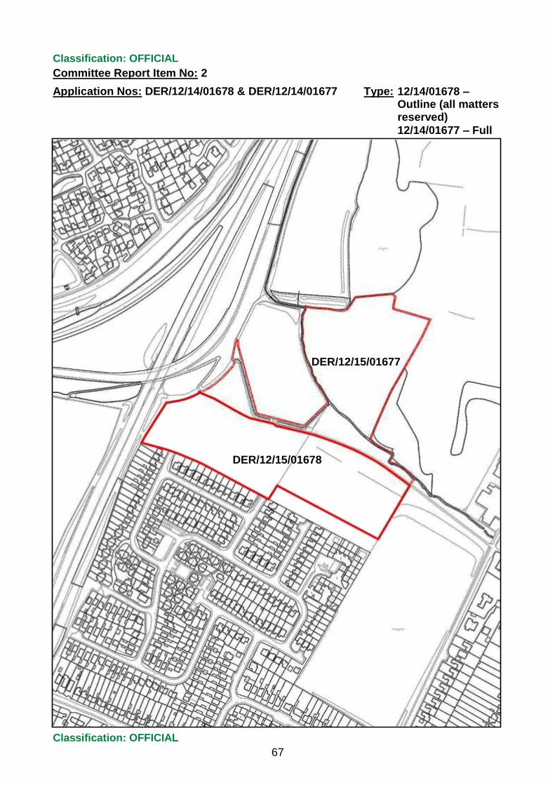
Classification: OFFICIAL
Committee Report Item No: 2
Application Nos: DER/12/14/01678 & DER/12/14/01677 Type:
Classification: OFFICIAL
67
12/14/01678 – Outline (all matters reserved)
12/14/01677 – Full
Crown copyright and database rights 2016 Ordnance Survey 100024913
DER/12/15/01677
DER/12/15/01678

Classification: OFFICIAL
Committee Report Item No: 3
Application No: DER/10/15/01277 & DER/10/15/01278 Type:
Classification: OFFICIAL
68
Full & Listed Building
1. Application Details
Address: 19 Cornhill, Allestree.
Ward: Allestree
Proposal:
Erection of dwelling house, demolition of garage and part removal of boundary wall
Further Details:
Web-link to applications: 10/15/01277: https://eplanning.derby.gov.uk/online-applications/applicationDetails.do?activeTab=summary&keyVal=_DERBY_DCAPR_98935
10/15/01278: https://eplanning.derby.gov.uk/online-applications/applicationDetails.do?activeTab=summary&keyVal=_DERBY_DCAPR_98936
A site visit by Members of the committee was carried out on 27 April, at the request of the committee at the previous meeting. Members visited the site and neighbouring properties to view the impact of the development.
Full planning permission and Listed Building Consent are sought for development of a single dwelling and garage/car port on part of the rear curtilage of 19 Cornhill, Allestree. 19 Cornhill (Yew Tree Cottage) is a Grade II listed, thatched dwelling, which lies on the south side of Cornhill and lies within the Allestree Conservation Area. It is a two storey building, faced in white painted brick and with a timber frame, which probably dates from the 17th Century. It is a prominent building in the Conservation Area, which is one of a group of historic properties in the old part of Allestree village. To the west and south of the site, there are residential properties dating from the early 20th Century and Post-War period. The properties on Park View Close are at a lower level than the houses on Cornhill.
The site comprises the listed dwelling, a modern detached garage and a large rear garden, which includes various trees. There is an existing vehicle access onto Cornhill, which serves the existing dwelling. A historic stone wall, approximately 1.5 metres high runs along the highway boundary with Cornhill.
The proposed development would involve demolition of the modern garage and development of a four bedroom detached dwelling and detached garage and car port to the rear of the listed building, within the rear part of the garden. A driveway to the new dwelling would be formed from the existing entrance onto Cornhill. The access is to be widened to approximately 4.25 metres by removal of up to 1.2 metres of the stone boundary wall. Two small sections of the wall would be rebuilt on either side of access.
The proposed two storey dwelling would be of a traditional appearance, with an L-shaped layout. The principal block would be stepped to reflect the fall in land level across the site. It measures approx. 17 metres in length and 6.5 metres width. A single storey element would project to the rear of the dwelling by approx. 5.5 metres. The buildings would both be of a brick construction with a pitched tiled roofline and
Classification: OFFICIAL
Committee Report Item No: 3
Application No: DER/10/15/01277 & DER/10/15/01278 Type:
Classification: OFFICIAL
69
Full & Listed Building
would have casement style fenestration. The proposed garage is of a simple design and would measure approx. 6.5 metres x 3.5 metres in area. A timber car port would be positioned alongside the garage. They would be sited towards the southern boundary of the site. A parking and turning area is to be formed on the plot, whilst two parking spaces would be provided for the existing dwelling.
Five trees are to be removed from the site, to accommodate the development. These include two Cypresses which would be affected by the proposed driveway, a Yew tree and two fruit trees in the rear of the site. The rest of the trees on the site are to be retained as part of the development. The removal of these trees was the subject of a Conservation Area Notification, (DER/12/14/01660) and no objections were raised to their removal.
The applications are accompanied by a Heritage Appraisal and a Tree Survey & Tree Constraints Plan. Since the last committee the agent has submitted a brief schedule of the proposed repair and restoration works to Yew Tree Cottage, which are to be undertaken with funding provided by the proposed development.
2. Relevant Planning History:
Application No: 03/15/00307 Type: L B C alterations and demolition
Status: Not Determined Date: Description: Part demolition of front boundary wall and detached garage.
Erection of two dwelling houses
Application No: 03/15/00306 Type: Full Planning Permission Status: Not Determined Date: Description: Erection of two dwelling houses
Application No: 12/14/01634 Type: L B C alterations and demolition
Status: Withdrawn Application Date: 27/01/2015 Description: Part demolition of front boundary wall and detached garage.
Erection of two dwelling houses
Application No: 12/14/01633 Type: Full Planning Permission Status: Withdrawn Application Date: 27/01/2015 Description: Erection of two dwelling houses
Application No: 12/14/01660 Type: Works to Trees in a Conservation Area
Status: Raise no objection Date: 20/01/2015 Description: Felling of various trees within the Allestree Conservation Area
3. Publicity:
Neighbour Notification Letter - 44
Site Notice - Yes
Statutory Press Advert - Yes
Classification: OFFICIAL
Committee Report Item No: 3
Application No: DER/10/15/01277 & DER/10/15/01278 Type:
Classification: OFFICIAL
70
Full & Listed Building
This publicity is in accordance with statutory requirements and the requirements of the Council’s adopted Statement of Community Involvement.
4. Representations:
There have been 30 objections received to date, to both of the applications, including one from Pauline Latham MP. The main issues raised are as follows:
The development would be detrimental to the setting of the listed building, Yew Tree Cottage.
The development would lead to substantial harm to the character of the Conservation Area.
Contrary to the new Core Strategy policies and Local Plan policies.
The development would be out of character with the surrounding area.
The listed building is part of group of buildings in the old village of Allestree and should be protected
The loss of the Yew tree is unacceptable.
The listed cottage has been neglected.
Visibility splays at access are substandard.
The front boundary wall of the site should not be destroyed.
Footprint of the dwelling would be too large.
Limited details of proposed external materials are provided.
Adverse impact on residential amenity.
5. Consultations:
CAAC: Objected and Recommend refusal for same reasons as on previous application.
The proposed development would be detrimental to the significance of the listed wall, would have a negative impact on the character and appearance of the Conservation Area and it adversely affects the setting of the listed buildings and the impact would remain negative on the street scene due to the scale and massing of the proposed new building and alterations to the access to it.
Highways Development Control: The drive is at the existing vehicle entrance to Yew Tree Cottage.
The applicant has used a reduced pedestrian inter-visibility splay of 1m x 1m rather than 2m x 2m to reduce the impact on the boundary wall. In this particular instance this is acceptable. Also the reduction to the visibility distance of 2m rather than 2.4m is acceptable in this location as the drive will only serve 2 properties.
Conditions are recommended to control pedestrian visibility splays, layout of private driveway and surface water discharge onto the highway.

Classification: OFFICIAL
Committee Report Item No: 3
Application No: DER/10/15/01277 & DER/10/15/01278 Type:
Classification: OFFICIAL
71
Full & Listed Building
Natural Environment: Permission has been given for the removal of the five trees shown for removal as part of this application. No objections were raised to their removal under a Conservation Area works to trees application, in January 2015.
As long as the advice given / recommendations made in the submitted tree report are followed, there is no further comment to make other than the usual standard conditions, to ensure tree protection measures, such as protective fencing are in place before and during construction works and where necessary, no dig solutions are implemented in the root protection area of trees to be retained.
DCC Archaeologist: The site is on the periphery of the 19th century village as shown on historic maps but does not fall within the likely medieval core of Allestree which lies further to the east around the church.
The site does contain a record for a 19th century post office building, now lost (HER 32479) but any archaeological remains of this would be of minimal significance. I therefore advise on the balance of probability that the site is very unlikely to be of archaeological significance, and that no archaeological requirement need be placed upon the applicant.
Historic England: No comments. This application should be determined in accordance with national and local policy guidance and on basis of expert conservation advice.
6. Relevant Policies: Saved CDLPR policies
GD2 GD4 GD5 H13 E9 E18 E19 E21 E23
Protection of the Environment Design and the Urban Environment Amenity Residential Development – general criteria Trees Conservation Areas Listed Buildings and Buildings of Local Importance Archaeology Design
T4 Access and servicing
The above is a list of the main policies that are relevant. Members should refer to their copy of the CDLPR for the full version or access the web-link.
http://www.cartogold.co.uk/DerbyLocalPlan/text/00cont.htm
Over-arching central government guidance in the NPPF is a material consideration and supersedes earlier guidance outlined in various planning policy guidance notes and planning policy statements.

Classification: OFFICIAL
Committee Report Item No: 3
Application No: DER/10/15/01277 & DER/10/15/01278 Type:
Classification: OFFICIAL
72
Full & Listed Building
7. Officer Opinion:
Key Issues:
In this case the following issues are considered to be the main material considerations which are dealt with in detail in this section.
Policy context
Heritage impacts
Residential amenity
Highway implications
Trees
Policy Context These applications for full planning permission and Listed Building Consent relate to residential development of a small backland plot to the rear of a Grade II listed cottage. Listed Building Consent is also sought for the demolition of a garage and removal of part of a stone boundary wall, which are within the curtilage of the listed cottage. The site lies on the edge of the Allestree Conservation Area, which covers the old part of Allestree village. The surrounding area is of a mixed residential character, comprising post-war housing as well as historic dwellings. The site is part of the rear garden of the listed Yew Tree cottage, which is a thatched property fronting onto Cornhill. The proposed development would therefore be within the curtilage of the listed building. It would affect the setting of the listed cottage on the site as well as the setting of the adjacent listed buildings at 11 to 17 Cornhill, which are also Grade II listed.
The National Planning Policy Framework (NPPF) is relevant to this application. Paragraph 14 of the NPPF gives a “presumption in favour of sustainable development”. Under para 14, sustainable development should be granted, where the development plan is absent or the relevant policies are out of date, unless “any adverse impacts of doing so would significantly and demonstrably outweigh the benefits” or where “specific policies in this Framework indicate development should be restricted.”
In this case, the restrictive policies include those related to designated heritage assets, including listed buildings and conservation areas.
A recent court judgement in Forest of Dean District Council v Secretary of State for Communities & Local Government and Gladman Developments Ltd has clarified the interpretation of paragraph 14 in regard to the presumption in favour of sustainable development. The judgement states that there are certain policies in the NPPF where this presumption does not apply, where instead development should be restricted. Paragraph 134 is one such policy, relating to designated heritage assets. It provides for a balancing exercise to be undertaken between less than substantial harm to the significance of a heritage asset and the public benefits of the proposal. This decision means that the presumption to approve sustainable development, unless the harm would significantly and demonstrably outweigh the benefits, which is given in para. 14 is not relevant to the decision making on applications which may affect listed buildings and conservation areas.

Classification: OFFICIAL
Committee Report Item No: 3
Application No: DER/10/15/01277 & DER/10/15/01278 Type:
Classification: OFFICIAL
73
Full & Listed Building
This recent case follows a judgement in 2014 for Banwell Manor Wind Energy Ltd v East Northamptonshire District Council, which concluded that decision makers should give considerable importance and weight, to the harm to a designated heritage asset, even if the harm is found to be less than substantial. In carrying out the balancing exercise, the desirability of preserving the setting of listed buildings should be given considerable weight as required under Section 72 of the Planning (Listed Buildings and Conservation Areas) Act 1990.
Paragraphs 128 – 141 of the NPPF are all restrictive policies which seek to conserve and enhance the historic environment, through the decision making process. The impacts of development on designated heritage assets, including Conservation Areas and Listed buildings, must be considered and given weight, having regard for the degree of harm and the significance of the asset, according to paragraph 132. Any harm or loss of an asset “should require clear and convincing justification” (para 132). Paragraph 134 states that where proposals “will lead to less than substantial harm to the significance of a designated heritage asset, this harm should be weighed against the public benefits of the proposal, including securing its optimum viable use.”
The saved Local Plan policies E18 and E19 are considered to be consistent with the NPPF and should be given due weight in the decision making process. Policy E18, seeks to ensure that new development preserves the special character and appearance of Conservation Areas. New buildings should enhance the Conservation Area in terms of their siting and alignment of buildings, materials used and the mass, scale and design. Under Policy E19, development proposals should not have a detrimental impact on the special architectural and historic interest of the character or setting of listed buildings. Proposals for the alteration or demolition of affected listed buildings should also not result in a significant loss of historic fabric, unless it has been justified by means of an impact assessment.
The development of a single dwelling on this residential curtilage would in principle accord with the provisions of saved Policy H13 of the adopted Local Plan, subject to a satisfactory form of development and high quality living environment being created. Policies GD4 and E23 require a good standard of urban design, which complements the existing urban context and local distinctiveness.
Applications have been previously submitted for the erection of two detached dwellings on the same site, with a similar means of access onto Cornhill. The latter of these submissions for full permission and Listed Building Consent are still undetermined (DER/03/15/00306 & DER/03/15/00307) and have been held in abeyance pending a decision on the current applications for a single dwelling. The proposal for two dwellings involved a slightly larger site area, which would have resulted in a reduced curtilage for the listed cottage. The design and appearance of the two houses was more contemporary and the overall footprint of the development would be substantially larger than the proposal currently being considered. Significant objections were raised to the applications for the two dwellings, in regard to the adverse impacts on the setting of the adjacent listed buildings and on the character of the Conservation Area.
Heritage Impacts

Classification: OFFICIAL
Committee Report Item No: 3
Application No: DER/10/15/01277 & DER/10/15/01278 Type:
Classification: OFFICIAL
74
Full & Listed Building
The proposed residential development is to be sited in part of the rear curtilage of the Grade II listed Yew Tree Cottage, which is an historic timber framed dwelling that fronts onto Cornhill. The site also lies within the Allestree Conservation Area, which extends up to the western and southern boundary of the application site. The listed property has a large rear garden compared with other houses along this stretch of Cornhill. The garden is currently unmanaged and slopes down by approximately 2 metres from the cottage towards Parkview Close.
This application must be determined, having regard to paragraphs 131 to 134 of the NPPF, which relate to the impacts of development on designated heritage assets and consideration of any harm to those assets. Policies E18 and E19 of the Local Plan are consistent with the NPPF and seek to protect Conservation Areas and historic buildings from harm to their special character.
Yew Tree Cottage is part of a group of listed houses on Cornhill, including 11 to 17 which are all Grade II listed and are part of the old village centre. They are designated heritage assets with a high level of historical significance, which make a significant contribution to the character of the Conservation Area.
The proposed development includes the erection of a single dwelling and garage/car port, which is to be sited to the rear of the listed cottage and the adjacent 17 Cornhill, in part of the rear garden of No.19. This forms part of the rear curtilage of the listed building and the development would therefore impact on the setting of the listed cottage (19) and the group of listed dwellings (11 to 17) on Cornhill.
The development would take up a large section of the rear curtilage of the property and the retained garden area for 19 Cornhill would comprise a small area of garden to the rear and side of the principal building. The retained curtilage for the listed dwelling would be comparable with the size of gardens of the adjacent listed properties. The existing modern garage on the site is also proposed to be removed, which would be restored to garden space for the listed dwelling. The removal of the garage is welcomed and would, in my opinion, enhance the setting of the listed cottage. The garden which is to be developed is terraced and lawned with three trees and a conifer hedge. There are substantial hedges along the west, south and eastern boundaries of the site. The land levels across the curtilage fall from north to south, with the principal building being elevated relative to the levels of the garden. The proposed works within the curtilage of the listed building would also involve the demolition of a 1.2 metre high section of the front stone wall to the Cornhill frontage. The boundary wall attaches to the main building at its eastern boundary and is covered by the listing.
The proposed development would be formed within the curtilage of Yew Tree Cottage and be sited adjacent to the listed properties at 11 to 17 Cornhill and also includes the part demolition of the listed wall. In accordance with paragraph 134 of the NPPF, the proposals would result in less than substantial harm to the special character of the listed cottage and the setting of the nearby listed buildings. This relates to impacts which would affect the setting of a heritage asset or minor alteration or demolition work, which in this case includes the removal of part of the curtilage wall. These impacts will still affect the significance of the heritage asset and they must be considered accordingly in line with the relevant legislation and the

Classification: OFFICIAL
Committee Report Item No: 3
Application No: DER/10/15/01277 & DER/10/15/01278 Type:
Classification: OFFICIAL
75
Full & Listed Building
heritage policies in the NPPF. Where there is harm to the setting and significance of a listed building and conservation area, considerable weight and importance must be given to that harm in determining the application. As required in paragraph 134, this less than substantial harm needs to be balanced against the public benefits of the proposal. This includes consideration of securing its optimum viable reuse. It should be borne in mind that whilst there is acknowledged to be a level of harm to the setting and significance of listed buildings and conservation area on and adjacent to the site, this does not necessarily mean that the residential development should be automatically resisted. Each proposal for development affecting a designated heritage asset must be considered on its own merits and by making a planning judgement on the degree of harm balanced against any benefits of that proposal.
The weight given to adverse impacts or harm to a heritage asset and the material considerations which would weigh in favour of a proposal, is the assessment which must be made for all such developments where is considered to be less than substantial harm. This is borne out in recent case law and in other appeal decisions, which have related to similar impacts on listed buildings and conservation areas. A recent appeal relating to Wingfield Manor, a Grade I listed building and South Wingfield conservation area in Amber Valley (APP/M1005/W/15/3006136), dealt with less than substantial harm to those highly significant heritage assets, from a major residential development. In that case the Inspector considered that the benefits of the proposal did not outweigh the harm to the significance of the heritage assets. However, this appeal and other decisions based on a similar judgement, make a judgement on the context and nature of the development and the characteristics and significance of the affected heritage assets. The key issue, highlighted in court judgements, most recently Forest of Dean District Council v Secretary of State for Communities and Local Government & Gladman Developments Ltd (2016) is that is for the decision maker to undertake the balancing exercise, in line with para.14 and restrictive policy 134 of the NPPF and weigh the harm against the benefits of a development proposal, provided that the harm is given considerable importance and weight in the balance.
The design and form of the new proposed dwelling would have the appearance of a traditional cottage, with a linear, rectangular form and two storeys in height. The built form is to be stepped, to reflect the fall in ground level across the site. There is a small rear projection which would be single storey and subordinate to the main building. It is proposed to use brick and tile for the construction and arched brick lintels for window and door openings. The garage and car port would be of a similar form and external materials to the main dwelling. They would be of simple appearance and sited at a lower level than the dwelling towards the rear boundary of the site.
The new dwelling would be positioned on a similar alignment to the listed cottage and the two together would have the appearance of a short row of traditional cottages, stretching back from Cornhill. The front elevation of the proposed dwelling is also to be stepped back about 2 metres from the principal elevation of the listed building, fronting onto the private access drive. The finished floor levels of the development are to be lower than that of the cottage at No.19 and the adjacent No.17, due to the falling land levels to the rear of the existing buildings. The proposed building would

Classification: OFFICIAL
Committee Report Item No: 3
Application No: DER/10/15/01277 & DER/10/15/01278 Type:
Classification: OFFICIAL
76
Full & Listed Building
be at two levels, to reflect the gradient of the site. The garage/car port would be at a lower level again and a furthest distance from the listed cottage.
There are objections which have been have been raised to the development by the Council’s Conservation Officer and Conservation Area Advisory Committee (CAAC) and I acknowledge the concerns made on the grounds of the adverse impact of the development on the setting of nearby listed buildings and on the character of the Conservation Area, due in particular to the scale and massing of the development and the part removal of the front boundary wall. Whilst there would be less than substantial harm to the setting of the listed buildings and the Conservation Area as a result of the development and the demolition of the listed wall, I do not agree that these adverse impacts outweigh the public benefits of the proposal.
In my opinion, the proposed development would be of a high quality design and form, which is akin to a traditional cottage and of a comparable overall scale to Yew Tree Cottage. Having regard for the lower floor level, stepped down into the rear curtilage, which would result in a reduced ridge height, relative to the listed cottage, the new dwelling would, in my opinion, have a subordinate scale and massing compared with the listed properties at 11 to 19 Cornhill. The development would be sited to the rear of the principal listed building, such that views from the Conservation Area would be obscured by retained trees and by the historic buildings on Cornhill. The new dwelling would not detract from the key views of Yew Tree Cottage from Cornhill, due to its siting and layout, floor levels and sensitive design and use of materials. The development is considered to preserve the setting of the adjacent listed buildings and protect their group value and historic significance in the Conservation Area.
The demolition of part of the listed boundary wall on Cornhill is proposed in order to widen the vehicular access to the site. The section of wall to be removed is on the eastern side of the existing access, which is located on the western side of the property. The stone wall abuts the highway frontage and is covered by the listing of 19 Cornhill. It is prominent in the street scene and contributes to the character and appearance of the Conservation Area. The proposed part demolition and formation of visibility splays on either side of the access would result in less than substantial harm to the historic significance of the listed building and to its setting.
As required by paragraph 134 of the NPPF, the harm to the listed wall, alongside the proposed development of new dwelling and garage/car port must be weighed against the public benefits of the proposed development. There are benefits associated with the proposal, in regards to the provision of a single new dwelling of sympathetic design, form and facing materials, which is subordinate in scale, mass and height to the adjacent listed buildings fronting Cornhill and sensitively sited to the rear of those buildings, such that it would not be prominent from the streetscene. The wall to be demolished would affect a small section of the wall abutting the existing driveway to improve vehicular access to the property, where there is currently limited visibility onto the highway. This is a benefit to highway safety for visitors to the property, which is considered to outweigh the loss of a modest section of the listed wall. The removal of the modern garage would also enhance the setting of the listed cottage at 19 Cornhill.

Classification: OFFICIAL
Committee Report Item No: 3
Application No: DER/10/15/01277 & DER/10/15/01278 Type:
Classification: OFFICIAL
77
Full & Listed Building
A further benefit which can be considered under para. 134 is to secure a viable reuse of the heritage asset. The listed cottage is currently vacant and the applicant has provided a schedule of repair/ restoration works for the listed cottage, to be funded from the proposed development. The renovation of the cottage would be welcome and enable its residential reuse. In order to ensure that there is some public benefit, by way of restoration works to the listed building, it is, in my opinion, reasonable to attach a planning condition to secure implementation of a detailed scheme of refurbishment works for the existing dwelling, following the carrying out of the development.
The benefits of the proposed development are material considerations and when balanced against the harm to the setting of the listed buildings at 11 to 19 Cornhill and to the character of the Conservation Area, they are considered to outweigh the harm to the heritage assets. A viable re-use of Yew Tree Cottage would also be delivered as part of the scheme, which is a further benefit to be weighed in the balance.
Overall, the less than substantial harm to the character and appearance of the Conservation Area and the loss of historic significance to the setting of listed buildings on Cornhill, when weighed in the balance against the benefits of the proposal, are in this case considered to be satisfactorily outweighed by the specified benefits of the development, which are related to the design, siting and layout of the development and the proposed refurbishment of the listed building. The proposed residential scheme would therefore be an appropriate form of development within the curtilage of this listed property and it is considered to be in accordance with the policies of the NPPF and saved Local Plan Policies E18 and E19.
Residential Amenity The development is to be sited on a backland plot to the rear of dwellings on Cornhill and to the north of post-war dwellings on Park View Close. The principal elevations of the building would be positioned at a right angle to the adjacent dwellings on either side of the plot, which reduces the potential for overlooking and loss of privacy to the nearby properties on Cornhill and Park View Close. The front elevation of the building would face towards the shared boundary with 21 and 21a Cornhill, at a distance of approx. 10 to 12 metres. This is an adequate distance from those properties to avoid unreasonable overlooking.
The main impacts are likely to be on the nearest properties at 17 and 19 Cornhill and 7 and 9 Park View Close. 17 and 19 Cornhill are elevated in relation to the proposed development and would face onto the north side elevation of the dwelling, which has a projecting single storey element. This side elevation has secondary windows to bathrooms and kitchen, which would not give rise to undue massing or loss of privacy for the adjacent residents. 7 and 9 Park View Close currently overlook the site and is at a lower level. There is a hedge along the shared boundary which provides some screening and this should be retained. There would be some impact from the garage/car port and the end elevation of the new dwelling, which are to be sited in close proximity to the hedge boundary. There is a large window opening to living room on the end elevation which would face towards the rear gardens of Nos. 7 and 9, although the window would not directly face onto the rear elevations of those

Classification: OFFICIAL
Committee Report Item No: 3
Application No: DER/10/15/01277 & DER/10/15/01278 Type:
Classification: OFFICIAL
78
Full & Listed Building
dwellings. There are four other openings to the living room which are on the front and rear elevations of the building. There would be some potential for loss of privacy from the living room opening on the end elevation and it is reasonable to require the glazing to be obscured to preserve the privacy of the nearby residents.
Subject to a condition to control obscure glazing to the living room opening, there would, in my opinion, be no significant harm caused to nearby residential properties, by the proposed development, in accordance with the provisions of Policies GD5 and H13.
Highways implications There is an existing vehicular access to the site from Cornhill, which is proposed to be widened to serve the proposed additional dwelling at the rear of the site. The private driveway would be formed in a similar position to the existing and extended along the western boundary of the site. The alterations to the access require a part demolition of the boundary wall, to form a 4.25m wide access onto Cornhill. This is required due to the narrow width and limited visibility afforded by the current access. A short section of the wall is to be removed and partially rebuilt to provide visibility splays onto the highway. The Highways Officer has accepted a reduced level of visibility at the access, to minimise the amount of wall which needs to be removed, to safeguard the historic integrity of the listed curtilage wall. This is a reasonable compromise, bearing in mind the limited traffic impact of the additional dwelling and to protect the special character and setting of the historic building. I note that the Highways Officer does not have any concerns in regard to highway safety at the amended access.
Parking and turning areas for both the existing dwelling at 19 Cornhill and the new development are to be provided and these are considered to be acceptable in terms of meeting parking requirements and effects on highway safety. Overall, there would not be any adverse highway implications arising from the development and the scheme accords with Policy T4.
Trees There are various trees on the site which are within the Conservation Area and therefore have protection from works being undertaken unless a notification is submitted for proposed works to trees. A Notification was made in 2014 for the felling of five trees within the site, which are same trees to be removed under these applications. Those trees were not considered to be of sufficient merit to be covered by a Tree Preservation Order, on the grounds of their limited public amenity value and overall quality. The felling of the five trees, which include two Cypress, a Yew and two fruit trees at the rear of the site, was agreed and can be implemented at any time, regardless of the outcome of the current applications.
The remaining trees towards the Cornhill frontage and the boundary hedge are shown for retention as part of the development and this includes a large Yew tree at the front of the site, which overhangs the highway. This is a prominent tree in the streetscene and contributes to the character of the Conservation Area. It is to be retained within the curtilage of the listed building and would soften the visual impact of the development to the rear of the site. The retained trees and hedges would be protected during construction, subject to a suitable condition and overall the proposal

Classification: OFFICIAL
Committee Report Item No: 3
Application No: DER/10/15/01277 & DER/10/15/01278 Type:
Classification: OFFICIAL
79
Full & Listed Building
would accord with the provisions for trees in developments laid out in Policies GD2 and E9.
8. Recommended decision and summary of reasons:
DER/10/15/01277:
To grant planning permission with conditions.
Summary of reasons: The proposed residential development and formation of vehicular access would form a high quality living environment and a design and layout which complement the character and local distinctiveness of the surrounding residential area. The development site is in the curtilage of the Grade II listed 19 Cornhill and the proposal would not have a detrimental effect on the setting and special character of nearby Grade II listed buildings, including 19 Cornhill and would preserve the character and appearance of the Allestree Conservation Area. There would not be adverse impacts on highway safety arising from the proposed access or on trees of importance within the site.
Conditions: 1. Standard condition (3 year time limit)
2. Standard condition ( approved plans condition)
3. Standard condition (details of external materials)
4. Standard condition (details of means of enclosure, including any retaining walls)
5. Standard condition (landscaping scheme, include retention of trees)
6. Standard condition (implementation and maintenance of landscaping scheme approved under condition 5)
7. Standard condition (tree constraints and tree protection plan for retained trees in accordance with BS5837:2012 to be agreed and implemented during construction)
8. Development shall not be brought into use until pedestrian visibility splays 1 metre x 1 metre at the vehicular access to be provided and areas within the splays to be maintained at no more than 0. 6 metres above ground level.
9. The shared driveway to be laid out to a width of no more than 4.25 metres for at least 5 metres back from the highway. Vehicle parking and turning areas shall not be used for any purpose other than for parking and turning of vehicles.
10. The driveway to be constructed to prevent surface water discharging onto the public highway and retained for life of development.
11. The living room window opening on the south facing end elevation of the dwelling to be obscure glazed and retained as such for life of development.
12. Window and door joinery details and sections to be agreed for the proposed dwelling and implemented.
Reasons:
Classification: OFFICIAL
Committee Report Item No: 3
Application No: DER/10/15/01277 & DER/10/15/01278 Type:
Classification: OFFICIAL
80
Full & Listed Building
1. As required by Sections 91-92 of the Town and Country Planning Act 1990.
2. For the avoidance of doubt.
3. To ensure a satisfactory appearance of the development in the interests of visual amenity and to protect the setting and character of the listed building and conservation area – Policies GD4, H13, E18 & E19
4. To ensure a satisfactory appearance of the development in the interests of visual amenity and to protect the setting and character of the listed building and conservation area – Policies GD4, H13, E18 & E19
5. To ensure a suitable landscaping and planting scheme, incorporating retained trees, in the interests of visual amenity – Policies GD4, H13, E18 & E23
6. To ensure a suitable landscaping and planting scheme, incorporating retained trees, in the interests of visual amenity – Policies GD4, H13, E18 & E23
7. To ensure the protection of retained trees and hedges on the site, in the interests of visual amenity – Policies GD2 & E9
8. In the interests of traffic and pedestrian safety – Policy T4
9. In the interests of traffic and pedestrian safety – Policy T4
10. In the interests of traffic and pedestrian safety – Policy T4
11. To protect the amenities and privacy of nearby residents at 7 and 9 Park View Close – Policy GD5
12. To ensure a satisfactory appearance of the development in the interests of visual amenity and to protect the setting and character of the listed building and conservation area – Policies GD4, H13, E18 & E19
Informative Notes: The development makes it necessary to alter a vehicular crossing over a footway of the public highway. These works shall be constructed to the satisfaction of the Highway Authority. You are, therefore, required to contact StreetPride at Derby City Council to apply for a vehicle access under Section 184 of the Highways Act 1980 (as amended) to arrange for these works to be carried out. Contact [email protected] tel 0333 2006981.
Waste/recycling storage facilities are to be located within 25m of the public highway.
DER/10/15/01278:
To grant listed building consent with conditions:
Conditions: 1. Standard condition 03 (3 year time limit)
2. Standard condition 100 (approved plans)
3. Before any works to the stone boundary wall are carried out, precise details to be submitted of the making good of the retained wall and construction of the new sections of wall, including elevation drawings to a scale of 1:20 or 1:50.

Classification: OFFICIAL
Committee Report Item No: 3
Application No: DER/10/15/01277 & DER/10/15/01278 Type:
Classification: OFFICIAL
81
Full & Listed Building
4. Before occupation of the dwelling, a scheme of repair and restoration works for the listed building, 19 Cornhill, to be submitted for approval and implemented in accordance with agreed timetable.
Reasons: 1. In accordance with the relevant Regulations.
2. For the avoidance of doubt.
3. To safeguard the character and integrity of the listed curtilage wall and setting of Grade II listed building and Conservation Area – Policies E18 & E19
4. To protect the special character and historic fabric of the listed building – Policy E19
Application timescale: The target date for determination of the applications expired on the 10 December 2015 and an agreed extension of time has been given until 15 April 2016.

Classification: OFFICIAL
Committee Report Item No: 3
Application No: DER/10/15/01277 & DER/10/15/01278 Type:
Classification: OFFICIAL
82
Full & Listed Building
Crown copyright and database rights 2016 Ordnance Survey 100024913

Classification: OFFICIAL
Committee Report Item No: 4
Application No: DER/06/15/00781 Type:
Classification: OFFICIAL
83
Full
1. Application Details
Address: Land adjacent to The Needles Public House, Bembridge Drive, Alvaston.
Ward: Alvaston
Proposal:
Erection of a single storey convenience store with associated car parking, landscaping, access arrangements and installation of ATM.
Further Details:
Web-link to application: https://eplanning.derby.gov.uk/online-applications/applicationDetails.do?activeTab=summary&keyVal=_DERBY_DCAPR_98414
The application site relates to land adjacent to the existing Needles Public House on the west side of Bembridge Drive in Alvaston. The site is currently used as a car park associated with the Public House. The area surrounding the application site is predominantly residential except for the adjacent Public House and convenience store. To the immediate north is an area of public open space recreation ground / playing field; to the east is Bembridge Drive and beyond that on Medina Close; to the south is the Public House and retail unit; to the west are properties forming Trevone Court, off Brightstone Close. These are two storey buildings and the nearest would be No’s 23-30 which backs onto the site – 4m from the common boundary. The site itself is relatively flat with a tarmacadam surface and some trees and vegetation along the site perimeter boundaries. The site is irregular in shape and its main access point is adjacent to the public house accessed off Bembridge Drive.
Proposal The application seeks full planning permission for the erection of a single storey convenience store incorporating an ATM machine to the front elevation. Amended plans have been received showing a revised layout and building design. The area of land in question is part of the existing car park to the north of the Public House. The proposed retail unit would be a standalone building with the main store measuring approximately 17m by 15m in footprint and the attached rectangular shaped service area approximately 15m by 7m. The height from ground floor to eaves level measures approximately 3m and height to ridge level approximately 7m. The proposed unit would provide approximately 224 square m of net sales area. Its principal elevation would face the interior of the site and rear aspect would be north facing. The Bembridge Drive elevation would contain a number of windows along the building side.
The service area building would be adjoined to and directly behind the main store building. The deliveries, plant cages, bin storage area would be sited to the west side of the store, which would be screened by 2.7m high acoustic fencing. The boundary treatment is shown to be a combination of 2.1m high fencing, retained vegetation and bollards. The site access would remain as per the existing vehicle access, off Bembridge Drive. A total of 12 car parking spaces would be created between the proposed new store and The Needles building. A dedicated pedestrian access would be sited approximately 5m south of the main store.

Classification: OFFICIAL
Committee Report Item No: 4
Application No: DER/06/15/00781 Type:
Classification: OFFICIAL
84
Full
The applicant has indicated within the submitted documents that they seek to operate the building between the hours of 07.00-23.00 Monday to Sunday. The development would employ 6 full time and 14 part-time staff members.
The application is accompanied by the following documents: Design and Access Statement; Planning Statement, including Retail Impact Assessment; Transport Assessment.
2. Relevant Planning History:
No relevant or recent planning history.
3. Publicity:
Neighbour Notification Letter sent to properties surrounding the site
Site Notice displayed on street furniture
This publicity is in accordance with statutory requirements.
4. Representations:
A total of 20 objections have been received and an objection petition with 406 signatures.
Noise from deliveries and servicing
Increase in traffic in the area
Increase levels of youths loitering in the area
Rubbish thrown in neighbouring gardens
Impact on neighbouring convenience store
Late night opening until 11pm unacceptable in a residential area
Absence of information on capacity for additional “top-up” shopping
Unacceptable impact on the living conditions of residents at Trevone Court properties
No assessment of the combined servicing and access arrangement for the site
Lead to displaced parking
Contrary to NPPF on retail policy test grounds
The Premier convenience store is likely to close
Unnecessary to have a shop next door to an existing business of the same type and which the wider area is already saturated
3 Co-op stores within 1 mile from the site
Too many Co-op shops in area
Hazard to other traffic and pedestrians
No community benefits

Classification: OFFICIAL
Committee Report Item No: 4
Application No: DER/06/15/00781 Type:
Classification: OFFICIAL
85
Full
With the bend of the road and increased flow of traffic in and out of the Needles, it will introduce even more risk as visibility will decrease and number of cars increasing
Revised plans are inaccurate and misleading
Who will stop people parking on the road and on the bus stop
Inconsistent plans and statement information
Relocation of plant area and loading bay harmful to residential amenity
Location of ATM and potential effects
Relocation of smoking shelter and its implications
Boundary fencing inadequate
5. Consultations:
Highways Development Control: The location of the proposed development sits within a residential area and it is likely that a large percentage of those using the store will arrive on foot. The parking provision proposed consists of 12 spaces (one disabled and one parent and child) which will be adequate for a store of this size. The store is located adjacent to a bus stop and space for three pedal cycles will be provided which will further enable sustainable travel to and from the development.
The ATM is to be located at the side of the store adjacent to Bembridge Drive and a bus layby. There are concerns that the bus layby may become a place where people pull up and stop in to gain access to the ATM, it is therefore essential that a relevant TRO (Traffic Regulation Order) be introduced to protect the bus layby and the area around the existing access to limit this behaviour.
Service vehicles will access the development via the main entrance, the developer has suggested the vehicles used will be 10m rigid and it is possible for all manoeuvres in and out to be made in a forward gear. The development site includes a marked loading bay which will ensure that service vehicles have parking available and the ability to load/unload in a safe location. Even if the delivery driver chooses not to use the proposed it is possible to service the site off the public highway. It is felt that this development is a sustainable one with no significant highway implications. Should planning permission be granted the authority will require the developer to agree to fund a TRO which will enable protection to be provided for the bus layby and the vehicular access.
Police Liaison Officer: The amended plans lodged show different detail on different plans. The site plan T52 0302 revision B shows boundary fencing to the side and rear of the store to be wooden hit and miss fencing of 2.1m in height. The external works plan shows the same positioned fencing to be wooden close boarded type of 2.1m in height. In combination with the existing hedges and shrubbery close boarded fencing of this height would be seen as acceptable for the rear boundary. Open boarded fencing would be seen as more liable to damage and less secure, so not acceptable for this

Classification: OFFICIAL
Committee Report Item No: 4
Application No: DER/06/15/00781 Type:
Classification: OFFICIAL
86
Full
application. Other previous comments regarding external lighting, CCTV, cycle racks
and hours of operation still apply to the amended submission.
6. Relevant Policies: Saved CDLPR policies
GD4 GD5 S2 S5 S9 E23 T4 T6 T7
Design and the Urban Environment Amenity Retail Location Criteria Small Shops Range of Goods and Alterations to Retail Units Design Access, Parking and Servicing Provision for Pedestrians Provision for Cyclists
T10 Access for Disabled People
The above is a list of the main policies that are relevant. Members should refer to their copy of the CDLPR for the full version or access the web-link.
http://www.cartogold.co.uk/DerbyLocalPlan/text/00cont.htm
Over-arching central government guidance in the NPPF is a material consideration and supersedes earlier guidance outlined in various planning policy guidance notes and planning policy statements.
7. Officer Opinion:
Key Issues:
In this case the following issues are considered to be the main material considerations which are dealt with in detail in this section.
Retail policy implications
Design and layout issues
Highway impacts
Residential amenity impacts
Retail policy implications The site of the proposal is not allocated for any particular use in the CDLPR. The site is currently used as a pub car park, serving the Needles PH and adjacent convenience store which are located to the south of the proposal site. The proposed store is 325sqm (gross) with a net sales area of 224sqm and the Co-op has been identified as the future operator.
Policy S2 of the CDLPR and the NPPF require retail proposals that are not located in defined centres to demonstrate compliance with the sequential test. The NPPF also requires Local Planning Authorities to consider the impact of retail proposals, in terms of investment into centres and the vitality and viability of centres. The NPPF states that where an application fails to satisfy the sequential test or is likely to have a significant adverse impact on one of the factors mentioned above, it should be refused. The applicant has carried out a sequential test, using a 500 metre catchment

Classification: OFFICIAL
Committee Report Item No: 4
Application No: DER/06/15/00781 Type:
Classification: OFFICIAL
87
Full
area, but has not provided any evidence as to why the site was chosen in the first place. It is useful to understand why retail proposals need to be located in a specific location (is it meeting a qualitative or quantitative deficiency for example?), before identifying the catchment area. Only then can we know whether the catchment area is logical and robust for the purposes of the sequential test.
No defined centres fall within the Primary Catchment Area defined by the applicant, although the applicant has considered a number of alternative locations beyond the Primary Catchment Area, including Holbrook Neighbourhood Centre (NC), Keldholme NC, Boulton NC, Brackens Lane NC, Harvey Road NC and Alvaston District Centre, which is around 1.5km from the proposal site. Whilst the Primary Catchment Area has been identified as 500m, the extent of the search area used for the sequential test is larger and appropriate for a proposal of this scale. The only centre with any vacancies at the time of survey was Alvaston District Centre, which is well beyond the Primary Catchment Area and where Co-op already has representation. Therefore, the applicant has concluded that the proposal meets the requirements of the sequential test.
I am generally in agreement with the applicant, in terms of their sequential test conclusions. The NPPF requires retail proposals of greater than 2500 sqm to submit a retail impact assessment. Whilst this proposal is well below the assessment threshold, the issue of impact is still a consideration. Importantly, the NPPF states that impacts should be ‘significantly adverse’ to justify refusal. On the basis that the proposed store is around 460metres from similar stores in existing centres and is relatively small, I am satisfied that the proposal is unlikely to have a significant adverse impact in terms of the vitality and viability of existing centres. I am also not aware of any investment opportunities within centres that would be prejudiced by this proposal. Therefore, I am satisfied that the proposal is compliant with the provisions of the impact test.
It is also useful to consider the application in the context of the ‘Small Shops’ policy in the CDLPR. Policy S5 relates to the provision of small shops and permits the provision of small shops in locations that are more than 400m from a District Centre, a Neighbourhood Centre, or defined out-of-centre locations – provided that individually or cumulatively undermine the vitality and viability of defined centres. The supporting text to S5 acknowledges that whilst retail development outside of existing centres is generally undesirable, it may be appropriate to encourage the provision of small shops in areas not well served by existing centres or out-of-centre locations. The supporting text also acknowledges that small shops accepted under S5 should generally not exceed 100 sqm gross floorspace. Whilst the Policy suggests a floorspace figure of 100 sqm (gross), we have generally accepted that this is unrealistic and does not reflect the scale and nature of ‘small shops’ in the context of modern retailing. 224 sqm (net sales area) is probably closer to the scale of store that constitutes a ‘small shop’ in modern retailing and as noted above is of a scale that is unlikely to have a significant adverse impact on nearby centres. There is also an argument that it is beneficial to enable newer modern stores, rather than relying on more limited, constrained stores within some of the neighbourhood centres.

Classification: OFFICIAL
Committee Report Item No: 4
Application No: DER/06/15/00781 Type:
Classification: OFFICIAL
88
Full
The site of the proposal is located more than 400m from the two nearest neighbourhood centres, so would meet the requirement of S5. However, it should be noted that S5 does not take account of existing retail provision, not located within defined centres. In the case of this proposal there is already a small convenience store (Premier) located next to the Needles PH. Whilst the proposal meets the requirements of the policy in term of proximity to centres, it could be argued that the area does not suffer from a retail deficiency due to the existing Premier store. It can be asserted that the proposal is compliant with the sequential and impact tests. The provision of a small shop in this location is also generally supported by the provisions of S5, although it is difficult to see how the area is deficient in reality due to the presence of the Premier.
On the basis that the proposal is in an out-of-centre location, conditions restricting the net sales area of the store to 224 sqm and to limit subdivision of the unit and limit the range of goods that can be sold from the store in line with S9. We have generally accepted that small scale convenience stores sometimes sell a small amount of comparison goods (non-food items) in a purely ancillary manner, with no more than 15% of the net sales area being used for the sale of ancillary / complementary goods.
Design and layout Amended plan drawings have been received showing a revised format and design of store, as seen in plan drawing numbers T52-0305 revision A and T52-0302 revision C. In summary, the changes are: alterations to the east elevation; changes to the roof design; the location of plant equipment; the location and building shape of the service/storage area. The scale, building footprint and design reflects the unusual shaped plot and limited frontage to Bembridge Drive. Consequently, the proposed retail unit is orientated to face the southern aspect with a limited presence along the street frontage. Nonetheless, this location along the west side of Bembridge Drive is partly fragmented by a large gap between the housing which forms and fronts Bembridge Drive. This can be seen by the public open space, application site car park area, the Needles Public House and adjoining retail unit which comprises the gap between the housing, as described. The proposed development would in-fill part of this gap in the streetscape and would integrate reasonably well when viewed against the scale, form and design of the neighbouring Needles Public House building.
The retail store has been designed to ‘fit’ the site, with a mix of hipped and flat roof sections and primarily brick and render elevation finishes. The incorporation of large amounts of glazing on the principal façade adds interest and provides a legible entrance feature. It is considered that the overall scale of the building would be appropriate given the surrounding context and the contemporary style of the building would be an enhancement to the somewhat dilapidated visual appearance of the site. Overall, it considered that the proposed would provide a satisfactory layout, would enhance what is currently and an untidy site and, accordingly, would provide visual enhancements for the character and appearance of the surrounding area. The proposal would reasonably comply with saved policies E23, E24, GD4 and E17 of the adopted CDLPR.

Classification: OFFICIAL
Committee Report Item No: 4
Application No: DER/06/15/00781 Type:
Classification: OFFICIAL
89
Full
Highways impacts Subject to the imposition of conditions, it is noted that no objections have been raised by the Highway Officer to the location, or dimensions of the vehicular access off Bembridge Drive. The level of off street parking being provided for the development and for the use of the existing Public House is also considered to be acceptable in this location. It is noted that access and parking is one of the main issues raised by objectors to this application Overall, it is not considered that the development would result in a reduction in highway safety in the area. It is considered that a sufficient level of 12 parking spaces being proposed to serve the proposed development which is located in a sustainable location with good access to public transport links. In practice, the Public House car parking area may well become utilised, albeit in an ad-hoc fashion, by those travelling to the site by car. Such a potential consequence would not necessarily be unacceptable and nor would it be controllable through the planning application, as the two sites would co-exist in terms of their use, function and operational activity.
The site’s close proximity to Bembridge Drive means it benefits from good connectivity to surrounding residential areas. The site is also easily accessed by public transport due to its close proximity to bus stops located along Bembridge Drive, with regular bus services (No’s. 1 and 11) operating throughout the day and evening. I note the comment from the Highways Officer in respect of the ATM is to be located at the side of the store adjacent to Bembridge Drive and a bus layby. There are concerns that the bus layby may become a place where people pull up and stop in to gain access to the ATM, it is therefore considered necessary that a relevant TRO (Traffic Regulation Order) be introduced to protect the bus layby and the area around the existing access to limit.
The loading bay would be located to the side of the entrance. Service vehicles will access the development via the main entrance, the developer has suggested the vehicles used will be 10m rigid vehicles and it is possible for all manoeuvres in and out to be made in a forward gear. The development site includes a marked loading bay which will ensure that service vehicles have parking available and the ability to load/unload in a safe location. Even if the delivery driver chooses not to use the proposed it is possible to service the site off the public highway.
Therefore, subject to the compliance with the attached conditions, it is considered that the proposal would be acceptable in terms of its impact upon on the efficiency of the highway network and highway safety. The level of car parking complies with Local Plan standards and parking/servicing arrangements are acceptable. The level of cycle parking proposed meets minimum standards, but it is considered that in order to promote sustainable travel to the store, the site would benefit from additional cycle stands, which can be controlled through condition. Accordingly the proposal would comply with saved policies T1, T4, T7 of the Local Plan Review.
Residential amenity The proposed development is sited within a predominantly residential locality, off a principal road that is a main bus route and vehicular route through to surrounding residential streets and the southern part of Alvaston. Indeed, the locality is a relatively busy suburban location rather than a quiet isolated area. As such, a view must be

Classification: OFFICIAL
Committee Report Item No: 4
Application No: DER/06/15/00781 Type:
Classification: OFFICIAL
90
Full
taken on the relative impacts on residential amenity. A number of objectors have highlighted concerns with noise implications from delivery vehicles, anti-social behaviour, increased vehicle movements, 24 hour availability of the ATM machine and the effects of the plant equipment, impacts of operational activity of the proposed store. The nearest residential properties are situated immediately to the west of the application site at Trevone Court, a purpose built retirement complex. Directly opposite the site on the other side of Bembridge Drive are properties along Medina Close. In particular No’s 22-30 Trevone Court back onto the part of the application site near to where the proposed retail store would be located.
The starting point for the assessment of this application must be that the site currently benefits from an A4 Use Class – Public House. That use has its own impacts upon the surrounding dwellings and immediate area, be it from noise and activity associated with the public house and car park area. The general comings and goings of customers using the proposed retail store is likely to be dispersed throughout the day and evening. On certain occasions this may result in a degree of noise and nuisance to neighbouring residents, by way of general comings and goings to the proposed store. Therefore, one of the noise sensitive aspects of the proposal which cannot be conditioned or mitigated against is the anticipated movements of people entering and leaving the site and any resultant significant noise and nuisance.
The amenity impacts associated with the car park area is a material consideration. Residents at 22-30 Trevone Court are likely to experience some degree of disturbance through vehicle lights, motor engines running and closing of vehicle doors. Yet the existence of suitable boundary treatment and retention of the semi-mature vegetation dividing the northern boundary of the Trevone Court properties and the application site, would be sufficient to minimise disturbances to those properties. Undoubtedly, the intensification of use to this part of the site is greater than that of the former car park area, but given the existing use of the site and dispersed frequency of vehicles using the new car park layout, the proposed development should not result in significant harm to the amenities of adjoining residents.
With regard to potential massing impacts the re-designed building now alleviates much of the physical mass of the building structure by the low level flat roof profile to the rear section of the building and hipped roof profile of the main store building which angles away from eaves to ridge level rising from 3.5m to 6.6m in total height. There are principal habitable room windows upon the rear elevations of 22-30 Trevone Court dwellings, at ground and first floor level, together with very shallow depth garden areas. It is considered that the proposed building would have a degree of impact on natural light reaching those windows and garden areas identified. Yet significantly, due to the orientation, position and height of the building any massing effects would not severely encompass the entire rear elevation of No’s 22-30, rather any shadowing effects would be toward the east side of the block of dwellings. Thus, some harm to residential amenity would result, in terms of massing effects, but that harm would not necessarily be significantly adverse to warrant the scheme unacceptable on those grounds. Importantly, the existing landscaping along the common boundary consisting of semi-mature vegetation and trees offers a degree of screening from the site. Therefore, the retention of that green buffer between the

Classification: OFFICIAL
Committee Report Item No: 4
Application No: DER/06/15/00781 Type:
Classification: OFFICIAL
91
Full
application site and the residential block of No’s 22-30 should be a stand-alone condition.
The location of the loading bay/delivery and cage/bin areas are in close proximity to the nearest residential properties at Trevone Court. The applicant’s would be relying on 2.7m height acoustic fencing and existing vegetation to limit the effect of the external elements serving the proposed retail store. Undoubtedly, there would be some noise generation by the workings of the plant equipment, but its revised location behind the main building (north elevation) is sufficient enough to minimise noise emission, away from the Trevone Court dwellings. In addition there would be some noise generated by the cage and bin equipment, but the acoustic grade fencing should offer substantive mitigation. A condition requiring precise details of the acoustic fencing is therefore required in order to ensure the appropriate boundary treatment is installed. With regard to the incorporation of an ATM machine, its existence would not necessarily result in anti-social behaviour but may well create additional trips to the application site. Any noise or disturbance created would be negligible when compared to the impacts of the proposed retail store, thus the presence of an ATM machine upon the front elevation of the building would be reasonable and acceptable in this context.
As explained above, the proposal would not, in my opinion, result in significant adverse harm in terms of residential amenity and it is therefore considered compliant against saved policy GD5 of the adopted City of Derby Local Plan Review.
Other matters The plan drawings indicate the relocation of a smoking shelter associated with the Needles public house adjacent to the site access. As no further details or information has been provided, it is considered appropriate to discount this element of the scheme and exclude the relocated shelter from this permission through an appropriately worded planning condition.
8. Recommended decision and summary of reasons:
To grant planning permission with conditions.
Summary of reasons: It is considered that the proposal would result in a satisfactory form of development that would be a reasonable addition to the street scene and, subject to conditions, would preserve the amenity of neighbouring residents. In terms of retail policy, it is accepted that there are no alternative sites within the defined Primary Catchment Area that are available, suitable, and viable and therefore the sequential test to site selection has been passed. Moreover, in the absence of any clear evidence of ‘significant adverse’ impact on the health of centres within the shopping hierarchy, it is considered that there are no grounds to resist the application on the basis of retail impact. The development is also considered to be acceptable in terms of the potential impacts on the amenities of neighbouring residents. The proposal would be suitably served by public transport and provide appropriate means of access/egress to and from the site. Parking levels are considered acceptable and the development would not result in adverse highway safety issues.

Classification: OFFICIAL
Committee Report Item No: 4
Application No: DER/06/15/00781 Type:
Classification: OFFICIAL
92
Full
Conditions: 1. Time limit condition
2. Condition listing the approved plans
3. Condition controlling precise details of external materials
4. Condition requiring the submission of hard surfacing materials
5. Condition requiring the submission of a surface water drainage scheme
6. Condition controlling the location of and external plant/machinery
7. Condition requiring a detailed scheme for external lighting
8. Condition controlling store opening hours (23:00hrs)
9. Condition controlling the hours for deliveries
10. Condition controlling security measures (CCTV)
11. Condition restricting vegetation clearing during bird breeding season
12. Condition restricting the removal of trees and vegetation along the western boundary.
13. Condition requiring the parking/servicing areas to be implemented
14. Condition requiring the implementation of cycle parking/cycle parking available for customers
15. Restriction of goods condition.
16. Condition limiting the extent of comparison sales to 224sqm of the net sales area
17. Condition restricting subdivision of the unit
18. Condition requiring a construction management schedule
19. Condition excluding the relocated smoking shelter
20. Condition requiring further details of acoustic fencing
Reasons: 1. Standard time limit reason
2. For the avoidance of doubt
3. To provide a satisfactory external appearance and in the interests of visual amenity...policies E23 and GD4
4. In the interests of visual amenity….policy E17
5. To ensure satisfactory drainage…policy GD3
6. In the interests of visual amenity….policy E17
7. To provide a satisfactory external appearance and in the interests of visual amenity…policies E23 and GD4
8. To protect the amenity of nearby residents…policy GD5

Classification: OFFICIAL
Committee Report Item No: 4
Application No: DER/06/15/00781 Type:
Classification: OFFICIAL
93
Full
9. To protect the amenity of nearby residents…policy GD5
10. To protect the amenity of nearby residents…policy GD5
11. In the interests of wildlife preservation…policy E7
12. To protect the amenity of nearby residents…policy GD5
13. To protect the amenity of nearby residents and in the interests of highway safety...policies GD5 and T4
14. To promote sustainable transport….policy T7
15. To minimise the impact of the proposed development on allocated shopping centres within the shopping hierarchy...policies S1, S2, S9
16. To minimise the impact of the proposed development on allocated shopping centres within the shopping hierarchy...policies S1, S2, S9
17. To minimise the impact of the proposed development on allocated shopping centres within the shopping hierarchy...policies S1, S2, S9
18. To protect the amenity of nearby residents…policy GD5
19. In the interests of visual amenity….policy E17
20. To protect the amenity of nearby residents…policy GD5
Informative Notes: The development requires works to be undertaken in the public highway, which is land subject to the provisions of the Highways Act 1980 (as amended) and over which you have no control. In order for these works to proceed, you are required to enter into an agreement under S278 of the Act. Please contact Robert Waite Tel: 01332 641876 for details.
It is noted that the proposal will involve building works. Given the proximity of residential properties, it is recommended that contractors limit noisy works to between 07.30 and 18.00 hours Monday to Friday, 07.30 and 13.00 hours on Saturdays and no noisy work on Sundays and Bank Holidays. This is to prevent nuisance to neighbours. The City Council’s Environmental Health Team also wish to see a traffic management plan and a dust management plan for the construction process, so as to prevent an issue of vehicle noise and dust nuisance to existing domestic and commercial properties. There should also be no bonfires on site at any time.
Application timescale: The 13 week target timescale for determination of the application expired on the 13
August 2015.However a formal extension of time has been agreed with the applicant. The application is brought before the committee because of the number of objections received.

Classification: OFFICIAL
Committee Report Item No: 4
Application No: DER/06/15/00781 Type:
Classification: OFFICIAL
94
Full
Crown copyright and database rights 2016 Ordnance Survey 100024913

Classification: OFFICIAL
Committee Report Item No: 5
Application No: DER/03/16/00373 Type:
Classification: OFFICIAL
95
Full
1. Application Details
Address: 8 St. Brides Walk, Mackworth.
Ward: Mackworth
Proposal:
Formation of vehicular access
Further Details:
Web-link to application: https://eplanning.derby.gov.uk/online-applications/applicationDetails.do?activeTab=summary&keyVal=_DERBY_DCAPR_98414
Brief Description: St Brides Walk is narrow one way street off Mornington Crescent in Mackworth. Number 8 forms part of a row of terrace houses set back from the road with a large grassed area along the front of the properties. At present access to the front of the property is made via a footpath that runs along the back of the grassed area. The front garden of the property is all hard standing with fenced boundary.
The proposal is to create a new vehicular access from St Brides Walk with dropped kerbs providing access to the driveway over the grassed area. Part of the existing fence line will be removed to allow access to the front garden.
2. Relevant Planning History:
Application No: 08/89/01401 Type: Full Planning Permission Status: Refused Date: 26/10/1989 Description: Extensions and alterations to dwelling house.
3. Publicity:
Neighbour Notification Letter - 4
Site Notice
This publicity is in accordance with statutory requirements and the requirements of the Council’s adopted Statement of Community Involvement.
4. Representations:
Two representations received in support of the application.
5. Consultations:
Highways Development Control: The area of hardstanding proposed is not a concern provided that proposed driveway is drained sustainably.
I can support this application if one of the following drainage strategies is employed:
The hardstanding is constructed using a permeable surfacing material, with permeable block paving or permeable asphalt being the recommended options due to cost and sustainability.
Classification: OFFICIAL
Committee Report Item No: 5
Application No: DER/03/16/00373 Type:
Classification: OFFICIAL
96
Full
The hardstanding is drained to a soakaway chamber so that water dissipates to the ground.
The hardstanding drains to a permeable area such as a garden or lawn where it can infiltrate naturally.
The hardstanding should not be drained to the public sewer and surface water should not be allowed to drain directly onto the highway. In terms of highway safety, there are no objections subject to planning conditions.
6. Relevant Policies: Saved CDLPR policies
GD4 Design and the Urban Environment GD5 Amenity T4 Access, Parking and Servicing
The above is a list of the main policies that are relevant. Members should refer to their copy of the CDLPR for the full version or access the web-link.
http://www.cartogold.co.uk/DerbyLocalPlan/text/00cont.htm
Over-arching central government guidance in the NPPF is a material consideration and supersedes earlier guidance outlined in various planning policy guidance notes and planning policy statements.
7. Officer Opinion:
Key Issues:
In this case the following issues are considered to be the main material considerations which are dealt with in detail in this section.
The impact upon highway safety
The visual impact of the proposal
The impact upon highway safety Subject to conditions, there are no highway safety concerns with the proposed formation of the vehicular access onto St. Brides Walk.
The visual impact of the proposal The proposed vehicular access would not, in my opinion have an unacceptable impact upon the character and appearance of the street scene. I note that a precedent would be set for similar development at neighbouring properties, which co not currently have a vehicle access from St. Brides Walk. In the event that further similar applications are received I do not think that the cumulative effect of such development would have an unacceptable impact upon the street scene.
8. Recommended decision and summary of reasons:
To grant planning permission with conditions.
Summary of Reasons The proposal is considered acceptable in regards to design, visual amenity and highway safety.

Classification: OFFICIAL
Committee Report Item No: 5
Application No: DER/03/16/00373 Type:
Classification: OFFICIAL
97
Full
Conditions: 1. The development hereby permitted shall be begun before the expiry of three
years from the date of this permission.
2. The development hereby permitted shall be carried out in accordance with the following approved plans:
3. No part of the development hereby permitted shall be brought into use until all parking areas are surfaced in a hard bound material (not loose gravel) for the full length of the parking area behind the highway boundary. The surfaced parking areas shall then be maintained in such hard bound material for the life of the development.
4. No part of the development hereby permitted shall be brought into use until the parking areas are constructed with provision to prevent the discharge of surface water from the parking areas to the public highway in accordance with details first submitted to and approved in writing by the Local Planning Authority. The provision to prevent the discharge of surface water to the public highway shall then be retained for the life of the development.
5. No part of the development hereby permitted shall be brought into use until a dropped vehicular footway crossing is available for use and constructed in accordance with the Highway Authority specification to the satisfaction of the Local Planning Authority.
Reasons: 1. To conform with Section 91(1) of the Town and Country Planning Act 1990 as
amended by Section 51 of the Planning and Compulsory Purchase Act 2004.
2. For the avoidance of doubt.
3. To reduce the possibility of deleterious material being deposited on the public highway (loose stones etc) and in accordance with saved policy T4 of the City of Derby Local Plan Review.
4. To ensure surface water from the site is not deposited on the public highway causing dangers to road users and in accordance with saved policy T4 of the City of Derby Local Plan Review.
5. In the interests of Highway safety and in accordance with saved policy T4 of the City of Derby Local Plan Review.
Informative Notes: 1. Access to the parking area will require a domestic vehicular crossing
constructed under Section 184 of the Highways Act 1980. It requires the formation of an access to the highway, which is land subject to the provisions of the Highway Act 1980 (as amended) over which you have no control. Please contact Street Pride on 0333 2006981 or [email protected] for details of how this work can be undertaken.
2. In order to satisfy condition 2, the applicant is advised to employ one of the following drainage strategies, in line with Approved Document H of the Building Regulations 2000:

Classification: OFFICIAL
Committee Report Item No: 5
Application No: DER/03/16/00373 Type:
Classification: OFFICIAL
98
Full
a. The hardstanding is constructed using a permeable surfacing material, with permeable block paving or permeable asphalt being the recommended options due to cost and sustainability,
b. The hardstanding is drained to a soakaway chamber so that water dissipates to the ground, or
c. The hardstanding drains to a permeable area such as a garden or lawn where it can infiltrate naturally
Application timescale: Extension of time agreed (until 9th June 2016) for to accommodate committee schedule.
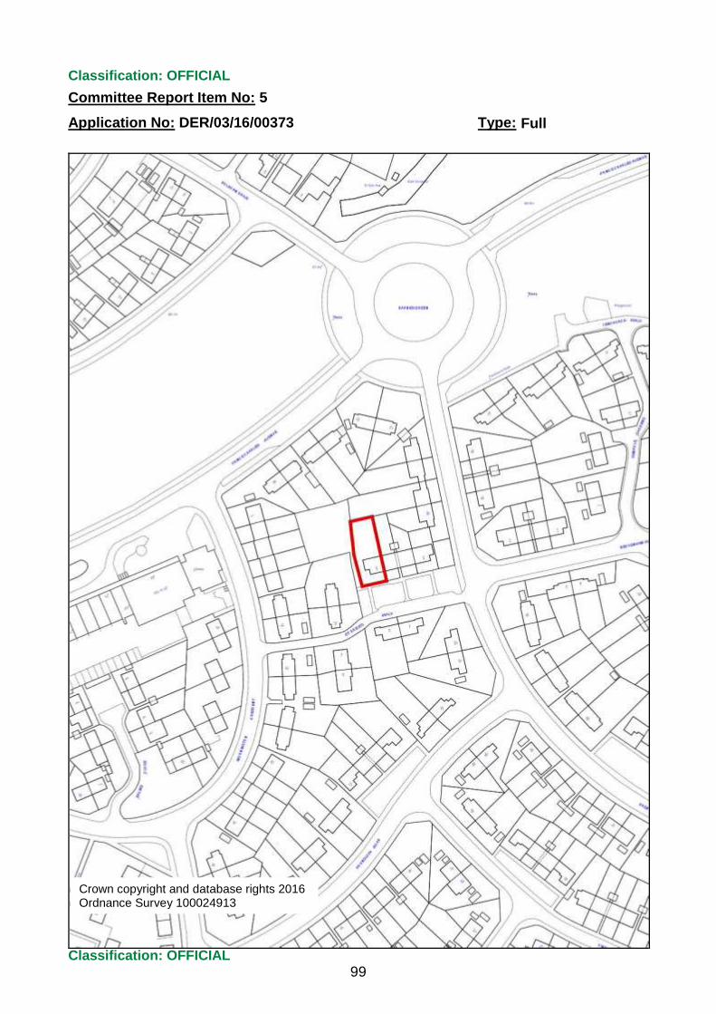
Classification: OFFICIAL
Committee Report Item No: 5
Application No: DER/03/16/00373 Type:
Classification: OFFICIAL
99
Full
Crown copyright and database rights 2016 Ordnance Survey 100024913

Application No. Application Type Location Proposal Decision Decision Date
05/14/00709/PRI Full Planning Permission Land corner of Wood Road & Wayfaring Road, Oakwood, Derby
Erection of 6 dwelling houses Granted Conditionally 13/04/2016
05/15/00698/PRI Full Planning Permission Derby Triangle, Wyvern Way, Derby
Enabling Infrastructure Works prior to change of use of existing undeveloped land to open space including flood alleviation conveyance corridor, top soil stripping and earthworks re-modelling within the wider outline planning application site for mixed use employment development.
Granted Conditionally 06/04/2016
07/15/00900/PRI Certificate of Lawfulness Proposed Use
1 Marks Close, Sunnyhill, Derby, DE23 7HB
Bricking up of existing front door and installation of new front door and window to the side elevation
Granted 26/04/2016
08/15/01036/PRI Full Planning Permission 22 Avalon Drive, Chellaston, Derby, DE73 5AP
Erection of boundary fence Granted Conditionally 29/04/2016
08/15/01106/PRI Full Planning Permission 2 Songbird Close, Derby, DE22 1LB Erection of balcony on the rear elevation Granted Conditionally 29/04/2016
09/15/01123/PRI Full Planning Permission 4 West Road, Spondon, Derby, DE21 7AB
Repair works to the existing outbuilding. Single storey side and rear extensions to dwelling house (utility room, shower room and enlargement of lobby and store room)
Granted Conditionally 08/04/2016
09/15/01134/PRI Variation/Waive of condition(s)
Land to the west of Wilmore Road and the North of Lea Farm, Sinfin Moor Lane, Chellaston, Derby
Variation of condition 2 of previously approved planning permission Code No. DER/01/14/00011 to amend the approved site layout and elevations to the sub-station
Granted Conditionally 18/04/2016
10/15/01231/PRI Full Planning Permission 19 Mileash Lane, Darley Abbey, Derby, DE22 1DD
Erection of potting shed, extension to boundary wall together with landscaping and retention of erection of shed and various landscaping works
Granted Conditionally 06/04/2016
Derby City CouncilDelegated decsions made between 01/04/2016 and 30/04/2016
Data Source: Acolaid DCCORETime Fetched: 5/4/2016 3:08:10 PMReport Name: Delegated DecisionsPage 1 of 14
ENCLOSURE

Application No. Application Type Location Proposal Decision Decision Date
10/15/01286/PRI Full Planning Permission 40 St. Marys Gate, Derby, DE1 3JZ Change of use from office (use class B1) to residential (use class C3) and installation of three replacement windows to the rear elevation and a boundary wall
Granted Conditionally 15/04/2016
10/15/01287/PRI Listed Building Consent -alterations
40 St. Marys Gate, Derby, DE1 3JZ Various alterations in association with change of use from office (use class B1) to residential (use class C3)
Granted Conditionally 15/04/2016
10/15/01297/PRI Full Planning Permission 111 Morley Road, Chaddesden, Derby, DE21 4QX
First floor and single storey extensions to dwelling (kitchen, utility room, breakfast room, three bedrooms, two bathrooms and store). Conversion and extension of garage to form accommodation for a dependent relative, erection of a detached garage, boundary wall and gates
Granted Conditionally 07/04/2016
10/15/01337/DCC Variation/Waive of condition(s)
Land between Holmleigh Way and Wilmore Road, Derby
Variation of condition 2 and removal of condition 3 of previously approved planning permission Code No. DER/05/13/00463/DCC to provide facilities for cyclists and allow opening of the road without junction improvements due to the re-alignment of Victory Road under application Code no. DER/04/15/00506/PRI
Granted Conditionally 19/04/2016
10/15/01341/PRI Listed Building Consent -alterations
19 Mileash Lane, Darley Abbey, Derby, DE22 1DD
Erection of potting shed, extension to boundary wall together with landscaping and retention of erection of shed and various landscaping works
Granted Conditionally 06/04/2016
10/15/01344/PRI Full Application - Article 4 84 Chester Green Road, Derby, DE1 3SF
Installation of replacement windows to the front elevation
Granted Conditionally 19/04/2016
11/15/01367/PRI Works to Trees under TPO Coney Grey, South Drive, Derby, DE1 3ET
Crown reduction in height by 1.5m and width by 1m of Walnut tree protected by Tree Preservation Order No. 299
Granted Conditionally 18/04/2016
Data Source: Acolaid DCCORETime Fetched: 5/4/2016 3:08:10 PMReport Name: Delegated DecisionsPage 2 of 14
ENCLOSURE
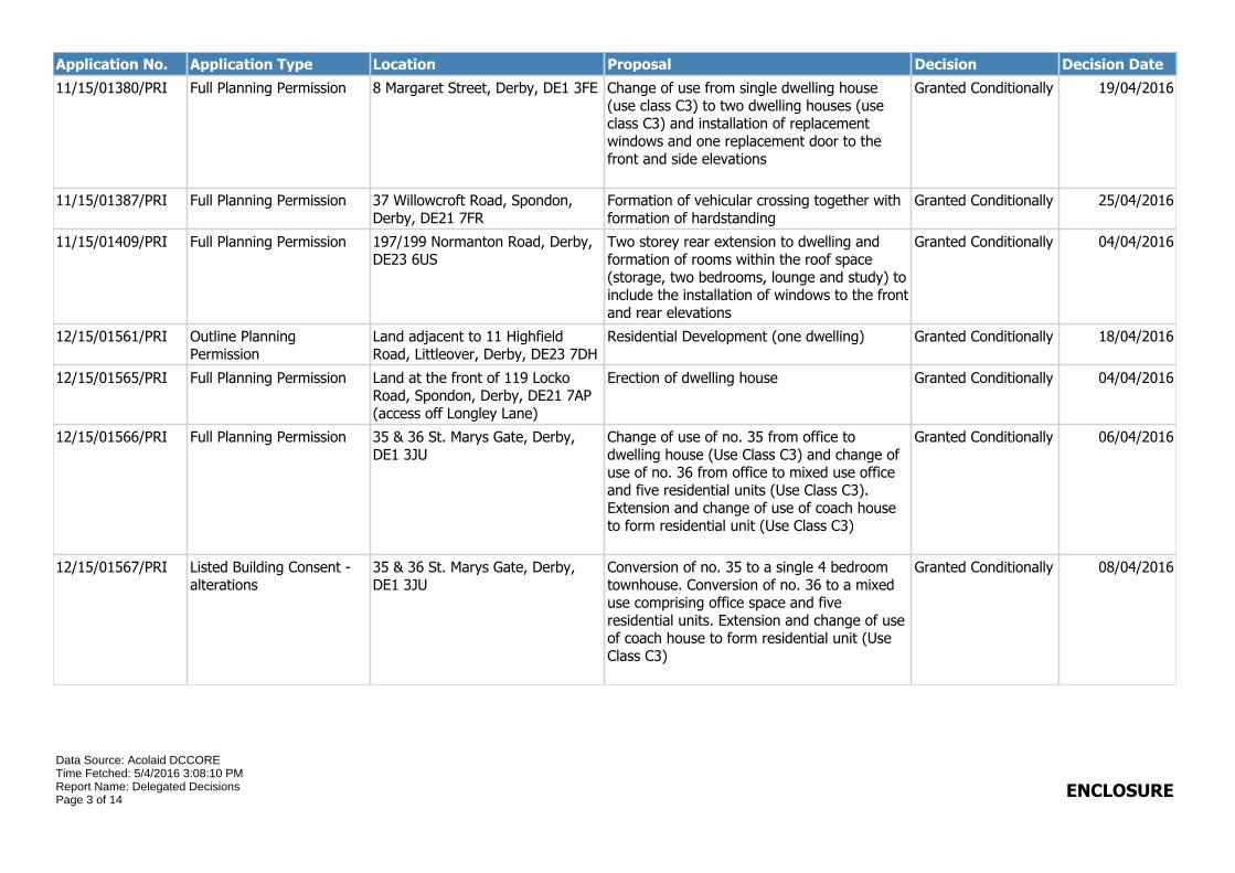
Application No. Application Type Location Proposal Decision Decision Date
11/15/01380/PRI Full Planning Permission 8 Margaret Street, Derby, DE1 3FE Change of use from single dwelling house (use class C3) to two dwelling houses (use class C3) and installation of replacement windows and one replacement door to the front and side elevations
Granted Conditionally 19/04/2016
11/15/01387/PRI Full Planning Permission 37 Willowcroft Road, Spondon, Derby, DE21 7FR
Formation of vehicular crossing together with formation of hardstanding
Granted Conditionally 25/04/2016
11/15/01409/PRI Full Planning Permission 197/199 Normanton Road, Derby, DE23 6US
Two storey rear extension to dwelling and formation of rooms within the roof space (storage, two bedrooms, lounge and study) to include the installation of windows to the front and rear elevations
Granted Conditionally 04/04/2016
12/15/01561/PRI Outline Planning Permission
Land adjacent to 11 Highfield Road, Littleover, Derby, DE23 7DH
Residential Development (one dwelling) Granted Conditionally 18/04/2016
12/15/01565/PRI Full Planning Permission Land at the front of 119 Locko Road, Spondon, Derby, DE21 7AP (access off Longley Lane)
Erection of dwelling house Granted Conditionally 04/04/2016
12/15/01566/PRI Full Planning Permission 35 & 36 St. Marys Gate, Derby, DE1 3JU
Change of use of no. 35 from office to dwelling house (Use Class C3) and change of use of no. 36 from office to mixed use office and five residential units (Use Class C3). Extension and change of use of coach house to form residential unit (Use Class C3)
Granted Conditionally 06/04/2016
12/15/01567/PRI Listed Building Consent -alterations
35 & 36 St. Marys Gate, Derby, DE1 3JU
Conversion of no. 35 to a single 4 bedroom townhouse. Conversion of no. 36 to a mixed use comprising office space and five residential units. Extension and change of use of coach house to form residential unit (Use Class C3)
Granted Conditionally 08/04/2016
Data Source: Acolaid DCCORETime Fetched: 5/4/2016 3:08:10 PMReport Name: Delegated DecisionsPage 3 of 14
ENCLOSURE

Application No. Application Type Location Proposal Decision Decision Date
12/15/01576/PRI Full Planning Permission 119 Locko Road, Spondon, Derby, DE21 7AP
Single storey extensions to dwelling (porch, bedroom, lobby and w.c.) remodelling of the existing roof and erection of detached garage
Granted Conditionally 04/04/2016
01/16/00001/PRI Works to Trees under TPO Land adjacent to 15 Crossdale Grove, Oakwood, Derby, DE21 2QZ
Felling of Willow tree and cutting back of hedgerow to give 3m clearance from the boundary of 15 Crossdale Grove protected by Tree Preservation Order No's 31 and 220
Refuse Planning Permission
08/04/2016
01/16/00006/PRI Full Application - disabled People
65 South Avenue, Spondon, Derby, DE21 7FS
Single storey front extension to dwelling house (bathroom and enlargement of living room)
Granted Conditionally 19/04/2016
01/16/00016/PRI Works to Trees under TPO 408 Burton Road, Derby, DE23 6AJ Felling of Horse Chestnut tree protected by Tree Preservation Order No. 279
Granted Conditionally 08/04/2016
01/16/00047/PRI Full Planning Permission 652 Nottingham Road, Derby, DE21 6SX
Single storey side extension (treatment room, w.c. and office) to form clinic (use class D1) and change of use of part of the existing clinic (use class D1) to a dwelling house (use class C3) including formation of an access from Nottingham Road
Granted Conditionally 27/04/2016
01/16/00053/PRI Full Planning Permission 3 Cotswold Close, Littleover, Derby, DE23 7FE
Single storey extension to dwelling house (kitchen/dining room, utility room and shower room)
Granted Conditionally 07/04/2016
01/16/00063/PRI Full Planning Permission 96 Traffic Street, Derby, DE1 2NL Change of use of first floor from office (use class B1) and erection of additional storey to form four flats (use class C3)
Granted Conditionally 05/04/2016
01/16/00069/PRI Works to Trees under TPO 26 Beechwood Park Drive, Derby, DE22 1BF
Removal of deadwood and crown reduction by 3m of Lime tree protected by Tree Preservation Order No. 308
Refuse Planning Permission
18/04/2016
01/16/00083/PRI Full Planning Permission 128 & 130 London Road, Derby, DE1 2SR
First floor rear extension to 128 London Road to form two flats and two bedsits (use class C3) and installation of an external staircase
Granted Conditionally 19/04/2016
Data Source: Acolaid DCCORETime Fetched: 5/4/2016 3:08:10 PMReport Name: Delegated DecisionsPage 4 of 14
ENCLOSURE

Application No. Application Type Location Proposal Decision Decision Date
01/16/00087/PRI Local Council devt Reg 4 A52 Wyvern Junction, Derby A52 Wyvern Transport Improvements scheme - The scheme involves the realignment of A52 Wyvern junction, replacement footbridge and associated embankments, highway, accommodation and earth works. The areas requiring Planning Permission are as follows; Replacement footbridge from Meadow Lane to Wyvern Way over the A52 Realigned junction from the A52 to Wyvern Way Construction of a new pumping station and associated earthworks to the south of Wyvern Way Accommodation works including new access road to Toys 'R' us car park Construction of a new noise bund to the North of the A52
Granted Conditionally 12/04/2016
01/16/00100/PRI Full Planning Permission 4 Stonechat Close, Mickleover, Derby, DE3 5XQ
Two storey side extension to dwelling house (kitchen, dining room, utility room, two bedrooms and en-suite)
Granted Conditionally 19/04/2016
01/16/00106/PRI Full Planning Permission 347 Boulton Lane, Derby, DE24 9FT
Single storey front and two storey side extensions to dwelling house (porch, garage, utility room, w.c., bedroom, en-suite and enlargement of bedroom)
Granted Conditionally 08/04/2016
01/16/00117/PRI Advertisement consent Derby High School, Hillsway, Littleover, Derby, DE23 7DT
Display of externally illuminated fascia sign to Kindergarten building
Granted Conditionally 06/04/2016
01/16/00118/PRI Full Planning Permission 56 Boulton Lane, Derby, DE24 0GE Two storey side extensions to dwelling house (kitchen, dining room, two bedrooms and enlargement of bathroom)
Granted Conditionally 01/04/2016
02/16/00120/PRI Certificate of Lawfulness Proposed Use
Unit 7, Prime Enterprise Park, Prime Park Way, Derby, DE1 3QB
Change of use from general industry (use class B2) to business (use class B1)
Granted 05/04/2016
Data Source: Acolaid DCCORETime Fetched: 5/4/2016 3:08:10 PMReport Name: Delegated DecisionsPage 5 of 14
ENCLOSURE

Application No. Application Type Location Proposal Decision Decision Date
02/16/00125/PRI Works to Trees under TPO Willow Lodge, 5 Stanley Close, Derby, DE22 1AG
Pollarding and crown reduction back to previous work height of 3 Lime trees, deadwood and removal of branch of Pine tree and reduce and shape of 2 Yew trees and 1 Holly tree protected by Tree Preservation Order No's.152 & 566
Granted Conditionally 19/04/2016
02/16/00126/PRI Works to Trees under TPO 44 Bridgeness Road, Littleover, Derby, DE23 7UJ
Felling of two Ash Trees protected by Tree Preservation Order No. 78
Granted Conditionally 06/04/2016
02/16/00127/PRI Full Planning Permission 29 Wimbledon Road, Derby, DE22 4ED
Single storey side extension to dwelling house (bedroom and bathroom)
Granted Conditionally 07/04/2016
02/16/00130/PRI Full Planning Permission 76B Pastures Hill, Littleover, Derby, DE23 7BB
Erection of detached garage Granted Conditionally 06/04/2016
02/16/00134/PRI Full Planning Permission Meadfoot, 28 Parkfields Drive, Derby, DE22 1HH
First floor side and single storey rear extensions to dwelling house (living space and two bedrooms)
Granted Conditionally 08/04/2016
02/16/00141/PRI Works to Trees in a Conservation Area
130 Duffield Road, Derby, DE22 1BG
Crown reduction of Silver Birch tree by six metres with proportionate reduction in overall width within the Strutts Park Conservation Area
Raise No Objection 05/04/2016
02/16/00142/PRI Works to Trees in a Conservation Area
4 Siddals Lane, Allestree, Derby, DE22 2DY
Felling of Lawson Cypress tree within the Allestree Conservation Area
Raise No Objection 05/04/2016
02/16/00147/PRI Full Planning Permission 247 Porter Road, Derby, DE23 6RG Two storey rear extension to dwelling house (kitchen, bedroom and bathroom)
Granted Conditionally 01/04/2016
02/16/00150/PRI Full Planning Permission 1 New Zealand Square, Derby, DE22 3BZ
Single storey front extension to dwelling house (porch and enlargement of bathroom)
Granted Conditionally 08/04/2016
02/16/00151/PRI Full Planning Permission 11 Crabtree Close, Allestree, Derby, DE22 2SW
Two storey and single storey side and rear extensions to dwelling house (utility room, w.c., dining room, conservatory and two bedrooms) and installation of raised decking area
Granted Conditionally 06/04/2016
02/16/00154/PRI Full Planning Permission Ivatt House, Unit 7, The Point, Pinnacle Way, Pride Park, Derby, DE24 8ZS
Erection of cycle shelter and formation of three additional parking bays
Granted Conditionally 05/04/2016
Data Source: Acolaid DCCORETime Fetched: 5/4/2016 3:08:10 PMReport Name: Delegated DecisionsPage 6 of 14
ENCLOSURE

Application No. Application Type Location Proposal Decision Decision Date
02/16/00156/PRI Full Planning Permission 456 Kedleston Road, Derby, DE22 2ND
Single storey rear extension to dwelling house (utility room and enlargement of sitting room)
Granted Conditionally 05/04/2016
02/16/00157/PRI Full Planning Permission 12 Bramble Street, Derby, DE1 1HU
Change of use from office (use class B1) to residential (use class C3)
Granted Conditionally 11/04/2016
02/16/00161/PRI Advertisement consent Pride Park Stadium, Pride Park, Derby, DE24 8XL (Greggs)
Display of various signage Granted Conditionally 06/04/2016
02/16/00162/PRI Full Planning Permission Air Training Corps, Curzon Lane, Alvaston, Derby, DE24 8RG
Demolition of cadet centre and modular buildings and erection of replacement cadet centre, closure of vehicle access and widening of vehicle access
Granted Conditionally 18/04/2016
02/16/00164/PRI Full Planning Permission Silecroft, 2 Friars Close, Darley Abbey, Derby, DE22 1FD
Installation of render to the front elevation and erection of detached garage and boundary gates
Granted Conditionally 08/04/2016
02/16/00165/PRI Full Planning Permission 26 Appian Way, Alvaston, Derby, DE24 0TG
Erection of boundary fence Granted Conditionally 05/04/2016
02/16/00167/PRI Full Planning Permission 221 Porter Road, Derby, DE23 6RG Two storey side extension to dwelling house (bedroom and enlargement of bedroom) and installation of a dormer window to the rear elevation
Granted Conditionally 29/04/2016
02/16/00168/PRI Certificate of Lawfulness Proposed Use
221 Porter Road, Derby, DE23 6RG Installation of rear dormer Granted 05/04/2016
02/16/00169/PRI Full Planning Permission 22 Aylesbury Avenue, Chaddesden, Derby, DE21 6JB
Two storey side and single storey front extensions to dwelling house (porch, lounge, shower room, bedroom and en-suite)
Granted Conditionally 05/04/2016
02/16/00172/PRI Full Planning Permission 133 Rutland Street, Derby, DE23 8PS
Retention of change of use from factory (use class B1) to storage and distribution (use class B8)
Granted Conditionally 06/04/2016
02/16/00173/PRI Full Planning Permission 16 Edale Avenue, Mickleover, Derby, DE3 5FY
Two storey side extension to dwelling house (garage, lounge/playroom, w.c. and two bedrooms)
Granted Conditionally 06/04/2016
Data Source: Acolaid DCCORETime Fetched: 5/4/2016 3:08:10 PMReport Name: Delegated DecisionsPage 7 of 14
ENCLOSURE
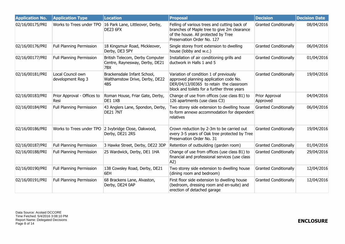
Application No. Application Type Location Proposal Decision Decision Date
02/16/00175/PRI Works to Trees under TPO 16 Park Lane, Littleover, Derby, DE23 6FX
Felling of various trees and cutting back of branches of Maple tree to give 2m clearance of the house. All protected by Tree Preservation Order No. 127
Granted Conditionally 08/04/2016
02/16/00176/PRI Full Planning Permission 18 Kingsmuir Road, Mickleover, Derby, DE3 5PY
Single storey front extension to dwelling house (lobby and w.c.)
Granted Conditionally 06/04/2016
02/16/00177/PRI Full Planning Permission British Telecom, Derby Computer Centre, Raynesway, Derby, DE21 7BX
Installation of air conditioning grills and ductwork in Halls 1 and 5
Granted Conditionally 01/04/2016
02/16/00181/PRI Local Council own development Reg 3
Brackensdale Infant School, Walthamstow Drive, Derby, DE22 4BS
Variation of condition 1 of previously approved planning application code No. DER/04/13/00365 to retain the classroom block and toilets for a further three years
Granted Conditionally 19/04/2016
02/16/00183/PRI Prior Approval - Offices to Resi
Roman House, Friar Gate, Derby, DE1 1XB
Change of use from offices (use class B1) to 126 apartments (use class C3)
Prior Approval Approved
04/04/2016
02/16/00184/PRI Full Planning Permission 43 Anglers Lane, Spondon, Derby, DE21 7NT
Two storey side extension to dwelling house to form annexe accommodation for dependent relatives
Granted Conditionally 06/04/2016
02/16/00186/PRI Works to Trees under TPO 2 Ivybridge Close, Oakwood, Derby, DE21 2RS
Crown reduction by 2-3m to be carried out every 3-5 years of Oak tree protected by Tree Preservation Order No. 31
Granted Conditionally 19/04/2016
02/16/00187/PRI Full Planning Permission 3 Hawke Street, Derby, DE22 3DP Retention of outbuilding (garden room) Granted Conditionally 01/04/2016
02/16/00188/PRI Full Planning Permission 25 Wardwick, Derby, DE1 1HA Change of use from offices (use class B1) to financial and professional services (use class A2)
Granted Conditionally 29/04/2016
02/16/00190/PRI Full Planning Permission 138 Cowsley Road, Derby, DE21 6EH
Two storey side extension to dwelling house (dining room and bedroom)
Granted Conditionally 12/04/2016
02/16/00191/PRI Full Planning Permission 68 Brackens Lane, Alvaston, Derby, DE24 0AP
First floor side extension to dwelling house (bedroom, dressing room and en-suite) and erection of detached garage
Granted Conditionally 12/04/2016
Data Source: Acolaid DCCORETime Fetched: 5/4/2016 3:08:10 PMReport Name: Delegated DecisionsPage 8 of 14
ENCLOSURE

Application No. Application Type Location Proposal Decision Decision Date
02/16/00192/PRI Works to Trees under TPO 3 Lindford Close, Oakwood, Derby, DE21 4TA
Reduction of overhanging branches by 2 metres and 3 metres of two Oak trees protected by Tree Preservation Order No.11
Granted Conditionally 08/04/2016
02/16/00196/PRI Full Planning Permission 3 Meynell Court, Allestree, Derby, DE22 2NW
Two storey side and single storey rear extensions to dwelling house (kitchen, utility room, sun lounge, bedroom and dressing room) and erection of boundary fence
Granted Conditionally 18/04/2016
02/16/00197/PRI Full Planning Permission 45 Madeley Street, Derby, DE23 8EY
Single storey rear extension to dwelling house (dining room, w.c and enlargement of kitchen)
Granted Conditionally 07/04/2016
02/16/00198/PRI Full Planning Permission 118 Grosvenor Street, Derby, DE24 8AT
Change of use from office (use class A2) and extension to form two flats (use class C3) and erection of single storey rear extension
Granted Conditionally 26/04/2016
02/16/00199/PRI Full Planning Permission 148 Derby Road, Chellaston, Derby, DE73 1RH
Two storey and single storey side extensions to dwelling house (study, kitchen, games room, w.c., garage, bedroom en-suite bathroom and rear balcony)
Granted Conditionally 12/04/2016
02/16/00200/PRI Full Planning Permission 28 Deincourt Close, Spondon, Derby, DE21 7LT
Single storey rear extension to dwelling house (kitchen and sun lounge)
Granted Conditionally 13/04/2016
02/16/00202/PRI Full Planning Permission 116 Nottingham Road, Spondon, Derby, DE21 7NP
Change of use from day nursery (Use Class D1), first floor extension and alterations to elevations to form 8 flats (Use Class C3)
Granted Conditionally 18/04/2016
02/16/00206/PRI Full Planning Permission 1 Elms Drive, Littleover, Derby, DE23 6FF
Single storey side extension to dwelling house (garage)
Granted Conditionally 08/04/2016
02/16/00208/PRI Full Planning Permission 28 Bonsall Avenue, Derby, DE23 6JW
Two storey side extension to dwelling house (shower room, hall, two bedrooms and enlargement of lounge)
Granted Conditionally 22/04/2016
02/16/00210/PRI Full Planning Permission Land at the side of 2 Moncrieff Crescent, Chaddesden, Derby, DE21 4NQ
Erection of dwelling house - amendments to previously approved planning permission Code No. DER/12/14/01697/PRI
Granted Conditionally 18/04/2016
Data Source: Acolaid DCCORETime Fetched: 5/4/2016 3:08:10 PMReport Name: Delegated DecisionsPage 9 of 14
ENCLOSURE
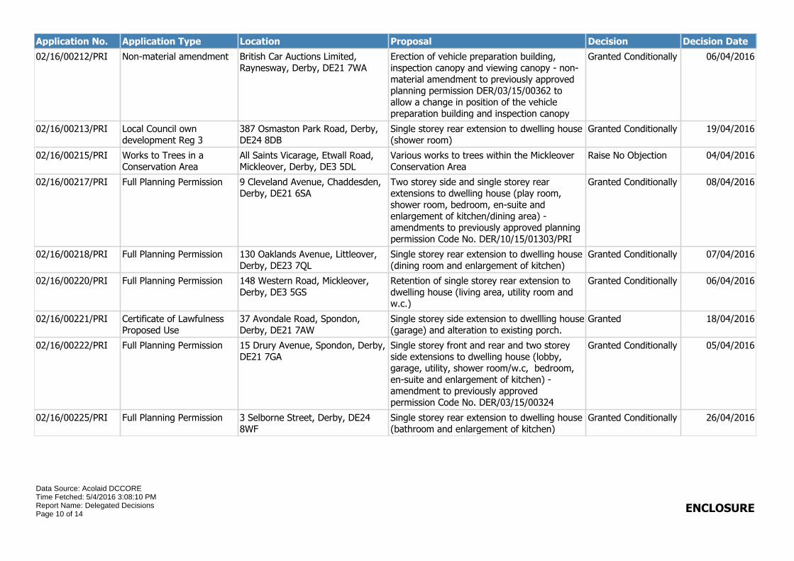
Application No. Application Type Location Proposal Decision Decision Date
02/16/00212/PRI Non-material amendment British Car Auctions Limited, Raynesway, Derby, DE21 7WA
Erection of vehicle preparation building, inspection canopy and viewing canopy - non-material amendment to previously approved planning permission DER/03/15/00362 to allow a change in position of the vehicle preparation building and inspection canopy
Granted Conditionally 06/04/2016
02/16/00213/PRI Local Council own development Reg 3
387 Osmaston Park Road, Derby, DE24 8DB
Single storey rear extension to dwelling house (shower room)
Granted Conditionally 19/04/2016
02/16/00215/PRI Works to Trees in a Conservation Area
All Saints Vicarage, Etwall Road, Mickleover, Derby, DE3 5DL
Various works to trees within the Mickleover Conservation Area
Raise No Objection 04/04/2016
02/16/00217/PRI Full Planning Permission 9 Cleveland Avenue, Chaddesden, Derby, DE21 6SA
Two storey side and single storey rear extensions to dwelling house (play room, shower room, bedroom, en-suite and enlargement of kitchen/dining area) - amendments to previously approved planning permission Code No. DER/10/15/01303/PRI
Granted Conditionally 08/04/2016
02/16/00218/PRI Full Planning Permission 130 Oaklands Avenue, Littleover, Derby, DE23 7QL
Single storey rear extension to dwelling house (dining room and enlargement of kitchen)
Granted Conditionally 07/04/2016
02/16/00220/PRI Full Planning Permission 148 Western Road, Mickleover, Derby, DE3 5GS
Retention of single storey rear extension to dwelling house (living area, utility room and w.c.)
Granted Conditionally 06/04/2016
02/16/00221/PRI Certificate of Lawfulness Proposed Use
37 Avondale Road, Spondon, Derby, DE21 7AW
Single storey side extension to dwellling house (garage) and alteration to existing porch.
Granted 18/04/2016
02/16/00222/PRI Full Planning Permission 15 Drury Avenue, Spondon, Derby, DE21 7GA
Single storey front and rear and two storey side extensions to dwelling house (lobby, garage, utility, shower room/w.c, bedroom, en-suite and enlargement of kitchen) - amendment to previously approved permission Code No. DER/03/15/00324
Granted Conditionally 05/04/2016
02/16/00225/PRI Full Planning Permission 3 Selborne Street, Derby, DE24 8WF
Single storey rear extension to dwelling house (bathroom and enlargement of kitchen)
Granted Conditionally 26/04/2016
Data Source: Acolaid DCCORETime Fetched: 5/4/2016 3:08:10 PMReport Name: Delegated DecisionsPage 10 of 14
ENCLOSURE

Application No. Application Type Location Proposal Decision Decision Date
02/16/00227/PRI Variation/Waive of condition(s)
Greyhound Hotel, Village Street, Derby, DE23 8DE
Variation of condition 3 of previously approved planning permission code No. DER/09/15/01221 to extend the hours of operation.
Granted Conditionally 15/04/2016
03/16/00230/PRI Certificate of Lawfulness Proposed Use
80 South Avenue, Spondon, Derby, DE21 7FS
Single storey rear extension to dwelling house Granted 21/04/2016
02/16/00233/PRI Full Planning Permission 356 Uttoxeter Road, Mickleover, Derby, DE3 5AG
Two storey rear and side extension to dwelling house (garage,cloak room, kitchen/diner, three bedrooms and two en-suites)
Granted Conditionally 19/04/2016
02/16/00236/PRI Works to Trees under TPO Derby Independent Grammar School For Boys, Rykneld Road, Littleover, Derby, DE23 7BH
Various works to trees protected by Tree Preservation Order No.78
Granted Conditionally 06/04/2016
02/16/00238/PRI Full Planning Permission 17 Babington Lane, Derby, DE1 1TA
Use of ground floor as an employment centre (Use Class A2)
Granted Conditionally 20/04/2016
02/16/00241/PRI Works to Trees under TPO Wilton Lodge, 38 Keats Avenue, Littleover, Derby, DE23 7ED
Crown reduction by 2 metres of Copper Beech tree protected by Tree Preservation Order No. 153
Granted Conditionally 18/04/2016
02/16/00246/PRI Full Planning Permission 1 North Close, Mickleover, Derby, DE3 5JA
Increase in height of roof and formation of rooms in roof space (two bedrooms, bathroom and dormers)
Granted Conditionally 24/04/2016
03/16/00247/PRI Full Planning Permission 17 Freesia Close, Mickleover, Derby, DE3 5NJ
First floor rear extension to dwelling house (bedroom)
Granted Conditionally 08/04/2016
03/16/00249/DCC Local Council own development Reg 3
Portway Infant School, Woodlands Road, Allestree, Derby, DE22 2HE
Erection of pergola Granted Conditionally 26/04/2016
02/16/00250/PRI Prior Approval - Householder
12 Melbourne Street, Derby, DE1 2GE
Single storey rear extension (projecting beyond the rear wall of the original house by 4.5m, maximum height 3.5m, height to eaves 2.6m) to dwelling house
Prior Approval Not required
01/04/2016
02/16/00252/PRI Full Planning Permission 30 Carsington Crescent, Allestree, Derby, DE22 2QZ
Two storey and single storey front and rear extensions to dwelling house (garage, hall, study, utility room, play room, lounge, two bedrooms and en-suite)
Refuse Planning Permission
29/04/2016
Data Source: Acolaid DCCORETime Fetched: 5/4/2016 3:08:10 PMReport Name: Delegated DecisionsPage 11 of 14
ENCLOSURE

Application No. Application Type Location Proposal Decision Decision Date
03/16/00253/PRI Full Planning Permission 18 Chain Lane, Mickleover, Derby, DE3 5AJ
Two storey side extension to dwelling house (kitchen, sitting room, two bedrooms and en-suite), formation of rooms in roof space (bedroom and en-suite) and installation of rear dormer
Granted Conditionally 29/04/2016
03/16/00255/PRI Full Planning Permission 57 South Avenue, Chellaston, Derby, DE73 1RS
Two storey side and single storey rear extensions to dwelling house (shower room, utility room, dining room, study and enlargement of kitchen and bedroom)
Granted Conditionally 26/04/2016
03/16/00256/PRI Full Planning Permission 7 Chesterton Avenue, Sunnyhill, Derby, DE23 7GS
Single storey side and rear extension to dwelling house (bathroom and kitchen/diner)
Granted Conditionally 28/04/2016
03/16/00261/PRI Full Planning Permission Unit 2C East Street, Derby, DE1 2AU
Change of use from retail (use class A1) to cafe (use class A3)
Granted Conditionally 24/04/2016
03/16/00262/PRI Certificate of Lawfulness Proposed Use
117 Markeaton Street, Derby, DE1 1DX
Single storey rear extension to dwelling house (enlargement of kitchen)
Granted 27/04/2016
03/16/00263/PRI Works to Trees in a Conservation Area
Trees at Roman House, Friar Gate, Derby, DE1 1XB
Cutting back of branches to give 2m clearance of the building of trees within the Friar Gate Conservation Area
Raise No Objection 07/04/2016
03/16/00265/PRI Full Planning Permission 10 Bishops Drive, Oakwood, Derby, DE21 2BA
Single storey side extension to dwelling (hall, bathroom, bedroom and en-suite)
Granted Conditionally 08/04/2016
03/16/00266/PRI Full Planning Permission 117 Friar Gate, Derby, DE1 1EX Retention of ATM Refuse Planning Permission
22/04/2016
03/16/00267/PRI Advertisement consent 117 Friar Gate, Derby, DE1 1EX Display of non illuminated ATM surround Refuse Planning Permission
22/04/2016
03/16/00268/PRI Listed Building Consent -alterations
117 Friar Gate, Derby, DE1 1EX Retention of installation of ATM to the front elevation
Refuse Planning Permission
22/04/2016
03/16/00271/PRI Prior Approval - Offices to Resi
Norman House & Saxon House, Friar Gate, Derby, DE1 1NU
Change of Use of offices (use class B1) to 87 apartments on first-fourth floors of Norman House and 48 apartments on ground-fifth floors of Saxon House (use class C3)
Prior Approval Approved
05/04/2016
Data Source: Acolaid DCCORETime Fetched: 5/4/2016 3:08:10 PMReport Name: Delegated DecisionsPage 12 of 14
ENCLOSURE

Application No. Application Type Location Proposal Decision Decision Date
02/16/00273/PRI Full Planning Permission Hartland Works, Haydock Park Road, Derby, DE24 8HW
Erection of office building Granted Conditionally 05/04/2016
03/16/00275/PRI Full Planning Permission 184 Chellaston Road, Derby, DE24 9EA
Enlargement of vehicular access Granted Conditionally 20/04/2016
03/16/00276/PRI Full Planning Permission 11 Kensal Rise, Derby, DE22 4DA Two storey side extension to dwelling house (lounge/bedroom, utility room, shower room and two bedrooms)
Granted Conditionally 18/04/2016
03/16/00279/PRI Prior Approval - Householder
56 Normanton Lane, Littleover, Derby, DE23 6GQ
Single storey rear extension (projecting beyond the rear wall of the original house by 4m, maximum height 3.3m, height to eaves 2.1m) to dwelling house
Prior Approval Not required
06/04/2016
03/16/00281/PRI Full Planning Permission 3 Church Lane, Darley Abbey, Derby, DE22 1EW
Two storey side extension and single storey and first floor rear extensions to dwelling house (kitchen, utility, two bedrooms, bathroom and enlargement of breakfast room)
Granted Conditionally 29/04/2016
03/16/00284/PRI Full Planning Permission McDonalds restaurant, Kingsway, Derby, DE22 4AA
Installation of replacement shopfront Granted Conditionally 19/04/2016
03/16/00286/PRI Full Planning Permission Osmaston Primary School, Addison Road, Derby, DE24 8FH
Erection of outbuilding (storage unit) Granted Conditionally 19/04/2016
03/16/00287/PRI Full Planning Permission 42 Murray Road, Mickleover, Derby, DE3 9LD
Single storey rear extension to dwelling house (conservatory and dining/living room) and formation of raised patio area
Granted Conditionally 20/04/2016
03/16/00288/PRI Full Planning Permission Car park fronting units 2-7, Wyvern Retail Park, Wyvern Way, Chaddesden, DE21 6NZ
Alterations to car park to form 22 additional spaces
Granted Conditionally 26/04/2016
03/16/00292/PRI Full Planning Permission 29 Kingsley Road, Allestree, Derby, DE22 2JJ
Single storey rear extension to dwelling house (bedroom and lounge)
Granted Conditionally 29/04/2016
03/16/00297/PRI Full Planning Permission 17 Sinfin Moor Lane, Chellaston, Derby, DE73 1SQ
Single storey rear extension to dwelling house (living room)
Granted Conditionally 26/04/2016
03/16/00302/PRI Full Planning Permission Land rear of 640 Burton Road, Littleover, Derby, DE23 6EL
Erection of dwelling house Granted Conditionally 24/04/2016
Data Source: Acolaid DCCORETime Fetched: 5/4/2016 3:08:10 PMReport Name: Delegated DecisionsPage 13 of 14
ENCLOSURE
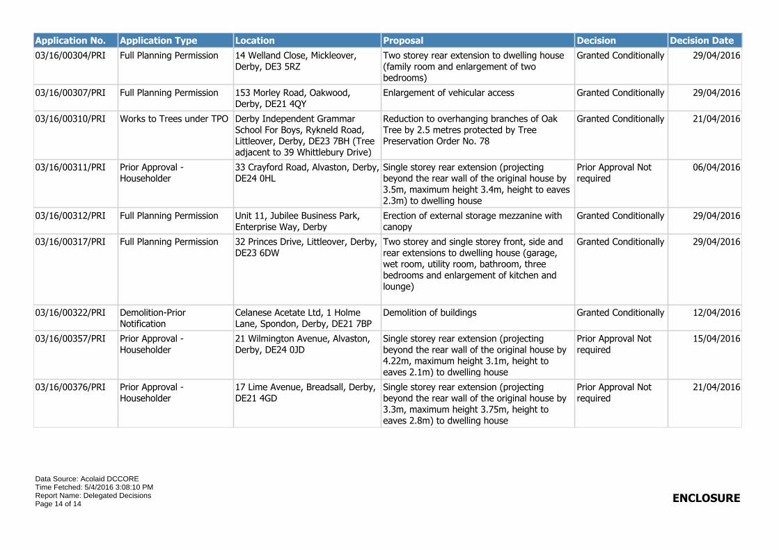
Application No. Application Type Location Proposal Decision Decision Date
03/16/00304/PRI Full Planning Permission 14 Welland Close, Mickleover, Derby, DE3 5RZ
Two storey rear extension to dwelling house (family room and enlargement of two bedrooms)
Granted Conditionally 29/04/2016
03/16/00307/PRI Full Planning Permission 153 Morley Road, Oakwood, Derby, DE21 4QY
Enlargement of vehicular access Granted Conditionally 29/04/2016
03/16/00310/PRI Works to Trees under TPO Derby Independent Grammar School For Boys, Rykneld Road, Littleover, Derby, DE23 7BH (Tree adjacent to 39 Whittlebury Drive)
Reduction to overhanging branches of Oak Tree by 2.5 metres protected by Tree Preservation Order No. 78
Granted Conditionally 21/04/2016
03/16/00311/PRI Prior Approval - Householder
33 Crayford Road, Alvaston, Derby, DE24 0HL
Single storey rear extension (projecting beyond the rear wall of the original house by 3.5m, maximum height 3.4m, height to eaves 2.3m) to dwelling house
Prior Approval Not required
06/04/2016
03/16/00312/PRI Full Planning Permission Unit 11, Jubilee Business Park, Enterprise Way, Derby
Erection of external storage mezzanine with canopy
Granted Conditionally 29/04/2016
03/16/00317/PRI Full Planning Permission 32 Princes Drive, Littleover, Derby, DE23 6DW
Two storey and single storey front, side and rear extensions to dwelling house (garage, wet room, utility room, bathroom, three bedrooms and enlargement of kitchen and lounge)
Granted Conditionally 29/04/2016
03/16/00322/PRI Demolition-Prior Notification
Celanese Acetate Ltd, 1 Holme Lane, Spondon, Derby, DE21 7BP
Demolition of buildings Granted Conditionally 12/04/2016
03/16/00357/PRI Prior Approval - Householder
21 Wilmington Avenue, Alvaston, Derby, DE24 0JD
Single storey rear extension (projecting beyond the rear wall of the original house by 4.22m, maximum height 3.1m, height to eaves 2.1m) to dwelling house
Prior Approval Not required
15/04/2016
03/16/00376/PRI Prior Approval - Householder
17 Lime Avenue, Breadsall, Derby, DE21 4GD
Single storey rear extension (projecting beyond the rear wall of the original house by 3.3m, maximum height 3.75m, height to eaves 2.8m) to dwelling house
Prior Approval Not required
21/04/2016
Data Source: Acolaid DCCORETime Fetched: 5/4/2016 3:08:10 PMReport Name: Delegated DecisionsPage 14 of 14
ENCLOSURE