appropriate assessment of the proposed variation …
TRANSCRIPT
APPROPRIATE ASSESSMENT OF THE PROPOSED VARIATION LANDS AT LUSK
AND THE DRAFT LUSK LOCAL AREA PLAN
Proposed Variation Lands At Lusk And The Draft Lusk Local Area Plan Appropriate Assessment
MDE0823RP0001 ii Rev F02
TABLE OF CONTENTS
1 INTRODUCTION ........................................................................................................................ 1
1.1 LEGISLATIVE CONTEXT – HABITATS DIRECTIVE ................................................................. 1
1.2 PROPOSED VARIATION AND THE DRAFT LAP..................................................................... 2
2 METHODOLOGY....................................................................................................................... 3
3 STAGE TWO APPROPRIATE ASSESSMENT ............................................................... 4
3.1 PROPOSED VARIATION – LANDS AT LUSK.......................................................................... 4
3.1.1 Development Plan Objectives........................................................................... 4
3.1.2 Local Objectives................................................................................................ 4
3.2 DRAFT LUSK LOCAL AREA PLAN ................................................................................. 7
3.3 QUALIFYING INTERESTS OF THE NATURA 2000 SITE.......................................................... 9
3.4 CONSERVATION OBJECTIVES OF THE NATURA 2000 SITE ...................................... 16
3.5 POTENTIAL EFFECTS.................................................................................................. 17
3.5.1 General ........................................................................................................... 17
3.5.2 Impacts on Water Quality................................................................................ 27
3.5.3 Water Abstraction and Supply ........................................................................ 28
3.5.4 Recreational Pressure .................................................................................... 28
4 MITIGATION MEASURES.................................................................................................... 29
5 CONCLUSIONS ....................................................................................................................... 34
6 REFERENCE DOCUMENTS ............................................................................................... 35
APPENDICES
Appendix 1: Appropriate Assessment Stage 1 Screening Report: Proposed Variation – Lands at Lusk
Appendix 2: Appropriate Assessment Stage 1 Screening Report: Draft Lusk Local Area Plan
Appendix 3: Plan Detailing the Proposed Variation of Lands at Lusk
Appendix 4: Plan Detailing the Draft Lusk Local Area Plan
Appendix 5: Natura 2000 Standard Data Form
Appendix 6: NPWS Site Synopses for cSAC and SPA Designations
Appendix 7: draft Conservation Plan for Rogerstown Estuary cSAC and SPA
Appendix 8: draft Conservation Objectives for Rogerstown Estuary
Proposed Variation Lands At Lusk And The Draft Lusk Local Area Plan Appropriate Assessment
MDE0823RP0001 1 Rev F02
1 INTRODUCTION
This report contains a record of the Habitats Directive Assessment (commonly called an ‘Appropriate Assessment’), undertaken by RPS on behalf of Fingal County Council in respect of a Proposed Variation to the Fingal Development Plan 2005-2011 for lands at Lusk (hereafter known as the Proposed Variation) and a Draft Lusk Local Area Plan (hereafter known as the Draft LAP), in accordance with the requirements of the Council Directive 92/43/EEC on the conservation of natural habitats and of wild fauna and flora.
This Appropriate Assessment Report should be read in conjunction with the Proposed Variation and the Draft LAP.
1.1 LEGISLATIVE CONTEXT – HABITATS DIRECTIVE
The Council Directive 92/43/EEC on the Conservation of Natural Habitats and of Wild Fauna and Flora, better known as “The Habitats Directive”, provides legal protection for habitats and species of European importance. The main aim of the Habitats Directive is “to contribute towards ensuring biodiversity through the conservation of natural habitats of wild fauna and flora in the European territory of the Member States to which the treaty applies” (92/43/EEC). Actions taken in order to fulfil the Directive must be designed to “maintain or restore, at a favourable conservation status, natural habitats and species of wild fauna and flora of Community interest” (92/43/EEC).
The Directive provides for the creation of protected sites known as Special Areas of Conservation (SACs) for a number of habitat types and certain species of flora and fauna. The Directive also seeks to establish “Natura 2000”, a network of protected areas throughout Europe. SACs together with the Special Protection Areas (SPAs) form the Natura 2000 network. The Directive was incorporated into Irish law by the European Communities (Natural Habitats) Regulations, SI 94/1997, under Regulation 31 (Annex 1.2).
An appropriate assessment is required under the EC Habitats Directive (92/43/EEC) for any plan or project likely to have significant effect on a Natura 2000. Article 6, paragraphs 3 and 4 of the Habitats Directive state as follows:
6(3) Any plan or project not directly connected with or necessary to the management of the site but likely to have a significant effect thereon, either individually or in combination with other plans or projects, shall be subject to appropriate assessment of its implications for the site in view of the site's conservation objectives. In the light of the conclusions of the assessment of the implications for the site and subject to the provisions of paragraph 4, the competent national authorities shall agree to the plan or project only after having ascertained that it will not adversely affect the integrity of the site concerned and, if appropriate, after having obtained the opinion of the general public.
6(4) If, in spite of a negative assessment of the implications for the site and in the absence of alternative solutions, a plan or project must nevertheless be carried out for imperative reasons of overriding public interest, including those of a social or economic nature, the Member State shall take all compensatory measures necessary to ensure that the overall coherence of Natura 2000 is protected. It shall inform the Commission of the compensatory measures adopted.
Where the site concerned hosts a priority natural habitat type and/or a priority species, the only considerations which may be raised are those relating to human health or public safety, to beneficial consequences of primary importance for the environment or, further to an opinion from the Commission, to other imperative reasons of overriding public interest.
Proposed Variation Lands At Lusk And The Draft Lusk Local Area Plan Appropriate Assessment
MDE0823RP0001 2 Rev F02
This means that where either the implementation of the Proposed Variation to the Fingal Development Plan 2005-2011 for lands at Lusk or the Draft Lusk Local Area Plan is likely to have a significant effect on a Natura site, the Local Authority must ensure that an appropriate assessment is carried out in view of that site’s conservation objectives. The Proposed Variation and Draft LAP can be approved by the Local Authority only if it has been ascertained that they will not adversely affect the integrity of the Natura 2000 site concerned, or in the case of a negative assessment and where there are no alternative solutions, the scheme can only be approved for reasons of overriding public interest.
1.2 PROPOSED VARIATION AND THE DRAFT LAP
In May 2005 Fingal County Council adopted a Variation to the Fingal Development Plan 2005-2011, Variation No.25. Variation No. 25 introduced a number of new land zonings within the plan area and Local Objectives. The purpose of the Variation was also to provide a framework onto which a LAP could be made.
As work has progressed on the Draft LAP Fingal County Council considered that further land rezonings would be required to realise the ambitions of the LAP. As a result a second Proposed Variation is now also proposed.
The Strategic Planning Unit of Fingal County Council prepared Appropriate Assessment Stage 1 Screening Reports for the Proposed Variation and the Draft LAP in May 2008, which are attached to this report as Appendices 1 and 2 respectively. Each report identifies elements of the Proposed Variation and Draft LAP respectively that are relevant to the Appropriate Assessment process and assesses the likelihood of significant effects upon the Rogerstown Estuary Natura 2000 site by the implementation of either the Proposed Variation and the Draft LAP. Based largely upon a Screening Matrix of potential effects of both the Proposed Variation and Draft LAP, each report concludes as follows:
On the basis of the findings of the Screenings for Appropriate Assessment it is concluded that neither the Proposed Variation for Lusk or the Draft Local Area Plan for Lusk was:
“(i) Not directly connected with or necessary to the management of a European Natura 2000 site and
(ii) May have significant effects on the management of the Natura 2000 site being Rogerstown Estuary a designated cSAC and SPA.”
Accordingly, having regard to Article 6(3) of the Habitats Directive, it is recommended that a full Appropriate Assessment will be required before the Planning Authority proceeds to adopt the Variation for lands at Lusk and the Lusk Local Area Plan.
It is in this context that RPS were commissioned by Fingal County Council to undertake a Stage Two Appropriate Assessment.

Proposed Variation Lands At Lusk And The Draft Lusk Local Area Plan Appropriate Assessment
MDE0823RP0001 3 Rev F02
2 METHODOLOGY
To date the Department of the Environment, Heritage and Local Government has not published guidelines specifically for undertaking assessment of plans or projects likely to result in significant impacts to the Natura network in Ireland. This assessment has been carried out using the following guidance:
Managing Natura 2000 Sites: the provisions of Article 6 of the Habitats Directive 92/43/EEC;
Assessment of Plans and Projects Significantly Affecting Natura 2000 Sites: Methodological guidance on the provisions of Article 6(3) and (4) of the Habitats Directive 92/43/EEC;
Guidance document on Article 6(4) of the 'Habitats Directive' 92/43/EEC – Clarification of the concepts of: alternative solutions, imperative reasons of overriding public interest, compensatory measures, overall coherence, opinion of the commission.
Based on these guidelines, the assessment is a four-staged approach described below.
Stage One: Screening / Test of Significance - the process which identifies the likely impacts upon a Natura 2000 site of a project or plan, either alone or in combination with other projects or plans, and considers whether these impacts are likely to be significant. The Strategic Planning Unit of Fingal County Council carried out Stage 1 Screening for the Proposed Variation and the Draft LAP in May 2008, which are attached to this report as Appendices 1 and 2
Stage Two: Appropriate Assessment - the consideration of the impact of the project or plan on the integrity of the Natura 2000 site, either alone or in combination with other projects or plans, with respect to (1) the site’s conservation objectives; and (2) the site’s structure and function and its overall integrity. Additionally, where there are adverse impacts, an assessment of the potential mitigation of those impacts;
Stage Three: Assessment of Alternative Solutions - the process which examines alternative ways of achieving the objectives of the project or plan that avoid adverse impacts on the integrity of the Natura 2000 site; and
Stage Four: Assessment Where Adverse Impacts Remain - an assessment of compensatory measures where, in the light of an assessment of Imperative Reasons of Overriding Public Interest (IROPI), it is deemed that the project or plan should proceed.
Proposed Variation Lands At Lusk And The Draft Lusk Local Area Plan Appropriate Assessment
MDE0823RP0001 4 Rev F02
3 STAGE TWO APPROPRIATE ASSESSMENT
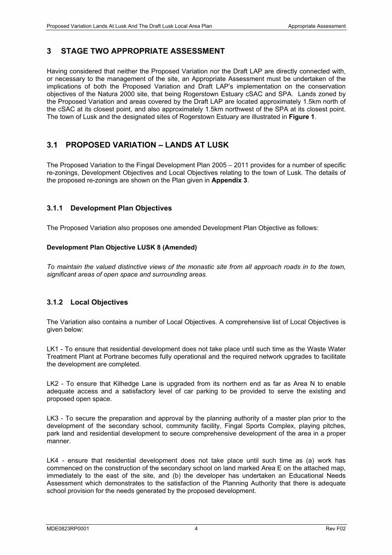
Having considered that neither the Proposed Variation nor the Draft LAP are directly connected with, or necessary to the management of the site, an Appropriate Assessment must be undertaken of the implications of both the Proposed Variation and Draft LAP’s implementation on the conservation objectives of the Natura 2000 site, that being Rogerstown Estuary cSAC and SPA. Lands zoned by the Proposed Variation and areas covered by the Draft LAP are located approximately 1.5km north of the cSAC at its closest point, and also approximately 1.5km northwest of the SPA at its closest point. The town of Lusk and the designated sites of Rogerstown Estuary are illustrated in Figure 1.
3.1 PROPOSED VARIATION – LANDS AT LUSK
The Proposed Variation to the Fingal Development Plan 2005 – 2011 provides for a number of specific re-zonings, Development Objectives and Local Objectives relating to the town of Lusk. The details of the proposed re-zonings are shown on the Plan given in Appendix 3.
3.1.1 Development Plan Objectives
The Proposed Variation also proposes one amended Development Plan Objective as follows:
Development Plan Objective LUSK 8 (Amended)
To maintain the valued distinctive views of the monastic site from all approach roads in to the town, significant areas of open space and surrounding areas.
3.1.2 Local Objectives
The Variation also contains a number of Local Objectives. A comprehensive list of Local Objectives is given below:
LK1 - To ensure that residential development does not take place until such time as the Waste Water Treatment Plant at Portrane becomes fully operational and the required network upgrades to facilitate the development are completed.
LK2 - To ensure that Kilhedge Lane is upgraded from its northern end as far as Area N to enable adequate access and a satisfactory level of car parking to be provided to serve the existing and proposed open space.
LK3 - To secure the preparation and approval by the planning authority of a master plan prior to the development of the secondary school, community facility, Fingal Sports Complex, playing pitches, park land and residential development to secure comprehensive development of the area in a proper manner.
LK4 - ensure that residential development does not take place until such time as (a) work has commenced on the construction of the secondary school on land marked Area E on the attached map, immediately to the east of the site, and (b) the developer has undertaken an Educational Needs Assessment which demonstrates to the satisfaction of the Planning Authority that there is adequate school provision for the needs generated by the proposed development.
LUSK
RUSH
DONABATE
ROGERSTOWN ESTUARYcSAC / SPA / pNHA / Ramsar
Scale: 1:25,000 @ A3
Approved by:
Checked by:
Title
Project
Issue Details
Drawn by:
Legend
Figure
Designated NatureConservatiuon Sitesat Rogerstown Estuary
Lusk Local Area PlanAppropriate Assessment
1
Rev.
File Ref.
Date: 22/09/2008
MC
SK
xxxx
JMC Project No. NI 1115
Drawing No.
xxxx
xxxxxxx
FingalCountyCouncil
Client
West Pier Business Campus,Dun Laoghaire,Co. DublinIreland
Notes 1. This drawing is the property of RPS Group Ltd.It is a confidential document and must not be copied,used, or its contents divulged without prior writtenconsent.
TFEW
+353 (0)1 2884499+353 (0)1 [email protected]/ireland
2. All levels are referred to Ordnance Datum, Malin Head.3. Ordnance Survey Ireland Licence 2003/07/CCMA© Copyright Government of Ireland.
Rogerstown Estuary SPA[Special Protection Area](including proposed extension)
Rogerstown Estuary pNHA[proposed Natural Heritage Area].
Rogerstown Estuary SAC[Special Area of Conservation].
Proposed Variation Lands At Lusk And The Draft Lusk Local Area Plan Appropriate Assessment
MDE0823RP0001 6 Rev F02
LK5 - To ensure that residential development does not take place until such time as (a) work has commenced on the construction of a new permanent primary school beyond the existing schools currently operating within the Lusk catchment area, and a new secondary school at Lusk, and (b) the developer has undertaken an Educational Needs Assessment which demonstrates to the satisfaction of the Planning Authority that there is adequate school provision for the needs generated by the proposed development.
LK6 - To provide for a Civic Square, and ensure that proposed development in the vicinity of the junction of Main Street, Station Road and Church Road facilitates the provision of a high quality Civic Square.
LK7 – To provide for a pedestrian right of way from Church Road to Post Office Road.
LK8 –To provide for a pedestrian right of way from Dublin Road through Town Park to Minister’s Road/Tower View.
LK9 – To limit residential development within Area D to a maximum of 10 dwellings per hectare.
LK11 – To ensure that development does not take place until such time as the Waste Water Treatment Plant at Portrane becomes fully operational and the required network upgrades to facilitate the development are completed.
LK12 – To ensure an appropriate mix of housing is provided in the local housing market.
LK13 – To require the provision of good pedestrian and cycle links between Areas M and N and the adjoining Chapel Farm Estate.
LK14 – To ensure that development does not take place until the necessary improvement of Minister’s Road as indicated on the Development Plan map is completed.
LK15 – To ensure that development does not take place until the playing pitch on Area R and Community Facility are constructed.
LK16 – To provide for a new Community Facility with a minimum floor area of 300 square metres.
LK17 – To provide for a pedestrian right of way between the Community Facility and Hand’s Lane.
LK18 [Applies to Areas D, F, H, R, P, Q, and S] - To ensure that no development takes place until such time that a Management Plan for the Outer Rogerstown Estuary is adopted by the Council. The Management Plan shall incorporate a timescale for the implementation of management measures.
Proposed Variation Lands At Lusk And The Draft Lusk Local Area Plan Appropriate Assessment
MDE0823RP0001 7 Rev F02
3.2 DRAFT LUSK LOCAL AREA PLAN
The Draft Lusk LAP also contains a number of Local Area Plan Objectives. A Plan detailing the Lusk Local Area Plan is provided as Appendix 4 to this report. A comprehensive list of Local Plan Objectives is given below:
Archaeology Objectives
Objective LP1: To protect and enhance the zone of archaeological potential {ZAP, DU008-010) of Lusk town through planning decisions attached to future developments. In accordance with the objectives of the Fingal Development Plan 2005 – 2011, development proposals within Lusk shall have due regard to the historical dimension of the existing environment and new development shall reflect the local distinctiveness, layout and scale of buildings and designed spaces, the quality and character of the built fabric and historic patterns that contribute to the overall uniqueness of the streetscape and surrounding landscape.
Objective LP2: To require that in accordance with the National Monuments Legislation 1930 – 2004 all proposed development in the ZAP will require pre-development archaeological assessment.
Objective LP3: To protect and enhance recorded archaeological sites (RMP sites) and their settings from inappropriate development that would adversely affect or detract from the monuments whilst at the same time enabling sustainable future development for Lusk.
Objective LP4: To protect as yet undiscovered archaeological sites or features that survive subsurface in accordance with the National Monuments Legislation.
Objective LP5: To create an accessible archaeological landscape, open to all, which will respect the setting and topographical integrity of the upstanding monuments
Heritage Trail Objective
Objective LP6: To create a town heritage trail to provide for a way marked route through the town interpreting important archaeological and historic features of the town
Boundary Treatment Objectives
Objective LP7: To reflect the important garden aspect of the character of the town, the protection of existing boundary hedges shall be encouraged and with regard to new developments strong preference will be given to the planting of boundary hedges and trees, using native species.
Objective LP8 – [Applies to Areas P, Q and R]: To ensure that existing hedgerows are maintained where practical and where necessary enhanced to secure adequate boundaries to the lands are maintained except where limited removal is necessary for the provision of access.
Inner Core Area of Protection Objectives
Objective LP9: To preserve the integrity of St. MacCullin’s Graveyard. No additional breaks within the graveyard wall shall be permitted.
Proposed Variation Lands At Lusk And The Draft Lusk Local Area Plan Appropriate Assessment
MDE0823RP0001 8 Rev F02
Objective LP10: To facilitate the provision of open space. The Council, will as and when opportunities arise, seek to promote in principle proposals which would significantly contribute to the openness and historic character of the Inner Core Area of Protection.
Objective LP11: To ensure that the character, setting and openness of the area surrounding the former St. MacCullin’s Church, Round Tower and graveyard complex is protected from inappropriate development.
Policy LP12: To ensure that all new developments respect the historic character of the Inner Core Area of Protection. All proposals within the Inner Core Area of Protection shall be laid out and designed to a high standard, to a scale in keeping with the historic character of the area. The external walls and roofs shall be faced with high quality materials and finishes.
Policy LP13: To preserve the openness of the locality and views of the former St. MacCullin’s Church, Round Tower and graveyard complex. No building within the Inner Core Area of Protection shall normally be permitted to exceed single storey height, unless special justification can be made. In the case of existing two storey residential dwellings two storey extensions may be permitted provided they meet the requirements of other Objectives. In any event developments shall be designed in such a manner so as not to compromise the important views of the former St. MacCullin’s Church when approaching from the south.
Outer Core Area of Protection Objectives
Objective LP14: To promote and support the openness and historic character of the Outer Core Area of Protection.
Objective LP15: To ensure that the views towards the former St. MacCullin’s Church and Round Tower are protected.
Objective LP16: To ensure that all new developments respect the historic character of the area. All proposals within the Outer Core Area of Protection shall be laid out and designed to a high standard, to a scale in keeping with the historic character of the area. The external walls and roofs shall be faced with high quality materials and finishes.
Objective LP17: To preserve the openness of the locality and views of the former St. MacCullin’s Church and Round Tower. With the possible exception of the key garage site, no building within the Outer Core Area of Protection shall exceed 2 storeys in height. The development of the key garage site shall not, unless special justification is made, exceed 3 storeys in height. In any event developments shall be designed in such a manner so as not to compromise the important views of the former St. MacCullin’s Church when approaching from the south.
Road Hierarchy, Shared surfaces and Footpath Network Objective
Objective LP18: To ensure and safeguard the expeditious passage of all route users. There shall be a clear hierarchy of road, shared surface routes and footpath network clearly defined through careful design incorporating surface treatments in a consistent manner throughout the town.
Proposed Variation Lands At Lusk And The Draft Lusk Local Area Plan Appropriate Assessment
MDE0823RP0001 9 Rev F02
3.3 EXISTING ENVIRONMENT
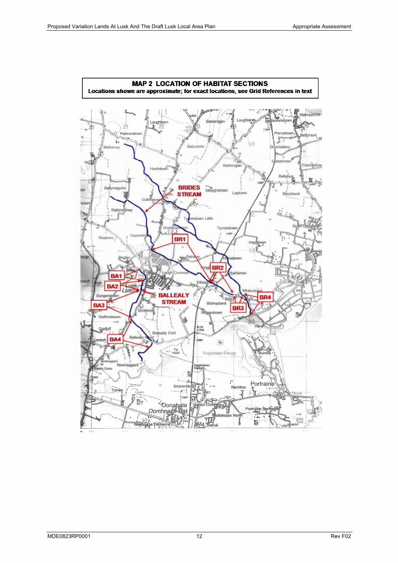
Two water courses are located in the vicinity of Lusk; Baleally and Bride streams. Baleally stream accepts storm water run-off from the Lusk area and for the Bride stream caters for surface water run off from the R127 and from developed land. Both of these streams flow into Rogerstown Estuary and any impacts on them have the potential to impact indirectly on the Estuary. The Balleally Stream rises in Lusk and flows for c.2.5km to Rogerstown Estuary. The Brides Stream rises c.1.5 north of Lusk and flows for c.5km in a south easterly direction to Rogerstown Estuary.
As part of this appropriate assessment, a general assessment of salmonid, lamprey and crayfish habitat quality was carried out on the Brides Stream and the Balleally Stream from Lusk to where the streams meet the tide at Rogerstown Estuary.
3.3.1 BALLEALLY STREAM
3.3.1.1 Water Quality
Biological sampling was carried out at Balleally Stream at a site indicate on Map 1. The macroinvertebrate fauna recorded at the site merit a Q-rating of Q1-2 indicating seriously polluted conditions. As the site may be subject to saline influence in high tide conditions, the Q-rating is tentative. However even in the case of saline influence the fauna would be indicative of significantly polluted conditions.
3.3.1.2 Fishery Importance
The combination of poor habitat quality, culverts and poor water quality makes it unlikely that the Balleally Stream has a population of trout, crayfish or lamprey.
3.3.1.3 Habitat Assessment
Habitat quality was assessed at four locations along Balleally stream as shown on Map 2. Details of the habitat are given in Table 3.1.
3.3.2 BRIDES STREAM
3.3.2.1 Water Quality
Biological sampling was carried out at Brides Stream at a site indicate on Map 1. The macroinvertebrate fauna recorded at the site merits a Q-rating of Q1-2 indicating seriously polluted conditions.
3.3.2.2 Fishery Importance
The combination of poor water quality, unsuitable culverts, and a man-made 1m high weir at Whitestown, makes it unlikely that brown trout, lamprey or crayfish exist in the potentially affected

Proposed Variation Lands At Lusk And The Draft Lusk Local Area Plan Appropriate Assessment
MDE0823RP0001 10 Rev F02
section of the Brides Stream. However sections of habitat suitable for trout, crayfish and lamprey were recorded. It is also notable the northern branch of the Brides Stream (i.e. the branch which flows via Collinstown Bridge) which is not potentially affected by the proposed development has habitat suitable for brown trout in the 1km section upstream of its confluence with the southern branch.
The Brides Stream system is likely to have had a population of brown trout in the past and may have served as a spawning area for sea/estuarine trout from Rogerstown Estuary.
3.3.2.3 Habitat Assessment
Habitat quality was assessed at four locations along Brides stream as shown on Map 2. Details of the habitat are given in Table 3.2.

Proposed Variation Lands At Lusk And The Draft Lusk Local Area Plan Appropriate Assessment
MDE0823RP0001 11 Rev F02
Proposed Variation Lands At Lusk And The Draft Lusk Local Area Plan Appropriate Assessment
MDE0823RP0001 12 Rev F02

Proposed Variation Lands At Lusk And The Draft Lusk Local Area Plan Appropriate Assessment
MDE0823RP0001 13 Rev F02
Table 3.1 Habitat description of Balleally stream.
Location Description Length SalmonidAdult
Habitat
SalmonidNursery Habitat
SalmonidSpawning
Habitat
Lamprey Nursery Habitat
Lamprey Spawning
Habitat
Crayfish Habitat
Habitat SectionBA - 1O2128 5438 to O2145 5411
Muddy drain with sections of dense Apiumnodiflorum.
c. 0.5km
None Poor Poor Poor Poor Poor
Habitat SectionBA - 2O2145 5411 to O2142 5383
Culvert of no habitat value and likely to constitute obstacle to upstream movement of aquatic fauna.
c.350m None None None None None None
Habitat SectionBA– 3O2142 5383 to O2110 5305
Polluted effluent enters the stream at the upstream end of the section (see Photo 3). Poor muddy glide with well developed Rorripa nasturtium aquaticum and Apium nodiflorum.Perched twin pipe culvert at O2134 5362 likely to constitute obstacle to upstream fish movement
c.1km None Poor - Fair None - Poor Fair None - Poor Poor - Fair
Habitat SectionBA– 4O2110 5305 to O2170 5230
Mostly poor muddy glide with some muddy cobble and gravel riffle. Heavy cover of hedgerow and bramble.
c.1km 08-Oct Poor Fair Poor Fair Poor

Proposed Variation Lands At Lusk And The Draft Lusk Local Area Plan Appropriate Assessment
MDE0823RP0001 14 Rev F02
Table 3.2 Habitat description of Brides stream.
Location Description Length SalmonidAdultHabitat
SalmonidNursery Habitat
SalmonidSpawning Habitat
Lamprey Nursery Habitat
Lamprey Spawning Habitat
Crayfish Habitat
Habitat SectionBR - 1O2178 5519 to O2345 5404
Mostly poor muddy glide much overgrown by Apium nodiflorum and Rorrippa nasturtium-aquaticum in upper section. Some poor muddy cobble and gravel riffle.
c.2.3km Poor Fair Fair Fair Fair Fair
Habitat SectionBR - 2O2345 5404 to O2405 5374
Muddy glide and riffle in upper section. Pond at O2366 5396 (photo 20 & 21). Lower section consisting of good riffle over muddy cobble and gravel. Stream backed up behind c.1.5m weir at O2400 5375
c.750m Poor Fair – Good Fair Fair Fair Fair
Habitat SectionBR - 3O2405 5374 to O2420 5369
This section conducts this branch of the stream to its confluence with the eastern branch of the stream. The section flows through a c. 150m culvert under buildings and then under an open field. There is a marked difference in turbidity between the upstream end of the culvert and the downstream end which is indicative of polluting material entering the stream within the culvert. The culvert is likely to constitute a partial or total obstruction to upstream fish movement.
c.200m None None None None None None
Habitat SectionBR – 4 O2420 5369 to O2445 5336
Mixture of riffle on muddy cobble and gravel and muddy glide with some marginal silts. Good bankside cover of bramble, hawthorn and some ash. The box culvert under the road at O2435 5362 is likely to constitute a partial obstacle to upstream fish movement, however the 1m high weir immediately upstream of the culvert is likely to constitute a total obstacle to upstream fish movement.
c.500m Fair Fair – Good Fair Fair Fair Fair
Proposed Variation Lands At Lusk And The Draft Lusk Local Area Plan Appropriate Assessment
MDE0823RP0001 15 Rev F02
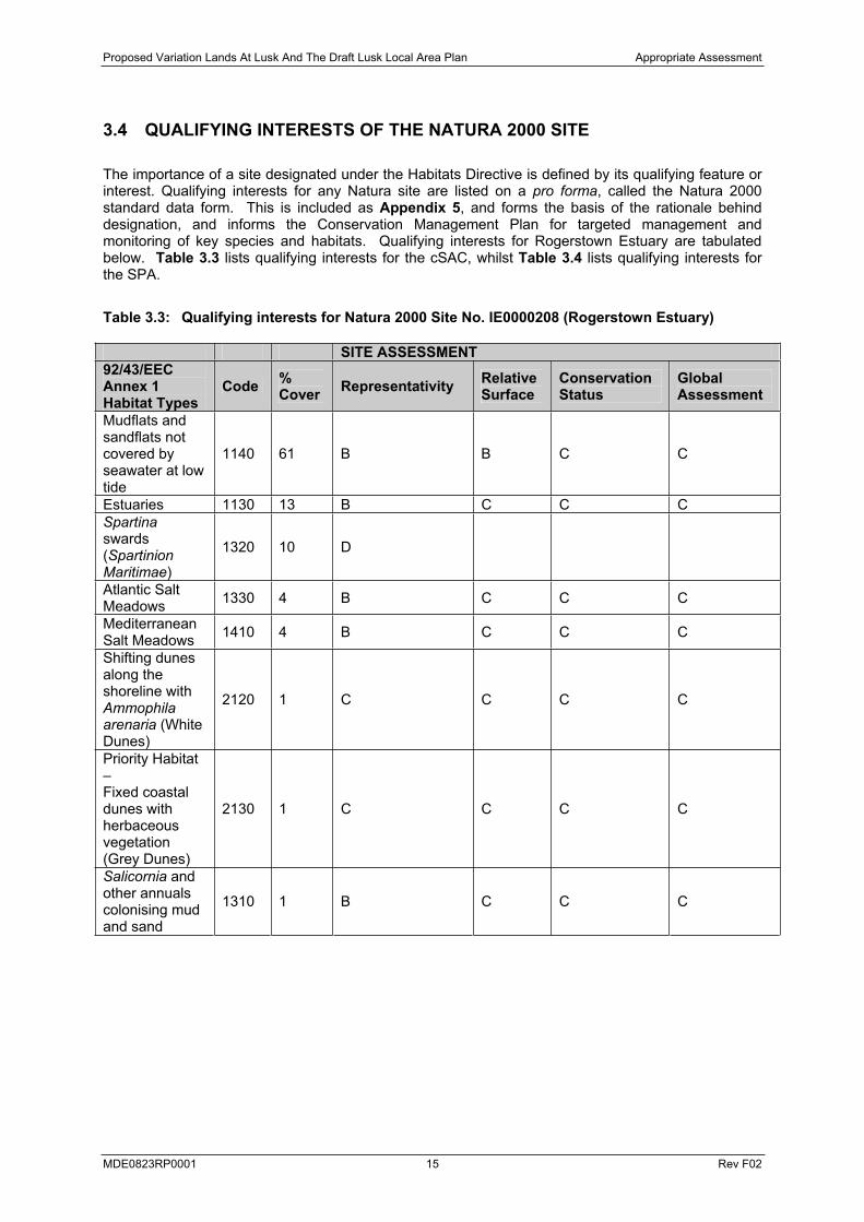
3.4 QUALIFYING INTERESTS OF THE NATURA 2000 SITE
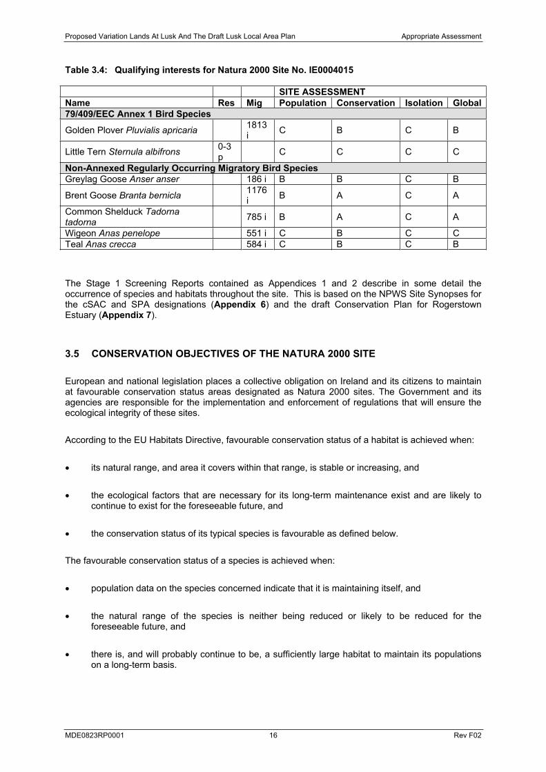
The importance of a site designated under the Habitats Directive is defined by its qualifying feature or interest. Qualifying interests for any Natura site are listed on a pro forma, called the Natura 2000 standard data form. This is included as Appendix 5, and forms the basis of the rationale behind designation, and informs the Conservation Management Plan for targeted management and monitoring of key species and habitats. Qualifying interests for Rogerstown Estuary are tabulated below. Table 3.3 lists qualifying interests for the cSAC, whilst Table 3.4 lists qualifying interests for the SPA.
Table 3.3: Qualifying interests for Natura 2000 Site No. IE0000208 (Rogerstown Estuary)
SITE ASSESSMENT 92/43/EECAnnex 1 Habitat Types
Code %Cover Representativity Relative
Surface Conservation Status
GlobalAssessment
Mudflats and sandflats not covered by seawater at low tide
1140 61 B B C C
Estuaries 1130 13 B C C C Spartinaswards (Spartinion Maritimae)
1320 10 D
Atlantic Salt Meadows 1330 4 B C C C
Mediterranean Salt Meadows 1410 4 B C C C
Shifting dunes along the shoreline with Ammophila arenaria (White Dunes)
2120 1 C C C C
Priority Habitat –Fixed coastal dunes with herbaceous vegetation(Grey Dunes)
2130 1 C C C C
Salicornia and other annuals colonising mud and sand
1310 1 B C C C
Proposed Variation Lands At Lusk And The Draft Lusk Local Area Plan Appropriate Assessment
MDE0823RP0001 16 Rev F02
Table 3.4: Qualifying interests for Natura 2000 Site No. IE0004015
SITE ASSESSMENTName Res Mig Population Conservation Isolation Global79/409/EEC Annex 1 Bird Species
Golden Plover Pluvialis apricaria 1813i C B C B
Little Tern Sternula albifrons 0-3p C C C C
Non-Annexed Regularly Occurring Migratory Bird Species Greylag Goose Anser anser 186 i B B C B
Brent Goose Branta bernicla 1176i B A C A
Common Shelduck Tadorna tadorna 785 i B A C A
Wigeon Anas penelope 551 i C B C C Teal Anas crecca 584 i C B C B
The Stage 1 Screening Reports contained as Appendices 1 and 2 describe in some detail the occurrence of species and habitats throughout the site. This is based on the NPWS Site Synopses for the cSAC and SPA designations (Appendix 6) and the draft Conservation Plan for Rogerstown Estuary (Appendix 7).
3.5 CONSERVATION OBJECTIVES OF THE NATURA 2000 SITE
European and national legislation places a collective obligation on Ireland and its citizens to maintain at favourable conservation status areas designated as Natura 2000 sites. The Government and its agencies are responsible for the implementation and enforcement of regulations that will ensure the ecological integrity of these sites.
According to the EU Habitats Directive, favourable conservation status of a habitat is achieved when:
its natural range, and area it covers within that range, is stable or increasing, and
the ecological factors that are necessary for its long-term maintenance exist and are likely to continue to exist for the foreseeable future, and
the conservation status of its typical species is favourable as defined below.
The favourable conservation status of a species is achieved when:
population data on the species concerned indicate that it is maintaining itself, and
the natural range of the species is neither being reduced or likely to be reduced for the foreseeable future, and
there is, and will probably continue to be, a sufficiently large habitat to maintain its populations on a long-term basis.

Proposed Variation Lands At Lusk And The Draft Lusk Local Area Plan Appropriate Assessment
MDE0823RP0001 17 Rev F02
The draft Conservation Objectives for Rogerstown Estuary cSAC Natura site have been provided by the NPWS (Appendix 8), and are as follows:
Objective 1: To maintain the Annex I habitats for which the cSAC has been selected at favourable conservation status: Estuaries; Mudflats and sandflats not covered by seawater at low tide; Salicornia and other annuals colonizing mud and sand; Atlantic salt meadows (Glauco-Puccinellietalia maritimae); Mediterranean salt meadows (Juncetalia maritimi);Shifting dunes along the shoreline with Ammophila arenaria (white dunes); Fixed coastal dunes with herbaceous vegetation (grey dunes).
Objective 2: To maintain the extent, species richness and biodiversity of the entire site.
Objective 3: To establish effective liaison and co-operation with landowners, legal users and relevant authorities.
Whilst SPA Conservation Objectives have been unavailable, the headline Conservation Objective will be to maintain the populations of Annex I and non-Annexed bird species for which the SPA has been selected at favourable conservation status.
3.6 POTENTIAL EFFECTS
3.6.1 General
The Proposed Variation and Draft LAP provide for development opportunities in and around the town of Lusk. The zonings provide a vehicle by which Local Objectives and Local Plan Objectives can be rationalised and implemented. The Proposed Variation and Draft LAP contains objectives in relation to residential development; educational facilities; transport and traffic management; public open space and landscaping; community facilities; water services and utilities.
The physical changes that will flow from the Proposed Variation and Draft LAP will include development proposals, with associated infrastructure, both within and outside proposed development limits. This will include potential impacts during the construction phase as well as day to day operational impacts. There are no Proposed Variation zonings, re-zonings, Development Plan Objectives or Local Objectives that have a direct negative impact on any features of the Natura 2000 site. However, a number of the Local Objectives, if implemented, have the potential to have an indirect impact, either alone or in combination, upon the qualifying interests of Rogerstown Estuary. These potential effects may derive from industrial or domestic emissions to water courses upstream of, or directly into a site; industrial aerial emissions and deposition; disturbance during construction phase (timing, duration, noise); or potential for increased disturbance/ pollution associated with increased recreational activity.
Table 3.5 lists a new Development Plan Objective included in the Proposed Variation and its likely effect upon the Natura 2000 site. Table 3.6 lists the Proposed Variation Zonings, Development Objectives and Local Objectives and their likely effects upon the Natura 2000 site. Table 3.7 lists the Draft LAP Objectives and their likely effect upon the Natura 2000 site.
Essentially, any element of the implementation of the Proposed Variation or Draft LAP which is likely to give rise to loss, fragmentation, pollution or degradation of habitats listed in Table 3.3 can be considered as a significant effect. Likewise, any element of the implementation of the Variation or LAP which is likely to result in effects upon those species listed in Table 3.4 by way of reduced populations, significant disturbance leading to increased energy expenditure due to avoidance,

Proposed Variation Lands At Lusk And The Draft Lusk Local Area Plan Appropriate Assessment
MDE0823RP0001 18 Rev F02
reduction in food availability or quality or loss of roosting sites can be considered as a significant effect.
In addition, any combination of effects not significant on their own, which would jeopardise the overall integrity or the conservation objectives of Rogerstown Estuary cSAC and SPA, or the conservation status of Annex habitats for which it has been designated, or populations of Annex species of high conservation importance for which it has been designated can be considered as a significant effect.
This Appropriate Assessment is focussed upon both the Variation and the Lusk LAP. Any site specific development consent applied for within areas subject to the LAP under the Planning and Development Regulations, 2001-2007 may result in a development specific Environmental Impact Assessment being triggered.
Proposed Variation Lands At Lusk And The Draft Lusk Local Area Plan Appropriate Assessment
MDE0823RP0001 19 Rev F02
Table 3.5 Lands at Lusk Variation: Proposed Development Plan Objective and its likely effects upon the Natura Site
Obj Lusk Variation Likely effects Nature of effect
LUSK8
To maintain the valued distinctive views of the monastic site from all approach roads in to the town, significant areas of open space and surrounding areas.
Implementation of Lusk 8 is assessed as having no relationship (significant or otherwise) to the Natura 2000 site, its qualifying interests or conservation objectives.
None
Table 3.6 Lands at Lusk Variation Zonings and Local Objectives and their likely effects upon the Natura 2000 site
Item Lusk Variation Zonings Likely effects Nature of effect
Z1
RS1 – To provide for new residential communities in accordance with approved local area plans and subject to the provision of the necessary social and physical infrastructure.
Development of any lands in Areas D, F, G, M, O, Q and S as per zoning objective RS1 is likely to place increased demands upon the sewerage and foulwater treatment infrastructure currently in place in Lusk. Without upgrading and increasing the capacity of these facilities, implementation of RS1 may result in increased frequencies of pollution events either via the treatment works located at and discharging into the estuary at various points, or via discharge and runoff entering Brides Stream or Balleally Stream, which in turn will drain to the estuary. Having said this, item O1 below is an integral part of the Lusk LAP and must be considered also. Other effects may arise from increased disturbance to feeding or roosting birds due to increased human activity as a result of more people living in closer proximity to the Natura 2000 site, or increased educational visiting to the estuary. Even if any such effects are not significant alone, they may contribute to cumulative or in-combination effects arising from the implementation of other elements of the Lusk LAP or other LAPs surrounding Rogerstown Estuary.
Potential (not likely). Adverse (not significant). Refer to item O1 below. Indirect, cumulative and/or in combination effects with Fingal Development Plan 2005-2011 and/or Rush Local Area Plan and/or Donabate Local Area Plan.
Z2
OS - To preserve and provide for open space and recreational amenities
Lands zoned for Open Space within the LAP area are located a minimum of 1.5km from the Natura site boundary. Disturbance arising from amenity or recreational use of zoned lands is not likely to give rise to any significant effect upon the Conservation Objectives of the Natura site.
Potential (Not likely). Neutral.Indirect, in combination beneficial effect may arise due to implementation of an integrated masterplan for amenity, nature, agriculture and education in the Rogerstown Inner Estuary. It aims to

Proposed Variation Lands At Lusk And The Draft Lusk Local Area Plan Appropriate Assessment
MDE0823RP0001 20 Rev F02
Item Lusk Variation Zonings Likely effects Nature of effect manage the inner estuary (and parts of the Natura site) for the benefit of biodiversity interests present therein.
Z3
SC - To protect and enhance the special physical and social character of major suburban centres and provide and/or improve urban facilities.
Future development of the Lusk town centre in accordance with zoning SC will result in similar potential pollution effects as for residential construction and/or operation. No tangible effect resulting in increased disturbance within the estuary is likely.
Potential (not likely). Adverse (not significant). Indirect, cumulative and/or in combination effects with other LAPs.
Z4
ST1 - To facilitate opportunities for science and technology based employment and associated and complementary uses in a high quality environment in accordance with an approved local area plan.
Development of lands in Area P in accordance with zoning SC will result in similar potential pollution effects as for residential or light industrial construction and/or operation. No tangible effect resulting in increased disturbance within the estuary is likely.
Potential (not likely). Adverse (not significant). Indirect, cumulative and/or in combination effects with other LAPs.
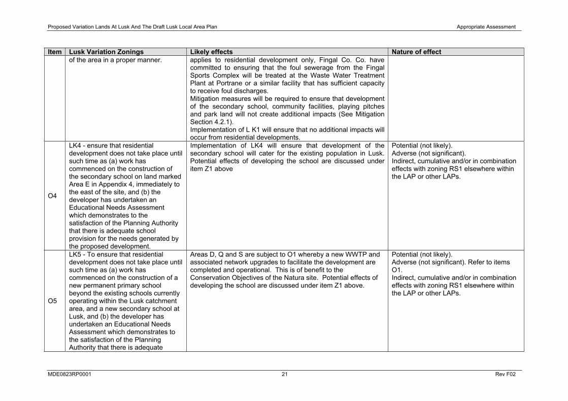
ItemLands at Lusk Variation Local Objectives Likely effects Nature of effect
O1
LK1 - To ensure that residential development does not take place until such time as the Waste Water Treatment Plant at Portrane becomes fully operational and the required network upgrades to facilitate the development are completed.
Implementation of LK1 in areas D, F, Q and S will ensure that the potential risks to the Natura site as a result of implementation of item Z1 above are reduced to non-significant levels. The effect of LK1 is not only beneficial, but LK1 is critical to the outcome of this assessment.
Likely.Beneficial (Significant). Indirect.
O2
LK2 - To ensure that Kilhedge Lane is upgraded from its northern end as far as area N to enable adequate access and a satisfactory level of car parking to be provided to serve the existing and proposed open space.
Implementation of LK2 within Area N is assessed as having no relationship (significant or otherwise) to the Natura 2000 site, its qualifying interests or conservation objectives.
None.
O3
LK3 - To secure the preparation and approval by the planning authority of a master plan prior to the development of the secondary school, community facility, Fingal Sports Complex, playing pitches, park land and residential development to secure comprehensive development
Implementation of LK3 has the potential to place increased demands upon the sewerage and foulwater treatment infrastructure currently in place in Lusk. Without upgrading and increasing the capacity of these facilities, implementation of LK3 may result in increased frequencies of pollution events either via the treatment works located at and discharging into the estuary at various points, or via discharge and runoff entering Brides Stream, which in turn will drain to the estuary. Although LK1
Potential (not likely). Adverse (not significant). Indirect, cumulative and/or in combination effects with Fingal Development Plan 2005-2011 or other LAPs.
Proposed Variation Lands At Lusk And The Draft Lusk Local Area Plan Appropriate Assessment
MDE0823RP0001 21 Rev F02
Item Lusk Variation Zonings Likely effects Nature of effect of the area in a proper manner. applies to residential development only, Fingal Co. Co. have
committed to ensuring that the foul sewerage from the Fingal Sports Complex will be treated at the Waste Water Treatment Plant at Portrane or a similar facility that has sufficient capacity to receive foul discharges. Mitigation measures will be required to ensure that development of the secondary school, community facilities, playing pitches and park land will not create additional impacts (See Mitigation Section 4.2.1). Implementation of L K1 will ensure that no additional impacts will occur from residential developments.
O4
LK4 - ensure that residential development does not take place until such time as (a) work has commenced on the construction of the secondary school on land marked Area E in Appendix 4, immediately to the east of the site, and (b) the developer has undertaken an Educational Needs Assessment which demonstrates to the satisfaction of the Planning Authority that there is adequate school provision for the needs generated by the proposed development.
Implementation of LK4 will ensure that development of the secondary school will cater for the existing population in Lusk. Potential effects of developing the school are discussed under item Z1 above
Potential (not likely). Adverse (not significant). Indirect, cumulative and/or in combination effects with zoning RS1 elsewhere within the LAP or other LAPs.
O5
LK5 - To ensure that residential development does not take place until such time as (a) work has commenced on the construction of a new permanent primary school beyond the existing schools currently operating within the Lusk catchment area, and a new secondary school at Lusk, and (b) the developer has undertaken an Educational Needs Assessment which demonstrates to the satisfaction of the Planning Authority that there is adequate
Areas D, Q and S are subject to O1 whereby a new WWTP and associated network upgrades to facilitate the development are completed and operational. This is of benefit to the Conservation Objectives of the Natura site. Potential effects of developing the school are discussed under item Z1 above.
Potential (not likely). Adverse (not significant). Refer to items O1.Indirect, cumulative and/or in combination effects with zoning RS1 elsewhere within the LAP or other LAPs.
Proposed Variation Lands At Lusk And The Draft Lusk Local Area Plan Appropriate Assessment
MDE0823RP0001 22 Rev F02
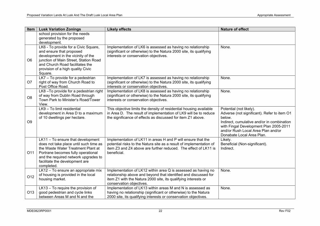
Item Lusk Variation Zonings Likely effects Nature of effect school provision for the needs generated by the proposed development.
O6
LK6 - To provide for a Civic Square, and ensure that proposed development in the vicinity of the junction of Main Street, Station Road and Church Road facilitates the provision of a high quality Civic Square.
Implementation of LK6 is assessed as having no relationship (significant or otherwise) to the Natura 2000 site, its qualifying interests or conservation objectives.
None.
O7LK7 – To provide for a pedestrian right of way from Church Road to Post Office Road.
Implementation of LK7 is assessed as having no relationship (significant or otherwise) to the Natura 2000 site, its qualifying interests or conservation objectives.
None.
O8
LK8 –To provide for a pedestrian right of way from Dublin Road through Town Park to Minister’s Road/Tower View.
Implementation of LK8 is assessed as having no relationship (significant or otherwise) to the Natura 2000 site, its qualifying interests or conservation objectives.
None.
O9
LK9 – To limit residential development in Area D to a maximum of 10 dwellings per hectare.
This objective limits the density of residential housing available in Area D. The result of implementation of LK9 will be to reduce the significance of effects as discussed for item Z1 above.
Potential (not likely). Adverse (not significant). Refer to item O1 below. Indirect, cumulative and/or in combination with Fingal Development Plan 2005-2011 and/or Rush Local Area Plan and/or Donabate Local Area Plan.
O11
LK11 – To ensure that development does not take place until such time as the Waste Water Treatment Plant at Portrane becomes fully operational and the required network upgrades to facilitate the development are completed.
Implementation of LK11 in areas H and P will ensure that the potential risks to the Natura site as a result of implementation of item Z3 and Z4 above are further reduced. The effect of LK11 is beneficial.
Likely.Beneficial (Non-significant). Indirect.
O12
LK12 – To ensure an appropriate mix of housing is provided in the local housing market.
Implementation of LK12 within area Q is assessed as having no relationship above and beyond that identified and discussed for item Z1 with the Natura 2000 site, its qualifying interests or conservation objectives.
None.
O13LK13 – To require the provision of good pedestrian and cycle links between Areas M and N and the
Implementation of LK13 within areas M and N is assessed as having no relationship (significant or otherwise) to the Natura 2000 site, its qualifying interests or conservation objectives.
None.
Proposed Variation Lands At Lusk And The Draft Lusk Local Area Plan Appropriate Assessment
MDE0823RP0001 23 Rev F02
Item Lusk Variation Zonings Likely effects Nature of effect adjoining Chapel Farm Estate.
O14
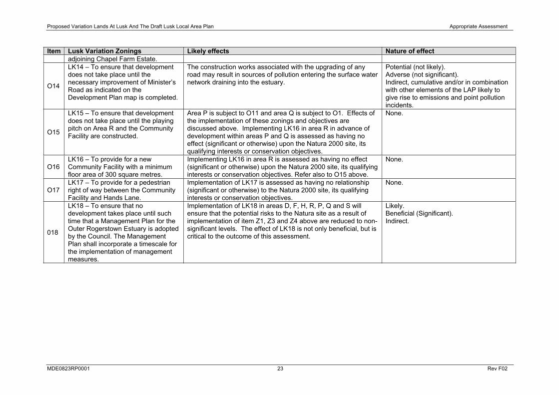
LK14 – To ensure that development does not take place until the necessary improvement of Minister’s Road as indicated on the Development Plan map is completed.
The construction works associated with the upgrading of any road may result in sources of pollution entering the surface water network draining into the estuary.
Potential (not likely). Adverse (not significant). Indirect, cumulative and/or in combination with other elements of the LAP likely to give rise to emissions and point pollution incidents.
O15
LK15 – To ensure that development does not take place until the playing pitch on Area R and the Community Facility are constructed.
Area P is subject to O11 and area Q is subject to O1. Effects of the implementation of these zonings and objectives are discussed above. Implementing LK16 in area R in advance of development within areas P and Q is assessed as having no effect (significant or otherwise) upon the Natura 2000 site, its qualifying interests or conservation objectives.
None.
O16LK16 – To provide for a new Community Facility with a minimum floor area of 300 square metres.
Implementing LK16 in area R is assessed as having no effect (significant or otherwise) upon the Natura 2000 site, its qualifying interests or conservation objectives. Refer also to O15 above.
None.
O17LK17 – To provide for a pedestrian right of way between the Community Facility and Hands Lane.
Implementation of LK17 is assessed as having no relationship (significant or otherwise) to the Natura 2000 site, its qualifying interests or conservation objectives.
None.
018
LK18 – To ensure that no development takes place until such time that a Management Plan for the Outer Rogerstown Estuary is adopted by the Council. The Management Plan shall incorporate a timescale for the implementation of management measures.
Implementation of LK18 in areas D, F, H, R, P, Q and S will ensure that the potential risks to the Natura site as a result of implementation of item Z1, Z3 and Z4 above are reduced to non-significant levels. The effect of LK18 is not only beneficial, but is critical to the outcome of this assessment.
Likely.Beneficial (Significant). Indirect.
Proposed Variation Lands At Lusk And The Draft Lusk Local Area Plan Appropriate Assessment
MDE0823RP0001 24 Rev F02
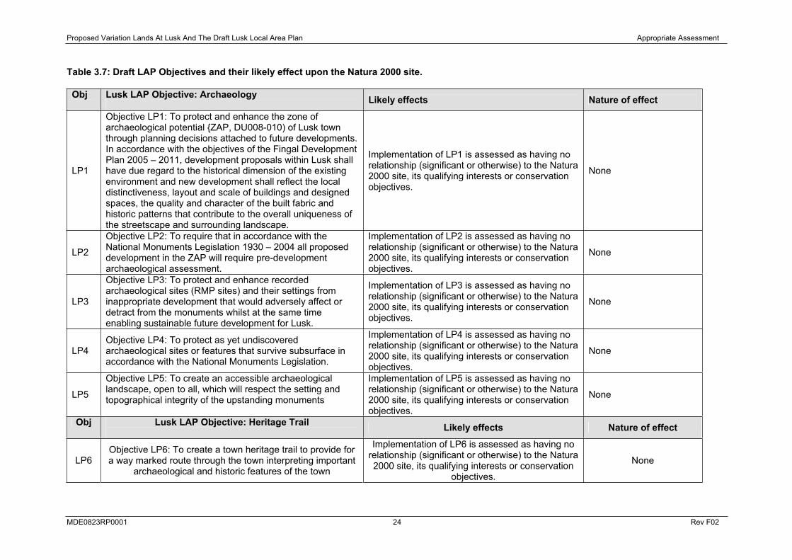
Table 3.7: Draft LAP Objectives and their likely effect upon the Natura 2000 site.
Obj Lusk LAP Objective: Archaeology Likely effects Nature of effect
LP1
Objective LP1: To protect and enhance the zone of archaeological potential {ZAP, DU008-010) of Lusk town through planning decisions attached to future developments. In accordance with the objectives of the Fingal Development Plan 2005 – 2011, development proposals within Lusk shall have due regard to the historical dimension of the existing environment and new development shall reflect the local distinctiveness, layout and scale of buildings and designed spaces, the quality and character of the built fabric and historic patterns that contribute to the overall uniqueness of the streetscape and surrounding landscape.
Implementation of LP1 is assessed as having no relationship (significant or otherwise) to the Natura 2000 site, its qualifying interests or conservation objectives.
None
LP2
Objective LP2: To require that in accordance with the National Monuments Legislation 1930 – 2004 all proposed development in the ZAP will require pre-development archaeological assessment.
Implementation of LP2 is assessed as having no relationship (significant or otherwise) to the Natura 2000 site, its qualifying interests or conservation objectives.
None
LP3
Objective LP3: To protect and enhance recorded archaeological sites (RMP sites) and their settings from inappropriate development that would adversely affect or detract from the monuments whilst at the same time enabling sustainable future development for Lusk.
Implementation of LP3 is assessed as having no relationship (significant or otherwise) to the Natura 2000 site, its qualifying interests or conservation objectives.
None
LP4Objective LP4: To protect as yet undiscovered archaeological sites or features that survive subsurface in accordance with the National Monuments Legislation.
Implementation of LP4 is assessed as having no relationship (significant or otherwise) to the Natura 2000 site, its qualifying interests or conservation objectives.
None
LP5
Objective LP5: To create an accessible archaeological landscape, open to all, which will respect the setting and topographical integrity of the upstanding monuments
Implementation of LP5 is assessed as having no relationship (significant or otherwise) to the Natura 2000 site, its qualifying interests or conservation objectives.
None
Obj Lusk LAP Objective: Heritage Trail Likely effects Nature of effect
LP6Objective LP6: To create a town heritage trail to provide for a way marked route through the town interpreting important
archaeological and historic features of the town
Implementation of LP6 is assessed as having no relationship (significant or otherwise) to the Natura 2000 site, its qualifying interests or conservation
objectives.
None

Proposed Variation Lands At Lusk And The Draft Lusk Local Area Plan Appropriate Assessment
MDE0823RP0001 25 Rev F02
Obj Lusk LAP Objectives: Boundary Treatments Likely effects Nature of effect
LP7
Objective LP7: To reflect the important garden aspect of the character of the town, the protection of existing boundary hedges shall be encouraged and with regard to new developments strong preference will be given to the planting of boundary hedges and trees, using native species.
Implementation of LP7 is assessed as having no relationship (significant or otherwise) to the Natura 2000 site, its qualifying interests or conservation objectives.
None
LP8
Local Objective LP8 – [Applies to Areas P, Q and R] To ensure that existing hedgerows are maintained where practical and where necessary enhanced to secure adequate boundaries to the lands are maintained except where limited removal is necessary for the provision of access.
Implementation of LP8 is assessed as having no relationship (significant or otherwise) to the Natura 2000 site, its qualifying interests or conservation objectives.
None
Obj Lusk LAP Objectives: Inner Core Area of Protection Likely effects Nature of effect
LP9
Objective LP9: To preserve the integrity of St. MacCullin’s Graveyard. No additional breaks within the graveyard wall shall be permitted.
Implementation of LP9 is assessed as having no relationship (significant or otherwise) to the Natura 2000 site, its qualifying interests or conservation objectives.
None
LP10
Objective LP10: To facilitate the provision of open space. The Council, will as and when opportunities arise, seek to promote in principle proposals which would significantly contribute to the openness and historic character of the Inner Core Area of Protection.
Implementation of LP10 is assessed as having no relationship (significant or otherwise) to the Natura 2000 site, its qualifying interests or conservation objectives. None
LP11
Objective LP11: To ensure that the character, setting and openness of the area surrounding the former St. MacCullin’s Church, Round Tower and graveyard complex is protected from inappropriate development.
Implementation of LP11 is assessed as having no relationship (significant or otherwise) to the Natura 2000 site, its qualifying interests or conservation objectives.
None
LP12
Policy LP12: To ensure that all new developments respect the historic character of the Inner Core Area of Protection. All proposals within the Inner Core Area of Protection shall be laid out and designed to a high standard, to a scale in keeping with the historic character of the area. The external walls and roofs shall be faced with high quality materials and finishes.
Implementation of LP12 is assessed as having no relationship (significant or otherwise) to the Natura 2000 site, its qualifying interests or conservation objectives. None
LP13Policy LP13: To preserve the openness of the locality and views of the former St. MacCullin’s Church, Round Tower and graveyard complex. No building within the Inner Core
Implementation of LP13 is assessed as having no relationship (significant or otherwise) to the Natura 2000 site, its qualifying interests or conservation
None
Proposed Variation Lands At Lusk And The Draft Lusk Local Area Plan Appropriate Assessment
MDE0823RP0001 26 Rev F02
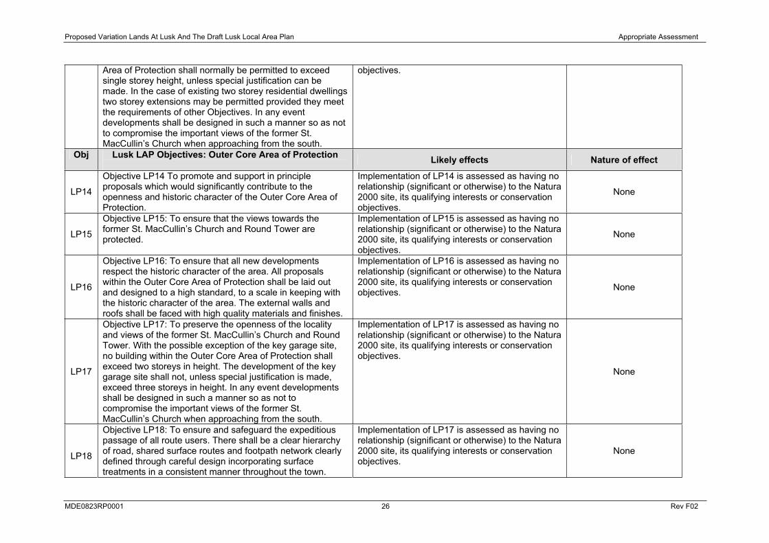
Area of Protection shall normally be permitted to exceed single storey height, unless special justification can be made. In the case of existing two storey residential dwellings two storey extensions may be permitted provided they meet the requirements of other Objectives. In any event developments shall be designed in such a manner so as not to compromise the important views of the former St. MacCullin’s Church when approaching from the south.
objectives.
Obj Lusk LAP Objectives: Outer Core Area of Protection Likely effects Nature of effect
LP14
Objective LP14 To promote and support in principle proposals which would significantly contribute to the openness and historic character of the Outer Core Area of Protection.
Implementation of LP14 is assessed as having no relationship (significant or otherwise) to the Natura 2000 site, its qualifying interests or conservation objectives.
None
LP15
Objective LP15: To ensure that the views towards the former St. MacCullin’s Church and Round Tower are protected.
Implementation of LP15 is assessed as having no relationship (significant or otherwise) to the Natura 2000 site, its qualifying interests or conservation objectives.
None
LP16
Objective LP16: To ensure that all new developments respect the historic character of the area. All proposals within the Outer Core Area of Protection shall be laid out and designed to a high standard, to a scale in keeping with the historic character of the area. The external walls and roofs shall be faced with high quality materials and finishes.
Implementation of LP16 is assessed as having no relationship (significant or otherwise) to the Natura 2000 site, its qualifying interests or conservation objectives. None
LP17
Objective LP17: To preserve the openness of the locality and views of the former St. MacCullin’s Church and Round Tower. With the possible exception of the key garage site, no building within the Outer Core Area of Protection shall exceed two storeys in height. The development of the key garage site shall not, unless special justification is made, exceed three storeys in height. In any event developments shall be designed in such a manner so as not to compromise the important views of the former St. MacCullin’s Church when approaching from the south.
Implementation of LP17 is assessed as having no relationship (significant or otherwise) to the Natura 2000 site, its qualifying interests or conservation objectives.
None
LP18
Objective LP18: To ensure and safeguard the expeditious passage of all route users. There shall be a clear hierarchy of road, shared surface routes and footpath network clearly defined through careful design incorporating surface treatments in a consistent manner throughout the town.
Implementation of LP17 is assessed as having no relationship (significant or otherwise) to the Natura 2000 site, its qualifying interests or conservation objectives.
None

Proposed Variation Lands At Lusk And The Draft Lusk Local Area Plan Appropriate Assessment
MDE0823RP0001 27 Rev F02
3.6.2 Impacts on Water Quality
The implementation of the Proposed Variation and Draft LAP is likely to place increased demands upon the sewerage and foulwater treatment infrastructure currently in place in Lusk. Without upgrading and increasing the capacity of these facilities, implementation of the Proposed Variation and Draft LAP may result in increased frequencies of pollution events either via the treatment works located at and discharging into the estuary at various points, or via discharge and runoff entering Brides Stream or Balleally Stream, which in turn will drain to the estuary.
The Eastern River Basin District Characterisation Report notes that Rogerstown Estuary is considered to be ‘probably at risk’ on the basis of both point source pollution and morphological pressures. The most significant point source risks were considered to be inadequate municipal WWTPs and combined sewer overflows and the most significant morphological element was intensive land-use.
Local objectives LK1 and LK11 are integral to the Variation and central to the predicted effects of the implementation of the LAP. In their absence, diminution of water quality and habitat quality may occur through nutrient loading from agricultural and other processes in combination with sewerage and run-off associated with industrial development and residential development within lands subject to the Variation. Current predictions of an increasing population trend in Lusk and other settlements around Rogerstown Estuary mean that the current sewerage and foulwater infrastructure has insufficient capacity to deal with the implementation of the Fingal Development Plan 2005-2011 and resulting LAPs arising from it. Left untreated, further eutrophication may increase growth of algal blooms to the detriment of the estuarine habitats (for example smothering the growth of eelgrass which is a food source of the Brent Goose).
As outlined in Table 3.6, Local objective LK1 does not apply to development of the secondary school, community facility and Fingal Sports Complex in Areas E. In effect, these developments can proceed prior to the upgrade of the sewerage and foulwater treatment infrastructure. In order to ensure that the Fingal Sports Complex does not have a significant impact on Rogerstown Estuary, Fingal County Council have committed to ensuring that the foul sewerage from the Fingal Sports Complex will be treated at the Waste Water Treatment Plant at Portrane or a similar facility that has sufficient capacity to receive foul discharges.
Development of the secondary school and community facility will cater for the existing population in Lusk and with mitigation in place, will not create an additional impact on the Natura 2000 site as long as the existing treatment plants can cater for any discharges.
Construction, operation and decommissioning will occur over the lifetime of the LAP and on a variety of sites as zoned around the town through the Variation. The potential exists for a range of pollutants to enter Brides Stream or Balleally Stream, and ultimately the Rogerstown Estuary, during construction of the infrastructure planned for in the Proposed Variation and Draft LAP. For example any of the following would have deleterious effects on fish, plants and invertebrates if allowed to enter watercourses:
Suspended sediment due to runoff of soil from construction areas
Raw or uncured concrete and grouts
Fuels, lubricants and hydraulic fluids for equipment used on the development site
During the operational phase, small quantities of potentially hazardous materials such as fuels, solvents or paints may be stored and used on the site. If not stored and handled appropriately, these could impact the aquatic environment through accidental release (spills, leaks, etc.). Potential impacts may also arise from chemical emissions during the operational phase and domestic and industrial emissions during the lifetime of the Variation and LAP and beyond.

Proposed Variation Lands At Lusk And The Draft Lusk Local Area Plan Appropriate Assessment
MDE0823RP0001 28 Rev F02
Construction of hard surfaces such as roads and buildings can lead to increased runoff from former greenfield areas. Any major changes in hydrology reflected in significant changes in peak and minimum flows would have significant effects on instream flora and fauna, both directly and through the effects of increased erosion. This could ultimately have an effect on Rogerstown Estuary during the lifetime of the Variation and LAP
3.6.3 Water Abstraction and Supply
Water is currently supplied to Lusk from Ballycoolen Reservoir. The Reservoir is fed from the Water Pumping Station at Leixlip. Leixlip Water Treatment plant is the second largest water treatment plant in Ireland and supplies drinking water to the Greater Dublin Region including Fingal, South Dublin, Dublin City and areas of Kildare and Meath. The existing plant is close to capacity and requires further expansion to cater for the rapidly growing water demands of the region. To facilitate this, a Water Abstraction Agreement between ESB and Fingal County Council was approved by the Minister for Environment, Heritage and Local Government on 10 October 2007.
Current proposals for expansion and water abstraction through the existing Water Abstraction Agreement have taken into account population growth projections for the interim period. The level of water demand expected to be generated from the proposed new land zonings in Lusk and development opportunities arising from the LAP are able to be accommodated under the existing plans.
The proposed development will provide the infrastructure necessary to treat an additional 80Mld (Megalitres/day) of Raw Water, providing a total volume of 225Mld. The new units will provide the necessary standby capacity to enable Fingal County Council to meet the demands of its customers in the Greater Dublin Region, including Fingal, South Dublin, Dublin City and areas of Counties Meath and Kildare, while maintaining the required treated water quality at all times. The expected commencement date for construction is middle of 2009. In effect, this will mean that the increased water consumption needs associated with the implementation of the Proposed Variation and Draft LAP at Lusk will not lead to any significant impacts on any Natura 2000 site
3.6.4 Recreational Pressure
With regard to population growth in Lusk, the population of the town at the last census was 5,236. Under existing zonings the population could grow to at least 7,350. Under the Proposed Variation the population could further grow resulting in a total overall population of at least 8,030 in number. Additional recreational activity resulting indirectly from more people living in additional housing in the Lusk environs and consequently visiting the estuary may lead to increased disturbance of feeding, breeding or roosting birds throughout the winter months. Recreational activities are wide ranging and could include: jet-skiing, boating, bait digging, dog walking, fishing, rambling etc. Even if any such effects arising out of increased visitor pressure are not significant alone, they may contribute to cumulative or in-combination effects arising from the implementation of other elements of the Lusk LAP or other LAPs surrounding Rogerstown Estuary.
Whilst increased recreational and amenity use of the estuary is envisaged in the future, this pressure has been and will continue to be managed, as is exemplified in the recent Integrated Masterplan for amenity, nature, agriculture and education in the Rogerstown Inner Estuary.

Proposed Variation Lands At Lusk And The Draft Lusk Local Area Plan Appropriate Assessment
MDE0823RP0001 29 Rev F02
4 MITIGATION MEASURES
4.1 GENERAL
Where a likely significant adverse effect has been identified during an Appropriate Assessment or cannot conclusively be ruled out, it may be possible to proceed with a proposal where mitigation measures can be implemented to address the adverse effect. Objectives have been included in the Proposed Variation and LAP that will mitigate the potential impacts on Rogerstown Estuary.
The Planning Authority has highlighted the need for a new WWTP at Portrane and associated network upgrades to be completed and operational prior to the development of many elements of the Variation and LAP where there is inadequate sewerage treatment capacity. This is contained within the Proposed Variation as a Local Objectives LK1 and LK11. The requirement of the Proposed Variation in ensuring that a new WWTP at Portrane and associated network upgrades are completed and operational prior to the development of many aspects of the LAP on the most significant areas of land proposed to be rezoned through the Variation greatly reduces the likelihood of significant effects upon the habitats and species of Rogerstown Estuary.
4.2 MITIGATION OF IMPACTS TO WATER QUALITY
In order that additional effluent discharge to the local streams does not compound the eutrophication of Rogerstown Estuary, water quality in the Balleally Stream and Brides Stream must be improved. NPWS state that rivers and streams contribute 70% of total nitrogen and 50% of total phosphorus nutrients entering Rogerstown Estuary (Appendix 4, Section 1.10). The Regional River Basin Management Plan relevant to Fingal County Council and Rogerstown Estuary is currently being prepared as a requirement of The European Communities (Water Policy) Regulations, 2003. Regular water quality sampling is currently undertaken by Fingal County Council, but no management prescriptions aiming for improvement in water quality currently exist. The River Basin Management Plan will address this shortcoming.
4.2.1 Mitigation for impacts from development of the secondary school and community facility in Areas E
If construction of the secondary school and community facility commence prior to the proposed development of the Portrane WWTP further studies will be carried out to determine the appropriate methods for treatment of the associated foul sewerage. These methods could include the use of onsite treatment or upgrades to the existing WWT facilities. Any treatment method that is chosen will use best available technology and all discharges to water will be subject to licensing by Fingal County Council.
4.2.2 Mitigation for impacts from development of Fingal Sports Complex
Fingal County Council have committed to ensuring that the foul sewerage from the Fingal Sports Complex will be treated at the Waste Water Treatment Plant at Portrane or a similar facility that has sufficient capacity to receive foul discharges.
Proposed Variation Lands At Lusk And The Draft Lusk Local Area Plan Appropriate Assessment
MDE0823RP0001 30 Rev F02
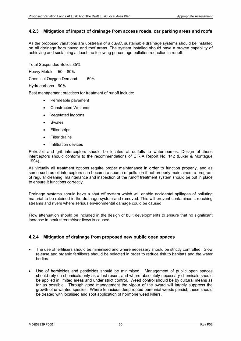
4.2.3 Mitigation of impact of drainage from access roads, car parking areas and roofs
As the proposed variations are upstream of a cSAC, sustainable drainage systems should be installed on all drainage from paved and roof areas. The system installed should have a proven capability of achieving and sustaining at least the following percentage pollution reduction in runoff:
Total Suspended Solids 85%
Heavy Metals 50 – 80%
Chemical Oxygen Demand 50%
Hydrocarbons 90%
Best management practices for treatment of runoff include:
Permeable pavement
Constructed Wetlands
Vegetated lagoons
Swales
Filter strips
Filter drains
Infiltration devices
Petrol/oil and grit interceptors should be located at outfalls to watercourses. Design of those interceptors should conform to the recommendations of CIRIA Report No. 142 (Luker & Montague 1994).
As virtually all treatment options require proper maintenance in order to function properly, and as some such as oil interceptors can become a source of pollution if not properly maintained, a program of regular cleaning, maintenance and inspection of the runoff treatment system should be put in place to ensure it functions correctly.
Drainage systems should have a shut off system which will enable accidental spillages of polluting material to be retained in the drainage system and removed. This will prevent contaminants reaching streams and rivers where serious environmental damage could be caused
Flow attenuation should be included in the design of built developments to ensure that no significant increase in peak stream/river flows is caused
4.2.4 Mitigation of drainage from proposed new public open spaces
The use of fertilisers should be minimised and where necessary should be strictly controlled. Slow release and organic fertilisers should be selected in order to reduce risk to habitats and the water bodies.
Use of herbicides and pesticides should be minimised. Management of public open spaces should rely on chemicals only as a last resort, and where absolutely necessary chemicals should be applied in limited areas and under strict control. Weed control should be by cultural means as far as possible. Through good management the vigour of the sward will largely suppress the growth of unwanted species. Where tenacious deep rooted perennial weeds persist, these should be treated with localised and spot application of hormone weed killers.
Proposed Variation Lands At Lusk And The Draft Lusk Local Area Plan Appropriate Assessment
MDE0823RP0001 31 Rev F02
4.2.5 Mitigation of impact of leakages and accidental spillages in proposed area rezoned for science & technology
Best practice must be employed to prevent accidental spillages/leakage at all stages from delivery of potentially polluting raw materials, to storage, distribution/dispensing, processing, to shipment of finished product and disposal of wastes. Where potentially polluting substances are used failsafe spill contingency procedures should be put in place to minimise the risk of accidental emission of raw materials, products and waste materials and to prevent their entry into surface water drains and the aquatic environment should spillage occur. Inter alia process waters, site drainage waters, emergency firewater, chemically contaminated waters and spillages of chemicals should be contained and, where necessary, routed to the effluent system and treated before emission to surface waters or sewer. Sufficient storage should be provided to ensure that this can be achieved. Any emergency firewater collection system should also take account of the additional firewater flows or fire-fighting foams.
4.2.6 Mitigation of impacts during construction
Temporary impacts are likely to arise during any construction activities associated with development provided for under the Lusk LAP and variation to the Fingal County Development Plan. The following mitigation is proposed to mitigate any impacts on Balleally Stream and Brides Stream that may have indirect impacts on Rogerstown Estuary.
4.2.6.1 Reduction and prevention of suspended solids pollution
Release of suspended solids to surface waters should be kept to a minimum. The key factors in erosion and sediment control are to intercept and manage off- and on-site runoff. This limits the potential for soils to be eroded and enter the stream in runoff. Sediment ponds and grit/oil interceptors should be placed at the end of drainage channels. However, runoff and surface erosion control is more effective and less expensive than sediment control with sediment control ponds only.
The following general guidelines are recommended:
Schedule development to minimise risk of potential erosion by, where possible, planning construction activities during drier months, halting construction during periods of heavy precipitation and run-off to minimise soil disturbance, and restrict vehicular and equipment access or provide working surfaces/pads.
Retain existing vegetation where possible and physically mark clearing boundaries on the construction site.
Revegetate denuded areas, particularly cut and fill slopes and disturbed slopes as soon as possible. Use mulches or other organic stabilisers to minimise erosion until vegetation is established on sensitive soils.
Cover temporary fills or stockpiles which are likely to erode into nearby watercourses with polyethylene sheeting.
Divert runoff away from denuded areas.
Minimise the length and steepness of slopes where possible.
Minimise runoff velocities and erosive energy by maximising the lengths of flow paths for precipitation runoff, constructing interceptor ditches and channels with low gradients to minimise secondary erosion and transport, and lining unavoidably steep interceptors or conveyance ditches with filter fabric, rock or polyethylene lining to prevent channel erosion.
Proposed Variation Lands At Lusk And The Draft Lusk Local Area Plan Appropriate Assessment
MDE0823RP0001 32 Rev F02
Retain eroded sediments on site with erosion and sediment control structures such as sediment traps, silt fences and sediment control ponds. Sediment control ponds should be designed for a minimum retention time of 15 hours.
Access roads should be constructed or topped with a suitable coarse granular material/non-woven geotextile, and if possible organic topsoil should be stripped prior to access road construction.
If significant alterations to the existing stream/river bank, or instream works are to be carried out, the works area should be isolated from the river/stream by coffer dams or other suitable containment methods. Water within the contained area contaminated with suspended solids or other potential pollutants should never be released directly to the stream/river, but should be pumped to a land site to allow sediment removal before it re-enters the river.
Temporary stream diversions should be excavated in isolation of stream flow, starting from the bottom end of the diversion channel and working upstream to minimise sediment production. The temporary channel should be constructed in such a way as to minimise suspended solids released when the river is re-routed. Upon completion the bank should be stabilised around the temporary diversion.
Permanent stream diversions should be completed as far in advance as possible. The channel should be constructed in such a way as to minimise suspended solids released when the river is re-routed. Use of loose fine grained materials in the new channel construction should be strictly limited.
4.2.6.2 Reduction of pollution with other substances associated with the construction process
Raw or uncured waste concrete should be disposed of by removal from the site.
Wash down water from exposed aggregate surfaces, cast-in-place concrete and from concrete trucks should be trapped on-site to allow sediment to settle out and reach neutral pH before clarified water is released to surface waters or allowed to percolate into the ground.
Fuels, lubricants and hydraulic fluids for equipment used on the construction site, as well as any solvents, oils, and paints should be carefully handled to avoid spillage, properly secured against unauthorised access or vandalism, and provided with spill containment according to codes of practice.
Fuelling and lubrication of equipment should not be carried out close to watercourses.
Any spillage of fuels, lubricants of hydraulic oils should be immediately contained and the contaminated soil removed from the site and properly disposed of.
Waste oils and hydraulic fluids should be collected in leak-proof containers and removed from the site for disposal or re-cycling.
Foul drainage from site offices etc. should be removed to a suitable treatment facility or charged to a septic tank system constructed in accordance with EPA guidelines.
Sites for use as storage areas, machinery depots, site offices, temporary access roads or the disposal of spoil should be located least 50m from the nearest watercourse may be chosen. Disposal of spoil or storage of soils should not be carried out in any location where runoff can occur into watercourses.
4.2.6.3 Mitigation for direct impacts on watercourses
The following measures will apply to any construction activities affecting Balleally Stream and Brides Stream
Where construction is to take place close to rivers/streams, a 5m wide riparian leave strip should be clearly marked on either side of the stream and its significance explained to machinery operators.
Proposed Variation Lands At Lusk And The Draft Lusk Local Area Plan Appropriate Assessment
MDE0823RP0001 33 Rev F02
If either stream is to be rerouted, permanent diversions should be completed as far in advance as possible.
Any new stream channel should be bio-engineered to ensure no net loss of habitat value for aquatic flora and fauna, by maximising flow and substrate diversity and natural bankside cover. The channel should follow a sinuous course and incorporate a natural sequence of riffle, glide and pool habitat.
The construction of new channel should be carried out as far as possible in advance of the actual diversion of flow, and bankside vegetation of native streamside tree and bush species should be well established.
Culverts should be designed and constructed in such a way as to ensure that the stream remains passable for aquatic fauna.
4.3 MITIGATION FOR RECREATIONAL PRESSURE
In order to address potential impacts from increased recreational pressure, a Masterplan has been prepared for amenity, nature, agriculture and education in the Rogerstown Inner Estuary by Fingal County Council in conjunction with Bird Watch Ireland and the Department of the Environment, Heritage and Local Government. The Department have expressed their support for the proposals for lands adjacent to and partially within Rogerstown Esturary, SAC (Site Code 208) and SPA (Site Code 4015). The Masterplan, was adopted by Fingal County Council on the 13th October 2008. The Masterplan provides a coherent strategy to manage the area including the rehabilitation of Balleally landfill which will cease operations over the next couple of years. Upon its closure, it is intended that the landfill site and the ecologically sensitive lands of the adjoining estuary would be rehabilitated as a conservation and recreational resource.
While the Integrated Masterplan concerns the Inner Estuary Area, the eastern boundary of the Masterplan being the viaduct and causeway carrying the Dublin Belfast railway line, it is proposed that work will commence on the preparation of a conservation plan for the Outer Estuary in 2009. This will include the remainder of the estuary stretching from the railway viaduct east to the sea. The Outer Estuary Plan will include inter alia a management strategy for beach areas adjacent to the settlement of Rush. On completion of this study, a management plan will be in place for all lands forming part of Rogerstown Estuary, ensuring that increased demands for recreational and leisure use in its vicinity arising from an increase in population will be successfully managed. In order to safeguard the integrity of the Estuary and its Natura 2000 designations, a Local Objective LK18 is included in the Proposed Variation to be applied as follows:
Local Objective LK 18– [Applies to Areas D, F, H, R, P, Q, and S]
To ensure that no development takes place until such time that a Management Plan for the Outer Rogerstown Estuary is adopted by the Council. The Management Plan shall incorporate a timescale for the implementation of management measures.
Proposed Variation Lands At Lusk And The Draft Lusk Local Area Plan Appropriate Assessment
MDE0823RP0001 34 Rev F02
5 CONCLUSIONS
An Appropriate Assessment of the Proposed Variation of Lands at Lusk and the Draft Lusk Local Area Plan 2015 has been carried out. No measurable significant adverse effect that would impact on the integrity of Rogerstown Estuary Natura 2000 site was shown.
In the case of the Variation for lands at Lusk, the most significant risks to the safeguarding and integrity of the qualifying interests and conservation objectives of the Natura site have been largely addressed by the inclusion of the following Local Objectives. Firstly LK1 and LK11 to ensure the provision of a new operational municipal WWTP, prior to the development of many areas of land identified for development in the Variation. Secondly Local Objective LK18 requiring that a Management Plan for the Outer Rogerstown Estuary is adopted by the Council prior to the development of many areas of land identified by the Variation.
In the case of the Lusk LAP as the majority of the Local Plan Objectives proposed are to protect the archaeological heritage of the town or to ensure new developments in the centre are of a high quality of design and sympathetic in terms of height and layout there are no significant risks to the safeguarding and integrity of the qualifying interests and conservation objectives of the Natura site.
Having incorporated mitigation measures, it is considered that neither the Proposed Variation for lands at Lusk or the Draft Lusk LAP will not have a significant adverse effect on the Rogerstown Estuary Natura 2000 site, and that the integrity of that site will not be adversely affected.
Proposed Variation Lands At Lusk And The Draft Lusk Local Area Plan Appropriate Assessment
MDE0823RP0001 35 Rev F02
6 REFERENCE DOCUMENTS
DoE (unpub.) draft Conservation Plan for Rogerstown Estuary cSAC [IE0000208] and SPA [IE0004015]
DoE (unpub.) draft Conservation Objectives for Rogerstown Estuary cSAC [IE0000208]
DoE (unpub.) Natura 2000 Standard Data Form for cSAC [IE0000208] and SPA [IE0004015]
DoE (unpub.) NPWS Site Synopses for cSAC [IE0000208] and SPA [IE0004015]
EC (2000a) Communication from the Commission on the Precautionary Principle, Office for Official Publications of the European Communities, Luxembourg.
EC (2000b) Managing Natura 2000 Sites: the provisions of Article 6 of the ‘Habitats’ Directive 92/43/EEC, Office for Official Publications of the European Communities, Luxembourg.
EC (2001) Assessment of Plans and Projects Significantly Affecting Natura 2000 Sites: Methodological guidance on the provisions of Article 6(3) and (4) of the Habitats Directive 92/43/EEC, Office for Official Publications of the European Communities, Luxembourg.
EC (2007) Guidance document on Article 6(4) of the 'Habitats Directive' 92/43/EEC – Clarification of the concepts of: alternative solutions, imperative reasons of overriding public interest, compensatory measures, overall coherence, opinion of the commission, Office for Official Publications of the European Communities, Luxembourg.
ERBD (2005) Eastern River Basin District Project Characterisation Report, River Basin District Advisory Council, Dublin.
FCC (2005) Fingal Development Plan 2005-2011, Fingal County Council, Swords.
FCC (2008a) Variation No.25 to the Fingal Development Plan 2005-2011, Fingal County Council, Swords.
FCC (2008b) Appropriate Assessment Stage 1 Screening Report: Proposed Variation for Lands at Lusk, Fingal County Council, Swords.
FCC (2008c) Appropriate Assessment Stage 1 Screening Report: Draft Lusk Local Area Plan, Fingal County Council, Swords.
FCC (2008 d) Nature on Display: an integrated masterplan for amenity, nature, agriculture and education in the Rogerstown Inner Estuary, Fingal County Council, Swords.
Luker & Montague 1994 CIRIA Report No. 142.
APPENDIX 1
Screening Report: Proposed Variation – Lands at Lusk
Appropriate Assessment Screening of Proposed Variation
to the
Fingal Development Plan 2005-2011
____________________________________________
In line with the requirements of
Article 6(3) of theEU Habitats Directive (Directive 92/43/EEC)
Prepared by
Strategic Planning Unit Fingal County Council
1.0 Introduction
This report comprises an Appropriate Assessment Screening in line with the requirements of Article 6 of the EU Habitats Directive (Directive 92/43/EEC) of Proposed Variation to the Fingal Development Plan 2005-2011, hereafter referred to as the proposed Variation. This assessment has been carried out using the following guidance:
(i) Managing Natura 2000 Sites – the provisions of Article 6 of the Habitats Directive 92/43/EEC, Assessment of Plans and Projects Significantly Affecting Natura 2000 Sites: Methodological Guidance on the provisions of Article 6(3) and (4) of the Habitats Directive 92/43/EEC;
(ii) Guidance document on Article 6(4) of the Habitats Directive 92/43/EEC- Clarification of the concepts of alternative solutions, imperative reasons of overriding interest, compensatory measures, overall coherence, opinion of the commission.
(iii) Circular Letter SEA 1/08 & NPWS 1/08 from the Department of the Environment, Heritage and Local Government.
2.0 Background
Legal protection is afforded habitats and species of European importance through the Habitats Directive and Regulations 1994 which transpose Directive 92/43/EEC on the Conservation of Natural Habitats and Wild Flora and Fauna. Articles 6(3) and 6(4) of the Habitats Directive require that an Appropriate Assessment be carried out on all plans/projects which may impact upon designated Natura 2000 sites.
The three stages of Appropriate Assessment are set out below:
(i) Determine whether the plan/project is likely to have a significant effect on a European site either alone or in combination with other plans or projects. This is referred to as the Screening Stage and is the subject of this report.
(ii) Where significant effects are found to occur, an Appropriate Assessment ascertaining the full effects on the integrity of the site will be initiated.
(iii) Where there is a risk of the plan/project having effects on the integrity of a site, an examination of mitigation measures and alternative solutions will be required.
Implicit in the Habitats Directive is the application of the Precautionary Principle which requires that the conservation objectives of Natura 2000 should prevail where there is uncertainty as set out in Section 2.2 of the European Commissions Guidance Document. The use of the precautionary principle presupposes the:
(i) identification of potentially negative effects resulting from a phenomenon, product or procedure
(ii) scientific evaluation of risks which because of the insufficiency of the data, inconclusive or imprecise nature, makes it possible to determine with sufficient certainty the risk in question.
3.0 Description of Plan or Project
Fingal County Council proposes to vary the Fingal Development Plan 2005-2011. The proposed Variation concerns lands to the west and south west of the settlement of Lusk.
An earlier Variation, Variation No. 25 to the Development Plan also concerning lands at Lusk, was adopted on the 12th May 2008.
Both the proposed and adopted Plan Variations provide the foundation for a Local Area Plan for Lusk which is also currently being prepared by the Planning Authority.
The proposed Variation provides for a number of re-zonings as well as a number of amendments to existing Specific and Local Objectives. The proposed Variation also proposes amending previously adopted Local Objectives, proposing new Local Objectives and deleting existing Objectives. All amendments to Specific and Local Objectives are detailed in Table No. 1 below. All proposed re-zonings as well as the Local and Specific Objectives detailed below appear on the map accompanying the Appropriate Assessment.
Table No. 1: Amended, Proposed and Deleted Local and Specific Objectives
The following Specific Objectives will be amended by the Proposed Variation:
(i) Development Boundary To amend the existing development boundary to encompass the new land zonings Areas L-S and remove the boundary from Area J.
(ii) Neighbourhood Centre To delete the requirement for a Neighbourhood Centre that was to be provided within the Dun Emer Estate.
The following Local Objectives will be amended by the Proposed Variation:
Local Objective LK1 [Applies to Areas D,F, Q and S] To ensure that residential development does not take place until such time as the Wastewater Treatment Plant at Portrane becomes fully operational and the required network upgrades to facilitate the development are completed.
Local Objective LK3 [Applies to Areas E and F] To secure the preparation and approval by the planning authority of a master plan prior to the development of the secondary school, Fingal Sports Complex, community facility, playing pitches, park land and residential development to secure comprehensive development of the area in a proper manner.
Local Objective LK5 [Applies to Area D, Q and S]
To ensure that residential development does not take place until such time as (a) work has commenced on the construction of a new permanent primary school beyond the existing schools currently operating within the Lusk catchment area, and a new secondary school within Lusk and (b) the developer has undertaken an Educational Needs Assessment which demonstrates to the satisfaction of the Planning Authority that there is adequate school provision for the needs generated by the proposed development.
Local Objective LK11 [Applies to Area H and P] To ensure that development does not take place until such time as the Waste Water Treatment Plant at Portrane becomes fully operational and the required network upgrades to facilitate the development are completed.
New Local Objectives:
Local Objective LK2 (Applies to Area N) To ensure that Kilhedge Lane is upgraded from its northern end as far as Area N to enable adequate access and a satisfactory level of car parking is to be provided to serve the existing and proposed open space.
[Note: This is proposed to replace the original LK2 which was adopted by Variation No. 25 which sought to secure the upgrading of Kilhedge Lane in connection with the school proposal in Area J, which is now proposed to be deleted]
Local Objective LK12- [Applies to Areas Q] To ensure an appropriate mix of housing is provided in the local housing market.
Local Objective LK13 [Applies to Areas M and N] To require the provision of good pedestrian and cycle links between Areas M and N and the adjoining Chapel Farm Estate.
Local Objective LK14 [Applies to Areas P and Q] To ensure that the development does not take place until the necessary improvement of Minister’s Road as indicated on the Development Plan map is completed.
Local Objective LK15 (Applies to Areas P and Q)To ensure that development does not take place until the playing pitch on Area R and community facility are constructed.
Local Objective LK16 [Applies to Area R] To provide for a new Community Facility with minimum floor area of 300 square metres.
Local Objective LK17 [Applies to Area R] To provide for a pedestrian right of way between the Community Facility and Hand’s Lane.
Local Objective LK18 [Applies to D,F,H,P,Q,R and S] To ensure that no development takes place until such time as a Management Plan for
the Outer Rogerstown Estuary is adopted by the County Council. The Management Plan shall incorporate a timescale for the implementation of management measures. _____________________________________________________________________
Proposed Amendment to Development Plan Objective LUSK 8:
Variation No. 25 incorporated Objective LUSK 8 ‘to identify important views and ensure that policies are incorporated within the Local Area Plan to preserve them into the Fingal Development Plan 2005-2011. However, as a result of further studies of the views of the former St. MacCullins church and Round Tower, the current Proposed Variation seeks to further amend the existing Objective as follows:
Objective LUSK 8 To maintain the valued distinctive views of the monastic site from all approach roads into the town, significant areas of open space and surrounding areas.
Local Objectives to be deleted:
Local Objective LK10 [Applies to Areas D,E,F,H]To ensure that no development proceeds until such time as an appropriate assessment has been carried out. The appropriate assessment shall provide for mitigation measures where required and shall clearly demonstrate that any development will not have an adverse impact on any relevant Natura 2000 site. In the event that mitigation measures are not sufficient to overcome significant effects on the conservation objectives of a Natura 2000 site development shall not proceed.
Local Objective 92 To develop this site as a landscaped civic open space to create an appropriate setting for the (St. MacCullins) church on the southern side.
This Local Objective is no longer required as the treatment of lands is dealt with within the LAP. It is therefore proposed to delete Local Objective 92 on the adoption of the Local Area Plan.
Table No. 2: Proposed Re-zonings
Area Existing Zoning Proposed Zoning M OS RU N RU OS O RU RS1 P RU ST1 Q RU RS1 R RU OS S RU RS1
4.0 Identification of Natura 2000 sites
While there are no Natura 2000 sites located within the boundaries of the proposed Variation lands, Rogerstown Estuary, a designated Special Protection Area (SPA) and
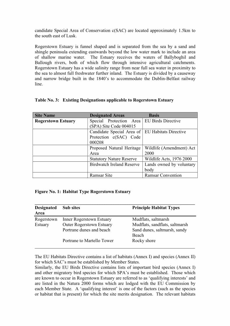
candidate Special Area of Conservation c(SAC) are located approximately 1.5km to the south east of Lusk.
Rogerstown Estuary is funnel shaped and is separated from the sea by a sand and shingle peninsula extending eastwards beyond the low water mark to include an area of shallow marine water. The Estuary receives the waters of Ballyboghil and Ballough rivers, both of which flow through intensive agricultural catchments. Rogerstown Estuary has a wide salinity range from near full sea water in proximity to the sea to almost full freshwater further inland. The Estuary is divided by a causeway and narrow bridge built in the 1840’s to accommodate the Dublin-Belfast railway line.
Table No. 3: Existing Designations applicable to Rogerstown Estuary
Site Name Designated Areas Basis Rogerstown Estuary Special Protection Area
(SPA) Site Code 004015 EU Birds Directive
Candidate Special Area of Protection c(SAC) Code 000208
EU Habitats Directive
Proposed Natural Heritage Area
Wildlife (Amendment) Act 2000
Statutory Nature Reserve Wildlife Acts, 1976 2000 Birdwatch Ireland Reserve Lands owned by voluntary
body Ramsar Site Ramsar Convention
Figure No. 1: Habitat Type Rogerstown Estuary
_____________________________________________________________________Designated Sub sites Principle Habitat Types AreaRogerstown Inner Rogerstown Estuary Mudflats, saltmarsh Estuary Outer Rogerstown Estuary Mudflats, sandflats, saltmarsh Portrane dunes and beach Sand dunes, saltmarsh, sandy Beach Portrane to Martello Tower Rocky shore _____________________________________________________________________
The EU Habitats Directive contains a list of habitats (Annex I) and species (Annex II) for which SAC’s must be established by Member States. Similarly, the EU Birds Directive contains lists of important bird species (Annex I) and other migratory bird species for which SPA’s must be established. Those which are known to occur in Rogerstown Estuary are referred to as ‘qualifying interests’ and are listed in the Natura 2000 forms which are lodged with the EU Commission by each Member State. A ‘qualifying interest’ is one of the factors (such as the species or habitat that is present) for which the site merits designation. The relevant habitats
and species for Rogerstown Estuary are detailed in the Figures 2 and 3 below. Figure No. 4 details the type, prevalence and level of significance of bird life within the Estuary.
Figure No. 2: Annex I Habitat types occurring in the designated area
Habitat types (as in Annex I of the Habitats Directive)
Estuaries Mudflats and sandflats not covered by seawater at low tide Atlantic salt meadows Salicornia and other annuals colonizing mud and sand Mudflats and sandflats not covered by seawater at low tide Spartina swards Mediterranean salt meadows Fixed coastal dunes with herbaceous vegetation (grey dunes) Shifting dunes along the shoreline with Ammophila arenaria (white dunes)
Figure No. 3: Species Listed in Natura 2000 forms for SAC and SPA designations:
Species Rogerstown Estuary
Bird species listed in Golden plover Annex I of the EU Birds Little tern DirectiveOther migratory bird 22 species species covered by EU (See Table No. 5 below) Birds Directive Other important species Hairy violet (Viola hirta)Of flora and fauna listed in Green-winged orchid (Orchid morio)Natura 2000 forms. Meadow barley (Hordeum secalinum)
Rogerstown Estuary is internationally important for light-bellied brent goose and has nationally important numbers of a further sixteen species. The significance of these classifications is that any threat to the habitats of these species in Rogerstown Estuary could have consequences for either the All-Ireland or international populations of these birds, depending on the species affected.
Figure No. 4: Five-year mean annual peak of wintering water birds:
Species listed in Natura 2000 forms for SAC and SPA designations
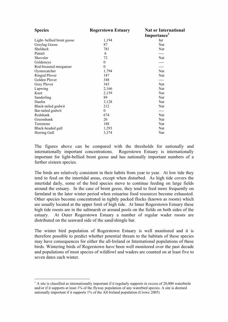
Species Rogerstown Estuary Nat or International Importance1
Light- bellied brent goose 1,194 Int Greylag Goose 87 Nat Shelduck 781 Nat Pintail 6 ---- Shoveler 72 Nat Goldeneye 0 ---- Red-breasted merganser 0 ---- Oystercatcher 1,794 Nat Ringed Plover 187 Nat Golden Plover 348 ---- Grey Plover 343 Nat Lapwing 2,166 Nat Knot 2,159 Nat Sanderling 89 Nat Dunlin 3,128 Nat Black-tailed godwit 212 Nat Bar-tailed godwit 0 ---- Redshank 674 Nat Greenshank 26 Nat Turnstone 188 Nat Black-headed gull 1,293 Nat Herring Gull 3,374 Nat
The figures above can be compared with the thresholds for nationally and internationally important concentrations. Rogerstown Estuary is internationally important for light-bellied brent goose and has nationally important numbers of a further sixteen species.
The birds are relatively consistent in their habits from year to year. At low tide they tend to feed on the intertidal areas, except when disturbed. As high tide covers the intertidal daily, some of the bird species move to continue feeding on large fields around the estuary. In the case of brent geese, they tend to feed more frequently on farmland in the later winter period when estuarine food resources become exhausted. Other species become concentrated in tightly packed flocks (known as roosts) which are usually located at the upper limit of high tide. At Inner Rogerstown Estuary these high tide roosts are in the saltmarsh or around pools on the fields on both sides of the estuary. At Outer Rogerstown Estuary a number of regular wader roosts are distributed on the seaward side of the sand/shingle bar.
The winter bird population of Rogerstown Estuary is well monitored and it is therefore possible to predict whether potential threats to the habitats of these species may have consequences for either the all-Ireland or International populations of these birds. Wintering birds of Rogerstown have been well monitored over the past decade and populations of most species of wildfowl and waders are counted on at least five to seven dates each winter.
1 A site is classified as internationally important if it regularly supports in excess of 20,000 waterbirds and/or if it supports at least 1% of the flyway population of any waterbird species. A site is deemed nationally important if it supports 1% of the All-Ireland population (Crowe 2005)
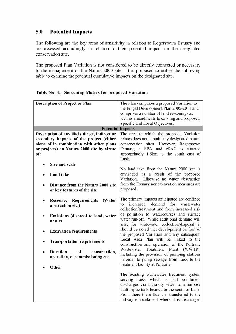
5.0 Potential Impacts
The following are the key areas of sensitivity in relation to Rogerstown Estuary and are assessed accordingly in relation to their potential impact on the designated conservation site.
The proposed Plan Variation is not considered to be directly connected or necessary to the management of the Natura 2000 site. It is proposed to utilise the following table to examine the potential cumulative impacts on the designated site.
Table No. 4: Screening Matrix for proposed Variation
Description of Project or Plan The Plan comprises a proposed Variation to the Fingal Development Plan 2005-2011 and comprises a number of land re-zonings as well as amendments to existing and proposed Specific and Local Objectives.
Potential Impacts Description of any likely direct, indirect or secondary impacts of the project (either alone of in combination with other plans or projects) on Natura 2000 site by virtue of:
Size and scale
Land take
Distance from the Natura 2000 site or key features of the site
Resource Requirements (Water abstraction etc.)
Emissions (disposal to land, water or air)
Excavation requirements
Transportation requirements
Duration of construction, operation, decommissioning etc.
Other
The area to which the proposed Variation relates does not contain any designated nature conservation sites. However, Rogerstown Estuary, a SPA and cSAC is situated appropriately 1.5km to the south east of Lusk.
No land take from the Natura 2000 site is envisaged as a result of the proposed Variation. Likewise no water abstraction from the Estuary nor excavation measures are proposed.
The primary impacts anticipated are confined to increased demand for wastewater collection/treatment and from increased risk of pollution to watercourses and surface water run-off. While additional demand will arise for wastewater collection/disposal, it should be noted that development on foot of the proposed Variation and any subsequent Local Area Plan will be linked to the construction and operation of the Portrane Wastewater Treatment Plant (WWTP), including the provision of pumping stations in order to pump sewage from Lusk to the treatment facility at Portrane.
The existing wastewater treatment system serving Lusk which is part combined, discharges via a gravity sewer to a purpose built septic tank located to the south of Lusk. From there the effluent is transferred to the railway embankment where it is discharged
to Rogerstown Estuary at the railway viaduct. The outfall from the septic tank currently has no capacity to accept further development pending upgrade.2
The Whitestown Wastewater pumping station is a new pumping station which will replace the existing pumping station adjacent to Rush Sailing club. The pumping station is intended to collect all the wastewater flows from Lusk and pump it on towards the Portrane Wastewater Treatment Plant. The existing overflow will continue to be used in the event that the pumping station capacity is exceeded during wet weather or if there is an emergency equipment failure3.
The proposed pipe line from the Whitestown pumping station to the Portrane WWTP will cross Rogerstown Estuary near Rogerstown Pier. On completion of the proposed Rush/Lusk treatment scheme, sewage flows from both towns will no longer be discharged untreated into the Irish sea and to Rogerstown Estuary respectively, thus having a positive impact on the quality of the water in these areas.
Describe any likely changes to the site arising as a result of:
reduction of habitat area disturbance to key species habitat or species fragmentation reduction in species density changes in key indicators of conservation value (water quality etc.)climate change
It cannot be categorically stated in the absence of carrying out further detailed research that the proposed Variation will not adversely impact upon the Natura 2000 site to the south east.
As such, in adopting the Precautionary Principle as set out in the European Commissions Guidance Document4 it is the intention of the Planning Authority to carry out an Appropriate Assessment in line with Article 6(3) of the Habitats Directive 92/43/EEC.
While further research will be conducted, it is not anticipated that the proposed Variation would directly result in diminished habitat area, disturbance to key species, habitat or species fragmentation, reduction in species density or climate change.
2 Fingal County Council, ‘Environmental Report - Strategic Environmental Assessment for draft Lusk Variation’, January 2008. 3 Portrane, Donabate, Rush and Lusk Wastewater Treatment Scheme Description of the Nature and Extent of the Proposed Development: Local Authority Planning Process. 4 European Commission Environment DG ‘Assessment of Plans and Projects significantly affecting Natura 2000 sites- Methodological guidance on the provisions of Article 6(3) and (4) of the Habitats Directive 92/43/EEC’ November 2001.
Particular attention will be paid to anticipated changes in key indicators of conservation value such as water quality. It is noted that two water courses are located in the vicinity of Lusk being Baleally and Bride streams. Given the requirement of the Baleally stream to accept storm water run-off from the area and for the Bridestream to cater for surface water run off from the R127 and from developed land, the risk of contamination of both water courses from anticipated future development arising from the proposed Variation must be investigated.
Describe any likely impacts on the Natura 2000 site as a whole in terms of:
interference with the key relationships that define the structure of the site. Interference with key relationships that define the function of the site.
While no direct impacts on the Natura site are anticipated as a result of the proposed variation, indirect impacts which may cause interference with key relationships which define the structure and function of the site will require further investigation. Preliminary desk top studies and research conducted as part of the Strategic Environmental Assessment (SEA) for the draft Plan Variation would appear to suggest that such impacts will be limited mainly to increased risk of pollution to ground waters in the area and the risks associated with increased wastewater generation and disposal. These issues will be investigated under Appropriate Assessment.
Provide indicators of significance as a result of the identification of effects set out above in terms of:
LossFragmentation DisruptionDisturbanceChange to key elements of the site (e.g. water quality etc.)
The impact of the proposed Variation may be long term in nature i.e. potential contamination of ground waters may have long term repercussions for the makeup of the Estuary including interference with key relationships.
Possible indicators of significance include the following:(i) Capacity of the new wastewater treatment plant to cater for increased demand from Lusk and potential/frequency of emergency outflows from associated pumping stations. A positive development however, is the cessation of temporary treatment plants within the town. (ii) Estimated degree of risk of pollution affecting the site if groundwater is polluted as a result of increased levels of development.
Describe from the above those elements of the project or plan, or combination of elements, where the above impacts are likely to be significant or where the scale or magnitude of impacts is not known
On the basis of research conducted for the SEA prepared as part proposed Variation process and following a desk top exercise conducted for the Screening for Appropriate Assessment, it is concluded that while direct
negative impacts on the Natura site are not anticipated, it cannot be categorically concluded without further investigation that indirect negative impacts will not result. Consequently, it is recommended that an Appropriate Assessment under Article 6(3) of the Habitats Directive be conducted.
5.0 Conclusions and Recommendations:
On the basis of the findings of this Screening for Appropriate Assessment it is concluded that the proposed Plan Variation is:
(i) not directly connected with or necessary to the management of a European Natura 2000 site and
(ii) may have significant effects on the management of the Natura 2000 site being Rogerstown Estuary a designated cSAC and SPA.
In accordance with Article 6(3) of the Habitats Directive, it is recommended that Appropriate Assessment will be required before the Planning Authority proceeds to adopt the proposed Variation.
APPENDIX 2
Screening Report: Draft Lusk Local Area Plan

Appropriate Assessment Screening of draft
Local Area Plan
for
Lusk Co. Dublin.
____________________________________________
In line with the requirements of
Article 6(3) of theEU Habitats Directive (Directive 92/43/EEC)
Prepared by
Strategic Planning Unit Fingal County Council

1.0 Introduction
This report comprises an Appropriate Assessment Screening in line with the requirements of Article 6(3) of the EU Habitats Directive (Directive 92/43/EEC) of the draft Local Area Plan (LAP) for Lusk Co. Dublin. The report has taken into consideration the European Commissions publication- ‘Assessment of plans and projects significantly affecting Natura 2000 sites’- Methodological guidance on the provisions of Articles 6 (3) and (4) of the Habitats Directive 92/43/EEC’ and Circular Letter SEA 1/08 & NPWS 1/08 from the Department of the Environment, Heritage and Local Government.
2.0 Background
Legal protection is afforded habitats and species of European importance through the Habitats Directive and Regulations 1994 which transpose Directive 92/43/EEC on the Conservation of Natural Habitats and Wild Flora and Fauna. Articles 6(3) and 6(4) of the Habitats Directive require that an Appropriate Assessment be carried out on all plans/projects which may impact upon designated Natura 2000 sites.
The three stages of Appropriate Assessment are set out below:
(i) Determine whether the plan/project is likely to have a significant effect on a European site either alone or in combination with other plans or projects. This is referred to as the Screening stage.
(ii) Where significant effects are found to occur, an Appropriate Assessment ascertaining the full effects on the integrity of the site will be initiated.
(iii) Where there is a risk of the plan/project having effects on the integrity of a site, an examination of mitigation measures and alternative solutions will be required.
Implicit in the Habitats Directive is the application of the Precautionary Principle which requires that the conservation objectives of Natura 2000 should prevail where there is uncertainty as set out in Section 2.2 of the European Commissions Guidance Document. The use of the precautionary principle presupposes the:
- identification of potentially negative effects resulting from a phenomenon, product or procedure - scientific evaluation of risks which because of the insufficiency of the data, inconclusive or imprecise nature, makes it possible to determine with sufficient certainty the risk in question.
2.1 Site Location and Description of Project
The plan, the subject of this Screening for Appropriate Assessment, concerns the draft Local Area Plan for the town of Lusk located in the north east of the functional area of Fingal County Council. Lusk is situated approximately 18km north of Dublin City Centre, 3.5 km west of the coastal village of Rush, 8 km north of Swords and 10km south of Balbriggan. The town is located between the old National Route N1 (R132)
(replaced by the M1 motorway located to the west) and the Dublin/Belfast Rail corridor and is accessed from the south along Regional road R127, a spur off the R132 which links Lusk with Skerries to the north. The Regional road intersects with the R128 linking Lusk to Rush to the east.
Lusk has experienced significant levels of population increase since the production of the last Action Area Plan in 2000. An increase of 113.2% in residential population has been experienced in the town over this period. The LAP aims to provide integration between the peripheral estates and existing communities within the village and will provide for improvements to existing services/facilities to cater for current demand within the town and anticipated future growth.
By utilising existing zoned lands within the town, the potential exists that Lusk could grow to at least 7,000 persons.
2.2 Variation No. 25 to the 2005-2011 Fingal Development Plan
Variation 25 to the 2005-2011 Fingal Development Plan adopted on the 12th May 2008 provides for a number of specific re-zonings and Local Objectives within the town. The Variation to the Development Plan sets the foundation for the Local Area Plan ensuring that the policies and objectives of the LAP will be consistent with those of the Development Plan.
The components of the Variation as adopted by the Members of Fingal County Council are set out below:
(A) Rezone the area of land marked D on the attached map from zoning objective RU to zoning objective RS1.
(B) Rezone the area of land marked E on the attached map from zoning objectives RU and RS to zoning objective OS.
(C) Rezone the area of land marked F on the attached map from zoning objective RU to zoning objective RS1.
(D) Rezone the area of land marked H on the attached map from zoning objective RS to zoning objective SC
The following Local Objectives are also included:
Local Objective LK1 (Applies to Areas D & F) To ensure that residential development does not take place until such time as the Public Waste Water Treatment Plant at Portrane becomes fully operational and the required network upgrades to facilitate the development are completed.
Local Objective LK2 (Referred to as LK12 in Manager’s Report) To ensure that development of the school takes place only in conjunction with the upgrading of the length of Kilhedge Lane north of the site access to where it joins the existing estate road.
Local Objective LK3 (Applies to Areas E & F) To secure the preparation and approval by the Planning Authority of a master plan prior to the development of the secondary school, community facility, playing pitches, park land and residential development to secure comprehensive development of the area in a proper manner.
Local Objective LK4 (Applies to Area F) To ensure that residential development does not take place until such time as (a) work has commenced on the construction of the secondary school on land marked Area E on the attached map, immediately east of the site and (b) the developer has undertaken an Educational Needs Assessment which demonstrates to the satisfaction of the Planning Authority that there is adequate school provision for the needs generated by the proposed development.
Local Objective LK5 (Applies to Area D) To ensure that residential development does not take place until such time as (a) work has commenced on the construction of a new permanent primary school beyond the existing schools currently operating with the Lusk catchment area and a new secondary school within Lusk and (b) the developer has undertaken an Educational Needs Assessment which demonstrates to the satisfaction of the Planning Authority that there is adequate school provision for the needs generated by the proposed development.
Local Objective LK6 Creation of a Civic Square: to provide for a Civic Square and ensure that proposed development in the vicinity of the junction of Main Street, Station Road and Church Road facilitates the provision of a high quality Civic Square.
Local Objective LK7 To provide for a pedestrian right of way from Church Road to Post Office Road.
Local Objective LK8 To provide for a pedestrian right of way from the Dublin Road through Town Park to Minister’s Road/Tower View.
Local Objective LK9 (Applies to Area D) To limit residential development on these lands to a maximum of 10 dwellings per hectare.
Local Objective LK10 (Applies top Areas D, E, F and H) To ensure that no development proceeds until such time as Appropriate Assessment has been carried out. The Appropriate Assessment shall provide for mitigation measures where required and shall clearly demonstrate that any development will not have an adverse impact on any relevant Natura 2000 Site. In the event that mitigation measures are not sufficient to overcome significant effects on the conservation objectives of a Natura site, development shall not proceed.
Local Objective LK11 (applies to Area H)To ensure that development does not take place until such time as the Waste Water

treatment Plant at Portrane becomes fully operational and the required network upgrades to facilitate the development are completed.
New Development Objective Lusk 9- Traffic Management and Traffic Calming
To develop and implement comprehensive and effective measures for Traffic Management and Traffic Calming and to carry out a study in this regard to include the following:
Assessment of the existing traffic environment. Review of traffic speeds within the town and approaches to the town. Measures to promote the use of the By-Pass and disincentives to through traffic. Identification of rat runs and measures to alleviate these. In conjunction with urban design measures the identification of appropriate road surface treatments ad shared surfaces. Identification of appropriate access points for newly zoned lands Improvements to facilitate pedestrians and cyclists. Review of the existing one-way system Identification of traffic calming measures Implementation plan including timeframes of measures proposed.
Area J The Variation also provides for a specific objective for a new primary school site, on the area marked J on the attached map; and for improvements to be made to Minister’s Road between the R132 (old N1 Dublin Road) junction to the Round Tower’s GAA club’.
3.0 Identification of designated conservation sites
While there are no Natura 2000 sites located within the boundaries of Plan lands, Rogerstown Estuary, a designated Special Protection Area (SPA) and candidate Special Area of Conservation c(SAC) is located to the south-east of the town.
The Estuary is funnel shaped and is separated from the sea by a sand and shingle peninsula extending eastwards beyond the low water mark to include an area of shallow marine water. The Estuary receives the waters of Ballyboghil and Ballough rivers, both of which flow through intensive agricultural catchments. Rogerstown Estuary has a wide salinity range from near full sea water in proximity to the sea to almost full freshwater further inland. The Estuary is divided by a causeway and narrow bridge built in the 1840’s to accommodate the Dublin-Belfast railway line.

3.1 Table No. 1: Existing Designations applicable to Rogerstown Estuary
Site Name Designated Areas Basis Rogerstown Estuary Special Protection Area
(SPA) Site Code 004015 EU Birds Directive
Candidate Special Area of Protection c(SAC) Code 000208
EU Habitats Directive
Proposed Natural Heritage Area
Wildlife (Amendment) Act 2000
Statutory Nature Reserve Wildlife Acts, 1976 2000 Birdwatch Ireland Reserve Lands owned by voluntary
body Ramsar Site Ramsar Convention
3.2 Table No. 2: Habitat Type Rogerstown Estuary:
_____________________________________________________________________Designated Sub sites Principle Habitat Types AreaRogerstown Inner Rogerstown Estuary Mudflats, saltmarsh Estuary Outer Rogerstown Estuary Mudflats, sandflats, saltmarsh Portrane dunes and beach Sand dunes, saltmarsh, sandy Beach Portrane to Martello Tower Rocky shore _____________________________________________________________________
The EU Habitats Directive contains a list of habitats (Annex I) and species (Annex II) for which SAC’s must be established by Member States.
Similarly, the EU Birds Directive contains lists of important bird species (Annex I) and other migratory bird species for which SPA’s must be established. Those which are known to occur in Rogerstown Estuary are referred to as ‘qualifying interests’ and are listed in the Natura 2000 forms which are lodged with the EU Commission by each Member State. A ‘qualifying interest’ is one of the factors (such as the species or habitat that is present) for which the site merits designation. The relevant habitats and species for Rogerstown Estuary are detailed in the Tables 3, 4 and 5 below.
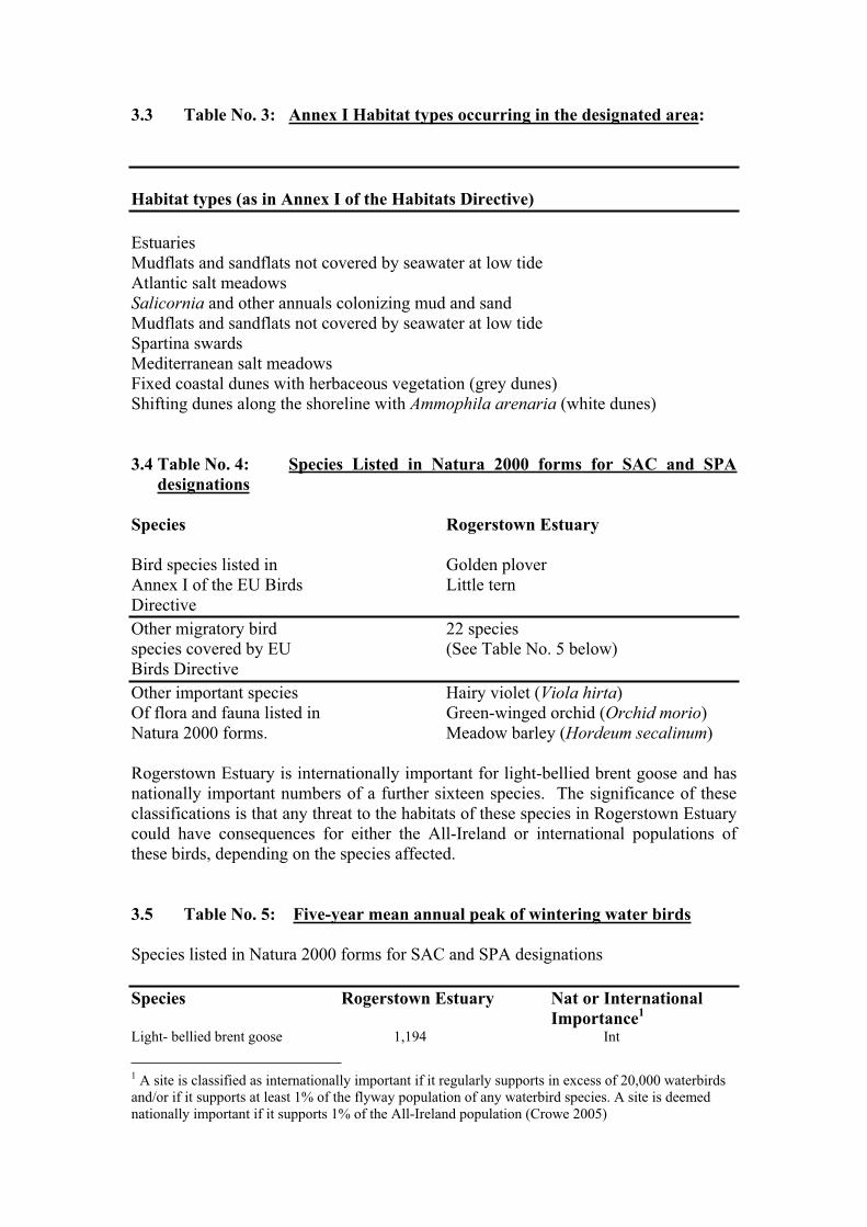
3.3 Table No. 3: Annex I Habitat types occurring in the designated area:
Habitat types (as in Annex I of the Habitats Directive)
Estuaries Mudflats and sandflats not covered by seawater at low tide Atlantic salt meadows Salicornia and other annuals colonizing mud and sand Mudflats and sandflats not covered by seawater at low tide Spartina swards Mediterranean salt meadows Fixed coastal dunes with herbaceous vegetation (grey dunes) Shifting dunes along the shoreline with Ammophila arenaria (white dunes)
3.4 Table No. 4: Species Listed in Natura 2000 forms for SAC and SPA designations
Species Rogerstown Estuary
Bird species listed in Golden plover Annex I of the EU Birds Little tern DirectiveOther migratory bird 22 species species covered by EU (See Table No. 5 below) Birds Directive Other important species Hairy violet (Viola hirta)Of flora and fauna listed in Green-winged orchid (Orchid morio)Natura 2000 forms. Meadow barley (Hordeum secalinum)
Rogerstown Estuary is internationally important for light-bellied brent goose and has nationally important numbers of a further sixteen species. The significance of these classifications is that any threat to the habitats of these species in Rogerstown Estuary could have consequences for either the All-Ireland or international populations of these birds, depending on the species affected.
3.5 Table No. 5: Five-year mean annual peak of wintering water birds
Species listed in Natura 2000 forms for SAC and SPA designations
Species Rogerstown Estuary Nat or International Importance1
Light- bellied brent goose 1,194 Int
1 A site is classified as internationally important if it regularly supports in excess of 20,000 waterbirds and/or if it supports at least 1% of the flyway population of any waterbird species. A site is deemed nationally important if it supports 1% of the All-Ireland population (Crowe 2005)
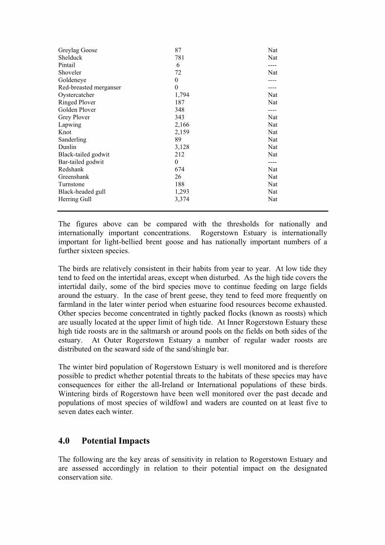
Greylag Goose 87 Nat Shelduck 781 Nat Pintail 6 ---- Shoveler 72 Nat Goldeneye 0 ---- Red-breasted merganser 0 ---- Oystercatcher 1,794 Nat Ringed Plover 187 Nat Golden Plover 348 ---- Grey Plover 343 Nat Lapwing 2,166 Nat Knot 2,159 Nat Sanderling 89 Nat Dunlin 3,128 Nat Black-tailed godwit 212 Nat Bar-tailed godwit 0 ---- Redshank 674 Nat Greenshank 26 Nat Turnstone 188 Nat Black-headed gull 1,293 Nat Herring Gull 3,374 Nat
The figures above can be compared with the thresholds for nationally and internationally important concentrations. Rogerstown Estuary is internationally important for light-bellied brent goose and has nationally important numbers of a further sixteen species.
The birds are relatively consistent in their habits from year to year. At low tide they tend to feed on the intertidal areas, except when disturbed. As the high tide covers the intertidal daily, some of the bird species move to continue feeding on large fields around the estuary. In the case of brent geese, they tend to feed more frequently on farmland in the later winter period when estuarine food resources become exhausted. Other species become concentrated in tightly packed flocks (known as roosts) which are usually located at the upper limit of high tide. At Inner Rogerstown Estuary these high tide roosts are in the saltmarsh or around pools on the fields on both sides of the estuary. At Outer Rogerstown Estuary a number of regular wader roosts are distributed on the seaward side of the sand/shingle bar.
The winter bird population of Rogerstown Estuary is well monitored and is therefore possible to predict whether potential threats to the habitats of these species may have consequences for either the all-Ireland or International populations of these birds. Wintering birds of Rogerstown have been well monitored over the past decade and populations of most species of wildfowl and waders are counted on at least five to seven dates each winter.
4.0 Potential Impacts
The following are the key areas of sensitivity in relation to Rogerstown Estuary and are assessed accordingly in relation to their potential impact on the designated conservation site.
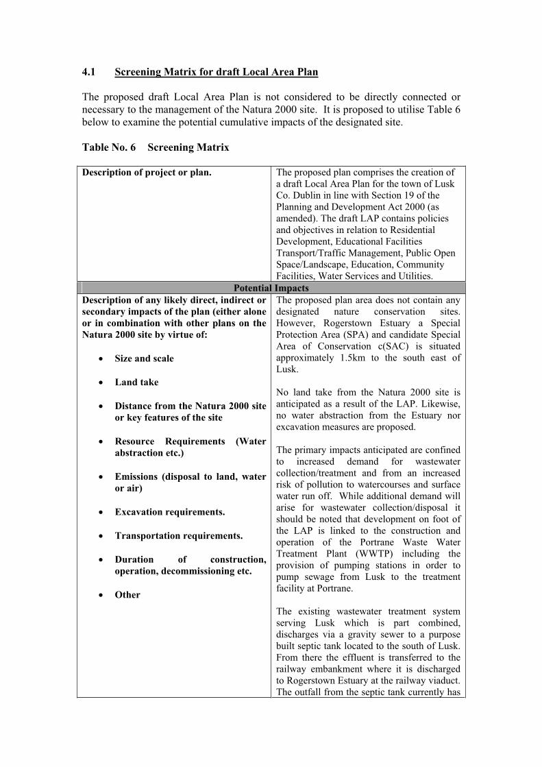
4.1 Screening Matrix for draft Local Area Plan
The proposed draft Local Area Plan is not considered to be directly connected or necessary to the management of the Natura 2000 site. It is proposed to utilise Table 6 below to examine the potential cumulative impacts of the designated site.
Table No. 6 Screening Matrix
Description of project or plan. The proposed plan comprises the creation of a draft Local Area Plan for the town of Lusk Co. Dublin in line with Section 19 of the Planning and Development Act 2000 (as amended). The draft LAP contains policies and objectives in relation to Residential Development, Educational Facilities Transport/Traffic Management, Public Open Space/Landscape, Education, Community Facilities, Water Services and Utilities.
Potential Impacts Description of any likely direct, indirect or secondary impacts of the plan (either alone or in combination with other plans on the Natura 2000 site by virtue of:
Size and scale
Land take
Distance from the Natura 2000 site or key features of the site
Resource Requirements (Water abstraction etc.)
Emissions (disposal to land, water or air)
Excavation requirements.
Transportation requirements.
Duration of construction, operation, decommissioning etc.
Other
The proposed plan area does not contain any designated nature conservation sites. However, Rogerstown Estuary a Special Protection Area (SPA) and candidate Special Area of Conservation c(SAC) is situated approximately 1.5km to the south east of Lusk.
No land take from the Natura 2000 site is anticipated as a result of the LAP. Likewise, no water abstraction from the Estuary nor excavation measures are proposed.
The primary impacts anticipated are confined to increased demand for wastewater collection/treatment and from an increased risk of pollution to watercourses and surface water run off. While additional demand will arise for wastewater collection/disposal it should be noted that development on foot of the LAP is linked to the construction and operation of the Portrane Waste Water Treatment Plant (WWTP) including the provision of pumping stations in order to pump sewage from Lusk to the treatment facility at Portrane.
The existing wastewater treatment system serving Lusk which is part combined, discharges via a gravity sewer to a purpose built septic tank located to the south of Lusk. From there the effluent is transferred to the railway embankment where it is discharged to Rogerstown Estuary at the railway viaduct. The outfall from the septic tank currently has

no capacity to accept further development pending upgrade.2
The Whitestown Wastewater pumping station is a new pumping station which will replace the existing pumping station adjacent to Rush Sailing club. The pumping station is intended to collect all the wastewater flows from Lusk and pump it on towards the Portrane Wastewater Treatment Plant. The existing overflow will continue to be used in the event that the pumping station capacity is exceeded during wet weather or if there is an emergency equipment failure.3
The proposed pipe line from the Whitestown pumping station to the Portrane WWTP will cross Rogerstown Estuary near Rogerstown Pier. On completion of the proposed Rush/Lusk treatment scheme, sewage flows from both towns will no longer be discharged untreated into the Irish sea and to Rogerstown Estuary respectively, thus having a positive impact on the quality of the water in these areas.
Describe any likely changes to the site arising as a result of:
reduction of habitat area disturbance to key species habitat or species fragmentation reduction in species density changes in key indicators of conservation value (water quality etc.)climate change
It cannot be categorically stated in the absence of carrying out further detailed research that the draft LAP will not adversely impact upon the Natura 2000 site to the south east.
As such, in adopting the Precautionary Principle as set out in the European Commissions Guidance Document4 it is in the intention of the Planning Authority to carry out an Appropriate Assessment of the Plan in line with Article 6(3) of the Habitats Directive 92/43/EEC.
While further research will be conducted into the following areas as part of the Appropriate Assessment, it is not anticipated that the LAP will directly result in diminished habitat area, disturbance to key species, habitat or species fragmentation, reduction in species density or climate change.
2 Fingal County Council, ‘Environmental Report - Strategic Environmental Assessment for draft Lusk Variation’, January 2008. 3 Portrane, Donabate, Rush and Lusk Wastewater Treatment Scheme Description of the Nature and Extent of the Proposed Development: Local Authority Planning process. 4 European Commission Environment DG ‘Assessment of Plans and Projects significantly affecting Natura 2000 sites- Methodological guidance on the provisions of Article 6(3) and (4) of the Habitats Directive 92/43/EEC’ November 2001.
Particular attention will be paid to anticipated changes in key indicators of conservation value such as water quality. It is noted that two water courses are located in the vicinity of Lusk being Balleally stream and Bridestream. Given the requirement of the Baleally stream to accept storm water run-off from the area and for the Bridestream to cater for surface water run off from the R127 and from developed land, the risk of contamination of both water courses from anticipated future development arising from the LAP must be investigated.
Describe any likely impacts on the Natura 2000 site as a whole in terms of:
interference with the key relationships that define the structure of the site. Interference with key relationships that define the function of the site.
While no direct impacts on the Natura site are anticipated as a result of the LAP, indirect impacts which may cause interference with key relationships which define the structure and function of the site will require further investigation. Preliminary desk top studies and research conducted as part of the Strategic Environmental Assessment (SEA) for the Variation process would appear to suggest that such impacts will be limited mainly to increased risk of pollution to ground waters in the area and the risks associated with increased wastewater generation and disposal. These issues will be investigated under Appropriate Assessment.
Provide indicators of significance as a result of the identification of effects set out above in terms of:
LossFragmentation DisruptionDisturbanceChange to key elements of the site (e.g. water quality etc.)
The impact of the LAP may be long term in nature i.e. potential contamination of ground waters may have long term repercussions for the makeup of the Estuary including interference with key relationships.
Possible indicators of significance include the following:(i) Capacity of the new wastewater treatment plant to cater for increased demand from Lusk and potential/frequency of emergency outflows from associated pumping stations. A positive development however, is the cessation of temporary treatment plants within the town. (ii) Estimated degree of risk of pollution affecting the site if groundwater is polluted as a result of increased levels of development.
Describe from the above those elements of the project or plan, or combination of elements, where the above impacts are likely to be significant or where the scale or magnitude of impacts is not known
On the basis of research conducted for the SEA prepared as part of the LAP process and following desk top exercise conducted for the Screening for AA exercise, it is concluded that while direct negative impacts on the Natura site are not anticipated, it cannot be categorically concluded without further investigation that indirect negative impacts
will not result. Consequently, it is recommended that an Appropriate Assessment under Article 6(3) of the Habitats Directive be conducted
5.0 Conclusions and Recommendations:
On the basis of the findings of this Screening for Appropriate Assessment it is concluded that the proposed Draft Local Area Plan for Lusk is
(i) not directly connected with or necessary to the management of a European Natura 2000 site and
(ii) may have significant effects on the management of the Natura 2000 site being Rogerstown Estuary a designated cSAC and SPA.
In accordance with Article 6(3) of the Habitats Directive, it is recommended that a full Appropriate Assessment will be required before the Planning Authority proceeds to adopt the draft Local Area Plan.
APPENDIX 3
Plan Detailing the Proposed Variation of Lands at Lusk
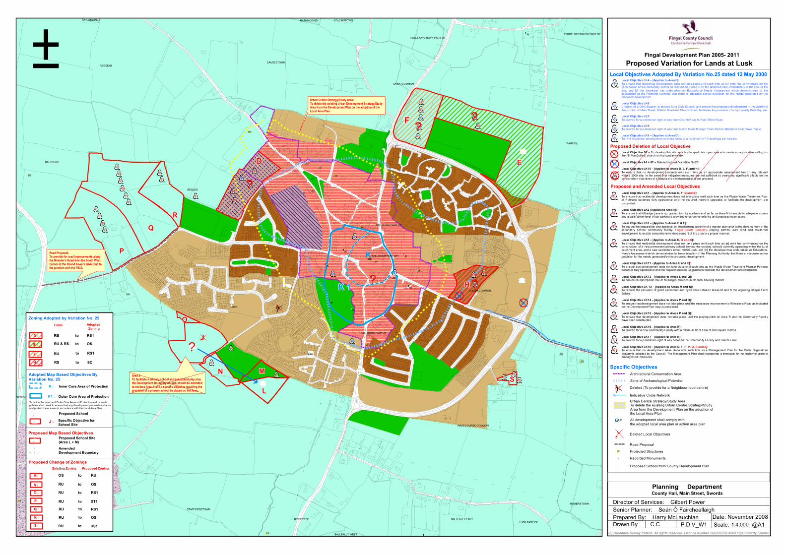
!
¾¾½¾¾½
¾¾½
¾¾½
¾¾½¾¾½
¾¾½
!
! !
!
!
!
!
!!
!
!
!
!
!!
!
! !
!
³
.
''
''
''
''
''
''''
''
''
''
''''
''
.
&&1LK
&&3LK
&&4LK
&&3LK
&&6LK
&&8LK
&&9LK
&&0LK1
&&0LK1
&&0LK1
&&1LK1
&&0LK1
&&8LK
&&1LK
&&5LK
&&1LK
&&5LK
&&7LK
&&1LK1
&&5LK
&&1LK
&&2LK1 ?
??
&&7LK1
&&6LK1
&&5LK1
&&4L K1
&&5LK1
&&4L K1
&&8LK1
&&8LK1
&&8LK1
&&8LK1
&&8LK1
&&8LK1
&&8LK1
?
&&2LK
&&3LK1
.
&&3LK1
!!
!!
!!!!
!!!
! !!!
!!
!!
!!
!!
!!!!!!!!!!!!!!!!!!!!
!!
!!!!!!!!!!!!!!
!!
!!
!!!!!!!!
!!!!
!!
!!!!
!!
!!
!!!
!!
!!
!!
!!!!!
!!
!!
!!
!! !
!!
!!
!!
!!
!!
!!
!!!!!!!
!!
!!
!!
!!
!!
!!
!
!!
!!
!
!!
!!!
!!
!!
!!
!!
!!
!
!!!!!!!
!!
!!
!!
! !
!!
!!
!!
! ! !!
! ! ! ! ! ! ! ! ! ! ! ! ! !
!!
!!
!
!!
!
!
! ! ! ! !! !
!!
!!
!!
!!
!!
! !!
!!
!!
!!
!!
!!
!!
!!
! ! ! ! ! !!
! ! ! ! ! ! ! ! ! ! ! ! ! ! ! ! ! ! ! ! !
!!
!!
!!
!!
!!
!
! ! ! ! ! ! ! ! ! ! !!
!! ! ! ! ! ! ! ! ! ! ! ! ! ! ! ! !
!!
!!
!!
!!
!!
!!
!!
!!
! ! ! ! ! !! !!
!!
!!
!!
!!
!!
!!
!!
!!
!!
!!
!!
!!
!!
!!
!!
!!
!!
! !
J
D
F
E
H
K
K 1
SL
O
M
P
Q
R
N
LAP
298
LUSK
REGLES
REGEENS
RAHENY
RACECOURSE COMMON
CAUSESTOWN
GREATCOMMON
BALLOUGH
STAFFORDSTOWN
CORDUFF (Hackett)
DUNGANSTOWN
REGLES PART OF
BRIDETREE
ROGERSTOWN
BALLEALLY EAST
LOUGH COMMON
LUSK PART OF
TYRRELSTOWN BIG PART OF
COLLINSTOWN
RALLEKAYSTOWN PART OF
BALLOUGH PART OF
NEWTOWNCORDUFF
RATHMOONEY
BALLEALLY WEST
BALLOUGH PART OF
RATHMOONEY
BALLOUGH PART OF
303304
300
301302
305
309
314
315
293
294
316
310
295
296
297
299
79
86
87
96
89
97
98
92
94
99
93
91
±
Zoning Adopted by Variation No. 25From Adopted
Zoning
. Proposed School
J : Specific Objective forSchool Site
Inner Core Area of ProtectionK :
K1 : Outer Core Area of Protection
Adopted Map Based Objectives ByVariation No. 25
Proposed Change of ZoningsExisting Zoning Proposed Zoning
to RS1RU
RB to RS1
RU & RS to OS
RS to SC
toRU
OS to RU
RU to RS1
RU ST1
RU RS1
to
to
Local Objectives Adopted By Variation No.25 dated 12 May 2008
Fingal Development Plan 2005- 2011Proposed Variation for Lands at Lusk
(c) Ordnance Survey Ireland. All rights reserved. Licence number 2003/07/CCMA/Fingal County Council.
1:4,000Date: November 2008
@A1P.D.V_W1 Scale:Prepared By: Harry McLauchlanDrawn By C.C
Senior Planner: Seán Ó FaircheallaighDirector of Services: Gilbert Power
Planning DepartmentCounty Hall, Main Street, Swords
OS
Proposed and Amended Local Objectives
Proposed Map Based Objectives
P:
Q :
R :
S :
RU OSto
RU RS1to
!
! ! !
!!!
AmendedDevelopment Boundary
Proposed School Site(Area L + M)
N :
M :
O :
D :
E :
F :
H :
To define the Inner and Outer Core Areas of Protection and promotepolicies which seek to ensure that any development proposals enhanceand protect these areas in accordance with the Local Area Plan.
&&LK6
&&LK4
&&LK3
&&LK7
&&LK8
&&LK9
Urban Centre Strategy/Study Area:To delete the existing Urban Development Strategy/StudyArea from the Development Plan on the adoption of theLocal Area Plan.
Road Proposal:To provide for road improvements alongthe Minister’s Road from the South WestCorner of the Round Towers GAA Club tothe junction with the R132.
Area J:To facilitate a primary school and associated play areathe Development Boundary of Lusk should be extendedto enclose Area J, and a specific objective requiring theprovision of a primary school be placed on the Area.
Local Objective LK4 – [Applies to Area F]:To ensure that residential development does not take place until such time as [a] work has commenced on theconstruction of the secondary school on land marked Area E on the attached map, immediately to the east of thesite, and [b] the developer has undertaken an Educational Needs Assessment which demonstrates to thesatisfaction of the Planning Authority that there is adequate school provision for the needs generated by theproposed development.
Local Objective LK6:Creation of a Civic Square: to provide for a Civic Square, and ensure that proposed development in the vicinity ofthe junction of Main Street, Stat ion Road and Church Road, facilitates the provision of a high quality Civic Square.
Local Objective LK7:To provide for a pedestrian right of way from Church Road to Post Office Road.
Local Objective LK8:To provide for a pedestrian right of way from Dublin Road through Town Park to Minister’s Road/Tower View.
Local Objective LK9 – [Applies to Area D]:To limit residential development on these lands to a maximum of 10 dwellings per hectare.
Local Objective 92 – To develop this site as a landscaped civic open space to create an appropriate setting forthe (St MacCullins) church on the southern s ide.
Local Objective 94 + 97 – Deleted by Lusk Variat ion No.25
Local Objective LK10 – [Applies to Areas D, E, F, and H]:To ensure that no development proceeds unt il such time as an appropriate assessment has on any relevantNatura 2000 site. In the event that mitigation measures are not sufficient to overcome significant effects on theconservation objectives of a Natura site development shall not proceed.
Local Objective LK1 – [Applies to Areas D, F, Q and S]:To ensure that res idential development does not take place until such time as the Waste Water Treatment Plantat Portrane becomes fully operational and the required network upgrades to facilitate the development arecompleted.
Local Objective LK2 [Applies to Area N]:To ensure that Kilhedge Lane is up graded from its northern end as far as Area N to enable to adequate accessand a sat isfactory level of car parking is provided to serve the exist ing and proposed open space.
Local Objective LK3 – [Applies to Areas E & F]:To secure the preparation and approval by the planning authority of a master plan prior to the development of thesecondary school, community facility, Fingal Sports Complex, playing pitches , park land and residentialdevelopment to enable comprehensive development of the area in a proper manner.
Local Objective LK5 – [Applies to Areas D, Q and S]:To ensure that residential development does not take place until such time as [a] work has commenced on theconstruction of a new permanent primary school beyond the existing schools currently operating within the Luskcatchment area, and a new secondary school within Lusk, and [b] the developer has undertaken an Educat ionalNeeds Assessment which demonstrates to the satisfaction of the Planning Authority that there is adequate schoolprovision for the needs generated by the proposed development.
Local Objective LK11 - [Applies to Areas H and P]:To ensure that development does not take place until such time as the Waste Water Treatment Plant at Portranebecomes fully operational and the required network upgrades to facilitate the development are completed.
Local Objective LK12 – [Applies to Areas L and Q]:To ensure an appropriate mix of housing is provided in the local housing market.
Local Objective LK 13 – [Applies to Areas M and N]:To require the provision of good pedestrian and cycle links between Areas M and N the adjoining Chapel FarmEstate.
Local Objective LK14 – [Applies to Areas P and Q]:To ensure that development does not take place until the necessary improvement of Minister’s Road as indicatedon the Development Plan map is completed.
Local Objective LK15 – [Applies to Areas P and Q]:To ensure that development does not take place until the playing pitch on Area R and the Community Facilityhave been constructed.
Local Objective LK16 – [Applies to Area R]:To provide for a new Community Facility with a minimum floor area of 300 square metres.
Local Objective LK17 – [Applies to Area R]:To provide for a pedestrian right of way between the Community Facility and Hand’s Lane.
Local Objective LK18 – [Applies to Area D, F, H, P, Q, R and S]:To ensure that no development takes place until such time as a Management Plan for the Outer RogerstownEs tuary is adopted by the Council. The Management Plan shall incorporate a timescale for the implementat ion ofmanagement measures .
")NC
.
.
&&LK5
&&LK2
&&LK1
Specific Objectives
Proposed Deletion of Local Objective
&&LK11
&&LK12
&&LK13
&&LK16
&&LK15
&&LK14
&&LK17
&&LK18.?
Deleted (To provide for a Neighbourhood centre)
Indicative Cycle Network
Deleted Local Objectives
Road Proposal
Zone of Archaeological Potential
Urban Centre Strategy/Study Area :To delete the existing Urban Centre Strategy/StudyArea from the Development Plan on the adoption ofthe Local Area Plan
All development shall comply withthe adopted local area plan or action area plan
Protected Structures
Recorded Monuments
Proposed School from County Development Plan
Architectural Conservation Area
¾¾½
''94,
»
.
!293
³LAP
")NC
&&LK10
''94
''92
?
APPENDIX 4
Plan Detailing the Draft Lusk Local Area Plan
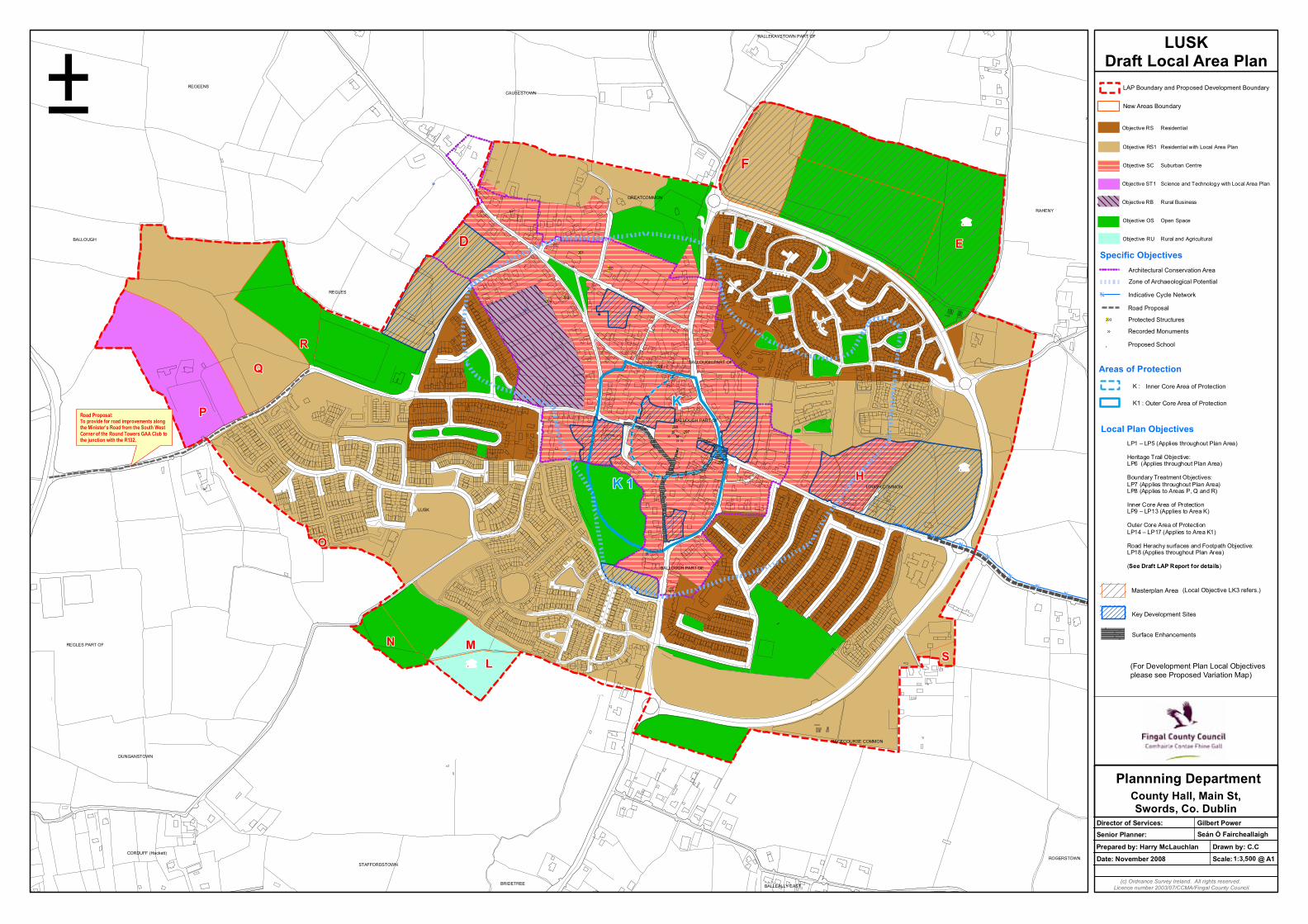
¾¾½¾¾½
¾¾½
¾¾½
¾¾½¾¾½
¾¾½
»
»»
»
»»
»
»
»
»
»
!
.
!
! !
!
!
!!
!
! !
.
.
D
F
E
H
K
K 1
S
O
M
P
Q
R
N
L
LUSK
REGLES
RACECOURSE COMMON
RAHENY
REGEENS
GREATCOMMON
CAUSESTOWN
BALLOUGH
DUNGANSTOWN
CORDUFF (Hackett)
REGLES PART OF
STAFFORDSTOWN
LOUGH COMMON
ROGERSTOWN
BRIDETREE BALLEALLY EAST
BALLOUGH PART OF
BALLOUGH PART OF
RALLEKAYSTOWN PART OF
BALLOUGH PART OF
303304
300
301302
295
296
297298
299
±
Road Proposal:To provide for road improvements alongthe Minister’s Road from the South WestCorner of the Round Towers GAA Club tothe junction with the R132.
LUSKDraft Local Area Plan
Objective RS Residential
Objective RS1 Residential with Local Area Plan
Objective SC Suburban Centre
Objective ST1 Science and Technology with Local Area Plan
Objective RB Rural Business
Objective OS Open Space
Objective RU Rural and Agricultural
LP1 – LP5 (Applies throughout Plan Area)
Heritage Trail Objective:LP6 (Applies throughout Plan Area)
Boundary Treatment Objectives:LP7 (Applies throughout Plan Area)LP8 (Applies to Areas P, Q and R)
Inner Core Area of ProtectionLP9 – LP13 (Applies to Area K)
Outer Core Area of ProtectionLP14 – LP17 (Applies to Area K1)
Road Herachy surfaces and Footpath Objective:LP18 (Applies throughout Plan Area)
(See Draft LAP Report for details)
Specific Objectives
Indicative Cycle Network
Road Proposal
Zone of Archaeological Potential
Protected Structures
Recorded Monuments
Proposed School
Architectural Conservation Area
¾¾½
»
.
!293
Local Plan Objectives
Inner Core Area of ProtectionK :
K1 : Outer Core Area of Protection
Areas of Protection
(Local Objective LK3 refers.)
(For Development Plan Local Objectivesplease see Proposed Variation Map)
Key Development Sites
Surface Enhancements
Masterplan Area
LAP Boundary and Proposed Development Boundary
New Areas Boundary
Date: November 2008 1:3,500
(c) Ordnance Survey Ireland. All rights reserved.Licence number 2003/07/CCMA/Fingal County Council.
Scale:
Prepared by: Harry McLauchlan
@ A1
Drawn by: C.C
Senior Planner:Director of Services: Gilbert Power
Seán Ó Faircheallaigh
Plannning DepartmentCounty Hall, Main St,Swords, Co. Dublin
APPENDIX 5
Natura 2000 Standard Data Form

NATURA 2000
Site code: IE0000208 NATURA 2000 Data Form
STANDARD DATA FORM
FOR SPECIAL PROTECTION AREAS (SPA)
FOR SITES ELIGIBLE FOR IDENTIFICATION AS SITES OF COMMUNITY IMPORTANCE (SCI)
AND
FOR SPECIAL AREAS OF CONSERVATION (SAC)
1. SITE IDENTIFICATION
1.5. RELATION WITH OTHER NATURA 2000 SITES:
1.1. TYPE 1.2. SITE CODE 1.3. COMPILATION DATE 1.4. UPDATE
I IE0000208 199912
1.6. RESPONDENT(S):National Parks & Wildlife Service of the Department of the Environment, Heritage and Local Government. 7 Ely Place, Dublin 2, Ireland.
DATE SITE PROPOSED AS ELIGIBLE AS SCI:
199912
DATE CONFIRMED AS SCI:
DATE SITE CLASSIFIED AS SPA: DATE SITE DESIGNATED AS SAC:
1.7. SITE NAME:Rogerstown Estuary
1.8. SITE INDICATION AND DESIGNATION/CLASSIFICATION DATES:
1 - 1
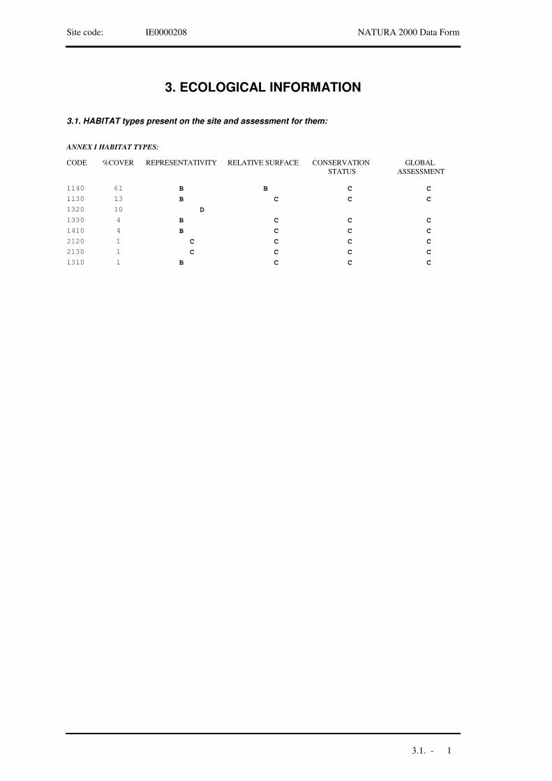
Site code: IE0000208 NATURA 2000 Data Form
3. ECOLOGICAL INFORMATION
3.1. HABITAT types present on the site and assessment for them:
ANNEX I HABITAT TYPES:
CODE %COVER REPRESENTATIVITY RELATIVE SURFACE CONSERVATION STATUS
GLOBAL ASSESSMENT
B1140 61 B C C
B1130 13 C C C
1320 D10
B1330 4 C C C
B1410 4 C C C
C2120 1 C C C
C2130 1 C C C
B1310 1 C C C
3.1. - 1
Site code: IE0000208 NATURA 2000 Data Form
3.2. SPECIES
covered by Article 4 of Directive 79/409/EEC
and
and
listed in Annex II of Directive 92/43/EEC
site assessment for them
3.2 - 1
Site code: IE0000208 NATURA 2000 Data Form
3.2.a. BIRDS listed on Annex I of Council directive 79/409/EEC
3.2.b. Regularly occuring Migratory Birds not listed on Annex I of Council Directive 79/409/EEC
3.2.c. MAMMALS listed on Annex II of Council directive 92/43/EEC
3.2.d. AMPHIBIANS and REPTILES listed on Annex II of Council directive 92/43/EEC
Population
SITE ASSESSMENT
MigratoryResident
POPULATIONNAMECODE
Conservation Isolation Global
Breed Winter Stage
1813 iPluvialis apricaria
A140 C B C B
0-3 pSterna albifronsA195 C C C C
Population
SITE ASSESSMENT
MigratoryResident
POPULATIONNAMECODE
Conservation Isolation Global
Breed Winter Stage
186 iAnser anserA043 B B C B
1176 iBranta berniclaA046 B A C A
785 iTadorna tadornaA048 B A C A
551 iAnas penelopeA050 C B C C
584 i Anas creccaA052 C B C B
244 iAnas platyrhynchosA053 C B C C
30 iAnas acutaA054 C B C B
69 iAnas clypeataA056 C B C B
27 iMergus merganserA070 C B C C
1028 iHaematopus ostralegus
A130 C B C B
152 iCharadrius hiaticula
A137 C B C B
245 iPluvialis squatarola
A141 B A C A
4056 iVanellus vanellusA142 C B C B
2076 iCalidris canutusA143 B A C A
57 iCalidris albaA144 B B C B
2625 iCalidris alpinaA149 B A C B
66 iGallinago gallinago
A153 C B C B
272 iLimosa limosaA156 B A C B
621 iNumenius arquataA160 C B C C
732 iTringa totanusA162 B A C B
22 iTringa nebulariaA164 B A C B
85 iArenaria interpresA169 C B C C
3.2 - 2
Site code: IE0000208 NATURA 2000 Data Form
3.2.e. FISHES listed on Annex II of Council directive 92/43/EEC
3.2.f. INVERTEBRATES listed on Annex II of Council directive 92/43/EEC
3.2.g. PLANTS listed on Annex II of Council directive 92/43/EEC
3.2 - 3
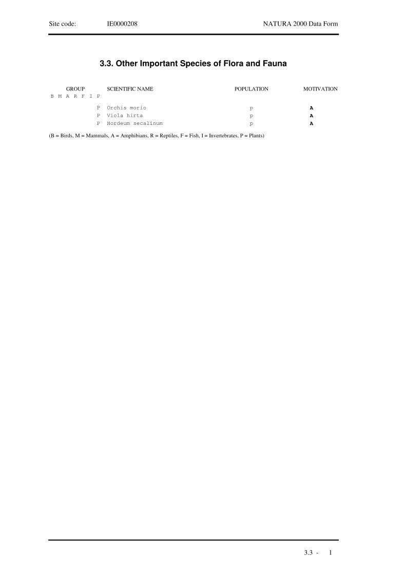
Site code: IE0000208 NATURA 2000 Data Form
3.3. Other Important Species of Flora and Fauna
(B = Birds, M = Mammals, A = Amphibians, R = Reptiles, F = Fish, I = Invertebrates, P = Plants)
SCIENTIFIC NAME POPULATION MOTIVATIONB M A R F I P
GROUP
P Orchis morio p A
P Viola hirta p A
P Hordeum secalinum p A
3.3 - 1

Site code: IE0000208 NATURA 2000 Data Form
4. SITE DESCRIPTION
4.1. GENERAL SITE CHARACTER:
Habitat classes % cover
Tidal rivers, Estuaries, Mud flats, Sand flats, Lagoons (including saltwork basins)
75
Salt marshes, Salt pastures, Salt steppes 8
Coastal sand dunes, Sand beaches, Machair 6
Dry grassland, Steppes 1
Humid grassland, Mesophile grassland 4
Improved grassland 5
Other arable land 1
Total habitat cover 100 %
Other site characteristicsSite comprises a relatively small estuarine system in north County Dublin. Receives the Ballyboghil and Ballough rivers, both of which flow through an agricultural catchment. It is a funnel shaped estuary, extending for about 6 km from east to west and up to 2 km at its widest. Has a wide salinity range, from near full sea water to near full fresh water. Estuary is bisected by a causeway and bridge which carries the Dublin-Belfast railway line. A sandy peninsula stretches across the outer part of the estuary, restricting water flow to a channel of c.200 m. In addition to salt marsh and sand dune habitats, some agricultural fields which adjoin the estuary are included in site - some of these have botanical or ornithological interests. .
4.2. QUALITY AND IMPORTANCE:A typical eastern estuary with fairly extensive intertidal sand and mud flats. Quality variable owing to pollution from a number of sources, especially a large landfill site which was built on the mudflats. The salt marshes which fringe the estuary are of moderate importance and quality and include both Atlantic and Mediterannean salt meadows, as well as Salicornia flats. The sand dune element at site is limited in its distribution and quality. Has three Red Data Book plant species. Of high importance for wintering waterfowl, with an internationally important population of Branta bernicla horta and nationally important populations of a further 16 species including Pluvialis apricaria. Sterna albifrons has bred.
4.3. VULNERABILITYA significant part of estuary (intertidal flats and salt marsh) has been lost due to landfilling and this remains a threat. Landfill site is also a major source of pollution to estuary. Other sources of pollution include input of raw sewage from a local town and general pollution inputs from a rich agricultural hinterland. Dunes at site are considered to be in a highly vulnerable state due to a combination of natural (i.e. erosion) and anthropogenic factors. Erosion has removed much of nesting area of Sterna albifrons.
4.4. SITE DESIGNATION:
4 - 1

Site code: IE0000208 NATURA 2000 Data Form
4.5. OWNERSHIPState : Department of the Marine
Local authority : Fingal County Council
Non-government organisation : IWC BirdWatch Ireland
Private : multiple
4.6. DOCUMENTATIONBowman, J.J., Clabby, K.J., Lucey, J., Mc Garrigle, M.L. and Toner, P.H. (1996). Water Quality in Ireland 1991-1994. Environmental Protection Agency, Wexford.
Colhoun, K. (1998). I-WeBS Report 1996-97. BirdWatch Ireland, Dublin.
Curtis, T.G.F. and Sheehy Skeffington, M.J. (1998). The salt marshes of Ireland: an inventory and account of their geographical variation. Biology and the Environment, Proceedings of the Royal Irish Academy 98B: 87-104.
Curtis, T.G.F. (1991a). A site inventory of the sandy coasts of Ireland. In Quigley, M.B. (ed.) A Guide to the Sand Dunes of Ireland. E.U.C.C. Dublin.
Curtis, T.G.F. (1991b). The flora and vegetation of sand dunes in Ireland. In Quigley, M.B. (ed.) A Guide to the Sand Dunes of Ireland. E.U.C.C. Dublin.
Doogue, D., Nash, D., Parnell, J., Reynolds, S., & Wyse Jackson, P., (1998). Flora of County Dublin. Dublin Naturalists’ Field Club, Dublin.
Fahy, E., Goodwillie, R., Rochford, J. & Kelly, D. (1975). Eutrophication of a partially enclosed estuarine mudflat. Marine Pollution Bulletin 6: 29-31.
Gaynor, K. & Browne, A. (1999). Survey of Irish Link Golf Courses. Unpublished report for Duchas, The Heritage Service. Dublin.
Goodwillie, R. (1988). A preliminary report on areas of scientific interest in County Dublin. 2nd Edition. An Foras Forbartha, Dublin.
Hannon, C., Berrow, S.D., and Newton S.F. (1997). The status and distribution of breeding Sandwich Sterna sandvicensis, Roseate S. dougallii, Common S. hirundo, Arctic S. paradisaea and Little Terns S. albifrons in Ireland in 1995. Irish Birds 6: 1-22.
Kavanagh, P. (1989). Assessment of Copper, Lead and Zinc Levels in Rogerstown Estuary. Unpublished BA (Mod) thesis, Trinity College, Dublin.
Kirk McClure Morton / MarEnCo. (1993). Mathematical Modelling Study and Environmental Survey of Rogerstown Estuary, County Dublin. A report for Dublin County Council.
Madden, B., Jeffrey, D.W. & Jennings, E. (1993). Distribution and ecology of Zostera in County Dublin. Irish Naturalists' Journal 24: 303-309.
McManus, F., McNally, J. & Cooney, T. (1992). The wildfowl and waders of Rogerstown Estuary. Irish East Coast Bird Report 1991, pp54-72.
Merne, O.J. (1989). Important bird areas in the Republic of Ireland. In: Grimmett, R.F.A. and Jones, T.A. (eds) Important Bird Areas in Europe. ICBP Technical Publication No. 9. Cambridge.
O’Reilly, H. & Pantin, G. (1957). Some observations on the salt marsh formation in Co. Dublin. Proceedings of the Royal Irish Academy, Vol. 58 Sect. B: 89-128.
Praeger, R.L. (1934). The Botanist in Ireland. Hodges, Figgis & Co, Dublin.
Sheppard, R. (1993). Ireland’s Wetland Wealth. IWC, Dublin.
4 - 2
Site code: IE0000208 NATURA 2000 Data Form
5. SITE PROTECTION STATUS AND RELATION WITH CORINE BIOTOPES
5.1. DESIGNATION TYPES at National and Regional level:
5.2. RELATION OF THE DESCRIBED SITE WITH OTHER SITES:
5.3. RELATION OF THE DESCRIBED SITE WITH CORINE BIOTOPE SITES:
designated at National or Regional level:
designated at International level:
CODE % COVER
IE01 33
IE05 60
IE21 3
TYPE CODE SITE NAME OVERLAP TYPE % COVER
IE01 Rogerstown Estuary Nature Reserve + 33
IE05 Rogerstown Estuary Wildfowl Sanctuary * 60
IE21 Rogerstown Estuary BirdWatch Ireland Reserve
+ 3
CORINE SITE CODE OVERLAP TYPE % COVER
800000152
5 - 1
Site code: IE0000208 NATURA 2000 Data Form
7. MAPS OF THE SITE
Physical map
Aerial photograph(s) included:
8. SLIDES
7/8 - 1

Site code: IE0000208 NATURA 2000 Data Form
4. SITE DESCRIPTION
4.7. HISTORY
4.7 - 1
NATURA 2000 Data FormSite code: IE0000208
6. IMPACTS AND ACTIVITIES IN AND AROUND THE SITE
6.1. GENERAL IMPACTS AND ACTIVITIES AND PROPORTION OF THE SURFACE OF THE SITE AFFECTED
6.2. SITE MANAGEMENT AND PLANS
IMPACTS AND ACTIVITIES WITHIN the site
IMPACTS AND ACTIVITIES AROUND the site
CODE INTENSITY % OF SITE INFLUENCE140 5A B C + 0 -221 5A B C + 0 -701 75A B C + 0 -810 5A B C + 0 -900 1A B C + 0 -954 50A B C + 0 -622 5A B C + 0 -621 30A B C + 0 -802 1A B C + 0 -
CODE INTENSITY INFLUENCE110 A B C + 0 -120 A B C + 0 -140 A B C + 0 -403 A B C + 0 -420 A B C + 0 -502 A B C + 0 -601 A B C + 0 -
BODY RESPONSIBLE FOR THE SITE MANAGEMENT
SITE MANAGEMENT AND PLANS
Duchas The Heritage Service manages the Nature Reserve and controls shooting in the Wildfowl Sanctuary.
IWC BirdWatch Ireland manage the property that the organisation owns.
A management plan for the site is in preparation.
The Nature Reserve is managed for the benefit of habitats and species of flora and fauna.
No-Shooting signs are erected around the estuary and the site is monitored by Duchas staff.
6 - 1
Site code: IE0000208 NATURA 2000 Data Form
2.1. SITE CENTRE LOCATION
LONGITUDE LATITUDE
W
W/E (Greenwich)
6 8 27 53 30 24
2.2. AREA (HA): 2.3. SITE LENGTH (KM):
586.46
2.4. ALTITUDE (M):
0
MINIMUM MAXIMUM MEAN
6 1
2. SITE LOCATION
2.6. BIOGEOGRAPHIC REGION:
Alpine Atlantic Continental MacaronesianBoreal Mediterranean
NUTS CODE REGION NAME % COVER
2.5. ADMINISTRATIVE REGION:
IE021 Dublin 25
75Marine area not covered by a NUTS-region
2 - 1

APPENDIX 6
NPWS Site Synopsis

SITE SYNOPSIS
SITE NAME : ROGERSTOWN ESTUARY
SITE CODE : 000208
Rogerstown estuary is situated about 2 km north of Donabate. It is a relatively small, narrow estuary separated from the sea by a sand and shingle bar. The estuary is divided by a causeway and narrow bridge, built in the 1840s to carry the Dublin-Belfast railway line. The site contains good examples of a number of habitats listed on Annex I of the EU Habitats Directive.
The estuary drains almost completely at low tide. The intertidal flats of the outer estuary are mainly of sands, with soft muds in the north-west sector and along the southern shore. Associated with these muds are stands of Cordgrass (Spartina anglica). Green algae (mainly Enteromorpha spp. and Ulva lactuca) are widespread and form dense mats in the more sheltered areas. The intertidal angiosperm, Beaked Tasselweed (Ruppia maritima), grows profusely in places beneath the algal mats. The Lugworm (Arenicola marina) is common in the outer estuary and large Mussel beds (Mytilus edulis) occur at the outlet to the sea.
The area of intertidal flats in the inner estuary is reduced as a result of the local authority refuse tip on the north shore. The sediments are mostly muds, which are very soft in places. Cordgrass (Spartina anglica) is widespread in parts, and in summer, dense green algal mats grow on the muds. In the extreme inner part, the estuary narrows to a tidal river.
Saltmarsh fringes parts of the estuary, especially the southern shores and parts of the outer sand spit. Common plant species of the saltmarsh include Sea Rush (Juncus maritimus), Sea Purslane (Halimione portulacoides) and Common Saltmarsh-grass (Puccinellia maritima). Salt meadows and wet brackish fields occur along the tidal river. Low sand hills occur on the outer spit, including some small areas of fixed dunes and Ammophila dunes. Fine sandy beaches and intertidal sandflats occur at the outer part of the estuary.
Two plant species, which are legally protected under the Flora (Protection) Order, 1999, occur within the site: Hairy Violet (Viola hirta) occurs on the sand spit and Meadow Barley (Hordeum secalinum) occurs in the saline fields of the inner estuary. This species has declined apparently due to reclamation and embankment of lands fringing estuaries. Another rare species, Green-veined Orchid (Orchis morio), occurs in the sandy areas of the outer estuary.
Rogerstown Estuary is an important waterfowl site, with Brent Geese having a population of international importance (1176). A further 16 species have populations of national importance: Greylag Goose (186), Shelduck (785), Teal (584), Pintail (30), Shoveler (69), Oystercatcher (1028), Ringed Plover (152), Golden Plover (1813), Grey Plover (245), Lapwing (4056), Knot (2076), Dunlin (2625), Sanderling (57),
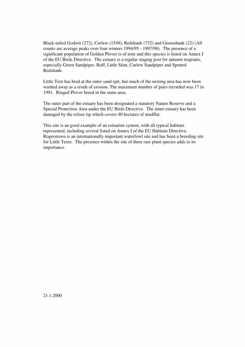
Black-tailed Godwit (272), Curlew (1549), Redshank (732) and Greenshank (22) (All counts are average peaks over four winters 1994/95 - 1997/98). The presence of a significant population of Golden Plover is of note and this species is listed on Annex I of the EU Birds Directive. The estuary is a regular staging post for autumn migrants, especially Green Sandpiper, Ruff, Little Stint, Curlew Sandpiper and Spotted Redshank.
Little Tern has bred at the outer sand spit, but much of the nesting area has now been washed away as a result of erosion. The maximum number of pairs recorded was 17 in 1991. Ringed Plover breed in the same area.
The outer part of the estuary has been designated a statutory Nature Reserve and a Special Protection Area under the EU Birds Directive. The inner estuary has been damaged by the refuse tip which covers 40 hectares of mudflat.
This site is an good example of an estuarine system, with all typical habitats represented, including several listed on Annex I of the EU Habitats Directive. Rogerstown is an internationally important waterfowl site and has been a breeding site for Little Terns. The presence within the site of three rare plant species adds to its importance.
21.1.2000
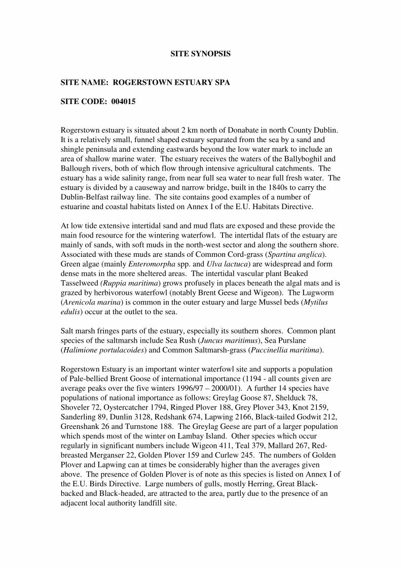
SITE SYNOPSIS
SITE NAME: ROGERSTOWN ESTUARY SPA
SITE CODE: 004015
Rogerstown estuary is situated about 2 km north of Donabate in north County Dublin. It is a relatively small, funnel shaped estuary separated from the sea by a sand and shingle peninsula and extending eastwards beyond the low water mark to include an area of shallow marine water. The estuary receives the waters of the Ballyboghil and Ballough rivers, both of which flow through intensive agricultural catchments. The estuary has a wide salinity range, from near full sea water to near full fresh water. The estuary is divided by a causeway and narrow bridge, built in the 1840s to carry the Dublin-Belfast railway line. The site contains good examples of a number of estuarine and coastal habitats listed on Annex I of the E.U. Habitats Directive.
At low tide extensive intertidal sand and mud flats are exposed and these provide the main food resource for the wintering waterfowl. The intertidal flats of the estuary are mainly of sands, with soft muds in the north-west sector and along the southern shore. Associated with these muds are stands of Common Cord-grass (Spartina anglica). Green algae (mainly Enteromorpha spp. and Ulva lactuca) are widespread and form dense mats in the more sheltered areas. The intertidal vascular plant Beaked Tasselweed (Ruppia maritima) grows profusely in places beneath the algal mats and is grazed by herbivorous waterfowl (notably Brent Geese and Wigeon). The Lugworm (Arenicola marina) is common in the outer estuary and large Mussel beds (Mytilus edulis) occur at the outlet to the sea.
Salt marsh fringes parts of the estuary, especially its southern shores. Common plant species of the saltmarsh include Sea Rush (Juncus maritimus), Sea Purslane (Halimione portulacoides) and Common Saltmarsh-grass (Puccinellia maritima).
Rogerstown Estuary is an important winter waterfowl site and supports a population of Pale-bellied Brent Goose of international importance (1194 - all counts given are average peaks over the five winters 1996/97 – 2000/01). A further 14 species have populations of national importance as follows: Greylag Goose 87, Shelduck 78, Shoveler 72, Oystercatcher 1794, Ringed Plover 188, Grey Plover 343, Knot 2159, Sanderling 89, Dunlin 3128, Redshank 674, Lapwing 2166, Black-tailed Godwit 212, Greenshank 26 and Turnstone 188. The Greylag Geese are part of a larger population which spends most of the winter on Lambay Island. Other species which occur regularly in significant numbers include Wigeon 411, Teal 379, Mallard 267, Red-breasted Merganser 22, Golden Plover 159 and Curlew 245. The numbers of Golden Plover and Lapwing can at times be considerably higher than the averages given above. The presence of Golden Plover is of note as this species is listed on Annex I of the E.U. Birds Directive. Large numbers of gulls, mostly Herring, Great Black-backed and Black-headed, are attracted to the area, partly due to the presence of an adjacent local authority landfill site.

Some of the wader species also occur on passage, notably Black-tailed Godwit with numbers often exceeding 300 in April. The estuary is a regular staging post for scarce migrants, especially in autumn when Green Sandpiper, Ruff, Little Stint, Curlew Sandpiper and Spotted Redshank may be seen. Shelduck breed within the site.
Rogerstown Estuary is an important link in the chain of estuaries on the east coast. It supports an internationally important population of Brent Goose and a further 14 species in numbers of national importance. Bird populations have been well- monitored since the 1980s and the site is counted at monthly intervals each winter (September to March) as part of the Irish Wetland Bird Survey (I-WeBS). The site is a statutory Nature Reserve and a candidate Special Area of Conservation under the E.U. Habitats Directive.
10.11.2003
APPENDIX 7
Draft Conservation Plan for Rogerstown Estuary
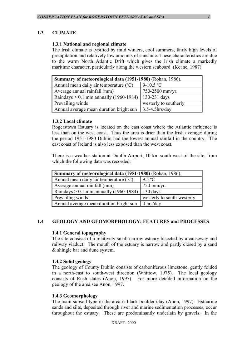
CONSERVATION PLAN for ROGERSTOWN ESTUARY cSAC and SPA 1
DRAFT- 2000
1.3 CLIMATE
1.3.1 National and regional climateThe Irish climate is typified by mild winters, cool summers, fairly high levels ofprecipitation and relatively low amounts of sunshine. These characteristics are dueto the warm North Atlantic Drift which gives the Irish climate a markedlymaritime character, particularly along the western seaboard (Keane, 1987).
Summary of meteorological data (1951-1980) (Rohan, 1986).Annual mean daily air temperature (ºC) 9-10.5 ºCAverage annual rainfall (mm) 750-2500 mm/yr.Raindays > 0.1 mm annually (1960-1984) 130-231 daysPrevailing winds westerly to southerlyAnnual average mean duration bright sun 3.5-4.5hrs/day
1.3.2 Local climateRogerstown Estuary is located on the east coast where the Atlantic influence isless than on the west coast. Thus the area is drier than the Irish average: duringthe period 1951-1980 Dublin had the lowest annual rainfall in the country. Theeast coast of Ireland is also less exposed than the west coast.
There is a weather station at Dublin Airport, 10 km south-west of the site, fromwhich the following data was recorded:
Summary of meteorological data (1951-1980) (Rohan, 1986).Annual mean daily air temperature (ºC) 9.5 ºCAverage annual rainfall (mm) 750 mm/yr.Raindays > 0.1 mm annually (1960-1984) 130 daysPrevailing winds westerly to south-westerlyAnnual average mean duration bright sun 4 hrs/day
1.4 GEOLOGY AND GEOMORPHOLOGY: FEATURES and PROCESSES
1.4.1 General topographyThe site consists of a relatively small narrow estuary bisected by a causeway andrailway viaduct. The mouth of the estuary is narrow and partly closed by a sand& shingle bar and dune system.
1.4.2 Solid geologyThe geology of County Dublin consists of carboniferous limestone, gently foldedin a north-east to south-west direction (Whittow, 1975). The local geologyconsists of Rush slates (Anon, 1997). For more detailed information on thegeology of the area see Anon, 1997.
1.4.3 GeomorphologyThe main subsoil type in the area is black boulder clay (Anon, 1997). Estuarinesands and silts, deposited through river and marine sedimentation processes, occurthroughout the estuary. These are predominantly underlain by gravels. In the
CONSERVATION PLAN for ROGERSTOWN ESTUARY cSAC and SPA 2
DRAFT- 2000
inner estuary fine muds predominate, while sands and gravels are more commonin the outer estuary.
1.4.3 Hydrology, hydrography and water qualityThere are a number of small rivers & streams entering the site e.g. the Ballough &Ballyboghill Rivers: the total catchment area for the estuary is 112 km² (Anon,1997). These watercourses drain a rich agricultural catchment. Water quality is not good. Ballough Stream is classified as moderately pollutedwhile Ballyboghil is classified as both moderately and seriously polluted (Luceyet. al., 1999). Leachate from the dump adjacent to the site is a serious cause ofpollution (see Section 1.10.3).
The railway causeway, which was built in the 1840s, restricts the flow betweenthe inner and outer parts of the estuary. Thus low tide occurs 3.5 hours later in theinner part of the estuary than the outer part, although high tide coincides in both(Fahy et al. 1975). A sandy peninsula protrudes across the outer part of the outerestuary, restricting the flow to a narrow channel of c. 200 m.
There is a wide range in salinity with a good gradient from full strength sea waterto near full fresh water.
1.5 SOILS AND SOIL PROCESSESMost of the site is marine and is therefore dominated by sand and mud flats.However, the process of soil development is occurring in the sand dunes: theembryo and white dunes are almost pure sand but the grey dunes feature a humuslayer which has formed a thin soil. Over time the grey dunes will graduallybecome decalcified.
1.6 HABITATS AND VEGETATIONThe main reason for the proposal of this site as an SAC is the presence of a rangeof coastal habitats listed in Annex I habitat of the EU Habitats Directive:
The figures listed below for percentage area are approximate, derived from theattached habitat map and field visit by the author. The location of the habitats isillustrated by Map 3. The area of the proposed seaward extension - to be includedin SPA only - is not considered in the overall area.
Throughout the management plan, habitats are named and described under twodifferent classification systems: the priority habitat (indicated by an asterisk*) isas listed in the E.U. Habitats Interpretation Manual, while all other habitats are aslisted in the Dúchas NHA classification system. In the table below the Annex Ihabitats of the Habitats Directive for which the site was selected are listed, withthe relevant NHA category also shown:
Annex I habitat Type Corresponding NHAcategory
Comments
* Fixed Grey Dunes Sand Dunes mapped separatelyEstuaries Tidal Rivers & Estuarine
ChannelsMudflats and Sandflats Mudflats and Sandflats
CONSERVATION PLAN for ROGERSTOWN ESTUARY cSAC and SPA 3
DRAFT- 2000
Salicornia Mud SaltmarshAtlantic Salt Meadows SaltmarshMediterranean SaltMeadows
Saltmarsh
Shifting Dunes ofAmmophila
Sand Dunes a mosaic of dune types mapped separately
Lowland Wet Grassland includes a mosaic of saltmarshmerging to wet grassland.
Lowland Dry GrasslandImproved Grassland mapped with arable landAmenity Grassland not mappedArable LandDeciduous WoodlandOpen Marine Water in SPA only - proposed extn.
1.6.1 Sand dunes (2%)Thin sand dunes strips occur to the north-east and south-east of the estuarymouth. Some natural dune erosion has occurred and the dune face is quite steepin places. It is estimated that erosion is occurring at around 60 cm per annum(Anon, 1992). However, there are also areas of accretion where embryo dunesare beginning to form up to 25m from the dune face.
*Fixed dunes (grey dunes) (<1%)Only a very small area of fixed dune occurs within the site, located behind thefrontal dune ridges. Typical species are present including Kidney Vetch(Anthyllis vulneraria), Bird’s-foot Trefoil (Lotus corniculatus), Wild Pansy(Viola tricolor subsp. curtsii), Restharrow (Ononis repens), Lady’s Bedstraw(Galium verum), Eyebright (Euphrasia agg.), Yellow Rattle (Rhinanthus minor)and Meadow Grass (Poa pratensis).
Marram dunes (white dunes) (1.5%)The white dunes, which form the next dune ridge behind the embryo dunes, aredominated by Marram Grass (Ammophila arenaria). Additional species presentinclude Red Fescue (Festuca rubra), Sea Spurge (Euphorbia paralias), WildCarrot (Daucus carota) and several species of yellow-flowered compositae e.g.Ragwort (Senecio jacobea) and Hawkbits (Leontodon spp.)
Embryonic shifting dunes (<1%)Behind the drift line there are low embryo dunes dominated by Sand Couch(Elymus farctus) with Lyme Grass (Leymus arenarius) also common in places.
Drift lines (<1%)The drift line is colonised by characteristic species including Prickly Saltwort(Salsola kali), Sea Rocket (Cakile maritima), Sea Beet (Beta maritima) andOraches (Atriplex spp.).
1.6.2 Mudflats and sandflats (64%)

CONSERVATION PLAN for ROGERSTOWN ESTUARY cSAC and SPA 4
DRAFT- 2000
The flats of the inner estuary generally consist of soft muds vegetated by a densegreen algal mat in summer. Green algal species present include Vaucheria, Ulvaand Enteromorpha (Goodwillie, 1997).
The intertidal flats of the outer estuary are generally sandy with abundantLugworm (Arenicola marina) casts. However, soft muds occur along thesouthern shore and in the north-western corner (near the viaduct). In these areasgreen algae are widespread and form dense mats in the more sheltered areas(McManus et al., 1992). Tasselweed (Ruppia maritima) commonly occurs inassociation with the algal mats (Madden, 1993).
Parts of the flats are gravelly to stony in nature, especially in the narrow part ofthe estuary between Burrow and Rogerstown pier. In addition to green algae,these areas support fucoids (e.g. Fucus spiralis, F. cerenoides, F. vesiculosus)and Ascophyllum nodosum.
Eelgrass (Zostera sp.) was once widespread on the intertidal flats but was lastrecorded from the site in 1951. Possible reasons for its extinction include thespread of Spartina, a reduction in the area of intertidal flats due to landfill andthe impacts of eutrophication (Madden, 1993).
Mussel (Mytilus edulis), Cockle (Cerastoderma edule) and Winkle (Littorinaspp.) beds occur in the outer estuary (Map 6).
The Biomar Project sampled a site at Rush Beach (O264537) (Survey 510, No.09). The site is described as a moderately exposed sandy beach. No talitrids(Sand Hoppers) were found on upper shore. The midshore consisted of mediumrippled sand with Lugworm. The low shore consists of firm rippled sand withoccasional Tubeworms (Lanice conchilega). A Sea Anemone, probably aSagartia spp. was living in the sand. The bivalve Donax species was present atlow water mark.
The mudflats support important populations of wintering wildfowl.
1.6.3 Saltmarshes (11%)
Salicornia mud (1%)Glasswort (Salicornia spp.) once covered extensive areas of the intertidal flats(see Map 5 in O’Reilly & Pantin, 1957). However, these areas have now largelybeen colonised by Spartina (see Figure 2 in McManus et al., 1992). Althoughthe area of Salicornia has been reduced, the species still occurs between theareas of established saltmarsh and bare estuarine mud.
Salicornia dolichostachya is the main species which occurs on the openmudflats, notably at the extreme south east and north west corners of the outerestuary but also in the inner estuary (west of the railway line). Doogue et al., inThe Flora of Co. Dublin (1998), note the presence of S. ramosissima and S.europaea on the muds at Raheen Point.
Spartina swards (3%)

CONSERVATION PLAN for ROGERSTOWN ESTUARY cSAC and SPA 5
DRAFT- 2000
Cordgrass (Spartina anglica) swards occur in both the inner estuary and outerestuary. Spartina was first recorded from the estuary in 1938 (Praeger, 1939),although in 1957 it was noted “that nowhere in the Estuary does Spartina occur”(O’Reilly & Pantin, 1957). However, by the 1970s it had become wellestablished (Fahy et al., 1975). In more recent years there appears to have beensome natural dieback (Madden cited in McManus et al., 1992).
Atlantic salt meadows (6%)The two main areas of Atlantic saltmeadow occur in (a) the outermost part of thesite (to the east of the Burrow peninsula) and (b) the inner estuary. Thesaltmarsh in the outer estuary is characterised by the presence of Sea-purslane(Halimione portulacoides), Saltmarsh-grass (Puccinellia maritima), Lax-flowered Sea-lavender (Limonium humile), Annual Sea-blite (Suaeda maritima),Sea Pink (Armeria maritima) and Sea Plantain (Plantago maritima) (O’Reilly &Pantin, 1957). The saltmarsh of the inner estuary features similar speciesalthough Sea-purslane (Halimione portulacoides) is less common.
Mediterranean salt meadows (1%)The upper part of the narrow band of saltmarsh fringing the southern shore ofthe outer estuary could be considered Mediterranean saltmarsh since thecharacteristic species Sea Rush (Juncus maritimus) is present. The upper marshcommunities in the inner estuary also feature Sea Rush (Juncus maritimus).
1.6.4 Tidal Rivers and Estuarine channels (13%)A broad channel runs through the middle of the estuary with a few smalltributaries present.
1.6.5 Wet Grassland (7%)Adjacent to the inner-most part of the estuary there are a number of fieldsfeaturing rough grassland. The fields range from wet to dry, but no attempt hasbeen made here to map the different areas. Grasses present include CreepingBent (Agrostis stolonifera), Common Couch (Elymus repens), Cock’s-foot(Dactylis glomerata), False Oat-grass (Arrhenatherum elatius), Yorkshire Fog(Holcus lanatus), Timothy Grass (Phleum pratense) and Tufted Hair-grass(Deschampsia cespitosa). Other species present include Silverweed (Potentillaanserina), docks (e.g. Rumex crispus), rushes (Juncus spp.) and MeadowButtercup (Ranunculus acris). Brackish hollows support species such as SeaClub-rush (Scirpus maritimus) and Saltmarsh Rush (Juncus gerardii). MeadowBarley (Hordeum secalinum) is found in this habitat.
1.6.6 Amenity grassland & parkland (<1%)In the outer estuary, to the west of Rogerstown Pier, a strip of shore has beeninfilled and grassed over. A few Sycamore (Acer pseudoplatanus) have beenplanted here. This area of mown grassland has been included in the site becauseit is used by Brent Geese.
1.6.7 Arable Land & Improved Grassland (2%)Some improved fields have been included in the site as they are used by roostingand feeding birds. Subsequent to the boundary of the SAC being drawn in 1994,one of these fields has been turned over to crop production.
1.6.8 Dry lowland grassland (<1%)
CONSERVATION PLAN for ROGERSTOWN ESTUARY cSAC and SPA 6
DRAFT- 2000
There are small areas of dry, rough grassland within the site. These featurecoarse grasses such as Cock’s-foot (Dactylis glomerata) and False Oatgrass(Arrhenatherum elatius), along with species such as Common Knapweed(Centaurea nigra) and thistles (Cirsium spp.). At the tip of the Burrow a gardenlawn of dry grassland has been included in the site because it supports severalOrchis morio (a Red Data Book species).
1.6.7 Woodland (<1%)There is a small strip of woodland along the tidal channel at the western-mostedge of the site. Species present include Ash (Fraxinus excelsior) and Willow(Salix spp.).
1.6.8 Open Marine Water (in SPA only)It is proposed to include a band of open marine water below the MLWM. Thisarea of shallow sea is important for roosting and feeding birds. There is littleother information on this habitat at present.
1.7 NOTABLE FLORA
Four Red Data Book species have been recorded from the site, three of whichare legally protected under the Flora Protection Order (1999):
Hairy Violet (Viola hirta) - grows in association with Orchis morio.Meadow Barley (Hordeum secalinum) - several large populations occur inbrackish fields adjacent to inner estuary.Rough Poppy (Papaver hybridum) - a poppy of sandy and gravelly places.
Green-winged Orchid (Orchis morio) is a Red Data Book species. More than200 flowering stems grow in the main location of this species. A further 37+grow in a second area. Smaller populations occur in several locations nearthe cSAC. This plant is no longer listed under the Flora Protection Order.
A number of relatively scarce plants also occur within the site. The first fourspecies listed below are native to Ireland, while the latter five are introductions:
Mignonette (Reseda lutea)Dune Fescue (Vulpia fasciculata)Bur Chervil (Anthriscus caucalis)Sea Wormwood (Artemisia maritima)Northern Dead-nettle (Lamium confertum)Prickly Poppy (Papaver argemone)Wall Mustard (Diplotaxis muralis)Flixweed (Descurania sophia)Small-flowered Crane’s-bill (Geranium pusillum)
Note: all plant records are from Doogue, 1993.
1.8 NOTABLE FAUNA
1.8.1 Invertebrates

CONSERVATION PLAN for ROGERSTOWN ESTUARY cSAC and SPA 7
DRAFT- 2000
The invertebrate fauna is typical of sheltered estuary and no rare or unusualspecies have been recorded (Anon, 1997).
1.8.2 BirdsThe main reason for the designation of the SPA, which covers one third of theSAC, is the presence of internationally important numbers of Pale-bellied BrentGeese (Branta bernicla hrota). The geese are present from October to April,with overall counts indicating that numbers are increasing in line with thenational trend. Feeding takes place in the inner and outer parts of the estuary:green algae growing on the intertidal flats dominates the diet until mid-winter,after which the geese switch to grazing grass in adjacent fields.
The only Annex I species which occurs within the site in nationally importantnumbers is Bar-tailed Godwit (Limosa lapponica), which feed in the sandy outerestuary. Other Annex I species occurring within the site are listed in Table 2.
The winter counts for all the regularly occurring migratory species which occurin nationally important numbers are shown in Table 1. In 1995/96 the totalnumbers of waterfowl supported by the estuary was greater than 20,000: if thisnumber is regularly exceeded the estuary would be considered of internationalimportance on this basis. Most of these species feed on the intertidal flats, butgenerally roost on the saltmarsh at the Burrow (Portrane) or on damp fields inthe inner estuary (Goodwillie, 1997).
As well as internationally important numbers of Brent Geese and nationallyimportant numbers of 16 other species, it is of particular note that the site holds8.3% of the national total of Knot, 6.3% of Shelduck, 6.1% of Grey Plover andover 4% of Greenshank and Greylag geese (the latter are only present for part ofthe winter).
The Annex I species Little Tern (Sterna albifrons) occasionally bred within thesite. In 1995, eight adults and one nesting pair were recorded (Hannon et al.,1997). However, the Irish East Coast Bird Reports from 1984-1995 onlyindicate the presence of pairs in three other years: 1993 (2 pairs), 1992 (1 pair)and 1985 (3 pairs). Since 1995, no known nesting has occurred and it isconsidered that beach erosion and loss of the shingle habitat at Portrane is thecause of this.
The site also has interest as a regular staging post for scarce passage migrants,including Ruff (Philomachus pugnax), which is an Annex I species, along withGreen Sandpiper (Tringa ochropus), Little Stint (Calidris minuta), CurlewSandpiper (Calidris ferruginea) and Spotted Redshank (Tringa erythropus). Afew Shelduck (Tadorna tadorna) and Mallard (Anas platyrhynchos) breedwithin the site (McManus et al., 1992).
High numbers of gulls are found in the estuary, mainly due to the Landfill Site.Numbers present between Oct. 1996 and March 1997 varied between 4000 and9000 (Goodwillie, 1997). The most abundant species are Black-headed Gull(Larus ridibundus), Herring Gull (Larus argentatus), Great Black-backed Gull(Larus marinus) and Common Gull (Larus canus).
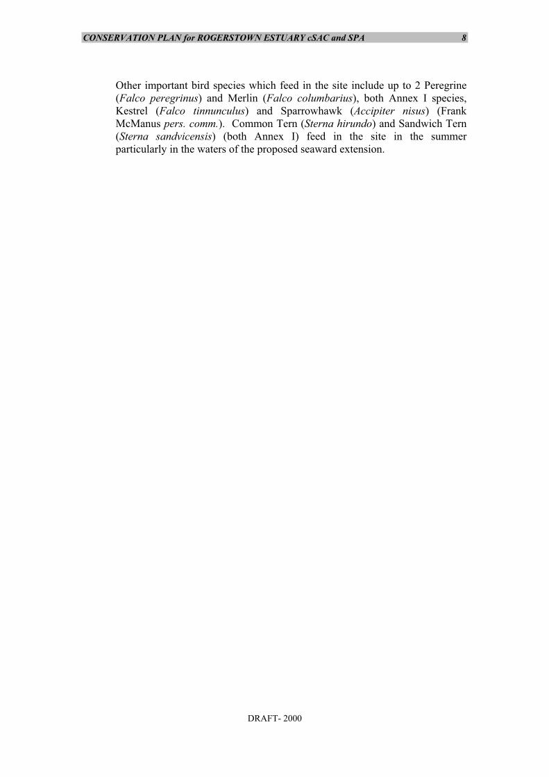
CONSERVATION PLAN for ROGERSTOWN ESTUARY cSAC and SPA 8
DRAFT- 2000
Other important bird species which feed in the site include up to 2 Peregrine(Falco peregrinus) and Merlin (Falco columbarius), both Annex I species,Kestrel (Falco tinnunculus) and Sparrowhawk (Accipiter nisus) (FrankMcManus pers. comm.). Common Tern (Sterna hirundo) and Sandwich Tern(Sterna sandvicensis) (both Annex I) feed in the site in the summerparticularly in the waters of the proposed seaward extension.
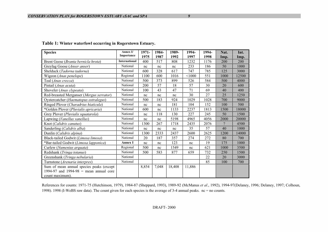
CONSERVATION PLAN for ROGERSTOWN ESTUARY cSAC and SPA 9
DRAFT- 2000
Table 1: Winter waterfowl occurring in Rogerstown Estuary.
Species Annex I/Importance
1971-1975
1984-1987
1989-1992
1994-1997
1994-1998
Nat.Imp.
Int.Imp.
Brent Geese (Branta bernicla hrota) International 400 517 808 1232 1176 200 200Greylag Goose (Anser anser) National nc nc nc 233 186 50 1000Shelduck (Tadorna tadorna) National 600 328 617 747 785 125 3000Wigeon (Anas penelope) Regional 1100 600 1016 <1000 551 1000 12500Teal (Anas crecca) National 500 373 899 526 584 500 4000Pintail (Anas acuta) National 200 57 18 57 30 20 600Shoveler (Anas clypeata) National 100 43 47 71 69 40 400Red-breasted Merganser (Mergus serrator) National nc nc nc 30 27 25 1250Oystercatcher (Haematopus ostralegus) National 500 183 924 1029 1028 700 9000Ringed Plover (Charadrius hiaticula) National nc nc 181 104 152 100 500*Golden Plover (Pluvialis apricaria) National 600 nc 1133 2237 1813 1500 18000Grey Plover (Pluvialis squatarola) National nc 118 130 227 245 50 1500Lapwing (Vanellus vanellus) National nc nc 5198 4965 4056 2000 20000Knot (Calidris canutus) National 1300 267 1718 2435 2076 ? 4500Sanderling (Calidris alba) National nc nc nc 35 57 40 1000Dunlin (Calidris alpina) National 1300 2333 2437 2600 2625 1200 14000Black-tailed Godwit (Limosa limosa) National 20 187 357 274 272 80 700*Bar-tailed Godwit (Limosa lapponica) Annex I nc nc 123 nc 19 175 1000Curlew (Numenius arquata) Regional 500 nc 1549 nc 621 1000 3500Redshank (Tringa totanus) National 500 583 877 659 732 250 1500Greenshank (Tringa nebularia) National 22 20 3000Turnstone (Arenaria interpres) National 85 100 700Sum of mean annual species peaks (except1994-97 and 1994-98 = mean annual corecount maximum).
8,854 7,048 18,408 11,886
References for counts: 1971-75 (Hutchinson, 1979), 1984-87 (Sheppard, 1993), 1989-92 (McManus et al., 1992), 1994-97(Delaney, 1996; Delaney, 1997; Colhoun,1998). 1998 (I-WeBS raw data). The count given for each species is the average of 3-4 annual peaks. nc = no counts.
CONSERVATION PLAN for ROGERSTOWN ESTUARY cSAC and SPA 10
DRAFT- 2000
Table 2: Species listed in Annex I of the EU Birds Directive recorded fromRogerstown Estuary.
Species NotesBar-tailed Godwit (Limosa lapponica) Regionally important numbers (winter)Golden Plover (Pluvialis apricaria) Nationally important numbers (winter)Peregrine Falcon (Falco peregrinus) Single birds regularly recordedMerlin (Falco columbarius) Single birds regularly recordedHen Harrier (Circus cyaneus) Single birds occasionally recordedRuff (Philomachus pugnax) Scarce passage migrant (autumn)Common Tern (Sterna hirundo) Feeding in summerSandwich Tern (Sterna sandvicensis) Feeding in summerLittle Tern (Sterna albifrons) 2 pairs bred in 1993.Short-eared Owl (Asio flammeus) Annual winter visitor. 2-3 may winter.Kingfisher (Alcedo atthis) Single birds occasionally recorded
References: McManus et al., 1992 (waders, raptors & kingfisher) and Irish East Coast BirdReports (terns).
The bird usage of the site has been documented by McManus et al., 1992.Diagrams illustrating their findings accompany this conservation plan (see Map5).
1.8.3 FishFish found within the estuary include Sea Trout (Salmo trutta), Plaice(Pleuronectes platessa) and Flounder (Platichthys flesus). Brown Trout (Salmotrutta) are found upstream of the rivers which flow into the west of the site(Martin Kelly, Eastern Fisheries Board pers. comm.).
1.9 CURRENT HUMAN USE: WITHIN THE SITE
Descriptions of the main activities occurring within the site are given below. Theaccompanying landuse map (Map 6) gives an indication of where these activitiesoccur.
1.9.1 Nature Conservation33% of the SAC is a statutory Nature Reserve. Present management of this areais limited to patrolling by the conservation ranger (one visit per month onaverage) assisted by the four caretakers who report any damaging activities noted.However, information boards have been designed which are to be erected at twoof the main access points (Raheen and Rogerstown pier). Furthermore, a systemof licensing the bait digging/shellfish picking activities has been suggested. Ashort management plan was drawn up for the statutory Nature Reserve coveringthe five year period 1994-1998 (Warner et al., 1993)
Around 4% of the SAC is a BirdWatch Ireland reserve managed by a ReserveManagement Team. Part of this area is owned by BirdWatch Ireland and part ismanaged through management agreements. The reserve is wardened byBirdWatch Ireland members who also carry out a number of practical tasks suchas controlling water levels through a system of pipes and maintenance of gates,fences & stiles.
CONSERVATION PLAN for ROGERSTOWN ESTUARY cSAC and SPA 11
DRAFT- 2000
Fingal County Council, in association with the Fingal Branch of BirdWatchIreland, have provided a hide on the shore opposite the reserve. BirdWatchIreland use the hide as a focal point for public bird watching days. A second hidestands adjacent to the BirdWatch Ireland reserve.
1.9.2 Recreation & tourismBathing - in summer, the beaches south of Rush and north of Portrane arepopular bathing beaches.Walking - walkers use the two beaches all year round. Dogs are often present.The local authority have proposed a coastal walk along the southern shore ofthe estuary from Raheen (near the railway) eastward (see County DevelopmentPlan). This is, at present, the most undisturbed area for birds and largenumbers roost here (see bird usage). Horse Riding - this is a regularly occurring pastime. It has exacerbated theproblem of erosion at Portrane. Water-sports - a pier and slipways run into the site at the mouth of the estuary.Rush Sailing Club operates out of this area. Jet skiing and use of speed boatstakes place. New bye laws govern the activities of jet-skiing speed boating inthen inner and outer estuaries. Most watersports activities are confined to thenarrow channel by the slip and open water seaward of there. The present yachtclub slip is being upgraded.Caravans - there are several mobile homes and holiday chalets within thedunes.
1.9.3 Bait digging & shellfish pickingBait digging and collection of shellfish - including winkles (Littorina spp.) andcockles (Cerastoderma edule) - occur within the outer estuary (McManus et al.,1992; Warner et al., 1993).
According to the Conservation Ranger this activity is carried out on a commercialbasis. This activity is at present unlicensed.
1.9.4 TransportThe Dublin-Belfast railway line bisects the site via a causeway and narrowbridge.The Lambay Island Ferry operates from Rogerstown Quay
1.9.5 AgricultureSome sheep/cattle grazing occurs on the fields on the northern shore of the innerestuary, while horses graze a dune grassland field at the tip of the Burrow.Stocking rates are not known. One field on the northern shore of the inner estuaryis under crop production.
1.9.6 DumpingDumping of organic matter (a large number of tree stumps, grass cuttings, etc.)occurs in a field on the southern shore of the inner estuary. Other rubbish, e.g. oldmachinery, has also been dumped. Other locations where dumping occurs includeRaheen Point, on the shore near the Ballealy tip and around Rogerstown Quay.
1.10 CURRENT HUMAN USE: ADJACENT TO THE SITE
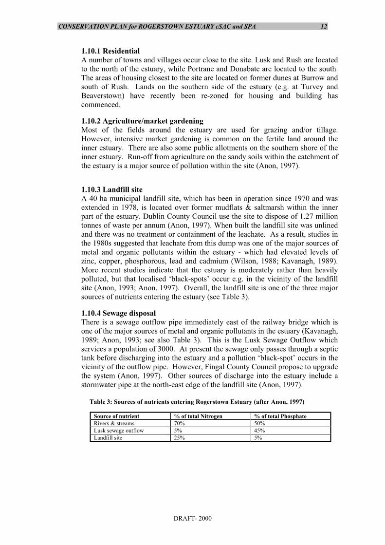
CONSERVATION PLAN for ROGERSTOWN ESTUARY cSAC and SPA 12
DRAFT- 2000
1.10.1 ResidentialA number of towns and villages occur close to the site. Lusk and Rush are locatedto the north of the estuary, while Portrane and Donabate are located to the south.The areas of housing closest to the site are located on former dunes at Burrow andsouth of Rush. Lands on the southern side of the estuary (e.g. at Turvey andBeaverstown) have recently been re-zoned for housing and building hascommenced.
1.10.2 Agriculture/market gardening Most of the fields around the estuary are used for grazing and/or tillage.However, intensive market gardening is common on the fertile land around theinner estuary. There are also some public allotments on the southern shore of theinner estuary. Run-off from agriculture on the sandy soils within the catchment ofthe estuary is a major source of pollution within the site (Anon, 1997).
1.10.3 Landfill siteA 40 ha municipal landfill site, which has been in operation since 1970 and wasextended in 1978, is located over former mudflats & saltmarsh within the innerpart of the estuary. Dublin County Council use the site to dispose of 1.27 milliontonnes of waste per annum (Anon, 1997). When built the landfill site was unlinedand there was no treatment or containment of the leachate. As a result, studies inthe 1980s suggested that leachate from this dump was one of the major sources ofmetal and organic pollutants within the estuary - which had elevated levels ofzinc, copper, phosphorous, lead and cadmium (Wilson, 1988; Kavanagh, 1989).More recent studies indicate that the estuary is moderately rather than heavilypolluted, but that localised ‘black-spots’ occur e.g. in the vicinity of the landfillsite (Anon, 1993; Anon, 1997). Overall, the landfill site is one of the three majorsources of nutrients entering the estuary (see Table 3).
1.10.4 Sewage disposal There is a sewage outflow pipe immediately east of the railway bridge which isone of the major sources of metal and organic pollutants in the estuary (Kavanagh,1989; Anon, 1993; see also Table 3). This is the Lusk Sewage Outflow whichservices a population of 3000. At present the sewage only passes through a septictank before discharging into the estuary and a pollution ‘black-spot’ occurs in thevicinity of the outflow pipe. However, Fingal County Council propose to upgradethe system (Anon, 1997). Other sources of discharge into the estuary include astormwater pipe at the north-east edge of the landfill site (Anon, 1997).
Table 3: Sources of nutrients entering Rogerstown Estuary (after Anon, 1997)
Source of nutrient % of total Nitrogen % of total PhosphateRivers & streams 70% 50%Lusk sewage outflow 5% 45%Landfill site 25% 5%

CONSERVATION PLAN for ROGERSTOWN ESTUARY cSAC and SPA 13
DRAFT- 2000
1.10.5 Recreation & tourismGolf: There is a 9 hole golf course (Rush Golf Club) located on the sand dunesalong the north-eastern shore of the site. Two other golf courses are located onthe south shore of the inner estuary (Beaverstown Golf Club and Turvey HouseGolf Club).Holiday homes: there are many mobile homes and other holiday dwellingswithin the former dunes on the Burrow.Watersports: Rush sailing Club, with associated slipway and buildings, islocated at the narrow mouth of the estuary (on the northern shore).
1.10.6 ForestryThere are some small forestry plantations (both deciduous and coniferous) to thesouth of the inner estuary. These have been planted by Fingal County Council.
1.10.7 FishingDraught net fishing for Sea Trout is carried out under licence in the deeper watersoutside the site (Martin Kelly, Eastern Fisheries Board, pers. comm.).
1.11 PAST HUMAN USEDuring the 1980s Mussel seed was taken from the site on a commercial scale,but this has now ceased. The saltmarsh and fields within the BirdWatch Ireland reserve were grazed inthe past.
1.12 LANDSCAPE AND AESTHETIC QUALITIESThe outer part of the estuary has high scenic value: it features long sandy beaches andthere are excellent views out over Lambay Island. The inner estuary still has some scenicvalue despite the presence of the landfill site - the sides of the landfill have beenlandscaped and grassed over.
CONSERVATION PLAN for ROGERSTOWN ESTUARY cSAC and SPA 14
DRAFT- 2000
1.13 ADDITIONAL DESCRIPTIVE MATERIAL
1.13.1 References
Anon (1992) Coastal Management - A Case for Action. National Coastal ErosionCommittee, a report by EOLAS on behalf of the County and CityEngineers Association.
Anon (1996) Environmentally Friendly Coastal Protection - ECOPRO - Code ofPractise. Government Publications Sales Office, Dublin.
Anon (1997) Environmental Impact Statement for Ballealy Landfill & Rush/LuskWastewater Treatment Plant. M C O’Sullivan/Fingal County Council.
Anon (1998) Fingal County Council Draft Development Plan. Bowman, J.J., Clabby, K.J., Lucey, J., McGarrigle, M.L. and Toner, P.H. (1996).
Water Quality in Ireland 1991-1994. Environmental Protection Agency.Wexford.
Colhoun, K. (1998) I-WeBS Report 1996-97. IWC BirdWatch Ireland, Dublin.Curtis, T.G.F. & McGough, H.N. (1988). The Irish Red Data Book 1: Vascular
Plants. Wildlife Service, Ireland.Curtis, T.G.F. & Sheehy Skeffington, M.J. (1998). The salt marshes of Ireland:
an inventory and account of their geographical variation. Biology and theEnvironment. Proceedings of the Royal Irish Academy 98B: 87-104.
Curtis, T.G.F. (1991a) A site inventory of the sandy coasts of Ireland. InQuigley, M.B. (ed.) A Guide to the Sand Dunes of Ireland. E.U.C.C.Dublin.
Curtis, T.G.F. (1991b) The flora and vegetation of sand dunes in Ireland. InQuigley, M.B. (ed.) A Guide to the Sand Dunes of Ireland. E.U.C.C.Dublin.
Delaney, S. (1996) I-WeBS Report 1994-95. IWC BirdWatch Ireland, Dublin.Delaney, S. (1997) I-WeBS Report 1995-96. IWC BirdWatch Ireland, Dublin.Doogue, D.A. (1993) Rare Plant Survey of Co. Dublin, 1991-1993. Report to
NPWS, Dublin.Doogue, D., Nash, D., Parnell, J., Reynolds, S. & Wyse Jackson, P. (1998) Flora
of County Dublin. Dublin Naturalists Field Club, Dublin.Fahy, E., Goodwillie, R., Rochford, J. & Kelly, D. (1975) Eutrophication of a
partially enclosed estuarine mudflat. Marine Pollution Bulletin 6:29-31.Fingal County Council (1999). Fingal County Council Development Plan 1999.
Planning Section. Fingal County Council. Goodwillie, R. & Associates (1997) Development of Ballealy Landfill: Report on
Flora and Fauna for EIS. Report prepared for M C O’Sullivan, Sept.1997.
Hannon, C., Berrow, S.D. & Newton, S.F. (1997) The status and distribution ofbreeding Sandwich Sterna sandvicensis, Roseate S. dougalli, Common S.hirundo, Arctic S. Paradisaea and Little Terns S. albifrons in Ireland in1995. Irish Birds 6:2-22.
Hutchinson, C.D. (Ed.) (1975) The Birds of Dublin and Wicklow. Dublin.Hutchinson, C.D. (1979) Ireland’s Wetlands and their Birds. Irish Wildbird
Conservancy, Dublin.
CONSERVATION PLAN for ROGERSTOWN ESTUARY cSAC and SPA 15
DRAFT- 2000
Kavanagh, P. (1989) Assessment of Copper, Lead and Zinc Levels in RogerstownEstuary. B.A. (Mod.) thesis, Trinity College, Dublin.
Keane, T. (1987) The Climate of Ireland. In: Mitchell, F.(ed.) The Book of theIrish Countryside. The Blackstaff Press, Belfast.
Kirk McClure Morton (1993) Environmental Survey of the Rogerstown Estuary.Report prepared by for Dublin County Council.
Kirk McClure Morton/MarEnCo (1993) Mathematical Modelling Study andEnvironmental Survey of Rogerstown Estuary, County Dublin. A reportfor Dublin County Council.
Lucey, J., Bowman, J.J., Clabby, K.J., Cunningham, P., Lehane, M.,MacCarthaigh, M., McGarrigle, M.L., and Toner, P.F. (1999). WaterQuality in Ireland 1995-1997. Environmental Protection Agency.Wexford.
Madden, B., Jennings, E. & Jeffrey, D.W. (1993) Distribution and ecology ofZostera in Co. Dublin. Ir. Nat. J. 24(8):303-310.
Merne, O.J. (1989). Important bird areas in the Republic of Ireland. In:Grimmett, R.F.A. and Jones, T.A. (Des) Important Bird Areas in Europe.ICBP Technical Publication No. 9. Cambridge.
McManus, F., McNally, J. & Cooney, T. (1992) The Wildfowl and Waders ofRogerstown Estuary. East Coast Bird Report 1991. pp 54-72
Nairn, R.G.W. (1986) Spartina anglica in Ireland and its potential impact onwildfowl and waders - a review. Irish Birds 3(2):215-228.
O Briain, M. (1977) Vegetation Survey of Rogerstown Estuary, Autumn 1976.Unpublished report for Aer Lingus Young Scientists Exhibition.
O’Reilly, H. & Pantin, G. (1957) Some observations on the saltmarsh formationin County Dublin. Proceedings of the Royal Irish Academy, 58B:89.
Praeger, R.L. (1937) A further contribution to the flora of Ireland. Proceedings ofthe Royal Irish Academy. 45B:231-254
Rohan, P.K. (1986) The Climate of Ireland. Meteorological Service, Dublin.Sheehy Skeffington, M.J. & Wymer, E.D. (1991) Irish Salt Marshes - An Outline
Review. In: Quigley, M.B. (Ed.) (1991) A Guide to the Sand Dunes ofIreland. 3rd Congress of the European Union for Dune Conservation andCoastal Management, Galway, Ireland.
Sheppard, R. (1993) Ireland’s Wetland Wealth. Irish Wildbird Conservancy,Dublin.
Warner, P., Patton, L. & Keleman, J. (1993) Short Management Plan forRogerstown Estuary National Nature Reserve. Unpublished report,National Parks & Wildlife Service.
Webb, D.A., Parnell, J. & Doogue, D. (1996). An Irish Flora. Dundalgan Press,Dundalk.
Whilde, A. (1985) The All Ireland Tern Survey 1984. RSPB/IWC.Whilde, A. (1993) The Irish Red Data Book 2: Vertebrates. Department of the
Environment, Northern Ireland.Wilson, J.G. (1988) The Biology of Estuarine Management. Croom Helm,
London.Whittow, J.B. (1975) Geology and Scenery in Ireland. Pelican Books,
Harmondsworth.
CONSERVATION PLAN for ROGERSTOWN ESTUARY cSAC and SPA 16
DRAFT- 2000
Bibliography:Quigley, M.B. (Ed.) (1991) A Guide to the Sand Dunes of Ireland. 3rd Congress
of the European Union for Dune Conservation and Coastal Management,Galway, Ireland.
Wyse Jackson, M.B. (in press) An annotated bibliography of works containingrecords of the vascular plant and stonewort floras of County Dublin,1904-1996. Available from the author at Dúchas, Dublin.
Irish East Coast Bird Reports, 1984 -1995. Available in BirdWatch Irelandlibrary, Dublin.
1.13.2 Databases:Natura 2000 Database, Site Code: 800000208, Dúchas, Dublin.NHA Database, Site Code: 208, Dúchas, Dublin.Corine Database, Site Code: 800000152, Dúchas, Dublin.Protected/Threatened Plant Database, Dúchas, Dublin.I-WeBS Database, BirdWatch Ireland, Monkstown.
1.13.3 Aerial photographsOS Aerial photo No. 7404, Flight Line 35. Date: June 1995.

APPENDIX 8
Draft Conservation Objectives for Rogerstown Estuary
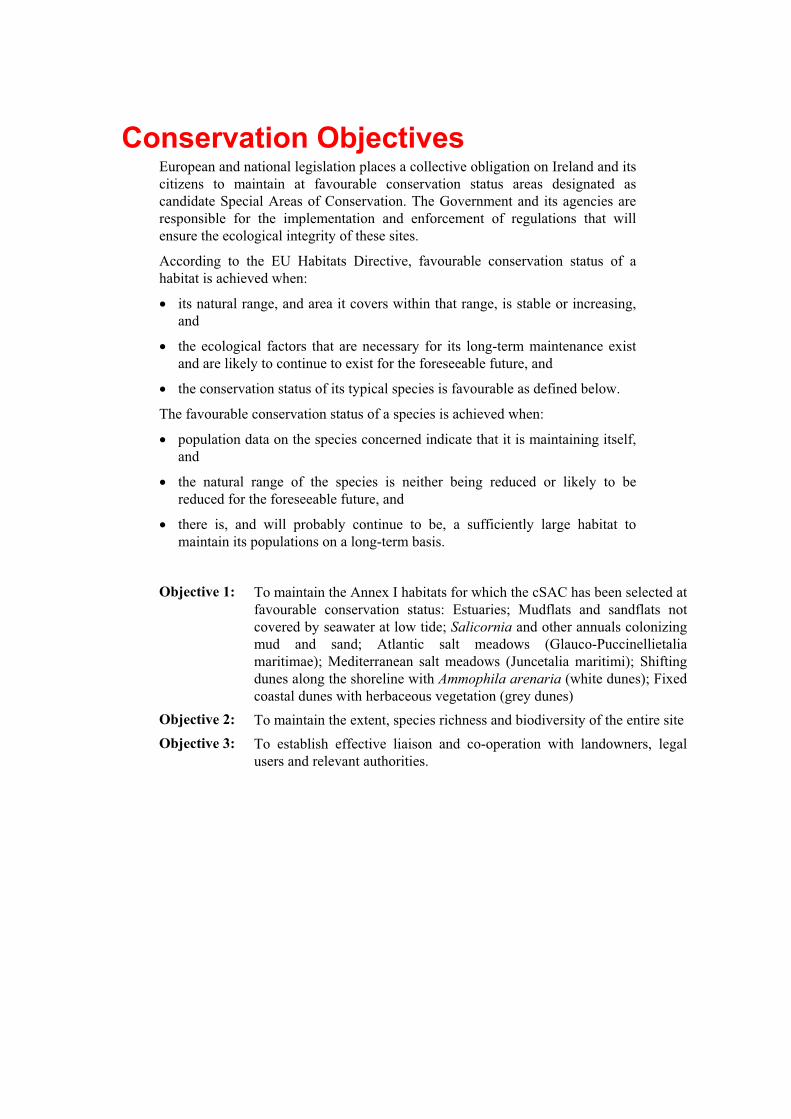
Conservation ObjectivesEuropean and national legislation places a collective obligation on Ireland and itscitizens to maintain at favourable conservation status areas designated ascandidate Special Areas of Conservation. The Government and its agencies areresponsible for the implementation and enforcement of regulations that willensure the ecological integrity of these sites.
According to the EU Habitats Directive, favourable conservation status of ahabitat is achieved when:
its natural range, and area it covers within that range, is stable or increasing,and
the ecological factors that are necessary for its long-term maintenance existand are likely to continue to exist for the foreseeable future, and
the conservation status of its typical species is favourable as defined below.
The favourable conservation status of a species is achieved when:
population data on the species concerned indicate that it is maintaining itself,and
the natural range of the species is neither being reduced or likely to bereduced for the foreseeable future, and
there is, and will probably continue to be, a sufficiently large habitat tomaintain its populations on a long-term basis.
Objective 1: To maintain the Annex I habitats for which the cSAC has been selected atfavourable conservation status: Estuaries; Mudflats and sandflats notcovered by seawater at low tide; Salicornia and other annuals colonizingmud and sand; Atlantic salt meadows (Glauco-Puccinellietaliamaritimae); Mediterranean salt meadows (Juncetalia maritimi); Shiftingdunes along the shoreline with Ammophila arenaria (white dunes); Fixedcoastal dunes with herbaceous vegetation (grey dunes)
Objective 2: To maintain the extent, species richness and biodiversity of the entire siteObjective 3: To establish effective liaison and co-operation with landowners, legal
users and relevant authorities.