april 16, 2015 federal highway administration 1200 new ...sp.route.transportation.org/documents/05...
TRANSCRIPT

April 16, 2015 Mr. Greg Nadeau Deputy Administrator Federal Highway Administration 1200 New Jersey Ave., SE Washington, DC 20590 Dear Mr. Nadeau: AASHTO is in receipt of the following member department interstate applications
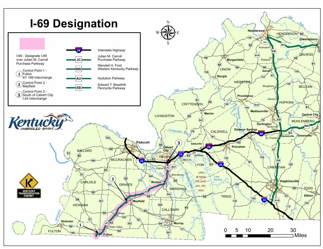
Member DOT Request Kentucky Interstate 69 – Establish along Pennyrile Parkway
Kentucky Interstate 69 – Establish at Purchase Parkway
Mississippi Interstate 22 – Establish
North Carolina Interstate 485 – Extension
Texas Interstate 169 - Establish
The member departments submitted the above applications to AASHTO for official approval and we have enclosed them for your consideration and approval. The AASHTO Special Committee on U.S. Route Numbering is presently reviewing and voting on these applications. Please let us know your decision as soon as your time permits. AASHTO will make a final decision at the Standing Committee on Highways meeting on May 14, 2015 in Cheyenne, Wyoming. Thank you for your time and attention to these Interstate Route applications. Please contact Marty Vitale at [email protected], if more information is necessary. Thank you.
Sincerely,
Bud Wright Executive Director
Enclosures Cc: Kevin Adderly – HEPI-20 Special Committee on USRN


OP80
0168
0160
0168
0160
0160
0151
0160
0160
0151
01641
01641
01641
!"#24
!"#24!"#24
OP80
0168
0162
0162
0162
0145
0141A
")EB
0141
0141A
0141A
OP70
OP70
")AU
OP56OP56
OP56
OP91
OP91
OP91
ST139
ST121
ST121OP94
OP94OP94
ST307
OP80
0151
")EB
")EB
§̈¦69
§̈¦69
")JC
")JC
!"#24
Marion
Providence
ST109
ST358
ST166
OP58
OP58ST339
ST303ST121
ST299
0168")JC
ST131ST348
OP970145
0162
01641ST286
")WK
0168
ST109
ST109
0141
ST189
ST164
ST115
ST139
ST104
ST181
ST138
OP56
ST136
ST132
0160
ST1360160
OP81
OP81
0141
LANDBETWEENTHE LAKESNATL. REC.
AREA
OP93
0162
ST120
Green
River
River
Ohio
RiverOhio
RiverTradewater
Riverberland
0160
RiverTennessee
CumOhio
River
River
Clarks
River
Miss
issipp
i
Water Valley
Wingo
Briensburg
Palma
Lake CityKuttawa
Eddyville
Gilbertsville
Sebree
NortonvilleSt. Charles
Morton'sGap
Hanson
Slaughters
Robards
Anthoston
Zion
LakeBarkley
Kentucky Lake
DAVIESS
UNION
HOPKINSCRITTENDEN
BALLARD
MCCRACKENLYON
TRIGG
CARLISLE GRAVES
HENDERSON
MCLEANWEBSTER
LIVINGSTONMUHLENBERG
CALDWELL
CHRISTIAN
MARSHALL TODD
HICKMANCALLOWAY
FULTON
Princeton
Dawson Springs
Madisonville
Earlington
CalvertCity
Benton
Paducah
Mayfield
Murray
Fulton
Hickman
Hopkinsville
Elkton
Greenville
Central City
Owensboro
Henderson
Morganfield
Sturgis
0 10 20 305Miles
I-69 Designationµ
¬«1
¬«2
¬«3
§̈¦24
")JC
")WK
")AU
")EB
Interstate HighwayJulian M. CarrollPurchase ParkwayWendell H. FordWestern Kentucky Parkway
Audubon ParkwayEdward T. BreathittPennyrile Parkway
I-69 - Designate I-69 over Julian M. CarrollPurchase Parkway
¬«1Control Point 1 - FultonKY 166 Interchange
¬«3Control Point 3 - South of Calvert CityI-24 interchange
¬«2 Control Point 2 - Mayfield
UV425


OP80
0168
0160
0168
0160
0160
0151
0160
0160
0151
01641
01641
01641
!"#24
!"#24!"#24
OP80
0168
0162
0162
0162
0145
0141A
")EB
0141
0141A
0141A
OP70
OP70
")AU
OP56OP56
OP56
OP91
OP91
OP91
ST139
ST121
ST121OP94
OP94OP94
ST307
OP80
0151
")EB
")EB
§̈¦69
§̈¦69
")JC
")JC
!"#24
Marion
Providence
ST109
ST358
ST166
OP58
OP58ST339
ST303ST121
ST299
0168")JC
ST131ST348
OP970145
0162
01641ST286
")WK
0168
ST109
ST109
0141
ST189
ST164
ST425
ST139
ST104
ST181
ST138
OP56
ST136
ST132
0160
ST1360160
OP81
OP81
0141
LANDBETWEENTHE LAKESNATL. REC.
AREA
OP93
0162
ST120
Green
River
River
Ohio
RiverOhio
RiverTradewater
Riverberland
0160
RiverTennessee
CumOhio
River
River
Clarks
River
Miss
issipp
i
Water Valley
Wingo
Briensburg
Palma
Lake CityKuttawa
Eddyville
Gilbertsville
Sebree
NortonvilleSt. Charles
Morton'sGap
Hanson
Slaughters
Robards
Anthoston
Zion
LakeBarkley
Kentucky Lake
DAVIESS
UNION
HOPKINSCRITTENDEN
BALLARD
MCCRACKENLYON
TRIGG
CARLISLEGRAVES
HENDERSON
MCLEANWEBSTER
LIVINGSTONMUHLENBERG
CALDWELL
CHRISTIAN
MARSHALL TODD
HICKMANCALLOWAY
FULTON
Princeton
Dawson Springs
Madisonville
Earlington
CalvertCity
Benton
Paducah
Mayfield
Murray
Fulton
Hickman
Hopkinsville
Elkton
Greenville
Central City
Owensboro
Henderson
Morganfield
Sturgis
0 10 20 305Miles
I-69 Designationµ
¬«1
¬«2
¬«3
§̈¦24
")JC
")WK
")AU
")EB
Interstate HighwayJulian M. CarrollPurchase ParkwayWendell H. FordWestern Kentucky Parkway
Audubon ParkwayEdward T. BreathittPennyrile Parkway
I-69 - Designate I-69 over section of Edward T.Breathitt Pennyrile Parkway
¬«1Control Point 1 - Nortonville WK Pkwy Interchange
¬«3Control Point 3 - South of HendersonKY 425 interchange
¬«2 Control Point 2 - Madisonville


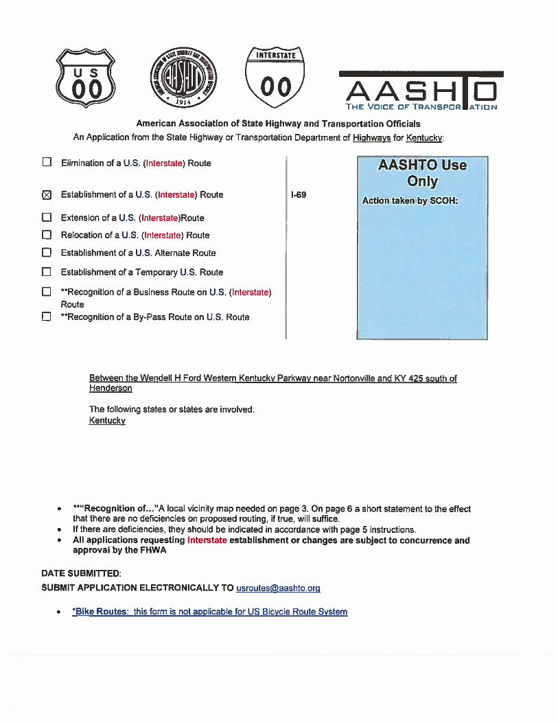
American Association of State Highway and Transportation Officials An Application from the State Highway or Transportation Department of Mississippi for:
Elimination of a U.S. (Interstate) Route AASHTO Use
Only Establishment of a U.S. (Interstate) Route I-22 Action taken by SCOH: Extension of a U.S. (Interstate)Route Relocation of a U.S. (Interstate) Route Establishment of a U.S. Alternate Route
Establishment of a Temporary U.S. Route
**Recognition of a Business Route on U.S. (Interstate) Route
**Recognition of a By-Pass Route on U.S. Route
Between Future I-269 and Alabama State Line
The following states or states are involved:
Mississippi
**“Recognition of…”A local vicinity map needed on page 3. On page 6 a short statement to the effect that there are no deficiencies on proposed routing, if true, will suffice.
If there are deficiencies, they should be indicated in accordance with page 5 instructions. All applications requesting Interstate establishment or changes are subject to concurrence and
approval by the FHWA
DATE SUBMITTED: March 30, 2015 SUBMIT APPLICATION ELECTRONICALLY TO [email protected]
*Bike Routes: this form is not applicable for US Bicycle Route System

2
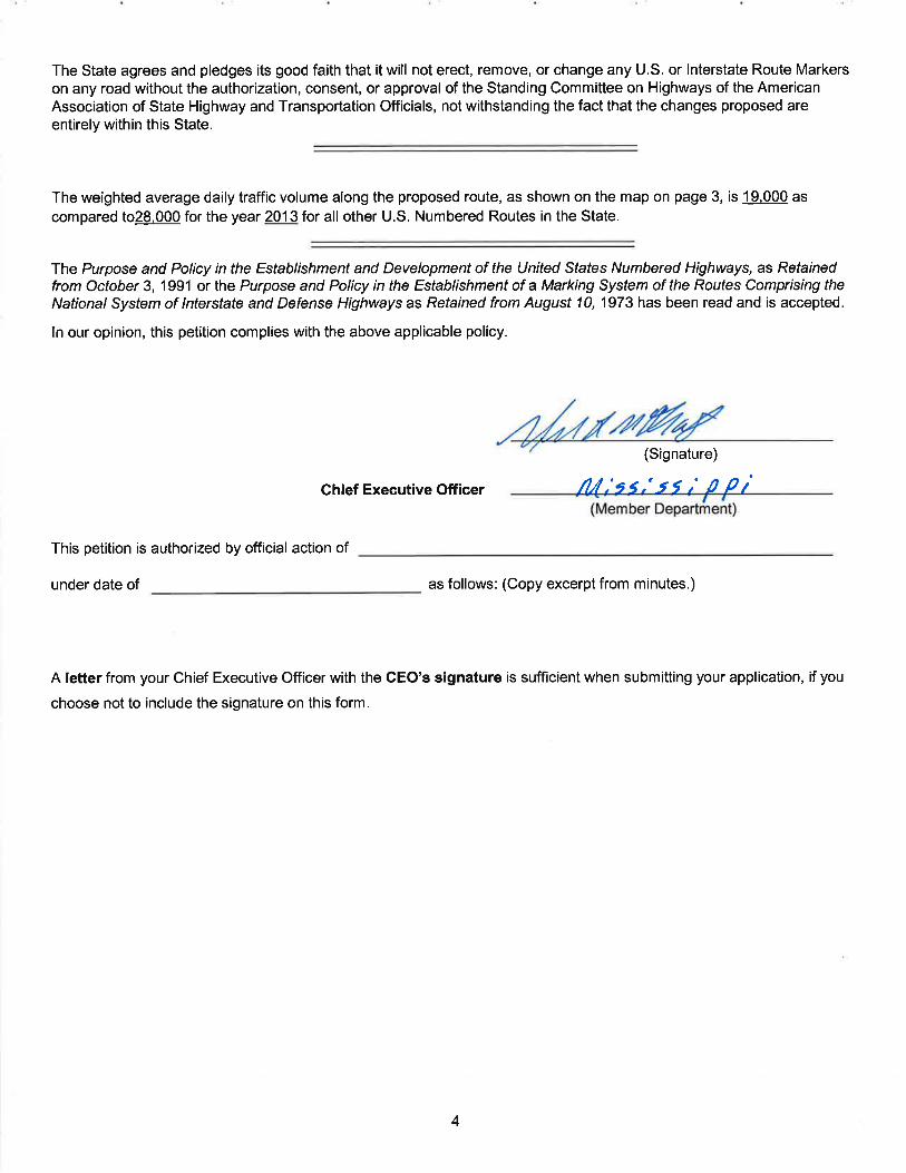
The purpose of the United States (U.S.) Numbered Highway System is to facilitate travel on the main interstate highways, over the shortest routes and the best available roads. A route should form continuity of available facilities through two or more states that accommodate the most important and heaviest motor traffic flow in the area.
The routes comprising the National System of Interstate and Defense Highways will be marked with its own distinctive route marker shield and will have a numbering system that is separate and apart from the U.S. Numbered Highway System. For the convenience of the motorist, there must be continuity and a uniform pattern of marking and numbering these Interstate routes without regard to state lines.
The U.S. Numbered System was established in 1926 and the Interstate Numbered System was established in 1956. Both have reached the period of review, revision, and consolidation. They now need perfecting rather than expansion. Therefore, any proposed alteration in the established systems should be extremely meritorious and thoroughly, though concisely, explained in order that the Special Committee on U.S. Route Numbering and the Standing Committee on Highways of the Association may give prompt and proper consideration to each and every request made by a member department.
Explanation and Reasons for the Request: (Keep concise and pertinent.)
MDOT requests approval to sign US 78 from future I-269 to the Alabama state Line as I-22. This 106.7 mile
section of roadway meets all interstate standards and will connect to I-22 in Alabama.
Date facility available to traffic Currently available to traffic. Does the petition propose a new routing over a portion of an existing U.S. Route? yes If so, where? The new routing of US 78, proposed Interstate I-22, will begin at future Interstate I-269 in Desoto County, Mississippi southeasterly for 106.7 miles to the end of the route at the Alabama State Line. Does the petition propose a new routing over a portion of an existing Interstate Route? no If so, where?


5
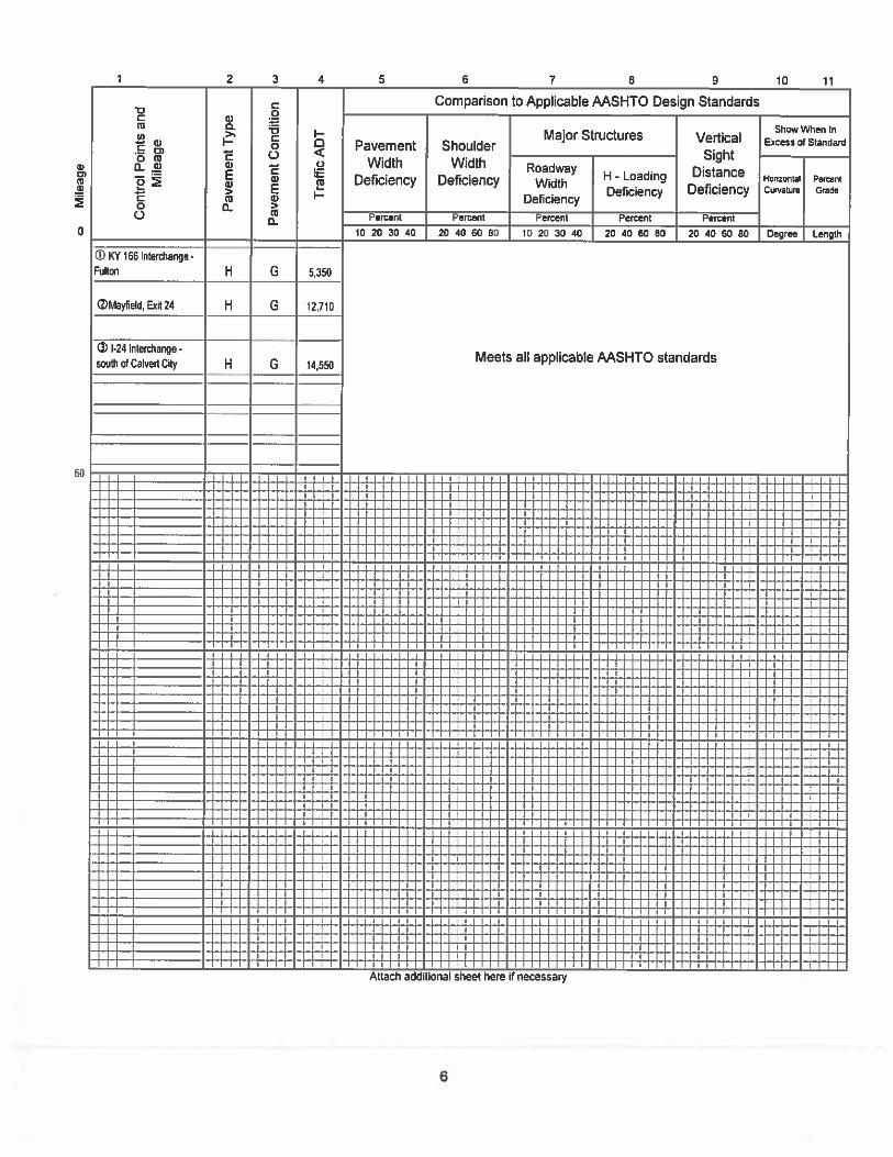
Instructions for Preparation of Page 6 Column 1: Control Points and Mileage. Top of column is one terminus of road. Indicate control points by identical
number as shown on map on page 3. Show mileage between control points in miles and tenths. Column 2: Pavement Type. Code High type, heavy duty H
Intermediate type I Low type, dustless L (show in red) Not paved N (show in red)
Column 3: Pavement Condition Code
Excellent E Good G Fair F (show in red) Poor P (show in red)
NOTE: In columns 2 and 3, where pavements types and conditions change, the location of the change shall be indicated by a short horizontal line at the proper place opposite the mileage log and the proper code letter (shown above) shall be entered in the respective column between the locations so indicated. Column 4: Traffic. Indicate average daily traffic volumes in this column. Points of changes in these data to
be indicated by short horizontal lines opposite the appropriate mileage point on the mileage log. Any existing main line rail crossing that is not separated shall be indicated at the appropriate mileage point by RXR - black if signalized - red if not protected by signals.
Columns 5 & 6 Pavement Width and Shoulder Width. These columns to be completed by comparing standards
of highway involved with applicable AASHTO standards. Entries that fall to the right of the tolerance lines (dashed) should be shaded in red. If there are no deficiencies indicate by use of the word NONE.
Columns 7 & 8 Major Structures. Show in these columns those structures that do not meet AASHTO standards.
Show by horizontal line sufficiently long to indicate percentage of deficiency. Portion on right of tolerance line shall be shown in red. Indicate length of structure in feet immediately under the line. Any sub-standard highway underpass structure shall be shown opposite the appropriate mileage point by the designation LP with the vertical clearance in feet following and shown in red. If there are no deficiencies indicate by the use of the word NONE.
Column 9: Vertical Sight Distance. Items to be shown in this column as a horizontal line, the length of
which will indicate the deficiency as determined in accordance with comparisons with comparable AASHTO standards. Portions of the line past the tolerance line shall be shown in red.
Column 10: Horizontal Curvature. Curves in excess of AASHTO applicable standards to be shown in this
column by a short horizontal line with degree of curve shown immediately above the line. To be shown in red.
Column 11 Percent Grades. Show by horizontal lines opposite proper mileage point on mileage log. Show
percent of grade above the line and length of grade in feet immediately below. To be shown in red.
What follows is an Excel worksheet that you can open by right clicking your mouse and select “Worksheet Object” – you can then Edit, Open or Convert but you must first unlock the form as show when inserting maps..

6
1 9865432
Mile
age
Con
trol P
oint
s an
d M
ileag
e
Pav
emen
t Typ
e
Pave
men
t Con
ditio
n
Traf
fic A
DT
Comparison to Applicable AASHTO Design Standards
Pavement Width
Deficiency
Shoulder Width
Deficiency
Show When In Excess of Standard
Roadway Width Deficiency
H - Loading Deficiency
Horizontal Curvature
Percent Grade
10 117
Percent Percent Percent Percent
Major Structures Vertical Sight Distance
Deficiency
Percent
010 20 30 40 20 40 60 80 60 8010 20 30 40 Degree Length
20
40
20 40 60 8020 40
140
160
Attach additional sheet here if necessary
60
80
100
120
Contact Information:
CP 2
CP 3
19.2 Miles
H
E
22,0
00
NONE
NONE
NONE
NONE
NONE
CP 4
H
E
21
,000
NONE
NONE
NONE
NONE
31.1 Miles
24.7Miles
31.7
Miles
CP 5
CP 6
NONE
NONE
NONE
NONE
NONE
NONE
NONE
NONE
NONE
NONE
NONE
H
E
H
E
17
,000
17,0
00

7
Name: Mark McConnell, Deputy Executive Director, Chief Engineer Telephone Number: 601-359-7004 Email Address: [email protected]
The following description will be provided to the AASHTO Highways Special Committee on U. S. Route Number (USRN).
Where does the route begin? Where is it going? What type of facility is it traveling over? Explain the direction (north, east, south, and west) Name the focal point city or cities Total number of miles the route will cover Where does it end?
Begin your description here: The Mississippi portion of future Interstate 22, identified as current route US 78, is currently designated as a Principal Arterial facility. The roadway extends from the junction of future Interstate I-269 (Control Point 2) in Desoto County, Mississippi southeasterly for 106.7 miles to the Alabama State Line. The roadway, intersects MS 4 (Control Point 3) in Holly Springs, MS, then with MS 30 in New Albany, Mississippi (control point 4), continues through Tupelo, MS where it intersects with US 45 (control point 5), and ends at the Alabama State Line (control point 6). The entire portion of roadway meets interstate standards.
118 STAT. 293PUBLIC LAW 108–199—JAN. 23, 2004
in subsection (a)(4) shall remain available until used and shallbe in addition to the amount of any limitation imposed on obliga-tions for Federal-aid highway and highway safety construction pro-grams for future fiscal years.
(g) Of the obligation authority distributed to a State undersubsection (a)(6), an amount of obligation authority equal to theamount for each surface transportation project in such State identi-fied in section 115 of the statement of managers accompanyingthis Act shall be available for carrying out each project.
(h) The obligation limitation made available for the programs,projects, and activities for which funds are made available underthe heading ‘‘Federal-Aid Highways, Miscellaneous Highway andHighway Safety Program’’ of this Act shall remain available untilused and shall be in addition to the amount of any limitationimposed on obligations for Federal-aid highway and highway safetyconstruction programs for future fiscal years.
SEC. 111. Notwithstanding any other provision of law:(1) Section 1105(c) of the Intermodal Surface Transpor-
tation Efficiency Act of 1991 (105 Stat. 2032; 112 Stat. 191;115 Stat. 871) is amended—
(A) in paragraph (42), by striking ‘‘Fulton, Mississippi,’’the first time that it appears and all that follows to theend of the paragraph and inserting ‘‘Fulton, Mississippi.’’;and
(B) by adding at the end the following:‘‘(45) The United States Route 78 Corridor from Memphis,
Tennessee, to Corridor X of the Appalachian development high-way system near Fulton, Mississippi, and Corridor X of theAppalachian development highway system extending from nearFulton, Mississippi, to near Birmingham, Alabama.’’.
(2) Section 1105(e)(5) of the Intermodal Surface Transpor-tation Efficiency Act of 1991 (105 Stat. 2032; 115 Stat. 872)is amended—
(A) in subparagraph (A) by striking ‘‘(A) IN GENERAL.—The portions’’ and all that follows through the end of thefirst sentence and inserting:
‘‘(A) IN GENERAL.—The portions of the routes referredto in subsection (c)(1), subsection (c)(3) (relating solely tothe Kentucky Corridor), clauses (i), (ii), and (except withrespect to Georgetown County) (iii) of subsection (c)(5)(B),subsection (c)(9), subsections (c)(18) and (c)(20), subsection(c)(36), subsection (c)(37), subsection (c)(40), subsection(c)(42), and subsection (c)(45) that are not a part of theInterstate System are designated as future parts of theInterstate System.’’; and
(B) by adding the following at the end of subparagraph(B)(i): ‘‘The route referred to in subsection (c)(45) is des-ignated as Interstate Route I–22.’’.
SEC. 112. Notwithstanding any other provision of law, in section1602 of the Transportation Equity Act for the 21st Century:
(1) Item number 230 is amended by striking ‘‘MonroeCounty transportation improvements on Long Pond Road,Pattonwood Road, and Lyell road’’ and inserting ‘‘Route 531/Brockport-Rochester Corridor in Monroe County, New York’’.
(2) Item number 1149 is amended by striking ‘‘Traffic Miti-gation Project on William Street and Losson Road inCheektowaga’’ and inserting ‘‘Study and implement mitigation
112 Stat. 256.
VerDate 11-MAY-2000 11:40 Feb 19, 2004 Jkt 029139 PO 00199 Frm 00291 Fmt 6580 Sfmt 6581 E:\PUBLAW\PUBL199.108 APPS10 PsN: PUBL199


oUS.Departmentof Transportation
Federal HighwayAdministration
Melinda L. McGrath, P.E.Executive Director
Mississippi Department of TransportationP.O.Box 1850
Jackson, MS 39205-1850
wild*'Dear Ms. McGrath:
Office of the Administrator
November 26, 2012
1200 New Jersey Ave., SEWashington, D.C. 20590
In Reply Refer To:HEPH-20
Through: Mr. Andrew H. HughesDivision Administrator
Jackson. MS
Thank you for your letter requesting that U.S. 78 from U.S. 45 to the Mississippi/Alabama StateLine be added to the Interstate Systemas 1-22. This segment is part of the 1-22 corridor that wasdesignated a future part of the Interstate System by Section 1105(e)(5) of the Intermodal SurfaceTransportation Efficiency Act of 1991, as amended.
Our Mississippi DivisionOffice confirms that the 31.1-mile segmentof U.S. 78 from U.S. 45 tothe Mississippi/Alabama State Line has been completed to Interstate standards and meets astatutory requirement by planning to connect to an existing Interstate System segment byOctober 1, 2037. The 74.9-mile segment of U.S. 78 from future 1-269 to U.S. 45 is projected tobe completed to Interstatestandards by December 2018, connecting the remainder of theproposed route to the existing System. I find the requirements of Section 1105(e)(5)(A) havebeen satisfied and hereby approve the addition of the 31.1-mile segment to the Interstate Systemas follows:
1-22 from U.S. 45 to the Mississippi/Alabama State Line
Upon completion to Interstate standards of U.S. 78 from 1-269 to U.S. 45, the 74.9-milesegment will be eligible for addition to the Interstate System under the provisions ofSection 1105(e)(5)(A).
Section 1105(e)(5)(C)(i) established the route numbering of this future Interstate corridoras 1-22.This segment will become eligible for Mississippi's remaining Interstate Maintenance funds fortheir specified period of availability.
Sincerely,
cc: Marty Vitale (AASHTO)
Victor M. Mendez
Administrator


3
Map of state, or portion thereof, indicating proposed addition or change in the U.S. Numbered or Interstate Numbered System:
Send your PDF color map to [email protected] or [email protected] with this application.
(Indicate termini and control points on the map for the route, and number them in sequence. Use the same numbers in column 1 tabulation, page 6, when listing mileage. Towns, cities, major highway intersections and state lines to be
used as control points. The top of column 1, page 6, will be one terminus, and column 1 will give the log of the route as needed to describe the route in the Association publication U.S. Numbered Highways if the application is approved by the
Standing Committee on Highways.)
")51
")16
")115
")27
")49
")24
")160
")49
")218
UNION
MECKLENBURG
CA
BA
RR
US
ME
CK
LE
NB
UR
G
GASTON
LINCOLN
£¤601
£¤21
£¤29
£¤74
£¤521
£¤29
§̈¦85
§̈¦85
§̈¦485
§̈¦485
§̈¦485
§̈¦485
§̈¦77
§̈¦77
§̈¦277
³I-485
Mecklenburg County
Created: 1/26/2015Revised: 2/12/2015Revised: 3/12/2015
GASTON
Huntersville
Concord
Charlotte
SCALE
C
0 3 61.5Miles
(1 inch = 3 miles)
B
A
SOUTHCAROLINA
I-485Length = 6.7 milesSegment A
Segment B
Segment C
I-485 from I-77 to the Charlotte Municipal Limits (2.0 miles)
I-485 within Charlotte Municipal Limits (3.7 miles)
I-485 from Charlotte Municipal Limits to I 85 (1.0 mile)


