aquifer storage and recovery in washington · aquifer storage and recovery in washington hossein...
TRANSCRIPT
Aquifer Storage and Recovery in Washington
Hossein ArvanMax Golubovskiy
Kirsten Wood
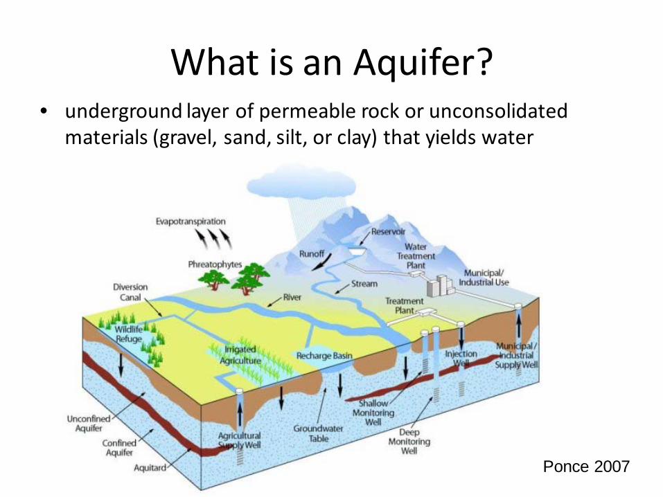
What is an Aquifer?• underground layer of permeable rock or unconsolidated
materials (gravel, sand, silt, or clay) that yields water
Ponce 2007

Vocabulary• Confined – trapped between dense
impermeable layers
• Unconfined-upper boundary is the water table• Aquitard- layer that restricts flow of
groundwater
• Aquiclude- completely impermeable aquitard• Vadose zone-between land surface and
saturated aquifer. Important natural defense against groundwater pollution.
CARA 9, Robins 8
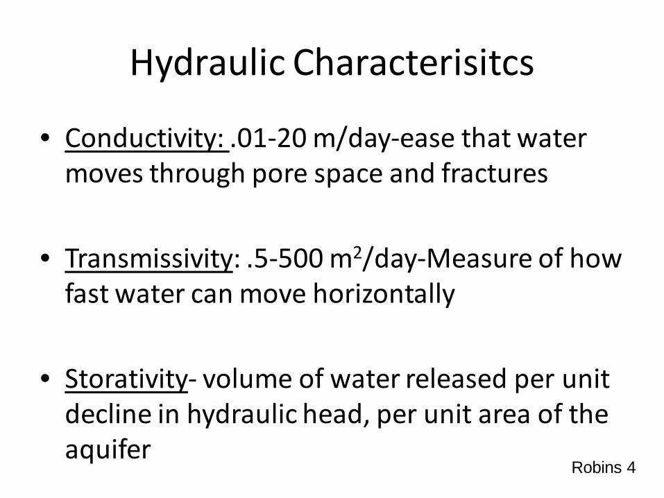
Hydraulic Characterisitcs
• Conductivity: .01-20 m/day-ease that water moves through pore space and fractures
• Transmissivity: .5-500 m2/day-Measure of how fast water can move horizontally
• Storativity- volume of water released per unit decline in hydraulic head, per unit area of the aquifer
Robins 4
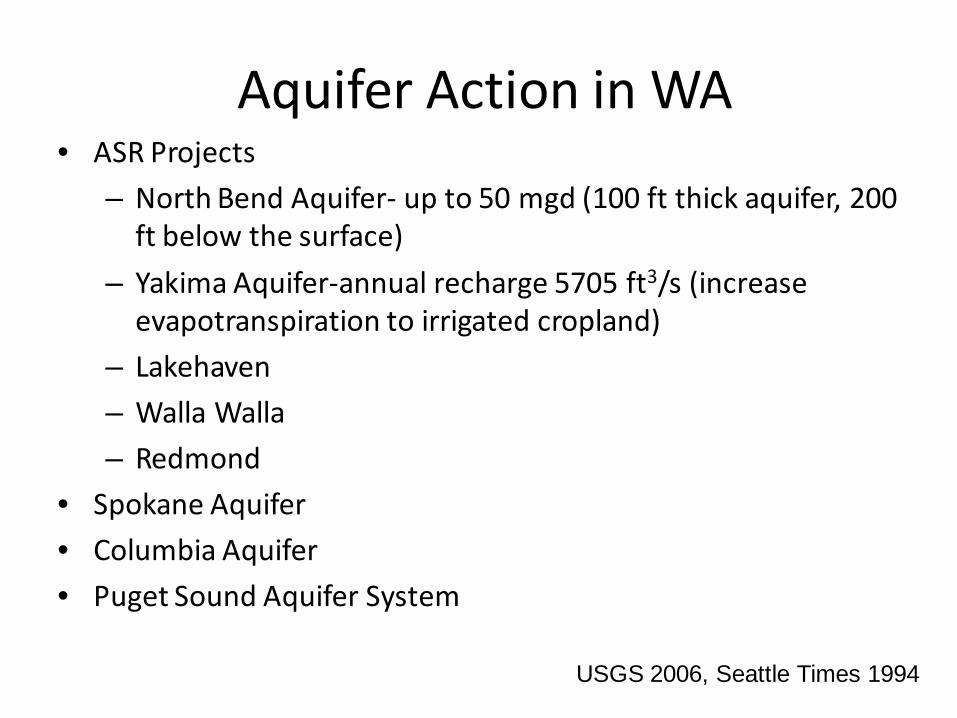
Aquifer Action in WA• ASR Projects
– North Bend Aquifer- up to 50 mgd (100 ft thick aquifer, 200 ft below the surface)
– Yakima Aquifer-annual recharge 5705 ft3/s (increase evapotranspiration to irrigated cropland)
– Lakehaven
– Walla Walla
– Redmond
• Spokane Aquifer
• Columbia Aquifer
• Puget Sound Aquifer System
USGS 2006, Seattle Times 1994
ASR Purpose
• Capture usable excess water and detain it underground for later use– Offset rising demand for drinking water
– Offset hydraulic variability due to climate change
– Prevent saltwater intrusion
– Prevent land subsidence– Maintain baseflow in streams
National Ground Water Association

Hydrogeologic Site Selection Criteria
• High Conductivity: low conductivity leads to high water levels =pressure-surface flooding, hydraulic fracturing)
• Low Concentrations of TDS: high TDS lowers quality water
• Homogeneous: heterogeneous = higher mixing and dispersion
• Strong aquifer materials
Pyne, pg 37
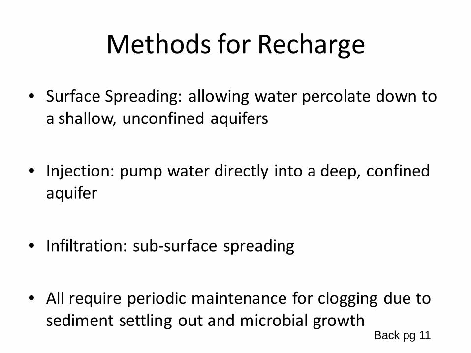
Methods for Recharge
• Surface Spreading: allowing water percolate down to a shallow, unconfined aquifers
• Injection: pump water directly into a deep, confined aquifer
• Infiltration: sub-surface spreading
• All require periodic maintenance for clogging due to sediment settling out and microbial growth
Back pg 11
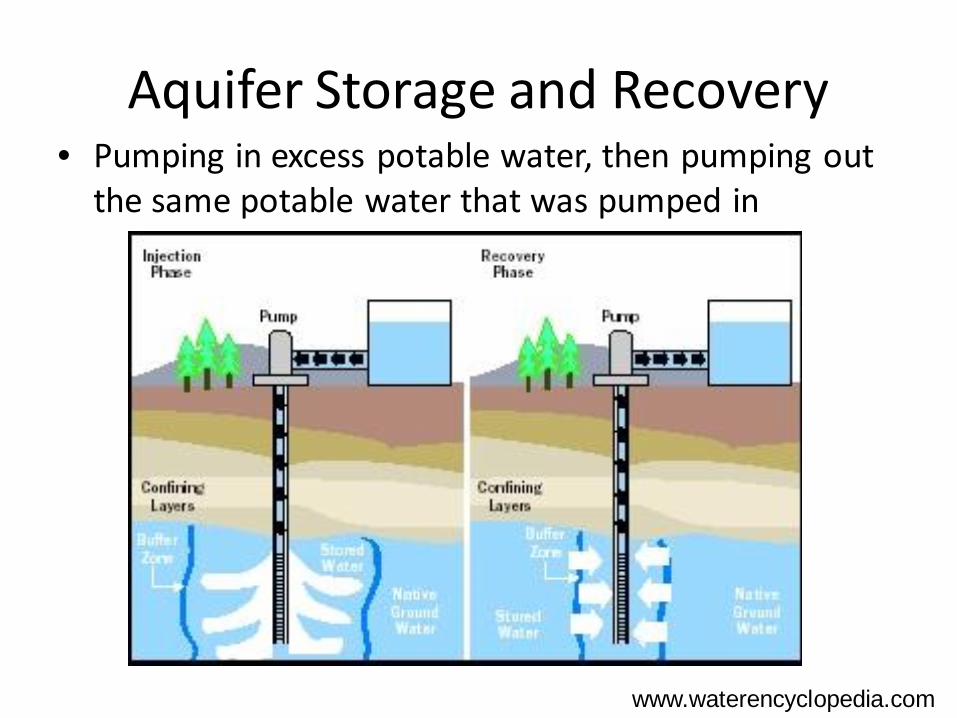
Aquifer Storage and Recovery• Pumping in excess potable water, then pumping out
the same potable water that was pumped in
www.waterencyclopedia.com
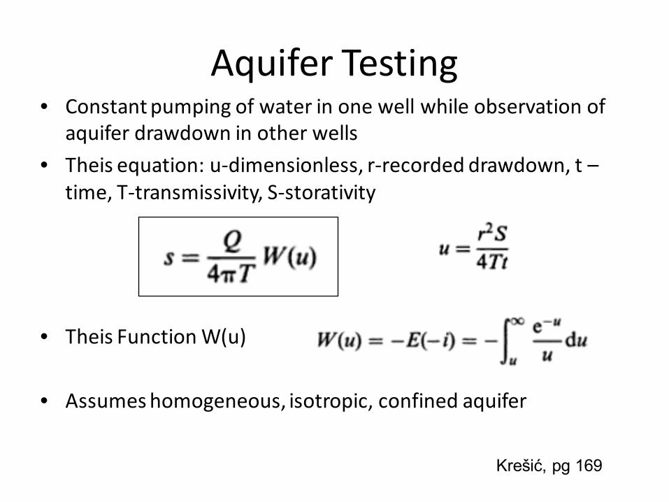
Aquifer Testing• Constant pumping of water in one well while observation of
aquifer drawdown in other wells
• Theis equation: u-dimensionless, r-recorded drawdown, t –time, T-transmissivity, S-storativity
• Theis Function W(u)
• Assumes homogeneous, isotropic, confined aquifer
Krešić, pg 169

Yakima Aquifer• Needed to backup current surface water drinking
supply
• Recharge in Winter with Naches River Flow• Closed Basin with Basalt Ridges
• Confined Sandstone Aquifer
• Water level dropped 30ft in 30 years
• No interbasin flow• Retrofitted existing well, add 26 @ 2,000 gpm
• Pilot test 70% of recharge water recovered after 55 day storage
– Pumping 2,000 gpm for 30 days Appendix B, WADOE
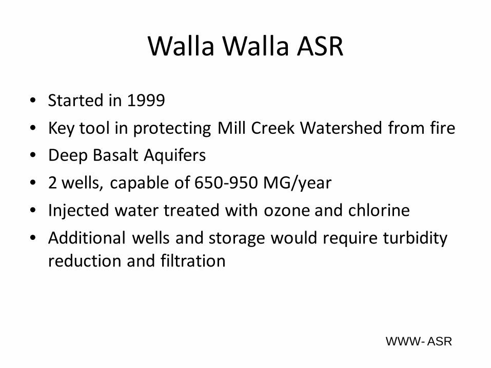
Walla Walla ASR
• Started in 1999
• Key tool in protecting Mill Creek Watershed from fire• Deep Basalt Aquifers
• 2 wells, capable of 650-950 MG/year
• Injected water treated with ozone and chlorine
• Additional wells and storage would require turbidity reduction and filtration
WWW- ASR

Lakehaven ASR
• Winter recharge from Green and Cedar rivers• Usable storage=29,000 acre-ft
• Course sands and gravels confined by aquitards
• Currently: 3 wells, water meets primary drinking water standards
• Future: 27 wells, require pre and post treatment required from surface water use
Bowman
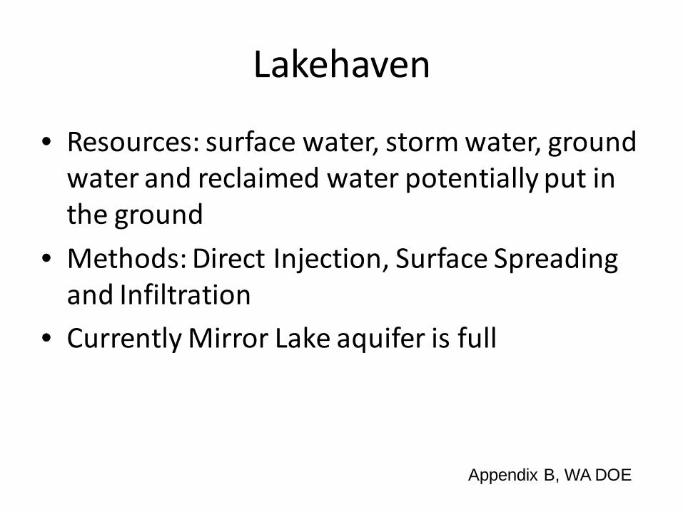
Lakehaven
• Resources: surface water, storm water, ground water and reclaimed water potentially put in the ground
• Methods: Direct Injection, Surface Spreading and Infiltration
• Currently Mirror Lake aquifer is full
Appendix B, WA DOE
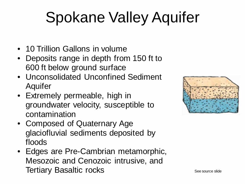
Spokane Valley Aquifer
• 10 Trillion Gallons in volume• Deposits range in depth from 150 ft to
600 ft below ground surface• Unconsolidated Unconfined Sediment
Aquifer• Extremely permeable, high in
groundwater velocity, susceptible to contamination
• Composed of Quaternary Age glaciofluvial sediments deposited by floods
• Edges are Pre-Cambrian metamorphic, Mesozoic and Cenozoic intrusive, and Tertiary Basaltic rocks See source slide
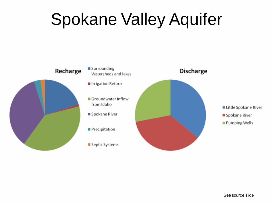
Spokane Valley Aquifer
See source slide

Columbia Plateau AquiferSemi-Confined Aquifer• A semi-confined aquifer is an aquifer
underlain by an impermeable stratum and bounded at the top by soil layers of relatively low permeability (hydraulic conductivity), especially in horizontal sense. These layers form the semi-confining layer (the aquitard) in which a free water table is found.
Recharge Aquifer• Varies areas of the regional areas of the
Columbia Plateau receives about six to 25 inches of rainfall annual
• Do to ground-water pumping the water-level has declined to 300 feet on the interior and declines of more than 100 feet over extensive areas, which has placed important agricultural regions at risk.
• The water in the aquifer system recharges near the edges of the plateau toward regional drains, such as the Columbia River
Vaccaro
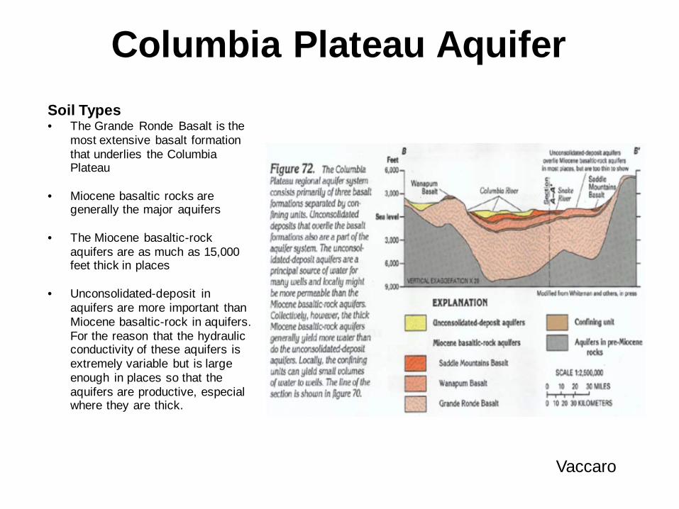
Columbia Plateau Aquifer Soil Types• The Grande Ronde Basalt is the
most extensive basalt formation that underlies the Columbia Plateau
• Miocene basaltic rocks are generally the major aquifers
• The Miocene basaltic-rock aquifers are as much as 15,000 feet thick in places
• Unconsolidated-deposit in aquifers are more important than Miocene basaltic-rock in aquifers. For the reason that the hydraulic conductivity of these aquifers is extremely variable but is large enough in places so that the aquifers are productive, especial where they are thick.
Vaccaro
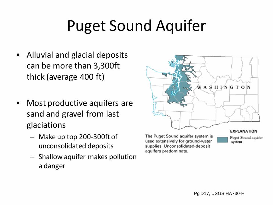
Puget Sound Aquifer
• Alluvial and glacial deposits can be more than 3,300ft thick (average 400 ft)
• Most productive aquifers are sand and gravel from last glaciations – Make up top 200-300ft of
unconsolidated deposits– Shallow aquifer makes pollution
a danger
Pg D17, USGS HA730-H
Puget Sound Recharge• Recharge estimates based on precipitation,
surface geology, land use and cover categories
• Mean annual recharge ~27 in/year – 14,510 ft3/s
– 10,500,000 acre-ft – 51% precipitation
• Fine-grain deposits ~17.6 in/year
• Course-grained deposits ~35.9 in/year
D40
Sources• Appendix B: Summary of Major ASR Projects in Washington. Washington State Department of Ecology,
2000• Back, William et al. Hydrogeology. Geological Society of America, Inc. Boulder, CO 1988. pg 311, 4-11• Bowman, John. Aquifer Storage and Recovery an OASIS. Lakehaven Utility District, 2004.• Bridge, John S and David W. Hyndman. Aquifer Characterization. Society for Sedimentary Geology Tulsa,
OK, 2004• Brown, Chris J. Development of an Aquifer, Storage and Recovery (ASR) Site Selection Suitability Index in
Support of the Comprehensive Everglades Restoration Project .U.S. Army Cops of Engineers 2008• Morgan, Laurie. Critical Aquifer Recharge Areas. Washington State DOE: Water Quality Program. 2005.• North Bend Aquifer Testing Going On This Week, Seattle Times. August 30, 1994• Krešić, Neven. Hydrogeology and Groundwater Modeling. Edition 2. CRC Press, 2007• Ponce, Victor M. Sustainable Yield of Ground Water. 2007• Pyne, R. David G. Groundwater Recharge and Wells: A Guide to Aquifer Storage Recovery CRC Press, 1995• Robins, N. S. Groundwater Pollution, Aquifer Recharge and Vulnerability. The Geological Society; London
1998. • Vaccaro, John J. and OLSEN, Theresa D., Hydrogeologic Framework of the Puget Sound Aquifer System,
Washington and British Columbia. U.S. Geological Survey. 2006 Philadelphia Annual Meeting (22–25 October 2006)
• Walla Walla Watershed Planning. http://www.wallawallawatershed.org/earlyactions.html 2006

Sources for Spokane Valley Aquifer
• Slide 1:o MacInnis, Blake, Painter, Buchanan, Lachaff, Boese, The Spokane
Valley-Rathdrum Prairie Aquifer Atlas, pg 3, July 2000o B Phelps, “Local Perspectives on Aquifer Protection”, April 1997o USGS, “Assessment of Areal Recharge to the Spokane Valley-Rathdrum
Prairie Aquifer”, http://pubs.usgs.gov/sir/2007/5038/pdf/sir20075038.pdf, 2007
o Image courtesy of: “Spokane Aquifer In-depth”, Spokane Aquifer Joint Board, 2001-2009, http://www.spokaneaquifer.org/aq.htm
• Slide 2:o Graphs made with data from: MacInnis, Blake, Painter, Buchanan,
Lachaff, Boese, The Spokane Valley-Rathdrum Prairie Aquifer Atlas, pg 11, July 2000