‘arab ar rashaiyda village profile - applied research …vprofile.arij.org/bethlehem/pdfs/vp/arab...
TRANSCRIPT

‘Arab ar Rashaiyda Village Profile
Prepared by
The Applied Research Institute – Jerusalem
Funded by
Spanish Cooperation Azahar Program
2010

Palestinian Localities Study Bethlehem Governorate
1
Acknowledgments
ARIJ hereby expresses its deep gratitude to the Spanish agency for International Cooperation for Development (AECID) for their funding of this project through the Azahar Program. ARIJ is grateful to the Palestinian officials in the ministries, municipalities, joint services councils, village committees and councils, and the Palestinian Central Bureau of Statistics (PCBS) for their assistance and cooperation with the project team members during the data collection process. ARIJ also thanks all the staff who worked throughout the past couple of years towards the accomplishment of this work.

Palestinian Localities Study Bethlehem Governorate
2
Background This booklet is part of a series of booklets, which contain compiled information about each city, town, and village in Bethlehem Governorate. These booklets came as a result of a comprehensive study of all localities in Bethlehem Governorate, which aims at depicting the overall living conditions in the governorate and presenting developmental plans to assist in developing the livelihood of the population in the area. It was accomplished through the "Village Profiles and Azahar Needs Assessment;" the project funded by the Spanish Agency for International Cooperation for Development (AECID) and the Azahar Program. The "Village Profiles and Azahar Needs Assessment" was designed to study, investigate, analyze and document the socio-economic conditions and the needed programs and activities to mitigate the impact of the current unsecure political, economic and social conditions in Bethlehem Governorate with particular focus on the Azahar program objectives and activities concerning water, environment, and agriculture.
The project's objectives are to survey, analyze, and document the available natural, human, socioeconomic and environmental resources, and the existing limitations and needs assessment for the development of the rural and marginalized areas in Bethlehem Governorate. In addition, the project aims at preparing strategic developmental programs and activities to mitigate the impact of the current political, social, and economic instability with the focus on the agricultural sector. All locality profiles in Arabic and English are available online at http://proxy.arij.org/vprofile.

Palestinian Localities Study Bethlehem Governorate
3
Table of Content Location and Physical Characteristics ____________________ 4 History _____________________________________________ 5 Religious and Archaeological Sites_______________________ 6 Population __________________________________________ 7 Education ___________________________________________ 7 Health Status ________________________________________ 8 Economic Activities ___________________________________ 9 Agricultural Sector __________________________________ 10 Institutions and Services ______________________________ 12 Infrastructure and Natural Resources ___________________ 12 Environmental Conditions ____________________________ 14 Impact of the Israeli Occupation________________________ 15 Development Plans and Projects________________________ 18 Implemented Projects ________________________________ 18 Proposed Projects____________________________________ 18 Locality Development Priorities and Needs _______________ 19 References:_________________________________________ 20

Palestinian Localities Study Bethlehem Governorate
4
‘Arab ar Rashayida Village Profile
Location and Physical Characteristics ‘Arab ar Rashayida is a Palestinian village in Bethlehem Governorate located 18.7km (horizontal distance) south-east of Bethlehem City. ‘Arab ar Rashayida is bordered by Kisan village territories to the east, Kisan village and Amos settlement to the north, Sa’ir town territory, in Hebron government to the west, and Bani Na’im town territory in Hebron governorate to the south (See map 1).
Map 1: ‘Arab ar Rashayida location and borders
‘Arab ar Rashaiyda is located at an altitude of 512m above sea level with a mean annual rainfall of 246mm. The average annual temperature is 19.2o C, and the average annual humidity is about 58 percent (ARIJ GIS, 2009).
Palestinian Localities Study Bethlehem Governorate
5
Since 1996, ‘Arab ar Rashaiyda has been governed by a village council which is currently administrated by nine members appointed by the Palestinian Authority. The village council owns a permanent headquarters and a private car. It is the responsibility of the village council to provide a number of services to the residents of ‘Arab ar Rashaiyda, including:
1. Infrastructure services such as water and electricity. 2. Protection of religious, historical, and archaeological sites. 3. Implementation of projects and case studies for the village.
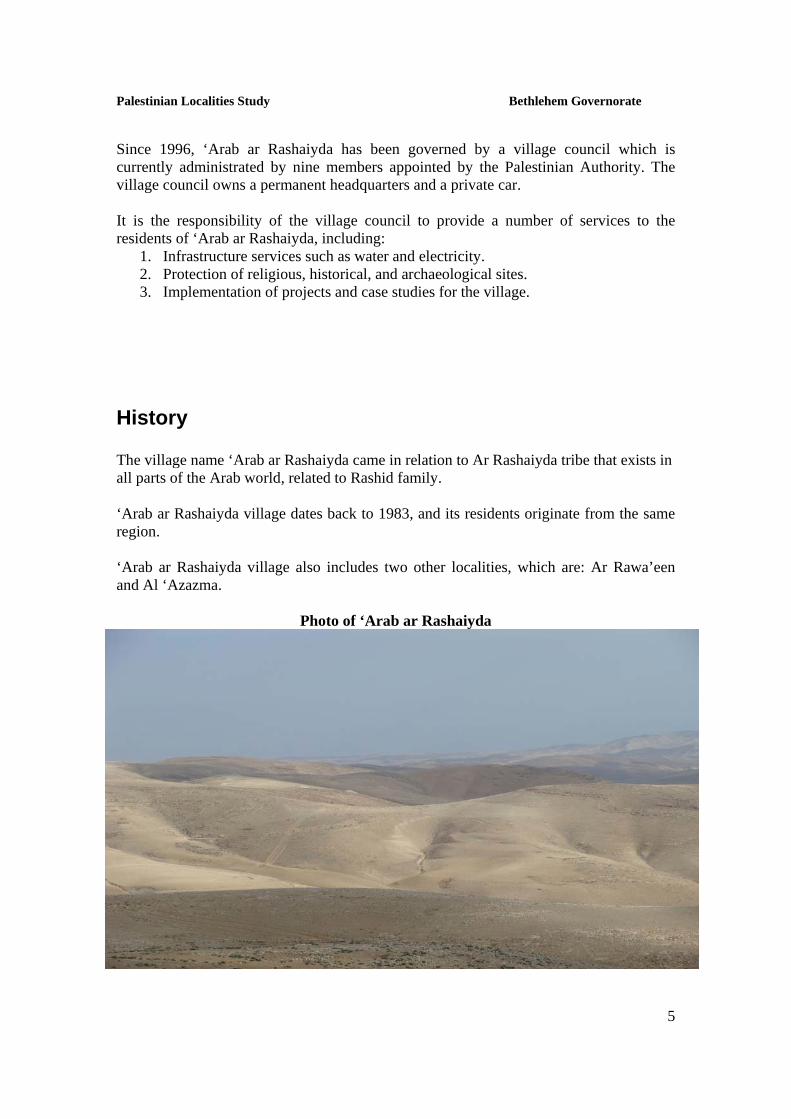
History The village name ‘Arab ar Rashaiyda came in relation to Ar Rashaiyda tribe that exists in all parts of the Arab world, related to Rashid family. ‘Arab ar Rashaiyda village dates back to 1983, and its residents originate from the same region. ‘Arab ar Rashaiyda village also includes two other localities, which are: Ar Rawa’een and Al ‘Azazma.
Photo of ‘Arab ar Rashaiyda

Palestinian Localities Study Bethlehem Governorate
6
Religious and Archaeological Sites In terms of religious establishments, there are two mosques in ‘Arab ar Rashaiyda: Haroon ar Rashid Mosque and Khaled Ben El Walid Mosque. As for the archaeological and tourist sites in the village, there is Al ‘Erishah area, which overlooks the Dead Sea and which can be used for tourism (See map 2).
Map 2: Main locations in ‘Arab ar Rashaiyda village

Palestinian Localities Study Bethlehem Governorate
7
Population According to the Palestinian Central Bureau of Statistics (PCBS), the total population of ‘Arab ar Rashaiyda in 2007 was 1,453; of whom 750 are males and 703 are females. There are 224 households living in 291 housing units. Age Groups and Gender The General Census of Population and Housing carried out by PCBS in 2007 showed that the distribution of age groups in ‘Arab ar Rashaiyda is as follows: 50.4 percent are less than 15 years, 46.1 percent are between 15 - 64 years, and 2.4 percent are 65 years and older. Data also showed that the sex ratio of males to females in the village is 106.6:100, meaning that males constitute 51.6 percent of the population, and females constitute 48.4 percent of the population. Families The inhabitants of ‘Arab ar Rashaiyda village are composed of several families, mainly: Al Basabsa, As Suna’, Al Qreinat, Al Jreiyat, Ar Rweilat, As Sa’edat, Al Magharfa, Al Jwefieen, and As Sawarkah.
Education According to the results of the PCBS Population, Housing and Establishment Census-2007, the illiteracy rate among ‘Arab ar Rashaiyda population is about 23.8 percent, of whom 80 percent are females. Of the literate population, 41.6 percent can read and write, 33 percent had elementary education, 18.5 percent had preparatory education, 5.8 percent had secondary education, and 1.2 percent completed higher education. Table 1, shows the educational level in the village of ‘Arab ar Rashaiyda, by sex, and educational attainment in 2007.
Table 1: ‘Arab ar Rashaiyda population (10 years and above) by sex and educational attainment S E x
Illiterate Can read & write
Elementary Preparatory Secondary Associate Diploma Bachelor Higher
Diploma Master PhD Total
M 42 157 138 87 27 3 3 - - - 457 F 168 122 83 37 12 1 1 - - - 424 T 210 279 221 124 39 4 4 - - - 881
Source: PCBS, 2009. Population, Housing and Establishment Census-2007, Final Results

Palestinian Localities Study Bethlehem Governorate
8
In regards to the basic and secondary educational institutions and schools in ‘Arab ar Rashaiyda in the academic year 2008/2009, there are two public schools in the village, run by the Palestinian Ministry of Higher Education (See Table 2). In the village there is a total number of 343 students, 28 teachers, and 18 classes (Directorate of Education in Bethlehem, 2009). It should be noted here that the average number of students per teacher in the school is nearly 12, while the average number of students per class is approximately 19. Table 2: The Schools in ‘Arab ar Rashaiyda by name, stage, sex, and supervising authority
School Name Supervising Authority Sex Ar Rashaiyda Girls Elementary School Government Female Ar Rashaiyda Mixed High School Government Mixed Source: Directorate of Education in Bethlehem, 2009 Furthermore, there is one kindergarten in ‘Arab ar Rashaiyda; Ar Rashaiyda Kindergarten, which is run by ‘Arab ar Rashaiyda village council and has a total number of 50 children (‘Arab ar Rashaiyda village council, 2010).
Health Status There are no health facilities available in ‘Arab ar Rashaiyda village; there is only one mobile physician’s clinic run by the government. Also, there is no ambulance in the village. In emergency cases, residents of ‘Arab ar Rashaiyda use Tuqu’ hospitals and health centers, such as: Tuqu’ Charitable Society, which is about 8km from the village, Tuqu’ Medical complex, which is about 8km form the village, and Tuqu’ Governmental Clinic, which is about 7km from the village. The health sector in ‘Arab ar Rashaiyda faces many obstacles, mainly:
1. The absence of a permanent health center in the village. 2. The absence of an ambulance. 3. The absence of a pharmacy. 4. The absence of a dental clinic in the village.

Palestinian Localities Study Bethlehem Governorate
9
Economic Activities The economy in ‘Arab ar Rashaiyda is dependent mainly on the agricultural sector, which absorbs 60 percent of the village workforce (See Figure1). The results of a field survey for the distribution of labor by economic activity in ‘Arab ar Rashaiyda are the following:
• Agriculture Sector (60%) • Israeli Labor Market (38%) • Government or Other Employees Sector (2%)
Figure 1: Economic Activity in ‘Arab ar Rashaiyda Village
There are very few and almost non-existing businesses and industrial parks in ‘Arab ar Rashaiyda, as there are only two grocery stores in the village However, ‘Arab ar Rashaiyda village is characterized with livestock rearing and the production of animal products, such as milk, cheese and meat. The unemployment rate in ‘Arab ar Rashaiyda has reached about 70 percent. It was found that the most vulnerable social groups in the town, as a result of Israeli actions, are: 1. Former workers in Israel. 2. Workers in agricultural activities and livestock rearing. Labor Force According to the PCBS Population, Housing and Establishment Census-2007, 27.6 percent of ‘Arab ar Rashaiyda population was economically active, of whom 14.4 percent
Agriculture Sector
60%
Government or Other
Employees Sector
2%
Israeli Labor Market
38%

Palestinian Localities Study Bethlehem Governorate
10
were employed, 72.4 percent were not economically active, 38.9 percent were students, and 43.6 percent were housekeepers (See table 3).
Table 3: ‘Arab ar Rashaiyda population (10 years and above) by sex and employment status-2007 S E X
Economically Active Not Economically Active Total
Employed Currently Unemployed
Unemployed (Never worked)
Total Students House- keeping
Unable to work
Not working & Not looking for work
Other Total
M 33 113 94 240 145 4 32 - 35 216 457 F 2 1 - 3 103 274 31 - 13 421 424 T 35 114 94 243 248 278 63 - 48 637 881
Source: PCBS, March 2009. Population, Housing and Establishment Census-2007, Final Results
Agricultural Sector ‘Arab ar Rashaiyda lies on a total area of about 47,841 dunums of which 47,005 dunums are considered arable land, and 483 dunums are residential land (See table 4 and map 3).
Table 4: Land Use in ‘Arab ar Rashaiyda village (dunum) Arable Land
(47,005) Total Area
Built up
Area Seasonal Crops
Permanent Crops Greenhouses Forests
Open Spaces and Rangelands
Area of Industrial,
Commercial & Transport
Unit
Area of Settlements
and Military
Bases 47,841 483 6,723 34 0 0 40,248 0 353
Source: GIS unit – ARIJ, 2008

Palestinian Localities Study Bethlehem Governorate
11
Map 3: Land use/land cover and Segregation Wall in ‘Arab ar Rashaiyda Village
Agricultural production in ‘Arab ar Rashaiyda depends mostly on rainwater. As for irrigated fields, they depend on domestic harvesting cisterns. Table 5 shows the different types of rain-fed and irrigated open-cultivated vegetables in ‘Arab ar Rashaiyda. The most common crop cultivated within this area is tomato.
Table 5: Total area of rain-fed and irrigated open cultivated vegetables in ‘Arab ar Rashaiyda village (dunum)
Fruity vegetables
Leafy vegetable
Green legumes Bulbs Other
vegetables Total area
RF Irr. RF Irr. RF Irr. RF Irr. RF Irr. RF Irr. 0 4 0 1 0 0.5 0 0 0 1 0 6.5 Rf: Rain-fed, Irr: Irrigated Source: Palestinian Ministry of Agriculture, 2007
As for the field crops and forage in ‘Arab ar Rashaiyda, cereals, in particular, wheat and barley are the most cultivated covering an area of about 260 dunums, while forage crops,

Palestinian Localities Study Bethlehem Governorate
12
such as common vetch and bitter vetch, are the second most cultivated crops (See table 6). Table 6: Total area of field crops in ‘Arab ar Rashaiyda village (dunum) Cereals Bulbs Dry
legumes Oil crops
Forage crops
Stimulating crops
Other crops
Total area
Rf Irr Rf Irr Rf Irr Rf Irr Rf Irr Rf Irr Rf Irr Rf Irr 260 0 0 0 12 0 0 0 17 0 0 0 0 0 289 0 Rf: Rain-fed, Irr: Irrigated Source: Palestinian Ministry of Agriculture, 2007
The field survey shows that 60 percent of the residents in ‘Arab ar Rashaiyda are rearing and keeping domestic animals such as sheep, goats, and broiler chicken (See Table 7). Table 7: Livestock in ‘Arab ar Rashaiyda village Cows* Sheep
Goats Camels Horses Donkeys
Mules Broilers Layers Bee
Hives0 6,991 6,109 370 23 40 8 3,600 0 0 *Including cows, bull calves, heifer calves and bulls Source: Palestinian Ministry of Agriculture, 2007
There are about 5 kilometers of agricultural roads in the village suitable for tractors and agriculture machinery.
Institutions and Services ‘Arab ar Rashaiyda has a village council which was established in 1996 by the Palestinian National Authority, but there are no associations, committees, centers, or sport or cultural clubs in the village (‘Arab ar Rashaiyda village council, 2010).
Infrastructure and Natural Resources
Electricity and Telecommunication Services: ‘Arab ar Rashaiyda has been connected to a public electricity network; served by Jerusalem Electricity Company, which is the main source of electricity in the village.

Palestinian Localities Study Bethlehem Governorate
13
However, only 1.9 percent of the housing units in the village are connected to the network, while 96.8 percent of the housing units do not have any source for electricity, and only 1.4 percent of the housing units are dependent on private generators for electricity (PCBS, 2007). Furthermore, ‘Arab ar Rashaiyda has no telecommunication network in the village (‘Arab ar Rashaiyda village council, 2010). Transportation Services: Taxis are considered the main means of transportation within ‘Arab ar Rashaiyda; there are 4 taxis in the village. As for the road network in the village; there are a total of 8km of main roads, which are paved and in good condition, and a total of 3.5km of secondary roads, which are paved but in bad condition (‘Arab ar Rashaiyda village council, 2010). Water Resources: ‘Arab ar Rashaiyda is provided with water by the West Bank Water Department, through the public water network established in 1983. About 67.6 percent of the housing units are connected to the water network, 31.5 percent are dependent on the purchase of water tanks, and 0.9 percent are dependent on rainwater harvesting cisterns (PCBS, 2007). The quantity of water supplied to ‘Arab ar Rashaiyda in 2008 was about 0.0297 million cubic meters/year therefore, the estimated rate of water supply per capita is about 89 liters/day (PWA, 2008). Here it should be noted that many ‘Arab ar Rashaiyda citizens do not in fact consume this amount of water due to water losses, which are about 50 percent. The losses happen at the main source, major transport lines, distribution network, and at the household level (‘Arab ar Rashaiyda village council, 2010), thus the rate of water consumption per capita in ‘Arab ar Rashaiyda is 45 liters per day. This is a low rate compared with the minimum quantity proposed by the World Health Organization, which is 100 liters per capita per day. Sanitation: ‘Arab ar Rashaiyda lacks a public sewage network; thus, 25.9 percent of ‘Arab ar Rashaiyda's housing units are connected to cesspits where generated wastewater are collected, while the majority of ‘Arab ar Rashaiyda's housing units (74.1%) don’t have any means for wastewater collection and disposal (PCBS, 2007). Based on the estimated daily per capita water consumption, the estimated amount of wastewater generated per day, is approximately 52 cubic meters, or 19 thousands cubic meters annually. At the individual level in the village, it is estimated that the per capita wastewater generation is approximately 36 liters per day. The wastewater collected by cesspits, are discharged by wastewater tankers directly to open areas or nearby valleys without any regard for the environment. Here it should be noted that there is no

Palestinian Localities Study Bethlehem Governorate
14
wastewater treatment either at the source or at the disposal sites and this poses a serious threat to the environment and the public health. Solid Waste Management: ‘Arab ar Rashaiyda village lacks a solid waste management service, i.e. solid waste collection and disposal, generated from the citizens. The daily per capita rate of solid waste production in ‘Arab ar Rashaiyda is 0.7kg. Thus the estimated amount of solid waste produced per day from the ‘Arab ar Rashaiyda residents is nearly 1 ton, or 371 tons per year. The main component of household solid waste is composed of organic materials, followed by paper, cardboard, and then plastic, as shown in Figure 2 below.
Figure 2: The components of the household solid waste produced
59%15%
12%
4% 4% 6%Organic Materials
Cardboard & Paper
Plastic
Glass
Metal
Others
Environmental Conditions Like other villages in the governorate, ‘Arab ar Rashaiyda experiences several environmental problems which must be addressed and solved. These problems can be identified as follows: Water Crisis: Water is cut off for long periods of time in summer in, for several reasons:

Palestinian Localities Study Bethlehem Governorate
15
(1) Israeli domination over Palestinian water resources; accordingly, supplying Palestinians communities with insufficient water quantities to cover their domestic needs.
(2) High rate of water losses, because the water network is old, and in need of rehabilitation and renovation. Moreover, the practices of citizens like creating illegal connections, water theft, and damaging water meters increase the proportion of water losses.
(3) Many homes are not connected to the public water network. (4) Many housing units lack rainwater harvesting cisterns; thus they suffer from
periods of water shortage. Wastewater Management: The absence of a public sewage network, thus, the use of cesspits by some citizens for the disposal of wastewater, where the majority of citizens have no means for wastewater disposal, and thus the discharge of wastewater in the streets and neighboring lands, causes environmental damages, health problems, and the spread of epidemics and diseases in the village. Moreover, the use of cesspits pollutes the groundwater because most cesspits are built without lining, which allows wastewater to enter into the ground and avoids the need to use sewage tankers from time to time. Solid Waste Management: Due to the lack of a solid waste management service in addition to the lack of a central sanitary landfill to serve ‘Arab ar Rashaiyda village, the citizens dispose of waste in the neighboring lands and on the roadsides,and set it on fire from time to time, in order to reduce its size. These practices constitute a hazard risk for the health and a source of pollution to the groundwater and soil through the leachate produced from the solid waste, it pollutes the air with smoke and gases resulted from the burning of such wastes, and it creates bad odors and distortion of the landscape. It should be noted here that in cooperation with the Joint Council for solid waste in Bethlehem governorate, a solid waste management service will be provided for ‘Arab ar Rashaiyda village, in addition to a sanitary landfill which is currently under construction in Al Maniya area, south of Bethlehem governorate, to serve Bethlehem and Hebron governorates.
Impact of the Israeli Occupation On September 13, 1993 the Palestine Liberation Organization and Israel signed the Declaration of Principles, which provided for a transitional period of 5 years. On May 4, 1994 Oslo I Agreement (Gaza and Jericho) was signed, where areas in the West Bank and
Palestinian Localities Study Bethlehem Governorate
16
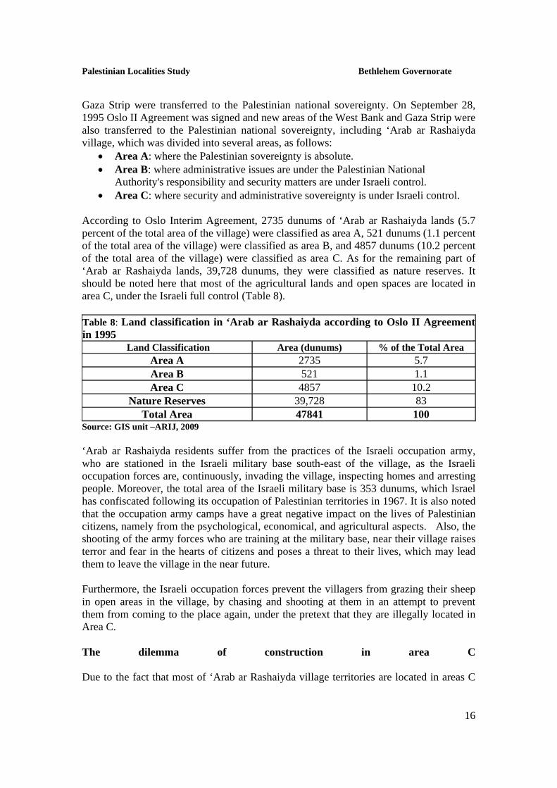
Gaza Strip were transferred to the Palestinian national sovereignty. On September 28, 1995 Oslo II Agreement was signed and new areas of the West Bank and Gaza Strip were also transferred to the Palestinian national sovereignty, including ‘Arab ar Rashaiyda village, which was divided into several areas, as follows:
• Area A: where the Palestinian sovereignty is absolute. • Area B: where administrative issues are under the Palestinian National
Authority's responsibility and security matters are under Israeli control. • Area C: where security and administrative sovereignty is under Israeli control.
According to Oslo Interim Agreement, 2735 dunums of ‘Arab ar Rashaiyda lands (5.7 percent of the total area of the village) were classified as area A, 521 dunums (1.1 percent of the total area of the village) were classified as area B, and 4857 dunums (10.2 percent of the total area of the village) were classified as area C. As for the remaining part of ‘Arab ar Rashaiyda lands, 39,728 dunums, they were classified as nature reserves. It should be noted here that most of the agricultural lands and open spaces are located in area C, under the Israeli full control (Table 8). Table 8: Land classification in ‘Arab ar Rashaiyda according to Oslo II Agreement in 1995
% of the Total Area Area (dunums) Land Classification 5.7 2735 Area A 1.1 521 Area B
10.2 4857 Area C 83 39,728 Nature Reserves
100 47841 Total Area Source: GIS unit –ARIJ, 2009
‘Arab ar Rashaiyda residents suffer from the practices of the Israeli occupation army, who are stationed in the Israeli military base south-east of the village, as the Israeli occupation forces are, continuously, invading the village, inspecting homes and arresting people. Moreover, the total area of the Israeli military base is 353 dunums, which Israel has confiscated following its occupation of Palestinian territories in 1967. It is also noted that the occupation army camps have a great negative impact on the lives of Palestinian citizens, namely from the psychological, economical, and agricultural aspects. Also, the shooting of the army forces who are training at the military base, near their village raises terror and fear in the hearts of citizens and poses a threat to their lives, which may lead them to leave the village in the near future. Furthermore, the Israeli occupation forces prevent the villagers from grazing their sheep in open areas in the village, by chasing and shooting at them in an attempt to prevent them from coming to the place again, under the pretext that they are illegally located in Area C. The dilemma of construction in area C Due to the fact that most of ‘Arab ar Rashaiyda village territories are located in areas C

Palestinian Localities Study Bethlehem Governorate
17
and natural reserves, which are under full Israeli control, according to Oslo Agreement, the Palestinian citizens living in these areas are obliged to obtain construction permits from the Israeli Civil Administration in the region. However, the Israeli Civil Administration imposes difficult conditions on the Palestinians who are seeking construction permits for their lands located in area C, and charges them very high fees, thus leading the village inhabitants to build without permission due to their desperate need for houses in keeping up with the population growth and agricultural needs. On July 21, 2005, Israeli bulldozers demolished five tents and five sheep stockyards in the village, under the pretext of unauthorized construction. Moreover, on August 17, 2005, the Israeli occupation authorities handed ‘Arab ar Rashaiyda village residents 20 military orders notifying them to evacuate their lands and about the demolition of five animals stockyards, in order for the military to construct a section of the racist Segregation Wall on the village territories. Israeli bypass roads network in the Occupied Palestinian Territory During the years of occupation, the Israeli occupation forces have established a bypass road network in order to create a kind of territorial contiguity between the Israeli settlements, outposts, and military bases in the West Bank, whereas these roads have isolated the Palestinian communities from each other, and caused material and agricultural losses. ‘Arab ar Rashaiyda was also affected by the establishment of the bypass road network, as it lost part of its territories for the construction of Israeli bypass road no. 3698 which extends for 12.5km on the village territory. The Segregation Wall According to the updated Segregation Wall plan published on the web page of the Israeli Ministry of Defense in April 30, 2007; the Segregation Wall will extend for 6.4km on ‘Arab ar Rashaiyda lands, from the south-eastern area; thus isolating and confiscating 7,167 dunums of the village territory (15% of the total area of the village). Table 9 shows the lands isolated behind the wall in ‘Arab ar Rashaiyda village:
Table 9: The impact of the Israeli Segregation Wall on ‘Arab ar Rashaiyda Land Use/Land Cover areas
Item Total Area (in Dunums)
Arable Land 7126 Forests & Open spaces 41 Total 7167
Source: ARIJ database- GIS, 2008

Palestinian Localities Study Bethlehem Governorate
18
Development Plans and Projects
Implemented Projects ‘Arab ar Rashaiyda village council has implemented several development projects in ‘Arab ar Rashaiyda, during the years 2007 to 2009, as shown in Table 10.
Table 10: Implemented Development Plans and Projects in ‘Arab ar Rashaiyda (2007-2009) Name of the Project
Year Donor
Construction of ‘Arab ar Rashaiyda Kindergarten 2007 German Development Bank Construction of First Floor for Ar Rashaiyda Girls School
2009 PECDAR & the Development Bank
Establishment of Electricity Network 2009 Ministry of Finance Source: ‘Arab ar Rashaiyda Village Council, 2010
Proposed Projects ‘Arab ar Rashaiyda village council, in cooperation with the civil society organizations in the village and the village residents, looks forward to the implementation of several projects in the coming years. The project ideas were developed during the PRA workshop that was conducted by ARIJ staff in the village. The projects are as follows, in order of priority, from the viewpoint of the participants in the workshop:
1. Supporting farmers and the agriculture production inputs. 2. Supporting livestock through the provision of feed and barracks. 3. Providing a health center and an ambulance. 4. Providing a veterinary center and an agricultural society. 5. Providing job opportunities. 6. Construction of agricultural roads. 7. Construction of agricultural wells. 8. Providing permanent transportations in the village. 9. Providing educational and awareness courses for the village residents. 10. Providing a dairy factory and a market for animal products.

Palestinian Localities Study Bethlehem Governorate
19
Locality Development Priorities and Needs ‘Arab ar Rashaiyda suffers from a significant shortage of infrastructure and services. Table 11 shows the development priorities and needs in the village, according to the village council's point of view (‘Arab ar Rashaiyda Village Council, 2010):
Table 11: Development Priorities and Needs in ‘Arab ar Rashaiyda No. Sector Strongly
Needed Needed Not a
Priority Notes
Infrastructural Needs
1 Opening and Pavement of Roads * 26km 2 Rehabilitation of Old Water Networks * 3km 3 Extending the Water Network to Cover New Built up
Areas * 3km
4 Construction of New Water Networks * 5km 5 Rehabilitation/ Construction of New Wells or
Springs *
6 Construction of Water Reservoirs * 100m3 7 Construction of a Sewage Disposal Network * 5km 8 Construction of a New Electricity Network * 2km 9 Providing Containers for Solid Waste Collection * 100 containers
10 Providing Vehicles for Collecting Solid Waste * 1 11 Providing a Sanitary Landfill Health Needs
1 Building of New Clinics or Health Care Centres * 1 clinic 2 Rehabilitation of Old Clinics or Health Care Centres *
3 Purchasing of Medical Equipment and Tools * Educational Needs
1 Building of New Schools * 2 Rehabilitation of Old Schools * elementary &
secondary 3 Purchasing of New Equipment for Schools * elementary &
secondary schools
Agriculture Needs
1 Rehabilitation of Agricultural Lands * 3,000 dunums 2 Building Rainwater Harvesting Cisterns * 50 cistern 3 Construction of Barracks for Livestock * 200 barracks 4 Veterinary Services * 5 Seeds and Hay for Animals * 6 Construction of New Greenhouses * 200
greenhouses 7 Rehabilitation of Greenhouses * 8 Field Crops Seeds * 9 Plants and Agricultural Supplies *
8km is a main road, 3km internal road and 15km agricultural road.

Palestinian Localities Study Bethlehem Governorate
20
References: • Applied Research Institute - Jerusalem (ARIJ). (2008 - 2009). Bethlehem,
Palestine: Geographic Information Systems and Remote Sensing unit Database, 2009.
• ‘Arab ar Rashaiyda Village Council. 2010. • Directorate of Education - Bethlehem. 2008/2009. Bethlehem, Palestine:
A database of schools. • Palestinian Central Bureau of Statistics. 2009. Ramallah, Palestine:
General Census of Population and Housing Censuses, 2007. • Palestinian Ministry of Agriculture (MOA). 2007/2008. Bethlehem,
Palestine: Directorate of Agriculture data. • Palestinian Water Authority. 2009. Ramallah, Palestine: Quantities of
Water Supply in the West Bank Governorates, 2008.