araripe manakin wildlife refuge · areas, federal law 9,985/2000), the team has prepared three...
TRANSCRIPT

ARARIPE MANAKIN
CEARÁ, BRAZIL
Final Report of activities 2007
ANAKIN WILDLIFE REFUGE
RAZIL
Final Report of activities 2007-2009
November, 2009

Araripe Manakin Wildlife Refuge
1
AQUASIS – Associação de Pesquisa e Preservação de Ecossistemas Aquáticos
Araripe Manakin Wildlife Refuge team
Alberto Alves Campos – Protected Areas and conservation strategies
Weber de Andrade Girão e Silva – Ornithologist
Ciro Ginez Albano - Ornithologist
Paulo Thieres Pinto de Brito – GIS and mapping
Roberto Vinicius Lima - Education
Anna Karla Cavalcante – Education
ARARIPE MANAKIN WILDLIFE REFUGE
CEARÁ, BRAZIL
This project is supported by:
Araripe Manakin Wildlife Refuge
2
Table of contents
ARARIPE MANAKIN WILDLIFE REFUGE
Chapter 1. Introduction 3
1.1. General Introduction and Objectives 3
1.2. Project site: the Araripe region 6
1.3. The Araripe Manakin Conservation Process 12
1.4. Major threats to the Araripe Manakin and its habitat 14
1.5. Recommendations from the Conservation Plan 27
1.6. The Araripe plateau in national and international priorities 30
Chapter 2. Brazilian Protected Area Legal Framework 31
2.1. Overview of the main legal instruments 31
2.2. Protected Areas categories applicable to the Araripe 32
2.3. The Chico Mendes Institute for the Conservation of Biodiversity 40
Chapter 3. Building the Protected Area proposal 41
3.1. Building scenarios 41
3.2. Discussing scenarios with key stakeholders and local communities 43
3.3. Land tenure assessment 54
3.4. Proposed limits of the Protected Area 66
Chapter 4. Opening a formal process at ICMBio 69
4.1. Building a partnership to file a formal request (Jun 2008) 69
4.2. Presenting the proposal to federal authorities (Sep 2008) 70
4.3. Process opened at ICMBio (Aug 2009) and next steps 71
Appendices 73
Appendix 1. List of acronyms and abbreviations. 74
Appendix 2. Official document sent to request federal government
authorities to open a process to create a fully protected
area in the slopes of the Araripe plateau.
75

Araripe Manakin Wildlife Refuge
3
Chapter 1
Introduction
1.1. General Introduction and Objectives
The main goal of this project was to produce a formal proposal for the creation
of a fully protected area in the northeastern slopes of the Chapada do Araripe,
based on discussions with key stakeholders and local communities. Supported by
the existing Brazilian legal framework on Protected Area creation and
management, we intend to provide formal protection for the remaining habitat
of the Araripe Manakin and guarantee some room for population recovery.
Ultimately, the overall goal is to prevent this species from going extinct.
Specific objectives were: (1) to determine the most appropriate category for the
protected area and its limits, based on discussions with Protected Area managers
and other stakeholders; (2) conduct a land tenure assessment in the selected
area to comply with environmental authorities demands for new Protected Area
proposals; (3) produce a preliminary proposal and discuss with the communities
and stakeholders along the northeastern slope of the Chapada do Araripe; and
(4) to consolidate a formal document to be handed to environmental authorities
for the creation of a fully protected area for the conservation of the Araripe
Manakin's habitat and the water sources in the Araripe region.
A summary of these objectives and their outcomes are presented below:
Objective 1 - Defining the category and the limits of the Protected Area:
based on the previous studies (i.e., Viability Study for the Conservation Plan of
the Araripe Manakin) and strategies (i.e., Conservation Plan of the Araripe
Manakin), and guided by the existing legal instruments that regulate Protected
Area creation and management in Brazil (i.e., National System of Protected
Areas, Federal Law 9,985/2000), the team has prepared three possible scenarios
for categories and limits, which were presented and discussed with the managers
of both existing protected areas in the region (i.e., Araripe National Forest and
Araripe Environmental Protection Area) and other key stakeholders, including
the communities along the slopes of the Chapada do Araripe who will be
influenced by the creation of a Protected Area. The team has conducted several
meetings, in each of the 3 municipalities where the Protected Area will be
established (Crato, Barbalha and Missão Velha), including urban and rural

Araripe Manakin Wildlife Refuge
4
communities, and local municipal authorities. A preliminary area has already
been proposed in the Conservation Plan, and it is important to note that most of
this area (which comprises the Manakin's habitat and a buffer zone) is already
supposed to be protected by some Brazilian environmental laws (e.g., belongs to
the protected Atlantic Forest Domain; has several water springs; has a declivity
higher than 45 degrees, etc.), but very little enforcement of these laws is
observed in practice.
Objective 2 – Land tenure assessment in the proposed area: during the
discussions for the consolidation of the Conservation Plan of the Araripe
Manakin, the federal environmental authorities responsible for Protected Area
creation at that time (2005-2006) requested that a land tenure assessment
should be conducted in order to determine land ownership and evaluate the
legal aspects of current ownership, in order to fulfill the requirements for the
proposal of new protected areas, especially the fully protected ones, where
disappropriation of lands may be necessary. After the creation of the Chico
Mendes Institute for the Conservation of Biodiversity, in August 2007,
environmental authorities responsible for the creation and management of
Protected Areas shifted their orientation regarding land tenure assessments in
the sense that these studies had to be performed by government agencies in
order to be part of the formal processes of creation of federal Protected Areas.
After several discussions, the project team decided to work togeteher with the
government agency responsible for this type of assessment (i.e., INCRA, or
National Institute of Colonization and Land Reform) to produce a land tenure
study that would be officially recognized by the environmental authorities. After
initial discussions with technicians from this federal Institute, we were informed
that a large assessment was planned for the southern portion of Ceará State. We
then managed to have a meeting with the President of this Institute to ask him
to give priority to the Araripe region, specifically the three municipalities that
encompass the Araripe Manakin’s habitat (i.e., Crato, Barbalha and Missão
Velha). He was very much interested in the Araripe Manakin’s story and gave his
team the green light to start these studies in the area required. In September
2009, the land tenure studies were completed for two out of the three
municipalities, and the last one is expected to be ready by early 2010.

Araripe Manakin Wildlife Refuge
5
Objective 3 – Refining and disseminating the proposal: a preliminary proposal
was built, based on the scenarios mentioned above, and a series of presentations
were conducted with local stakeholders in order to evaluate the proposal and
also to disseminate the idea of the fully protected area and its benefits for the
urban and rural societies. These meetings and talks focused specially on the
water conservation issue, since the area concentrates the majority of water
sources that supply the area for irrigation and human consumption and is
directly related to the quality of life of the local society.
Objective 4 – Producing a final proposal for federal environmental
authorities: after discussing the preliminary proposal with stakeholders and
refining the concept, category and limits of the Protected Area (June 2008), a
final document was produced and presented to federal environmental
authorities responsible for the creation of Protected Areas in their main office in
the country’s capital, Brasília, in September 2008. Since the initial project was
conducted with the partnership of the managers of the two existing federal
protected areas in the region, the idea of the fully protected area for the
Araripe region, was better accepted by federal environmental authorities. After
this meeting, where the National Director for the creation of protected areas
and his team were present, the proposal was considered viable and the Director
gave his team the approval to further verify the viability of the proposal. By
August 2009, almost one year later, a formal process was opened in the Brazilian
Ministry of Environment/Chico Mendes Institute (process no.
02070.001184/2009-73) and a government technician - the biologist Gabriela
Leonhardt – was finnaly appointed as responsible for this process. We are now
expecting their first field visit to continue the formal steps to create a protected
area.
After several years of research and assessments, we believe the most important
single action that has to be taken to prevent the extinction of the Araripe
Mankin, its unique habitat and the associated biodiversity, is the establishment
of a fully protected area in the NE slopes of the Chapada do Araripe, as stated in
the Conservation Plan for the species.
Besides creating a Protected Area for the Araripe Manakin and the rich
associated biodiversity that lives in the moist forest, the project is also aimed at
protecting the water springs that are concentrated in this part of the Chapada
do Araripe. The outflow of these important water sources are being dangerously
reduced due to deforestation, and the establishment of a protected area will
also greatly benefit the local society that depends heavily on these water
resources for their quality of life and their main economic activities.

Araripe Manakin Wildlife Refuge
6
1.2. Project site: the Araripe region
The Araripe sedimentary basin is located in central northeastern Brazil, in
the border of the States of Ceará, Pernambuco and Piauí, covering an area of
approximately 11,000km2 (Figure 1). Although it is completely inserted in the
heart of the Caatinga biome (dominated by semi-arid thorn forests), the Araripe
Basin presents some geological, climatic and ecological features that support
unique transition ecosystems, including the slope moist forests that are the
habitat of the Araripe Manakin.
Figure 1. The Araripe Basin, Chapada do Araripe (plateau), and the
Araripe Manakin’s range.

Araripe Manakin Wildlife Refuge
7
The main distinctive feature of the Araripe landscape is the Chapada, a
sedimentary mesa, or plateau-like formation found in some bordering areas of
the Brazilian Shield, consisting of a large flat plateau, and slopes of varying
declivities that gradually merge with the surrounding lowland alluvial terraces
that form the Araripe Basin. The plateau of the Chapada do Araripe - like an
insular flat highland formed by several dry vegetation types - rises 500m above
the surrounding lowlands, ranging from 700m to 1,000m of altitude. The slopes
host unique moist tropical forests, a narrow ecosystem that occurs along the
northeastern slope of the Chapada, where a combination of factors allow a year
round water supply to maintain this ecosystem. Strictly speaking, these are
gallery forests, since they occur along the water springs and streams that flow
down from contact areas between geologic formations of different permeability.
However, there are so many springs in some portions of the northeastern slope
of the Chapada, that the forest seems uniformly distributed along the slopes
(Figure 2).
Figure 2. Northeastern slopes of Chapada do Araripe, showing the table-like
plateau and remaining patches of the dense vegetation along the slopes.
Araripe Manakin Wildlife Refuge
8
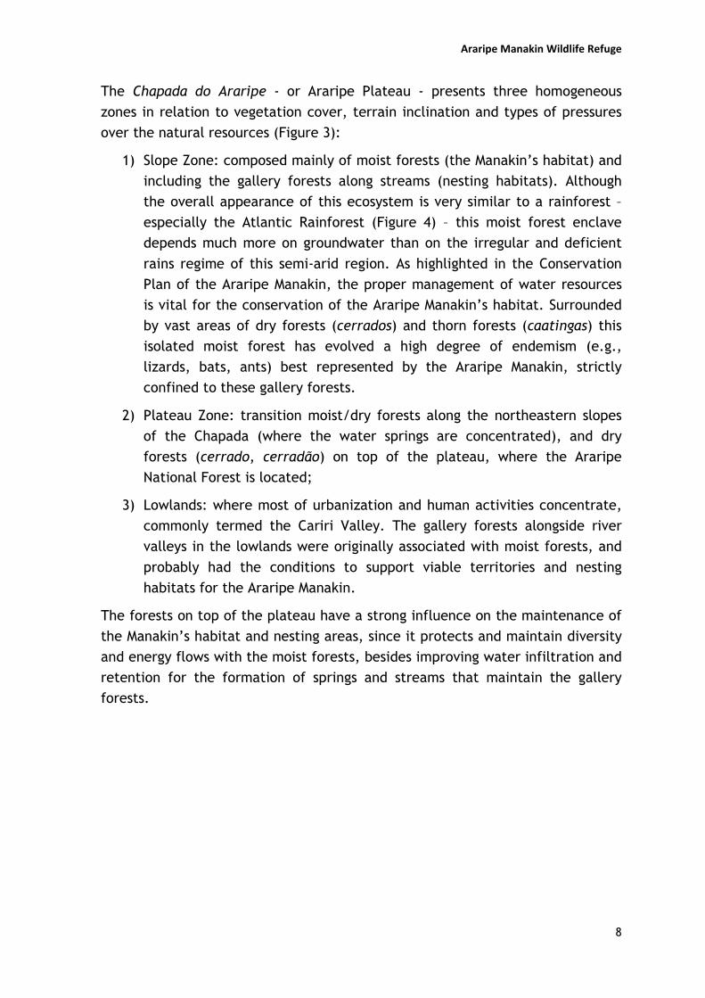
The Chapada do Araripe - or Araripe Plateau - presents three homogeneous
zones in relation to vegetation cover, terrain inclination and types of pressures
over the natural resources (Figure 3):
1) Slope Zone: composed mainly of moist forests (the Manakin’s habitat) and
including the gallery forests along streams (nesting habitats). Although
the overall appearance of this ecosystem is very similar to a rainforest –
especially the Atlantic Rainforest (Figure 4) – this moist forest enclave
depends much more on groundwater than on the irregular and deficient
rains regime of this semi-arid region. As highlighted in the Conservation
Plan of the Araripe Manakin, the proper management of water resources
is vital for the conservation of the Araripe Manakin’s habitat. Surrounded
by vast areas of dry forests (cerrados) and thorn forests (caatingas) this
isolated moist forest has evolved a high degree of endemism (e.g.,
lizards, bats, ants) best represented by the Araripe Manakin, strictly
confined to these gallery forests.
2) Plateau Zone: transition moist/dry forests along the northeastern slopes
of the Chapada (where the water springs are concentrated), and dry
forests (cerrado, cerradão) on top of the plateau, where the Araripe
National Forest is located;
3) Lowlands: where most of urbanization and human activities concentrate,
commonly termed the Cariri Valley. The gallery forests alongside river
valleys in the lowlands were originally associated with moist forests, and
probably had the conditions to support viable territories and nesting
habitats for the Araripe Manakin.
The forests on top of the plateau have a strong influence on the maintenance of
the Manakin’s habitat and nesting areas, since it protects and maintain diversity
and energy flows with the moist forests, besides improving water infiltration and
retention for the formation of springs and streams that maintain the gallery
forests.

Araripe Manakin Wildlife Refuge
9
Figure 3. Distinctive zones identified in the Araripe region: plateau, slope, and lowlands or lower terraces. The Araripe
Manakin’s range is presently confined to the Slope Zone.
Araripe Manakin Wildlife Refuge
10
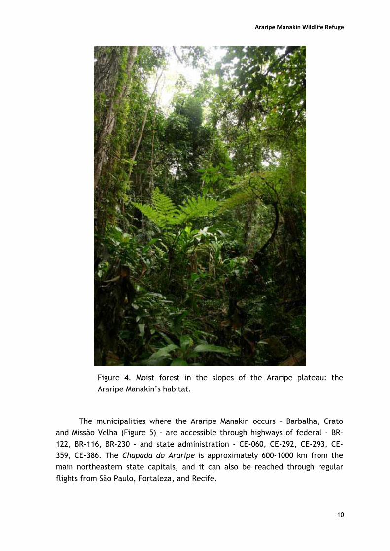
Figure 4. Moist forest in the slopes of the Araripe plateau: the
Araripe Manakin’s habitat.
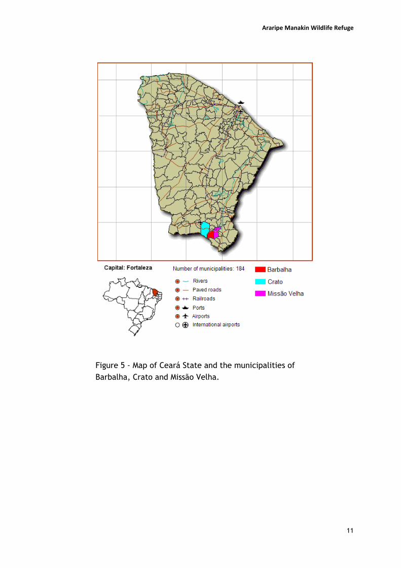
The municipalities where the Araripe Manakin occurs – Barbalha, Crato
and Missão Velha (Figure 5) - are accessible through highways of federal - BR-
122, BR-116, BR-230 - and state administration - CE-060, CE-292, CE-293, CE-
359, CE-386. The Chapada do Araripe is approximately 600-1000 km from the
main northeastern state capitals, and it can also be reached through regular
flights from São Paulo, Fortaleza, and Recife.
Araripe Manakin Wildlife Refuge
11
Figure 5 - Map of Ceará State and the municipalities of
Barbalha, Crato and Missão Velha.
Araripe Manakin Wildlife Refuge
12
1.3. The Araripe Manakin Conservation Process
Initial efforts in this long-term conservation process were focused on
determining the conservation status of the Araripe Manakin (e.g., overall
population size, present range; reproductive cycle and nesting characteristics;
major threats). After these research and field assessment oriented efforts, the
team managed to produce and publish a Conservation Plan for the species, which
was printed with the help of the Brazilian Ministry of Environment, in November
2006. This document recognizes two important, clearly stated issues: (1) habitat
loss is the main threat to the conservation of the Araripe Manakin; and (2) the
existing protected areas, both of Sustainable Use designation and with no
management tools implemented (i.e., Management Plans, Zonings) are not being
effective in protecting the Manakin's habitat. In this sense, one of the main
recommendations of the Conservation Plan is the creation of a fully protected
area encompassing the moist forests along the northeastern slopes of the
Chapada do Araripe.
During the discussions to consolidate the Conservation Plan of the Araripe
Mnakin, in 2006, the conservation process of this species was internalized in the
NGO Aquasis, becoming a long-term, permanent program, with a full-time team,
in order to conduct the actions proposed in the Plan and promote the constant
discussions and follow up of the strategies presented in that document.
A timeline of the conservation process is summarized below, in order to provide
a view of the long-term process and how the strategy to create a fully protected
area fits in the broader picture (Table 1).
Table 1. Timeline of the conservation process of the Araripe Manakin (summary
1996-2009).
1996 December 10th. Galileu Coelho and Weber Girão e Silva discover a new species for the genus Antilophia, in the moist forests of the NE slopes of the Araripe plateau, Ceará State, NE Brazil.
1998 Species first description in a journal (Coelho & Silva, 1998).
2000 First systematic and funded research project, sponsored by the Brazilian Fundação O Boticário de Proteção à Natureza.
2002 First results published (Silva & Rêgo, 2002).
2004 Project funded by the Brazilian Ministry of Environment (National Fund for the Environment).

Araripe Manakin Wildlife Refuge
13
2005 CLP Future Conservationist Award: “Conservation of the Araripe Manakin”. Extensive field research to determine the actual population of the Araripe Manakin, its present range and remaining moist forest habitat.
2006 Araripe Manakin conservation process established as a permanent process of the NGO Aquasis.
Publication of the “Conservation Plan of the Araripe Manakin”.
2007 CLP Follow up award: “Araripe Manakin Wildlife Refuge”.
Establishment of a partnership with key stakeholders to coordinate and consolidate a proposal to create a fully protected area in the Araripe (i.e., Aquasis, manager of the Araripe National Forest, manager of the Araripe Sustainable Use Protected Area, Secretary of Environment of the town of Crato, and the Director of the regional office of the State’s Water Management Agency).
August 28th. A new governmental institution was created to take care of the Federal Protected Areas and protect endangered species, the Chico Mendes Institute for the Conservation of Biodiversity/ICMBio (see details below).
2008 Consolidation of the proposal to create a fully protected area, including detailing mapping of the limits of the PA based on discussions with stakeholders
June 19th. Proposal was formally filed in the Ministry of Environment.
September 19th. Proposal was presented by the Aquasis team in Brasília to the Director of creation of fully protected areas (Chico Mendes Institute for the Conservation of Biodiversity/Ministry of Environment), and a group of technicians. The Director gave his team the approval to go on with the process due to its relevance to the conservation of biodiversity and water resources.
2009 Process to create a fully protected area in the Araripe was finally formally opened by the federal environmental authorities (process ICMBio # 02070.001184/2009-73) and a government technician designated to follow up the process.

Araripe Manakin Wildlife Refuge
14
1.4. Major threats to the Araripe Manakin and its habitat
The Conservation Plan of the Araripe Manakin highlights that habitat loss is the
major threat to this species, since its already minute remaining habitat (i.e.,
less than 28km2) is shrinking daily due to deforestation and diversion of water
sources. Figure 6 shows the remaining moist forests along the slopes of the
Araripe plateau and the central portion of preserved forests where the Araripe
Manakin is confined.
In this topic, we briefly present the main threats to the Araripe Manakin’s
habitat, to stress the importance of the creation of a fully protected area in
order to protect this unique and vanishing forest environment and its associated
biodiversity and water resources.
Figure 6. Araripe Manakin present range: 28km2 along the NE slopes of the
Chapada do Araripe (Ceará State, municipalities of Crato, Barbalha e Missão
Velha).

Araripe Manakin Wildlife Refuge
15
a) Suppression of the moist forests
The suppression of the vegetation cover along the slopes of the Chapada do
Araripe has broad consequences for the Araripe Manakin and the unique diversity
of living forms that compose this enclave of moist forests. Besides destroying the
gallery forest where the Manakin establishes its territory and performs its annual
reproductive cycle, it also suppresses the adjoining moist forests that are an
important part of the living area of the Araripe Manakin.
Any slope forest with a declination of 45° or higher is protected by federal law (Law 4,771/1965), but enforcement is limited in the region. All Atlantic Forest
and associated ecosystems are also strictly protected by federal law (Federal
Decree 750/1993), but some scientists and environmental authorities still don’t
agree about the classification of this enclave as Atlantic Forest. The text of the
decree, and several other Resolutions of the National Council for the
Environment (e.g., Resolutions 010/1993, 003/1996, 009/1996), however, make
it clear that moist forest enclaves in the northeastern Brazilian region should be
protected.
In this sense, the Manakin’s habitat is clearly protected by several legal
instruments, but the pressures for development are much higher than the
pressures for enforcing environmental laws. Below are discussed and illustrated
some of the main causes of the suppression of the slope forests:
o Forest fires
During the drier months of the year, i.e., from August till December, and
coinciding with the first half of reproductive season of the Manakin, forest
fires are perhaps the most important concern for environmental authorities
in the Araripe region. Although the fires are more common in the plateau
zone of the Chapada do Araripe, where the drier Araripe National Forest is
located, one of the protected areas in the region, the fires usually reach the
border of the plateau and the slope forests when not controlled in time.
Probably the major investments of the local environmental authorities (i.e.,
the IBAMA and ICMBio office in Crato) are in fire prevention campaigns,
equipment and personnel, especially because the fires attract a great deal
of attention from the media and provoke a general commotion in the local
society. During the dry season, a team of temporarily hired individuals patrol
the National Forest in bycicles and by foot with some basic equipment (e.g.,
blankes, fire extinguishers) to avoid the development of fires. The IBAMA
also keeps four watching towers in the plateau, of about 15-20m high, to

Araripe Manakin Wildlife Refuge
16
help spot fires during the dry season.
Fires are almost always related to human activities, mainly when the ‘slash
and burn’ practices still used by the small scale farmes get out of control.
Hunter’s campfires, and fires started to scare away bees while the honey is
collected are also common causes. Environmental authorities also report
that several fires are started on purpose by local farmers and subsistence
hunters that do not agree with the environmental policies of no-hunting, no-
cattle and no-crops in the National Forest.
During the development of field activities for this study, three forest fires
were witnessed along the slopes of the Chapada in the Manakin’s habitat. In
one of these events, the team was monitoring nests in the best spot ever
recorded, consisting of the territories of ten adult males along a series of
streams. Despite desperate efforts of the team to control the fire while the
fire brigade was on its way (Figure 7), some prime territories were destroyed
(Figure 8). Luckily, and thanks to the team’s dedicated effort, the nests
being monitored – some already with nestlings inside – were not destroyed,
and one nest was only a dozen meters from the flames.
Figure 7. Team member trying to prevent the fire from reaching the Araripe
Manakin’s nests that were being monitored.

Araripe Manakin Wildlife Refuge
17
Figure 8. Destruction of Araripe Manakin territories due to Forest fires.
o Crops
Suppression of the moist forests for monocultures is mainly related to the
culture of bananas (Musa spp), as seen in Figure 9. Corn, beans and
mandioca are also planted in some slope areas, but these require less
irrigation, and thus can be grown in drier areas. The banana plantations
usually derive water from the streams, and they occupy the gallery forest
areas along the streams that comprise the prime Araripe Manakin territories.
When not totally suppressing the gallery forest, the banana plantations
reduce drastically de diversity of plant species that are used by the Manakin
for feeding, and usually makes nestbuilding virtually impossible, since the
Manakin has only been observed to nest in native species of the lower strata
of the gallery forest above the streams. No nests were found along streams
passing through monocultures.

Araripe Manakin Wildlife Refuge
18
Figure 9. Examples of streams with native gallery forest (right),
and with banana plantations (left).
o Recreational facilities
The hundreds of springs and streams that flow down the northeastern
slope of the Chapada do Araripe have different outflows and serve not
only as a source of drinking water and for irrigation purposes: some of the
springs and streams with a higher flow are commonly diverted to provide
running water for the pools and artificial waterfalls of several clubs and
aquatic parks in the region. Besides the abundant water supply, these
clubs also take advantage of the cooler microclimate formed in the
northeastern slopes, mainly because of a combination of humidity, height,
vegetation cover, wind and rains regime, that provide a welcome break
from the hot and dry, semi-arid conditions of the lower terraces and
surrounding lowlands.

Araripe Manakin Wildlife Refuge
19
Only in the range of the Manakin, the existing recreational infrastructure
comprises about a dozen clubs of varying sizes and environmental
impacts. Most of these clubs have a significant influence on the
alterations of the water dynamics of the springs and streams. Some of
them have completely channeled and/or piped the springs and streams
and the gallery forests along these bodies of water have completely been
suppressed (Figures 10 and 11). This is totally illegal according to Brazilian
environmental laws (Law 4,771/1965), but the clubs are usually quite old
and so culturally and (not so) economically important for the local society
that the authorities make a ‘blind eye’ for this aggression. Also because
the clubs are owned by the local elite who have strong influence in the
regional economy and politics.
This phenomenon has caused the loss of prime reproductive territories for
the Araripe Manakin, leading also to the fragmentation of the moist
forests patches, and possibly creating physical barriers for the dispersion
of the existing Manakin population.
Figure 10. Caldas recreational club. Note the channellization of the
stream and the total suppression of the gallery forest. After several visits
to this area, two ‘green’ individuals were recorded in the surrounding
moist forests, but no adult males, denoting that territories are
established in this area anymore.

Araripe Manakin Wildlife Refuge
20
Figure 11. Using water from the springs and streams to irrigate lawns and
maintain swimming pools in the clubs along the slopes. Note the proximity of
the recreational areas to the moist forests in the background of both pictures.
o Urban pressure
The constant pressure of the growing expansion of urban areas towards
the slopes of the Chapada do Araripe are specially felt in Crato and
Barbalha, in the core of the Manakin’s range. The lower slopes are being
sought for the development of medium and high-class condos (Figure 12).
In this sense, the moist forests and all its associated biodiversity are
slowly being pushed upwards, as the outskirts of Crato and Barbalha
expand without any urban planning or respect for the environmental laws
that protect this vegetation.

Araripe Manakin Wildlife Refuge
21
Figure 12. Luxury houses (condos) being built in Crato municipality, in the
slopes along the Araripe Manakin’s range.
b) Spring and stream degradation
Spring and stream degradation has a direct influence on the conservation of
the Araripe Mankin: besides providing a year round supply of freshwater for
the maintenance of the moist forests, these sources of water are also vital
for the completion of the Manakin’s life cycle, since females only build nests
above running water.
Water is perhaps the most valuable natural resource in this semi-arid region,
and the conflicts for the control and access to the springs and streams date
back to pre-columbian times. The fierce Kariri Indians controlled these rich
environments for hundreds of years, until white settlers displaced them and
split the best irrigated lands along the northeastern slopes between the local
elite. During the 18th century, a unique water management system was
devised by the landowners to minimize the growing and violent conflicts,
where the water bodies could be owned privately and water could be sold
and controlled. This is totally illegal according to the more recent regulations
(i.e., Brazilian Water Management Act), but in some localities this archaic
system still persists due to the influence of the local landowning elite. Again,
there are two important federal laws that protect water springs and gallery
forests, but little enforcement is done.

Araripe Manakin Wildlife Refuge
22
o Channeling of springs
In order to have complete control over the water resources, some
landowners have been chanelling the water streams along the slopes of
the Chapada. In some cases, the springs are completely piped with the
use of concrete boxes (Figure 13) built straight in the fractures between
geologic layer where the water flows from the underground reservoirs.
This completely dries out some of the streams, making it impossible for
the recovery of the gallery forests. This practice has been observed
mainly in the recreational clubs and large properties.
Figure 13. Concrete boxes built to control the water flow directly from
the springs.
Araripe Manakin Wildlife Refuge
23
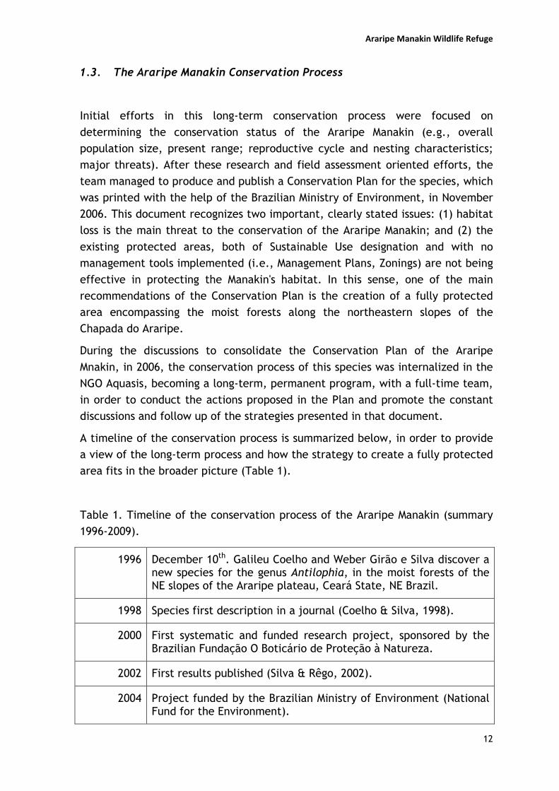
o Suppression of vegetation along streams
Recreational clubs and large properties commonly suppress the vegetation
along the streams to allow easier access to the water. Streams are usually
straightened by the clubs in the shape of narrow concrete canals to supply
water for several swimming pools and for irrigation (Figure 14).
Figure 14. Comparison between a preserved gallery forest environment (left,
with Araripe Manakin nest over water), and a channeled stream completely
devoid of marginal vegetation in one of the recreational clubs in the region
(right).
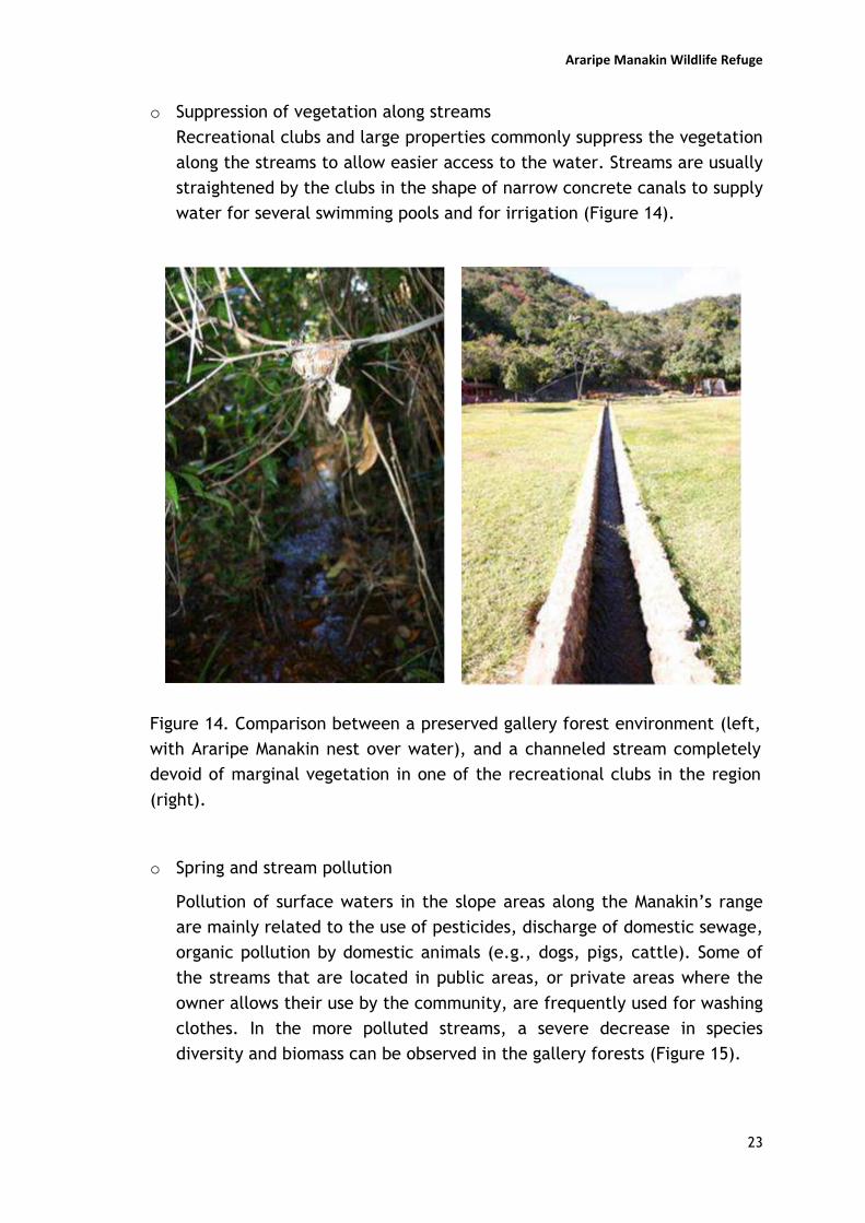
o Spring and stream pollution
Pollution of surface waters in the slope areas along the Manakin’s range
are mainly related to the use of pesticides, discharge of domestic sewage,
organic pollution by domestic animals (e.g., dogs, pigs, cattle). Some of
the streams that are located in public areas, or private areas where the
owner allows their use by the community, are frequently used for washing
clothes. In the more polluted streams, a severe decrease in species
diversity and biomass can be observed in the gallery forests (Figure 15).
Araripe Manakin Wildlife Refuge
24
Figure 15. A common sight in the springs and streams that are open for
public access: local residents washing clothes and domestic animals. The
moist forest in the background of this picture is the territory of an adult
male Araripe Manakin.
o Walking paths along streams
The presence of dirt tracks and walking paths following the streams in the
Araripe Manakin’s range has shown to have a direct impact not only in the
suppression of the gallery forest, but also in the inhibition of nestbuing
and incubation activities by the females (Figure 16). Females are very shy
and suspicious while building nests, and the constant presence of humans
around the streams probably have very negative effects on site selection,
nestbuilding, incubation, and nestling feeding and parental care.

Araripe Manakin Wildlife Refuge
25
Figure 16. Partial suppression of gallery forests along streams in the
Manakin’s range, to give way for walking paths. This has probably very
negative effects on reproductive success due to reduced nesting area and
the transit of people.
o Reduction in spring and stream outflow
Reduction in flow rates of some springs and streams is alarming in some
areas. The main factor is the deforestation on top of the Chapada,
causing a greater evaporation, and reduced infiltration capacity. The
water that infiltrates in the plateau is the water that flows through the
cracks in the geologic layers of the Arajara and Exu Formations, forming
the springs. In some streams, the consequences of flow reduction can be
visibly felt in the gallery forests, showing a lower density and species
diversity.
There are cases where the springs have totally dried out, and
consequently the steams and their associated gallery forests no longer
exist. This reduction in spring flow, and stream quality and overall
number, directly reduces the available territories and reproductive
habitats for the Araripe Manakin.

Araripe Manakin Wildlife Refuge
26
c) Slope degradation
o Deforestation of slopes and plateau border areas
The habitat of the Araripe Manakin is mostly situated close to the
borders of the Chapada, in the contact zone between the Plateau and
Slope Zones. These are areas of high declivity and prone to landslides,
especially due to the nature of the sandstone material that forms the
upper layers of the Chapada. The risk of landslides has been aggravated
by several factors, especially the deforestation of the dry forests on the
plateau and the moist forests along the slopes. The rains regime, highly
irregular and concentrated in a few months of the year also contributes
for the slope degradation. In recent years, almost every rainy season is
expected to bring landslides along the slopes, especially along the
Manakin’s range, where the rains are more abundant. Landslides have
been covering springs and streams, and even destroying patches of moist
forest with former Manakin territories (Figure 17).
Figure 17. Severe landslides occurred in the slopes of the Chapada do
Araripe during the rainy seasons of 2004 and 2009, due to heavy rainfall
coupled with deforestation (Arajara District, the type locality of the
Araripe Manakin).

Araripe Manakin Wildlife Refuge
27
1.5. Recommendations from the Conservation Plan
The Conservation Plan of the Araripe Manakin (Figure 18) has five sets of recommendations related to the most important themes identified by the group of researchers, external advisors, stakeholders and collaborators, who participated in the discussions of the Plan:
1. Legal aspects and public environmental policies; 2. Protected Areas; 3. Habitat recovery; 4. Research and Monitoring; 5. Involvement of the local stakeholders.
In this topic, we will present the recommendations of the Conservation Plan regarding Protected Areas, and how the idea of creating a fully protected area in the slopes of the Araripe plateau is considered and prioritized by this strategic planning document.
Figure 18. Front page of the Conservation Plan of the Araripe Manakin.

Araripe Manakin Wildlife Refuge
28
Although there are already two federal protected areas near and/or surrounding
the Araripe Manakin’s habitat (see Figure 19; and topic 2.2. Protected Areas in
the Araripe region) they are considered of Sustainable U and the type of
management they experience have contributing little to the conservation of
biodiversity and water resources along the slopes of the Araripe plateau.
Figure 19 . Two Sustainable Use protected areas in the Araripe (Araripe National Forest and Chapada do Araripe Environmental Protection Area), and the critical area proposed by the Conservation Plan Preliminary for the creation of a fully protected area for the Araripe Manakin’s habitat and the water resources.
As stated in the Conservation Plan, the critical situation of the Araripe Manakin and its habitat, and the reduction in the outflow of the springs measured in the Araripe, require more restrictive measures to protect these natural resources. In this sense, the recommendation of the highest priority in the Conservation Plan regarding the topic of Protected Areas, is the “creation of a fully protected area – encompassing the present range of the Araripe Manakin and the region with the highest concentration
of springs in the northeastern slope of the Araripe plateau – including areas to
promote habitat recovery, and a Buffer Zone of at least 500m along the lower limit
of the protected area, and of 1km along the top of the plateau” (critical area illustrated in Figures 19 and 20).

Figure 20. Critical areas identified for the conservation of the habitat of the Araripe manakin along the slopes of the Chapada do Araripe. The
remaining habitat areas are shown in green, Short-term actions (in red) are recommended for slope restoration. Mid- to long-term actions are recommended for the slopes (in orange) and for the adjoining plateau (in yellow).

Araripe Manakin Wildlife Refuge
30
1.6. The Araripe plateau in national and international priorities
The Araripe Manakin (Antilophia bokermanni) is classified as Critically Endangered
(CR) in the IUCN and Brazilian Red Lists. The site of the project, the Chapada do
Araripe, is considered an AZE (Alliance for Zero Extinction, see
www.zeroextinction.org) site. Birdlife ranks the site as an IBA (Important Bird Area)
and inserted in an EBA (Endemic Bird Area) biome.
The Species Information Sheet, of the IUCN Red List, highlights the “idenfication of
new protected areas” as a conservation action priority (www.iucnredlist.org).
The site (Chapada do Araripe) is also considered of “Extreme Biological Importance”
by the Brazilian Ministry of Environment (BRASIL, 2006).

Araripe Manakin Wildlife Refuge
31
Chapter 2
Brazilian Protected Area Legal Framework
2.1. Overview of the main legal instruments
On July 2000, after 8 years of discussions in the Senate and the House of
Deputies, the Brazilian Congress passed the Federal Law 9.985 that created a National
System of Protected Areas (SNUC – Sistema Nacional de Unidades de Conservação),
which created 12 categories of Protected Areas in two main branches: Fully Protected
and Sustainable Use (Table 2). Two years later, in August 2002, the Federal Decree
4.340 was promulgated, in order to regulate some aspects of the National System of
Protected Areas, especially concerning management plans, public hearings,
integrated management of contiguous protected areas (i.e., mosaics), management
councils, and the relocation of traditional communities living in fully protected areas.
Presently, these are the two main legal tools existing in the Brazilian Protected Area
legal framework, and any protected area created at the federal, state or municipal
level has to comply with the rules and definitions established in these laws to be
considered part of the official Brazilian System of Protected Areas. Protected areas
created before 2000 had to adjust to one of these 12 categories to be formally
accepted and legally valid in the national system.
Table 2 – Categories of Protected Areas established by the National System of
Protected Areas, and acronyms used to designate each category.
Category of Protected Area Acronym Fully Protected areas
Biological Reserve REBIO Ecological Station ESEC National Park PARNA Natural Monument MONAT Wildlife Refuge REVIS
Sustainable Use areas National Forest FLONA Fauna Reserve n/a Extractivist Reserve RESEX Sustainable Development Reserve RDS Environmental Protection Area APA Area of Relevant Ecological Interest ARIE Natural Heritage Private Reserve RPPN

Araripe Manakin Wildlife Refuge
32
According to the legal instruments mentioned above, Fully Protected areas do not
allow direct use of natural resources or any significant alteration in the natural
environment, being managed for biodiversity conservation and the maintenance of
ecological services, and allowing basically scientific research, environmental
education, and, in most cases, public visitation (except in Biological Reserves and
Ecological Stations).
Sustainable Use type of protected areas have the objective to “conciliate nature
conservation with the sustainable use of part of its natural resources” (SNUC, 2000).
In practice, Sustainable Use protected area should function more as instruments for
land use and development planning. In reality, most of these areas do not contribute
significantly for biodiversity conservation.
Sustainable use protected areas also do not require land disappropriation, consisting
of mainly private properties, and thus are much cheaper and politically less strenuous
to create by the government than fully protected areas.
Originally, this system of 12 categories was intended to create a gradient of
protection, ranging from a totally “no-take, no entry” concept (i.e., Biological
Reserves) to a very flexible category that would be more like a “test tube” for
sustainable development, allowing all kinds of development inside their boundaries,
including cities and industrial development (i.e., Environmental Protection Area).
Among the 5 categories of fully Protected Areas existing in the Brazilian National
System of Protected Areas, the two that were considered by the project team to build
the 3 scenarios were the Wildlife Refuge and the National Park. The third scenario
considered the production of a Management Plan for the Chapada do Araripe
Environmental Protection Area, with a special Zoning category for the slopes including
the moist forests and springs as a no-take zone. The pros and contras of each scenario
are discussed in 3.1. Building scenarios.
2.2. Protected Areas in the Araripe region
The state of Ceará possesses 58 public and private protected areas including those
under federal, state and municipal control. Among these, 25 are Environmental
Protection Areas (“Áreas de Proteção Ambiental”), 14 Natural Heritage Private
Reserves (“Reservas Particulares do Patrimônio Natutal”), 3 National or State Parks,
2 National Forest, and the remaining areas including a number of different types of
reserves (extractive, biological, ecological), botanical gardens and state monuments1.
In the southern tip of the State of Ceará, in the area known as the Araripe basin,
there are two officially listed federal protected areas, both of sustainable usage
designations (Table 3).
1 Superintendência Estadual do Meio Ambiente (SEMACE) website. http://www.semace.ce.gov.br
Araripe Manakin Wildlife Refuge
33
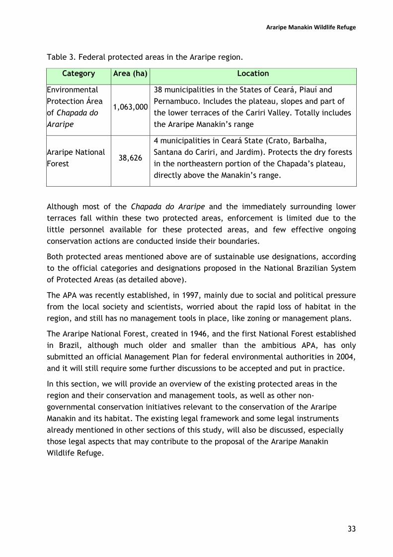
Table 3. Federal protected areas in the Araripe region.
Category Area (ha) Location
Environmental
Protection Área
of Chapada do
Araripe
1,063,000
38 municipalities in the States of Ceará, Piauí and
Pernambuco. Includes the plateau, slopes and part of
the lower terraces of the Cariri Valley. Totally includes
the Araripe Manakin’s range
Araripe National
Forest 38,626
4 municipalities in Ceará State (Crato, Barbalha,
Santana do Cariri, and Jardim). Protects the dry forests
in the northeastern portion of the Chapada’s plateau,
directly above the Manakin’s range.
Although most of the Chapada do Araripe and the immediately surrounding lower
terraces fall within these two protected areas, enforcement is limited due to the
little personnel available for these protected areas, and few effective ongoing
conservation actions are conducted inside their boundaries.
Both protected areas mentioned above are of sustainable use designations, according
to the official categories and designations proposed in the National Brazilian System
of Protected Areas (as detailed above).
The APA was recently established, in 1997, mainly due to social and political pressure
from the local society and scientists, worried about the rapid loss of habitat in the
region, and still has no management tools in place, like zoning or management plans.
The Araripe National Forest, created in 1946, and the first National Forest established
in Brazil, although much older and smaller than the ambitious APA, has only
submitted an official Management Plan for federal environmental authorities in 2004,
and it will still require some further discussions to be accepted and put in practice.
In this section, we will provide an overview of the existing protected areas in the
region and their conservation and management tools, as well as other non-
governmental conservation initiatives relevant to the conservation of the Araripe
Manakin and its habitat. The existing legal framework and some legal instruments
already mentioned in other sections of this study, will also be discussed, especially
those legal aspects that may contribute to the proposal of the Araripe Manakin
Wildlife Refuge.

Araripe Manakin Wildlife Refuge
34
Araripe National Forest (Floresta Nacional do Araripe)
Article 17th of the SNUC describes the main characteristics of a National Forest:
“Art.17. The National Forest is an area predominantly
covered by native plant species, with the basic objectives
of multiple sustainable use of its forest resources and
scientific research, with emphasis on methods for the
sustainable exploitation of native species.”
The Araripe National Forest was established in May 2nd 1946, and constitutes
the first protected area in its category to be established in Brazil (Figure 21). At that
time, only four other protected areas had formally been established in the country:
the Itatiaia (1937), the Iguaçu (1939) and the Serra dos Órgãos (1939) National Parks,
and the Biological Reserve of Soretama (1943). Basic information regarding the main
characteristics of the Araripe National Forest are summarized in Table 4.
Table 4. Main characteristics of the Araripe National Forest
Name: Araripe-Apodi National Forest (Official). Araripe National Forest (Usual)
Mailing Address: Praça Joaquim Fernandes Teles, s/n, Crato, CE, 63.100-000
Telephones: (55) (88) 3523-1999 (Office); (55) (88) 3501-1702 (Visitor Centre)
Internet or e-mail address: none
Area (ha): 38,262.33 hectares
(Register nº 7,433 in the Notaries Office of G. Lobo, Crato, Ceará)
Municipalities: Barbalha, Crato, Jardim and Santana do Cariri, all in Ceará
State.
Geographic coordinates: Northern tip: 07º11’42”S; Southern tip: 07º28’38”S;
Eastern tip: 39º13’28”W and Western tip: 39º36’33”W
Decree of creation: Federal Decree nº 9,226, May 2nd 1946, published in May
4th 1946.
Vegetation types: moist forests, tall savannah or cerradão, savannah or
cerrado, shrublands or carrasco.
Distance to nearest urban centres: Crato: 10 Km; Barbalha: 12 Km; Jardim: 18
Km; Santana do Cariri: 22 Km.
Road Access to the National Forest: BR-122 (via Exu, PE); CE-060 (via Jardim or
Barbalha, in CE); CE-292 (via Crato or Nova Olinda, CE); CE-494 (via Crato,
CE).

Araripe Manakin Wildlife Refuge
35
Although the National Forest was established in 1946, it had no management
plans or other effective conservation tools until 2001, when a concentrated effort led
by a former manager of the protected area led to the production of a preliminary
document, in 2003, that was presented for Environmental Authorities (i.e., Ministry of
Environment, IBAMA) in late 2004. In order to have an officially recognized forum to
conduct all the discussions required before the Plan was presented in Brasília, a
Consultive Council was established with 24 members divided as follows:
- 4 representatives from Federal governmental institutions, i.e., IBAMA
(Federal Environmental Agency), IBGE (National Institute for Geography and
Statistics), PNF (National Forest Program/Ministry of Environment), and
“Banco do Nordeste” (Regional Development Bank);
- 4 representatives from State governmental institutions, i.e., COGERH
(Water Management Agency), URCA (Regional State University), CBECE
(State Fire Department), and State’s Health Department (20th regional unit);
- 4 representatives from Municipal governmental institutions, i.e.,
municipalities of Crato, Barbalha, Jardim, and Santana do Cariri;
- 6 representatives from NGOs and associations, i.e., ACB, Oikos Cariri,
Araripe Foundation, Aconguia (Association of tourist guides), Federation of
the communities from Jardim, and Rural Workers Union of Crato;
- 6 representatives from communities in the buffer zone around the National
Forest, i.e., Serra da Boa Vista, Boca da Mata, Sítio Páscoa, Cacimbas,
Macaúba and Belmonte.
According to the manager of this protected area, the main activities legally
permitted and practiced today in the Araripe National Forest are:
1) Exploitation of plant materials – practiced since colonial times, it refers to
the subsistence and commercial activities related to the collection of roots,
barks, fruits, leaves, and resins of several native plants;
2) Firewood collection – the poor population that lives around the National
Forest is allowed to collect every Tuesday, firewood that is deposited in the
floor of the Forest, the use of axes and chainsaws for cutting living parts of
the plant are forbidden. There is a limit of one cubic meter per family per
month. Although several species are collected, some are preferred by their
caloric content and low smoke production characteristics, like the murici
species (Byrsonima ssp);
3) Environmental education and research – the Araripe National Forest
receives about 200 excursions from public and private schools every year,
for field classes and environmental education activities. About 15-20
excursions from universities are also recorded every year, including

Araripe Manakin Wildlife Refuge
36
researchers developing graduate theses. The Environmental Education
Facility promotes regular courses and talks in nearby schools and
communities;
4) Ecotourism – after a partnership was established between the protected
area and the State Secretary of Tourism, several tracks in the forest have
been implemented with maps and signs. One association of guided tours was
established, and the guides were trained and licensed by environmental
authorities to develop the ecotourism in the area.
The main problems and conflicts witnessed by the manager of the Araripe
National Forest are summarized as follows:
1) Illegal hunting – hunting of wildlife is practiced by subsistence, sport, and
commercial hunters, commonly using dogs, traps, and firearms. The main
target species for this illegal practice are deer, armadillos, agoutis, and
guans;
2) Roads – traditionally used to transport merchandise goods and people
between Ceará and Pernambuco States, this roads are older than the
protected area, and constitute a great enforcement problem to the
protected area, besides being a constant threat to the wildlife, provoking
several casualties, mainly foxes, skunks and small birds;
3) Urban expansion – population growth and the constant expansion of the
urban outskirts around the National Forest are resulting in negative impacts.
The illegal cutting of trees for building materials and fences is increasing,
together with the hunting pressure, honey extraction and forest fires;
4) Cattle raising – the practice of indiscriminate release of cattle in the
plateau of the Chapada during some periods of the year has more than 300
years. Despite enforcement efforts, it is still very widespread between
small and medium sized ranchers who claim to have not enough land for
their cattle, and creates a tense situation between the local society and the
environmental authorities. The ‘blind eye’ has been the management
practice adopted by the managers with few resources and lots of pressure
from local politicians and emerging ranchers.

Araripe Manakin Wildlife Refuge
37
Figure 21. The two main protected areas in the Araripe region: the Chapada do Araripe Environmental Protection Area
and the Araripe National Forest.

Araripe Manakin Wildlife Refuge
38
Chapada do Araripe Environmental Protection Area (APA)
Environmental Protection Areas are defined by the SNUC (Article 15th) as “a generally large area, with a certain degree of human occupation, which presents abiotic, biotic, aesthetic, and cultural features especially important to the quality of life and the well-being of the human populations, and has the basic objectives to protect the biological diversity, regulate the occupation processes, and assure the sustainability of the use of natural resources”.
Being large areas with significant human occupation, this category of Protected Areas are generally established in medium to highly impacted areas that demand urgent conservation and urban planning measures to avoid the collapse of some ecological services or natural resources that are vital to the local economy. Among the twelve categories established by the SNUC, this, in practice, has been the easiest to create - since it does not require land disappropriation or any other unpopular and expensive measures – and the hardest to manage, since everything is virtually possible, depending on the pressures that orient the zoning and management plans. This is also by far the most common Protected Area category in Brazil, and is becoming the most ineffective, since very few established Protected Areas of sustainable usage designation in Brazil have management plans in practice.
The creation of the huge 1-million hectare Chapada do Araripe Environmental Protection Area was triggered mainly by a concentrated effort by the scientific community of the Cariri Valley, who managed to draw the attention of the local society to the importance of some urgent conservation measures to protect one of the most valuable resources of the region: the waters that flow from the springs and streams from the great reservoir of the Chapada do Araripe, and the remaining vegetation that is responsible for the quantity and quality of this precious resource. The campaign was tremendously helped by recent scientific evidences that the major springs and streams were presenting alarming reductions in their outflow, and that the rich fossil beds of the region were being degraded. Local politicians soon joined the effort and the Chapada do Araripe Environmental Protection Area was created by Federal Decree in August 5th 1997 (FIGURE 27).
The objectives of this Protected Area, where the Araripe Manakin’s habitat is fully inserted, are (in the order they appear in the creation Decree; bold characters were included when they potentially refer to the conservation of the Araripe Manakin and its habitat):
- to protect the fauna and flora, especially the threatened species;
- to guarantee de conservation of remaining gallery forests, of the original natural
rainwater beds, and of the hydric reserves;
- to guarantee the protection of scenic, archaeological and paleontological sites of the Lower Cretaceous, of the Araripe Complex;
- to regulate ecological, scientific and cultural tourism, and the other economic activities compatible with environmental conservation;
- to promote incentives for the cultural manifestations, and contribute for the revival of the regional cultural diversity;
- to ensure the sustainability of natural resources, with emphasis in improving the quality of life of the populations residing in the Protected Area and its surroundings.

Araripe Manakin Wildlife Refuge
39
Thirty eight municipalities in three States are part of this huge area, and the urban areas of these municipalities are exempt of the regulations that will be proposed in the management plan. The same group that proposed the creation of the APA, also promoted an initial effort to subsidize a management plan, producing a comprehensive study financed by the Ministry of Environment. Although this process is expected to be faster than the one witnessed in the National Forest – which took 57 years from the creation of the area till the proposal of the management plan – the APA is still in the process of creating a Consultive Committee to discuss these matters based on the study mentioned above.
In this sense, the managers have to rely on the few restrictions posed in the initial decree, where some activities are forbidden (translated from the decree):
- implementation of potentially pollutant industrial activities, that may imply in environmental degradation and alterations in the water sources;
- development of land leveling or opening channels, when these activities result in alterations of the local ecological conditions, especially in the wildlife zones (proposed in the zoning and management plan);
- development of activities that may imply in accelerated erosion, silting of watersheds, or damaging the aquifers;
- development of activities that imply in the killing, capture, or harassing of rare species of the local biota;
- disposal of effluents, residues or detritus in the water resources of the APA, capable of producing environmental degradation.
The problems and conflicts faced by the managers of this Protected Area are enormous, ranging from illegal hunting, logging and extensive sacking of paleontological sites, to the expanding agricultural activities and urban settlements in almost all the 38 municipalities that comprise the area. Fortunately, for the conservation of the Araripe Manakin and its habitat, the headquarter of the manager of this protected area is located in the city of Crato, close to the Manakin’s range, and they seemed concerned about the protection of the remaining moist forest along the slopes of the Chapada.

Araripe Manakin Wildlife Refuge
40
2.3. The Chico Mendes Institute for the Conservation of Biodiversity
On August 28th 2007, the Brazilian Ministry of Environment announced the
creation of the Chico Mendes Institute for the Conservation of Biodiversity, (ICMBio)
which would have the mandate to take care of the creation and management of all
federal Protected Areas, and also conduct research and conservation actions with
endangered species. The conservation community was somewhat surprised by this
unilateral measure, since there was no public discussions and very little involvement
of protected area managers and other government employees involved with the
management of protected areas in the process. However, although there was some
initial uproar from some protected area managers and park rangers, the idea was soon
accepted, since the concept seemed interesting enough: to have a whole new
Institute for biodiversity protection.
The former governmental agency responsible for the protected areas and
natural resource management (i.e., IBAMA), has been since then responsible for
enforcement of environmental laws and regulations, and the issuing of permits and
environmental licensing.
From August 2007 till April 2008, the new Chico Mendes Institute was trying to
organize itself and its new structure without a proper budget. Employees were
relocated from IBAMA and the two Institutes were sharing their infrastructure and
materials. During this period, many conservation biologists had the feeling that
instead of two institutions we had “two halves”. To this date (November 2009), the
new Chico Mendes Institute has not yet been able to organize itself into a functioning
organization: they are still sharing office space with IBAMA, competing for the spoils
of the former organization (e.g., vehicles, equipment, buildings, etc), and struggling
with the federal government to give them a proper budget so that they can
effectively take the great responsibility to protect the Brazilian biodiversity.

Araripe Manakin Wildlife Refuge
41
Chapter 3
Building the Protected Area Proposal
3.1. Building scenarios
In order to facilitate decision-making and the involvement of stakeholders who are
not familiar with the Brazilian legal framework of protected areas, the project team
and some local partner initially tried to devise viable scenarios that would comply
with the proposals of the Conservation Plan of the Araripe Manakin and be legally and
socially acceptable.
The five categories of fully protected areas present in the National Protected Area
System were considered (i.e., Biological Reserve, Ecological Station, Wildlife Refuge,
National park and National Monument) and, according to their definitions, two were
considered viable for our purposes, the National Park and the Wildlife Refuge:
“Article 11. The National Park has the basic objective to preserve natural
ecosystems of great ecological relevance and scenic beauty, allowing
scientific research, environmental education and interpretation activities,
recreation in close contact with nature and ecotourism.”
“Article 13. The Wildlife Refuge has the objective to protect natural
environments that ensure conditions to the existence or reproduction of
species or communities of the local flora and of resident and migratory
fauna.”
National Protected Area System (MMA, 2000)
In this sense, preliminary meetings with the managers and the teams of the two
existing protected areas in the Araripe were conducted to discuss the viable scenarios
and 3 alternatives were designed:
1) Produce a Management Plan for the existing APA Chapada do Araripe, with
the Manakin’s habitat and the water springs included in its zoning as a no-take
area for strict protection of the moist forest habitats and the water springs;
2) Create a fully protected area (Araripe Manakin Wildlife Refuge) along the
slopes of the Chapada do Araripe to protect the moist forest habitats and the
water springs;
3) Create a larger fully protected area (Chapada do Araripe National Park) to
encompass the slopes and part of the Araripe plateau.
Araripe Manakin Wildlife Refuge
42
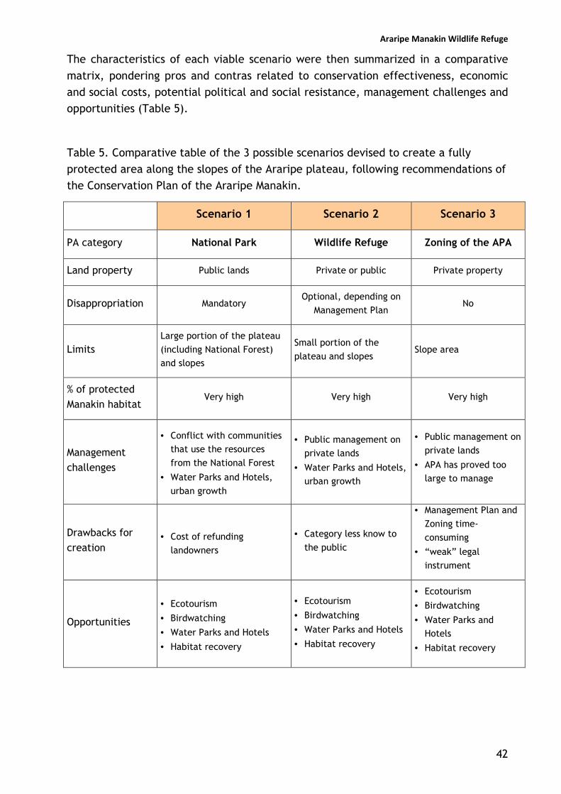
The characteristics of each viable scenario were then summarized in a comparative
matrix, pondering pros and contras related to conservation effectiveness, economic
and social costs, potential political and social resistance, management challenges and
opportunities (Table 5).
Table 5. Comparative table of the 3 possible scenarios devised to create a fully
protected area along the slopes of the Araripe plateau, following recommendations of
the Conservation Plan of the Araripe Manakin.
Scenario 1 Scenario 2 Scenario 3
PA category National Park Wildlife Refuge Zoning of the APA
Land property Public lands Private or public Private property
Disappropriation Mandatory Optional, depending on
Management Plan No
Limits Large portion of the plateau
(including National Forest) and slopes
Small portion of the
plateau and slopes Slope area
% of protected Manakin habitat
Very high Very high Very high
Management challenges
• Conflict with communities that use the resources
from the National Forest
• Water Parks and Hotels,
urban growth
• Public management on
private lands
• Water Parks and Hotels, urban growth
• Public management on
private lands
• APA has proved too large to manage
Drawbacks for creation
• Cost of refunding
landowners
• Category less know to
the public
• Management Plan and
Zoning time-
consuming
• “weak” legal
instrument
Opportunities
• Ecotourism
• Birdwatching
• Water Parks and Hotels
• Habitat recovery
• Ecotourism
• Birdwatching
• Water Parks and Hotels
• Habitat recovery
• Ecotourism
• Birdwatching
• Water Parks and Hotels
• Habitat recovery

Araripe Manakin Wildlife Refuge
43
3.2. Discussing scenarios with key stakeholders and local communities
The three proposed scenarios for the creation of a fully protected area (i.e, National
Park, Wildlife Refuge, and the Zoning of the APA) were then presented to individuals
and organizations, representing groups of stakeholders.
The discussions, meetings with government authorities and presentations in rural
communities were jointly conducted by the team of educators and the protected area
team. In this topic, we will present an overview of the groups of stakeholders that
have been involved in the discussions of the creation of a fully protected area, trying
to characterize each group and summarize its contributions.
Government authorities
These have been key stakeholders and have participated closely in the construction of
the proposal of the fully protected area for the Araripe, especially:
• the manager of the APA Chapada do Araripe;
• the manager of the Araripe National Forest;
• the Director of the regional office of the State’s Water Management Agency;
• the Municipal Secretary of Environment of Crato.
Besides participating in the discussions, these stakeholders have also later signed the
formal document to request from the Ministry of Environment/Chico Mendes Institute
for Biodiversity Conservation the creation of the fully protected area.
In terms of creating a fully protected area there is a consensus among government
authorities that the slopes of the Araripe plateau have to be fully protected in order
to preserve its rich and endemic biodiversity, and to guarantee the protection of the
numerous water springs.
Rural communities and small landowners
The rural communities found along the lower slopes of the Chapada are mainly
concentrated in small villages, or scattered along the roads that run along the
foothills of the Araripe. Although they benefit from the pleasant climate and the
abundance of water, the lack of environmental awareness, together with the limited
economic opportunities and social policies, leads to traditional, but generally
unsustainable use of those resources.

Araripe Manakin Wildlife Refuge
44
The main economic activities in the rural areas along the Manakin’s range (i.e., Crato,
Barbalha and Missão Velha municipalities) are: small-scale agriculture (banana,
maize, beans, cassava); Backyard-grown chicken and medium-sized mammals (e.g.,
goat and pig); extensive cattle farming; small business for general household supplies;
and employment in the nearby towns and recreational parks.
Although these communities use little pesticides and fertilizers – more so because of
the costs rather than for environmental and health concerns – their traditional
methods of “slash and burn” for clear cutting the lower slopes for agriculture and
cattle, and the diversion of streams for irrigation purposes, has had profound effects
on the vegetation cover of the Araripe, especially along the lowlands and lower
slopes.
However, most of the people of the local communities that participated in the
activities expressed a strong desire to understand the environmental changes they
have been witnessing for the past decades (e.g., reduction in stream outflow, scarcity
of wildlife), and were eager to discuss ways to reduce their impact over their
environment (Figures 22 and 23).
Regarding the protected area, the majority was inclined to support the proposal if it
would help to improve water availability and reduce the conflicts for water use with
the larger landowners, who in some places deny the access to springwater. These
communities would also favor the scenario where only the slopes and part of the
plateau is protected (Wildlife Refuge scenario). Although they want the forest on top
of the plateau to be protected, they also express the desire to continue using the
forest resources, like wood for fuel and construction, fruits, animals, and grazing
areas.
Some of the small landowners, especially the ones who moved to nearby towns and
kept their properties as a complementary income or vacation house, have expressed
the desire to promote the conservation of the remaining moist forests in their slope
properties. One of them has actually started the process to turn part of the property
into a Private Reserve.
Table 6 summarizes some of the key rural communities along the slopes of the
Chapada, in the Manakin’s range and neighbouring areas of remaining moist forests,
and Table 7 shows some small landowners interested in the conservation of the
Manakin’s habitat.

Araripe Manakin Wildlife Refuge
45
Figure 22. Discussions with rural communities about sustainable living, the
Protected Area scenarios and their implications for their lives. Arajara District,
Barbalha municipality.
Figure 23. Discussions with rural
communities that depends on the collection
of the “pequi” fruit in the National Forest.
Cacimbas locality, on the road between the
municipalities of Barbalha and Jardim.

Araripe Manakin Wildlife Refuge
46
Table 6. Key rural communities along the Manakin’s range where the protected area
was presented and discussed.
Communities Municipality Description
Jamacaru Missão Velha Rural village in the eastern extreme of the Manakin’s distribution
Gameleira Missão Velha Small community in the foothills of the chapada, close to some important nesting areas.
Arajara Barbalha Rural village, type locality of the Araripe Manakin, potential for hosting ecotourism and birdwatching activities.
Riacho do Meio Barbalha
In the outskirts of Barbalha, this area has also potential for ecotourism and birdwatching activities. The underutilized facilities of the municipal park could support meetings.
Granjeiro Crato
One of the best nesting areas found so far, this rural area in the outskirst of Crato is developing into an elite neighbourhood, displacing the rural community, or hiring them as caretakers.
Guaribas Crato
String of houses and small properties scattered along the road in the foothills of the Chapada, this is the western extreme of the Manakin’s distribution, with potential for rural tourism (e.g., waterfalls, sugar cane mills).
(Source: fieldwork survey)
Table 7. Small landowners in Manakin’s range interested in preserving the moist
forests and supporting the creation of the fully Protected Area.
Landowner Municipality Description
José Wolkmar (Sítio Melo)
Barbalha
Local artist interested in preserving the remaining moist forests. At least three streams were recorded in this property with viable territories dominated by adult males.
Jácio Missão Velha Local politician whose property encompasses nesting areas, and has offered logistical support for research.
Heitor de Santana
Missão Velha
Araripe Mankin’s nesting area. Local landowner who has already started the process to establish a Private Reserve (RPPN), and is very concerned about environmental regulations.
(Source: fieldwork survey)
Araripe Manakin Wildlife Refuge
47
Large landowners and recreational clubs
Large agricultural activities are rare in the slopes of the Chapada, since the steep
terrain does not allow the use of heavy machinery, and most of the large properties
are related to recreational clubs located in the foothills of the Chapada, and use the
abundant water resources to maintain artificial pools and cascades.
In this sense, since these enterprises depend on a constant supply of springwater,
they are concentrated in the northeastern slope of the Chapada, in the Araripe
Manakin’s range. They usually channel the water springs and divert the streams to
provide their water needs, suppressing totally or partially the gallery forests that
compose the Manakin’s nesting territories.
Although some of these areas are officially protected (a portion of the Arajara Park,
the type locality of the Araripe Manakin, was turned into a private reserve, as part of
the environmental compensations negotiated with governmental agencies) the
effective protection of the region’s biodiversity is not guaranteed. Logging and water
channeling are common practices.
Most of these clubs have been experiencing losses due to environmental problems,
especially the reduction of spring outflow and the erosion caused by the suppression
of the slope vegetation cover, and some of them, especially the Arajara Park – the
biggest club and located in the type locality of the Araripe manakin - are becoming
more interested in ecotourism and birdwatching. Table 8 lists some of the main clubs
and recreational parks in the Manakin’s range, especially the ones located in nesting
areas.
These enterprises seemed to be interested in the creation of the protected area,
mainly because they would guarantee the surrounding forests around their properties
and probably improve spring outflow, one of their major concerns presently. They
would support any relocation or disappropriation of lands, but seemed interested in
promoting active habitat recovery. One of the water parks have already started to
experiment with planting along the slopes to reduce the risk of landsliding.
This group of stakeholders seemed more inclined to the scenario where there is no
disapropriation (Wildlife Refuge, since they also do not believe that the Zoning of the
APA would have any significant practical impact on the conservation of slope forests).

Araripe Manakin Wildlife Refuge
48
Table 8. Main recreational parks in the Manakin’s range.
Recreational
Park
Municipality Description
Arajara Park Barbalha
Type locality of the Araripe Manakin. Presently the easiest place to spot the Araripe Manakin, due to the easy access, and consistently visited by foreign groups of birdwatchers. The Park has established a Private Reserve (RPPN), but landslidings are still common during the rainy season. Park management is friendly to the Araripe Project and willing to do participate in the discussions.
Caldas Club Barbalha Weekend club, has produced several alterations in the streams and suppression of gallery forests.
Riacho do Meio Ecological Park
Barbalha
Municipal park. Although part of the gallery forests have been suppressed for the construction of concrete pools, it still presents some nesting areas. There are no management actions implemented, but the municipality has expressed the desire to manage it in a more conservation-minded way. Could become an important visiting area for birdwatching and environmental education.
Granjeiro Club Crato
Weekend club, has produced several alterations in the streams and suppression of gallery forests. Neighboring areas with natural vegetation comprise the best nesting areas found so far.
Serrano Club Crato Weekend club, has produced several alterations in the streams and suppression of gallery forests.
‘Serviço Brasileiro de Apoio às Micro e Pequenas Empresas’ (SEBRAE)
Crato Non-profit organization that supports the competitiveness and sustainable development of small businesses. It is a result of the union of both public and private sectors, and research entities.
‘Serviço Social do Comércio’ (SESC)
Crato Non-profit institution which main goal is to promote the cultural and artistic development and social welfare, as well as improve the quality of life of workers in the trade and service industries.
Associação dos Produtores Rurais
Crato Landowners’ association.
(Source: fieldwork survey)

Araripe Manakin Wildlife Refuge
49
Other institution that deserves attention for already getting involved in the actions to
promote the Conservation of the Chapada do Araripe are: FECOMERCIO, the State’s
trade organization, and the ‘Serviço Social do Comércio’ (SESC/Crato). Both
institutions were involved in the logistics and financing the materials for the
exhibition promoted in the city of Crato central square, showing a great interest in
taking part of the long-term initiative (Figure 24).
Figure 24. Outdoor in Crato’s central square about the
conservation of the Araripe manakin and the region’s natural
resources, sponsored by Ceará State Trade Federation.
The ‘Serviço Brasileiro de Apoio às Micro e Pequenas Empresas’ (SEBRAE) is also a
potential partner once it is developing the ‘Programa Araripe’, an initiative of SEBRAE
of Ceará, Pernambuco and Piauí States, aiming the integrated and sustainable
development of the Chapada do Araripe, through environment management. This
programme is being developed in partnership with ‘Fundação Araripe’, ‘Universidade
Regional do Cariri’, ‘Fundação de Desenvolvimento Tecnológico do Cariri’
(FUNDETEC), and has the participation of IBAMA, and the Ministry of Integration,
among other government bodies.

Araripe Manakin Wildlife Refuge
50
Local NGOs
There are a number of NGOs and civil society organizations working in Chapada do
Araripe (Table 9). Most of them are working with children, education and/or focused
on improving economic activities, a consequence of the region’s socioeconomic
limited opportunities. The most active NGOs are located in Crato; among these, two
must be highlighted: ‘Fundação Araripe’ and ‘Associação Cristã de Base’. The first one
develops projects involving landscape planning, public health, environment
conservation, watershed protection, research and dissemination. Among its main
projects is the socioeconomic and biological study produced to support the
development of the Management Plan of the protected area APA Chapada do Araripe.
The second one seems to be developing a consistent work involving the local
communities, specially related to the promotion of a better quality of life using
agroforestry systems and ‘organic’ certificates for small farmers.
One NGO in Nova Olinda municipalty, “Casa Grande”,although not directly located in
the Manakin’s range, has been developing communications tools for the local
communities (e.g., community radio) and is very influential with the rural
communities, since they provide free education for their children (Figure 25). When
visited, both the children and their teachers agreed immediately to sign a petition to
create the Fully Protected Area along the slopes of the Chapada, and disseminate the
idea among their communities.
Regarding the creation of the fully protected area, two influential NGOs responded in
different ways. A representative of the board of the Fundação Araripe expressed that
the foundation would rather insist on producing a Management Plan and Zoning of the
APA Chapada do Araripe instead of creating a fully protected area. Since the
Fundação Araripe was co-responsible for the proposal and creation of the huge and
little managed Sustainable Use APA Chapada do Araripe, they are struggling to
produce a Management Plan for this PA and promote its proper management.
Another NGO, Associação Cristã de Base, whose main activities are related to the
promotion of social welfare through improving agricultural techniques, would support
the full protection of the slopes, but would not be sympathetic to the full protection
of the National Forest.

Araripe Manakin Wildlife Refuge
51
Table 9. Nongovernmental organizations in the key municipalities of the Araripe
Project that were visited to discuss the protected area and the conservation process.
Name Description Contact
‘Associação Cristã de
Base’
NGO of socio-environmental
focus. It works in partnership
with other associations, directly
involving local community
(mainly in the rural area), aiming
to promote of a better quality of
life through the development
and dissemination of agroforestry
systems.
Rua dos Cariris, n. 61,
Centro – Crato – CE –
Brazil, 63100-000,
PO Box: 206
Phone/fax: (88) 3521 3005
e-mail:
‘Fundação Araripe’ Develops projects involving
research on landscape planning,
public health, environment
conservation, water
conservation. One of its main
projects: the socioeconomic and
biological study produced to
support a Management Plan for
the APA Chapada do Araripe.
Rua Santos Dumont, n. 88,
Centro – Crato – CE –
Brazil, 63100-040,
PO Box: 206
Ph: (88) 3523 1605
Phone/fax: (88) 3521 5033
e-mail:
‘Fundação de
Desenvolvimento
Tecnológico do
Cariri’ (FUNDETEC)
Private research and training
institution, also involved in the
‘Programa Araripe’. It is focused
on promoting the sustainable
development of the Araripe
region, through research for the
promotion of public policies, and
capacity building.
Rua Teófilo Siqueira, n.
734, Pimenta – Crato – CE
– Brazil, 63100-010
‘Sindicato dos
Trabalhadores
Rurais’
Affiliated to the Brazilian
Workers Central Union (CUT)
and FETAGRI (‘Federação dos
Trabalhadores na Agricultura’),
deals with issues related to the
improving working and welfare
conditions of rural workers.
Rua Pedro II, n. 56 Crato –
CE – Brazil, 63100-100,
PO Box: 72

Araripe Manakin Wildlife Refuge
52
‘Associação dos
Cordelistas do Crato’
Institution developed to preserve
and disseminate the cordel
cultural tradition. It is very
active in the Chapada do Araripe
region, and has produced a
cordel edition especially
dedicated to the Araripe Manakin
conservation issues, per request
of the Araripe project team.
‘NGO Candeeiro das
Trilhas’
Local NGO which is concerned
about the conservation of
watershed ecosystems along the
slopes of the chapada.
(Source: fieldwork survey)
Figure 25. Presentation and discussion about the Protected Area scenarios for
students and teachers in the influential NGO “Casa Grande”in Nova Olinda
municipality, located in the foothills of the Chapada do Araripe, neighboring Crato
municipality (probably a part of the original range of the Araripe Manakin).

Araripe Manakin Wildlife Refuge
53
External NGOs working in the area
The Chapada do Araripe attracts the attention of external NGOs, both Brazilian and
foreign. These organizations support the work developed by local NGOs, as it is the
case of the Conservation Leaderhip Programme (involving Fauna & Flora International,
Conservation International, Wildlife Conservation Society and BirdLife International),
which has been participating in the process through awards, training and team
capacity building and other types of technical and logistical support.
SAVE Brasil, the Birdlife representative for Brazil, has also been participating and
sharing technical expertise in protected area creation and management and the
management of private reserves.
Research Institutions
Four Universities of State and Federal administration are involved in the conservation
process of the Araripe Manakin and have contributed with their expertise and
research experience in the Araripe Basin for the definition of the best scenario for the
creation of a protected area in the Araripe (Table 10).
Table 10. Research institutions involved in the Araripe Manakin’s Conservation Process
and the discussions of the fully protected area.
Name Description Contact
Universidade Regional do Cariri (URCA)
State University which plays a strong role on scientific research in the Cariri Valley, especially related to biology and palaeontology.
Rua Cel. Antônio Luiz, n. 1161, Pimenta – Crato – CE – Brazil, Ph: (88) 3102 1212 e-mail: [email protected]
Universidade Federal do Pará (UFPA) – Campus de Bragança
Federal University located in Pará State, partner in the Manakin Project responsible for the genetic analyses.
Alameda Leandro Ribeiro, s/n bloco B, Aldeia – Bragança – PA – Brazil Ph. (91) 3425 1209
Universidade Federal do Ceará (UFC)
Federal University located in Fortaleza, Ceará, who is helping to identify the plant species in the Manakin’s diet.
Av. da Universidade, n. 2853, Benfica – Fortaleza – CE – Brazil CEP: 60020-181 Ph. (85) 4009 7300
Universidade Federal de Pernambuco (UFPE)
Federal University located in Recife, Pernambuco, who is colaborating in the identification of plant species in the Manakin’s diet.
Av. Prof. Moraes Rego, n. 1235, Cidade Universitária - Recife – PE CEP: 50670-901 Ph. (81) 2126 8000

Araripe Manakin Wildlife Refuge
54
3.3. Land tenure assessment
Originally, we expected to produce a preliminary land tenure assessment to facilitate
the process of creating a fully protected area in the Araripe, since the former federal
environmental authorities responsible for Protected Area creation and management
(i.e., IBAMA) oriented us to produce this type of land tenure assessment.
However, with the creation of a new agency to take care of the Protected Areas and
biodiversity conservation in Brazil (i.e., the Chico Mendes Institute for Biodiversity
Conservation/ICMBio), new methods and procedures were devised by this Institute.
When our team consulted the ICMBio authorities concerning the new models for land
tenure assessment for the creation of Protected Areas, we were told that this type of
assessments – especially when dealing with fully Protected Areas, where
disappropriation may be applicable – would only be accepted as part of the formal
process to create a new protected area if performed by some State or Federal
governmental agency.
In this sense, the team decided to concentrate field efforts in the detailed mapping of
the limits and contour of the proposed fully Protected Area, while partnering with the
federal and State agencies responsible for this type of land tenure assessment, i.e.,
INCRA (National Institute for Colonization and Land Reform) and IDACE (Institute for
Agrarian Development of the State of Ceará), respectively.
Initially, the team discussed the matter with technician from the federal agency
mentioned above (i.e., INCRA), who found out that an extensive assessment was
already planned for the region but it would include dozens of municipalities and
might take a couple of years to be completed. They suggested that our team should
talk to the President of this Institute, explaining the reasons to conduct the land
assessments and asking him to put a priority on the three municipalities were the
Protected Area is proposed, so that the technical personnel could start the fieldwork
in Barbalha, Missão Velha and Crato.
Thanks to the interest and involvement of the technical staff from INCRA, we
managed to set up a meeting with the President of the regional office of INCRA in
Ceará. The President was very concerned about the protection of the slopes of the
Araripe plateau and approved the idea of starting the assessment in the municipalities
affected by the Protected Area proposal.
As this report was being closed, the assessments of the municipalities of Barbalha and
Missão Velha were finished, and the assessment of Crato is expected to be ready by
early 2010. These are being made by a state agency (i.e., IDACE/Institute for Agrarian
Development of the State of Ceará) hired by the federal agency (i.e., INCRA/National
Institute for Colonization and Land Reform).
This is a very detailed assessments compiled with extensive fieldwork, visits to the
properties, interviews with landowner and registrar’s offices in the region. As soon as

Araripe Manakin Wildlife Refuge
55
this assessment is ready, we will be delivering the final product to the federal
environmental authorities responsible for the creation process of the fully Protected
Area in the Araripe.
In order to produce a more general assessment identifying trends and general aspects
of land ownership and property size in the Araripe, our team has also compiled some
information available through the National Institute for Colonization and Land Reform
(INCRA), and produced a more general assessment of the history of human
settlements in the Araripe and its main economic cycles, including some comments
about water use and spring ownership that might be useful for government official to
understand some characteristics of the land and water tenure issues in the Araripe, as
detailed below.
The history of permanent European settlements in the Araripe is not very old, and
dates back to the mid-eighteenth century. The territory was occupied by cattle
farmers that came from Bahia and Pernambuco provinces. The cultivation of sugar
cane in large scale was most evident in the coastal areas of Northeastern Brazil, due
to soil and climate conditions, and livestock raising was then developed to promote
the inland occupation of semi-arid backlands, and to secure the transportation of
sugar cane and timber.
The expansion of large sugar cane and livestock raising areas are the most important
causes of land concentration in the state of Ceará. Two other relevant cultures that
also contributed to this process was the cotton and tobacco cultivation. The
northeastern economy is predominantly based on agriculture, and 60% of its
population lives in rural areas (INCRA, 1998). The same is valid to Ceará state and the
Chapada do Araripe.
The analysis of the land use and tenure in the Chapada do Araripe, aiming to gather
information about the properties with watersheds where the Araripe Manakin occurs
is an issue that demands a great effort, because there are more than 120 streams
along the species range. In addition to this fact, there is a historical problem
originated in 1854 with the creation of a local law (Law 645, January 17th 1854),
which allowed the tenure of water. According to this law, a watershed can have one
or more owners who use the water according to the quotes established on the
watershed deeds. This model is still adopted in the region and led to a market of
water, contradicting the state and federal legislation, where the water is of public
property, management and use.
As consequence, any land use and tenure assessment must collect information about
properties and their spring “owners”. Because of this, we will present here an
overview of land tenure situation in the region of the Chapada do Araripe, based on
the Census promoted by ‘Instituto Nacional de Colonização e Reforma Agrária’

Araripe Manakin Wildlife Refuge
56
(INCRA), in 1998, but a further detailed assessment is in progress, as mentioned
above.
In relation to the total area surveyed through the census, most of the properties in
Barbalha (Table 11) and Missão Velha (Table 13) are small lands (between 1 and 4
hectares). In Crato, the scenery is slightly different, and the average of small and
large properties (more than 15 hectares) is similar (Table 12). The large properties,
although being less numerous, represent more than 50% of the total area in all three
municipalities indicating that there is high land concentration in the region.
Brazilian environmental laws require that 20% of a rural property has to be preserved
and managed in such a way that it will permanently assure the maintainance of the
original vegetation cover. This is called ‘Legal Reserve’. Another legal instrument
aimed to protect critical ecosystems, the Forest Code (Federal Law 4,771/1965)
establishes one category of protection for different types of vegetation, called ‘Areas
of Permanent Protection’, including mangroves, vegetation along rivers, streams, and
springs, vegetation located in slopes steeper than 45°, etc.
In this sense, regarding the properties with established ‘Areas of Permanent
Protection’ (APPs) and ‘Legal Reserves’ in all three municipalities, the amount of
lands with these designation is very small, especially the ‘Legal Reserve’. It is
important to notice that few landowners designate their lands as ‘Legal Reserves’ or
‘APPs’, and this is usually done when forced by environmental authorities or
governmental investment banks. In all three municipalities these protect areas are
more frequent in medium (between 5 and 15 hectares) and large properties (Tables
14, 15 and 16). Barbalha and Missão Velha, even with smaller number of properties
with ‘APPs’ (Table 14 and 16), proportionally have larger number of hectares of
protected areas than Crato (Table 15). Missão Velha is also the municipality with more
areas (in number and hectare) of ‘Legal Reserve’.
Regarding the type of economic activities, in Barbalha most of the properties are
focused on agriculture. However, the total area (hectares) used for livestock raising is
almost the same to one used for agriculture, probably a result of the extensive
livestock raising system. There are few properties with native species reforested
areas, and, on the other hand there are a great number of lands with extractive
agriculture and forestry activities. Both agriculture and livestock raising activities are
concentrated in large properties (Table 17).
Also in Crato most of the properties are focused on agriculture. However, the total
area used for livestock raising is larger than the total used for agriculture, what is
also a result of the extensive livestock raising system. There are some properties with
native species reforested areas and, on the other hand, there are few lands with
extractive agriculture and forestry activities. Both agriculture and livestock raising
activities are concentrated in large properties (Table 18).
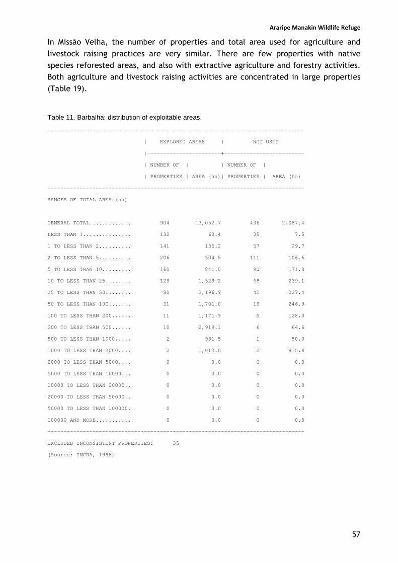
Araripe Manakin Wildlife Refuge
57
In Missão Velha, the number of properties and total area used for agriculture and
livestock raising practices are very similar. There are few properties with native
species reforested areas, and also with extractive agriculture and forestry activities.
Both agriculture and livestock raising activities are concentrated in large properties
(Table 19).
Table 11. Barbalha: distribution of exploitable areas.
--------------------------------------------------------------------------------
| EXPLORED AREAS | NOT USED
|-----------------------+-------------------------
| NUMBER OF | | NUMBER OF |
| PROPERTIES | AREA (ha)| PROPERTIES | AREA (ha)
--------------------------------------------------------------------------------
RANGES OF TOTAL AREA (ha)
GENERAL TOTAL............. 904 13,052.7 436 2,087.4
LESS THAN 1............... 132 60.4 35 7.5
1 TO LESS THAN 2.......... 141 135.2 57 29.7
2 TO LESS THAN 5.......... 206 504.5 111 106.6
5 TO LESS THAN 10......... 160 841.0 90 171.8
10 TO LESS THAN 25........ 129 1,529.2 68 239.1
25 TO LESS THAN 50........ 80 2,196.9 42 227.4
50 TO LESS THAN 100....... 31 1,701.0 19 246.9
100 TO LESS THAN 200...... 11 1,171.9 5 128.0
200 TO LESS THAN 500...... 10 2,919.1 6 64.6
500 TO LESS THAN 1000..... 2 981.5 1 50.0
1000 TO LESS THAN 2000.... 2 1,012.0 2 815.8
2000 TO LESS THAN 5000.... 0 0.0 0 0.0
5000 TO LESS THAN 10000... 0 0.0 0 0.0
10000 TO LESS THAN 20000.. 0 0.0 0 0.0
20000 TO LESS THAN 50000.. 0 0.0 0 0.0
50000 TO LESS THAN 100000. 0 0.0 0 0.0
100000 AND MORE........... 0 0.0 0 0.0
--------------------------------------------------------------------------------
EXCLUDED INCONSISTENT PROPERTIES: 35
(Source: INCRA, 1998)

Araripe Manakin Wildlife Refuge
58
Table 12. Crato: distribution of exploitable areas.
--------------------------------------------------------------------------------
| EXPLORED AREAS | NOT USED
|---------------------+---------------------------
|NUMBER OF | | NUMBER OF |
|PROPERTIES| AREA (ha)| PROPERTIES | AREA (ha)
--------------------------------------------------------------------------------
RANGES OF TOTAL AREA (ha)
GENERAL TOTAL............. 1,449 36,918.5 1,194 11,341.1
LESS THAN 1............... 105 49.8 64 9.4
1 TO LESS THAN 2.......... 108 119.7 75 26.7
2 TO LESS THAN 5.......... 267 619.0 209 214.3
5 TO LESS THAN 10......... 247 1,235.2 209 431.5
10 TO LESS THAN 25........ 299 3,477.8 261 1,165.3
25 TO LESS THAN 50........ 213 4,983.0 191 1,983.3
50 TO LESS THAN 100....... 112 5,488.5 97 1,835.2
100 TO LESS THAN 200...... 55 5,447.9 50 1,781.8
200 TO LESS THAN 500...... 31 7,257.6 27 1,806.6
500 TO LESS THAN 1000..... 9 3,950.0 9 1,566.5
1000 TO LESS THAN 2000.... 2 2,084.0 1 345.5
2000 TO LESS THAN 5000.... 1 2,206.0 1 175.0
5000 TO LESS THAN 10000... 0 0.0 0 0.0
10000 TO LESS THAN 20000.. 0 0.0 0 0.0
20000 TO LESS THAN 50000.. 0 0.0 0 0.0
50000 TO LESS THAN 100000. 0 0.0 0 0.0
100000 AND MORE........... 0 0.0 0 0.0
--------------------------------------------------------------------------------
EXCLUDED INCONSISTENT PROPERTIES: 51
(Source: INCRA, 1998)

Araripe Manakin Wildlife Refuge
59
Table 13. Missão Velha - distribution of exploitable areas.
--------------------------------------------------------------------------------
| EXPLOITABLE | NOT USED
|-------------------------+-----------------------
| NUMBER OF | | NUMBER OF |
| PROPERTIES | AREA (ha) | PROPERTIES | AREA (ha)
--------------------------------------------------------------------------------
RANGES OF TOTAL AREA (ha)
GENERAL TOTAL............. 730 31,815.4 137 1,509.0
LESS THAN 1............... 4 2.9 0 0.0
1 TO LESS THAN 2.......... 35 47.5 0 0.0
2 TO LESS THAN 5.......... 107 349.5 7 7.7
5 TO LESS THAN 10......... 134 937.7 15 30.1
10 TO LESS THAN 25........ 190 2,823.9 33 163.3
25 TO LESS THAN 50........ 107 3,647.8 19 139.6
50 TO LESS THAN 100....... 78 4,801.9 29 274.0
100 TO LESS THAN 200...... 49 6,120.3 19 265.9
200 TO LESS THAN 500...... 21 5,140.0 13 616.5
500 TO LESS THAN 1000..... 4 1,852.9 2 11.9
1000 TO LESS THAN 2000.... 0 0.0 0 0.0
2000 TO LESS THAN 5000.... 0 0.0 0 0.0
5000 TO LESS THAN 10000... 1 6,091.0 0 0.0
10000 TO LESS THAN 20000.. 0 0.0 0 0.0
20000 TO LESS THAN 50000.. 0 0.0 0 0.0
50000 TO LESS THAN 100000. 0 0.0 0 0.0
100000 AND MORE........... 0 0.0 0 0.0
---------------------------------------------------------------------------------
EXCLUDED INCONSISTENT PROPERTIES: 29
(Source: INCRA, 1998)

Araripe Manakin Wildlife Refuge
60
Table 14. Barbalha: distribution of the properties with permanent protection areas.
-----------------------------------------------------------------------------------------------------------------------------------------------
|PROPERTIES WITH AREAS OF PERMANENT PROTECTION (APPs)| PROPERTIES WITH AREAS OF LEGAL RESERVE
|--------------------------------------------- ------+-----------------------------------------------------------
|NUMBER OF |TOTAL AREA (ha) OF THE | TOTAL AREA (ha)|NUMBER OF | TOTAL AREA (ha) OF THE | TOTAL AREA (ha)
|PROPERTIES | PROPERTIES WITH APPs | OF APPS |PROPERTIES |PROPERTIES WITH LEGAL RESERVE|OF LEGAL RESERVE
-----------------------------------------------------------------------------------------------------------------------------------------------
RANGES OF TOTAL AREA (ha)
GENERAL TOTAL............. 18 2,531.5 426.0 2 1,318.9 258.0
LESS THAN 1............... 1 0.4 0.1 0 0.0 0.0
1 TO LESS THAN 2.......... 1 1.1 0.1 0 0.0 0.0
2 TO LESS THAN 5.......... 1 4.8 2.0 0 0.0 0.0
5 TO LESS THAN 10......... 1 8.0 2.0 0 0.0 0.0
10 TO LESS THAN 25........ 6 112.0 30.3 0 0.0 0.0
25 TO LESS THAN 50........ 3 118.4 42.5 0 0.0 0.0
50 TO LESS THAN 100....... 2 126.8 26.0 0 0.0 0.0
100 TO LESS THAN 200...... 0 0.0 0.0 0 0.0 0.0
200 TO LESS THAN 500...... 1 261.6 30.0 1 201.5 40.0
500 TO LESS THAN 1000..... 1 525.6 3.0 0 0.0 0.0
1000 TO LESS THAN 2000.... 1 1,372.8 290.0 1 1,117.4 218.0
2000 TO LESS THAN 5000.... 0 0.0 0.0 0 0.0 0.0
5000 TO LESS THAN 10000... 0 0.0 0.0 0 0.0 0.0
10000 TO LESS THAN 20000.. 0 0.0 0.0 0 0.0 0.0
20000 TO LESS THAN 50000.. 0 0.0 0.0 0 0.0 0.0
50000 TO LESS THAN 100000. 0 0.0 0.0 0 0.0 0.0
100000 AND MORE........... 0 0.0 0.0 0 0.0 0.0
---------------------------------------------------------------------------------------------------------------------------------------------
EXCLUDED INCONSISTENT PROPERTIES: 5
(Source: INCRA, 1998)
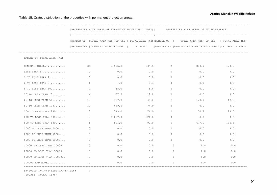
Araripe Manakin Wildlife Refuge
61
Table 15. Crato: distribution of the properties with permanent protection areas.
-------------------------------------------------------------------------------------------------------------------------------------------------
|PROPERTIES WITH AREAS OF PERMANENT PROTECTION (APPs)| PROPERTIES WITH AREAS OF LEGAL RESERVE
|--------------------------------------------- ------+-----------------------------------------------------------
|NUMBER OF |TOTAL AREA (ha) OF THE | TOTAL AREA (ha)|NUMBER OF | TOTAL AREA (ha) OF THE | TOTAL AREA (ha)
|PROPERTIES | PROPERTIES WITH APPs | OF APPS |PROPERTIES |PROPERTIES WITH LEGAL RESERVE|OF LEGAL RESERVE
-------------------------------------------------------------------------------------------------------------------------------------------------
RANGES OF TOTAL AREA (ha)
GENERAL TOTAL............. 36 3,585.3 534.5 5 899.0 173.0
LESS THAN 1............... 0 0.0 0.0 0 0.0 0.0
1 TO LESS THAN 2.......... 0 0.0 0.0 0 0.0 0.0
2 TO LESS THAN 5.......... 1 4.0 0.3 0 0.0 0.0
5 TO LESS THAN 10......... 2 15.0 8.6 0 0.0 0.0
10 TO LESS THAN 25........ 4 67.5 12.8 0 0.0 0.0
25 TO LESS THAN 50........ 10 337.3 45.0 3 120.9 17.5
50 TO LESS THAN 100....... 10 669.6 74.9 0 0.0 0.0
100 TO LESS THAN 200...... 5 713.0 76.9 1 100.2 20.0
200 TO LESS THAN 500...... 3 1,207.9 226.0 0 0.0 0.0
500 TO LESS THAN 1000..... 1 571.0 90.0 1 677.9 135.5
1000 TO LESS THAN 2000.... 0 0.0 0.0 0 0.0 0.0
2000 TO LESS THAN 5000.... 0 0.0 0.0 0 0.0 0.0
5000 TO LESS THAN 10000... 0 0.0 0.0 0 0.0 0.0
10000 TO LESS THAN 20000.. 0 0.0 0.0 0 0.0 0.0
20000 TO LESS THAN 50000.. 0 0.0 0.0 0 0.0 0.0
50000 TO LESS THAN 100000. 0 0.0 0.0 0 0.0 0.0
100000 AND MORE........... 0 0.0 0.0 0 0.0 0.0
---------------------------------------------------------------------------------------------------------------------------------------------
EXCLUDED INCONSISTENT PROPERTIES: 4
(Source: INCRA, 1998)

Araripe Manakin Wildlife Refuge
62
Table 16. Missão Velha: distribution of the properties with permanent protection areas.
-------------------------------------------------------------------------------------------------------------------------------------------------
|PROPERTIES WITH AREAS OF PERMANENT PROTECTION (APPs)| PROPERTIES WITH AREAS OF LEGAL RESERVE
|--------------------------------------------- ------+-----------------------------------------------------------
|NUMBER OF |TOTAL AREA (ha) OF THE | TOTAL AREA (ha)|NUMBER OF | TOTAL AREA (ha) OF THE | TOTAL AREA (ha)
|PROPERTIES | PROPERTIES WITH APPs | OF APPS |PROPERTIES |PROPERTIES WITH LEGAL RESERVE|OF LEGAL RESERVE
-------------------------------------------------------------------------------------------------------------------------------------------------
RANGES OF TOTAL AREA (ha)
GENERAL TOTAL............. 18 2,147.3 745.3 7 8,680.8 1,801.2
LESS THAN 1............... 0 0.0 0.0 0 0.0 0.0
1 TO LESS THAN 2.......... 0 0.0 0.0 0 0.0 0.0
2 TO LESS THAN 5.......... 0 0.0 0.0 0 0.0 0.0
5 TO LESS THAN 10......... 0 0.0 0.0 0 0.0 0.0
10 TO LESS THAN 25........ 4 62.9 2.7 1 23.9 5.0
25 TO LESS THAN 50........ 1 25.1 1.0 1 28.8 2.0
50 TO LESS THAN 100....... 6 409.2 107.1 1 54.2 10.2
100 TO LESS THAN 200...... 5 677.2 149.5 2 319.9 40.0
200 TO LESS THAN 500...... 1 358.9 65.0 1 235.0 50.0
500 TO LESS THAN 1000..... 1 614.0 420.0 0 0.0 0.0
1000 TO LESS THAN 2000.... 0 0.0 0.0 0 0.0 0.0
2000 TO LESS THAN 5000.... 0 0.0 0.0 0 0.0 0.0
5000 TO LESS THAN 10000... 0 0.0 0.0 1 8,019.0 1,694.0
10000 TO LESS THAN 20000.. 0 0.0 0.0 0 0.0 0.0
20000 TO LESS THAN 50000.. 0 0.0 0.0 0 0.0 0.0
50000 TO LESS THAN 100000. 0 0.0 0.0 0 0.0 0.0
100000 AND MORE........... 0 0.0 0.0 0 0.0 0.0
---------------------------------------------------------------------------------------------------------------------------------------------
EXCLUDED INCONSISTENT PROPERTIES: 1
(Source: INCRA, 1998)
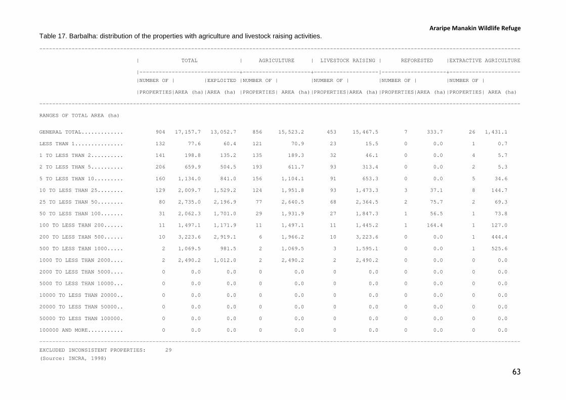
Araripe Manakin Wildlife Refuge
63
Table 17. Barbalha: distribution of the properties with agriculture and livestock raising activities.
-----------------------------------------------------------------------------------------------------------------------------------------------------
| TOTAL | AGRICULTURE | LIVESTOCK RAISING | REFORESTED |EXTRACTIVE AGRICULTURE
|-------------------------------+---------------------+--------------------|--------------------+----------------------
|NUMBER OF | |EXPLOITED |NUMBER OF | |NUMBER OF | |NUMBER OF | |NUMBER OF |
|PROPERTIES|AREA (ha)|AREA (ha) |PROPERTIES| AREA (ha)|PROPERTIES|AREA (ha)|PROPERTIES|AREA (ha)|PROPERTIES| AREA (ha)
-----------------------------------------------------------------------------------------------------------------------------------------------------
RANGES OF TOTAL AREA (ha)
GENERAL TOTAL............. 904 17,157.7 13,052.7 856 15,523.2 453 15,467.5 7 333.7 26 1,431.1
LESS THAN 1............... 132 77.6 60.4 121 70.9 23 15.5 0 0.0 1 0.7
1 TO LESS THAN 2.......... 141 198.8 135.2 135 189.3 32 46.1 0 0.0 4 5.7
2 TO LESS THAN 5.......... 206 659.9 504.5 193 611.7 93 313.4 0 0.0 2 5.3
5 TO LESS THAN 10......... 160 1,134.0 841.0 156 1,104.1 91 653.3 0 0.0 5 34.6
10 TO LESS THAN 25........ 129 2,009.7 1,529.2 124 1,951.8 93 1,473.3 3 37.1 8 144.7
25 TO LESS THAN 50........ 80 2,735.0 2,196.9 77 2,640.5 68 2,364.5 2 75.7 2 69.3
50 TO LESS THAN 100....... 31 2,062.3 1,701.0 29 1,931.9 27 1,847.3 1 56.5 1 73.8
100 TO LESS THAN 200...... 11 1,497.1 1,171.9 11 1,497.1 11 1,445.2 1 164.4 1 127.0
200 TO LESS THAN 500...... 10 3,223.6 2,919.1 6 1,966.2 10 3,223.6 0 0.0 1 444.4
500 TO LESS THAN 1000..... 2 1,069.5 981.5 2 1,069.5 3 1,595.1 0 0.0 1 525.6
1000 TO LESS THAN 2000.... 2 2,490.2 1,012.0 2 2,490.2 2 2,490.2 0 0.0 0 0.0
2000 TO LESS THAN 5000.... 0 0.0 0.0 0 0.0 0 0.0 0 0.0 0 0.0
5000 TO LESS THAN 10000... 0 0.0 0.0 0 0.0 0 0.0 0 0.0 0 0.0
10000 TO LESS THAN 20000.. 0 0.0 0.0 0 0.0 0 0.0 0 0.0 0 0.0
20000 TO LESS THAN 50000.. 0 0.0 0.0 0 0.0 0 0.0 0 0.0 0 0.0
50000 TO LESS THAN 100000. 0 0.0 0.0 0 0.0 0 0.0 0 0.0 0 0.0
100000 AND MORE........... 0 0.0 0.0 0 0.0 0 0.0 0 0.0 0 0.0
-----------------------------------------------------------------------------------------------------------------------------------------------------
EXCLUDED INCONSISTENT PROPERTIES: 29
(Source: INCRA, 1998)

Araripe Manakin Wildlife Refuge
64
Table 18. Crato: distribution of the properties with agriculture and livestock raising activities.
-----------------------------------------------------------------------------------------------------------------------------------------------------
| TOTAL | AGRICULTURE | LIVESTOCK RAISING | REFORESTED |EXTRACTIVE AGRICULTURE
|-------------------------------+---------------------+--------------------|--------------------+----------------------
|NUMBER OF | |EXPLOITED |NUMBER OF | |NUMBER OF | |NUMBER OF | |NUMBER OF |
|PROPERTIES|AREA (ha)|AREA (ha) |PROPERTIES| AREA (ha)|PROPERTIES|AREA (ha)|PROPERTIES|AREA (ha)|PROPERTIES| AREA (ha)
-----------------------------------------------------------------------------------------------------------------------------------------------------
RANGES OF TOTAL AREA (ha)
GENERAL TOTAL............. 1,449 51,549.0 36,918.5 1,403 46,359.3 1,034 49,841.3 10 1,025.8 17 487.9
LESS THAN 1............... 105 59.4 49.8 104 59.1 11 7.2 0 0.0 2 1.2
1 TO LESS THAN 2.......... 108 152.7 119.7 108 152.7 31 43.9 0 0.0 0 0.0
2 TO LESS THAN 5.......... 267 879.3 619.0 260 859.3 131 444.5 2 5.8 5 20.0
5 TO LESS THAN 10......... 247 1,767.6 1,235.2 238 1,704.5 172 1,253.6 1 9.4 1 8.7
10 TO LESS THAN 25........ 299 4,911.7 3,477.8 292 4,796.7 278 4,621.7 0 0.0 4 59.4
25 TO LESS THAN 50........ 213 7,423.3 4,983.0 207 7,218.1 203 7,077.9 3 89.6 3 97.9
50 TO LESS THAN 100....... 112 7,747.7 5,488.5 106 7,342.8 111 7,673.1 1 92.7 0 0.0
100 TO LESS THAN 200...... 55 7,779.0 5,447.9 50 7,147.4 54 7,678.8 1 185.4 2 300.7
200 TO LESS THAN 500...... 31 9,627.4 7,257.6 27 8,279.2 31 9,839.7 2 642.9 0 0.0
500 TO LESS THAN 1000..... 9 6,050.0 3,950.0 9 6,050.0 9 6,050.0 0 0.0 0 0.0
1000 TO LESS THAN 2000.... 2 2,749.5 2,084.0 2 2,749.5 2 2,749.5 0 0.0 0 0.0
2000 TO LESS THAN 5000.... 1 2,401.4 2,206.0 0 0.0 1 2,401.4 0 0.0 0 0.0
5000 TO LESS THAN 10000... 0 0.0 0.0 0 0.0 0 0.0 0 0.0 0 0.0
10000 TO LESS THAN 20000.. 0 0.0 0.0 0 0.0 0 0.0 0 0.0 0 0.0
20000 TO LESS THAN 50000.. 0 0.0 0.0 0 0.0 0 0.0 0 0.0 0 0.0
50000 TO LESS THAN 100000. 0 0.0 0.0 0 0.0 0 0.0 0 0.0 0 0.0
100000 AND MORE........... 0 0.0 0.0 0 0.0 0 0.0 0 0.0 0 0.0
----------------------------------------------------------------------------------------------------------------------------------------------------
EXCLUDED INCONSISTENT PROPERTIES: 47
(Source: INCRA, 1998)

Araripe Manakin Wildlife Refuge
65
Table 19. Missão Velha: distribution of the properties with agriculture and livestock raising activities.
-----------------------------------------------------------------------------------------------------------------------------------------------------
| TOTAL | AGRICULTURE | LIVESTOCK RAISING | REFORESTED |EXTRACTIVE AGRICULTURE
|-------------------------------+---------------------+--------------------|--------------------+----------------------
|NUMBER OF | |EXPLOITED |NUMBER OF | |NUMBER OF | |NUMBER OF | |NUMBER OF |
|PROPERTIES|AREA (ha)|AREA (ha) |PROPERTIES| AREA (ha)|PROPERTIES|AREA (ha)|PROPERTIES|AREA (ha)|PROPERTIES| AREA (ha)
-----------------------------------------------------------------------------------------------------------------------------------------------------
RANGES OF TOTAL AREA (ha)
GENERAL TOTAL............. 730 37.375.7 31.815.4 706 35.484.7 645 36.045.1 9 683.8 9 374.2
LESS THAN 1............... 4 2.9 2.9 4 2.9 3 2.3 0 0.0 0 0.0
1 TO LESS THAN 2.......... 35 48.8 47.5 34 47.6 22 30.0 0 0.0 0 0.0
2 TO LESS THAN 5.......... 107 363.7 349.5 105 358.3 82 284.4 0 0.0 2 5.7
5 TO LESS THAN 10......... 134 984.4 937.7 133 975.4 116 854.8 1 6.9 2 18.8
10 TO LESS THAN 25........ 190 3,063.1 2,823.9 185 2,981.5 173 2,809.5 1 16.6 1 11.7
25 TO LESS THAN 50........ 107 3,833.4 3,647.8 105 3,749.5 100 3,608.6 3 113.7 1 30.3
50 TO LESS THAN 100....... 78 5,438.7 4,801.9 71 4,916.0 77 5,370.0 1 80.0 1 68.7
100 TO LESS THAN 200...... 49 6,930.1 6,120.3 45 6,358.9 47 6,706.9 2 234.3 2 239.0
200 TO LESS THAN 500...... 21 6,082.1 5,140.0 19 5,466.1 20 5,750.1 1 232.3 0 0.0
500 TO LESS THAN 1000..... 4 2,609.5 1,852.9 4 2,609.5 4 2,609.5 0 0.0 0 0.0
1000 TO LESS THAN 2000.... 0 0.0 0.0 0 0.0 0 0.0 0 0.0 0 0.0
2000 TO LESS THAN 5000.... 0 0.0 0.0 0 0.0 0 0.0 0 0.0 0 0.0
5000 TO LESS THAN 10000... 1 8,019.0 6,091.0 1 8,019.0 1 8,019.0 0 0.0 0 0.0
10000 TO LESS THAN 20000.. 0 0.0 0.0 0 0.0 0 0.0 0 0.0 0 0.0
20000 TO LESS THAN 50000.. 0 0.0 0.0 0 0.0 0 0.0 0 0.0 0 0.0
50000 TO LESS THAN 100000. 0 0.0 0.0 0 0.0 0 0.0 0 0.0 0 0.0
100000 AND MORE........... 0 0.0 0.0 0 0.0 0 0.0 0 0.0 0 0.0
---------------------------------------------------------------------------------------------------------------------------------------------------
EXCLUDED INCONSISTENT PROPERTIES: 26 (Source: INCRA, 1998)
Araripe Manakin Wildlife Refuge
66
3.4. Proposed limits of the Protected Area
According to the discussions with stakeholders there was a general consensus that the
slopes of the Araripe plateau should be fully protected, because of its threatened
water resources and the associated moist forest with its rich and endemic
biodiversity. However people did not seem inclined to support disappropriation of
private lands and removal of existing recreational facilities.
In this sense, we tried to produced a mapping of the moist forests along the
northeastern slopes, in the critical area identified in the Conservation Plan for the
Araripe Manakin, drawing the boundary line of the protected area in a way that it
would surround all recreational facilities and houses, to see if it would be acceptable
in terms of moist forest and water resource conservation (Figures 26 and 27).
Initially, a satellite image of the Araripe plateau was used to produce a preliminary
contour line along the base of the slopes, identifying the major 6 recreational
facilities, water parks and/or hotels situated at the border with the slope forests
(i.e., Arajara Water Park, Clube Serrano, Clube Granjeiro, Riacho do Meio Municipal
Park, Clube Caldas, Clube Lameiro).
After the initial planning, an extensive field campaign was promoted to refine this
contour line and identify other facilities and/or buildings that could be situated in the
slope area, conflicting with the moist forest conservation proposal. This detailed and
field-refined mapping is presented in Figure XX, and was sent with the formal request
for the creation of the fully protected area to the federal environmental authorities.

Araripe Manakin Wildlife Refuge
67
Figure 26. Aerial view of the contour of the proposed Protected Area, including the slopes and part
of the plateau of Chapada do Araripe.

Figure 27. Lateral view of the contour of the proposed Protected A
. Lateral view of the contour of the proposed Protected Area in the slopes of the municipality of Crato.
Araripe Manakin Wildlife Refuge
68
rea in the slopes of the municipality of Crato.

Araripe Manakin Wildlife Refuge
69
Chapter 4
Opening a Formal Process at ICMBio
4.1. Building a partnership to file a formal request (Jun 2008)
After the discussions with stakeholders and the extensive field surveys to determine a
preliminary proposal of the limits of the Protected Area, the team prepared a
presentation to discuss the results with some key stakeholders that were interested in
signing the request to federal environmental authorities to open a formal process to
create a fully Protected Area along the northeastern slopes of the Araripe plateau.
This meeting was conducted on June 4th 2008, in the meeting room of the
headquarters of the Chapada do Araripe Environmental Protection Area (APA Chapada
do Araripe), with the following participants:
• Jackson Antero (manager of the APA Chapada do Araripe);
• Quitéria Pereira (APA Chapada do Araripe);
• Verônica Lima (manager Araripe National Forest);
• José Nivaldo Soares (Secretary of Environment, Municipal Government of
Crato);
• Yarley Brito (Regional Director, COGERH – Ceará State Water Management
Agency);
• Pedro Monteiro (Araripe National Forest);
• Alberto Campos (Aquasis team);
• Weber Girão e Silva (Aquasis team);
• Paulo Thieres Pinto (Aquasis team).
The Aquasis team presented the results of the meetings and discussions with
stakeholders and, after some suggestions and refinements of the initial idea, the
group decided to support the proposal. Other names of stakeholders and organizations
were suggested to be included in the process, and it was decided that this group
would start the process and would promote the involvement of other interested
parties along the process. A partnership was then formed to create a fully protected
area with the following organizations:
• Chapada do Araripe Environmental Protection Area (APA);
• Araripe National Forest;
• Ceará State Water Management Agency (COGERH);

Araripe Manakin Wildlife Refuge
70
• Municipal Government of Crato;
• Aquasis.
A group statement was produced that the organization signing the document intend to
promote “the creation of a Fully Protected Area along the slopes and a portion of the
Araripe plateau, in order to preserve the springs and water resources, guarantee the
recharge of the aquifer by rainwater, and protect the habitat of the Araripe Manakin,
a bird endemic to the Araripe region, and Critically Endangered”.
As an outcome of the meeting, Aquasis was responsible to summarize the proposal in
a document to be sent to the federal environmental authorities responsible for the
creation of fully protected areas, and that the document would be sent in official
paper of the Chapada do Araripe Environmental Protection Area.
The Aquasis team then produced an initial document that was circulated by-mail with
the partners and after an agreement was sent to the federal authorities by June 19th
2008 (document reproduced in Appendix 2).
4.2. Presenting the proposal to federal authorities (Sep 2008)
After sending the document to request the creation of the fully protected area in the
Araripe, the Aquasis team contacted the federal environmental authorities of the
newly created Chico Mendes Institute for the Conservation of Biodiversity (ICMBio) to
follow up closely the process.
Three months later, an opportunity appeared to present and explain the proposal to a
group of technicians of the ICMBio and the national Director of creation of Fully
Protected Areas, Mr. Júlio Gonchorowski.
A meeting was set up for September 19th 2008, and three members of the Aquasis
team flew to Brasília (i.e., Alberto Campos, Weber Girão e Silva, and Thieres Pinto) to
present our proposal and discuss the methods used and alternatives (scenarios) that
were pondered.
A group of 20 persons was assembled for this meeting:
• Alberto Campos (AQUASIS)
• Fernando Reader (DIBIO/ICMBio)
• Eduardo Godoy (DIREP/ICMBio)
• João Seyffarth (DAP/SBF/MMA)
• Jorge Luiz do Nascimento (DIREP/ICMBio)
• Júlio Gonchorowski (DIREP/ICMBio)

Araripe Manakin Wildlife Refuge
71
• Magnus Severo (CMA/ICMBio)
• Marcelo Cavallini
• Márcio Barragana (APA Delta/ICMBio)
• Maria Iolita Bampi (DIREP/ICMBio)
• Mariana Fava Cheade (DIREP/ICMBio)
• Nadini Oliveira Sousa (DAP/SBF/MMA)
• Ricardo Castelli Vieira (DIREP/ICMBio)
• Roberta Magalhães Holmes (DAP/SBF/MMA)
• Rogério Vereza (DAP/SBF/MMA)
• Suelma Ribeiro Silva (COPOM/ICMBio)
• Silvio Souza (DAP/SBF/MMA)
• Thieres Pinto (AQUASIS)
• Weber Girão e Silva (AQUASIS)
The main outcome of this meeting was that Director gave his team of technicians the
green light to perform a “feasibility analysis”, and they asked our team to send some
complementary information and mapping info. They explained our team that if the
proposal was considered technically (environmentally and economically) and
politically feasible, and if the area was included in the federal priorities for the
creation of Protected Areas, they would open a formal process to create this PA.
4.3. Process opened at ICMBio (Aug 2009) and next steps
After almost a year the process was considered viable by the federal environmental
authorities and coherent with the national biodiversity conservation priorities
established in the National Plan for Protected Area and the “Priority Areas for the
Conservation of Biodiversity” (MMA, 2006).
A formal process was then created in the new structure of the Chico Mendes Institute
for Biodiversity Conservation (ICMBio), in August 2009 (process number
02070.001184/2009-73), and a technician was appointed as responsible for this
process:
Gabriela Leonhardt
Chico Mendes Institute for Biodiversity Conservation/ICMBio
Coordination of Creation of Protected Areas / CCUC
e-mail: [email protected]
Phone: (55)(61) 3341-9274

Araripe Manakin Wildlife Refuge
72
We are now waiting for a field visit (scheduled for January 2010) with the technician
responsible for our proposal. She is expected to come to the Araripe to conduct a
meeting with the signing partners responsible for the request of the creation of the
fully protected area to discuss the further steps. According to ICMBio authorities,
these next steps are:
1. Consolidate a “government” document based on our studies and proposals, and
the information collected by the ICMBio technician during the field visit;
2. Formal consultations to the two managers of the existing federal Sustainable
Use Protected Areas in the Araripe region (who are both already signing
partners of our proposal);
3. Publish the proposal in the Ministry of Environment’s website, including
Protected Area limits and main objectives and restrictions;
4. Plan and prepare three Public Hearings, in each of the municipalities affected
by the fully Protected Area, according to the law that established the National
Protected Area System;
5. Prepare a preliminary text for the Decree of creation of the Protected Area,
including the inputs of the Public Hearings;
6. Produce a final version of the Decree to be dispatched by the Director of
creation of Protected Areas;
7. Send the Decree to be signed by the President and published in the official
media.

Araripe Manakin Wildlife Refuge
73
Appendices
Appendix 1. List of acronyms and abbreviations.
Appendix 2. Official document sent to request federal government authorities to open a
process to create a fully protected area in the slopes of the Araripe plateau.

Araripe Manakin Wildlife Refuge
74
Appendix 1. List of acronyms and abbreviations.
DAP Department of Protected Areas / Ministry of Environment
IBAMA Brazilian Institute for the Environment and Renewable Natural
Resources
ICMBio Chico Mendes Institute for the Conservation of Biodiversity
INCRA National Institute of Colonization and Land Reform
IDACE Ceará State Institute of Agrarian Development
MMA Brazilian Ministry of the Environment
PA Protected Area
SBF Secretary of Biodiversity and Forests / Ministry of Environment
SNUC National System of Protected Areas

Araripe Manakin Wildlife Refuge
75
Appendix 2. Official document sent to request federal government authorities to open a
process to create a fully protected area in the slopes of the Araripe plateau.
SERVIÇO PÚBLICO FEDERAL
MINISTERIO DO MEIO AMBIENTE - MMA
INSTITUTO CHICO MENDES DE CONSERVAÇÃO DA BIODIVERSIDADE
ÁREA DE PROTEÇÃO AMBIENTAL CHAPADA DO ARARIPE – APA ARARIPE
Praça Joaquim Fernandes Teles, s/n – Pimenta – 63.105-000 – Crato/CE.
Fone/Fax (88) 3521.5138 e Fax (88) 3523.1999
Memo. Nº. 078/2008 – APA ARARIPE/ICMBio – CE. Crato, 19 de junho
de 2008.
Ao: Diretor de Unidades de Conservação de Proteção Integral –DIREP/ICMBio.
Dr. Júlio Gonchorosky.
Assunto: Criação de Unidade de Proteção Integral na encosta da Chapada do
Araripe.
Senhor Diretor,
A sétima Conferência das Partes da Convenção sobre Diversidade Biológica
(CDB), através do seu Programa de Trabalho sobre Áreas Protegidas, teve por finalidade instar os países signatários, inclusive o Brasil, a estabelecer programas nacionais que contribuíssem para redução da taxa de perda de biodiversidade por meio da criação e manutenção de sistemas nacionais e regionais de áreas protegidas. Para implementar seu Programa de Trabalho, o Governo Brasileiro, através do Ministério do Meio Ambiente e um conjunto de organizações da sociedade civil, formulou o Plano Nacional de Áreas Protegidas (PNAP). O PNAP é o instrumento norteador de planejamento e gestão, dinâmico e flexível, que define princípios, diretrizes, objetivos e estratégias para o estabelecimento, até 2015, de um sistema abrangente de áreas protegidas, ecologicamente representativas e efetivamente manejadas, bem como para promoção de acesso e repartição justa e eqüitativa dos custos e benefícios advindos da conservação da natureza.

Araripe Manakin Wildlife Refuge
76
Desde 2006, as encostas norte-orientais da Chapada do Araripe foram classificadas pelo PNAP como uma das áreas de importância biológica Extremamente Alta, com prioridade de ação Extremamente Alta.
Esta área é internacionalmente reconhecida como Importante para Conservação das Aves (Important Bird Area, ou IBA, conforme a classificação da Birdlife International) e prioritária para conservação pela Aliança para Extinção Zero (Conservation International) devido à presença restrita do soldadinho-do-araripe (Antilophia bokermanni), a ave mais ameaçada de extinção global (Criticamente Em Perigo) em sua família (Pipridae) e a única ave endêmica do Ceará. Este pássaro tem reprodução condicionada à presença de cursos d’água, nas encostas norte-orientais da Chapada do Araripe, nos municípios cearenses de Crato, Barbalha e Missão Velha. São áreas de ressurgência de 47% das 348 fontes d'água de toda a Chapada do Araripe, representando 78% de sua vazão total (mais de 4.700 m3/h), um recurso natural estratégico em uma região encravada no sertão semi-árido do bioma Caatinga.
Apesar de estas encostas estarem situadas na Área de Proteção Ambiental Chapada do Araripe – APA Araripe, e Zona de Amortecimento da Floresta Nacional do Araripe, e de estarem sobrepostas a diversas modalidades de Área de Preservação Permanente (i.e., APP de aclive, topo de morro, área de reprodução de espécies ameaçadas, e de margens de córregos e nascentes), estas áreas ainda são insuficientemente protegidas, existindo degradação dos recursos hídricos e bióticos essenciais para a manutenção da qualidade de vida direta de mais de um milhão de habitantes.
Dados históricos apontam que, em cerca de um século, a vazão da principal fonte d’água desta região declinou para um quinto de sua vazão original, sobretudo devido à supressão vegetal. Esta área de aclive, sem a cobertura florestal nativa, é mais propensa a desmoronamentos, inclusive sobre áreas habitadas, podendo inclusive soterrar e suprimir as fontes.
A floresta que recobre estas encostas é considerada como um relicto de Mata Atlântica, obtendo a umidade necessária à sua manutenção devido à concentração singular de nascentes, orografia e confluência de dois sistemas de chuvas. A biodiversidade desta floresta única é submetida à pressão de caça, extração de madeira e minérios (inclusive uso insustentável de recursos hídricos), decorrente da proximidade da segunda região mais densamente povoada do Ceará, o Cariri.
O soldadinho-do-araripe, por sua dependência à conservação dos recursos hídricos, distribuição restrita, ameaça de extinção e carisma junto à sociedade local, foi adotado pela população do Cariri como uma espécie-bandeira para a conservação das águas da região. Atualmente, a Chapada do Araripe é o maior atrativo para o turismo ambiental da região, explorado de maneira ainda pouco sustentável.
A criação de uma Unidade de Conservação nestas encostas poderá ordenar o uso sustentável do mosaico de paisagens que constitui a Chapada do Araripe, estimulando a vocação natural desta região para o ecoturismo, preservando as matas úmidas de encosta que compõem o último refúgio natural global do soldadinho-do-araripe, e atendendo a

Araripe Manakin Wildlife Refuge
77
um grande anseio da sociedade local: a recuperação das nascentes degradadas e manutenção da vazão das águas a longo prazo.
A chefia da APA Chapada do Araripe, juntamente com outros parceiros aqui signatários (i.e., a Prefeitura Municipal de Crato, através de sua Secretaria de Meio Ambiente; a Companhia de Gestão de Recursos Hídricos do Ceará – COGERH, através da Gerência da Bacia do Rio Salgado; a Floresta Nacional do Araripe – FLONA Araripe; e a Associação de Pesquisa e Preservação de Ecossistemas Aquáticos – AQUASIS) já vem realizando pesquisas e ações para a conservação mais efetiva deste ambiente singularmente úmido, em meio ao semi-árido nordestino, e já possuem um cabedal de informações suficientes para justificar e embasar uma proposta de criação de Unidade de Conservação de Proteção Integral para proteção dos mananciais da Chapada do Araripe.
Nesse sentido, as instituições abaixo assinadas que compõem esta parceria, gostariam de requerer ao Instituto Chico Mendes de Conservação da Biodiversidade, através desta Diretoria, a participação de um técnico para ajudar a consolidar a proposta de criação de UC de Proteção Integral para as encostas da Chapada do Araripe, pelos motivos acima expostos. Ressaltamos que os parceiros envolvidos já possuem levantamentos de fauna, flora, mapeamentos detalhados das nascentes e vegetação remanescente de mata úmida de encosta, dentre outros, e gostariam de contar com esta Diretoria para consolidar os limites, a categoria, e os trâmites legais da referida proposta de criação de Unidade de Conservação de Proteção Integral.
Atenciosamente,
Francisco Jackson Antero de Sousa Chefe de UC Federal II. APA Chapada do Araripe José Nivaldo Soares de Almeida Secretário Municipal de Meio Ambiente Prefeitura Municipal de Crato José Yarlei de Brito Gonçalves Gerente da COGERH/Crato Companhia de Gestão de Recursos Hídricos do Ceará Verônica Maria Figueiredo Lima Chefe de UC Federal II Floresta Nacional do Araripe Alberto Alves Campos Diretor-presidente AQUASIS