arboricultural impact assessment/method statement land off
TRANSCRIPT

Tree Solutions Ltd Registration in England & Wales Company No 04548951
Arboricultural Impact Assessment/Method Statement
Land off Maes Gwern, Mold, CH7 1XN
Prepared for: WATES C/o Atmos Consulting Our Ref: 17/AIA/FLINTS/13 17 March 2017 Tree Solutions Ltd T: 01244 389114 E: [email protected] W: www.tree-solutions.co.uk
Contents:
1.0 Instruction 2.0 Statutory Controls & Planning Policy 3.0 The Site 4.0 Development Proposal 5.0 General Constraints Data – Construction Exclusion Zones 6.0 Survey Methodology 7.0 Juxtaposition of Trees & Structures 8.0 Demolition/Development Impact to Trees 9.0 Proposed Revisions 10.0 Conclusions 11.0 Limiting Conditions Appendix 1 Tree Survey Schedule Appendix 2 Preliminary Tree Constraints Plan Appendix 3 Arboricultural Impact Plan Appendix 4 Tree Protection Plan Appendix 5 Tree Protection Measures/Method Statement Appendix 6 No Dig Footpath Cross Section 'Example'

www.tree-solutions.co.uk
Arboricultural Impact Assessment – Land off Maes Gwern, Mold (17/03/2017) © Tree Solutions Ltd (2017)
2
1.0 INSTRUCTION
1.1 We have been instructed by Atmos Consulting to carry out an Arboricultural Impact Assessment (AIA) in order to assess the development proposal in relation to trees in accordance with the principles of British Standard 5837 ‘Trees in Relation to Design, Demolition & Construction - Recommendations’ 2012.
1.2 We are instructed to prepare a report in order to provide information to assist all parties involved
in the planning process to make balanced judgements with regard to arboricultural features in relation to the proposed residential development on land off Maes Gwern, Mold, CH7 1XN. As such, all significant trees within influencing distance to the development proposal both on and adjoining the site have been surveyed and are listed within a Tree Survey Schedule (Appendix 1) and plotted on all accompanying plans.
1.3 The phase 1 tree survey was carried out on 10 January 2017 by Alistair Henderson, Principal
Consultant to Tree Solutions Ltd. Our appraisal of the mechanical integrity of trees on the site is sufficient only to inform the current project. The assessment of trees is carried out from ground level without invasive investigation and the disclosure of hidden defects cannot therefore be expected. Whilst the survey is not specifically commissioned to report on matters of tree safety, we report obvious defects that are significant in relation to the existing and proposed land use. We do not carry out detailed safety inspections unless specifically instructed to do so in writing and have not carried out such inspections of trees on the proposal site.
1.4 Twenty two individual trees (T1–T22), twenty groups (G1-G20), four woodland (W1-W4) and one
hedgerow (H1) were surveyed and mapped on a Preliminary Tree Constraints Plan and Impact Assessment Plan Ref: 17/AIA/FLINTS/33 Drawing No. 1&2 at Appendix 2/3. All arboricultural information recorded during the survey is presented within a schedule at Appendix 1.
1.5 The Arboricultural Impact Assessment is based on proposed site layout plan Ref: 671.06 001MG
(Rev L) provided by Halliday Clark Architects. 2.0 STATUTORY CONTROLS
2.1 On 24 February 2017, Flintshire Council confirmed that trees located on and adjoining the west
and northern boundary are subject to a Tree Preservation Order. Individual trees to the west are protected by TPO No 310 (2014) and woodland areas to the NE are protected by TPO No. 57 (2003). The exact trees have not been identified.
Plate 1 - Email from FCC confirming location of protected trees

www.tree-solutions.co.uk
Arboricultural Impact Assessment – Land off Maes Gwern, Mold (17/03/2017) © Tree Solutions Ltd (2017)
3
2.2 Protected Species 2.2.1 Mature trees often contain cavities, crevices and hollows that offer potential habitat for species
such as bats and barn owls. Both are afforded protection under the Schedule 5 of the Wildlife and Countryside Act 1981 (as amended). Bats are also protected under The Conservation of Habitats and Species Regulations 2010 (as amended).
2.3 Wildlife Habitats
2.3.1 Trees and hedgerows of most species provide valuable nesting sites for a wide range of birds
and it is likely that nesting birds will be present on the site during the period March to September. 3.0 THE SITE 3.1 The site is vacant agricultural land with residential dwellings to the north, business park to the
south and school playing fields to the east. There are woodlands outside the north and southern boundary and individual trees of merit to the west.
4.0 DEVELOPMENT PROPOSAL 4.1 Residential development with associated vehicular access and parking. 5.0 GENERAL CONSTRAINTS DATA - CONSTRUCTION EXCLUSION ZONES (CEZ’s) 5.1 GENERAL
5.1.1 The three phases of an AIA were outlined in Section 1. In addition, during the development
process for retention trees, there may be three and even four constraints to consider: Construction Exclusion Zone (CEZ’s):
• CEZ 1: Root Protection Area (see 5.2) • CEZ 2: Tree Crown Protection (see 5.3) • CEZ 3: Tree Dominance (see 5.4) • CEZ 4: New Tree Planting Zone (see 5.5)
CEZ’s are explained below: 5.2 CEZ 1: ROOT PROTECTION AREA (RPA) 5.2.1 The RPA, calculated in m2, should be protected before and during any demolition/construction
works. This ensures the effective retention of trees by safeguarding a reliable quantum of functioning tree roots. The RPA is based on a radial measure from the centre of the tree stem, which is calculated by multiplying the stem diameter by a factor of twelve or by the (mean stem diameter²) x number of stems for multi-stemmed trees. With the AIA 1, the RPA is only shown
indicatively on the preliminary TCP, as its shape may be subject to amendment as the design progresses.
5.2.2 During the AIA 2, the derived radial measure is converted by the arboriculturalist into the actual
area to be protected, having due regard to prevailing site conditions and how these may have affected the tree(s), particularly in relation to factors affecting their likely rooting disposition. The RPA for each tree should initially be plotted as a circle centred on the base of the stem. Where pre-existing site conditions or other factors indicate that rooting has occurred asymmetrically, a
polygon of equivalent area should be produced. Modifications to the shape of the RPA should reflect a soundly based arboricultural assessment of likely root distribution.
5.2.3 The means of protecting the RPA will include the installation of tree protective fencing prior to the
start of any demolition or construction work on site. The prohibition of various activities within the RPA must be adhered to (e.g. mechanical excavation, soil stripping, fire lighting, material storage, lowering levels and creating excessive sealed surfacing) and may include the use of temporary ground protection and/or special engineering solutions where construction is proposed near to retention trees or within the RPA.

www.tree-solutions.co.uk
Arboricultural Impact Assessment – Land off Maes Gwern, Mold (17/03/2017) © Tree Solutions Ltd (2017)
4
5.3 CEZ 2: TREE CROWN PROTECTION ZONE
5.3.1 This is the area above ground occupied by the crown (branches) of the tree, along with
allowances for working space (safe working area) and if appropriate, for future growth. The extent of CEZ 2 is determined by considering the existing and future crown spread of the tree(s), bearing in mind the possibility of this being modified by an acceptable quantum of pruning.
5.4 CEZ 3: TREE DOMINANCE ZONE 5.4.1 This is the area above ground dominated by the tree in relation to issues of shading, seasonal
debris and safety apprehension. This area is calculated by considering the height and spread of the tree relative to the proposed buildings, cross referenced with intended end use. As such, what is assessed is the likely psychological effect of the tree on the end user.
5.4.2 The purpose of identifying CEZ 3 is to protect trees from post development pressure (resentment)
by the site’s end users, who may, if resentful of the trees, seek to procure excessive pruning treatments or even to have them removed. This is a common Planning Service concern, which has led on many occasions both to refusals of consent and to dismissed Appeals against those refusals
5.4.3 The means of protecting CEZ 3 is likely to include optimising the site layout and room type
(especially in relation to new residential dwellings), such that any adverse psychological impacts of the trees are reduced to an acceptable minimum. Key principles include ensuring adequate separation distances between trees and new buildings, in the context of the buildings’ end use relative to the location of the tree(s) and avoiding excessive obstruction by trees of critical solar access.
5.5 CEZ 4: NEW PLANTING ZONE 5.5.1 In some cases, it may be appropriate to identify and protect areas intended for new landscape
planting, which can fail to establish if the soil has been heavily compacted or contaminated during the demolition/construction process. The means of protecting CEZ 4 will either be by fencing it off prior to the start of works on site, or by soil remediation once construction has finished (and prior to the start of planting). Topsoil protection in areas destined for new planting is frequently an economy measure, saving on plant replacement and soil structure remediation.
6.0 SURVEY METHODOLOGY
6.1 The method used in the preparation of this report is based on the principles of BS 5837: 2012.
1. Tree heights were surveyed to the nearest 1m. 2. Trunk diameters were measured by use of forestry girth tape 3. The category assessment (Table 1) on which the trees is based include current and long-term
arboricultural, landscape, cultural and conservation values (BS5837: 2012). This table can be found at Appendix 1
4. For clarity, the grading system is summarised from Table 2 of the BS as follows:
U grade – trees for removal, effective for less than 10 years A grade – trees of high quality and value, effective for more than 40 years B grade – trees of moderate quality and value, effective for more than 20 years C grade – trees of low quality and value, effective for 10 years Note: We have indicated colour coding on the drawing and therefore a monochrome copy should not be relied on.
6.2 SOIL ASSESSMENT
6.2.1 A soil assessment should be undertaken by a competent person to inform decisions relating to:
• the root protection area (RPA) • tree protection • new planting design; and • foundation design to take account of retained, removed and new trees (potential soil
subsidence/heave) Tree Solutions do not undertake soil assessments and the client is advised to seek specialist advice in this respect.

www.tree-solutions.co.uk
Arboricultural Impact Assessment – Land off Maes Gwern, Mold (17/03/2017) © Tree Solutions Ltd (2017)
5
7.0 JUXTAPOSITION OF TREES AND STRUCTURES 7.1 Below ground constraints 7.1.1 The below ground constraints are generally summarised as the root protection area (RPA). The
shape of the RPA and its exact location will depend upon arboricultural considerations including likely tolerance of the tree to root disturbance; morphology and disposition of the roots when known influenced by past or existing site conditions; soil type and structure; and topography and drainage.
7.1.2 The purpose of the RPA is to prevent physical damage to tree roots and to prevent damage to
the soil structure. Tree roots are damaged by soil compaction, changes in soil levels or soil contamination which could reduce tree health and/or stability.
7.1.3 Root patterns are affected by topography and characteristics of the soil or substrate. Where trees
are located within close proximity to existing hard standing or underground physical barriers they are unlikely to have an even distribution of lateral roots due to restrictions in root growth created by compacted sub-grades beneath. All RPA's have been plotted unmodified as there were no significant underground barriers present to prevent good radial root spread.
7.2 Underground Services 7.2.1 We have considered the broad implications of the provision of underground services but the
locations of existing and proposed were not identified on the plans supplied by the Project Architect and in this regard, our advice is of a general nature.
7.2.2 Drainage and service runs may need to be constructed within the rooting areas of retained trees.
If this is a requirement of the development it will be necessary to retain significant roots and methods of excavation, such as thrust boring or hand digging, may need to be adopted to ensure that these impacts are acceptable.
7.2.3 As with foundation design, low impact construction methods for services installation are now well
established. For more information regarding underground services, reference should be made to the National Joint Utilities Group (NJUG) Publication No. 10. Volume 4 ‘Guidelines for the Planning, Installation and Maintenance of Utility Services in Proximity to Trees’ 2007
8.0 DEVELOPMENT IMPACT TO TREES
8.1 Tree Solutions carried out a stage one preliminary tree survey and provided the project architect with a report in which all existing trees/hedgerows and their respective Root Protection Areas (RPA) were identified and plotted on a tree constraints and impact assessment plan. The architect has incorporated the design and layout advice contained within the stage 1 survey and the layout has been amended a number of times following consolation with Tree Solutions in order to ensure the best quality trees can be retained with no adverse construction impacts. We are therefore satisfied that the proposal has taken the long-term future of the most important trees and into account and the layout is therefore in accordance with Flintshire Council Planning Policies and recommendations contained with BS5837: 2012.
8.2 In order to accommodate the proposed development it will be necessary to remove tree number
17 and groups 9, 11,18 and H1. Tree number 17 is a Larch on the edge of an established woodland area. It is not visually prominent and as such its removal will have no adverse impact on the landscape character and setting of the locale. Group 9 is a linier group of unmanaged Hazel coppice and occasional Holly of no merit. Group 11 are all Elm trees within the boundary hedge. Many are dead with the remaining appearing stressed & in decline. Group 18 are crack Willow stems on the edge of the woodland area. We have advised that they be removed due to their close proximity to plot 120 as these trees by nature of their brittle branch structure are prone to failure during excessive loading or inclement weather conditions. It should however be noted that the development area is outside the RPA of these trees so they could be retained if requested. H1 is an unmanaged hedge that can be coppiced to ground level and allowed to re-establish to form a better quality well managed green boundary treatment. All other trees are to be retained.

www.tree-solutions.co.uk
Arboricultural Impact Assessment – Land off Maes Gwern, Mold (17/03/2017) © Tree Solutions Ltd (2017)
6
8.3 Development impacts on retained trees are listed below:
1. The turning head of the internal spine road encroaches within the RPA of tree number 4. Whilst we are confident that no significant tree roots will be encountered within this area, as a precautionary measure it will be hand excavated under supervision from the project arboricultural consultant. Any tree roots encountered will be cleanly pruned back to a suitable inner node by the arboricultural consultant in order to ensure minimal adverse impact to the existing and future health and vigour of this tree.
2. Plot number 3 encroaches within the RPA of tree number 12. This incursion is minor,
approximately 3m on the outer extremities of the RPA. As with the turning head, we are confident from site investigations that no significant tree roots will be present around the outside edge of the RPA and as such, we are satisfied that excavating standard strip foundations will have no adverse impact on this tree. As a precautionary measure, the excavation of the foundations will be overseen and supervised by the project arboricultural consultant with any tree roots cleanly pruned if required.
3. There is a potential footpath in the NW corner of the site that links into Stewart Milne. Whilst
details of the exact alignment and construction methodology were not available, if installed it will need to be constructed to a no-dig design specification in order to comply with recommendations contained within para. 7.2 of BS5837: 2012. This will involve the use of a three dimensional cellular confinement system such as ‘Infraweb’. This is possible due to the area being level and containing no undulations. The footpath section within the site can be installed with a 75mm layer of plastic cells laid above the existing ground level and back filled with a free draining washed stone that contains no fines in order to help maintain adequate gaseous diffusion for tree roots below. The top dressing will be a porous asphalt or similar to be agreed by the client and the LPA. An example of the design can be found within Infragreen cross section drawing Ref: IG-SD-IW-PA-75 at Appendix 6.
4. Tree numbers 18 & 19 were not included in the topographical site survey, as such their
positions are plotted indicatively and the impact of development cannot be substantiated. Both trees appear to be on the site boundary and if crown reduced by approximately 30% could form attractive mature back drop to plot numbers 51-54.
5. The woodland outside the southern boundary (W4) is predominantly naturally colonised scrub
trees that have in many areas been coppiced in the past leaving multiple small diameter stems from the coppice stool. Assuming this management will continue into the future we can see no direct conflict with the adjacent dwellings.
6. The woodland to the north (W2, G3-G5) forms an attractive mature back drop to the plot
numbers 6-21 and screens the site well from residential dwellings located to the north. These trees are a real asset to the site providing a mature landscape feature that future occupiers will cherish. As they are north of the dwellings they are unlikely to cast significant shade to the rear gardens and the plots are set back far enough to ensure both trees and dwellings can coexist with no future pressure to fell of prune.

www.tree-solutions.co.uk
Arboricultural Impact Assessment – Land off Maes Gwern, Mold (17/03/2017) © Tree Solutions Ltd (2017)
7
Photo 1 - Tree numbers 4-9 in NW corner of site
Photo 2 - Tree numbers 10-13
Photo 3 - Woodland along northern boundary

www.tree-solutions.co.uk
Arboricultural Impact Assessment – Land off Maes Gwern, Mold (17/03/2017) © Tree Solutions Ltd (2017)
8
Photo 4 - Group 4 linier belt of Eucalyptus along boundary fence line
Photo 5 - Group 5, mature Large offering attractive backdrop to dwellings
Photo 6 - Woodland outside northern boundary viewed from east (Plot 16)

www.tree-solutions.co.uk
Arboricultural Impact Assessment – Land off Maes Gwern, Mold (17/03/2017) © Tree Solutions Ltd (2017)
9
Photo 7 - Woodland outside southern boundary, predominantly small diameter scrub on boundary with larger trees sett well back within centre
Photo 8 - Small diameter multi-stemmed past coppice on edge of wooded copse that runs along southern boundary in front of plots 96-107
9.0 PROPOSED REVISIONS TO THE SCHEME
9.1 We advise that all proposed revisions having implications for trees should be referred to us for
review. 10.0 CONCLUSIONS
10.1 BS 5837: 2012 contains clear and current recommendations for a best practice approach to the
assessment, retention and protection of trees on development sites. The proposed development has followed this guidance by:
Seeking arboricultural advice and undertaking a phase 1 preliminary tree survey in order to inform the layout and design of the proposed development
Respecting the constraints posed to development of the site by high or moderate quality trees
Acting upon arboricultural advice throughout the design process in order to obtain the best development proposal whilst considering the current and future tree requirements
10.2 The protection of retained trees will be in accordance with recommendation contained within the
BS and as detailed on the Tree Protection Plan at Appendix 4.

www.tree-solutions.co.uk
Arboricultural Impact Assessment – Land off Maes Gwern, Mold (17/03/2017) © Tree Solutions Ltd (2017)
10
11.0 LIMITING CONDITIONS
Unless stated otherwise: Information contained in this report covers only those trees that were examined and reflects the condition of those trees at the time of the inspection. The inspection is limited to visual examination of the subject trees from ground level only and without dissection, excavation, probing or coring. There is no warranty or guarantee, expressed or implied, that problems or deficiencies of the subject trees may not arise in the future. This report has been prepared for the sole use and benefit of the client. Any liability of Tree Solutions shall not be extended to any third party. No part of this report can be reproduced without the authorisation of Tree Solutions Ltd.

www.tree-solutions.co.uk
Arboricultural Impact Assessment – Land off Maes Gwern, Mold (17/03/2017) © Tree Solutions Ltd (2017)
11
Appendix One
Tree Survey Schedule

TREE SURVEY SCHEDULE (BS5837: 2012) SITE: LAND OFF MAES GWERN, MOLD, CH71XN SURVEYOR: A. HENDERSON
CLIENT: WATES C/O ATMOS CONSULTING ASSESSMENT DATE: 10 JANUARY 2017 PAGE 1 OF 7
BRIEF: ARBORICULTURAL IMPACT ASSESSMENT VIEWING CONDITIONS: GOOD
JOB REFERENCE: 17/AIA/FLINTS/33
TREE NO.
T - Tree G - Group H- Hedge
SPECIES
(COMMON NAME)
AGE
HEIGHT (m) + CROWN CLEARANCE/DIRECTION OF GROWTH (N.S.E.W)
RADIAL CROWN SPREAD
(m)
N S E W
ST
EM
/
MU
LT
I-ST
EM
* D
IA.(m
m)
VITALITY
COMMENTS
MANAGEMENT
CATEGORY
& SUB-CATEGORY GRADING BS 5837
BS 5837 RADIUS
(m)
RPA (m2)
T1
Oak
M
17
1S
4
5.5
5
1
650
G
Crown bias east due to close proximity to T2 (forms closed canopy)
E.R.C. 40
Remove dead wood
A2 7.8
191m²
T2
Sycamore
M 17
2N
4.5 4.5 5 5 830 M
Tip dieback in crown
E.R.C. 20
N/A
B2 10
312m²
T3
Sycamore
EM
16
3W
2
3
4
5
400
M
Self set tree with poor structural form
Tree of no value outside site boundary
E.R.C. 10
N/A
C2 4.8
72m²
T4
Oak
M
20
3E
6
8
10
8
1250
G
Dead wood in crown
Crown bias east
E.R.C. 40
Crown lift to allow easement for construction plant
A2 15
707m²
T5
Oak
M 20
4E
6 4 5 4 860 G
Dead wood in crown
E.R.C. 40
N/A
A2 10.3
335m²
T6
Oak
MD
In decline
Significant stems decay
E.R.C. 0
3rd party tree
U N/A
HEADINGS & ABBREVIATIONS TREE NO. REFERENCE NUMBER. REFER TO PLAN OR NUMBERED TAGS WHERE APPLICABLE (T = TREE, G = GROUP, H = HEDGE) SPECIES: COMMON NAME (LATIN NAMES AVAILABLE ON REQUEST) AGE RANGE/LIFE STAGE: Y = YOUNG, SM = SEMI MATURE, EM = EARLY MATURE, M = MATURE, PM = POST MATURE HEIGHT: ESTIMATED AND RECORDED IN METRES. APPROXIMATELY 1 IN 10 TREES ARE MEASURED USING A CLINOMETER AND THE REMAINDER ESTIMATED AGAINST THE MEASURED TREES CROWN SPREAD: MAXIMUM CROWN RADIUS MEASURED TO THE FOUR CARDINAL COMPASS POINTS FOR SINGLE SPECIMENS ONLY (MEASUREMENT FOR TREE GROUPS - MAXIMUM RADIUS OF THE GROUP) CROWN CLEARANCE & DIRECTION OF GROWTH: STEM DIA/MULTI-STEM DIA:
HEIGHT IN METERS OF CROWN CLEARANCE ABOVE ADJACENT GROUND LEVEL (TO INFORM ON GROUND CLEARANCE, CROWN/STEM RATIO AND SHADING) STEM DIAMETER - MEASURED AT APPROXIMATELY 1.5 METRES ABOVE GROUND LEVEL OR A COMBINATION OF STEMS FOR MULTI-STEMMED TREES
VITALITY: E.R.C. = ESTIMATED REMAINING CONTRIBUTION: BS 5837CATEGORY & SUB-CATEGORY GRADING: BS 5837 RADIUS & BS 5837 RPA:
A MEASURE OF PHYSIOLOGICAL CONDITION. D = DEAD, MD = MORIBUND, P = POOR, M = MODERATE, G = GOOD RELATIVE USEFUL LIFE EXPECTANCY (YEARS) A = HIGH QUALITY AND VALUE, B = MODERATE QUALITY AND VALUE, C = LOW QUALITY AND VALUE, U = UNSUITABLE FOR RETENTION (SUB-CATEGORY REFERS TO ARBORICULTURAL., LANDSCAPE AND CULTURAL/CONSERVATION VALUES) PROTECTIVE DISTANCE - RADIUS FROM THE CENTRE OF THE STEM TO THE LINE OF TREE PROTECTION (CONSTRUCTION EXCLUSION ZONE - CEZ) AND PROTECTIVE BARRIER ROOT PROTECTION AREA - BS 5837 (2012) ANNEX D (THE RECOMMENDATIONS STATE THAT THE RPA SHOULD BE CAPPED AT 707 M2) NOTE – ALL CALCULATIONS ROUNDED TO NEAREST DECIMAL
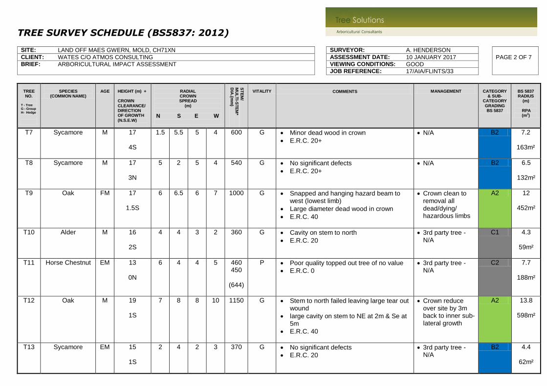
TREE SURVEY SCHEDULE (BS5837: 2012) SITE: LAND OFF MAES GWERN, MOLD, CH71XN SURVEYOR: A. HENDERSON
CLIENT: WATES C/O ATMOS CONSULTING ASSESSMENT DATE: 10 JANUARY 2017 PAGE 2 OF 7
BRIEF: ARBORICULTURAL IMPACT ASSESSMENT VIEWING CONDITIONS: GOOD
JOB REFERENCE: 17/AIA/FLINTS/33
TREE NO.
T - Tree G - Group H- Hedge
SPECIES
(COMMON NAME)
AGE
HEIGHT (m) + CROWN CLEARANCE/DIRECTION OF GROWTH (N.S.E.W)
RADIAL CROWN SPREAD
(m)
N S E W
ST
EM
/
MU
LT
I-ST
EM
* D
IA.(m
m)
VITALITY
COMMENTS
MANAGEMENT
CATEGORY
& SUB-CATEGORY GRADING BS 5837
BS 5837 RADIUS
(m)
RPA (m2)
T7
Sycamore
M
17
4S
1.5
5.5
5
4
600
G
Minor dead wood in crown
E.R.C. 20+
N/A B2 7.2
163m²
T8
Sycamore M
17
3N
5
2
5
4
540
G
No significant defects
E.R.C. 20+
N/A B2 6.5
132m²
T9
Oak
FM
17
1.5S
6
6.5
6
7
1000
G
Snapped and hanging hazard beam to west (lowest limb)
Large diameter dead wood in crown
E.R.C. 40
Crown clean to removal all dead/dying/ hazardous limbs
A2 12
452m²
T10
Alder
M
16
2S
4
4
3
2
360
G
Cavity on stem to north
E.R.C. 20
3rd party tree - N/A
C1 4.3
59m²
T11
Horse Chestnut
EM
13
0N
6
4
4
5
460 450
(644)
P
Poor quality topped out tree of no value
E.R.C. 0
3rd party tree - N/A
C2 7.7
188m²
T12
Oak
M
19
1S
7
8
8
10
1150
G
Stem to north failed leaving large tear out wound
large cavity on stem to NE at 2m & Se at 5m
E.R.C. 40
Crown reduce over site by 3m back to inner sub-lateral growth
A2 13.8
598m²
T13
Sycamore
EM
15
1S
2
4
2
3
370
G
No significant defects
E.R.C. 20
3rd party tree - N/A
B2 4.4
62m²

TREE SURVEY SCHEDULE (BS5837: 2012) SITE: LAND OFF MAES GWERN, MOLD, CH71XN SURVEYOR: A. HENDERSON
CLIENT: WATES C/O ATMOS CONSULTING ASSESSMENT DATE: 10 JANUARY 2017 PAGE 3 OF 7
BRIEF: ARBORICULTURAL IMPACT ASSESSMENT VIEWING CONDITIONS: GOOD
JOB REFERENCE: 17/AIA/FLINTS/33
TREE NO.
T - Tree G - Group H- Hedge
SPECIES
(COMMON NAME)
AGE
HEIGHT (m) + CROWN CLEARANCE/DIRECTION OF GROWTH (N.S.E.W)
RADIAL CROWN SPREAD
(m)
N S E W
ST
EM
/
MU
LT
I-ST
EM
* D
IA.(m
m)
VITALITY
COMMENTS
MANAGEMENT
CATEGORY
& SUB-CATEGORY GRADING BS 5837
BS 5837 RADIUS
(m)
RPA (m2)
T14
Larch
M
18
5S
9
6
6
3
560
G
No defects
E.R.C. 20
3rd party tree - N/A
B2 6.7
142m²
T15
Pine
M
18
5S
2.5
5
5
5
610 G
Browsing damage at base
E.R.C. 20
N/A B2 7.3
168m²
T16
Larch
M 18
1.5S
4 7 6.5 2.5 670 G Stem & crown bias SE
E.R.C. 20
N/A
B2 8
203m²
T17
Larch
M 17
1S
2 3 4.5 2 440 M/G Browsing damage at base
Insignificant tree due to extensive woodland beyond
E.R.C. 20
Fell for development
B2 5.3
88m²
T18
Ash
M 18
1N
5 5 5 9 700 G Edge tree to woodland
Not visually prominent from any location outside boundary - no loss in amenity if removed
E.R.C. 20
Remove if within site ownership
B2 8.4
222m²
T19
Ash
M 19
1N
7 7 9 7 900 G Large tree with no significant defects
E.R.C. 40
N/A
A2 10.8
366m²
T20
Oak
M 17
0N
6 5 6 5 600 G Location plotted indicatively
Good quality tree
E.R.C. 40
N/A
A2 7.2
163m²

TREE SURVEY SCHEDULE (BS5837: 2012) SITE: LAND OFF MAES GWERN, MOLD, CH71XN SURVEYOR: A. HENDERSON
CLIENT: WATES C/O ATMOS CONSULTING ASSESSMENT DATE: 10 JANUARY 2017 PAGE 4 OF 7
BRIEF: ARBORICULTURAL IMPACT ASSESSMENT VIEWING CONDITIONS: GOOD
JOB REFERENCE: 17/AIA/FLINTS/33
TREE NO.
T - Tree G - Group H- Hedge
SPECIES
(COMMON NAME)
AGE
HEIGHT (m) + CROWN CLEARANCE/DIRECTION OF GROWTH (N.S.E.W)
RADIAL CROWN SPREAD
(m)
N S E W
ST
EM
/
MU
LT
I-ST
EM
* D
IA.(m
m)
VITALITY
COMMENTS
MANAGEMENT
CATEGORY
& SUB-CATEGORY GRADING BS 5837
BS 5837 RADIUS
(m)
RPA (m2)
T21
Willow
(Crack)
PM P Partial root plate failure, evidence of lifting to west
Multiple crown failures - tree is hazardous
E.R.C. 0
Fell & grind out stump to prevent re-growth
U N/A
T22
Willow
(Crack)
FM 21
1N
6 8 7 6 900 M Ivy clad stem impeding inspection
Unsuitable species of tree to retain within close proximity to targets i.e. within residential development due to likelihood of extensive scaffold limb failures
Tree is reaching the end of its safe & useful life expectancy
E.R.C. 20
Recommend removing & grinding out stump to prevent re-growth
B2 10.8
366m²
G1
Alder
M
≤15
1N
4.5
4
4
4
≤670 G
Mature trees at top of slope
All Ivy clad impeding inspection
E.R.C. 20
N/A
B2 8
203m²
G2
Willow
(Goat)
M
≤15
0
200x2
100x3
(332)
M
Area of low grade scrub with multiple crown/stem failures
E.R.C. 10
Requires coppicing
C2 3.9
50m²
G3
Larch
M
≤18
1.5S
4
4.5
4.5
4
≤500 G
No visual defects
E.R.C. 20+
N/A
B2 6
113m²
G4
Eucalyptus
M
≤18
0.5S
4
4.5
3
3
≤450 G
Linier group planted along the boundary fence line
Attractive back drop to site
E.R.C. 20
N/A
A2 5.4
92m²

TREE SURVEY SCHEDULE (BS5837: 2012) SITE: LAND OFF MAES GWERN, MOLD, CH71XN SURVEYOR: A. HENDERSON
CLIENT: WATES C/O ATMOS CONSULTING ASSESSMENT DATE: 10 JANUARY 2017 PAGE 5 OF 7
BRIEF: ARBORICULTURAL IMPACT ASSESSMENT VIEWING CONDITIONS: GOOD
JOB REFERENCE: 17/AIA/FLINTS/33
TREE NO.
T - Tree G - Group H- Hedge
SPECIES
(COMMON NAME)
AGE
HEIGHT (m) + CROWN CLEARANCE/DIRECTION OF GROWTH (N.S.E.W)
RADIAL CROWN SPREAD
(m)
N S E W
ST
EM
/
MU
LT
I-ST
EM
* D
IA.(m
m)
VITALITY
COMMENTS
MANAGEMENT
CATEGORY
& SUB-CATEGORY GRADING BS 5837
BS 5837 RADIUS
(m)
RPA (m2)
G5
Larch
M
≤18
1S
4
4.5
3
3
≤450 G
Linier group planted along the boundary fence line
Attractive back drop to site
E.R.C. 20+
N/A
A2 5.4
92m²
G6
Oak Alder
EM
≤13
0
2 2 2 2 ≤250 G
Small diameter trees located outside site boundary
No defects
E.R.C. 20
N/A
B2 3
28m²
G7
Pine Spruce
EM/M
≤15
3
3
3
4
≤400 G
Small copse on downward slope outside boundary
E.R.C. 20
N/A
B2 4.8
72m²
G8
Ash 80% Oak
Spruce Hawthorn
SM
≤12
0
≤200 G
Linear group planted of upward slope from playing fields
No management since planting
E.R.C. 20+
3rd party trees
B2 2.4
18m²
G9
Hazel (Coppice) Holly
M
≤7
0
2
2
2
2
50x 20
(224)
G
Past coppice
E.R.C. 10
Remove for development
C2 2.7
23m²
G10
Oak
EM
≤8
1S
2.5
2.5
2.5
2.5
≤300 G
Two small trees outside boundary fence
Well established & have future potential
E.R.C. 20+
N/A
C2 3.6
41m²
G11
Elm
EM
11
1W
2.5
2.5
2.5
2.5
≤300 M
Row of trees within boundary hedge
Many showing evidence of Dutch Elm Disease
E.R.C. 0
Remove as part of boundary hedge restoration
C2 3.6
41m²

TREE SURVEY SCHEDULE (BS5837: 2012) SITE: LAND OFF MAES GWERN, MOLD, CH71XN SURVEYOR: A. HENDERSON
CLIENT: WATES C/O ATMOS CONSULTING ASSESSMENT DATE: 10 JANUARY 2017 PAGE 6 OF 7
BRIEF: ARBORICULTURAL IMPACT ASSESSMENT VIEWING CONDITIONS: GOOD
JOB REFERENCE: 17/AIA/FLINTS/33
TREE NO.
T - Tree G - Group H- Hedge
SPECIES
(COMMON NAME)
AGE
HEIGHT (m) + CROWN CLEARANCE/DIRECTION OF GROWTH (N.S.E.W)
RADIAL CROWN SPREAD
(m)
N S E W
ST
EM
/
MU
LT
I-ST
EM
* D
IA.(m
m)
VITALITY
COMMENTS
MANAGEMENT
CATEGORY
& SUB-CATEGORY GRADING BS 5837
BS 5837 RADIUS
(m)
RPA (m2)
G12
Sycamore Ash
Alder Poplar
M
≤20
4
4
4
4
≤400 M/G
Wooded copse on upward sloping embankment outside site boundary
E.R.C. 20
N/A
B2 4.8
72m²
G13
Elm
EM
MD/D
Dead/dying Elm scrub
Remove
U N/A
G14
Ash Oak Lime
Maple
EM
≤15
1W
4 4 3 4 ≤300 G
Linear group of unmanaged trees forming a close canopy
E.R.C. 20
N/A
B2 3.6
41m²
G15
Pine Alder
M
≤18
1W
4
4
4
4
≤550 G
Trees located outside eastern boundary
No access to survey
E.R.C. 20+
N/A
B2 6.6
137m²
G16
Holly Elm
M
12
2
2
2
2
≤200 G
Overgrown hedge
E.R.C. 10
N/A
C2 2.4
18m²
G17
Alder
EM
16
3
2
2
2
150x7
(397)
G
Small copse of multi-stemmed trees from past coppice
E.R.C. 20
N/A
B2 4.7
71m²
G18
Willow
(Crack)
EM
≤16
1N
7
5
7
6
≤350 G
Insignificant trees on edge of woodland
E.R.C. 10
Coppice
C2 4.2
55m²
G19
Alder
M
≤15
0
5
5
4
4
≤450 G
Boundary trees
Trees to east dead & needs to be removed
E.R.C. 20
N/A
B2 5.4
92m²
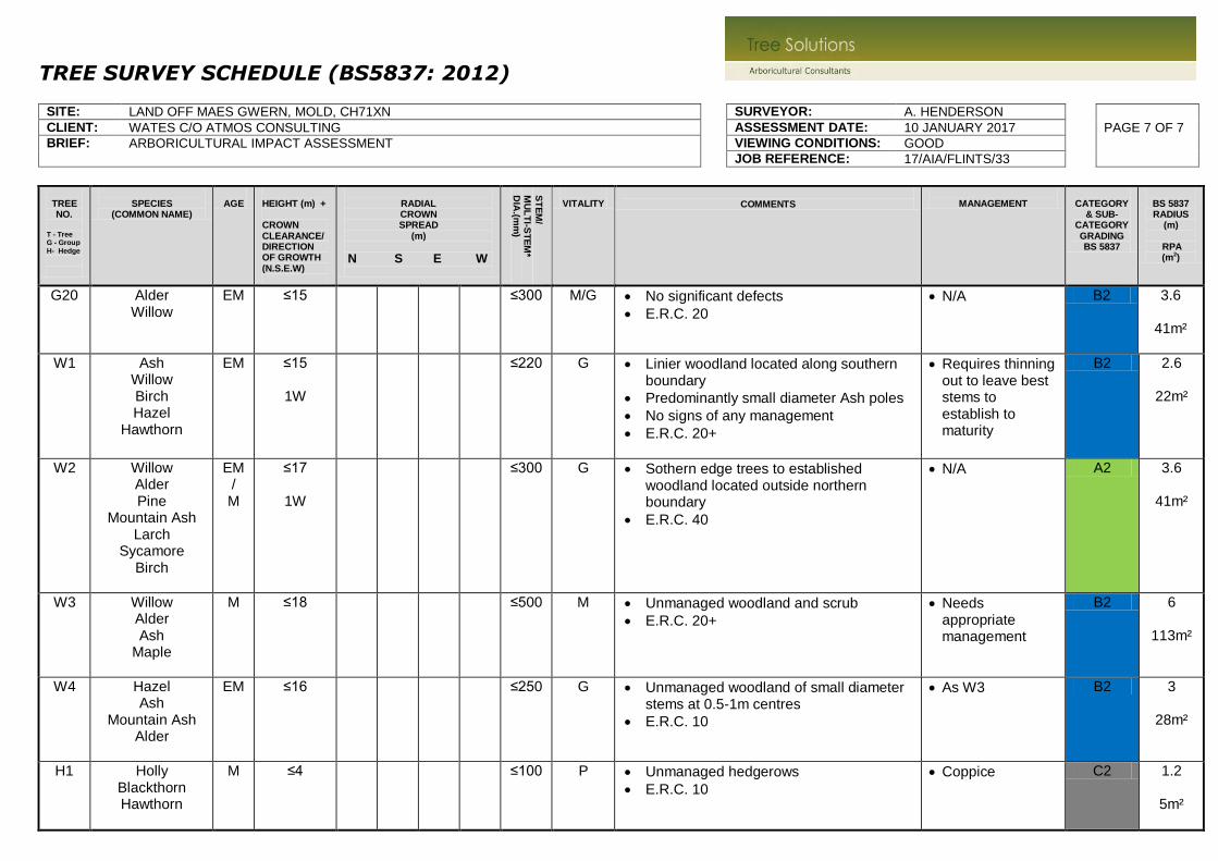
TREE SURVEY SCHEDULE (BS5837: 2012) SITE: LAND OFF MAES GWERN, MOLD, CH71XN SURVEYOR: A. HENDERSON
CLIENT: WATES C/O ATMOS CONSULTING ASSESSMENT DATE: 10 JANUARY 2017 PAGE 7 OF 7
BRIEF: ARBORICULTURAL IMPACT ASSESSMENT VIEWING CONDITIONS: GOOD
JOB REFERENCE: 17/AIA/FLINTS/33
TREE NO.
T - Tree G - Group H- Hedge
SPECIES
(COMMON NAME)
AGE
HEIGHT (m) + CROWN CLEARANCE/DIRECTION OF GROWTH (N.S.E.W)
RADIAL CROWN SPREAD
(m)
N S E W
ST
EM
/
MU
LT
I-ST
EM
* D
IA.(m
m)
VITALITY
COMMENTS
MANAGEMENT
CATEGORY
& SUB-CATEGORY GRADING BS 5837
BS 5837 RADIUS
(m)
RPA (m2)
G20
Alder Willow
EM
≤15
≤300 M/G
No significant defects
E.R.C. 20
N/A
B2 3.6
41m²
W1
Ash Willow Birch Hazel
Hawthorn
EM
≤15
1W
≤220 G
Linier woodland located along southern boundary
Predominantly small diameter Ash poles
No signs of any management
E.R.C. 20+
Requires thinning out to leave best stems to establish to maturity
B2 2.6
22m²
W2
Willow Alder Pine
Mountain Ash Larch
Sycamore Birch
EM/
M
≤17
1W
≤300 G
Sothern edge trees to established woodland located outside northern boundary
E.R.C. 40
N/A
A2 3.6
41m²
W3
Willow Alder Ash
Maple
M
≤18
≤500 M
Unmanaged woodland and scrub
E.R.C. 20+
Needs appropriate management
B2 6
113m²
W4
Hazel Ash
Mountain Ash Alder
EM
≤16
≤250 G
Unmanaged woodland of small diameter stems at 0.5-1m centres
E.R.C. 10
As W3
B2 3
28m²
H1
Holly Blackthorn Hawthorn
M
≤4 ≤100 P
Unmanaged hedgerows
E.R.C. 10
Coppice
C2 1.2
5m²

Table 1 Cascade chart for tree quality assessment
Category and definition Criteria (including subcategories where appropriate) Identificationon plan
Trees unsuitable for retention (see Note)Category U
Those in such a conditionthat they cannot realisticallybe retained as living trees inthe context of the currentland use for longer than10 years
• Trees that have a serious, irremediable, structural defect, such that their early loss is expected due to collapse,including those that will become unviable after removal of other category U trees (e.g. where, for whateverreason, the loss of companion shelter cannot be mitigated by pruning)
• Trees that are dead or are showing signs of significant, immediate, and irreversible overall decline
• Trees infected with pathogens of significance to the health and/or safety of other trees nearby, or very lowquality trees suppressing adjacent trees of better quality
NOTE Category U trees can have existing or potential conservation value which it might be desirable to preserve;see 4.5.7.
See Table 2
1 Mainly arboricultural qualities 2 Mainly landscape qualities 3 Mainly cultural values,including conservation
Trees to be considered for retentionCategory A
Trees of high quality with anestimated remaining lifeexpectancy of at least40 years
Trees that are particularly goodexamples of their species, especially ifrare or unusual; or those that areessential components of groups orformal or semi-formal arboriculturalfeatures (e.g. the dominant and/orprincipal trees within an avenue)
Trees, groups or woodlands of particularvisual importance as arboricultural and/orlandscape features
Trees, groups or woodlandsof significant conservation,historical, commemorative orother value (e.g. veterantrees or wood-pasture)
See Table 2
Category B
Trees of moderate qualitywith an estimated remaininglife expectancy of at least20 years
Trees that might be included incategory A, but are downgradedbecause of impaired condition (e.g.presence of significant thoughremediable defects, includingunsympathetic past management andstorm damage), such that they areunlikely to be suitable for retention forbeyond 40 years; or trees lacking thespecial quality necessary to merit thecategory A designation
Trees present in numbers, usually growingas groups or woodlands, such that theyattract a higher collective rating than theymight as individuals; or trees occurring ascollectives but situated so as to make littlevisual contribution to the wider locality
Trees with materialconservation or othercultural value
See Table 2
Category C
Trees of low quality with anestimated remaining lifeexpectancy of at least10 years, or young trees witha stem diameter below150 mm
Unremarkable trees of very limitedmerit or such impaired condition thatthey do not qualify in higher categories
Trees present in groups or woodlands, butwithout this conferring on themsignificantly greater collective landscapevalue; and/or trees offering low or onlytemporary/transient landscape benefits
Trees with no materialconservation or othercultural value
See Table 2
BR
ITISHSTA
ND
AR
DB
S5837:2012
©Th
eB
ritishStan
dard
sIn
stitutio
n2012
•9

www.tree-solutions.co.uk
Arboricultural Impact Assessment – Land off Maes Gwern, Mold (17/03/2017) © Tree Solutions Ltd (2017)
12
Appendix Two
Preliminary Tree Constraints Plan

SEP2
SEP3
SEP4
SEP5
DF1
DF2
DF3
DF4
DF5
DF5A
DF6
DF7
DF8
SEP4A
ML1
ML2
SEP1
SEP5
DF2
DF3
DF4
DF5
DF5A
DF6
DF7
DF8
D1
D1A
D2
D1B
D3
D4
D5
D6
D6A
D7 D8
D7A
D7B
D9 D9A
D9C
D9D
D9E
D9G
D50
D51D52
D53
D54
D55
D56
D60
D59
D60A
D57
D58
D61
D62
D63
D3
RE2
RE1
ML1
ML1A
ML2
ML3
ML4
E323169.613N362938.645
E323225.541
E323223.128
E323289.005
N362908.967
N362955.304
N362923.266
N362989.753E323336.016
N362982.742E323396.449
N362941.192E323433.043
N362956.056E323190.003
N362920.823E323189.696
N362898.483E323330.734
N362843.625E323352.521
N362881.643E323399.060
N362836.803E323434.636
DEAD ALDER
STUMP
STUMP
1
2
3
4Stump
Stump
5
6
7
8
9
10
11
12
13
Sm Sycamore
14
15
16
17
Poor quality Willow scrub
21
G1*
G2*
G3
G4
G5
G6*
G7*
Sm Hawthorn (H3, D150mm)
Sm Oak (H8, D100mm)
G18*
Dead Alder
G19*
G20
W1*
W2*
W4*
22
23
20*
5m 10m 20m 30m 40m 50m
Crown
Spread
Tree
Number
Category
Root
Protection
Area
13
Category A
(High Quality)
Category B
(Moderate Quality)
Do not scale from this drawing all dimensions to be
checked on site.
The copyright of this document resides with Tree
Solutions unless assigned in writing by the company
Job Ref:
Drawn By:
Scale: Date:
Revision:
LI
1:500 @ A1 January 2017
-
Title:
Tree Constraints Plan
Project:
Maes Gwern, Mold, CH7 1XN
Client:
Wates C/o Atmos Consulting
Root Protection Area
Modified to Account for
Site Features
Legend
17/AIA/FLINTS/33 01
Drawing No:
W: www.tree-solutions.co.uk
T: 01244 389114
M: 07766 774508
Category C
(Low Quality)
Category U
(Dead/Dying/In Decline)
N
W E
S
NOTE: Trees marked with # have approximate
measurements as outside site boundary with no
access
NOTE: Tree/group numbers marked
with an * have approximate locations
Drawing sheets
S01
S02

SEP5
SEP6
SEP7
SEP8
SEP9
SEP8
DF8
SEP5
SEP6
SEP8SEP8
DF8
D9 D9A
D10
D9C
D9B
D11
D12D12A
D12B
D13
D60
D59
D60A
D61
D62
D63
D64D65
D66
D67
ML4
N362989.753E323336.016
N362982.742E323396.449
N362941.192E323433.043
N362910.130E323457.278
N362879.990E323547.344
N362898.483E323330.734
N362843.625E323352.521
N362881.643E323399.060
N362836.803E323434.636
N362857.119E323491.868
N362865.569E323543.967
N362890.240E323602.541
17
18
19
G5
G6*
G7*
Sm Hawthorn (H3, D150mm)
Sm Oak (H8, D100mm)
G8*
G9* Dead Ash
G10
G11*
G12*
G13*
G14*
G15*#
G16*
G17*
W3*
W4*
H1*
20*
5m 10m 20m 30m 40m 50m
Crown
Spread
Tree
Number
Category
Root
Protection
Area
13
Category A
(High Quality)
Category B
(Moderate Quality)
Do not scale from this drawing all dimensions to be
checked on site.
The copyright of this document resides with Tree
Solutions unless assigned in writing by the company
Job Ref:
Drawn By:
Scale: Date:
Revision:
LI
1:500 @ A1 January 2017
-
Title:
Tree Constraints Plan
Project:
Maes Gwern, Mold, CH7 1XN
Client:
Wates C/o Atmos Consulting
Root Protection Area
Modified to Account for
Site Features
Legend
17/AIA/FLINTS/33 01
Drawing No:
W: www.tree-solutions.co.uk
T: 01244 389114
M: 07766 774508
Category C
(Low Quality)
Category U
(Dead/Dying/In Decline)
N
W E
S
NOTE: Trees marked with # have approximate
measurements as outside site boundary with no
access
NOTE: Tree/group numbers marked
with an * have approximate locations
Drawing sheets
S01
S02

www.tree-solutions.co.uk
Arboricultural Impact Assessment – Land off Maes Gwern, Mold (17/03/2017) © Tree Solutions Ltd (2017)
13
Appendix Three
Impact Assessment Plan


www.tree-solutions.co.uk
Arboricultural Impact Assessment – Land off Maes Gwern, Mold (17/03/2017) © Tree Solutions Ltd (2017)
14
Appendix Four
Tree Protection Plan

A
B
B
A
9
1
6
1
0
2
S
A
N
D
Y
G
R
O
V
E
T
R
A
D
I
T
I
O
N
A
L
E
S
T
A
T
E
R
O
A
D
2m WIDE PRIVATE FOORPATH ABUTING PUBLIC
OPEN SPACE AND EXISTING WATERCOURSE TO
SOUTHERN BOUNDARY
V
I
E
W
V
I
E
W
VIE
W
3
5
6
T
2
T
2
T
R
A
D
I
T
I
O
N
A
L
E
S
T
A
T
E
R
O
A
D
T
ra
d
itio
n
a
l E
s
ta
te
R
o
a
d
8
T2
M
E
W
S
C
O
U
R
T
V
I
S
T
A
T
O
W
A
R
D
S
P
R
O
P
E
R
T
Y
F
R
O
N
T
A
G
E
V
I
S
T
A
T
O
W
A
R
D
S
P
R
O
P
E
R
T
Y
F
R
O
N
T
A
G
E
T
2
26
2
5
2
4
58
59
60
61
68
69
70
STEWART MILNE
DEVELOPMENT
E
X
IS
T
IN
G
G
R
A
V
E
L
F
O
O
T
P
A
T
H
O
U
T
F
A
L
L
P
O
S
I
T
I
O
N
T
O
B
E
L
O
O
K
E
D
A
T
B
Y
S
T
R
U
C
T
U
R
A
L
E
N
G
I
N
E
E
R
T
1
2
2
2
3
T
1
T
1
T1
T
3
T
4
T
3
T
9
T
9
T4
T4
T
7
T
4
T4
9
28
27
7
57
T4
21
T
4
T
3
T
2
T
6
T
2
T
2
V
IS
T
A
T
O
W
A
R
D
S
P
R
O
P
E
R
T
Y
F
R
O
N
T
A
G
E
134
T2
T2
133
132
131
T
6
T
6
T
6
5
6
TU
RN
IN
G H
EA
D
125
123
124
T6
122
T6
T6
T6
P
R
IV
A
T
E
D
R
IV
E
B
i
n
s
t
o
r
e
T10
114-119
T10
107
B
i
n
s
t
o
r
e
108-113
T10
Bin
sto
re
Bin
sto
re
17
1
8
T
7
T
7
T
8
T
8
T
9
15
1
9
T
7
2
0
T
7
1
0
T7
1
1
T
2
12
T
7
T
2
T
7
T7
62
T
7
T
7
T
7
T
3
T
3
T
3
7
7
7
8
81
80
82
79
T
9
16
75
76
T
2
T
1
T
7
T
7
T
8
T
8
T
7
T
7
T
7
T
7
T
8
T8
T8
T7
V
I
S
T
A
T
O
W
A
R
D
S
P
R
O
P
E
R
T
Y
F
R
O
N
T
A
G
E
T
7
T
7
T8
T8
Private Drive
T6 T6
T6
T6
T
6
T
6
T
6
T
6
1
3
1
4
63
64
65
66
67
71
72
73
74
87
88
89
90
91
92
95
94
120
121
126
127
129
128
130
106
V
IS
T
A
T
O
W
A
R
D
S
P
R
O
P
E
R
T
Y
F
R
O
N
T
A
G
E
V
I
E
W
S
1
2
T
5
T
3
T
9
AREA TO BE LANDSCAPED
POTENTIAL FOOTPATH LINK THROUGH
TO STEWART MILNE - FURTHER
CONSULTATION REQUIRED
P
r
o
p
o
s
e
d
S
u
b
s
t
a
t
i
o
n
4
T
1
0
T
1
0
9
6
-
1
0
1
T10
159
160
1
5
2
1
5
7
158
Private Drive
Bin
sto
re
T11
T11
V
IS
T
A
T
O
W
A
R
D
S
P
R
O
P
E
R
T
Y
F
R
O
N
T
A
G
E
T
9
T
U
R
N
I
N
G
H
E
A
D
102
103
104
105
135
136137
138
139
140 - 1
45
146
147
148
149
151
T
8
T
8
T
8
T
8
Pond
ESTIMATED POSITION OF FAULT LINE
FFORDD HENGOED
Car
park
ing for
Apart
ments
Car p
arkin
g fo
r A
partm
ents
C
a
r
p
a
r
k
i
n
g
f
o
r
A
p
a
r
t
m
e
n
t
s
T2
T1
1
5
5
1
5
6
T
4
154
T
3
1
5
3
T
2
T2
93
T2
T2
P
riv
a
te
D
riv
e
P
riv
a
te
D
riv
e
150
F
F
L
1
3
5
.
5
0
0
m
F
F
L
1
3
5
.
3
0
0
m
F
F
L
1
3
5
.
3
0
0
m
F
F
L
1
3
5
.
3
0
0
m
F
F
L
1
3
5
.
3
0
0
m
FFL134.500m
FFL134.500m
FFL134.500m
FF
L134.8
50m
F
F
L
1
3
4
.7
5
0
m
FFL134.250m
FFL134.200m
FFL133.900m
F
F
L134.100m
FF
L134.100m
FFL134. 100m
F
F
L
1
3
4
.2
5
0
m
F
F
L
1
3
3
.5
0
0
m
FFL133.500m
FF
L133.5
00m
FFL134.200m
FFL134.200m
FFL133.900mFFL134.200m
FFL134.650m
FFL134.650m
FFL134.800m
FFL134.800m
FFL134.450m
FFL134.185m
FFL134.200m
FFL134.200m
FFL133.500m
FFL133.800m
FFL133.300m
FFL133.300m
FFL133.100m
FFL133.100m
FFL134.850m
FFL134. 550m
FFL134. 550m
FFL134. 300m
FFL134. 300m
FFL134.000m
FFL133.600m
FFL133.400m
FFL133.400m
FFL133.100m
FFL133.100m
FFL132.750m
FFL132.750m
FFL129.750m
FFL129.750m
FFL132.000m
FFL131.250m
FFL130.900m
FFL131.500m
FFL133.500m
FFL133.700m
F
F
L133.700m
FFL133.500m
FFL133.500m
FFL133.500m
FFL135.500m
FFL133.500m
FFL133.000m
FFL133.500m
FFL134.000m
F
F
L134.500m
FFL134.000m
T
5
F
F
L
1
3
5
.
5
0
0
m
FFL133.500m
T
6
T
6
T
6
T
8
POTENTIAL COMMUNITY
ORCHARD / GROWING
AREA
84
85
86
T9
FFL132.700m
T12
T12
FFL132.000m
T
6
F
F
L
1
3
3
.5
0
0
m
T
6
T
6
F
F
L
1
3
3
.5
0
0
m
T
4
T
4
F
F
L
1
3
3
.
8
0
0
m
V
IS
T
A
T
O
W
A
R
D
S
P
R
O
P
E
R
T
Y
F
R
O
N
T
A
G
E
1
2
3
4Stump
Stump
5
6
7
8
9
10
11
12
13
Sm Sycamore
14
15
16
Poor quality Willow scrub
G1*
G2*
G3
G4
G5
G6*
G7*
Sm Hawthorn (H3, D150mm)
Sm Oak (H8, D100mm)
G19*
G20
W1*
W2*
W4*
20*
22
5m 10m 20m 30m 40m 50m
Crown
Spread
Tree
Number
Category
Root
Protection
Area
13
Category A
(High Quality)
Category B
(Moderate Quality)
Do not scale from this drawing all dimensions to be
checked on site.
The copyright of this document resides with Tree
Solutions unless assigned in writing by the company
Job Ref:
Drawn By:
Scale: Date:
Revision:
1:500 @ A1
Title:
Tree Protection Plan
Project:
Maes Gwern, Mold, CH7 1XN
Client:
Wates C/o Atmos Consulting
Root Protection Area
Modified to Account for
Site Features
Legend
17/AIA/FLINTS/33 03
Drawing No:
W: www.tree-solutions.co.uk
T: 01244 389114
M: 07766 774508
Category C
(Low Quality)
Category U
(Dead/Dying/In Decline)
N
W E
S
NOTE: Trees marked with # have approximate
measurements as outside site boundary with no
access
NOTE: Tree/group numbers marked
with an * have approximate locations
Drawing sheets
S01
S02
Tree Protection Fencing
LI & AM
March 2017
A
Ground Protection
No-Dig Surface Installation Areas -
see Method Statement

B
B
M
AE
S G
W
ER
N
El Sub Sta
Pond
V
I
E
W
VIE
W
V
I
E
W
V
I
S
T
A
T
O
W
A
R
D
S
P
R
O
P
E
R
T
Y
F
R
O
N
T
A
G
E
Playing Field
PROPOSED FOOTPATH TO
ACCESS PLAYING FIELD.
THIS COULD ALSO BE
USED TO REDUCE TRAVEL
TO THE LOCAL SCHOOl.
T
2
T
2
T
R
A
D
I
T
I
O
N
A
L
E
S
T
A
T
E
R
O
A
D
V
I
S
T
A
T
O
W
A
R
D
S
P
R
O
P
E
R
T
Y
F
R
O
N
T
A
G
E
T
2
26
2
5
2
4
58
59
60
61
68
69
70
T
1
2
2
2
3
T
1
T
1
T
3
T
9
T
9
T
7
T
4
T4
T
6
T
6
T
6
T
6
40
33
32
31
28
27
57
T4
21
P
U
B
L
I
C
O
P
E
N
S
P
A
C
E
0
.
1
8
H
A
-
0
.
4
4
A
C
R
E
S
5
5
5
6
TU
RN
IN
G H
EA
D
P
R
IV
A
T
E
D
R
IV
E
B
i
n
s
t
o
r
e
T10
114-119
T10
107
B
i
n
s
t
o
r
e
108-113
T10
Bin
sto
re
Bin
sto
re
T
7
1
9
2
0
T
7
T7
T
2
T
7
T7
62
T
7
T
7
T
7
T
3
T
3
T
3
7
7
7
8
81
80
82
7
9
75
76
T
U
R
N
I
N
G
H
E
A
D
T
2
T
7
T
7
T
8
T
8
T
7
T
8
T
8
T
7
T
7
T
7
T
7
T
2
T
7
T
7
T
8
T
8
T
7
T
7
T
7
T
7
T
7
T
7
V
I
S
T
A
T
O
W
A
R
D
S
P
R
O
P
E
R
T
Y
F
R
O
N
T
A
G
E
T
7
T
7
38
39
29
30
34
35
36
37
63
64
65
66
67
71
73
74
83
87
88
89
90
91
92
95
94
106
V
IS
T
A
T
O
W
A
R
D
S
P
R
O
P
E
R
T
Y
F
R
O
N
T
A
G
E
P
r
o
p
o
s
e
d
S
u
b
s
t
a
t
i
o
n
T
1
0
T
1
0
9
6
-
1
0
1
T10
T
9
T
U
R
N
I
N
G
H
E
A
D
102
103
104
105
T
8
T
8
Pond / Bog
ESTIMATED POSITION OF FAULT LINE
ESTIMATED POSITION OF FAULT LINE
Existing building
M
e
w
s
C
o
u
r
t
Car
parkin
g for
Apart
ments
C
a
r
p
a
r
k
i
n
g
f
o
r
A
p
a
r
t
m
e
n
t
s
T
9
P
r
i
v
a
t
e
D
r
i
v
e
T2
93
FFL134.185m
FFL134.200m
FFL134.200m
FFL133.500m
FFL133.800m
FFL133.300m
FFL133.300m
FFL133.100m
FFL133.100m
FFL134. 300m
FFL134. 300m
FFL134.000m
FFL133.600m
FFL133.400m
FFL133.400m
FFL133.100m
FFL133.100m
FFL132.750m
FFL132.750m
FFL131.700m
FFL132.450m
FFL132.450m
FFL131.000m
FFL130.500m
FFL129.000m
FFL129.500m
FFL129.750m
FFL129.750m
FFL132.000m
FFL131.250m
FFL130.900m
FFL131.500m
FFL133.500m
FFL133.700m
F
F
L133.700m
FFL133.500m
FFL133.500m
FFL133.500m
FFL135.500m
FFL133.500m
FFL134.000m
FFL134.000m
T
6
T
6
T
6
T
8
84
85
86
T9
FFL132.700m
T12
T12
FFL132.000m
T
6
F
F
L
1
3
3
.5
0
0
m
T
6
T
6
F
F
L
1
3
3
.5
0
0
m
T
4
T
9
T
9
T
1
T
1
T
1
T
5
T
1
T
4
T
4
T
1
T
1
T
5
T
4
45
43
44
47
48
51
42
52
46
53
FFL128.100m
FFL127.500m
FFL128.000m
FFL127.800m
FFL127.500m
FFL127.000m
FFL127.000m
FFL127.000m
FFL127.000m
FFL127.000m
FFL127.000m
49
FFL127.000m
50
54
FFL127.000m
Gateway
Feature
T
4
F
F
L
1
3
3
.
8
0
0
m
T
1
F
F
L
1
2
8
.
1
0
0
m
41
V
IS
T
A
T
O
W
A
R
D
S
P
R
O
P
E
R
T
Y
F
R
O
N
T
A
G
E
V
IS
T
A
T
O
W
A
R
D
S
P
R
O
P
E
R
T
Y
F
R
O
N
T
A
G
E
G5
G6*
G7*
Sm Hawthorn (H3, D150mm)
Sm Oak (H8, D100mm)
G8*
G10
G12*
G13*
G14*
G15*#
G16*
G17*
W3*
W4*
20*
19*
18*
5m 10m 20m 30m 40m 50m
N
W E
S
Drawing sheets
S01
S02
Do not scale from this drawing all dimensions to be
checked on site.
The copyright of this document resides with Tree
Solutions unless assigned in writing by the company
Job Ref:
Drawn By:
Scale: Date:
Revision:
LI & AM
1:500 @ A1
March 2017
A
Title:
Tree Protection Plan
Project:
Maes Gwern, Mold, CH7 1XN
Client:
Wates C/o Atmos Consulting
17/AIA/FLINTS/33 03
Drawing No:
W: www.tree-solutions.co.uk
T: 01244 389114
M: 07766 774508
Crown
Spread
Tree
Number
Category
Root
Protection
Area
13
Category A
(High Quality)
Category B
(Moderate Quality)
Root Protection Area
Modified to Account for
Site Features
Legend
Category C
(Low Quality)
Category U
(Dead/Dying/In Decline)
NOTE: Trees marked with # have approximate
measurements as outside site boundary with no
access
NOTE: Tree/group numbers marked
with an * have approximate locations
Tree Protection Fencing
Ground Protection
No-Dig Surface Installation Areas -
see Method Statement

www.tree-solutions.co.uk
Arboricultural Impact Assessment – Land off Maes Gwern, Mold (17/03/2017) © Tree Solutions Ltd (2017)
15
Appendix Five
Tree Protective Measures/Method Statement

www.tree-solutions.co.uk
Arboricultural Impact Assessment – Land off Maes Gwern, Mold (17/03/2017) © Tree Solutions Ltd (2017)
16
SEQUENCE OF OPERATIONS
From commencement of the above development, the following methodology shall be implemented in the manner and sequence described:
1. Tree Surgery Works 2. Erect temporary protective fencing 3. Install ground protection boards 4. Main construction phase 5. Excavation of turning head within RPA of T4 6. Installation of no-dig footpath 7. Removal of temporary fencing 8. Landscaping within RPA’s 9. Arboricultural site supervision
1. Tree Surgery Works
1. Before the erection of the temporary protective fencing, all tree removal shall be implemented in accordance with the Tree Survey Schedule at Appendix 1
2. All possible efforts must be made to prevent damage to retained trees including potential root incursion or compaction caused by vehicle access.
3. All arboricultural works shall conform to the recommendations of BS 3998 (2010) ‘Recommendations for Tree Work’
4. All operatives shall be equipped with and use personal protective equipment (PPE) in accordance with current Health & Safety Executive current directives and industry codes of practice.
5. Performance of all arboricultural operations and use of equipment shall be in accordance with current Health & Safety Executive current directives and industry codes of practice
2. Erect Temporary Tree Protective Fencing
1. Prior to commencement of any construction, preparation, excavation or material deliveries the
main contractor shall erect the temporary protective fencing as detailed in the ‘Tree Protection Specification’ and in the location indicated on the Tree Protection Plan.
2. Tree Solutions are to be given 5 days written notice as soon as all protective fencing has been
erected in order to inspect the specification and location. An inspection report will be completed and returned to the LPA Tree Officer for approval. Any damage occurring to protective fencing during the demolition or construction phase shall be made good by the main contractor
3. Install ground protection within RPA of tree number 12, 18 & 19
1. The ground protection measures must be capable of supporting the expected loads and evenly distribute the carried weight over the track width of any vehicles that will use the access route in order to avoiding rutting, compaction and damage to the soil.
2. The method of protecting the ground for tracked construction traffic movements within the RPA will involve the use of a high density polyethylene track boards or bog mats laid across the RPA that extends beyond the protective fencing location butted together to form a continuous line as indicated on the Tree Protection Plan. The boards will be fixed in place by construction tie-rods to avoid any displacement details of which are to be approved for use by Tree Solutions and the LPA before installation commences.
3. Temporary ground protection materials shall be delivered and moved by low impact tracked machinery and installed by hand.
4. The ground beneath any protection boarding will be left undisturbed and will be protected with a porous geotextile fabric and side butting scaffold boards on a 100mm compressible layer such of sharp sand
5. Boards will remain in-situ until the construction of the building has been completed

www.tree-solutions.co.uk
Arboricultural Impact Assessment – Land off Maes Gwern, Mold (17/03/2017) © Tree Solutions Ltd (2017)
17
Plate 1 protective boards & scaffolding to be installed
4. Main Construction Phase
1. Tree protective fencing to be erected prior to any construction plant or materials entering the site 2. Tree protective barriers in accordance with BS 5837: 2012 will be erected to prevent damage to
the tree stems and any movement of plant with the RPA 3. There shall be no storage of construction material, site parking, site accommodation or
equipment in any area designated as the Root Protection Area (RPA) and Construction Exclusion Zone (CEZ) and enclosed by Temporary Protective Fencing
4. No materials that are likely to have an adverse effect on tree health such as oil, bitumen or cement will be stored or discharged within 10 metres of the trunk of a tree that is to be retained. No fires will be lit
5. The site agent shall supervise deliveries by self-loading crane, with vehicles positioned in such a manner that retained trees are not at risk of damage
Cement Mixing
The cement mixer will be laid on top of plywood boards in a position outside the RPA of any trees. The mixer will be kept in this position throughout all development work. Avoiding Damage to Stems and Branches
Care shall be taken when planning site operations in proximity to trees to ensure that wide or tall loads or plant with booms, jibs and counterweights can operate without coming into contact with retained trees. Such contact can result in serious injury resulting in safe retention impossible
On Site Storage of Spoil and Building Materials
Prior to and during all site construction works no spoil will be stored and no cement mixing will take place within the Root Protection Area of any tree on or adjacent to the site even if proposed site work is to be within the crown spread. Any encroachment within this protected area will only be with the prior agreement of the LPA Arboricultural Officer

www.tree-solutions.co.uk
Arboricultural Impact Assessment – Land off Maes Gwern, Mold (17/03/2017) © Tree Solutions Ltd (2017)
18
5. Excavation of Turning Head within RPA of T4
The section of road that encroaches within the RPA of tree number 4 will be excavated by hand digging or by use of an ‘Airspade’ under the direct supervision of the project arboricultural consultant. The use of mechanical excavation plant is prohibited. The following steps will be adhered to in order to minimise damage:
1. After careful removal of the turf surface digging must proceed with hand tools. Clumps of roots less than 25mm in diameter (including fibrous roots) should be retained in situ without damage. Throughout the excavation works great care should be taken to protect the bark around the roots.
2. All roots greater than 25mm diameter should be preserved and worked around. These roots must not be severed without first consulting the owner of the tree or the local authority tree officer. If after consultation severance is unavoidable, roots must be cut back using a sharp tool to leave the smallest wound.
3. Fine roots are vulnerable to desiccation once they are exposed to the air. Larger roots have a bark layer which provides some protection against desiccation and temperature change. The greatest risk to these roots occurs when there are rapid fluctuations in air temperature around them e.g. frost and extremes of heat. It is therefore important to protect exposed roots where a trench is to be left open overnight where there is a risk of frost. Roots, whist exposed, shall be wrapped in dry (winter) or wet (summer), clean Hessian sacking to prevent desiccation and to protect from rapid temperature changes prior to backfilling. Exposed roots shall be pruned back to a side branch, by use of a sharp saw or secateurs by the project arboricultural consultant and not construction personnel.
Backfilling trench
1. Without prejudice to the requirements relating to the specification of materials and the standards
of workmanship, backfilling should be carefully carried out to avoid direct damage to roots and excessive compaction of the soil around them.
2. The backfill should, where possible, include the placement of an inert granular material mixed with top soil or sharp sand (not builder’s sand) around the roots. This should allow the soil to be compacted for resurfacing without damage to the roots securing a local aerated zone enabling the root to survive in the longer term. Backfilling should be carried out using the excavated soil. This should not be compacted but lightly “tamped” and left slightly proud of the surrounding surface to allow natural settlement. Other materials should not be incorporated into the backfill
6. Installation of ‘No-Dig’ Footpath
1. Upon completion of all development work and removal of associated plant and material from site, the proposed new pedestrian footpath within the RPA of tree number 4 & 5 and as indicated with a blue cross hatch on the tree protection plan shall be constructed using a no-dig three dimensional cellular confinement system in accordance with the engineers and manufacturers recommendations see drawing at Appendix 6.
2. Construction shall ideally be undertaken in dry weather when ground is driest and least prone to compaction
3. Ground vegetation should be killed using a translocated herbicide such as glyphosate. To prevent severe oxygen depletion in the soil during the process of decomposition, all dead organic material shall be removed
4. All major protrusions such as rocks and demolition material shall be removed minimizing ground disturbance. All hollows will be filled with sharp sand
5. Permeable matting will then be laid and the cellular confinement system laid on top and pegged in place.
6. The cellular confinement system will then be installed in accordance with the manufacturer’s guidelines using no-fines aggregate. Fill the cells working from the area furthest from the tree first. Further filling should be carried out using the filled Cellweb/Infraweb as a platform
7. Edging will be constructed with tantalised boards attached to pegs driven into the ground. Pegs should be long enough to give adequate support during construction
8. Install a permeable wearing course, e.g. resin bonded gravel placed on the aggregate. 9. Tree Solutions will be responsible for monitoring all excavation works and issuing a certificate of
practical completion 10. Under no circumstances is limestone aggregate to be used

www.tree-solutions.co.uk
Arboricultural Impact Assessment – Land off Maes Gwern, Mold (17/03/2017) © Tree Solutions Ltd (2017)
19
7. Remove all Temporary Tree Protective Fencing
1. Tree Protective fencing will only be removed upon completion of all construction work and once all machinery associated with the works has left site.
2. The tree protection fencing shall not be removed until written confirmation has been received from the Local Planning Authority that it is acceptable to do so.
8. Landscaping within RPA of Trees
1. There shall be no rotovation of ground within any area designated as a Root Protection Area
(RPA) and Construction Exclusion Zone (CEZ) and enclosed by Temporary Protective Fencing. 2. No hard landscaping works or excavation for cables or any other service should be installed
within the Root Protection Area (RPA) and Construction Exclusion Zone (CEZ) without the written consent of the LPA
9. ARBORICULTURAL SITE SUPERVISION
1 The erection of all tree protection measures outlined in this AMS and as indicated on the Tree
Protection Plan will be inspected by the contract Arboricultural Consultant immediately after erection. Photographic evidence of the location and specification of all protective fencing will be forwarded to the LPA Tree Officer upon completion.
2 All proposed work within any designated RPA will be overseen by contract Arboricultural Consultant with photographic records taken and signed inspection report emailed direct to the LPA for approval
3 The contract Arboricultural Consultant to make visits to site to inspect all tree protection measures during all key development work within close proximity to retained trees
Useful Contacts
Arboricultural Consultant LPA Consultant Forestry Officer Name: Alistair Henderson (Tree Solutions Ltd) Name: Stuart Body Tel: 01244 389114 Tel: 01352 703264
Mobile: 07766 774508 Email: [email protected]
TREE PROTECTIVE FENCING
1 Before the commencement of any site excavations and subsequent construction works (other than those set out in the schedule of tree works contained in this document), protective fencing will be erected as detailed on the Tree Protection Plan and as specified below. The LPA Tree Officer will be given 5 days notice upon completion of the fencing in order to inspect and approve prior to the commencement of any site works.
2 The fencing will consist of a scaffold framework in accordance with Figure 2 of BS 5837 – 2012 (illustration below) comprising a metal framework, both vertical and horizontal, well braced to resist impacts. Vertical tubes will be spaced at a maximum interval of 3m. Onto this, weldmesh panels shall be securely fixed with wire or scaffold clamps. Weldmesh panels on rubber or concrete feet are not considered resistant to impact and for this reason will not be used. The site manager or other suitably qualified appointed person will be responsible for inspecting the protective fencing on a daily basis; any damage to the fencing or breaches of the fenced area will
be rectified immediately. 3 Clearly legible weatherproof signage, stating “Protected Trees – Exclusion Zone” shall be
attached to the fencing 1.5m from the ground, facing out of the Tree Protection Zone located at regular intervals along the fence line
4 The fencing will remain in place until completion of all site works and then only removed when all site traffic is removed from site
5 Other than works detailed within this method statement or approved in writing by the Local Planning Authority (LPA), no works including storage or dumping of materials shall take place within the exclusion zones defined by the protective fencing.

www.tree-solutions.co.uk
Arboricultural Impact Assessment – Land off Maes Gwern, Mold (17/03/2017) © Tree Solutions Ltd (2017)
20
Protective Fencing Detail
1. Magenta - Trees

www.tree-solutions.co.uk
Arboricultural Impact Assessment – Land off Maes Gwern, Mold (17/03/2017) © Tree Solutions Ltd (2017)
21
Appendix Six
Proposed 'No-Dig' Footpath Infragreen example cross section drawings
Ref: IG-SD-IW-PA-75
