archaeological desk- based assessment reportusir.salford.ac.uk/43920/1/bluecoat school dba.pdf ·...
TRANSCRIPT

© CfAA: Desk-Based Assessment: Bishop’s Bluecoat C of E High School Chester, November 2015
Archaeological Desk-
Based Assessment
Report
Bishop’s Bluecoat C of E
High School, Chester
Client: Cowan & Co
Technical Report: Rachael Reader
Report No: 23/2015

© CfAA: Desk-Based Assessment: Bishop’s Bluecoat C of E High School Chester, November 2015
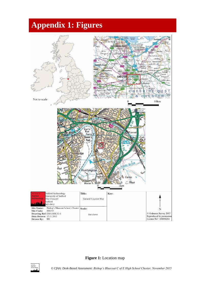
Site Location: Bishop’s Bluecoat C of E High School, Chester
NGR: SJ 42198 65576
Internal Ref: CfAA 23/2015
Proposal: Archaeological Desk-Based Assessment
Planning Ref: 14/02953/FUL
Prepared for: David Whiteside, Cowan & Co, Chartered Architects and Chartered
Building Surveyors
Document Title: Archaeological Desk-Based Assessment: Bishop’s Bluecoat C of E High
School, Chester
Document Type: Desk-Based Assessment.
Version: Version 1.0
Author: Rachael Reader BA Hons, MA, PhD, ACIfA
Position: Supervising Archaeologist
Date: November 2015
Approved by: Adam J Thompson BA Hons, MA, MIFA
Position: Director of Archaeology
Date: November 2015 Signed:…………………..
Copyright: Copyright for this document remains with the Centre for Applied
Archaeology, University of Salford.
Contact: Salford Archaeology, University of Salford, Peel Building, The Crescent,
Salford, M5 4WT
Telephone: 0161 295 2545 Email: [email protected]
Disclaimer:
This document has been prepared by the Centre for Applied Archaeology, University of Salford for the titled project
or named part thereof and should not be used or relied upon for any other project without an independent check
being undertaken to assess its suitability and the prior written consent and authority obtained from the Centre for
Applied Archaeology. The University of Salford accepts no responsibility or liability for the consequences of this
document being used for a purpose other than those for which it was commissioned. Other persons/parties using or
relying on this document for other such purposes agrees, and will by such use or reliance be taken to confirm their
agreement to indemnify the University of Salford for all loss or damage resulting therefrom. The University of
Salford accepts no liability or responsibility for this document to any other party/persons than by whom it was
commissioned.

© CfAA: Desk-Based Assessment: Bishop’s Bluecoat C of E High School Chester, November 2015
Summary 1
1. Introduction 2
2. Methodology Statement 4
3. The Setting 5
4. Archaeological & Historical Background 6
5. Gazetteer of Sites 10
6. Significance of the Remains 16
7. Impact of the Development 20
8. Recommendations for Mitigation 23
9. Sources 24
10. Archive 26
Appendix 1: Figures 27
Contents

© CfAA: Desk-Based Assessment: Bishop’s Bluecoat C of E High School Chester, November 2015
Salford Archaeology (formerly known as the Centre for Applied Archaeology) was
commissioned by David Whiteside of Cowan & Co, Chartered Architects, to carry out
an archaeological desk-based assessment on land at the Bishop’s Blue Coat C of E High
School, Chester, Cheshire (centred on SJ 42198 65576).
The aim of the archaeological assessment was to identify, as far as possible the nature,
extent and significance of the archaeological resource so as to enable any informed
recommendations to be made for the future treatment of any surviving remains. This
information was required to inform a planning application (14/02953/FUL) to demolish
three temporary classrooms and build a new classroom extension.
The desk-based research has found that the school may lie within the boundary of a
Roman Cremation Cemetery (Sites 1 and 2) and cremations were found during the
school’s construction (Site 2). The area remained rural until the late 20th century with
very little development, therefore there is also the potential for remains relating to
Medieval agriculture to survive. These remains have been assessed and a programme
of mitigation has been proposed.
Summary

© CfAA: Desk-Based Assessment: Bishop’s Bluecoat C of E High School Chester, November 2015
1.1 Planning Background
Salford Archaeology (formerly known as the Centre for Applied Archaeology) was
commissioned by David Whiteside of Cowan & Co, Chartered Architects, to carry out
an archaeological desk-based assessment on land located at the Bishop’s Blue Coat C
of E High School, Chester, Cheshire (centred on SJ 42198 65576). This information
was required to inform a planning application (14/02953/FUL) to demolish a series of
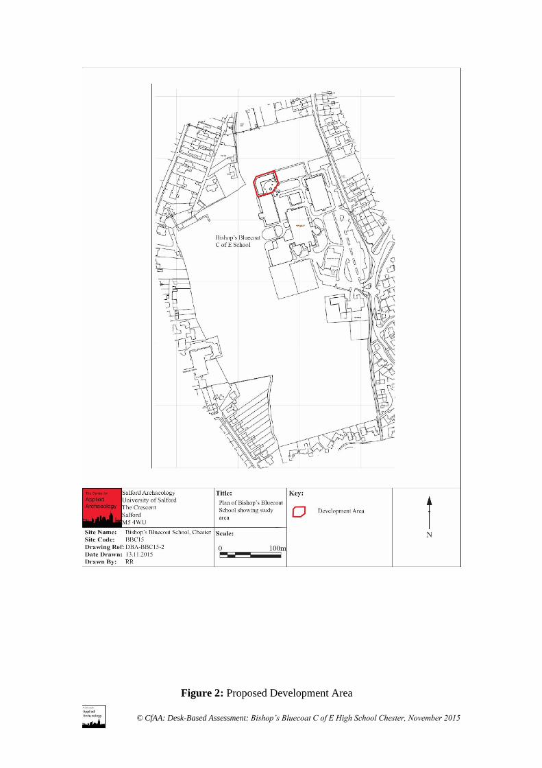
temporary classrooms and build a new classroom block at the NW edge of the school
complex.
The aim of the archaeological assessment was to identify, as far as possible the nature,
extent and significance of the archaeological resource so as to enable any informed
recommendations to be made for the future treatment of any surviving remains.
1.2 Government and Local Planning Policies
1.2.1 National Planning Policy Framework (NPPF)
The significance of the archaeological resource identified within this report has been
assessed as recommended in National Planning Policy Framework (Department for
Local Communities, March 2012).
NPPF sets out the Government’s planning policies and outlines the presumption in
favour of sustainable development, which is defined by three principles: economic,
social and environmental. Of the twelve core planning principles underpinning plan
and decision making, conserving “heritage assets in a manner appropriate to their
significance, so they can be enjoyed for their contribution to the quality of life of this
and future generations” is one.
Section 12 specifically deals with the historic environment (paragraphs 126-141) and
local planning authorities should consider:
The desirability of sustaining and enhancing the significance of heritage assets
and putting them to viable uses consistent with their conservation
The wider social, cultural, economic and environmental benefits that
conservation of the historic environment can bring
The desirability of new development making a positive contribution to local
character and distinctiveness; and
Opportunities to draw on the contribution made by the historic environment to
the character of a place
1. Introduction

© CfAA: Desk-Based Assessment: Bishop’s Bluecoat C of E High School Chester, November 2015
Paragraph 128 states that local planning authorities, when determining applications,
should require the applicant to describe the significance of any affected heritage assets.
This should be sufficient so as to understand the potential impact on their significance
and this should be done using the appropriate expertise where necessary.
Paragraph 135 indicates that the effect of the proposal on non-designated heritage assets
(designated assets are covered in paragraphs 132-134) should be taken into account.
Paragraph 141 requires developers to record and advance understanding of heritage
assets to be lost, in a manner appropriate to their importance and impact.
1.2.2 Local Development Framework
NPPF outlines the need for local planning authorities to create local plans and
frameworks to implement NPPF at a local level. The Chester Archaeological Plan
(Beckley and Campbell 2014) provides the evidence base for the Cheshire West and
Chester (CWaC) Local Plan and summarises the approach the local authority will take
in determining planning applications which may affect heritage assets. In addition to
this, there is a research framework specific to the archaeology and heritage of Chester
(Beckley and Campbell 2013), as well as character zones within the Chester Urban
Archaeological Database (UAD) which defines the archaeology of wider areas of
Chester and its surroundings.
Cheshire and Chester West Council are advised on archaeological matters by the
development control archaeologist at Cheshire Archaeology Planning Advisory Service
(CAPAS).
© CfAA: Desk-Based Assessment: Bishop’s Bluecoat C of E High School Chester, November 2015
The assessment considers the potential impact of the development upon any potential
heritage assets within the study area and comprises of an archaeological desk-based study
and a site inspection. The works followed the IfA standard and guidance for undertaking
archaeological desk-based assessments (Institute for Archaeologists, Standard and
Guidance for Archaeological Desk-Based Assessment, 1994, revised 2014)
2.1 Research
The desk-based assessment made use of the following sources:
• Published and unpublished cartographic, documentary and photographic sources.
• The Cheshire Historic Environment Record, held by CAPAS
2.2 Site Inspection
The aim of the site inspection was to relate the findings of the desk-based study to the
existing land use of the study area in order to identify any evidence of the structures which
formally stood on the site along with the sites potential for surviving below ground remains.
2. Methodology Statement

© CfAA: Desk-Based Assessment: Bishop’s Bluecoat C of E High School Chester, November 2015
3.1 Location, Topography and Land use
The city of Chester lies at the western extreme of the Cheshire county boundary with
Wales. The study area (centred on SJ 42198 65576) lies approximately 2km SE of the
city centre and is on the site of a secondary school. Historically, the area lies within
the township of Great Boughton and the parish of Chester St Oswalds.
The study area is located on relatively flat land although the ground gently slopes
towards Caldy Brook to the south and the river Dee lies 300m to the west. The site is
located at approximately 20m AOD.
The study area appears to lie in Roman and Medieval Chester’s rural fringe and is
undeveloped until the school was built in the late 20th century.
3.2 Geology
The underlying bedrock of the study area, as mapped by the British Geological Survey,
is described as ‘Chester Pebble Beds Formation, comprising of sandstone and pebbles.
The overlying drift geology is described as Till’ (http://www.bgs.ac.uk).
3.3 Designations
There are no designations within the development area considered to be of national
importance, although there two listed buildings with the wider study area: Walmoor
House (Site 6; NHL No’: 1375760) and Beauford Lodge (Site 7; NHL No’: 1375759)
which are Grade II* and II listed respectively. The study area however does fall within
the Chester Urban Archaeological Database area, which was a project designed to
enhance the current HER and address specific research question with regards to the
Chester area. The site lies within Character Zone 81 – Caldy Valley Road, which is
described as an area of rural landscapes, replaced by expanding settlement from the
Victorian times onwards. The Dee Banks (Chester) Conservation area also lies to the
NW (Designation Number: DCH1466).
3.4 Previous Archaeological Works
A watching brief by Grosvenor Museum during the 1970s was conducted during the
school’s construction and found the remains of Roman cremations and associated finds
(Site 2). All the finds were recovered from a service trench excavated for a main drain.
3. The Setting
© CfAA: Desk-Based Assessment: Bishop’s Bluecoat C of E High School Chester, November 2015
This section of the report is based on cartographic (Figures 3 to 7) and documentary
research in addition to the information laid out in CAPAS documents: Chester
Archaeological Research Framework (2013) and the Chester Archaeological Plan
(2014).
4.1 Prehistoric Period (c. 250,000-8000BC)
Evidence for prehistoric activity is generally limited and none is recorded within the
study area, with virtually no evidence for Palaeolithic activity in Cheshire. The body
of evidence for the Mesolithic period (8000-4000 BC) is growing but activity is
generally dispersed across Cheshire although palaeo-environmental evidence clearly
suggests that the landscape was being exploited at this time (Leah et al 1997). Neolithic
(4000-2500BC) finds are recorded within the city but examples of structures and burial
monuments are recorded from the wider Cheshire area. Again, Bronze Age (2500-
700BC) activity is limited to scattered artefacts within the city and Iron Age activity
(700BC – AD42) although limited, has been seen in some areas of the city. For example,
settlement activity has been recorded at the amphitheatre and pottery has been
recovered from Handbridge, just over 1km W of the study area.
With so little evidence for prehistoric activity, the potential is considered low for the
study area however as the area has not been intensely developed there is scope for
evidence to be discovered.
4.2 Roman Period
The centre of Deva fortress lies 2km NW of the current study area and was established
in 74AD and probably abandoned by 410AD. The sequence and development is
generally well understood and there are both upstanding and below ground
archaeological remains of the Roman fort. The stone-faced rampart, dating to 100AD
survives in parts of the city wall and parts of the principia and amphitheatre can still be
seen today.
Contemporary, civilian, settlement (Canabae Legionis) has also been identified on the
outskirts of the city particularly along Watling Street (south) and Foregate Street (east).
Other activity identified within and outwith the city includes agricultural activity,
Roman roads, industrial activity and cemeteries. A Roman cemetery has been
identified along the east-running Watling Street as well as stretching southwards
running parallel with the River Dee.
4. Archaeological & Historical Background

© CfAA: Desk-Based Assessment: Bishop’s Bluecoat C of E High School Chester, November 2015
There is the potential for Roman activity within the study area, as the Roman road
network extended into this area although it was beyond the civilian settlement area.
However Roman cremation urns have been found in a wide area, including from Stocks
Lane, just to the north of the study area (CHER 8006) and there is the potential for the
cemetery to extend into the study area. These remains could be of regional significance
and has the potential to address Theme 24 in the archaeological research framework
4.3 Saxon and Medieval
The Saxon period (400 – 1066AD) is poorly understood generally across the county
and much of the evidence can only be implied from placenames and church dedications.
There is limited evidence within Chester for occupation evidence, from around the 7th
century and settlement is thought to have concentrated around St. John’s Church, SE of
the Roman fort. A burh was established in 907 AD in response to a threat from Hiberno-
Norse settlements in the Wirral and archaeological evidence for this period is better
attested. By the late 9th century AD, Chester had become an important administrative,
trading and military centre (Higham 1993) as well as a port.
The city developed in the Medieval period (1066 – c.1550) into the largest and most
prosperous city in the north-west (Carrington 1994, 6). A castle was established in the
south-west corner of Chester and the Saxon Minster was refounded as a Benedictine
abbey in 1092. There are a number of upstanding buildings dating to this period and
the period is well documented archaeologically. However the city generally developed
in the same area as the Roman settlement, therefore the study area still remained
undeveloped at this time.
The potential for Medieval activity within the study area is considered to be low
although the UAD assessment identified the potential for below ground remains
relating to Medieval agricultural activity at a relatively shallow depth. These remains
could have the potential to address Themes 60.4 and 60.5 in the archaeological research
framework
4.4 Post Medieval
By 1750, Chester had lost its status as other towns and cities prospered although
cathedral status had by this time transferred to St Werbergh’s Abbey from St John’s.
Chester was a Royalist stronghold during the Civil War and this neccessited the
building of defensive and artillery earthworks surrounding the city. The town suburbs
began to take shape and major infrastructure changes during the 18th century prepared
Chester for the Industrial Revolution.
The study area still remained undeveloped and was located historically within the
township of Great Boughton. The origins of this village are fairly obscure although it
was described in Kelly’s 1889 Directory as an area of cultivated market gardens.

© CfAA: Desk-Based Assessment: Bishop’s Bluecoat C of E High School Chester, November 2015
Boughton Hall, 0.5km N of the study area, was in existence by the 17th century and was
supposedly rebuilt after being burnt down during the Civil War (Chester
Characterisation Study). It appears that Boughton was settled during the Medieval
period and was home to the Leper Hospital and villages which developed to the east,
including Great Boughton, remained predominantly rural.
The potential for Post-Medieval activity is considered to be low although the UAD
assessment identified the potential for below ground remains relating to Post-Medieval
agriculture. These have the potential to address Themes 94.2 and 95.1 in the
archaeological research framework.
4.5 19th Century
Chester’s canal network developed in 1779, with the Shropshire Union Canal running
E-W approximately 1.5km to the N of the study area, and factories were established in
locations around the city. Prior to this, Chester’s suburbs developed slowly and it was
only after 1840 that most of the development occurred around the study area. The
railway came to Chester in 1840, with the Chester-Birkenhead and Chester-Crewe lines
joining at Chester station.
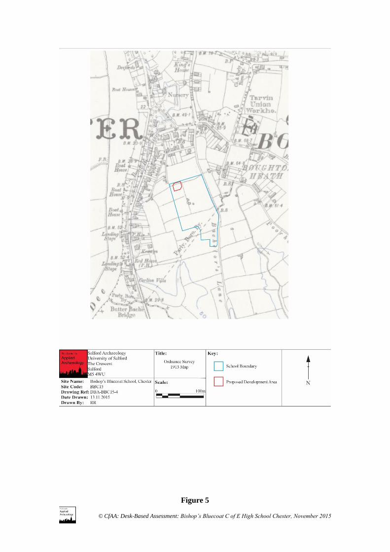
The first mapping evidence for this area dates to 1849 and is the tithe apportionment
map showing enclosed fields and a small pond, belonging to the Minor Canons of
Chester Cathedral and Joseph Sparks, within the study area. The northern fields were
known as Near and Far Green Fields and the southern field was known as Water Reans,
the former occupied by Thomas Vaughan and the latter by George Taylor. Thomas
Vaughan is also traceable in the 1851 census, also living near Boughton Hall and was
a farmer of 5 acres. George Taylor is listed in the 1851 census, living in Great Boughton
near Boughton Hall and described as a farmer of 5 acres. He is also listed living with
a brother who was also described as a market gardner of 20 acres, confirming Kelly’s
observations. Thomas Vaughan is also traceable in the 1851 census, also living near
Boughton Hall and was a farmer of 5 acres. The parliamentary boundary for Chester
ran through the area of the school although is a later creation as it ran at an angle to the
field boundaries and does not seem to indicate that it had earlier origins.
The general area still remained predominantly rural, although a small number of villa
and large houses were constructed between the study area and the river Dee, now Dee
Banks Conservation area, on an elevation overlooking the river and towards the city.
4.6 20th Century
The wider area still remained relatively undeveloped until the mid-20th century when
the area was developed for residential housing.
By the early twentieth century, three small structures are shown towards the southern
part of the study area although there is no indication as to what they were. By 1960, a

© CfAA: Desk-Based Assessment: Bishop’s Bluecoat C of E High School Chester, November 2015
track is shown leading up to them. In the 1980s, these were demolished and Bishop’s
Bluecoat school was built.

© CfAA: Desk-Based Assessment: Bishop’s Bluecoat C of E High School Chester, November 2015
The following gazetteer provides a summary of the sites identified within the study
area. For their location please see (Figure 7).
Site Number: 1
Site Name: Boughton Roman Cemetery
HER Number: 8006
NGR: Centred on SJ 4228 6609
Site Type: Burial
There is evidence for several cremations as well as possible associated grave goods
from this area. At least six cremations have been discovered at the former Cherry
Orchard sand extraction pit although these were mostly 19th century chance finds. A
second concentration focuses around Stocks Lane where up to seven cremations have
been found, three of which have been dated to the late first to mid second century AD.
Isolated examples from Batchelor’s Lane and Whitchurch road suggests that the
cemetery could extend for at least half a mile.
Site Number: 2
Site Name: Batchelor’s Lane Roman Cremation
HER Number: 8006/4; ECH 2509
NGR: SJ 4222 6568
Site Type: Burial
Roman pottery and a cremation were found during construction for a new school,
probably Bishop’s Bluecoat, in 1975. Most of the pottery sherds were not recovered
from in situ however the cremation was found at 1.20m below the ground surface. The
pottery was dated to the mid first to late second century AD. It is likely to be part of a
larger Roman cemetery identified from other chance finds in the area (Site 1).
Site Number: 3
Site Name: Chester to Aldford Roman Road
HER Number: 8019/1/0
NGR: Centred on SJ 4228 6570
Site Type: Communications
It has been proposed that the Roman road system running east from Chester divided
into three directions at Boughton; towards Manchester, Chesterton and Aldford, with
the latter identified running south just to the east of the School. This is thought to have
been a minor road (Watkin 1886, 31).
Site Number: 4
5. Gazetteer of Sites

© CfAA: Desk-Based Assessment: Bishop’s Bluecoat C of E High School Chester, November 2015
Site Name: Tarvin Union Workhouse
HER Number: 11195
NGR: SJ 4243 6590
Site Type: Institution
This workhouse opened in 1857 and comprised of an E shaped plan with a long front
range parallel to the road and three narrow ranges extending from the rear of the front
range and forming two yards. There were also a number of ancillary buildings. By the
1940s it was used as a care home for the elderly although this did not last long as the
building was demolished during the latter part of the 20th century. The site is now
modern housing
Site Number: 5
Site Name: The Meadows Ridge and Furrow
HER Number: 11213
NGR: Centred on SJ 4163 6575
Site Type: Agricultural
Evidence from aerial photography shows ridge and furrow surviving in the SE part of
the Meadows, possibly dating to the early Medieval period (Chester Archaeology
1993).
Site Number: 6
Site Name: Walmoor House
HER Number: 11178; DCH 6489; ECH 5468
National Heritage List Number: 1375760
NGR: SJ 4205 6592
Site Type: Residential
This was a private residential home built for the well-known local architect John
Douglas in 1896 and is a sandstone building, built in the Elizabethan style. It was used
as a girl’s school in the early 20th century and became the County Fire Service
headquarters until 1997. It is a Grade II* listed building, first designated in 1972.
Site Number: 7
Site Name: Beauford Lodge
HER Number: 11180; DCH 6488
National Heritage List Number: 1375759
NGR: SJ 4204 6577
Site Type: Residential
This consists of two semi-detached houses, designed by John Douglas who lived in one
of them until Walmoor House was constructed (Site 6). They are still in residential use
and are Grade II listed, first designated in 1972.
© CfAA: Desk-Based Assessment: Bishop’s Bluecoat C of E High School Chester, November 2015
Site Number: 8
Site Name: Roman coin from the Dee
HER Number: 8600/24; ECH 4911
NGR: SJ 4191 6598
Site Type: Find Spot
A denarius of Octavian (44-27BC) was recovered from the crook of the Dee at the
Meadows in 1980.
Site Number: 9
Site Name: Roman coin from Dee Banks
HER Number: 8017/10; ECH 4911
NGR: SJ 4206 6587
Site Type: Find Spot
A Roman coin bearing the head of Emperor Valerian (253-260AD) was found in a
private garden at Dee Banks in 1961.
Site Number: 10
Site Name: Administrative Boundary
HER Number: 11393
NGR: Centred on SJ 4000 6589
Site Type: Communications
The historic administrative boundary for the Chester parish was first explicitly defined
in 1354, however it is likely to have earlier origins (Lewis and Thacker 2003). The
Ordnance Survey map of 1880 records this boundary as well as the boundary stones.
Site Number: 11
Site Name: Bottoms Lane, Handbridge
HER Number: 11381
NGR: Centred on SJ 4133 6562
Site Type: Communications
Historic routeway which has been recorded under various names since the sixteenth
century and therefore has possible earlier Medieval origins. It once served as the
boundary between two parishes: St Bridget’s and St Mary’s on the Hill (Dodgson 1981,
48). Part of it now forms Meadows Lane however it originally ran eastwards to the
bank of the river and past (to the north) what appears to be Medieval strip fields
preserved in the field boundaries of the late 19th century, indicating its early origins.
Site Number: 12
Site Name: Sandy Lane
© CfAA: Desk-Based Assessment: Bishop’s Bluecoat C of E High School Chester, November 2015
HER Number: 11395
NGR: Centred on SJ 4198 6577
Site Type: Communications
Historic routeway which is first mentioned in the 14th century and has been used as part
of the boundary of the city of Chester (Dodgson 1981, 124). Its modern course runs
along the eastern bank of the Dee and south into Saighton.
Site Number: 13
Site Name: Green Lane, Boughton Heath
HER Number: 11384
NGR: Centred on SJ 4235 6547
Site Type: Communications
Historic routeway leading east from Boughton Heath. It is marked on Bryant’s 1831
map although not labelled and appears to be the same one marked as Becket’s Lane on
the 1874 Ordnance Survey. It is shown running in a south-easterly direction to the
south of the workhouse (Site 4).
Site Number: 14
Site Name: Boughton Roman Vessel
HER Number: 8017/5; ECH 4911
NGR: SJ 4200 6600
Site Type: Find Spot
A Roman ‘water bottle’ was discovered and donated to Grosvenor Museum in 1910,
therefore its exact provenance is unknown. It is thought to date to the late second –
early third century AD.
Site Number: 15
Site Name: Boughton Roman Amphora Stoppers
HER Number: 8017/6; ECH 4911
NGR: SJ 4193 6567
Site Type: Find Spot
Two amphora stoppers were found in a garden close to the river bank and were donated
to Grosvenor museum in the early 1980s. No date is given but they are possibly
Spanish in origin.
Site Number: 16
Site Name: Stocks Lane Roman Cremation
HER Number: 8006/5; ECH 2518
NGR: SJ 4224 6610
Site Type: Burial
© CfAA: Desk-Based Assessment: Bishop’s Bluecoat C of E High School Chester, November 2015
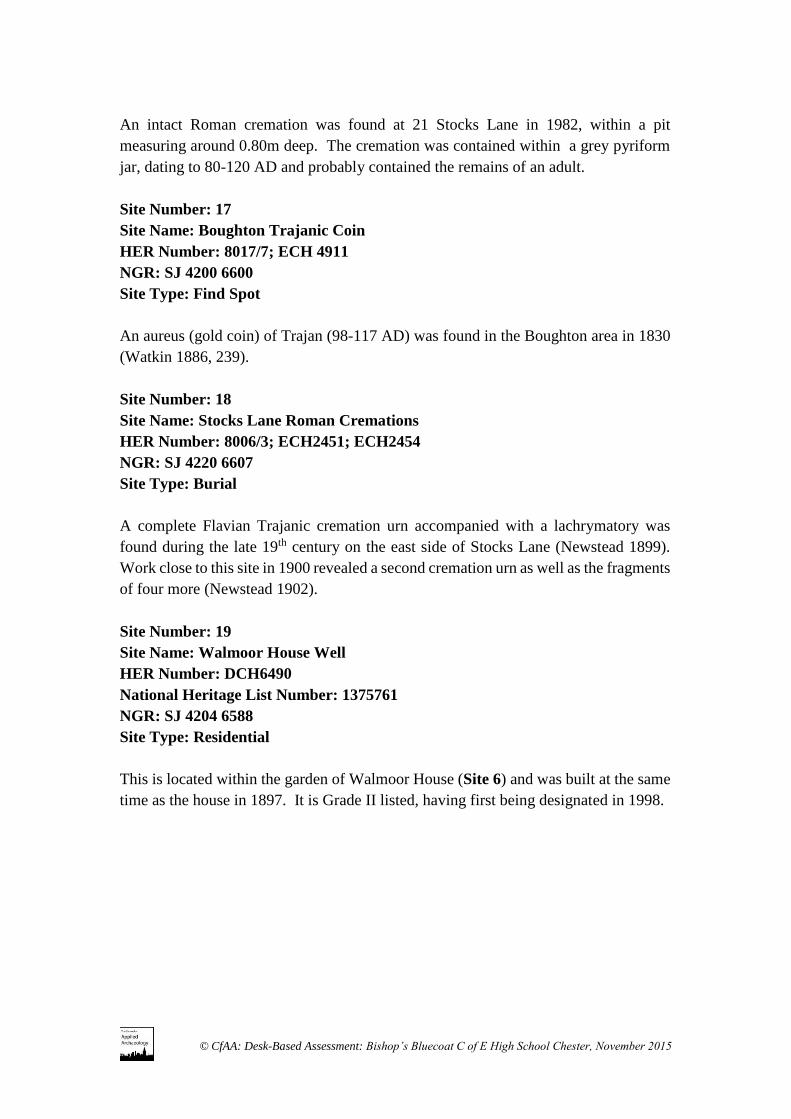
An intact Roman cremation was found at 21 Stocks Lane in 1982, within a pit
measuring around 0.80m deep. The cremation was contained within a grey pyriform
jar, dating to 80-120 AD and probably contained the remains of an adult.
Site Number: 17
Site Name: Boughton Trajanic Coin
HER Number: 8017/7; ECH 4911
NGR: SJ 4200 6600
Site Type: Find Spot
An aureus (gold coin) of Trajan (98-117 AD) was found in the Boughton area in 1830
(Watkin 1886, 239).
Site Number: 18
Site Name: Stocks Lane Roman Cremations
HER Number: 8006/3; ECH2451; ECH2454
NGR: SJ 4220 6607
Site Type: Burial
A complete Flavian Trajanic cremation urn accompanied with a lachrymatory was
found during the late 19th century on the east side of Stocks Lane (Newstead 1899).
Work close to this site in 1900 revealed a second cremation urn as well as the fragments
of four more (Newstead 1902).
Site Number: 19
Site Name: Walmoor House Well
HER Number: DCH6490
National Heritage List Number: 1375761
NGR: SJ 4204 6588
Site Type: Residential
This is located within the garden of Walmoor House (Site 6) and was built at the same
time as the house in 1897. It is Grade II listed, having first being designated in 1998.

© CfAA: Desk-Based Assessment: Bishop’s Bluecoat C of E High School Chester, November 2015
6.1 The Policy Context of Heritage Assets
The archaeological resource of an area can encompass a range of assets, including
belowground remains, earthworks, and standing buildings and other structures. Some
of these remains may have statutory protection, as Scheduled Ancient Monuments or
Listed Buildings. Others do not but may nevertheless be of archaeological significance.
Under both national and local planning policy, as outlined below, both statutory and
non-statutory remains are to be considered within the planning process.
The NPPF (Planning Policy Statement 5: Planning for the Historic Environment, March
2010) sets out the Secretary of State’s policy on planning and includes a section on the
conservation of the historic environment (including historic, archaeological,
architectural and artistic heritage assets, NPPF paras 126-141), and its wider economic,
environmental and social benefits. NPPF emphasises the significance of an individual
heritage asset within the historic environment and the value that it holds for this and
future generations in order to minimise or avoid conflict between the heritage asset’s
conservation and any aspect of the planning proposals. NPPF draws a distinction
between designated heritage assets of national importance and heritage assets that are
not designated but which are of heritage interest and are thus of a material planning
consideration (paras 134 and 135). In the case of the former, the presumption should be
in favour of conservation; in the case of the latter, where this is warranted by its
significance, the developer is required to record and understand the significance of the
heritage asset before it is lost, in a way that is proportionate to the nature and level of
the asset’s significance, by the use of survey, photography, excavation or other methods.
NPPF states that non-designated assets of archaeological interest that are demonstrably
of equivalent significance to scheduled monuments should be considered in the same
manner as designated sites (NPPF para 139). Regarding this policy a lack of formal
designation does not itself indicate a lower level of significance; in this instance the
lack of designation reflects that the site was previously unknown and therefore never
considered for formal designation. Wherever possible, development should be located
and designed so as to avoid damage to archaeological remains, ensuring that they are
preserved in situ. Where this is not possible, or appropriate, the developer will be
required to make suitable provision to ensure that the archaeological information is not
lost, and in many cases to secure the preservation of the remains.
6.2 Assessment Methodology and Significance Criteria
6. Significance of the Remains
© CfAA: Desk-Based Assessment: Bishop’s Bluecoat C of E High School Chester, November 2015
The most commonly accepted methodology for assessing archaeological significance
is the Secretary of State’s criteria for the scheduling of ancient monuments, outlined in
Annex 1 of Scheduled Monuments: identifying, protecting, conserving and
investigating nationally important archaeological sites under the Ancient Monuments
and Archaeological Areas Act 1979 (DCMS March 2010). These criteria have all been
utilised in this assessment and are listed below:
Period
Rarity
Documentation
Group Value
Survival/Condition
Fragility/Vulnerability
Diversity
Potential
6.3 Baseline Significance Conditions for the Bishop’s Bluecoat School Study Area.
Period
The study area contains late 20th century buildings and prior to this, was undeveloped
agricultural land farmed during the post-medieval period and probably earlier. There
is the possibility that a Roman cremation cemetery could have extended into the study
area although previously discovered cremations are scattered and its true extent is
unknown.
Rarity
The remains relating to the possible Roman cremations and the road network can be
considered to be of regional rarity. The extent of the cemetery has never been
established and the cremations have been discovered through chance finds rather than
modern archaeological excavation. Therefore any more information to help establish
the nature, date and extent of the Roman cremation cemetery could help us understand
the nature of occupation around Chester further and address Theme 24 of the research
framework.
The remains relating to possible Medieval and Post-Medieval agricultural activity can
be considered to be of local rarity. Any remains could help establish land use patterns
in this area and help to understand the development of the city and its relationship with
its hinterland. This can help address Themes 60.4, 60.5, 94.2 and 95.1.
Documentation
© CfAA: Desk-Based Assessment: Bishop’s Bluecoat C of E High School Chester, November 2015
The landscape history of the site has been recovered from the historic map base, the use
of archival material such as the census returns and trade directories, local historical
sources and previous archaeological study. More detail could undoubtedly by learned
about the development and use of the site through the examination of further
documentary sources, but these are unlikely to alter significantly the archaeological and
historical importance of the sites identified in this report.
Group Value
Although no remains are definitely known from the study area, there is the potential for
possible Roman cremations to have a high group value. The remains of the possible
cemetery (Sites 1 and 2) represents a group of remains relating to the early
development of Chester and the use of the area outside the city walls for burial purposes.
Survival / Condition
The extent and survival of below ground archaeological remains within the study area
is presently unknown. Previous chance finds around the study area of Roman
cremations shows that the site has the potential to yield below ground remains relating
to a possible Roman cremation cemetery. Mapping shows that the area was
predominantly rural until the mid-1800s and that the study area was not developed until
late 20th century. There is also the potential for below ground remains relating to
agricultural activity, such as relict field boundaries or buried ploughsoil. Although
subsequent development of the school will have negatively impacted on these remains,
there is still a chance for archaeology to survive.
Fragility/Vulnerability
See below section 7.1 Identification and the Evaluation of Key Impacts’
Diversity
The diversity of the below-ground remains within the study area is presently unknown.
However cartographic and previous archaeological investigations suggest that any
below ground remains would most probably date to 1st and 4th century AD activity
associated with the possible Roman cemetery (Sites 1 and 2) and post Roman
agricultural activity.
Potential

© CfAA: Desk-Based Assessment: Bishop’s Bluecoat C of E High School Chester, November 2015
Outside of the heritage assets identified within Chapter 5 of this report the study area
does have the potential to yield below ground archaeological remains dating to the
Roman Period. Although the area lies 2km away from the Roman fort centre, the City
archaeological assessments shows that there was possibly a cemetery lying along
Watling Street and another possible road leading SE. Previous chance finds of Roman
cremations close to the study area shows that it does have the potential to lie within the
extent of the cemetery, which has to date not been fully established.
6.4 Significance
On the available evidence there are no remains within the study area which are
considered to be a heritage asset of national significance.
The study area has the potential to contain remains of Roman and post Roman periods,
which could be considered of regional and local significance respectively.

© CfAA: Desk-Based Assessment: Bishop’s Bluecoat C of E High School Chester, November 2015
7.1 The Identification and Evaluation of the Key Impacts on the Archaeology
There are no nationally recognized standard criteria for assessing the significance of
the impact of development on archaeological remains. However, the following criteria
have been adopted from the Highways Agency’s Design Manual for Roads and Bridges,
Volume 11, Section 3, Part 2, Annex 5, August 2007. Although designed for use in
transport schemes, these criteria are appropriate for use in other environmental impact
assessments.
The value of known and potential archaeological remains that may be affected by the
proposed development has been ranked using the following scale: Very High, High,
Medium, Low, and Negligible:
Very High includes World Heritage Sites and archaeological remains of
international importance.
High includes Scheduled Ancient Monuments and undesignated archaeological
remains of national importance.
Medium includes undesignated archaeological remains of regional
importance.
Low includes undesignated archaeological remains of local importance.
Negligible includes archaeological remains of little or no significance.
Unknown applies to archaeological remains whose importance has not been
ascertained.
The Bishop’s Bluecoat School study area contains archaeological remains of potentially
Medium significance and Low significance.
Impacts on archaeological remains can be adverse or beneficial, direct or indirect,
temporary or permanent. The magnitude of sensitivity for the study area has been
assessed using the following scale:
Major involves change to archaeological remains or their setting such that the
resource is totally altered.
7. Impact of Development
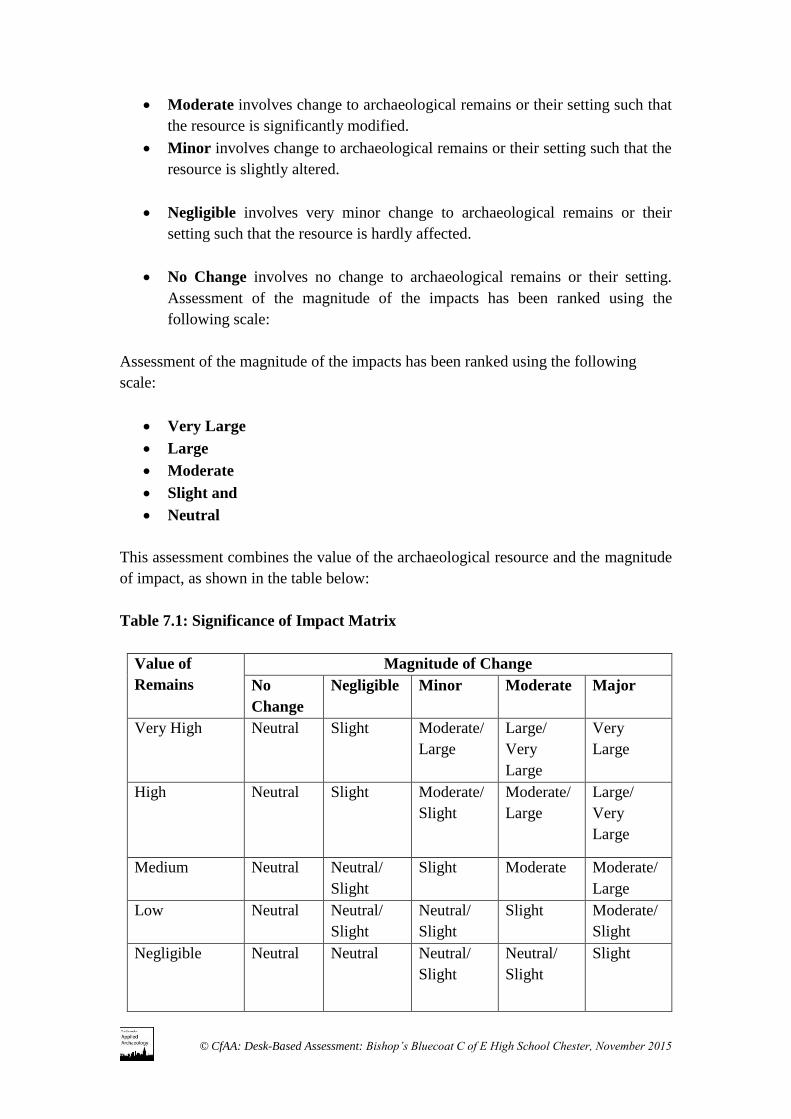
© CfAA: Desk-Based Assessment: Bishop’s Bluecoat C of E High School Chester, November 2015
Moderate involves change to archaeological remains or their setting such that
the resource is significantly modified.
Minor involves change to archaeological remains or their setting such that the
resource is slightly altered.
Negligible involves very minor change to archaeological remains or their
setting such that the resource is hardly affected.
No Change involves no change to archaeological remains or their setting.
Assessment of the magnitude of the impacts has been ranked using the
following scale:
Assessment of the magnitude of the impacts has been ranked using the following
scale:
Very Large
Large
Moderate
Slight and
Neutral
This assessment combines the value of the archaeological resource and the magnitude
of impact, as shown in the table below:
Table 7.1: Significance of Impact Matrix
Value of
Remains
Magnitude of Change
No
Change
Negligible Minor Moderate Major
Very High
Neutral Slight Moderate/
Large
Large/
Very
Large
Very
Large
High
Neutral Slight Moderate/
Slight
Moderate/
Large
Large/
Very
Large
Medium
Neutral Neutral/
Slight
Slight Moderate Moderate/
Large
Low
Neutral Neutral/
Slight
Neutral/
Slight
Slight Moderate/
Slight
Negligible Neutral Neutral Neutral/
Slight
Neutral/
Slight
Slight
© CfAA: Desk-Based Assessment: Bishop’s Bluecoat C of E High School Chester, November 2015
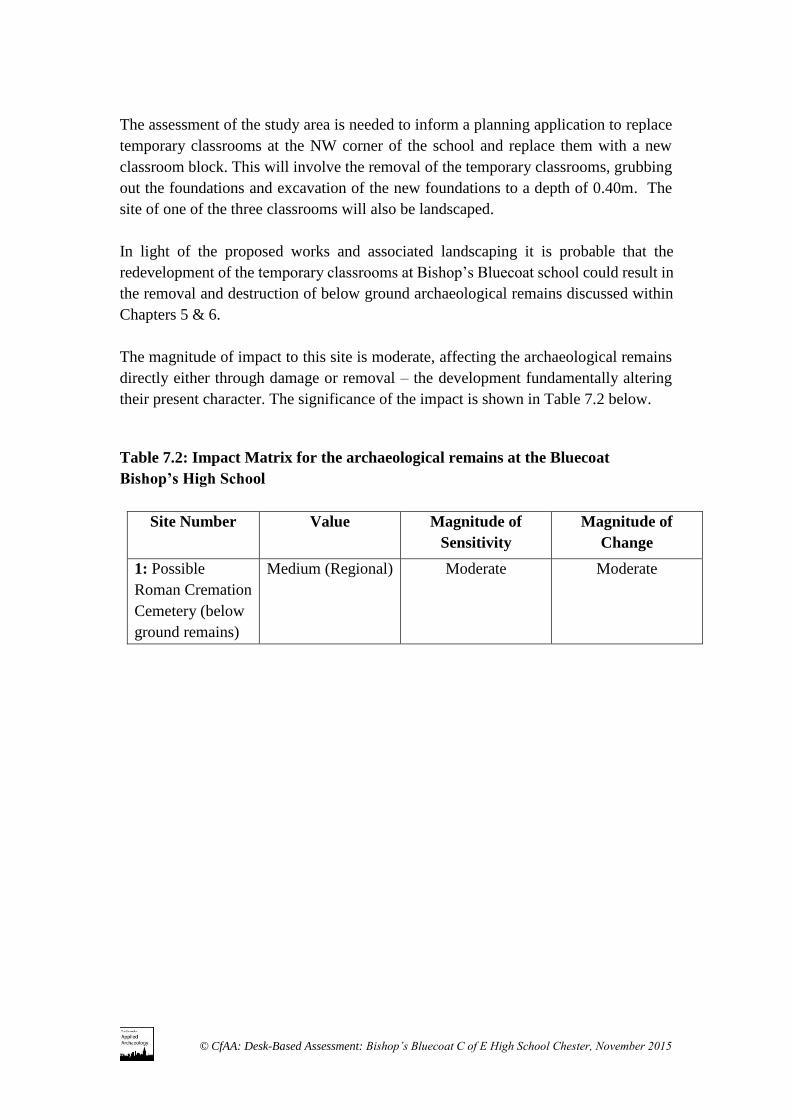
The assessment of the study area is needed to inform a planning application to replace
temporary classrooms at the NW corner of the school and replace them with a new
classroom block. This will involve the removal of the temporary classrooms, grubbing
out the foundations and excavation of the new foundations to a depth of 0.40m. The
site of one of the three classrooms will also be landscaped.
In light of the proposed works and associated landscaping it is probable that the
redevelopment of the temporary classrooms at Bishop’s Bluecoat school could result in
the removal and destruction of below ground archaeological remains discussed within
Chapters 5 & 6.
The magnitude of impact to this site is moderate, affecting the archaeological remains
directly either through damage or removal – the development fundamentally altering
their present character. The significance of the impact is shown in Table 7.2 below.
Table 7.2: Impact Matrix for the archaeological remains at the Bluecoat
Bishop’s High School
Site Number Value Magnitude of
Sensitivity
Magnitude of
Change
1: Possible
Roman Cremation
Cemetery (below
ground remains)
Medium (Regional) Moderate Moderate
© CfAA: Desk-Based Assessment: Bishop’s Bluecoat C of E High School Chester, November 2015
8.1 Heritage Assets
Where the loss of the whole or a material part of a heritage asset’s significance is
justified by a development, the developer should be required to record that asset and
advance understanding of its significance, and to make this evidence publicly accessible
(NPPF para 141).
None of the known and possible heritage assets identified within the application site
are considered to be of national importance. However, there are known and potential
heritage assets of lesser archaeological significance which merit preservation by record,
should they be directly affected by development.
8.2 Mitigation Measures
The impact of development can be seen to be moderate on Site 1. Thus, any
redevelopment occurring within the study area would involve the loss and disturbance
of some of the below-ground archaeological remains identified within this report.
Where appropriate because of their significance, mitigation will need to be undertaken
through an archaeological record (NPPF 2012, paras 141). The construction
programme will involve the grubbing out of current foundations and digging for new
ones to a depth of 0.40m. As find spots have been relatively isolated and the proposed
foundations do not intend to go 0.40m below the current ground surface, a watching
brief is recommended during the excavation of the foundations and service trenches.
All archaeological works will require a Written Scheme of Investigation (WSI) to be
produced in consultation with CAPAS and should be concluded at the earliest possible
opportunity.
8.2 Residual Effects
As a consequence of the proposed mitigation measures, following development, there
will be no significant residual impact on the archaeological resource.
8. Recommendations for Mitigation
© CfAA: Desk-Based Assessment: Bishop’s Bluecoat C of E High School Chester, November 2015
Bibliography
Beckley, R. and Campbell, D. 2013 An Archaeological Research Framework for
Chester Cheshire Archaeology Planning Advisory Service Document
(http://www.cheshirearchaeology.org.uk/?page_id=156)
Beckley, R., Campbell, D. and Collens, J. 2014 Chester Archaeological Plan Cheshire
Archaeology Planning Advisory Service Document
(http://www.cheshirearchaeology.org.uk/?page_id=165)
Carrington, P. 1994 The Book of Chester London: English Heritage
Chester Archaeology 1993 The Meadows, Chester: Archaeological Audit, September
1993
Department for Communities and Local Government 2012 National Planning Policy
Framework (https://www.gov.uk/government/publications/national-planning-policy-
framework--2)
Dodgson, J. 1981 The Placenames of Cheshire: Vol 5
Higham, N. 1993 The Origins of Cheshire Manchester: Manchester University Press
Leah, M.D., Wells, C.E., Appleby, C. and Huckerby, E. 1997 The Wetlands of
Cheshire: North West Wetlands Survey 4 Lancaster: Lancaster Imprints 5
Lewis, C.P. and Thacker, A.T. Eds. 2003 Victoria County History: Volume 5 Part 1:
The City of Chester General History and Topography
Newstead, R. 1899 Notes on some Roman remains found in the City and its
environments Journal of the Chester Archaeological and Historical Society 6: 156-8
Newstead, R. 1902 A descriptive account of Roman and other objects from various sites
in Chester and district, 1898-1901 Journal of the Chester Archaeological and
Historical Society 8: 100-01
Watkins, T. 1886 Roman Cheshire: A Description of the Roman Remains in the County
of Chester
9. Sources
© CfAA: Desk-Based Assessment: Bishop’s Bluecoat C of E High School Chester, November 2015
Maps
1831 Map of the County Palatine of Chester by A Bryant
1849 Tithe Apportionment Map
1871 Ordnance Survey Map 6 inch to 1 mile. Cheshire Sheet 38.SE
1899 Ordnance Survey Map 6 inch to 1 mile. Cheshire Sheet 38.SE
1913 Ordnance Survey Map 6 inch to 1 mile. Cheshire Sheet 38.SE
1945 Ordnance Survey Map 6 inch to 1 mile. Cheshire Sheet 38.SE
Trade Directories
1889 Kelly’s Directory of Cheshire
Web Sources
British Geological Survey: http://www.bgs.ac.uk/ (accessed 11/11/2015).
Cheshire Archaeology Planning Advisory Service:
http://www.cheshirearchaeology.org.uk/ (accessed 10.11.2015)
Chester Roman Roads:
http://www.cheshiretrove.com/current/history/romans/roads_chester.html (accessed
12.11.2015)
Chester Urban Archaeological Database Project:
http://www.cheshirearchaeology.org.uk/?page_id=156 (accessed 11.11.2015)
Cheshire Tithe Maps:
http://maps.cheshire.gov.uk/tithemaps/ (accessed 12.11.2015)

© CfAA: Desk-Based Assessment: Bishop’s Bluecoat C of E High School Chester, November 2015
The archive comprises a historical map regression and historical research notes. This
archive is currently held by the Centre for Applied Archaeology and a copy of this
report will be forwarded to Cowan & Co.
A copy of this report will be deposited with the Cheshire Historic Environment Record,
held by the Cheshire Archaeology Planning Advisory Service.
10. Archive
© CfAA: Desk-Based Assessment: Bishop’s Bluecoat C of E High School Chester, November 2015
#
Appendix 1: Figures
Figure 1: Location map
© CfAA: Desk-Based Assessment: Bishop’s Bluecoat C of E High School Chester, November 2015
Figure 2: Proposed Development Area

© CfAA: Desk-Based Assessment: Bishop’s Bluecoat C of E High School Chester, November 2015
Figure 3

© CfAA: Desk-Based Assessment: Bishop’s Bluecoat C of E High School Chester, November 2015
Figure 4
© CfAA: Desk-Based Assessment: Bishop’s Bluecoat C of E High School Chester, November 2015
Figure 5

© CfAA: Desk-Based Assessment: Bishop’s Bluecoat C of E High School Chester, November 2015
Figure 6

© CfAA: Desk-Based Assessment: Bishop’s Bluecoat C of E High School Chester, November 2015
Figure 7