archaeological documentary study 186 st. george's crescent block
TRANSCRIPT

Archaeological Documentary Study
186 St. George’s Crescent
Block 3313, Lot 12
Bronx, New York
LPC Project # 09BSA109X
Archaeological Documentary Study
186 St. George’s Crescent
Block 3313, Lot 12
Bronx, New York
LPC Project # 09BSA109X
Prepared For:
Michael Waldman
North Manhattan Construction Corp.
69 East 130th
Street, 2nd
Floor
New York, NY 10037
Prepared By:
Historical Perspectives, Inc.
P.O. Box 3037
Westport, CT 06880
Authors:
Julie Abell Horn, M.A., R.P.A.
Cece Saunders, M.A., R.P.A.
October 2009

i
EXECUTIVE SUMMARY
North Manhattan Construction Corp. proposes to construct an eleven-story and cellar
multi-family residential building at 186 St. George‟s Crescent in the Bronx. The project
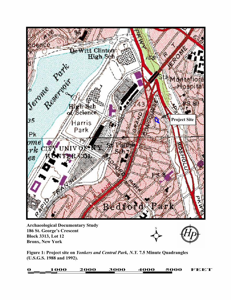
site is on Block 3313, Lot 12 (Figures 1, 2, and 3). Block 3313 is bounded by Grand
Concourse on the west, Mosholu Parkway South on the east, Van Cortlandt Avenue East
on the north, and East 206th
Street on the south. Block 3313 is bisected by St. George‟s
Crescent, and Lot 12, an irregularly-shaped parcel, is located on the east side of St.
George‟s Crescent.
As part of the 186 St. George‟s Crescent project, sponsors submitted project materials to the
New York City Landmarks Preservation Commission (LPC) for an initial archaeological
review in accordance with New York City Environmental Quality Review (CEQR)
regulations and procedures. Additionally, a letter was sent to the LPC dated June 15, 2009
by District Manager Fernando Tirado of the Borough of the Bronx Community Board 7 to
the Board of Standards and Appeals, noting that:
“…as per the Bronx Historical Society, the proposed site is most likely the
location of a Revolutionary War fort named the “Negro Fort” and we believe
that there may be items of significant cultural and historical value located
underneath” (Tirado 2009).
The LPC then recommended “that an archaeological documentary study be completed to
further assess this potential as per the CEQR Technical Manual” (Sutphin 2009). The
present report, prepared by Historical Perspectives, Inc. (HPI) comprises the Archaeological
Documentary Study for Block 3313, Lot 12.
Research conducted for this Archaeological Documentary Study has indicated that the
former “Negro Fort,” which probably was built in the fall of 1776 and may have stood for
several years before being abandoned in the fall of 1779, appears to have been located
across the street from the project site. The fort was in an area formerly covered by a
house belonging to John Corsa by at least the 1840s, and which stood until just after the
turn of the twentieth century. Today, this former house site is covered almost entirely by
multiple-story apartment buildings with basements, suggesting that the small, earthen
“Negro Fort” itself has been obliterated by modern development.
The project site is located on a northeast facing hillside overlooking the former Boston
Post Road. Based on its position between the former fort and the road, it seems less
likely that archaeological features associated with the fort, such as fireplaces for troop
housing, would have been located on this exposed slope. Rather, if any archaeological
materials associated with the fort were deposited on the project site, it seems more likely
that they would consist of garbage tossed down the hill by troops stationed on the
summit. Further, the presence of at least some unspecified fill on the property suggests
that there is an unclear amount of disturbance to the ground surface that could preclude
preservation of any such materials. However, it is also possible that the fill could have
preserved some older historical layers.

ii
Based on these conclusions, HPI recommends that a limited program of archaeological
testing be undertaken on the project site in order to ascertain whether any Revolutionary
War deposits are present on the property. The extent of the exposed rock outcrops, as
well as the relatively shallow bedrock in much of the Area of Potential Effect (APE)
argues against extensive testing. A limited testing strategy should be designed by project
archaeologists, in consultation with LPC, to determine the most effective means to
accomplish these goals.
For example, since there is no specific area of the project site where potential
archaeological resources might be concentrated, one or two ca. six-foot long trench
locations could be selected by archaeological personnel based on field conditions. The
first task would be the removal (at grade) of the very thick vegetation that covers the
trench locations. Since there could be up to 5 feet of fill on the property, as well as
shallow bedrock in many places, the excavation might include a combination of
approaches that have worked well on military encampments and urban parcels.
Any archaeological testing requested by LPC should be conducted according to
applicable archaeological standards (LPC 2002). Professional archaeologists, with an
understanding of and experience in urban archaeological excavation techniques, would be
required to be part of the archaeological team.
Last, despite the paucity of archival data concerning the “Negro Fort,” it does seem clear
that such a fort did exist along what is now St. George‟s Crescent, and had some
association with African Americans who had joined the British forces in the fall of 1776.
Regardless of the results of the archaeological testing program on the project site, HPI
further recommends that a plaque commemorating this fort be placed either on the project
site or on St. George‟s Crescent itself, to mark the former location of this important
cultural resource.

iii
TABLE OF CONTENTS
EXECUTIVE SUMMARY ................................................................................................ i
TABLE OF CONTENTS ................................................................................................... ii
I. INTRODUCTION .......................................................................................1
II. METHODOLOGY ......................................................................................1
III. ENVIRONMENTAL/PHYSICAL SETTING.............................................3
A. CURRENT CONDITIONS ...................................................................3
B. TOPOGRAPHY, HYDROLOGY AND SOILS ...................................3
IV. PROJECT SITE HISTORY .........................................................................4
V. DISTURBANCE RECORD AND ARCHAEOLOGICAL
SENSITIVITY .............................................................................................9
VI. CONCLUSIONS AND RECOMMENDATIONS ....................................10
VII. REFERENCES ..........................................................................................12
FIGURES
PHOTOGRAPHS

iv
FIGURES
1. Project site on Yonkers and Central Park, N.Y. 7.5 Minute Quadrangles (U.S.G.S.
1988 and 1992).
2. Project site on modern Bromley map.
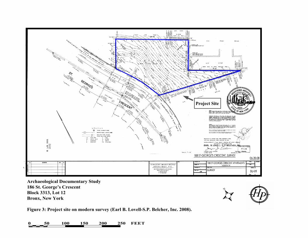
3. Project site on modern survey (Earl B. Lovell-S.P. Belcher, Inc. 2008).
4. Project site on Maps or plans and profiles... (Risse 1895).
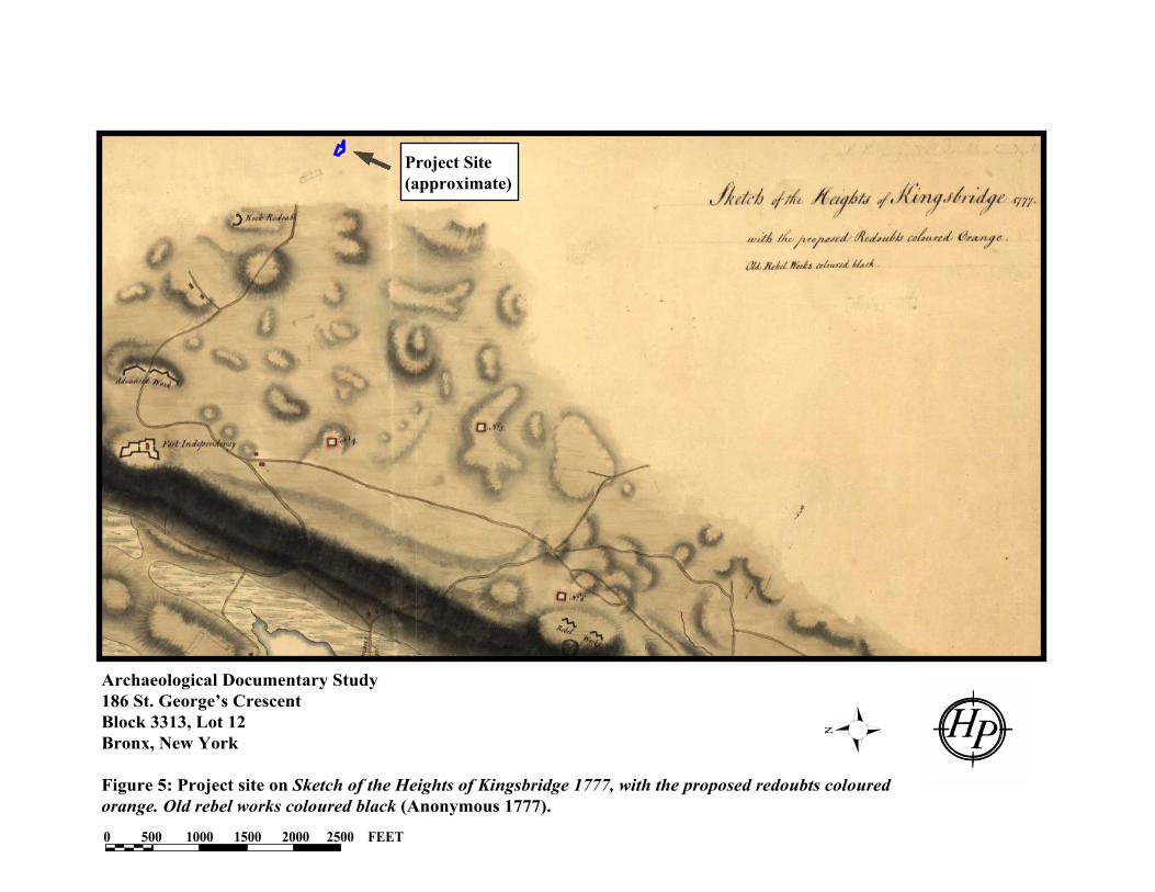
5. Project site on Sketch of the Heights of Kingsbridge 1777, with the proposed redoubts
coloured orange. Old rebel works coloured black (Anonymous 1777).
6. Project site on British Headquarters Map (British Headquarters 1782).
7. Project site on Historical Sketch Map of Kings’ Bridge, 1645-1783 (Edsall 1886).
8. Project site on Lower Part of Westchester County, now the Bronx Borough of New
York City (Hufeland 1926).
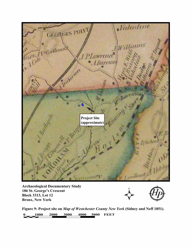
9. Project site on Map of Westchester County New York (Sidney and Neff 1851).
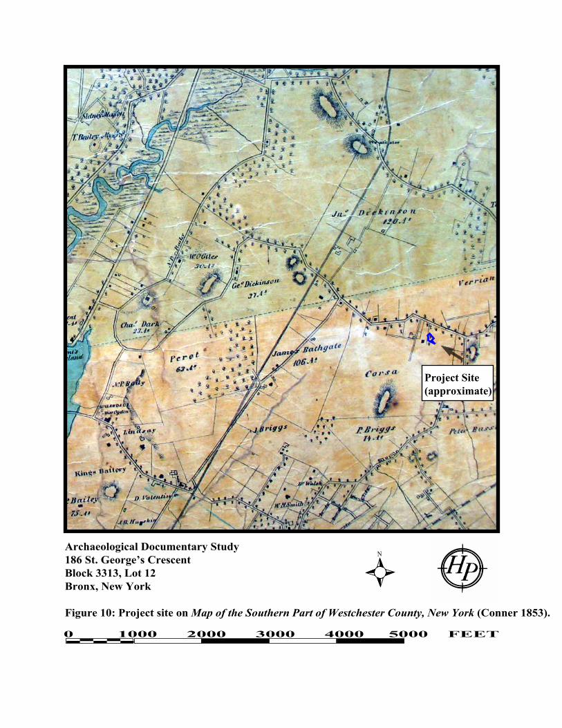
10. Project site on Map of the Southern Part of Westchester County, New York (Conner
1853).
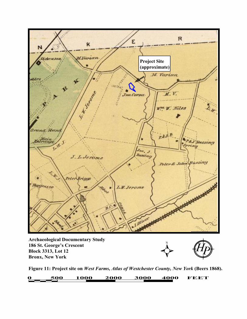
11. Project site on West Farms, Atlas of Westchester County, New York (Beers 1868).
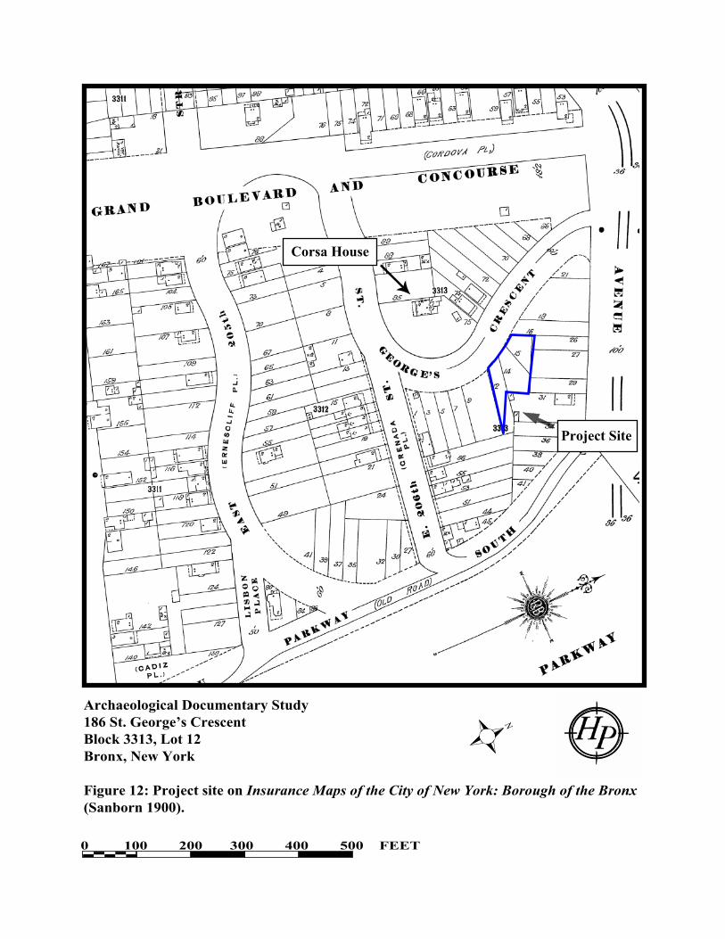
12. Project site on Insurance Maps of the City of New York: Borough of the Bronx
(Sanborn 1900).
13. Project site on Draft Damage Map in the matter of acquiring title to St. George’s
Crescent... (Bronx Topographical Bureau 1909).

v
PHOTOGRAPHS
(see Figure 2 for locations)
1. View of project site beyond chain link fence, with apartment building on right. View
looking east from St. George‟s Crescent. Source: HPI, August 5, 2009.
2. View of project site in background, with apartment building on left. View looking
southwest from Van Cortlandt Park East. Source: HPI, August 5, 2009.
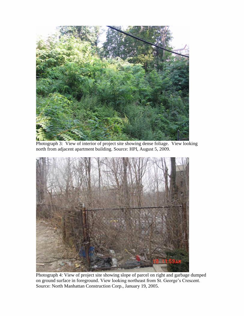
3. View of interior of project site showing dense foliage. View looking north from
adjacent apartment building. Source: HPI, August 5, 2009.
4. View of project site showing slope of parcel on right and garbage dumped on ground
surface in foreground. View looking northeast from St. George‟s Crescent. Source:
North Manhattan Construction Corp., January 19, 2005.
5. View of project site showing slope of parcel, recently felled trees, bedrock outcrops,
and garbage on ground surface. View looking north from interior of lot. Source:
North Manhattan Construction Corp., September 13, 2006.
6. View of project site in winter, showing slope of parcel, recently felled trees, bedrock
outcrops, and garbage on ground surface. View looking south from interior of lot.
Source: North Manhattan Construction Corp., September 13, 2006.
7. Enlargement of photograph taken in 1936 showing project site in center of image,
behind stone wall. View looking southeast from intersection of Grand Concourse and
St. George‟s Crescent. Source: NYPL.

1
I. INTRODUCTION
North Manhattan Construction Corp. proposes to construct an eleven-story and cellar multi-
family residential building at 186 St. George‟s Crescent in the Bronx. The project site is on
Block 3313, Lot 12 (Figures 1, 2, and 3). Block 3313 is bounded by Grand Concourse on the
west, Mosholu Parkway South on the east, Van Cortlandt Avenue East on the north, and East
206th
Street on the south. Block 3313 is bisected by St. George‟s Crescent, and Lot 12, an
irregularly-shaped parcel, is located on the east side of St. George‟s Crescent.
As part of the 186 St. George‟s Crescent project, sponsors submitted project materials to the New
York City Landmarks Preservation Commission (LPC) for an initial archaeological review in
accordance with New York City Environmental Quality Review (CEQR) regulations and
procedures. Additionally, a letter was sent to the LPC dated June 15, 2009 by District Manager
Fernando Tirado of the Borough of the Bronx Community Board 7 to the Board of Standards and
Appeals, noting that”
“…as per the Bronx Historical Society, the proposed site is most likely the location
of a Revolutionary War fort named the “Negro Fort” and we believe that there may
be items of significant cultural and historical value located underneath” (Tirado
2009).
The LPC then recommended “that an archaeological documentary study be completed to further
assess this potential as per the CEQR Technical Manual” (Sutphin 2009).
The present report, prepared by Historical Perspectives, Inc. (HPI) comprises the Archaeological
Documentary Study for Block 3313, Lot 12. This lot is also referred to as the Area of Potential
Effect, or APE. This lot is a modern tax lot designation, created in 1966-1967 when historic lots 12,
14, and 15 were combined. This study complies with the guidelines of the LPC (CEQR 2001;
LPC 2002). The HPI project team consisted of Julie Abell Horn, M.A., R.P.A., who conducted
the majority of the project research and wrote this report; and Cece Saunders, M.A., R.P.A., who
assisted with the project research, oversaw the project, and provided editorial and interpretive
assistance.
II. METHODOLOGY
This archaeological documentary study, in direct response to the specific concerns expressed by
LPC, has concentrated on establishing the potential “Negro Fort” occupation of and later
disturbance to the APE.
The project site is located on the steep slope of a hill and likely because of this topography, was
never developed, according to nineteenth and twentieth century maps. Since there was no
development on the project site over time, many of the standard archival resources normally
consulted for an Archaeological Documentary Study were not applicable, including Department
of Buildings records, tax records, city directories, and census records. Additionally, because
archival information concerning the “Negro Fort” proved to be so sparse, interviews with experts
on Bronx and Westchester County history, African-American history in New York City, and the

2
archaeology of Revolutionary War resources in New York City were invaluable in locating
possible archival sources for review, and for ruling out other archival and secondary sources that
were either not relevant to this site or provided erroneous information.
Experts consulted for this project included:
Lloyd Ultan, Bronx County Historian and author of numerous books and articles on
Bronx history;
Christopher P. Moore, Research Coordinator, Schomburg Center for Research in Black
Culture, New York Public Library;
Michael Cohn, Timeline Associates, author of Fortifications of New York during the
Revolutionary War, 1776-1782;
Alan Gilbert, Professor of Anthropology, Fordham University;
Paul Huey, New York State Office of Parks, Recreation and Historic Preservation; and
Thomas X. Casey, East Bronx History Forum.
Numerous repositories were visited, contacted, or their online resources viewed for this project.
In some cases archivists or librarians from these repositories (noted in brackets) were consulted
to ascertain the presence or absence of pertinent materials in their collections regarding the
“Negro Fort.” The repositories included:
New York Public Library [Matthew Knutzen, Assistant Chief, The Lionel Pincus &
Princess Firyal Map Division];
New York State Library and Archives;
Library of Congress;
Bronx County Historical Society [Laura Tosi, Librarian];
Westchester County Historical Society [Patrick Raftery, Assistant Librarian];
New-York Historical Society [Reference Librarians];
Manhattan College Library;
Borough of the Bronx, New York City Register;
Borough of the Bronx, Tax Map Unit;
Borough of the Bronx Topographical Bureau [Gjela Prenga, Topographic Planner];
New York State Office of Parks, Recreation and Historic Preservation; and
Websites: davidrumsey.com; ancestry.com, Google Books.
A site visit was conducted on August 5, 2009 by Julie Abell Horn of HPI to assess any obvious or
unrecorded subsurface disturbances, although the site had dense foliage and the ground surface
could not be seen. The project sponsor provided additional photographs of the project site taken
during the winter, when the ground was bare, and these images are included as well (see Figure 2;
Photographs 1-7).
3
III. ENVIRONMENTAL/PHYSICAL SETTING
A. Current Conditions
As noted above, the APE is a steeply sloped parcel located on the northeast side of St. George‟s
Crescent. There are high rise apartment buildings located immediately to the south and to the
northeast. A gasoline station and a surface parking lot are situated to the north and east. The
APE is enclosed by a chain link fence, with a gate on the St. George‟s Crescent side of the parcel
(Photograph 1). At the time of the 2009 site visit, the entire APE was very heavily overgrown
with thick foliage, precluding any observation of the ground surface (Photographs 2 and 3).
However, photographs provided by the project sponsors of the property in 2005 and 2006, when
there was no foliage (Photographs 4, 5, and 6), show that the ground surface formerly contained
a number of mature trees (shown here as recently felled), and despite what the soil boring data
claim, below, does have a number of large rocks and/or bedrock outcrops on the ground surface.
According to the project sponsors, in many places bedrock is only about two feet below the
ground surface (Heiman 2009). In 2005 and 2006, the slope was littered with debris, presumably
from dumping by local residents over the years.
B. Topography, Hydrology and Soils
The APE is on the northeast side of a former hill, and as such is primarily a sloped landform.
The earliest topographic maps available for this area show that the APE was between
approximately 140-160 feet above sea level (Grant 1873; Bien and Vermeule 1891). The official
map of grades adopted in 1895 for the Bronx shows that the APE ranged from between 140-150
feet above sea level at the lowest point, to just over 160 feet above sea level at the highest point
(Risse 1895; see Figure 4). A topographical survey made of the APE in 2006 (and printed in 2008)
indicates little overall change to the APE elevation over time, with the exception of the southeastern
corner of the lot, which has been graded down to 137 feet above sea level, and is supported by a
retaining wall (Figure 3). The sidewalk bordering the property on St. George‟s Crescent is near
the top of the original summit of the hill. According to the Bronx Topographical Bureau, the
legal grade of St. George‟s Crescent bordering the project site is 162 feet above sea level.
Prior to landfilling in the area, there were two branches of a perennial creek, which emptied into the
Bronx River, to the east and south of the project site. One branch ran roughly along the route of the
modern Mosholu Parkway and the other ran along the approximate line of modern 204th Street.
MacNamara (1993) notes that the drainage along Mosholu Parkway was called “Schuil Brook” and
its name later was anglicized to “School Brook.”
The USDA soil survey for New York City indicates that the APE falls within a large area mapped
as “Pavement & buildings, till substratum, 0 to 5 percent slopes.” It is described as:
Nearly level to gently sloping, highly urbanized areas with more than 80 percent of
the surface covered by impervious pavement and buildings, over glacial till;
generally located in urban centers (USDA 2005:14).
Despite this designation, it should be emphasized that the project site is in fact quite sloped.

4
In 2004, two soil borings were completed on the APE (International Geotechnical/Structural
Laboratories, Inc. 2004). Boring B-1 was located 7 feet east of the property line along St. George‟s
Place near the southern end of the property and Boring B-2 was located 15 feet east of the property
line along St. George‟s Place near the approximate center of the property. The borings were
excavated in 5-foot increments and basic soil descriptions were recorded for each increment. Only
one soil type was recorded for each 5-foot increment, and if there were different soil strata within
the increments, they were not noted on the boring logs. In both borings, the first 5-foot increment
was noted as “brown backfill.” No inclusions were recorded within this stratum to indicate whether
the soil was modern introduced fill that had been deposited on the property or local soils that had
been disturbed and then redeposited in place. Beneath the “backfill” were increments of brown,
gray, or grayish brown fine or medium sand with gravel or fine or medium sand with “silt/clay.”
Refusal (or bedrock) was noted at 13 and 25 feet below grade in Boring B-1, and 20 feet below
grade in Boring B-2. No groundwater was encountered in either boring.
IV. PROJECT SITE HISTORY
The project site and vicinity falls within the original Fordham Manor grant, initially obtained by
John Archer in the 1660s. Fordham Manor encompassed some 1,250 acres, extending from the
Bronx River on the east to the Harlem River on the west, and roughly between present
Kingsbridge on the north to the Manor of Morrisania on the south (about West 169th
Street). The
lands of the manor including the project site were mortgaged by John Archer in 1676, and later
passed to the Dutch Reformed Church. In 1759, local landowner Lewis Morris purchased a large
portion of the former Fordham Manor, but through a series of transactions the land ended up
back with the Archer family in 1766 (Scharf 1886). The original Boston Post Road, which later
was known as Van Cortlandt Avenue East and now survives only in fragments, as much of the
original road is under the Jerome Reservoir in this part of the Bronx, was along the line of an old
Native American trail, and was officially named in 1673 (Bolton 1922; Jenkins 1912). This road
runs along the northern border of Block 3313. However, despite the presence of this road, there
is no indication that the project site ever was developed during the colonial period.
The first documented use of the general project vicinity was during the Revolutionary War. In
May 1775, when fighting was still confined to areas around Boston, the Continental Congress
first proposed building fortifications at Kingsbridge, which was noted as a strategic point
between the island of Manhattan and the Westchester County mainland. In late August 1775, a
large number of cannon were taken from the Battery at the tip of lower Manhattan and moved to
Kingsbridge for safekeeping. The cannon were placed along a line north of Isaac Valentine‟s
House (now the Valentine-Varian House, home of the Bronx County Historical Society and
located on the north side of the original Boston Post Road), in an area roughly parallel to what is
now known as Gun Hill Road. A number of these cannon were spiked (damaged by inserting
spikes into holes meant for gunpowder) in January 1776, but were repaired that spring and
mostly moved back to Manhattan in June 1776 (Ultan 1983).
At the same time that the cannon were being moved off Isaac Valentine‟s property, General
George Washington visited Kingsbridge and selected seven sites in the area where he ordered
forts to be built. Two battalions from Pennsylvania arrived on June 21, 1776 to begin

5
constructing the forts, and work continued through the summer of 1776. The closest American
built fort to the project site was Fort Independence (later renamed Fort Number 4 by the British),
located on what is now Giles Place to the northeast of the project site. In October 1776, General
Heath of the American forces, who was in charge of the operations at Kingsbridge, ordered
additional works built to strengthen the fortifications, including a redoubt above Williams Bridge
to the northeast of the project site. However, when the British forces under General Howe
approached Kingsbridge in late October after the Battle of Harlem Heights, the Americans still
felt that their position there was too vulnerable and so evacuated troops to White Plains. By
October 23, 1776, the forts in Kingsbridge were essentially abandoned, allowing the British
forces to occupy them. They subsequently were renamed Forts 1-8 (Ultan 1983).
The history of the “Negro Fort” in the project site vicinity appears to have begun in November
1776. After the British forces moved into the Kingsbridge area and occupied the now abandoned
American forts, they set to work repairing the forts. Lloyd Ultan, the Bronx County Historian,
writes:
It is likely that, on this occasion, the troops threw up a small earthen fortification
on a hill on the Valentine farm overlooking the Boston Post Road near Isaac
Valentine‟s stone house. (It later came to be called “Negro Fort,” so called from a
black detachment in British pay being headquartered there, and was near where
Van Cortlandt Avenue East and the Grand Concourse cross today, atop the hill at
St. George‟s Crescent) (Ultan 1983:24-25).
A review of numerous primary and secondary archival sources failed to reveal details about the
construction of the “Negro Fort” or about its specific association with African-Americans.
Communications with local Bronx, Revolutionary War, and African-American history experts,
including Lloyd Ultan, Michael Cohn, Christopher Moore, and Thomas Casey, all revealed the
same information: that there is no known recorded reference to the construction of the “Negro
Fort.” Michael Cohn in particular stressed that in his work researching Revolutionary War forts
in the New York City area, he had thoroughly read all of the military “orderly books” at the New
York Historical Society and the New York Public Library and that none of them mentioned the
“Negro Fort.” A number of these orderly books were reviewed for this study as well, including
orders by British General Howe and diaries of several of his assistants, the diaries of George
Washington and the memoirs of American commander General William Heath. Again, none of
these primary sources revealed any information about the construction of the “Negro Fort.”
The assumption by all of the local experts interviewed for this study, and certainly by many of
the secondary sources consulted as well, is that the “Negro Fort” was small compared to other
forts in the Kingsbridge area, and that it was made of earth. The term “fort” is a bit misleading
here; a “redoubt” or “outpost” would probably be a more accurate way of describing the
structure, which likely was no more than a half-moon shaped defensive work capable of
supporting less than 30 men (Cohn 2009).
The first mention of the “Negro Fort” that could be found (and which the local experts agreed
was the earliest notation they had seen as well) was in General Heath‟s memoirs (Heath 1901).
He provides a description of the attack of the American forces on the British forces at
6
Kingsbridge in January 1777, and indicates that the “Negro Fort” was part of the British holdings
at the time. When noted, the “Negro Fort” often was mentioned in conjunction with Valentine‟s
House. For example:
January 17: Those who fled from Valentine's and the Negro Fort were fired at as
they ran, but none were killed: one, who could not run so fast as the rest, was
taken prisoner.
January 19: The enemy cannonaded from the fort, and killed one American, as the
guards were relieving at the Negro Fort.
January 25: Emboldened by this success, about 10 o'clock A.M. they made a
powerful sally towards Valentine's, instantly driving the guards and pickets from
the Negro Fort and Valentine's house; pushing on with great impetuosity, keeping
up a brisk fire, the balls passing at Williams's house sufficiently strong to do
execution.
Most of the secondary sources reviewed for this study (e.g. Dawson in Scharf 1886; Comfort
1906; Jenkins 1912; Hufeland 1926) repeated the information provided by Heath but added few
new details. Edsall (in Scharf 1886:753) notes that the British forces kept an “outgard” at the
fort over the winter of 1776-1777, but provides no reference for this statement.
Maps made during the Revolutionary War era also failed to show the location of the “Negro
Fort,” in some cases because it was not yet built, in others because coverage did not extend this
far east (focusing on the forts in and around Kingsbridge instead), and presumably in other cases
because it was not important enough to note. A list of maps reviewed for this project is provided
at the end of this report, and includes those made by Sauthier, Erskine, and those with no known
author (e.g. Anonymous 1777 [Figure 5]). Curiously, a number of secondary sources claim that
the “Negro Fort” is shown on the British Headquarters Map of 1782, when in fact it is not, as the
map does not extend far enough east to cover this area (Figure 6). It appears that after the first
source made the claim, the others followed suit. For example, Jenkins (1912:128) writes:
The British Headquarters map of 1782 (or 1783) shows seven other redoubts lying
south of Number Four along the Fordham ridge, making eleven in all from the
Hudson to the shore of the Harlem abreast of Fort George on Manhattan. In
addition, there are shown entrenchments across the Boston Road to the east of
Number Four and a small redoubt, called the Negro Fort, about half-way between
Fort Independence and Williamsbridge. It was so called because, so it is stated, it
was garrisoned by negroes from Virginia; it was situated just south of the old
Boston Road—this part of it now called Van Cortlandt Avenue,—about where the
new Concourse joins Mosholu Parkway.

7
An article by John MacNamara, published in 1974, says:
Military dispatches mention the Negro Fort in January, 1777, and it was noted on
the 1782 map. But aside from this, very little is known of the number of Negro
soldiers it housed, or the length of their tenancy. All that is known is that the
black soldiers hailed from Virginia, and were presumably “free men of color.”
MacNamara‟s assumptions that the black men were soldiers and free both are open to debate. It
was well known that many black slaves had run away to join the British forces, whom they
hoped would give them refuge. In 1775, Virginia‟s Governor Lord Dunmore had promised
freedom to those slaves willing to support the British cause (Burrows and Wallace 1999).
Numerous secondary sources claim that the black men for whom the “Negro Fort” was named
came from Virginia, but no clear evidence in primary sources could be found to support this
assertion. It is known that the British arrived in New York in August 1776 with about a
thousand “refugees and blackamoors from Virginia” (Jones 1879, Vol. I:103; Scharf 1886, Vol.
I:400). Other local blacks, both slaves and freemen, had joined the British forces from the
greater New York City area (Burrows and Wallace 1999). Some became soldiers and others did
not. It is not clear whether the black men associated with the “Negro Fort” were soldiers, or if
they were being utilized in other capacities, such as carpenters or laborers. According to Lloyd
Ultan, it is possible that these black men for whom the fort was named were in fact also the
builders of the fort (Ultan 2009).
Since no maps made during the Revolutionary War era could be found that clearly sited the
“Negro Fort” on the landscape, the question arises as to whether the project site vicinity was in
fact the actual location of this fort. The secondary sources all state that the hill now traversed by
St. George‟s Crescent was the fort‟s former location, and two maps of the area reconstructed
years later (Edsall 1886 [Figure 7] and Hufeland 1926 [Figure 8]) show the location, but few
primary sources could be found that definitively place the fort here. One primary source that
provided some information is the McDonald Papers manuscript on file at the Westchester
County Historical Society. The McDonald Papers contain interviews by Judge James MacLean
Macdonald from 1844-1851 with 241 elderly residents about their experiences during the
Revolutionary War in Westchester County. Two of the residents interviewed by MacDonald
were Dennis Valentine and Andrew Corsa. Valentine was a descendant of Isaac Valentine, and
Corsa was the landowner who later acquired the project site.
The interview with Dennis Valentine noted the location as:
Negro fort about a mile and a half from Dennis Valentine‟s (No. ?) on John
Corsa‟s land (that is, a son of Andrew Corsa) so called from a detachment of the
Negroes in the British pay, being quartered there, commanded by Captain Cook
(McDonald Papers 1844, Vol. 1:113).

8
The first interview with Andrew Corsa indicated the location as:
Negro fort or Cook‟s fort stood about two hundred yards south of Isaac
Valentine‟s stone house on the old Post Road on the left as you go to Kingsbridge
and on a round hill near the road (McDonald Papers 1844, Vol. 1:103).
A second interview with Andrew Corsa noted:
The cannon were spiked in 1776, at Cook‟s or the Negro fort, which stood exactly
where my son‟s house now stands about a quarter of a mile and perhaps a little
more south of the stone house built by Isaac Valentine and adjacent to the old post
road (McDonald Papers 1844, Vol. 1:520).
Clearly, there was consensus among the two men, who were interviewed together on August 26,
1844 by MacDonald, that the commander of the “Negro Fort,” at least for a time, was a Captain
Cook. However, perhaps due to the low rank of the commander, his name did not appear in any
of the contemporary sources reviewed for the report.
Interestingly, Andrew Corsa believed that the spiked cannons were located at the “Negro Fort,”
rather than the area north of the Valentine House near modern day Gun Hill Road, as described
by Ultan. It seems unlikely that the small, earthen “Negro Fort” would have contained any
cannons, being intended as an outpost and manned at least initially by African Americans, and
this recollection may be the result of an elderly man conflating two disparate events many years
after they occurred (Cohn 2009).
In terms of locating the “Negro Fort,” however, both Dennis Valentine and Andrew Corsa agreed
that the “Negro Fort” was on land owned by John Corsa in 1844, and this statement seems to
place the fort in the project site vicinity. Edsall (1886:753) likewise notes that the fort was
located on the Corsa farm, and that the location of the fort now had a house on it. The earliest
historic maps found as part of this project that show any structures in the project site vicinity
were those made beginning in the 1850s. The Sidney and Neff map from 1851 (Figure 9) shows
a structure just west of the APE, south of the Boston Post Road, and the Connor map from 1853
(Figure 10) confirms that the tract that the structure was on belonged to “Corsa.” The 1868
Beers map (Figure 11) noted the same structure as attributed to “Jno. Corsa.” Thus, it appears
that the “Negro Fort” was, in fact, located in the project site vicinity and those reconstructed
maps of the area during the Revolutionary War era that show the “Negro Fort” in this location
likely are mostly accurate (e.g. Edsall 1886; Hufeland 1926).
How long did the “Negro Fort” remain standing? The answer is unclear. As noted earlier, none
of the maps reviewed for this project made during the eighteenth century appeared to show the
“Negro Fort.” A number of the maps, including one made in 1777 and the 1782 British
Headquarters map, did not extend coverage far enough east to include the project site. Those
maps that did include the APE, such as the Robert Erskine road map from 1779 and the
Christopher Colles road maps from 1789, did not show the “Negro Fort,” either. According to
the McDonald Papers, the “Negro Fort” was still standing in January 1778, when Captain
Emmerick of the Hessian forces conducted “operations” there (McDonald Papers, p. 93). And

9
probably it was used by various additional forces during the remainder of 1778 and 1779, when
the British were still encamped in the Kingsbridge area.
By the early fall of 1779, however, the British began moving their base of operations out of the
Kingsbridge area to consolidate efforts in Manhattan and other theaters of war. They demolished
nearby Fort Independence from August-September 1779 and used the building materials and
arms elsewhere (Ultan 1983). It is probable that the “Negro Fort” was abandoned at this time as
well, although since presumably the redoubt was small and earthen, rather than wood or stone,
there would have been less to demolish at the time. It is likely that some remnants of the “Negro
Fort” remained visible beyond this period, although the lack of documentation on maps of the
time argues that whatever remained was not significant.
The Corsa family acquired the land containing the former “Negro Fort” and the project site
during the nineteenth century, although since deeds from this period are not well indexed, the
precise time is unknown. However, it does appear that John Corsa built his house directly over
the former “Negro Fort” site (e.g. Edsall 1886:753). Corsa‟s house seems to have remained
standing until the early years of the twentieth century, although Corsa sold the farm in 1871 to
George Opdyke, whose family then had the tract subdivided into building lots in the 1880s and
sold to individual owners (Liber 781, 1871:314; McNamara 1993). The former Corsa house
appears on the 1879 Bromley map, the 1885 Robinson map, the 1900 Sanborn map (Figure 12),
and the 1901 Hyde map. However, by 1909, when the official “damage map” was made for
officially acquiring St. George‟s Crescent for the City of New York, the Corsa house had been
razed (Figure 13). Today, the former Corsa house location and lot contains a 5 to 6-story
apartment building with a basement, which covers essentially the entire footprint of the former
summit of the hill (see Figure 2). Additional 4- and 5-story apartment buildings with basements
cover the remainder of the area once containing the hill, on the west side of St. George‟s
Crescent.
As noted above, the project site is located on the other side of St. George‟s Crescent from the
presumed location of the “Negro Fort.” Due perhaps to the steep nature of the terrain, the APE
was never developed. A photograph taken in 1936 (Photograph 7) shows that there was once a
stone wall marking the edge of the APE along St. George‟s Crescent, and that the property seems
to have been used at least partially for storage of building materials at that time. Based on the
data from the two soil borings, the APE appears to have been used for some dumping activities
as well, perhaps associated with nearby construction of the apartment buildings.
V. DISTURBANCE RECORD AND ARCHAEOLOGICAL SENSITIVITY
There are two issues to consider in determining the archaeological sensitivity of the project site
for potential remains associated with the “Negro Fort.” The first is whether any potential
resources would have been located within the project site at all, and if so, what they might be;
and the second is whether these potential resources could still be present within the project site
after more than 200 years.
It seems evident from the archival research that the “Negro Fort” was located across the street
from the project site. That area was the summit of the hill through which St. George‟s Crescent

10
now runs, and would have been the natural spot on which to site a fort. According to interviews
with local residents, the fort was situated in the location where John Corsa‟s house once stood,
which corresponds to Block 3313, Modern Lots 77 and 84.
However, while the fort itself appears to have been located off the project site, it seems
reasonable to expect that troops would have occupied and used more than just the footprint of the
actual fort, likely extending their camps, guards, and patrols to the area surrounding the fort on
the hill. In his descriptions of archaeological excavations at a number of Revolutionary War
forts and camps in the Bronx and upper Manhattan, Bolton (1916) repeatedly describes finding
certain types of former fort features embedded in hillsides surrounding known fort sites, most
notably fireplaces that often were associated with small huts. Since the “Negro Fort” would have
been sited to monitor traffic and/or attacks along the Boston Post Road to the north and northeast
of the project site, it seems less likely that the project site, being located between the fort and the
road, would have been chosen as the location to put fireplaces and troops‟ huts. However, it is
not impossible that these types of features could have been placed in this vicinity.
More likely, though, the project site could have been a location where troops tossed their
garbage, as hillsides are frequently used for such purposes. Bolton (1916) notes that artifacts
associated with Revolutionary War forts have, in places, been found to be extensive. Recovered
artifacts at war sites such as Fort Independence, Fort Number 4, Fort Swartwout, and the camp of
Emmerick‟s troops included military items such as bullets, pike and bayonet parts, and gun
flints; as well as camp-related materials such as barrel hoops, pot hooks, ceramics, tableware,
and glass bottles (especially rum bottles); personal items such as buttons and smoking pipes; and
building materials such as nails, carpenter‟s tools, and hardware.
There clearly has been some disturbance to the project site, although the extent is not well
understood. The two soil borings excavated near the St. George‟s Crescent side of the property
noted “backfill” from 0-5 feet below grade. However, because there were no inclusions recorded
within this arbitrary stratum to indicate whether the soil was modern in nature or perhaps from
historic dumping episodes, it is unclear to what degree this upper layer of soil would preclude the
recovery of potential Revolutionary War features or artifacts, should they exist here.
Topographical surveys note little change in overall elevations on the project site over time. A
Phase I Environmental Assessment for the project site noted no known contaminants or buried
oil tanks (Singer Environmental Group, LTD 2005). Bedrock depths on the site range from at
grade to at least 20 feet below grade, with much of the site having shallow bedrock at about 2
feet below grade.
VI. CONCLUSIONS AND RECOMMENDATIONS
Research conducted for this Archaeological Documentary Study has indicated that the former
“Negro Fort,” which probably was built in the fall of 1776 and may have stood for several years
before being abandoned in the fall of 1779, appears to have been located across the street from
the project site. The fort was in an area formerly covered by a house belonging to John Corsa by
at least the 1840s, and which stood until just after the turn of the twentieth century. Today, this
former house site is covered almost entirely by multiple-story apartment buildings with

11
basements, suggesting that the small, earthen “Negro Fort” itself has been obliterated by modern
development.
The project site is located on a northeast facing hillside overlooking the former Boston Post
Road. Based on its position between the former fort and the road, it seems less likely that
archaeological features associated with the fort, such as fireplaces for troop housing, would have
been located on this exposed slope. Rather, if any archaeological materials associated with the
fort were deposited on the project site, it seems more likely that they would consist of garbage
tossed down the hill by troops stationed on the summit. Further, the presence of at least some
unspecified fill on the property suggests that there is an unclear amount of disturbance to the
ground surface that could preclude preservation of any such materials. However, it is also
possible that the fill could have preserved some older historical layers.
Based on these conclusions, HPI recommends that a limited program of archaeological testing be
undertaken on the project site in order to ascertain whether any Revolutionary War deposits are
present on the property. The extent of the exposed rock outcrops, as well as the relatively
shallow bedrock in much of the APE argues against extensive testing. A limited testing strategy
should be designed by project archaeologists, in consultation with LPC, to determine the most
effective means to accomplish these goals.
For example, since there is no specific area of the project site where potential archaeological
resources might be concentrated, one or two ca. six-foot long trench locations could be selected
by archaeological personnel based on field conditions. The first task would be the removal (at
grade) of the very thick vegetation that covers the trench locations. Since there could be up to 5
feet of fill on the property, as well as shallow bedrock in many places, the excavation might
include a combination of approaches that have worked well on military encampments and urban
parcels.
Any archaeological testing requested by LPC should be conducted according to applicable
archaeological standards (LPC 2002). Professional archaeologists, with an understanding of and
experience in urban archaeological excavation techniques, would be required to be part of the
archaeological team.
Last, despite the paucity of archival data concerning the “Negro Fort,” it does seem clear that
such a fort did exist along what is now St. George‟s Crescent, and had some association with
African Americans who had joined the British forces in the fall of 1776. Regardless of the
results of the archaeological testing program on the project site, HPI further recommends that a
plaque commemorating this fort be placed either on the project site or on St. George‟s Crescent
itself, to mark the former location of this important cultural resource.

12
VII. REFERENCES
Primary and Secondary Sources cited and/or consulted
Bolton, Reginald Pelham
1916 Relics of the Revolution, The Story of the Discovery of the Buried Remains of Military
Life in Forts and Camps on Manhattan Island. Published by the Author, New York, New
York.
1922 “Indian Paths in the Great Metropolis.” Indian Notes and Monographs. Volume 23.
Museum of the American Indian Heye Foundation, New York.
Bolton, Robert
1848 A History of the County of Westchester, from its First Settlement to the Present Time.
Alexander S. Gould, New York.
Burrows, Edwin G. and Mike Wallace
1999 Gotham: a History of New York City to 1898. Oxford University Press, New York.
City Environmental Quality Review (CEQR)
2001 City Environmental Quality Review Technical Manual. City of New York, Mayor‟s
Office of Environmental Coordination. October, 2001.
City of New York, Borough of the Bronx, Department of Finance, City Register (City Register)
Deeds as cited in the text.
Comfort, Randall, Charles David Steuter and Charles A.D. Meyerhoff
1906 History of Bronx Borough, City of New York; compiled for the North Side News. North
Side News Press, New York.
Dawson, Henry B.
1886 “Westchester-County, New-York During the American Revolution.” In Thomas J.
Scharf, History of Westchester County, New York. Picton Press, Maine. L.E. Preston and
Company, Philadelphia.
Edsall, Thomas H.
1886 “Kings‟ Bridge.” In Thomas J. Scharf, History of Westchester County, New York. Picton
Press, Maine. L.E. Preston and Company, Philadelphia.
French, J.H.
1860 Gazetteer of the State of New York. R.P. Smith, Syracuse, New York.
Heath, Major-General William
1901 Memoirs, Major-General William Heath, By Himself, To which is added The Accounts of
the Battle of Bunker Hill by Generals Dearborn, Lee and Wilkinson. New Edition.
Illustrations and Notes Edited by William Abbatt. William Abbatt, New York.
13
Hufeland, Otto
1926 Westchester County in the American Revolution, 1775-1783. Westchester County
Historical Society, White Plains, New York.
International Geotechnical/Structural Laboratories, Inc.
2004 Surface Investigation, Soil Investigation Report, 188 St. George’s Crescent, Bronx, NY.
Jenkins, Stephen
1912 The Story of The Bronx. New York: G.P. Putnam's Sons
Jones, Thomas
1879 History of New York During the Revolutionary War: and of the Leading Events in the
Other Colonies at that Period. Vol. I. Edited by Edward Floyd De Lancey. New York
Historical Society, New York.
Kaplan, Sidney
1989 The Black Presence in the Era of the American Revolution, 1770-1800. Revised Edition.
University of Massachusetts Press, Amherst, MA.
Kemble, Stephen
1773-9 “The Kemble Papers,” Vol. I. Includes Kemble‟s Journals, 1773-1789 and British Army
Orders by General Sir William Howe, 1775-1778. Collections of the New-York
Historical Society for the Year 1883. Vol. 16. New York.
Landmarks Preservation Commission (LPC)
2002 Landmarks Preservation Commission Guidelines for Archaeological Work in New York
City.
Lossing, Benson J.
1852 The Pictorial Field-Book of the Revolution.
MacDonald, Judge James MacLean
1844 The McDonald Papers. Volume 1. On file at the Westchester County Historical Society.
McNamara, John
1974 “Black Soldiers Manned Revolution „Negro Fort.‟” Article on file, Bronx County
Historical Society. January 17, 1974. No newspaper given.
1993 History in Asphalt: The Origin of Bronx Street and Place Names. Bronx County
Historical Society, Bronx, New York.
New York State Comptroller‟s Office
1901-4 New York in the Revolution as Colony and State. J.B. Lyon Co. Albany, N.Y.

14
Raphael, Ray
2001 A People's History of the American Revolution: How Common People Shaped the Fight
for Independence. New Press, New York.
Scharf, J. Thomas
1886 History of Westchester County, New York. Two volumes. Picton Press, Maine. L.E.
Preston and Company, Philadelphia.
Singer Environmental Group, LTD
2005 Phase I Environmental Assessment, St. Georges Crescent, Block 3313, Lot 12, Bronx, NY
10458. Prepared for Intervest National Bank, New York, NY by Singer Environmental
Group, LTD, Brooklyn, NY.
Sutphin, Amanda
2009 Environmental Review letter for 186 St. George‟s Crescent Project. Landmarks
Preservation Commission, New York, NY.
Tieck, William Arthur
1968 Riverdale, Kingsbridge, Spuyten Duyvil: New York City; a Historical Epitome of the
Northwest Bronx. F. H. Revell Co., Old Tappan, N.J.
Tirado, Fernando
2009 Letter from Borough of the Bronx Community Board 7 District Manager Fernando Tirado
to the Landmarks Preservation Commission. June 15, 2009.
Ultan, Lloyd
1975 The Bronx in the American Revolution. Bronx County Historical Society, Bronx, N.Y.
1983 Legacy of the Revolution: the Valentine-Varian House. Bronx County Historical Society,
Bronx, N.Y.
Ultan, Lloyd and Gary Hermalyn
2000 The Birth of the Bronx: 1609-1900. Bronx County Historical Society, Bronx, N.Y.
United States Department of Agriculture (USDA)
2005 New York City Reconnaissance Soil Survey. United States Department of Agriculture,
Natural Resources Conservation Service, Staten Island, NY.
von Muenchhausen, Captain Friedrich
1974 At General Howe's Side, 1776-1778: the Diary of General William Howe's Aide de camp,
Captain Friedrich von Muenchhausen. Translated by Ernst Kipping and annotated by
Samuel Smith. Philip Freneau Press, Monmouth Beach, N.J.

15
Maps cited and/or consulted
Anonymous
1777a Sketch of the Heights of Kingsbridge 1777, with the proposed redoubts coloured orange.
Old rebel works coloured black. On file at the Library of Congress.
1777b Sketch of the Heights of Kingsbridge, with the proposed redouts couloured yellow. On
file at the Library of Congress.
1777c Map of defenses of New York Island from Fort Washington to Fort Independence, with
redoubts, etc. planned between. On file at the Library of Congress.
1778? Skecth [sic] of the road from Kings Bridge to White Plains. On file at the Library of
Congress.
1781? Reconnoissance de King's bridge. I. On file at the Library of Congress.
1781 Position du camp de l'armée combinée a Philipsburg du 6 juillet au 19 aoust. On file at
the Library of Congress.
Beers, Frederick W.
1868 Atlas of Westchester County, New York. Beers, Ellis, and Soule, New York. On file at the
New York Public Library.
Bien, Joseph Rudolph and C.C. Vermeule
1891 Atlas of the Metropolitan District and adjacent country comprising the counties of New
York, Kings, Richmond, Westchester and part of Queens in the state of New York, the
county of Hudson and parts of the counties of Bergen, Passaic, Essex and Union in the
state of New Jersey ... From original surveys by J.R. Bien and C.C. Vermeule, the U.S.
Coast and Geodetic Survey and the Geological Survey of New Jersey. Published by
Julius Bien & Co., New York. Online at www.davidrumsey.com.
British Headquarters Map
1782 Untitled Map (a.k.a. the British Headquarters map). On file at the New York Public
Library.
Bromley, George W.
1879 Atlas of the City of New York. On file at the New York Public Library.
1921 Atlas of the City of New York. On file at the New York Public Library.
Bronx Topographical Bureau
1909 Draft Damage Map in the matter of acquiring title to St. George’s Crescent between E.
206th
Street and Van Cortlandt Avenue in the 24th
Ward, Borough of the Bronx, City of
New York. On file at the Bronx Borough Topographical Bureau.

16
Colles, Christopher
1789 Survey of the roads of the United States of America, From New York to Stratford [2]. C.
Colles, New York. Online at www.davidrumsey.com.
Conner, R.E.O.
1853 Map of the Southern Part of Westchester County, New York. Matthew Dripps, New
York. On file at the New York Public Library.
Edsall, Thomas H.
1886 “Historical Sketch Map of Kings‟ Bridge, 1645-1783.” Compiled by Thomas Henry
Edsall. In Thomas J. Scharf, History of Westchester County, New York. Picton Press,
Maine. L.E. Preston and Company, Philadelphia.
Erskine, Robert
1780-1 No. 122, The Environs of Kingsbridge. On file at the New-York Historical Society.
Grant, William H.
1873 Topographical map made from surveys by the commissioners of the Department of Public
Parks of the city of New York of that part of Westchester County adjacent to the City and
County of New York embraced in Chapter 534 of Laws of 1871 as amended by Chapter
878 of Laws of 1872. Department of Public Parks of the City of New York. On file at the
Library of Congress. On file at the Library of Congress.
Hufeland, Otto
1926 “Lower Part of Westchester County, now the Bronx Borough of New York City.” In
Westchester County During the American Revolution, 1775-1783. Westchester County
Historical Society, White Plains, New York.
Hulber, Archer Butler
1904-8 The Crown collection of photographs of American maps. Selected and edited by Archer
Butler Hulbert. [Series I]. The Arthur H. Clark Company, Cleveland, Ohio. On file at the
New York Public Library.
Hyde, E. Belcher
1901 Atlas of the Borough of the Bronx, City of New York. E. Belcher Hyde Map Company,
Brooklyn. On file at the New York Public Library.
Rice, Howard C. and Anne K. Brown (translator and editor)
1972 The American Campaigns of Rochambeau's Army, 1780, 1781, 1782, 1783. Princeton
University Press, Princeton, N.J.

17
Risse, Louis
1895 Maps or plans and profiles, with field notes and explanatory remarks, showing the
location, width, grades, and class of streets, roads, avenues, public squares and places,
located and laid out by the Commissioner of Street Improvements of the 23rd and 24th
wards of the city of New York : under authority of Chapter 545 of the laws of 1890.
Section 18. R.A. Welcke, New York. On file at the New York Public Library.
Robinson, Elisha, and R. H. Pidgeon
1885 Atlas of the City of New York. E. Robinson, New York. On file at the New York Public
Library.
Sanborn Map Company
1900 Insurance Maps of the City of New York: Borough of the Bronx.
1915 Insurance Maps of the City of New York: Borough of the Bronx.
1950 Insurance Maps of the City of New York: Borough of the Bronx.
Sauthier, Claude Joseph
1777 A topographical map of the northn. part of New York Island, exhibiting the plan of Fort
Washington, now Fort Knyphausen, with the rebels lines to the southward, which were
forced by the troops under the command of the Rt. Honble. Earl Percy on the 16th. Novr.
1776, and survey'd immediately after by order of His Lordship, by Claude Joseph
Sauthier. To which is added the attack made to the northd. by the Hessians, survey'd by
order of Lieutt. Genl. Knyphausen. Published by permission of the Rt. Honble. the
Commissioners of Trade & Plantations. W. Faden, London. On file at the Library of
Congress.
Sidney and Neff
1851 Map of Westchester County New York. Newell S. Brown, White Plains, NY. On file at
the New York Public Library.
United States Geological Survey (U.S.G.S.)
1988 Yonkers, N.Y.-N.J. Quadrangle. 7.5 minute series.
1992 Central Park, N.Y-N.J. Quadrangle. 7.5 minute series.
Viele, Egbert
1874 Topographical Atlas of The City of New York Including Annexed Territory. Egbert L.
Viele, New York. On file at the New York Public Library.
Individuals consulted
Casey, Thomas X.
2009 Personal telephone communication, Thomas X. Casey, East Bronx History Forum, with
Julie Abell Horn, Historical Perspectives, Inc. August 17, 2009.

18
Cohn, Michael
2009 Personal telephone communication, Michael Cohn, Timeline Associates, with Julie Abell
Horn, Historical Perspectives, Inc. August 27, 2009.
Heiman, Matthew
2009 Personal telephone communication, Matthew Heiman, North Manhattan Construction
Corp., with Cece Saunders, Historical Perspectives, Inc., October 6, 2009.
Knutzen, Matthew
2009 Email communications, Matthew A. Knutzen, Assistant Chief, The Lionel Pincus &
Princess Firyal Map Division, New York Public Library with Julie Abell Horn, Historical
Perspectives, Inc., September 4, 2009.
Moore, Christopher P.
2009 Personal telephone communication, Christopher P. Moore, Research Coordinator,
Schomburg Center for Research in Black Culture, New York Public Library, with Julie
Abell Horn, Historical Perspectives, Inc. August 13, 2009.
Raftery, Patrick
2009 Personal email and in-person communications, Patrick Raftery, Assistant Librarian,
Westchester County Historical Society, with Julie Abell Horn, Historical Perspectives,
Inc. August 5-6, 2009.
Tosi, Laura
2009 Person telephone communication, Laura Tosi, Librarian, Bronx County Historical
Society, with Julie Abell Horn, Historical Perspectives, Inc. August 4, 2009.
Ultan, Lloyd
2009 Personal telephone communication, Lloyd Ultan, Bronx County Historian, with Julie
Abell Horn, Historical Perspectives, Inc. August 13, 2009.
Archaeological Documentary Study186 St. George’s CrescentBlock 3313, Lot 12Bronx, New York
Figure 1: Project site on Yonkers and Central Park, N.Y. 7.5 Minute Quadrangles (U.S.G.S. 1988 and 1992).
0 1000 2000 3000 4000 5000 FEET
Project Site

Archaeological Documentary Study186 St. George’s CrescentBlock 3313, Lot 12Bronx, New York
Figure 2: Project site on modern Bromley map.
0 100 200 300 400 500 FEET
Project Site4 31
2
photographs andorientations 1
56
7
0 50 100 150 200 250 FEET
Archaeological Documentary Study186 St. George’s CrescentBlock 3313, Lot 12Bronx, New York
Figure 3: Project site on modern survey (Earl B. Lovell-S.P. Belcher, Inc. 2008).
Project Site
Archaeological Documentary Study186 St. George’s CrescentBlock 3313, Lot 12Bronx, New York
Figure 4: Project site on Maps or plans and profiles... (Risse 1895).
0 100 200 300 400 500 FEET
Project Site
Archaeological Documentary Study186 St. George’s CrescentBlock 3313, Lot 12Bronx, New York
Figure 5: Project site on Sketch of the Heights of Kingsbridge 1777, with the proposed redoubts coloured orange. Old rebel works coloured black (Anonymous 1777).
0 500 1000 1500 2000 2500 FEET
Project Site(approximate)

Archaeological Documentary Study186 St. George’s CrescentBlock 3313, Lot 12Bronx, New York
Figure 6: Project site on British Headquarters Map (British Headquarters 1782).
0 500 1000 1500 2000 2500 FEET
Edge ofmapcoverage
Project Site(approximate)

Archaeological Documentary Study186 St. George’s CrescentBlock 3313, Lot 12Bronx, New York
Figure 7: Project site on Historical Sketch Map of Kings’ Bridge, 1645-1783(Edsall 1886).
0 1000 2000 3000 4000 5000 FEET
Project Site(approximate)

Archaeological Documentary Study186 St. George’s CrescentBlock 3313, Lot 12Bronx, New York
Figure 8: Project site on Lower Part of Westchester County, now the Bronx Borough of New York City (Hufeland 1926).
0 2000 4000 6000 8000 10,000 FEET
Project Site(approximate)
Archaeological Documentary Study186 St. George’s CrescentBlock 3313, Lot 12Bronx, New York
Figure 9: Project site on Map of Westchester County New York (Sidney and Neff 1851). 0 1000 2000 3000 4000 5000 FEET
Project Site(approximate)
Archaeological Documentary Study186 St. George’s CrescentBlock 3313, Lot 12Bronx, New York
Figure 10: Project site on Map of the Southern Part of Westchester County, New York (Conner 1853).
0 1000 2000 3000 4000 5000 FEET
Project Site(approximate)
Archaeological Documentary Study186 St. George’s CrescentBlock 3313, Lot 12Bronx, New York
Figure 11: Project site on West Farms, Atlas of Westchester County, New York (Beers 1868).
0 500 1000 2000 3000 4000 FEET
Project Site(approximate)
Archaeological Documentary Study186 St. George’s CrescentBlock 3313, Lot 12Bronx, New York
Figure 12: Project site on Insurance Maps of the City of New York: Borough of the Bronx(Sanborn 1900).
0 100 200 300 400 500 FEET
Project Site
Corsa House

Archaeological Documentary Study186 St. George’s CrescentBlock 3313, Lot 12Bronx, New York
Figure 13: Project site on Draft Damage Map in the matter of acquiring title to St. George’s Crescent... (Bronx Topographical Bureau 1909).
0 100 200 300 400 500 FEET
Project Site
Former CorsaHouse Location

Photograph 1: View of project site beyond chain link fence, with apartment building on
right. View looking east from St. George’s Crescent. Source: HPI, August 5, 2009.
Photograph 2: View of project site in background, with apartment building on left. View
looking southwest from Van Cortlandt Park East. Source: HPI, August 5, 2009.
Photograph 3: View of interior of project site showing dense foliage. View looking
north from adjacent apartment building. Source: HPI, August 5, 2009.
Photograph 4: View of project site showing slope of parcel on right and garbage dumped
on ground surface in foreground. View looking northeast from St. George’s Crescent.
Source: North Manhattan Construction Corp., January 19, 2005.

Photograph 5: View of project site showing slope of parcel, recently felled trees, bedrock
outcrops, and garbage on ground surface. View looking north from interior of lot.
Source: North Manhattan Construction Corp., September 13, 2006.
Photograph 6: View of project site in winter, showing slope of parcel, recently felled
trees, bedrock outcrops, and garbage on ground surface. View looking south from
interior of lot. Source: North Manhattan Construction Corp., September 13, 2006.

Photograph 7: Enlargement of photograph taken in 1936 showing project site in center of
image, behind stone wall. View looking southeast from intersection of Grand Concourse
and St. George’s Crescent. Source: NYPL.