archaeological investigation of the court kiva in chaco ...cgem.mines.edu/s/martinez et al...
TRANSCRIPT
Archaeological investigation of the Court Kiva in Chaco Canyon using geophysical methods Cericia Martinez*†, Arianne Dean†, Elise Goggin†, Brenda K. Todd††, Richard A. Krahenbuhl† † Department of Geophysics, Colorado School of Mines †† Department of Anthropology, University of Colorado, Boulder Summary In this talk, we present results from geophysical investigations, including DC resistivity, FEM, and magnetic method conducted within Chaco Culture National Historical Park. In particular, we focus on data gathered within the plaza of one of the great houses, Chetro Ketl, in search of a buried kiva. The Court Kiva, as it is referred to, is known to be buried within the plaza region of Chetro Ketl from early archaeological excavations. However, following its infill and the passage of time, its location, boundary, depth and depth extent have been lost. Using geophysical methods, we have confirmed the existence and identified the location of this missing kiva. We have also gained valuable insight into the predicted geophysical responses of these desired archaeological targets for broader and ongoing investigations within the Park. Introduction Geophysics is often an important and even necessary tool for archaeological investigations. For example, digging at a site may prove prohibitively expensive when limited-to-no information is available before field activities begin. Also, archaeological sites are non-renewable resources. Major Chacoan great houses number less than ten, of which four have been fully or partially excavated. Additionally, great houses are cultural heritage sites for Native American tribes, which are often understandably skeptical of excavations. Therefore, the NPS seldom grants permits for excavations, but has encouraged non-invasive, geophysical techniques. Due to the non-invasive nature of magnetic, electrical and electromagnetic data collection, we have been allowed to acquire data at various sites as part of an ongoing geophysical investigation in cooperation with the Park. Geophysical activities began in late 2006 and will continue as long as park approval is granted. The data and interpretation from a component of this project is the focus here. The Chaco Culture National Historical Park is a site of archaeological significance in northwest New Mexico. Chaco Canyon was a locus of cultural florescence from approximately 800 A.D. to 1200 A.D., as evidenced by the numerous ruins spread out over a distance of about 10 miles [Lekson et al., 1988]. It is believed that Chaco
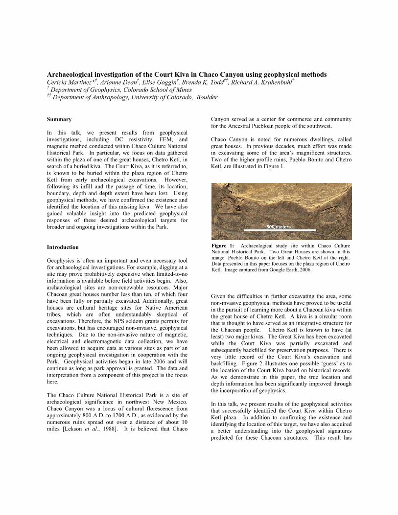
Canyon served as a center for commerce and community for the Ancestral Puebloan people of the southwest. Chaco Canyon is noted for numerous dwellings, called great houses. In previous decades, much effort was made in excavating some of the area’s magnificent structures. Two of the higher profile ruins, Pueblo Bonito and Chetro Ketl, are illustrated in Figure 1.
Given the difficulties in further excavating the area, some non-invasive geophysical methods have proved to be useful in the pursuit of learning more about a Chacoan kiva within the great house of Chetro Ketl. A kiva is a circular room that is thought to have served as an integrative structure for the Chacoan people. Chetro Ketl is known to have (at least) two major kivas. The Great Kiva has been excavated while the Court Kiva was partially excavated and subsequently backfilled for preservation purposes. There is very little record of the Court Kiva’s excavation and backfilling. Figure 2 illustrates one possible ‘guess’ as to the location of the Court Kiva based on historical records. As we demonstrate in this paper, the true location and depth information has been significantly improved through the incorporation of geophysics. In this talk, we present results of the geophysical activities that successfully identified the Court Kiva within Chetro Ketl plaza. In addition to confirming the existence and identifying the location of this target, we have also acquired a better understanding into the geophysical signatures predicted for these Chacoan structures. This result has
Figure 1: Archaeological study site within Chaco Culture National Historical Park. Two Great Houses are shown in this image: Pueblo Bonito on the left and Chetro Ketl at the right. Data presented in this paper focuses on the plaza region of Chetro Ketl. Image captured from Google Earth, 2006.

Chaco Canyon Investigation
significant implications for ongoing geophysical investigations within Chaco Culture National Historical Park.
Background The Chacoans built the great houses and kivas mainly with sandstone and mud mortar. There are four main composition styles that differ by the size of sandstone blocks and the amount of mortar used [Lekson et al., 1988]. Based on our early geophysical investigations in 2006, there is a sufficient contrast in electrical conductivity between the Chacoan structures and surrounding soils which allow for shallow electromagnetic and DC resistivity methods. The larger kivas within great houses likewise had ancient fire pits within them, which can manifest as strong anomalies in surface magnetic data. Given the extent of data coverage desired, predicted geophysical signatures, and project goals, we have opted to implement three geophysical methods here: FEM ground conductivity surveys, DC resistivity profiling, and magnetic methods. In the following sections, we discuss how these data were collected, processing methods that were applied to the field data, and interpretations of these data for improved archaeological understanding of the Court Kiva within Chetro Ketl. Geophysical Methods EM31-ground conductivity data Electromagnetic methods provide a general overview of the area of study. The Geonics EM31-MK2 was used for data collection in Chetro Ketl because of its collection speed
and ability to ‘highlight’ targets of varying conductivity. The instrument has a depth of penetration of approximately 6 meters. Data were collected in a north-south then east-west orientation at a sample rate of 1Hz and a line spacing of 3 meters. GPS data were collected simultaneously for increased position accuracy. DC Resistivity DC resistivity data were collected in the plaza of Chetro Ketl for 3D imaging of the subsurface, rather than the more common 2D array configurations. The array was implemented such that two cables, each with fourteen electrodes, were laid out in four parallel lines, with seven electrodes per line (Figure 3). The electrode and line spacing for the resistivity survey was three meters. After data were recorded from the first set-up, the survey continued as a 3D roll-along in an eastward direction with 14 electrode advancements and similar line/electrode separation. Following the tenth cable roll, the array was then shifted to the north and this process was repeated from east to west. Approximately four-thousand DC resistivity data points were collected within Chetro Ketl plaza.
Figure 2: Sketch of Chetro Ketl showing location of the Great Kiva and an estimated location of the geophysical target, the Court Kiva [Lekson, 2007]
Figure 3: 3D resistivity survey layout within the plaza of Chetro Ketl. The upper image shows the locations of the electrodes, with a few points missing in the lower left corner. The lower image illustrates the 3D roll-along survey pattern performed. The background image is from USGS Seamless.

Chaco Canyon Investigation
Magnetics The magnetic data were collected with the Geometrics Cesium 858 magnetometer along the same grid as the EM31. Line spacing was therefore also three meters, and the magnetometer collected data at a sample rate of 1Hz. GPS data were likewise collected simultaneously with magnetic data as with the EM-31. Processing and Interpretation EM31-ground conductivity data The geo-referenced EM31 data has undergone denoising to enhance the response of the Court Kiva. Figure 4 illustrates the quadrature component of the EM31 data, in mS/m, after applying a 9-meter Butterworth filter. While various levels have been applied, the 9 meter adequately reveals that the central location of the Court Kiva is shifted to the north-east of the predicted location, which is one of the key questions of interest for this target. Likewise, it has preserved the overall amplitude of the kiva response while reducing the level of noise in the data.
Figure 4 shows a large resistive and circular target, presumed to be the response of the buried Court Kiva. Overlain within the figure is the previous best estimate of location for the kiva within the plaza of Chetro Ketl (Lekson, 2007). EM31 data does not inherently contain the resolution necessary to directly identify the boundaries of
the kiva. However, it can be interpreted from the data on hand that the central location of this sought-after kiva is several meters to the north-east of the previous estimates. DC Resistivity The 3D DC resistivity data were inverted using the DCINV3D code developed by the University of British Columbia-Geophysical Inversion Facility (UBC-GIF), based on the methodology of Li and Oldenburg (1999). The model mesh has uniform cell dimensions of 1.5 x 1.5 x 0.75 meters (East/West/Vertically, respectively) within the region of interest. This core region of interest represents the plaza of Chetro Ketl, but more specifically has been identified by the resistive circular target dominating the EM31 quadrature data (Figure 4). 3D inversion of the DC data, shown in Figure 5, recovers a resistive target, coincident with surface conductivity data in Figure 4, and consistent with the predicted cylindrical kiva. The feature is approximately 12 meters in diameter and has a depth extent of approximately 3 meters. We note that target boundaries are subject to the limitations of information contained within the data, as well as mesh discretization. Additional data and continued processing may improve upon these boundary estimates in the future. Based on the joint information contained within the surface EM31 and 3D DC resistivity data, we can also conclude that the central location of the sought-after Court Kiva is approximately 4 meters north and 4 meters east of the previous estimate.
Figure 4: EM31 ground conductivity meter data collected within Chetro Ketl plaza. The data spans a distance of 90 meters in the left-right direction. The figure illustrates the resistive region associated with the Court Kiva as color contours. The black circle represents previous location estimation of the Court Kiva sketched in Figure 2. The white circle illustrates the location predicted for the Court Kiva by DC resistivity data in Figure 5.
Figure 5: 3D DC resistivity inversion result for data collected within the plaza of Chetro Ketl. The model spans a distance of 69 meters in the east (left-right) direction and 36 meters in the north (up-down) direction. The image is presented as conductivity (S/m) and shows a horizontal slice through the recovered model at a depth of 2.25 meters. The resistive circular target in the middle is likely the Court Kiva, with the outline in white corresponding to the white circle overlay on the EM31 data in Figure 4.

Chaco Canyon Investigation
Magnetics Figure 6 illustrates the total-gradient of the reduced-to-pole magnetic data collected within Chetro Ketl. These processes were performed to enhance any large magnetic anomalies from the site. The data illustrate several strong magnetic anomalies. To the north end of the data map, several of the anomalies are the confirmed response of metallic rebar/stakes along tourist paths. At the east end of the data, just outside the Great Kiva, is likewise the response of a USGS survey marker.
There is one magnetic anomaly of particular interest which exists within the boundary of the Court Kiva, as predicted by both EM31 data and DC resistivity inversion. We observe that the source of this compact magnetic anomaly is not manifested directly in either the electrical or EM data. While such interpretation is speculative without dig verification, this non-correlation between the methods is consistent with trends predicted for past fire-pits, such as those present in the great kivas. The largest magnetic anomaly at the south-east corner of the data is of strong interest for continued research as this project progresses. This compact anomaly is likewise coincident with a broad resistive structure identified near the edges of the EM31 and DC resistivity data. Further data collections are planned within this section of the plaza.
Conclusions As part of an ongoing archaeological investigation within Chaco Culture National Historical Park, we have collected several data sets using non-invasive geophysical techniques. Here, we present the results of these data sets focused within the plaza region of Chetro Ketl. There is a strong correlation between magnetic, EM31 and DC resistivity data which reveals the presence of the supposed Court Kiva buried within this plaza. The data indicate the kiva is approximately centered six meters to the north-east of previous archaeological estimates, with an estimated diameter of 12 meters and depth extent of 3 meters from the surface. Denser data and continued processing may further refine these values as this project continues. Finally, results of this geophysical study within Chetro Ketl plaza have provided valuable insights into the potential geophysical responses of unknown kivas that remain hidden throughout the park. Acknowledgements This project was made possible through the kind support of the National Park Service at Chaco Cultural National Historical Park. We especially thank Dabney Ford for supporting this project from the beginning and providing invaluable insights (prior information) during field activities. We thank Dr. Stephen Lekson from CU Boulder for providing us with his extensive knowledge of Chetro Ketl prior to field activities and during interpretation. Funding for fieldwork was provided through the Department of Geophysics Senior Design program at CSM by Chevron. Finally, we thank several members of the Center for Gravity, Electrical & Magnetic Studies (CGEM) for their assistance at all stages of the project. These individuals, namely Yaoguo Li, M. Andy Kass, Kristofer Davis and Misac Nabighian have been a part of the long term project at Chaco since the beginning.
Figure 6: Total gradient of the reduced-to-pole magnetic data collected within Chetro Ketl plaza (in nT/m). The data spans a distance of 90 meters in the left-right direction. The anomaly identified with the arrow is potentially the response of a fire-pit within the Court Kiva.