archaeological investigations at and around …donkey‐curse stone (gadhegal) was seen in the...
TRANSCRIPT

Archaeological Investigations At and Around Umbardi,
Taluka Mangaon, District Raigad, Maharashtra
Anjay Dhanawade1, Salil Sayed2 and P. P. Joglekar2
1. M. M. Jagtap Senior College of Arts, Science and Commerce, District Raigad, Mahad
402 301, Maharashtra, India (Email: [email protected]) 2. Department of Ancient Indian History, Culture and Archaeology, Deccan College
Post Graduate and Research Institute, Deemed to be University, Pune – 411 006,
Maharashtra, India (Email: [email protected])
Received: 26 July 2017; Revised: 21 September 2017; Accepted: 04 November 2017
Heritage: Journal of Multidisciplinary Studies in Archaeology 5 (2017): 1013‐1029
Abstract: The archaeological remains of a deserted town were discovered in 2014 at Umbardi in
Mangaon taluka of Raigad district. This article presents the preliminary findings of the explorations at
the site and its surroundings, with a primary aim of reporting newly discovered structural remains.
Many features such as fortification walls, dilapidated temple complexes and foundations of houses point
to a large settlement. Perhaps this was an important town controlling a mountain pass that connected the
Konkan and the upland region during the Medieval period. The ruins of the town and those in its
surrounding area are described and put in relation with the local and regional geography to forward the
hypothesis about importance of mountain passes for guarding trade connections.
Keywords: Medieval Archaeology, Konkan, Trade Routes, Umbardi, Temple,
Fortification, Ceramics
Introduction During one of the visits (in 2012) while exploring the surroundings of Kurdu Fort in
Mangaon taluka of Raigad district remains of old constructions in the thick forests near
Umbardi village were observed by the first author (Figure 1). Further visits revealed
that these remains point to existence of a large historical, so far unknown town or a
settlement of large size. Subsequent exploration showed presence of ancient and
medieval remains in several villages (Dhanawade 2017a). This article is focused on
reporting of the remains at Fort Kurdu, Umbardi, Kadape, Sangi, Maluste, Shiravali,
Borivali, Yelavade and Jita. Also, the importance of these remains in connection with
ancient trade routes (that connected upland Maharashtra and the Konkan region) and
the forts associated with such passes has been discussed.
The Konkan region of Maharashtra comprises five districts, viz. Palghar, Thane,
Raigad, Ratnagiri and Sindhudurg. Konkan is a narrow coastal strip in between the
Arabian Sea and the hilly Western Ghat. Present‐day village of Umbardi is located on

ISSN 2347 – 5463 Heritage: Journal of Multidisciplinary Studies in Archaeology 5: 2017
1014
the banks of River Kal, a tributary of River Savitri. The archaeological site of Umbardi
is situated in densely forested area from where River Kal originates. Several streams
join each other to form River Kal. The source region of this river, locally known as
‘Satnal’ has very dense forest. To the north of Umbardi is the preset‐day pass known as
Tamhini Ghat and to the south is Fort Kurdu, also called Vishramgad (18° 22’ 27’’ N;
73° 25’ 07’’ E). These two features form a U‐shaped valley.
Figure 1: Location map of Umbardi and the Study Area
Kadape Kadape (18° 21’ 22’’ N; 73° 21’ 11’’ E) is a small village located 13 km to the northeast of
the taluka headquarter Mangaon. Archaeological remains were found in the vicinity of
three temples, i.e. Bapujibuva, Kalkai and Rameshwar Shiva temple.
Near Rameshwar temple, two hero stones (Veergal) and a Sati stone (in memory of a
Sati) were found. Besides these, eight dressed stones of a Maratha period Samadhi were
seen in scattered condition. The temple of Kalkai or goddess Kalika also has three
fragmented hero stones and a stone slab. The slab (35 x 70 cm) has depictions of a
Kalasha, the sun, the moon and cow‐calf sculpture in the middle (Figure 2). The lower
30 cm portion of this slab is vacant. Perhaps there was an inscription in this portion.
Based on style the hero stones and the cow‐calf sculpture can be assigned to 11th‐13th
centuries CE.

Dhanawade et al. 2017: 1013‐1029
1015
Figure 2: Cow‐calf Sculpture at Kadape

ISSN 2347 – 5463 Heritage: Journal of Multidisciplinary Studies in Archaeology 5: 2017
1016
Figure 3: Mahishasuramardini, Sangi
Sangi Sangi (18° 22’ 24’’ N; 73° 22’ 08’’ E) is situated at a distance of 17 km from Mangaon.
Near a small local goddess temple (Gavdevi) four sculptures were found. These
sculptural fragments could not be identified due to heavy corrosion of their surface.
Perhaps one of these is of Mahishasuramardini (Figure 3) assignable to the 12th century
CE.
Maluste Maluste (18° 21’ 07’’ N; 73° 22’ 03’’ E) is 15 km northeast of Mangaon. Archaeological
remains were found in the premises of two temples – Maljai and a Shiva temple. The
foundation of the Maljai temple is old and without any ornamentations. Though the
temple walls are modern, the plan is older and a few corroded sculptures of Ganesh, a
nandi (Figure 4) and Vishnu point to a period of 13th‐14th centuries CE. Behind the
Maljai temple a fragmented female bust, three hero stones and a Sati stone were
observed.

Dhanawade et al. 2017: 1013‐1029
1017
Figure 4: Nandi, Maluste
Shiravali Shiravali village (18° 10’ 30’’ N; 73° 15’ 47’’ E) is situated on the right bank of River Kal,
7 km southwest of Mangaon. The temples of Kalbhairav and Shiva have been recently
renovated. Hence, old sculptures were found scattered in the backyards of these
temple. These fairly eroded sculptural elements include two hero stones (Figure 5), a
Sati stone, a nandi and a Shivalinga. In addition, a few dressed stones of some Samadhi
were found in loose condition. Based on comparison of these elements with those
found in other places, these have been dated to 17‐18th centuries CE.
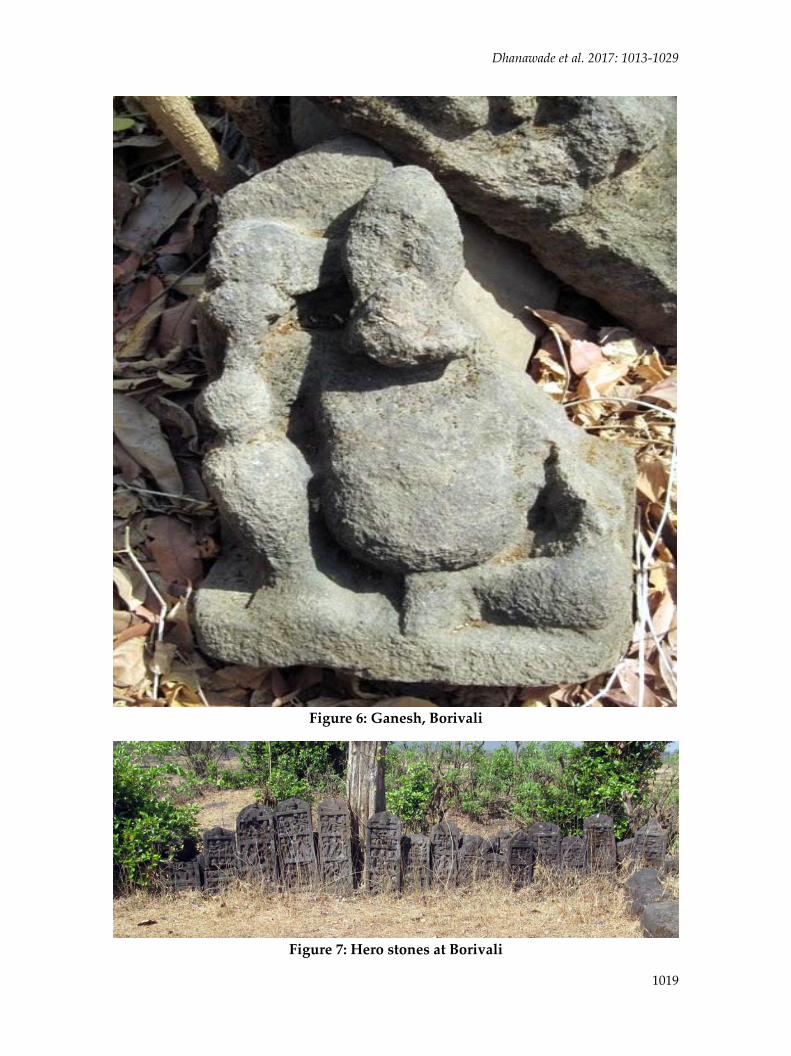
Borivali Borivali (18° 21’ 50’’ N; 73° 21’ 55’’ E) is included in Shiravali Grama Panchayat. It has a
Shiva and Kalbahirav temple. Though both these temples have been renovated, old
sculptural elements are still preserved in the premises. These include an image of
Parvati in Samabhanga posture (85 x 40 cm), an image of Ganesh (Figure 6), two nandi
sculptures, and twenty hero stones (Figure 7). All these based on style can be dated
between 12th and 15th century CE. A few fragments of glazed ware sherds were noticed
from the Shiva temple.

ISSN 2347 – 5463 Heritage: Journal of Multidisciplinary Studies in Archaeology 5: 2017
1018
Figure 5: Hero Stone at Shiravali
Yelavade The village (18° 22’ 44’’ N; 73° 21’ 37’’ E) is 2 km away from Shiravali. It has the temples
of Kalbhairav and Shiva. However, both are completely renovated, perhaps in the 19th
century. Older archaeological remains were not found in this village.
Dhanawade et al. 2017: 1013‐1029
1019
Figure 6: Ganesh, Borivali
Figure 7: Hero stones at Borivali

ISSN 2347 – 5463 Heritage: Journal of Multidisciplinary Studies in Archaeology 5: 2017
1020
Jita Jita (18° 21’ 7’’ N; 73° 22’ 03’’ E) is located 19 km northeast of Mangaon and at the base
of Kurdu Fort. Scattered archaeological material was found in the courtyard of modern
Hanuman temple. It includes hero stones (Figure 8) and a Sati stone. Also, one eroded
female sculpture was found. These remains belong to 12‐13th centuries CE.
Figure 8: Hero Stones, Jita
Fort Kurdu This was an important fort (18° 22’ 27.08’’ N; 73° 25’ 7.31’’ E) during the medieval
period overlooking the pass known as Lingya Pass that connected Konkan to the areas
in Pune district (Figure 9). Rock‐cut caves have been reported from the eastern portion
of this fort earlier (Joshi 2011). During exploration the first author discovered two west‐
facing rock‐cut caves along a 300 m high pinnacle near the Kurdai temple on the fort.
These caves are at 95 m above the base of the pinnacle and could be reached only with
mountaineering equipment. Two rock‐cut caves (Figure 10) and two rock‐cut water
tanks were found. Tank No. 1 (3 x 4 m) is filled with soil at present. Tank no. 2 has
rectangular columns. A room is excavated in the middle of its southern wall. Its
internal details could not be investigated as it was filled with water. Cave No. 1 (1.90 x
2.3 x 1.70 m) is situated above this tank appears to be an ancient vihara. The walls and
roof are flat without any decoration. Cave No. is shaped like an axe blade ‐ narrow at
the entrance and wide inside with a semicircular rear portion. At first glance it appears

Dhanawade et al. 2017: 1013‐1029
1021
like water tank as its floor is by 1.40 m deep. The northern wall has a hidden chamber
(1.70 x 0.90 m). The pivot holes suggest provision of wooden shutters. A similar hidden
chamber was dug in the eastern wall but this is in L‐shape. This chamber has a 1.30 m
high and 0.30 m wide door opening. These hidden chambers may have been used for
keeping valuable goods or arms. Because one can have a long‐distance view from this
cave, it could have had a watch‐tower like function. Based on the pattern of cave
excavation it is suggested that these caves were excavated during the Shilahara period
(800‐1260 CE).
Figure 9: Pinnacle of Kurdu Fort
The entrance to the fort has rock‐cut stairs. This path has holes indicating it was once
covered with wooden paving. The hero‐stones on the fort are very similar to those at
the base in Umbardi village and the whole region in general. Near the temple of local
goddess Kurdai, a worn out Gajalaksmi sculpture and a stone slab was found. The
semicircular end of the slab has a moon and sun symbol.
Umbardi The archaeological remains at Umbardi (18° 22’ 31’’ N; 73° 24’ 18’’ E) comprise temples,
fortification, foundations of residential structures, hero stones, loose stone icons,
ceramics (Figure 11‐12) and ornaments such as bangles (Figure 13). The ceramics
include monochrome glazed ware, red ware and porcelain similar to those found at
Chaul (Gogte et al.) and Kelshi (Joglekar et al. 2001‐2002) on West Coast of
Maharashtra.

ISSN 2347 – 5463 Heritage: Journal of Multidisciplinary Studies in Archaeology 5: 2017
1022
Figure 10: Newly Discovered Cave at Kurdu Fort
Figure 11: Medieval Ceramics from Umbardi

Dhanawade et al. 2017: 1013‐1029
1023
Figure 12: Porcelain from Umbardi
Figure 13: Bangles from Umbardi
ISSN 2347 – 5463 Heritage: Journal of Multidisciplinary Studies in Archaeology 5: 2017
1024
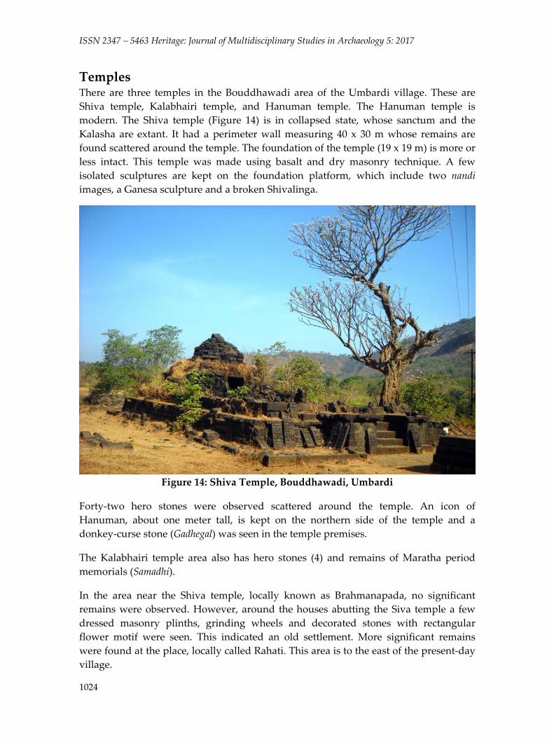
Temples There are three temples in the Bouddhawadi area of the Umbardi village. These are
Shiva temple, Kalabhairi temple, and Hanuman temple. The Hanuman temple is
modern. The Shiva temple (Figure 14) is in collapsed state, whose sanctum and the
Kalasha are extant. It had a perimeter wall measuring 40 x 30 m whose remains are
found scattered around the temple. The foundation of the temple (19 x 19 m) is more or
less intact. This temple was made using basalt and dry masonry technique. A few
isolated sculptures are kept on the foundation platform, which include two nandi
images, a Ganesa sculpture and a broken Shivalinga.
Figure 14: Shiva Temple, Bouddhawadi, Umbardi
Forty‐two hero stones were observed scattered around the temple. An icon of
Hanuman, about one meter tall, is kept on the northern side of the temple and a
donkey‐curse stone (Gadhegal) was seen in the temple premises.
The Kalabhairi temple area also has hero stones (4) and remains of Maratha period
memorials (Samadhi).
In the area near the Shiva temple, locally known as Brahmanapada, no significant
remains were observed. However, around the houses abutting the Siva temple a few
dressed masonry plinths, grinding wheels and decorated stones with rectangular
flower motif were seen. This indicated an old settlement. More significant remains
were found at the place, locally called Rahati. This area is to the east of the present‐day
village.

Dhanawade et al. 2017: 1013‐1029
1025
Figure 15: Remains of Plinths in Rahati, Umbardi
Rahati Area
Rahati area (about 5 ha) at present has thick forest cover. The highest part in Rahati is
at 230 to 250 m AMSL. Here 25 stonework plinths were seen in good condition (Figure
15). Thirteen of these plinths have decorative dressed stones. The rampant growth of
vegetation has made it difficult to understand the spatial organisation of these remains.
It was interesting to note that this area had a fortification wall.
The main structure in Rahati is west facing and most likely a palace or the residence of
administrator. The plinth measuring 21 x 21 x 1.5 m has steps on the west giving it a
star shape. Special effort seems to have gone in the decoration of this building. The
superstructure has not survived. All the plinths in this area indicate that the buildings
were west facing. A staircase reaching a small flat area was found at about 12 m away
from the main structure in depilated condition (Figure 16).
A fortification wall is 20 m away from the main structure. It has an entrance and a
staircase. The staircase reached a terrace that is 5‐6 m below the entrance, but could not
be traced further due to thick growth of creepers. Near the end of stairs two broken
sculptures of Sharduls were found. Perhaps these were standing once near the
entrance. About 50 m away on the south of the terrace is a stream. From here one can
reach the Shiva temple. Perhaps a footpath existed earlier since one can notice rock‐cut
steps at a few places.

ISSN 2347 – 5463 Heritage: Journal of Multidisciplinary Studies in Archaeology 5: 2017
1026
Figure 16: Depilated Staircase, Rahati, Umbardi
Talai Area
Talai in local parlance refers to a bed of stream which contains water even in summer.
Upstream part has a steep phallic‐shaped pinnacle that is known as Lingya. An ancient
mountain path (Lingya Pass) exists here that connects Umbardi and Dhamanval in
Pune district. Two rock‐cut water cisterns were found near the pass at 500 AMSL.
These rectangular water cisterns are similar to those found at many forts including
those on Kurdu Fort.
Talai area also has a west facing Shiva temple at 200 m AMSL. Only plinth (20 x 12 m)
is extant. The plan of the temple is similar to that at Bouddhawadi. The local people
told a story that there was a nandi sculpture, but someone blew it and the pedestal in
search of hidden treasure. Also, for this purpose someone dug in the other parts of the
temple complex. An image of Ganesha, a broken Shivalinga, sculptures of Bhairava
and a free standing nandi are seen kept on the plinth. Remains of several residential
structures like those in Rahati area were found here (Figure 17).
Fortification The remains of fortification were found at about 400 m distance from the Shiva temple
of Bouddhwadi on the way to Rahati area. This dry masonry basalt wall extends for
about 1 km in north south direction (Figure 18). The wall begins in the northern hill at

Dhanawade et al. 2017: 1013‐1029
1027
180 m AMSL and ends in southern part near the hill of Kurdu Fort at 152 m AMSL. The
thickness of the wall reduces as we move from bottom to the top. It has rectangular
bastions like that of a fort wall. The purpose of this fortification was to protect the town
on its eastern side.
Figure 17: Remains of Residential Structures in Talai, Umbardi
Figure 18: Remains of Fortification, Umbardi

ISSN 2347 – 5463 Heritage: Journal of Multidisciplinary Studies in Archaeology 5: 2017
1028
There were four entrance gates in the fortification. A gate in the northern side is at 148
m AMSL with Z‐like entrance, but closed due to collapsed courses of masonry. Near
the stream bed there is the largest gate with two bastions on either side. The entrance
measures 24 x 25m. The wall here has seven to eight courses. The third gate is at 93 m
distance from the main gate. There are two bastions of which only a few courses are
extant (5 of the northern and 6 of the southern bastion). The fourth gate is located at
151 m AMSL. Only one bastion is extant with eight courses.
Concluding Remarks The archaeological remains at Umbardi and the neighbouring villages indicate
historical importance of this region (Dhanawade 2015). The combination of an
important administrative/trading centre at Umbardi and its guardian fort at Kurdu is
interesting. Forts constructed for guarding the passes leading from Konkan to the
Upland Maharashtra has been a common feature in this part of the Western Ghat (Joshi
2014; Joglekar et al. 2015). Though Umbardi and the Kurdu Fort are scantily mentioned
in historical documents, Mangaon and nearby villages were known from the Early
Historic times until the Mediaeval period. The villages of Vihule and Bamangaon,
located 27 km and 10 km away respectively, from Umbardi are mentioned in Shilahara
copper plates (Mirashi 1974). Bamangaon is near Fort Kurdu. It is clear from the Janjira
copper plate inscription of Shilahara king Aparajita dated to 993 CE that the region of
Umbardi and Vihule had administrative significance (Mirashi 1974).
Mandad on the west coast, about 40 km from Mangaon was an important ancient port
during the first century CE (Dhavalikar 1984). Umbardi was perhaps an important
centre on a trade route that began at the Mandad port and reached the Upland region
through Umbardi/ via Vihule. Evidence of a settlement along such a connection has
been found at Chandore near Mangaon (Dalal 2012). Based on the findings of
exploration in Tala and other talukas of Raigad district, two ancient routes are
suggested. One could have been Dive Agar‐ Kharsai ‐ Chandore ‐ Vihule ‐ Kadape ‐
Umbardi, and the second would have been Mandad‐ Talegav ‐ Kharavali ‐ Koste ‐
Kadape – Umbardi. Almost all villages in Tala and Mangaon takuka have
archaeological remains pointing to a period between 9/10th centuries and 14/15th
centuries CE (Dhanawade 2017b). This work has shown a possibility of uncovering the
historical background of this region provided that more data are gathered from
excavations as has been done at Chandore in recent years. Discovery of more rock‐cut
caves at Fort Kurdu is significant addition to our database on such caves in Konkan
region. Earlier a new cave complex was found at Pandheri (Dhanawade et al.2011‐
2012). These researchers indicate that still there is scope to explore the region for such
caves and that that could change our perception of cave‐cutting activities in ancient
and medieval periods.
Acknowledgements We wish to acknowledge the help of Aditi Mahajan and mountaineers Dr. Rahul
Warange, Prashant Bhutkar, Nikesh Shinde, Kunal Gosavi, Chetan Pawar, Chintan

Dhanawade et al. 2017: 1013‐1029
1029
Vaishnav, Bhushan Sheth, Omkar Mane, Rakesh Halande, Yogesh Shinde, Deepak
Sakpal and Rupesh Vanarase. We give special thanks to Shri Ganesh Mehendale for
support during exploration and for preparation of the maps. Also, Dr. Shantanu
Vaidya helped in preparation of the map images.
References Dalal, K.F. 2012. A Short note on the Exploration at the Site of Chandore, District
Raigad, Maharashtra, Journal of the Asiatic Society of Bombay 84:133‐136.
Dhanawade, Anjay 2017a. Preliminary Report on Archaeological Exploration in North
Konkan, in Explorations in Maharashtra (Kurush Dalal Ed.), pp. 79‐88.
Mumbai: India Study Centre Trust.
Dhanawade, Anjay 2017b. Archaeological Investigations of the Early Historic to Medieval
Settlements in the Southern Part of Raigad District, Unpublished thesis, Tilak
Maharashtra Vidyapeeth, Pune.
Dhanawade, Anjay, P.P. Joglekar and Abhay Kale 2011‐2012. Discovery of Rock‐Cut
Caves at Panderi, District Ratnagiri, Maharashtra, Journal of Indian Ocean
Archaeology 7‐8: 179‐184.
Dhavalikar, M.K. 1984. Late Hinayana Caves of Western India. Pune: Deccan College.
Gogte, Vishwas, Shrikant Pradhan, Abhijit Dandekar, Sanchin Joshi, Rikshana Nanji,
Shivendra Kadgaonkar and Vikram Marathe 2006. Ancient Port at Chaul,
Journal of Indian Ocean Archaeology 3: 62‐80.
Joglekar, P.P, Sushama Deo, Arati Deshpande‐Mukherjee and Savita Ghate 2001‐2002.
Archaeological Investigation at Kelshi, District Ratnagiri, Maharashtra,
Puratattva 32: 63‐73, 244.
Joglekar, P.P., Abhjit Dandekar, Sachin Joshi, Girish Mandke and Milind Kshirsagar
2015. Exploration (2013‐14) at Ghanagad Fort and Surrounding Area,
District Pune, Maharashtra, Bulletin of the Deccan College Research Institute
75: 141‐146.
Joshi, Sachin 2011. Durga Vaibhav (in Marathi), Pune: Bookmark Publications.
Joshi, Sachin 2014. A Study of Defence Architecture and Geopolitical Significance of Coastal
and Hinterland Forts on the Konkan Coast, Maharashtra, Unpublished PhD
Thesis, Pune: Deccan College.
Mirashi, V.V. 1974. Shilahara rajavamshacha itihas ani korivlekh (in Marathi), Nagpur:
Vidarbha Sanshodhan Mandal.