archaeological investigations at … of sanhs-147...resistivity caused by topographic and geological...
TRANSCRIPT

143Archaeological investigations at Templecombe, 1995
ARCHAEOLOGICAL INVESTIGATIONS ATTEMPLECOMBE, 1995
PHIL HARDING, STEWART AINSWORTH, J. BUTTERWORTH, J. GATER AND M. SIRAUT
with contributions byMichael J. Allen, Lorraine Mepham, E. Murphy and M. Pallister
SUMMARY
An earthwork survey, supplemented by geophysics, north-east of Manor House, Templecombe,has redefined the extent of the former Templar preceptory. The site, of which only fragmentsof the former chapel survive, is defined by a stone wall lying within tithe-free land. Excavationhas confirmed the survival of archaeological features and shown that medieval buildings withtiled floors once occupied the site.
The work formed part of the Channel Four series Time Team.Subsequent small-scale rescue excavations by the South East Somerset Archaeological and
Historical Society at a development site in the north-east corner of the preceptory identifiedrobbed stone wall footings from an additional building. They also reassessed the evidence forchanges to the road layout in Templecombe following the Dissolution.
INTRODUCTION
Early in 1995 the producers of the Channel Four programme Time Team were investigatingpotential locations for a third series. Following an approach from Mr G. Wilson of Templecombeand discussions with Robert Croft, Somerset County Archaeologist, it was agreed toreexamine the former preceptory of the Knights of the Temple of Soloman, or Templars,which was located in the village. This military order, which had its origins in the HolyLand, was established in the early 12th century with the aim of protecting pilgrims, butsoon developed into a fighting force defending Christian interests there. The order wasregular and monastic, following a rule based on that of St Benedict, with a General Chaptersimilar to that of the Cistercians. As well as fighting in the East, the order soon spread toWestern Europe, acquiring extensive property to provide wealth and resources for itsactivities (Forey 1992).
The full extent of the site, its condition and relationship to the present Manor House wereunknown. The report argues that the site has been previously mislocated and shows that thepreceptory complex lies to the north-east of Manor House.
143
144 Somerset Archaeology and Natural History, 2003
SITE AND LOCATION
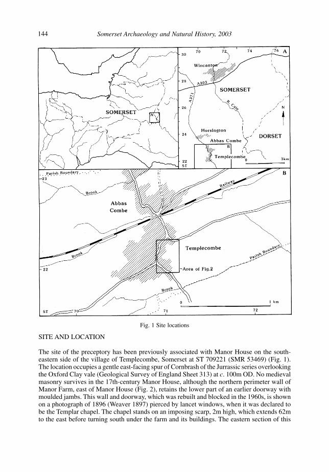
The site of the preceptory has been previously associated with Manor House on the south-eastern side of the village of Templecombe, Somerset at ST 709221 (SMR 53469) (Fig. 1).The location occupies a gentle east-facing spur of Cornbrash of the Jurrassic series overlookingthe Oxford Clay vale (Geological Survey of England Sheet 313) at c. 100m OD. No medievalmasonry survives in the 17th-century Manor House, although the northern perimeter wall ofManor Farm, east of Manor House (Fig. 2), retains the lower part of an earlier doorway withmoulded jambs. This wall and doorway, which was rebuilt and blocked in the 1960s, is shownon a photograph of 1896 (Weaver 1897) pierced by lancet windows, when it was declared tobe the Templar chapel. The chapel stands on an imposing scarp, 2m high, which extends 62mto the east before turning south under the farm and its buildings. The eastern section of this
Fig. 1 Site locations

145Archaeological investigations at Templecombe, 1995
Fig. 2 Site plan showing trench location and earthwork survey

146 Somerset Archaeology and Natural History, 2003
scarp and its return formed part of a depression 40m square which is now occupied by ManorFarm. This feature has been variously described as a fish pond, moated enclosure or ‘cockpit’but is probably an ornamental garden associated with Manor House.
Paddocks to the north of the chapel which slope down from the scarp were formerly orchardsand contain a network of slight earthworks, including further probable fishponds.
DOCUMENTARY BACKGROUND
In 1066 an estate at Combe, later known as Temple Combe, was held by Earl Leofwin (d.1066) and, at the time of the Domesday survey, by Bishop Odo of Bayeux and his tenantSamson, bishop of Worcester from 1096 (VCH Somerset, 1, 445; ibid. 7, 76–86; DNB).
The Order of Templars, founded in 1118, had been established in England by 1128 (Knowlesand Hadcock 1971, 290). In 1185 the Templars held an estate at Combe, which was possiblyTemple Combe but may have been West Combland in Buckland St Mary (Dugdale, Mon. vi.801). Templars were certainly resident at Temple Combe by 1240 when it was recorded thatmembers of the order had been buried in Bruton priory (SRS 8, 62). Among those arrested andexamined on the orders of Edward II in 1308 was William Raven who was received into theorder at Temple Combe before transferring to Cambridge. The preceptor and two brethrenfrom Temple Combe were held in custody in Sherborne castle. The order was suppressed in1312 and its estates confiscated (Wilkins 1737, 334, 340–1, 346–7; Knowles and Hadcock1971, 290, 295; PRO, E 142/111).
The manor of Temple Combe, valued at £26 12s. 6d. in 1308 (PRO, E 142/111) was farmedout until 1332 when it was given to the Hospitallers who retained it until their dissolution in1540 (Cal. Mem. R. 1326–7, 347; Cal. Pat. 1327–30, 88; 1330–34, 130; Cal. Close, 1330–3,514). In 1388 the manor comprised a house, two dovecots, 488 acres of arable, sterile andmeadow land and pasture for 45 cattle and 200 ewes. The house was occupied by a preceptorand two brothers with their servants (Larking 1855–6, 183–6). A large part of the estate wasfarmed out by 1392 (PRO, C 143/412, no. 34) and the whole by the early 16th century. In1514 the commandery, comprising chapel, hall, great parlour with chamber over, pantry,brewhouse, bolting house, kitchen, wheat larder, dairy, new chamber with a chamber within it,little parlour with chamber over, yeoman chamber, milk house and study, was let with husbandrytools, pigs, geese, ducks, and peafowl (PRO, E 326/9056). In 1540 the manor was valued at£19 l0s 7d when it passed to the Crown (PRO, SC 6/Hen VIII/7262). It eventually came intothe hands of Richard Duke (d. 1572) and he and his successors seem to have been residentuntil 1632, thereafter the site was occupied as a farmstead (SRS 15, 163; SRS 67, xix; SRS 69,47; Som. Wills (ed. Brown), 1, 4; ibid. 6, 75). The chapel continued in private use until theearly 18th century (SDNQ 4, 126; SANH 112, 74) although a parishioner was buried there in1621 (SRO, D/P temp 2/1/1).
METHODS
The project set out to define the limits of the preceptory and locate any internal structuresusing a combination of earthwork and geophysical surveys. These surveys were centred onManor Farm but included the previously unrecorded earthworks and associated features northof the chapel. Exploratory trenching was then used to establish the state of preservation of anyanomalies and provide corroborative dating and phasing evidence of the preceptory.
A standing building survey of the Manor House, Templecombe, was also undertaken tosupplement an existing record compiled in 1983 by Williams and Penoyre (SMR archive

147Archaeological investigations at Templecombe, 1995
report). This survey was supported by a programme of dendrochronolgy to date phases ofconstruction or repair of Manor House and establish the relationship of the house with the preceptory.
This report summarises the results of the archaeological investigations of the project,incorporating data from the geophysical report (GSB 1995). Full details are retained in thearchive deposited with the finds in Taunton Museum (Accn no. TTNCM16/1996). The resultsof the standing building and dendrochronology surveys are contained in separate reports(Morley 1995; Howard 1995) which are retained in archive and will be published separately.
RESULTS
Earthwork and geophysical surveys
The complex of features north of the chapel (Figs 2 and 3) lies partly within an intermittentstone wall enclosing an area approximately 130m north–south by 70m east–west (0.91ha).Significantly this area is shown on the Tithe Apportionment Map of 1839 (Fig. 4) to have beentithe free which suggests that it may have had monastic attributes and may represent the extentof the preceptory. The wall has been rebuilt on the west where it runs adjacent to the line of theformer main road through Templecombe. Its line on the south has been largely destroyed byManor Farm although a short rebuilt section south of the farmhouse may perpetuate the line.The north side is fossilised by a garden wall in the north-east corner but has otherwise beendestroyed by former industrial premises. The east side, although partially collapsed, survivesas a narrow, high stone wall, approximately 32m long. Its continuation towards Manor Farm,visible as a slight east-facing scarp, was detected by geophysics and a former occupier couldrecall its demolition.
The earthworks are visible within the southern half of this enclosed area (Fig. 2), the northernpart now being overgrown waste ground. Flanking the scarp a shallow ditch-like earthwork,6m across, with traces of a slight intermittent bank on the north side runs approximately east–west. In the south-west corner of the survey area a short, narrow linear depression leads to amodern gate. This depression has the appearances of a wear-line, however it also coincideswith an h-shaped walled structure identified by geophysics. These features were investigatedin Trench 1. A pair of parallel earthworks, one of which projects the approximate line of theeast gable of the chapel to the north beyond the scarp, maintain the symmetry of the enclosure.
The geophysics within this area (Fig. 3) also revealed probable structural walls, includingthe eastern boundary wall, represented by linear high-resistance readings symmetrical withthe earthworks. These alignments were apparent despite fluctuations in the backgroundresistivity caused by topographic and geological variations. Other high-resistance responses,particularly along the western and southern edges of the survey area, including the area of thechapel, suggested rubble or accumulations of archaeological deposits. This was confirmed byexcavation. A damp area, evident as low-resistance readings, may represent a pond.
A number of additional earthworks perpetuate these alignments beyond the walled area tothe north and north-east. A slight ditch, which is apparently overlain at its west end by a smallearthwork platform extends north-east away from the walled enclosure towards a substantialL-shaped, double-banked ditch or trackway. This feature, c.170m in length and c. 4.5m wideand 0.5m deep, has a flat-topped bank, 5m wide, on the south and east sides and a slightlynarrower bank to the north. Geophysical survey identified a line of high resistance, interpretedas a wall, approximately coincident with the west side of this earthwork and low-resistancereadings within the slight ditch which probably indicate modern drains.
A similar survey in paddocks south of the farm produced no significant anomalies, whichsuggests that this area lies beyond the southern limit of the preceptory.

148 Somerset Archaeology and Natural History, 2003
Excavation
Six trenches (Fig. 2) were excavated using a JCB excavator fitted with a 1.5m bucket toremove overburden until undisturbed archaeological deposits were reached. Trenches werethen cleaned and all subsequent excavation undertaken by hand.
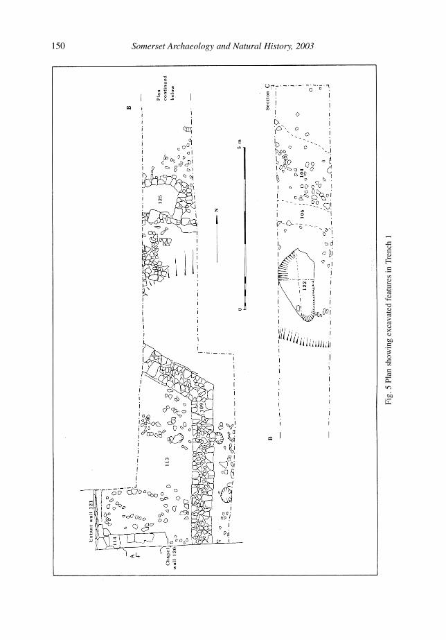
TRENCH 1This trench (Figs 5 and 6) measured 23.8m long and 1.5m wide from the north door of thechapel wall southwards across areas of high resistance, including the h-shaped anomaly, to theshallow ditch recorded in the earthwork survey. The south end of the trench was later widenedto 3m.
Fig. 3 Plan showing geophysics results and extent of preceptory

149Archaeological investigations at Templecombe, 1995
Early medieval activity was indicated by two fragments of pottery, in an irregular oval pit(122), measuring 2.20m long, 1.10m wide and 0.25m deep, at the north end of the trench. Itwas cut with steeply sloping, rounded sides and an irregular base and was filled with midgrey-brown loamy clay (107).
There is no convincing evidence for the existence of wooden buildings before the constructionof the main chapel wall (120) (Fig. 7). The original stonework survives to a height ofapproximately 0.50m for most of its recorded section and comprises seven courses of uncutmortared limestone slabs. However at its junction with wall 121 it survives to a height of1.60m in 27 courses. It is pierced by a doorway, 1.04m wide, framed by chamfered ashlarjambs and a chamfered cill. It is likely that the wall was constructed directly onto the bedrocksurface without a foundation trench.
Approximately 10.5m north of the doorway a stone-lined pit or trough (125) projected fromthe western section. The base sloped to the north and was formed by a single large limestoneslab. The lining of thin, coursed, unshaped limstone slabs formed a sub-rectangular cisternover 1m long from east–west, 0.90m north–south and 0.50m deep. A stone roof tile in theconstruction suggests that it was not part of the initial development of the site. The feature wasapparently deliberately backfilled with limestone slabs and rubble, up to 0.30m across (117),much of it placed on edge and set in a grey-brown clay loam matrix. This material containeda single medieval sherd but may be contemporary with the large scale post-medieval demolitionphase (108).
At an unspecified date, probably in the 15th century, extensions were added to the northwall of the chapel. Wall 121 is of a similar construction to wall 120 to which it is butted. It hasa progressively stepped foundation and extends 1.80m to the north before turning west. Asecond wall (109) was also added which is aligned north-west to south-east before turning torun north–south. It is constructed of two limestone faces, 0.78m apart, with a rubble core. The
Fig. 4 Detail from the Tithe Apportionment map of 1839
150 Somerset Archaeology and Natural History, 2003
Fig.
5 P
lan
show
ing
exca
vate
d fe
atur
es in
Tre
nch
1
151Archaeological investigations at Templecombe, 1995
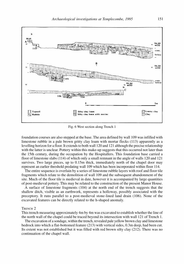
Fig. 6 West section along Trench 1
foundation courses are also stepped at the base. The area defined by wall 109 was infilled withlimestone rubble in a pale brown gritty clay loam with mortar flecks (113) apparently as alevelling horizon for a floor. It extends to both wall 120 and 121 although the precise relationshipwith the latter is unclear. Pottery within this make-up suggests that this occurred not later thanthe 15th century, during the occupation by the Hospitallers. This foundation base carried afloor of limestone slabs (114) of which only a small remnant in the angle of walls 120 and 121survives. Two large pieces, up to 0.15m thick, immediately north of the chapel door mayrepresent an earlier threshold predating wall 109 which has been incorporated within floor 114.
The entire sequence is overlain by a series of limestone rubble layers with roof and floor tilefragments which relate to the demolition of wall 109 and the subsequent abandonment of thesite. Much of the floor tile is medieval in date, however it is accompanied by large quantitiesof post-medieval pottery. This may be related to the construction of the present Manor House.
A surface of limestone fragments (104) at the north end of the trench suggests that theshallow ditch, visible as an earthwork, represents a holloway, possibly associated with thepreceptory. It runs parallel to a post-medieval stone-lined land drain (106). None of theexcavated features can be directly related to the h-shaped anomaly.
TRENCH 2This trench measuring approximately 4m by 4m was excavated to establish whether the line ofthe north wall of the chapel could be traced beyond its intersection with wall 121 of Trench 1.
The excavation of a sondage, within the trench, revealed pale yellow brown clay and limestonebedrock into which a flat-bottomed feature (213) with vertical sides, 0.3m deep, had been cut.Its extent was not established but it was filled with red brown silty clay (212). There was nocontinuation of the chapel wall.

152 Somerset Archaeology and Natural History, 2003
Fig. 7 Elevation of chapel doorway and wall showing original stonework
Most of the trench comprised made up ground, 0.50m thick above the natural bedrock. Theupper surface was capped by a floor of cobbles (205) and pitched limestone fragments (209)of a thatched post-medieval outbuilding shown on a photograph of 1896 (Weaver 1897).These floors ran to a blocked doorway in wall 121 with a rough stone threshold and to arectangular mortared limestone block (207), 1.40m long by 0.60m wide, in the central area ofthe building. The base of a small internal drystone wall (206) extended from this centralstructure to the east.
The entire sequence was capped by 0.50m of garden soil.
TRENCH 3This hand-excavated trench was located along the east wall of the main east range of theManor House and was 4m long. It aimed to examine whether the present structure, dated bydendrochonology to 1615–20 (Howard 1995), lay on earlier Templar foundations. Theexcavation revealed a pitched limestone slab floor (303) of post-medieval date leading to aseries of robbed-out steps to a subterranean structure or cellar. The pitched limestone floorappeared to be cut by a limestone drain (305) which ran below the east wall of the manorrange. Inspection of the interior of the range showed that only half a bay is represented at thisend of the building, indicating that it had been shortened since its construction (B. Morley,pers. comm.).
TRENCH 4A machine-excavated trench, measuring 14m long, was dug across an extant linear bank andditch 135m south of the preceptory site to ascertain its date and function. The ditch (408), onthe southern side of the bank, measured 2.5m across and was excavated 0.6m deep to a modernceramic field drain. The ditch fill of red-brown silty clay (407) was sealed by a buried turf line(403), up to 0.20m thick. A thin layer of dark red-brown silty clay loam (402) lay immediatelybelow the modern topsoil.
The bank, constructed from the ditch upcast, was 5m across and 0.4m high. It was composedof orange-brown clay (409) with partially oxidised grey clay with fossil shell fragments (406)

153Archaeological investigations at Templecombe, 1995
THE FINDS
The total number of finds from each context is shown in Table 1.
The pottery by Lorraine Mepham
A total of 229 sherds (3445g) recovered from Templecombe was examined. This smallassemblage dates largely to the medieval and post-medieval periods, with a single sherd ofRomano-British date. A chronological breakdown of the pottery by context is given inTable 2.
ROMANO-BRITISH
A single sherd of Romano-British coarseware came from the topsoil in Trench 1. This sherd isnot closely datable within the Romano-British period.
MEDIEVAL
Approximately one quarter of the total assemblage by weight is dated to the medieval period,and this can be subdivided into two chronological groups. The earliest material consists of 47sherds, generally small and abraded, in a variety of coarse fabrics, some sandy, some temperedwith flint and/or crushed limestone. Few diagnostic sherds are present, but this group seemslargely to represent coarse, utilitarian vessels such as jars for storage or cooking purposes,although at least one glazed jug or pitcher form was distinguished. This small group of sherdsfinds parallels in larger medieval assemblages from sites such as Sherborne and Ilchester(Harrison and Williams 1979; Pearson 1982); within the local area several smaller comparablegroups, although none well-dated, are known from the Dorset/Somerset border area betweenSherborne and Shaftesbury (e.g. Ellison and Pearson 1978; Ross 1985; Newman et al.forthcoming; Mepham 1992). A number of different sources for the pottery are likely to berepresented. Scratchmarked sandy wares, of a type comparable to material from the Laverstockkilns outside Salisbury (Musty et al. 1969), have been recognised in very small quantities;other potential sources are the Yeo valley around Ilchester, and the putative medieval productioncentre at Crockerton in west Wiltshire. A general date range of late 12th to 13th century maybe suggested for this small group.
on the southern side. Root fragments suggest that it was once hedged. There were nofinds.
TRENCH 5This trench was also machine excavated north–south across a shallow depression in the fieldsurface 65m south of the preceptory. It measured 11m long and was dug 0.5m deep to thenatural clay. There were no features apart from a post-medieval land drain.
TRENCH 6The foundations of the eastern wall of the enclosure were examined by a trench 9m longwhere it had been identified by geophysics. This line marks the boundary of the tithe-free landand is therefore likely to be the precinct boundary. It confirmed that the wall was of drystoneconstruction, 0.80m across, and built of limestone slabs with a rubble core. The basal threecourses were laid directly on the natural subsoil and were overlain by a dark grey-brown clayloam topsoil, 0.25m deep. The subsoil horizons on both sides contained heavily abradedmedieval pottery.

154 Somerset Archaeology and Natural History, 2003
The remaining medieval material (45 sherds) is of different character and appears to beslightly later in date. This consists of sherds in finer sandy fabrics, nearly all oxidised, somepartially glazed. Similar sandy wares are widespread across west Dorset and beyond, andwere probably manufactured at several centres, amongst them the kilns at Donyatt in Somerset(Coleman-Smith and Pearson 1988). A date range of 14th to 15th century is likely for these wares.
POST-MEDIEVAL AND MODERN
Approximately three-quarters of the total assemblage by weight may be dated to the post-medieval or modern periods, and this was again concentrated in Trench 1, mainly from thetopsoil and underlying demolition layers. The majority of this comprises sherds of coarse redearthenwares, generally glazed. These represent the ubiquitous utilitarian domestic wares ofthe post-medieval period, and have a wide date range, although the relative absence here ofthe pale-firing earthenwares of Verwood type from the Dorset/Hampshire border industry,which swamped the market from the 18th century, might indicate that their date range fallsgenerally within the 16th and 17th centuries. Templecombe is situated roughly halfway betweentwo known sources of redwares – Donyatt in Somerset and Crockerton in west Wiltshire, andis likely to have received products of both centres.
Context Description 1 2 3 4 5 6
Trench 1101 Topsoil/overburden 82/1887 30 129 46 – 7 glass102 Base of topsoil 5/54 – – 1 – –103 Rubble spread 6/36 3 8 26 6 3 nails107 Fill of hollow 2/8 – – 2 – –108 Base of 103 47/544 29 87 63 11 3 nails110 Demolition 7/86 2 5 1 – –111 Base of 103 6/46 9 15 – – –112 Rubble 8/48 1 – 7 3 2 stone slates, 1 nail113 Infill inside wall 109 17/200 5 15 12 3 3 nails115 ? Demolition of wall 109 2/74 1 – 2 – 1 stone slate116 ? Demolition of wall 109 2/16 – 2 6 – –117 Deliberate backfill 1/4 – – – – –118 Weathered natural 6/70 – 1 – – –
Trench 2201 Topsoil 7/176 – 19 – – –202 Clearance 6/56 1 8 18 11 –203 – – – 17 – –204 Make-up 8/66 2 12 82 25 –205 – – – 4 – –210 – – 1 7 – –211 Make-up 3/16 – – 7 – –212 – – – 1 – –
Trench 3301 Clearance 2/6 – 7 4 – –302 Modern infill 1/10 – – – 2 –
Trench 6601 Topsoil/clearance 11/42 – – 7 2 –
Totals 229/3445 83 309 313 63 20
Table 1 All finds by context. Key: 1 Pottery (number/weight); 2 Floor tile (number); 3 Roof tile(number); 4 Animal bone (number); 5 Oyster shell (number); 6 Others (listed)

155Archaeological investigations at Templecombe, 1995
Contemporary with these local wares are German stoneware jugs of Raeren and Cologne/Frechen type, and one deep hook-rimmed bowl in North Italian polychrome marbled slipware.The latter is an unusual find in a rural location such as Templecombe; it is known in contexts of thefirst half of the 17th century from upwards of 50 sites in England, but generally occurs on coastalsites and larger urban centres (Hurst et al. 1986, 33–7). One other example, a bowl of identicalform, is known from Old Wardour Castle in south-west Wiltshire (Hurst 1967, fig. 4, no. 8).
Other less common wares amongst the post-medieval group are the base of a tinglazedearthenware ointment pot of 18th-century type, probably of British origin (1 sherd), and whitesaltglaze, an English stoneware of 18th-century date (1 sherd).
Modern wares, in the form of fine whitewares and stonewares, and redware flowerpot, arepresent in much smaller quantities, and occurred only in topsoil, clearance and make-up layersin Trenches 1 and 2.
DISTRIBUTION
The overwhelming majority of the pottery derived from contexts in Trench 1 (191 sherds outof the total of 229), and this included sherds covering the whole of the medieval to moderndate range represented, as well as the single Romano-British sherd. Of this early medieval(12th to 13th century) material, 32 sherds out of the total of 47 came from Trench 1, where itoccurred in small quantities in a number of contexts, in nearly every case mixed with latermaterial, although some contexts towards the base of the stratigraphic sequence produced
Context Description R-B Medieval Late- Post- Modern Totalmedieval medieval
Trench 1101 Topsoil/overburden 1/4 – 7/142 68/1655 6/86 82/1887102 Base of topsoil – 3/22 – 2/32 – 5/54103 Rubble spread – 1/4 2/12 3/20 – 6/36107 Fill of hollow – 2/8 – – – 2/8108 Base of 103 – 7/40 11/104 29/400 – 47/544110 Demolition – 1/2 2/40 4/44 – 7/86111 Base of 103 – 1/2 5/44 – – 6/46112 Rubble layer – 4/14 4/34 – – 8/48113 Infill at base of wall 109 – 5/118 12/82 – – 17/200115 ?Demolition of wall 109 – – – 2/74 – 2/74116 ?Demolition of wall 109 – 1/4 1/12 – – 2/16117 Deliberate backfill – 1/4 – – – 1/4118 Weathered natural – 6/70 – – – 6/70
Trench 2201 Topsoil – 1/36 – 5/134 1/6 7/176202 Clearance – – – 5/52 1/4 6/56204 Levelling/make-up – – – 7/60 1/6 8/66211 Levelling/make-up – 3/16 – – – 3/16
Trench 3301 Clearance – – – 2/6 – 2/6302 Modern infill – – 1/10 – – 1/10
Trench 6601 Topsoil/clearance – 11/42 – – – 11/42
Totals 1/4 47/382 45/480 127/2477 9/102 229/3445
Table 2 Chronological breakdown of the pottery by context

156 Somerset Archaeology and Natural History, 2003
only early medieval sherds, as did one context in Trench 2 (see Table 2). Trench 6 producedonly medieval pottery, but this was derived from a topsoil context.
Later medieval sherds (14th to 15th century) came almost exclusively from contexts inTrench 1 and, like the earlier material, occurred in a number of contexts in relatively smallquantities. Post-medieval sherds, again concentrated in Trench 1, derived mainly from topsoiland underlying demolition layers. Closely datable types amongst the post-medieval assemblage,in the form of the German stonewares and Italian slipware, would indicate a date range for thebulk of the Trench 1 material within the 16th and 17th centuries, and this is supported by thescarcity of Verwood-type earthenwares. There are just a handful of sherds which can bedefinitely dated to the 18th century or later (white saltglaze, modern stonewares and finewhitewares), and these all came from the topsoil.
The medieval floor tile E. Murphy
GENERAL
No in situ pavement or unbroken floor tiles were found but 83 fragments of square and bordertile were found in the present excavations. These are of red clay with very few inclusions,mostly heavily worn and of typical Wessex style, green or yellow glazed with white slip-inlaiddesign (where recognisable). A few have been glazed over a plain white slip.
DESCRIPTION
The majority of the square tiles would have been between 140 and 150mm square and onaverage 20mm thick when complete, one exception being the larger version representing theArms of Ferrers (Emden 1977, no. 157), and possibly one thought to represent the Arms ofClare. Other large fragments comprise part of a square tile with the Catherine wheel design(ibid, ill. 114) from context 111, measuring <140 x <120 x 21 mm and a side piece of Emden(ibid) design no. 100 or similar (<143 x <84 x 20mm). The border tiles fragments are darkgreen without pattern and between 48 and 50mm wide.
One worn 20mm thick tile, triangular cut, from context 101, has a peg or stab hole in theback, 10mm in diameter and c.10mm deep, apparently made with an implement, probably tohold it in place. This feature is not repeated in any of the other tiles, nor was it possible toestablish whether this was a random feature or one of several such holes, as used by the HailesAbbey tilers of the period to facilitate drying (Eames 1992, 51). There was no evidence of nailholes in the top surface, as found on some imports from the Low Countries (Keen 1980).
On the back of most fragments of sufficient size, keys are positioned which suggest a patternof four or five to a square. Some of the border tiles also have keys in the back that wereseemingly scooped out along the length of a longer slab, from which the tiles were broken off.
DESIGNS
Examples of approximately ten known Wessex designs were recognised. These included thearms of Brian, probably Clare, Ferrers and Wyvill. Using the Emden (1977) numbering, overallthe following designs are represented: E.100, 109, 114, 115, 129, 130, 135, 140, 157, 217 inaddition to plain coloured and border tiles.
Furthur details of all fragments are available in the archive.
DATING
Tiles of this type were current in the late 13th to mid 14th centuries. No attempt has beenmade to date these examples closely from design, since tilers reused stamps and copies byother tilers were frequently used throughout the Wessex region over an extended period, manyof them based on the 13th-century Clarendon series. In certain cases, such as some heraldic

157Archaeological investigations at Templecombe, 1995
designs, an earliest design can be given on historic evidence, as in that of the Arms of RobertWyvill, Bishop of Salisbury from 1330–1375.
SUMMARY
The spread and broken nature of the floor tile is such that it would seem difficult to establishwith any certainty the location of any pavement or pavements to which the various examplesbelong. However, with the variety of designs present, including both heraldic and other lesscommon patterns, such as E.114 and E.115, alongside a number of dark green border tiles,there is enough to suggest the presence of one or more fairly elaborate tile floors, probablydivided into sections by the dark green border tiles.
The roof tile by E. Murphy
The 309 ceramic roof tile fragments, most of which are unstratified, included examples ofglazed and unglazed, shallow curved, half round and flat tiles, as well as a quantity of ridgetiles of several designs. Fragments of three stone slates of Oolitic Limestone were also foundin the demolition layers. These tiles may have formed part of a slated roof or have been usedto add weight at the bottom edge of the roof.
Some of the ceramic tiles are still highly green glazed and in relatively good condition. Witha single exception (see below), the basic fabric in all contexts is red, generally grey cored andwith few visible inclusions. The outer tile surface is predominantly smooth or lined, with afairly crude inner finish. Most of the flat tiles were probably unglazed and some have lipped edges.
Tiles worthy of comment include two joining small pieces (context 111) which show a pattern ofcombing, three bands crossed with five. This could be either decorative or a form of masons’ mark.Another exceptional example (context 113) is of a creamy colour, minutely speckled with granularinclusions. It is a small hooked tile, length 55mm, width 32mm and 20mm deep at the hook.
Decorative forms of the crested ridge tiles include four-sided twin or single points, knife-cut and acutely angled, some with slanted stabbings in the curve of one of the sides only, andedges emphasised with raised strips. In most of these cases, the height, base to peak, is between30 and 40mm, the points accounting for about 8 to 10mm of the overall height. More roundedcrests, scooped between the points (Draper 1983, fig. 6, no. 39) are also present. Averagelength could not be established as the tiles were not complete. Most are, or have been, greenglazed. Two related green-glazed fragments (context 108) show a combing design along thenarrow tops of the crest, where they would be unlikely to be seen.
DATING
The presence of knife-cut crests is probably indicative of a date after the late 13th century(Jope 1951).
CONCLUSIONS
The mix of styles suggests that the medieval roofs in this part of the site conformed withpatterns in other such buildings of the period as described by Eames (1992, 6), in that decorativecrests and coloured, weather-proof glazing were used in the more exposed and visible positions,with the plainer ones at the lower levels, possibly finished off by heavy slabs at the lowestedge (Draper 1983).
Animal bone by Michael J. Allen
A small assemblage of 313 bone fragments was recovered from the excavations. Preservationwas good and fragmentation moderate. The faunal assemblage is summarised in Table 3,

158 Somerset Archaeology and Natural History, 2003
where large mammal is cow/horse sized and small mammal is sheep/pig sized. The majorityof the stratified assemblage was associated with the post-medieval phases and probablyrepresents refuse from the manor. Most of the bone from topsoil and modern contexts is alsoof a similar character with similar butchery traits to those from post-medieval layers. They arediscussed together.
MEDIEVAL
Only three bones can be securely placed into the medieval period and potentially associatedwith the Templars or Hospitallers. They are probably all sheep/goat, two of which are longbones.
POST MEDIEVAL
Some modern damage and physical abrasion was noticed in the post-medieval assemblage,particularly from fragments associated with modern topsoil and the rubble/demolition horizons,but dog gnawing or weathering was not common. The remains had not been left to be scavengedby dogs, but had become broken (fragmented). Most the bone was probably buried relativelysoon after discard
The assemblage is typical of discarded kitchen waste with long bones (ulna, radii metapodialsetc) and mandibular fragments of cow, sheep/goat and pig. Some fowl leg and wing longbones were also present but no horse, deer or dog was identified. Most butchery includedchopping of distal and proximal ends and the cutting through femoral heads with a sharpmetal blade.
DISCUSSION
The work at Templecombe has defined an area which it is thought likely represents the extentof the former Templar preceptory. Much of the argument lies on the evidence of the distributionof tithe-free land in the parish. Land belonging to the Templars was traditionally tithe free,owing to a papal exemption granted in 1139. An ecclesiastical survey of 1705 describes aprivate chapel belonging to the Manor House, and a farm belonging to the same Manor Housewhich pays no tithes ‘under the pretence that they did belong to the order of the KnightsTemplar’ (Dunning 1968, 74). The 1839 Tithe Award map for Abbas Combe and Templecombe(SRO tithe map 89) shows a large amount of land in the parish which was tithe free (Fig. 4).The distribution of these areas suggests that the Templar presence was confined to the south ofthe parish and is not represented in Abbas Combe, which lies to the north. The tithe-free areaof the village demonstrates that the Manor House itself is not in fact on tithe-free ground at all,although the land immediately to the east is.
Feature type Cow sheep/ pig large small fowl bird/ unid totalgoat mam mam amphib
Topsoil and modern 37 36 11 34 24 5 1 10 158Post-med demolition 28 18 9 14 15 – – 21 105Post-med building 4 3 1 12 10 7 6 4 47Medieval – 1 – – – – – – 1Early medieval – – – – 1 – – 1 2
Total 69 58 21 60 50 12 7 36 313
Table 3 Summary table of bone fragments

159Archaeological investigations at Templecombe, 1995
The work by Time Team at Templecombe has been unable to establish an internal groundplan of the preceptory. However similar sites (Fig. 8), about which more is known, provide anidea of what might be expected at Templecombe, in terms of area and buildings, their layoutand function. South Witham (Yorkshire) is the only fully excavated example of a Templarpreceptory in England (Selkirk 1968, 232). It was a very small and poor house, but it displayedall the features of a substantial medieval secular farmstead. It was built around a courtyard,with extensive barns, storage facilities, workshops and kitchens. In the centre was a hall andchapel, where the preceptor and knights would have lived. The evidence from this site reinforcesthe fact that Templar houses were not claustral, like other monastic establishments, but insteadmodelled on secular manors. Temple Balsall (Warwickshire) has surviving architecturalevidence, with a late 12th early 13th-century aisled hall still standing, and again, it is moreakin to a secular manor house than a monastery (Gooder 1995). This similarity means, ofcourse, that potential preceptories are harder to distinguish in the landscape than other monastichouses. Although not all Templar preceptories were defined by a wall the area of the preceptoryat Templecombe with its chapel compares well with that of the enclosed courtyard at SouthWitham (Fig. 8). The excavations at Templecombe have also shown that substantial buildingswith lavish tiled floors once lay within this area indicating considerable wealth.
Beyond the preceptory buildings would have been the precinct, an area which defined thefocus of the monastery’s activities and fulfilled many functions necessary to it. At South Witham,extensive millponds and fishponds were found, a common feature, and normally some form ofwalled boundary or earthworks marking the precinct would be expected. It is possible that the
Fig. 8 Comparative plans of Templar preceptories

160 Somerset Archaeology and Natural History, 2003
earthworks recorded at Templecombe, beyond the preceptory wall, form part of the precinctcomplex. Excavations by St John Hope (1908), at the large Templar house of Temple Bruer(Lincolnshire), revealed a church, following the classic circular Templar plan, as well as partof a boundary wall with buildings attached. There is however evidence of rectangular Templarchapels. An examination of 13 recorded preceptories showed that six were constructed withrectangular chapels, many of which were associated with preceptories in rural surroundings.It has been suggested (Morley 1995) that the angled wall (109) once formed part of thepreceptory boundary, allowing parishoners access to the chapel from the main road whiledenying them entry to the confines of the preceptory. If this is so the excavated evidencesuggests that this probably dates to the period of occupancy by the Hospitallers.
Nationally Templecombe formed part of a network of Templar establishments concentratedin the east of the country in an area spreading from the North Riding of Yorkshire, throughLincolnshire, down across the east Midlands. South of this area, the Templar presence wasmuch more fragmentary. Templecombe was probably one of the largest centres in the south-west, the nearest major preceptories being Temple Cowley and Sandford (Oxfordshire) andTemple Guiting (Gloucestershire). In value, Templecombe was a wealthy house, assessed atover £106 p.a. by the Hospitallers in 1338, making it the ninth wealthiest in the country.Willoughton (Leicestershire) was the richest at £284 p.a. and Copmanthorpe (Yorkshire) theleast at £10 p.a. (Knowles and Hadcock 1971, 292–3).
In terms of size, at the suppression, a preceptor and two knights (Knowles and Hadcock1971, 295) were imprisoned from Templecombe, which although a small number, was fairlyaverage, and would have probably also entailed a large household of servants and labourers.
At the suppression of the preceptory in 1541 the site passed to Henry Strangways as aCrown lease before the freehold was granted to Edward Fiennes, Lord Clinton and Say in1543. It is likely that either or both of these men disposed of the fabric of the preceptory as ameans of raising funds. It is unclear how much of the preceptory remained at the time ofconstruction of the Manor House. This building, of later 16th-century date, shows no apparentreused stone (Morley archive report) which suggests that the preceptory had been clearedcompletely except for the chapel. The majority of the pottery however is of post-medievaldate and is associated with demolition rubble possibly from the preceptory.
RESCUE EXCAVATIONS IN 1996 BY SESAHS
Rescue excavations at Templecombe were undertaken by the South East SomersetArchaeological and Historical Society (SESAHS) in an area of c. 250m2 located at the north-east corner of the preceptory (Fig. 9). The site archive and full report have been depositedwith the finds in Taunton Museum. The principal results are summarised here.
The initial phase of work was restricted to the excavation of ten 1m2 test pits, which revealedthat the site had been heavily disturbed by a former engineering business and a builders yard.However archaeological features and deposits that may have been related to the preceptoryalso survived.
A line of large, quite well faced stones, was identified that were aligned parallel to and c. 5mwest of the east boundary wall of the preceptory, as identified by the Time Team. The blockswere arranged edge to edge and were found towards the base of a test pit. Much of the linecomprised a single course that was laid on disturbed soil but occasionally more than onecourse survived. The alignment, which was associated with medieval potsherds both in andunder the foundations, was traced in a series of additional test pits for c. 20m. The blocks weremixed with rubble and loose mortar which suggested that they represented a robbed wallfoundation. The discovery of these remains, which possibly relate to a barn, workshop or

161Archaeological investigations at Templecombe, 1995
Fig. 9 Location of excavations by SESAHS, and road alignments

162 Somerset Archaeology and Natural History, 2003
kitchen, situated well away from the chapel, marks a significant contribution to understandingthe layout of buildings within the preceptory.
Additional features detected by the excavation included a line of flat stones that overlay asoil deposit mixed with rubble and appeared to represent a path or floor.
A total of 534 sherds of medieval pottery were found during the excavation, with ten Romanand 14 post-medieval sherds. A collection of animal bone was also recovered, which broadlyresembled that described from the Time Team excavation, with the addition of specimensidentified as deer and fish.
The Society was also able to demonstrate that two probable phases of alteration had occurredto the road layout in Templecombe after the Dissolution to bypass the manor house (Fig. 9).The original medieval road alignment lay along the west edge of the preceptory, following theedge of the tithe-free land. The line of this road was subsequently blocked and diverted awayfrom the former preceptory to pass the north façade of the 17th-century manor. This route,with its two right-angle bends, is shown on the Tithe Map of 1839 and may have arisen fromthe decision of the Lord of the Manor to adopt the former Templar chapel into the grounds ofthe manor. The road was later realigned through the village, in a gentle curve, to its presentcourse.
ACKNOWLEDGEMENTS
The Time Team wish to thank Channel 4 for funding the project and to Mr G. Wilson of ManorHouse and Mr. R. Hunt of Manor Farm for granting access and allowing the work to takeplace. Thanks also go to Robert Croft, Somerset County Archaeologist, for his cooperation.
The report has been made possible by the assistance of a number of people whose names donot appear on the list of authors. The excavation was undertaken by volunteers under thesupervision of Peter Bellamy, Peter Cox and Alan Graham who were responsible for the trenchrecords. Stuart Ainsworth wishes to thank the RCHME for supplying survey equipment and E.Murphy acknowledges the help of Merry Ross in discussion of the floor tile. Phil Hardingwishes to express thanks to Wessex Archaeology and its drawing office staff for allowing thisreport to be completed successfully.
The South East Somerset Archaeological and Historical Society wish to thank Dr ChrisGerrard for providing advice on the date and phasing of the pottery from their rescueexcavations. Figure 9 was provided by Nick Griffiths.
AUTHORS
Phil Harding (et al.), Wessex Archaeology, Portway House, Old Sarum Park, Salisbury,Wiltshire SP4 6EB
M Pallister (SESAHS), Abbascombe Barn, Lily Lane, Templecombe, Somerset BA8 0HN
REFERENCES
Coleman-Smith, R., and Pearson, T., 1988. Excavations in the Donyatt Potteries, Chichester.Draper, J., 1983. ‘Medieval and post-medieval pottery’, in P.J. Woodward, ‘Wimborne Minster, Dorset
– Excavations in the Town Centre 1975–80’, Dorset Nat Hist Archaeol Soc Proc 105, 69.Dunning, R.W., 1968. ‘Some Somerset parishes in 1705’, SANH 112, 71–92.Eames, E., 1992. English Tilers, British Museum, London.

163Archaeological investigations at Templecombe, 1995
Ellison, A., and Pearson, T., 1978. The Wincanton Bypass: a study in the archaeological recording ofroad works, CRAAGS Occ. Paper 8.
Emden, A.B., 1977. Medieval Decorated Tiles in Dorset, Chichester.Forey, A., 1992. The Military Orders from the Twelfth to the early Fourteenth Century, Basingstoke.Godfrey, W., 1953. ‘Recent discoveries at the Temple, London and notes on the topography of the site’,
Archaeologia 95, 12–40.Gooder, E., 1995. The Warwickshire Preceptory of the Templars and their Fate, Chichester.GSB, 1995. Report on the Geophysical Survey at Templecombe, No 95/56, GSB Prospection, unpub
archive report.Harrison, B.P., and Williams, D.F., 1979. ‘Sherborne Old Castle, Dorset: medieval pottery fabrics’,
Dorset Natur Hist Archaeol Soc Proc 101, 91–102.Howard, R., 1995. The Manor House, High Street, Templecombe, Somerset. Dating by
dendrochronology, timber survey and analysis’, unpub archive report for Videotext CommunicationsLtd.
Hurst, J.G., 1967. ‘The pottery’, in L. Keen, ‘Excavations at Old Wardour Castle, Wiltshire’, WiltshireArchaeol Natur Hist Mag 62, 74–7.
_____ , Neal, D.S., and van Beuningen, H.J.E., 1986. Pottery Produced and Traded in North-WestEurope 1350–1650, Rotterdam Papers 6.
Jope, E.M., 1951. ‘The development of pottery ridge tiles in the Oxford region’, Oxoniensia 16, 86–8.Keen, L., 1980. ‘Excavations at Denny Abbey: the medieval floor tiles’, Archaeol J 137, 212–19.Knowles, D., and Hadcock, R.N., 1971. Medieval Religious Houses: England and Wales, 2nd edn.,
London.Larking, L., 1855–6. The Knights Templar in England. Being the report of Prior Philip de Thame to
the Grand Master Elyan de Villanova for AD 1338, Camden Society, London.Mepham, L., 1992. ‘The pottery’, in M.J. Heaton, ‘Two mid-Saxon grain driers and later medieval
features at Chantry Fields, Gillingham, Dorset’, Dorset Natur Hist Archaeol Soc Proc 119, 115–17.Morley, B.M., 1995. Manor House Templecombe. investigations 26–28 May 1995, unpub archive
report for Videotext Communications Ltd.Musty, J., Algar, D.J., and Ewence, P.F., 1969. ‘The medieval pottery kilns at Laverstock, nr. Salisbury,
Wiltshire’, Archaeologia 102, 139–40.Newman, C., Mepham, L., and Bonner, D., forthcoming. ‘A medieval farmstead at Meadow Vale Farm,
near Wincanton’, SANH.Pearson, T., 1982. ‘The post-Roman pottery’, in P. Leach, Ilchester Volume 1: Excavations 1974–5,
Western Archaeol. Trust Monog 3, Bristol, 169–217.Ross, M., 1985. ‘The Pottery’, in M. Cox, ‘Excavations within no. 8 Gold Hill, Shaftesbury’, Dorset
Natur Hist Archaeol Soc Proc 107, 52.Selkirk, A., 1968. ‘South Witham’, Current Archaeol, 1/9, 232.St John Hope, W.H., 1908. ‘The Church of the Knights Templars at Temple Bruer’, Archaeologia 61,
177.Wilkins, D., 1737. Concilia Magnae Britanniae et Hiberniae …, Londini, 334, 340–1, 346–7.Weaver, F.W., 1897. ‘Templecombe’, Notes Queries Somerset Dorset 5, 48–9.