archaeology serves tourism
TRANSCRIPT

american archaeologyamerican archaeologyWINTER 2003-04
A POTENTIAL THREAT TO PUBLIC ARCHAEOLOGY • AMAZING GEOGLYPHS • PRESERVING SHERWOOD RANCH PUEBLO
a quar terly publication of The Archaeological Conservancy Vol. 7 No. 4
7 525274 91765
34>
$3
.95
Caracol:Archaeology
Serves Tourism
Caracol:Archaeology
Serves Tourism

archaeological toursled by noted scholars
superb itineraries, unsurpassed service
For the past 29 years, Archaeological Tours has been arranging specialized tours for a discriminating clientele.Our tours feature distinguished scholars who stress the historical, anthropological and archaeological aspects of the areas visited. We offer a unique opportunity for tour participants to see and understand historically important and culturally significant areas of the world.
Trevor Marchand in Central Asia
THE SPLENDORS OF ANCIENT EGYPTAn in-depth tour of ancient Egypt, begins with six daysin Cairo, a visit to Tanis in the Delta and the collapsedpyramid of Meydum and Roman Karanis in the FaiyumOasis. With five full days in Luxor we will have a thoroughexploration of the temples and tombs of Thebes,Dendera and Abydos before a five-day Nile cruise on thedeluxe Oberoi Philae. The tour concludes with threedays in Aswan, the Nubian Museum and Abu Simbel.FEBRUARY 6 – 25, 2004 20 DAYSLed by Dr. Robert S. Bianchi, EgyptologistNOVEMBER 2 – 21, 2004Led by Prof. Lanny Bell, Brown University
BYZANTINE TO BAROQUEAs we travel from Assisi to Venice, this spectacular tourwill offer a unique opportunity to observe thedevelopment of art and history in both the Eastern andWestern Christian worlds. We begin with four days inAssisi, including a day trip to medieval Cortona. Wethen continue to Arezzo, Padua and Ravenna, endingwith three glorious days in Venice, gateway to theOrient. Throughout we will experience the sources ofvisual inspiration for a thousand years of art whilesampling the food and drink that have enhanced theItalian world since it was the center of the Roman Empire.MARCH 3 – 14, 2004 12 DAYSLed by Prof. Ori Z. Soltes, Georgetown University
MAYA SUPERPOWERSThis exciting tour examines the ferocious politicalstruggles between the Maya superpowers in the LateClassical period including bitter antagonism betweenTikal in northern Guatemala and Calakmul across theborder in Mexico. New roads will allow us to visit theseancient cities, as well as Copan in Honduras, Lamanaiand the large archaeological project at Caracol in Belizeand Kohunlich and Edzna in Mexico. The tour will alsoprovide opportunities to see the still-pristine tropical forestin the Maya Biosphere Reserves. Our adventure ends incolonial Campeche, a UNESCO World Heritage Site.MARCH 12 – 28, 2004 17 DAYSNOVEMBER 12 – 28, 2004Led by Prof. John Henderson, Cornell University
MALTA, SARDINIA & CORSICAThis unusual tour will explore the ancient civilizations ofthese three islands. Tour highlights include immensemegalithic temples on Malta, Sardinia’s uniquenuraghes, and the mysterious cult sites on Corsica, aswell as the ancient remains of the Phoenicians,Romans, Greeks and Crusader knights. The islands’wild and beautiful settings and their wonderful cuisineswill enhance our touring of these archaeological sites.APRIL 28 – MAY 15, 2004 18 DAYSLed by Dr. Mattanyah Zohar, Hebrew University
CHINA’S LIVING LANDSCAPES:Sacred Mountains & The Yangtze River
This unique tour encompasses one of China’s mostsacred Buddhist mountains, Emeishan, and mostbeautiful, Huangshan. Highlights include the terra-cottaarmy of the First Emperor and archaeological splendors inXian, Beijing’s Forbidden City, Dazu’s fabulous grottoescarved with thousands of Buddhas, the newly installedShanghai Museum — plus four days sailing on theYangtze River and through the famous Three Gorges.MAY 1 – 21, 2004 21 DAYSLed by Prof. Robert Thorp, Washington University
SICILY & SOUTHERN ITALYTouring includes the Byzantine and Normanmonuments of Palermo, the Roman Villa in Casale,unique for its 37 rooms floored with exquisite mosaics,Phoenician Motya and the classical sites of Segesta,Selinunte, Agrigento and Siracusa — plus, on themainland, Paestum, Pompeii, Herculaneum and theincredible "Bronzes of Riace."MAY 29 – JUNE 14, 2004 17 DAYSLed by Prof. Blaise Nagy, College of the Holy CrossOCTOBER 9 – 25, 2004 17 DAYSLed by Prof. Barbara Barletta, University of Florida
CYPRUS, CRETE & SANTORINIThis tour examines the maritime civilizations linking pre-and ancient Greek and Roman cultures with the East.After a seven-day tour of Cyprus and five daysexplorating Minoan Crete, we sail to Santorini to visitThera and Akrotiri. The tour ends in Athens and a visitto Mycenae and Tiryns. Throughout, there will be timeto enjoy the lovely beaches and countryside.MAY 9 – 27, 2004 19 DAYSLed by Dr. Robert S. Bianchi, Archaeologist
ANCIENT CITIES OF MARITIME TURKEYNever far from the sea, this unusual tour begins in Izmirand continues along the Mediterranean and Aegeancoasts, exploring the ancient cities and sites in Karia,Lycia, and Pamphylia. We will visit three of the SevenWonders of the Ancient World as well as the ancientcities on northern Cyprus and the Greek islands of Kosand Samos ending with two days in Istanbul.MAY 27 – JUNE 16, 2004 21 DAYSLed by Prof. Robert Stieglitz, Rutgers University
SILK ROAD OF CHINAAs we trace the fabled Silk Road from Xian to Kashgarwe will visit the remote Hotan oasis, famed for its jade andsilk, Ürümqi, the fascinating Sunday bazaar at Kashgarand the caravan oasis of Turfan. Highlights includeLabrang’s Tibetan monastery, Dunhuang’s spectacularmural and sculpture grottoes, Buddhist caves at Binglingsiand the fine museum at Lanzhou, ending in Beijing.MAY 26 – JUNE 16, 2004 21 DAYSLed by Prof. James Millward, Georgetown University
BULGARIA & ROMANIA (Ancient Peoples of the Danube Valley)
While studying the complicated history of the manypeoples who have occupied the lands along theDanube River, we will visit Neolithic villages and tombs,fortified Dacian citadels and marvelously carved andpainted Thracian tombs. We will see great monumentsand cities built by the Romans, fabulous Byzantinechurches and World Heritage monasteries, as well asuniquely Ottoman architecture. But our most amazingdiscoveries will be in the museums, where the art andartifacts of these diverse peoples are displayed,including the remarkable 6,000-year-old gold of Varna.Our tour is completed with visits to the charmingwooden and painted churches in northern Romania.MAY 24 – JUNE 12, 2004 20 DAYSLed by Dr. Mattanyah Zohar, Hebrew University
SCOTLAND AND ITS ISLANDSThis new tour explores the fascinating prehistoric andearly Christian sites scattered throughout the Scottishcountryside. Our touring will span thousands of yearsas we study Stone and Bronze Age monuments andartifacts, Celtic remains and medieval castles. Tourhighlights include the enigmatic megalithic Stones ofCalanish on the Isle of Lewis, the Machrie Moorceremonial landscape on the Isle of Arran, fascinatingcarved Pictish menhirs, Edinburgh and Glasgow, and themany Neolithic sites on the Orkney and Shetland Islands.JUNE 30 – JULY 18, 2004 19 DAYSLed by Dr. Mattanyah Zohar, Hebrew University
THE ANCIENT KINGDOM OF TIBETAs we traverse Tibet’s spectacular mountain passesand lush valleys, visits will be made to the famousmonasteries, temples and tombs around Lhasa, Tsdang,Gyantse and Shigatse. We will be introduced to the manyorders of Tibetan Buddhism, its art and architecture, andobserve the solemnity of monks at study and prayer.Throughout we will be drawn to Tibet's colorful marketsand enchanted by the warmth of its people.JULY 15 – AUGUST 1, 2004 18 DAYSLed by Prof. Gregory Hillis, University of California
ADDITIONAL TOURSThailand; Central Asia; Brittany; Morocco; Georgia &Armenia; Prehistoric Caves of Spain & France;Portugal; Peru; No. India; Khmer Kingdoms...and more
NEW

american archaeology
american archaeology 1
a quarterly publication of The Archaeological Conservancy Vol. 7 No. 4
COVER FEATURE
12 A R C H A E O T O U R I S MBY MICHAEL BAWAYA
A major project by the government of
Belize aims to boost tourism while
preserving the Maya’s handiwork.
20 A N ATTEMPT AT U T OPI A?BY DEBRA GALANT
The historical record indicates Feltville was a 19th-century utopiancommunity. An archaeological investigation is challenging that notion.
27 THE POTENTIAL THREAT OF A-76BY ELIZABETH WOLF
What are the consequences of a Bush administration initiative tooutsource federal archaeology jobs?
32 A CLOSE LOOK AT G E O G LYPHSBY TAMARA STEWART
These fascinating images, found in the Western desert, are believed to be as much as 12,000 years old.
38 THE PRESERVAT I O N O F S H E R W O O D R A N C H P U E B L OBY KATHLEEN BRYANT
Preservation is a crucial, if challenging, component of archaeology.The Conservancy used its expertise to protect this Mogollon site.
winter 2003-04
44 new acquisitionI N M E M O RY O F T H EM O N O N G A H E L AThe Conservancy saves a prehistoric sitethreatened by urban sprawl and mining.
45 new acquisitionDEVELOPER DONATESPREHISTORIC SITE I N C A L I F O R N I AThe Amador site is an example of howarchaeology and development can co-exist.
46 new acquisitionP R O T E C T I N G C A D D O A N M O U N D SResearchers will be able to study thishabitation site.
47 point acquisitionA PICTURE OF 19th- C E N T U RYI N D U S T RYThe Conservancy acquires a well-preserved tannery.
48 point acquisitionF O R T Y-THOUSAND-YEAR-OLDT O O L S ?The Conservancy obtains a site that couldhave extremely ancient Paleo-Indian artifacts.
2 Lay of the Land
3 Letters
5 Events
7 In the NewsAleutian Island Site Amazes Researchers • Earliest Evidence of Mexican Warfare Found in Oaxaca • Ancient Maya AltarRecovered
50 Field Notes
52 Reviews
54 Expeditions
COVER: Caracol, Belize’s largest Maya site, features a number of impressive structures. Structure A6,
which is part of an astronomical complex, is seen here. Photograph by Jerry Rabinowitz
DIA
NE
AN
D A
RL
EN
CH
AS
E,
CA
RA
CO
L A
RC
HA
EO
LO
GIC
AL
PR
OJE
CT
LA
RR
Y L
IND
AH
L

MARK MICHEL, President
2 winter • 2003-04
Lay of the Land
Sites of different eras and differ-ent parts of the country require di-verse and sometimes innovative tech-niques. In Oklahoma we are layingdown riprap to stop a stream’s mean-der. In Mississippi, we are plantinggrass in an old cotton field to stabi-lize the soil and hide the artifactsfrom looters. In the California desert,fencing in the right place will allownative vegetation to return and stoperosion—we hope.
Often funds to acquire a prop-erty are much easier to secure thanthose to stabilize it. But they are bothessential parts of the preservationprocess. Delicate walls must be madeto keep standing, and previous exca-vations must be backfilled. It takes
DA
RR
EN
PO
OR
E
When The ArchaeologicalConservancy acquires anancient ruin to preserve it
for posterity, often the work is justbeginning. In this issue, we tell partof the story (see p. 38) that comesnext—stabilizing and protecting theruins. Often carried out with thehelp of volunteers guided by our sta-bilization experts, this is a criticalpart of the preservation process, andvery often a very difficult one. Weare faced with the forces of time thatare determined to turn even ruinsinto dust. Erosion is our biggest andmost powerful enemy, and the fightto control it is ongoing. Experienceand trial and error are our bestteachers.
The Hard Work of Preservation
money and hard work to bring in1,541 cubic yards of sterile dirt, aswe did at Sherwood Ranch Pueblo.But that’s what it takes to do the job.
AA
12/0
3
Travel with top scholars throughout the Southwest and Abroad
Southwest ProgramsHistory & Artistry of Hopi Kachinas(May 10-16) Scholars: Dr. E. Charles (Chuck) Adams, Dr.Barton Wright, Dr. Kelley Hays-Gilpin,and Michael Kabotie
Hiking in Navajo Country:Ancient Sites in Hidden Alcoves (May 23-29 )
Scholars: Harry Walters & Paul F. Reed
Solstice Markers & Puebloan Skies**(with new destinations!) June 19-26
Scholars: Dr. Gwinn Vivian & John Fountain
A Workshop with R. Carlos Nakai:Rattles, Beads, and Buckskin (July 18-24 )
Scholars: R. Carlos Nakai & Jennifer Good Tracks
Lakota Country on Horseback:Badlands, Buffaloes, and Beadwork (Sept 4-9)
Scholars: Don Montileaux, Alex White Plume, PauletteMontileaux, and other Lakota scholars
Exploring Chaco Canyon (Sept 19-25)
Scholars: Dr. Gwinn Vivian & Dr. Jim Judge
Retracing Footprints in the PuebloWorld: From the Rio Grande Back to Mesa Verde (Oct 2-9) Scholars: Dr. Tessie Naranjo,Dr. Mark Varien, Dr. Kurt Anschuetz, and Tito Naranjo
Back Country Archaeology: (Oct 9-15)
Hiking Southeast Utah’s Comb Ridge Scholars: Dr. William D. (Bill) Lipe & Scott Ortman
Foreign ExplorationsBurma: The Golden Land (Jan 21- Feb 6)
(with optional extensions to Angkor, Cambodia and Laos) Scholars: Dr. Donald Stadtner, U Moe Aung Lwin, and variousBurmese archaeologists and other experts
The Mysteries of Egypt (Feb 22- March 7)
Scholars: Dr. Tarek Swelim, Dr. Zahi Hawass, Dr. RomualdSchild, Dr. Renee Friedman, Dr. Kent Weeks, and other prominent archaeologists, conservators, and Egyptologists
Civilizations of Central Mexico: (May 5-16)
Teotihuacan, the Toltecs, & the Aztecs Scholars: Dr. Ian Robertson, Oralia Cabrera, Prof. RubenCabrera, & other scholars as schedules allow
Maya Textiles: (Oct 28-Nov 7)
Woven Jewels of Mexico and Guatemala Scholars: Margot Blum Schevill, Walter (Chip) Morris, DoloresRatzan, and many Maya weavers
Learning Adventures for all agesExcavation and travel programs in the Southwest and the world beyond
CROW CANYONNear Mesa Verde in Cortez, Colorado
Call now to reserve your space! 1-800-422-8975, ext. 146 or visit www.crowcanyon.org to reserve on-line.CCAC’s programs and admission practices are open to applicants of any race, color, nationality, or ethnic origin. CST 2059347-50
SUMMER SPECIAL! Treat your family to aFour Corners Family Explorationled by Crow Canyon Research Archaeologist,Kristin Kuckelman and numerous Native Americantribal members (July 11-18)
Crow Canyon Invites you to Explore...so much more in 2004!
Crow Canyon Invites you to Explore...so much more in 2004!
LettersEditor’s CornerThese days there is much talk of privatiz-ing some federal government services inthe United States. This talk is spurred bythe presumption that privatizing someservices could save taxpayers money.In this issue we examine the potential effects of the A-76 initiative, which couldresult in what the government refers toas the “outsourcing” of services.
A-76 compares the cost of govern-ment functions vis-à-vis their cost in theprivate sector. If, in this comparison, theprivate sector appears to be able to per-form these functions more cost-effec-tively, then private sector workers couldbe hired to replace government workers.
A-76 is just beginning to make itsimpact felt in public archaeology, andsome archaeologists are very concernedabout its implications. A U.S. Congress-man succinctly voiced one of the maincomplaints of a number of A-76’s critics: the initiative employs a “beancounter” approach to determine value.As this initiative extends across thelength and breadth of the federal gov-ernment, its ramifications go far beyondarchaeology. This initiative raises ques-tions as large as its reach: How do wemeasure value? Can we put a price onsuch things as cultural resources? Arewe in fact a nation of bean counters?
american archaeology 3
SENDING LETTERS TO American Archaeology
American Archaeology welcomes yourletters. Write to us at 5301 Central AvenueNE, Suite 902, Albuquerque, NM 87108-1517, or send us e-mail at [email protected] reserve the right to edit and publishletters in the magazine’s Letters dept. asspace permits. Please include your name,address, and telephone number with allcorrespondence, including e-mail messages.
Delighted and DisappointedWe were both de-lighted and surprisedto find that a photo-graph of a petroglyphsite in Sheep Canyonwon first place inAmerican Archaeology’s photo con-test. We were delighted becauseNaval Air Weapons Station ChinaLake manages Sheep Canyon as partof the Coso Rock Art National His-toric Landmark. The landmark con-tains several million petroglyphs on90,000 acres located in the center ofour secured military installation. Thestation goes out of its way to provideoccasional access to some of thelandmark’s more remote sites.
But we were surprised that thepetroglyphs in the photo were notidentified as being on our station.We are proud of our stewardship andof our ability to allow occasional ac-cess to sites such as Sheep Canyon.
Russell L. Kaldenberg Command Archaeologist
Naval Air Weapons StationChina Lake, California
It’s Not a Prehistoric SpearIn the article on the Kaplan-Hoover bison kill site in theSummer 2003 issue, one cap-tion mentions “prehistoricspears called atlatls.” The atlatlwas not the spear itself, but thespear thrower. Atlatls are basicallya stick with a hook on the end
which fits into the end of the dart.The added leverage of the atlatl al-lows a spear to be thrown much fasterand farther than by hand alone, andthey are very effective weapons.
The World Atlatl Society(http://www.worldatlatl.org/) pro-motes modern atlatl sporting eventsall over the country, and many of usalso find atlatls to be an excellenttool for teaching about prehistorictechnology. Though they are fun andsimple enough for anyone to makeand use, the difficulty of masteringthem inspires respect for prehistoricpeople.
John WhittakerDepartment of Anthropology,
Grinnell CollegeGrinnell, Iowa
STATEMENT OF OWNERSHIP, MANAGEMENT, AND CIRCULATION Publication Title: American Archaeology. 2. Publication No.:1093-8400. 3. Date of Filing: September 29, 2003. 4. Issue Frequency: Quarterly. 5. No. of Issues Published Annually: 4. 6. Annual Subscription Price:$25.00. 7. Complete Mailing Address of Known Office of Publication: The Archaeological Conservancy, 5301 Central Avenue NE, Suite 902, Albuquerque,NM 87108-1517. 8. Complete Mailing Address of Headquarters or General Business Office of Publisher: same as No. 7. 9. Names and Mailing Addressesof Publisher, Editor, and Managing Editor: Publisher—Mark Michel, address same as No. 7. Editor—Michael Bawaya, address same as No. 7. ManagingEditor—N/A. 10. Owner: The Archaeological Conservancy, address same as No. 7. 11. Known Bondholders, Mortgagees, and Other Security HoldersOwning or Holding 1 Percent or More of Total Amount of Bonds, Mortgages, or Other Securities: None. 12. Tax Status: Has Not Changed During Preceding12 Months. 13. Publication Title: American Archaeology. 14. Issue Date for Circulation Data Below: Spring 2003. 15. Extent and Nature of Circulation:Average Number of Copies Each Issue During Preceding 12 Months: (A) Total No. Copies (net press run): 32,000; (B) Paid and/or Requested Circulation:(1) Paid/Requested Outside-County Mail Subscriptions Stated on Form 3541 (Include advertiser’s proof copies and exchange copies): 20,311; (2) PaidIn-County Subscriptions (Include advertiser’s proof copies and exchange copies): 0; (3) Sales Through Dealers and Carriers, Street Vendors, Counter Sales,and Other Non-USPS Paid Distribution: 4,831; (4) Other Classes Mailed Through the USPS: 1,052. (C) Total Paid and/or Requested Circulation (Sum of15B (1), (2), (3), and (4)): 26,194; (D) Free Distribution by Mail (Samples, complimentary, and other free): (1) Outside-County as Stated on Form 3541: 0;(2) In-County as Stated on Form 3541: 0; (3) Other Classes Mailed Through the USPS: 80; (E) Free Distribution Outside the Mail (Carriers or other means):700; (F) Total Free Distribution (Sum of 15D and 15E): 780; (G) Total Distribution (Sum of 15C and 15F): 26,974; (H) Copies not Distributed: 5,026; (I)Total (Sum of 15G and 15H): 32,000. Percent Paid and/or Requested Circulation (15C/15G x 100): 97.11%. 15. Extent and Nature of Circulation: NumberCopies of Single Issue Published Nearest to Filing Date: (A) Total No. Copies (net press run): 31,500; (B) Paid and/or Requested Circulation: (1)Paid/Requested Outside-County Mail Subscriptions Stated on Form 3541 (Include advertiser’s proof copies and exchange copies): 19,085; (2) Paid In-County Subscriptions (Include advertiser’s proof copies and exchange copies): 0; (3) Sales Through Dealers and Carriers, Street Vendors, Counter Sales,and Other Non-USPS Paid Distribution: 3,374; (4) Other Classes Mailed Through the USPS: 1,875. (C) Total Paid and/or Requested Circulation (Sum of15B (1), (2), (3), and (4)): 24,334; (D) Free Distribution by Mail (Samples, complimentary, and other free): (1) Outside-County as Stated on Form 3541: 0;(2) In-County as Stated on Form 3541: 0; (3) Other Classes Mailed Through the USPS: 55; (E) Free Distribution Outside the Mail (Carriers or other means):750; (F) Total Free Distribution (Sum of 15D and 15E): 805; (G) Total Distribution (Sum of 15C and 15F): 25,139; (H) Copies not Distributed: 6,361; (I)Total (Sum of 15G and 15H): 31,500. Percent Paid and/or Requested Circulation (15C/15G x 100): 96.80%. 16. This Statement of Ownership will beprinted in the Winter 2003 issue of this publication. 17. I certify that all information furnished on this form is true and complete. Michael Bawaya, Editor.

American Archaeology (ISSN 1093-8400) is published quarterly by The Archaeological Conservancy, 5301 Central Avenue NE,Suite 902, Albuquerque, NM 87108-1517. Title registered U.S. Pat. and TM Office, © 2003 by TAC. Printed in the UnitedStates. Periodicals postage paid Albuquerque, NM, and additional mailing offices. Single copies are $3.95. A one-year mem-bership to the Conservancy is $25 and includes receipt of American Archaeology. Of the member’s dues, $6 is designated fora one-year magazine subscription. READERS: For new memberships, renewals, or change of address, write to The Archaeo-logical Conservancy, 5301 Central Avenue NE, Suite 902, Albuquerque, NM 87108-1517, or call (505) 266-1540. For changesof address, include old and new addresses. Articles are published for educational purposes and do not necessarily reflect theviews of the Conservancy, its editorial board, or American Archaeology. Article proposals and artwork should be addressed tothe editor. No responsibility assumed for unsolicited material. All articles receive expert review. POSTMASTER: Send addresschanges to American Archaeology, The Archaeological Conservancy, 5301 Central Avenue NE, Suite 902, Albuquerque, NM87108-1517; (505) 266-1540. All rights reserved.
American Archaeology does not accept advertising from dealers in archaeological artifacts or antiquities.
5301 Central Avenue NE, Suite 902Albuquerque, NM 87108-1517 • (505) 266-1540www.americanarchaeology.org
Board o f D i rectors
Vincas Steponaitis, North Carolina, CHAIRMAN
Cecil F. Antone, Arizona • Carol Condie, New MexicoJanet Creighton, Washington • Janet EtsHokin, Illinois
Jerry EtsHokin, Illinois • W. James Judge, ColoradoJay T. Last, California • Dorinda Oliver, New York
Rosamond Stanton, Montana Dee Ann Story, Texas • Stewart L. Udall, New Mexico
Regiona l Of f ices and D i rectorsJim Walker, Vice President, Southwest Region (505) 266-1540
5301 Central Avenue NE, Suite 902 • Albuquerque, New Mexico 87108Tamara Stewart, Projects Coordinator • Steve Koczan, Site-Management Coordinator
Amy Espinoza-Ar, Field Representative
Paul Gardner, Vice President, Midwest Region (614) 267-11003620 N. High St. #207 • Columbus, Ohio 43214
Joe Navari, Field Representative
Alan Gruber, Vice President, Southeast Region (770) 975-43445997 Cedar Crest Road • Acworth, Georgia 30101
Jessica Crawford, Delta Field Representative
Gene Hurych, Western Region (916) 399-11931 Shoal Court #67 • Sacramento, California 95831
Conser vancy Sta f fMark Michel, President • Tione Joseph, Business Manager
Kerry Slater, Special Projects Director • Lorna Thickett, Membership DirectorShelley Smith, Membership Assistant • Valerie Long, Administrative Assistant
Yvonne Woolfolk, Administrative Assistant
american archaeology ®
PUBLISHER: Mark MichelEDITOR: Michael Bawaya (505) 266-9668, [email protected]
ASSISTANT EDITOR: Tamara StewartART DIRECTOR: Vicki Marie Singer, [email protected]
Editorial Advisor y Board
Ernie Boszhardt, Mississippi Valley Archaeological Center Darrell Creel, University of Texas • Jonathan Damp, Zuni Cultural Resources
Richard Daugherty, Washington State University • David Dye, University of MemphisKristen Gremillion, Ohio State University • Megg Heath, Bureau of Land Management
Susan Hector, San Diego • Richard Jenkins, California Dept. of ForestryJohn Kelly, Washington University • Robert Kuhn, New York Historic Preservation
Mark Lynott, National Park Service • Linda Mayro, Pima County, ArizonaJeff Mitchem, Arkansas Archaeological Survey • Giovanna Peebles, Vermont State Archaeologist
Janet Rafferty, Mississippi State University • Ann Rogers, Oregon State UniversityKenneth Sassaman, University of Florida • Donna Seifert, John Milner Associates
Art Spiess, Maine Historic Preservation • Richard Woodbury, University of Massachusetts
National Advertising OfficeMarcia Ulibarri, Advertising Representative
5401 6th Street NW, Albuquerque, New Mexico 87107;(505) 344-6018; Fax (505) 345-3430; [email protected]
he Archaeological Conservancy is the only national non-profit organization that identifies, ac-quires, and preserves the most sig-
nificant archaeological sites in theUnited States. Since its beginning in1980, the Conservancy has preservedmore than 275 sites across the nation,ranging in age from the earliest habita-tion sites in North America to a 19th-century frontier army post. We arebuilding a national system of archaeo-logical preserves to ensure the survivalof our irreplaceable cultural heritage.
Why Save Archaeological Sites? Theancient people of North America leftvirtually no written records of their cul-tures. Clues that might someday solvethe mysteries of prehistoric America arestill missing, and when a ruin is de-stroyed by looters, or leveled for a shop-ping center, precious information is lost.By permanently preserving endangeredruins, we make sure they will be here forfuture generations to study and enjoy.
How We Raise Funds: Funds for the Conservancy come from member-ship dues, individual contributions, cor-porations, and foundations. Gifts andbequests of money, land, and securitiesare fully tax deductible under section501(c)(3) of the Internal Revenue Code.Planned giving provides donors withsubstantial tax deductions and a varietyof beneficiary possibilities. For more in-formation, call Mark Michel at (505)266-1540.
The Role of the Magazine: AmericanArchaeology is the only popular maga-zine devoted to presenting the rich di-versity of archaeology in the Americas.The purpose of the magazine is to helpreaders appreciate and understand thearchaeological wonders available tothem, and to raise their awareness of thedestruction of our cultural heritage. Bysharing new discoveries, research, and ac-tivities in an enjoyable and informativeway, we hope we can make learningabout ancient America as exciting as it is essential.
How to Say Hello: By mail:The Archaeological Conservancy, 5301 Central Avenue NE, Suite 902, Albuquerque, NM 87108-1517; by phone: (505) 266-1540; by e-mail: [email protected]; or visit our Web site: www.americanarchaeology.org
WELCOME TO THE ARCHAEOLOGIC AL
CONSERVANC Y!
t
4 winter • 2003-04

Events
american archaeology 5
Museum exhibits • Tours • Festivals
Meetings • Education • Conferences
■ NEW EXHIBITSFrank H. McClung MuseumUniversity of Tennessee,Knoxville—Ancient ceramicshaft-tomb clay figures fromthe West Mexican states of Na-yarit, Jalisco, Colima, and Mi-choacán are featured in thenew exhibit “Images for Eter-nity: West Mexican Tomb Fig-ures.” These well-preservedfigurines date between 200B.C. and A.D. 300 and provideinvaluable clues about themysterious ancient cultures ofWest Mexico. (865) 974-2144,http://mcclungmuseum.utk.edu(Through January 4)
Amerind FoundationDragoon, Ariz.—A new exhibi-tion of Hopi watercolor paint-ings by early masters FredKabotie, Otis Polelonema, Rod-erick Holmes, and Mootzkaincludes representative exam-ples of the Amerind’s superbkatsina doll collection. (520)586-3666, www.amerind.org(Opening reception January 10)
PE
AB
OD
Y M
US
EU
M O
F A
RC
HA
EO
LO
GY
AN
D E
TH
NO
LO
GY
SM
ITH
SO
NIA
N I
NS
TIT
UT
ION
Arizona State MuseumUniversity of Arizona, Tucson—Thenew photographic exhibition “With anEye on Culture: A Helga Teiwas PhotoRetrospective” includes more than 50of Teiwas’s photographs, including im-ages of early 20th-century excavationsand native peoples of the Southwest.Helga Teiwas stands among the lastcentury’s most accomplished documen-tary photographers of the Southwest,and her work has resulted in landmarkbooks on Navajo culture, Hopi carvers,and basket weavers. (520) 621-6281,www.statemuseum.arizona.edu (Newlong-term exhibit)
Bowers Museum of Cultural ArtsSanta Ana, Calif.—The new installa-tion “First Californians” showcases themuseum’s extensive permanent collec-tion of Native American art and arti-facts in stone, shell, plant fiber, andfeathers. These natural resources helptell the story of the culture of NativeCalifornians. The exhibit gives specialattention to local groups that inhabitedthe coastal regions of Southern Califor-nia. (714) 567-3600, www.bowers.org(New permanent exhibit)
Peabody Museum ofArchaeology and EthnologyHarvard University, Cambridge, Mass.—Withthe opening of the new exhibit “From Nationto Nation: Examining Lewis and Clark’s IndianCollection,” the museum celebrates a year-long series of special events commemoratingthe bicentennial of Lewis and Clark’s Corps ofNorthwest Discovery Expedition. As the reposi-tory for the only remaining Native Americanobjects acquired by the Corps of NorthwestDiscovery, the museum presents a number ofrare and important expedition artifacts fromtheir Lewis and Clark collection, other periodobjects, and works by contemporary NativeAmerican artists. (617) 495-3045,www.peabody.harvard.edu (Opens December 11)
Smithsonian’s National Museum of the American IndianBattery Park, New York, N.Y.—More than 200 of the mu-seum’s finest Native American baskets are included in “The Language of Native American Baskets: From theWeavers’ View,” which focuses on the weaver’s perspectiveand the process of basket-making. The exhibit’s highlightsinclude a Haida woven hat, exquisitely woven Pomo bas-kets, and a very rare early 19th-century Chumash basketwoven with the design of Spanish coins. (212) 514-3700,www.americanindian.si.edu (New long-term exhibit)

Events
6 winter • 2003-04
■ CONFERENCES,LECTURES & FESTIVALS27th Annual Pueblo Grande Museum Indian MarketDecember 13–14, Steele Indian School Park, Phoenix, Ariz. More than500 Native American artisans representing over 60 tribes will sell theirpaintings, sculptures, jewelry, pottery, Kachina dolls, and other worksof art at this market, which has been named one of the 10 best in thenation. The event also features traditional performances and food.(877) 706-4408, www.pgmarket.org
37th Annual Conference on Historical and Underwater ArchaeologyJanuary 7–11, Hyatt-Regency Union Station, St. Louis, Mo. A keynotespeaker and plenary sessions will address this year’s theme, “Lewis andClark: Legacy and Consequences.” In addition to a wide variety of pa-pers on current research, several symposia related to the opening of theWest have been organized. (856) 224-0995, www.sha.org, [email protected]
9th Southwest SymposiumJanuary 9–10, Chihuahua City, Mexico. Hosted by the Centro INAHChihuahua, the theme of this year’s symposium is “Archaeology WithoutBorders: Contact, Commerce, and Change in the U.S. Southwest andNorthern Mexico.” Scheduled sessions include Mesoamerica’s Relationswith the North, Detecting Social Identity in the Archaeological Record,and Early Agriculture in the U.S. Southwest and Northern Mexico. Con-tact Michael Whalen at (918) 631-2370, [email protected],www.swanet.org/zarchives/swsymposium/2004symposium.pdf
46th Annual Guild Indian Fair & MarketMarch 6–7, Heard Museum, Phoenix, Ariz. This event, considered tobe one of the most prestigious of its kind in the Southwest, draws morethan 500 of the nation’s finest native artists and features traditionalmusic, performances, and foods. (602) 252-8848, www.heard.org
SA
N D
IEG
O M
US
EU
M O
F M
AN
UN
IVE
RS
ITY
OF
BR
ITIS
H C
OL
UM
BIA
MU
SE
UM
OF
AN
TH
RO
PO
LO
GY
San Diego Museum of ManSan Diego, Calif.—Showcasing an array of archaeological and ethnographic artifacts,the new exhibit “Inuit: People of the Midnight Sun” brings to life the iliqqusiq or “waysof life” of the Inuit. Previously known as the Eskimo, the Inuit inhabit a wide arcticterrain spanning from Russia to Alaska and Canada to Greenland. The Inuit’s creativity,innovation, and craftsmanship are demonstrated by a wide array of 19th- and 20th-century artifacts such as tools for hunting and sewing, handmade games, clothing,masks, and kayaks. (619) 239-2001, www.museumofman.org (New long-term exhibit)
University of British Columbia Museum of AnthropologyVancouver, B.C., Canada—“Mehodihi—Our Great Ancestors Lived That Way: Well-KnownTraditions of Tahltan People” is the first museum exhibit of the Tahltan First Nation’s art and culture. The Tahltan live in the villagesof Iskut and Dease Lake on the Stewart-Cassiar Highway, and Telegraph Creek, belowthe Grand Canyon of the Stikine River. Thisexhibit has been collaboratively developed bymembers of the Tahltan community to highlightthe links between the Tahltan and their land,culture, and heritage. (604) 822-3825,www.moa.ubc.ca (New long-term exhibit)

american archaeology 7
A rchaeologists excavating a smallsite in the Unalaska Bay area ofAlaska uncovered at least 10
large stone-lined dwellings contain-ing complex features and stunningartifacts. Radiocarbon dating andpreliminary analysis indicate that thesite was occupied year-round be-tween 2,600 and 3,400 years ago byas many as 200 people.
“We were startled to find largemultiple-roomed houses with elabo-rately constructed stone walls and in-terior features such as chimneys,”said Richard Knecht, director of theMuseum of the Aleutians and one ofthe principal investigators of theproject. “The artifact assemblage, in-cluding large and elaborate labrets(lip plugs), beads, and artwork, wasfar beyond what we expected. Theconventional wisdom was that thesewere all correlates of a rise in culturalcomplexity that seemed to occur latein the prehistoric sequence through-out coastal Alaska, but here we wereseeing all these things in a site 3,000years old. It really blew us away.”
First discovered during the con-struction of military installations inWorld War II, the Amaknak Bridgesite had seen only preliminary re-search until this past summer whenplanned replacement of the bridge in2005 prompted full-scale excavations.
The deeply stratified site con-tains at least 10 round or ovoid semi-subterranean dwellings lined withmultiple rows of boulders and largecobbles. The houses, some of whichhave multiple rooms, hearths, andlarge stone- or whale bone-linedchimneys, contain sub-floor storage
pits and drainage systems. In somehouses, whale vertebrae were used tohold up support beams. Heatedbeach stones are thought to havebeen used in a complex system ofcooking and possibly heating.
“We are also very intrigued bythe lithic assemblage, which includesan amazing array of chipped andground stone knives, scrapers, drills,and points,” said Knecht. “Manyfeatures in the stone tool inventoryare identical to those seen in earlysites in the eastern Arctic, particu-larly with Dorset sites in Canada.The connections between earlyAleutian and Canadian prehistoryare fascinating, and this site has thepotential to shed some new light onthese issues.” —Tamara Stewart
Aleutian Island SiteAmazes ResearchersResearch at the 3,000-year-old Amaknak Bridge site reveals elaborate multiple-room houses.
MU
SE
UM
OF
TH
E A
LE
UT
IAN
S
CAPTION
NEWSin the
This ivory figurine is among the thousands of
artifacts recovered from the site.
An aerial view of the Amaknak Bridge. The site
is located at the foot of the mound by the
bridge in the center of the photograph.

A rchaeologists with the University of Vermont(UVM) discovered the state’s first Late Paleo-Indian site last September in Colchester, in north-
west Vermont. Parallel-flaked projectile point bases foundat the site indicate that it was occupied between 9,000 to10,000 years ago during the Late Paleo-Indian period.
“This site is extremely significant within Vermontand the broader region,” said John Crock, director ofUVM’s Consulting Archaeology Program, who led the ex-cavation. Archaeologists once believed that Vermont wasuninhabited during this period, according to Crock.“Though presumed-to-be Late Paleo-points exist in pri-vate collections from Vermont sites, the Mazza site repre-sents the first unequivocally Late Paleo-Indian site in thestate that has been systematically excavated,” he said.
Named after landowner Sam Mazza, the small, an-cient campsite was discovered during an archaeologicalsurvey of the property, which will be affected by a pro-posed highway. The site’s parallel-flaked Agate Basin–likeprojectile point fragments closely resemble artifacts recov-ered from the Varney Farm site in Turner, Maine, that
8 winter • 2003-04
NEWSin the Paleo-Indian Site
Discovered in VermontThe find is the first evidence of a late Paleo-Indian occupation in the state.
JO
HN
CR
OC
K
were radiocarbon dated to the Late Paleo-Indian period.The Varney Farm site is one of the very few well-studiedPaleo sites in the Northeast. Researchers will undertake lab-oratory analysis of the artifacts and other materials recov-ered from the Mazza site this winter. —Tamara Stewart
D id Chaco Canyon’s inhabitantsimport food, primarily corn,to supplement what could be
grown in the canyon? This is one ofthe biggest questions about Chaco,which, between the 9th and 12thcenturies, stood at the center of amassive great house community, anetwork of roads, and great housecommunities in the San Juan Basinof north-central New Mexico.
In a study published by theNational Academy of Science, re-searchers used strontium isotopesand elemental analyses to showthat prehistoric corn cobs found atPueblo Bonito, Chaco’s largestgreat house, were grown as faraway as 50 miles to the west alongthe foothills of the Chuska Moun-tains and on the San Juan River 50miles to the north.
“This is really a brilliant and suc-cessful effort to resolve a major prob-lem in Chacoan archaeology,” saidSteve Lekson, an archaeologist andChaco expert at the University of Col-orado, Boulder. “It opens up a wholerange of possibilities for Chaco, and re-opens a few discarded ideas as well.”
A popular model proposed in thelate 1970s saw Chaco as a central stor-age facility or “corn bank” where sur-plus corn from outlying communitieswas stored and redistributed to othercommunities as needed. The modelwas rejected when artifacts such aspottery, in which it’s believed the cornmay have been conveyed, did notshow a pattern of redistribution fromChaco to the outliers. Now that re-searchers can locate the source of thecorn, the model can be truly tested.
The import of corn to Chaco
may also support the popular theorythat Chaco served as a ceremonialpilgrimage center where peoplebrought goods from afar to con-tribute to feasting and other ceremo-nial events. The earliest corn testedin the study from Pueblo Bonitodates to the late 9th or early 10thcenturies and was grown in theChuska Mountain area, where sev-eral very large contemporary com-munities were located.
“The study indicates that peoplein Chaco Canyon depended for basicresources (food) on a very well or-ganized network of labor that wasspread over many miles,” said LindaS. Cordell at the University of Col-orado, one of the study’s co-authors.“I suspect that it was through ritualsand ceremonies that people were to-gether.” —Tamara Stewart
Study Reveals Source of Corn Imported to Chaco CanyonPreviously discarded theories of Chaco are now being reevaluated.
In addition to projectile point bases, the Mazza site has yielded other
stone tools.

american archaeology 9
NEWSin the
A rchaeologists found numer-ous artifacts, including asmall bone fragment with
butcher marks, at Alder Creek,which is believed to have been acamp used by the Donner Party inthe winter of 1846–47. The bonefragment is that of a medium-to-large-sized mammal that could be ahuman, according to Julie Schablit-sky, who co-directed the investiga-tion. Should it prove to be human, itcould be evidence that the DonnerParty resorted to cannibalism.
Last August Schablitsky, of theUniversity of Oregon, and KellyDixon, of the University of Mon-tana, discovered evidence of a hearthas well as such artifacts as wagonparts, broken dishes, lead shot, cloth-ing buckles, condiment and alcoholbottles, and pipe bowl fragments.
Archaeologists Donald Hardestyand Susan Lindstrom found and par-tially excavated the site, which is lo-cated in northeastern California nearReno, Nevada, 13 years ago. Theysuspected it might be the Donnercamp location, but they were notcertain because of the lack of archae-ological features such as a hearth.Schablitsky and Dixon believe it isthe Donner camp. She said thehearth and the variety and density ofthe artifacts “support an 1840s do-mestic camp that was occupiedlonger than a few weeks.”
She added that “once we posi-tively identify human bone, thephysical evidence will prove theDonner Party camped, lived, andsome even died at this location.”
Such evidence would also dis-
prove the theory that the originalcampsite is located beneath nearbyProsser Creek Reservoir.
It’s thought that a worn cleaveror a Bowie knife made the marks onthe bone. Laboratory tests on thebone will be done sometime in2004. If the bone is human it willsubsequently undergo DNA analysisin an attempt to link it to livingDonner descendants.
The Donner Party headed west-ward from Springfield, Illinois, tothe California frontier in May 1846.Eighty-seven people in covered wag-ons traversed the continent in hopesof opportunity on the western fron-tier. But they made a fateful decisionto leave the main trail to take ashortcut. Unexpectedly, the familieswere trapped in the Sierra Nevada
Mountains by unrelenting blizzardsand were forced to establish wintercamps. They then faced a remarkablestruggle for survival.
Held back by a broken wagonaxle, the George and Jacob Donnerfamilies stayed behind while the re-maining 60 people pressed forwardto Donner Lake. The group settledinto two encampments, one at Don-ner Lake consisting of three cabinsand a lean-to, and the remaining 21people six miles away at Alder Creekwith little more than wigwam andbrush shelters. Confined by thesnowstorms for five months, over 50percent of the expedition perished.The 46 survivors reportedly enduredby eating small animals and eventu-ally resorting to cannibalism.
—Kerry Slater
Excavation Could Prove CannibalismA site thought to have been used by the Donner Partyyields items that may include a human bone.
These artifacts were recovered during the excavation. They include small fragments of bone, a metal
buckle, bottle glass, ceramics, and small lead shots.
MA
RK
HO
ME

10 winter • 2003-04
NEWSin the
Chinookan Village InvestigatedThe excavation may offer clues to the site’s abandonment.
A rchaeologists excavating a Chinookan village in theheart of Portland, Oregon’s industrial district have re-covered hundreds of artifacts and revealed dozens of
features that could reveal why the Chinookan people aban-doned the site. The excavation was done in advance of arailroad construction project that will affect the site.
Excavators revealed 59 features, including plank molds,post molds, and fire pits at the village, known as the St. Johnssite. “Some features, especially the plank molds, are direct ev-idence of houses,” said Richard Pettigrew of Cascadia Archae-ology, who directed the work last fall. Despite heavy lootingover many decades, a wide range of artifacts was recovered atthe site, including projectile points, flaked-stone tools, andbone awls. Rare antler wedges, a bone wedge, and sculptedmauls were also found, as were dietary remains such as mam-mal, bird, and large amounts of fish bones.
“Through this investigation, we hope to gather directinformation on the lifeway of the late-prehistoric and early-contact-period Chinookan people in the Portland Basin,”Pettigrew explained. Based on findings of copper beads rep-resentative of the maritime fur trade period, researchers be-lieve the site was occupied until the late 18th century. The
that a gang of drug traffickers wear-ing ski masks and armed with sub-machine guns had badly beaten alocal woman to get informationabout the altar. Apparently the loot-ers had tried to sell the altar to drugtraffickers, but the two gangs had afalling-out followed by a gun battlethat was heard by nearby villagers.Demarest notified Guatemalan au-thorities, who, after a six-month pur-suit, were able to track down thelooters’ hideout and recover the 600-pound artifact in a nighttime raid.
Demarest called the altar a “mas-terpiece of Maya art,” adding thatthe text inscribed on the disk will beof great importance in helping re-searchers to understand the final
artifacts will be analyzed at the Cascadia Archaeology Labin Seattle and eventually housed at the Oregon State Mu-seum of Anthropology at the University of Oregon.
—Kerry Slater
Researchers excavated to a depth of more than 10 feet searching for
evidence of the village. Aluminum hydraulic shoring was installed to
support the trench walls.
CA
SC
AD
IA A
RC
HA
EO
LO
GY
Two years after a gang of lootersstole an elaborately carved stonealtar from the site of Cancuén in
the Petén rain forest of Guatemala,officials announced that the limestonedisc has been recovered and the loot-ers arrested. Cancuén has one of thelargest Maya royal palaces ever found.The great altar, which depicts theking Taj Chan Ahk playing the royalball game with another Maya ruler,was placed at one end of a ballcourtin A.D. 796, where it was discoveredby looters after a rainstorm washedaway the dirt that had covered it.
Archaeologist Arthur Demarestof Vanderbilt University, who isworking at Cancuén, learned of thealtar when village elders told him
days of the kingdom at Cancuén andits greatest king, Taj Chan Ahk. Foursuspects have been arrested and willstand trial in January.
—Tamara Stewart
Ancient Maya Altar Recovered Villagers, archaeologists, and Guatemalanauthorities help reclaim treasure.
Federico Fahsen, Cancuén Archaeological
Project epigrapher, kneels next to an
ancient Maya altar recovered from looters
in Guatemala.
MIC
HA
EL
CA
LL
AG
HA
N

Earliest Evidence of Mexican Warfare Found in OaxacaStudy establishes conditions for warfare and traces its evolution in Oaxaca Valley.
NEWSin the
american archaeology 11
A rchaeologists have found evidence of the first doc-umented group conflict in Mexico. As part of along-term collaborative study, Joyce Marcus and
Kent Flannery of the University of Michigan radiocarbon-dated a palisade and burned structures at San JoséMogote in Oaxaca, an early village in Mexico and hometo the Zapotec people. The testing yielded dates of 1940B.C. for a burned house and 1700 to 1400 B.C. for thepalisade, making it the oldest directly dated defensivework in Mexico.
The archaeologists, who have been working in Oax-aca for 15 years, were testing a theory proposed by an-thropologist Raymond Kelly, also of the University ofMichigan. Kelly’s theory predicts that the first raiding be-tween groups occurred in environments rich in natural re-sources by people with facilities to store agricultural sur-plus and who could therefore afford to be in conflict withtheir neighbors. Additionally, the population needed tobe large enough to be divided into social units like clansor lineages. Excavations of houses in the village suggestthat, by the time the San José Mogote palisade was built,the village had a population of more than 100 and per-haps as many as several hundred people. Social segmenta-tion was apparent in the use of different public buildingsin different sections of the village as well as in icono-graphic data that indicated the inhabitants descendedfrom different ancestors.
“This social segmentation creates a group mentality inwhich homicide becomes a group offense requiring agroup response,” said Marcus. “Our study shows that earlyhumans were not genetically programmed for warfare assome scholars have argued. There is a long period of hunt-ing and gathering without evidence of group conflict, per-haps only individual homicides.”
Group conflicts were typically fomented by “social is-sues,” Marcus said, such as insults, witchcraft, and dis-putes over women. After chiefdoms arose in Mexicoaround 1500 B.C., raiding escalated because chiefs used itas a strategy for self-aggrandizement. True warfare withstanding armies arose when states invested in it as a way toexpand their territories. In the case of Oaxaca, residents ofSan José Mogote moved to the more defensible site of
UN
IVE
RS
ITY
OF
MIC
HIG
AN
MU
SE
UM
OF
AN
TH
RO
PO
LO
GY
Monte Albán at about 500 B.C., according to heiroglyphicinscriptions found there. The society evolved into a statethat continued the practice of conquest warfare to expandand become the first Mesoamerican empire.
“Raiding thus begins as a group-versus-group socialaction,” Marcus said. “More than a thousand years later,raiding escalated into war when societies had growngreatly in both scale and complexity.”—Tamara Stewart
This carved stone found at San José Mogote depicts a slain captive with
his heart removed and his hieroglyphic name between his feet. The stone
was buried under a layer of material that was radiocarbon-dated to
approximately 770 B.C.

JE
RR
Y R
AB
INO
WIT
Z
12 winter • 2003-04
Archaeotourism
It’s a long, slow drive to Caracol. A badly rutted,punishing dirt road takes visitors to this place deepin the lush jungle of southwestern Belize. As she hasdone many times, Sherry Gibbs patiently wends herway along this road that is more than a match for
the sturdiest four-wheel-drive vehicles.For three weeks at a time a single-room pole-and-
thatch hut serves as her office and home. A mosquito netcovers her bed. Hers is one of a number of such austerehuts that form a small village inhabited by a handful of ar-chaeologists and dozens of other workers. These huts areadjacent to several far larger and grander structures—theawesome handiwork of the ancient Maya.
Caracol is the largest site in Belize and one of the largestin the Maya area. According to one estimate, it covers ap-proximately 110 square miles and includes thousands of
structures of varying sizes. For centuries it was the jungle’ssecret. In 1937 it was discovered by a logger who reportedthe finding to A. H. Anderson, the first archaeological com-missioner of Belize. Anderson investigated the site that year,finding eight carved stone monuments, some architecturalremains, and numerous mounds. More work was done inthe 1950s, and in 1985 archaeologists Arlen and DianeChase of the University of Central Florida embarked on amajor investigation of the site that is still ongoing.
It’s believed that Caracol once wielded considerablepolitical, economic, and military power. The site was firstinhabited some time around 600 B.C., and it reached itszenith during the Maya Classic Period (A.D. 250–900).Many of its numerous structures were built during thisperiod. The Chases believe that the population of urbanCaracol could have grown to roughly 140,000 people,
Towering some 135 feet above the jungle canopy, Caana (Sky Place) is the tallest human-made structure in Belize. The front of Caana is now completely
exposed. It’s thought that ritual, administrative, and commercial activities once took place here.

BE
LIZ
E T
OU
RIS
M D
EV
EL
OP
ME
NT
PR
OJE
CT
american archaeology 13
Caracol. Gibbs, who sports a Maya glyph tattoo justbelow her left ear, is his crew chief. The work is doneunder the auspices of the government of Belize, and itspurpose is twofold: to contribute to the country’s archae-ological record and to increase tourism to its Maya sites,thereby bolstering its economy.
The project began in the fall of 2000, when Awe andhis crew of about 25 set to work building their own vil-lage of huts, complete with a community dining room,basketball court, and a soccer field of sorts. These pole-and-thatch huts mirror the Maya dwellings of centuriesago; and like those ancient residents, Awe’s crew, some ofwhom are Maya, can build these huts without use of asingle nail.
There are but two native Ph.D. archaeologists in allof Belize, and Awe, who has done research in the country
Recovering Caana from the jungle required a tremendous amount of work. Awe’s crew spent roughly 18 months excavating and consolidating this huge
structure, the back half of which remains covered by vegetation.
INCREASING TOURISM AND KNOWLEDGE OF THE MAYA ARE THE GOALS OF A MAJOR PROJECT AT A SITE IN BELIZE. By Michael Bawaya
which is more than twice that of Belize City, the largestcity in the country today. Its inhabitants excelled at cityplanning and agriculture; the latter is all the more remark-able since the site is far from any source of water. Caracolwarred with, and defeated, Tikal, an extremely powerfulMaya city in nearby Guatemala, in A.D. 562, and thenNaranjo, also in Guatemala, in the early A.D. 600s.Roughly 400 years later this great city was abandoned.
J aime Awe, laden with 15 chickens, has returned fromtown. Before setting out for Caracol, he performed
one of his many obligations: making sure his crew wouldhave dinner. Working in the jungle can be very difficult,but he boasts that his workers eat well. Awe, the directorof Belize’s Institute of Archaeology, supervises a huge proj-ect devoted to excavating and stabilizing structures at

JE
RR
Y R
AB
INO
WIT
Z
14 winter • 2003-04
for 20 years, is one of them. With that distinction comessignificant responsibility. The work at Caracol is part ofthe Tourism Development Project, a grand effort that alsoincludes archaeological work at four other sites in Belize:Altun Ha, Lamanai, Cahal Pech, and Xunantunich. Awealso directs the work at these sites, and therefore he’s oftenin motion, going from one place to the next. “It meansthat I would love to be cloned,” he says.
Awe is of medium build and has dark, wavy hair. Heis plain-spoken, and frequently jokes with his crew. Hetries to spend at least two days a week at Caracol. Uponreturning here he gathers a few members of the crew andbegins “the walk.” Gibbs informs him of the good and thebad that’s occurred in his absence as they tour the excava-tion areas, assessing the various situations. “I’m makingdecisions as I go,” Awe says. “I don’t have the luxury ofbeing every day, every minute at these sites.” Due to thelack of highly trained archaeologists and the lesser-creden-
tialed archaeologists being “swamped,” Awe states that he“can’t call upon a host of other Belizian archaeologists tocome and assist us.” This personnel shortage is addressedby foreign archaeologists. “We have very good relation-ships with our foreign colleagues,” Awe observes.
“We have a hundred people up here,” he says. “Atone time we had 150.” They work throughout the year.Given the size of their task, they need every worker andevery day. Over the decades archaeologists have exposedand stabilized, either partly or completely, the tiniestfraction of Caracol’s structures. The rest are buried undera layer of jungle, appearing as mounds that stud the site.Compared to many other archaeological projects, Awehas vast resources at his disposal; nonetheless, he hasnowhere near sufficient time, money, and manpower torecover all of these structures.
The crew is working in the center of Caracol in sec-
B5 is one of the structures Awe’s crew is focusing on. Excavators have uncovered large stucco masks of Tlaloc, the rain god, and the sacred water lily monster.
Jaime Awe (right) discusses the day’s work with his crew chief Sherry
Gibbs and archaeologist Doug Weinberg.
Excavators expose the architecture along the base of mounds in the
South Acropolis, a place where the elite resided.

BE
LIZ
E T
OU
RIS
M D
EV
EL
OP
ME
NT
PR
OJE
CT
american archaeology 15
tions known as the A and B groups and the South Acrop-olis. The A and B groups feature plazas surrounded bylarge structures. It’s thought that the A Group plaza wasused for ritual activity. There are a number of large stoneslying on the ground and the archaeologists believe theyare fragments of stelae and altars. Several of the A Group’sstructures were temple pyramids and there was also an ob-servatory from which the Maya tracked the movements ofthe celestial bodies.
The B Group features the huge pyramid namedCaana (or “Sky Place) which, at approximately 135 feet,remains the tallest building in Belize. Various ritual, ad-ministrative, and commercial activities probably tookplace here. It was probably home to Caracol’s rulers. TheSouth Acropolis was a place where the elite resided. “Weknow that because of the size and quality of a masonrystructure,” Gibbs notes. “The everyday farmer or com-mon person wasn’t living in structures like this.” They
have also found jade and tombs with grave goods that alsosuggest it was an upper-class residence.
The weather is hot and sticky and there’s no lack ofbugs. Though it’s the rainy season, the sun is relentless.The incessant din of the jungle’s wildlife reaches everycorner of the site. When first heard, the roar of the howlermonkeys is alarming. The crew is accustomed to theseconditions. Their work is painstaking and orderly. The ex-cavators, under the supervision of the archaeologists, peeloff the foliage and collapsed stone covering a structure toexpose its architecture. That done, “we have a drafts crewthat goes in, they map, draw, photograph, illustrate, doprofiles, elevation, plan views,” Gibbs explains. “Then the
The eastern facades of structures A5, A6 and A7. These structures are part of what’s known as the A Group. Their location is thought to be a place
where rituals were performed.
JE
RR
Y R
AB
INO
WIT
ZJE
RR
Y R
AB
INO
WIT
Z
Workmen construct the thatch roof of a temporary structure that protects
the monuments found at Caracol.
Because of Caracol’s remote location a camp was constructed to house
the huge crew that works there.

JE
RR
Y R
AB
INO
WIT
Z
16 winter • 2003-04
masons move in and stabilize.” It took about 18 monthsto expose and consolidate the front half of Caana. Theback half, from which sprouts a number of trees, is stillfirmly in the jungle’s grasp.
Across the plaza from Caana is a temple pyramidcalled B5. There are roughly 10 men working on thisstructure, the upper portion of which is covered by vege-
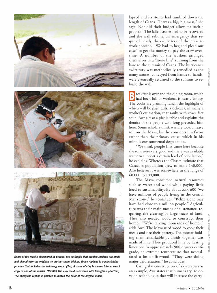
tation. They are working on B5 because, “when you climbCaana and turn around you look at this thing,” Gibbsstates. “We really had to do something about it.” Twomasks (human, animal, or god-like effigies), roughly nine-feet tall and eight-feet wide, have been discovered here.“When we found them it was like opening Pandora’sBox,” she says. They were faced with the sort of decisionthey have to make from time to time: Should they leavethe original exposed? Or should they make a replica thatwould be used to cover the original in order to preserve it?The decision is determined by the condition of the mask.In this case, they decided to cover the originals with pre-cise replicas made of fiberglass.
When they discover masks that are extremely fragile,extra care is required to make the replicas. They map,photograph, and draw the original, using this informationto create an exact clay copy. The map details “every singlestone,” says Gibbs, as well as informing the craftsmen howdeep to draw crevices. Any cracks or other evidence of de-terioration in the original will be reflected in the replica.“They mess up the clay a little bit in spots” she says, togive it a stone-like texture.
Needless to say, it requires skilled hands to craft theseclay models, though some of their tools are surprisinglysimple. Two craftsmen sit under a sheet of corrugatedmetal held up by poles at the foot of B5 fashioning a clayreplica. The metal shields them from the sun. A map andan illustration of the mask they’re recreating are next to theclay mold they carefully sculpt with spokes from a bicyclewheel that have been customized for this task. They em-ploy several triangular and oval tools made from spokes.One of them says that he learned of these tools and how touse them from “a guy in Guatemala.” One of their crafts-men is scheduled to receive more formal training by at-tending a class in replica making in Taiwan.
T he challenges inherent in keeping an operation the sizeof Caracol’s going from one day to the next extend far
beyond archaeology. Awe says it costs about $50,000 a
The temporary structure being built in the photograph on p. 15 now serves
as a sort of makeshift museum in which the monuments are displayed.
This strangler fig tree has taken root above a structure. Despite all the
recovery work that has taken place, the jungle still has a purchase on
much of Caracol.
This monument, named Altar 12, dates to A.D. 820. It was discovered in
the B group plaza.

tend with. The road to Caracol crosses the Macal, andcome the rainy season the river may flood. “Last year wewere stuck back here for a week,” says Awe. “We couldnot get out.” The river, by his estimation, rose 10 to 12feet over the bridge. Consequently, keeping sufficient foodon hand to last for 10 days is a priority. “We might be eat-ing beans and rice and canned goods,” he says, “but atleast we won’t starve.”
Hurricane Iris hit Belize in October of 2001. Havinggotten more rain than wind at Caracol, the crew thoughtthe site had escaped serious damage. “Then I went up tothe top of Caana. We lost the whole back side of the west-ern pyramid,” Gibbs recalls, referring to one of the smallpyramids at the top of the structure. “It was gone.”
The wall forming the back of the pyramid had col-
DIA
NE
AN
D A
RL
EN
CH
AS
E,
CA
RA
CO
L A
RC
HA
EO
LO
GIC
AL
PR
OJE
CT
american archaeology 17
week to field his crew, and they work year-round. “Whenyou’re doing a big research project like this, it’s all aboutlogistics,” he observes. Logistics “takes up easily 50 per-cent of your time.” They run short of supplies, theirequipment breaks down. They have about six vehicles toget the crew to and from Caracol, but they could usetwice that. The site is so remote that two-way radio pro-vides their only communication with the outside world.Sustaining the operation requires a variety of skills. Theworkers range from archaeologists to mechanics to cooksto artists. As it was for the Maya, water is a concern forAwe’s crew. They estimate their daily usage at roughly3,000 gallons. The Macal River, their nearest source ofwater, is 12 miles away.
There are also the occasional acts of nature to con-
Dedicated to CaracolIn order to obtain a permit from the Belize government, husband-and-wife archaeologists Arlen and Diane Chase ini-tially committed to doing 10 years of research at Caracol beginning in 1984.The sitehas been plagued by looting and early in their investigation the Chases found a noteaffixed to a tree.The note, authored by a looter, informed them that the “real ar-chaeologists” were already at work and, as their services weren’t needed, they shouldpack up and leave.The Chases refused the advice, and they’ve been working at Cara-col ever since.“We could be doing this for the rest of our natural lives,” says Arlen.
He is not speaking in hyperbole.This former metropolis covers approximately110 square miles.The Chases surmise the site has some 36,000 structures, only a fewof which are exposed. In short, there is work enough to occupy several lifetimes.
But that’s not to say they haven’t been busy.Their count of Caracol’s structuresresults from having mapped more than 14 square miles of the site.“We’ve tested 107residential groups outside the epicenter,” Arlen states.They’ve also done considerablework in the A, B, and C groups, the heart of Caracol. Some of their recent work com-plements that of Belize’s Tourism Development Project directed by Jaime Awe.Thisproject is Belize’s second attempt to promote tourism through archaeology. TheChases directed the initial attempt, which took place between 1989 and 1993.
At the start of their investigation they assumed Caracol would prove to be amidsized Classic Maya city of the sort found in the southern lowlands. Major struc-tures and monuments were built in the center of these cities, and settlements werescattered beyond the core. Caracol, they soon learned, did not fit this profile. It wasso large and dense that establishing its boundaries was a challenge. Goods such as ex-otic shells and jadeite pendants were found throughout the city, whereas in other sites such luxury items were gen-erally concentrated in ceremonial areas.Vaulted masonry tombs, usually the trappings of royalty, were discovered inhumble residences as well as pyramids and temples.These tombs also indicate that the common people were engag-ing in ritual activities that normally were performed only by the elite.
These findings indicated that Caracol was highly unusual in that it possessed a huge “mid-level group that devel-oped its own identity,” according to Arlen.This group, a precursor of the modern middle class, appears to have en-joyed prosperity and in return contributed to the city’s development and social cohesion. Because of the thousandsof structures they’ve identified, the Chases deduce that Caracol’s population, in the late A.D. 600s, was at least 115,000and may have reached 140,000.
The sociopolitical system that produced this middle class held sway for more than three centuries, from A.D. 560to about 790. After this time, luxury goods are found only in palaces, suggesting that they belonged exclusively to theelite. It also appears that ordinary people discontinued ritual activities.
In Arlen’s estimation, Caracol was abandoned due to “political exigencies” and a possible drought. By A.D. 895 thecenter of Caracol was burned.The discovery of an unburied child is evidence of “rapid abandonment” that could havebeen caused by warfare.
“Caracol is a very important site in the Maya world,” Arlen states.Take it from a real archaeologist. —Michael Bawaya
Diane works on a scale drawing.
Arlen reconstructs pottery.
JE
RR
Y R
AB
INO
WIT
Z
18 winter • 2003-04
lapsed and its stones had tumbled down thelength of Caana. “It was a big, big mess,” shesays. Nor did their budget allow for such aproblem. The fallen stones had to be recoveredand the wall rebuilt, an emergency that re-quired nearly three-quarters of the crew towork nonstop. “We had to beg and plead ourcase” to get the money to pay the crew over-time. A number of the workers arrangedthemselves in a “stone line” running from thebase to the summit of Caana. The hurricane’sswift fury was methodically remedied as themany stones, conveyed from hands to hands,were eventually returned to the summit to re-build the wall.
B reakfast is over and the dining room, whichhad been full of workers, is nearly empty.
The cooks are planning lunch, the highlight ofwhich will be pigs’ tails, a delicacy, in many aworker’s estimation, that ranks with cows’ feetsoup. Awe sits at a picnic table and explains thedemise of the people who long preceded himhere. Some scholars think warfare took a heavytoll on the Maya, but he considers it a factorrather than the primary cause, which in hismind is environmental degradation.
“We think people first came here becausethe soils were very good and there was availablewater to support a certain level of population,”he explains. Whereas the Chases estimate thatCaracol’s population grew to some 140,000,Awe believes it was somewhere in the range of60,000 to 100,000.
The Maya consumed natural resourcessuch as water and wood while paying littleheed to sustainability. By about A.D. 600 “wehave millions of people living in the centralMaya zone,” he continues. “Belize alone mayhave had close to a million people.” Agricul-ture was their main means of sustenance, re-quiring the clearing of large tracts of land.They also needed wood to construct theirhomes. “We’re talking thousands of homes,”adds Awe. The Maya used wood to cook theirmeals and fire their pottery. The mortar hold-ing their remarkable pyramids together wasmade of lime. They produced lime by heatinglimestone to approximately 900 degrees centi-grade, an extreme temperature that necessi-tated a lot of firewood. “They were doingmajor deforestation,” he concludes.
Citing the construction of skyscrapers asan example, Awe states that humans try “to de-velop technologies that will increase the carry-
BE
LIZ
E T
OU
RIS
M D
EV
EL
OP
ME
NT
PR
OJE
CT
Some of the masks discovered at Caracol are so fragile that precise replicas are made
and placed over the originals to protect them. Making these replicas is a painstaking
process that includes the following steps: (Top) A mass of clay is carved into an exact
copy of one of the masks. (Middle) The clay mold is covered with fiberglass. (Bottom)
The fiberglass replica is painted to match the color of the original mask.

ing capacity” of their environments. The Maya’s technicalprowess was evidenced in the reservoirs they built to in-crease their water supply as well as the terraces they con-structed to prevent erosion and increase the moisture in,and thereby the fertility of, the soil. The Maya adapted toa degree but, he states, “ultimately they failed because theyabandoned this area.”
Caracol’s environmental decline had political conse-quences. Unable to maintain their lifestyles, the people re-fused to support the ruling families who, though oncethought to be omnipotent, had seemingly lost the powerto provide for their subjects.
C aracol is a major archaeological site but hardly amajor tourist attraction. A mere handful of tourists
wander the plaza between Caana and B5. Of the TourismDevelopment Project’s five sites, Altun Ha gets the mosttourists—approximately 800 to 1,000 a day—and Cara-col the least. Altun Ha benefits from its proximity to Be-lize City, getting traffic from the cruise ships that dockthere. Caracol suffers for its remoteness. Awe and the Be-lize government (the Institute of Archaeology is part ofthe Ministry of Tourism) would be happy to lure 1,000tourists a day to Caracol which now, during high season,gets perhaps 100. “We hope to eventually make this ouranchor site,” he explains, “just like Tikal is the anchor sitefor Guatemala.”
The main problem is the condition of the road. “I’vedestroyed I don’t know how many vehicles on that road,”
JE
RR
Y R
AB
INO
WIT
Z
american archaeology 19
laments Arlen Chase, who’s been driving it for nearly twodecades. There are plans to improve the road and anairstrip located about 30 minutes from the site. Thentourism could flourish. But could a swarm of visitorsovertax Caracol as the Maya once did? “A lot of peoplesay, ‘Oh my god, would you want that many people at thesite?’ ” Awe says, mimicking the concern in their voices.His answer, of course, is yes. Because of its size, Caracolhas a large “carrying capacity.” He adds that the limestoneused to build the structures here is more durable than thatused at some other Maya sites.
He admits it’s possible to be too successful, and thathe wouldn’t want it to draw the huge crowds that ChichénItzá, in southern Mexico, does. Despite the few touristsCaracol gets, they have caused problems now and again. Atourist climbed a mask and damaged it. Another visitor,having made her way to the top of a structure, froze infear. Members of Awe’s crew were dispatched to escort herdown. Other tourists have ignored flagging tape and en-tered restricted areas that were being stabilized.
But Awe is optimistic. One of the advantages of Belize’sarchaeology department being subsumed by the tourismdepartment is that the archaeologists are in regular contactwith, and can influence the decisions of, tourism officials.“What we want is sustained tourism,” he states. “And if wewant to sustain tourism in Belize into the distant future,we’ve got to manage appropriately and properly.”
MICHAEL BAWAYA is the editor of American Archaeology.
A view of structures A2 and A3. These are two of the structures that the Tourism Development Project has focused on conserving.

JO
SE
PH
PO
BE
RE
SK
IN
20 winter • 2003-04
New Jersey is the most densely populated state in the union, and UnionCounty, where the small community of Feltville was once located, is one ofthe most densely populated counties in the state. But there’s no evidence ofthis deep in the woods where a 12-member crew was excavating on a humidday in mid-July. A path they cleared two summers earlier is the only meansof reaching this area.
Caked in mud, kneeling on gardener’s knee pads, depositing dirt samples in
An Attempt at Utopia?
By Debra Galant
The 19th century saw a number of utopian communities. Historical accounts suggest Feltville was one of them. An investigation of this village challenges those accounts.
This building once housed workers at Feltville. It is one of the nine buildings from that period that still stands.
Archaeologist Matt Tomaso

JO
SE
PH
PO
BE
RE
SK
IN
american archaeology 21
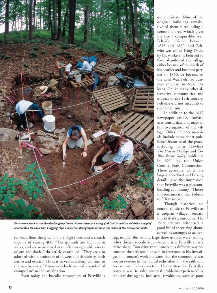
industrial-size Hellmann’s mayonnaisecontainers, most of the crew was down ina hole approximately 20 by 26 feet, partsof which are as deep as nine feet. On oneside of the hole was a giant upended Eng-lish walnut tree, marked by yellow policetape. The hole was once the cellar of whatthe archaeologists refer to as the Raddin-Badgeley House. That day the team dis-covered the northwestern corner of thefoundation. “Hitting a corner is nicestuff,” said Matt Tomaso, the project’s di-rector, who has been excavating Feltvilleevery summer since 1998.
But a few weeks later Tomaso, whoteaches archaeology at Montclair StateUniversity, made a much more thrillingdiscovery, one that had eluded him forfive years: finding the cellar of the housebelonging to David Felt, founder of theeponymously named Feltville.
Feltville was a 660-acre factory vil-lage complete with its own currency, apost office, a multi-denominational churchthat included a store, a free school, andhousing for approximately 160 workers,who made blank books and other writingsupplies. It was located between three im-portant industrial centers: New York City,Philadelphia, and Paterson, New Jersey.Felt, who was a book publisher in NewYork before starting the village, publishedan 1838 tract, Moral Views of Commerce,Society and Politics, by the Unitarianwriter Orville Dewey, who promoted aliberal version of Christianity. The firstminister of Feltville was Austin Craig,who went on to become president of An-tioch College and a leading theologian ofhis time. Craig described Feltville as a freereligious society.
If Felt produced a written record ofhis community, it has not been found.For contemporaneous writing on Feltville,Tomaso relies heavily on an 1847 news-paper article that he found on eBay. (Hehas set up his computer to search eBaydaily for the terms “Feltville” and “Glen-side Park.”) Published in a New Yorknewspaper called The Home Journal, thearticle is headlined “A New and BeautifulVillage,” and it describes Feltville inbreathless terms. The author calls the vil-lage “magic-like” and a “place where owlsmight dwell and satyrs dance.” It de-
This ceramic teapot was recovered from the privy associated with the church-store. Due to its
maker’s mark and style archaeologists know it was made in the early 20th century.
Two bottles and a mason jar were among the artifacts found in the Commons area. The bottles
apparently contained soda or tonic. The three items date to the mid-to-late 19th century.
JO
SE
PH
PO
BE
RE
SK
IN
22 winter • 2003-04
scribes a flourishing school, a village store, and a churchcapable of seating 400. “The grounds are laid out inwalks, and are so arranged as to offer an agreeable varietyof sun and shade,” the article continued. “They are alsoadorned with a profusion of flowers and shrubbery, bothnative and exotic.” Thus, it served as a sharp contrast tothe nearby city of Paterson, which seemed a symbol ofcramped urban industrialization.
Even today, the bucolic atmosphere of Feltville is
quite evident. Nine of theoriginal buildings remain,five of them surrounding acommons area, which givesthe site a campus-like feel.Feltville existed between1845 and 1860, and Felt,who was called King Davidby his workers, is believed tohave abandoned the villageeither because of the death ofhis brother and business part-ner in 1860, or because ofthe Civil War. Felt had busi-ness interests in New Or-leans. Unlike many other al-ternative communities andutopias of the 19th century,Feltville did not succumb toeconomic ruin.
In addition to the 1847newspaper article, Tomasouses census data and maps inhis investigation of the vil-lage. Other reference materi-als include some short pub-lished histories of the place,including James Hawley’sThe Deserted Village and TheBlue Brook Valley, publishedin 1964 by the UnionCounty Park Commission.These accounts, which arelargely anecdotal and lackingdetails, give the impressionthat Feltville was a pleasant,bustling community. “There’sthis romanticism that I objectto,” Tomaso said.
Though historical ac-counts allude to Feltville asa utopian village, Tomasothinks that’s a misnomer. The19th century witnessed agood bit of theorizing about,as well as attempts at achiev-
ing, utopia. But by and large these utopias were, amongother things, socialistic, a characteristic Feltville clearlydidn’t share. “You reinterpret history in a different way be-cause of the artifacts,” he said in reference to his investi-gation. Tomaso’s work indicates that the community wasnot an exercise in the radical redistribution of wealth or abreakdown of class structure. He’s written that Feltville’spurpose was “to solve practical problems experienced bylaborers during the industrial revolution, such as poor
Excavators work at the Raddin-Badgeley house. Above them is a string grid that is used to establish mapping
coordinates for each find. Flagging tape marks the stratigraphic levels in the walls of the excavation units.

JO
SE
PH
PO
BE
RE
SK
IN
american archaeology 23
housing, lack of access to community facilities, and anurban environment that was increasingly seen as un-healthy and demoralizing.”
Before Feltville, the area was mostly farmland. AfterFelt left, the village had a number of owners, the mostcolorful being Samuel Townsend, the Sarsparilla King,who bottled the popular beverage there. But its most sig-nificant use afterwards was as an Adirondack-style resortcalled Glenside Park, whichexisted between 1882 and1916. Since then it has beencalled the Deserted Village,and Union County, whichowns it, plans to turn it intoan interpretive site. But it isthe Felt occupation that mostinterests Tomaso, who usesthe word “humdinger” when-ever he comes upon an excit-ing or perplexing find andwho gets so keyed up duringhis excavation season that heoften forgets, or is unable to,eat during the day.
In 1996 Dan Bernier, aUnion County employee wholives in the house historical ac-
counts say is David Felt’s office, contacted a colleague ofTomaso’s to suggest Feltville be investigated. Tomaso said hewas attracted by the history of the place, particularly to thefact that it represents a succession of several completelyself-contained and separate economies. “It’s a perfect exper-iment in a way, where the entire community changes at onetime,” Tomaso said, referring to the fact that the still largelyintact village went through several discrete economic
phases—Feltville, a sarsparillafactory, and then a middle-class resort.
Tomaso’s focus is socialhistory, and his themes aregender, ethnicity, and class.He is interested in the rela-tionships between the differ-ent residences on the site, andhow they, along with featuresand the artifact assemblage,create a picture of social iden-tity. Over the years, his teamhas excavated privies, walk-ways, the commons area, andthe cellar of the nearbyRaddin-Badgeley house.
He’s concluded that theresidential pattern of the vil-
A 19th-Century Planned CommunityTo understand the spirit of 19th-century utopian communities contemporaneous with Feltville, archaeologist Matt Tomasoemphasized the work of Robert Owen, a Scot-tish industrialist who experimented in small,utopian communities, and the French socialphilosopher Charles Fourier, who espousedthe building of small commune-like pha-lanxes, where work would be fairly divided.The North American Phalanx, a utopian com-munity built on Fourier’s philosophy, existednot too far away in Colts Neck, New Jersey,during roughly the same period as Feltville.
Though Tomaso doesn’t consider Feltvilleto be a utopian endeavor—he refers to it asmore of a “planned community”—he believesthat “in order to understand 19th-centuryutopian thinking, you have to look atFeltville.” It was a sort of toned down ex-pression of various radical types of utopianthinking. Though it didn’t flourish economi-cally, Tomaso considers it a success. “Work-ers had a nice place to work and live forawhile,” he observed, adding that, when Feltdeparted, those workers were better off thanthe great majority of the inhabitants of the various utopian societies. —Debra Galant
This row of workers’ cottages is indicative of the orderly arrangement of residences at
Feltville. With its uniform houses and careful attention to details of construction and
landscaping, it can be said that Feltville anticipated the planned community.
This small clay pipe was found in two pieces in the cellar hole of the
Raddin-Badgeley house. Pipes of a similar style were found in great
quantities in Feltville’s workers’ area.

24 winter • 2003-04
lage was determined by its three classes. There was a lowerclass consisting of laborers, a small middle class of skilledworkers, such as printers, and an upper class consisting pri-marily of Felt and his family and the clergy. The laborers,along with the livestock, were located on the west side, themiddle class kept to the central commons area, and theupper class inhabited the east. “He most definitely wantedthe clergy by himself,” Tomaso said of Felt, adding that hewas a religious man. Tomaso believes that these social pat-
terns persisted into, and became more rigid during, theGlenside Park period.
During the day, the time of work and education, thevillage’s grounds were delineated by gender. Women’s per-fume bottles have been recovered in the commons area,which was where, it’s assumed, they did housework. Thefactory, a male domain, was in the south, and the childrenattended the school in the north. Written accounts of theschool are sketchy and it no longer stands, but Tomasohas confirmed its existence and location through analysisof historical photography of the building. He’s also foundplenty of artifacts there that suggest children’s activities,such as marbles.
“The artifacts themselves speak to the issue of class,”said Tomaso. A clear pattern can be discerned in the ce-
ramic artifacts scatter, which has concentrations of less ex-pensive redware and yellowware found in the workers’area, while the more expensive whiteware and pearlwareare concentrated in the middle- and upper-class areas. Atype of clay pipe known as a T.D. pipe, which was thenpopular with the lower class in the U.S., was found inlarge quantities in Feltville’s workers’ area. Tomaso wassomewhat surprised to find smaller quantities of them inother parts of the village and he’s reluctant to draw any
conclusions, such as interaction between the classes, fromthis discovery.
The excavations of two privies have also provided in-formation about class distinctions at Feltville. Behind agrouping of three workers’ cottages, Tomaso’s team dis-covered a single-vaulted, two-seat privy that apparentlyserviced the 30 to 48 people who, according to censusdata, lived in the cottages nearby. Built from basalt, nevermortared, and dug so deep that it entered the watertable—Tomaso found layers of rocks that he believes theresidents threw into the privy in repeated efforts to raisethe floor—that privy amounts to an open sewer with aclapboard shack over it.
The excavation of the workers’ privy highlightsTomaso’s intense focus on stratigraphy. Trained in geology H
AW
LE
Y,
UN
ION
CO
UN
TY
PA
RK
S C
OM
MIS
SIO
N/
CO
LO
RIZ
ED
BY
CH
AR
LO
TT
E C
OB
B
Schoolhouse
Church-Store
Book Factory
David Felt’sHouse
Men’sDormitory
Women’sDormitory
Workers’ Cottages
Workers’Cottages
Animal Barn
Storehouse
This artist's depiction shows Feltville as it may have appeared in the 1850s. Archaeological evidence indicates that the size of David Felt’s house, shown
near the center of the illustration, is greatly exaggerated.

JO
SE
PH
PO
BE
RE
SK
IN
american archaeology 25
as well as archaeology, he discerned where the water tableonce was and deduced that the layers of rocks in theworkers privy had been thrown there to try to rectify theerror of the privy having been dug too deep. “Every arche-ologist worth their salt would have seen that material,”Tomaso explained. “But a lot of them wouldn’t have real-ized necessarily why it was put there.”
By contrast, the privy found behind the church, nextto the building thought to be Felt’s office, was relativelyspa-like. It was constructed of cut and mortared sandstone,with a wood-plank floor, and was apparently used by about20 people. It’s presumed these people included Felt and hisfamily, his live-in domestic servants, and the communityminister, as well as worshippers and shoppers.
The faunal remains found there suggest an upper-classdiet of pork and beef, and other artifacts, such as soda andmixer bottles, also represent more expensive tastes. By con-trast, Tomaso’s team found faunal evidence of turkey, pheas-ant, raccoon, opossum, local fish, box turtle, and deer inthe workers’ privy.
Though the Raddin-Badgeley house, which predatedFeltville, wasn’t part of the community, Tomaso is investi-gating it to get an idea of what the area was like prior tothe creation of Feltville as well as to gauge the effectFeltville had on these environs. One of the things Tomaso’swork at the house revealed was a lack of upkeep there. Hiscrew discovered items ranging from wine and whiskey bot-tles to redware to a surprising number of buttons in theyard. This stands in dramatic contrast to the general neat-ness of the yards of Feltville—the numerous artifacts re-covered in the village were mostly found under what oncewere porches and walkways. In fact, not a single spirits’bottle has been found at Feltville, which, according toTomaso, is highly unusual for 19th-century archaeologicalsites. “Felt had some fairly rigid standards of how the vil-lage would appear,” he said. The absence of alcohol bottlesmight also indicate that Felt espoused temperance.
The study of the house suggests that Feltville stimu-lated the area’s economy. According to census data, Mrs.Raddin, who then owned the house, had two borders thatworked at Feltville, as did her son.
In mid-August Tomaso was back in his office atMontclair State, doing paperwork, preparing for the up-coming school year, and inputting information aboutFeltville into a huge database. The database includes, andcan make correlations among, census data, photographs,digital video, field notes, and artifact analysis. It’s an in-valuable analytical tool, Tomaso said, one that eventuallywill establish connections through space and time.
The database was essential in solving the puzzle of theWillow Pattern Pearlware. Tomaso originally assumed thatthe value of artifact types would directly reflect their own-ers’class. Consequently, the workers’ area should yield in-expensive artifacts. But the pearlware, a fairly expensiveEnglish import dating to between 1815 and 1820,
“showed up near one of the worker’s cottages in unex-pected quantities,” he said. “We had to explain this.”
A careful examination of the census records eventuallyindicated why lower-class residents of the community hadaccess to such expensive ceramics. One family that livedwhere the pearlware was found had emigrated from Eng-land only five years before coming to Feltville. Tomaso con-cluded that they probably brought the pearlware—whichwould have been less expensive in England—with them.
But useful as it is, building such an extensive databaserequires an extensive effort. “Actually sitting there andtyping in all this stuff is the most tedious stuff in theworld,” he said.
Although he still has several years of analysis to do onFeltville, Tomaso was hoping to wrap up his excavationthere this past summer. But the discovery of Felt’s househas thrown a monkey-wrench into his plans. “I’m obli-gated to do something with this household because thiswas The Man,” Tomaso said. “This was the entire upperclass of the village.”
In the written accounts of the community, DavidFelt’s house has alternatively been referred to as a mansionand a summer residence. The 1847 newspaper article saidit was the center of the village. Yet, despite five years oflooking, Tomaso had never found any physical evidenceof Felt’s residence. “The mansion was such a wild goosechase for so many years,” Tomaso said. “I honestly didn’tknow if it existed.”
Tomaso photographs details of floorboards found in the cellar of the
Raddin-Badgeley house.

MA
TT
TO
MA
SO
26 winter • 2003-04
Why he found the Felt house this final summer is oneof those mysteries. Tomaso was wandering around in thecenter of the village when out of nowhere he noticed aslight depression near the main road. “I thought, There itis, under the road.” He kicked at the dirt and quickly dis-covered the top of a sandstone block. Then he noticed an-other block next to it. Tomaso had to restrain himself fromthe “urge to just rip the whole thing open.” Instead, hebegan to map the area, and he and his team rapidly dis-covered two corners, and a probable third, of Felt’s cellar.
Coming as it did at the end of the excavation,Tomaso didn’t have much time to investigate. He did de-termine that the width of Felt’s cellar is 24 feet, and he be-lieves the length will turn out to be 36 feet, because all ofthe residences in Feltville have been this size and becauseof the “rule of twelve.” This rule is an idiosyncrasy, andmystery, of Feltville: the dimensions of all the houses andlots, the distances to outhouses, and even the spacing be-tween the trees can be measured in multiples of 12 feet.
“First of all, it’s not a mansion,” Tomaso said. “Andthere is no privacy hedge.” This was a reference to a row oftrees near the center of the village once thought to shieldFelt from viewing, or being viewed by, his workers. ButTomaso had his students count the rings on the treestumps—the trees died and were cut down—to determine
their ages and concluded that they were planted during thesubsequent Glenside era. “So that takes away these two ro-mantic elements that are talked about in the literature.”
What this indicates is that while class distinctionswere manifested in several ways at Feltville, they were notapparent in the size of the dwellings. There was no man-sion. “It doesn’t look like he’s lording it over his vassals,”Tomaso said. “It’s a more egalitarian feeling, if not anegalitarian reality. But that’s just speculation.”
What’s certain is that Feltville and Matt Tomaso arenot through with each other. In addition to investigatingFelt’s house, he’ll continue his search for two dormitoriesthat, according to historical accounts, housed the village’sworkers. Though he has doubts that these buildings ex-isted—“We have too few families in 1850 to occupy thatmany buildings”—that won’t stop him from looking. Butfor Tomaso, who has had the experience of finding im-portant features at the very end of a field season severaltimes, most notably in 1999, when he discovered theworkers’ privy on the last day of fieldwork, it’s a mixedblessing. “Oh boy,” Tomaso said, laughing and sighing si-multaneously. “My immediate reaction was: I’ll never fin-ish this site. It just keeps throwing stuff at me.”
DEBRA GALANT writes about New Jersey for the New York Times.
The church-store was rehabilitated by Union County’s Department of Parks and Recreation in 1998. The store was on the first floor and the church on the
second. This building will eventually serve as a museum and interpretive center and will be the ultimate repository and curation facility for materials
recovered by Tomaso’s project.

american archaeology 27
It’s been a long, hard year for the Southeast andMidwest Archeological Centers. That’snot because of their workload,which consists of the archaeo-logical oversight of 122 na-
tional parks and 780 national land-marks. What made this year difficultfor SEAC and MWAC, two of the na-tion’s three National Park Service(NPS) agencies devoted exclusively toarchaeology, was getting “A-76ed.”
This is not the same as being 86ed—although SEAC and MWAC wondered ifthe Bush administration’s plan to subject civilservants to competition against the private sec-tor might not amount to that. Circular A-76, first
The Potential Threat of A-76By Elizabeth Wolf
A BUSH ADMINISTRATION INITIATIVE COULD HAVE GRAVE CONSEQUENCES FOR PUBLIC ARCHAEOLOGY.
drafted during the Eisenhower Administration and revisedby the Office of Management and Budget (OMB)
over the years, is the government’s vehicle for con-ducting public-private cost comparisons.President Bush says A-76 “competitivesourcing” promotes government efficiencyand gets the most bang for the taxpayer’sbuck even if the jobs ultimately stay in the
public sector.Under A-76 regulations, the 100 em-
ployees of SEAC, located in Tallahassee,Florida, and MWAC in Lincoln, Nebraska,
had to prove they could do their jobs betterand cheaper than archaeologists in the private
sector. If the costs of their operations came inhigher than private sector comparisons, they stood
CL
IFF
BA
RB
OU
RN
PS
On the bank of the Yellowstone River, an archaeological crew carries out salvage excavations at the Fishing Hole site in Yellowstone National Park.
The site, which dates to approximately 7500 B.C., contains seven components.

NP
S
28 winter • 2003-04
to lose their jobs or be reassigned. SEAC ultimately won its“competition,” demonstrating costs more than 40 percentless than the going rate for their services in the private sec-tor. The competitive sourcing study at MWAC is stillunder way. The third NPS archaeology center, the West-ern Archeological & Conservation Center in Tucson, Ari-zona, is scheduled for competitive sourcing in 2004.
The A-76 process requires agencies to inventory alltasks, calculate all costs, draft a binding PerformanceWork Statement outlining what work they perform andhow they do it, and often create an entirely new organiza-tional structure.
SEAC and MWAC question whether they were suit-able targets for A-76 in the first place. As full-service centerswith cross-trained staff, the centers perform fieldwork, arti-fact analysis, curation, database management, and resourcepreservation and interpretation. Many staff members havedecades of experience in their fields of expertise and at par-ticular sites and parks. During the A-76 process, MWACarchaeologists Douglas Scott, a renowned battlefieldscholar, and Tom Thiessen, a noted ethnohistorian, receivedawards from the Interior Department. National Park Ser-vice employees are committed to “the resources, not thebottom line,” says SEAC director John Ehrenhard. “Publicarchaeology is from the heart, not the profit margin.”
The SEAC and MWAC staffs were also baffled as towhy neither the OMB nor NPS officials consulted themprior to mandating competitive sourcing at the centers.No feasibility studies were done to determine the centers’
suitability for study, a requirement of the A-76 process.The manner in which the A-76 process was initiated tooka heavy toll on the morale of the centers’ staffs. “There isnow a lack of trust in the NPS leadership that can’t bemeasured in dollars,” says Ehrenhard.
PROPONENTS OF COMPETITIVE SOURCING TOUT EFFICIENCY ANDsavings as likely benefits, but critics say more may be lostthan gained in the process. SEAC and MWAC archaeolo-gists say it’s too soon to judge whether particular archaeo-logical sites will be affected by A-76; their larger concernis that competitive sourcing threatens the institution ofpublic archaeology, the value of which cannot be meas-ured solely by dollars spent or saved. “Efficiency is farfrom the only measure, and I don’t want it to be the onlymeasure when it’s our national heritage that’s at stake,”says Don Blakeslee, a Wichita State University archaeolo-gist who organized opposition to competitive sourcing.
Government archaeologists are guided by an ethic thatmarries public service with resource preservation. ThoughNPS archaeologists were quick to praise the competence oftheir colleagues in the private sector, Ehrenhard says that nomatter how qualified a private contractor may be, the firm’sallegiance is necessarily to the bottom line, not the public.
Clifford Brown, a Florida Atlantic University archae-ologist, was once a senior contract archaeologist at NavyHeadquarters. He believes that, in the case of mismanage-ment, a contract archaeologist is less likely to report the
NPS archaeologist Greg Heide conducts an archaeological survey of Water Island prior to the U.S. Government transferring ownership of the island to the
government of the Virgin Islands in 1998. NPS archaeologists informed the Virgin Islands government of the cultural resources that were identified so that
they would be protected.

american archaeology 29
action than a government archaeologist. That’s becausethe contract archaeologist may fear for his job, whereas agovernment archaeologist, being a civil servant, hasgreater job security due to “statutory protections.”
Brown says public employees “can and should” ques-tion the government when the need arises. “That’s whythey’re there, and it’s clearly in the public interest that civilservants do that. Contract employees, lacking civil serviceprotection, can’t do that,” states Brown.
Government archaeologists also work virtually oncredit, a luxury contractors cannot afford. While awaitingfunding for projects they’ve undertaken, the three NPScenters routinely dip into their operational budgets to paysalaries. “We work on the promise that we’ll get funded;a contractor works on the guarantee that the money isthere now,” says Ehrenhard.
This fiscal flexibility enables rapid response. For ex-ample, in the wake of Hurricane Isabel in September,SEAC mobilized archaeological teams within six hours ofreceiving a call for their services to assess the possibledamage to cultural resources. “If it had been a contractor,it would have taken days because they’d have to modifythe contract” to ensure payment, says Ehrenhard. “Thoseare the sorts of things A-76 doesn’t think about.”
Another thing A-76 doesn’t take into account, saysBlakeslee, is the conditions under which science flour-
ishes, such as having ample time to investigate and revise,as well as the intellectual freedom to follow hunches andtry new techniques. Public archaeology provides theseconditions. He recalls a nine-year research project madepossible by the Bureau of Reclamation that completely re-vised earlier interpretations of settlement at WacondaLake in Kansas. A graduate student developed methodsfor determining the seasons during which mussels werecollected and the length of the interval between largeclambakes. He was able to demonstrate that the sites wereoccupied year-round and for periods of five to ten years.
“The structuring of contract work prevents full-fledged science that pushes the boundaries from takingplace,” Blakeslee states. “Contract archaeology typicallygenerates answers to small questions.” This isn’t becausecontract archaeologists lack scientific curiosity, but be-cause they have to confine their reports to the issuesidentified by the employer.
Finally, the institutional knowledge public archaeolo-gists bring to their work reduces the learning curve on aproject and keeps costs low. Archaeologists at the TucsonNPS center “can go from the Great Basin to the MojaveDesert because they’ve worked in both for years,” sayschief archaeologist Susan Wells. “We can work efficientlybecause we have a steady workforce.”
“We’re not thinking about anything but the cost in
THE GROWING OPPOSITION TO A-76 Competitive sourcing is the most controversial component of the President’s five-part Management Agenda, the Bushadministration’s strategy “to improve the management and performance of the government” in accomplishing the Pres -ident’s main priorities: national defense and revitalizing the economy.
Federal unions see competitive sourcing as a bald attempt to shrink the civil service and reduce government ac-countability to American citizens. Employees in land-management agencies are concerned about the potential threatsto cultural and natural resources, and the public service ethic. Government Accounting Office chief David Walker hassaid the President’s plan lacks “sound analysis” grounded in firm research. Members of Congress have questionedBush’s claim that competitive sourcing saves money. And although competitions such as SEAC’s have reduced agencybudgets, the cost of the process has been exorbitant in some cases. The price tag on the Forest Service’s competitivesourcing plan, for example, estimated at $10 million, prompted a Senate subcommittee in July to halt all new NFS sourcingstudies until they are approved by Congress.
Congressman Doug Bereuter (R-Nebraska), objecting to what he calls a “bean counter” approach to competitivesourcing, offered an amendment prohibiting the use of funds to implement the studies conducted at both the Midwestand Southeast Archeological Centers. The amendment passed 362 to 57 in the House; the final outcome will be decidedin a House-Senate conference, as yet unscheduled, according to a Bereuter spokesperson.
When President Bush unveiled competitive sourcing in August 2001, he originally set targets of 15 percent of allcommercial functions in 2003 and 50 percent by 2006. Due to strong opposition from federal unions, government work-ers, and members of Congress, the administration abandoned these targets last July.
Agencies are now graded by a “scorecard” that measures their overall compliance with the President’s manage-ment goals. The scorecard awards points for streamlining operations and conducting or scheduling competitive sourcingstudies, and subtracts them for foot dragging. Overall, the Office of Management and Budget, the final arbiter of federalagency budgets, will be looking for evidence that “an agency is on board with the program,” states Donna Kalvels, NPScompetitive sourcing coordinator. Though the targets have been abandoned, President Bush remains staunchly com-mitted to competitive sourcing.
In September, the House voted to scratch OMB’s recent revisions to A-76, designed to speed up competitive sourc-ing studies throughout the government; the House amendment has not yet reached the Senate. Senator Harry Reid(D-Nevada) sponsored an amendment that would stop all competitive sourcing studies in the Interior Department; thebill was defeated in the Senate, 51 to 44. —Elizabeth Wolf

CH
AR
LE
S S
WE
DL
UN
D
30 winter • 2003-04
dollars,” Ehrenhard says of A-76. “The rewards of public ar-chaeology are far greater than money could ever hope to buy.”
A-76 WORKS IN TANDEM WITH THE FAIR ACT INVENTORY OF1998, which classifies all government jobs as either “com-mercial” or “inherently governmental.” Commercial func-tions are those that could be performed by a private sectorsource, such as a contractor. An inherently governmentalfunction is one “so intimately related to the public inter-est that it mandates performance by federal employees,”such as policymaking and funds allocation, according tothe Interior Department. Most federal archaeology jobsare classified as commercial, and are therefore eligible forcompetitive sourcing study.
Critics of competitive sourcing say the classificationsof commercial and inherently governmental fail to takeinto account aspects of jobs that require both technicalskill and a solid grasp of federal policy. Says Susan Wellsof the Western Archeological & Conservation Center,“Archaeology isn’t rocket science, but the parks are betterserved by people who understand the Park Service missionand goals. It’s very efficient. We don’t have any slackers.”
A total of about 1,000 full-time government archae-ologists, plus an uncounted number of temporary archae-ologists, serve as the custodians of cultural resourceslocated on 563 million acres of public lands—nearly 25percent of the nation’s total area of 2.3 billion acres. This
amounts to about one full-time, permanent governmentarchaeologist for every 563,000 acres, plus “a substantialnumber” of temporary archaeologists, according to NPSchief archaeologist Frank McManamon.
Susan Wells began her career 21 years ago as an assistantcrew chief with the Western Archeological & ConservationCenter; she was classified as a temporary employee of thecenter for 10 years. Today she is acting chief of the archaeol-ogy division at the center, one of only two permanent, full-time archaeologists among the center’s staff of 22. The otherarchaeologists are term and temporary employees—the typeof position often targeted by competitive sourcing—thoughmany have worked at the center for years.
The Interior and Agriculture departments employabout 80 percent of the federal government archaeologists.Within these departments, only National Park Service ar-chaeologists have been A-76ed. The archaeological centerswere selected for study, explains NPS competitive sourcingcoordinator Donna Kalvels, based on the number of theirpositions classified as commercial. Because the initiative tar-gets all federal agencies, other government archaeologistscould be subject to competitive sourcing in the future.
“In all this outsourcing business, the one thing that’smissing is an expression of concern for resource protec-tion” says MWAC’s Tom Thiessen. Suspicion of a hiddenagenda in the President’s plan to outsource civil servicejobs arises due to his administration’s land-use policies. Towit, President Bush has allowed or proposed construction
Mammoth Cave National Park has the longest recorded cave system in the world. More than 336 miles of cave have been explored and mapped. In 1992
the NPS initiated a long-term archaeological inventory of the caves. Many of the artifacts archaeologists have identified are from the Early Woodland
period that dates to approximately 2,200 to 3,000 years ago.

WE
ST
ER
N A
RC
HE
OL
OG
ICA
L &
CO
NS
ER
VA
TIO
N C
EN
TE
R
american archaeology 31
of power plants near parks such as Yellowstone, drilling atPadre Island National Seashore, relaxed protection of en-dangered species in national forests, and oil and gas ex-ploration in the Alaskan wilderness. Many national parksface multi-million-dollar maintenance backlogs, despitethe President’s campaign promises to redress them.
This prompted more than 115 retired NPS officialsto lambaste the President and Interior Secretary Gale Nor-ton in an August 15 letter for “sacrificing the public in-terest for private profits.” Adds Stewart Udall, former In-terior Secretary under Presidents Kennedy and Johnson,“If the objective is profit and not service to the Americanpeople, then where are we headed?”
Charles Tiefer, a University of Baltimore law profes-sor and an expert on government contracting, says “A-76is the spearhead, but more important is the awareness thatwhat the OMB wants is to privatize.” He claims the Bushadministration aims to dismantle the civil service, includ-ing government cultural resource management, to ad-vance its pro-business, pro-development agenda.
The A-76 process itself is disruptive, costly, and timeconsuming. Whole families were “put on hold,” saysEhrenhard, under the threat of a spouse’s possible job loss.Each center spent more than $80,000 of their lean opera-tional budgets and devoted thousands of staff hours tocomplete A-76 documentation in addition to performingtheir regular duties. The $2 million NPS administratorsspent on private consultants, who interpret the arcane re-quirements of A-76 and suggest targets for competitivesourcing studies, alsocame out of the NPSbudget. Agencies thatwin their competitionsmust undergo additionalcompetitions every fiveyears. And while bothcenters made the com-mitment that “no parkwould suffer because ofA-76,” according toEhrenhard, time spentcomplying with A-76regulations could even-tually detract from theirarchaeological work.
Low morale couldalso affect the qualityand quantity of govern-ment archaeologists’work. SEAC’s staff in-terpreted the call forcompetitive sourcing asmeaning that they were“second-class citizens,expendable,” Ehren-
hard says. MWAC’s Tom Thiessen says “morale is the low-est I’ve seen it in 31 years.”
The climate of uncertainty produced by competitivesourcing affects the next generation of archaeologists aswell. Low morale among public archaeologists and shakyjob security undermines the incentive to pursue a careerin public service. During SEAC’s 14-month A-76 process,three staff members in their 20s and 30s left the centerdue to concerns about their job security. Graduate stu-dents now question the wisdom of taking government ar-chaeology jobs, says Blakeslee. Yet they also wonder, hesays, whether private sector firms are any more secure ifcultural resources themselves are threatened under a pro-business, pro-development administration.
In Blakeslee’s view, competitive sourcing calls into ques-tion the very future of American archaeology. “If the A-76promoters have their way, there’s going to be a whole lot lessarchaeology done,” Blakeslee says. “There will be fewer jobsbecause there will be fewer resources because they will be de-stroyed. Our cultural patrimony will wither away.”Editor’s note: Shortly before going to press American Archae-ology learned that the National Park Service has cancelled theMidwest Archeological Center’s outsourcing study. NPS officialDonna Kalvels said the cancellation was due to the result of theSoutheast Archeological Center’s study and opposition inCongress. Kalvels didn’t know if the Western Archeological &Conservation Center’s study would also be cancelled.
ELIZABETH WOLF is a writer and editor who lives in Albuquerque, New Mexico.
Spruce Tree House is one of the hundreds of cliff dwellings found at Mesa Verde National Park. Some of the park’s
archaeological resources were damaged by two fires in 2000. NPS archaeologists worked with fire fighters to determine
how best to battle the blazes while doing as little damage as possible to these resources.

AD
RIE
L H
EIS
EY
32 winter • 2003-04
A CLOSE LOOKAT GEOGLYPHS
By Tamara Stewart
A CLOSE LOOKAT GEOGLYPHSThese mysterious earth images embellish the Western desert.

AD
RIE
L H
EIS
EY
Reaching across the Mojave andSonoran Deserts of Arizona andCalifornia, immense figures areetched into the desert floor, testi-monies to the beliefs of an ancient
people that persist today. Images of giants,mythic figures, animals, and geometric designsare fashioned by rock alignments. So far, morethan 600 of these figures, known as geoglyphs,have been recorded in this area of the Ameri-can Southwest and northern Mexico.
The earthen images, some estimated atthousands of years old, were formed by scrap-ing away the very stable dark desert pavementto reveal the lighter soil beneath; thus the termintaglio, or engraving, is applied to some of thegeoglyphs. Other types of geoglyphs werecreated by arranging rocks into various shapes.Aside from a few flakes of stone, occasionalbroken quartz cobbles, and a very rare ceramicsherd, precious few artifacts have been foundin association with the geoglyphs, leavingarchaeologists to ponder who made them,when, and why.
“Archaeologists pay too little attention tothese features because, in my opinion, they arehard to date, difficult to understand, and wehave to think outside the box and use ethno-graphic analogy,” says Russell Kaldenberg, basearchaeologist at the China Lake Naval WeaponsStation in east-central California, where numer-ous geoglyphs are being discovered.
The geoglyphs’ immensity makes themmost clearly visible from the sky. Covering aterrace above the Colorado River just north ofBlythe, California, near the Arizona border, theBlythe intaglios were the first of the area’sgeoglyphs to be discovered, spotted by a pilotflying over the area in the late 1920s. There arevarious images in this area, including a 170-foot-tall human-like figure facing north and a60-foot-tall giant, accompanied by a spiral
american archaeology 33
(Opposite page) A human figure known by non-natives as the
“Fisherman” intaglio holds a quartz-tipped spear over his head
while two fish swim below. The intaglio is found near
Quartzsite, in southwest Arizona in the foothills of the
Plomosa Mountains. Images of the sun and a water ripple or a
snake over the figure’s head suggest that he is Kumastamho,
a creator spirit who, according to Quechan peoples, is carving
out the course of the Colorado River with his spear.
(Right) Just south of Quartzite there is a group of 14
intaglios, one of which is a large arrow that points directly
at the Fisherman miles away.

about these desert images since they were first found,”says Altschul, who has been working in the area for thelast 20 years. “They are surface sites, so we can’t dig them.We try to put them in context: What were the people whocreated these images doing in the desert? What otheractivities took place and are they preserved in the archae-ology of the region? Archaeologists are still wonderingwhere these people lived. We still haven’t found a majorresidential site along the Colorado or lower Gila rivers.”
Altschul is not satisfied with the explanation thatthese sites have been destroyed by the river and he’s confi-dent that they will be found eventually. Numerous tem-porary prehistoric campsites have been recorded along theriver, where Cachora says his ancestors camped while theytraveled along the trail of dreams, ceremonially visitingthe geoglyph sites.
AN EXPERIMENTAL RADIOCARBONDATING TECHNIQUE THAT HASapplications for rock geoglyphs is being developed by Nic-cole Cerveny, a graduate student of Ronald Dorn, aprominent geoscientist at Arizona State University and apioneer in rock art dating. Cerveny dated a nine-foot-longrock alignment known as “Running Man” found on theancient shoreline of Searles Lake in the western MojaveDesert of California with this technique, determining thatit was created at least 6,000 years ago.
“Running Man was made with very large cobbles thathave seated themselves into the soil just deep enough toform a crust of calcium carbonate on the rocks’ under-sides,” explains Cerveny. “Basically the water in the soilevaporates leaving behind the evaporite minerals that at-tach to the surface of the rock as a carbonate coating.Therefore the radiocarbon date from the calcium carbon-ate is the minimum age of the geoglyph creation event.”
Farrel Lytle, a noted x-ray spectroscopist now retiredfrom Boeing, and Nicholas Pingitore, a geochemist at theUniversity of Texas at El Paso, are currently exploringanother experimental approach to dating rock varnishusing x-ray fluorescence. Using hand-held units, re-searchers can non-destructively measure the manganeseand iron content in the varnish, the patina that coversrocks in this area, which reflects the time it took for thevarnish-forming bacteria to slowly deposit these metals.
The tremendous stability of the desert pavement thatpreserves the geoglyphs for hundreds and perhaps thou-sands of years also preserves the tracks of off-road vehiclesthat, largely unintentionally, have marred them in recenttimes. Due to the remote locations of many geoglyphs,they are occasionally vandalized. The Bureau of LandManagement (BLM), which manages an estimated 75percent of all known geoglyphs in the American South-west, has fenced some of the better-known sites such asthe Blythe intaglios to protect them. The geoglyphs wereoften damaged prior to being fenced.
34 winter • 2003-04
design, facing south. The north-facing figure was oncesurrounded by a circular path that is largely destroyed.
By comparing the current conditions of the geoglyphsto their former conditions in the earlier aerial photographs,Jeffrey Altschul, president of the Tucson-based archaeolog-ical consulting company Statistical Research, Inc., notesthat the human and animal figures at the famous Ripley siteare deteriorating rapidly due to natural forces. He surmisesthat these and other anthropomorph/zoomorph geoglyphsalong the Colorado River were made fairly recently, proba-bly within the last 500 years or so, and that they werecreated by Yuman peoples who still occupy the land. About200 of these massive geoglyphs have been discovered alongthe Colorado River throughout the traditional lands of theYuman-speaking tribes.
It was along the lower Colorado and Gila rivers ofArizona, California, and northern Mexico that the pre-historic Yuman-speaking tribes including the Cocopah,Quechan, Mojave, and Maricopa farmed, fished, andpresumably created the geoglyphs found in this area. Inaddition to speaking the same language, the ColoradoRiver Indian peoples share a basic belief in the great im-portance of dreams, considered the source of true wis-dom. According to Lorey Cachora, an archaeologist andtribal historian of the Quechan tribe, visions seen indreams are often re-created as geoglyphs or other types ofrock art to form a stronger connection between thedreamer and the spirit of the vision.
Cachora explains that the geoglyphs along the Col-orado River tell of his people’s migration along what herefers to as the “Trail of Dreams,” an actual as well asmythological trail that extends along the river northfrom Newberry Mountain in Nevada, and south to PilotKnob Mountain in Arizona. Many geoglyphs are foundin association with ancient trails, particularly in theYuman tribal area.
“Archaeologists have been scratching their heads
JA
CK
SO
N U
ND
ER
WO
OD
Found on the ancient shoreline of Searles Lake in the western Mojave
Desert of California, this nine-foot-long rock-alignment geoglyph, known
as “Running Man,” is believed to be at least 6,000 years old.

AD
RIE
L H
EIS
EY
This giant snake was made by scraping the desert pavement. Two large granite cobbles form the snake’s eyes.This geoglyph is located east of Parker, Arizona.
american archaeology 35
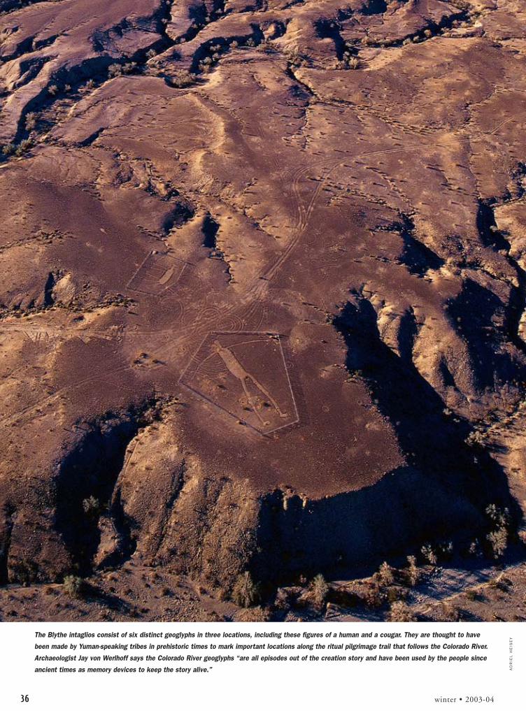
36 winter • 2003-04
The Blythe intaglios consist of six distinct geoglyphs in three locations, including these figures of a human and a cougar. They are thought to have
been made by Yuman-speaking tribes in prehistoric times to mark important locations along the ritual pilgrimage trail that follows the Colorado River.
Archaeologist Jay von Werlhoff says the Colorado River geoglyphs “are all episodes out of the creation story and have been used by the people since
ancient times as memory devices to keep the story alive.” AD
RIE
L H
EIS
EY

AD
RIE
L H
EIS
EY
american archaeology 37
“The most important thing for the ge-oglyphs now is their preservation,” stressesJay von Werlhoff, who has spent the last 30years documenting and studying them.“We have been trying to get the BLM tobe more responsive to the preservationneeds of geoglyphs, but they’re just notthat aggressive about it.”
The fences do not seem to have inter-rupted ceremonial uses of the geoglyphs.David Whitley, world-renowned rock artscholar, and Altschul have noted that theearthen images along the Colorado Riverchange slightly in orientation and detailfrom year to year, indicating their contin-ued use by native peoples.
“The ethnography suggests that thegeoglyphs had at least two functions,” ex-plains Whitley. “Along the Colorado River,they mark the locations of importantevents during the creation of the world andportray the mythic actors involved in theacts that occurred at those locations.”
WHITLEY NOTES THE DIF-FERENCE BETWEEN THEiconic Yuman-made etched geoglyphsalong the Colorado River, and the geomet-ric rock alignments, frequently foundalong ancient shorelines in the interior ofthe Mojave Desert, which are more numer-ous and possibly much older. Recentlydiscovered geoglyphs along the ancientshorelines of Searles Lake in the westernMojave Desert and Panamint Lake in east-central California are estimated to havebeen made about 12,000 years ago whenthe shorelines were used at the end of thelast Ice Age. Primarily geometric designs,the images also include Running Man, asnake, and what appear to be ravens.
“It remains a mystery who madethem,” says Kaldenberg. “A member of the Kawaiisu, asouthern Shoshone group, came out to see them and wasas puzzled as we are. There are no traditions among localnative peoples as to having made them.” A hearth associ-ated with the geoglyphs has been radiocarbon dated tobetween 10,000 and 12,000 years ago, and geoglyphs inthe Panamint Valley were dated by Dorn and Whitley tobetween 11,000 to 12,000 years ago. “The geoglyphsappear to be examples of some of the oldest archaeologi-cal sites in North America and probably exist throughoutthe archaeological record,” says Kaldenberg.
In the Coso upland area of east-central California,Kaldenberg and other archaeologists are discovering new
geoglyphs daily, including a unique ridge of rocks at-tached to a star-shape that form the image of what appearsto be a comet.
“We used to think of geoglyphs as solely a Yuman tra-dition, but the more we look in the interior, the more wesee that there is a fair amount of variability in geoglyphsof the western desert,” says Altschul. “There is a long tra-dition in this area of people cross-culturally expressingtheir creation stories and worldviews on the landscapethat may date all the way back to Paleo-Indian times.”
TAMARA STEWART is the assistant editor of American Archaeology and theConservancy’s Southwest projects coordinator.
This geoglyph, which could suggest a fish swimming under water, is a replica of one of the two
fish by the feet of the Fisherman geoglyph shown on p. 32. It’s located very near the Fisherman
and, because of its superior condition, it may not be as old as the Fisherman, which is thought
to date to about A.D. 1450.

It’s an unusually hot July day in the Richville Valley north of Springerville, in east-centralArizona. Temperatures hover near the century mark as thunderheads build above theWhite Mountains. The clouds looming to the south tease the crewworking at Sherwood Ranch Pueblo with the possibility that thesummer rainy season, known statewide as the monsoon, mightmake its grand entrance. The crew—a mixture of volunteers and
staff of The Archaeological Conservancy—watches the horizon asclosely as pueblo dwellers must have done hundreds of years ago.
Though everyone working in the blistering heat is concernedabout the Southwest’s long-running drought, a storm would bea mixed blessing, slowing progress on this important project.The partially excavated 300-room pueblo, a recent acquisi-tion of the Conservancy’s, is being stabilized to prevent fur-ther erosion of exposed walls.
Vicki Erhardt and Lila Elam, members of the ArizonaArchaeological Society, a volunteer group that assists pro-fessional archaeologists, are here from Phoenix, wherethis kind of heat is routine. Even then, the kiva where theyare working, measuring and piecing heavy black geotextile fabric,is beginning to feel like a solar-collecting oven. Elam plucks her water bottle from the sparse shade beneath a saltbush and pauses for a drink.
“We arrived on-site Friday evening just as the sun was setting,” she says. “We saw aherd of elk grazing in the valley below as the full moon was coming up over the horizon.” Itwas a peaceful prelude to the race to complete the stabilization before the summer rains begin.
Since then, work has proceeded quickly, and several rooms have already been backfilled withsterile soil. The Great Kiva where Elam and Erhardt labor is next. On top of features they haveneatly fitted with geotextile, Erhardt arranges ceramic tiles impressed with the ArchaeologicalConservancy logo. The tiles will mark the extent of work to this point, a signal to future exca-vators that they have reached the bottom of sterile fill.
Beginning in the 1980s, the privately owned White Mountain Archaeological Center leasedthe 11-acre site from its owners, the Sherwood family. White Mountain dubbed it the RavenRuin and launched a pay-to-dig program that excavated about 100 rooms and recovered some70 types of pottery, along with other artifacts. Even after decades of looting and wandering live-stock, the site contained significant cultural deposits, including trash middens and kivas.
Unfortunately, after White Mountain ceased its operations at the end of the 1990s, partlyexcavated rooms were left exposed to the elements. Due to inadequate fencing, the site re-mained vulnerable to looters and livestock. “The kiva walls were badly eroded and needed im-
By Kathleen Bryant
The Preservation ofSaving an archaeological site is no easy matter. To protect this important Mogollon site, theConservancy applied its expertise and got a lot of help from its friends.
38 winter • 2003-04
(Upper left) A huge truck
dumps sterile dirt to be used
for backfilling. (Above) This is
an example of the tiles that
were placed on top of the geo-
textile to inform future
researchers of the depths of
previous excavations. The tiles
were made by Conservancy
employee Tione Joseph.

LA
RR
Y L
IND
AH
L
american archaeology 39
Sherwood Ranch Pueblo
This roomblock is located
at the southern edge of the
pueblo. Sherwood’s southern
roomblocks were constructed
during the A.D. 1300s. Most
of the rooms are about nine
square feet.

DO
UG
LA
S G
AN
N /
CE
NT
ER
FO
R D
ES
ER
T A
RC
HA
EO
LO
GY
LA
RR
Y L
IND
AH
L
mediate attention,” says Steve Koczan, the Conservancy’ssite-management coordinator. Cultural materials wereeroding in an excavated area that is 10 feet deep. Devel-opment also poses a potential threat as Springerville’spopulation grows, and a nearby power plant continuesto expand its operations. After surviving more than sixcenturies since its abandonment, Sherwood RanchPueblo needed help.
The first step was taken in 2001, when landownersWendell and Ruth Sherwood, who wished to protect theruin, donated the property to the Conservancy for thepurpose of establishing an archaeological preserve. Fromthe start of the project, the Conservancy has worked in
partnership with the Center for Desert Archaeol-ogy, a Tucson-based private, nonprofit organiza-tion that promotes stewardship through research,preservation, and public education.
Not long after the Sherwoods’ decision, An-drew Duff, an archaeologist at Washington StateUniversity, joined archaeologists from both or-ganizations to assess the condition of the puebloand identify areas in immediate danger. In themid-1990s, Duff directed the excavations atnearby Rattlesnake Point Pueblo. He is particu-larly interested in regional interaction, and viewsSherwood Ranch Pueblo as an integral part of thedynamic social changes taking place within this,the Western Pueblo area, during the A.D. 1300s.
Based on the archaeologists’ recommenda-tions, the Conservancy determined that the bestway to preserve the site’s tremendous researchpotential was to stabilize it by backfilling thepueblo, leaving selected rooms open for publicviewing. “The main goal of the stabilization pro-gram is to ensure the long-term protection and
preservation of the archaeological site,” Koczan says. Thiswas accomplished by backfilling the excavated and lootedareas to prevent features from eroding or collapsing. Back-filling also discourages looting. “The Conservancy hascompleted many stabilization projects similar to this thataccomplished the goal,” Koczan adds.
Duff considers archaeological sites to be nonrenew-able resources. “As archaeologists, we should think of waysto answer questions while causing the least amount of im-pact, using records from previous surveys and excavationsand making the most of surface investigations. Advancesin scientific techniques mean that we can extract more in-formation with much less impact.”
For exactly thatkind of technical ex-pertise, Geo-Map, Inc.,a Tucson firm that useslaser scanning, globalpositioning systems,AutoCAD software,and other advancedtechniques to docu-ment and map archaeo-logical sites, was calledupon. Geo-Map’s sitemap indicated the ex-tent of previous excava-tions and showed ar-chitectural differencesbetween the northernand southern halves ofthe pueblo. Northernrooms are irregularly
40 winter • 2003-04
Amy Espinoza-Ar, the Conservancy’s Southwest field representative, prunes a large plant
in preparation for laying down geotextile in a room. To ensure fill dirt settles evenly, each
room is carefully cleared of plants and debris. Laying the geotextile material down as
smoothly as possible prevents air pockets from forming and keeps the dirt from exerting
uneven pressure on opposite sides of the walls.
This wall is an example of one of the four distinct types of masonry work found in the pueblo. Modern re-creations have
unsuccessfully attempted to duplicate the fine craftsmanship of the pueblo's architects.

LA
RR
Y L
IND
AH
L
american archaeology 41
shaped and vary widely in size. The southern roomblockshave a strongly linear arrangement, with most roomsabout nine square feet in size.
“The northern section of the pueblo went throughseveral additions, growing over time,” Duff explains. “Thesouthern roomblocks were constructed in a single period,during the 1300s.” Masonry styles also reflect this.Though four different masonry techniques were used dur-ing the construction of the northern rooms, only one wasused in southern rooms, suggesting a single buildingepisode. The occupation dates of the southern rooms have
also been confirmed by tree-ringdating. Duff obtained samples ofwood used in the constructionof the southern half of thepueblo and sent them to theUniversity of Arizona’s Labora-tory of Tree-Ring Research foranalysis. Results indicated thepueblo was occupied until atleast A.D. 1370. Archaeologistsalso noted pottery sherds of atype called Cliff Polychrome, aware that did not become popu-lar until A.D. 1350 to 1375.
Geo-Map documented ar-chitectural information, includ-ing thousands of digital photo-graphs of exposed walls,recording wall height, length,and thickness. According to ar-chaeologist Patrick Lyons of theCenter for Desert Archaeology,the information detailed ma-sonry styles, wall conditions,construction techniques, bond-ing, and abutment. “If a wall wasbuilt at the same time as anotherwall, this is evidenced by bond-ing—the interlocking of stonesat the corner where two or morewalls meet,” Lyons explains. “Ifwalls were constructed at differ-ent times, this will be evidencedby abutment—one wall built upagainst an existing wall.”
The information is storedin an electronic database that ar-chaeologists can access to studythe architecture of SherwoodRanch Pueblo. The Center forDesert Archaeology providedmatching funds for the project,which was also funded in partby an Arizona Heritage Fund
grant administered by Arizona State Parks. The centerwill use Geo-Map’s data to create three-dimensionalcomputer models that show the pueblo at different peri-ods during its occupation from A.D. 1250 to the closeof the 1300s. Combining these with photographs andinterpretive information, the center plans to create aCD-ROM-based program about Sherwood RanchPueblo. The program, which will be a key component offuture interpretation, will be featured on the center’s Website and distributed to schools.
After extensive documentation and mapping, features
Backhoes were used to fill most of the rooms and both kivas. Volunteers used shovels and rakes to level the
piles of dirt and to fill in the corners, doorways, and nooks and crannies. By doing this they applied equal
pressure to both sides of the walls, which helps to keep them stable.

LA
RR
Y L
IND
AH
L
42 winter • 2003-04
and rooms were covered with geotextile, then dirt. Thelatter was applied either by hand shoveling, or in the caseof larger areas, by backhoe. A staggering total of 1,541cubic yards of dirt was needed, more than enough to fill150 dump trucks. Afterward, the soil was seeded with na-tive grasses. By late 2004, when the site opens to the pub-lic, the pueblo will appear virtually undisturbed.
The Conservancy has stabilized many sites, accordingto Jim Walker, the organization’s Southwest regional direc-tor. “We’ve refined our techniques,” says Walker, offeringthe use of the geotextile and ceramic tiles as examples. Ar-chaeologists used to cover unexposed areas with black plas-tic, which isn’t water permeable, and consequently didn’tallow underground water to circulate naturally, whichcould result in cultural deposits being damaged by excesswater. This doesn’t occur with geotextile, which is waterpermeable as well as extremely durable. The ceramic tiles,which don’t deteriorate, are inscribed with a simple mes-
sage that tells a future excavator what work wasdone here.
“Implementing these preservation steps isexpensive,” Walker says. “On some sites the costof putting these steps in place exceeds the mar-ket value of the property.”
Having stabilized the site, an interpretiveprogram is being implemented. “The goal of theinterpretive program is to look at the site in itsentirety,” says Koczan. Tour guides will lead visi-tors along a trail around the pueblo. The differentarchitectural styles of the northern and southernportions of Sherwood Ranch will be on display.Site stewards will keep an eye out for looters.
Geographically, this area is a transitionzone between the Colorado Plateau to the northand basin-and-range country to the south. Theprehistoric people of this region, known as theMogollon, shared many traits with the inhabi-tants of the plateau, the Anasazi, and the desertfarmers to the south, the Hohokam. TheMogollon raised and ate corn and other crops,which they supplemented with game and wildplants. They constructed partially subterraneanpithouses and, later, pueblos. They made pot-tery and traded with their neighbors. Many ar-chaeologists considered them a high-countryvariant of the Anasazi. When noted archaeolo-gist Emil Haury declared the Mogollon a dis-tinct cultural group in the 1930s, he sparked acontroversy that lasted for decades.
Haury named the Mogollon after themountains of southwestern New Mexico, whichhad been named in honor of Don Juan IgnacioFlores Mogollón, the provincial governor from1712 to 1715. Where Spanish colonials oncesearched for gold and silver, Emil Haury uncov-
ered the architectural and ceramic evidence to define theMogollon culture. Haury’s discovery spurred researchthroughout the region.
Mogollon territory was enormous, extending south toChihuahua, Mexico, east to the Pecos River of New Mex-ico, and west to Arizona’s Verde River. The rugged terrain,ranging in elevation from below 3,000 to over 10,000 feet,encompasses desert grassland, piñon-juniper woodland, oakchaparral, ponderosa, and alpine meadow. The Mogollonpeople, who developed out of the Southwestern Archaicculture, were as diverse as the landscapes that sustainedthem. They consisted of the residents of Paquimé, a sophis-ticated trading center in present-day Chihuahua; the Mim-bres people of southwestern New Mexico, whose hauntingblack-on-white ceramics became prized by looters; and thepeople of Arizona’s Mogollon Rim frontier, where huntingand gathering were as important as agriculture.
The Mogollon, often characterized as mountain folk
Once the rooms are cleared of plants and debris, the geotextile is put in place. Rocks are
scattered across the floors and tucked into doorways and crevices to hold the cloth flat
against all of the surfaces to be backfilled.

JIM
WA
LK
ER
american archaeology 43
still following the ways of their Archaic ancestors, werethe first of Arizona’s prehistoric cultures to adopt cornagriculture. During the late 1200s, the time of the South-west’s Great Drought, the Mogollon region was the focusof great social and political changes.
“These were tough times for corn farmers,” Duff ex-plains. “Populations had grown due to sedentary lifestyles,and agricultural-based subsistence created more pressure onthe land. With larger numbers of people on the landscape,the drought became critical. People trickled out of the FourCorners region, leaving places where they’d lived 200 years.”
Residents of the Colorado Plateau moved into thegreater Mogollon region, joining established villages and, inthe case of Sherwood Ranch Pueblo, spurring new con-struction. Around A.D. 1300, roomblocks on the south en-closed a large plaza area. Archaeologist E. Charles Adams ofthe University of Arizona has proposed that large publicplazas such as this are part of a constellation of clues thatindicate the beginningsof katsina ceremonialism.
Though he might“quibble” with Adamsover the details, Duffagrees that public cere-monies may have servedto unify villagers fromdispersed areas. “Katsinarituals are integrative inthat lots of differentgroups can contribute forthe good of the wholecommunity,” says Duff.“The katsina religion isalso an opportunity forcompetition in the sensethat groups presenting the best or most effective ceremoniescould gain sociopolitically.”
During the social dynamics of the late 1200s and1300s, Mogollon and Anasazi populations blended to be-come what archaeologists refer to as the Western PuebloTradition, the beginnings of historic Hopi, Zuni, Acoma,and Laguna populations. Though Hopi and Zuni peoplecontinued to use the area for hunting expeditions andreligious pilgrimages, the Upper Little Colorado Rivervillages were all abandoned by 1400. When Coronado’s1540 expedition crossed Mogollon territory, he referred tothe region as the despoblado, the place without people.
In the 1700s, Basque sheepherders settled nearby,calling the area Valle Redondo. Later, Indian scouts andtrappers joined the Mexican-American community inRound Valley, and in 1879, Henry Springer established atrading post. Mormon settlers named the communityaround the post Springerville. The Sherwood family ar-rived in 1880, redeveloping prehistorically used springsand irrigation systems for their livestock. Frank Hamilton
Cushing, an anthropologist who studied Zuni Pueblo forthe American Bureau of Ethnology, traveled through herein the 1880s searching for ancestral sites he’d heard aboutfrom Zuni informants. He likely visited Sherwood RanchPueblo on his route along the Little Colorado River.
Since Cushing’s expedition, several archaeologistshave investigated this Hopi-Zuni frontier, including KeithKintigh, an archaeologist at Arizona State University,whose research in the area addresses changing agriculturalstrategies and social integration. He says, “If we are to un-derstand how the Upper Little Colorado River villagesworked together, we need to preserve Sherwood Ranch.”Because it is by far the largest village in the area, as well asthe last to be abandoned, Kintigh views Sherwood RanchPueblo as a “key site.”
Its preservation benefits not only archaeologists whowant to learn more about this dynamic period in theSouthwest’s past, but also tribal members who trace their
lineage to the area, andwho will become a vitalpart of Sherwood RanchPueblo’s future. Public in-volvement is an essentialpart of conservation ar-chaeology, according toLyons, because it encour-ages stewardship by “get-ting the word out to thegeneral public about whycultural resources are im-portant and what we canlearn from them.”
Sherwood RanchPueblo has a strong net-work of people who have
a stake in its future, including local residents who alreadyparticipate in the area’s heritage tourism programs. Whenthe City of Springerville developed nearby Casa Malpaisas a heritage site, locals volunteered to lead tours, staff thevisitor center, or monitor the ruin as Arizona Site Stew-ards, a group of citizens who watch over cultural resourcesites throughout the state. This past summer, severalpicked up shovels and joined the stabilization work atSherwood Ranch Pueblo, which was completed before themonsoon’s arrival.
“Much more will be learned in the future from thedeposits we leave untouched,” says Lyons. Someday Sher-wood Ranch Pueblo may answer our questions about afascinating period in Southwest prehistory. Until then, thepueblo will join other preserved sites in the region, placeswhere people who value our nation’s cultural heritage canexperience the past.
KATHLEEN BRYANT, a member of the Arizona Archaeology Society, haswritten for Arizona Highways, Plateau Journal, Sunset, and other publications.
Ruth and Wendell Sherwood donated the 11-acre site to the Conservancy in 2001.
LA
RR
Y L
IND
AH
L

T he Dividing Ridge site, located in WestmorelandCounty in western Pennsylvania, is a very interest-ing example of a Late Woodland period fortified
village. The site was discovered in 1979 and recorded in1981 by Bob Oshnock, an archaeologist and historian. TheMonongahela Culture is most likely responsible for thehabitations on the site, but due to the lack of professionalwork done there, little is known about the people who in-habited the hilltop more than 900 years ago.
Monongahela culture flourished in the river and creekvalleys of Western Pennsylvania, West Virginia, and Mary-land from approximately A.D. 1050 to 1635. DividingRidge is unusual in that it is not on any major creek orriver. The Monongahela depended on agriculture and thefertile lands were found along creeks and river bottoms.
Monongahela cultural traits include stockades aroundvillages, an abundance of pottery, and clay artifacts such aspipes. Their structures were generally rounded and laidout in rings around a central common area. Often thedead were buried beneath homes and inside the walls ofthe stockade. The people who inhabited Dividing Ridgeprobably moved there from a site by the river. Why theydid this is not known, which adds to the importance ofDividing Ridge. Their relocation to a higher area marks aninteresting cultural change.
Other Monongahela sites such as Janitor, Consol, andTurkey Town have been found in the uplands. Their ele-vated positions and limited access suggest the inhabitantswere concerned about defense. These sites have been datedto the later part of the Monongahela existence in WesternPennsylvania and Dividing Ridge will probably yield simi-lar dates. The artifacts from Dividing Ridge also look verysimilar to other upland sites in Western Pennsylvania.
n e w a cq u i s i t i o n
In Memory of the Monongahela The Conservancy saves a prehistoric site threatened by urban sprawl and mining.
44 winter • 2003-04
BO
B O
SH
NO
CK
The top two rows of these Monongahela artifacts are Madison-type
knives; the third row, Madison projectile points. The bottom row
consists of (from left) a fragment of a clay pipe bowl, a pendant, two
bone beads, and a cordmarked sherd.
ConservancyPlan of ActionSITE: Dividing RidgeCULTURE & TIME PERIOD: Monongahela A.D. 1050–1635.STATUS: The site is threatened by urban sprawl.ACQUISITION: The Conservancy is purchasing 10 acres for $32,000.HOW YOU CAN HELP: Please send contributions to The Archaeological Conservancy, Attn: DividingRidge Project, 5301 Central Ave. NE, Suite 902, Albuquerque,NM 87108-1517.
Coal mining and urban sprawl threaten sites likeDividing Ridge. The site probably would have been af-fected by construction in the near future. But WilliamBarclay, the site’s owner and a lifelong resident of West-moreland County, wanted to protect it. Consequently, hesold it to the Conservancy. As sprawl and mining compa-nies continue to threaten the vestiges of Monongahela cul-ture, the Conservancy will be preserving as many sites aspossible in Western Pennsylvania. —Joe Navari
Dividing Ridge

L ast summer the PonderosaRidge site, located east of Sacra-mento in Amador County, be-
came a Conservancy preserve. Situ-ated on a knoll overlooking GrassValley Creek, the one-acre prehistoricsite was discovered in 1991 during asurvey conducted by California StateUniversity’s Institute for Archaeology.At that time a small trench revealedan abundance of prehistoric artifactsincluding stone tools for grindingseeds and other food stuffs and debrisfrom stone tool-making.
“This is a very interesting smallsite that has all the tools of a habita-tion site, but no midden,” said JuliaCostello, owner of the archaeologicalconsulting company Foothills Re-sources, Ltd., who lives in the areaand helped to negotiate the agree-ment that preserved the site. “Thelack of midden may indicate that the
LIS
A E
AG
YE
/A
MA
DO
R L
ED
GE
R D
ISP
AT
CH
site is very old, in the range of threeto five thousand years old, and themidden has eroded or leached away.”The site is thought to have been in-habited by a pre-Miwuk group, butno subsurface testing has been un-dertaken to determine the dates ofprehistoric occupation. The remainsof a 1930s homestead is also locatedon the property.
Following the site’s discovery,developer Bob Reeder was faced withthe cost of testing and then perhapsexcavating the site in order to pro-
ceed with a planned subdivision.Debra Grimes, the cultural re-
source coordinator with theCalaveras Band of
Miwuk Indians, andCostello proposeddeeding the site to aconservation group
in lieu of conductingcostly test excava-
n e w a cq u i s i t i o n
Developer Donates Prehistoric Site in CaliforniaThe Ponderosa Ridge site is an example of how archaeology and development can co-exist.
(From left) Archaeologist Julia Costello, developer Bob Reeder, Miwuk Tribal representative Debra
Grimes, and the Conservancy’s Western regional director, Gene Hurych stand by a sign announcing
that a portion of the subdivision has been designated an archaeological site.
tions. Negotiations with the devel-oper, a county representative, andGene Hurych, the Conservancy’sWestern regional director, resulted inthe site being donated to the Conser-vancy as a permanent archaeologicalpreserve.
“This is our first preservation inAmador County and we’re verythankful,” said Grimes, who hopesthat it can serve as a model solutionfor developers faced with the highcosts of excavating archaeologicalsites. The subdivision will be builtaround the site, which will be fencedand monitored by the local CalaverasBand of Miwuk Indians as well aspeople in the neighborhood. Grimesis working with landowners who aredeveloping nearby property that con-tains the remains of an extensive pre-historic midden and house structuresthat may be related to the PonderosaRidge site. —Tamara Stewart
american archaeology 45
PonderosaRidge

PA
TT
I H
AS
KIN
S
The Conservancy’s newest Texas preserve, theJamestown site, is a large Caddoan habitation andceremonial center located about 30 miles north of
Tyler. The land has been in Orval Johnston’s family sinceshortly after the Civil War. He remembered finding “lotsof Indian pots and arrowheads” around the property andalong the nearby creek bank when he was a boy. Johnstonand his wife, Elsie, are selling the site to the Conservancyin order to protect it.
Sam Whiteside, an avocational archaeologist from Tyler,first recorded the seven-mound site in 1959. E. Mott Davis,W. A. Davis, and Lathel Duffield of the University of Texasvisited the site with Whiteside shortly after he discovered it.
Today Farm Road 1253 bisects the site, and the fourmounds located west of this road have been plowed downor destroyed. As for the intact mounds, Mound A isroughly 120 feet in diameter and 12 feet high; Mound Bis about 60 feet in diameter and 3 feet high; Mound C isabout 45 feet in diameter and 16 inches high.
Whiteside excavated a trench with the assistance of hisnephew, Mark Walters, who recently donated the Redwinesite, another Caddoan habitation with tremendous re-search potential, to the Conservancy. Within the trenchthey found a large trash pit, many ceramic sherds, and achert drill. Whiteside thinks that the mounds west of theroad were probably house mounds with clay floors.
The mounds were arranged in a more or less circularpattern. The largest mound was located at the southwest-ern side of the circle. The area between the mounds doesnot appear to contain significant amounts of cultural ma-
Protecting Caddoan Mounds Researchers will be able to study this habitation site.
Mound A, the largest of Jamestown’s intact mounds, is seen in the back-
ground of this photograph. Archaeologists hope that deposits within this
mound will provide information about life in a Caddo village.
n e w a cq u i s i t i o n
ConservancyPlan of Action
SITE: JamestownCULTURE & TIME PERIOD: Early to Middle Caddoan Period A.D. 1000–1400STATUS: The site is threatened by agricultural and residential development.ACQUISITION: The Conservancy is purchasing 18.64 acres for$46,000.HOW YOU CAN HELP: Please send contributions to The Archaeological Conservancy, Attn: Jamestown Project, 5301Central Ave. NE, Suite 902, Albuquerque, NM 87108-1517.
terial and is thought to be a plaza. Midden deposits werefound on the northeast, south, and west sides of the sitebeyond the mounds.
Archaeologists James Bruseth and Bob Skiles com-pleted a small excavation next to the large pothole on top ofthe mound in the 1970s. Different fill zones were exposed,the profiles were photographed, and a few ceramic sherdswere recovered.
Firm dates for the site have not been established. Ac-cording to archaeologist Dee Ann Story, a former directorof the Texas Archeological Reserarch Laboratory, the rangeof cultural material suggests that the site was occupied be-tween A.D. 1000 and 1400. Story says she is delighted thatthe Conservancy is acquiring the Jamestown site. “Moundsites are disappearing so fast and not a lot of careful re-search has been done on the habitation sites. Jamestown isa good site to bank for the future.” —Amy Espinoza-Ar
46 winter • 2003-04
Jamestown

Nestled between the Canadianborder and East Grand Lake inForest City, Maine, are the rem-nants of a 19th-century indus-trial site known as the F. Shaw
& Brothers Tannery. Owned byDale and Jana Wheaton, who runnearby Wheaton’s Fishing Lodge, theShaw & Brothers tannery site, whichoperated from 1869 until 1896, isthe best preserved 19th-century tan-nery site in Maine and Canada’sNew Brunswick province. The Con-servancy acquired the site because ofits pristine state and its potential toanswer a host of research questions.
Shaw & Brothers importedhides from Texas, California, Ari-zona, Mexico, and South Americaand shipped the finished leatherfrom its plant to Boston. During itspeak, the tannery produced over 600tons of leather a year. Unfortunately,the depression of 1872 hit the tan-ning industry hard and the tannerystruggled and then failed.
There are well-preserved kilns,foundations, vats, and waterways.Remains of tools, equipment, rawmaterial, and finished products arealso likely preserved within the site’sarchaeological deposits. This evi-dence will allow archaeologists tobetter understand the technologyand manufacturing processes of theindustry and its evolution.
Research at the site can be
placed in the context of Forest Cityand its physical, cultural, and eco-nomic development. The ShawBrothers tannery can be used to ex-plore what has been termed “indus-trial ecology”—the life of the work-ers outside the domestic setting andthe worker-employer relationship.The impact of the tanning processon the landscape as well as the healthof its workers and the surroundingcommunity can also be analyzed.
The tannery is in a unique loca-
tion associated with Canada and theUnited States that affords the oppor-tunity to study trade routes. Archae-ologists can not only study the routesof the raw material arriving at thesite and of the finished productsbeing shipped, they also can analyzeconsumer goods arriving at the site.The origin of some of these con-sumer products may add valuable in-formation to trade relations alongthe U.S.–Canadian border.
—Donald Craib
american archaeology 47american archaeology 47
LE
ON
CR
AN
ME
R,
MA
INE
HIS
TO
RIC
PR
ES
ER
VA
TIO
N C
OM
MIS
SIO
N
A Picture of 19th-Century IndustryThe Conservancy acquires a well-preserved tannery.
N E W P O I N T- 2
a cq u i s i t i o n
This 1992 photo shows the remnants of the tannery’s boiler house. The boiler supplied power and
steam to the tannery. A corner of the building’s foundation can be seen.
ST
ON
E A
RT
IFA
CT
S O
F T
EX
AS
IN
DIA
NS

N E W P O I N T- 2
a cq u i s i t i o n
48 winter • 2003-04
DO
N W
YC
KO
FF
Gene Burnham was grading apond bank to build a dam inthe spring of 1986 when he
scraped what appeared to be a bisonskull. The skull was that of an extinctform of Pleistocene bison, bison lat-ifrons. While sorting soil samplestaken from below the skull, re-searchers discovered chipped stonesthat appeared to be tools. Man-madetools in a Pleistocene soil?
Nearly two decades of researchthat included a multitude of differ-ent dating methods suggests that theanswer may be yes. Don Wyckoff,the principal investigator of the siteand the associate curator of archaeol-
ogy at the Sam Noble OklahomaMuseum of Natural History, said,“We recovered chipped stone thingswhere we shouldn’t have, and all ofour research was devoted to deter-mining what these were, how theygot there, and when. They look hu-manly made, and they appear to be alot older than 12,000 years ago.”Materials from the Burnham sitesubmitted for testing consistentlydate within a range of 21,000 to40,000 years ago.
This remarkable assemblage ofPleistocene fauna and cultural mate-rials is found on a five-acre tract ofland in north-central Oklahoma
owned by the Burnham family. TheNellie Burnham Revocable Trust hasgiven a preservation easement withan option to purchase the land to theConservancy. In addition to the five-acre tract, the Conservancy pur-chased 130 acres with the potentialto yield additional cultural materialsfrom Gene’s brother, Vic, a life-longavocational archaeologist.
The authenticity of the stonetools and the validity of the associa-tion of the tools and animal bonesare two of the site’s most contestedissues. Wyckoff will publish a manu-script towards the end of 2003 thataddresses these matters. Researchers
Forty-Thousand-Year-OldTools?The Conservancy obtains a site that could have extremely ancient Paleo-Indian artifacts.
Researchers work at the Burnham site in 1989. Their findings could influence thinking as to when the first Americans arrived.

POINT Acquisitions
american archaeology 49
gests that human activity did occurat this little pond in northern Okla-homa thousands of years earlier thanthe commonly accepted date ofhuman occupation on the continent.
The Burnham site perfectly rep-resents the type of site the Conser-vancy is most interested in protect-ing: a significant site with substantialintact deposits that contains anenigma. Thanks to the efforts of theBurnham family, Wyckoff, andcountless other researchers, volun-teers, and students, the Conservancywill preserve the Burnham site. Per-haps 100 years from now archaeolo-gists employing the latest innova-tions in field methods and datingtechnologies will solve the enigma.
—Amy Espinoza-Ar
The Protect Our Irreplaceable National Treasures (POINT) Program was designedto save significant sites that are in immediate danger of destruction.
N E W P O I N T- 2
a cq u i s i t i o n
familiar with the geology of the re-gion generally agree that this loca-tion is a complex record of sedi-mentation, horizon development,erosion, and water runoff depositsoccurring roughly between 11,000and 40,000 years ago.
Most professionals agree that ar-tifacts and geofacts share some char-acteristics. However, consistency informs within an entire assemblage isnot typical. The consistency of theforms of the flakes found at Burn-ham suggest they are man-madetools. In addition, the source mate-
rial for at least one flake and possiblyanother two are Edwards Chert, astone that’s found primarily in cen-tral Texas.
Proving whether or not humansproduced the lithics is only solvinghalf the puzzle. The other half isproving an association between thelithics and the Pleistocene fauna.Testing of various materials by suchdating methods as radiocarbon, ac-celerator, uranium series, and elec-tronic spin resonance indicate thatthe lithics and the faunal remains areof a similar time period. This sug-
These are eight of the 51 flakes recovered from the site. These flakes are believed to be debris that
resulted from tool making.
★
Tannery
Burnham
★
DO
N W
YC
KO
FF

Field NotesC O N S E R V A N C Y
50 winter • 2003-04
Work Continues at Parchman PlaceSOUTHEAST—Researchers from the University of Mis-sissippi’s Center for Archaeological Research continuedwork at Parchman Place Mounds, a Conservancy preserve,this past summer. Parchman Place is a Late Mississippiansite that archaeologists believe was occupied sometimeduring the late A.D. 1400s to the mid-1500s. Archaeolo-gists Jay Johnson and Bryan Haley instructed field schoolstudents in state-of-the-art remote-sensing equipment aswell as basic mapping and excavation techniques.
Research focused on Mound A, which rises over 45
feet above the former Mississippi River channel on whichit is located. The researchers utilized data gathered duringthe previous summer’s field school (see “A MississippianColonial Center,” American Archaeology, Spring 2003),which used geophysical techniques to locate scores ofhouses from the plaza area all the way up to Mound A.
This year trenches were dug in the mound in hopesthey would reveal its construction sequence. During theprevious field season, one of the test units placed on theside of Mound A revealed a midden containing brokenpottery and animal bones. A remote-sensing imageshowed what Johnson and Haley believe to be a Missis-sippian house located not far up the slope and likely thesource of the trash. An excavation unit was dug in an areawhere Johnson correctly estimated it would intersect theedge of the house. The unit exposed a wall trench andpostholes in one wall of the house. This season the fieldschool extended the trench and exposed burned housefloors and several mound construction episodes. Theepisodes appeared to have occurred very quickly after theburning of structures. This was indicated by the presenceof charred bundles of thatch that still retained some oftheir original bundled shape.
Johnson’s work at Parchman has confirmed the in-corporation of at least one and possibly two mounds inMound A. Sites like Parchman Place enable researchersto test theories regarding why such mound centers werebuilt, how quickly they were built, and why they wereabandoned.
Research at Bloom Pueblo Reveals Architecture and ConflictSOUTHWEST—Last summer, archaeologist John Spethof the University of Michigan directed a second season offieldwork at Bloom Mound, a small prehistoric Conser-vancy preserve located on the Hondo River just south-west of Roswell, New Mexico.
Once thought to have been fully excavated by ama-teurs in the 1930s and 1940s, Speth and his crew found
Archaeologist Jay Johnson interprets the features in the profile of the
trench for his students.
JE
SS
ICA
CR
AW
FO
RD

american archaeology 51
that not only had some deposits sur-vived intact, but that previouslyundiscovered rooms still existed tothe east and north of what may be aceremonial structure. The researchersdetermined that the site consists of atleast 20 surface rooms arranged in aninverted, square-cornered “U” shapethat surrounds the probable ceremo-nial room on three sides.
The structures at the north endof the village are often called “bath-tub rooms” because of their sunkenfloors. Fortunately the bathtubrooms had been inadvertently buriedby the amateurs’ backdirt andthereby saved from destruction.These deeply buried structures werefilled with prehistoric plant remains,animal bones, broken pottery, anddiscarded stone tools that providethe key to understanding the village’seconomic history.
The researchers also found theremains of a number of elderlymen, young women, and infantswho had been killed. A projectilepoint found in one of the adults re-sembling a Perdiz point, a type thatis common to the southeast ofRoswell, indicates that the attackersmay have come from the vast areaof the Edwards Plateau that extendsto the east and south. The evidencethat has been recovered thus far in-dicates that Bloom was the target ofrepeated raids during the tumul-tuous 13th and 14th centuries.Speth believes that Bloom and othercommunities like it that were situ-ated along the interface betweenPueblo and Plains may have beencaught up in the rapid economicand political changes that character-ize this period in the Southwest.These changes may have causedthese communities to engage in
warfare with bison-hunting groupsfarther out in the Plains.
Stabilization of Fourmile Ruin CompletedSOUTHWEST—This summer,Conservancy staff and a small, ener-getic group of volunteers from theArizona Site Steward Program andthe Arizona Archaeological Societycompleted stabilization of exposedrooms and features located withinthe Conservancy’s recently acquiredFourmile Ruin Preserve in east-cen-tral Arizona. In addition to filling theareas that have been exposed over theyears by looters, native grass seed wasplanted in the stabilized areas and afence was built around the preserve.
Fourmile Ruin, a 450-roommulti-story adobe and masonry vil-lage that was first occupied aroundA.D. 1275 and then abandoned by1400, was the largest of several con-temporaneous village sites in the Sil-ver Creek drainage. The site was also
one of the last of these villages to beoccupied, making it of particular in-terest to researchers studying this lit-tle-known time period. LandownerPeter Shumway donated the 4.6-acresite to the Conservancy last spring.
A particularly important aspectof the project was the preservation ofthe site’s unusual adobe walls. Unlikethe more common monolithic adobewalls recorded at other prehistoricsites in the area, the walls at FourmileRuin were built with adobe bricksand mortar, a construction techniquethat archaeologists previously thoughtwas not used in the American South-west until the arrival of the Spanish inthe late 16th century. ArchaeologistScott Van Keuren, curator of NorthAmerican archaeology at the NaturalHistory Museum of Los AngelesCounty, has completed detailed doc-umentation of these walls and ispreparing a site map. A managementplan will be prepared for the site withinput from the two tribes that claimancestry to it, the Hopi and the Zuni.
Researchers work at Bloom Pueblo. While the analysis of the material found here has barely begun,
it appears that Bloom was established in the third quarter of the 13th century.
JO
HN
SP
ET
H

Colonial Encounters in a Native American Landscape: The Spanish and Dutch in North AmericaBy Nan A. Rothschild(Smithsonian Books, 2003; 282 pgs., illus., $40 cloth;www.sipress.si.edu)This is the study of two distinct colonial experi-ences that happened in 17th-century NorthAmerica, but 2,000 miles apart—the Dutch inNew York and the Spanish in New Mexico. TheSpanish were mostly a medieval, agrarian society thatcame to New Mexico by way of colonial Mexico. The Dutch, on the otherhand, were largely urban and at the forefront of the Renaissance and the mercantileworld. The native Pueblos and Mohawks were both agricultural people who lived inlarge villages structured by matrilineal clan-based social systems. The Spanish prima-rily sought mineral wealth. The Dutch sought wealth from the fur trade.
Noted archaeologist Nan A. Rothschild of Barnard College, Columbia Uni-versity, uses archaeological techniques to weave social theory with detailed materialevidence to give us a well-balanced understanding of the experience. At the end ofthe experience, the Pueblos were thriving in New Mexico, and the Mohawks hadlong since disappeared from the Hudson and Mohawk valleys. Rothschild demon-strates that the reasons are complex and paradoxical. In New Mexico, the Spanishsought to annihilate the Pueblo culture, which may have produced the resistancethat led to survival. The Dutch kept the Mohawks at a distance, interacting withthem only for trade. The Mohawks finally moved to Canada to survive.
Rothschild’s multidisciplinary approach to the issue underscores the similari-ties and differences that led to these results. Colonial Encounters in a Native Amer-ican Landscape provides fresh and exciting insights to a little understood chapter ofthe American experience.
Indians of Central and South Florida: 1513–1763By John H. Hann(University Press of Florida, 2003; 256 pgs., illus.,$40 cloth; www.upf.com)Historian John Hann has produced the first surveyof Florida’s natives who lived south of a line roughlythrough Orlando that includes some of the richestcultural history in the nation. Focusing first on the“Fierce People,” the Calusa of the southern GulfCoast, Hann draws on the latest archaeological re-search to try to explain these people as they resis-ted Spanish colonialism in vain.
This volume also tells the story of theTequesta of Miami Circle fame on the Atlantic coast. Chapterson religious beliefs and political and economic organization make this a well-rounded study with an interest and significance far beyond the region.
Stories on StoneBy Jennifer Owings Dewey
(University of New Mexico Press,2003; 32 pgs., illus.; $15 cloth;
www.unmpress.com)
Noted children’s authorand illustrator Jennifer
Dewey introduces youngpeople (ages seven andup) to the fabulous rock
art of the AmericanSouthwest. Drawing on
her personal experiences as a child in New
Mexico, Dewey takes the young reader
through the artistictechniques of rock art
and its meaning to theancient people of the
Southwest. Superblyillustrated with accuratedetail, Stories on Stone is
a perfect Christmasaddition to your
favorite child’s library.
52 winter • 2003-04
Reviews

american archaeology 53
One Vast Winter Count: The Native American West before Lewis and Clark
By Colin G. Calloway(University of Nebraska Press, 2003;631 pgs., illus., $40 cloth;www.nebraskapress.unl.edu)Colin Calloway has pro-duced a magnificent, sweep-ing history of the Nativepeople of the AmericanWest from their arrivalsome 12,000 years ormore ago to the Euro-pean-American arrival inthe early 19th century.Blending archaeology,ethnology, and colonial
and frontier history, Callowayprovides an unparalleled study of the people who
dominated the West for generations. The West is alwayshard to define, and this volume suffers from a vague defini-tion that at times includes the entire continent west of theAppalachians, but usually describes the area between theMississippi River and the Rocky Mountains.
For 10,000 years the American Indians were on foot, andthey existed in a sometimes harsh and hostile environment.For most of this time they were nomads, following the foodsources from season to season. The first dramatic changecame with the introduction of corn agriculture around A.D.500. Hunter-gatherers became farmers. Populations grew andby A.D. 1500 small cities were abundant. Spreading north andeast from Mexico, corn agriculture revolutionized the Nativeway of life, even in the arid parts of the West.
A second great change came in the 18th century whenhorses became widely available. Thanks to Lewis and Clarkand to Hollywood, most Americans are at least somewhatfamiliar with the great horsemen of the Plains—Sioux,Cheyenne, Arapahoe, and Comanche. But few of us realizethat this was only the end of a long and distinguished his-tory. Horses allowed them to move freely and prosper foronly about 100 years before the conquest.
Of course horses were a mixed blessing, for the Euro-peans that brought them to the New World also broughtmeasles and smallpox and a lust for land. Calloway pullsall these threads together in a coherent story that is skill-fully written. —Mark Michel
Reviews
On the Trail of the MayaExplorer: Tracing the Epic Journey of John Lloyd StephensBy Steve Glassman(University of AlabamaPress, 2003; 296 pgs.,illus., $30 cloth;www.uapress.ua.edu)
For those of us who love the adventure oftravel to remote and wondrous areas of the world, there isno better travel book than John Lloyd Stephens’ Incidents ofTravel in Central America, Chiapas and Yucatan. In October1839, Stephens climbed on a mule in the Mico Mountainsof eastern Guatemala to explore an obscure land with “vol-canoes and earthquakes, torn and distracted by civil war.”Accompanied by the talented and intrepid illustrator, Freder-ick Catherwood, Stephens embarked on an epic journey tofind and describe the lost cities of the Maya. Incidents ofTravel appeared in 1841 and was an instant success, sellingan unheard number of 20,000 copies in the first threemonths.
Bored with the practice of law on Wall Street, Stephenslearned travel writing and archaeology in Europe and the Mid-dle East. But he was much more than a travel writer. He wasthe first to recognize that the human portraits that adornedMaya ruins were those of “deified kings and heroes.” He cor-rectly guessed that the Mayan hieroglyphs told the history ofwars and kings and their great cities, now recaptured by thetropical forest.
Author Steve Glassman, a professor of English, retracesStephens’ route, visiting the same Maya ruins, Spanish colo-nial towns, markets, and churches, many of them hardlychanged in the 170 years since Stephens and Catherwoodvisited. Intertwining history, anthropology, and the environ-ment, Glassman presents a wonderful tale of Stephens’ ad-venture and his own. This is a fun and informative book forlovers of Mesoamerica who are drawn to the mysteries ofthe ancient and modern Maya.

54 winter • 2003-04
T H E A R C H A E O L O G I C A L C O N S E R V A N C Y
Sojourns in the SouthP E O P L E S O F T H E M I S S I S S I P P I V A L L E YWhen: April 17–24, 2004Where: Tennessee, Arkansas, Louisiana, MississippiHow much: $1,545 per person ($230 single supplement)
Beginning in Memphis and following the Mississippi Riversouth to Natchez, our weeklong journey covers everythingfrom ancient earthen mounds to Civil War battlefields andspans more than 5,000 years of history.
The trip offers an exciting opportunity to learn moreabout the rich and complex moundbuilder cultures that flour-ished along the Mississippi River Valley until the arrival of theEuropeans. While taking in the charms of the Old South,you’ll visit important sites, including Emerald Mound, thethird-largest Mississippian mound in the United States. AtPoverty Point, you’ll tour one of the country’s most complexand oldest prehistoric sites. Several of the Conservancy’s pre-serves, such as Watson Brake Mounds, which may be the old-est mound site in North America, are also featured on the tour.
You’ll also visit sites from historic times, including the GrandVillage of the Natchez and the Civil War battlefield at Vicksburg.
AL
AN
G
RU
BE
R
Mound A at the Winterville site in Mississippi is the fifth-largest
mound in North America.
The Yampa River offers breathtaking scenery.
DA
VID
GR
AN
T N
OB
LE
A Spectacular River TripY A M P A R I V E RWhen: May 29–June 5, 2004Where: Colorado and UtahHow much: $1,595 per person
($85 single supplement)
Join us for a downriver adventure through thespectacular scenery of Dinosaur National Monu-ment, including Whirlpool Canyon, which wasfirst described by the explorer John Wesley Powell.In addition to the beautiful scenery, your 70-milejourney down the Yampa and Green rivers offersan opportunity to visit remote archaeological sites,including Fremont-culture rock art panels and pre-historic rock shelters. David Grant Noble, a notedphotographer and author of Ancient Ruins of theSouthwest, will guide the tour.
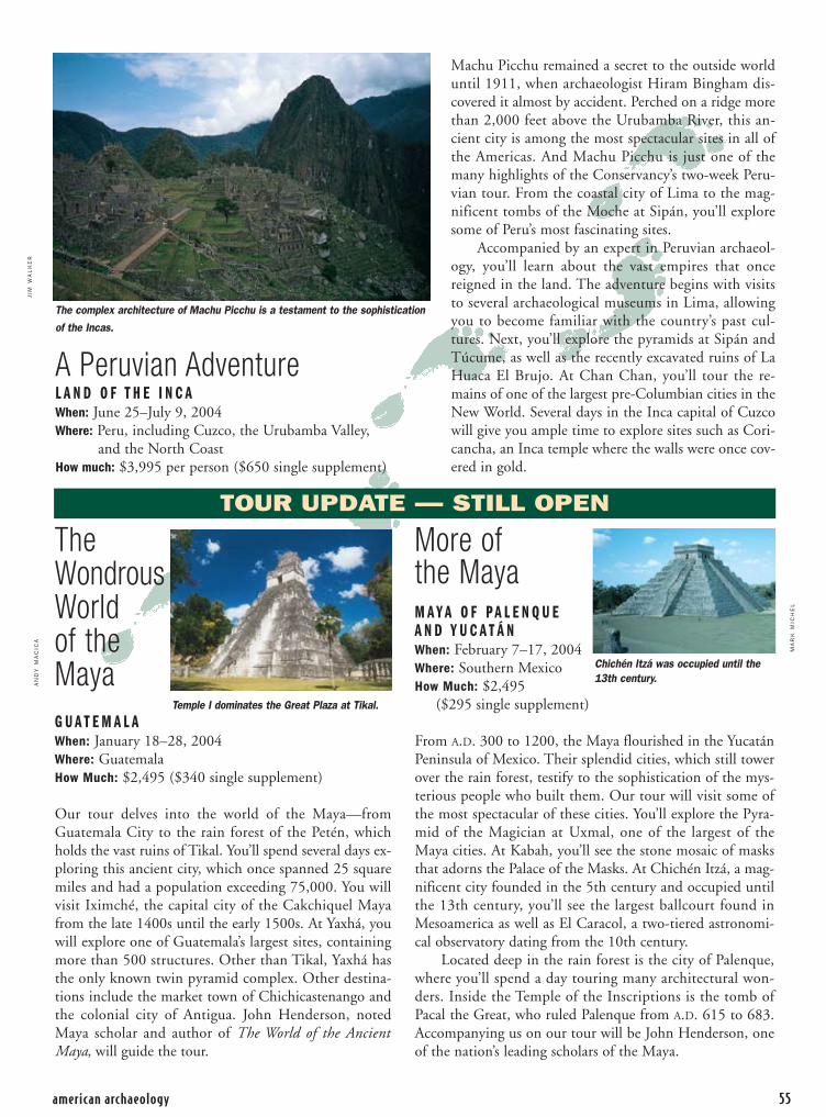
TheWondrousWorld of theMayaG U A T E M A L A When: January 18–28, 2004Where: GuatemalaHow Much: $2,495 ($340 single supplement)
Our tour delves into the world of the Maya—fromGuatemala City to the rain forest of the Petén, whichholds the vast ruins of Tikal. You’ll spend several days ex-ploring this ancient city, which once spanned 25 squaremiles and had a population exceeding 75,000. You willvisit Iximché, the capital city of the Cakchiquel Mayafrom the late 1400s until the early 1500s. At Yaxhá, youwill explore one of Guatemala’s largest sites, containingmore than 500 structures. Other than Tikal, Yaxhá hasthe only known twin pyramid complex. Other destina-tions include the market town of Chichicastenango andthe colonial city of Antigua. John Henderson, notedMaya scholar and author of The World of the AncientMaya, will guide the tour.
More of the MayaM A Y A O F P A L E N Q U E A N D Y U C A T Á NWhen: February 7–17, 2004Where: Southern MexicoHow Much: $2,495
($295 single supplement)
From A.D. 300 to 1200, the Maya flourished in the YucatánPeninsula of Mexico. Their splendid cities, which still towerover the rain forest, testify to the sophistication of the mys-terious people who built them. Our tour will visit some ofthe most spectacular of these cities. You’ll explore the Pyra-mid of the Magician at Uxmal, one of the largest of theMaya cities. At Kabah, you’ll see the stone mosaic of masksthat adorns the Palace of the Masks. At Chichén Itzá, a mag-nificent city founded in the 5th century and occupied untilthe 13th century, you’ll see the largest ballcourt found inMesoamerica as well as El Caracol, a two-tiered astronomi-cal observatory dating from the 10th century.
Located deep in the rain forest is the city of Palenque,where you’ll spend a day touring many architectural won-ders. Inside the Temple of the Inscriptions is the tomb ofPacal the Great, who ruled Palenque from A.D. 615 to 683.Accompanying us on our tour will be John Henderson, oneof the nation’s leading scholars of the Maya.
american archaeology 55
A Peruvian AdventureL A N D O F T H E I N C AWhen: June 25–July 9, 2004Where: Peru, including Cuzco, the Urubamba Valley,
and the North CoastHow much: $3,995 per person ($650 single supplement)
Machu Picchu remained a secret to the outside worlduntil 1911, when archaeologist Hiram Bingham dis-covered it almost by accident. Perched on a ridge morethan 2,000 feet above the Urubamba River, this an-cient city is among the most spectacular sites in all ofthe Americas. And Machu Picchu is just one of themany highlights of the Conservancy’s two-week Peru-vian tour. From the coastal city of Lima to the mag-nificent tombs of the Moche at Sipán, you’ll exploresome of Peru’s most fascinating sites.
Accompanied by an expert in Peruvian archaeol-ogy, you’ll learn about the vast empires that oncereigned in the land. The adventure begins with visitsto several archaeological museums in Lima, allowingyou to become familiar with the country’s past cul-tures. Next, you’ll explore the pyramids at Sipán andTúcume, as well as the recently excavated ruins of LaHuaca El Brujo. At Chan Chan, you’ll tour the re-mains of one of the largest pre-Columbian cities in theNew World. Several days in the Inca capital of Cuzcowill give you ample time to explore sites such as Cori-cancha, an Inca temple where the walls were once cov-ered in gold.
JIM
WA
LK
ER
MA
RK
MIC
HE
L
AN
DY
MA
CIC
A
Temple I dominates the Great Plaza at Tikal.
TOUR UPDATE — STILL OPEN
The complex architecture of Machu Picchu is a testament to the sophistication
of the Incas.
Chichén Itzá was occupied until the13th century.

Since the inception of theConservancy’s Living Spirit Circle in 2002, participation has grown to over 50 members. Thesededicated members have includedthe Conservancy in their long-termplanning to ensure that America’spast will always have a future.
This elite group is open to those who wish to make a lasting
contribution by including the Conservancy in their will or estate plans, or by making a life-income gift such as a charitable annuity. TheConservancy would like to thank the following Living Spirit Circlemembers for their thoughtfulness and generosity.
56 winter • 2003-04
LivingSpiritCircle
The Archaeological Conservancy
AnonymousDee Aiani, Illinois
Carol M. Baker, TexasOlive Bavins, CaliforniaEarl C. Biffle, MissouriDenis Boon, ColoradoJean Carley, Oregon
Deborah Chastain, ColoradoElva B. Cook, California
Donna Cosulich, New YorkRichard Dexter, WisconsinPatricia H. Douthitt, Ohio
Professor and Mrs. Robert C. Dunnell, MississippiArthur and Mary Faul, Arizona
Preston Forsythe, KentuckyVeronica Frost, Ohio
Derald and Bridget Glidden, CaliforniaGrace E. Hartzel, Ohio
Barbara J. Jacobs, Washington, D.C.Walter and Allene Kleweno, New Mexico
Lavinia C. Knight, CaliforniaDerwood Koenig, Indiana
Jay Last, CaliforniaDeborah Leitner Jones, Maryland
Margaret A. Lussky, MinnesotaOsceola W. Madden, Florida
Laura Marianek, OhioRobin Marion, New JerseyNeil E. Matthew, Arizona
Mark Michel, New MexicoJanet E. Mitchell, Colorado
James A. Neely, TexasDavid Noble and Ruth Meria, New Mexico
Jan and Judith Novak, New MexicoLee O’Brien, Indiana
Michael R. Palmer, New MexicoMargaret P. Partee, TennesseeMarguerite B. Peterson, FloridaDonald E. Pierce, New Mexico
Barbara A. Reichardt, CaliforniaCaryl Richardson, New Mexico
Joy Robinson, CaliforniaSusan J. Rudich, New York
Lorraine Schramm, MissouriWalter Sheppe, Ohio
Harriet N. Smith, New YorkDee Ann Story, Texas
Paula M. Strain, MarylandAnn M. Swartwout, MichiganRon and Pat Taylor, VirginiaSteven Vastola, Connecticut
James B. Walker, New MexicoKarl and Nancy Watler, Colorado
Ron Whiddon, New MexicoKatheryne Willock, ArizonaKathrin W. Young, Alaska
Robert Zimmerman, NevadaWendell E. Zipse, Arizona
GIFTS OF DISTINCTIONThe Anasazi Circle is an elite group of members who contribute $2,000 or more annual-ly to the Conservancy’s ongoing efforts to permanently preserve America’s cultural treas-ures. Since its inception in 1993, participation in the Anasazi Circle has increased by267 percent.
Anasazi Circle member support is essential to the Conservancy’s ability to expandits archaeological preservation goals. G. and S.T., Conservancy members since 1999,joined the Anasazi Circle this year. “We must preserve the information we have of ourpredecessors to better understand the past,” says S.T. “Too often information is destroyedbefore it can be analyzed and the knowledge is gone forever. With donated funds, theConservancy can step in and act quickly to get an area preserved.”
The benefits of Anasazi Circle membership include discounts on tours, recognitionin American Archaeology magazine, and an invitation to an exclusive seminar weekend.The 2003 Anasazi Circle explored the ancient mounds of Alabama in October. By send-ing in your donation of $2,000 or more today, you can ensure your invitation to TheArchaeological Conservancy’s engaging 2004 Anasazi Circle Weekend. —Kerry Slater
Patrons of Preservation
The Archaeological Conservancy would like tothank the following individuals, foundations,
and corporations for their generous support during the period of August 2003 through
October 2003. Their generosity, along with the generosity of the Conservancy’s other
members, makes our work possible.
LIFE MEMBER GIFTS OF $1,000 OR MORE
David T. Arthur, IllinoisBetty Banks, WashingtonHelen Ann Bauer, IllinoisSusan J. Bauer, Georgia
Hester A. Davis, ArkansasAnne H. Dibble, Texas
(in memory of David S. Dibble)Stephen D. Jones, New YorkRoger and Frances Kennedy,
New MexicoLinda Koch, Ohio
Carl W. Kohls, New YorkSusan Mayer Reaves, Florida
William J. and Priscilla Robinson,Arizona
Catherine Symchych, WyomingKathleen Tweed, CaliforniaBeryl Zimberoff, California
ANASAZI CIRCLE GIFTS OF $2,000 OR MORE
Barbara and Nance Creager, TexasStewart Findlater and Sherry
Brallier, CaliforniaJune Stack, Pennsyvlania
FOUNDATION/CORPORATEGIFTS OF $5,000–$29,999
The Beirne Carter Foundation,Virginia
The Philip R. Jonsson Foundation,Texas
The Archaeological Conservancy5301 Central Avenue NE • Suite 902
Albuquerque, NM 87108(505) 266-1540 www.americanarchaeology.org
TO MAKE A DONATION
OR BECOME A MEMBER CONTACT:

Coyote PressP.O. Box 3377
Salinas, CA 93912
Specializing in Archaeology, Rock Art,Prehistory, Ethnography, Linguistics,Native American Studies and anythingclosely related.
We stock thousands of new books andreprints, used and rare books, and theback issues of many journals.
Browse or shop online at our newlyredesigned e-commerce website:
WWW.COYOTEPRESS.COM
E-mail: [email protected]
BOOKS
Proud sponsors of: www.californiaprehistory.com
ShowPride inAmerica’sArchaeological Resources!
To order, send your check to:
The Archaeological Conservancy5301 Central Ave. NE, Suite 902Albuquerque, NM 87108
NAME
ADDRESS
CITY
STATE ZIP
Archaeological ConservancyT-shirt: 100% cotton
$12, plus $1.75 S&H circle size: S M L XL XXL

Make your mark in time.Some Conservancy membersthink the only way to help savearchaeological sites is throughmembership dues. While dues are a constant lifeline, there aremany ways you can support theConservancy’s work, both todayand well into the future. And bysupporting the Conservancy, younot only safeguard our past foryour children and grandchildren,you also may save some money.
Place stock in the Conservancy.Evaluate your investments. Some members choose to make adifference by donating stock. Suchgifts offer a charitable deductionfor the full value instead of payingcapital gains tax.
Give a charitable gift annuity.Depending on your circumstances,you may be able to make a gift ofcash and securities today that letsyou receive extensive tax benefitsas well as an income for as long as you live.
leave a lasting legacy.Many people consider protectingour cultural heritage by remem-bering the Conservancy in theirwill. While providing us with a dependable source of income,bequests may qualify you for an estate tax deduction.
Whatever kind of gift you give,you can be sure we’ll use it topreserve places like SugarloafPueblo and our other 275 sitesacross the United States.
Yes, I’m interested in making a planned-giving donation to The Archaeological Conservancy and saving money on my taxes. Please send more information on:
❏ Gifts of stock ❏ Bequests ❏ Charitable gift annuities
Name:
Street Address:
City: State: Zip:
Phone: ( ) -
Sugarloaf Pueblo, AZAtop Sugarloaf Mountain
A Conservancy preserve since 1991
Rooms with a view 600 years ago.
Part of our cultural heritage today.
Mail information requests to:
The Archaeological Conservancy
Attn: Planned Giving
5301 Central Avenue NE
Suite 902
Albuquerque, NM 87108-1517
Or call:
(505) 266-1540
JER
RY
JAC
KA