architectural survey of african american neighborhoods in
TRANSCRIPT

1
Architectural Survey of African American Neighborhoods
in East and Southeast Greensboro
Prepared by hmwPreservation 2020 Principal Investigators: Heather Wagner Slane
Cheri LaFlamme Szcodronski

2
TABLE OF CONTENTS Project History and Overview .................................................................................................. 6
Survey Methodology and Limitations ...................................................................................... 7
Historic Context ..................................................................................................................... 10
Nineteenth Century Greensboro ................................................................................. 10
Warnersville and Early Neighborhood Development .................................................. 10
Historically Black Colleges and Universities and the Development of
East Greensboro .................................................................................................... 13
Nocho Park, Clinton Hills, and the Growth of Southeast Greensboro ........................ 15
Benbow Park and Mid-Twentieth Century Residential Growth .................................. 18
Residents of East and Southeast Greensboro and the Civil Rights Movement ......... 21
Architectural Context ............................................................................................................. 23
Residential Architecture .............................................................................................. 24
Religious Architecture ................................................................................................. 30
Architect Profiles ......................................................................................................... 33
Development Context ................................................................................................. 38
Recommendations ................................................................................................................ 47
Bibliography .......................................................................................................................... 66
Appendix A: List of Previously Surveyed Properties
Appendix B: List of Newly Surveyed Properties
Thispublication/projecthasbeenfinancedinpartwithfederalfundsfromtheNationalParkService,U.S.DepartmentoftheInterior.However,thecontentsandopinionsdonotnecessarilyreflectviewsorpoliciesoftheU.S.DepartmentoftheInterior,nordoesthementionoftradenames,commercialproducts,ororganizationsconstituteendorsementorrecommendationbytheDepartmentoftheInterior.

3
LIST OF FIGURES Figure 1: Map of the Study Area ............................................................................................. 9
Figure 2: St. James Presbyterian Church (GF2037) .............................................................. 14
Figure 3: Plat of the south end of Nocho Park ...................................................................... 16
Figure 4: Washington Street School (GF2109) ...................................................................... 16
Figure 5: Grace Lutheran Church (GF9142) .......................................................................... 17
Figure 6: Vance Chavis Library (GF9127) .............................................................................. 18
Figure 7: Portion of the 1936 HOLC map .............................................................................. 19
Figure 8: 1600-1602 Tuscaloosa Street ................................................................................ 20
Figure 9: 500 block High Street (GF9145) ............................................................................. 20
Figure 10: 1500 Marboro Drive (GF9144) .............................................................................. 21
Figure 11: 1813 Martin Luther King Jr. Drive (GF5499) ......................................................... 24
Figure 12: 1700 Martin Luther King Jr. Drive (GF5520) ......................................................... 24
Figure 13: Joseph D. Overman House (GF5519) .................................................................. 24
Figure 14: Wesley Arledge House (GF4609) ......................................................................... 25
Figure 15: Dr. S. P. Sebastian House (GF1692) .................................................................... 25
Figure 16: John D. Henry House (GF6060) ........................................................................... 26
Figure 17: 1400 block Julian Street ....................................................................................... 26
Figure 18: Claude Patterson House (GF6071) ....................................................................... 26
Figure 19: Charles W. Pinkney House (GF6068) ................................................................... 27
Figure 20: Bert C. Piggott House (GF6780) ........................................................................... 27
Figure 21: Jones Jeffries House (GF6057) ............................................................................ 27
Figure 22: Roy D. Moore House (GF6790) ............................................................................ 27
Figure 23: 1216 East Side Drive (GF6784) ............................................................................ 28
Figure 24: Walter Johnson House (GF6067) ......................................................................... 28
Figure 25: William Streat House (GF4863) ............................................................................ 28
Figure 26: J. Kenneth Lee House (GF6168) .......................................................................... 29
Figure 27: Milton Barnes House (GF6066) ............................................................................ 29
Figure 28: Grace Lutheran Church (GF9142) ........................................................................ 30
Figure 29: Saint Mary’s Catholic Church (GF9137) ............................................................... 30
Figure 30: Union Memorial Methodist Church (GF9132) ....................................................... 30
Figure 31: Pilgrim Baptist Church (GF6774) .......................................................................... 31

4
Figure 32: Trinity African Methodist Episcopal Church (GF2086) ......................................... 31
Figure 33: Saint Matthews United Methodist Church (GF9131) ........................................... 31
Figure 34: Saint Stephen United Church of Christ (GF9136) ................................................ 32
Figure 35: Metropolitan United Methodist Church (GF9139) ................................................ 32
Figure 36: Saint Matthews United Methodist Church (GF9131) ........................................... 33
Figure 37: Barbara Gore House ........................................................................................... 35
Figure 38: Eugene and Lorena Marrow House ...................................................................... 36
Figure 39: Providence Baptist Church (GF9141) ................................................................... 37
Figure 41: Map of Nocho Park .............................................................................................. 39
Figure 42: 500 block South Benbow Road ........................................................................... 40
Figure 43: 1100 block Gorrell Street ..................................................................................... 40
Figure 44: 1500 block McConnell Street ............................................................................... 40
Figure 45: 1400 block Julian Street ....................................................................................... 40
Figure 46: Map of Clinton Hills Subdivision .......................................................................... 41
Figure 47: 1200 block Julian Street ....................................................................................... 42
Figure 48: 1800 block Curry Street ....................................................................................... 42
Figure 49: 900 block Stephens Street ................................................................................... 42
Figure 50: Map of Benbow Park Subdivision (GF9143) ........................................................ 43
Figure 51: 1100 block East Florida Street (GF9143) ............................................................. 43
Figure 52: 1202 Eton Drive .................................................................................................... 44
Figure 53: 2214 New Castle Road ........................................................................................ 44
Figure 54: 1905 Drexmore Avenue ........................................................................................ 44
Figure 55: 1805 Carlton Avenue ............................................................................................ 45
Figure 56: Map of Ray Warren Homes (GF9133) .................................................................. 45
Figure 57: Ray Warren Homes (GF9133) ............................................................................... 46
Figure 58: Ray Warren Homes (GF9133) ............................................................................... 46
Figure 59: 400 block Hargett Street (GF9145) ...................................................................... 46
Figure 60: 500 block Hargett Street (GF9145) ...................................................................... 46
Figure 61: Map of Washington Street Redevelopment (GF9145) ......................................... 47
Figures 62-64: J. Kenneth Lee House (GF6168) ................................................................... 48
Figures 65-68: J. Kenneth Lee House (GF6168) ................................................................... 49
Figures 69-71: Dr. Alvin V. and Gwendolyn Blount House (GF6783) .................................... 50
Figures 72-74: Dr. Alvin V. and Gwendolyn Blount House (GF6783) .................................... 51

5
Figures 75-77: William Streat House (GF4863) ..................................................................... 52
Figures 78-80: William Streat House (GF4863) ..................................................................... 53
Figure 81: 1200 block East Side Drive .................................................................................. 54
Figure 82: 1600 block Tuscaloosa Street .............................................................................. 54
Figure 83: 1201 South Benbow Road ................................................................................... 54
Figure 84: Map of the Benbow Road Historic District (GF9146) ........................................... 55
Figure 85: 900 block Stephen Street ..................................................................................... 56
Figure 86: 800 block Cambridge Street ................................................................................ 56
Figure 87: 927 Stephen Street .............................................................................................. 56
Figure 88: 1700 South Side Boulevard ................................................................................. 56
Figure 89: Map of Clinton Hills Historic District (GF9144) ..................................................... 57
Figure 90: 1200 block Eton Drive .......................................................................................... 58
Figure 91: 1900 block Carlton Avenue .................................................................................. 58
Figure 92: 2200 block Lakeland Road ................................................................................... 59
Figure 93: 1900 block Drexmore Avenue .............................................................................. 59
Figure 94: Map of Benbow Park Historic District (GF9143) .................................................. 60
Figures 95 and 96: Justice Henry and Shirley Frye House (GF9128) .................................... 61
Figure 97: 1810 South Benbow Road (GF6058) ................................................................... 62
Figure 98: Dr. Frank & Gladys White House (GF6785) .......................................................... 62
Figure 99: Annie Lee Holley House (GF9138) ........................................................................ 63
Figure 100: Milton H. Barnes House (GF6066) ...................................................................... 63
Figures 101 and 102: Windsor Community Center (GF9134) ............................................... 64
Figures 103-105: St. Matthews United Methodist Church (GF9131) .................................... 65
Figures 106-108: Metropolitan United Methodist Church (GF9139) ..................................... 66

6
PROJECT HISTORY AND OVERVIEW In 2019, the City of Greensboro received a Historic Preservation Fund (HPF) grant from the North Carolina State Historic Preservation Office (NC HPO) and contracted with hmwPreservation to undertake an architectural survey of African American neighborhoods and resources in East and Southeast Greensboro. While architectural surveys were conducted in Greensboro in 1975-1976, 1989-1990, and 1992, none of those surveys included the historically African American resources and neighborhoods in East/Southeast Greensboro. The area was initially surveyed by Circa, Inc. in 2008 as part of the city-wide Greensboro’s Phase 1-B Historic Architectural Survey update. That survey documented only representative resources that were constructed prior to 1965. It did, however, note significant concentrations of post-World War II residential architecture in the area. The post-World War II developments of East/Southeast Greensboro are significant for a number of reasons: they contain outstanding examples of Modernist residential and religious architecture; they contain examples of the work of prominent African American architects and builders; and they were home to leaders of and participants in the Civil Rights Movement in Greensboro. The primary objectives for this project were as follows:
• update the existing survey photographs and survey data for 124 properties surveyed in 2008
• survey with individual records sixteen resources identified during the planning phase
• document with District/Neighborhood/Area records groups of houses with the goal of identifying potential National Register historic districts
• collect primary and secondary sources to build a historic context for the area

7
SURVEY METHODOLOGY AND LIMITATIONS The Survey of African American Neighborhoods in East and Southeast Greensboro focused on the documentation of historically African American residential and institutional resources. The survey area was generally bounded by East Market Street on the north, US 29 (O’Henry Boulevard) on the east, Bennett and East Florida streets on the west, and Martin Luther King Jr. Drive on the south. Heather Slane and Cheri Szcodronski served as the principal investigators. A planning phase took place in January 2020 during which surveyors identified sixteen individual resources and three planned developments (including approximately 515 properties) that had not been previously surveyed and warranted documentation. The surveyors used plat maps to identify neighborhoods with shared development histories, prioritizing these areas for survey using district/neighborhood/area forms. Surveyors conducted a windshield survey of the entire study area to identify resources that warranted individual documentation, prioritizing buildings with high material integrity and interesting or unique design elements. Finally, a working bibliography was prepared and print sources gathered during the planning phase. A public meeting to kick off the project was held in February 2020 at Saint James Church, just west of the Study area. Fieldwork took place from February 2020 through March 2020, during which time surveyors verified the 124 previously surveyed resources and comprehensively resurveyed those properties with updated field survey forms, written descriptions, and digital photographs. Additionally, resources (including distinguishable historic neighborhoods) identified during the planning phase were documented with field survey forms, brief written descriptions, and photographs. Written summaries were prepared for all surveyed properties, and changes to previously surveyed properties were noted as appropriate in the summaries. For newly identified district/neighborhood/areas, all houses were photographed and a brief written summary addresses the area overall, rather than each of its components. Basic archival research, including the examination of plats, Sanborn maps (1919, 1925, and 1950), city directories (1925-1975), Home Owner’s Loan Corporation maps, and other digital resources was carried out as appropriate to provide additional data for significant properties and neighborhoods. Special notation was made of properties that appeared potentially eligible for listing in the National Register of Historic Places. Material gathered during the fieldwork and research phases was used to update and fully populate database records and create paper survey files. Database For new and previously surveyed properties, the consultant fully populated the database records. Report forms generated from the database were printed for inclusion in the paper survey files. A digital copy of the database was presented to both the NC-HPO and staff for the Greensboro Historic Preservation Commission. Photographs Digital survey photographs were taken from the public right-of-way using a digital SLR camera. Photographs of both primary and secondary resources were labeled according to the NC-HPO guidelines and contact sheets printed for inclusion in the paper survey files. A DVD of all

8
labeled survey photographs was prepared for the NC-HPO and Greensboro Historic Preservation Commission staff. Paper Files Paper files for each surveyed property include the field survey notes, printed contact sheets, and printed database records, as well as any related notes and documentation gathered during the project. Maps Digital maps, prepared by the City of Greensboro, were used during the planning phase along with a field survey to identify the boundaries of the study area, the location of previously surveyed properties, and to mark the location of new properties to be surveyed. Project findings and proposed historic districts were annotated by the consultant on base maps provided by the City of Greensboro. Survey Report Upon completion of the field survey and database records, this written report was prepared. It outlines the project methodology, findings, and recommendations for further study. The report includes community development and planning context for East and Southeast Greensboro as well as historic context for the study area, placing the development of African American residential neighborhoods within the broader historic context of mid-twentieth-century Greensboro. Finally, the report provides architectural context, including both an examination of the historic architecture within the study area as well as the work of notable African American architects and builders. The consultant presented the findings of the survey at a public information meeting in Greensboro. Study List Recommendations Included within the survey report is a list of properties considered by the consultant to be eligible for listing in the National Register of Historic Places, specifically those properties that appear to have notable historic and/or architectural significance and a high level of material integrity. The report explains why each property was selected. The consultant will present these properties to the North Carolina National Register Advisory Committee for consideration for placement on the NCHPO National Register Study List. Survey Limitations In mid-March 2020, the COVID-19 pandemic resulted in the abrupt statewide closure of public buildings, including libraries and other research facilities. These closures, together with social distancing mandates, made follow-up research and fieldwork not possible. While the majority of the research and fieldwork had already been completed, the pandemic did limit the ability of the consultants to collect newspaper clippings and other research materials from the Greensboro Public Library and the Greensboro Historical Museum. Social distancing requirements did not allow for in-person interviews to be conducted. However, local organizers were able to conduct phone and video interviews with several long-time residents. Finally, the pandemic limited the ability of the consultants to take interior photographs of buildings thought to be eligible for the NC-HPO National Register Study List. The City of Greensboro issued letters to the affected property owners, requesting that they take and submit digital interior photographs to the consultant. However, photographs were obtained from the building owners of only three of the eleven potentially eligible properties.

9

10
HISTORIC CONTEXT
Nineteenth Century Greensboro Guilford County was formed in 1771 from sections of Orange and Rowan counties and was largely agricultural, producing cotton, tobacco, pine resin and turpentine, wheat, oats, corn, and various fruits and vegetables. The county was originally much larger, but parts were carved away to form Randolph County in 1779 and Rockingham County in 1785, leaving the approximately 650 square miles that remain today. Greensboro was established in 1808 and replaced Guilford Courthouse, now Martinsville, as the county seat. The town was only about forty-two acres at that time of its establishment, located at the geographic center of Guilford County.1 By 1870, it had grown to include fourteen blocks that encompassed about 160 acres. Commercial and residential buildings often sat alongside one another, while other groupings of homes were clustered around the courthouse, churches, or the Greensboro Female College, now Greensboro College.2 The North Carolina Railroad, which ran from Goldsboro to Charlotte, was built through Greensboro in the 1850s, and when the first train arrived in 1856 it was greeted by much fanfare among the city’s residents. It was joined by the Piedmont Railroad in 1864, the Cape Fear and Yadkin Valley Railroad in 1888, and the Northwestern North Carolina in 1890, resulting in a network of six sets of tracks converging on Greensboro by 1891. Sixty trains stopped in the city each day, and Greensboro became known as “The Gate City.”3 In 1891, the city expanded its boundaries, encompassing a total of four square miles and a population of just over 3,300 people. Industry came to Greensboro in the late nineteenth century, with the arrival of textile mills. Proximity Mills opened in 1896, Revolution Mills opened in 1898, and White Oak Mills opened in 1905, and each built mill villages that attracted new residents and resulted in even more population growth. By 1900, the population had jumped to just over 10,000 people, and trollies began service to the edges of the city in 1902, which also fueled growth. The population continued to increase at a rapid pace, reaching nearly 16,000 people by 1910, and almost 20,000 people by 1920. In 1923, the city limits expanded outward again, encompassing eighteen miles that included the mill villages. During the 1920s, the population more than doubled, reaching over 53,000 people by 1930, and by 1938, the city limits expanded again to include fifty-two square miles and twenty-four neighborhoods.4 Warnersville and Early Neighborhood Development As with cities throughout the South in the first half of the twentieth century, Greensboro practiced strict segregation. The separation of races took place not only in churches, schools, businesses and other public places, but also extended to neighborhoods – and not just the relatively common practice of excluding people of color through restrictive covenants in
1 Ruth Little-Stokes, An Inventory of Historic Architecture, Greensboro, NC (Greensboro, NC: City of Greensboro and North Carolina Division of Archives and History, 1976), 3; Alexander R. Stoesen, Guilford County: A Brief History (Raleigh, NC: North Carolina Division of Archives and History, 1993), 73.
2 Gayle Hicks Fripp, Greensboro Volume II: Neighborhoods (Charleston, SC: Arcadia Publishing, 1998), 1-2.
3 Marvin Brown, Greensboro: An Architectural Record: A Survey of the Historic and Architecturally Significant Structures of Greensboro, North Carolina (Greensboro, NC: Preservation Greensboro Inc., The Junior League of Greensboro, The City of Greensboro, 1995), 60; Fripp, Greensboro Volume II, 1-2.
4 Brown, Greensboro: An Architectural Record, 60; Fripp, Greensboro, Volume II, 1-2.

11
exclusive white neighborhoods, but a clear pattern of racially-based neighborhood development that remains visible on the city’s landscape even today. Upper- and middle-class white neighborhoods formed west of the city near the State Normal & Industrial College, now the University of North Carolina at Greensboro, which opened in 1892. These neighborhoods often included parks or manmade lakes, as their names reflect: College Hill, College Park, Lindley Park, Lake Daniel, and Hamilton Lakes, to name a few.5 North of the city became an affluent white area, with Fisher Park, Irving Park, and Latham Park forming around parks and country clubs. Working class white neighborhoods formed northeast of downtown near the city’s industries, including Bessemer, Rankin, Edgeville, and Hamtown, as well as the textile mill villages for Proximity, Revolution, and White Oak, which also included the Black mill village of East White Oak by 1925. South of town was a white neighborhood known simply as South Greensboro.6 Warnersville was the first planned neighborhood for African Americans in Greensboro and was anchored by schools and churches. The neighborhood was first established by Yardley Warner, a Quaker from Pennsylvania who traveled the South after the Civil War, erecting schools for freedmen. In 1867, he established a school for Black children south of downtown Greensboro known as the Ashe Street School. He then purchased over thirty-five acres around the school, which was divided into lots and sold to African American families between 1868 and 1888, forming a community roughly bounded by present-day West Gate City Boulevard, Freeman Mill Road, West Florida Street, and South Elm Street.7 In 1922, the J.C. Price School replaced the Old Ashe Street School, serving students in first through ninth grades until its closure in 1983 and demolition in 2014.8 St. Matthew’s Methodist Church, originally known as Warnersville Methodist Episcopal Church, was founded in 1866, making it the oldest African American congregation in Greensboro.9 In 1868, thirty African American members of the First Presbyterian Church separated and formed St. James Presbyterian Church, holding services in a house on North Forbis Street before constructing a sanctuary in the Warnersville neighborhood in 1910.10 Shiloh Church was founded in 1892 by a group who split from Providence Baptist Church, founded on East Market Street twenty-five years previously. The first sanctuary was built on Austin Street, and replaced with a new building in 1925, which was added onto several times by the 1940s.11
5 Brown, Greensboro: An Architectural Record, 86-88; Fripp, Greensboro Volume II, 1-2. 6 Brown, Greensboro: An Architectural Record, 83-85. 7 Blackwell P. Robinson and Alexander R. Stoesen, “The History of Guilford County, North Carolina,
USA, to 1980, A.D.,” Sydney M. Cone, Jr., ed. (Greensboro, NC: The Guilford County Bicentennial Commission, 1971), 119-121, Greensboro Public Library; Otis L. Hairston, Jr., Black America Series: Greensboro, North Carolina (Charleston, SC: Arcadia Publishing, 2003), 93.
8 Hairston, Black America Series, 34; TriadHistory.org, “J.C. Price School,” https://triadhistory.org/projects-and-resources/j-c-price-school (accessed August 2020).
9 H.A. Sieber, White Water, Colored Water: The Historicity of the African-American Community of Greensboro, North Carolina (Greensboro, NC: Project Homestead, Inc., 1993), North Carolina Collection, Louis Round Wilson Special Collections Library, University of North Carolina at Chapel Hill, 16; St. Matthew’s United Methodist Church, “History,” http://www.stmattchurch.com/history (accessed August 2020); Greensboro Public Library, “Profiles of Prominent African-Americans in Greensboro,” https://library.greensboro-nc.gov/home/showdocument?id=33341 (accessed August 2020).
10 Fripp, Greensboro Volume II, 46. 11 Shiloh Baptist Church, “About Us,” http://eugeneshilohbaptistchurch.com/about-us (accessed August
2020).

12
These three churches together established Union Cemetery at East Whittington and South Elm streets, listed to the National Register of Historic Places in 1993. The earliest burials took place in the 1880s. The city closed the cemetery in 1917 citing health concerns, however the closure was likely racially motivated, as the Warnersville community was immediately adjacent to the white South Greensboro neighborhood. Burials continued by permit only until 1940.12 Percy Street School opened around 1875, the first public graded school for African American children in the state to be supported by taxes. The school first met in the St. James Presbyterian Church, but by 1878 there were over 150 students and five teachers utilizing the same room simultaneously, so the three-room, one-story Percy Street School was built in 1880. It was later expanded to a two-story, four-room building, and it remained in use until 1937.13 The Warnersville Graded School, also known as Graded School Number 2 for Colored Children, opened in 1898 and remained in use until 1922. Jacksonville School also served children in this neighborhood from 1909 to 1954.14 By 1914, the social practice of segregating neighborhoods became legal mandate when the city passed an ordinance that prohibited African Americans from buying property on any block where the majority of property owners were white. The ordinance was passed in response to William B. Windsor, the principal of the Warnersville Graded School, who purchased a home in a nearby all-white neighborhood. Eventually, under threats to his life and livelihood, he was forced into selling the house at a loss to white investors, while city leaders quickly enacted the ordinance to prevent such mixing of the races. In addition to ensuring neighborhood segregation, the ordinance also prevented any gathering place for African Americans, such as theaters, on white-dominated blocks. This law remained on the books until 1929, though restrictive deeds helped reinforce residential segregation both before its passage and after its repeal.15 Urban renewal in the 1950s and 1960s resulted in the demolition and subsequent reconstruction of most of Warnersville. By 1940, the Works Progress Administration found that while only 3% of white-occupied homes were “in need of major repairs or unfit for use,” this was true for more than 28% of homes occupied by African Americans.16 The Housing Act of
12 Hairston, Black America Series, 52; Kaye Graybeal, “Union Cemetery,” National Register of Historic
Places Nomination, 1993, Section 8, 2-3. 13 Sieber, White Water, Colored Water, 16; Ethel Stephens Arnett, Greensboro, North Carolina: The
County Seat of Guilford (Chapel Hill, NC: The University of North Carolina Press, 1955), 87-89; Fripp, Greensboro Volume II, 46; Nadine Sherri Lockwood, “Bennett College for Women 1926-1966” (PhD diss., State University of New York at Buffalo, 2004), 84, North Carolina Collection, Louis Round Wilson Special Collections Library, University of North Carolina at Chapel Hill.
14 City of Greensboro Planning Department, “Heritage Communities: Warnersville,” https://www.greensboro-nc.gov/departments/planning/learn-more-about/historic-preservation/heritage-communities/warnersville (accessed August 2020).
15 Samuel M. Kipp, “Urban Growth and Social Change in the South, 1870-1920: Greensboro, North Carolina as a Case Study” (PhD diss., Princeton University, 1971), 322-323, University of North Carolina at Greensboro Digital Collections, http://libcdm1.uncg.edu/cdm/ref/collection/ttt/id/18757 (accessed August 2020); Greensboro Public Library, “Profiles of Prominent African Americans in Greensboro,” https://library.greensboro-nc.gov/home/showdocument?id=33341 (accessed August 2020); Brown, Greensboro: An Architectural Record, 80-81.
16 Works Progress Administration, “Report of the Real Property Survey, Greensboro, North Carolina,” 20, Guilford Vertical Files, Greensboro Public Library, via University of North Carolina at Greensboro Digital

13
1949 authorized federal assistance to acquire and clear properties that were deemed blighted. The Redevelopment Commission of Greensboro was established in 1951, and renewal projects began in earnest in 1958, focused on the African American neighborhoods south and east of the city.17 St. James Presbyterian Church relocated to its present location at 820 Ross Avenue in 1958, the building designed by prominent African American architect, W. Edward Jenkins.18 The Shiloh Baptist Church relocated to Eugene Street during urban renewal and the current building, designed by African American architect Clinton Gravely, was built in 1974.19 Urban renewal also had a devastating effect on African American businesses in Warnersville that were forced to relocate and, as a result, became separated from their community and customers. Only three of these businesses relocated successfully and remain in operation today. Hargett Funeral Home, which had operated on South Street since 1922, relocated to its present location on East Market Street, northwest of the study area. Smith Funeral Home, originally located on Ashe Street, now operates as Smith-Hinnant Funeral Services on Martin Luther King, Jr., Drive, west of the study area. Thomas and Theresia Fairley’s The Little Spot, a nightclub and café established on Ashe Street in the 1940s, was reopened on Martin Luther King, Jr., Drive as Tom’s Take Home Restaurant, although it too is now closed.20 Historically Black Colleges and Universities and the Development of East Greensboro African Americans settled primarily in east Greensboro, drawn to this part of town by the establishment of the Agricultural and Mechanical College for the Colored Race, now North Carolina Agricultural and Technical State University (NC A&T), in 1893. The school was established by the state two years earlier and first operated in Raleigh, but was moved to Greensboro after the successful advocacy of Charles Moore, Dr. D.W.C. Benbow, and other African American leaders, supported by the Greensboro Chamber of Commerce.21 In 1928, the college began admitting female students. A school of engineering was added in the 1930s, and by the end of the decade, degree offerings included graduate study in agriculture, education, and engineering. The college was accredited in 1939. During World War II, an Army ROTC unit was added, followed by an Air Force ROTC unit in 1952. The School of Nursing opened in 1957. The college was reclassified as a university in 1967.22
Collections, http://libcdm1.uncg.edu/cdm/compoundobject/collection/UrbanDevGSO/id/7668/rec/13 (accessed August 2020).
17 City of Greensboro, “Redevelopment History in Greensboro,” www.greensboro-nc.gove/home/showdocument?id=34234 (accessed August 2020).
18 Fripp, Greensboro Volume II, 46. 19 Hairston, Black America Series, 54. 20 Hairston, Black America Series, 60. 21 Hairston, Back America Series, 46; Sieber, White Water, Colored Water, 18-19; Stoesen, Guilford
County, 31. 22 Stoesen, Guilford County, 49; Otis L. Hairston, Jr., Picturing Greensboro: Four Decades of African
American Community (Charleston, SC: The History Press, 2007), 104.
Figure 2: St. James Presbyterian Church (GF2037) 820 Ross Avenue

14
The first president of the college was Dr. James B. Dudley, who served from 1896 until 1925, and the neighborhood surrounding the college is known as the Dudley Street neighborhood (north of the study area). Meanwhile, Scott Park and College Heights formed east of the college (northeast of the study area), and East Side Park and Lincoln Grove formed southeast of the college (east of the study area).23 Bennett Seminary, now Bennett College, also attracted African Americans to settle on the east side of town. In 1873, the Freedmen’s Aid Society first organized the Bennett Seminary in the basement of St. Matthew’s United Methodist Church. By 1875, the Society had purchased the first twenty acres for a new campus east of downtown Greensboro (near present-day NC A&T), and had started a fundraising campaign to pay for construction costs. With additional assistance from the church’s Women’s Home Mission Society, the seminary was dedicated in 1878.24 It initially functioned as a junior college and also offered a college preparatory program with a high school curriculum, as there was no high school for African Americans until the late 1920s.25 The city provided financial assistance for students to enroll in the high school program.26 In 1926, the school eliminated male enrollment, then phased out the high school, which had its last graduating class in 1932.27 Bennett College has remained a four-year women’s college since that time, and was accredited in 1957.28 In addition to schools, churches were another important foundational institution in the development of East Greensboro, and several early congregations built churches on East Market Street, just north of the study area. The Providence Baptist Church was organized on East Market Street in 1866 and first met under a brush arbor. It was the first Baptist church for African Americans in Greensboro. In 1871 the congregation built a frame church that housed worship services and a school. This building was replaced by a brick church in 1876, reputedly the first brick church for Black congregants in North Carolina.29 The Bethel AME Church congregation formed in 1869 under the name Boon’s Chapel and built a brick church at 200 North Regan Street, just north of East Market Street. The Episcopal Church of the Redeemer was organized in 1909 when a mission was established on East Market Street.30 In the early twentieth century, a Black business district began to form along East Market Street near the colleges, as restaurants and entertainment venues in particular relied on business from students. Chef Eddie’s restaurant served chitterlings, fried chicken, collard greens, yams, and other soul food to students, and the Half Moon Café served students until 1939 when it was demolished for construction of the Hayes Taylor YMCA. The Palace Theater offered movies for a dime during the week and booked comedians, dancers, and other acts on the weekends. Leon Hardy opened a photography studio and became well-known for capturing African American community and college events. McRae Taxi, Daniel Taxi (later known as Daniel-Keck Taxi), and Royal Taxi provided transportation services. The Carolina Peacemaker
23 Brown, Greensboro: An Architectural Record, 197-198, 211-212; Hairston, Black America Series, 46;
Stoesen, Guilford County, 31. 24 Stoesen, Guilford County, 32; Lockwood, “Bennett College for Women,” 85. 25 Stoesen, Guilford County, 50. 26 Arnett, Greensboro, 89-90. 27 Brown, Greensboro: An Architectural Record, 73; Hairston, Black America Series, 36. 28 Stoesen, Guilford County, 50. 29 Hairston, Black America Series, 50; Fripp, Greensboro Volume II, 46. 30 Fripp, Greensboro Volume II, 50, 123.

15
newspaper was founded by John Kilamanjaro in 1967 to focus on African American community life.31 Like Warnersville, urban renewal had a devastating effect on the more than seventy Black-owned businesses on East Market Street, the commercial area that served as a center for African American community life during the first half of the twentieth century. Black residents went to East Market Street to visit restaurants, shop, attend church, obtain health care, and enjoy entertainment venues. Urban renewal widened East Market Street from two lanes to six lanes, creating a thoroughfare into and out of downtown and demolishing the African American resources in this area. Although Vance Chavis, an African American educator and politician, advocated for partially widening the road while leaving the businesses on the south side of the street intact, the city rejected the idea. Once removed from this network, most businesses failed. Only a few successfully relocated, including Wilkins Beauty Nook, Bowman Chapel Church, Shaw’s Curb Market, Carolina Peacemaker, King’s Barbeque, Elite Clothing Company, and Carl’s Famous Foods. Even fewer black-owned businesses remained on East Market Street, including Carolina Florist, Hayes Beauty Shop, and Gate City Seafood.32 The churches were also affected by urban renewal. Providence Baptist Church relocated to its present location at 1106 Tuscaloosa Street, in the study area, in 1964.33 The Episcopal Church of the Redeemer was condemned in 1954, and the current church was built at 901 East Friendly Avenue, west of the study area, in 1967.34 Bethel AME Church was demolished in 1964, but the congregation remained in this location, west of the study area, completing an education building in 1967 and the current church in 1975.35 Nocho Park, Clinton Hills, and the Growth of Southeast Greensboro In the early twentieth century, residential neighborhoods in East Greensboro, like those throughout the city, began to expand. This growth was facilitated in part by the popularity of the automobile, as well as the efforts of realtors and speculative builders who carefully targeted and recruited specific socio-economic groups to specific areas of the city. The city limits were expanded in 1923, bringing the city’s area from four square miles to eighteen square miles. On the east side of the city, the boundaries were extended beyond the concentration of development around Bennett College and NC A&T. New growth firmly followed the previously established patterns of racial division, and this area remained predominantly African American.36 Nocho Park is one of the African American developments that followed annexation and makes up the northern section of the survey area. The Nocho Park neighborhood was platted in three stages from 1924 to 1926. Like many of Greensboro’s planned neighborhoods, it featured
31 Hairston, Black America Series, 62-67, 101. 32 Hairston, Black America Series, 68-69, 94. 33 Hairston, Black America Series, 50; Fripp, Greensboro Volume II, 46. 34 Fripp, Greensboro Volume II, 50. 35 Fripp, Greensboro Volume II, 123. 36 Jonathan F. Baylin, “An Historical Study of Residential Development in Greensboro, 1808-1965”
(master’s thesis, University of North Carolina at Chapel Hill, 1968), 70-73, 80, North Carolina Collection, Louis Round Wilson Special Collections Library, University of North Carolina at Chapel Hill.

16
green space and baseball fields that remain extant.37 The neighborhood was planned by white developers, but named for prominent African American Jacob R. “Jim” Nocho, who had died in 1914.38 Nocho came to Greensboro from Pennsylvania following the Civil War to serve as a teacher for the Freedman’s Bureau. He later also worked as a railroad postal clerk and was active in the community as a member of St. James Presbyterian Church.39 Clinton Hills is located south of Nocho Park and was also platted by white developers. Centered on Benbow Road, it is roughly bounded by Julian Street to the north, Oxford Street to the west, Curry Street to the south, and East Side Drive and Broad Street to the east. The two sections of Clinton Hills were platted in 1926, followed by a re-plat of the south section of the neighborhood in 1956 that accommodated alterations to the path of Midland (now E. Florida) Street and reconfigured the southwestern edge of the neighborhood. The Clinton Hills development includes curvilinear street patterns and may be the first African American neighborhood in Greensboro to do so.40 Clinton Hills also includes several green spaces, including Clinton Hill Natural Area on South Side Boulevard and the East Side Drive Natural Area, which divides the street and forms a boulevard. Benbow Park, located at the south end of Clinton Hills, is a small neighborhood park with a playground, picnic tables, and a paved walking trail. Both Nocho Park and Clinton Hills benefitted from close proximity to Bennett College to the west and NC A&T to the north, and they developed as a result of the growth of both schools. The neighborhoods also benefit from the proximity of the Washington Street School, located at 1110 East Washington Street, west of Nocho Park and Dudley High School, east of Nocho Park and Clinton Hills. The former served elementary age students until 1926 when a high school curriculum was added. Dudley High School opened in 1929 as the first African American
37 “Part of Nocho Park Subdivision,” 1924, Plat Book 5, Page 395, Guilford County Register of Deeds, Greensboro, North Carolina (hereafter referred to as GCRD); “Part of Nocho Park Subdivision,” 1924, Plat Book 6, Page 31, GCRD; “Part 3, Nocho Park,” 1926, Plat Book 8, Page 63, GCRD.
38 Fripp, Greensboro, Volume II, 93. 39 Greensboro Public Library, “Profiles of Prominent African-Americans in Greensboro.” 40 “Clinton Hills, Part 1,” January 1926, Plat Book 9, Page 90, GCRD; “Clinton Hills, Part 2,” January
1926, Plat Book 8, Page 136, GCRD; A Resubdivision of Clinton Hills, Section 3,” January 1956, Plat Book 23, Page 53, GCRD.
Figure 3: Plat of the south end of Nocho Park
Figure 4: Washington Street School (GF2109) 1110 East Washington Street

17
high school in Greensboro. It was designed by Charles C. Hartmann and named for James B. Dudley, the second president of NC A&T. Upon its construction, the high school program at the Washington Street School was relocated to the new school, and the first high school class graduated from Dudley in 1930.41 The current 1951 Washington Street School building replaced the earlier campus, and the school currently operates as the Washington Street Montessori School. As with Greensboro’s other African American neighborhoods, churches were important to the cultural fabric, with the city’s oldest African American congregations located in Nocho Park. The first congregation of Lutherans in Greensboro formed in Warnersville in 1894 and built the Evangelical Lutheran Grace Church in 1897, although it was destroyed by fire in the late 1920s. The congregation merged with that of the Luther Memorial Church, which had been formed in 1924. The merged congregations built their current church, Grace Lutheran Church, in 1927 at 1315 East Washington Street, the oldest African American church remaining extant in Greensboro.42 The church served the students and staff of nearby Immanuel Lutheran College, which moved from Concord, North Carolina, to Greensboro’s East Market Street 1905, closed in 1961.43 St. Mary’s Catholic Church built a mission church and school at Gorrell and Duke streets in 1928. In 1948, the name was changed to Our Lady of the Miraculous Medal. In 1972, the parish school was closed due to low enrollment, and the name was changed again to St. Mary’s. The historic chapel remains extant, but the school was demolished in 2003 for a new parish center.44 Another institution that drew residents to these neighborhoods was the Greensboro Negro Hospital Association in Nocho Park, which was the first modern hospital in Greensboro that treated African American patients. Designed by Charles C. Hartmann, the hospital opened at Benbow and McConnell roads in 1927. It was funded through a $100,000 fundraising campaign by the Association and a $50,000 donation by the Richardson family, founders of the Vick Chemical Company. In 1937, the hospital was renamed L. Richardson Memorial Hospital (GF1137). In the 1940s, a prenatal clinic was opened at the hospital to address the nearly 28% infant mortality rate in the city. The hospital facilities were soon inadequate to support the community needs, so a new larger facility was constructed on Southside Boulevard in 1966.
41 Fripp, Greensboro Volume II, 93; Greensboro Public Library, “Profiles of Prominent African-Americans
in Greensboro.” 42 Fripp, Greensboro Volume II, 50; Hairston, Black America Series, 46; Benjamin Briggs, “The Secrets of
Nocho Park, Clinton Hills, and Benbow Park,” Preservation Greensboro, https://preservationgreensboro.org/the-secrets-of-nocho-park-clinton-hills-and-benbow-park (accessed August 2020).
43 Brown, Greensboro: An Architectural Record, 197-198, 211-212; Hairston, Black America Series, 46; Stoesen, Guilford County, 31; Briggs, “The Secrets of Nocho Park, Clinton Hills, and Benbow Park.”
44 St. Mary’s Catholic Church, “Our History,” https://stmarysgreensboro.org/about/history (accessed August 2020); Hairston, Black America Series, 40.
Figure 5: Grace Lutheran Church (GF9142) 1315 East Washington Street

18
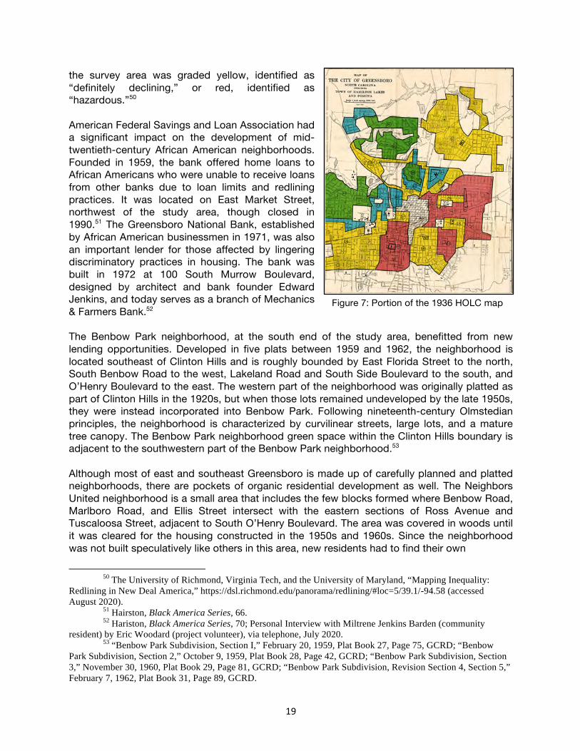
The original building was converted for use as a nursing home facility, which operated at least into the 1990s, and the building is currently an affordable housing complex.45 The presence of the schools, churches, and hospital made these especially desirable neighborhoods, and the residents included teachers, bricklayers, barbers, and other laborers and professionals.46 The neighborhoods were also served by the Windsor Community Center, built in Nocho Park in 1937 and named for William B. Windsor, the principal of Warnersville Graded School, superintendent of African American schools in Greensboro, and president of Bennett College, as well as the target of a 1914 campaign to prevent interracial neighborhoods. Windsor was also involved in the establishment of Greensboro’s Carnegie Negro Library and edited an African American newspaper called the Greensboro Herald. The community center included a bathhouse, Olympic-sized swimming pool, tennis courts, and playground. The original building was replaced by the current building in 1968.47 The Vance Chavis Library is also located in Nocho Park and was constructed around 1965. The library is named in honor of Greensboro educator Vance Chavis, who taught at Dudley High School in the 1930s, then served as principal of Lincoln Junior High School, and after retirement was elected to the Greensboro City Council.48 In the 1950s, Greensboro was selected for the convergence point of Interstate 40 and Interstate 85, and O’Henry Boulevard was constructed and dedicated in 1957. In 1970, U.S. Route 220 was rerouted to align with U.S. Route 29/O’Henry Boulevard.49 The construction of these thoroughfares, with on- and off-ramps that cut into the Nocho Park neighborhood, fractured the Nocho Park and Clinton Hills neighborhoods, separating Dudley High School from the community on one side, while the Winsor Recreation Center and Chavis Library were on the other side. Benbow Park and Mid-Twentieth Century Residential Growth In 1936, the Home Owners’ Loan Corporation (HOLC) utilized data provided by developers, real estate appraisers, and lending institutions to evaluate residential neighborhoods. The group assigned one of four colored grades to indicate mortgage security in that neighborhood: green for high security and red for low security. The colors used in the coded system led the practice to be termed “redlining.” Racial identity was a significant factor in grade assignments, and a red grade resulted in refusal by banks to offer home loans in these areas. Nearly all of
45 Marvin Brown, “(Former) L. Richardson Memorial Hospital,” National Register of Historic Places
Nomination, 1992, Section 8, 3-4; Hairston, Black America Series, 104; Sieber, White Water, Colored Water, 23. 46 Brown, Greensboro: An Architectural Record, 86, 211-212. 47 Briggs, “The Secrets of Nocho Park, Clinton Hills, and Benbow Park”; Hairston, Black America Series,
99; Greensboro Public Library, “Profiles of Prominent African-Americans in Greensboro.” 48 Hairston, Black America Series, 47. 49 Stoeson, Guilford County, 62; Briggs, “The Secrets of Nocho Park, Clinton Hills, and Benbow Park.”
Figure 6: Vance Chavis Library (GF9127) 900 South Benbow Road
19
the survey area was graded yellow, identified as “definitely declining,” or red, identified as “hazardous.”50 American Federal Savings and Loan Association had a significant impact on the development of mid-twentieth-century African American neighborhoods. Founded in 1959, the bank offered home loans to African Americans who were unable to receive loans from other banks due to loan limits and redlining practices. It was located on East Market Street, northwest of the study area, though closed in 1990.51 The Greensboro National Bank, established by African American businessmen in 1971, was also an important lender for those affected by lingering discriminatory practices in housing. The bank was built in 1972 at 100 South Murrow Boulevard, designed by architect and bank founder Edward Jenkins, and today serves as a branch of Mechanics & Farmers Bank.52 The Benbow Park neighborhood, at the south end of the study area, benefitted from new lending opportunities. Developed in five plats between 1959 and 1962, the neighborhood is located southeast of Clinton Hills and is roughly bounded by East Florida Street to the north, South Benbow Road to the west, Lakeland Road and South Side Boulevard to the south, and O’Henry Boulevard to the east. The western part of the neighborhood was originally platted as part of Clinton Hills in the 1920s, but when those lots remained undeveloped by the late 1950s, they were instead incorporated into Benbow Park. Following nineteenth-century Olmstedian principles, the neighborhood is characterized by curvilinear streets, large lots, and a mature tree canopy. The Benbow Park neighborhood green space within the Clinton Hills boundary is adjacent to the southwestern part of the Benbow Park neighborhood.53 Although most of east and southeast Greensboro is made up of carefully planned and platted neighborhoods, there are pockets of organic residential development as well. The Neighbors United neighborhood is a small area that includes the few blocks formed where Benbow Road, Marlboro Road, and Ellis Street intersect with the eastern sections of Ross Avenue and Tuscaloosa Street, adjacent to South O’Henry Boulevard. The area was covered in woods until it was cleared for the housing constructed in the 1950s and 1960s. Since the neighborhood was not built speculatively like others in this area, new residents had to find their own
50 The University of Richmond, Virginia Tech, and the University of Maryland, “Mapping Inequality:
Redlining in New Deal America,” https://dsl.richmond.edu/panorama/redlining/#loc=5/39.1/-94.58 (accessed August 2020).
51 Hairston, Black America Series, 66. 52 Hariston, Black America Series, 70; Personal Interview with Miltrene Jenkins Barden (community
resident) by Eric Woodard (project volunteer), via telephone, July 2020. 53 “Benbow Park Subdivision, Section I,” February 20, 1959, Plat Book 27, Page 75, GCRD; “Benbow
Park Subdivision, Section 2,” October 9, 1959, Plat Book 28, Page 42, GCRD; “Benbow Park Subdivision, Section 3,” November 30, 1960, Plat Book 29, Page 81, GCRD; “Benbow Park Subdivision, Revision Section 4, Section 5,” February 7, 1962, Plat Book 31, Page 89, GCRD.
Figure 7: Portion of the 1936 HOLC map

20
surveyors, architects, builders, and financing, and so they too benefitted from newly-established African American lending institutions. Architects Edward Jenkins and William Streat both lived in the neighborhood and designed their own homes, as well as those of several neighbors. Other residents included William Goldsboro, the principal at David Caldwell School, and his wife Juanita, a counselor at Dudley High School; William Hampton, the first African American elected to the Greensboro City Council; E.E. Smith, who owned and operated a funeral home serving African Americans in Warnersville; and nearby on East Side Drive lived Dr. Alvin Blount, who sued Moses Cone Hospital with Dr. George Simkins and helped achieve integration in hospitals nationwide. Residents of this neighborhood, and the surrounding streets, included doctors, teachers and principals, funeral home directors, post office workers, day care givers, NC A&T professors and staff, lawyers, and police officers and chiefs.54 West of Nocho Park on East Gate City Boulevard, a 1930s residential area deemed by the HOLC to be “largely consisting of cheap type negro cottages” and therefore demonstrating “hazardous” mortgage security was leveled in the 1950s for public housing. Ray Warren Homes, the city’s third public housing project and first integrated housing development, is a complex of seventy buildings, including apartments, gathering spaces, playgrounds, basketball courts, and a childcare center. The street patterns were realigned to reflect the popular curvilinear principles of the time, and the complex is roughly bounded by East Gate City Boulevard to the north, Benjamin Benson Street to the west, Julian Street to the south, and Logan Street to the east. The complex was named for Ray Warren, the first director of the Greensboro Housing Authority, who served from 1941 until 1956.55 It was the third public housing development after the 1951 construction of Smith Homes (for whites) and Morningside Homes (for blacks). The City of Greensboro also redeveloped a residential area west of Nocho Park between East Washington Street and East Gate City Boulevard in the mid-twentieth century. While the Clinton Hills and Benbow Park neighborhoods to the south were growing, this area was designated “definitely declining” by the HOLC, although the HOLC noted it was a “good residential section” helped by its proximity to Bennett College and NC A&T.56 The area was selected by the Redevelopment Commission of Greensboro for an urban renewal
54 Personal Interview with Miltrene Jenkins Barden, July 2020. 55 Greensboro Housing Authority, “Our History,” http://www.gha-nc.org/about-us/our-
history/expansion.aspx (accessed August 2020); Sanborn Map Company, “Greensboro North Carolina,” 1950, www.nclive.org (accessed August 2020); The University of Richmond, Virginia Tech, and the University of Maryland, “Mapping Inequality: Redlining in New Deal America.”
56 The University of Richmond, Virginia Tech, and the University of Maryland, “Mapping Inequality: Redlining in New Deal America.”
Figure 8: 1600-1602 Tuscaloosa Street
Figure 9: 500 block High Street (GF9145)
21
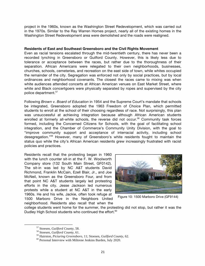
project in the 1960s, known as the Washington Street Redevelopment, which was carried out in the 1970s. Similar to the Ray Warren Homes project, nearly all of the existing homes in the Washington Street Redevelopment area were demolished and the roads were realigned. Residents of East and Southeast Greensboro and the Civil Rights Movement Even as racial tensions escalated through the mid-twentieth century, there has never been a recorded lynching in Greensboro or Guilford County. However, this is likely less due to tolerance or acceptance between the races, but rather due to the thoroughness of their separation. African Americans were relegated to their own neighborhoods, businesses, churches, schools, cemeteries, and recreation on the east side of town, while whites occupied the remainder of the city. Segregation was enforced not only by social practices, but by local ordinances and neighborhood covenants. The closest the races came to mixing was when white audiences attended concerts at African American venues on East Market Street, where white and Black concertgoers were physically separated by ropes and supervised by the city police department.57 Following Brown v. Board of Education in 1954 and the Supreme Court’s mandate that schools be integrated, Greensboro adopted the 1963 Freedom of Choice Plan, which permitted students to enroll at the school of their choosing regardless of race. Not surprisingly, this plan was unsuccessful at achieving integration because although African American students enrolled at formerly all-white schools, the reverse did not occur.58 Community task forces formed, including the Concerned Citizens for Schools, with the goal of facilitating school integration, and the Chamber of Commerce’s Community Unity Division, with the goal to “improve community support and acceptance of interracial activity, including school desegregation.”59 However, many of Greensboro’s white residents fought to maintain the status quo while the city’s African American residents grew increasingly frustrated with racist policies and practices. Residents recall that the protesting began in 1960 with the lunch counter sit-in at the F. W. Woolworth Company store (132 South Main Street, GF0142). The sit-in was led by NC A&T students David Richmond, Franklin McCain, Ezell Blair, Jr., and Joe McNeil, known as the Greensboro Four, and from that point NC A&T students largely led protesting efforts in the city. Jesse Jackson led numerous protests while a student at NC A&T in the early 1960s. He and his wife, Jackie, often took refuge at 1500 Marboro Drive in the Neighbors United neighborhood. Residents also recall that when the college students went home for the summer, the protesting did not stop, but rather it was the Dudley High School students who continued the effort.60
57 Stoesen, Guilford County, 58. 58 Stoesen, Guilford County, 61. 59 Hairston, Picturing Greensboro, 11; Stoesen, Guilford County, 62. 60 Personal Interview with Miltrene Jenkins Barden, July 2020.
Figure 10: 1500 Marboro Drive (GF9144)

22
Community resident Miltrene Jenkins Barden recalls protesting in the 1960s while a student at Dudley High School and later NC A&T. “My generation [was] out there pounding the streets, that’s what we did in the sixties,” she recalls. “We were integrating Greensboro.” Barden also recalls that her father, architect W. Edward Jenkins, always stayed home when she went to protest so he could bail her out of jail if she was arrested. “They put us in jail. They put the dogs and fire hoses on us,” she recalls. More than a thousand protestors were held in the former polio hospital at 710 Huffine Mill Road – nearly two miles east of the NC A&T campus. According to Barden, it was relatively common for residents in the neighborhood to mortgage their houses to raise funds for protestors’ bail. Civil Rights attorney Kenneth Lee, who resided at 1021 Broad Street in the survey area, frequently represented jailed protestors pro bono.61 Although protests, counter-protests, and racially-motivated violence got worse before it got better, by about 1970 both white and Black residents in the city were ready to find neutral ground and move forward. As historian William Chafe explains, “new forums for interracial communication were established, long-standing black grievances were addressed, and a framework was created for middle-class cooperation across racial lines.”62 The February One Society formed to support the city’s efforts to achieve one community and sponsored annual events honoring the Greensboro Four in the 1980s and 1990s.63 After F.W. Woolworth Corporation announced the downtown Greensboro store would be closing, Sit-In Movement, Inc., was formed in 1993 to purchase the building and establish the International Civil Rights Museum, which opened in 2010.64
61 Personal Interview with Miltrene Jenkins Barden, July 2020. 62 William H. Chafe, Civilities and Civil Rights: Greensboro, North Carolina, and the Black Struggle for
Freedom (Oxford: Oxford University Press, 1980), 234-236. 63 Hairston, Picturing Greensboro, 65. 64 Hairston, Picturing Greensboro, 93.

23
ARCHITECTURAL CONTEXT The architectural significance of the study area is derived from the varied styles of the primarily residential and religious buildings in the area, with the absence of Revival styles as significant as the prominence of Modernist-style buildings in the area. The earliest buildings in the district follow national trends, though are generally less ornate, representing the adaptation of the forms and styles to the homes of middle- and working-class residents. However, by the mid-twentieth century, styles diverged noticeably from those utilized in white neighborhoods of the same era. Historian M. Ruth Little, in her study of mid-twentieth century neighborhoods in Raleigh notes that, “for these [African American] groups the traditional status quo represented oppression. Modern design was a new beginning, without the associative values of Colonialism and other Revival styles.” Thus, while Colonial Revival details were sometimes applied to Ranch and Split Level houses in the study area, the near-complete absence of true Revival style buildings, in favor of forward-looking Modernist designs is illustrative of a distinctly African American trend. As in Raleigh, a “startling divergence of architectural taste between middle-class whites and blacks [emerged]…Blacks looked toward a brighter future and chose clean modern forms; whites preferred expressions of the Colonial Revival style that harkened to an era of white dominance.”65 While Modernism in Raleigh during the same era was led by leading white architects associated with the School of Design at North Carolina State University, in Greensboro, it was African American architects, most associated with the Architectural Engineering program at North Carolina Agricultural & Technical State University that were at the forefront of Modernism. Many worked in some capacity with the white firm of Loewenstein-Atkinson Architects, AIA, the first firm in the city to hire African American architects, though all went on to establish their own, highly successful firms. As residents of the study area, W. Edward Jenkins and William Streat in particular, furthered the architectural narrative of East/Southeast Greensboro toward Modernism. Finally, the development patterns in the study area followed national trends with the earliest platted developments following grid patterns with relatively narrow, urban residential lots. Later plats, particularly at the south end of the study area were established with curved streets and wide, sometimes irregularly shaped lots that could accommodate Ranch and Split Level suburban house forms.
65 Little, Margaret Ruth. “Getting the American Dream for Themselves: Postwar Modern Subdivisions for
African Americans in Raleigh, North Carolina.” Buildings & Landscapes: Journal of the Vernacular Architecture Forum, Vol. 19, No. 1 (Spring 2012), pg. 73.

24
Residential Architecture Popularized by a group of nineteenth century English architects, the Queen Anne style borrowed heavily from the Medieval models of the Elizabethan and Jacobean eras, having little to do with the 1702-1714 reign of Queen Anne as the name implies. The style was popular nationwide in the late-1800s, spread through pattern books and mail-order house plans as well as via the expanding railroad network along which precut architectural details were distributed.66 The style reached its peak in North Carolina from 1890 to 1913, aligning with the earliest development in the study area, that along Martin Luther King Jr. Drive. The style is characterized by asymmetrical forms, large porches, a variety of material textures, steeply pitched gables, and abundant ornamentation.67 The c.1898 house at 1813 Martin Luther King Jr. Drive (GF5499) is the best one-story example of the style in the study area. It features a steeply pitched, hipped roof with projecting, pedimented bays connected by a wraparound porch supported by turned posts. The c.1900 house at 1700 Martin Luther King Jr. Drive (GF5520) is a two-story example of the style, also with projecting, pedimented wings and bays with wood shingles in the gables. The wraparound porch is supported by turned posts with sawn brackets.
Throughout the 1920s and 1930s, the Craftsman style dominated residential construction at the very south end of the study area, along and adjacent to Martin Luther King Jr. Drive, and in the north half of the study area, between East Gate City Boulevard and East Market Street. An extension of the Arts and Crafts movement of the early twentieth century, the style was dominant nationally starting around 1905 and had become popular in North Carolina by the 1910s. One- or one-and-a-half-stories in height with compact building footprints, Craftsman-style bungalows were well suited to narrow, early-twentieth-century
66 Virginia Savage McAlester, A Field Guide to American Houses (New York, NY: Alfred P. Knopf, 2015),
350. 67 Bishir and Southern, A Guide to the Historic Architecture of Piedmont North Carolina, 541; McAlester,
A Field Guide to American Houses, 346-370.
Figure 11: 1813 Martin Luther King Jr. Drive (GF5499)
Figure 12: 1700 Martin Luther King Jr. Drive (GF5520)
Figure 13: Joseph D. Overman House (GF5519) 2002 Martin Luther King Jr. Drive

25
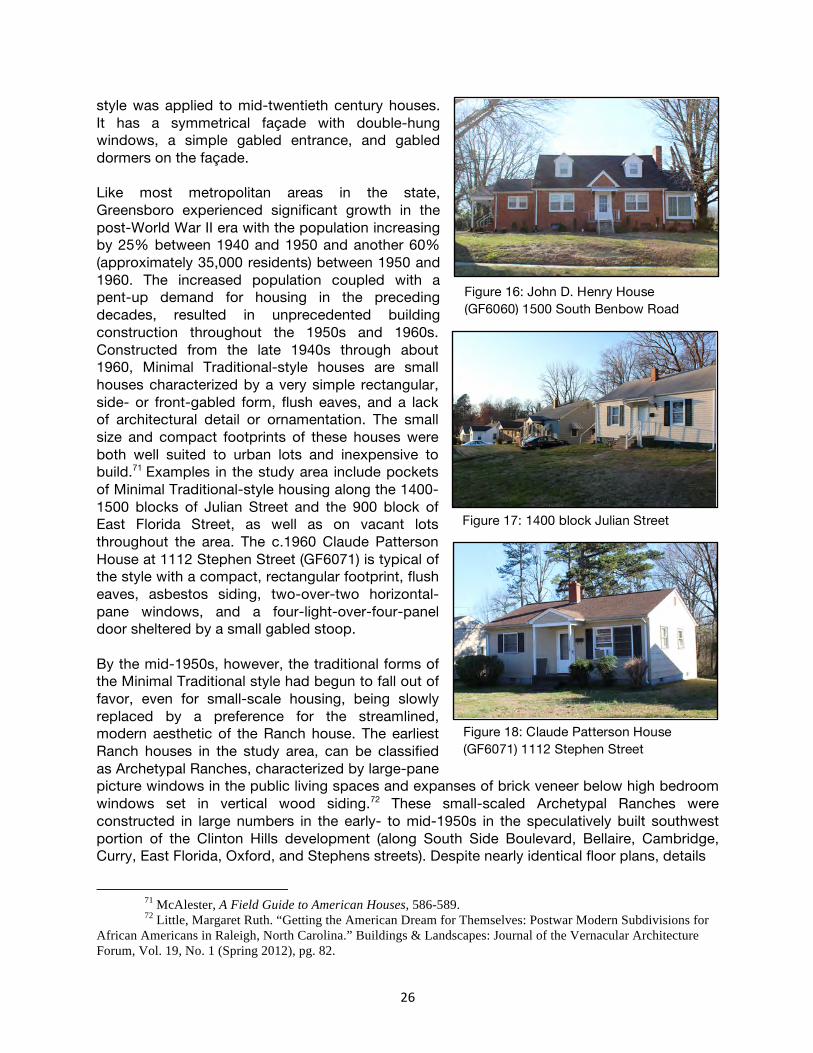
urban lots. Further, the form was adaptable to front-gabled, side-gabled, and hipped roofs, providing versatility in construction and appearance. Finally, when minimally detailed, as many in the study area are, the bungalow was inexpensive and easily built. Characteristic details of the Craftsman style include deep eaves with knee brackets; exposed rafters and purlins; and porches supported by heavy, tapered posts on brick piers.68 The c.1920 Joseph D. Overman House at 2002 Martin Luther King Jr. Drive (GF5519) is among the earliest, most decorative, and most intact examples of the style in the district. It retains characteristic four-over-one wood-sash windows, wood shingles in the gable, knee brackets, exposed rafter tails, and a partial-width porch supported by tapered wood posts on brick piers. The c.1930 Wesley Arledge House at 501 South Benbow Road (GF4609) illustrates a one-and-a-half-story, brick example of the style with four-over-one wood-sash windows, knee brackets in the gables, and two-part brick piers supporting the porch. Revival styles, most notably the Colonial Revival and Tudor Revival styles, were popular in white suburbs nationwide from the 1920s through the 1940s, with the Colonial Revival style in use through the 1960s and later. However, they were rarely used in the study area, especially for residential buildings where the preference was for modern styles. The few notable examples that exist include the c.1926 Dr. S. P. Sebastian House at 1401 McConnell Road (GF1692), an outstanding example of the Tudor Revival style. Loosely adapted from a variety of late Medieval and early Renaissance precedents, the Tudor style was a popular suburban residential style in the United States for much of the early twentieth century. It is characterized by half-timbered walls, tall narrow windows or diamond-pane casement windows, steep gables, arched entryways, and irregular forms.69 The Sebastian House incorporates a brick veneer, faux-half-timbering at the second-floor level, six-over-six windows, a batten door, and a clipped-front-gabled wing with decorative basketweave brick. Colonial and classical architecture were experiencing a nationwide resurgence as part of an eclectic phase of architecture that took inspiration from the American 1876 and 1893 expositions. The Colonial Revival style is generally characterized by an elaborate front entrance, typically centered on a symmetrical façade, and paired windows and dormers.70 The c.1950 John D. Henry House at 1500 South Benbow Road (GF6060) is illustrative of how the
68 Bishir and Southern, A Guide to the Historic Architecture of Piedmont North Carolina, 535; McAlester, A Field Guide to American Houses, 567-578; Catherine W. Bishir, North Carolina Architecture (Chapel Hill: University of North Carolina Press, 1990), 498-505.
69 Bishir and Southern, A Guide to the Historic Architecture of Piedmont North Carolina, 543; McAlester, A Field Guide to American Houses, 449-466.
70 McAlester, A Field Guide to American Houses, 409-432.
Figure 14: Wesley Arledge House (GF4609) 501 South Benbow Road
Figure 15: Dr. S. P. Sebastian House (GF1692) 1401 McConnell Road
26
style was applied to mid-twentieth century houses. It has a symmetrical façade with double-hung windows, a simple gabled entrance, and gabled dormers on the façade. Like most metropolitan areas in the state, Greensboro experienced significant growth in the post-World War II era with the population increasing by 25% between 1940 and 1950 and another 60% (approximately 35,000 residents) between 1950 and 1960. The increased population coupled with a pent-up demand for housing in the preceding decades, resulted in unprecedented building construction throughout the 1950s and 1960s. Constructed from the late 1940s through about 1960, Minimal Traditional-style houses are small houses characterized by a very simple rectangular, side- or front-gabled form, flush eaves, and a lack of architectural detail or ornamentation. The small size and compact footprints of these houses were both well suited to urban lots and inexpensive to build.71 Examples in the study area include pockets of Minimal Traditional-style housing along the 1400-1500 blocks of Julian Street and the 900 block of East Florida Street, as well as on vacant lots throughout the area. The c.1960 Claude Patterson House at 1112 Stephen Street (GF6071) is typical of the style with a compact, rectangular footprint, flush eaves, asbestos siding, two-over-two horizontal-pane windows, and a four-light-over-four-panel door sheltered by a small gabled stoop. By the mid-1950s, however, the traditional forms of the Minimal Traditional style had begun to fall out of favor, even for small-scale housing, being slowly replaced by a preference for the streamlined, modern aesthetic of the Ranch house. The earliest Ranch houses in the study area, can be classified as Archetypal Ranches, characterized by large-pane picture windows in the public living spaces and expanses of brick veneer below high bedroom windows set in vertical wood siding.72 These small-scaled Archetypal Ranches were constructed in large numbers in the early- to mid-1950s in the speculatively built southwest portion of the Clinton Hills development (along South Side Boulevard, Bellaire, Cambridge, Curry, East Florida, Oxford, and Stephens streets). Despite nearly identical floor plans, details
71 McAlester, A Field Guide to American Houses, 586-589. 72 Little, Margaret Ruth. “Getting the American Dream for Themselves: Postwar Modern Subdivisions for
African Americans in Raleigh, North Carolina.” Buildings & Landscapes: Journal of the Vernacular Architecture Forum, Vol. 19, No. 1 (Spring 2012), pg. 82.
Figure 16: John D. Henry House (GF6060) 1500 South Benbow Road
Figure 18: Claude Patterson House (GF6071) 1112 Stephen Street
Figure 17: 1400 block Julian Street

27
vary slightly throughout the development with the 1956 Charles W. Pinckney House at 1814 Curry Street (GF6068) having a hipped roof, grouped double-hung windows with fixed transoms to the left of the entrance, and high paired windows within sided bays at the left end of the façade. The 1956 Bert C. Piggott House at 801 Cambridge Street (GF6780) has a side-gabled form, brick veneer throughout, picture windows on the right end of the façade, and double-hung windows on the left end. Larger Ranch houses were constructed throughout the south part of the study area, south of Julian Street, throughout the 1950s, 1960s, and 1970s. These typically wide, low, one-story houses, most often constructed with brick veneers, were attractive to middle-class families as both a low-maintenance alternative to siding, which required regular repainting, and as a more expensive material, illustrating their upward economic status. Additionally, the open floor plans with centrally located kitchens represented the family-centered focus of the 1950s house, a direct response to the fragmentation of rooms separated by hallways that earlier house forms provided. Finally, the Ranch house often included an attached garage or carport, supporting an increased trend in automobile ownership nationwide in the decades after World War II. The c.1958 Jones Jeffries House at 1900 South Benbow Road (GF6057) is a good example of the style with an elongated form, Roman-brick veneer that further accentuates the horizontal form, an inset entrance bay with contrasting stone veneer, and an attached carport on the right end. The c.1962 Roy D. Moore House at 1105 Ross Avenue (GF6790) is a typical example of the style with a five-bay-wide façade, brick veneer, twenty-light bow window to the right of the entrance, and an inset carport at the right rear that is supported by full-height brick walls. While the Colonial Revival style was not popular in the study area, several Ranch houses employed Colonial Revival-style symmetry and detailing. The c.1969 House at 1216 East Side Drive (GF6784) illustrates this with a symmetrical façade, brick quoins at the building’s corners, a shallow dentil cornice, double-hung six-over-nine wood-sash windows, and an entrance bay with a classical surround.
Figure 19: Charles W. Pinkney House (GF6068) 1814 Curry Street
Figure 20: Bert C. Piggott House (GF6780) 801 Cambridge Street
Figure 21: Jones Jeffries House (GF6057) 1900 South Benbow Road
Figure 22: Roy D. Moore House (GF6790) 1105 Ross Avenue

28
While the Ranch form remained popular into the 1970s, by the mid-1960s, the Split Level form had also become popular in the study area. This was due in part to a considerable number of speculatively built Split Level houses in the Benbow Park development at the southeast end of the study area. The Split Level form is composed of three or more staggered levels separated by partial flights of stairs. This allowed for a separation of public and private spaces within the house, providing “privacy, noise control, and good interior circulation.” The form was attractive to buyers because it looked more like a two-story house without the expense of constructing a full two stories. It was well-suited to developments with uneven terrain, as the stories could be partially built into sloping lots.73 Garages, when present, were typically located at the lowest level of the house. Stylistic characteristics applied to the form may include Colonial Revival or Contemporary detailing, while others mimic the Archetypal Ranch with paired down Modernist detailing. The 1962 Walter Johnson House at 1802 Carlton Avenue (GF6067) is an example of the speculatively built houses in Benbow Park. It has a brick veneer at the first-floor levels and aluminum siding at the upper level, which is cantilevered slightly. Colonial Revival detailing includes eight-over-eight wood-sash windows, a dentil cornice on the one-story section, and a sixteen-light wood-framed picture window to the left of the entrance. The form was also utilized by architects who applied distinctive Modernist detailing to the interiors, as was the case with the c.1965 William Streat House at 1507 Tuscaloosa Street (GF4863). An impressive number of noteworthy examples of the Modernist style are present in the study area. The proximity of North Carolina Agricultural & Technical State University and their department of Architectural Engineering furthered both a training in, and appreciation for, Modernist styles. The influence of prominent African American architects who resided in the study area and designed Modernist-style houses for themselves and their neighbors further led to a concentration of Modernist, architect-designed buildings that is higher than typical mid-century neighborhoods. The houses, most of which date from the late 1950s through the early 1970s, are characterized by flat, shed, and low-sloped gabled roofs with deep overhangs, exposed roof beams and purlins, large banks of windows, recessed entries, natural materials, and grouped windows that blur the distinction between interior and exterior spaces. Perhaps the most recognizable and well-known example of Modernist architecture in the study area is the 1959 Kenneth Lee House at 1021 Broad Avenue
73 McAlester, A Field Guide to American Houses, 613-614.
Figure 23: 1216 East Side Drive (GF6784)
Figure 24: Walter Johnson House (GF6067) 1802 Carlton Avenue
Figure 25: William Streat House (GF4863) 1507 Tuscaloosa Street

29
(GF6168). Designed by W. Edward Jenkins, the house features a low-sloped, nearly flat, roof with clerestory windows lighting the main living and dining spaces. A flat-roofed carport on the façade and grouped windows contribute to the horizontality of the building. Taking advantage of the sloped site, the rear of the house has an exposed basement level. The c.1966 Milton H. Barnes House at 2219 Lakeland Drive (GF6066) employs a more traditional Ranch form, but is set apart by Modernist detailing including paired doors flanked by decorative, pierced concrete-block walls that screen the windows behind them. Additional Modernist-style residences are highlighted in the Recommendations section of the report.
Figure 27: Milton Barnes House (GF6066) 2219 Lakeland Drive
Figure 26: J. Kenneth Lee House (GF6168) 1021 Broad Avenue
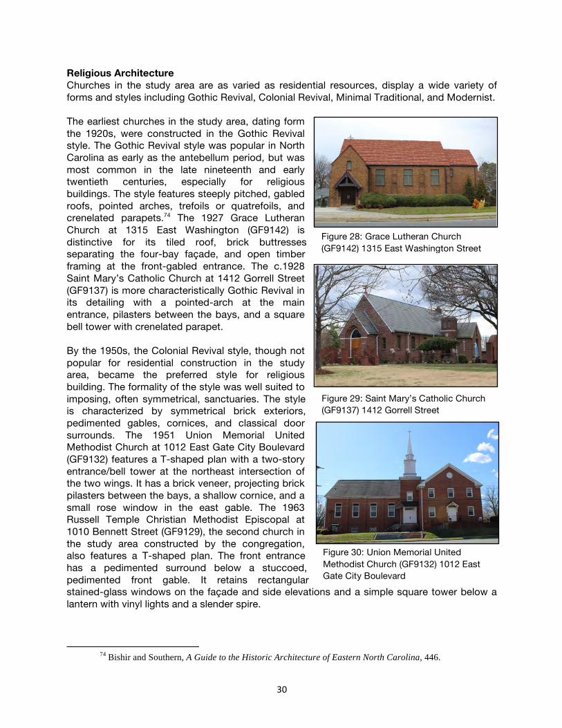
30
Religious Architecture Churches in the study area are as varied as residential resources, display a wide variety of forms and styles including Gothic Revival, Colonial Revival, Minimal Traditional, and Modernist. The earliest churches in the study area, dating form the 1920s, were constructed in the Gothic Revival style. The Gothic Revival style was popular in North Carolina as early as the antebellum period, but was most common in the late nineteenth and early twentieth centuries, especially for religious buildings. The style features steeply pitched, gabled roofs, pointed arches, trefoils or quatrefoils, and crenelated parapets.74 The 1927 Grace Lutheran Church at 1315 East Washington (GF9142) is distinctive for its tiled roof, brick buttresses separating the four-bay façade, and open timber framing at the front-gabled entrance. The c.1928 Saint Mary’s Catholic Church at 1412 Gorrell Street (GF9137) is more characteristically Gothic Revival in its detailing with a pointed-arch at the main entrance, pilasters between the bays, and a square bell tower with crenelated parapet. By the 1950s, the Colonial Revival style, though not popular for residential construction in the study area, became the preferred style for religious building. The formality of the style was well suited to imposing, often symmetrical, sanctuaries. The style is characterized by symmetrical brick exteriors, pedimented gables, cornices, and classical door surrounds. The 1951 Union Memorial United Methodist Church at 1012 East Gate City Boulevard (GF9132) features a T-shaped plan with a two-story entrance/bell tower at the northeast intersection of the two wings. It has a brick veneer, projecting brick pilasters between the bays, a shallow cornice, and a small rose window in the east gable. The 1963 Russell Temple Christian Methodist Episcopal at 1010 Bennett Street (GF9129), the second church in the study area constructed by the congregation, also features a T-shaped plan. The front entrance has a pedimented surround below a stuccoed, pedimented front gable. It retains rectangular stained-glass windows on the façade and side elevations and a simple square tower below a lantern with vinyl lights and a slender spire.
74 Bishir and Southern, A Guide to the Historic Architecture of Eastern North Carolina, 446.
Figure 28: Grace Lutheran Church (GF9142) 1315 East Washington Street
Figure 29: Saint Mary’s Catholic Church (GF9137) 1412 Gorrell Street
Figure 30: Union Memorial United Methodist Church (GF9132) 1012 East Gate City Boulevard
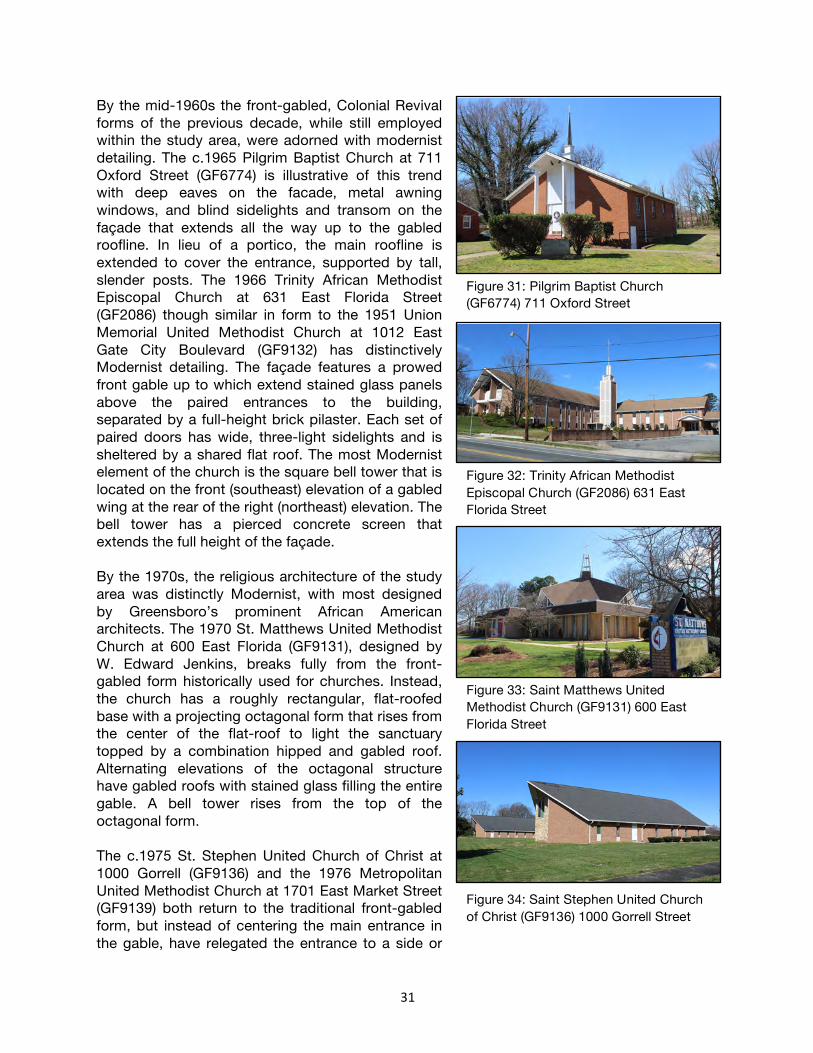
31
By the mid-1960s the front-gabled, Colonial Revival forms of the previous decade, while still employed within the study area, were adorned with modernist detailing. The c.1965 Pilgrim Baptist Church at 711 Oxford Street (GF6774) is illustrative of this trend with deep eaves on the facade, metal awning windows, and blind sidelights and transom on the façade that extends all the way up to the gabled roofline. In lieu of a portico, the main roofline is extended to cover the entrance, supported by tall, slender posts. The 1966 Trinity African Methodist Episcopal Church at 631 East Florida Street (GF2086) though similar in form to the 1951 Union Memorial United Methodist Church at 1012 East Gate City Boulevard (GF9132) has distinctively Modernist detailing. The façade features a prowed front gable up to which extend stained glass panels above the paired entrances to the building, separated by a full-height brick pilaster. Each set of paired doors has wide, three-light sidelights and is sheltered by a shared flat roof. The most Modernist element of the church is the square bell tower that is located on the front (southeast) elevation of a gabled wing at the rear of the right (northeast) elevation. The bell tower has a pierced concrete screen that extends the full height of the façade. By the 1970s, the religious architecture of the study area was distinctly Modernist, with most designed by Greensboro’s prominent African American architects. The 1970 St. Matthews United Methodist Church at 600 East Florida (GF9131), designed by W. Edward Jenkins, breaks fully from the front-gabled form historically used for churches. Instead, the church has a roughly rectangular, flat-roofed base with a projecting octagonal form that rises from the center of the flat-roof to light the sanctuary topped by a combination hipped and gabled roof. Alternating elevations of the octagonal structure have gabled roofs with stained glass filling the entire gable. A bell tower rises from the top of the octagonal form. The c.1975 St. Stephen United Church of Christ at 1000 Gorrell (GF9136) and the 1976 Metropolitan United Methodist Church at 1701 East Market Street (GF9139) both return to the traditional front-gabled form, but instead of centering the main entrance in the gable, have relegated the entrance to a side or
Figure 31: Pilgrim Baptist Church (GF6774) 711 Oxford Street
Figure 32: Trinity African Methodist Episcopal Church (GF2086) 631 East Florida Street
Figure 33: Saint Matthews United Methodist Church (GF9131) 600 East Florida Street
Figure 34: Saint Stephen United Church of Christ (GF9136) 1000 Gorrell Street

32
rear elevation, instead reserving the full-height front gable for Modernist detailing. St. Stephens UCC has a deeply prowed gable, below which is an angular, cutaway bay with a stone veneer and fixed stained-glass windows. Metropolitan United Methodist Church also features a steeply sloped roof with front gable. The five-bay façade has three near-full-height arched stained-glass windows with projecting arched brick surrounds and each bay is separated by projecting brick pilasters, all of which contribute to the perceived verticality of the building. Finally, both churches are sited with deep grassy front lawns that provide an intentional distance from which the facades are best viewed and appreciated.
Figure 35: Metropolitan United Church of Christ (GF9139) 1701 East Market Street

33
Architect Profiles The architectural history of southeast Greensboro is not complete without a discussion of these four prominent African American architects, two of whom lived in the study area, and all of whom made significant contributions to Greensboro’s built environment and Modernist narrative. Though none were Greensboro natives, W. Edward Jenkins, William Streat, Gerard Gray, and Clinton Gravely all found their way to Greensboro by the mid-twentieth century. The parallels between the lives and career paths are significant. They each served in the Army Corps of Engineers, and all served during World War II except Gravely, who was too young. All four men either attended or taught in the Department of Architectural Engineering at North Carolina Agricultural & Technical State University. Jenkins, Streat, and Gravely worked for the progressive-minded Edward Loewenstein, who specialized in Modernist designs and openly recruited architects of color, and eventually all four men established independent firms. Together they represent the first African Americans to be registered architects in North Carolina, the first to be hired by a white firm in the state, and the first to join the North Carolina chapter of the American Institute of Architects. They each faced the challenges of racism in the mid-twentieth century, and they each contributed to their field not only in achieving greater racial equality but also as leaders of the Modern movement in Greensboro. Edward Jenkins Edward Jenkins was born in Raleigh in 1923. He graduated from Washington High School, then served in the Army Corps of Engineers from 1943 until 1946. He attended North Carolina A&T University in Greensboro where he studied architectural engineering, supported by the GI Bill. In 1949, as he was completing his degree, his wife and daughter also relocated from Raleigh to Greensboro. The Jenkins family lived in a mill house on Boyd Street that was built for Cone Mills. Although Jenkins struggled initially to find work and took a job as a telephone lineman, a relative who worked as a maid for the Cone family helped him get his first architecture position. She mentioned him to the Cones, who suggested he meet with their son-in-law, Edward Loewenstein, a prominent architect in the city known for his modernist designs. Jenkins was the first African American hired by the firm of Loewenstein and Atkinson, which was the first white firm in the state to hire African American architects. Jenkins became a registered architect in 1953, only the third African American to acquire an architectural license in North Carolina. His daughter, Miltrene Jenkins Barden, recalls that when he arrived to take the registration exam, the test proctors assumed he was the janitor. He later became the first African American to serve on the North Carolina Board of Architectural Registration, signing the same licenses during his term from 1975 to 1980. While working with Loewenstein, Jenkins designed several high-profile buildings for both Black and white clients. The 1959 Dudley High School Gymnasium was one his most celebrated
Figure 36: Saint Matthews United Methodist Church (GF9131) 600 East Florida Street

34
designs, and earned awards from the National Association of School Architects, the American Institute of Steel Construction, and the local American Institute of Architects chapter. Jenkins also designed residential buildings, including the c.1950 William and Wilhelmina Goldsborough House at 1411 Marboro Drive, the c.1954 William Hampton House at 1207 Ross Avenue, the c.1956 Bishop Wyoming Wells House/Justice Henry and Shirley Frye House at 1401 South Benbow Road, and the 1959 J. Kenneth Lee House at 1021 Broad Avenue. Jenkins also designed the c.1959 E.E. and Ella Smith House at 1403 Ellis Street and the Smith Funeral Home at 717 Ashe Street, although the funeral home was forced to relocate during urban renewal and the original building was demolished. These homes formed the Neighbors United neighborhood, and Jenkins received a lot in the neighborhood as payment for the Goldborough House. He designed his own home at 1301 Ross Avenue c.1956. In 1962, Jenkins established his own practice. One of first buildings he designed was the 1965 Cumberland Professional Building at 107 North Murrow Boulevard, where he and other African American professionals had their offices. He then designed and moved to a new office at 1102 East Market Street around 1970, which he shared with Civil Rights attorney Kenneth Lee. Barden recalls that he would lean back in his chair to visualize a new building before drawing, and that he would regularly work late into the night every day, including Sundays. He was licensed in several states throughout the Southeast and later opened additional offices employing surveyors and draftsman. Jenkins maintained a close relationship with NCA&T throughout his career. He assisted the NCA&T Department of Architectural Engineering with earning accreditation from the Accreditation Board for Engineering and Technology in 1969. He designed the Business and Math Building in 1966, Aggie Stadium in 1981, and the McNair School of Engineering in 1984. He was active in alumni organizations, helped raise scholarship funds, and offered positions in his office to students enrolled in the Architectural Engineering program. In 1970, Jenkins designed a new sanctuary for St. Matthew’s United Methodist Church at 600 East Florida Street after the congregation was forced to relocate from Warnersville during urban renewal. In 1971, he joined other community leaders in founding the Greensboro National Bank to provide home loans to African Americans, and he served on its board of directors until 1991. He designed the bank building at 100 South Murrow Boulevard in 1972, which remains extant and now serves as a branch of Mechanics & Farmers Bank. Barden recalls that she was unaware of how extraordinary Jenkins was until she moved away from Greensboro in the early 1970s and discovered her peers were in disbelief that an African American man could find success as an architect. But Jenkins had been an important figure in breaking down racial barriers in his field. In addition to becoming the third African American registered architect in North Carolina, the first African American employed by a white firm in North Carolina, and the first African American to serve on the North Carolina Board of Architectural Registration, he was also the first African American to join the North Carolina Chapter of the American Institute of Architects and a member of the American Association of Architects. Like Jenkins, many in the neighborhood “were struggling hard to provide for their family,” observed Barden, but they were also “doing something to help African Americans, doing something to help humanity.”75
75 Personal Interview with Miltrene Jenkins Barden (community resident) by Eric Woodard (project
volunteer), via telephone, July 2020; Catherine Bishir, “Jenkins, W. Edward (1923-1988),” North Carolina

35
William Streat William Streat was born and raised in Virginia in 1920 and graduated from St. Paul’s High School in Lawrenceville with a certificate in drafting in 1937. He earned a bachelor’s degree in construction from the Hampton Institute in Hampton, Virginia, in 1941, then served in World War II in the Army Corps of Engineers and with the Tuskegee Airmen. He continued his education following the war with a bachelor’s degree in architecture from the University of Illinois in 1948, a master’s degree in architectural engineering from the Massachusetts Institute of Technology in 1949, and additional study in civil engineering at Duke University and the University of California at Berkeley, in architectural criticism at Harvard University and MIT, and in city and regional planning at Columbia University. Streat served as the chair of the Department of Architectural Engineering at NCA&T in 1949, continuing in that role until his retirement in 1985. During his time as chair, the department grew to enroll two hundred students, added a master’s degree program, and earned accreditation from the Accreditation Board for Engineering and Technology in 1969 with the help of Greensboro architect and alumni Edward Jenkins. Streat also taught classes including advanced design and structural engineering. From 1950 until 1952, Streat worked for Edward Loewenstein’s architectural firm as a structural consultant. In 1952, he became the second African American registered architect in North Carolina, and established his own firm in 1954. He joined Edward Jenkins as the only two African American members of the North Carolina chapter of the American Institute of Architects in 1961. The majority of Streat’s work included modernist residential designs, including his own 1962 home at 1507 Tuscaloosa Street, the 1965 Dr. Frank and Gladys White House at 1206 East Side Drive, the 1966 Earl F. Davis House at 1103 South Benbow Road, and a 1987 addition for Barbara Gore’s house at 1208 East Side Drive. Although he focused on residential designs, he also designed the Episcopal Church of the Redeemer at 901 East Friendly Avenue, just west of the survey area, which was built in 1956 and expanded in 1967.76 Streat retired from teaching in 1985, but continued to accept limited design commissions until his death in 1994.
Architects & Builders: A Biographical Dictionary, https://ncarchitects.lib.ncsu.edu/people/P000349 (accessed August 2020); “Willie Edward “Blue” Jenkins (1923-1988),” NC Modernist, https://ncmodernist.org/jenkins.htm (accessed August 2020).
76 Sally Warther, “Streat, William Alfred, Jr. (1920-1994),” North Carolina Architects & Builders: A Biographical Dictionary, https://ncarchitects.lib.ncsu.edu/people/P000348 (accessed August 2020); “William Alfred Streat, Jr., AIA (1920-1994),” NC Modernist, https://www.ncmodernist.org/streat.htm (accessed August 2020).
Figure 37: Barbara Gore House, 1208 East Side Drive

36
Gerard Gray Gerard Gray was born in South Carolina in 1919 and graduated from high school in Bennettsville in 1937. He relocated to Greensboro to enroll in the architectural engineering program at NCA&T, and he received his bachelor’s degree in 1942. He served in the Army Corps of Engineers during World War II, then continued his education with a master’s degree in architectural engineering from the University of Illinois in 1949 and additional study at Penn State, the University of Colorado, Michigan Tech, and the U.S. Navy Civil Engineering School. He took a position as a draftsman for a firm in Philadelphia, then returned to the Army Corps of Engineers to serve in the Korean War. In 1953, he returned to Greensboro to accept a position as a professor as NCA&T. He taught classes on working drawings, building materials, and architectural history. With William Streat and Edward Jenkins, he assisted the Department of Architectural Engineering to achieve accreditation in 1969. He then served as the Director of the Physical Plant from 1974 until 1981. In the late 1950s, while also teaching, Gray worked as a part-time draftsman for Greensboro architect Thomas P. Heritage. He then established his own architectural firm in 1961, focusing on modernist residential designs for prominent African American residents in east Greensboro. His work within the survey area includes the 1964 Dr. Alvin and Gwendolyn Blount House at 1224 East Side Drive, and the 1968 Eugene and Lorena Marrow House at 1204 East Side Drive. He also designed the 1961 Dr. Melvin Alexander House at 1200 Moody Drive, the 1968 Dr. Charles and Fannie Fountain House at 211 North Dudley Street, and the 1972 Joe and Eunice Dudley House at 1316 Youngs Mill Road. In 1962, he became the third African American member of the North Carolina chapter of the American Institute of Architects. In 1982, Gray left NCA&T to accept a position as the Vice President and Director of Physical Plant at Prairie View A&M University in Texas. He retired in 1984 and returned to Philadelphia, where he remained until his death in 2001.77 Clinton Gravely Clinton Gravely was born in Reidsville, North Carolina, in 1935. While in high school, he often worked with his father and grandfather’s contracting business, sometimes drawing simple design plans or roughing out houses. He enrolled in the architecture program at Howard University with the intention to take a few classes to help with the family business, but he was encouraged by his hometown principal to earn his degree. Following that advice, Gravely graduated from Howard in 1959.
77 Sally Warther, “Gray, Gerard E. (1919-2001),” North Carolina Architects & Builders: A Biographical
Dictionary, https://ncarchitects.lib.ncsu.edu/people/P000607 (accessed August 2020); “Gerard E. Gray, AIA (1919-2001),” NC Modernist, https://www.ncmodernist.org/gray.htm (accessed August 2020).
Figure 38: Eugene and Lorena Marrow House, 1204 East Side Drive

37
After graduation, Gravely served in the Army Corps of Engineers at Fort Benning, Georgia, where he coordinated on-post construction projects. After less than a year, he began seeking a job that would take him back to North Carolina. Although he got invited to several job interviews, when employers realized he was African American, they would sometimes refuse to interview him. In 1961, he took a job with Greensboro architectural firm Loewenstein-Atkinson, one of the few white firms in the state that hired African Americans at that time. He was first hired as an Architect in Training, since he was not yet a registered architect. When he passed the licensing exam and traveled to the North Carolina chapter of the American Institute of Architects meeting in Wilmington to be inducted, he recalled that no one talked to him except one man, who questioned his choice to become an architect and intimated that he could not be successful with African American clients. To increase his value to Loewenstein’s firm and help bring in business from white clients, Gravely decided to pursue a specialty, seeking training in the construction of fallout shelters at NCA&T. He was invited to assist the course instructor with writing a book on the subject, and afterward he found that his expertise in this area often led white clients to be more open to his other designs. With Loewenstein’s support, Gravely established his own design firm in 1967, and in the early years he sought business in Durham, Raleigh, and Charlotte in addition to Greensboro. In the survey area, Gravely designed the 1967 Providence Baptist Church at 1106 Tuscaloosa Street. He also designed the 1967 Norman Curtis House at 3109 Watauga Drive, his own 1974-1977 house at 601 Callan Drive, and the 1991 F.D. Bluford Library at 1601 East Market Street on the NCA&T campus. In 1996, Gravely was awarded the Outstanding Architect of the Year by the North Carolina chapter of the National Organization of Minority Architects. Gravely is still actively designing, and his firm has completed nearly nine hundred projects since its establishment in 1967.78
78 “Clinton Eugene Gravely, AIA (1935-),” NC Modernist, https://www.ncmodernist.org/gravely.htm
(accessed August 2020); Ross Howell, Jr., “The Wright Stuff: Clinton E. Gravely’s odyssey in Modern architecture,” O’Henry Magazine, www.ohenrymag.com (accessed August 2020).
Figure 39: Providence Baptist Church (GF9141) 1106 Tuscaloosa Street

38
Development Context Greensboro’s residential development in the early and mid-twentieth century was reliant on three basic factors: new transportation technology, the evolution of public policy, and the previously existing patterns of development.79 While the streetcar followed existing white development, the automobile allowed for broad patterns of suburban development. However, many African American families, with fewer opportunities for automobile ownership, especially in the pre-World War II era, were limited to neighborhoods within walking distance of jobs, schools, and commercial areas. An expanded public role in development, in the form of the creation of water and sewer systems, road paving, and other infrastructure, was initially focused on areas that had already been developed. Again, the extension of public infrastructure to African American neighborhoods was secondary to that of white neighborhoods. Finally, through zoning and restrictive covenants, early- and mid-twentieth century residential development followed established patterns of economic and racial segregation. Five different geographic areas were identified within the study area, each with a distinct development story. The earliest of these is Nocho Park, at the north end of the study area. Platted from 1924 to 1926 it extends from Washington Street all the way down to Julian Street. Clinton Hills, which abuts the south end of Nocho Park was platted in 1926 and extends southwest from Julian Street to Curry Street with areas south of East Florida Street replatted in the mid- to late-1950s. Benbow Park, platted from 1959-1962, is located southeast of Clinton Hills, though the two developments are generally considered to be part of a single Benbow Road neighborhood today. Redevelopment efforts that began in the 1950s resulted in the clearing of land for Greensboro’s third public housing development, Ray Warren Homes, in 1959. Additionally, in the early 1970s, land in the northwest corner of the study area, west of the Nocho Park development was cleared and reorganized as the Washington Street Redevelopment project. Nocho Park Subdivision South Benbow and McConnell roads; East Bragg, Douglass, Duke, Gorrell, Law, Logan, Perkins, Sloan, and East Washington streets; East Gate City Boulevard The largest early-twentieth century development in East Greensboro, Nocho Park was platted in three separate plats dating from 1924 to 1926. Nocho Park was part of an era of significant growth early twentieth century growth. However, that growth was largely focused on white developments west of downtown where Irving Park, Westerwood, Sunset Hills, Lindley Park, Hamilton Lakes, and Sedgefield were all begun between 1911 and 1930. The growth of Scott Park, College Heights, and eventually Clinton Hills in east Greensboro represented a “dual-market” in Greensboro, planned segregated developments that remained the practice through the 1960s.80
79 Baylin, “An Historical Study of Residential Development in Greensboro, 1808-1965,” 71. 80 Baylin, “An Historical Study of Residential Development in Greensboro, 1808-1965,” 77-81.

39
Greensboro’s premier African American neighborhood in the early twentieth century, the growth and development of the Nocho Park neighborhood aligns with a period of significant growth for both Bennett College—which was largely rebuilt with brick Georgian Revival-style buildings in the 1920s and 1930s—and North Carolina Agricultural & Technical State University. White developers Matheson-Wills Real Estate and Benbow & White, purchased pastureland of the former Benbow Dairy and laid out the sprawling neighborhood, which included land reserved for a hospital (the 1927 L. Richardson Hospital) and twelve-acre park that included the 1937 Windsor Community Center.81 Additionally, the Washington Street School, just west of the development, and the 1929 Dudley High School, to the east made the area an ideal neighborhood for families as well as teachers and administrators. The development was named for Jacob Robert Nocho, a local black educator and Reconstruction-era state politician.82 The neighborhood is located on a relatively flat plain with streets arranged in a grid pattern with the exception of diagonal streets extending adjacent to the L. Richardson Hospital and the curvilinear East Side Drive extending along the west side of Nocho Park. Streets are paved with
concrete curb and gutter and sidewalks extend along most blocks. The sidewalks, coupled with narrow lots—most measuring 50’ wide by 150’ deep—are typical of early twentieth century urban, walkable neighborhoods. Because the development spanned World War II, there is more variation in building styles than in later, postwar developments. Residences from the late 1920s through the 1930s are largely built in the Craftsman style. Popular for its compact footprints, the style was well suited to the area’s narrow urban lots and the small, one-story houses were easily constructed by local African American builders. The style was also easily adapted to duplexes, especially in the north end of the development, to house both blue- and white-collar workers including bellman, bricklayers, barbers, laborers, and teachers.83 Larger one-and-a-half-story examples of the style as well as small-scale cottages with Colonial or Tudor Revival detailing, located on Law,
81 Briggs, Benjamin. “The Secrets of Nocho Park, Clinton Hills, and Benbow Park.” https://preservationgreensboro.org/the-secrets-of-nocho-park-clinton-hills-and-benbow-park/ Accessed August 1, 2020.
82 Briggs, Benjamin. “The Secrets of Nocho Park, Clinton Hills, and Benbow Park.” https://preservationgreensboro.org/the-secrets-of-nocho-park-clinton-hills-and-benbow-park/ Accessed August 1, 2020.
83 Brown, Marvin, pg. 211.
Figure 41: Map of Nocho Park
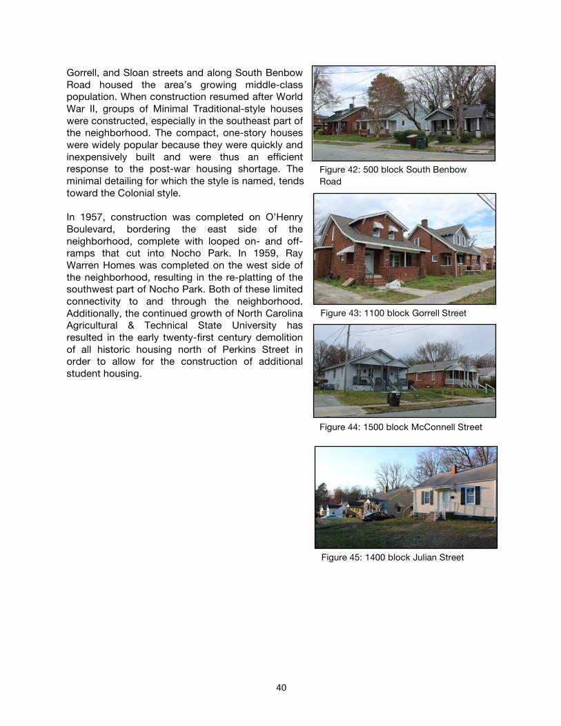
40
Gorrell, and Sloan streets and along South Benbow Road housed the area’s growing middle-class population. When construction resumed after World War II, groups of Minimal Traditional-style houses were constructed, especially in the southeast part of the neighborhood. The compact, one-story houses were widely popular because they were quickly and inexpensively built and were thus an efficient response to the post-war housing shortage. The minimal detailing for which the style is named, tends toward the Colonial style. In 1957, construction was completed on O’Henry Boulevard, bordering the east side of the neighborhood, complete with looped on- and off-ramps that cut into Nocho Park. In 1959, Ray Warren Homes was completed on the west side of the neighborhood, resulting in the re-platting of the southwest part of Nocho Park. Both of these limited connectivity to and through the neighborhood. Additionally, the continued growth of North Carolina Agricultural & Technical State University has resulted in the early twenty-first century demolition of all historic housing north of Perkins Street in order to allow for the construction of additional student housing.
Figure 42: 500 block South Benbow Road
Figure 43: 1100 block Gorrell Street
Figure 44: 1500 block McConnell Street
Figure 45: 1400 block Julian Street

41
Clinton Hills Subdivision East Side and Marboro drives; Bellaire, Cambridge, Curry, East Florida, Julian, Oxford, Stephens, and Tuscaloosa streets; South Benbow Road; Broad Avenue; South Side Boulevard Laid out in 1926 by white developers on formerly agricultural lands, the Clinton Hills development (GF9144 and GF9147) may be the first African American suburban development in Greensboro to utilize curvilinear street patterns. Located just south of the Nocho Park development, it is one of a number of subdivisions platted as a response to the growth of Bennett College and NC A&T in the early twentieth century. Yet, by the late-1920s, the land east and southeast of Benbow Road was one of only a few pockets of undeveloped land within
the corporate limits of Greensboro. Further, the African American developments in east Greensboro were the exception to extensive post-World War II growth outside of the corporate limits. Thus, this area featured land that had been planned and platted, but as late as 1957 remained largely unbuilt.84 The two 1926 plats of Clinton Hills are arranged with South Benbow Road as the main north-south thoroughfare through the neighborhood. The northern plat, which extends mostly east from South Benbow Road, has lots arranged around curved streets that follow a natural ravine that extends as a natural boulevard down the center of East Side Drive. The southern plat, which extends mostly west from South Benbow Road, is also oriented around a green space on South Side Boulevard that was platted to be a boulevard similar to that on East Side Drive. However, it was not completed because houses were never constructed on the north side of
84 Baylin, “An Historical Study of Residential Development in Greensboro, 1808-1965,” 84-87.
Figure 46: Map of Clinton Hills Subdivision

42
the street and that area remains a natural area. A second green space, designated as Benbow Park, extends on the east side of South Benbow Road. Lots throughout the development were platted with consistent 50’ street frontage. However, in the north part of the neighborhood, lots were frequently combined to create lots with 100’ to 150’ of frontage to accommodate the sprawling Ranch and Modernist-style houses constructed in that area. Conversely, the south end of the neighborhood remained largely undeveloped and in 1956, much of it was re-platted with slightly large lots (most measuring 60’ of street frontage) and to accommodate alterations to the street grid along Bennett, East Florida, and Oxford Streets. Houses in the north part of the neighborhood were largely custom built and thus display a wide variety of forms and styles. A number of them were designed by one of Greensboro’s noted African American architects and collectively they represent some of Greensboro’s best examples of Modernist residential architecture. Others in the northern part of the neighborhood and extending along South Benbow Road were more typical Ranch houses or cottages with Colonial or Tudor Revival detailing. Houses in the re-platted south end of the neighborhood, along Bellaire, Cambridge, Curry, East Florida, Oxford, and Stephens streets were speculatively built by Joseph Koury and Bill Kirkman, white builders who went on to develop the adjacent Benbow Park subdivision. They represent a limited number of four-bay-wide, hipped and side-gabled forms executed with varying details. The small-scale, Ranch houses all have brick veneers and while several have Colonial Revival-style detailing including multi-light windows with paneled aprons, most have more Modernist detailing including including grouped awning windows in the public space and high awning windows lighting the bedrooms.
Figure 48: 1800 block Curry Street
Figure 49: 900 block Stephens Street
Figure 47: 1200 block Julian Street

43
Benbow Park Subdivision Belcrest, Eton, and Lakeland drives; Carlton and Drexmore avenues; Britton, Finley, and East Florida streets; Chelsea Lane; New Castle Road; South Side Boulevard Developed in five separate plats dating from February 1959 to February 1962, the Benbow Park subdivision (GF9143) illustrates Olmstedian principles, including curvilinear streets, large lots with deep setbacks, and the retention of mature tree canopies. The west part of the subdivision, along South Benbow Road was originally platted as part of the adjacent Clinton Hills development. However, when it remained undeveloped by the late 1950s, the land was replatted and developed with the Benbow Park subdivision. While this area was already within the corporate limits, the development of Benbow Park followed a large annexation of land in 1957, the result of which was a focus on concentrated development
within the corporate boundaries where public utilities were available. Yet, the African American neighborhoods in the southeast part of the city saw relatively static growth in the 1950s and 1960s when compared with the growth of white neighborhoods in the west and northwest.85 The Clinton Hills and Benbow Park developments are linked in a number of ways. The streets that intersect South Benbow Road on the west side of the Benbow Park subdivision, are located at regular intervals and align with the street grid of the Clinton Hills subdivision on the opposite side of Benbow
Road. Additionally, the greenspace and public park located just southwest of the Benbow Park subdivision bears the name of the subdivision, despite having been platted with the Clinton Hills development. 85 Baylin, “An Historical Study of Residential Development in Greensboro, 1808-1965,” 90.
Figure 50: Map of Benbow Park Subdivision (GF9143)
Figure 51: 1100 block of East Florida Street (GF9143)

44
Streets within the subdivision curve throughout in response to the gentle rolling terrain, to slow traffic, and to provide varied views as one moves through the area. In the southwest part of the subdivision, houses on corner lots are angled to face the intersections, a practice typical in postwar developments and espoused by the Urban Land Institute.86 Streets and building lots on the east side of the subdivision are largely straight and rectangular, respectively, a response to the north-south North O’Henry Boulevard (US-220) that borders the east end of the subdivision. Houses in the subdivision were almost entirely speculatively built with several variations of the Ranch and Split Level forms repeated throughout the subdivision. Colonial Revival details on the majority of the houses—Including multi-light double-hung windows, paneled aprons, modillion and dentil cornices, paneled doors, and classical surrounds—stand in stark contrast to the more Modernist styles and details found in the adjacent Clinton Hills development. Their presence is indicative of the subdivision’s development by white developers and builders who employed the styles and details popular in white subdivisions of the era. Most of the houses in the subdivision were constructed using one of the following four forms. Four-bay Ranch Side-gabled, four-bay Ranch houses are one of the most common forms in the subdivision. Several have a projecting center bay, sheltered by the main overhang of the roof, while others have a stepped roofline, allowing for one half of the façade to be inset by about a foot. Most have double-hung windows with paneled aprons. A few have more Modernist detailing including grouped awning windows in the public space and high awning windows lighting the bedrooms. Five-bay Ranch A number of side-gabled Ranch houses have five-bay facades, emphasizing the horizontality of the form. These are most often detailed with double-hung windows and Colonial Revival-style door surrounds. Ranch with Projecting Front-gabled Wing A variation on the four-bay Ranch, this house has a two-bay-wide, projecting, front-gabled wing on one end of the façade. The wing typically has double-hung windows and partial gable returns. The main body of the house has the entrance and a large window—either paired windows, a bow window, or a picture window—lighting the interior living space.
86 Mott, Seward and Max Wehrly (editors). The Community Builders Handbook (Washington D.C., Urban
Land Institute, 1947).
Figure 52: 1202 Eton Drive
Figure 53: 2214 New Castle Road
Figure 54: 1905 Drexmore Avenue

45
Split Level Split Level houses were constructed throughout the subdivision, though the largest concentration of them is along Carlton Avenue at the east side of the development. The houses most often have brick veneer on the one-story wing and the lower level of the two-story wing with wood or aluminum siding or vertical board-and-batten above. Colonial Revival-style details include eight-over-eight wood-sash windows, partial gable returns, cornices, and exposed purlins supporting the cantilevered second floors. Picture or bow windows on the one-story section light the main living space. Several examples have classical door surrounds and, in rare instances, porches shelter the entrances.
Ray Warren Homes
1300 East Gate City Boulevard Built in 1959 Ray Warren Homes (GF9133) was Greensboro’s third public housing development and its first integrated development. The complex of 70 buildings (containing 236 housing units) was named for Ray Warren, the Greensboro Housing Authority’s first Executive Director (serving from 1941-1956). The development replaced early twentieth century housing that had been designed in 1937 by the Home Owner Loan Corporation (HOLC) to be “fourth grade” housing, “largely consisting of cheap type of negro cottages.” The 1950 Sanborn map shows dense housing only at the northwest corner of the development, with much of the remaining land still vacant. The area was cleared of existing
housing and the street patterns realigned to construct the development. The layout of the development is consistent with mid-twentieth century suburban residential development with the one- and two-story buildings, though closely spaced, arranged around
Figure 56: Map of Ray Warren Homes (GF9133)
Figure 55: 1805 Carlton Avenue

46
curvilinear streets. Mature trees shade the grassy lawns around the buildings, some of which are oriented toward concrete paths between the buildings. The buildings are mostly two-story, side-gabled, brick four-plexes with stepped rooflines that divide each building into two adjacent duplexes. Other buildings are one-story handicap accessible units. The buildings all have brick veneers, vinyl windows, flush eaves and wood shingles in the gable ends. Doors are solid wood doors and are sheltered by either front-gabled, single-bay porches or hip-roofed, two-bay porches, each supported by square posts. Similar to the natural green spaces planned for inclusion in middle- and upper-class suburbs, the housing development includes a paved basketball court, a baseball field, and a modern playground on the north end, adjacent to Gate City Boulevard. Adjacent to the park is a community building housing the Boys & Girls Club, a Kids Café, and the management office for the complex. Southeast of the community building is the R. W. Child Development Center (715 Burbank). Washington Street Redevelopment Bennett, High, Hargett, Perkins, and East Washington streets The Washington Street Redevelopment (GF9145) dates to the 1970s. Home Owner Loan Corporation (HOLC) maps and notes from as early as 1937 designate this area as “third grade” housing, but a “good residential section” with “close proximity to colored college being a contributing factor.” The 1950 Sanborn map shows a dense collection of small homes, albeit on misaligned streets, the product of gradual, organic development over time. While Clinton Hills and Benbow Park experienced significant growth from the 1950s through the 1970s, this area appears to have declined. The Redevelopment Commission of Greensboro, established in 1951, targeted the area in the 1960s with the redevelopment plan implemented in the early 1970s. The City of Greensboro cleared the
Figures 59 and 60: 400 and 500 blocks of Hargett Street (GF9145)
Figures 57 and 58: Ray Warren Homes (GF9133)

47
land, reserving only two houses in the 500 block of Bennett Street and a handful of buildings near the intersection of East Washington and Law Streets. Once cleared, they altered the street grid, removing Best and Armstrong/Connell Road entirely to create longer and wider blocks, and creating the loop at the west end of Perkins Street (which originally extended west all the way to Bennett Street. The full block bordered by East Washington, Law, Gorrell, and Hargett streets was reserved for the Washington Street School. Original plats from 1971, 1973, and 1977 show large rectangular lots measuring 75-90’ wide and 147-170’ deep. Following recommendations espoused by the Urban Land Institute in the 1950s and 1960s, the plat included roughly square-shaped lots at the corners of blocks, which allowed for a single lot to face each of the cross-streets. However, the plan was not carried out with those lots in place. Housing throughout the development is very consistent, though with slight variations evident between the three separately platted areas. The repetitive Ranch and Split Level forms are
indicative of construction by a single entity. While the Benbow Park subdivision was similarly constructed with repetitive Ranch and Split Level forms, the curvilinear street pattern, narrower streets, and mature trees serve to both identify the neighborhood as a cohesive, contained entity, and contribute character to the streetscape that is generally lacking in this area.
Figure 61: Map of Washington Street Redevelopment (GF9145)

48
RECOMMENDATIONS National Register Study List The following resources are proposed for placement on the North Carolina National Register Study List as potentially eligible for listing in the National Register of Historic Places: J. Kenneth Lee House, 1021 Broad Avenue The J. Kenneth Lee House (GF6168) appears eligible for the National Register under Criterion C for Architecture. Designed by local African American architect W. Edward Jenkins, the flat-roofed, Modernist-style house was completed in 1959. The core of the house is roughly rectangular with a triangular projection on the right (east) elevation that houses an indoor pool. The house has a Roman brick veneer and stacked, one-light, wood-sash awning windows, generally grouped. The entrance, located near the center of the façade is inset and has paired doors flanked by wide, one-light sidelights. A single palm tree just outside the door extends above the cut-out roofline. Flanking the entrance/foyer are two dome-shaped skylights. Just beyond the entrance is a wide living and dining room separated by a two-sided stone fireplace with brick chimney and lit by clerestory windows along the south elevation of the shed roof. A glassed sunroom extends along the rear wall of the living and dining rooms, visible on the rear (north) elevation. To the right (east) of the entrance are the bedrooms, defined on the exterior by grouped windows with vertical wood sheathing between each group, all above a brick half-wall. The triangular-shaped pool room on the right elevation features bands of one-over-one double-hung windows above a brick half-wall and pierced brick wall at the basement level below. To the left (west) of the entrance is a projecting bay with two exterior doors, sheltered by a flat-roofed carport. The carport is supported on the front (south) wall by a full-height brick wall with several square “cut-outs” at the top of the wall. The kitchen and family room spaces at the left end of the house are have paired double-hung windows and open to a patio space at the left end of the façade that is partially enclosed by a brick half-wall.
Figures 62 and 63: J. Kenneth Lee House (GF6168) 1021 Broad Street, facing north (top) and west (bottom)
Figure 64: J. Kenneth Lee House (GF6168) 1021 Broad Street, foyer facing southeast

49
A spiral stair at the west end of the entrance/foyer (said to have been taken from the ship on which Lee served while in the military) leads to a full, finished basement. Both the interior and the exterior of the house retain integrity of design, materials, and workmanship. Its original plan and many original features, including a stone fireplace; exposed beams in the living, dining, and sunroom; hardwood floors in the entry, hallways, living, and dining rooms; doors and trim; and an interior pool remain in place. The house stands on a large lot at the northwest corner of Broad Street and South Benbow Road. It is set well back from the road and accessed by a circular drive that extends through the covered carport at the left end of the façade. The house may also be eligible for the National Register under Criterion B for its association with J. Kenneth Lee. Born in Charlotte, Lee graduated from North Carolina Agricultural & Technical State University with a degree in Electrical Engineering in 1945 and served in the Navy as electrician’s mate during World War II. In 1951, after a lengthy lawsuit, Lee, along with Harvey Beech, became the first two African Americans to attend the University of North Carolina at Chapel Hill Law School, and they were the first African American graduates of the Law School in 1952. During his 38 years of legal practice, Lee participated in more than 1700 Civil Rights lawsuits and various Civil Rights leaders and organizations met in the Lee House. Lee was also a founder of American Federal Savings & Loan, the second African American-owned thrift in the state, as well as serving on numerous boards and commissions. Lee remained in the house until 2018 when he moved to assisted living and died soon after at the age of 94.87 The boundary should include the entire 0.77-acre parcel historically associated with the property. The Period of Significance is 1959, the date of construction. An extended period of significance may be appropriate for a Criterion B argument.
87 North Carolina Architects and Builders website.
Figures 65, 66, 67, and 68: J. Kenneth Lee House (GF6168) 1021 Broad Street, (from top to bottom) living room facing southwest, living room facing northwest, pool room facing east, basement living area
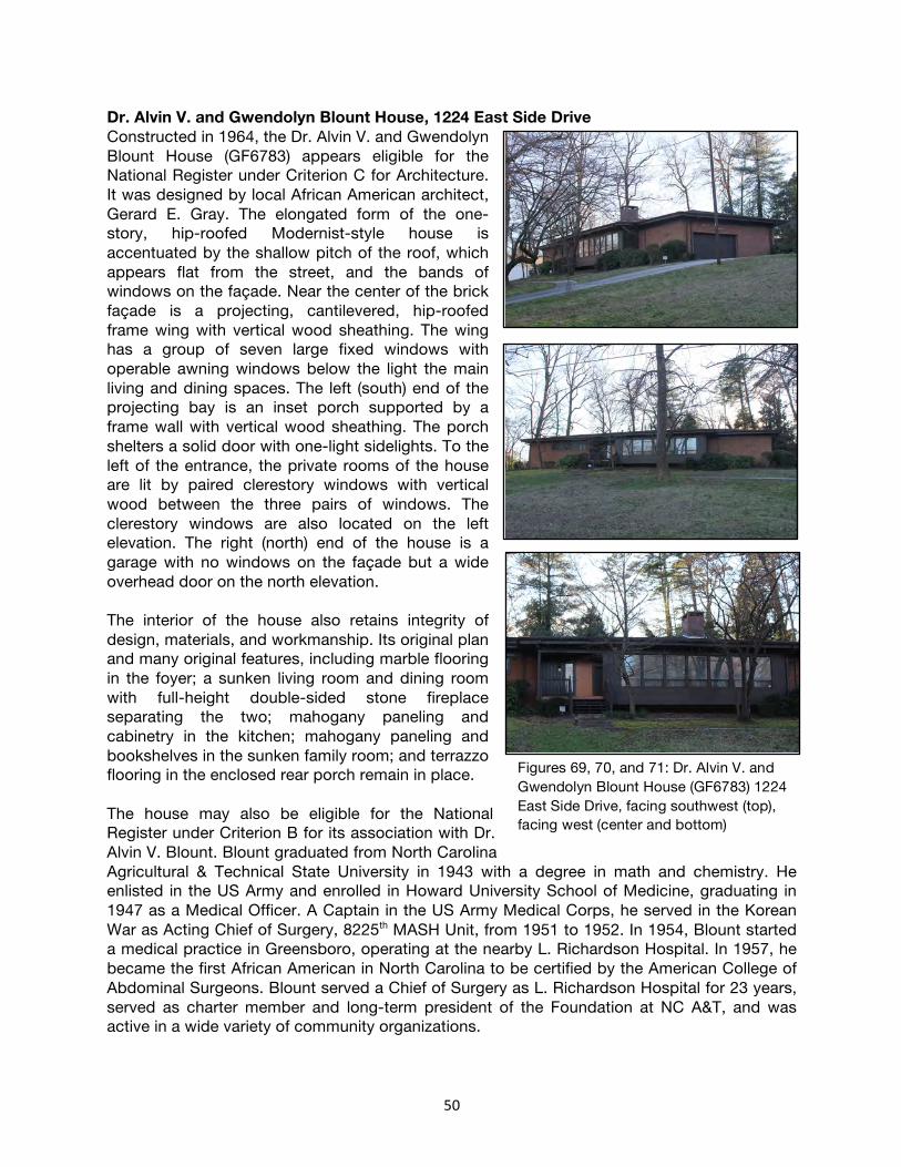
50
Dr. Alvin V. and Gwendolyn Blount House, 1224 East Side Drive Constructed in 1964, the Dr. Alvin V. and Gwendolyn Blount House (GF6783) appears eligible for the National Register under Criterion C for Architecture. It was designed by local African American architect, Gerard E. Gray. The elongated form of the one-story, hip-roofed Modernist-style house is accentuated by the shallow pitch of the roof, which appears flat from the street, and the bands of windows on the façade. Near the center of the brick façade is a projecting, cantilevered, hip-roofed frame wing with vertical wood sheathing. The wing has a group of seven large fixed windows with operable awning windows below the light the main living and dining spaces. The left (south) end of the projecting bay is an inset porch supported by a frame wall with vertical wood sheathing. The porch shelters a solid door with one-light sidelights. To the left of the entrance, the private rooms of the house are lit by paired clerestory windows with vertical wood between the three pairs of windows. The clerestory windows are also located on the left elevation. The right (north) end of the house is a garage with no windows on the façade but a wide overhead door on the north elevation. The interior of the house also retains integrity of design, materials, and workmanship. Its original plan and many original features, including marble flooring in the foyer; a sunken living room and dining room with full-height double-sided stone fireplace separating the two; mahogany paneling and cabinetry in the kitchen; mahogany paneling and bookshelves in the sunken family room; and terrazzo flooring in the enclosed rear porch remain in place. The house may also be eligible for the National Register under Criterion B for its association with Dr. Alvin V. Blount. Blount graduated from North Carolina Agricultural & Technical State University in 1943 with a degree in math and chemistry. He enlisted in the US Army and enrolled in Howard University School of Medicine, graduating in 1947 as a Medical Officer. A Captain in the US Army Medical Corps, he served in the Korean War as Acting Chief of Surgery, 8225th MASH Unit, from 1951 to 1952. In 1954, Blount started a medical practice in Greensboro, operating at the nearby L. Richardson Hospital. In 1957, he became the first African American in North Carolina to be certified by the American College of Abdominal Surgeons. Blount served a Chief of Surgery as L. Richardson Hospital for 23 years, served as charter member and long-term president of the Foundation at NC A&T, and was active in a wide variety of community organizations.
Figures 69, 70, and 71: Dr. Alvin V. and Gwendolyn Blount House (GF6783) 1224 East Side Drive, facing southwest (top), facing west (center and bottom)

51
At the time of his death, Dr. Blount was the last living litigant in the case of Simkins v. Moses Cone Hospital (1963), the landmark Supreme Court decision that desegregated hospitals throughout the South. Following the lawsuit, in 1964, he became the first African American physician to perform a surgery at Cone Hospital. In September of 2016, Cone Hospital honored Dr. Blount by issuing an apology for its segregationist past and awarding a $250,000 scholarship to the Greensboro Medical Society in honor of Blount and his fellow Supreme Court litigants. Blount died in 2017 at the age of 94; the house is still owned by his children. The boundary should include the entire 0.57-acre parcel historically associated with the property. The Period of Significance is 1964, the date of construction. An extended period of significance may be appropriate for a Criterion B argument.
Figures 72, 73, and 74: Dr. Alvin V. and Gwendolyn Blount House (GF6783) 1224 East Side Drive, living room fireplace (top), den (center), and kitchen (bottom)

52
William Streat House, 1507 Tuscaloosa Street Designed by African American architect William Streat as his personal residence, this c.1965 split-level, Modernist-style house (GF4863) appears eligible for the National Register under Criterion C for Architecture. The brick-veneered house, as viewed from the street, has a typical split-level form with a one-story, side-gabled wing on the left (west) that houses the foyer, kitchen, dinette, dining room, and living room. A two-story, flat-roofed wing at the right (east) features bedrooms at the upper level and additional family living space at the lower level. The one-story wing is five bays wide with the entrance inset at the right (east) bay. The solid wood door with one-light sidelight to its right is accessed by an uncovered brick terrace that extends across the right two bays of the wing and is encircled with a brick knee wall. Windows to the left of the entrance are paired, one-light, slider windows. An engaged carport on the left end of the wing is supported by full-height brick walls on the left gable end. The two-story wing on the right projects beyond the facade of the one-story wing. It has paired slider windows on the first-floor level. The second floor, which overhangs the first on the façade and right elevations, is supported by purlins, has vertical wood sheathing and large, triple, slider windows. The two-story, flat-roofed brick wing at the rear has an exterior brick chimney on the east elevation and grouped windows. Paired sliding glass doors on the upper level of the rear elevation open to an elevated wood deck with a half wall that is sheathed with vertical wood. The interior of the house also retains integrity of design, materials, and workmanship. Its original plan remains intact, as do many original features, including exposed beams, clerestory windows, and a two-sided brick and wood fireplace separating the living room and dining room; cabinetry in the kitchen; tile in the bathrooms; and paneling in the foyer, living room, and basement-level rooms. Streat earned degrees from Hampton Institute and the University of Illinois. He began his career as a Professor of Architectural Engineering at North Carolina Agricultural & Technical State University in 1949 and was later chair of the department. He worked as a structural consultant for local architect Edward Loewenstein from 1950 to 1952. In 1952 Streat became the second registered African-American architect in North Carolina and the second African American to join the North Carolina Chapter of the AIA.
Figures 75, 76, and 77: William Streat House (GF4863) 1507 Tuscaloosa Street, facing north (top), facing south west (center), and facing east (bottom)

53
The house stands at the northwest corner of Tuscaloosa Street and Marboro Drive with a flagstone terrace at the rear. The boundary should include the entire 0.43-acre parcel historically associated with the property. The Period of Significance is c. 1965, the date of construction.
Figures 78, 79, and 80: William Streat House (GF4863) 1507 Tuscaloosa Street, living room facing west (top), kitchen facing southeast (center), and front hall facing east (bottom)

54
Benbow Road Historic District The Benbow Road Historic District (GF9147) appears eligible for the National Register under Criterion A for Community Planning and Development, Criterion A for African American Ethnic Heritage and Social History, and Criterion C for Architecture. The district may also be eligible under Criterion A for its association with Civil Rights activities in Greensboro and throughout the state. The planned African American development was initially platted as several separate developments including: Clinton Hills in 1936, Spaulding Park in 1955 and 1956, Spaulding Heights in 1964, and a number of other smaller plats. While the latter were gridded extensions of earlier streets, the largest platted area, Clinton Hills, may be the first African American suburban development in Greensboro to utilize curvilinear street patterns. It was laid out to follow natural ravines in the area, with a planned natural green space forming a boulevard along East Side Drive and Marboro Street, extending parallel to, and echoing the arch of East Side Drive. The automobile-oriented development follows planning principals typical of twentieth century suburban residential development, and features concrete curbs and gutters, concrete driveways to each house, but sidewalks are generally limited to South Benbow Road, the main thoroughfare through the district. Lots throughout the development were platted with consistent 50’ street frontage. However, lots were frequently combined to create lots with 100’ to 150’ of frontage to accommodate the sprawling Ranch and Modernist-style houses. Houses were largely custom built and thus display a wide variety of forms and styles. A number of them were designed by one of Greensboro’s noted African-American architects and collectively they represent some of Greensboro’s best examples of Modernist residential architecture. Others, especially those along South Benbow Road were more typical Ranch houses or cottages with Colonial or Tudor Revival detailing. Finally, a cluster of small-scale, Minimal Traditional-style houses are located along Julian Street in the northeast corner of the district. Vinyl windows, siding, and trim are common in the district. Yet, the overall material integrity of the buildings remains high with few alterations to the building forms and little infill construction that post-dates the original development of the district. Sections of the original plats with more significant alterations have been excluded from the district boundary. Thus the district maintains integrity of location, design, setting, materials, workmanship, feeling, and
Figures 81, 82, and 83: 1200 block East Side Drive (top), 1600 block Tuscaloosa Street (middle), and 1201 South Benbow Road (bottom)

55
association.
Located just south of the Nocho Park development, the Benbow Road area is one of a number of residential areas that grew as a response to the growth of Bennett College and NC A&T in the early twentieth century. The area was planned and built for Greensboro’s growing African American upper and middle classes. Occupants included teachers, doctors, lawyers, architects, engineers, professors at North Carolina Agricultural and Technical State University. A number of clergymen also resided in the district, earning the area near the intersection of South Benbow Road and Broad Avenue the nickname “Religion Hill.” Several residents—including J. Kenneth Lee, Dr. Alvin V. Blount, and Justice Henry Frye—were influential in Civil Rights lawsuits and legislation. Many other residents participated in Civil Rights activities including sit-ins
and other forms of protest. A full inventory of buildings and occupants will undoubtedly uncover significant connections to Greensboro’s larger Civil Rights history. The period of significance extends from 1936, when the earliest part of the neighborhood was platted, to about 1973, when the area was largely built out. The boundary of the Benbow Road Historic District includes the majority of resources within the Clinton Hills (1936), Spaulding Park (1955/1956), and Spaulding Heights (1964) platted developments, excluding areas along Julian Street that have been significantly altered, excluding properties at the southwest part of the development that were re-platted developed later, and including other adjacent properties that are consistent with the architecture and social history of the proposed district. The district extends along South Benbow Road, roughly bounded by the properties on the west side of South Benbow Road, Julian Street on the north, O’Henry Boulevard (US-220) on the east, and Ross Avenue on the south.
Figure 84: Map of the Benbow Road Historic District (GF9146)

56
Clinton Hills Historic District The Clinton Hills Historic District (GF9144) appears eligible for the National Register under Criterion A for Community Planning and Development and Criterion C for Architecture. The planned African American development was initially platted in 1926 and followed planning principals typical of twentieth century suburban residential development. The automobile-oriented development features an irregular street pattern laid out to follow a natural ravine in the area and to incorporate street curves along Bennett and East Florida streets. The development includes concrete curbs and gutters and concrete driveways to each house, though sidewalks are limited to the major thoroughfares of South Benbow Road and the west end of East Florida Street. A creek extends through a natural green space on the north side of South Side Boulevard. The area was initially platted in 1926 and included lots with consistent 50’ street frontage. However, in 1956, when the area neighborhood remained largely undeveloped, it was re-platted by Joseph Koury and Bill Kirkman (through the entity Better Homes, Inc.), white builders who went on to develop the adjacent Benbow Park subdivision in 1959. The new plat included slightly larger lots (most measuring 60’ of street frontage) and accommodated alterations to the street grid along Bennett, East Florida, and Oxford Streets. Further, the re-plat featured corner lots sized to allow houses on those lots to face the intersections, a practice typical in postwar developments and espoused by the Urban Land Institute. Koury and Kirkman constructed houses throughout the district, along Bellaire, Cambridge, Curry, East Florida, Oxford, and Stephens streets. The houses were predominantly four-bay-wide, hipped and side-gabled Ranch houses, executed with varying details. The small-scale houses all have brick veneers and while several have Colonial Revival-style detailing including multi-light windows with paneled aprons, most have more Modernist detailing including grouped awning windows in the public space and high awning windows lighting the bedrooms. Houses along South Benbow Road did not necessarily follow
Figures 85 and 86: 900 block Stephen Street (top) and 800 block Cambridge Street (bottom)
Figures 87 and 88: 927 Stephen Street (top) and 1700 South Side Boulevard (bottom)
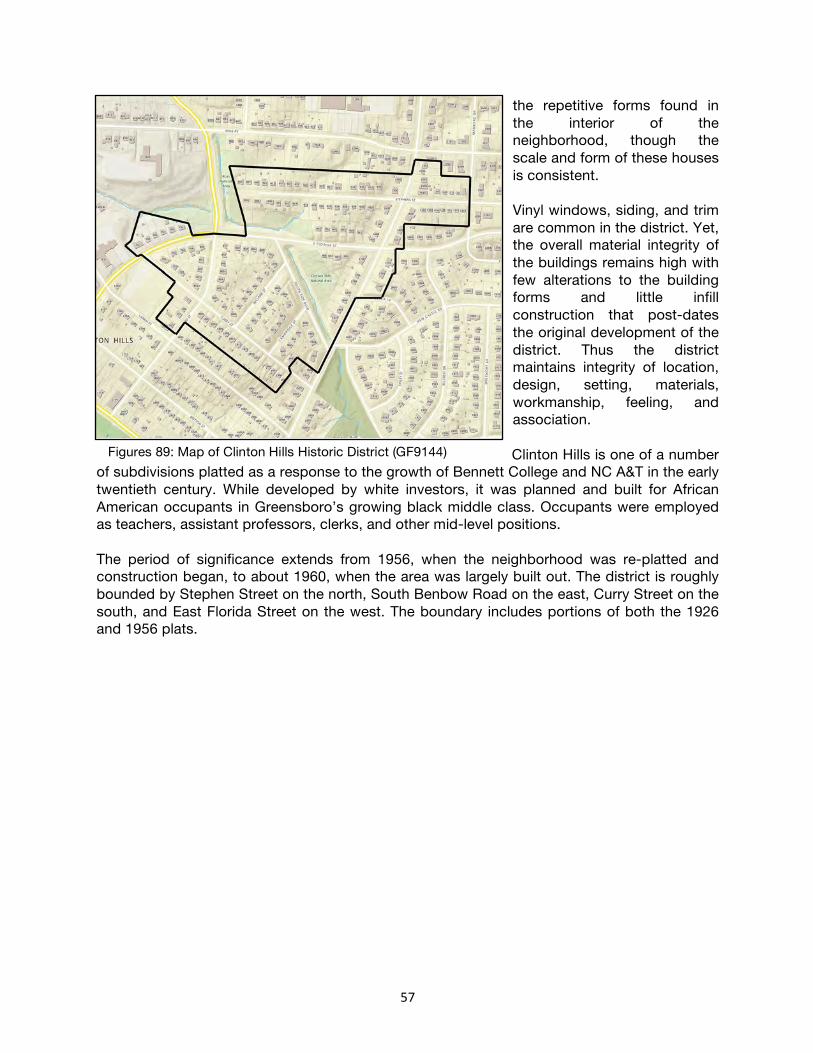
57
the repetitive forms found in the interior of the neighborhood, though the scale and form of these houses is consistent. Vinyl windows, siding, and trim are common in the district. Yet, the overall material integrity of the buildings remains high with few alterations to the building forms and little infill construction that post-dates the original development of the district. Thus the district maintains integrity of location, design, setting, materials, workmanship, feeling, and association. Clinton Hills is one of a number
of subdivisions platted as a response to the growth of Bennett College and NC A&T in the early twentieth century. While developed by white investors, it was planned and built for African American occupants in Greensboro’s growing black middle class. Occupants were employed as teachers, assistant professors, clerks, and other mid-level positions. The period of significance extends from 1956, when the neighborhood was re-platted and construction began, to about 1960, when the area was largely built out. The district is roughly bounded by Stephen Street on the north, South Benbow Road on the east, Curry Street on the south, and East Florida Street on the west. The boundary includes portions of both the 1926 and 1956 plats.
Figures 89: Map of Clinton Hills Historic District (GF9144)

58
Benbow Park Historic District The Benbow Park Historic District (GF9143) appears eligible for the National Register under Criterion A for Community Planning and Development and Criterion C for Architecture. The planned African American development was platted from February 1959 to February 1962, employing planning principals typical of twentieth century suburban residential development. The automobile-oriented development, features concrete curbs and gutters, concrete driveways to each house, but no sidewalks. Large lots with deep setbacks and curvilinear streets enhance the gentle rolling terrain of the area, which slopes generally downward toward South Side Boulevard. In the southwest part of the subdivision, houses on corner lots are angled to face the intersections, a practice typical in postwar developments and espoused by the Urban Land Institute. Streets and building lots on the east side of the subdivision are largely straight and rectangular, respectively, a response to the north-south North O’Henry Boulevard (US-220) that borders the east end of the subdivision. The west part of the subdivision, along South Benbow Road was originally platted as part of the adjacent Clinton Hills development. However, when it remained undeveloped by the late 1950s, the land was replatted and developed with the Benbow Park subdivision. Thus, the greenspace and public park located just southwest of the district bear the name of the subdivision, despite having been platted with the Clinton Hills development. The subdivision was platted and developed by Joseph Koury and Bill Kirkman (through the entity Better Homes, Inc.). Koury formed a cloth weaving company with his brother in the 1940s, but soon teamed up with Fred Williams to purchase and cut up buildings from the World War II Overseas Replacement Depot, his foray into homebuilding. Kirkman worked as a draftsman for noted Greensboro architect Edward Loewenstein in the 1940s, before leaving to start his own home building company about 1950.88
88 Barkley, Meredith. “Kirkman & Koury: Opposites Attract to Form one of the Largest Home-Building
Operations in Greensboro History.” Greensboro News & Record. March 21, 1998. Accessed via https://greensboro.com/kirkman-koury-opposites-attract-to-form-one-of-the-largest-home-building-operations-in-greensboro/article_213210c4-8a8f-5ca6-ad25-6ade1f95625e.html September 1, 2020.
Figures 90 and 91: 1200 block Eton Drive (top) and 1900 block Carlton Avenue (bottom)

59
Koury and Kirkman joined forces formally in 1952 to form Kirkman and Koury Homebuilders. The company capitalized on the housing shortages of the 1950s, building more than 8,000 houses in both white and black neighborhoods throughout Greensboro in the span of about 20 years. By 1960, when Benbow Park was being developed, the pair was building roughly 300 homes a year. They were able to erect houses so quickly in part because they employed a staff of about 300, manufactured their own wall units and roof trusses in a local factory, and further controlled the supply chain by maintaining their own supply company, Craft Building Supply Company.89 Houses in the subdivision were almost entirely speculatively built with four easily identified variations of the Ranch and Split Level forms repeated throughout the subdivision. Colonial Revival details on the majority of the house include multi-light double-hung windows, paneled aprons, modillion and dentil cornices, paneled doors, and classical surrounds. These stand in stark contrast to the more Modernist styles and details found in the adjacent Clinton Hills development. Their presence is indicative of the subdivision’s development by white developers and builders who employed the styles and details popular in white subdivisions of the era. Vinyl windows, siding, and trim are common in the district. Yet, the overall material integrity of the buildings remains high with few alterations to the building forms and no infill construction that post-dates the original development of the district. Thus the district maintains integrity of location, design, setting, materials, workmanship, feeling, and association. While the district was developed by white homebuilders, it was planned and built for African American occupants in Greensboro’s growing black middle class. Occupants include teachers, engineers, postal workers, clerks and professors and employees of North Carolina Agricultural and Technical State University.
89 Barkley, Meredith. “Kirkman & Koury: Opposites Attract to Form one of the Largest Home-Building
Operations in Greensboro History.” Greensboro News & Record. March 21, 1998.
Figures 92 and 93: 2200 block Lakeland Road (top) and 1900 block Drexmore Avenue (bottom)
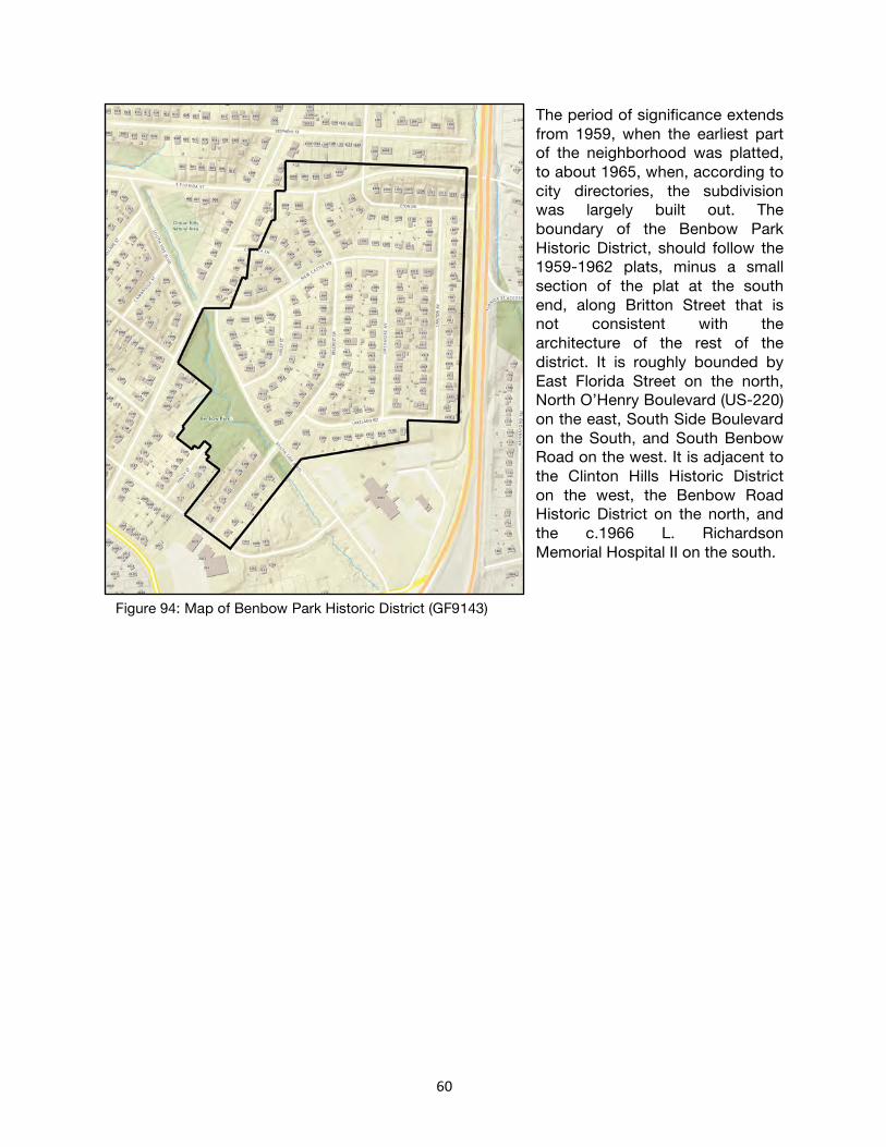
60
The period of significance extends from 1959, when the earliest part of the neighborhood was platted, to about 1965, when, according to city directories, the subdivision was largely built out. The boundary of the Benbow Park Historic District, should follow the 1959-1962 plats, minus a small section of the plat at the south end, along Britton Street that is not consistent with the architecture of the rest of the district. It is roughly bounded by East Florida Street on the north, North O’Henry Boulevard (US-220) on the east, South Side Boulevard on the South, and South Benbow Road on the west. It is adjacent to the Clinton Hills Historic District on the west, the Benbow Road Historic District on the north, and the c.1966 L. Richardson Memorial Hospital II on the south.
Figure 94: Map of Benbow Park Historic District (GF9143)

61
Additional Research Due to the Covid-19 pandemic, interior photographs and additional research were not available for the following properties. These properties have clear architectural significance, most having been designed by well-known African American architects that both lived and worked in the study area. Further, these properties—which include houses of prominent African Americans, African American churches, and a community center—may also have historic significance for their association with Greensboro’s Civil Rights movement and the Social History of Greensboro’s African American community during the mid-twentieth century. Thus, these properties require further study and verification of their interior integrity to make a determination of eligibility for placement on the National Register of Historic Places. These properties include: Bishop Wyoming Wells House/Justice Henry and Shirley Frye House, 1401 South Benbow Constructed about 1959, the Bishop Wyoming Wells House/Justice Henry and Shirley Frye House (GF9128) may be eligible for the National Register under Criterion C for Architecture. Located at the southeast corner of South Benbow Road and Tuscaloosa Street, the one-story, hip-roofed Ranch with a sprawling five-bay façade with attached garage wing was designed by W. Edward Jenkins in 1959 for Bishop Wyoming Wells, and listed as “under construction” in the 1960 city directory. The house has a brick veneer and two-over-two horizontal-pane wood-sash windows. A projecting, hip-roofed bay to the left of center has a twenty-light bow window. To its right (south) are two bays—a three-panel door with three-light sidelights and a triple window—that have vertical wood sheathing. On the far right end of the façade is a projecting hip-roofed bay with paired windows at the corner. At the right rear (southeast) is a hip-roofed frame wing. A gabled breezeway on the left (north) elevation is enclosed with jalousie windows. The breezeway connects to a two-bay-wide, hip-roofed garage with a group of awning windows on the left elevation and a cupola centered on the roofline. The house may also be eligible for the National Register under Criterion B for its association with Justice Henry Frye, who occupied the house beginning in 1976. Frye was a 1953 graduate of NC A&T and became a U. S. Air Force captain, serving in Korea and Japan. Despite his service, when he returned home and attempted to register to vote in 1956 he was told that he failed the required literacy test, an experience that led him to study law at the University of
Figures 95 and 96: Justice Henry and Shirley Frye House, 1401 South Benbow Road (GF9143)

62
North Carolina, graduating in 1959.90 Frye was the first African American first-year student to study law at UNC, the first African American to work in a U. S. Attorney’s office in North Carolina (in 1963), and in 1968 he became the first African American to be elected to the North Carolina House of Representatives since the Reconstruction era.91 His first bill introduced a constitutional amendment to abolish the literacy test. He went on to serve six terms in the state House and one term in the Senate before beginning his judicial career. He was sworn in as North Carolina’s first African American Supreme Court Justice in 1983 and in 1999 became the first African American Chief Justice in the state. Frye retired from the court until 2000 and remains in the house today. House, 1810 South Benbow Among the most overtly modernist houses in the area, this c.1973 house (GF6058) may be eligible for the National Register under Criterion C for Architecture, though the architect and the early history of the house is not known. The distinctive two-story, side-gabled house features a brick veneer at the first-floor level and vertical wood sheathing at the second floor, which cantilevers the first floor slightly. A group of four one-light clerestory windows are located on the right (north) end of the first floor and the left (south) end of the first floor is an open carport supported by metal posts on a tall brick wall. The second floor is three bays wide with two pairs of stacked awning windows on the left end of the façade and a group of four large fixed windows with operable awning windows below on the left end of the façade. The right gable end has a brick veneer that extends the full height of the elevation. The left gable end has an inset porch with a low knee wall. A one-story, gabled ell at the right rear (northwest) has vertical wood sheathing and paired fixed windows with operable awning windows below. Dr. Frank & Gladys White House, 1206 East Side Drive One of a number of Modernist-style houses on both sides of East Side Drive, the Dr. Frank & Gladys White House (GF6785) may be eligible for the National Register under Criterion C for Architecture. Designed by local architect William Streat and completed in 1965, this one-story, front-gabled house has a distinctive, low-sloped roof over the five-bay-wide façade. The house has a brick veneer, deep eaves, and large exposed purlins in the gables. Near the center of the façade is an inset entrance bay with paired solid wood doors with very wide,
90 Literacy tests were used from the 1850s to the 1960s as a means of disenfranchising African American
and other minority voters. 91 “Profiles of Prominent African-Americans in Greensboro.”
Figure 97: 1810 South Benbow Road (GF6058)
Figure 98: Dr. Frank & Gladys White House, 1206 East Side Drive (GF6785)

63
one-light sidelights and a three-part transom that extends all the way to the roofline. To the left (southeast) of the entrance is a large, three-part picture window. Windows on the right (northwest) end of the façade are one-light awning windows, two single windows and one triple window. The house was built for Dr. Frank White, a history professor at North Carolina Agricultural & Technical State University, and his wife Gladys. Annie Lee Holley House, 1206 Julian Street Located at the southwest corner of Julian Street and South Benbow Road, the Annie Lee Holley House (GF9138) may be eligible for the National Register under Criterion C for Architecture. Designed by local architect W. Edward Jenkins and completed about 1963, the split-level house has a two-story, hip-roofed wing on the left (east) and a one-story, side-gabled wing on the right (west). The two-story wing is three bays wide at the second-floor level with a brick veneer at the first floor that projects beyond the façade of the second-floor. The leftmost bay projects the farthest with the center bay projecting only slightly with an integrated brick planter in front of it that is lit by three pendant lights. The rightmost bay, the entrance bay, is flush with the second-floor, but sheltered by the shed roof that covers the other bays first-floor. The entrance bay has aluminum siding around a paneled door with three-light sidelights. The second floor has two-over-two horizontal-pane wood-sash windows, aluminum siding, and deep eaves. This part of the house is double-pile with a garage located at the front (north) of the left elevation. The one-story, side-gabled wing has a twenty-four-light bow window on the façade and an exterior brick chimney in the right gable end. A one-story, shed-roofed, brick wing extends from the left rear (southeast). The house was built about 1963 by Annie Lee Holley, a widow and teacher at Washington Street School. Holley was the sister of J. Kenneth Lee, who owned the nearby house at 1021 Broad Street. Milton H. Barnes House, 2219 Lakeland Drive Located at the northwest corner of Lakeland Drive and Carlton Avenue, the c.1966 Milton H. Barnes House (GF6066) may be eligible for the National Register under Criterion C for Architecture. The one-story, side-gabled, Modernist-style house, is set apart from the repetitive, speculatively built Ranches and split-level houses that make up the majority of the Benbow Park neighborhood. The core of the house is five bays wide and double-pile with a brick veneer and one-over-one wood-sash windows with paneled aprons on the façade. The center three bays of the façade are inset. Paired doors, each with two lights, are centered on the façade and accessed by brick steps. Paired windows on each side of the entrance are screened from the street by decorative, pierced concrete-block walls. Integrated planters are located between the building
Figure 99: Annie Lee Holley House, 1206 Julian Street (GF9138)
Figure 100: Milton H. Barnes House, 2219 Lakeland Drive (GF6066)

64
façade and concrete screen wall. A one-story, side-gabled, carport wing on the left (west) elevation is supported by metal posts on a brick knee wall. The right (east) side of the two-bay carport is enclosed with paired casement windows with shared one-light transoms on a knee wall with vertical wood siding. There is vertical wood sheathing in the left gables of the carport and main houses. The right gable end features paired slider windows near the top of the wall and narrow wood siding in the gable. A shed-roofed wing at the rear (north) has an exterior brick chimney on its right elevation. The house may also be eligible for the National Register under Criterion B for its association with Milton H. Barnes, a plaintiff with Dr. Blount in the case of Simkins v. Moses Cone Hospital (1963), the landmark Supreme Court decision that desegregated hospitals throughout the South. Windsor Community Center, 1601 East Gate City Boulevard The 1968 Windsor Community Center (GF9134) may be eligible for the National Register under Criterion A for African American Ethnic Heritage in the area of Recreation. Prominently sited at the northeast corner of East Gate City Boulevard and South Bennett Road, the building replaced an older community center on the site, which opened in 1937 and included a bathhouse, swimming pool, tennis courts, and playground.92 Both the earlier and the current community centers were named for William Blackstone Windsor, a prominent African American educator in Greensboro who was involved in the establishment of Greensboro’s Carnegie Negro Library, edited an African American newspaper called the Greensboro Herald, and was also an early activist in efforts to context racial segregation in Greensboro’s neighborhoods.93 The building may also be eligible under Criterion C for Architecture. The one-story, flat-roofed, Modernist-style building was designed by Charles M. Graves Organization in Atlanta. It has an exposed steel structure with white brick panels between the iron posts. There are no windows on the twenty-one-bay façade. However, a distinctive round entrance, faced with white brick, is centered on the façade. Within the round brick opening is an aluminum-framed glass wall with paired aluminum-framed glass doors. There is a hollow-core metal door west of the main entrance and additional hollow-core metal doors on the side elevations. Northeast of the main building is a large, two-story, flat-roofed gymnasium building of the same steel-framed construction with white brick panels. A 2019 mural on the rear (north) elevation of this wing depicts the “Greensboro Four.” Beyond the gymnasium are paved basketball courts.
92 “The Secrets of Nocho Park, Clinton Hills, and Benbow Park.” Preservation Greensboro.
https://preservationgreensboro.org/the-secrets-of-nocho-park-clinton-hills-and-benbow-park/) Accessed july 1, 2020.
93 “Profiles of Prominent African-Americans in Greensboro.”
Figures 101 and 102: Windsor Community Center, 1601 East Gate city Boulevard (GF9134)

65
Northwest of the main building is an in-ground swimming pool. It is surrounded by a concrete deck and is accessed by doors on the rear of the main building. St. Matthews United Methodist Church, 600 East Florida Street Constructed in 1970, St. Matthews United Methodist Church (GF9131) may be eligible for the National Register under Criterion C for Architecture. Designed by local African American architect W. Edward Jenkins, the building was completed in 1970 with the first services held in January 1971. The impressive, Modernist-style church has a one-story, flat-roofed, roughly square base. The sanctuary is located in the center of the building with an octagonal form rising from the center of the base and topped by a combination hipped and gabled roof and a bell tower rises from its center. The northeast, northwest, southeast, and southwest elevations of the octagonal structure have gabled roofs with stained glass filling the entire gable. The flat-roofed base has a blonde brick veneer and a shingled pent roof on all four elevations. The main entrance is centered on the northwest elevation, facing East Florida Street. It is located in a projecting bay and has paired, solid wood doors within an aluminum-framed glass wall that fills the entire bay. There are six bays each to the right (southwest) and left (northeast) of the entrance. Each has a narrow, aluminum-framed window that extends nearly the full height of the wall and has an operable awning window at its bottom. Projecting brick pilasters are located midway through each group of windows and at the outer corners of the façade. The left (northeast) and right (southwest) elevations matches the façade, though with smaller, single-door entrance bays that are flush with the elevation. The rear (southeast) elevation has pilasters matching the façade with few windows. The entrance on the right elevation is sheltered by a pent-roofed breezeway on full-height brick piers. The breezeway connects to a one-story, flat-roofed education wing with a pent roof matching the base of the church. The education wing has grouped windows with fixed sashes above operable awning windows, the windows filling the upper half of the façade between the brick pilasters. An entrance on the southwest elevation of the education wing, a solid wood door with narrow sidelights and a transom, is sheltered by a projecting pent roof on metal posts.
Figures 103, 104, and 105: St. Matthews United Methodist Church, 600 East Florida Street (GF9131)

66
The church may also be eligible for the National Register under Criterion A for African American Ethnic Heritage in the area of Social History. Organized in 1866 as the Warnersville Methodist Episcopal Church, it is the oldest African American church Greensboro and, according to the church website, is both the oldest and largest in the Western North Carolina Conference. The church also has close ties to Bennett College, which held inaugural classes at Warnersville Methodist Episcopal Church in 1873 due in part to the success of Rev. Matthew Alston in persuading the Freedman’s Aid Society to provide assistance to the school. The original church building was torn down about 1970 as part of Greensboro’s urban renewal efforts.94 Metropolitan United Methodist Church, 1701 East Market Street The 1976 Metropolitan United Methodist Church (GF9139) may be eligible for the National Register under Criterion C for Architecture. The front-gabled, Modernist-style church is located at the northeast corner of Market Street and North Benbow Road, set well back from the street with a grassy lawn on the west, south, and east elevations and parking at the rear and far east of the property. The sanctuary is located on the left (west) side of the building. The front-gabled form is five bays wide and eight bays deep with a brick veneer and steeply sloped roof with prowed eaves and deep overhangs. The five-bay façade is separated by brick pilasters with paired pilasters accentuating the middle bay. The center three bays have arched, stained-glass windows with projecting, arched brick surrounds. The windows extend nearly the full height of the gable. Inset exits on the right (east) and left ends of the façade are single hollow-core metal doors. Above the inset bays and extending up to the roofline are vertical wood fins. Matching fins are located at the top of the front gable. An integrated brick planter spans the center three bays of the façade. The left elevation features eight rectangular stained-glass windows with projecting brick pilasters between each pair of windows. The rear (north) elevation is relatively unadorned and features a blind brick wall divided by pilasters into five bays, and vertical wood in the gable. The right elevation of the sanctuary is obscured by a full-depth, flat-roofed wing with vertical wood at the roof fascia and a projecting, semi-octagonal bay, adjacent to the sanctuary, but set back from the façade of this wing. The building cornerstone is located at the southeast corner of this wing. A
94 “Profiles of Prominent African-Americans in Greensboro.”
Figures 106, 107, and 108: Metropolitan United Methodist Church, 1701 East Market Street (GF9139)

67
roughly square wing connects to the right rear of this wing, resulting in an L shape contains the entrance and administrative parts of the building and extends to the north beyond the rear elevation of the sanctuary. The formal entrance to the square-shaped portion of the building is located on the south elevation, facing East Market Street. The façade is three bays wide with the bays separated by brick pilasters. The center bay features paired wood doors flanked by rectangular stained-glass windows and the whole façade is sheltered by a front-gabled roof with deep eaves supported by square posts. The gable shelters only the entrance and does not extend to the building beyond. Instead, it is sheer with screens applied to a wood lattice. The right elevation is five bays deep with four pairs of one-light wood casement windows and paired hollow-core exit doors. The rear elevation is seven bays deep with paired casement windows and an accessible entrance. Mechanical equipment to the west of the flat-roofed wing and north of the sanctuary is screened by a brick wall.

68
BIBLIOGRAPHY Arnett, Ethel Stephens. Greensboro, North Carolina: The County Seat of Guilford. Chapel Hill,
NC: The University of North Carolina Press, 1955. Barkley, Meredith. “Kirkman & Koury: Opposites Attract to form one of the Largest Home-
Building Operations in Greensboro History.” Greensboro News & Record. https://greensboro.com/kirkman-koury-opposites-attract-to-form-one-of-the-largest-home-building-operations-in-greensboro/article_213210c4-8a8f-5ca6-ad25-6ade1f95625e.html
Baylin, Jonathan F. “An Historical Study of Residential Development in Greensboro, 1808-
1965.” Master’s thesis, University of North Carolina at Chapel Hill, 1968. North Carolina Collection. Louis Round Wilson Special Collections Library. University of North Carolina at Chapel Hill.
Briggs, Benjamin. “The Secrets of Nocho Park, Clinton Hills, and Benbow Park.” Preservation
Greensboro. https://preservationgreensboro.org/the-secrets-of-nocho-park-clinton-hills-and-benbow-park.
Brown, Marvin. “(Former) L. Richardson Memorial Hospital.” National Register of Historic
Places Nomination. 1992. Brown, Marvin. Greensboro: An Architectural Record: A Survey of the Historic and
Architecturally Significant Structures of Greensboro, North Carolina. Greensboro, NC: Preservation Greensboro Inc., The Junior League of Greensboro, The City of Greensboro, 1995.
Chafe, William H. Civilities and Civil Rights: Greensboro, North Carolina, and the Black Struggle
for Freedom. Oxford: Oxford University Press, 1980. City of Greensboro Planning Department. “Heritage Communities: Warnersville.”
https://www.greensboro-nc.gov/departments/planning/learn-more-about/historic-preservation/heritage-communities/warnersville.
City of Greensboro. “Redevelopment History in Greensboro.” www.greensboro-
nc.gove/home/showdocument?id=34234. Fripp, Gayle Hicks. Greensboro Volume II: Neighborhoods. Charleston, SC: Arcadia Publishing,
1998. Graybeal, Kaye. “Union Cemetery.” National Register of Historic Places Nomination. 1993. Greensboro Public Library. “Profiles of Prominent African-Americans in Greensboro.”
https://library.greensboro-nc.gov/home/showdocument?id=33341. Guilford County Register of Deeds. Greensboro, North Carolina.

69
Hairston, Otis L., Jr. Black America Series: Greensboro, North Carolina. Charleston, SC: Arcadia Publishing, 2003.
Hairston, Otis L, Jr. Picturing Greensboro: Four Decades of African American Community.
Charleston, SC: The History Press, 2007. Howell, Ross, Jr. “The Wright Stuff: Clinton E. Gravely’s Odyssey in Modern Architecture.”
O’Henry Magazine. http://www.ohenrymag.com/the-wright-stuff/?fbclid=IwAR0LA2UuNK82uD44SMaYhJivt_yamm2bA04eVBqygsP-L8L0Bp_rLj1_fGc.
Kipp, Samuel M. “Urban Growth and Social Change in the South, 1970-1920: Greensboro,
North Carolina as a Case Study.” PhD diss., Princeton University, 1971. University of North Carolina at Greensboro Digital Collections. http://libcdm1.uncg.edu/cdm/ref/collection/ttt/id/18757.
Little-Stokes, Ruth. An Inventory of Historic Architecture, Greensboro, NC. Greensboro, NC:
City of Greensboro and North Carolina Division of Archives and History, 1976. Lockwood, Nadine Sherri. “Bennett College for Women 1926-1966.” PhD diss., State
University of New York at Buffalo, 2004. North Carolina Collection. Louis Round Wilson Special Collections Library. University of North Carolina at Chapel Hill.
NC Modernist. www.ncmodernist.org. NC State University Libraries. “North Carolina Architects & Builders: A Biographical Dictionary.”
https://ncarchitects.lib.ncsu.edu. Personal Interview with Miltrene Jenkins Barden (community resident) by Eric Woodard (project
volunteer). Via telephone. July 2020. Robinson, Blackwell P. and Alexander R. Stoesen. “The History of Guilford County, North
Carolina, USA, to 1980, A.D.” Sydney M. Cone, Jr., ed. Greensboro, NC: The Guilford County Bicentennial Commission, 1971). Greensboro Public Library.
Sieber, H.A. White Water, Colored Water: The Historicity of the African-American Community of
Greensboro, North Carolina. Greensboro, NC: Project Homestead, Inc., 1993. North Carolina Collection. Louis Round Wilson Special Collections Library. University of North Carolina at Chapel Hill.
Stoesen, Alexander R. Guilford County: A Brief History. Raleigh, NC: North Carolina Division of
Archives and History, 1993. The University of Richmond, Virginia Tech, and the University of Maryland. “Mapping
Inequality: Redlining in New Deal America.” https://dsl.richmond.edu/panorama/redlining/#loc=5/39.1/-94.58.
Works Progress Administration. “Report of the Real Property Survey, Greensboro, North
Carolina.” Guilford Vertical Files. Greensboro Public Library. University of North

70
Carolina at Greensboro Digital Collections. http://libcdm1.uncg.edu/cdm/compoundobject/collection/UrbanDevGSO/id/7668/rec/13.

Survey Site # First Name, if any Name by which alphabetized House # St.Dir. Street/Road StatusGF1692 Dr. S. Powell Sebastian House 1401 McConnell SL1984
GF2035 St. Mary's Catholic School (GONE) 1412 Gorrell SL1990/GONE
GF2037 St. James Presbyterian Church 820 Ross
GF2086 Trinity AME Zion Church 631 E. Florida
GF2109 East Washington Street School 1110 E. Washington
GF4583 Leroy Morrison House 611 BennettGF4584 Leon F. Warren House 733 BennettGF4585 L. E. Reives House 735 BennettGF4586 Charles H. Smith House 805 BennettGF4587 Alfred H. Waddell House 901 BennettGF4588 Robert Austin House 917 BennettGF4589 Clarence Woods House 506 LoganGF4590 Lacy Chavis House 614 LoganGF4591 Edward G. Lodor House 615 LoganGF4592 James Dobbs House 709 LoganGF4593 House (GONE) 711 Logan GONEGF4594 Lizzie Jones House 807 LoganGF4595 Charles Womack House 808 LoganGF4596 Bowens A. Bradham House 809 LoganGF4597 Mary Beattie House 810 LoganGF4598 Herbert L. Rivers House 813 LoganGF4599 Seymour R. Richmond House 303 LawGF4600 Richard A. Robinson House 305 LawGF4601 Fleming House 308 LawGF4602 Henry Sellers House 405 LawGF4603 Lewis Gilcrest House 407 Law
APPENDIX A:LIST OF PREVIOUSLY SURVEYED PROPERTIES

Survey Site # First Name, if any Name by which alphabetized House # St.Dir. Street/Road StatusGF4604 Wallace Phipps House 411 LawGF4605 Ramsey DeVore House 507 LawGF4607 Jethro L. Watkins House 607 LawGF4608 Mason E. Robinson House 707 LawGF4609 Wesley Arledge House 501 S. BenbowGF4610 Hanson Herring House 502 S. BenbowGF4611 Rev. Alice J. Lewis House 503 S. BenbowGF4612 Rosa Woodward House 505 S. BenbowGF4613 Clarence Miller House 614 S. BenbowGF4614 Joseph H. Allen House 700 S. BenbowGF4615 Percy L. Gibson House 702 S. BenbowGF4616 William Emerson House 704 S. BenbowGF4617 George W. Sharpe House 710 S. BenbowGF4618 Edward Robinson House 818 S. BenbowGF4620 Lonnie A. Curry House 822 S. BenbowGF4622 Dewitt Womack House 1103 GorrellGF4623 Walter Thompson House 1104 GorrellGF4624 Wesley F. Taylor House 1105 GorrellGF4626 Waddy L. Jones House 1108 GorrellGF4627 Newton Gregg House 1109 GorrellGF4628 John W. Harris House 1201 GorrellGF4629 Louis Chavis House 1203 GorrellGF4630 William M. Anderson House 1209 GorrellGF4631 Dr. Henry C. Scarlett House 1211 GorrellGF4632 William Moore House 1201 SloanGF4634 Ernest Terrell House 1207 SloanGF4635 George Martin House 1209 SloanGF4636 William V. Hinnant House 1300 Sloan

Survey Site # First Name, if any Name by which alphabetized House # St.Dir. Street/Road StatusGF4637 Henry Jr. Capps House 1302 SloanGF4638 Homes Carter House 1304 SloanGF4639 John Pattishall House 1308 SloanGF4640 Baxter Hammond House 1528 McConnell
1538/1540
1542/1544
GF4653 Rome Siler House 1508 PerkinsGF4863 William Streat House 1507 Tuscaloosa SL2020GF5491 A. J. Hughes House 1715 Martin Luther King JrGF5493 Commercial Building 1719 Martin Luther King JrGF5494 House 1801 Martin Luther King JrGF5495 Alonzo J. Jr. Bowers House 1803 Martin Luther King JrGF5497 Gordon M. Payne House 1809 Martin Luther King JrGF5499 House 1813 Martin Luther King JrGF5500 Lacy A. Scott House 1815 Martin Luther King JrGF5502 Melvin E. Frasier House 1819 Martin Luther King JrGF5503 Joseph S. Moore House 1901 Martin Luther King JrGF5504 J. Tracy Moore House 1903 Martin Luther King JrGF5505 Lewis/Clark House 1905 Martin Luther King JrGF5506 Joseph T. Melvin House 1907 Martin Luther King JrGF5510 Ernest C. Spoon House 2009 Martin Luther King JrGF5511 Henry A. Wilhelm House 2011 Martin Luther King JrGF5512 William P. Waters House 2013 Martin Luther King JrGF5513 W. Frank Parker House 2015 Martin Luther King JrGF5515 Mrs. Clara F. Johnson House 2012 Martin Luther King JrGF5516 James B. Barnes House 2008 Martin Luther King Jr
GF4642 House McConnell
GF4641 Duplex McConnell

Survey Site # First Name, if any Name by which alphabetized House # St.Dir. Street/Road StatusGF5517 Curtis G. Harris House 2006 Martin Luther King JrGF5518 C. S. White House 2004 Martin Luther King JrGF5519 Joseph D. Overman House 2002 Martin Luther King JrGF5520 House 1700 Martin Luther King JrGF6051 Daniel D. Skelton House 2204 S. BenbowGF6052 Clinton A. Jr. Parrish House 2202 S. BenbowGF6053 James H. Teague House 2200 S. BenbowGF6054 Rufus M. Stanley House 2104 S. BenbowGF6055 W. Garland Williams House 2102 S. BenbowGF6056 William H. McCuiston House 2000 S. BenbowGF6057 Jones Jeffries House 1900 S. Benbow SL2020 (Clinton Hills HD)
GF6058 House 1810 S. Benbow SL2020 (Clinton Hills HD); may be individually eligible; no interior access
GF6059 Clarence M. Winchester House 1506 S. Benbow SL2020 (Clinton Hills HD)GF6060 John D. Henry House 1500 S. Benbow SL2020 (Benbow Road HD)GF6061 John B. McLaughlin House 1709 S. Benbow SL2020 (Clinton Hills HD)GF6062 Herman W. Highfill House 2007 S. BenbowGF6063 William H. Dubuy House 2009 S. BenbowGF6064 Cecil E. Chamblee House 2201 S. Benbow
GF6066 Milton H. Barnes House 2219 Lakeland SL2020 (Benbow Park HD); may be individually eligible; no interior access
GF6067 Walter Johnson House 1802 Carlton SL2020 (Benbow Park HD)GF6068 Charles W. Pinckney House 1814 Curry SL2020 (Clinton Hills HD)GF6069 William Jr. Camfield House 807 Oxford SL2020 (Clinton Hills HD)GF6070 Milton C. Reid House 1202 Stephens SL2020 (Benbow Road HD)GF6071 Claude Patterson House 1112 Stephens SL2020 (Clinton Hills HD)GF6168 Kenneth Lee House 1021 Broad SL2020; SL2020 (Benbow Road HD)

Survey Site # First Name, if any Name by which alphabetized House # St.Dir. Street/Road StatusGF6534 C. H. Glenn House 504 OxfordGF6773 Roman P. Jr. Blount House 1806 Curry SL2020 (Clinton Hills HD)GF6774 Pilgrim Baptist Church 711 Oxford SL2020 (Clinton Hills HD)GF6775 W. Clayton Harrison House 707 Oxford SL2020 (Clinton Hills HD)GF6776 Willette Parker House 703 Oxford SL2020 (Clinton Hills HD)GF6777 Mrs. Nettie L. Alexander House 1818 LarkinGF6778 James W. Michael House 804 Oxford SL2020 (Clinton Hills HD)GF6779 Branton Peterson House 808 Oxford SL2020 (Clinton Hills HD)GF6780 Bert C. Piggott House 801 Cambridge SL2020 (Clinton Hills HD)GF6781 Lee Hall House 808 Cambridge SL2020 (Clinton Hills HD)
GF6783 Dr. Alvin V. and Gwendolyn Blount House 1224 East Side SL2020; SL2020 (Benbow Road HD)
GF6784 House 1216 East Side SL2020 (Benbow Road HD)
GF6785 Dr. Frank & Gladys White House 1206 East Side SL2020 (Benbow Road HD); may be individually eligible; no interior access
GF6786 Edward Greenlee House 1114 DukeGF6787 Duplex 1013 LoganGF6788 House 1213 East Side SL2020 (Benbow Road HD)GF6789 Edward D. Hargrove House 1208 Ross SL2020 (Benbow Road HD)GF6790 Roy D. Moore House 1105 Ross SL2020 (Benbow Road HD)GF6791 Fred N. Rucker House 1602 Tuscaloosa SL2020 (Benbow Road HD)

APPENDIX B: LIST OF NEWLY SURVEYED PROPERTIES
Survey Site # Name by which alphabetized Other Name House
# St.Dir. Street/Road Status
GF9127 Vance H. Chavis Lifelong Learning Branch Greensboro Public Library 900 S. Benbow
GF9128 Justice Henry and Shirley Frye House Bishop Wyoming Wells House 1401 S. Benbow may be eligible; no interior access
GF9129 Russell Temple CME Church Reid Temple CME Church 1010 Bennett
GF9130 Waddell E. Hinnant House 1011 Broad
GF9131 St. Matthews United Methodist Church 600 E. Florida may be eligible; no interior access
GF9132 Union Memorial UMC 1012 E. Gate City
GF9133 Ray Warren Homes 1300 E. Gate City
GF9134 Windsor Community Center 1601 E. Gate City may be eligible; no interior access
GF9135 Nocho Park 1010 E. Duke
GF9136 St. Stephen UCC 1000 Gorrell
GF9137 St. Mary's Catholic Church 1412 Gorrell
GF9138 Annie Lee Holley House 1206 Julian may be eligible; no interior access
GF9139 Metropolitan United Methodist Church 1701 E. Market may be eligible; no interior access
GF9140 Russell Temple CME Church New Cedar Grove Baptist Church 1114 Morris
GF9141 Providence Baptist Church 1106 Tuscaloosa
GF9142 Grace Lutheran Church 1315 E. Washington GF9143 Benbow Park Historic District see map pg.60 SL2020GF9144 Clinton Hills Historic District see map pg.57 SL2020GF9145 Washington Street Development see map pg.47
GF9146 Benbow Road Historic District see map pg.55 SL2020