arizo na water resource
TRANSCRIPT

Vo/urne 13, Number i
U.S., MexicanResearchers StudyMonsoon byJoe Gelt
Eagerly anticipated and vitally needed, theNorth American monsoon is also elusive anddifficult to predict. When will it arrive? Howmuch precipitation will it deliver? How longwill it last? Research is underway to study theworkings of the monsoon to find answers tothese and other monsoon questions.
The work is being undertaken as part ofthe North American Monsoon Experiment,an eight-year international research projectled by the National Oceanic and Atmo-spheric Administration and Mexico's nationalweather service, the Servicio MeteorológicoNacionale. The project's overall goal is to im-prove monsoon forecasting on varying timescales, from just a few hours to a few monthsin advance, or in the words of David Gochis,one of the principal NAME investigators:"We're exploring the limits of predictability."The project is the most extensive study yet ofthe North Amencan monsoon.
(Although Arizona obviously has muchat stake in studies of the monsoon, the stateoccupies a relatively small section of the total
Continued onpage 9
C O N T E N T S
Water Vapors 3
News Briefs 4Guest View 6
Legislation and Law 7
Publications 8
Special Projects 9
Announcements IO
Public Policy Review i I
Water Resources Research Center
ARIZO NA
WATER RESOURCEfu/y - August 2004
Coping with the monsoon season requires know/edge and ingenuity. The above unfortunate situation
is the result of humanfo«y. What rna seem to be apuddle at the bottom of an underpass rnaj beapool of water aboutfour-feet deep. The North American monsoon is the subject of a major U.S.-
Mexican research project as scientists seek a better understanding of the workings of the monsoon.
(See article at kfl) Whether the scientific studji reduces such acts of humanfo«y as the above
remains to be seen. (Photo: Arizona Daily Star photo file)
Basin States Consider Ways to ShareColorado River ShortagesDrought is cause to cooperate byJoe Gelt
"V'tJrought drum" is a particularly apt expression now making the rounds since onecan sense a building intensity and a foreboding beat in the sound of a drum.
The drought drum beats along the Colorado River, and officials of basin statesare meeting to work out plans for sharing the dwindling resources of a drought-struck river. Whereas basin states once negotiated ways to fairly and equitably shareColorado River water (or at least achieve as close an approximation as possible) theyare now discussing ways to fairly and equitably share water shortages.
AJso, the sides are realigned. At one time, the defining Colorado River conflictpitted California against the other six basin states. Now the drought has each stateturning inward to focus on its own water needs and warily eyeing other basin states.
A new water management day is dawning on the Colorado River.
Continued onpage 2
College of Agriculture and Life Sciences The University of Arizona

2 Arizona Water Resource July-August 2004
Drought... continuedfrom page 1
Officials of the seven basin states are determined to seize theday by taking the initiative to work Out a plan to share and manageriver shortages. The federal government has put the states on noticethat if they do not devise a plan among themselves, federal officialswill step in and impose water restrictions along the river.
One action the states would prefer not to occur is for the Sec-retary of the Interior to declare a shortage on the river. Each yearthe Secretary, in her role as "river master," evaluates the ColoradoRiver water supply to determine whether it is normal or whethersurplus or shortage conditions prevail.
Since only normal and surplus conditions have been declaredto date, shortage criteria have not been developed to guide state andfederal officials when taking action. There is even a question aboutwhat should trigger a shortage declaration. Some officials believethe secretary could act when Lake Mead's surface level drops to alevel interfering with power generation. The lack of specificity inthe law of the river invites speculation.
Off in the future is yet another possible concern to provokeanxiety among officials and promote efforts at cooperative action.In the event that Lake Powell runs dry, the law allows the lower-basin states to issue a "compact call." The upper-basin states wouldthen have to release water downstream to ensure that 75 rniffionacre feet were released over the previous ten years, even if it meanssacrificing their own supplies. All basin states would prefer that sucha call is never made, fearing the consequences. Water war would belikely, with legal challenges and court actions the order of the day.
Events are therefore aligned for states to cooperatively workOut a shortage sharing strategy. The Arizona Department of Wa-ter Resources is conducting a series of public meetings to discussshortages on the river. The next meeting is scheduled for Sept. 28.Also, a technical group made up of representatives of all seven ba-sin states has been meeting. Its role includes working Out strategiesfor addressing shortage and shortage criteria. A principals' groupwith high-ranking officials from all the basin states also meets.
(Meanwhile Arizona has embarked on developing its owndrought management plan to enable the state to better cope withdrought internally. See side bar below for information about thestate plan.)
Arizona Drought PlanA draft of Arizona's first drought plan is available for public comment. The droughtplanning process sought to answer the question; What conditions create vulnerabilityto drought, and what potentiel edaptive responses can be taken to cope with the ef-fects of thought? The plan emphasizes monitoring, preparedness, mitigation andemergency response. Ezperts from the National Drought Mitigation Center contrib-uted to the development of the plri. Also, the drought planning experiences of otherstates was considered.
The draft drought plan and accompanying statewide conservation $trategy docu-nient can be obtained at http://wwwwater.az.gov/gdtf/ Public meetings will beconducted at the following locations: Prescott, 9/8 Show Lo 9/9; Safford, 9/14;Nogales 9/15; Yuma, 9/21; Kingman. 9/22. Comments can be submitted via e-mail;dtf1adwtstate.az.us. The public comment period ends September 24.
Issues are being identified that are likely to arise as cooperativedrought planning and negotiation progress. At this stage, much ofthe discussion might be stamped "rough draft," its intent specula-five and exploratory.Law of the RiverSpeculation persists about what effect the drought will have on thelaw of the river. The law of the river, actually a mix of compacts,congressional acts and legal decisions, has been viewed as the ulti-mate authority in allocating and using Colorado River water. In thatsense, speculation might more appropriately focus on what effectthe law of the river will have on drought planning and management.But that is not the case.
The prolonged drought is causing various ambiguities anduncertainties to arise challenging the law of the river. Not securelyin place are the necessary legal and institutional mechanisms to in-terpret the priories, define various options and devise strategies fordealing with drought. Yet the law of the river remains sacrosanct, itsauthority upheld and protected against those wanting to change ormodify it to accommodate developing conditions, such as emergingdrought conditions.
States have mixed feelings about the law of the river. Arizona,which is generally protective of the law, would like it rethought togive the state a more advantageous position in sharing the river withregards to priority during shortages on the river. The Central Ari-zona Project has junior status and would be the first to suffer watercutbacks during shortage. In fact, CAP could possibly have its entire1.5 million acre feet allocation cut before California loses a drop.Improved River ManagementWater better managed could mean more water available. MovingColorado River water to the lower river south of Parker Dam foruse by U.S. farmers is an unwieldy process, with a three-day inter-lude between when orders are placed and deliveries received. Inef-ficiencies result, and water is lost.
The amount of water lost due to the inefficiencies of the pro-cess is significant. In 2000, more than 300,000 acre feet flowed toMexico over the country's basic allocation. Since 2000, a total ofabout 600,000 acre-feet has been lost. Due to U.S. Bureau of Rec-lamation efforts to work with farmers to use water more efficientlyand place more accurate orders, total water lost fell to an estimated
60,000 acre feet last year.Also, better river management would
result in officials cracking down on farmerswho intentionally overuse their water entitle-ments. Further, the activities of unauthorizedusers who tap into the river would be halted.Yuma DesalterThe drought has brought the Yuma desalterto the forefront. Built to control the salinityof agricultural runoff entering Mexico, the$280-million plant was deemed too expensiveto operate; nor was it needed with the riverat normal flow and the reservoirs at LakePowell and Lake Mead at capacity. Bypassingsaline return flows from agricultural districts
Continued on page 8
USGS SponsorsSupplementTeciition of the "AWR" containsa 4-page supplement sponsored bythe U.S. Geological Survey, to provideinformation about two of its researchprojects. At the same time, USGS, bysponsoring the supplement, is support-ing the publication of the newsletter.We appreciate the opportunity to workwith USGS and for the agency's gener-ous support.
Other agencies and organizationsare invited also to sponsor a newslettersupplement. They would provide thetext, and we format it for publicationand mail it out as part of the newslet-ter. The fee we charge for the servicehelps support continued publication ofthe newsletter. Contact Joe Gelt, edi-tor, for information about sponsoringa supplement with information aboutyour organization.
Water Vapors
and after a while it ends. This also isvery much on the mind of droughtwatchers - the occurrence of rain,its beginning, ending and, of course,how much. The quote sounds awhimsical note amidst our continu-ing drought worries.
Rain Begins WithRaindropsThe long-running drought hascaused raindrops to be on just abouteverybody's minds, especially withthe monsoon season raising expecta-tions of rain. Aspects of raindropsthat previously had gone unnoticedmight now attract greater apprecia-tion; for example, what goes into de-termining the size of raindrops. Ac-cording to Randy Cerveny, associateprofessor of geography at ArizonaState University, the thickness ofclouds has a lot to do with the sizeof a raindrop. A raindrop faffing through athicker cloud is more likely to combine withanother raindrop to form a larger raindrop.
Although of lesser importance, tern-perature also is a consideration. Since coldair does not hold as much moisture as warmair, raindrops falling from cold clouds aresmaller. The great big monsoon raindropsthat fall and splatter are the result of thewarm summer temperatures.
Raindrops vary in size, with some get-ting as large as a quarter-inch in diameterbut most being about one-fiftieth of an inch
Looking ahead ...
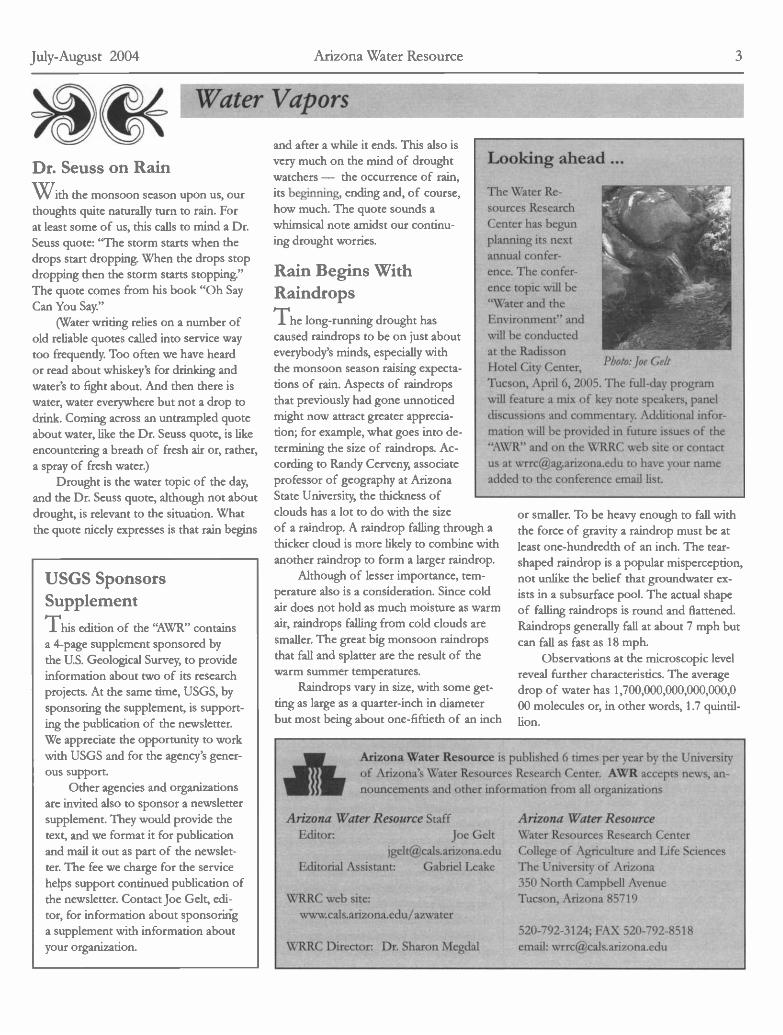
The Water Re-sources ResearchCenter has begunplanning its nextannual confer-ence. The confer-ence topic will be"Water and theEnvironment" andwill be conductedat the RadissonHotel City Center, Photo:Joe Geli
Tucson, April 6, 2005. The full-day programwifi feature a mix of key note speakers, paneldiscussions and commentary. Additional infor-mation wifi be provided in future issues of the"AWR" and on the WRRC web site or contactus at [email protected] to have your nameadded to the conference email list.
or smaller. To be heavy enough to fall withthe force of gravity a raindrop must be atleast one-hundredth of an inch. The tear-shaped raindrop is a popular misperception,not unlike the belief that groundwater ex-ists in a subsurface pool. The actual shapeof faffing raindrops is round and flattened.Raindrops generally fall at about 7 mph butcan fall as fast as I 8 mph.
Observations at the microscopic levelreveal further characteristics. The averagedrop of water has I ,700,000,000,000,000,O00 molecules or, in other words, I .7 quintil-lion.
Arizona Water Resource is published 6 times per year by the Universityof Arizona's Water Resources Research Center. AWR accepts news, an-nouncements and other information from all organizations
Arizona Water Resource StaffEditor: Joe Gelt
[email protected] Assistant: Gabriel Leake
WRRC web site:www.cals.arizona.edu/azwater
WRRC Director: Dr. Sharon Megdal
Arizona Water ResourceWater Resources Research CenterCollege of Agriculture and Life SciencesThe University of Arizona350 North Campbell AvenueTucson, Arizona 85719
520-792-3124; FAX 520-792-8518email: wrrc(,cals.atizona.edu
July-August 2004 Arizona Water Resource 3
Dr. Seuss on Rain'Vc ith the monsoon season upon us, ourthoughts quite naturally turn to rain. Forat least some of us, this calls to mind a Dr.Seuss quote: "The storm starts when thedrops start dropping. When the drops stopdropping then the storm starts stopping."The quote comes from his book "Oh SayCan You Say."
(Water writing relies on a number ofold reliable quotes called into service waytoo frequently. Too often we have heardor read about whiskey's for drinking andwater's to fight about. And then there iswater, water everywhere but not a drop todrink. Coming across an untrampled quoteabout water, like the Dr. Seuss quote, is likeencountering a breath of fresh air or, rather,a spray of fresh water.)
Drought is the water topic of the day,and the Dr. Seuss quote, although not aboutdrought, is relevant to the situation. Whatthe quote nicely expresses is that rain begins

ADEQ Completes SourceWater AssessmentsThe Arizona Department of Environmen-tal Quality recently fulfilled a Safe DrinkingWater Act requirement by completing itsSource Water Assessments. Required ofeach state, SWAs evaluate public drinkingwater sources, with the information thenmade available to the public for use inprotecting community source waters fromcontamination. The Arizona SWAs analyzedrinking water sources for the more than1,500 public water systems throughout thestate.
Safe Drinking Water Act guidelinesspecify what a state must to do to completeits SWAs. Source water assessment areasmust be delineated, with potential sourcesof pollution within the areas identified.Also, the susceptibility of an area's watersupply to the identified pollution must beevaluated.
A final and very crucial step of theSWA process is to release the informationto the public. A prime purpose of SWAs isto expand community awareness of the im-portance of source water protection and toprovide citizens the means to be involved inprotection activities.
"Source water protection is importantfor preserving clean, safe drinking water,"ADEQ Director Steve Owens said. 'Whencommunities better understand the natureof their drinking water sources and whattypes of activities could threaten the integri-ty of source waters, they are better equippedto protect those resources."
The intent of the SWA program tomake readily available a wide array of infor-mation about source waters was questionedafter 9/11 when security issues were raised.The U.S. Environmental Protection Agencyand the states then confronted the challengeof ensuring SWA data was available to ap-propriate parties and at the same time re-strict its access to those who would misuseit,
Arizona is ensuring the security of itsSWA information by requiring that an ap-plication be submitted to obtain any infor-
mation deemed sensitive, such as specificlocation of water sources and facilities.Jeff Stuck, manager of the ADEQ SafeDrinking Water Section, says an applicantwill have to state" ... how they will use theinformation and equally important how theywill not use the data."
For draft reports for various areas ofthe state or for more information contactADEQ's Source Water Assessment unit at602-771-4561; toll free 800-234-5677;email: [email protected]
Two New AMA DirectorsAnnouncedThe Arizona Department of WaterResources recently announced the ap-pointment of two new Active Manage-ment Area directors, for the Tucsonand the Pinal AMAs, and is presentlyadvertising for a Water Resource Spe-cialist IV a senior level position at thePhoenix AMA office.
The Tucson AMA's new directoris Ken Seasholes. Seasholes started atthe agency four and a half years agoas a water resource specialist, movingup to be assistant area director beforebeing appointed AMA director. Priorto joining ADWR, Seasholes workedat the University of Arizona's WaterResources Research Center as a seniorresearch specialist.
Randy Edmond has been ap-pointed the Pinal AMA director. Ed-mond has been at the Pinal office sinceit began in 1981,starting as a waterresource specialist, becoming the assis-tant director in 1985 and then directorin April. He has a bachelors degree inmathematics from the University ofArizona and earned a masters at theUA in agricultural economics in 1973.
Applicants are currently beingsought for a water resource special-ist IV position. The person will havean agency-wide role in reviewing theADWR's municipal water conservationprogram. See Announcements, page10, for job announcement.
CA's Water Savings isMexico's LossCalifornia's plans to limit its use of Colo-rado River water to its allotted 4.4 millionacre feet have consequences up and downthe river, and even into Mexico where Mexi-cali farmers will face dwindling groundwatersupplies.
To conserve Colorado River water, Cal-ifornia is planning to line segments of theAll American Canal that deliver water to theImperial Valley. Mexican farmers will feelthe unintended consequences of the actionsince water from the unlined canal has beenpercolating into the soil to recharge the un-derground water supply across the border.
Mexicali farmers in Baja California'srichest agricultural regions have relied onthe recharge benefits for more than 50years, ever since wells were dug in the areain early 1950s. lt is an area of rural agricul-tural communities, with more than 14,000families relying on canals and wells.
Long on the drawing boards, Califor-nia's plan to line the 23-mile stretch of thecanal with concrete is taking shape, with a2006 groundbreaking scheduled and a com-pletion date set for 2008. The U.S. Bureauof Reclamation estimates that the projectwill save California about 67,000 acre feetof Colorado River water, an amount aboutequal to the annual needs of 134,000 fami-lies in San Diego County.
San Diego's gain, however, is Mexico'sloss, with the Mexican federal governmentestimating that about 40,000 acres and 1,000families with water tights will be affected bythe California project. An additional 3,000acres partially watered by seepage as well aswetlands located near the canal are also ex-pected to be impacted by the project.
The project is expected to have con-sequences to water quality in Mexico.Groundwater fed by canal seepage containsless salt than Colorado River water, the oth-er water source for irrigation in the area. Asa result, groundwater is preferred by manyfarmers in the area.
Growers also fret about other conse-quences of the canal-lining project. Theyworry about having to dig deeper wells with
4 Arizona Water Resource July-August 2004

a higher energy cost for pumping and pos-sibly cutting back on acreage.
The issue has been on the horizon foryears, with Mexico voicing opposition to itand the United States asserting its right toline the canal. One of the points argued byMexican officials is that the farmers have es-tablished user rights to the water after hay-ing relied on it for more than five decades.
Mobil to Pay $5.5 Million forClean Water Violations onNavajo LandsThe U.S. Environmental ProtectionAgency and the U.S. Department of Justicerecently announced a settlement with MobilExploration and Producing U.S. Inc. worthover $5.5 million for numerous oil andproduced water spills from its oil produc-tion activities on the Navajo Nation. Thesettlement includes a $515,000 penalty andrequires the company to spend about $4.7
million on field operation improvements toreduce spill incidences.
Mobil also will spend approximately$327,000 on environmental projects. Theseinclude sanitation facilities and the con-struction of a drinking water supply lineextension to provide runmng water to i 7of the remote residences located on the oilproduction fields. Local residents currentlymay drive as long as an hour to fill 55-gallondrums with drinking water.
Undertaking these projects was notmandated by the settlement, and the goy-ernment viewed the commitment as a good-will gesture and somewhat reduced the oilcompany's penalty.
' 'This settlement brings Mobil's oil pro-duction activities into compliance with wa-ter pollution control requirements, and alsobrings much-needed public health benefitsto residents of the area who still lack an in-home drinking water supply," said WayneNastri, the EPA's regional administrator for
Cities Win/Lose Some in Efforts to Restore River FlowA Tale of Two Cities
Tucson's plans to restore flowing water in segments of the San-ta Cruz and Rïllito rivers encountered a setback recently when aU.S. Army Corps of Engineers' three-year study concluded thatrunning water in either river year-long is not feasible. Instead ofwater, a corps report scheduled to be released next month willpropose planting trees and shrubs along the rivers.
Named Paseo de las Iglesias, the Santa Cruz River projectcalls for planting 718 acres of large mesquite trees and 356 acresof smaller mesquites along with such shrubs as saitbush, wolf-berry and brittle bush. Also to be planted would be I 8 acres ofcottonwood and willow trees and 6 acres of marsh reeds andgrasses. The revegetated area will cover 7.5 miles of the SantaCruz at a cost of about $90 million. Another $100 million wouldhave been needed if water were to be put into the river.
The corps proposal for the Rillito includes the planting ofI 1 5 acres of mesquites, 99 acres of cottonwoods and willows, 62acres of shrubs and 7 acres of marsh grasses. The revegetationproject would benefit 4.8 miles of the Rillito River at a cost ofabout $66.6 million.
Stored rain water and effluent will probably be used to waterthe vegetation. The corps' report means that federal funds willnot likely be available to restore vater in the Tucson rivers.
Once flowing with water and bordered by varied vegetation,the rivers lost their flow and much of their vegetation about ahalf a century ago when groundwater tables dropped. The riverrestoration cause has been variously argued as an act of environ-mental rescue, an urban/natural amenity for locals and a feature
to attract tourists.Plans for restoring the flow of
Tucson rivers have been an item invarious campaigns and governmentplans in the past. Early plans for RioNeuvo, a current project to developthe Santa Cruz River area, includedcreating a "River of Blue."
That the rivers would be reveg-etated rather than rewatered attractedvaried responses, with some agreeingthat it was a sensible proposal whileothers expressed disappointment anding sources be sought.
Meanwhile Tucson's rival city, Phoenix, also a town with adry riverbed, is having more success in restoring river segmentswith both water and vegetation. Upstream dams have depletedwater flow to the Salt River, turning a once running river into abarren strip now defaced by gravel mines and accumulated trashand junk.
Rescue work is underway, with the corps and local govern-ments cooperating to return water to the riverbed and vegetationto the banks. Studies or actual restoration projects are in progresson sections of the Salt River, totaling about 40 miles, all locatedwithin the metropolitan area. Effluent, shallow groundwater andstorm or irrigation water runoff will supply water for the proj-ects.
Santa Crti River
Photo:Joe Gelt
suggested that other fund-
the Pacific Southwest region.The settlement is in response to a
March 1998 EPA and the U.S. Departmentof Justice lawsuit claiming that betweenDecember 1991 and March 1999 approxi-mately 83 spills at Mobil's oil fields reachedtributaries of the San Juan River.
Mobil's violations include unauthorizeddischarge of oil and oil and water mixturesinto tributaries of the San Juan River; failureto prepare and fully implement an adequatespill prevention and control plan; failure toimplement existing plans; failure to preparea facility response plan or conduct drills andtraining; and failure to notify the EPA ofdischarge events
Mobil's oil production fields are lo-cated on both sides of the San Juan River insoutheast Utah. The Navajo Nation Envi-ronmental Protection Agency first broughtthe spills to EPA's attention in I 996, andEPA worked closely with the tribal agencyin addressing the issue.
July-August 2004 Arizona Water Resource 5

Take Care When Providing Environmental Information to PublicSuzanne Pjìster, vice president, Environmental and Communi Outreach Di-
vision, BJ Communications, contributed this Guest View. She will be conduct-
ing a workshop on this topic Sept 15 at the Radisson Hotel, Tucson, as part of
the Arizona HjdrologicalSociey Sjmposium, Sept. 15 - 18. Check web sitefor additional information (hllp://www.arydrosoc.org/synposium.html)
"Corporations fined millions of dollars for groundwater con-tamination."
"Public policy leaders debate the health risks of spraying pes-ticides throughout neighborhoods to protect citizens from water-borne diseases."
"Strange amoeba in groundwater are linked to the deaths oftwo boys in a rare occurrence. Officials say chlorine kills the amoe-ba, yet it's still found in some chlorinated test results."
of these are real-world situations that izonans have strug-gled with during the past year or so, and they clearly bring home thefact that communicating scientific information - particularly withregard to water quality issues - can be extremely challenging. Un-fortunately, there are no easy answers for how to handle these situ-ations, but research and practical experience have shown us someways to approach the difficulties that can help practitioners achievea more balanced public discussion.
In America, acceptable water quality is something we take forgranted. Anyone who has traveled abroad knows that we are incred-ibly blessed with standards that, for the most part, allow you totravel anywhere in the country and not worry about whether it issafe to "drink the water." Because of this near universal acceptance,the threat of unsafe water is considered particularly egregious in oursociety, and generates strong outrage from the public if they do notunderstand, or do not trust, information they are being provided.
So just how do you communicate this difficult and often com-plicated information? There has been a great deal of research con-ducted about how people perceive risk; here are some suggestionswhen you are the one who must communicate the information.
Keep it simple and human: Countering emotional feelings withdata is deadly because it shows a lack of compassion and ignorespeople's feelings Throw out the jargon, put the terms in under-standable English, and use examples relating to real-world experi-ences.
(One example I often use is avoiding the word "contamina-tion." It is a regulatory term, but for most of us, the constituentsare often gasoline and cleaning solvents, and we understand thatbetter because these are things we use. I also use the term "impact-ed groundwater" instead of "contaminated groundwater" because itis a more value-neutral statement.)
Use visuals to support the information: We are a society thatis conditioned to receive our news and information visually. The"MTV" generation wants it quick, visual and with impact. You are
competing with this in order to get your message across, so supportyour information with visuals whenever possible.
(I once had to describe a situation when a process wastewatertank released water used to clean electronic wafers into a "second-ary containment" unit. I had to get the message out that it was nota "spill," since all the water had been contained. With the mediapressing for a response, I drew a simple picture and described it as atank in a concrete bathtub, and the bathtub was big enough to holdall the water that had been released. The environmental managerwas aghast at my description, but the media understood it and com-municated the situation in a less dramatic way. Two days later, wehad a great diagram depicting the entire containment process.)
When you can't talk content - talk process: There are manysituations when a complete technical analysis isn't ready when thepublic wants to react. Rather than the "no comment" mistake, ex-press compassion, and then explain the process by which the testsare being conducted, what the time frame is to know more infor-mation, and what steps are being taken to protect public health inthe interim. The more you don't talk, the more it appears that youare hiding something, rather than the real fact that you don't yetknow. So explain the process, and develop ways to update interestedpeople as you move through it.
Don't rely on just one communication technique to get theword out: A common mistake is to develop a fact sheet, distributeit to neighbors, and then wonder why people still feel they have notbeen communicated with. The reality is people have differing levelsof interest, and communicate most effectively in different ways.You need to account for this, and provide both formal and informallines of communication.
(An open house meeting is a good example of providing infor-mation in a way that allows people to consume at their own speedand in ways that work best for them. There is a lot of informalinteraction, the level of "political drama" is often reduced becauseopponents can't take over the meeting, and people can ask the ques-tions they are seeking answers to. Another key is to be as responsiveto the inquiries as you can.)
Release the bad news early to best manage the message: Ifthere is a good chance that the news will be made public, you aremore likely to succeed in framing the message on your terms if yourelease as much as you can as early as possible. It even appears lessnewsworthy if you release it. If you wait, and it gets leaked, it tendsto be a bigger story, and you are more apt to lose trust and cred-ibility. You also can better control the accuracy of the informationif you are the first to present it. In addition, you can focus on thesteps to resolving the situation as well as the problem.
The most important goal is to maintain your credibility andreassure people that you are working toward a good resolution tothe problem. And that you will keep them informed and engaged asyou do it. L
6 Arizona Water Resource July-August 2004

science for a changing world
Studies Examine Historical Water-use Trends, andClimate-Groundwater InteractionFollowing are two recent US. Geologica/Surveji reportsfrom Arizona Dis-
End hjìdrologists. Thefirst report snmmaries information in US. Geological
Survej Scientific Investigations Report 2004-5148, by A.D. Koniecki and
J.A. Hei/man, (inpress). The an4sisprovides a record of historical trendsfor agricultural, domestic and industrial water use. ContactA.D. Koniec/zat 520-670-6671 ext. 270 or via email at [email protected] fyou have anjquestions or comments.
WATER USE TRENDS IN FIVESOUTHWESTERN STATES-1950-2000
by A.D. Konieczki
Every 5 years since 1950, the U.S. Geological Survey has corn-piled and published water-use data in Circulars entitled "Estimateduse of water in the United States." The Circulars include water usefor several categories including public and domestic use, agricul-tural use, and industrial use. These reports also include populationand irrigated-acreage data. The most recent Circular (available athttp: / /water.usgs.gov/pubs/circ/2004/circl 268) summarizes wa-ter use for 2000.
In this study, data from these 5-year reports were compiledfor 1950 to 2000 and examined to identify changes over timein ground-water and surface-water withdrawals for agricultural,domestic, and self-supplied industrial water uses for Arizona, Cali-fornia, Nevada, New Mexico, and Utah as part of the SouthwestGround-Water Resources project that is supported by the Ground-Water Resources Program of the U.S. Geological Survey (USGS)Office of Ground Water. Comparisons of water use, water-usetrends, and sources of water among the Southwestern States mayassist in the distribution management of limited water resources.Estimated withdrawals for domestic use include reported public-water supply as well as self-supplied domestic use. Withdrawals forindustrial water use include self-supplied water used for mining,thermoelectric, and other general industrial and commercial pur-poses. Withdrawals for agricultural use include water used mainlyfor crop irrigation and, when reported, for livestock.
Water-Use Trends
The estimated amount of surface- and ground-water withdrawalsfrom 1950 to 2000 for all purposes in Arizona, California, Nevada,New Mexico, and Utah increased 58 percent, from 39.6 to 62.8miffion acre-ft. Individually, estimated withdrawal increased 81percent in Nevada, 72 percent in California, 46 percent in Utah,40 percent in Arizona, and declined 4 percent in New Mexicofrom 1950 to 2000 (fig. 1). Water-use trends in these five Statesare dominated by withdrawal in California, which has the largestwithdrawal of any State in the country. Crop acreage in Californiais about twice as large as the combined crop acreage of Arizona,
Arizona, Nevada,New Mexico, Utah,
and Californiacombined
IJ
uJu-
20,000 -<
10,000 -J
8,000D
6,000
Arizona Water Resource Supplement
Ju'y-August 2004
o,o,DD
Figure 1 Total water withdrawal in Nevada, New Mexico, Utah,Arizona, and California, 1950-2000.
Nevada, New Mexico, and Utah, and the population of Californiain 2000 was three times larger than the combined population inthe four other States.
Changes in ground-water withdrawal varied in the five Statesfrom 1950 to 2000. Ground-water withdrawals increased 324 per-cent in Nevada, 208 percent in Utah, 147 percent in New Mexico,and 52 percent in California, and decreased 15 percent in Arizona.Overall, estimated ground-water withdrawals for all five States in-creased 62 percent.
Agriculture
More water is used for agriculture than for domestic and indus-trial purposes in Arizona, California, Nevada, New Mexico, andUtah; however, the percentage of total withdrawal for agriculturedecreased from 94 percent in 1950 to 80 percent in 2000. FromI 965 to 2000, estimated water withdrawal for agriculture increased14 percent in the five States, from 44.0 to 50.2 million acre-ft. Ir-

S-2
rigated acreage data for the five States were available only as farback as 1965, and since then irrigated acreage increased 12 per-cent from 12.6 to 14.1 million acres. Withdrawals for agriculturein California accounted for 62 percent of the water withdrawalsfor agricukure in the five States in I 950 and 68 percent in 2000.
Statewide average of crop-application rates (water with-drawn for irrigation of crops divided by irrigated crop acreage)from 1965 to 2000 ranged from 2.29 acre-ft per acre in Utah in1975 to 6.21 acre-ft per acre in Arizona in 2000 (table 1). Morewater is used per acre of irrigated land in Arizona than in theother four States. This is due to several reasons, including dif-ferences in climate, type of crops grown, conveyance losses,growing season, and crop rotation during the year. Nearly all theagricultural land in Arizona requires irrigation because it is in thesouthern half of the State where the climate is arid. Another rea-son for the higher crop-application rate in Arizona is that a largeportion of the crops are cotton and alfalfa, which have a highwater use.
Domestic
Withdrawals for domestic water use, which included self-supplieddomestic and public supply (all deliveries to residential, com-mercial, and some industrial users), increased 410 percent from1950 to 2000. During that same period thetotal population in these five SouthwesternStates increased 250 percent. The percent-age of total withdrawal for domestic wateruse increased from 5 percent in 1950 to 16percent in 2000.
Estimated withdrawals for domestic usein California declined from 82 to 70 percentof the total domestic-water withdrawals inthe five States from I 950 to 2000, indicat-ing that the need for domestic use increasedmore in Arizona, Nevada, New Mexico,and Utah combined than in California. From 1950 to 2000 thepopulation of California increased 220 percent and the combinedpopulationin the fourother Statesincreased 390percent.
Publicsupply per-capita use
(water provid-ed by publicwater suppli-ers dividedby reportedpopulationserved) in thefive Statesis generally
Figure 2. Ground-water and suace-water withdrawalsin Arizona. 1950-2000
-4izona Wair /ßiotwce Supp/ewnt
us ÇeoicJStrv9/
in two dis-tinct groups.Per-capitause is gener-ally about300 gal/dayin Utah andNevada andabout 200gal/day inArizona, Cali-fornia, andNew Mexico(table 2).Data prior to1960 werenot available.
Industrial
10,000
I Agricultural use
U Domestic use
u Industrial use
Figure 3. Water withdrawalsfor agricultural, domestic, andindustrial use in Arizona, 1950-2000
Trends of water withdrawals for industrial use are difficult to iden-tifT because of differences in data reporting from year to year. FromI 950 to 2000, withdrawal for industrial use in the five States wasgenerally less than 6 percent of the total water withdrawal. With-
Table 2. Per-capita use in Arizona, Calfornia, Nevada, New Mexico, and Utah-1960-2000.(Ingallonsper daj. Dashes indicate no data.)
drawal for industrial use was less than 4 percent of the total with-drawal in Arizona, except in I 990; industrial withdrawal was lessthan 6 percent in California and less than 7 percent in Nevada, NewMexico, and Utah, except in 1980, when it was almost 12 percent ofthe total withdrawals in Utah.
Arizona
Ground-water and surface-water withdrawals for use in Arizonaincreased from 5.4 million acre-ft in 1950 to 7.5 miffion acre-ft in2000; the withdrawals peaked at 8.9 miffion acre-ft in 1980. Groundwater was the primary source of water from 1950 to 1980 (fig. 2).In i 985 more surface water than ground water was used becauseof deliveries of Colorado River water through the Central ArizonaProject. Agriculture is the dominant water-use category in Arizona;however, the portion of total withdrawal used for domestic use hasincreased. Estimated withdrawal for agriculture was 97 percent in1950 and 80 percent in 2000 (fig. 3). During that time period thepopulation in Arizona increased almost 600 percent and withdraw-als for domestic water use increased more than 1,100 percent.
State 1965 1970 1975 1980 1985 1990 1995 2000 Average
Arizona 145 147 207 213 230 200 208 206 219
California 198 231 182 186 184 218 228 184 204
Nevada 346 285 306 316 323 326 344 325 338
NewMexico 163 126 205 236 240 226 226 225 203
Utah 301 290 296 334 -- 285 308 269 293
2,000 j I I I I I I
- I Ground waler
fi 10,000 - D Surface water
8,000
uil-
6,000
'°°°III
2,000-
O1111I11i11

Thefo//owing article, written b Jesse Dickinson, summaries results from
a recent/y publishedpaper in "Water Resources Research " describing the
relations between climateftuctuations andgroundwater elevations. Contact
J. Dickinson at 520-670-6671 ext. 306 or via email atjdickins(Jusgs.govfyou have atzj questions or comments.
INVESTIGATING THE EFFECTSOF CLIMATE VARIABILITY ONGROUNDWATER LEVELS ANDRECHARGE RATES INSOUTHWESTERN BASINS
byJ. Dickinson
c; round water is a significant part of the watersupply for the Southwest's growing population. Forinstance, ground water accounts for about 60 percentof Arizona's water withdrawals. Historically, develop-ment of ground-water resources has outpaced naturalrecharge, resulting in water-level declines in many ofthe agricultural and densely populated regions of theSouthwest. In order to ensure that ground water willbe available for use in the future, water managers haveto plan for sustainability. Ground-water sustainabilityis defined as developing and using ground water ina manner that can be maintained for an indefinitetime without causing unacceptable environmental,economical, or social consequences. Managementof ground-water resources for sustainability is oftenaccomplished using ground-water flow models thatnumerically represent changes in ground-water lev-els and streamfiow discharges through time, givenrecharge and ground-water development informa-non. Simulations of ground-water flow models haveshown that the response of ground-water levels toclimate variability is a significant issue for sustainability The U.S.Geological Survey (USGS) Southwest Ground-Water ResourcesProject has been investigating how climate variability can affectnatural recharge rates and water levels. Results from this studyare summarized in the following discussion and are fully docu-mented in the journal articles listed in the section entitled "Formore information."
Use of models to study ground-waterresources
Computer models are useful tools for understanding complexground-water systems because the amount of ground waterstored in aquifers and the rates and directions of flow are dif-ficult and cost prohibitive to measure at adequate spatial scales.Ground-water models simulating Southwestern alluvial aquiferstypically use a steady-state, or average, recharge rate though time.Recharge processes in aquifers, however, are influenced by bothseasonal, interannual, and interdecadal climatic forcings. Addi-
'Cu
tionally, the variability of the recharge caused by these climatic forc-ings is largely unknown. In situations where recharge variations aresignificant, the use of steady-state boundaries is likely to lead to er-roneous model simulations that do not represent aquifer responses.Recharge rates that vary with time owing to climate variability areneeded to improve simulation results and, therefore, improve thequality of ground-water management decisions aimed to achievesustainability.
Reconstructing climate variability
Prior studies have revealed cyclical climate patterns during the pre-vious century using long-term data on streamfiow, precipitation,ground-water levels, and tree-ring indices (see, for example, Hansonand others, 2004). These patterns contain multiple frequencies thatare partially coincident to climate cycles. Water-level cycles of 2- to
Evapotranspiration
: :
Outflow tosurtace water
Aquifer
CQ.E
a.
'm,:'i,,, lii,
I
F/ i
Figure 1. Cross-section of an zdealzed aquiter in the Southwestern United States. Ground
waterflovsfrom recharge areas near mountainfronts to discharge areas near streams andwetlands.
6-year periods could be related to the El Niño-Southern Oscillation(ENSO), which is a system of interactions between the tropicaloceans and the overlying atmosphere. Other water-level cycles oflo- to 25-year periods could be related to sea-surface temperaturevariations in the North Pacific Ocean described by the PacificDecadal Oscillation (PDO).
Effects of climate variability on water levels
In order to gain a general understanding of the response of aqui-fers to climate variability, a series of ground-water flow models ofidealized aquifers (Figure 1 , for example) were used to simulate wa-ter-level fluctuations through time. The models include a range ofpossible configurations of basin size and shape, aquifer thickness,and aquifer hydraulic properties. Recharge patterns were variedsimilar to ENSO- and PDO-type cycles identified in previous analy-ses of hydrologic data (Figure 2). Ground-water flow was simulat-ed from areas of focused recharge at a mountain front along the ba-sin boundary to a stream at the basin center. The total recharge rateper aquifer varied between O and 26,000 acre-feet per year in cyclical
-4izona Waler /eJowce .Stpp/ement
us Çeoica/&Lrve/S-3
S-4
1960 1970
YEAR
MEASURED WATER-LEVEL FLUCTUATIONS- CALCULATED PDO-LIKE COMPONENT OF WATER-LEVEL FLUCTUATION
-----CALCULATED ENSO-LIKE COMPONENT OF WATER-LEVEL FLUCTUATION
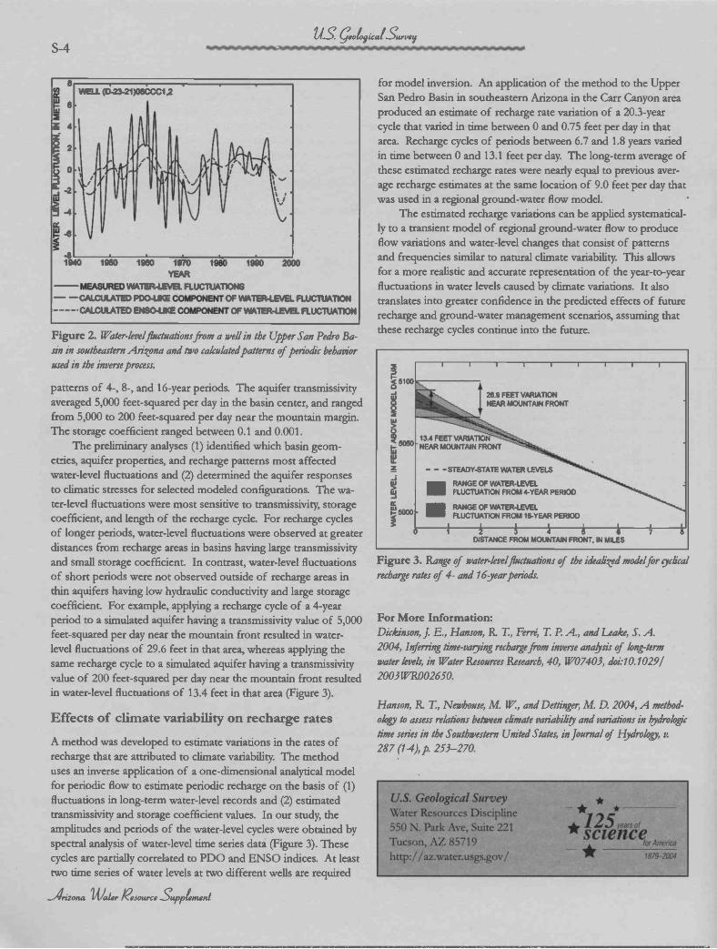
Figure 2. Water-levelfluctuatzonsfrom a well in the Upper San Pedro Ba-sin in southeastern Arizona and two calculatedpatterns ofperiodic behaviorused in the inverse process.
patterns of 4-, 8-, and I 6-year periods. The aquifer transmissivityaveraged 5,000 feet-squared per day in the basin center, and rangedfrom 5,000 to 200 feet-squared per day near the mountain margin.The storage coefficient ranged between 0.1 and 0.001.
The preliminary analyses (1) identified which basin geom-etries, aquifer properties, and recharge patterns most affectedwater-level fluctuations and (2) determined the aquifer responsesto climatic stresses for selected modeled configurations. The wa-ter-leve! fluctuations were most sensitive to transmissivity, storagecoefficient, and length of the recharge cycle. For recharge cyclesof longer periods, water-level fluctuations were observed at greaterdistances from recharge areas in basins having large transmissivityand small storage coefficient. In contrast, water-level fluctuationsof short periods were not observed outside of recharge areas inthin aquifers having low hydraulic conductivity and large storagecoefficient. For example, applying a recharge cycle of a 4-yearperiod to a simulated aquifer having a transmissivity value of 5,000feet-squared per day near the mountain front resulted in water-level fluctuations of 29.6 feet in that area, whereas applying thesame recharge cycle to a simulated aquifer having a transmissivityvalue of 200 feet-squared per day near the mountain front resultedin water-level fluctuations of 13.4 feet in that area (Figure 3).
Effects of climate variability on recharge rates
A method was developed to estimate variations in the rates ofrecharge that are attributed to climate variability. The methoduses an inverse application of a one-dimensional analytical modelfor periodic flow to estimate periodic recharge on the basis of (1)fluctuations in long-term water-level records and (2) estimatedtransmissivity and storage coefficient values. In our study, theamplitudes and periods of the water-level cycles were obtained byspectral analysis of water-level time series data (Figure 3). Thesecycles are partially correlated to PDO and ENSO indices. At leasttwo time series of water levels at two different wells are required
Arizona Water /ejogtrce £ppLnwii
us 4JS
for model inversion. An application of the method to the UpperSan Pedro Basin in southeastern Arizona in the Carr Canyon areaproduced an estimate of recharge rate variation of a 20.3-yearcycle that varied in time between O and 0.75 feet per day in thatarea. Recharge cycles of periods between 6.7 and 1.8 years variedin time between O and 13.1 feet per day. The long-term average ofthese estimated recharge rates were nearly equal to previous aver-age recharge estimates at the same location of 9.0 feet per day thatwas used in a regional ground-water flow model.
The estimated recharge variations can be applied systematical-ly to a transient model of regional ground-water flow to produceflow variations and water-level changes that consist of patternsand frequencies similar to natural climate variability This allowsfor a more realistic and accurate representation of the year-to-yearfluctuations in water levels caused by climate variations. It alsotranslates into greater confidence in the predicted effects of futurerecharge and ground-water management scenarios, assuming thatthese recharge cycles continue into the future.
Figure 3. Range of water-levelfiuctuations of the idealized modelfor cjìclicalrecharge rates of 4- and l6year periods.
For More Information:Dickinson, J. E., Hanson, R. T., Ferré, T P. A, and Leake, S. A.2004, Inferring time-varjiing rechargefrom inverse ana/ysis of long-term
water levels, in Water Resources Research, 40, W07403, doi:1O. 1029/
2003 1VR002650.
Hanson, R. T, Newhouse, M. IV., and Dettinger, M. D. 2004, A method-ology to assess relations between climate variabili'y and variations in hjdrologic
time series in the Southwestern United States, injournal of Hjidrology, y.
287 (1-4), p. 253-270.
U.S. Geological SurveyWater Resources Discipline550 N. Park Ave, Suite 221Tucson, AZ 85719http:/ /az.water.usgs.gov/
*-* *
* i25 years of
sciencefor America* 1879-2004
DI-< 5100n
û
- 5050Uiw
-
-I
5000
i I I I I I
26 9 FEET VARIATIONNEAR MOUNTAIN FRONT
FRONT
OF WATER-LEVELFROM 4-YEAR PERIOD
OF WATER-LEVELFROM 16-YEAR PERIOD
I
- - -STEADY-STATEWATERLEVELS
,
13.4 FEET VARIATIONNEAR MOUNTAIN
RANGEFLUCTUATION
RANGE- FLUCTUATION
I
o i 2 3 4 5 6DISTANCE FROM MOUNTAIN FRONT, IN MILES
7 8

e. lation aÑd 14wTTTT
Arizona - New Mexico Agreement Clears Way for Actionon Arizona Water Settlement ActAzona Water Settlement Act, S. 437, is expected soon to get congressional action now that Arizoha has worked out an agreementwith New Mexico over New Mexico's claims to i 8,000 acre feet ofCentral Arizona Project water. An Arizona legislative priorit S. 437is to resolve various outstanding CAP issues. The legislation wasstalled awaiting a settlement between Arizona and New Mexico overthe development of New Mexico's hitherto unused CAP allocation.
The 1968 Colorado River Basin Project Act, RL. 90-537,which authorized the building of the CAP, included an alloca-tion of 18,000 acre-feet of water to New Mexico. New Mexicos1968 allocation was not intended to be mainstem Colorado Riverwater. Instead the allocation was a strategy to enable New Mexicoto exchange 18,000 acre feet of Colorado River water for an equalamount of Gila River water. The Gila River is a tributary of theColorado River that flows through New Mexico.
New Mexico's main objective in the negotiations was to workout details that would enable the state to develop its CAP allocation.In effect, New Mexico wanted funding.
Arizona's priority in the negotiations was to protect the wa-ter rights of Arizona farmers irrigating about 30,000 acres alongthe Gila River in the Duncan-Virden and Safford valleys, if NewMexico were to tap upriver into the Gua River. In the event of suchpumping, Arizona wanted bypass parameters to be established toensure that New Mexico's actions would not result in cost or eco-nomic injury to state water right holders.
Also in the negotiations, Arizona wanted to protect its LowerBasin Development Fund. As defined by S 437, CAP repayments,instead of going to the U.S. Treasury would be used to establish thefund and spent to support Indian water projects in the state. NewMexico officials proposed that up to $150 million be set aside fromthe fund to assist the state in developing its CAP allocation.
New Mexico achieved some terms favorable to its cause butdid not get all it wanted. Instead of $150 million, New Mexico,beginning in 2010, is to have access to a total of $66 million, to bepaid in ten equal installments. The money is to be used for variouswater development projects in southwestern New Mexico. Suchprojects could include hydrologic studies or mitigation, restorationand/or environmental measures, and the work does not have to re-late to the state's CAP allocation. New Mexico officials announcedthey will seek local input to identify types of projects.
Further, if New Mexico eventually decides to build a projectto divert Gila basin water in exchange for CAP water, the state willhave access to up to $100 million - and possibly up to $128 mil-lion depending on interest earned by the Lower Colorado River Ba-sin Development Fund. Access to these funds would depend uponspecific project feasibility requirements being met.
New Mexico officials stress that no decision has yet been madewhether to divert water from the Gila River. Instead they say the
agreement opens the door to making a decision in the future. Ac-.cording to the settlement, New Mexico has until 2014 to notify theSecretary of the Interior about plans to divert water from the GilaRiver. Further, the NEPA process must be completed with a recordof decision by 2019.
The settlement also addressed Arizona's concern about pro-tecting the rights of Arizona water users along the Gila River. NewMexico agreed not to divert more than 1 4,000 acre feet in any tenyear period, even though the I 968 legislation allocated the stateI 8,000 acre feet. New Mexico's concession to reduce its allocationby 4,000 acre feet ensures that by-pass parameters can be set to ac-commodate the rights of Arizona water users along the Gila River.Specific by-pass parameters are being worked out. Further, NewMexico agreed not to divert water if the San Carlos Reservoir stor-age is less than 30,000 acre feet.
Environmentalists have kept a wary eye on the negotiations,concerned about possible environmental costs if New Mexico wereto develop its entitlement to the Gila River, the last mainstem riverin New Mexico without a major water development project. Theyargued that whatever diversion technique is adopted will reduce wa-ter available for wildlife, vegetation, nutrient cycling and other vitalriver functions.
They were concerned that the terms of agreement did notinclude wording to protect the Gila River. A statement issued bythe Gila Conservation Coalition urges that the amendment to S.437include language that would "allow for the adequate protection ofthe present ecological functions and processes, riverine habitat andassociated riparian corridors of the Gila and San Francisco rivers."
Some environmentalists, however, were somewhat heartenedby the progress of the settlement. On the plus side, state officialsseemed aware that damming the Gila River would be a very un-popular decision and therefore not an option likely to be pursued.Even further, the settlement showed that state officials, despite theirposition early in the negotiations, are not now totally committed toa diversion project and are willing to examine alternatives.
The New Mexico Interstate Stream Commission has endorsedthe agreement between the states and public hearings have beenconducted, Arizona is proceeding more cautiously. Gregg Houtz,an attorney with the Arizona Department of Water Resources,says, "We made a lot of progress and have a general agreement ofprinciples, and we are working out the details." Working out detailsinvolves executing contracts among parties affected by the NewMexico agreement.
Arizona officials are anxious to finalize the settlement so thatcongressional markup on 5 437 can occur. A July 14 targeted mark-up date was missed; officials now look forward to the work beingdone on Sept.15, with final legislative action occurring this session,although they concur this may be an overly optimistic goal. *
July-August 2004 Arizona Water Resource 7

Common Waters, Diverging Streams: LinkingInstitutions and Water Management in Ari-zona, California, and ColoradoWilliam Blomquist, Edella Schlager and TanyaHeikkila, Resources for the Future, 210 pp., $30.95
: paperback. (For purchasing information checkhttp://wwwrffpress.org)Conjunctive water management, a strategy recog-nizing the interconnection between groundwater
and surface water, has broad management and hydrological implica-tions. This book discusses the situation of three western states thatconjunctively manage, in at least parts of their areas, groundwaterand surface water. The states are Arizona, California and Colo-rado. By comparing these three states with similar water resourceproblems but with different laws and organizational structures, theauthors discuss the importance of institutions - laws, policies andorganizational organizations - in improving resource management.
The authors focus on Arizona, California and Colorado be-cause they share common characteristics. Each is experiencing rapidpopulation growth and rising water demands, and each has watersupplies often geographically remote from areas of water demand.Also, the states, each located in the arid Southwest, periodically ex-perience severe and prolonged drought
Despite such common characteristics, the authors say conjunc-tive management has taken different paths in each state, with vary-ing historical courses and adopted practices. The result has beendifferent outcomes as each state works to solve similar problemswith the same policy reform. In attempting to account for the dif-
Common Waters.Dioering Streams :
t::iij Publications & On-Line Resources
ferent outcomes, the authors describe the origins of the conjunctivemanagement policy, its practices, its potential and the influence ofinstitutional arrangements on its application.
Promoted as the first book on conjunctive water management,the book is said to be making an important contribution to policyliterature and policymaking. In other words, the authors are at-tempting to link theory with practice, often a challenging task. Theauthors take on the task by discussing how state laws and regula-tions, legal doctrines, the organizations that govern and managewater supplies, and the division of authority between state and localgovernment can explain the diverging courses taken by each state inits adoption of conjunctive water management.
Water Resources Data for Arizona, Water Year 2003The U.S. Geological Survey Arizona District's surface-water pro-gram operates 196 continuous-recording streamfiow-gaging stationsand 30 crest-stage gages throughout the state. The continuous-re-cording gaging stations transmit real-time data available on the Webat az.water.usgs.gov. Each year the data are reviewed, basic statisticalanalyses performed, and the data published in an annual data re-port, 'Water Resources Data - Arizona." The publication containsdaily streamfiow data, locations of gaging stations, drainage areas,periods of record, annual and historic peak flows, annual and his-toric low flows, discharge statistics and gage descriptions. Ground-water level, aquifer-compaction, water-quality, and sediment dataare also published in the report. The report is available online ataz.water.usgs.gov/publications.html. Local, state, tribal and federalagencies support USGS data collection and publication.
Drought...continuedfrornpage 2
in Yuma into the Cienga de Santa Clara also relieved the pressureto use the plant.
Those urging the start-up of the plant say that the I 00,000acre-feet of water now being released from Lake Mead to helpfulfill treaty obligations to Mexico could remain in the reservoir.Water desalinated at the Yuma plant could then replace the res-ervoir water and be delivered to Mexico. Mexico is guaranteed bytreaty i .5 million acre feet of low-salinity water.
The 100,000 acre feet remaining in Lake Mead would helpdefer a declaration of water shortage on the Colorado River. Ari-zona is especially anxious to avoid a shortage situation since theCAP has low-priority water.
Cost to restart the plant is figured at about $30 million, withan annual operating cost of $30 miffion. Also, however, thereis an environmental cost to be considered. Operating the plantwould harm the Cienega de Santa Clara, a Mexican weiland in theColorado River Delta which relies on the bypassed saline water.The weflands' supply of water would be cut off.MexicoThe basin states have agreed to request that the Secretary ap-
proach Mexico to discuss the possibility that the country sharethe Colorado River shortage, despite being ensured by treaty I .5million acre feet annually. Basin state officials believe the severityof the drought in the United States justifies requesting Mexico toaccept a reduced allocation.Water BankA proposed water-sharing strategy is to create an interstate waterbank in Lake Mead to benefit Arizona, California and Nevada.Agricultural water has been mentioned as a source for such abank, more specifically Imperial Irrigation District water. By us-ing less water the district would enable water to be banked inLake Mead, to be used by the three lower basin states. In return,the district would receive credit for the banked water, to be re-covered at a later date when river flow returns to normal. Anoth-er option would be for the district to expand its current fallowingprogram and then sell its resulting unused apportionment to thebank. Arranging such a plan without running afoul of the Lawof the River would be an issue.Interstate Water TransfersThe water bank is one example of interstate water sharing, with
Continued onpage 12
8 Arizona Water Resource July-August 2004

4ttik Spdal Projects
Monsoon Studji. . continiiedfrompage i
affected area. The area extends from southern Mexico, along thecountry's west coast into the U.S. desert Southwest. The Arizonarim country intercepts moisture coming north and is generally re-garded as the northern edge of the regular monsoon pattern. Somemonsoon moisture pushes into Utah and even into the Northwest,but it is very transitory.)
The first three years of the NAME were devoted to planningand to identifying hypotheses for testing. This year marks the datacollecting phase of the program, to be followed by research andanalysis to test hypotheses formed the previous four years.
Erik Pytlak, meteorologist with the Tucson National WeatherService, says, "After data is collected the real hard work begins. Wethen take a look at the data to figure out what it is we sampled andhow we use the data to improve our ability to forecast. . . . What willhappen after 2004 is basically trying to prove hypotheses formedduring the previous four years."
In taking on such a complex issue, NAME will be examiningmany and varied situations that likely effect the monsoon. Pytlaksays, "One of the key things we are looking at is gulf surges ormoisture that pool up over the Gulf of California. This is trans-ported either into Mexico or into Arizona by the wind patterns. Weare investigating when these moisture surges occur and what theydo to the weather regimes in Arizona and surrounding areas.
"We are also looking at upper-level disturbances and how theyimpact the monsoon. These upper-level disturbances can eitherbring a lot of thunderstorms or can shut the monsoon down. Weare investigating what conditions cause either an upswing or down-swing in monsoon activity to occur."
NAME's major field campaign is occurring this year, Julythrough September, with information about the monsoon beingcollected over a wide area. Scientists from more than 30 universities,laboratories and agencies in the United States, Mexico and CentralAmerica are participating in this phase of the program. U.S. institu-tions include the Sonora Research Institute, University of Arizona,Princeton University and Harvard University. The purpose of thefield campaign is to conduct atmospheric, oceanic and land-surfaceobservations in the core region of North American monsoons. Thisincludes northwest Mexico, southwest U.S. and adjacent oceanic ar-eas
The National Weather Service office in Tucson has a key rolein this phase of the program, with the Phoenix and Flagstaff officesalso participating. Ten other NWS offices in the desert Southwestand southern Plains also are involved. Designated as the ForecastOperations Center, the Tucson office will be gathering informationfrom wind profilers, balloons, radar, research airplanes, researchships in the Gulf of California and surface weather stations at morethan I 00 locations in Mexico and the United States. This bi-na-tional effort is breaking new ground, providing U.S. meteorologiststheir first opportunity to combine satellite data above Mexico withweather observations reported from 84 Mexican surface stations.
Pytlak says information provided to Tucson's Forecast Op-
erations Center wi]1 beused to compile a dailyweather forecast to beissued to NAVIE scienceand operation directors.The information will en-able them to make data-gathering decisions suchas determining when torelease weather balloonsmore frequently or sendaircraft to investigateconditions over the Gulfof California.
Pytlak says, "Thathas been our piece ofthis much larger puzzle."
Also, Arizona fig-ures into the project thissummer because a suit-able research site is located within the state for studying a criticalmonsoon issue: the effect of surface conditions on the monsoon.Researchers are examining the premise that land surface conditions,especially the amount of soil moisture, are critical in determiningwhen monsoons begin and their intensity This is because soil mois-Pire affects evapotranspiration, the quantity of water transferredfrom the surface to the atmosphere. This in turn is a likely signifi-cant factor in the development of storm systems.
Pytlak says, "One of the hypotheses is that soil moisture hasan impact on what is called moisture recycling. . . . Moisture in thesoil evaporates into the atmosphere, and you get the thunderstormsover and over again. Wet monsoon and dry monsoon seasons seemto feed on themselves."
NAME researchers are focusing on Tombstone, specifically theWalnut Gulch area, for the soil moisture study site. University ofArizona researchers have worked the area for the past 30 years, withthe result that soil types in the area are extensively known. Pytlaksays, "It is a very well documented plot of land."
A comparable research site for studying soil moisture is beingdeveloped in the Sonoran region of Mexico near Hemosillo.
NAME also includes an educational component, to encour-age monsoon understanding among people ranging from adults toschool age children. The strategy is to start with children. Pytlaksays, 'What we have seen in the Midwest and tornado alley is if weget children involved, from K through i 2, they would educate theparents." Monsoon safety will be stressed although informationabout the workings of the monsoon also will be presented.
Two teachers, a U.S. and a Mexican teacher, have been selectedto participate in NAME field activities and to provide leadershipin the educational component of the program. NOAA selected anArizona teacher, Rhonda Feher, who teachers at the Kayenta Inter-mediate School, as the U.S. teacher participant. L
Shown above is the mean calendar date of
monsoon onset, based on the time frame
1963-1988. Differences in rainfall regimes
canse varj/ing regional onset definitions. Using
dfflrent timeframes maj cause average onset
dates to change slight/y, but the relative timing
of the northwardprogression of the monsoon
should remain constant. (Datafrom Higgins, etaL, Journal of Climate, March 1999)
July-August 2004 Arizona Water Resource 9

Nominations Sought for 2005 EndangeredRivers ListThe American Rivers organizadon invites nominaons to itsAmerica's Most Endangered Rivers 2005 list. The organizationreleases an annual report listing U.S. rivers identified as facing anuncertain future due to activities within the coming year. Successfulnominations are judged by the following criteria: the magnitude ofthe threat to the river; a major action or decision being made in thecoming year that affects that threat; and the regional and nationalsignificance of the river. ÇI'he Upper San Pedro River was awardedthe dubious distinction in I 999 and the Colorado River in 2004)Nominations must be submitted by Oct. 1. For more informationabout the awards and to access nomination forms check the Amen-can Rivers website: http: / /www.amenicannivers.org
ADEQ Issues RFP for Water QualityImprovement ProgramThe Arizona Department of Environmental Quality is requestingapplications for the Water Quality Improvement Grant Program.The program funds on-the-ground water quality improvement proj-ects to control nonpoint source pollution, with about $1 .5 million
availableduring the2004 grantcycle. Tasksa proposedproject mustaddressinclude:improve,protect ormaintainwater qualityin an Ari-zona water
body by addressing a nonpoint source of pollution; demonstrateacceptable water quality management principles, sound design andappropriate procedures; yield benefits at a level commensurate withproject costs, have an on-the-ground implementation componentwithin Arizona; and provide for at least 40 percent of the projectcosts as non-federal match. The deadline for applications is 3 p.m.,October 20, 2004, with awards announced February 2005. A 2004-2007 Water Quality Improvement Grant Manual describing theprogram is available from Danese Cameron at 602-771-4569 or, tollfree, 800-234-5677, Ext. 771-4569. The grant manual also can bedownloaded from the ADEQ web site, http://azdeq.gov/environ/waten/watershed/fin.html. The program is funded by EPA underthe provisions of the 319(h) section of the Clean Water Act.
Urban runoff adds to nonpoint source pollution.
Announcements
Plant Society Includes WaterIssues at ConferenceThe Arizona Native Plant Society will hold its annual conferenceOctober 1 3 at the Lake Pleasant Desert Outdoor Center in Peoria,AZ. Participating in the event will professionals with expertise indesert and nipanian habitats, climate change, drought, ethnobotany,native plant landscaping, water management, flora data collection,exotic weeds, rare and endangered plants, and restoration, reveg-etation and plant salvage. The conference addresses the concernthat the impact of water and related population issues on nativeplants requires urgent attention as well as prudent planning toensure the survival of our unique heritage for future generations.For additional conference information check the ANPS website(wwaznps.org) or contact Doug Green, 480-998-5638 or email:[email protected]
Water for the West Issues REP\XTaten for the West announces the availability of grant moniesup to $25,000 for projects promoting the goals of the organization:accurate and timely information to those who shape public policyand opinion; educated and informed media on western water issues;educated and informed business community about the vital rolewater plays in the economic sustainability of the West; educatedand informed customers about the source, costs, history and ben-efits of water supplies; and informed youth on the role of westernwater developments and conservation. Approximately $200,000in grant funds will be available this fiscal year. Applications mustbe submitted by October 15. For addition information contact:Glenn D. Johnson, [email protected] or Lawrence M. Libeu,[email protected]
ADWR Seeks Water ResourceSpecialist IVThe Arizona Department of Water Resources seeksa Water Resource Specialist IV for the Phoenix Ac-tive Managenient Area. This is a senior-level positionresponsible for the redevelopment of the Third Man-agement Plan municipal conservation program in thePhoenix AMA and will assist the other AMAs with theirmunicipal conservation programs. This position will beinvolved in all facets of the operation and managementof the Phoenix AMA municipal program. It is antici-pated this individual will eventually lead the developmentof the Fourth Management Plan municipal conservationprogram. Applicants can contact Mark Frank, PhoenixAMA director orjohn Schneeman, assistant director,at 602-41 7-2465 or check the ADWR web site for addi-tional information: http: / /www.water.az.gov/adwn/
lo Arizona Water Resource July-August 2004

>4 Public Policy Review /y Sharon Megdal
WRRC Strives to be Productive Member of the AZ Water CommunityTmy first column as director of theUniversity of Arizona's Water Resources Re-search Center, and I begin my position dur-ing exciting times in the water world. We arefacing challenges related to providing waterto our increased and growing population andto supporting our varied local and regionaleconomies at a time of severe drought.There is much work to be done and, indeed,
the level of effort is high throughout the state.A recent Battelle Report recognized that Arizona's challenges
are similar to those faced by people the world over and recom-mended making Arizona the "Water Management Capital" ofthe world. One of the recommended strategies is creating a watersustainability consortium involving all three Arizona state universi-ties. The report also recommended involving all stakeholders indevelopment of a "water policy framework" to be a model for aridlands sustainability throughout the world. It is expected that theprivate sector and various levels of government will be involved.
The AWR newsletter has previously included informationabout the UA Technology and Research Initiative Fund, known asthe Water Sustainability Program. WSF funded research, educationand outreach activities relevant to resolving Arizona-specific waterquantity and quality issues. WRRC expects to continue its participa-tion in these and other efforts. Through our programs, we will con-tinue to inform and educate, to facilitate the connections betweenuniversity and non-university participants, and to provide indepen-dent analyses of water policy and management. As director, I intendnot only to continue but to expand our activities.
Based on internal assessment and stakeholder input, I have es-tablished some WRRC priorities. I will briefly describe them and in-clicate opportunities for you to participate in our efforts to promotesound water management and policy in Arizona and the region.
WRRC will serve as an effective focal point for the exchangeof water resources information and analysis, both on and off cam-pus. I am pleased to have received very positive feedback regardingthis newsletter. In addition to the distribution of it via mail, whichwe intend to continue, we post the newsletter on our web site. Wehope to include, as often as possible, special inserts like the U.S.Geological Survey supplement within this issue. The inserts enableus to provide more in-depth coverage on a topical area and to pro-vide a service to those offering financial support for the newsletter.
We will continue sponsoring our annual statewide water con-ference. The 2005 conference, to be held April 6, 2005 in Tucson,will be on the important topic, "Water and the Environment." Onan as needed basis, we will continue to offer "brown bag" seminarson water-related topics, with speakers and attendees both inter-nal and external to the university We publicize these seminars viaemail. If you want to be on our email list for the brown bag semi-nars or if you have suggestions for a program, please contact us at
[email protected]. We intend to continue our high-level pres-ence in conferences, programs and other forums. Recent papers andpresentations also can be found on the WRRC web site.
WRRC wifi continue to collaborate with others on and offcampus to address Arizona water resource issues. Interdisciplin-ary efforts, so important to addressing complex water quantity andquality questions, have flourished under the Water SustainabilityProgram's competitive grants program, instituted in 2003.
The WSP Education and Outreach component supports anumber of activities on campus and throughout the state. Includedamong its varied activities was a briefing for Legislators. TheSafford County Cooperative Extension Water Wagon, funded by aWSP grant, is an attractive, mobile educational trailer. Planning isjust getting underway for a Water Day at the Capitol Mall, whichis tentatively scheduled forjanuary 25, 2005. It is hoped that manyentities, public and private, and all three universities, will participatein this effort. If interested in participating, please contact DanaFlowers (602-470-8086, ext 335 or [email protected]). Asdiscussed above, our annual conference also involves significant op-portunities for collaboration through sponsorship and participation.
WRRC will continue to increase its policy analysis activities.During the past few years, Kathy Jacobs and I have joined WRRC.We've brought to campus our knowledge of policies and policymaking, gained from lengthy, and in my case, somewhat varied workexperiences. To increase our capacity in this area, I have created anew position to focus on applied research. This person will investi-gate and write about real-world policy and water management mat-ters in a manner understandable to the interested public as well asthe water professional. We intend to work with water stakeholderson identifying topics for analysis.
WRRC will continue to increase its involvement with federaland state agencies, Arizona State University and Northern ArizonaUniversity and private entities, to identify mutually beneficial, col-laborative projects. In addition to administering the 104b grant pro-gram in partnership with USGS, WRRC personnel are involved inseveral projects, including studies for the Army Corps of Engineersand the Bureau of Reclamation to enhance the environment in Ari-zona as well as a multi-disciplinary project involving Reclamationrelated to modeling Colorado River flows.
WRRC will continue its strong Water Education for Teachersprogram. Project WET Director Kerry Schwartz has overseen rapidgrowth of this program, which means more K-12 teachers are inte-grating water resource education into Arizona classrooms. ProjectWET includes the very popular Arizona Make a Splash, Project WetWater Festival. We are developing a business plan to increase thereach of this special one-day educational program for students.
Space constraints prevent me from providing more details. As Isaid at the outset, these are exciting times to be working in water re-sources. The WRRC staff and I look forward to continuing to workwith you. A
July-August 2004 Arizona Water Resource I I

12 Arizona Water Resource July-August 2004
Droeght...continuedfrompage 8
unused water leased or sold across state lines. Officials are explor-ing other arrangements for interstate water sharing. Whatever mightbe arranged, however, would have to be worked out among stateswithin a single basin, whether lower or upper basin, since the law ofthe river prohibits interbasin transfers.
Nevada wants to buy Colorado River water from willing Cali-fornia and Arizona farmers, a plan that would likely meet with for-midable legal obstacles. End users such as Arizona and Californiafarmers are not able to sell or exchange river water allocated tothem. Reallocating such water requires the approval of all sevenColorado River states; agreement is not a foregone conclusion sincethere is much opposition to the concept.
With the continuing drought, the interstate marketing of waterand water rights is likely to get increased attention. A June 8 edito-rial in the Las Vegas Review-Journal titled, '«A Free Market in Wa-ter," stated: "Market sales of water and water rights are the wave ofthe future. They are a better, proven system that will and eventuallymust be allowed to work. The more quickly an indolent bureaucracyis prodded to allow the re-introduction of market pricing to allowthe free movement of this vital resource to those who need it andare therefore wiliing to pay for it, the better."
Some creative thought has gone into ways to arrange interstatewater transfers. For example, a plan that has attracted some atten-tion is for Southern California to obtain a water supply from therelatively water-rich northern part of the state. What is obtainedfrom the north could replace Colorado River water now being used,with the water left in the reservoir. Obtaining water from the distantnorth, however, would incur an increased cost for pumping andtreatment. Another state paying that extra cost could access Califor-nia's unused Colorado River apportionment.
The Arizona Water Banking Authority has set a precedent forinterstate water transfers. AWBA has the authority to bank Colo-rado River water for California and Nevada. This would entitle the
Arizona WaterResource
THE UNFVERSFIY or
ARIZONA®TUCSON ARiZONA
Water Resources Research CenterCollege of Agriculture and Life SciencesThe University of Arizona.350 N. Campbell AveTucson, AZ 85721
Address Service Requested
two states to take extra water from the river during times of excessflow. With this strategy water does not actually cross state boundar-ies. California and Nevada pay Arizona for water that is used.Reservoir ManagementReservoirs might be managed differently to better save water. Oneproposal is store lower-basin water in upper-basin reservoirs to re-duce evaporation. Temperatures at Lake Mead can reach as high as120 degrees resulting in a huge evaporation loss. If that water wereretained in Lake Powell or other upstream reservoirs where lowertemperatures prevail, evaporation would be less.
Another proposal seeks to reduce Lake Powell releases to LakeMead, this time for power generating purposes, although the ideaalso would serve a water resource aim. Instead of releasing 8.23million acre feet from Lake Powell, 7.8 miffion acre feet would bereleased, thereby maintaining Lake Powell's generating capacity. Adrawback would be a more rapid drop of Lake Mead's water level.This would likely be to the disadvantage of Nevada since LakeMead is Las Vegas' primary water supply, and the state already isconcerned that the water level may drop below its intake.
The upper-basin states support this proposal since it is to theirdistinct advantage to maintain Lake Powell water levels. Depletionof Lake Powell could result in a "compact call" requiring that theupper-basin states dip into their own water reserves to supply waterto the lower basin.
The Metropolitan Water District of Southern California is in-volved in a project to reduce evaporation from the reservoirs. Oneidea is to cover the reservoir surface with a nontoxic substance toprevent evaporation. Another idea, one that would pay dividendsduring a future drought, is to raise the height of Hoover Dam.
What is basically at stake in Colorado River negotiations is theself-interest of the each of the seven basin states. That may not beas self-serving as it sounds since a state's self-interest might bestbe served by cooperating with other basin states when confrontingdrought. *
NON-PROFIT ORG.US POSTAGE
PAIDTUCSON,ARIZONA
PERMIT NO.190