article 784. pd 784. trinity river corridor special purpose …dallascityattorney.com/51p/articles...
TRANSCRIPT
ARTICLE 784.
PD 784.
Trinity River Corridor Special Purpose District
PART I.
GENERAL PROVISIONS. SEC. 51P-784.101. LEGISLATIVE HISTORY.
Date passed
Ordinance Number Description
9-24-08 27331 Established Planned Development District No. 784.(Ord. 27331) SEC. 51P-784.102. PROPERTY LOCATION AND SIZE. PD 784 is established on property generally bounded by the Union Pacific Railroad on the north, I-35 (Stemmons Freeway) on the east and south, the Union Pacific Railroad on the northeast, the DART right-of-way on the southeast, and the east Trinity River levee on the southwest and west. The size of PD 784 is approximately 338 acres. (Ord. Nos. 27331; 28027) SEC. 51P-784.103. PURPOSE, VISION, AND COMPONENTS. (a) Purpose. The purpose of form-based zoning is to integrate urban design into land use and development regulations and to define the desired scale and character of a particular area. Form-based zoning focuses on controlling the form and placement of buildings on a lot by describing the building types that may be developed, what the sidewalks and public spaces should look like, and how these elements relate to one another. Form-based zoning also uses simple graphic depictions to illustrate the required zoning and development regulations. (b) Vision. The Trinity River Corridor Comprehensive Land Use Plan was adopted on March 9, 2005 by City Council Resolution No. 05-0983. The Trinity River Corridor Comprehensive Land Use Plan established a broad vision that describes the Corridor as the heart of a thriving Dallas with unified, diverse neighborhoods and business centers connected by a ribbon of water and green spaces. The Trinity River Corridor Comprehensive Land Use Plan establishes the Corridor as the city’s model for economic growth without physical, social, or economic barriers, which attracts residents and visitors to live, learn, work, shop, and play within a cosmopolitan urban core alongside the river’s meandering environment. This article implements the Plan. (c) Components. This article includes: (1) Part I, General Provisions. Applies to the Property. (2) Part II, Form District Regulations. Development and use standards for each form district.
(3) Part III, Subarea Regulations. Regulating plans showing the subarea boundaries and height regulations, and additional regulations such as streetscape standards, build-to lines, setback lines, and parking setback lines for each subarea. (Ord. 27331) SEC. 51P-784.104. DEFINITIONS AND INTERPRETATIONS. (a) Unless otherwise stated, the definitions and interpretations in Chapter 51A apply to this article. In this article: (1) A-FRAME SIGN means a portable detached premise sign that is hinged at the top and is made primarily of durable, rigid materials such as wood, plastic, or metal. (2) ARCADE SIGN means a sign that is mounted under a canopy or awning and is perpendicular to the building to which the canopy or awning is attached. This sign is intended to be read from the pedestrian walkway that the canopy or awning covers. (3) AWNING SIGN means a sign attached to, painted on, or otherwise applied to an awning. (4) BANNER means a sign applied on a strip of cloth, vinyl, or similar material and attached to a building or structure. Awning signs, canopy signs, and flags are not banners. (5) BLADE SIGN means a sign projecting perpendicularly from a main building facade, visible from both sides, and made of rigid or soft materials. (6) BLOCK means an area bounded by streets, the Trinity River levee, sumps, or other bodies of water on all sides. (7) BUILD-TO LINE means the location where a street-fronting building facade must be constructed on a lot. (8) CANOPY SIGN means a sign attached to, applied on, or supported by a canopy. (9) CORRIDOR means the area included in the Trinity River Corridor Comprehensive Land Use Plan. (10) DISTRICT IDENTIFICATION SIGN means a sign that is a marker for the district. (11) FENESTRATION means an opening in the building wall that allows light and views between the interior and exterior of the building, including doors, windows, glass enclosed air conditioned space, and openings in parking structures or other non-air conditioned space. (12) ILLUSTRATION means a graphic representation of the regulations within this article. (13) LINEAR TREE PIT means a linear planting area designed to accept and treat storm water runoff; provide an improved planting environment for the tree; and accommodate additional soil volume, regular irrigation, and better drainage to promote tree growth. A linear tree pit includes a continuous soil trench underneath the pavement connecting individual tree pits. (14) PEDESTRIAN ZONE means that portion of the sidewalk for pedestrian passage that is free of any obstructions.
(15) PLANTING AND AMENITY ZONE means that portion of the sidewalk between the curb line and the pedestrian zone for landscaping and pedestrian amenities. (16) STOREFRONT ZONE means that portion of the sidewalk within the pedestrian zone closest to the building facade that may include seating with or without tables, recessed lighting for building facades, bike racks, valet or hostess stations, moveable sandwich boards, postal or freight collection boxes, or planters. (17) STREET WALL means the vertical plane of building facades along a block face. (18) STRUCTURAL SOILS means a landscape material that meets pavement design and installation requirements while remaining root penetrable and supportive of plant growth. (19) TANDEM PARKING means one parking space in front of another parking space, making it necessary to pass through one parking space to gain vehicular access to the other parking space from a street, alley, or driveway. (20) TOWER DIMENSION means the measurement taken along the longest axis of that portion of the structure subject to tower orientation regulations. (21) WINDOW SIGN means a sign painted or affixed to a window. (b) Unless otherwise stated, all references to articles, divisions, or sections in the article are to articles, divisions, or sections in Chapter 51A. (c) The form district regulations specify whether a form district is considered a residential or nonresidential district. (Ord. 27331) SEC. 51P-784.104.1. EXHIBIT. The following exhibit is incorporated into this article: Cedars West Subdistrict No. 2 site plan and elevation (Exhibit 784A). (Ord. 30493) SEC. 51P-784.105. ILLUSTRATIONS AND TABLES. Development and use of the Property must comply with the illustrations in this article. If there is a conflict between the text of this article and the illustrations, the text of this article controls. Information within a table is considered text. (Ord. 27331) SEC. 51P-784.106. CONCEPTUAL AND DEVELOPMENT PLANS. No conceptual plan or development plan is required, and the provisions of Section 51A-4.702 regarding submission of or amendments to a conceptual plan, development plan, site analysis plan, and development schedule do not apply. (Ord. 27331) SEC. 51P-784.107. REGULATING PLAN. (a) Development and use of the Property must comply with the regulating plans in Part III. If there is a conflict between the text of this article and the regulating plan, the text of this article controls.
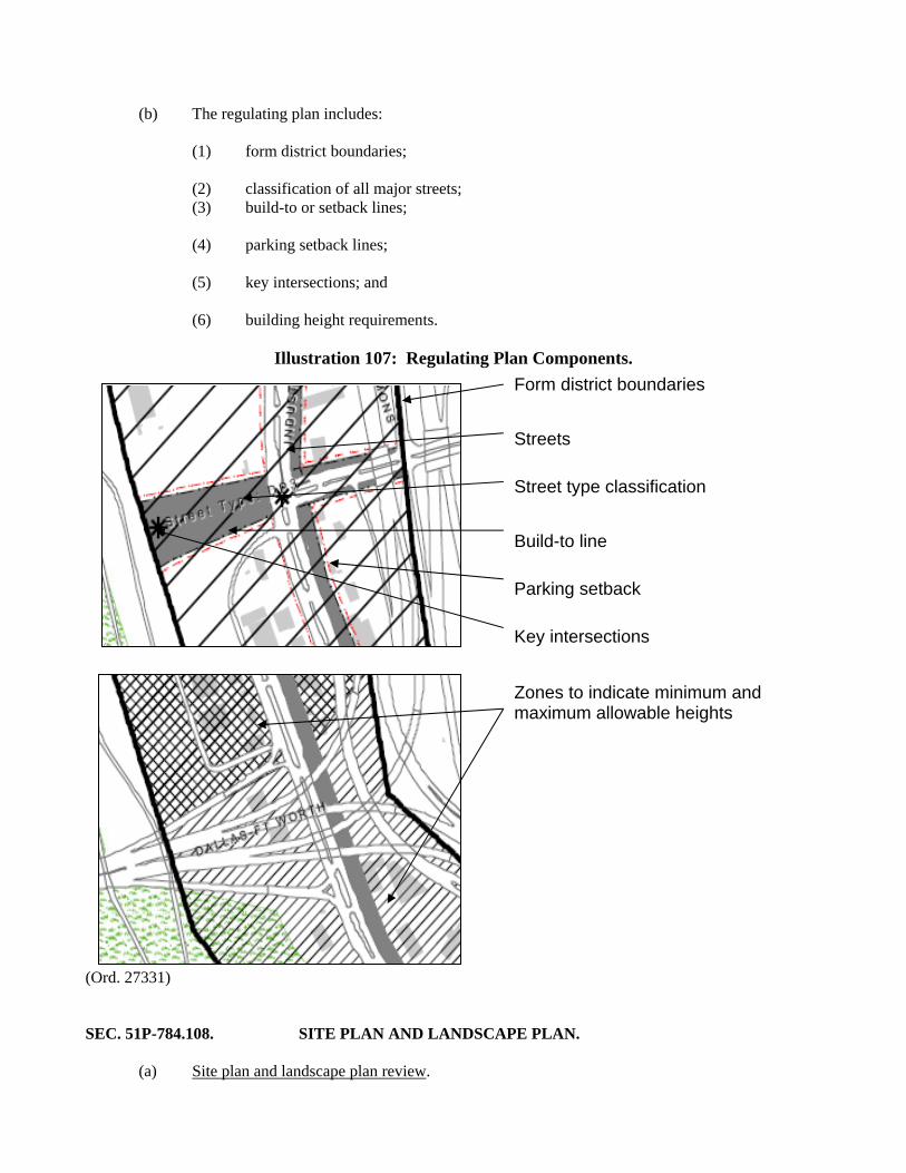
(b) The regulating plan includes: (1) form district boundaries; (2) classification of all major streets; (3) build-to or setback lines; (4) parking setback lines; (5) key intersections; and (6) building height requirements.
Illustration 107: Regulating Plan Components. (Ord. 27331) SEC. 51P-784.108. SITE PLAN AND LANDSCAPE PLAN. (a) Site plan and landscape plan review.
Form district boundaries
Streets
Street type classification
Build-to line
Parking setback
Key intersections
Zones to indicate minimum and maximum allowable heights
(1) Except as provided in Subsection (c), a site plan that complies with the requirements of this article and the regulating plan must be submitted to the Building official before an application is made for any work that will increase the floor area on a building site.
(2) Except as provided in Subsection (c), a landscape plan that complies with the requirements of this article and the regulating plan must be submitted to the Building official before an application is made for any work that will change the existing landscape plan or when required by Section 51A-10.121. (3) The site plan must include: (A) existing and proposed building footprints, points of ingress and egress, building entrances and exits, service areas, windows, and doors; (B) all public and private rights-of-way lines and easements; (C) the location, type, size, and height of perimeter fencing, screening, and buffering elements proposed or required; (D) all provisions to be made to direct and detain storm water; (E) mitigation to erosion during construction; (F) location, type, orientation, size, and height of light standards; (G) location of existing and proposed signs; (H) location of existing and proposed exterior loudspeakers and sound amplifiers; (I) location of existing and proposed mechanical equipment that produces high levels of noise; (J) pedestrian zones and circulation, including the location and description of amenities provided, including: (i) enhanced pavement, (ii) benches, (iii) trash receptacles, (iv) pedestrian street lamps, (v) awnings and canopies, (vi) bicycle parking, and (vii) tree grates; (K) shared parking reduction calculations for parking reduction eligibility, if requested;
(L) location of existing and proposed public and private utilities; (M) build-to lines and curb lines; (N) proposed street type classifications; (O) information sufficient to determine tower coverage on a block; (P) topographic contours at intervals of not less than two feet; (Q) height of nearest levee; and (R) any other information that the building official determines necessary. (4) The landscape plan must include: (A) date, scale, and north point; (B) names, addresses, and telephone numbers of both the property owner and the person preparing the plan; (C) location of existing boundary lines and dimensions of the lot, the zoning classification of the lot, including the form district, the zoning classification of adjacent properties, and a vicinity map; (D) approximate center line of existing water courses; location of the 100-year floodplain; and approximate location of significant drainage features; (E) location and size of existing and proposed streets and alleys, utility easements, driveways, and sidewalks on or adjacent to the lot; (F) project name, street address, and lot and block descriptions; (G) location, height, and material of proposed fencing and screening (with berms to be delineated by topographic contours at one-foot intervals), and the location of existing and proposed loading and garage storage areas; (H) location and dimensions of proposed landscape buffer strips; (I) a complete description of plant materials shown on the plan, including names (common and botanical), locations, quantities, container and caliper sizes at installation, heights, spread, and spacing; (J) location and type of all existing trees over six inches in caliper and the location and type of all trees to remain on the building site, in the adjacent right-of-way, or within 15 feet on the adjacent property, as well as plans to protect trees from damage during construction; (K) a complete description of landscaping and screening to be provided in or near off-street parking and loading areas, including the amount (in square feet) of landscape area to be provided interior to parking areas and the number and location of required off-street parking and loading spaces; (L) location of existing and proposed public and private utilities;
(M) size, height, location, and material of proposed seating, lighting, planters, sculptures, and water features; (N) location of the required irrigation system; (O) location of visibility triangles; (P) location and dimensions of pedestrian amenities and enhanced pavement; (Q) adjacent right-of-way area and any landscaping within the right-of-way area; (R) location and dimensions of required open space; and (S) any other information that the building official deems necessary. (b) Standard for approval. Except as provided in Subsection (c), the building official shall approve the site plan or the landscape plan if the: (1) plans are complete; (2) proposed development is adequately served by public facilities; (3) plans are consistent with or will not unreasonably impair the public use of the rights-of-way; (4) plans comply with the requirements of this article and the regulating plan; and (5) plans comply with all city codes, ordinances, rules, or regulations. (c) City plan commission approval required. (1) A site plan or landscape plan that does not comply with the regulating plan may be approved by the city plan commission using the minor amendment fee and public hearing process in Section 51A-1.105(k)(3). (2) The city plan commission shall approve a site plan or landscape plan that does not comply with the regulating plan if the modification: (A) is to the right-of-way or street alignments shown on the regulating plan, and the modification does not alter the street types designated on the regulating plan; (B) does not alter the minimum or maximum heights designated on the height map; and (C) the site plan or landscape plan: (i) does not alter the basic relationship of the proposed development to abutting property; (ii) does not adversely affect surrounding properties; (iii) is consistent with the Trinity River Corridor Comprehensive Land Use Plan; and

(iv) is consistent with the vision and intent of the applicable form district and regulating plan. (Ord. 27331) SEC. 51P-784.108.1. CEDARS WEST SUBDISTRICT NO. 2 SITE PLAN AND ELEVATION. For a tower/antenna for cellular communication in the Cedars West Subdistrict No. 2, development and use of the Property must comply with the Cedars West Subdistrict No. 2 site plan and elevation (Exhibit 784A). If there is a conflict between the text of the article and the Cedars West Subdistrict No. 2 site plan and elevation, the text of this article controls. (Ord. 30493)
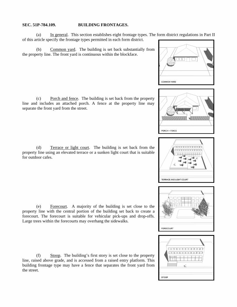
SEC. 51P-784.109. BUILDING FRONTAGES. (a) In general. This section establishes eight frontage types. The form district regulations in Part II of this article specify the frontage types permitted in each form district. (b) Common yard. The building is set back substantially from the property line. The front yard is continuous within the blockface.
(c) Porch and fence. The building is set back from the property line and includes an attached porch. A fence at the property line may separate the front yard from the street. (d) Terrace or light court. The building is set back from the property line using an elevated terrace or a sunken light court that is suitable for outdoor cafes. (e) Forecourt. A majority of the building is set close to the property line with the central portion of the building set back to create a forecourt. The forecourt is suitable for vehicular pick-ups and drop-offs. Large trees within the forecourts may overhang the sidewalks.
(f) Stoop. The building’s first story is set close to the property line, raised above grade, and is accessed from a raised entry platform. This building frontage type may have a fence that separates the front yard from the street.
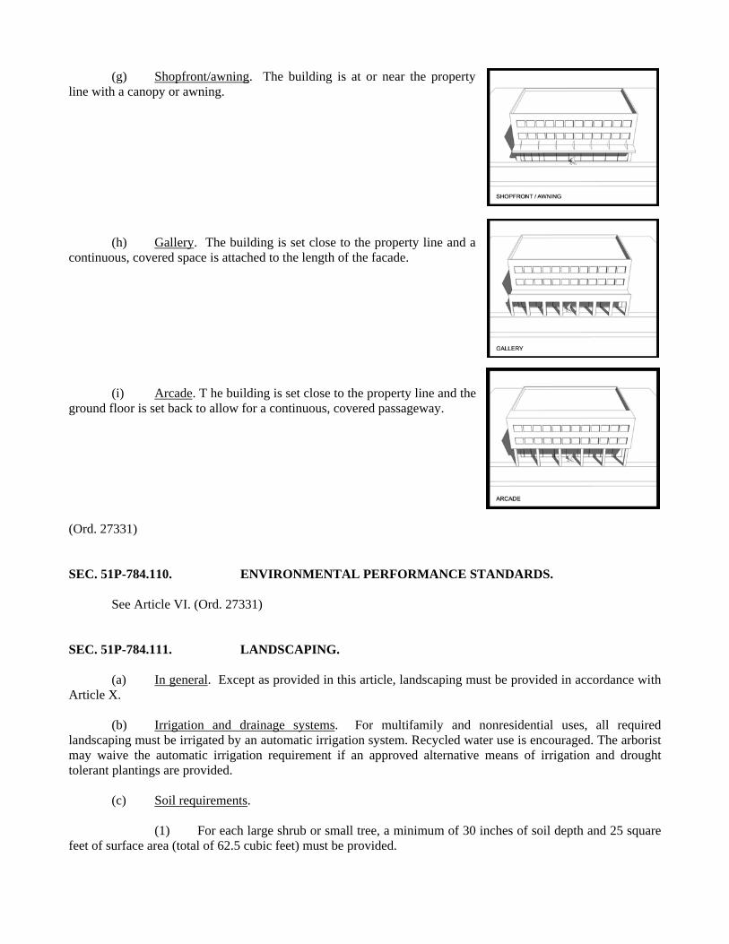
(g) Shopfront/awning. The building is at or near the property line with a canopy or awning.
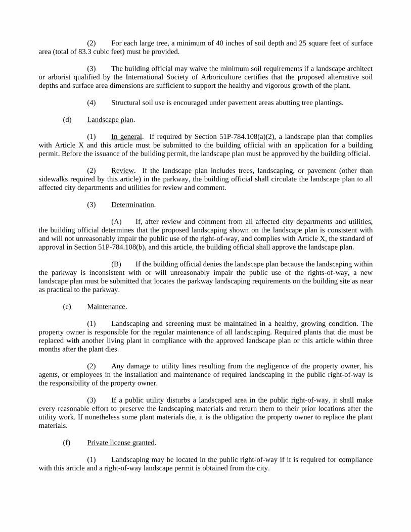
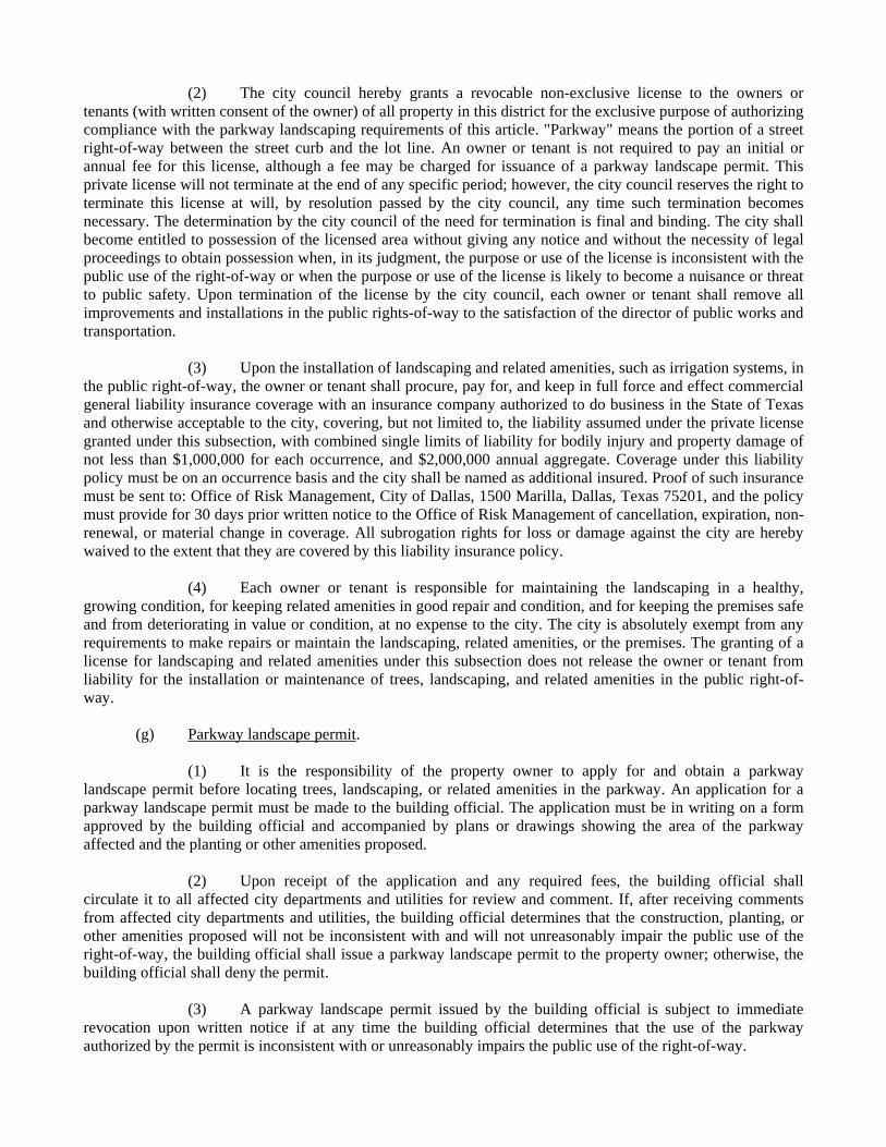
(h) Gallery. The building is set close to the property line and a continuous, covered space is attached to the length of the facade. (i) Arcade. T he building is set close to the property line and the ground floor is set back to allow for a continuous, covered passageway. (Ord. 27331) SEC. 51P-784.110. ENVIRONMENTAL PERFORMANCE STANDARDS. See Article VI. (Ord. 27331) SEC. 51P-784.111. LANDSCAPING. (a) In general. Except as provided in this article, landscaping must be provided in accordance with Article X. (b) Irrigation and drainage systems. For multifamily and nonresidential uses, all required landscaping must be irrigated by an automatic irrigation system. Recycled water use is encouraged. The arborist may waive the automatic irrigation requirement if an approved alternative means of irrigation and drought tolerant plantings are provided. (c) Soil requirements. (1) For each large shrub or small tree, a minimum of 30 inches of soil depth and 25 square feet of surface area (total of 62.5 cubic feet) must be provided.
(2) For each large tree, a minimum of 40 inches of soil depth and 25 square feet of surface area (total of 83.3 cubic feet) must be provided. (3) The building official may waive the minimum soil requirements if a landscape architect or arborist qualified by the International Society of Arboriculture certifies that the proposed alternative soil depths and surface area dimensions are sufficient to support the healthy and vigorous growth of the plant. (4) Structural soil use is encouraged under pavement areas abutting tree plantings. (d) Landscape plan. (1) In general. If required by Section 51P-784.108(a)(2), a landscape plan that complies with Article X and this article must be submitted to the building official with an application for a building permit. Before the issuance of the building permit, the landscape plan must be approved by the building official. (2) Review. If the landscape plan includes trees, landscaping, or pavement (other than sidewalks required by this article) in the parkway, the building official shall circulate the landscape plan to all affected city departments and utilities for review and comment. (3) Determination. (A) If, after review and comment from all affected city departments and utilities, the building official determines that the proposed landscaping shown on the landscape plan is consistent with and will not unreasonably impair the public use of the right-of-way, and complies with Article X, the standard of approval in Section 51P-784.108(b), and this article, the building official shall approve the landscape plan. (B) If the building official denies the landscape plan because the landscaping within the parkway is inconsistent with or will unreasonably impair the public use of the rights-of-way, a new landscape plan must be submitted that locates the parkway landscaping requirements on the building site as near as practical to the parkway. (e) Maintenance. (1) Landscaping and screening must be maintained in a healthy, growing condition. The property owner is responsible for the regular maintenance of all landscaping. Required plants that die must be replaced with another living plant in compliance with the approved landscape plan or this article within three months after the plant dies. (2) Any damage to utility lines resulting from the negligence of the property owner, his agents, or employees in the installation and maintenance of required landscaping in the public right-of-way is the responsibility of the property owner. (3) If a public utility disturbs a landscaped area in the public right-of-way, it shall make every reasonable effort to preserve the landscaping materials and return them to their prior locations after the utility work. If nonetheless some plant materials die, it is the obligation the property owner to replace the plant materials. (f) Private license granted. (1) Landscaping may be located in the public right-of-way if it is required for compliance with this article and a right-of-way landscape permit is obtained from the city.
(2) The city council hereby grants a revocable non-exclusive license to the owners or tenants (with written consent of the owner) of all property in this district for the exclusive purpose of authorizing compliance with the parkway landscaping requirements of this article. "Parkway" means the portion of a street right-of-way between the street curb and the lot line. An owner or tenant is not required to pay an initial or annual fee for this license, although a fee may be charged for issuance of a parkway landscape permit. This private license will not terminate at the end of any specific period; however, the city council reserves the right to terminate this license at will, by resolution passed by the city council, any time such termination becomes necessary. The determination by the city council of the need for termination is final and binding. The city shall become entitled to possession of the licensed area without giving any notice and without the necessity of legal proceedings to obtain possession when, in its judgment, the purpose or use of the license is inconsistent with the public use of the right-of-way or when the purpose or use of the license is likely to become a nuisance or threat to public safety. Upon termination of the license by the city council, each owner or tenant shall remove all improvements and installations in the public rights-of-way to the satisfaction of the director of public works and transportation. (3) Upon the installation of landscaping and related amenities, such as irrigation systems, in the public right-of-way, the owner or tenant shall procure, pay for, and keep in full force and effect commercial general liability insurance coverage with an insurance company authorized to do business in the State of Texas and otherwise acceptable to the city, covering, but not limited to, the liability assumed under the private license granted under this subsection, with combined single limits of liability for bodily injury and property damage of not less than $1,000,000 for each occurrence, and $2,000,000 annual aggregate. Coverage under this liability policy must be on an occurrence basis and the city shall be named as additional insured. Proof of such insurance must be sent to: Office of Risk Management, City of Dallas, 1500 Marilla, Dallas, Texas 75201, and the policy must provide for 30 days prior written notice to the Office of Risk Management of cancellation, expiration, non-renewal, or material change in coverage. All subrogation rights for loss or damage against the city are hereby waived to the extent that they are covered by this liability insurance policy. (4) Each owner or tenant is responsible for maintaining the landscaping in a healthy, growing condition, for keeping related amenities in good repair and condition, and for keeping the premises safe and from deteriorating in value or condition, at no expense to the city. The city is absolutely exempt from any requirements to make repairs or maintain the landscaping, related amenities, or the premises. The granting of a license for landscaping and related amenities under this subsection does not release the owner or tenant from liability for the installation or maintenance of trees, landscaping, and related amenities in the public right-of-way. (g) Parkway landscape permit. (1) It is the responsibility of the property owner to apply for and obtain a parkway landscape permit before locating trees, landscaping, or related amenities in the parkway. An application for a parkway landscape permit must be made to the building official. The application must be in writing on a form approved by the building official and accompanied by plans or drawings showing the area of the parkway affected and the planting or other amenities proposed. (2) Upon receipt of the application and any required fees, the building official shall circulate it to all affected city departments and utilities for review and comment. If, after receiving comments from affected city departments and utilities, the building official determines that the construction, planting, or other amenities proposed will not be inconsistent with and will not unreasonably impair the public use of the right-of-way, the building official shall issue a parkway landscape permit to the property owner; otherwise, the building official shall deny the permit. (3) A parkway landscape permit issued by the building official is subject to immediate revocation upon written notice if at any time the building official determines that the use of the parkway authorized by the permit is inconsistent with or unreasonably impairs the public use of the right-of-way.
(4) The issuance of a parkway landscape permit under this subsection does not excuse the property owner, his agents, or employees from liability for the installation or maintenance of trees or other amenities in the public right-of-way. (Ord. 27331) SEC. 51P-784.112. NONCONFORMING USES AND STRUCTURES. (a) In general. Except as provided in this section, Section 51A-4.704 applies to all nonconforming uses and structures. (b) Nonconforming uses. (1) Purpose. The city council finds that certain nonconforming uses are not compatible with the Trinity River Corridor Comprehensive Land Use Plan and have an adverse effect on nearby properties. The purpose of this section is to eliminate these nonconforming uses and make them comply with the regulations of the Dallas Development Code, having due regard for the property rights of the persons affected, the public welfare, and the character of the surrounding area. (2) Automatic compliance date for industrial uses. (A) A nonconforming industrial use must come into conformity with zoning five years after the use became nonconforming or five years after the use becomes nonconforming through incorporation into this district, whichever is later. The industrial use must cease operations on that date and it may not operate thereafter unless it becomes a conforming use. (B) Industrial uses operating under a specific use permit granted before the creation of this district are treated as a conforming use and may continue to operate until the specific use permit expires. When an industrial use operating under a specific use permit expires, the industrial use must come into conformity with zoning. The granting of a specific use permit does not confer nonconforming rights to a use. See Section 51A-4.219. (3) Extension of compliance deadline. (A) An owner of a nonconforming industrial use may request an extension of the compliance date required in Paragraph (2) by filing an application with the director on a form provided by the city. The application must be filed at least 180 days before the deadline in Paragraph (2). If a fee is required, the application shall not be considered filed until the fee is paid. Failure to timely file a complete application for extension shall constitute a waiver of the right to contest the reasonableness of the deadline in Paragraph (2). (B) Upon the filing of a complete application for extension of the compliance date, the board of adjustment shall, in accordance with the law, hold a public hearing to determine whether it is necessary to extend the compliance deadline for the nonconforming use. (C) The board of adjustment must consider the factors listed in Section 51A-4.704(a)(1)(D) in determining whether to grant the request for extension. (D) If, based on evidence presented at the public hearing, the board of adjustment finds that additional time is needed to recoup the owner's actual investment in the use before the use became nonconforming, the board of adjustment shall grant the request for extension and establish a new compliance deadline consistent with its determination of a reasonable amortization period; otherwise, the board of adjustment shall deny the request.
(E) If the board of adjustment denies the request, the nonconforming use must come into conformity with zoning on the compliance date in Paragraph (2), or 30 days after the date of the board's decision to deny, whichever is later. (4) Changes to nonconforming uses. Section 51A-4.704(b)(1), allowing a change from one nonconforming use to another, does not apply. (Ord. 27331) SEC. 51P-784.113. AMENDMENTS. (a) Amendments to Part I. An amendment to Part I is a zoning change that must comply with the zoning procedures in Section 51A-4.701. For notification purposes, the area of request is all of the Property. (b) Amendments to Part II. (1) New form districts may be added to the district. Adding a new form district is a zoning change that must comply with the zoning procedures in Section 51A-4.701. For notification purposes, the area of request is all property to be regulated by the new form district. (2) Existing form district regulations may be amended. Amendment to an existing form district regulation is a zoning change that must comply with the zoning procedures in Section 51A-4.701. For notification purposes, the area of request is all property regulated by the existing form district. (c) Amendments to Part III. (1) New subareas may be added to the district. Adding new subareas is a zoning change that must comply with the zoning procedures in Sections 51A-4.701 and 51A-4.702. For notification purposes, the area of request is all property within the new subarea. (2) Subarea regulations may be amended. Except as provided in this section, any amendment to a subarea regulation is a zoning change that must comply with the zoning procedures in Sections 51A-4.701 and 51A-4.702. For notification purposes, the area of request is the property within the subarea being amended. (3) Property within a subarea may be rezoned from one form district to another form district. A change from one form district to another form district is a zoning change that must comply with the zoning procedures in Sections 51A-4.701 and 51A-4.702. For notification purposes, the area of request is the property requesting the form district change. (Ord. 27331) SEC. 51P-784.114. ADDITIONAL PROVISIONS. (a) The Property must be properly maintained in a state of good repair and neat appearance. (b) Development and use of the Property must comply with all federal and state laws and regulations, and with all ordinances, rules, and regulations of the city. (Ord. 27331) SEC. 51P-784.115. COMPLIANCE WITH CONDITIONS. (a) All paved areas, permanent drives, streets, and drainage structures, if any, must be constructed in accordance with standard city specifications, and completed to the satisfaction of the director of public works and transportation.

(b) The building official shall not issue a building permit to authorize work, or a certificate of occupancy to authorize the operation of a use, until there has been full compliance with this article, the Dallas Development Code, the construction codes, and all other ordinances, rules, and regulations of the city. (Ord. 27331)
[Remainder of page intentionally left blank.]
PART II.
FORM DISTRICT REGULATIONS. SEC. 51P-784.201. CREATION OF FORM DISTRICTS. (a) Form district regulations are zoning district regulations that may be applied to any subarea. (b) The following form districts are incorporated into the Trinity River Special Purpose District:
(1) Downtown.
(2) Urban village. (Ord. Nos. 27331; 28027) SEC. 51P-784.202. DOWNTOWN FORM DISTRICT REGULATIONS. (a) In general. (1) The downtown form district is the most intense level of development in the Corridor, combining a dense mix of office, retail, residential, lodging, and civic uses to create a vibrant, urban, pedestrian-oriented environment. This form district creates a destination that draws residents, tourists, and businesses to retail, cultural, and civic attractions. Development will include low, mid-rise, and high-rise structures with active pedestrian frontages. The streets and open spaces will form a network with wide sidewalks and other pedestrian amenities. (2) This district is considered to be a nonresidential zoning district. (b) Open space. (1) Purpose. Open space requirements are intended to provide relief from a dense urban environment, assist with pedestrian movement, and provide connections to public spaces. (2) Requirements. A minimum of 10 percent of a lot area or building site must be open space meeting the following requirements: (A) Open space must be a contiguous area of not less than ten feet in width or length. (B) Open space must be unobstructed to the sky and may not have permanent structures except structures supporting pedestrian or outdoor recreational uses; kiosks that provide information related to the open space; water features, including fountains, ponds, and waterfalls; and security, audio-visual, or maintenance equipment. (C) Open space must be accessible to all occupants of the building site. (3) Location. Open space may be located at, below, or above grade.
(4) Landscaping. (A) A minimum of 25 percent of the open space area must be landscaped, and may include turf, ground cover, shrubs, trees, or seasonal plantings. (B) One tree having a caliper of at least three inches must be provided in the open space for each 2,000 square feet. Street trees may be counted toward this requirement. (5) Maintenance. Open spaces and pedestrian amenities must be maintained in a state of good repair and neat appearance. Landscaping must be maintained in a healthy, growing condition. The property owner is responsible for the regular maintenance of open spaces and all landscaping. Required plants that die must be replaced with another living plant in compliance with the approved landscape plan within three months after the plant dies. (c) Block standards. (1) Applicability. The following block standards apply during the platting process if the parcel of land being platted is greater than the block perimeters described in this subsection. (2) Block perimeter and length. (A) Except as provided in this paragraph, block perimeters may not exceed 1,600 linear feet, measured along the inner edges of each street right-of-way. (B) A block perimeter may exceed 1,600 linear feet if no single block face exceeds 700 feet in length and the block includes: (i) at least one plaza that is integrated into the proposed development and has at least one pedestrian access point for each 600 feet of block perimeter using escalators, stairs, or ramps to provide direct, public, pedestrian access from the street network to the levee top; or (ii) at least one mid-block sidewalk that has a minimum unobstructed width of eight feet and connects to at least two streets. (d) Frontage types.
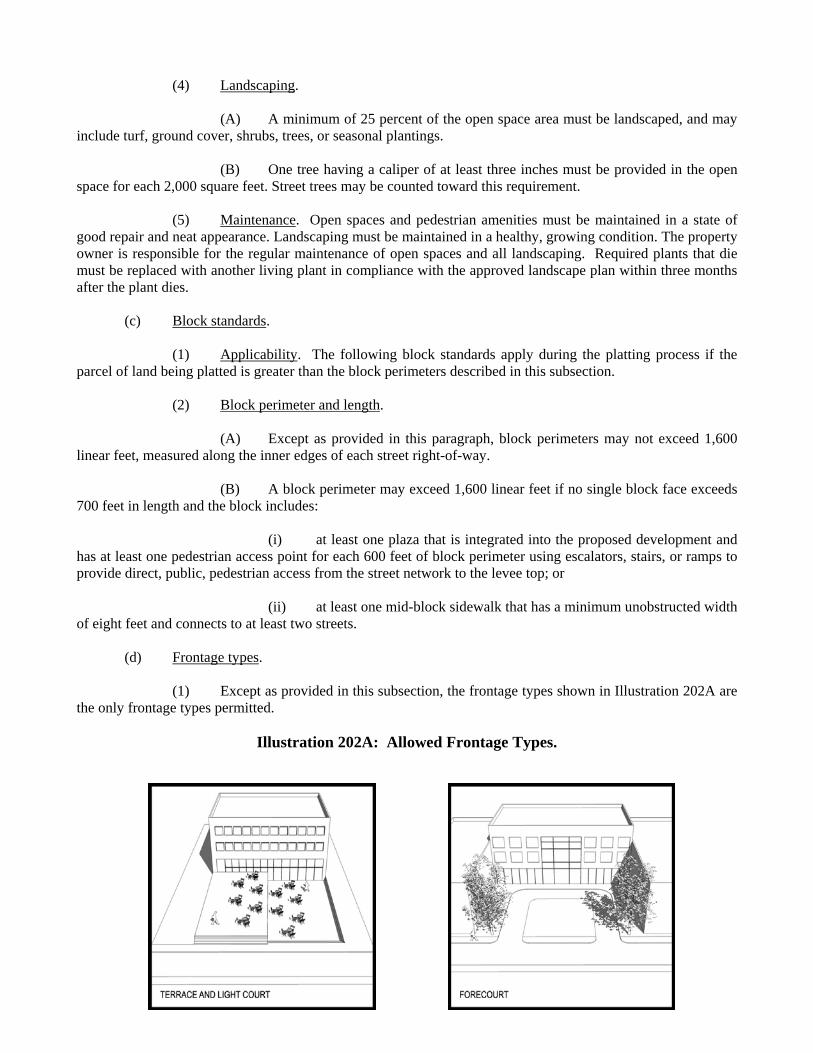
(1) Except as provided in this subsection, the frontage types shown in Illustration 202A are the only frontage types permitted.
Illustration 202A: Allowed Frontage Types.
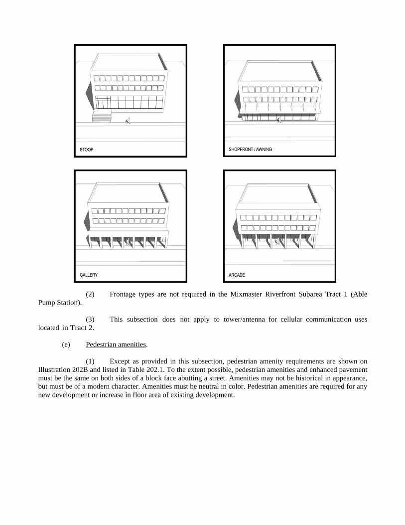
(2) Frontage types are not required in the Mixmaster Riverfront Subarea Tract 1 (Able Pump Station). (3) This subsection does not apply to tower/antenna for cellular communication uses located in Tract 2. (e) Pedestrian amenities.
(1) Except as provided in this subsection, pedestrian amenity requirements are shown on Illustration 202B and listed in Table 202.1. To the extent possible, pedestrian amenities and enhanced pavement must be the same on both sides of a block face abutting a street. Amenities may not be historical in appearance, but must be of a modern character. Amenities must be neutral in color. Pedestrian amenities are required for any new development or increase in floor area of existing development.
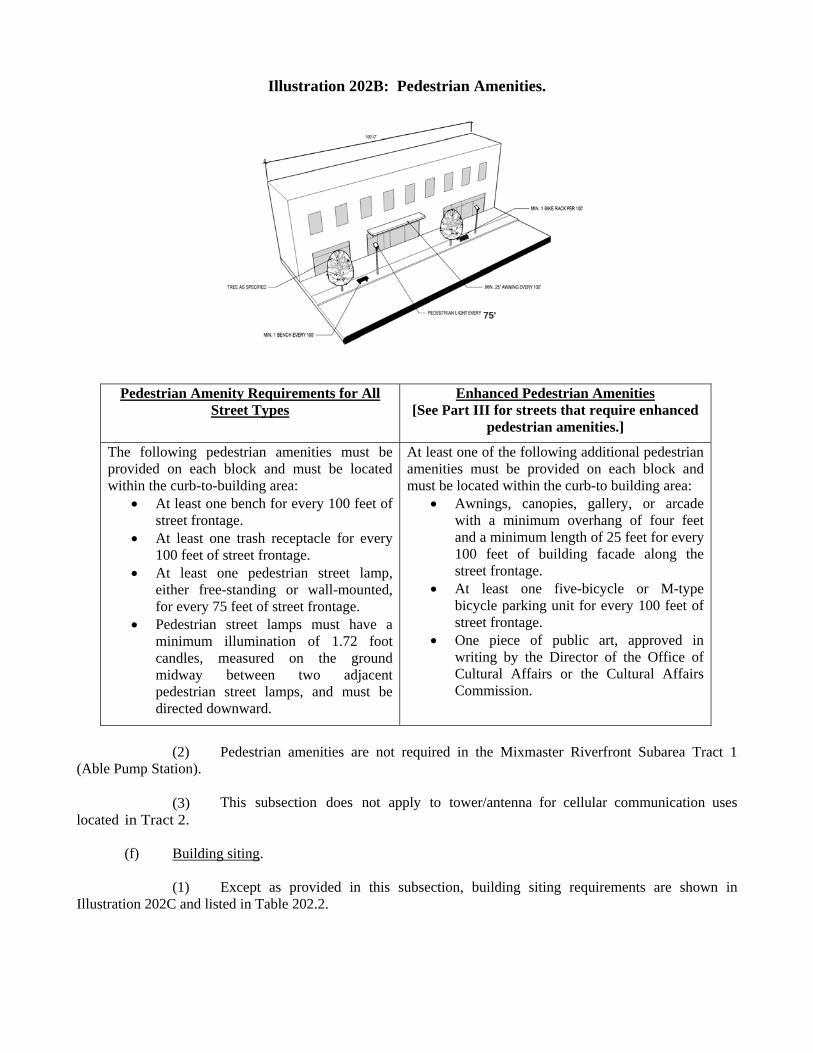
Illustration 202B: Pedestrian Amenities.
Table 202.1. Pedestrian amenity requirements.
Pedestrian Amenity Requirements for All Street Types
Enhanced Pedestrian Amenities [See Part III for streets that require enhanced
pedestrian amenities.]
The following pedestrian amenities must be provided on each block and must be located within the curb-to-building area:
At least one bench for every 100 feet of street frontage.
At least one trash receptacle for every 100 feet of street frontage.
At least one pedestrian street lamp, either free-standing or wall-mounted, for every 75 feet of street frontage.
Pedestrian street lamps must have a minimum illumination of 1.72 foot candles, measured on the ground midway between two adjacent pedestrian street lamps, and must be directed downward.
At least one of the following additional pedestrian amenities must be provided on each block and must be located within the curb-to building area:
Awnings, canopies, gallery, or arcade with a minimum overhang of four feet and a minimum length of 25 feet for every 100 feet of building facade along the street frontage.
At least one five-bicycle or M-type bicycle parking unit for every 100 feet of street frontage.
One piece of public art, approved in writing by the Director of the Office of Cultural Affairs or the Cultural Affairs Commission.
(2) Pedestrian amenities are not required in the Mixmaster Riverfront Subarea Tract 1
(Able Pump Station). (3) This subsection does not apply to tower/antenna for cellular communication uses located in Tract 2. (f) Building siting.
(1) Except as provided in this subsection, building siting requirements are shown in Illustration 202C and listed in Table 202.2.
7755''
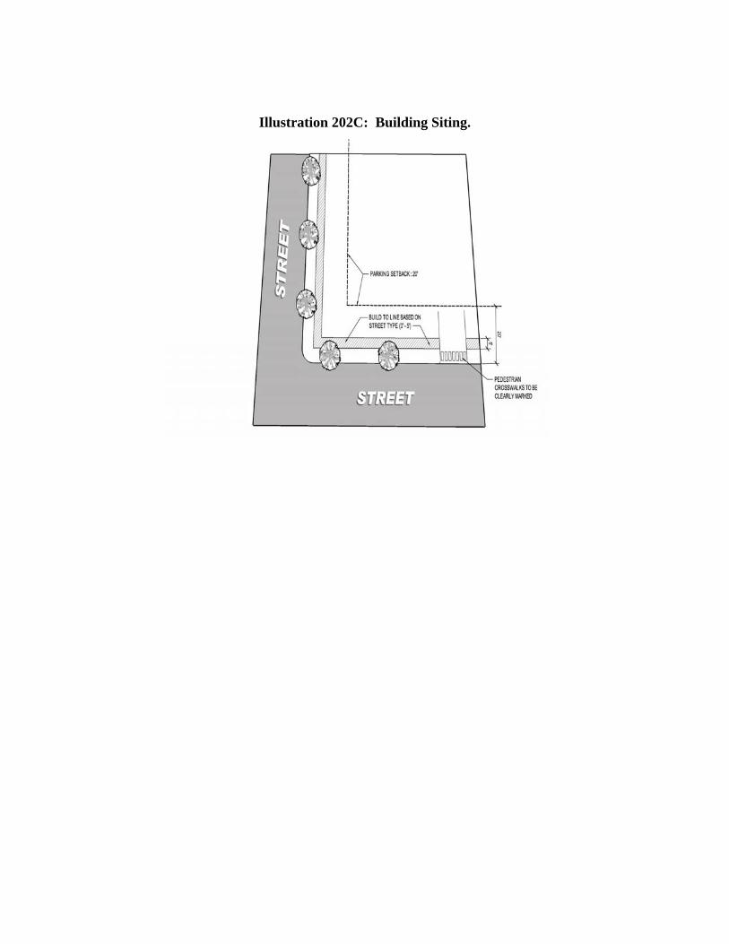
Illustration 202C: Building Siting.
Table 202.2. Building siting requirements.
Building Siting Requirements Build-to line
Primary street types. See Part III for build-to line requirements. Except as provided in this table, if a build-to line is not shown on the
regulating plan, the build-to line is the property line abutting the street or the edge of the public easement.
Where the required right-of-way in the thoroughfare plan does not provide adequate space to provide the required planting and amenity zone and pedestrian zone, the owner must provide a public access easement to accommodate the additional required space. In these cases, build-to lines and setback lines will be measured from this easement.
Secondary street types. See Part III for build-to line requirements. If a build-to line is not shown on the site plan, the build-to line is the
property line abutting the street or the edge of the public easement.Frontage on build-to lines
See Part III for additional frontage requirements for each street type. Building articulations of up to two feet are permitted behind the
build-to line.Side setback No minimum required.Rear setback No minimum required.Lot coverage No maximum required.
Parking setback Surface parking lots must be set back a minimum of 20 feet from abutting streets.
Key intersection setbacks
Additional setbacks may be required from key intersections. See Part III.
Driveway design Pedestrian crosswalks across ingress and egress driveways must be clearly marked by colored concrete, patterned or stamped concrete, or brick pavers.
Curb cuts must be at least 12 feet but not more than 24 feet in length (measured parallel to the frontage).
(2) Building siting is not required in the Mixmaster Riverfront Subarea Tract 1 (Able Pump
Station). (3) This subsection does not apply to tower/antenna for cellular communication uses located in Tract 2.
(g) Building configuration and orientation requirements. Building configuration and orientation
requirements are shown in Illustration 202D and listed in Table 202.3. (1) Height, story, and tower coverage.
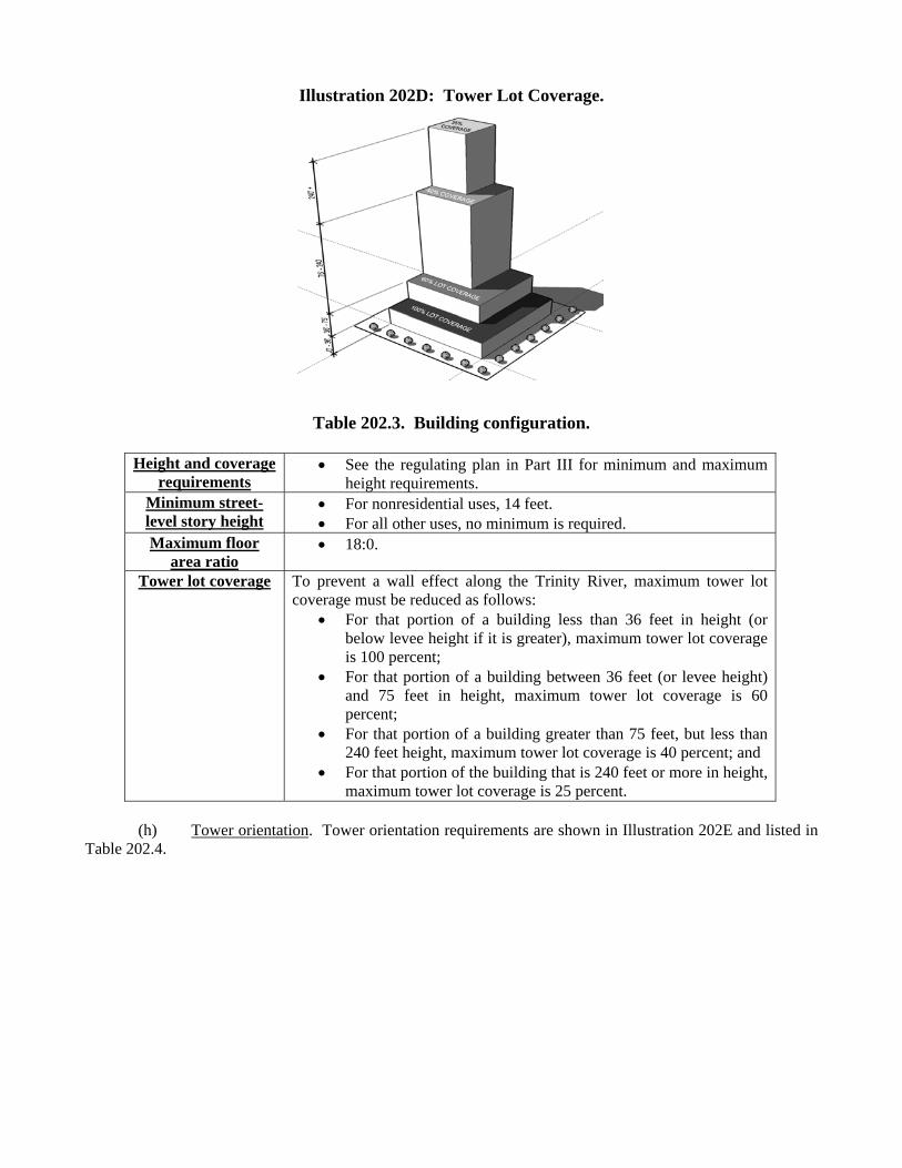
Illustration 202D: Tower Lot Coverage.
Table 202.3. Building configuration.
Height and coverage requirements
See the regulating plan in Part III for minimum and maximum height requirements.
Minimum street-level story height
For nonresidential uses, 14 feet. For all other uses, no minimum is required.
Maximum floor area ratio
18:0.
Tower lot coverage To prevent a wall effect along the Trinity River, maximum tower lot coverage must be reduced as follows:
For that portion of a building less than 36 feet in height (or below levee height if it is greater), maximum tower lot coverage is 100 percent;
For that portion of a building between 36 feet (or levee height) and 75 feet in height, maximum tower lot coverage is 60 percent;
For that portion of a building greater than 75 feet, but less than 240 feet height, maximum tower lot coverage is 40 percent; and
For that portion of the building that is 240 feet or more in height, maximum tower lot coverage is 25 percent.
(h) Tower orientation. Tower orientation requirements are shown in Illustration 202E and listed in Table 202.4.
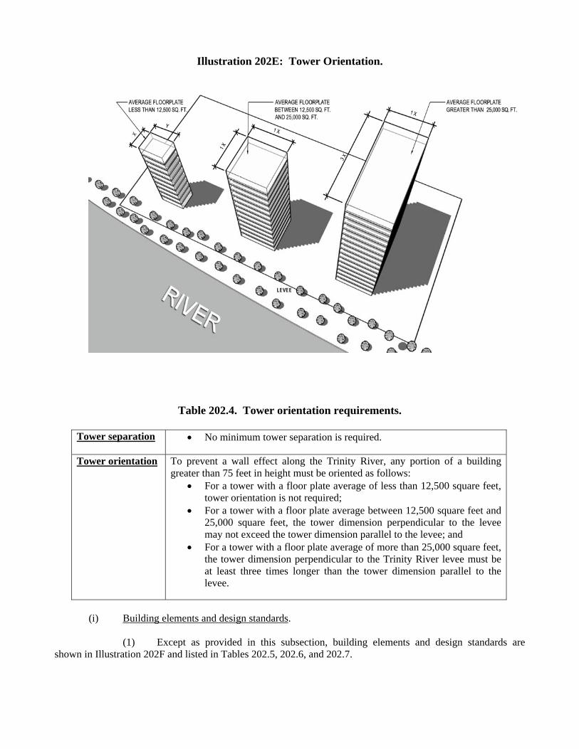
Illustration 202E: Tower Orientation.
Table 202.4. Tower orientation requirements.
Tower separation No minimum tower separation is required.
Tower orientation To prevent a wall effect along the Trinity River, any portion of a building greater than 75 feet in height must be oriented as follows:
For a tower with a floor plate average of less than 12,500 square feet, tower orientation is not required;
For a tower with a floor plate average between 12,500 square feet and 25,000 square feet, the tower dimension perpendicular to the levee may not exceed the tower dimension parallel to the levee; and
For a tower with a floor plate average of more than 25,000 square feet, the tower dimension perpendicular to the Trinity River levee must be at least three times longer than the tower dimension parallel to the levee.
(i) Building elements and design standards.
(1) Except as provided in this subsection, building elements and design standards are shown in Illustration 202F and listed in Tables 202.5, 202.6, and 202.7.
LLEEVVEEEE
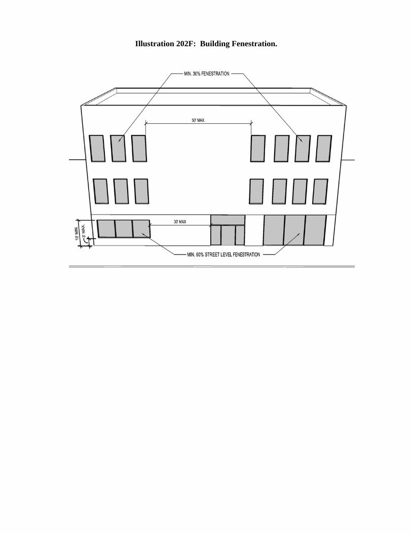
Illustration 202F: Building Fenestration.
Table 202.5. Building elements and layout standards.
Purpose Building elements and site layout standards are intended to: (1) ensure that new development enhances the character of the Corridor; and (2) create and enhance the character and environment for pedestrians.
Street-level fenestration for street-fronting
facades
To prevent long expanses of walls, a minimum of 60 percent of the street-level street-fronting facades must be fenestration, and no more than 30 continuous linear feet may lack transparent fenestration (e.g. a window or transparent door).
Street-fronting, street-level windows
Windows on street-fronting, street-level structures must be: clear and unpainted or made of similarly treated glass that
provides a transparent surface (spandrel glass or back-painted glass is prohibited); and
located a maximum of three feet above grade; and at least 10 feet above grade.
Upper-level fenestration for street-fronting
facades
To prevent long expanses of walls, a minimum of 30 percent of the upper-level street-fronting facade must be fenestration; and no more than 50 continuous linear feet may lack transparent fenestration (e.g. a window or transparent door).
[Remainder of this page intentionally left blank.]
Table 202.6. Building elements and entrances.
Entries Street-facing building entrances must be clearly visible from the street and may only be a maximum of 75 feet apart along the same side of the street on a lot.
Primary building entrances must face the street and must be accessible from the sidewalk.
For corner lots, primary building entrances may be oriented toward the corner. Primary building entrances must have two or more of the following:
Arches, awnings, canopies, gallery, or arcade with a minimum overhang of four feet that spans the entire building entrance.
Decorative elements such as friezes, tile work, molding, raised banding, or projected banding. Projections must extend horizontally from the building surface at least two inches.
Enhanced exterior light fixtures including wall sconces, light coves with concealed light sources, ground-mounted accent lights, or decorative pedestal lights.
Integral planters or wing walls that incorporate landscaped areas or places for sitting.
Patio. Porch.
All nonresidential street-level uses must have direct access to and from sidewalks along a street, square, or plaza.
Residential dwelling units with direct access to the sidewalk must have entrances raised or lowered a minimum of two feet from grade.
Facade standards
Street-level, street-fronting facades exceeding 30 feet in length must have two of the following elements. Street-level, street-fronting facades exceeding 100 feet in length must have three of the following elements. For block faces equal to or less than 500 feet in length, the cumulative length of these elements must extend 60 percent of the street level facade. For block faces greater than 500 feet in length, the cumulative length of the following elements must extend 80 percent of the street-level facade. Change in plane, such as an offset, reveal, recess, or projection at intervals not less
than 20 feet and not greater than 100 feet. Changes in plane must have a width of no less than 24 inches and a depth of at least eight inches and may include columns, planters, arches, and niches.
Architectural details such as raised bands, projected or bay windows, and cornices. Change in facade color, material, or texture at intervals not less than 20 feet and
not greater than 100 feet. Awnings or canopies with a minimum overhang of four feet and a minimum length
of 25 feet for every 100 feet of the building facade along the street frontage. Upper floor, street-fronting facades on blocks exceeding 500 feet in length must
incorporate the following elements: Change in plane, such as an offset, reveal, recess, or projection at intervals not less than 20 feet and not greater than 200 feet. Changes in plane must have a width of no less than 24 inches and a depth of at least eight inches. Change in facade color, material, or texture at intervals not less than 20 feet and not greater than 200 feet.
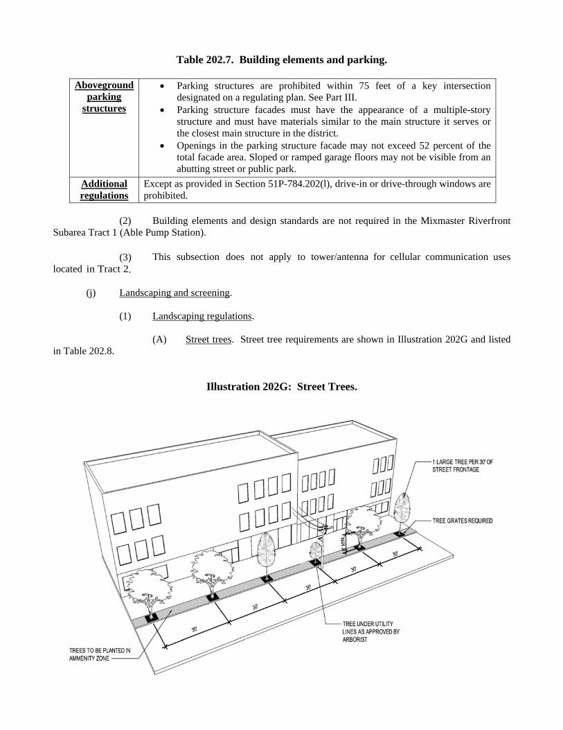
Table 202.7. Building elements and parking.
Aboveground parking
structures
Parking structures are prohibited within 75 feet of a key intersection designated on a regulating plan. See Part III.
Parking structure facades must have the appearance of a multiple-story structure and must have materials similar to the main structure it serves or the closest main structure in the district.
Openings in the parking structure facade may not exceed 52 percent of the total facade area. Sloped or ramped garage floors may not be visible from an abutting street or public park.
Additional regulations
Except as provided in Section 51P-784.202(l), drive-in or drive-through windows are prohibited.
(2) Building elements and design standards are not required in the Mixmaster Riverfront
Subarea Tract 1 (Able Pump Station). (3) This subsection does not apply to tower/antenna for cellular communication uses located in Tract 2.
(j) Landscaping and screening.
(1) Landscaping regulations. (A) Street trees. Street tree requirements are shown in Illustration 202G and listed in Table 202.8.
Illustration 202G: Street Trees.
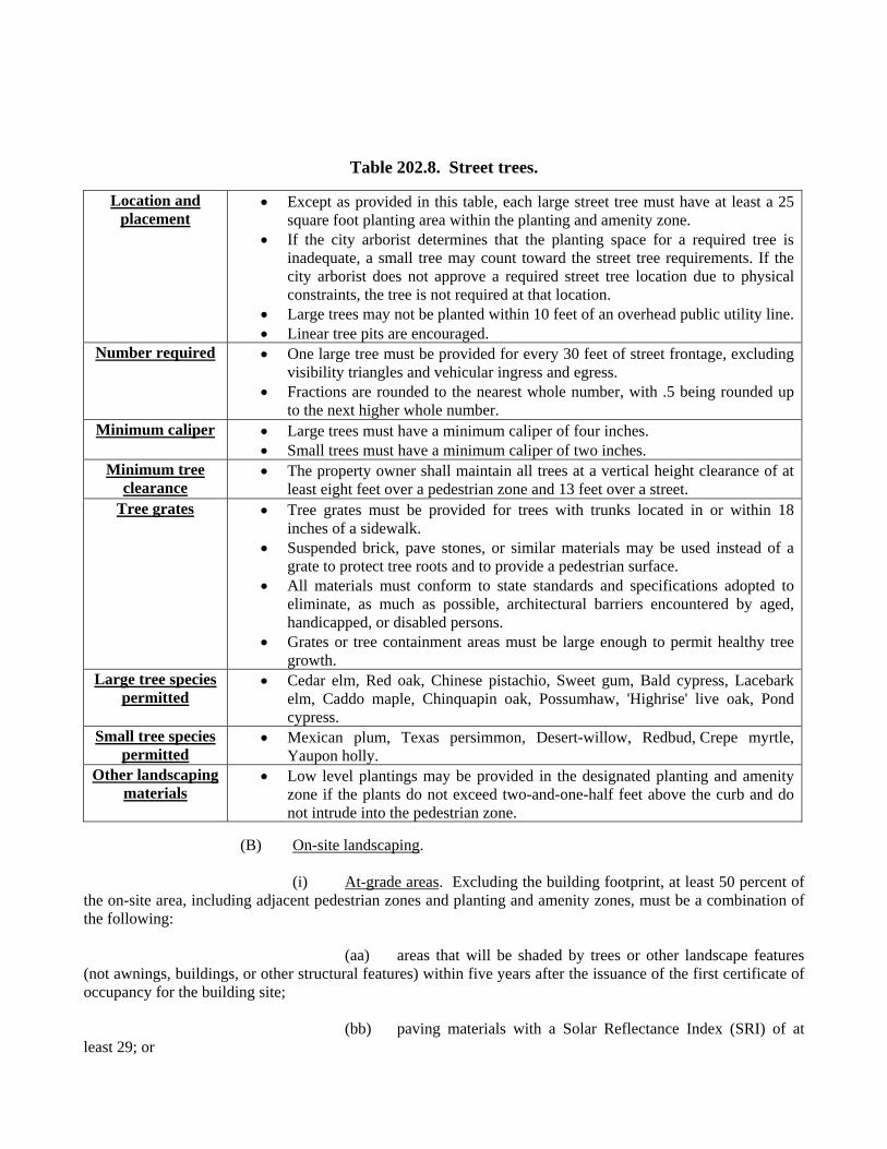
Table 202.8. Street trees.
Location and placement
Except as provided in this table, each large street tree must have at least a 25 square foot planting area within the planting and amenity zone.
If the city arborist determines that the planting space for a required tree is inadequate, a small tree may count toward the street tree requirements. If the city arborist does not approve a required street tree location due to physical constraints, the tree is not required at that location.
Large trees may not be planted within 10 feet of an overhead public utility line. Linear tree pits are encouraged.
Number required One large tree must be provided for every 30 feet of street frontage, excluding visibility triangles and vehicular ingress and egress.
Fractions are rounded to the nearest whole number, with .5 being rounded up to the next higher whole number.
Minimum caliper Large trees must have a minimum caliper of four inches. Small trees must have a minimum caliper of two inches.
Minimum tree clearance
The property owner shall maintain all trees at a vertical height clearance of at least eight feet over a pedestrian zone and 13 feet over a street.
Tree grates Tree grates must be provided for trees with trunks located in or within 18 inches of a sidewalk.
Suspended brick, pave stones, or similar materials may be used instead of a grate to protect tree roots and to provide a pedestrian surface.
All materials must conform to state standards and specifications adopted to eliminate, as much as possible, architectural barriers encountered by aged, handicapped, or disabled persons.
Grates or tree containment areas must be large enough to permit healthy tree growth.
Large tree species permitted
Cedar elm, Red oak, Chinese pistachio, Sweet gum, Bald cypress, Lacebark elm, Caddo maple, Chinquapin oak, Possumhaw, 'Highrise' live oak, Pond cypress.
Small tree species permitted
Mexican plum, Texas persimmon, Desert-willow, Redbud, Crepe myrtle, Yaupon holly.
Other landscaping materials
Low level plantings may be provided in the designated planting and amenity zone if the plants do not exceed two-and-one-half feet above the curb and do not intrude into the pedestrian zone.
(B) On-site landscaping. (i) At-grade areas. Excluding the building footprint, at least 50 percent of the on-site area, including adjacent pedestrian zones and planting and amenity zones, must be a combination of the following: (aa) areas that will be shaded by trees or other landscape features (not awnings, buildings, or other structural features) within five years after the issuance of the first certificate of occupancy for the building site; (bb) paving materials with a Solar Reflectance Index (SRI) of at least 29; or
(cc) permeable pavement surface or landscaping beds for areas that are not required to be paved. (ii) Roof tops. Roof materials must be composed of one of the following: (aa) Solar Reflectance Index (SRI) equal to or greater than the values listed in Table 202.9 covering a minimum of 75 percent of the roof surface.
Table 202.9.
Slope SRI Low-sloped roof 2:12 slope or less 78 Steep-sloped roof greater than 2:12 slope 29
(bb) Plant materials covering at least 50 percent of the roof area. (cc) A combination of materials complying with the SRI requirements of provision (aa) and plant materials collectively covering 75 percent of the roof area. (iii) Single family use. For each single family or handicapped group dwelling unit, one tree (large or small) from the replacement tree list in Section 51A-10.134 must be provided on the building site, subject to approval of the city arborist. (2) Screening. (A) Service areas. Garbage storage areas, service areas, and loading bays must be visually screened from a street or public park by a minimum six-foot-high brick, stone, concrete masonry, stucco, or concrete wall. (B) Mechanical equipment. Mechanical equipment, skylights, and solar panels on roofs must be screened or setback so that they are not visible from a point five feet, six inches above grade at the property line. (C) Prohibited materials. Chain link and vinyl fencing materials are prohibited. (3) Surface parking lots. Surface parking lot requirements are listed in Table 202.10.
Table 202.10. Surface parking requirements.
Screening requirements
Except pedestrian and vehicular ingress and egress points, a minimum four-foot-high screen must be provided along the perimeter of surface parking lots that abut a street, right-of-way, and build-to lines.
A maximum of two pedestrian access points are permitted for each street frontage.
Pedestrian access points may not exceed 10 feet in width. Surface parking lot screening is not required to be fully sight-obscuring.
Screening materials
Materials may include masonry and metal. To prevent visual monotony, at least 20 percent of the length of any fence or
wall longer than 200 feet must alternate materials; alternate textures; be a combination of materials; have gates, offsets, or openings; or provide a planted landscape area between the screening and the sidewalk. Landscape areas must be planted with a combination of ground cover, shrubs, or trees in an area having a
width of at least two-and-one-half feet.
Site trees Surface parking spaces must be within 40 feet of a large tree. For parking lot trees, minimum planting areas is 36 square feet. Each tree must have a caliper of at least three inches and may not be planted
closer than two-and-one-half feet to the paved portion of the parking lot.Pedestrian paths Surface parking lots having more than two rows of parking across the width of
the lot must have a pedestrian pathway system. The pedestrian pathway must be distinguished from the parking and driving
surface by landscape barriers or a change in surface materials such as pavers or patterned concrete. Pedestrian pathways may not be distinguished by paint alone.
Pedestrian pathways must be a minimum of four feet wide.
(k) Sign standards. Sign regulations are listed in Tables 202.11 and 202.12.
Table 202.11. General provisions for all signs.
Attached signs Detached signs Maximum
number permitted
Maximum effective area
Maximum height
Maximum number permitted
Maximum effective area
Maximum height
One per facade per occupant
Combined may not exceed 30 percent of the facade area
Four feet above the roof
One for each 600 feet of street
frontage
20 square feet Five feet
Table 202.12. Additional sign provisions for specific signs.
Type Maximum number
permitted
Maximum effective area
Position Additional regulations
A-frame sign No maximum 30 square feet Must be at least 50 feet apart; may only be located in a storefront zone.
May not be illuminated.
Arcade sign No maximum Six square feet Minimum distance between arcade signs is 10 feet, and may not be located lower than 10 feet above street-level.
None
Awning sign No maximum Six square feet per sign; 150 square feet for all signs combined.
May not be located lower than 10 feet above street-level, and may not project more than two inches from the surface either vertically or horizon-tally from the awning.
None
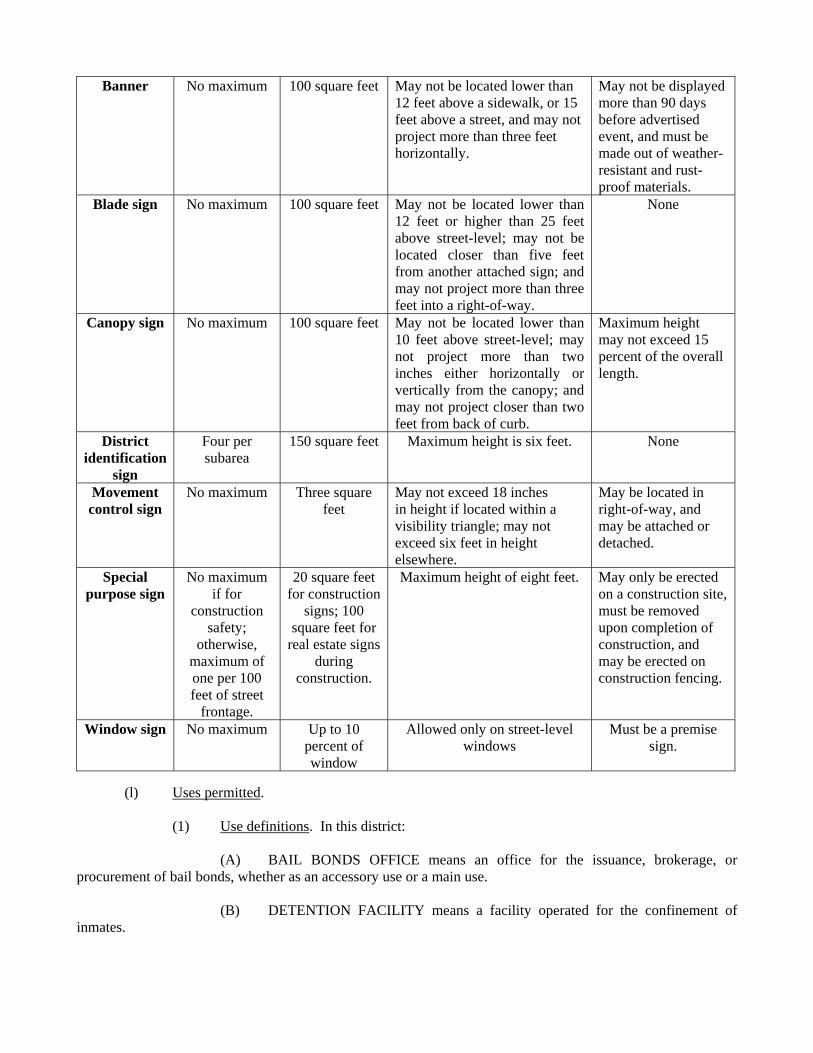
Banner No maximum 100 square feet May not be located lower than 12 feet above a sidewalk, or 15 feet above a street, and may not project more than three feet horizontally.
May not be displayed more than 90 days before advertised event, and must be made out of weather-resistant and rust-proof materials.
Blade sign No maximum 100 square feet May not be located lower than 12 feet or higher than 25 feet above street-level; may not be located closer than five feet from another attached sign; and may not project more than three feet into a right-of-way.
None
Canopy sign No maximum 100 square feet May not be located lower than 10 feet above street-level; may not project more than two inches either horizontally or vertically from the canopy; and may not project closer than two feet from back of curb.
Maximum height may not exceed 15 percent of the overall length.
District identification
sign
Four per subarea
150 square feet Maximum height is six feet. None
Movement control sign
No maximum Three square feet
May not exceed 18 inches in height if located within a visibility triangle; may not exceed six feet in height elsewhere.
May be located in right-of-way, and may be attached or detached.
Special purpose sign
No maximum if for
construction safety;
otherwise, maximum of one per 100 feet of street
frontage.
20 square feet for construction
signs; 100 square feet for
real estate signs during
construction.
Maximum height of eight feet. May only be erected on a construction site, must be removed upon completion of construction, and may be erected on construction fencing.
Window sign No maximum Up to 10 percent of window
Allowed only on street-level windows
Must be a premise sign.
(l) Uses permitted. (1) Use definitions. In this district: (A) BAIL BONDS OFFICE means an office for the issuance, brokerage, or procurement of bail bonds, whether as an accessory use or a main use. (B) DETENTION FACILITY means a facility operated for the confinement of inmates.
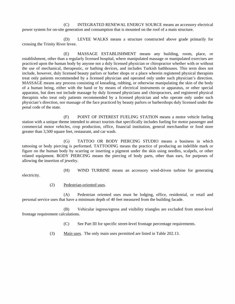
(C) INTEGRATED RENEWAL ENERGY SOURCE means an accessory electrical power system for on-site generation and consumption that is mounted on the roof of a main structure. (D) LEVEE WALKS means a structure constructed above grade primarily for crossing the Trinity River levee. (E) MASSAGE ESTABLISHMENT means any building, room, place, or establishment, other than a regularly licensed hospital, where manipulated massage or manipulated exercises are practiced upon the human body by anyone not a duly licensed physician or chiropractor whether with or without the use of mechanical, therapeutic, or bathing devices, and includes Turkish bathhouses. This term does not include, however, duly licensed beauty parlors or barber shops or a place wherein registered physical therapists treat only patients recommended by a licensed physician and operated only under such physician’s direction. MASSAGE means any process consisting of kneading, rubbing, or otherwise manipulating the skin of the body of a human being, either with the hand or by means of electrical instruments or apparatus, or other special apparatus, but does not include massage by duly licensed physicians and chiropractors, and registered physical therapists who treat only patients recommended by a licensed physician and who operate only under such physician’s direction, nor massage of the face practiced by beauty parlors or barbershops duly licensed under the penal code of the state. (F) POINT OF INTEREST FUELING STATION means a motor vehicle fueling station with a unique theme intended to attract tourists that specifically includes fueling for motor passenger and commercial motor vehicles, crop production, office, financial institution, general merchandise or food store greater than 3,500 square feet, restaurant, and car wash. (G) TATTOO OR BODY PIERCING STUDIO means a business in which tattooing or body piercing is performed. TATTOOING means the practice of producing an indelible mark or figure on the human body by scarring or inserting a pigment under the skin using needles, scalpels, or other related equipment. BODY PIERCING means the piercing of body parts, other than ears, for purposes of allowing the insertion of jewelry. (H) WIND TURBINE means an accessory wind-driven turbine for generating electricity. (2) Pedestrian-oriented uses. (A) Pedestrian oriented uses must be lodging, office, residential, or retail and personal service uses that have a minimum depth of 40 feet measured from the building facade. (B) Vehicular ingress/egress and visibility triangles are excluded from street-level frontage requirement calculations. (C) See Part III for specific street-level frontage percentage requirements. (3) Main uses. The only main uses permitted are listed in Table 202.13.

Table 202.13. Main uses permitted in the downtown form district.
Uses Additional Provisions Agriculture uses Crop production Permitted
Commercial and business service uses
Catering service PermittedCustom business services Permitted
Custom woodworking, furniture construction, or repair
Permitted
Electronics service center PermittedJob or lithographic printing Permitted
Medical or scientific laboratory SUPTechnical school Permitted Must be wholly enclosed. Traffic management plan
approved by the building official and updated annually.
Industrial uses Industrial (inside) for light
manufacturing SUP
Temporary concrete or asphalt batching plant
Permitted By special authorization of the building official.
Institutional and community service uses
Adult day care facility PermittedChild-care facility Permitted
Church PermittedCollege, university, or seminary Permitted
Convalescent and nursing homes, hospice care, and related institutions
Permitted
Hospital PermittedLibrary, art gallery, or museum Permitted
Public school SUP Traffic management plan approved by the building official and updated annually.
Private school or open- enrollment charter school
SUP Traffic management plan approved by the building official and updated annually.
Lodging uses Permitted SUP required for general purpose shelter. SUP required for 60 or fewer guest rooms.
Miscellaneous uses Attached non-premise sign SUP
Carnival or circus (temporary) Permitted By special authorization of the building official.Placement of fill material SUP
Temporary construction or sales office
Permitted
Office uses Permitted SUP required for bail bond office more than 500 feet from a detention facility.
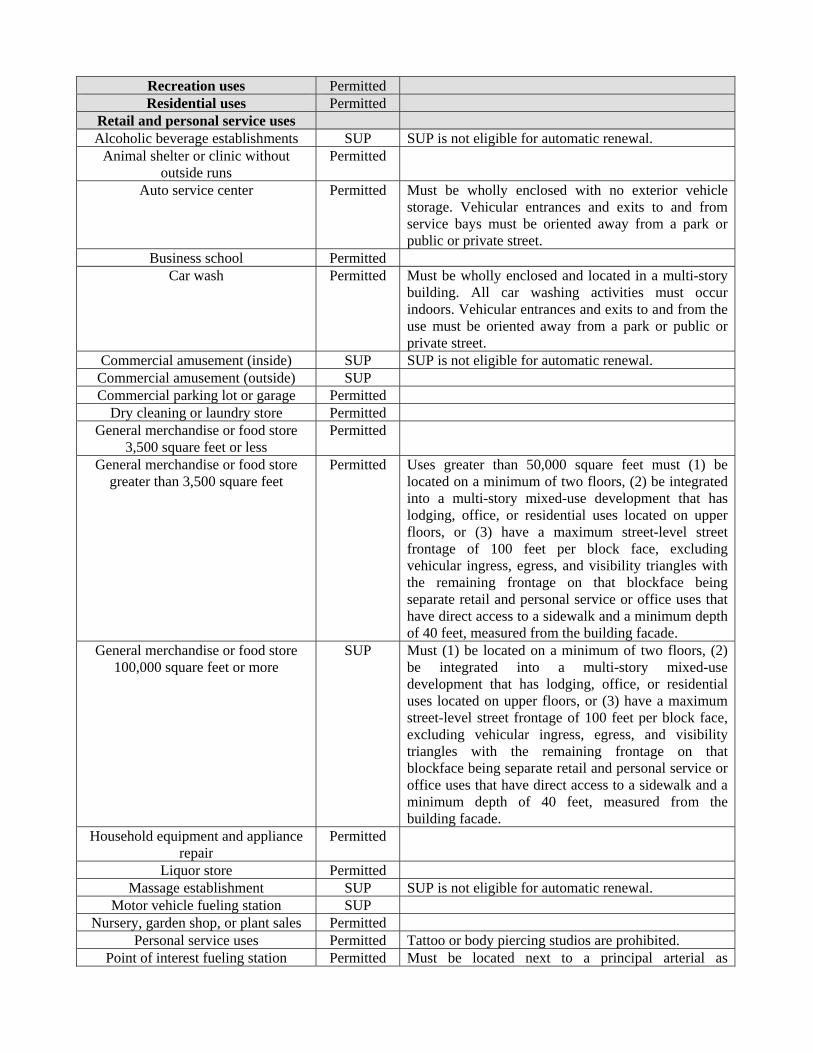
Recreation uses Permitted Residential uses Permitted
Retail and personal service uses Alcoholic beverage establishments SUP SUP is not eligible for automatic renewal.
Animal shelter or clinic without outside runs
Permitted
Auto service center Permitted Must be wholly enclosed with no exterior vehicle storage. Vehicular entrances and exits to and from service bays must be oriented away from a park or public or private street.
Business school Permitted Car wash Permitted Must be wholly enclosed and located in a multi-story
building. All car washing activities must occur indoors. Vehicular entrances and exits to and from the use must be oriented away from a park or public or private street.
Commercial amusement (inside) SUP SUP is not eligible for automatic renewal. Commercial amusement (outside) SUPCommercial parking lot or garage Permitted
Dry cleaning or laundry store Permitted General merchandise or food store
3,500 square feet or less Permitted
General merchandise or food store greater than 3,500 square feet
Permitted Uses greater than 50,000 square feet must (1) be located on a minimum of two floors, (2) be integrated into a multi-story mixed-use development that has lodging, office, or residential uses located on upper floors, or (3) have a maximum street-level street frontage of 100 feet per block face, excluding vehicular ingress, egress, and visibility triangles with the remaining frontage on that blockface being separate retail and personal service or office uses that have direct access to a sidewalk and a minimum depth of 40 feet, measured from the building facade.
General merchandise or food store 100,000 square feet or more
SUP Must (1) be located on a minimum of two floors, (2) be integrated into a multi-story mixed-use development that has lodging, office, or residential uses located on upper floors, or (3) have a maximum street-level street frontage of 100 feet per block face, excluding vehicular ingress, egress, and visibility triangles with the remaining frontage on that blockface being separate retail and personal service or office uses that have direct access to a sidewalk and a minimum depth of 40 feet, measured from the building facade.
Household equipment and appliance repair
Permitted
Liquor store Permitted Massage establishment SUP SUP is not eligible for automatic renewal.
Motor vehicle fueling station SUP Nursery, garden shop, or plant sales Permitted
Personal service uses Permitted Tattoo or body piercing studios are prohibited.Point of interest fueling station Permitted Must be located next to a principal arterial as
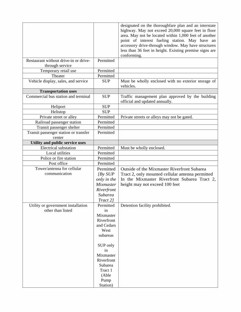
designated on the thoroughfare plan and an interstate highway. May not exceed 20,000 square feet in floor area. May not be located within 1,000 feet of another point of interest fueling station. May have an accessory drive-through window. May have structures less than 36 feet in height. Existing premise signs are conforming.
Restaurant without drive-in or drive-through service
Permitted
Temporary retail use PermittedTheater Permitted
Vehicle display, sales, and service SUP Must be wholly enclosed with no exterior storage of vehicles.
Transportation uses Commercial bus station and terminal SUP Traffic management plan approved by the building
official and updated annually. Heliport SUP Helistop SUP
Private street or alley Permitted Private streets or alleys may not be gated. Railroad passenger station PermittedTransit passenger shelter Permitted
Transit passenger station or transfer center
Permitted
Utility and public service uses Electrical substation Permitted Must be wholly enclosed.
Local utilities Permitted Police or fire station Permitted
Post office PermittedTower/antenna for cellular
communication Permitted [By SUP
only in the Mixmaster Riverfront Subarea Tract 2]
Outside of the Mixmaster Riverfront Subarea Tract 2, only mounted cellular antenna permitted In the Mixmaster Riverfront Subarea Tract 2, height may not exceed 100 feet
Utility or government installation other than listed
Permitted in
Mixmaster Riverfront and Cedars
West subareas
SUP only
in Mixmaster Riverfront Subarea Tract 1 (Able Pump
Station)
Detention facility prohibited.
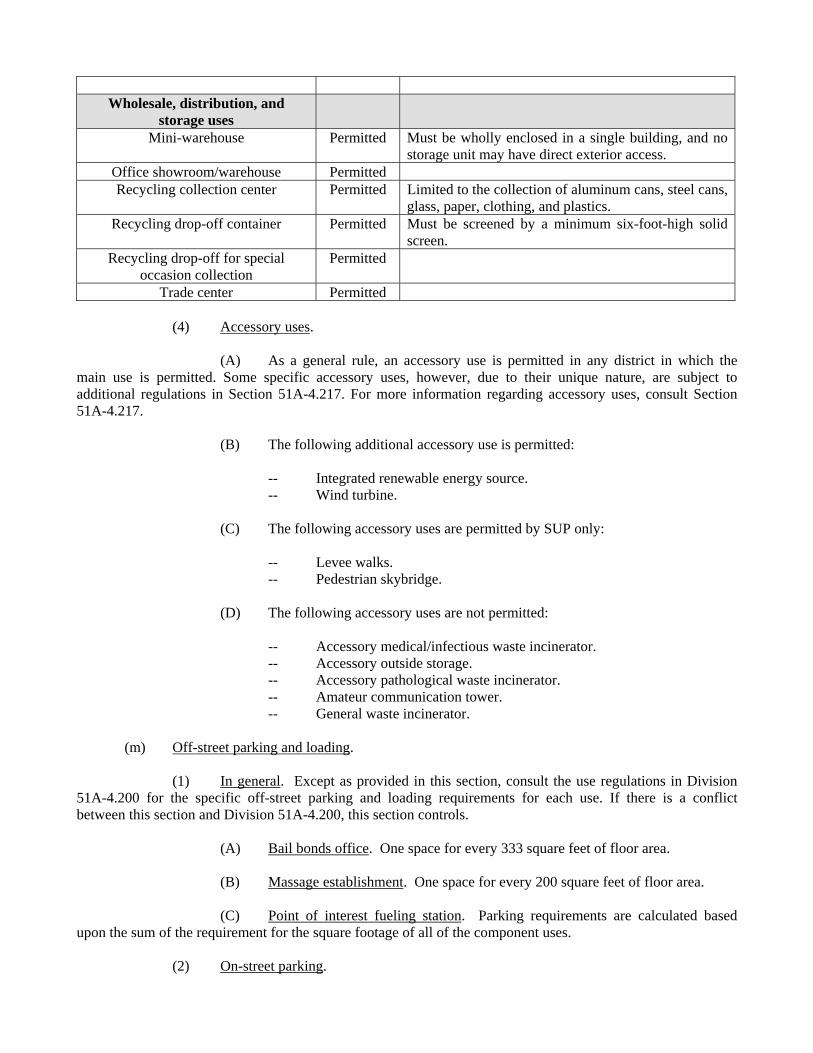
Wholesale, distribution, and storage uses
Mini-warehouse Permitted Must be wholly enclosed in a single building, and no storage unit may have direct exterior access.
Office showroom/warehouse Permitted Recycling collection center Permitted Limited to the collection of aluminum cans, steel cans,
glass, paper, clothing, and plastics. Recycling drop-off container Permitted Must be screened by a minimum six-foot-high solid
screen.Recycling drop-off for special
occasion collection Permitted
Trade center Permitted (4) Accessory uses. (A) As a general rule, an accessory use is permitted in any district in which the main use is permitted. Some specific accessory uses, however, due to their unique nature, are subject to additional regulations in Section 51A-4.217. For more information regarding accessory uses, consult Section 51A-4.217. (B) The following additional accessory use is permitted:
-- Integrated renewable energy source. -- Wind turbine.
(C) The following accessory uses are permitted by SUP only: -- Levee walks. -- Pedestrian skybridge. (D) The following accessory uses are not permitted: -- Accessory medical/infectious waste incinerator. -- Accessory outside storage. -- Accessory pathological waste incinerator. -- Amateur communication tower. -- General waste incinerator. (m) Off-street parking and loading. (1) In general. Except as provided in this section, consult the use regulations in Division 51A-4.200 for the specific off-street parking and loading requirements for each use. If there is a conflict between this section and Division 51A-4.200, this section controls. (A) Bail bonds office. One space for every 333 square feet of floor area. (B) Massage establishment. One space for every 200 square feet of floor area. (C) Point of interest fueling station. Parking requirements are calculated based upon the sum of the requirement for the square footage of all of the component uses. (2) On-street parking.
(A) Except as provided in this paragraph, on-street parking spaces may be counted as a reduction of the parking requirement of the use adjacent to the on-street parking space. (B) An on-street parking space may not be used to reduce the required parking for more than one use, except that on-street parking spaces may be used to reduce the combined total parking requirement of a mixed-use project. (C) An on-street parking space that is not available to the public at all times of the day may only be counted as a partial parking space in proportion to the amount of time that it is available. For example, a parking space that is available to the public only eight hours per day will be counted as one-third of a parking space (8 ÷ 24 = one-third). The total of the limited-availability parking spaces will be counted to the nearest whole number, with on-half counted as an additional space. (3) Mixed-use shared parking reduction. (A) Mixed-use project with office and residential uses. (i) Shared parking must be on the same building site as the mixed-use project. (ii) The number of off-street parking spaces required is 100 percent of the parking requirement for the use requiring the greater number of spaces plus 25 percent of the parking requirements for the use requiring fewer spaces. For example, if the office component would separately require 100 spaces and the residential component would separately require 80 spaces, then the parking requirement for the mixed-use project is 120 spaces [(100 x 1.00) + (80 x .25) = 120]. (B) Mixed-use project with retail and residential uses. (i) Any shared parking must be on the same building site as the mixed-use project. (ii) The number of off-street parking spaces required is 100 percent of the parking requirement for the use requiring the greater number of spaces plus 75 percent of the parking requirements for the use requiring fewer spaces. For example, if the retail component would separately require 100 spaces and the residential component would separately require 80 spaces, then the parking requirement for the mixed-use project is 160 spaces [(100 x 1.00) + (80 x .75) = 160]. (C) Mixed-use project with office, retail, and residential uses. The mixed-use project must use the parking reduction that offers the greatest reduction, but may not use both. For example, if the office-residential reduction reduces the parking to 120 spaces and the retail-residential reduction reduces the parking to 160 spaces, then the office-residential reduction must be used and the retail-residential reduction may not be used. (4) Tandem parking. For a residential use, tandem parking may be used as required off-street parking. (5) Fees. Fees may be collected from occupants or customers of the use on a daily, hourly, or other basis for use of its required off-street parking. (n) Additional regulations.
(1) Minimum density. Minimum density requirements do not require residential uses on each lot or building site. The density requirements are to ensure a minimum amount of dwelling units in a project that includes residential uses to achieve a more mixed-use walkable area. (2) Minimum residential density. (A) For multifamily uses, minimum dwelling unit density is 60 dwelling units per acre. (B) For a mixed-use project, the minimum dwelling unit density must be 60 units per acre for any portion of the project devoted to residential uses, as calculated using the following formula:
residential floor area x 60 units x acres = required dwelling units total project floor area per acre
(3) Bonuses. (A) Affordability. For moderate income housing, the following bonuses apply: (i) An additional one square foot of residential floor area may be constructed on a building site for each square foot of floor area of moderate income housing provided on that building site, above the maximum floor area ratio. (ii) To qualify, (1) the purchase price for a moderate income housing unit may not exceed 80 percent of the average PMSA purchase price of new or existing residences as reported annually by the United States Department of Housing and Urban Development (HUD) or (2) the rental rates may not exceed the annually updated Fair Market Rental Rates as reported by HUD. (iii) Before the issuance of a building permit that uses the floor area ratio bonus, the director of housing shall verify that the required moderate income housing is provided and ensure that this housing remains available at the specified maximum rates as required in Section 51A-4.908. (B) Sustainability. For buildings demonstrating eligibility for a LEED designation under the United States Green Building Leadership in Energy and Environmental Design rating system, the FAR bonuses listed in Table 202.14 apply.
Table 202.14. LEED floor area ratio bonuses.
LEED eligibility Additional Allowed FAR Gold 1.0
Platinum 2.0(Ord. Nos. 27331; 29412; 30421) SEC. 51P-784.203. URBAN VILLAGE FORM DISTRICT REGULATIONS. (a) In general. (1) The urban village form district emphasizes a dense, urban mid-rise development with a mix of residential and nonresidential uses. The character of development will include low-rise and mid-rise structures with active pedestrian frontages. Streets will create an important public open space network with wide sidewalks and other amenities. Landscaping is urban and emphasizes street trees within the planting and amenity zones to create pedestrian shading.
(2) This district is considered to be a nonresidential zoning district.
(b) Open space.
(1) Purpose. Open space requirements are intended to provide relief from a dense urban environment, assist with pedestrian movement, and provide connections to public spaces. (2) Requirements. A minimum of 10 percent of the lot area or building site must be private open space meeting the following requirements: (A) Open space must be a contiguous area of not less than 20 feet in width or length. Required pedestrian zones, planting and amenity zones, and setbacks located at grade and within the lot or building site may count toward open space requirements. (B) Open space must be unobstructed to the sky and may not have permanent structures except structures supporting outdoor recreational uses; kiosks that provide information related to the open space; water features, including fountains, ponds, and water falls; and security, audio-visual, or maintenance equipment. (C) Open space must be accessible to all occupants of the building site. (3) Location. Open space may be located at, below, or above grade. (4) Landscaping. (A) A minimum of 25 percent of the open space area must be landscaped, and may include turf, ground cover, shrubs, trees, or seasonal plantings. (B) One tree having a caliper of at least three inches must be provided in the open space for each 1,500 square feet of open space. (5) Maintenance. Open spaces and pedestrian amenities must be maintained in a state of good repair and neat appearance. Landscaping must be maintained in a healthy, growing condition. The property owner is responsible for the regular maintenance of open spaces and all landscaping. Required plants that die must be replaced with another living plant in compliance with the approved landscape plan within three months after the plant dies. (c) Block standards. (1) Applicability. The following block standards apply during the platting process if the parcel of land being platted is greater than the block perimeters described in this subsection. (2) Block perimeter and length. (A) Except as provided in this paragraph, block perimeters may not exceed 1,600 linear feet, measured along the inner edges of each street right-of-way. (B) A block perimeter may exceed 1,200 linear feet if no single block face exceeds 700 feet in length and the block includes: (i) at least one plaza that is integrated into the proposed development and has at least one pedestrian access point for each 600 feet of block perimeter using escalators, stairs, or ramps to provide direct, public, pedestrian access from the street network to the levee top; or
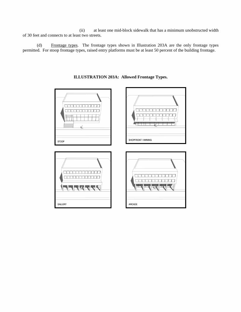
(ii) at least one mid-block sidewalk that has a minimum unobstructed width of 30 feet and connects to at least two streets. (d) Frontage types. The frontage types shown in Illustration 203A are the only frontage types permitted. For stoop frontage types, raised entry platforms must be at least 50 percent of the building frontage.
ILLUSTRATION 203A: Allowed Frontage Types.
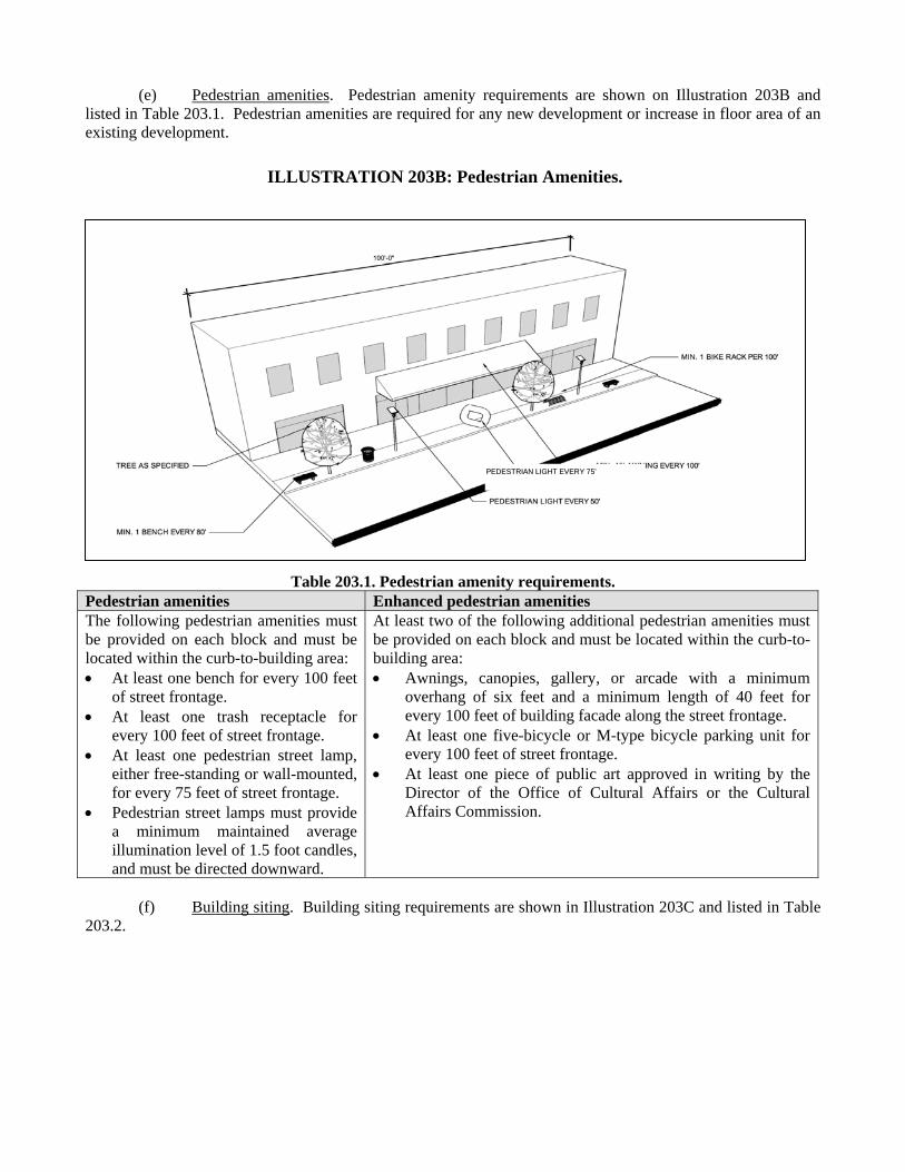
(e) Pedestrian amenities. Pedestrian amenity requirements are shown on Illustration 203B and listed in Table 203.1. Pedestrian amenities are required for any new development or increase in floor area of an existing development.
Table 203.1. Pedestrian amenity requirements.
Pedestrian amenities Enhanced pedestrian amenities The following pedestrian amenities must be provided on each block and must be located within the curb-to-building area: At least one bench for every 100 feet
of street frontage. At least one trash receptacle for
every 100 feet of street frontage. At least one pedestrian street lamp,
either free-standing or wall-mounted, for every 75 feet of street frontage.
Pedestrian street lamps must provide a minimum maintained average illumination level of 1.5 foot candles, and must be directed downward.
At least two of the following additional pedestrian amenities must be provided on each block and must be located within the curb-to-building area: Awnings, canopies, gallery, or arcade with a minimum
overhang of six feet and a minimum length of 40 feet for every 100 feet of building facade along the street frontage.
At least one five-bicycle or M-type bicycle parking unit for every 100 feet of street frontage.
At least one piece of public art approved in writing by the Director of the Office of Cultural Affairs or the Cultural Affairs Commission.
(f) Building siting. Building siting requirements are shown in Illustration 203C and listed in Table 203.2.
ILLUSTRATION 203B: Pedestrian Amenities.
PPEEDDEESSTTRRIIAANN LLIIGGHHTT EEVVEERRYY 7755’’
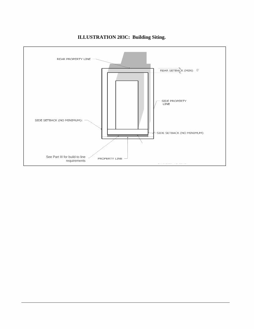
ILLUSTRATION 203C: Building Siting.
SSEEEE PPAARRTT IIIIII FFOORR BBUUIILLDD--TTOO LLIINNEE RREEQQUUIIRREEMMEENNTTSS
0’
See Part III for build-to line requirements
Table 203.2. Building siting requirements.
Building siting Requirements
Build-to line Primary street types. See Part III for build-to line requirements. Except as provided in this table, if a build-to line is not shown on the regulating
plan, the build-to line is the property line abutting the street or the edge of the public easement.
Where the required right-of-way in the thoroughfare plan does not provide adequate space to provide the required planting and amenity zone and pedestrian zone, the property owner must provide a public access easement to accommodate the additional required space. In these cases, build-to lines and setback lines will be measured from this easement.
Secondary street types. See Part III for build-to line requirements. If a build-to line is not shown on the site plan, the build-to line is the property line
abutting the street or the edge of the public easement. Urban form Any portion of a building above 48 feet in height must have an additional minimum 10
foot and maximum 15 foot front and side yard setback. Frontage on build-
to line See Part III for additional frontage requirements for each street type.
Side setback No minimum required. Rear setback No minimum required. Lot coverage No maximum required.
Parking setback No minimum surface parking lot setback required. Key intersection
setbacks Additional setbacks may be required from key intersections. See Part III.
Attached garages Attached garages for duplex, handicapped group dwelling unit, and single family uses are exempt from any minimum front setback requirement.
Driveway design Pedestrian crosswalks across ingress and egress driveways must be clearly marked by colored concrete, patterned or stamped concrete, or brick pavers.
Curb cuts must be at least 12 feet but no more than 24 feet in width (measured parallel to the frontage).
(g) Building configuration and orientation requirements. Building configuration and orientation requirements are shown in Illustration 203D and 203E and listed in Table 203.3.
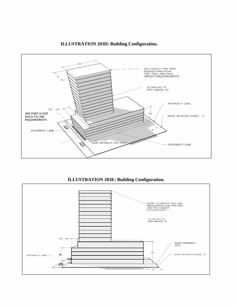
ILLUSTRATION 203D: Building Configuration.
SSEEEE PPAARRTT IIIIII FFOORR BBUUIILLDD--TTOO LLIINNEE RREEQQUUIIRREEMMEENNTTSS
0’
0’
ILLUSTRATION 203E: Building Configuration.
4488'' 0’
0’
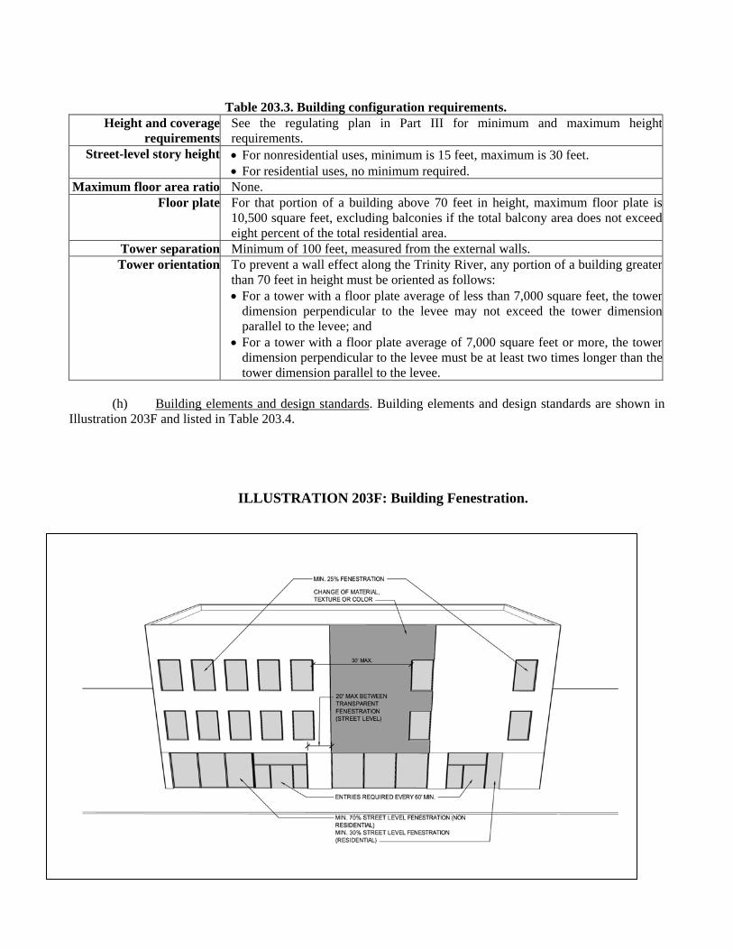
Table 203.3. Building configuration requirements. Height and coverage
requirementsSee the regulating plan in Part III for minimum and maximum heightrequirements.
Street-level story height For nonresidential uses, minimum is 15 feet, maximum is 30 feet. For residential uses, no minimum required.
Maximum floor area ratio None. Floor plate For that portion of a building above 70 feet in height, maximum floor plate is
10,500 square feet, excluding balconies if the total balcony area does not exceedeight percent of the total residential area.
Tower separation Minimum of 100 feet, measured from the external walls. Tower orientation To prevent a wall effect along the Trinity River, any portion of a building greater
than 70 feet in height must be oriented as follows: For a tower with a floor plate average of less than 7,000 square feet, the tower
dimension perpendicular to the levee may not exceed the tower dimensionparallel to the levee; and
For a tower with a floor plate average of 7,000 square feet or more, the tower dimension perpendicular to the levee must be at least two times longer than thetower dimension parallel to the levee.
(h) Building elements and design standards. Building elements and design standards are shown in
Illustration 203F and listed in Table 203.4.
ILLUSTRATION 203F: Building Fenestration.
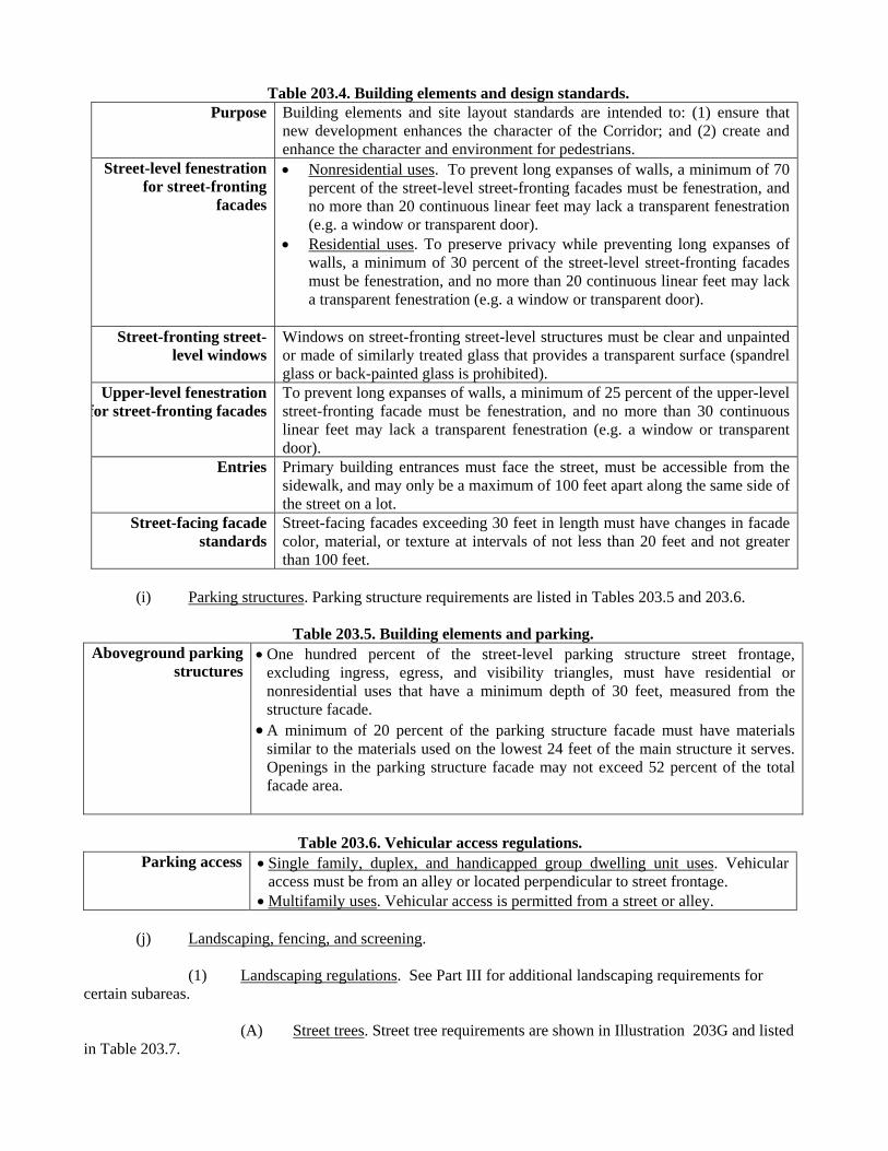
(i) Parking structures. Parking structure requirements are listed in Tables 203.5 and 203.6.
Table 203.5. Building elements and parking. Aboveground parking
structures One hundred percent of the street-level parking structure street frontage,
excluding ingress, egress, and visibility triangles, must have residential or nonresidential uses that have a minimum depth of 30 feet, measured from the structure facade.
A minimum of 20 percent of the parking structure facade must have materials similar to the materials used on the lowest 24 feet of the main structure it serves. Openings in the parking structure facade may not exceed 52 percent of the total facade area.
Table 203.6. Vehicular access regulations.
Parking access Single family, duplex, and handicapped group dwelling unit uses. Vehicular access must be from an alley or located perpendicular to street frontage.
Multifamily uses. Vehicular access is permitted from a street or alley.
(j) Landscaping, fencing, and screening.
(1) Landscaping regulations. See Part III for additional landscaping requirements for certain subareas. (A) Street trees. Street tree requirements are shown in Illustration 203G and listed in Table 203.7.
Table 203.4. Building elements and design standards. Purpose Building elements and site layout standards are intended to: (1) ensure that
new development enhances the character of the Corridor; and (2) create and enhance the character and environment for pedestrians.
Street-level fenestration for street-fronting
facades
Nonresidential uses. To prevent long expanses of walls, a minimum of 70 percent of the street-level street-fronting facades must be fenestration, and no more than 20 continuous linear feet may lack a transparent fenestration (e.g. a window or transparent door).
Residential uses. To preserve privacy while preventing long expanses of walls, a minimum of 30 percent of the street-level street-fronting facades must be fenestration, and no more than 20 continuous linear feet may lack a transparent fenestration (e.g. a window or transparent door).
Street-fronting street-
level windowsWindows on street-fronting street-level structures must be clear and unpainted or made of similarly treated glass that provides a transparent surface (spandrel glass or back-painted glass is prohibited).
Upper-level fenestration for street-fronting facades
To prevent long expanses of walls, a minimum of 25 percent of the upper-level street-fronting facade must be fenestration, and no more than 30 continuous linear feet may lack a transparent fenestration (e.g. a window or transparent door).
Entries Primary building entrances must face the street, must be accessible from the sidewalk, and may only be a maximum of 100 feet apart along the same side of the street on a lot.
Street-facing facade standards
Street-facing facades exceeding 30 feet in length must have changes in facade color, material, or texture at intervals of not less than 20 feet and not greater than 100 feet.

Table 203.7. Street tree requirements.
Location and placement
Except as provided in this table, each large street tree must have at least a 25 square foot planting area within the planting and amenity zone.
If the city arborist determines that the planting space for a required tree is inadequate, a small tree may count toward the street tree requirements. If the city arborist does not approve a required street tree location due to physical constraints, the tree is not required at that location.
Large trees may not be planted within 10 feet of an overhead public utility line. Linear tree pits are encouraged.
Number required See Part III for number of street trees required.Minimum caliper Large trees must have a minimum caliper of three inches.
Small trees must have a minimum caliper of two inches. Minimum tree
clearance The property owner shall maintain all trees at a vertical height clearance of at least
eight feet over a pedestrian zone and 13 feet over a street.Tree grates Tree grates must be provided for trees with trunks located in or within 18 inches of a
sidewalk. Suspended brick, pave stones, or similar materials may be used instead of a grate to
protect tree roots and to provide a pedestrian surface. All materials must conform to state standards and specifications adopted to eliminate,
as much as possible, architectural barriers encountered by aged, handicapped, or disabled persons.
Grates or tree containment areas must be large enough to permit healthy tree growth.Large tree
species permitted Cedar elm, Red oak, Chinese pistachio, Sweet gum, Bald cypress, Lacebark elm, Caddo maple, Chinquapin oak, 'Highrise' live oak, Pond cypress.
Small tree species permitted
Mexican plum, Texas persimmon, Desert-willow, Redbud, Crepe myrtle, Yaupon holly.
Other landscaping
materials
Low-level plantings may be provided in the designated planting and amenity zone if the plants do not exceed two-and-one-half feet above the curb and do not intrude into the pedestrian zone.
ILLUSTRATION 203G: Street Trees.
TREES TO BE PLANTED IN AMENITY ZONE
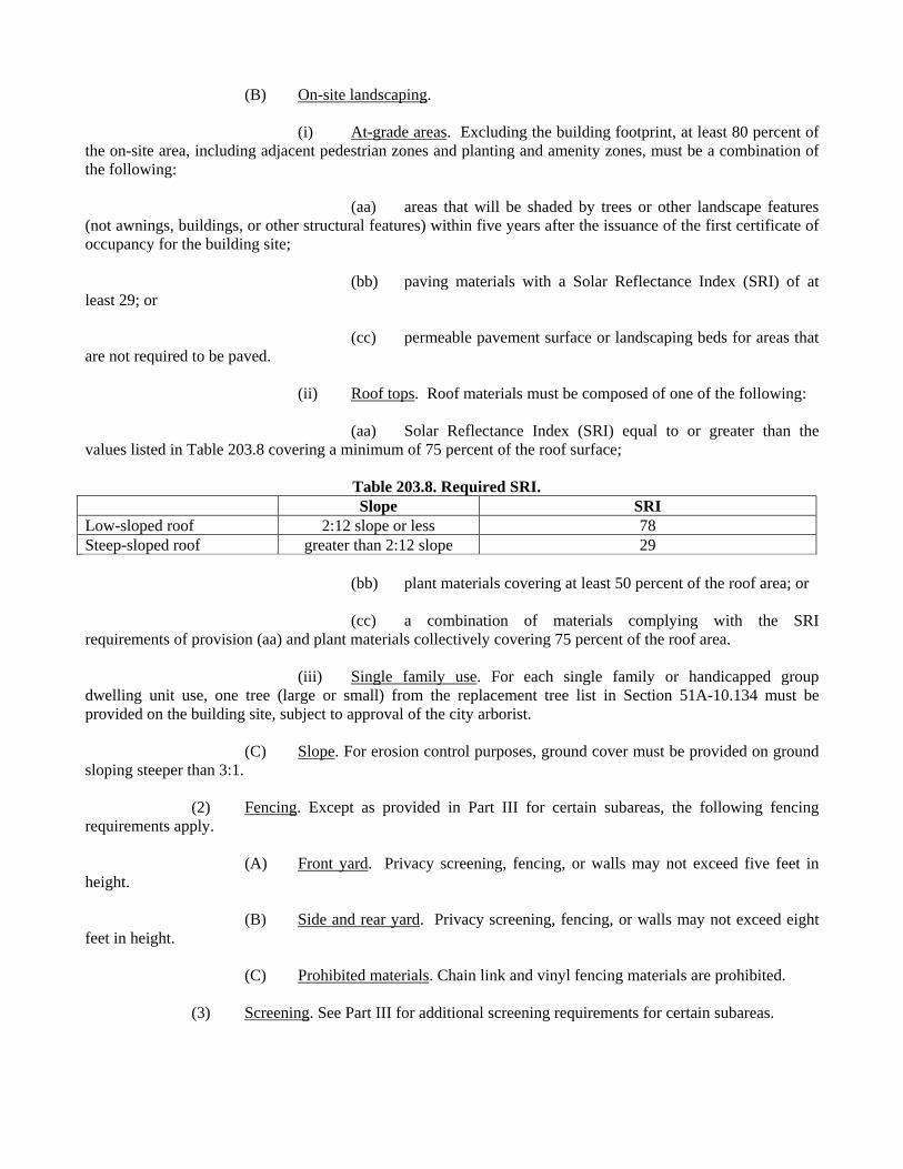
(B) On-site landscaping. (i) At-grade areas. Excluding the building footprint, at least 80 percent of the on-site area, including adjacent pedestrian zones and planting and amenity zones, must be a combination of the following: (aa) areas that will be shaded by trees or other landscape features (not awnings, buildings, or other structural features) within five years after the issuance of the first certificate of occupancy for the building site; (bb) paving materials with a Solar Reflectance Index (SRI) of at least 29; or (cc) permeable pavement surface or landscaping beds for areas that are not required to be paved. (ii) Roof tops. Roof materials must be composed of one of the following: (aa) Solar Reflectance Index (SRI) equal to or greater than the values listed in Table 203.8 covering a minimum of 75 percent of the roof surface;
Table 203.8. Required SRI. Slope SRI Low-sloped roof 2:12 slope or less 78 Steep-sloped roof greater than 2:12 slope 29 (bb) plant materials covering at least 50 percent of the roof area; or (cc) a combination of materials complying with the SRI requirements of provision (aa) and plant materials collectively covering 75 percent of the roof area. (iii) Single family use. For each single family or handicapped group dwelling unit use, one tree (large or small) from the replacement tree list in Section 51A-10.134 must be provided on the building site, subject to approval of the city arborist. (C) Slope. For erosion control purposes, ground cover must be provided on ground sloping steeper than 3:1. (2) Fencing. Except as provided in Part III for certain subareas, the following fencing requirements apply. (A) Front yard. Privacy screening, fencing, or walls may not exceed five feet in height. (B) Side and rear yard. Privacy screening, fencing, or walls may not exceed eight feet in height. (C) Prohibited materials. Chain link and vinyl fencing materials are prohibited. (3) Screening. See Part III for additional screening requirements for certain subareas.
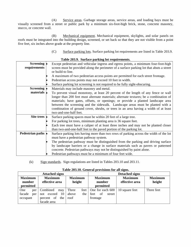
(A) Service areas. Garbage storage areas, service areas, and loading bays must be visually screened from a street or public park by a minimum six-foot-high brick, stone, concrete masonry, stucco, or concrete wall. (B) Mechanical equipment. Mechanical equipment, skylights, and solar panels on roofs must be integrated into the building design, screened, or set back so that they are not visible from a point five feet, six inches above grade at the property line. (C) Surface parking lots. Surface parking lot requirements are listed in Table 203.9.
Table 203.9. Surface parking lot requirements. Screening
requirements Except pedestrian and vehicular ingress and egress points, a minimum four-foot-high
screen must be provided along the perimeter of a surface parking lot that abuts a street or build-to line.
A maximum of two pedestrian access points are permitted for each street frontage. Pedestrian access points may not exceed 10 feet in width. Surface parking lot screening is not required to be fully sight-obscuring.
Screening materials
Materials may include masonry and metal. To prevent visual monotony, at least 20 percent of the length of any fence or wall
longer than 200 feet must alternate materials; alternate textures; be a combination of materials; have gates, offsets, or openings; or provide a planted landscape area between the screening and the sidewalk. Landscape areas must be planted with a combination of ground cover, shrubs, or trees in an area having a width of at least two-and-one-half feet.
Site trees Surface parking spaces must be within 20 feet of a large tree. For parking lot trees, minimum planting area is 36 square feet. Each tree must have a caliper of at least three inches and may not be planted closer
than two-and-one-half feet to the paved portion of the parking lot. Pedestrian paths Surface parking lots having more than two rows of parking across the width of the lot
must have a pedestrian pathway system. The pedestrian pathway must be distinguished from the parking and driving surface
by landscape barriers or a change in surface materials such as pavers or patterned concrete. Pedestrian pathways may not be distinguished by paint alone.
Pedestrian pathways must be a minimum of four feet wide. (k) Sign standards. Sign regulations are listed in Tables 203.10 and 203.11.
Table 203.10. General provisions for all signs. Attached signs Detached signs
Maximum number
permitted
Maximum effective area
Maximum height
Maximum number
permitted
Maximum effective area
Maximum height
One per facade per occupant
Combined may not exceed 10 percent of the facade area
Three feet above the roof
One for each 600 feet of street frontage
10 square feet Three feet
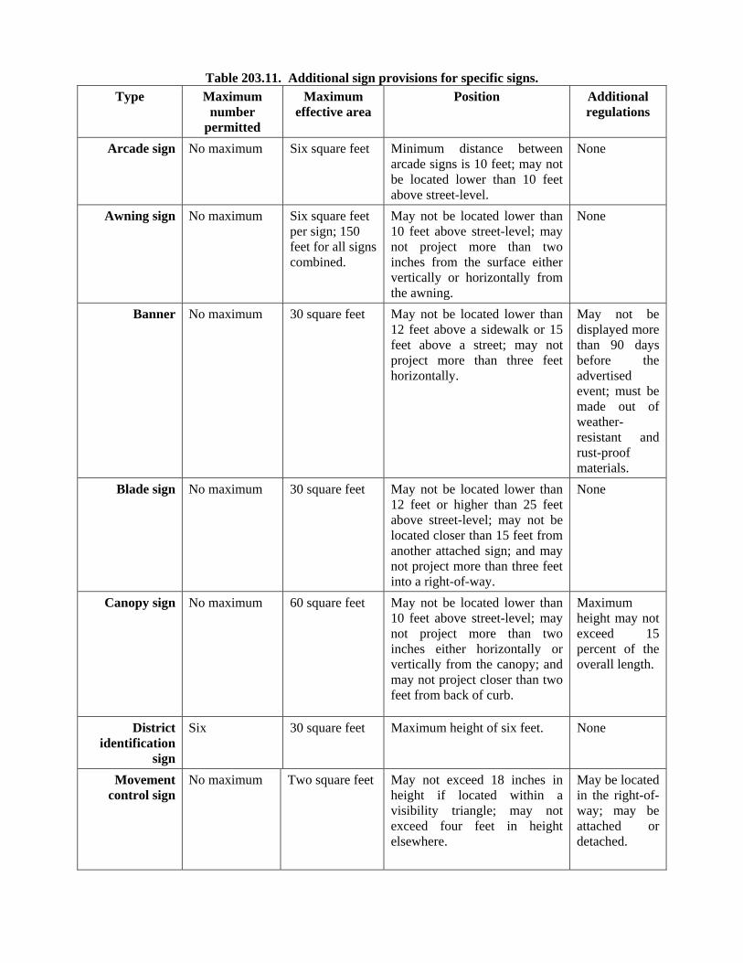
Table 203.11. Additional sign provisions for specific signs.
Type Maximum number
permitted
Maximum effective area
Position Additional regulations
Arcade sign
No maximum Six square feet Minimum distance between arcade signs is 10 feet; may not be located lower than 10 feet above street-level.
None
Awning sign No maximum Six square feet per sign; 150 feet for all signs combined.
May not be located lower than 10 feet above street-level; may not project more than two inches from the surface either vertically or horizontally from the awning.
None
Banner No maximum 30 square feet May not be located lower than 12 feet above a sidewalk or 15 feet above a street; may not project more than three feet horizontally.
May not be displayed more than 90 days before the advertised event; must be made out of weather-resistant and rust-proof materials.
Blade sign No maximum 30 square feet May not be located lower than 12 feet or higher than 25 feet above street-level; may not be located closer than 15 feet from another attached sign; and may not project more than three feet into a right-of-way.
None
Canopy sign No maximum 60 square feet May not be located lower than 10 feet above street-level; may not project more than two inches either horizontally or vertically from the canopy; and may not project closer than two feet from back of curb.
Maximum height may not exceed 15 percent of the overall length.
District identification
sign
Six 30 square feet Maximum height of six feet. None
Movement control sign
No maximum Two square feet May not exceed 18 inches in height if located within a visibility triangle; may not exceed four feet in height elsewhere.
May be located in the right-of-way; may be attached or detached.
Special purpose sign
No maximum if for construction safety; otherwise, maximum of one per 100 feet of street frontage.
20 square feet for construction signs; 40 square feet for real estate signs.
Maximum height of eight feet. May only be erected on a construction site; must be removed upon completion of construction; and may be erected on construction fencing.
Window sign No maximum Up to 10 percent of window.
Allowed only on street-level windows.
Must be a premise sign.
(l) Uses permitted. (1) Use definitions. In this district: (A) BAIL BONDS OFFICE means an office for the issuance, brokerage, or procurement of bail bonds, whether as an accessory use or a main use. (B) DETENTION FACILITY means a facility operated for the confinement of inmates. (C) INTEGRATED RENEWAL ENERGY SOURCE means an accessory electrical power system for on-site generation and consumption that is mounted on the roof of a main structure. (D) LEVEE WALKS means a structure constructed above grade primarily for crossing the Trinity River levee. (E) MASSAGE ESTABLISHMENT and MASSAGE means a massage establishment or massage as defined by Texas Occupation Code Chapter 455, as amended. (F) TATTOO OR BODY PIERCING STUDIO means a business in which tattooing or body piercing is performed. TATTOOING means the practice of producing an indelible mark or figure on the human body by scarring or inserting a pigment under the skin using needles, scalpels, or other related equipment. BODY PIERCING means the piercing of body parts, other than ears, for purposes of allowing the insertion of jewelry. (G) WIND TURBINE means an accessory wind-driven turbine for generating electricity. (2) Main uses. The only main uses permitted are listed in Table 203.12.
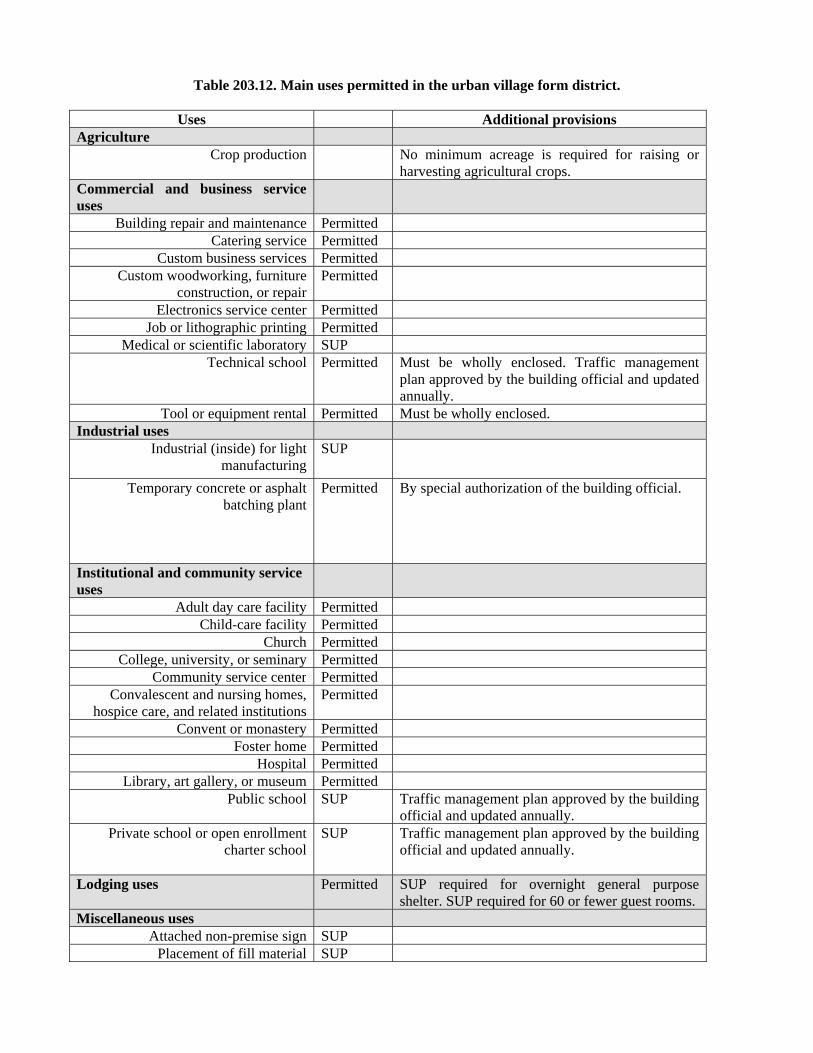
Table 203.12. Main uses permitted in the urban village form district.
Uses Additional provisions Agriculture
Crop production No minimum acreage is required for raising or harvesting agricultural crops.
Commercial and business service uses
Building repair and maintenance Permitted Catering service Permitted
Custom business services Permitted Custom woodworking, furniture
construction, or repair Permitted
Electronics service center Permitted Job or lithographic printing Permitted
Medical or scientific laboratory SUP Technical school Permitted Must be wholly enclosed. Traffic management
plan approved by the building official and updated annually.
Tool or equipment rental Permitted Must be wholly enclosed. Industrial uses
Industrial (inside) for light manufacturing
SUP
Temporary concrete or asphalt batching plant
Permitted By special authorization of the building official.
Institutional and community service uses
Adult day care facility Permitted Child-care facility Permitted
Church Permitted College, university, or seminary Permitted
Community service center Permitted Convalescent and nursing homes,
hospice care, and related institutions Permitted
Convent or monastery Permitted Foster home Permitted
Hospital Permitted Library, art gallery, or museum Permitted
Public school SUP Traffic management plan approved by the building official and updated annually.
Private school or open enrollment charter school
SUP Traffic management plan approved by the building official and updated annually.
Lodging uses
Permitted SUP required for overnight general purpose shelter. SUP required for 60 or fewer guest rooms.
Miscellaneous uses Attached non-premise sign SUP
Placement of fill material SUP
Temporary construction or sales office Permitted Office uses Permitted SUP required for bail bonds office. Recreation uses Permitted Residential uses
College dormitory, fraternity, or sorority house
Permitted
Duplex Permitted Group residential facility Permitted
Handicapped group dwelling unit Permitted Multifamily Permitted
Residential hotel Permitted Retirement housing Permitted
Single family Permitted Accessory structures may be rented. Retail and personal services uses
Alcoholic beverage establishments SUP Not eligible for automatic renewal. Animal shelter or clinic without
outside run Permitted
Auto service center Permitted Must be wholly enclosed with no exterior vehicle storage.
Business school Permitted Car wash Permitted Must be wholly enclosed with no exterior vehicle
storage. Commercial amusement (inside) SUP Not eligible for automatic renewal.
Commercial amusement (outside) SUPCommercial parking lot or garage Permitted
Dry cleaning or laundry store Permitted Furniture store Permitted
General merchandise or food store 3,500 square feet or less
Permitted
General merchandise or food store greater than 3,500 square feet
Permitted Uses greater than 50,000 square feet must (1) be located on a minimum of two floors, (2) be integrated into a multi-story mixed use development that has lodging, office, or residential uses located on upper floors, or (3) have a maximum street-level street frontage of 100 feet per block face, excluding vehicular ingress, egress, and visibility triangles, with the remaining frontage on that block face being separate retail and personal service or office uses that have direct access to a sidewalk and a minimum depth of 40 feet, measured from the building facade.
General merchandise or food store 100,000 square feet or more
SUP Must (1) be located on a minimum of two floors, (2) be integrated into a multi-story mixed use development that has lodging, office, or residential uses located on upper floors, or (3) have a maximum street-level street frontage of 100 feet per block face, excluding vehicular ingress, egress, and visibility triangles, with the remaining
frontage on that block face being separate retail and personal service or office uses that have direct access to a sidewalk and a minimum depth of 40 feet, measured from the building facade.
Home improvement center, lumber, brick, or building materials sales yard
SUP Any portion of a building open to the sky may not exceed five percent of the total lot area and must be screened from all sides by an eight-foot-high solid wall similar in appearance to the main building. The eight-foot-high wall must be screened with evergreen shrubs planted four feet on center that are capable of reaching nine feet in height within five years of planting.
Uses greater than 50,000 square feet must (1) be located on a minimum of two floors, (2) be integrated into a multi-story mixed use development that has lodging, office, or residential uses located on upper floors, or (3) have a maximum street-level street frontage of 100 feet per block face, excluding vehicular ingress, egress, and visibility triangles, with the remaining frontage on that block face being separate retail and personal service or office uses that have direct access to a sidewalk and a minimum depth of 40 feet, measured from the building facade.
Household equipment and appliance repair
Permitted
Liquor store Permitted Massage establishment SUP Not eligible for automatic renewals.
Mortuary, funeral home, or commercial wedding chapel
Permitted
Motor vehicle fueling station SUP Nursery, garden shop, or plant sales Permitted
Pawn shop Permitted Personal services uses Permitted Tattoo or body piercing studios are prohibited.
Restaurant without drive-in or drive-through service
Permitted
Restaurant with drive-in or drive-through service
SUP Limited to Cedars West Subdistrict No. 1 only.
Theater Permitted Vehicle display, sales, and service SUP Must be wholly enclosed with no exterior vehicle
storage. Transportation uses
Commercial bus station or terminal Permitted Traffic management plan approved by the building official and updated annually.
Heliport SUP Helistop SUP
Private street or alley Permitted Private street or alleys may not be gated. Railroad passenger station Permitted
Transit passenger shelter Permitted Transit passenger station or transfer Permitted
center Utility and public service uses
Commercial radio or television transmitting station
Permitted
Electrical substation Permitted Local utilities Permitted
Police or fire station Permitted Post office Permitted
Tower/antenna for cellular communication
Permitted Except as otherwise provided, only mounted cellular antenna permitted. In Cedars West Subdistrict No. 2, a tower/antenna for cellular communication must comply with Exhibit 784A.
Utility or government installation other than listed
Permitted Detention facility prohibited.
Wholesale, distribution, and storage uses
Auto auction Permitted Must be wholly enclosed in a single building. Mini-warehouse Permitted Must be wholly enclosed in a single building, and
no storage unit may have direct exterior access. Office showroom/warehouse Permitted
Recycling collection center Permitted Limited to the collection of aluminum cans, steel cans, glass, paper, clothing, and plastics.
Recycling drop-off container Permitted Recycling drop-off for special
occasion collection Permitted
Trade center Permitted
[Remainder of page intentionally left blank.]
(3) Accessory uses. (A) As a general rule, an accessory use is permitted in any district in which the main use is permitted. Some specific accessory uses, however, due to their unique nature, are subject to additional regulations in Section 51A-4.217. For more information regarding accessory uses, consult Section 51A-4.217. (B) The following additional accessory uses are permitted:
-- Integrated renewable energy source and wind turbines. -- Levee walk.
(C) The following accessory use is permitted by SUP only: -- Pedestrian skybridge. (D) The following accessory uses are not permitted:
-- Accessory medical/infectious waste incinerator. -- Accessory outside storage. -- Accessory pathological waste incinerator. -- Amateur communication tower. -- General waste incinerator. (m) Off-street parking and loading. (1) In general. Except as provided in this section, consult the use regulations in Division 51A-4.200 for the specific off-street parking and loading requirements for each use. If there is a conflict between this section and Division 51A-4.200, this section controls. (A) Bail bonds office. One space for every 333 square feet of floor area. (B) Massage establishment. One space for every 200 square feet of floor area. (2) On-street parking. (A) Except as provided in this paragraph, on-street parking spaces may be counted as a reduction of the parking requirement of the use adjacent to the on-street parking space. (B) An on-street parking space may not be used to reduce the required parking for more than one use, except that on-street parking spaces may be used to reduce the combined total parking requirement of a mixed use project. (C) An on-street parking space that is not available to the public at all times of the day may only be counted as a partial parking space in proportion to the amount of time that it is available. For example, a parking space that is available to the public only eight hours per day will be counted as one-third of a parking space (8 ÷ 24 = one-third). The total of the limited-availability parking spaces will be counted to the nearest whole number, with one-half counted as an additional space.
(3) Mixed use shared parking reduction. (A) Mixed use project with office and residential uses. (i) Shared parking must be on the same building site as the mixed use project. (ii) The number of off-street parking spaces required is 100 percent of the parking requirement for the use requiring the greater number of spaces plus 25 percent of the parking requirements for the use requiring fewer spaces. For example, if the office component would separately require 100 spaces and the residential component would separately require 80 spaces, then the parking requirement for the mixed use project is 120 spaces [(100 x 1.00) + (80 x .25) = 120]. (B) Mixed use project with retail and residential uses. (i) Shared parking must be on the same building site as the mixed use project. (ii) The number of off-street parking spaces required is 100 percent of the parking requirement for the use requiring the greater number of spaces plus 75 percent of the parking requirements for the use requiring fewer spaces. For example, if the retail component would separately require 100 spaces and the residential component would separately require 80 spaces, then the parking requirement for the mixed use project is 160 spaces [(100 x 1.00) + (80 x .75) = 160]. (C) Mixed use project with office, retail, and residential uses. The mixed use project must use the parking reduction that offers the greatest reduction, but may not use both. For example, if the office-residential reduction reduces the parking to 120 spaces and the retail-residential reduction reduces the parking to 160 spaces, then the office-residential reduction must be used and the retail-residential reduction may not be used. (4) Tandem parking. For a residential use, tandem parking may be used as required off-street parking. (5) Bicycle parking. One bicycle rack space must be provided for every 10 off-street parking spaces. (6) Fees. Fees may be collected from occupants or customers of the use on a daily, hourly, or other basis for use of its required off-street parking. (n) Additional regulations. (1) Minimum density. Minimum density requirements do not require residential uses on each lot or building site. The density requirements are to ensure a minimum amount of dwelling units in a project that includes residential uses to achieve a more mixed use walkable area. (2) Minimum residential density. (A) For multifamily uses, minimum dwelling unit density is 60 dwelling units per acre. (B) For a mixed use project, the minimum dwelling unit density must be 50 units per acre for any portion of the project devoted to residential uses, as calculated using the following formula:
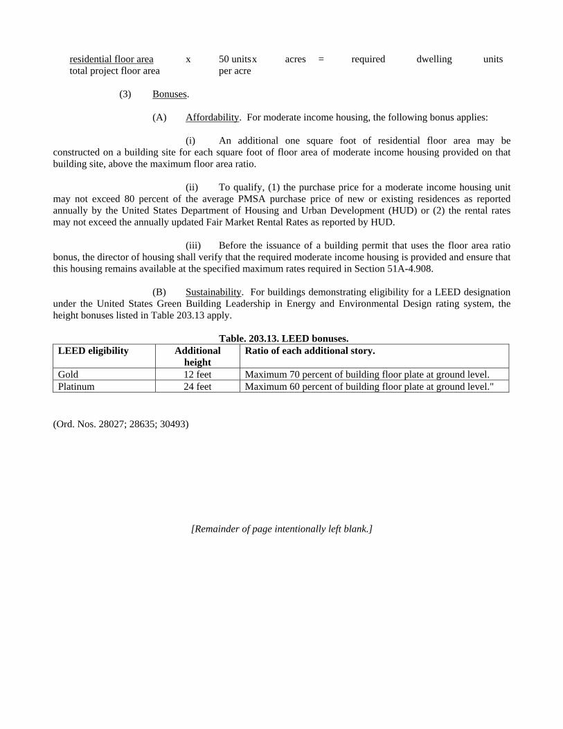
residential floor area x 50 units x acres = required dwelling units total project floor area per acre
(3) Bonuses. (A) Affordability. For moderate income housing, the following bonus applies: (i) An additional one square foot of residential floor area may be constructed on a building site for each square foot of floor area of moderate income housing provided on that building site, above the maximum floor area ratio. (ii) To qualify, (1) the purchase price for a moderate income housing unit may not exceed 80 percent of the average PMSA purchase price of new or existing residences as reported annually by the United States Department of Housing and Urban Development (HUD) or (2) the rental rates may not exceed the annually updated Fair Market Rental Rates as reported by HUD. (iii) Before the issuance of a building permit that uses the floor area ratio bonus, the director of housing shall verify that the required moderate income housing is provided and ensure that this housing remains available at the specified maximum rates required in Section 51A-4.908. (B) Sustainability. For buildings demonstrating eligibility for a LEED designation under the United States Green Building Leadership in Energy and Environmental Design rating system, the height bonuses listed in Table 203.13 apply.
Table. 203.13. LEED bonuses. LEED eligibility Additional
height Ratio of each additional story.
Gold 12 feet Maximum 70 percent of building floor plate at ground level.Platinum 24 feet Maximum 60 percent of building floor plate at ground level."
(Ord. Nos. 28027; 28635; 30493)
[Remainder of page intentionally left blank.]
PART III.
SUBAREA REGULATIONS. SEC. 51P-784.301. REGULATING PLANS.
Use and development of the Property must comply with the regulating plan approved for each subarea. If there is a conflict between the text of this article and a regulating plan, the text of this article controls. (Ord. 27331) SEC. 51P-784.302. CREATION OF SUBAREAS. (a) Subareas are geographic areas within the district. The form district regulations are applied to the subareas.
(b) The following subareas are incorporated into the Trinity River Special Purpose District (See Illustration 302A): (1) Mixmaster Riverfront Subarea.
(A) Mixmaster Riverfront Subarea Tract 1 (Able Pump Station).
(B) Mixmaster Riverfront Subarea Tract 2.
(2) Cedars West Subarea.
(A) Cedars West Subdistrict No. 1.
(B) Cedars West Subdistrict No. 2. (Ord. Nos. 27331; 28027; 28635; 29412; 30421; 30493)
[Remainder of page intentionally left blank.]
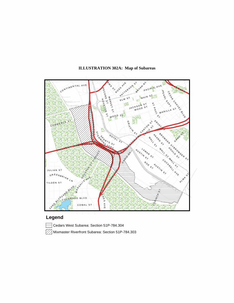
ILLUSTRATION 302A: Map of Subareas
E L M S TE L M S T M A I N S T
M A I N S T
L AM
AR
ST
L AM
AR
ST
AK
AR
D S
T
AK
AR
D S
T
ER
VA
Y S
T
ER
VA
Y S
T
RR LL TT HH
OORR
NN
TT
OO
NN FF
WWYY
SSTT
PPAA
UULL
SS
TT
GGRR
I IFF
FFII NN
SSTTS S
TTEE
MMMM
OONN SS FF WW YY
J A C K S O N S T
J A C K S O N S T
ZZAA
NN
GG BB
LL VV DD
CC
AANN
TT
OONN
SS
TT
W O O D S TW O O D S T
HHOO
UUSS
TTOO
NN SS
TT
PP AA CC II FF II CC AA VV EE
HH OO TT EE LL SS TT
CC OO LL OO RR AA DD OO BB LL VV DD
CCAA
DDII ZZ
SSTT
GO
UL
D S
T
GO
UL
D S
T
MM AA RR II LL LL AA SS TT
CCOO
CC
KKRR
EELL
LL
AAVV
EE
MA
RK
ET
ST
MA
RK
ET
ST
RR LL
TTHH
OORR
NNTT
OONN
HHOO
VV
SSTT
EEMM
MMOO
NN
SS SS EE RR VV
PPEE
AARR
LL EE
XXPP
YY
DD AA LL LL AA SS FF TT WW OO RR TT HH TT PP KK EE
C O M A L S TC O M A L S T
I 4 5 E X P Y
I 4 5 E X P Y
HO
US
TO
N S
T V
I AD
UC
T
HO
US
TO
N S
T V
I AD
UC
T
CO
RI N
TH
ST
CO
RI N
TH
ST
CCEE
SSAA
RR CC
HHAA
VVEE
ZZ BB
LLVV
DD
MMAA
RRSS
AALL
II SS AA VV EEGG RR EE EE NN BB RR II AA RR LL NN
C O M M E R C E S T
C O M M E R C E S T
RO
SS
AV
E
RO
SS
AV
E
CC OO NN TT II NN EE NN TT AA LL AA VV EE
EEAA
DDS S
A AV V
E E
SSPP
OO
RR TT SS SS TT
AU
ST I N
ST
AU
ST I N
ST
BR
OW
DE
R S
T
BR
OW
DE
R S
T
BR
YA
N S
T
BR
YA
N S
T
LLAA
WWSS
SSTT
RE
CO
RD
ST
RE
CO
RD
ST
AALL
MMAA
SSTT
WA
LL
ST
WA
LL
ST
PA T T ER
SO
N S
T
PA T T ER
SO
N S
T
J U L I A N S TJ U L I A N S T
T I L D E N S TT I L D E N S T
GA
NO
ST
GA
NO
ST
RO
E ST
RO
E ST
CA
DI Z
ST
CA
DI Z
ST
WW OO OO DD SS TT
WA
LL
ST
WA
LL
ST
SSTT
E EM M
MMOO
N NS S
F FW W
YY
BBRR
OOWW
DDEE
RR SS
TT
AU
ST I N
ST
AU
ST I N
ST
ZZAA
NNGG
BBLL
VVDD
WA
LL
ST
WA
LL
ST
Legend
Cedars West Subarea: Section 51P-784.304
Mixmaster Riverfront Subarea: Section 51P-784.303
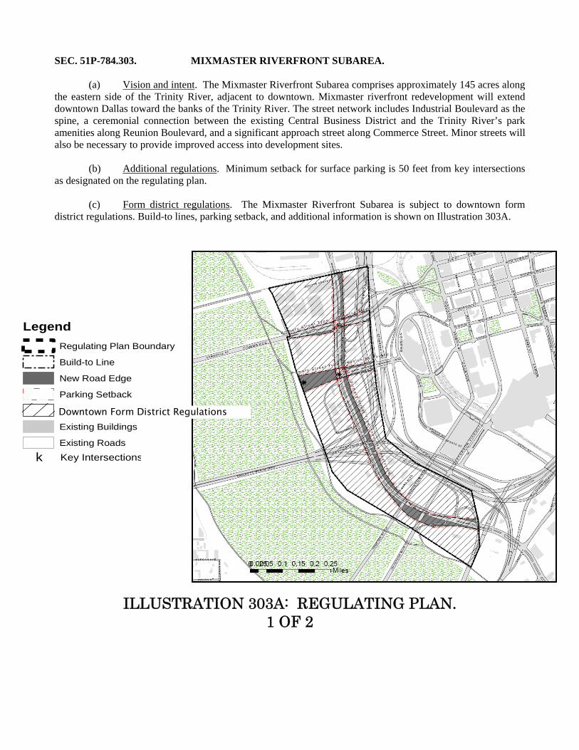
SEC. 51P-784.303. MIXMASTER RIVERFRONT SUBAREA. (a) Vision and intent. The Mixmaster Riverfront Subarea comprises approximately 145 acres along the eastern side of the Trinity River, adjacent to downtown. Mixmaster riverfront redevelopment will extend downtown Dallas toward the banks of the Trinity River. The street network includes Industrial Boulevard as the spine, a ceremonial connection between the existing Central Business District and the Trinity River’s park amenities along Reunion Boulevard, and a significant approach street along Commerce Street. Minor streets will also be necessary to provide improved access into development sites. (b) Additional regulations. Minimum setback for surface parking is 50 feet from key intersections as designated on the regulating plan. (c) Form district regulations. The Mixmaster Riverfront Subarea is subject to downtown form district regulations. Build-to lines, parking setback, and additional information is shown on Illustration 303A.
ILLUSTRATION 303A: REGULATING PLAN. 1 OF 2
Legend
Regulating Plan Boundary
Build-to Line
New Road Edge
!!
!
! ! ! ! ! !
!!
!
!!!!!!
Parking Setback
Downtown Subdistrict
Existing Buildings
Existing Roads
k Key Intersections
Downtown Form District Regulations
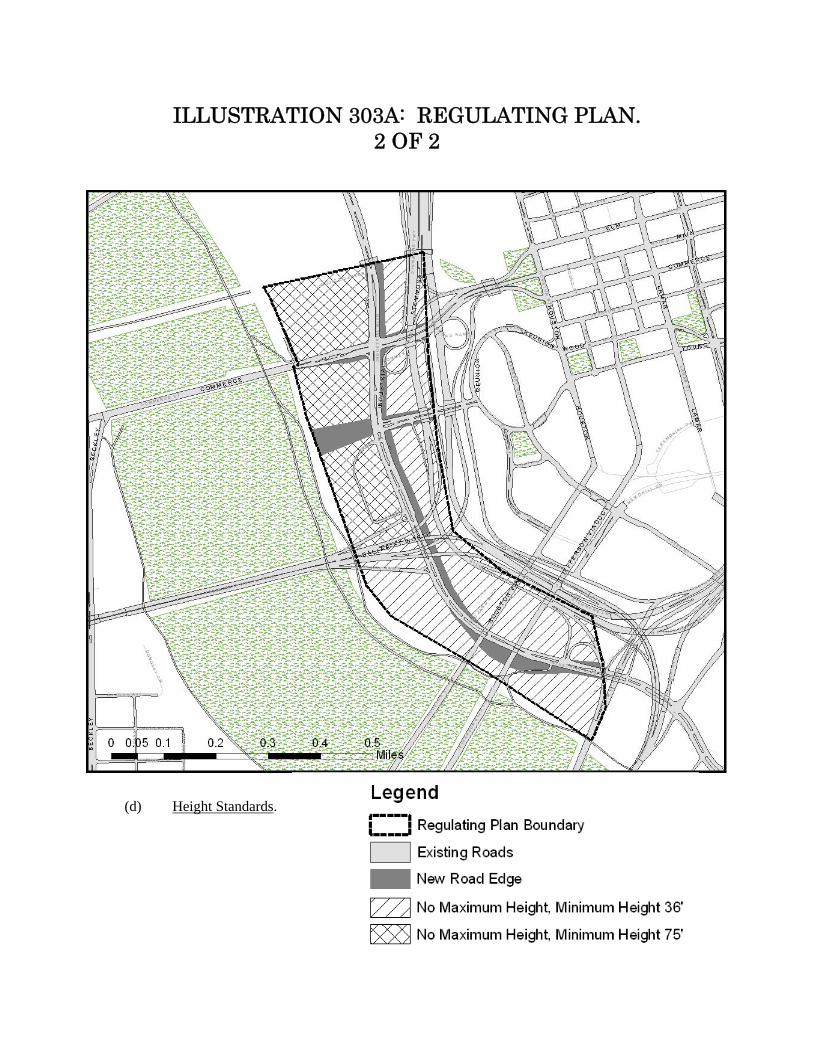
ILLUSTRATION 303A: REGULATING PLAN.
2 OF 2
(d) Height Standards.
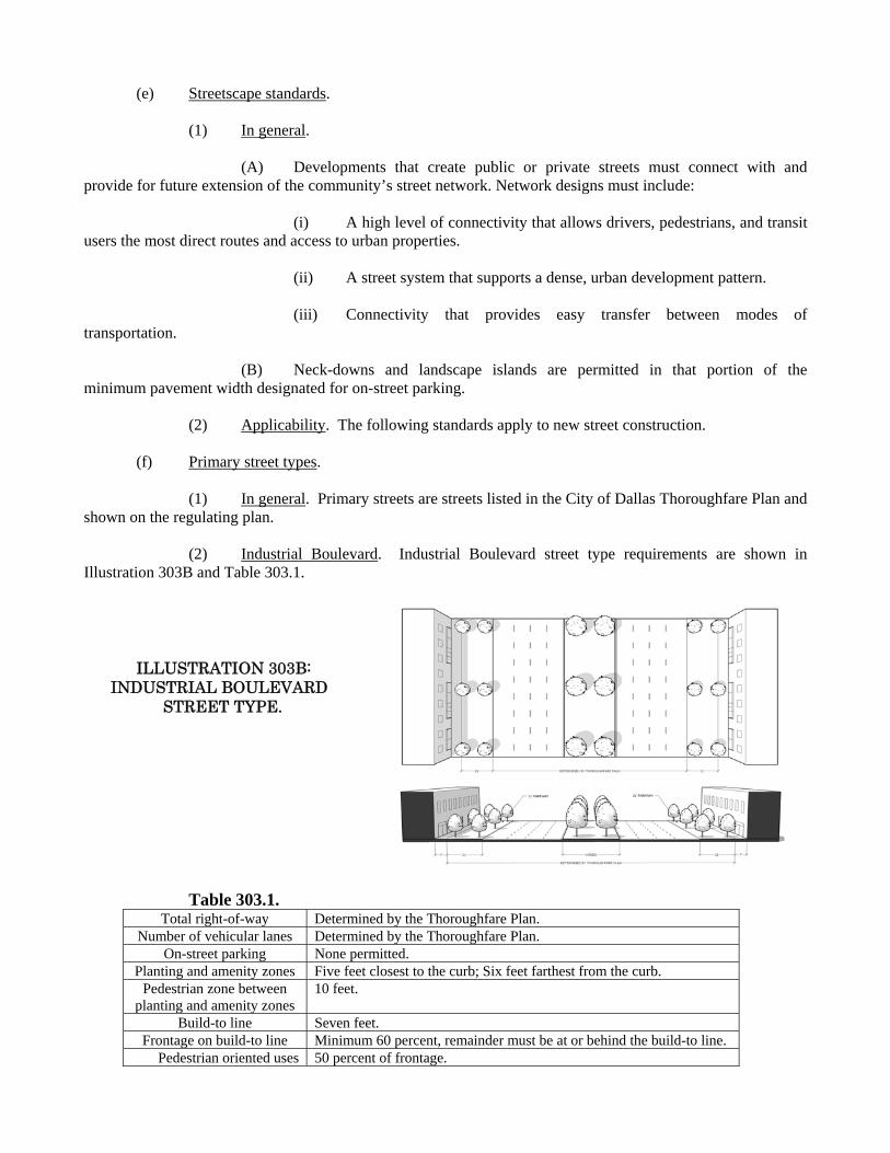
(e) Streetscape standards. (1) In general. (A) Developments that create public or private streets must connect with and provide for future extension of the community’s street network. Network designs must include: (i) A high level of connectivity that allows drivers, pedestrians, and transit users the most direct routes and access to urban properties. (ii) A street system that supports a dense, urban development pattern. (iii) Connectivity that provides easy transfer between modes of transportation. (B) Neck-downs and landscape islands are permitted in that portion of the minimum pavement width designated for on-street parking. (2) Applicability. The following standards apply to new street construction. (f) Primary street types. (1) In general. Primary streets are streets listed in the City of Dallas Thoroughfare Plan and shown on the regulating plan. (2) Industrial Boulevard. Industrial Boulevard street type requirements are shown in Illustration 303B and Table 303.1.
ILLUSTRATION 303B: INDUSTRIAL BOULEVARD STREET TYPE. Table 303.1.
Total right-of-way Determined by the Thoroughfare Plan. Number of vehicular lanes Determined by the Thoroughfare Plan.
On-street parking None permitted.Planting and amenity zones Five feet closest to the curb; Six feet farthest from the curb.
Pedestrian zone between planting and amenity zones
10 feet.
Build-to line Seven feet.Frontage on build-to line Minimum 60 percent, remainder must be at or behind the build-to line.
Pedestrian oriented uses 50 percent of frontage.

(3) Commerce Street. Commerce Street street type requirements are shown in illustration 303C and Table 303.2. Enhanced pedestrian amenities are required. See Section 51P-784.202(e).
ILLUSTRATION 303C: COMMERCE STREET STREET TYPE.
Table 303.2. Total right-of-way Determined by the Thoroughfare Plan.
Number of Vehicular lanes
Determined by the Thoroughfare Plan.
On-street parking None permitted.Planting and amenity zone
Five feet.
Pedestrian zone 15 feet.Storefront zone Up to five feet of the pedestrian zone.
Build-to line 0 feet. Frontage on build-
to line Minimum 80 percent, remainder must be at or behind the build-to line.
Pedestrian oriented uses
25 percent of frontage.
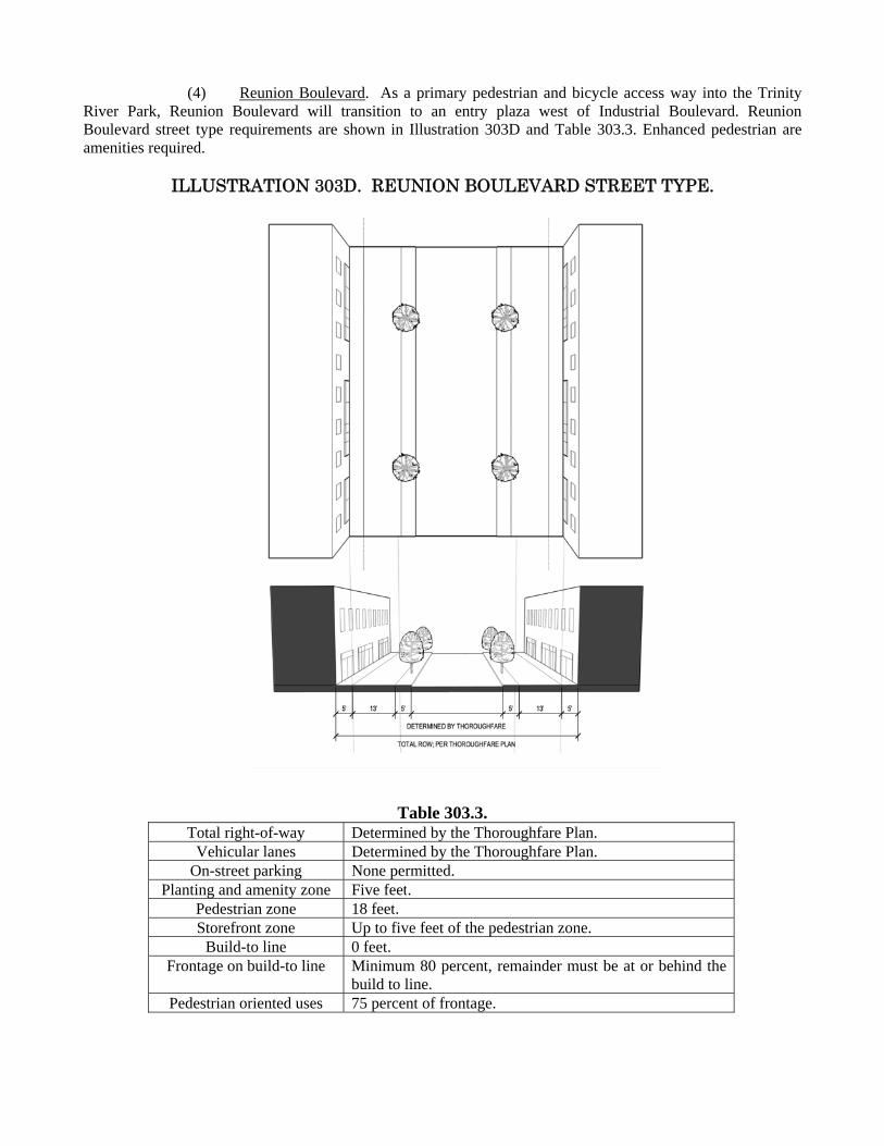
(4) Reunion Boulevard. As a primary pedestrian and bicycle access way into the Trinity River Park, Reunion Boulevard will transition to an entry plaza west of Industrial Boulevard. Reunion Boulevard street type requirements are shown in Illustration 303D and Table 303.3. Enhanced pedestrian are amenities required.
ILLUSTRATION 303D. REUNION BOULEVARD STREET TYPE.
Table 303.3. Total right-of-way Determined by the Thoroughfare Plan.
Vehicular lanes Determined by the Thoroughfare Plan.On-street parking None permitted.
Planting and amenity zone Five feet.Pedestrian zone 18 feet.Storefront zone Up to five feet of the pedestrian zone.
Build-to line 0 feet.Frontage on build-to line Minimum 80 percent, remainder must be at or behind the
build to line.Pedestrian oriented uses 75 percent of frontage.
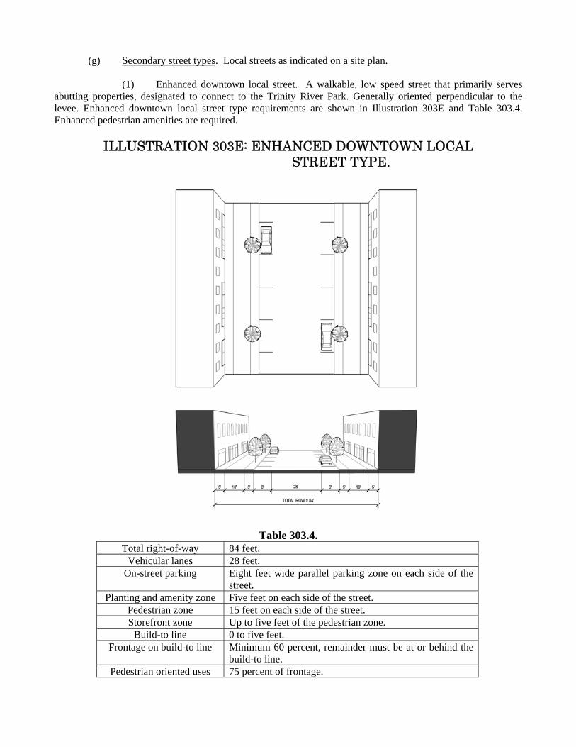
(g) Secondary street types. Local streets as indicated on a site plan. (1) Enhanced downtown local street. A walkable, low speed street that primarily serves abutting properties, designated to connect to the Trinity River Park. Generally oriented perpendicular to the levee. Enhanced downtown local street type requirements are shown in Illustration 303E and Table 303.4. Enhanced pedestrian amenities are required.
ILLUSTRATION 303E: ENHANCED DOWNTOWN LOCAL STREET TYPE.
Table 303.4. Total right-of-way 84 feet.
Vehicular lanes 28 feet.On-street parking Eight feet wide parallel parking zone on each side of the
street.Planting and amenity zone Five feet on each side of the street.
Pedestrian zone 15 feet on each side of the street.Storefront zone Up to five feet of the pedestrian zone.
Build-to line 0 to five feet.Frontage on build-to line Minimum 60 percent, remainder must be at or behind the
build-to line.Pedestrian oriented uses 75 percent of frontage.
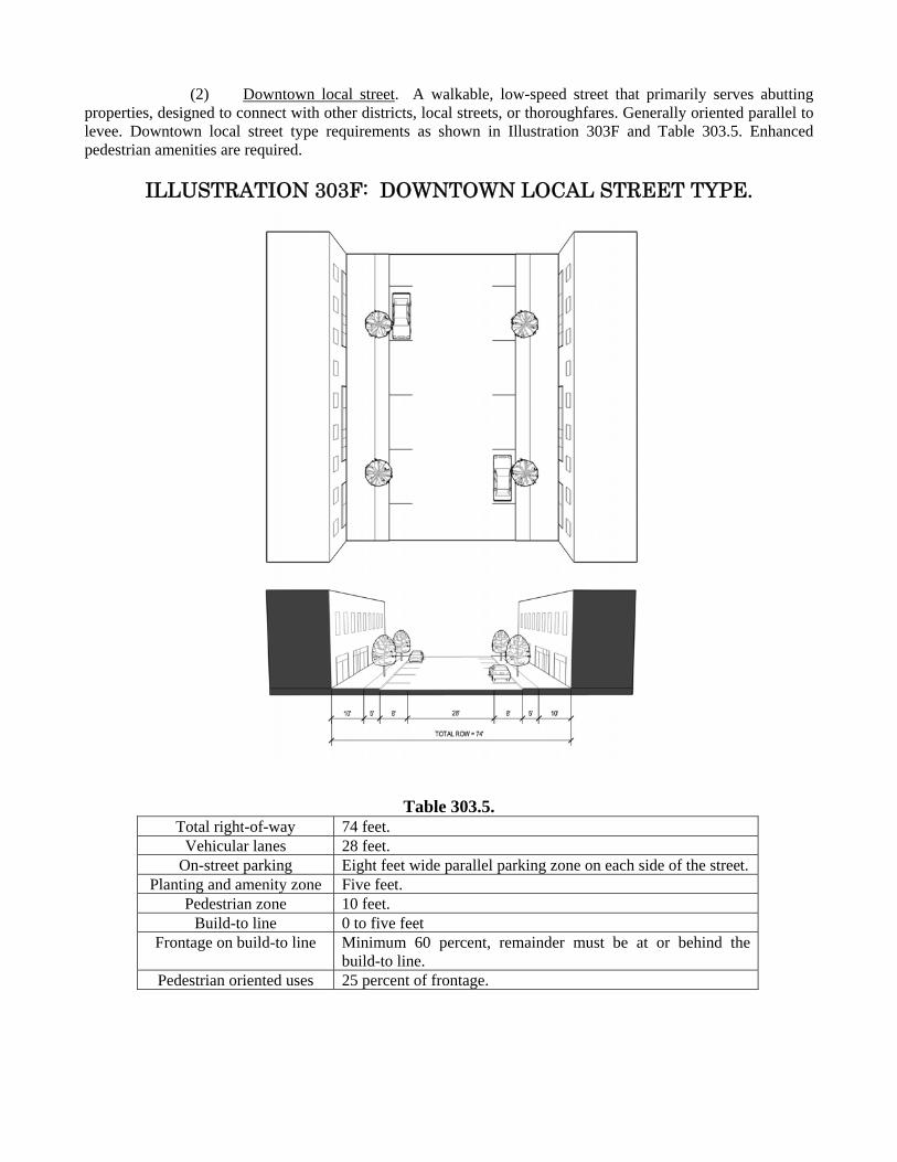
(2) Downtown local street. A walkable, low-speed street that primarily serves abutting properties, designed to connect with other districts, local streets, or thoroughfares. Generally oriented parallel to levee. Downtown local street type requirements as shown in Illustration 303F and Table 303.5. Enhanced pedestrian amenities are required.
ILLUSTRATION 303F: DOWNTOWN LOCAL STREET TYPE.
Table 303.5. Total right-of-way 74 feet.
Vehicular lanes 28 feet.On-street parking Eight feet wide parallel parking zone on each side of the street.
Planting and amenity zone Five feet.Pedestrian zone 10 feet.
Build-to line 0 to five feetFrontage on build-to line Minimum 60 percent, remainder must be at or behind the
build-to line.Pedestrian oriented uses 25 percent of frontage.

(3) Service drive. Primarily provides access to parking, service areas and other ancillary uses. Service drive street type requirements are shown in Illustration 303G and Table 303.6.
ILLUSTRATION 303G. SERVICE DRIVE STREET TYPE.
Table 303.6. Total right-of-way 64 feet.
Vehicular lanes 28 feet.On-street parking Eight feet wide parallel parking zone on each side of the street.
Planting and amenity zone Five feet.Pedestrian zone Five feet.
Build-to line None.Frontage on build-to line No minimum required.Pedestrian oriented uses None.
(Ord. 27331)
SEC. 51P-784.304. CEDARS WEST SUBAREA.
(a) Vision and intent. The Cedars West Subarea comprises approximately 193 acres along the eastern side of the Trinity River. The area is bounded on the southwest by the existing Trinity River levees, on the southeast by Cadiz Street, the sumps, and the DART right-of-way, on the northeast by the Union Pacific Railroad and on the northwest by Interstate 35 and Interstate 30. Riverfront Boulevard is the main connector between areas along the Trinity River; Cadiz Street and Corinth Street connect the Cedars West Subarea with South Lamar and the Dallas Convention Center. The proximity of the Cedars West Subarea to downtown, the Dallas Convention Center, the Cedars West entertainment area, and major transportation routes creates a destination center with restaurants, shops, and entertainment for Dallas residents and visitors. Open space areas and adjacent lakes create the opportunity to develop a mixed use residential neighborhood. (b) Enhancements for certain existing uses. (1) Purpose. The enhancements in this subsection are intended to ensure that certain existing uses, which are more industrial in nature, are modified with screening to:
(A) allow the use to continue but not be as visible to residents and visitors; (B) be more compatible with the new urban village form district land uses and
regulations; (C) reduce noise, dust, and visual clutter; and (D) enhance the unique character of this area as it transitions into a mixed use
destination. (2) Existing industrial uses. The following existing industrial uses that have a valid certificate of occupancy on or after June 23, 2010 are not subject to the automatic compliance date in Paragraph (2), “Automatic Compliance Date for Industrial Uses,” in Part I, “General Provisions,” of Article 784 if the enhancements listed in Paragraph (b)(4) are completed: -- Industrial (inside) not potentially incompatible.
-- Industrial (inside) light manufacturing. -- Metal salvage facility.
-- Outside salvage and reclamation. (3) Other existing uses. The following existing uses that have a valid certificate of occupancy on or after June 23, 2010 must complete the enhancements listed in Paragraph (b)(4): -- Metal or welding shop. -- Outside storage. -- Petroleum product storage and wholesale. -- Warehouse.
(4) Enhancements.
(A) Plant material screening. (i) Street trees. In addition to the street tree requirements in Part II, additional large street trees are required. The number of required large street trees is determined by dividing the number of feet of lot frontage, excluding driveways and visibility triangles, by 30. Fractions are rounded to the nearest whole number, with 0.5 being rounded up to the next higher whole number. Large street trees must be a minimum caliper of two inches at the time of planting. (ii) Other plant material screening. Excluding ingress and egress points, at least 50 percent of the street frontage between back-of-curb and the build-to line must have turf, ground cover, shrubs, trees, seasonal plantings, or a combination of these plant materials. Plant materials must comply with all visibility triangles. (B) Structural screening. (i) Uses must be wholly enclosed within a structure or screened so that the use and its operations are not visible from the property directly line across the street. (ii) Any screening provided must be a minimum of nine feet in height and must be located at the build-to line. Fences over nine feet in height must wrap at corners and driveway entrances for a minimum of one foot in length for every foot in height over nine feet. For example, a fence that is 10 feet in height must proceed from the driveway into the interior of the Property (“wrap”) for a minimum of one foot in length. (iii) To prevent visual monotony, at least 75 percent of the length of any screening longer than 50 feet must alternate materials; alternate textures; be a combination of materials; or have offsets or openings.
(C) Facade improvements. Street-facing facades exceeding 30 feet in length must have one of the following elements. Street facing facades exceeding 100 feet in length must have two of the following elements: (i) Change in plane every 30 feet, such as an offset, reveal, recess, or projection. Changes in plane must have a width of not less than 24 inches and a depth of at least eight inches and may include columns, planters, arches and niches. (ii) Architectural details such as raised bands and cornices. (iii) Design or mural features that cover 30 percent of the facade. The intent of this element is to encourage the use of materials and themes that celebrate the history of the area and comply with the spirit and intent of the design guidelines for the Trinity River Corridor Project. (5) Completion date and extensions. All existing uses listed in Paragraphs (b)(2) and (b)(3) that have a valid certificate of occupancy on or after June 23, 2010 must complete the enhancements listed in Paragraph (b)(4) by June 23, 2012. The board of adjustment may grant an extension of this deadline if it determines, after a public hearing, that strict compliance would result in substantial financial hardship or inequity to the applicant without sufficient corresponding benefit to the city and its citizens in accomplishing the objectives. In no case may the board of adjustment extend the date for completion of these enhancements past June 23, 2015.

(c) Additional regulations. (1) Surface parking setbacks. Minimum setback for surface parking is 60 feet from a key intersection as designated on the regulating plan. (2) Meanders. (A) In this subsection, MEANDERS means those portions of the old Trinity River channel that are outside of the levees. (B) For purposes of complying with the building elements and layout standards in the form district regulations, the meanders are considered a street. (C) Any building site abutting the meanders is required to have a build-to line located at the edge of the required sidewalk or property line abutting the meanders. Frontage on the build-to line is a minimum of 50 percent. (D) A minimum 15-foot-wide sidewalk with a minimum unobstructed width of 10 feet must be provided along the meanders. The required sidewalk must connect to an abutting sidewalk or be located to accommodate sidewalk extensions. The required sidewalk may be located in the meanders if approved by the director of public works and transportation.
(d) Form district regulations. (1) In general. Except as provided in this subsection, t[T]he Cedars West Subarea is
subject to the urban village form district regulations. Build-to lines, height standards, and additional information is shown on Illustration 304A.
(2) Tower/antenna for cellular communication in Cedars West Subdistrict No. 2. (A) The urban form district regulations, the build-to lines on the regulating plan, the streetscape standards, and the regulations for primary street types do not apply. (B) Except as provided in this paragraph, minimum setback from Riverfront Boulevard is seven feet. For an auxiliary building in conjunction with a tower/antenna for cellular communication, minimum setback from Riverfront Boulevard is 108 feet. (C) Maximum structure height is 80 feet.
(D) Maximum floor area for an auxiliary building in conjunction with a tower/antenna for cellular communication is 375 square feet.
[Remainder of page intentionally left blank.]
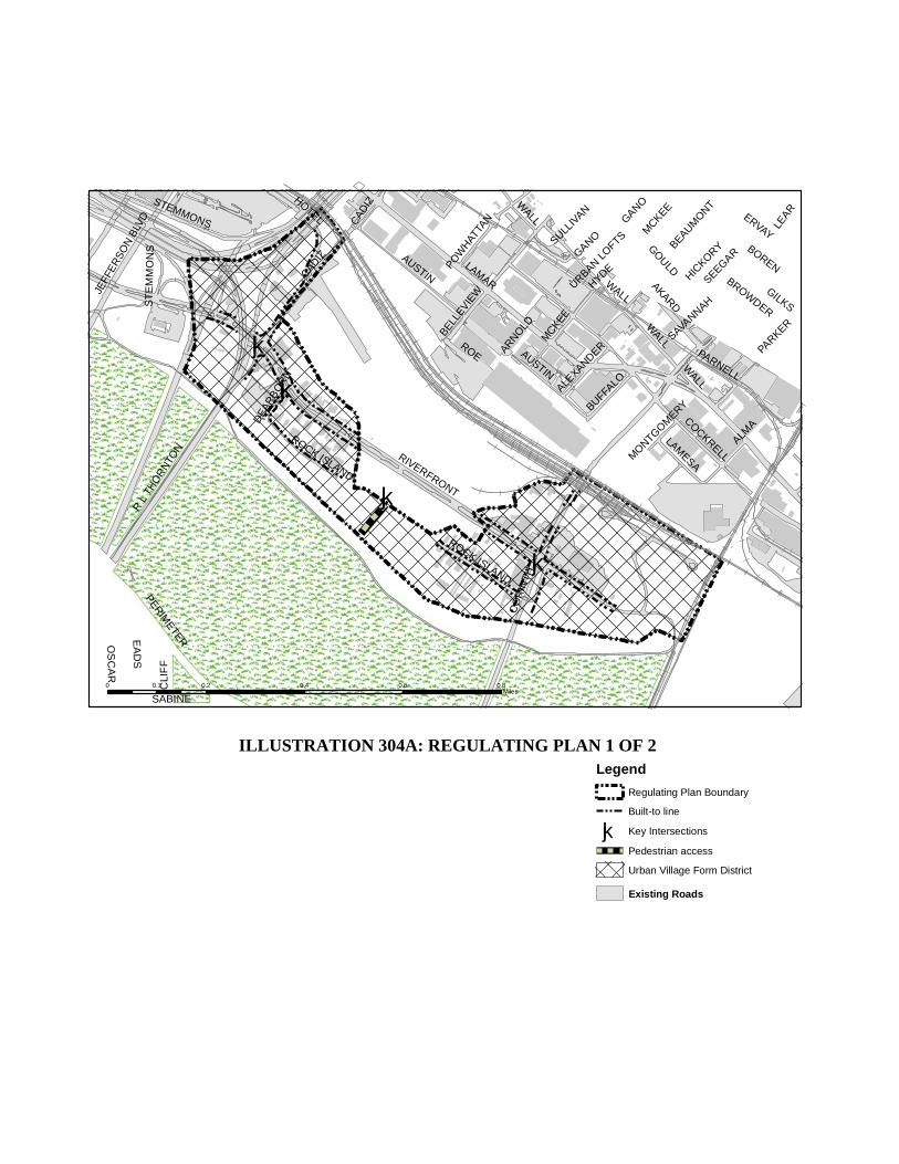
kj
kj
kj
kj
RIVERFRONT
LAMAR
CADIZ
GOULD
COCKRELL
AKARD
EA
DS
R L
TH
OR
NTO
N
CO
RIN
TH
ERVAY
AUSTIN
BELL
EVIEW
ALMA
BROWDER
HOTEL
PERIM
ETER
HICKO
RY
WALL
BEAUMO
NT
MCKEE
STEMMONS
ROE
SEEGAR
SABINE
CLI
FF
LEAR
JEFF
ER
SO
N B
LVD
GILKS
LAMESA
PARNELL
SAVANNAH
BUFFALO
ROCK ISLAND
GANO
ALEXANDER
BORENPOW
HAT
TAN
ARNOLD
PARKER
SULLIV
AN
DEA
RB
OR
N
OS
CA
R
MONTGO
MERY
URBAN LO
FTS
HYDE
AUSTIN
WALL
ST
EM
MO
NS
ROCK ISLAND
MCKEE
WALL
WALL
CAD
IZ
GANO
0 0.2 0.4 0.6 0.80.1Miles
Legend
Regulating Plan Boundary
Built-to line
kj Key Intersections
Pedestrian access
Urban Village Form District
Existing Roads
ILLUSTRATION 304A: REGULATING PLAN 1 OF 2
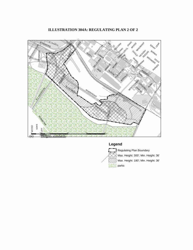
RIVERFRONT
LAMAR
CADIZ
GOULD
COCKRELL
AKARD
EA
DS
R L
TH
OR
NTO
N
CO
RIN
TH
ERVAY
AUSTIN
BELLE
VIEW
ALMA
BROWDER
HOTEL
PERIM
ETER
HICKO
RY
WALL
BEAUMO
NT
MC
KEE
STEMMONS
ROE
SEEGAR
SABINE
CLI
FF
LEAR
JEFF
ER
SO
N B
LVD
GILKS
LAMESA
PARNELL
SAVANNAH
BUFFALO
ROCK ISLAND
GANO
ALEXANDER
BORENPOW
HAT
TAN
ARNOLD
PARKER
SULLIV
AN
DE
ARB
OR
N
OS
CA
R
MONTG
OMERY
URBAN LO
FTS
HYDE
AUSTIN
WALL
ST
EM
MO
NS
ROCK ISLAND
MCKEE
WALL
WALL
CAD
IZ
GANO0 0.2 0.4 0.6 0.80.1
Miles
Legend
Regulating Plan Boundary
Max. Height: 300'; Min. Height: 36'
Max. Height: 180'; Min. Height: 36'
parks
(e) Heights standards.
ILLUSTRATION 304A: REGULATING PLAN 2 OF 2
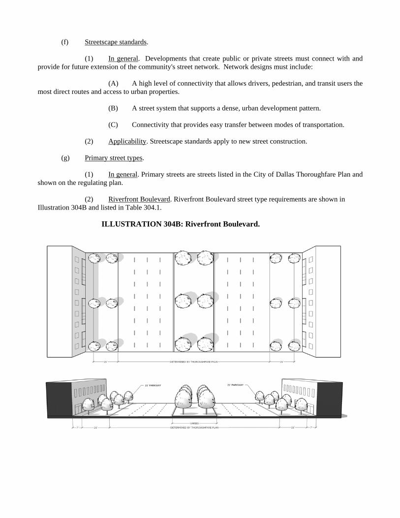
(f) Streetscape standards. (1) In general. Developments that create public or private streets must connect with and provide for future extension of the community's street network. Network designs must include: (A) A high level of connectivity that allows drivers, pedestrian, and transit users the most direct routes and access to urban properties. (B) A street system that supports a dense, urban development pattern. (C) Connectivity that provides easy transfer between modes of transportation. (2) Applicability. Streetscape standards apply to new street construction. (g) Primary street types. (1) In general. Primary streets are streets listed in the City of Dallas Thoroughfare Plan and shown on the regulating plan.
(2) Riverfront Boulevard. Riverfront Boulevard street type requirements are shown in Illustration 304B and listed in Table 304.1.
ILLUSTRATION 304B: Riverfront Boulevard.
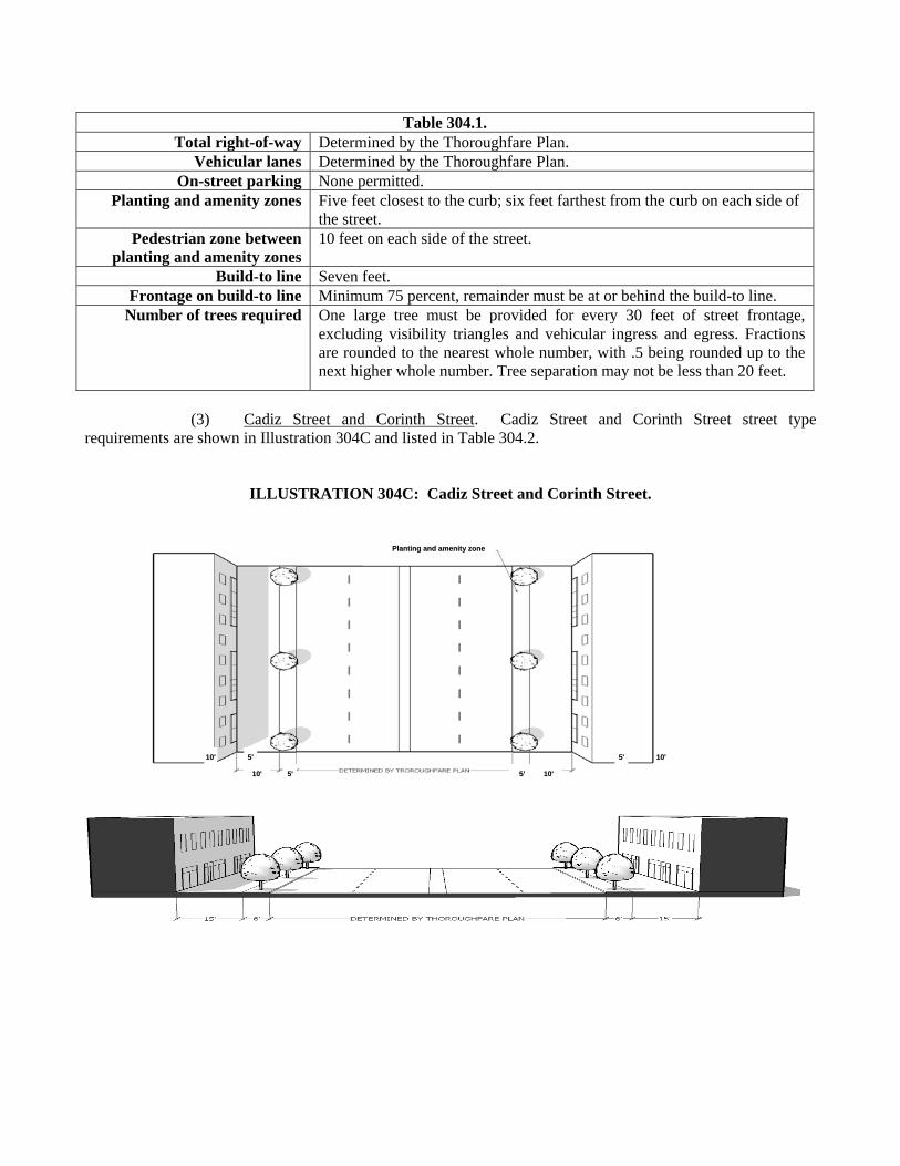
(3) Cadiz Street and Corinth Street. Cadiz Street and Corinth Street street type requirements are shown in Illustration 304C and listed in Table 304.2.
ILLUSTRATION 304C: Cadiz Street and Corinth Street.
Table 304.1. Total right-of-way Determined by the Thoroughfare Plan.
Vehicular lanes Determined by the Thoroughfare Plan. On-street parking None permitted.
Planting and amenity zones Five feet closest to the curb; six feet farthest from the curb on each side of the street.
Pedestrian zone between planting and amenity zones
10 feet on each side of the street.
Build-to line Seven feet.Frontage on build-to line Minimum 75 percent, remainder must be at or behind the build-to line.
Number of trees required One large tree must be provided for every 30 feet of street frontage, excluding visibility triangles and vehicular ingress and egress. Fractions are rounded to the nearest whole number, with .5 being rounded up to the next higher whole number. Tree separation may not be less than 20 feet.
PPllaannttiinngg aanndd aammeenniittyy zzoonnee
1100'' 1100'' 55'' 55''
1100'' 1100'' 55'' 55''
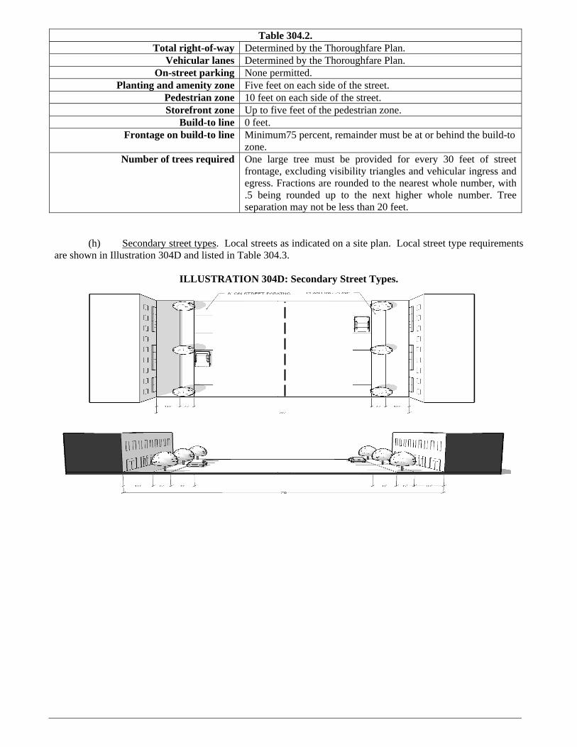
(h) Secondary street types. Local streets as indicated on a site plan. Local street type requirements are shown in Illustration 304D and listed in Table 304.3.
ILLUSTRATION 304D: Secondary Street Types.
Table 304.2. Total right-of-way Determined by the Thoroughfare Plan.
Vehicular lanes Determined by the Thoroughfare Plan. On-street parking None permitted.
Planting and amenity zone Five feet on each side of the street.Pedestrian zone 10 feet on each side of the street.Storefront zone Up to five feet of the pedestrian zone.
Build-to line 0 feet.Frontage on build-to line Minimum75 percent, remainder must be at or behind the build-to
zone.Number of trees required One large tree must be provided for every 30 feet of street
frontage, excluding visibility triangles and vehicular ingress and egress. Fractions are rounded to the nearest whole number, with .5 being rounded up to the next higher whole number. Tree separation may not be less than 20 feet.
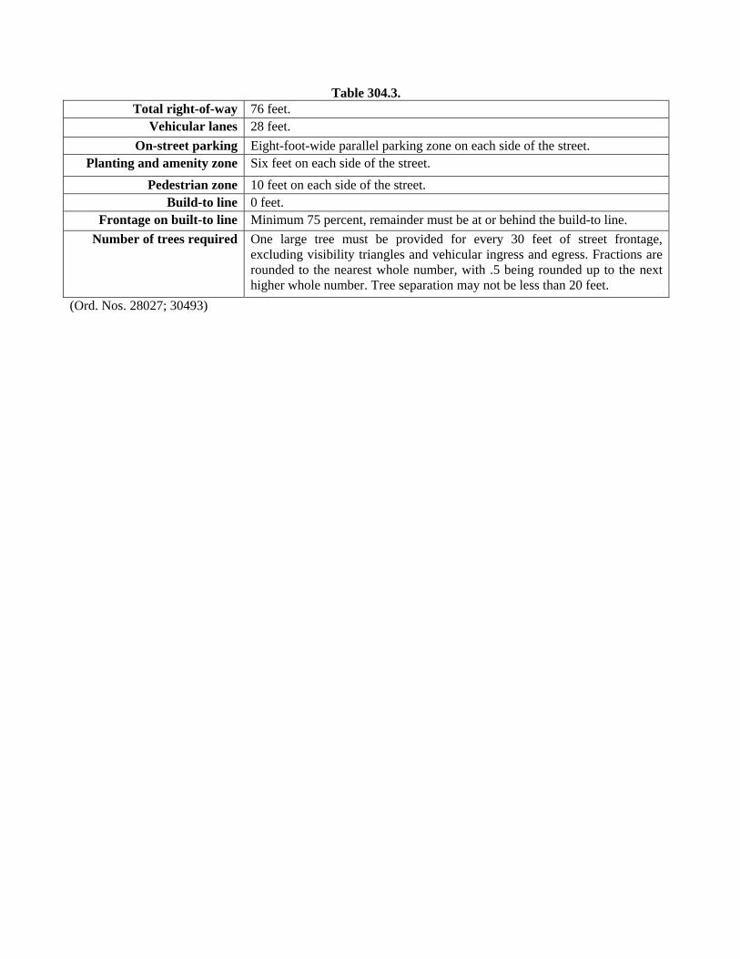
(Ord. Nos. 28027; 30493)
Table 304.3.
Total right-of-way 76 feet. Vehicular lanes 28 feet.
On-street parking Eight-foot-wide parallel parking zone on each side of the street. Planting and amenity zone Six feet on each side of the street.
Pedestrian zone 10 feet on each side of the street. Build-to line 0 feet.
Frontage on built-to line Minimum 75 percent, remainder must be at or behind the build-to line.
Number of trees required One large tree must be provided for every 30 feet of street frontage, excluding visibility triangles and vehicular ingress and egress. Fractions are rounded to the nearest whole number, with .5 being rounded up to the next higher whole number. Tree separation may not be less than 20 feet.