article designing in the cultural rural landscape. a
TRANSCRIPT
Article
Designing in the Cultural Rural Landscape. A Teaching
Opportunity to Experiment a Research-by-Design Process
Applied to an Italian UNESCO Wine Site
Catherine Dezio 1*, Can Zhang 2, Yilan Zhang 2, Davide Marino 3
1 Department of Architecture and Urban Studies, Politecnico di Milano, Italy; [email protected] 2 Independent researcher 3 Department of Bioscience and Territory, Università del Molise, Italy; [email protected]
* Correspondence: [email protected]
Abstract: Rural landscapes all over the world are subject to great transformations, first of all the
continuous and slow depopulation of land and villages. It is a dramatic phenomenon that causes
devastating consequences for environmental systems and for the tangible and intangible heritage
of entire territories. The situation becomes more ambiguous when it comes to cultural landscapes,
especially those internationally recognized as exceptional (i.e. inscribed on the UNESCO World
Heritage List). In this case, the risk is to abandon agricultural production in favor of consumerist
tourist economies, which can damage the territorial authenticity. In this paper we question the role
of the landscape project in strengthening territorial resilience. In particular, a composite and inter-
dependent action is proposed between landscape design and implementation of a multifunctional
agriculture model, oriented towards teaching and tourism. To undertake this investigation, a mas-
ter's thesis work on Landscape Architecture is examined, as an opportunity for a research-by-design
method. The application case is the Italian UNESCO site of Vignale Monferrato, a depopulated rural
village, characterized by abandoned land and buildings. The paper concludes by outlining replica-
bility application scenarios for the proposed model.
Keywords: landscape design and planning; research-by-design; multifunctional agriculture
1. Introduction
In 1992 the World Heritage Committee decided to define a separate category in the
World Heritage List that recognizes cultural landscapes [1]. The definition was actually
born much earlier, when during the twentieth century various landscape scholars (geog-
raphers, urban planners, sociologists) recognized in some rural territories a harmonious
balance in the relationship between environmental systems and the anthropogenic com-
ponents, thanks to which the territories remain such, while adapting to the transfor-
mations of the time [2, 3, 4, 5, 6, 7, 8]. It is for this characteristic of adaptation to the events
that overwhelm them, respecting the constituent and structuring elements, that they are
often taken into consideration as resilient systems [7, 8, 9, 10, 11, 12, 13, 14]. In particular,
Barbera et al. have seen prototypes of resilient socio-ecological systems in the cultural cat-
egory of traditional agricultural landscapes, tracing an evaluation method for the charac-
ters that make them so [7].
However, what escapes is a strong ambivalence between their constituent structure,
which is inherently resilient, and the tendency to fragility [7, 8, 13, 14]. Also here, rural
areas are under considerable pressure, some of these are: soil consumption, intensification
and monospecificity, the presence of pesticides in water, as well as the abandonment of
agriculture and related assets [15,16]. We know that a cultural rural landscape is resilient
as long as the community persists in keeping the methods that forged it productive. The
problem arises when the community abandons it, interrupts its production and therefore
Preprints (www.preprints.org) | NOT PEER-REVIEWED | Posted: 30 July 2021 doi:10.20944/preprints202107.0708.v1
© 2021 by the author(s). Distributed under a Creative Commons CC BY license.
also its care, with consequent environmental problems (hydrogeological), cultural prob-
lems (loss of tangible and intangible assets) and socioeconomic problems (loss of attractive
economies identifying the surrounding territory risks). All this is possible in cultural land-
scapes and in ordinary ones, because many rural systems around the world are subject to
continuous depopulation [15, 16].
There are numerous policies, projects, strategies, ideas concerning the possible re-
generation of marginal territories in depopulation. In Italy, the National Strategy of Inner
Areas [17] promoted by the Italian government, as a cohesion policy, provided the oppor-
tunity to bring back to the center of political and academic debates territories that had
remained on the margins for a long time, with a view it differs from simple welfare sub-
sidies, and instead promotes initiative and local growth.
In UNESCO sites the situation is more ambiguous. On one hand, they are still mar-
ginal areas, subject to depopulation, but on the other, tourism is growing. The risk is to
change the productive territorial identity (which is the same for which tourists are at-
tracted) in favor of purely consumerist commercial economies.
A new vision is needed for cultural rural landscapes, which abandons the principle
of conservation as freezing and takes the opportunities and stimuli for a sustainable de-
velopment of a new agriculture.
In this paper, we will try to investigate the role of the landscape design project within
an innovative multifunctional agriculture model, which maintains the traditional quality
production (and therefore also the landscape and the authenticity of the territory), insert-
ing integrative activities that support local economy, and generates value through a public
rural space integrated into the local and supra-local system. In particular, local resources
are enhanced (according to the SNAI guidelines for inner areas), restoring the production
of abandoned land, recovering disused buildings, generating jobs for local people and
providing opportunities for inclusion between tourists and residents. It will be an anti-
fragile landscape design project, able to dialogue with different policies, actors and gov-
ernance systems.
It is a model of a resilient regenerative agriculture, which becomes not only local ac-
tion but also territorial action. It is local because it restores production and integrates al-
ternative activities. It is super-local because it fits in an integrated way in the village and
with the rest of the region, thanks to a project of spaces and routes. It is a model that
implies a two-way vision between innovation and conservation, and between project and
policies, that can generate experimental and stimulating research opportunities, aimed at
replicability on others marginal territories.
To analyze this issue, we opted for an application on a known case study, such as the
wine-growing site of the Langhe in Italy, with particular reference to the village, in the
process of depopulation and aging, of Vignale Monferrato.
To carry out the idea it was decided to work on a master's thesis of the Landscape
Architecture Degree of the Polytechnic of Milan, Italy [18]. This choice was not made by
chance, but derives from the idea of experiment the teaching method as a meeting point
between research and real application. The paper is divided into: materials and methods
(section 2), which describes the applied approach, the analytical case studies and the ap-
plication case study that leads to the definition of the model; results (section 3) with the
illustration of the project; discussion (section 4) with the interpretation of the results; con-
clusions (section 5) with the identification of scenarios and possible guidelines for new
future developments on the theme of rural landscapes, from an antifragile, regenerative
and resilient perspective.
Preprints (www.preprints.org) | NOT PEER-REVIEWED | Posted: 30 July 2021 doi:10.20944/preprints202107.0708.v1
2. Materials and Methods
2.1 Approach and method adopted.
The approach adopted in this work draws on the school of research-by-design, which
refers in part to the movement of landscape urbanism, but also has more distant roots [19].
This method implies a project that is not only action but also a real cognitive process, made
up of mechanisms of composition and decomposition and identification of possible future
scenarios according to the many external variants. The design process itself constitutes the
method and innovation.
Teaching and working with students are used in research-by-design not for a coinci-
dence. The didactic process, proposed here as a process of shared knowledge building,
represents a precious opportunity to undertake an experimental research path. In this
case, there is the opportunity to build a structured and conscious methodology of action
on the territory, in which each step is explained and understood with awareness of the
diachronic and spatial implications.
The teaching process is based on case studies, which represent important learning
and research opportunities. On one hand, the analytical case studies are useful to decon-
struct the logic that generated them and to extrapolate positive and negative aspects, ele-
ments of replicability and lines of development. Avoiding the effect of compiling data
collection, it is a useful exercise for students to understand how the project must precede
a research and study phase aimed at developing and building a critical and constructive
point of view.
On the other hand, the application case study represents an opportunity to apply the
hypothesized strategy, with related considerations in terms of possible "what if" scenarios.
As part of this phase, the methods and tools adopted are many, but all are based on a
strong anchoring to the historical and traditional, tangible and intangible roots and traces
of the place, in line with a European approach to the territory. In the current case of the
historical rural landscape, we will talk about historical traces that actually coincide with
the ecological ones. For example, we talk about edges and green infrastructures, that have
accompanied the productive landscape over the centuries and that have disappeared with
mechanization. The study of land use through historical maps and past satellite images
will guide the restoration of the traditional agricultural landscape, and of a better ecolog-
ical condition in terms of both biodiversity and hydrogeological safety.
The planning action on the territory also becomes an important educational oppor-
tunity to understand the ambivalence of the relationships between: cause and effect, local
scale and macro-scale, socio-economic and political dynamics and spatial and geograph-
ical dynamics, natural sciences, social sciences and design sciences, and much more.
2.2 Analytical case studies.
EU Member States have tried to respond to the challenges and opportunities facing
rural areas in the 21st century by developing the EU's rural development policy: the Com-
mon Agricultural Policy (CAP) [20]. The CAP supports rural areas to cope with the wide
range of economic, environmental and social challenges that such fragile systems will face.
It is proposed to achieve the following strategic objectives: to foster the competitiveness
of agriculture; to guarantee the sustainable management of natural resources; to structure
actions to combat climate change; to achieve balanced territorial development of econo-
mies and rural communities, including the creation and maintenance of employment. EU
rural development policy is implemented through rural development programs (RDPs)
and through several projects focusing on resolving demographic decline and developing
rural communities [20].
In the teaching process, 12 European case studies of agriculture, in line with Euro-
pean directives, were analyzed, mostly financed through the European Agricultural Fund
for Rural Development (EAFRD), but also with national or partly regional and private
contributions. Following the analysis of these case studies, it is possible to identify the two
main aspects that feed rural regeneration projects. The first concerns the
Preprints (www.preprints.org) | NOT PEER-REVIEWED | Posted: 30 July 2021 doi:10.20944/preprints202107.0708.v1
multifunctionality of agriculture, capable of providing alternative incomes and generating
the conditions for choosing quality production. In this aspect also fall educational activi-
ties regarding traditional local skills, which are a cultural resource that can become the
subject of courses and supplementary activities of the farm. The second aspect concerns
the great abandoned heritage: the land but also the buildings. These are underutilized
local resources that can fuel antifragile and resilient regeneration projects.
To undertake a specific study on the open space project, an analysis was carried out
on three of these 12 companies. These three projects have interesting aspects in common
in the logic and spatial structure. Most of the spaces in the cases analyzed are obviously
dedicated to agricultural production, and the paths are distribution axes that connect the
entire property, also becoming a public space open to visitors who explore the estate.
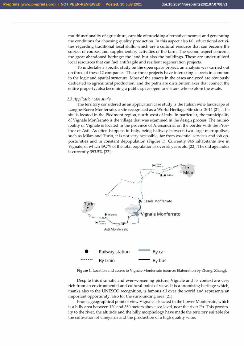
2.3 Application case study.
The territory considered as an application case study is the Italian wine landscape of
Langhe-Roero Monferrato, a site recognized as a World Heritage Site since 2014 [21]. The
site is located in the Piedmont region, north-west of Italy. In particular, the municipality
of Vignale Monferrato is the village that was examined in the design process. The munic-
ipality of Vignale is located in the province of Alessandria, on the border with the Prov-
ince of Asti. As often happens in Italy, being halfway between two large metropolises,
such as Milan and Turin, it is not very accessible, far from essential services and job op-
portunities and in constant depopulation (Figure 1). Currently 946 inhabitants live in
Vignale, of which 49.7% of the total population is over 55 years old [22]. The old age index
is currently 393.5% [22].
Figure 1. Location and access to Vignale Monferrato (source: Elaboration by Zhang, Zhang).
Despite this dramatic and ever-worsening picture, Vignale and its context are very
rich from an environmental and cultural point of view. It is a promising heritage which,
thanks also to the UNESCO recognition, is famous all over the world and represents an
important opportunity, also for the surrounding area [21].
From a geographical point of view Vignale is located in the Lower Monferrato, which
is a hilly area between 120 and 350 meters above sea level, near the river Po. This proxim-
ity to the river, the altitude and the hilly morphology have made the territory suitable for
the cultivation of vineyards and the production of a high quality wine.
Preprints (www.preprints.org) | NOT PEER-REVIEWED | Posted: 30 July 2021 doi:10.20944/preprints202107.0708.v1
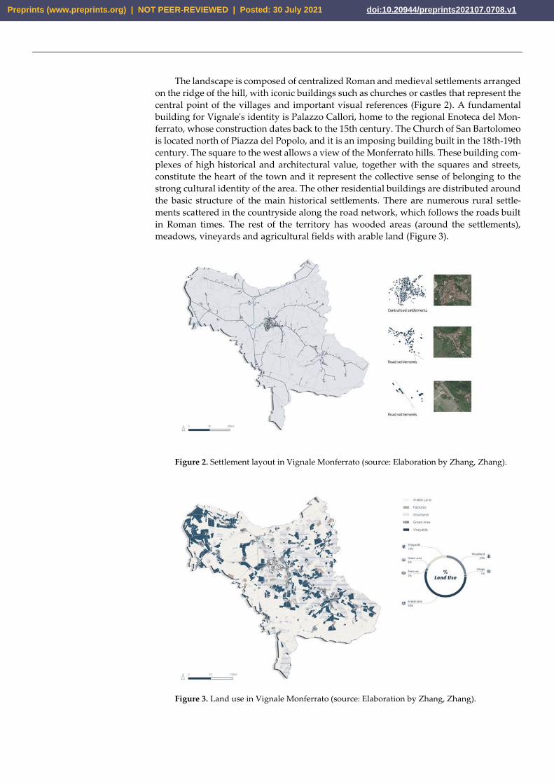
The landscape is composed of centralized Roman and medieval settlements arranged
on the ridge of the hill, with iconic buildings such as churches or castles that represent the
central point of the villages and important visual references (Figure 2). A fundamental
building for Vignale's identity is Palazzo Callori, home to the regional Enoteca del Mon-
ferrato, whose construction dates back to the 15th century. The Church of San Bartolomeo
is located north of Piazza del Popolo, and it is an imposing building built in the 18th-19th
century. The square to the west allows a view of the Monferrato hills. These building com-
plexes of high historical and architectural value, together with the squares and streets,
constitute the heart of the town and it represent the collective sense of belonging to the
strong cultural identity of the area. The other residential buildings are distributed around
the basic structure of the main historical settlements. There are numerous rural settle-
ments scattered in the countryside along the road network, which follows the roads built
in Roman times. The rest of the territory has wooded areas (around the settlements),
meadows, vineyards and agricultural fields with arable land (Figure 3).
Figure 2. Settlement layout in Vignale Monferrato (source: Elaboration by Zhang, Zhang).
Figure 3. Land use in Vignale Monferrato (source: Elaboration by Zhang, Zhang).
Preprints (www.preprints.org) | NOT PEER-REVIEWED | Posted: 30 July 2021 doi:10.20944/preprints202107.0708.v1
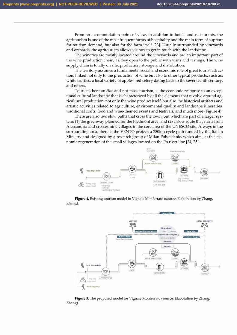
From an accommodation point of view, in addition to hotels and restaurants, the
agritourism is one of the most frequent forms of hospitality and the main form of support
for tourism demand, but also for the farm itself [23]. Usually surrounded by vineyards
and orchards, the agritourism allows visitors to get in touch with the landscape.
The wineries are mostly located around the vineyards and are an important part of
the wine production chain, as they open to the public with visits and tastings. The wine
supply chain is totally on site: production, storage and distribution.
The territory assumes a fundamental social and economic role of great tourist attrac-
tion, linked not only to the production of wine but also to other typical products, such as:
white truffles, a local variety of apples, red celery dating back to the seventeenth century,
and others.
Tourism, here an élite and not mass tourism, is the economic response to an excep-
tional cultural landscape that is characterized by all the elements that revolve around ag-
ricultural production: not only the wine product itself, but also the historical artifacts and
artistic activities related to agriculture, environmental quality and landscape itineraries,
traditional crafts, food and wine-themed events and festivals, and much more (Figure 4).
There are also two slow paths that cross the town, but which are part of a larger sys-
tem: (1) the greenway planned for the Piedmont area, and (2) a slow route that starts from
Alessandria and crosses nine villages in the core area of the UNESCO site. Always in the
surrounding area, there is the VENTO project: a 780km cycle path funded by the Italian
Ministry and designed by a research group of Milan Polytechnic, which aims at the eco-
nomic regeneration of the small villages located on the Po river line [24, 25].
Figure 4. Existing tourism model in Vignale Monferrato (source: Elaboration by Zhang,
Zhang).
Figure 5. The proposed model for Vignale Monferrato (source: Elaboration by Zhang,
Zhang).
Preprints (www.preprints.org) | NOT PEER-REVIEWED | Posted: 30 July 2021 doi:10.20944/preprints202107.0708.v1
2.4 The model.
What is proposed is a multifunctional agriculture model, which integrates produc-
tion income with university fees from educational courses (Figure 5). In particular, let's
talk about the Farmers' Incubation Program [26]. The Farmer Incubation Program is an
applied education program that aims to support the growth of new farmers. It provides
new farmers temporarily with land, infrastructure and training to develop skills and start
an agricultural business. These programs train young farmers on the obstacles faced by
beginners starting a business: access to land and capital and the opportunities to learn and
develop skills in planning agricultural activities.
To implement the model, four of these programs were selected to study their mech-
anisms and the amount of training fees (Pop-up garlic farmer in Melbourne; Future Grow-
ers Program in Bristol; Farm Start in Stockport; Commercial Growers Short Courses in
Stockport). The courses can have very variable durations, which allows a flexible turnover
of the farm. The main contents refer to the enhancement of local resources, in all their
forms, and to the guidelines of the 17 UN goals.
To undertake this model, it is possible to recover abandoned lands (previously aban-
doned because with a morphology difficult to cultivate) to use them with the main goal
of training and education. In this way, a multifunctional area is imagined that includes
production, a school of viticulture, a small museum and an agricultural park. In this sense,
job places can be generated that are partly temporary (for example, internships for those
who finish courses) and partly permanent. The whole project is a process of interaction
and integration between the various stakeholders, between visitors and residents, be-
tween farmers and young students.
3. Results
Hypothesizing a scenario for the proposed model, regarding activities and flows of
people, is fundamental for structuring the landscape design project. The spatial needs of
a multifunctional educational farm, in a tourism context, can be summarized in three
types: spaces for rest, both for guests but also open to the public outside; spaces for recre-
ation, for events, cultural festivals, cultural exhibitions; spaces for didactics, for all type of
students (brief and long time).
Two other fundamental aspects that can guide the choice of the site are: (i) the need
for agricultural land to be recovered for not only productive but also training purposes;
(ii) the need for a building to allocate functions that require internal space.
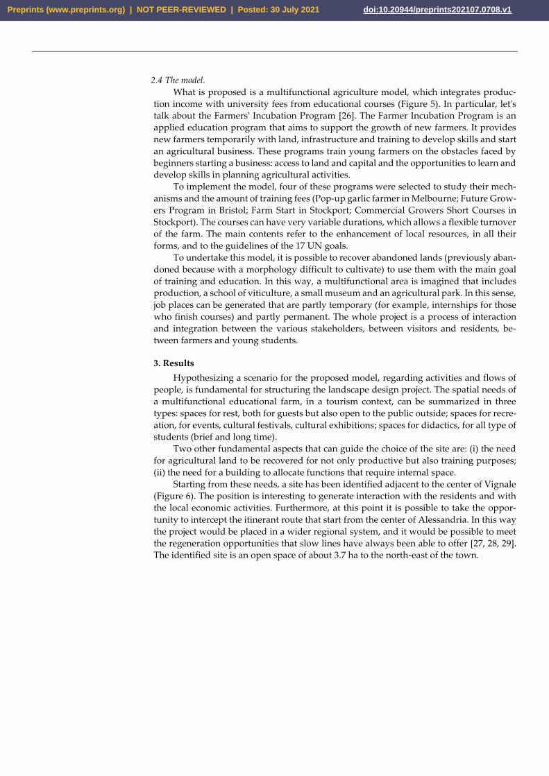
Starting from these needs, a site has been identified adjacent to the center of Vignale
(Figure 6). The position is interesting to generate interaction with the residents and with
the local economic activities. Furthermore, at this point it is possible to take the oppor-
tunity to intercept the itinerant route that start from the center of Alessandria. In this way
the project would be placed in a wider regional system, and it would be possible to meet
the regeneration opportunities that slow lines have always been able to offer [27, 28, 29].
The identified site is an open space of about 3.7 ha to the north-east of the town.
Preprints (www.preprints.org) | NOT PEER-REVIEWED | Posted: 30 July 2021 doi:10.20944/preprints202107.0708.v1
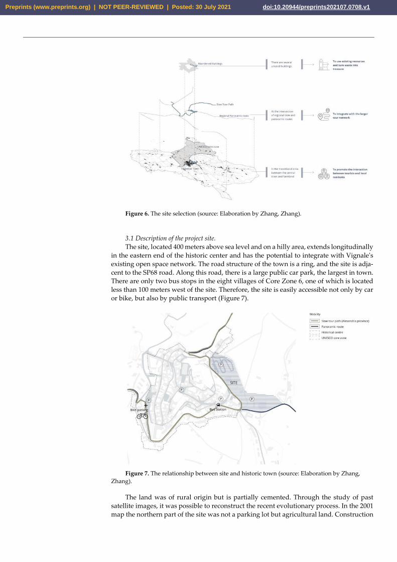
Figure 6. The site selection (source: Elaboration by Zhang, Zhang).
3.1 Description of the project site.
The site, located 400 meters above sea level and on a hilly area, extends longitudinally
in the eastern end of the historic center and has the potential to integrate with Vignale's
existing open space network. The road structure of the town is a ring, and the site is adja-
cent to the SP68 road. Along this road, there is a large public car park, the largest in town.
There are only two bus stops in the eight villages of Core Zone 6, one of which is located
less than 100 meters west of the site. Therefore, the site is easily accessible not only by car
or bike, but also by public transport (Figure 7).
Figure 7. The relationship between site and historic town (source: Elaboration by Zhang,
Zhang).
The land was of rural origin but is partially cemented. Through the study of past
satellite images, it was possible to reconstruct the recent evolutionary process. In the 2001
map the northern part of the site was not a parking lot but agricultural land. Construction
Preprints (www.preprints.org) | NOT PEER-REVIEWED | Posted: 30 July 2021 doi:10.20944/preprints202107.0708.v1

of the car park began in 2011. In addition, the vineyard on the east side of the site has
turned into hazelnuts.
Comparing the situation of 2021 with that one of 2013, we can find that the pavement
of the eastern car park is damaged by spontaneous vegetation.
There are four abandoned buildings on the site: a factory, two farmhouses and the
Vignale winery.
3.2 The design process.
Assuming that the hilly slopes are a suitable place for the cultivation of quality wine
grapes, especially with slopes of 10-20%, it was founded the area for vineyard.
Through the analysis of the needs of the model, different types of functions were
identified to be placed inside the buildings. Depending on the size of abandoned build-
ings and on the type of original space, the different functions will be suitably integrated.
The Cantina Sociale of Vignale, once the hub of the territory's production activity,
closed in December 2011 and has been in a state of neglect for many years. It is a charac-
terizing element, with large concrete silos, which can recall the winemaking tradition.
Therefore, it lends itself to being transformed into a museum of wine culture. In addition
to this, it can also host educational activities related to winemaking.
The farmhouses can be used as didactic spaces and services related to viticulture.
The factory lends itself to being transformed into reception services: accommodation,
restaurant, meeting rooms, rooms for events, etc.
Once the vineyard’s location and the program concerning the building’s functions
have been determined, the strategy of the open spaces can be examined.
There are no connecting roads between the various functional areas of the site, and it
is possible to access them only separately from external roads, for this reason it is neces-
sary to introduce a structured path within the site. Also, due to the hilly terrain, different
areas of activity are at different levels of height. Therefore, a design of the connections at
different height levels is necessary to facilitate accessibility for all.
To answer to these needs, it was decided to create a structured route, with new sys-
tem of open spaces along it, which then becomes a functional axis that crosses the entire
site, facilitating circulation and outlining the various functional areas. The new open
spaces within the site become spaces of conviviality mainly serving the historic center
(where some squares in the past have been transformed into parking lots and there are no
open spaces for aggregation).
Regarding the environmental design project, the aim was to introduce ecological in-
frastructures to increase the heterogeneity of the landscape, increasing biodiversity and
improving resilience of the vineyard. According to Böller et al. [30], the ecological infra-
structure network is composed of three fundamental elements: large areas for permanent
fauna habitats; smaller habitats that allow the accumulation of temporary animal popula-
tions; green corridor infrastructures that help animal species move between large and me-
dium-sized habitats. It is estimated that the optimal area of ecological infrastructure for a
production site, to ensure adequate diversity of species, is close to 15% [30]. According to
the International Organization for Biological and Integrated Control (IOBC), a minimum
of 5% of agricultural land must be used for ecological infrastructure [31]. With this goal,
trees and large shrubs of the site were kept to create a natural green space as a biodiversity
hotspot on the perimeter of the vineyard. Rows of trees and shrubs are planted along the
roads and the edges of the fields, which therefore act as connecting corridors between
ecological areas. Areas of linear elements and non-linear elements are put into a system
with the aim of generating a diverse and rich landscape in terms of biodiversity (Figure
8).
Preprints (www.preprints.org) | NOT PEER-REVIEWED | Posted: 30 July 2021 doi:10.20944/preprints202107.0708.v1
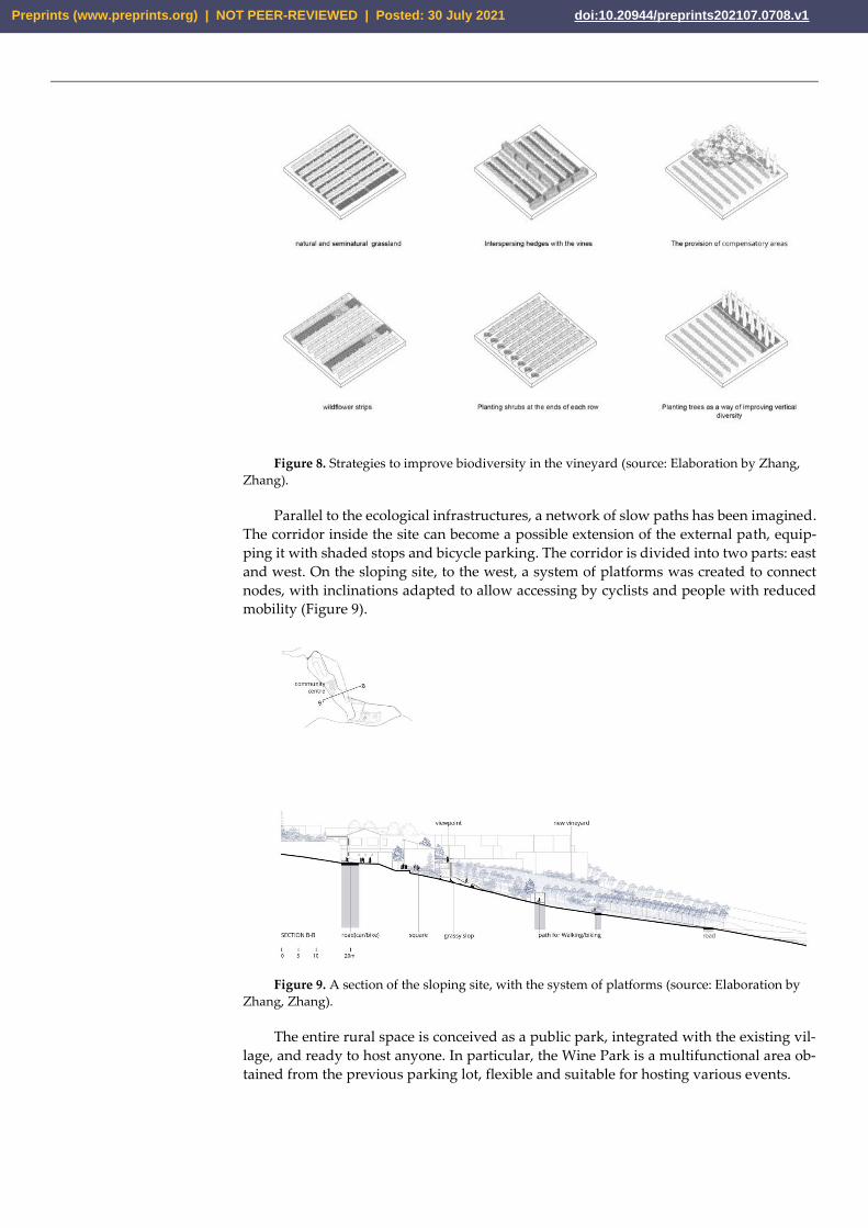
Figure 8. Strategies to improve biodiversity in the vineyard (source: Elaboration by Zhang,
Zhang).
Parallel to the ecological infrastructures, a network of slow paths has been imagined.
The corridor inside the site can become a possible extension of the external path, equip-
ping it with shaded stops and bicycle parking. The corridor is divided into two parts: east
and west. On the sloping site, to the west, a system of platforms was created to connect
nodes, with inclinations adapted to allow accessing by cyclists and people with reduced
mobility (Figure 9).
Figure 9. A section of the sloping site, with the system of platforms (source: Elaboration by
Zhang, Zhang).
The entire rural space is conceived as a public park, integrated with the existing vil-
lage, and ready to host anyone. In particular, the Wine Park is a multifunctional area ob-
tained from the previous parking lot, flexible and suitable for hosting various events.
Preprints (www.preprints.org) | NOT PEER-REVIEWED | Posted: 30 July 2021 doi:10.20944/preprints202107.0708.v1
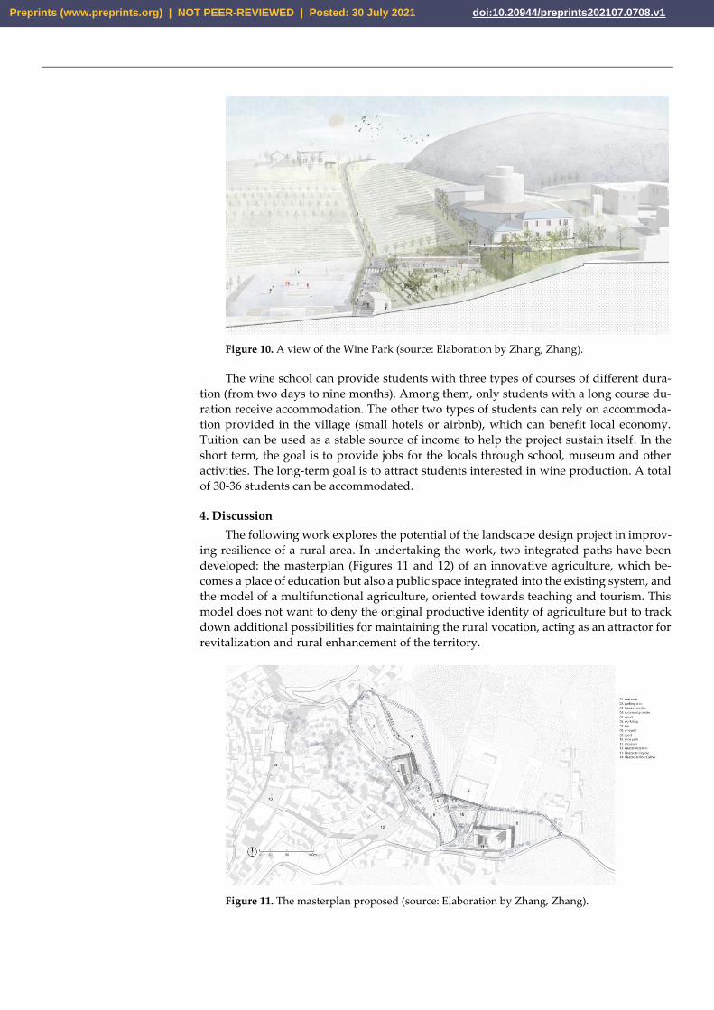
Figure 10. A view of the Wine Park (source: Elaboration by Zhang, Zhang).
The wine school can provide students with three types of courses of different dura-
tion (from two days to nine months). Among them, only students with a long course du-
ration receive accommodation. The other two types of students can rely on accommoda-
tion provided in the village (small hotels or airbnb), which can benefit local economy.
Tuition can be used as a stable source of income to help the project sustain itself. In the
short term, the goal is to provide jobs for the locals through school, museum and other
activities. The long-term goal is to attract students interested in wine production. A total
of 30-36 students can be accommodated.
4. Discussion
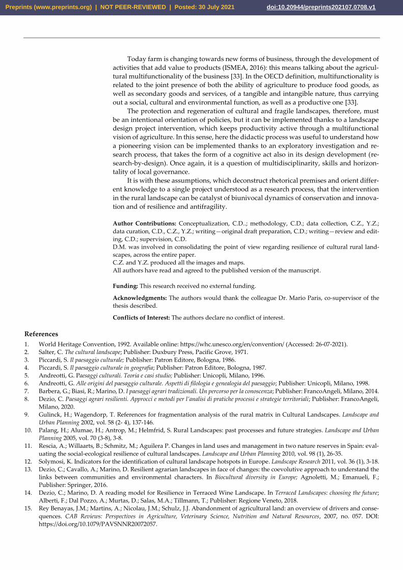
The following work explores the potential of the landscape design project in improv-
ing resilience of a rural area. In undertaking the work, two integrated paths have been
developed: the masterplan (Figures 11 and 12) of an innovative agriculture, which be-
comes a place of education but also a public space integrated into the existing system, and
the model of a multifunctional agriculture, oriented towards teaching and tourism. This
model does not want to deny the original productive identity of agriculture but to track
down additional possibilities for maintaining the rural vocation, acting as an attractor for
revitalization and rural enhancement of the territory.
Figure 11. The masterplan proposed (source: Elaboration by Zhang, Zhang).
Preprints (www.preprints.org) | NOT PEER-REVIEWED | Posted: 30 July 2021 doi:10.20944/preprints202107.0708.v1
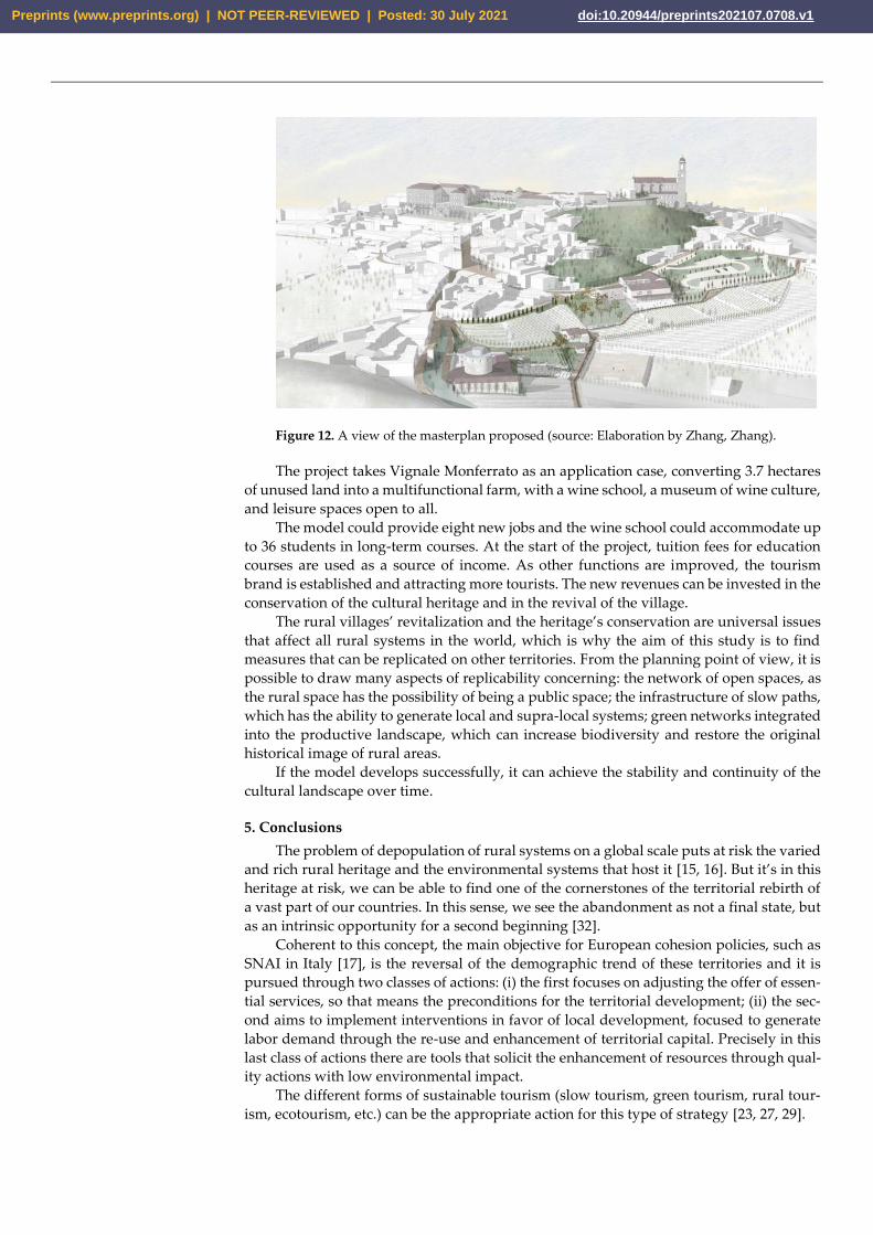
Figure 12. A view of the masterplan proposed (source: Elaboration by Zhang, Zhang).
The project takes Vignale Monferrato as an application case, converting 3.7 hectares
of unused land into a multifunctional farm, with a wine school, a museum of wine culture,
and leisure spaces open to all.
The model could provide eight new jobs and the wine school could accommodate up
to 36 students in long-term courses. At the start of the project, tuition fees for education
courses are used as a source of income. As other functions are improved, the tourism
brand is established and attracting more tourists. The new revenues can be invested in the
conservation of the cultural heritage and in the revival of the village.
The rural villages’ revitalization and the heritage’s conservation are universal issues
that affect all rural systems in the world, which is why the aim of this study is to find
measures that can be replicated on other territories. From the planning point of view, it is
possible to draw many aspects of replicability concerning: the network of open spaces, as
the rural space has the possibility of being a public space; the infrastructure of slow paths,
which has the ability to generate local and supra-local systems; green networks integrated
into the productive landscape, which can increase biodiversity and restore the original
historical image of rural areas.
If the model develops successfully, it can achieve the stability and continuity of the
cultural landscape over time.
5. Conclusions
The problem of depopulation of rural systems on a global scale puts at risk the varied
and rich rural heritage and the environmental systems that host it [15, 16]. But it’s in this
heritage at risk, we can be able to find one of the cornerstones of the territorial rebirth of
a vast part of our countries. In this sense, we see the abandonment as not a final state, but
as an intrinsic opportunity for a second beginning [32].
Coherent to this concept, the main objective for European cohesion policies, such as
SNAI in Italy [17], is the reversal of the demographic trend of these territories and it is
pursued through two classes of actions: (i) the first focuses on adjusting the offer of essen-
tial services, so that means the preconditions for the territorial development; (ii) the sec-
ond aims to implement interventions in favor of local development, focused to generate
labor demand through the re-use and enhancement of territorial capital. Precisely in this
last class of actions there are tools that solicit the enhancement of resources through qual-
ity actions with low environmental impact.
The different forms of sustainable tourism (slow tourism, green tourism, rural tour-
ism, ecotourism, etc.) can be the appropriate action for this type of strategy [23, 27, 29].
Preprints (www.preprints.org) | NOT PEER-REVIEWED | Posted: 30 July 2021 doi:10.20944/preprints202107.0708.v1
Today farm is changing towards new forms of business, through the development of
activities that add value to products (ISMEA, 2016): this means talking about the agricul-
tural multifunctionality of the business [33]. In the OECD definition, multifunctionality is
related to the joint presence of both the ability of agriculture to produce food goods, as
well as secondary goods and services, of a tangible and intangible nature, thus carrying
out a social, cultural and environmental function, as well as a productive one [33].
The protection and regeneration of cultural and fragile landscapes, therefore, must
be an intentional orientation of policies, but it can be implemented thanks to a landscape
design project intervention, which keeps productivity active through a multifunctional
vision of agriculture. In this sense, here the didactic process was useful to understand how
a pioneering vision can be implemented thanks to an exploratory investigation and re-
search process, that takes the form of a cognitive act also in its design development (re-
search-by-design). Once again, it is a question of multidisciplinarity, skills and horizon-
tality of local governance.
It is with these assumptions, which deconstruct rhetorical premises and orient differ-
ent knowledge to a single project understood as a research process, that the intervention
in the rural landscape can be catalyst of biunivocal dynamics of conservation and innova-
tion and of resilience and antifragility.
Author Contributions: Conceptualization, C.D..; methodology, C.D.; data collection, C.Z., Y.Z.;
data curation, C.D., C.Z., Y.Z.; writing—original draft preparation, C.D.; writing—review and edit-
ing, C.D.; supervision, C.D.
D.M. was involved in consolidating the point of view regarding resilience of cultural rural land-
scapes, across the entire paper.
C.Z. and Y.Z. produced all the images and maps.
All authors have read and agreed to the published version of the manuscript.
Funding: This research received no external funding.
Acknowledgments: The authors would thank the colleague Dr. Mario Paris, co-supervisor of the
thesis described.
Conflicts of Interest: The authors declare no conflict of interest.
References
1. World Heritage Convention, 1992. Available online: https://whc.unesco.org/en/convention/ (Accessed: 26-07-2021).
2. Salter, C. The cultural landscape; Publisher: Duxbury Press, Pacific Grove, 1971.
3. Piccardi, S. Il paesaggio culturale; Publisher: Patron Editore, Bologna, 1986.
4. Piccardi, S. Il paesaggio culturale in geografia; Publisher: Patron Editore, Bologna, 1987.
5. Andreotti, G. Paesaggi culturali. Teoria e casi studio; Publisher: Unicopli, Milano, 1996.
6. Andreotti, G. Alle origini del paesaggio culturale. Aspetti di filologia e genealogia del paesaggio; Publisher: Unicopli, Milano, 1998.
7. Barbera, G.; Biasi, R.; Marino, D. I paesaggi agrari tradizionali. Un percorso per la conoscenza; Publisher: FrancoAngeli, Milano, 2014.
8. Dezio, C. Paesaggi agrari resilienti. Approcci e metodi per l’analisi di pratiche processi e strategie territoriali; Publisher: FrancoAngeli,
Milano, 2020.
9. Gulinck, H.; Wagendorp, T. References for fragmentation analysis of the rural matrix in Cultural Landscapes. Landscape and
Urban Planning 2002, vol. 58 (2- 4), 137-146.
10. Palang, H.; Alumae, H.; Antrop, M.; Helmfrid, S. Rural Landscapes: past processes and future strategies. Landscape and Urban
Planning 2005, vol. 70 (3-8), 3-8.
11. Rescia, A.; Willaarts, B.; Schmitz, M.; Aguilera P. Changes in land uses and management in two nature reserves in Spain: eval-
uating the social-ecological resilience of cultural landscapes. Landscape and Urban Planning 2010, vol. 98 (1), 26-35.
12. Solymosi, K. Indicators for the identification of cultural landscape hotspots in Europe. Landscape Research 2011, vol. 36 (1), 3-18.
13. Dezio, C.; Cavallo, A.; Marino, D. Resilient agrarian landscapes in face of changes: the coevolutive approach to understand the
links between communities and environmental characters. In Biocultural diversity in Europe; Agnoletti, M.; Emanueli, F.;
Publisher: Springer, 2016.
14. Dezio, C.; Marino, D. A reading model for Resilience in Terraced Wine Landscape. In Terraced Landscapes: choosing the future;
Alberti, F.; Dal Pozzo, A.; Murtas, D.; Salas, M.A.; Tillmann, T.; Publisher: Regione Veneto, 2018.
15. Rey Benayas, J.M.; Martins, A.; Nicolau, J.M.; Schulz, J.J. Abandonment of agricultural land: an overview of drivers and conse-
quences. CAB Reviews: Perspectives in Agriculture, Veterinary Science, Nutrition and Natural Resources, 2007, no. 057. DOI:
https://doi.org/10.1079/PAVSNNR20072057.
Preprints (www.preprints.org) | NOT PEER-REVIEWED | Posted: 30 July 2021 doi:10.20944/preprints202107.0708.v1
16. De Rossi, A. Riabitare l’Italia. Le aree interne tra abbandoni e riconquiste; Publisher: Donzelli Editore, Roma, 2018.
17. SNAI. Strategia Nazionale per le Aree Interne. Available online: http://www.programmazione
economica.gov.it/2019/05/23/strategia-nazionale-delle-aree-interne/. (Accessed on 14-12-2019).
18. Zhang, C; Zhang, Y. Design with Landscape. An experimental model towards a goal of resilience in Vignale Monferrato. Thesis
of master’s degree, Landscape Architecture Degree Course, Polythecnic of Milan, Italy. Discussed on July 23rd, 2021.
19. Waldheim, C. The landscape urbanism reader. Publisher: New York, Princeton Architectural Press, 2006.
20. Common Agricultural Policy. Available online: https://ec.europa.eu/info/food-farming-fisheries/key-policies/common-agricul-
tural-policy_en (Accessed 26-07-2021).
21. Langhe-Roero Monferrato UNESCO. Available online: https://whc.unesco.org/en/list/1390/ (Accessed: 26-07-2021).
22. ISTAT data. Available online: https://www.istat.it (Accessed: 26-07-2021)
23. Dezio, C. Agritourisms and slow lines: hybrid practices for a landscape design model to support agriculture of mountain re-
gions. The Vermont case reading from Italian perspective. Ciudades, 2021, vol. 24, 79-98.
24. VENTO project. Available online: http://www.cicloviavento.it (Accessed: 26-07-2021).
25. Pileri, P.; Giacomel, A.; Giudici, D. VENTO. La rivoluzione leggera a colpi di pedale e paesaggio; Publisher: Corraini Edizioni,
Mantova, 2015.
26. Agudelo Winther, E.; Overton, M.; Heron, C. The Farm Incubator Toolkit: Growing the Next Generation of Farmers. Developed by the
National Incubator Farm Training Initiative (NIFTI); Publisheer: The New Entry Sustainable Farming Project (New Entry), 2013.
Available online: https://nesfp.org/sites/default/files/uploads/nifti_toolkit_v2.pdf (Accessed: 16-07-2021).
27. Dezio, C. A bioregional reading of the rural landscapes of the Italian inner areas and the regerative potential of rural tourism.
The case study of the VENTO project. Ciudades, 2020, vol. 23, 46-69.
28. Pileri, P. Progettare la lentezza. Publisher: People, Busto Arsizio (VA), 2020.
29. Pileri, P.; Moscarelli, R. Cycling & Walking for Regional Development. How slowness regenerates marginal areas. Publisher: Springer,
2021.
30. Boller, E.F.; Hani, F.; Poehling, H.M. Ecological Infrastructures. Ideabook on Functional Biodiversity at the Farm Level. Publisher:
IOBCwprs Commission on Integrated Production Guidelines and Endorsement, 2004.
31. Stefanucci, S.; Graca, A.; Novello, V.; Belda, I.; Carlos, C.; Gautier, J. OIV COLLECTIVE EXPERTISE FUNCTIONAL BIODI-
VERSITY IN THE VINEYARD, 2018. Available online: https://www.oiv.int/public/ medias/6367/functional-biodiversity-in-the-
vineyard-oiv- expertise-docume.pdf (Accessed: 26-07-2021).
32. Dezio, C. Abandonment | Territorial Fragilities in Territorial Fragilities in Italy. Defining a Common Lexicon. Territorio, 2020,
vol. 91, 25-26.
33. OECD Multifunctionality. Towards an analytical framework. Publisher: OECD Publications Service, 2001.
Preprints (www.preprints.org) | NOT PEER-REVIEWED | Posted: 30 July 2021 doi:10.20944/preprints202107.0708.v1