article i general provisions…….………….………3 no. 68-1 (amended 2005) subdivision...
TRANSCRIPT

Table of Contents
Article I General Provisions…….………….………3
Section 1. Title for Citation…………………………..…………………………….……..………3 Section 2. Authority……………………………….……………….…….................................3 Section 3. Policy……………………………….…………………………..…………………………..3 Section 4. Purpose…………………………………………….………………………………………3 Section 5. Applicability………………………….…………………….…………………………….4 Section 6. Exempt Subdivisions…………………………………….……………………………4 Section 7. Compliance……………………………………………………………………………….4 Section 8. Subdivisions Crossing Jurisdictional Boundaries…..……………………..5 Section 9. Interpretation, Conflict, and Severability………………….......................5 Section 10. Modifications…………………………………………………….………………………6 Section 11. Enforcement, Violations, and Penalties………….……………………………6
Article II Definitions…………………..………….7 Article III Administrative Subdivisions……18
Section 1. Purpose…………………………………….………………………………………….18 Section 2. Applicability…………………………..….…….……………………………………………18 Section 3. General Requirements………….……….……………………………………………….19 Section 4. Lots……………………………………………………..……………………………………….19 Section 5. Streets and Access……………………………………..………................................19 Section 6. Water Supply…………………………..……………………..…................................19 Section 7. Sewage Disposal………………………….………………………………………………..20
Article IV Major Subdivisions……………….20
General Requirements………………………..………………………….….……20 Section 1. Lots……………………………………………………………………………………….………23 Table IV-1: Minimum Driveway Separation Distance………………………………...……….23 Section 2. Blocks…………………………………………………………….………………………..……23 Section 3. Streets…………………………………………………………….…………………………….24 Table IV-2: Minimum Right of Way & Pavement Widths……….…..............................25 Table IV-3: Minimum Design Standards…………………………………………………………….25 Table IV-4: Vehicle Sight Distances…………………………………………………………………..26 Section 4. Curbs and Gutters………………………….……………………………………………….26 Section 5 Easements……………………….…………………………………………………………….26 Section 6 Intersections……………………..…………………………………………....................27 Table IV-5: Minimum Intersection Design Standards…………..…………......................27

Article V Greenway Subdivisions ................. 44
Purpose ....................................................................................................................... 44 Section 1. Submission Requirements ........................................................................ 44 Section 2. Criteria ..................................................................................................... 45
Article VI Review and Approval Procedures.. 47
General .....................................................................................................47 Section 1. Plat Committee .......................................................................................... 47 Section 2. Applications ............................................................................................. 47 Section 3. Validity of Approval ................................................................................. 48 Table VI-1: Validity of Approval ............................................................................... 48 Section 4. Development Agreements, Financial Guarantees ................................... 49 Section 5. Inspection ................................................................................................. 50 Section 6. Fees .......................................................................................................... 50
Article VII Remedies .............................................................................. 51
Section 1. Right of Entry ........................................................................................... 51 Section 2. Stop Orders .............................................................................................. 51
Appendices........................................................... 52
Appendix A - Street Classifications for IDOT .......................................................... 52 Appendix B - Typical Street Cross Sections and Intersection Design …….………..... 54 Appendix C - Certificates and Notations .................................................................. 58 Appendix D - Required Covenants ........................................................................... 62 Appendix E - Traffic Impact Format ........................................................................ 64

ORDINANCE NO. 68-1 (Amended 2005) SUBDIVISION CONTROL ORDINANCE
Article I General Provisions
Section 1. Title for Citation.
This title shall be known and may be cited as the "Subdivision Control Ordinance of Floyd County, Indiana."
Section 2. Authority.
A. This title is adopted pursuant to Indiana Code, 36-7-4, the 700 Series, A Subdivision Control, and all amendments thereto. The Plan Commission of Floyd County is vested under this statute with the authority to approve, approve with conditions, or disapprove subdivision of land. The Commission may grant modifications to these regulations pursuant to the provisions of Section 10.
B. Regulation of the subdivision of land and the attachment of reasonable conditions to land subdivision is an exercise of valid police power delegated by the State of Indiana to Floyd County. The developer has the duty of compliance with reasonable conditions laid down by the Plan Commission for design, dedication, improvement, and use of the land to conform to the physical and economic development of the County and to the health, safety, and general welfare of the future lot owners in the subdivision and the community at large.
Section 3. Policy
A. It is declared to be the policy of Floyd County to consider the subdivision of land and subsequent development of the land as subject to control of the County pursuant to the Comprehensive Plan, this Ordinance, and the Floyd County Zoning Ordinance for the orderly, planned, efficient, and economical development of the County.
B. Land to be subdivided shall be of such character that it can be used safely for building purposes without danger to health or peril from fire, flood, or other menace, and land shall not be subdivided until infrastructure and services that meet standards described herein exist or are guaranteed in accordance with Article VI, Section 4, and proper provision has been made for drainage, water, sewage, and streets.
C. All proposed improvements shall conform with and be properly related to the Comprehensive Plan and the standards contained in other applicable ordinances and regulations.
Section 4. Purpose
This Ordinance is adopted for the following purposes:
A. To promote the public health, safety and general welfare;
B. To guide the future growth and development of the County in accordance with the Comprehensive Plan and any future Zoning map;
C. To ensure that necessary facilities are available concurrent with development, in an

amount and size commensurate with the size of the subdivision and the land uses to which the land will be allocated;
D. To ensure that the developer will bear the cost of providing adequate facilities and services by requiring the developer to pay appropriate fees, furnish necessary land, provide infrastructure, and by establishing mitigation measures to ensure that the development provides its fair share of capital facilities needs generated by the development;
E. To provide pedestrian and vehicular connectivity among subdivisions; F. To secure suitable sites for building purposes and protect the property values
thereof; G. To provide assurance that future plats, subdivisions and dedications will be
approved in accordance with established public policy; H. To provide for open spaces through the most efficient design and layout of the
subdivision; I. To preserve the natural beauty and topography of the County and to ensure
appropriate development with regard to these features; J. To ensure minimal impact of new residential subdivisions on adjacent agricultural
property; K. To prevent the pollution of air, land, and water, safeguard surface and groundwater,
conserve and stabilize topsoil, and to otherwise encourage the wise use of resources throughout the County;
L. To supply proper land records for the convenience of the public and for appropriate identification and permanent location of real estate boundaries.
Section 5. Applicability
This title shall apply to all land within the jurisdiction of the Floyd County Plan Commission. All applications for subdivision approval that were not scheduled for public hearing before the effective date of this Ordinance shall be reviewed under this Ordinance. Any Commission approval of a preliminary plat granted before the effective date of this Ordinance shall remain valid, provided that the developer applies for final plat approval within 6 months after such effective date. A two (2) year extension per phase shall be permitted for multiphase subdivisions, if so designated and approved as a multiphase subdivision on the original preliminary plat. Requests for extensions shall be submitted to the Commission for consideration. Any Commission approval of a final plat granted before the effective date of this Ordinance shall remain valid, provided that the final plat is recorded in the Office of the County Recorder within 1 year after such effective date.
Section 6. Exempt Subdivisions
Those divisions of land meeting the definition of exempt subdivisions are not subject to review and approval by the Commission or Plat Committee.
Section 7. Compliance
A. No lot within a proposed subdivision shall be advertised for sale until one of the following has taken place: 1) For an administrative subdivision, the plat committee has granted primary
approval; 2) For a major subdivision, the Commission has granted primary approval.
B. No lot shall be sold and no permit to erect any building upon land in a subdivision shall be issued; unless and until the subdivision has received secondary approval and plat recorded.

C. For subdivisions recorded after a financial guarantee is posted for the improvements, no occupancy permit shall be issued for any building unless the following improvements are in place:
1) Streets having a compacted subgrade and a binder course; and 2) Traffic control signs and street signs.
D. Nothing in this ordinance shall abrogate or annul any other applicable federal or state statute or regulation or any applicable local ordinance or regulation. Applicable regulations include but are not limited to those promulgated by IDNR, IDEM, ISDH, and the Floyd County Health Department.
Section 8. Subdivisions and Lots Crossing Jurisdictional Boundaries
Lots that straddle jurisdictional boundaries shall be avoided wherever possible. If a subdivision is located in more than one jurisdiction, approval is required from each plan commission having jurisdiction, unless a valid interlocal agreement provides otherwise. Under no circumstances shall an individual lot be located in more than one taxing district. Section 9. Interpretation, Conflict, and Severability
A. This Ordinance shall be construed broadly to promote the purposes for which it is adopted.
B. Except as provided in Section 10 and Article V, the rules and standards contained in this Ordinance shall be held to be the minimum requirements for the promotion of the public health, safety, and general welfare.
C. Any publication referred to in this Ordinance shall mean the most recent edition of such publication. Any statute or ordinance shall mean the most recently adopted or amended version of such statute or ordinance. D. The staff of the Floyd County Planning Department is hereby authorized to interpret the various provisions of this Ordinance. Any interpretation by the staff may be appealed to the Plan Commission. Such appeal shall be filed within 30 calendar days after the staff decision and shall be placed on the Commission=s agenda for consideration at the earliest possible regular or special meeting of the Commission.
E. The regulations contained in this Ordinance are not intended to interfere with, abrogate, or annul any other ordinance, rule or regulation, statute, or other provision of law except as provided in this Ordinance. Where any provision of this Ordinance imposes restrictions or standards different from those imposed by any other provision of law, the provision that is more restrictive or imposes higher standards shall control.
F. The regulations contained in this Ordinance are not intended to abrogate any easement, covenant, or any other private agreement or restriction, provided that where the provisions of this Ordinance are more restrictive or impose a higher standard than such easement, covenant, or other private agreement or restriction, the provisions of this Ordinance shall govern.
G. If any part or provision of this Ordinance or the application of any provision herein to any person or circumstances is adjudged invalid by any court of competent jurisdiction, the judgment shall be confined in its operation to the part, provision, or
application directly involved in the matter in which the judgment is rendered, and it shall not affect or impair the validity of the remainder of these regulations or to the application of them to other persons or circumstances.
H. This Ordinance shall not be construed as abating any action now pending under or by virtue of a prior Subdivision Control Ordinance or as discontinuing, abating, modifying, or altering any penalty accruing or about to accrue, or as affecting the liability of any person, firm, or corporation, or as waiving any right of the County under any section or provision in effect at the time of adoption of this Ordinance, or as vacating or annulling any rights obtained by any person, firm, or corporation by lawful action of the County except as shall be expressly provided in this Ordinance.
I. Upon the adoption of this Ordinance in accordance with Indiana law, any previous Subdivision Control Ordinance is hereby repealed.
Section 10. Modifications
Notwithstanding Section 9, the Commission may grant such modifications to the requirements and standards of this Ordinance as will not be contrary to the public interest or inconsistent with Sections 3 and 4 hereof, but only, where owing to extraordinary conditions, fully demonstrated by the applicant on the basis of facts presented, strict compliance with the provisions of this Ordinance will result in practical difficulties or misuse of property. It is the intent of this Ordinance that this authority will be used sparingly and only when the applicant has clearly demonstrated that all criteria in Subsection A are met. The burden of proof is on the applicant.
A. In the exercise of its authority under this section, the Commission shall grant
modifications only upon finding that all of the following criteria are met:
1) The modification will not be detrimental to the public health, safety, or general welfare; 2) The modification will not adversely affect adjacent property; 3) The modification is justified because of exceptional topographic or other physical conditions unique to the property involved and is not to correct mere inconvenience or financial disadvantage; 4) The conditions upon which the modification request is based are unique to the property for which the relief is sought and are not applicable generally to other property; 5) The modification is consistent with the intent and purposes of this ordinance and with the Comprehensive Plan 6) The condition necessitating the modification was not created by the owner or applicant; 7) The relief sought will not in any manner vary the provisions of the Zoning Ordinance.
B. In granting modifications, the Commission may require such conditions as will, in
its judgment, secure substantially the purposes of this Ordinance.
C. A request for a modification from the terms of this Ordinance shall be submitted in writing at the time when the subdivision is filed with the Commission for consideration for primary approval or within 30 days after discovery of a need for modification under this section. The request shall state fully the grounds for the application and all facts relied upon by the applicant.

Section 11. Enforcement, Violations, and Penalties
A. Any structure erected, raised or converted, or land or premises used in violation of the provisions of IC 36-7-4 et seq., or this Ordinance is declared to be a common nuisance, and the owner or possessor of the structure, land or premises is liable for maintaining a common nuisance, all as provided and permitted by the provisions of IC 36-7-4-1012, provided, this declaration shall not apply to such structures, land or premises first erected or used prior to the effective date of this Ordinance if such erection or use was consistent with those statutes and/or ordinances then in effect and pertaining to same.
B. The Commission or any enforcement official designated by its rules or this Ordinance may bring an action in the Floyd Circuit or Superior Court to invoke any legal, equitable, or special remedy for the enforcement of this Ordinance; any conditions imposed hereunder; any covenant or restriction made in connection with a subdivision if the Commission is given express enforcement authority with respect to such restriction or covenant; or any contract, agreement, or restriction or commitment made under or pursuant to this Ordinance, all as permitted by the provisions of IC 36-7-4-1014, or any other applicable statute, rule, or regulation.
C. The Commission or any person permitted under its rules or this Ordinance may bring an action in the Floyd Circuit or Superior Court to enforce any commitment made by any person under or pursuant to the terms of this Ordinance, and in such action may request mandatory or prohibitory injunctive relief through the granting of a temporary restraining order, preliminary injunction, or permanent injunction, all as permitted and allowed by the provisions of IC 36-7-4-1015 or any other applicable statute, rule, or regulation.
D Enforcement of this Ordinance as against a person violating the terms and provisions of same may be by an action brought in accordance with the provisions of IC 34-28-5 et seq. Such an action to enforce this Ordinance shall be brought in the name of the Floyd County Plan Commission, and upon proof by a preponderance of the evidence of a violation hereof, judgment shall be entered against the defendant for a sum of not less than $500 for each violation. Any person, owner or agency who sells or purports to sell land constituting a subdivision without a recorded plat shall be fined not less than $100.00 nor more than $500.00 for each lot or parcel which was the subject of the sale of transfer or contract for sale or transfer. A separated violation of this Ordinance shall be deemed to occur for each day that a person shall be in violation of the terms and provisions hereof. No action under this paragraph shall be commenced, however, with respect to a violation for which an appeal is pending under Section 3 of Article VI hereof.
E To the extent permitted by law and this Ordinance, an action under Paragraph D of this Section may be joined with an action under either Paragraph B and/or C, and to any judgment in favor of the Floyd County Plan Commission shall be added costs of the action, reasonable attorney fees, and expenses incurred by the Department in the enforcement of this Ordinance.
F. In all actions under this Article, the Floyd County Plan Commission shall be represented by the attorney retained by the Commission pursuant to the provisions of IC 36-7-4-311, or otherwise designated by the Commission from time to time.

Article II Definitions
For the purpose of this Ordinance certain terms or words used herein shall be interpreted or defined as follows, unless the context clearly indicates to the contrary: words used in the present tense include the future tense; words used in the plural include the singular. The term "shall" is always mandatory. Definitions contained in the Zoning Ordinance also apply to this Ordinance, except for those terms defined differently in this Ordinance.
AASHTO means the American Association of State Highway and Transportation Officials
Access easement means a private way meeting the standards of this Ordinance that provides access to lots, tracts or parcels of land.
Adjacent property owners means the owners of property contiguous to the subject property, excluding those who are also the owners of the subject property, ignoring all intervening streams, street and railroad rights-of-way.
Administrative subdivision means a division of land, not requiring the opening of a new public right-of-way and which complies in all other respects with Article III of this subdivision control ordinance and the zoning ordinance of the County.
Agriculture means the production, keeping, cultivation, or maintenance, for sale, lease, or personal use, of plants and animals useful to man, including but not limited to forages and sod crops; grains and seed crops; dairy animals and dairy products, poultry and poultry products; livestock, including beef cattle, sheep, swine, horses, ponies, mules, or goats or any mutations or hybrids thereof, including the breeding and grazing of any or all of such animals; bees and apiary products; fur animals; llamas, chinchilla, ostrich and other specialty animals; fish for commercial sale (aquaculture); trees and forest products; fruits of all kinds; vegetables; nursery, floral, ornamental, and greenhouse products; or lands devoted to a soil conservation or forestry management program. Applicant means the owner or authorized representative thereof of land proposed for subdivision.
As-built plans means a drawing or drawings accurately indicating the location and design details of all improvements installed in relation to the subdivision.
Block means property abutting on one side of a street, and lying between the two nearest intersecting or intercepting streets, or between the nearest intersection of an intercepting street and railroad right-of-way, waterway or other definite barrier. For purposes of this definition, a cul-de-sac less than 100 feet in length does not constitute an intersecting or intercepting street.
Buffer means a natural growth or landscaped area, fence, wall, berm, or combination thereof used to physically separate or screen one use or property from another so as to visually shield or block noise, lights, or other nuisance.
Building setback line means the line nearest the front of and across a lot establishing the minimum open space to be provided between the front line of buildings or structures requiring permits under the building code and the street right-of-way line.
Building site means the three-dimensional space within which a structure is permitted to be built on a lot and is defined by maximum height regulations, and minimum yard setbacks.
Building site, suitable means a site properly related to topography and other natural or man-made features that does not contain wetlands, floodway areas, soils with severe limitations for foundations, environmental hazards, or other similar conditions that are adverse to construction

and is large enough to accommodate the principal structure, any on-site sewage disposal system with space for two lateral fields, and customary accessory structures such as garages, decks, and patios.
California Bearing Ratio (CBR) means the ratio of force per unit area required to penetrate a soil mass with standard circular piston at the rate of 1.25 mm/min. to that required for the corresponding penetration of a standard material.
Cluster septic treatment system means a waste disposal system serving more than one lot in which solids and grease are removed in one or more septic tanks and the effluent discharged to a common drainage field. Commercial or industrial subdivision means a subdivision of land involving land that is zoned or intended to be used for commercial or industrial purposes.
Commercial use means an activity involving the sale of goods or services carried out for profit.
Commission means the Floyd County Plan Commission.
Common facilities means land and/or improvements that are owned by and/or intended to be used by all property owners and residents in a subdivision.
Community Sewer System means a package wastewater treatment plant or a cluster septic treatment system.
Comprehensive Plan means the complete plan or any of its parts adopted in accordance with the 500 Series of the Indiana Code as is now or may hereafter be in effect.
Conventional subdivision means a subdivision in which all the land is divided into house lots and streets, with the only open space being undevelopable land such as wetlands, steep slopes, floodplains and stormwater management areas. Such subdivisions are laid out according to design principles that include but are not limited to blocks accommodating two tiers of lots, curvilinear or grid streets, and little or no common or public open space.
Construction plans means any maps or drawing accompanying a subdivision plat showing the location and design details of improvements to be installed for the subdivision in accordance with the requirements of this Ordinance.
Contiguous means when at least one boundary line of a parcel touches the boundary line of another parcel.
CONTROL POINT (TRAFFIC) means any traffic signal/sign by which traffic is alternately directed to stop and permitted to proceed.
County Commissioners means the Board of County Commissioners of Floyd County, Indiana.
County engineer means the Floyd County highway engineer.
County Health Department means the Floyd County Health Department.
County surveyor means the Floyd County surveyor.
Covenant means a restriction or affirmative obligation placed on the development or use of land through a written, recorded instrument.
Department means the Floyd County Planning Department.
Developer means any individual firm, association syndicate, partnership, corporation, trust or

any other legal entity commencing proceedings under these regulations to effect a subdivision of land, and includes any person who (1) having an interest in land, causes it, directly or indirectly, to be subdivided as defined herein, or (2) directly or indirectly, sells, leases or develops or offers to sell, lease or develop, or advertises to sell, lease, or develop, any interest, lot, parcel, site, or unit in a subdivision, or (3) engages directly or through an agent in the business of selling, leasing, developing, or offering for sale, lease, or development a subdivision or any interest, lot, parcel, site, or unit in a subdivision, or (4) is directly or indirectly controlled by or under direct or indirect common control with any of the foregoing.
Development agreement means a document that establishes the contractual relationship between the developer of a subdivision and the County for the installation of improvements in accordance with the standards and specifications set forth in this Ordinance.
Drainage report means a comprehensive analysis of the drainage, flood control and erosion control constraints on and impacts resulting from a proposed development. Such report shall include, in graphical format, a detailed grading plan addressing onsite and offsite drainage control, flood control and erosion control issues.
Drainage swale means a natural or constructed waterway, usually broad and shallow, covered with erosion-resistant grasses, used to conduct surface water from a field, diversion or other site feature.
Drainage system means the surface and subsurface system for the removal of water from the land, including both the natural elements of streams, marshes, swales and ponds, whether of an intermittent or continuous nature, and the man made element which includes culverts, ditches, channels, retention facilities, detention facilities, gutters, streets, and storm sewer systems. The drainage system includes any combination of surface and/or subsurface drainage components fulfilling the drainage requirements of this title.
Easement means a grant by the property owner of the use of part of the owner=s land by another for a specified purpose. Easement, conservation or open space means a legal agreement to restrict the type and amount of development that may take place on property. The easement spells out the rights the landowner retains and the restrictions on use of property.
Environmental audit, Phase I means an initial environmental investigation that is limited to a historical records search to determine ownership of a site and to identify the kinds of chemical processes that were carried out on the site. A Phase I audit includes a site visit, but it does not include any sampling.
Environmental audit, Phase II means an investigation that includes tests performed at the site to confirm the location and identity of environmental hazards. The audit includes preparation of a report that includes recommendations for cleanup alternatives.
Environmental hazard means a condition capable of posing an unreasonable risk to air, water, or soil quality, and to plants or wildlife.
Erosion means the wearing away of the land surface by the action of wind, water or gravity.
Erosion control plan means a plan which includes erosion control measures such as staked hay bales or silt fences, that will prevent damage to or siltation of adjacent property, street surfaces, or water bodies. These measures shall be in accordance with standards set forth by IDNR.
Exempt subdivision means and includes one or more of the following:

1.) A resubdivision of land or amendment of a recorded plat which does not result in the creation of additional lots with suitable building sites, but which (a) involves only the removal of interior lot lines, with the outside perimeter of the property remaining unchanged, or (b) A resubdivision which involves only the changing of notations written on the plat or correction of errors thereon or (c) involves the correction of any errors in an existing legal description or (d) which involves any combination of the foregoing;
2.) A division of land resulting from the order of any court having jurisdiction and entered in an action for the settlement of an estate, partition, condemnation, or similar proceeding.
3.) The division of land into cemetery plots; 4.) The division of land by sale, exchange, or otherwise, if the land transferred is for use by the public or for public utility purposes. 5.) The division of land by sale, exchange, or otherwise between adjoining property owners, but only if the land, transferred will not be used as an additional building site.
6.) The separation of a dwelling, which is at least three years old, together with its suitable building site, from a parent tract devoted to agricultural use, but only if the separate lot or tract meets the minimum requirements of the zoning ordinance.
7.) The creation, grant, or reservation of a right of way or easement. 8.) The term subdivision does not include transfers between family members
(parents, children, or siblings) so long as the parent tract is not divided into more than five (5) lots.
Floodway means that area shown on the Floyd County Flood Boundary and Floodway Maps of current adoption as meeting the definition of floodway promulgated by the Federal Emergency Management Agency and the Indiana Department of Natural Resources.
Floodway fringe means that area shown on the Floyd County Flood Boundary Maps of current adoption as meeting the definition of floodway fringe promulgated by the Federal Emergency Management Agency (FEMA) and the Indiana Department of Natural Resources. Flood hazard area means any floodplain, floodway, floodway fringe district or any combination thereof as illustrated on the flood boundary and floodway map prepared by the Federal Emergency Management Agency (FEMA). This is the area immediately affected by floodwater during a "one-hundred-year flood."
Floodplain means the floodway and the floodway fringe and any other areas indicated on the Flood Boundary maps as flood prone areas for which no data are available.
Flood protection grade means the following: For residential buildings, the elevation of the lowest floor of a building or structure. If a building contains a basement, the basement is considered the lowest floor.
1) For commercial and industrial buildings, the water surface elevation for which the building is protected according to standards and specifications established by the Federal Emergency Management Agency.
Geotechnical engineer means a civil engineer, licensed to practice in the State of Indiana, who by training, education and experience is competent in the practice of geotechnical or soils engineering practices.
Geotechnical report means the written study and analysis of the site of a proposed Major Subdivision prepared by a geotechnical engineer and focusing on the geotechnical conditions of

those areas to be developed. The report shall include the results of such hydrologic studies, laboratory tests, material samplings, test-hole borings and other information and data as shall be reasonably necessary to support each of the conclusions and recommendations of the author with respect to the following matters: (1) the location of significant rock deposits which may limit or restrict the proposed development and methods of mitigation, if any, (2) the presence of soil types, sink holes, springs, water tables, or other surface or subsurface conditions which might pose limitations on the proposed development, together with recommendations for mitigation, if any, and (3) if the application proposes the use of septic tanks, whether the conditions attendant to the location of proposed lots is suitable for septic tanks.
Grading means any stripping, cutting, filling, stockpiling or any combination thereof and shall include the land in its cut or filled condition.
Greenway subdivision means a subdivision with significant land set aside for open space or other amenities and designed to preserve significant features. These subdivisions include developments centered on a recreational feature such as a golf course or lake.
HCM means Highway Capacity Manual, 2000 edition.
Historical or Archeological significance means any site or artifact so defined by IC 14-21 and/or regulated by the IDNR Division of Historic Preservation and Archeology.
IDEM means the Indiana Department of Environmental Management.
IDNR means the Indiana Department of Natural Resources.
Improvement plans or drawings means the maps, drawings and text accompanying a subdivision plat and showing the specific location and design of improvements to be installed in the subdivision in accordance with the requirements of this chapter as a condition of the approval of the plat. (See Construction Plan.)
Industrial use means economic activity, not including sales of goods or services, such as manufacturing; transportation, communication, electric, gas and sanitary services; warehousing; wholesale trade; and any other uses designated in the Zoning Ordinance of Floyd County as industrial uses.
INDOT means Indiana Department of Transportation
ISDH means the Indiana State Department of Health. ITE means the Institute of Transportation Engineers.
LARGE SCALE DEVELOPMENT means a subdivision of land which creates more than 125 lots.
Landscape screen means any combination of fences, walls, hedges, shrubs, trees and other landscape materials which effectively provide a solid, dense and opaque mass, to prohibit view, absorb sound and provide site delineation. Such screen shall provide total opacity throughout the year.
Legal description means a property description recognized by law that defines boundaries by reference to government surveys, coordinate systems, or recorded maps and is sufficient to locate property with oral testimony.
Legal lot of record means a lot created in accordance with applicable regulations that is shown or described on a plat or deed in the Office of the County Recorder.
Level of service means a quantitative measure describing operational conditions within a traffic

stream, generally in terms of such service measures as speed and travel time, freedom to maneuver, traffic interruptions, and comfort and convenience. LOS categorizes quality of service into six levels: A through F. LOS A represents the best quality of service, that provided by a roadway or intersection at very low traffic volume when there is virtually no traffic congestion. LOS B through E represent increasingly congested, but undersaturated, conditions. LOS F represents oversaturated conditions, with traffic demands that exceed the capacity of the facility. In determining the level of service, the methods employed in the 2000 edition of the Highway Capacity Manual shall be utilized.
LEVEL OF SERVICE FOR SIGNALIZED INTERSECTIONS
Level of Service Average stopped delay per vehicle (secs)
Qualitative Description
A Less than 5.1 Good progression, few signs, and short cycle lengths
B 5.1-15.0 Good progression and/or short stop cycle lengths, more vehicle stops
C 15.1-25.0 Fair progression and/or short cycle lengths: more vehicle stops
D 25.1-40.0 Congestion becomes noticeable; high volume-to-capacity ratio, longer delays, noticeable cycle failures.
E 40.1-60.0 At or beyond limit of acceptable delay: poor progression, long cycles, high volumes, long queues.
F greater than 60.0 Unacceptable to drivers. Arrival volumes greater than discharge capacity: long cycle lengths, unstable-unpredictable flows.
Limited access R.O.W. means a right-of-way that has restrictions on access to and from the adjacent properties. Lot means a tract or parcel of land which, (1) meets the minimum requirements of the Floyd County Zoning Ordinance with respect to size, coverage, and area, (2) contains a suitable building site, and (3) except as may be permitted under Article III, has the required frontage on a dedicated, maintained county road.
Lot, double-frontage means a lot having frontage on two parallel streets or that fronts upon two streets that do not intersect at the boundaries of the lot.
Lot frontage means the linear distance of a lot measured at and along the front lot line where the lot abuts a street or other approved access.
Lot width means the distance between side lot lines as measured at and along the front setback line.
Manual on Uniform Traffic Control Devices means the book by that title prepared by the Joint Committee on Traffic Control Devices, U.S. Department of Commerce, Bureau of Public Roads, as amended.
Major subdivision means all subdivisions other than those subdivisions meeting the applicability

requirements set forth in Article III (Administrative Subdivisions) or the definition of Aexempt subdivision". Mulching means the application of plant or other suitable materials on the soil surface to conserve moisture, hold soil in place, and aid in establishing plant cover.
No access notation means a notation placed on a plat or subdivision drawing indicating an area in which property access to a public right-of-way is not permitted.
NRCS means the Natural Resources Conservation Service
Off-site means any premises or land not located within the area to be subdivided, whether or not such premises are in the same ownership as the property to be subdivided.
Open space means any parcel or area of land or water essentially unimproved and set aside, dedicated, designated, or reserved for public or private use or enjoyment.
Open space, common means land within or related to a development, not individually owned or dedicated for public use, that is designed and intended for the common use or enjoyment of the residents and their guests of the development and may include such complementary structures and improvements as are necessary and appropriate.
Oversized improvements means improvements in excess of those needed for the subdivision under review. These include but are not limited to increased pavement width, oversized culverts or drainage swales, and oversized retention ponds.
Owner (legal title) means the person(s) owning the fee interest in a lot, tract, or parcel as disclosed by the public records of Floyd County, Indiana.
Parent tract or property means a tract or parcel of land from which two or more lots, parcels, sites, units, plats, or interests for the purpose of transfer, sale, lease, or development, are created through subdivision.
Person includes an individual, corporation, firm, partnership, association, organization or any other unit or legal entity.
Petitioner means the owner(s) of land proposed to be subdivided or his/her representative.
Plat means a map indicating the subdivision or resubdivision of land, and intended to be recorded in the Floyd County recorder's plat books.
Plat committee means a committee appointed by the Commission to review major plats and act upon minor plats.
Plat, Final means a drawing prepared in accordance with the provisions of this ordinance, submitted for secondary approval and intended for recording.
Plat, Minor. See administrative subdivision.
Primary approval means approval granted by the Commission to a preliminary plat. The primary approval shall include all conditions needed to bring the plat into conformance with this ordinance.
Principal use means the primary or predominant use of any lot or parcel.
Project Site means a proposed subdivision and its infrastructure including roads, easements,

utility lines & conservation areas
Public Sewer -a sewage disposal service operated by a recognized governmental unit or political subdivision thereof within the State of Indiana. Recreation, Active means leisure-time activities, usually of a formal nature and often performed with others, such as basketball, softball, baseball, tennis, soccer. Active recreation requires equipment and takes place at prescribed places, sites, courts, or fields.
Recreation, Passive means activities that involve relatively inactive or less energetic activities, such as walking, sitting, picnicking, card games, chess, checkers, and similar table games.
Resubdivision or replat means any change in a recorded subdivision plat affecting any street layout, easement, area reserved for public use, lot line, or affecting any map or plan legally recorded prior to the adoption of any regulations controlling subdivision. A replat shall be considered a minor plat, provided, that no new streets or roads or utility extensions are required. If streets or utility extensions are required, then the plat shall be considered a major subdivision of land.
Sanitary sewer system means a system which processes sewage by transferring the effluent via a system of pipes to a central processing facility operating off the premises which created the effluent.
Secondary approval means the final approval granted to a subdivision by the Commission or a designated representative. This approval authorizes the owner or agent to record the plat.
Sewage disposal service means any public utility service performed by a sewage disposal company whereby liquid and solid waste, sewage, night soil, and industrial waste (hereinafter Sewage) of any single territorial area is collected, treated, purified, and disposed of in a sanitary manner.
Sewage disposal company means any natural person, firm, association, corporation, or partnership, owning, leasing, or operating any sewage disposal service within Floyd County, Indiana, pursuant to a CTA issued by the Indiana Utility Regulatory Commission
Steep slope means a pre-development grade which exceeds 20% as measured from the building line on one side of the proposed street to the building line on the opposite side, and/or exceeds 33% beyond the building lines.
Street means a right-of-way dedicated or otherwise legally established for public use, which affords the principal means of access to abutting property. A street may be designated as a highway, thoroughfare, parkway, boulevard, road, avenue, lane, drive or other appropriate name. A street may also be classified according to function as follows:
1) Freeways/expressways are limited-access highways which carry large volumes of traffic and have more importance regionally than locally. They often contain four or more moving lanes and permit a continuous high-speed traffic flow. These highways have a high order of design and construction requirements.
2) Arterials are high capacity/high volume thoroughfares. They provide access to and through the County. The main function of these roads is mobility, not access to property. Three different types of arterials are classified for the purposes of this title. They are: major arterials, minor arterials and one-way arterials.
3) Collector roads function as a collection and distribution system. These medium-volume and capacity roads collect and distribute traffic to and from streets of lower classification to arterial roads and/or activity centers. Mobility has a

much higher priority than access to property on these roads. Collector roads may be characterized based upon amount of traffic as major or minor.
4) Local roads are medium-volume roads that form the majority of the county road network. Often they are part of the numbered street system and are typically longer than subdivision streets. While in some cases these streets may provide direct access to property, their primary function is traffic movement.
5) Subdivision streets are low capacity and low speed roads whose function is to provide access to homes and property. Through traffic and heavy use of these roads should be discouraged. To the extent possible, residential driveways and ingress and egress points to other uses or structures should be oriented to the local roads rather than to arterials or collectors.
6) Marginal access streets are local roads that are parallel to, and separated by a limited access landscape buffer strip from arterial streets and highways. These roads provide for access to abutting property on one side only.
7) Cul-de-sac street is a local road or subdivision street with only one outlet, having a paved, circular turn-around area at the closed end.
8) Alley is a minor way that is used primarily for vehicular service access to the back or side of properties otherwise abutting on a street.
Street, dead-end means any street with only one outlet but having no paved turn-around at the closed end.
Structure, principal means a building in which is conducted the principal use of the lot on which it is located.
Structure, accessory means a subordinate structure on the same lot as the principal building or use
Subdivision means the division of a parcel of land into two or more lots, parcels, sites, units, plats or interests for the purpose of offer, sale, lease, or development. It may also include resubdivision.
Subdivision, greenway. See Greenway subdivision.
Subdivision, major. See Major subdivision.
Subdivision, minor. See Administrative subdivision.
Subdivision road means a road which is a part of an approved subdivision plat and which does not generally serve as a public thoroughway for non-residents of the subdivision.
Subsurface drainage means a system of pipes, tile, conduit or tubing installed beneath the ground surface used to collect ground water from individual parcels, lots or building footings.
Surface drainage means a system by which the stormwater runoff is conducted to an outlet. This would include the proper grading of parking lots, streets, driveways, yards, etc., so that the stormwater runoff is removed without ponding and flows to a drainage swale, open ditch or a storm sewer.
Technical review committee means a committee established by the Commission to assist with the technical evaluation of subdivisions and to make appropriate technical recommendations to the Commission, Plat Committee and Department.
Thoroughfare plan (official) means the part of the comprehensive plan, now or hereafter adopted which includes a major street and highway plan and sets the location, alignment, identification, and classification of existing and proposed public streets, highways and other thoroughfares.

Traffic Impact Study means a study prepared by a qualified traffic engineer evaluating the traffic impacts expected from a new development. The study shall include the following:
a. Within the study area a precise description of the existing transportation system, its capacity to meet anticipated demands, and a delineation of unique or special traffic flow issues. The study shall measure the average daily traffic volume during a business day as well as peak hour am and pm counts. Trip generation rates shall be based on the latest rate tables published by the Institute of Transportation Engineers (ITE).
b. The study shall include an estimate of the additional total daily and peak hour traffic to be reasonably expected from the proposed subdivision, as well as the assessment of the cumulative traffic impact (to include its distribution) which may be reasonably anticipated from other expected development within the study area. For purposes of this definition, the term expected development shall include those proposed commercial and industrial projects and other major residential subdivisions for which applications have been filed with or approved by those local planning authorities having jurisdiction as of the study date. In addition, the study will include a calculation of the Level of Service at the control points nearest the Subdivision. For purposes of this definition, the phrase nearest Control point(s) shall mean an intersection of the service roadway with another existing street (of local or higher classification), which is controlled by a stop sign or signal, and which is located within one-half mile of the point of access of the proposed subdivision. NOTE: if a control point does not exist within one-half mile of the point of access, the Plat Committee and the Developer shall agree upon an appropriate location for the required level of service determination.
c. The format and required contents of a traffic impact study are more particularly set forth in Appendix E.
d. The study shall assume a 3% annual growth rate through the date proposed by the developer to sell all lots in the subdivision.
Trail means a pathway prepared especially for pedestrian, equine, or bicycle travel.
Vicinity map means a map showing the location of a subdivision in relation to a larger area. This may include major thoroughfares related to the subdivision, nearby community facilities such as parks, schools, fire stations, etc., zoning on the site and adjoining property. This may also show the parent tract.
Wastewater treatment plant means a mechanical facility, whether prefabricated or site-built, used by a sewage disposal company in providing a sewage disposal service, as permitted under a certificate of territorial authority (CTA) issued by the Indiana utility Regulatory Commission pursuant to Title 8 of the Indiana Code or other applicable law or regulation. For purposes of this definition, the term facility shall include all sewage treatment plants, main sewers, submain sewers, force mains, pumping stations, ejector stations, and all other equipment and appurtenances necessary or useful and convenient for rendering a sewage disposal service. The term Package Wastewater Treatment Plant shall not include those facilities owned or operated by a municipal corporation, as defined by I.C. 36-1-2-10, or those which process sewage exclusively from one or more public or private schools located in Floyd County. For purposes of this Ordinance, a package wastewater treatment plant shall not be deemed a residential or agricultural use; an accessory thereto under Section 2.03; or, a contingent use under Section 2.04.
Wetland means an area that is inundated or saturated by surface or ground water at a frequency and duration sufficient to support, and that under normal circumstances does support, a

prevalence of vegetation typically adapted for life in saturated soil conditions. [33 C.F.R. ' 328.3(b)]
Zone A means floodplain.
Article III Administrative Subdivisions Section 1. Purpose
The purpose of this Article is to establish a simplified procedure for the subdivision of land that, (1) does not require the opening of a new public way and, (2) complies in all other respects with applicable portions of this ordinance and the Floyd County Zoning Ordinance. It is neither the purpose nor the intent of this Article to facilitate or permit the avoidance of those rules and regulations pertaining to Major Subdivisions through (a) the piecemeal development of a single parent tract, or (b) the subdivision of two or more parent tracts which are located adjacent or in close proximity to one another, or (c) any other method or means which are clearly indicative of an intent by the applicant to avoid or circumvent the provisions of this Ordinance pertaining to Major Subdivisions.
Section 2. Applicability
A proposed subdivision of land may be processed under this Article only if the staff determines:
A. That an application filed under this Article is not intended to avoid or circumvent the rules and regulations of this Ordinance applicable to Major Subdivisions. If a second or subsequent application is filed hereunder, for the further subdivision of a single parent tract within five (5) years of the first or next previous application, or if applications to subdivide adjoining or closely related parent tracts are submitted simultaneously or within five (5) years of one another, a rebuttable presumption is created that the avoidance or circumvention of the Major Subdivision regulations is intended. In either such event, or if the staff otherwise reasonably believes that such intent is indicated, the application shall be referred to the Commission for approval to proceed hereunder, at which time the applicant may present evidence and be heard. The decision of the Commission on this issue is final.
B. That the proposed subdivision contains not more than five ( 5) lots, inclusive of the parent tract, upon each of which shall be located not more than one (1) single family dwelling.
C. That each of the lots in the proposed subdivision shall have (a) the requisite frontage on a dedicated public roadway which is maintained by Floyd County or such other governmental entity having jurisdiction, or (b) the Commission has approved the use of a private access easement to serve one or more of the lots in the proposed subdivision. If a private access easement is proposed, the application shall be referred to the Commission for approval to proceed hereunder, at which time the applicant may present evidence and be heard. The decision of the Commission on this issue is final. The paved portion of a private access road shall be at least sixteen feet wide with a minimum of eight inches of crushed stone.
D. That the application for subdivision and the supporting documentation is sufficient to permit the Plat Committee or the Commission, as appropriate, to

affirmatively find and determine that the proposed Administrative Subdivision conforms in all respects to the provisions of this ordinance and the Floyd County Zoning Ordinance applicable thereto.
E. If a proposed Administrative Subdivision is referred to the Commission under this section, or if a decision of the staff hereunder is appealed by the applicant, due notice of the hearing thereon shall be given and published as required by law, this Ordinance, and the rules of the Commission. A decision by the Commission on any appeal is final.
Section 3. General Requirements.
Applications for primary or secondary approval of administrative subdivisions shall be made in accordance with applicable statute, this Ordinance, and the Commission=s Rules of Procedure.
Section 4. Lots All lots shall have suitable building sites.
A. All lots shall have the minimum frontage size required by the zoning ordinance on a public street or approved private access easement.
B. Wherever possible, residential lots shall be designed to have access from Subdivision Streets, not from streets of higher classification. Where no alternative exists to access from a street other than a subdivision or marginal access street, the Commission shall require that every two (2) lots be served by a single jointly used access drive in order to limit the points of traffic conflict on the street. When such a combined drive is required, the plat shall include an easement providing for joint use and maintenance.
Section 5. Streets and Access
A. Access. All parcels in the subdivision and adjacent land shall have adequate ingress and egress without the construction of any new streets or substantial improvement to existing streets. All lots shall have legal access to a platted private access easement or to a public street and all driveways shall be located so as to provide adequate sight distance in accordance with Table IV-4 and minimum separation as required by Table IV-1 and will be properly spaced according to County standards.
B. Land adjacent to the property involved in the subdivision shall have adequate access according to the criteria contained in this section. New subdivisions shall not be permitted to landlock nor to continue the landlocking of adjacent property.
C. Access easements providing legal access to land shall be at least 50 feet in width. D. Access easements shall be so located as to be suitable as future public streets
meeting the standards of this Ordinance. E. No more than five lots, parcels or tracts shall gain access from a private access
easement. F. When such easements are permitted, the plat shall contain a notation clearly stating
that the easement is private and that the County will provide no maintenance or services relating to such easement. There shall be a maintenance agreement included with the Deed restriction.
Section 6. Water Supply
A. When a public water supply is available within 2 mile of any point on the boundary of the property to be subdivided, the developer shall extend such system to serve the lots in the administrative subdivision. For purposes of this section, an available

system is one with sufficient capacity that can be utilized via existing rights-of-way or easements.
B. When a public water supply is not available, the Commission may approve the use of cisterns or individual wells. Wells and cisterns shall be located and/or constructed in accordance with the regulations of the Health Department. Any well serving an individual lot shall be located on such lot.
Section 7.Sewage Disposal
A. When a municipal- or county-owned or operated sanitary sewer system approved by IDEM is available within 600 feet of the property to be subdivided on the property proposed for subdivision, the developer shall extend such sewer system to serve the lots in the administrative subdivision. Such system shall meet the standards of IDEM. If the service provider imposes a higher standard, the higher standard shall apply. For purposes of this section, an available system is one with sufficient capacity that can be utilized via existing rights-of-way or easements and employing gravity flow.
B. The Commission shall permit the use of septic systems if the systems are approved
by the state and local boards of health. Such system shall be designed and installed in accordance with the regulations of the Health Department. Any septic system serving only an individual lot shall be entirely located on such lot. Two filter field locations approved by the Health Department shall be required. The septic system and both filter fields shall be protected from damage during construction.
Article IV Major Subdivisions
General Requirements
A. Applications for primary or secondary approval of major subdivisions shall be made in accordance with applicable statute, this Ordinance, and the Commission=s Rules of Procedure.
1) The developer shall prepare a preliminary plan of a realistic conventional subdivision, showing the lot and street layouts. All lots shall conform to the dimensional requirements of the Zoning Ordinance, and all streets shall meet the dimensional and geometric standards of this Ordinance.
2) The developer shall indicate on the preliminary plan the topography, wetlands, flood hazard areas, steep slopes, and soils shown on The Soil Survey of Floyd County as having severe limitations for urban development. Lots shall be laid out in such manner as to provide suitable building sites.
3) No construction can occur between Primary approval and Secondary approval as outlined in Article VI Section 4 Paragraph B. “ Construction” shall include disturbing the soil or removing trees except to the extent necessary to (a) obtain access to the site, (b) conduct testing required by the Subdivision Control Ordinance, or (c) meet the requirements of the Subdivision Control Ordinance.
B. A traffic study is required if the proposed development meets the following peak hour trips for the specific road classification. The applicant may stipulate to the findings of the Floyd County Major Thoroughfare Study through a letter to the Plan Commission. The letter shall state that the applicant accepts the findings of the level of service and proposed improvements as defined in the Major Thoroughfare Study. The applicant shall also provide a letter from the County Engineer and County Planner Office regarding the development and any

recommendations regarding the proposed impact and safety considerations. All letters shall be submitted as part of the initial application and be part of the record in the preliminary plat approval process. The plan commission does reserve the right to request additional information regarding traffic and the proposed site. Applicants for approval of a major subdivision shall submit the following, in addition to any required in the Commissions Rules of Procedure: 1) A Traffic Impact Study if the proposed subdivision results in more than:
a. 100 street peak hour trips with direct access to a roadway classified as a major collector or higher, b. 50 street peak hours trips with direct access to a roadway classified as minor collector. c. 25 street peak hour trips with direct access to a roadway classified as local. 2) Drainage Report which shows existing drainage on the site
1. Project name, developer, project engineer or surveyor, their addresses and telephone numbers, legal description, date of plans and any revisions, scale of plan, and north point;
2. Area Vicinity map detailing: project environs; current zoning; adjoining property owners; and existing street lines within one thousand (1,000) feet of the project boundaries;
3. Topography based on mean sea level elevation at a minimum two (2) foot interval for the project site and any adjoining areas whose topography may affect project drainage. if the drainage area is extensive, an additional map of sufficient clarity must be provided. In areas with greater than a 3% grade, ten foot contour intervals may be used;
4. The location of existing streams lakes, ponds, watercourses, and other flood water runoff channels (including their USGS map designations),, the extent of the floodplain at the established one hundred (100) year flood elevation, and the limits of the floodway, all properly identified;
5. The existing location of surface and subsurface drains, inlets, and outfalls, easements that are visible or of record, existing seeps, springs, and wells that are visible or of record;
6. Existing storm and sanitary sewers, inlets, or outfalls, existing septic tank systems, and treatment plant outlets and utilities;
7. Existing structures; 8. Identification of wetlands; 9. Boundary and acreage of project site indicated by a
heavily solid line based on a traverse with angular and linear dimensions; and
10. Other significant conditions of the area proposed to be improved.
B.) proposed modifications of on site drainage 1. Proposed changes in streams, lakes, swamps, detention
basins, watercourses and flood water runoff channels,

floodplains, and the limits of the floodway, all properly identified;
2. Proposed location of surface and subsurface drains, inlets, outfalls, and easements;
3. Proposed location and materials of storm and sanitary sewers, on-site sanitary effluent disposal systems, and location of affected utilities;
4. Structures to be removed or relocated on the project site;
5. The location and design of proposed streets, roads, sidewalks, culverts, bridges, parking lots, hard surfaced areas, including depressed pavements, and used to convey or temporarily store overflow from heavier rainstorms, and outlets for such overflow;
6. The cross section of existing streams and floodplains to be maintained or changed and new channels to be constructed, where changes are proposed or discharge into receiving streams is altered; and
7. The erosion and sediment control measures to be implemented including, but not limited to: design and installation details, location, vegetation and schedule.
C.) a certification by the developer and engineer that the proposed subdivision shall not increase drainage onto adjoining landowners in an amount that is greater than that which existed pre-development. Post-development peak discharges shall be equal to or less than pre-development peak discharges for design storms having recurrence intervals of 2- , 10-, 50-, and 100-years. An emergency spillway shall be provided for flows in excess of the preceding.
1. The drainage facilities, including but not limited to, inlets, catch basins, street gutters, component swales, storm sewers and small channels, which collect storm water must accommodate peak runoff from at least a fifteen (15) year return period storm. The allowable spread of water on collector streets is limited to maintaining two (2) clear ten foot moving lanes of traffic. One (1) lane is to be maintained on local roads and subdivisions streets.
2. For rainfall heavier than a fifteen (15) year storm, these minimum requirements must be satisfied:
(a) Open channels carrying peak flows greater than thirty (30) cubic feet per second must be capable of accommodating peak runoff for a fifty (50) year return period storm within the drainage easement;
(b) New culverts must be capable of accommodating peak runoff from the greater of a fifty (50) year return period storm or the minimum design period required by INDOT when crossing under a road which is part of the Indiana Department of Transportation functional classification system and is classified as principal or minor arterial, or major or minor collector road; and
(c) Drainage facilities must have adequate capacity to convey the storm water runoff from all upstream tributary areas through the development under consideration for a storm of fifteen (15) year design return period calculated on the basis of the upstream land in its present state of development.

3) A certification by the developer and engineer that IDEM Rule 5 shall be complied
with and that the Commission shall receive a copy of the Rule 5 report. Copies of Notice of Intent letters must also be filed with the Commission prior to commencement of the land disturbing activity.
4) A Geotechnical Report if the developed areas of the proposed subdivision: a. Include steep slopes; or
b. Include wetlands; or c. Are located in the flood plain; or
5) A Phase I Environmental Audit Report if the proposed project area has a. ever contained underground storage tanks b. has previously been used for an industrial use c. ever contained hazardous materials as defined by the EPA.
C. The developer shall complete all improvements and installations required by this
Ordinance within the time limits established in Article VI, Section 4. D. Every major subdivision with common facilities shall have a lot owners association
meeting the following requirements: 1) Membership shall be automatic for all owners of lots in the subdivision. 2) The association shall be incorporated. 3) The association shall be organized by the developer and shall be financed by the developer until a sufficient number of lots have been sold to enable the association to be financially solvent without a subsidy from the developer.
E. Every major subdivision shall be accompanied by covenants. The covenants shall be
consistent with the terms of this Ordinance. When necessary to ensure compliance with a provision of this ordinance or a condition of subdivision approval imposed by the Commission, the developer shall grant explict permission, as a condition precedent for Secondary Approval, for the Commission be a party to or have enforcement authority over specified covenants or restrictions. The covenants must be filed in the Office of the Floyd County Recorder.
F. All materials and construction procedures required by this Ordinance shall conform
with the most recent editions of The Indiana Department of Transportation Standard Specifications; and the following AASHTO publications: Road Design Manual, Bridge Design Manual, A Policy on Geometric Design of Highways and Streets
Section 1. Lots
A. All lots shall have suitable building sites properly related to topography and other natural and man-made features.
B. All driveways shall have a minimum sight distance that complies with the standards set forth on Table IV-4
C. Lot dimensions shall comply with the minimum standards of the Zoning Ordinance. Dimensions of corner lots shall be large enough to allow for construction of buildings meeting the setback requirements from all streets.
D. Each lot shall have the full required frontage on a public street. To the fullest extent practical, residential lots shall front on residential subdivision streets in such a manner as to provide neighborhood cohesiveness. Lots laid out in lines with access from existing arterial, collector, or local streets shall not be

permitted.
E. Residential double-frontage lots shall be permitted only where necessary to provide separation of residential development from street traffic or due to conditions peculiar to the property. Non-residential double-frontage lots are acceptable; however, the Commission shall require a landscape buffer along any frontage that constitutes a rear or side yard. Such buffer shall be at least 10 feet in depth along the lot frontage.
F. Driveway separations shall be provided in accordance with Table IV-1.
G. A wastewater treatment plant, and any future expansion of the wastewater treatment plant, shall have a minimum setback from all lot lines of the lot the wastewater treatment plant is located on of 80 feet.
Section 2. Blocks
The following standards shall apply to all major subdivisions other than Greenway Subdivisions.
A. Blocks shall have sufficient width to provide for two tiers of lots of appropriate depth. The Commission may waive this requirement if the block is adjacent to a major street or railroad or if topography or other natural features preclude this arrangement.
B. The lengths, widths, and shapes of blocks shall be appropriate for the location,
topography and the type of development permitted. Block lengths in residential areas shall not exceed 1500 feet nor be less than 250 feet in length. Where a functional stub road to adjacent property is provided for future connectivity, the stub road shall be considered a street for purposes of block length. Cul-de-sacs shall not exceed 2000 feet in length.
Section 3. Streets
A. Each proposed major subdivision shall be served by one or more existing public streets or roads, each of which shall have a hard surface (asphalt or concrete) that is in reasonably good repair and be capable of accommodating the traffic resulting from the

proposed development. For purposes of this ordinance, an existing street or road is not capable of accommodating the traffic if the commission finds that the level of service at one or more of the nearest control point(s) to the proposed subdivision has a pre-development (existing) rating of D, E, or F, or if it finds that the traffic generated by the subdivision and/or that resulting from expected development shall reduce the existing level to D, E, or F. In no event shall the commission approve a major subdivision which is served by a private roadway or easement.
B. If the existing public street serving a proposed subdivision has an actual right-of-way
width, as it abuts the land to be subdivided, less than that indicated in Table IV-2 (the deficit), the owner shall convey to the county one-half of the deficit from the abutting land, provided, in instances where topography or design features necessitate the creation of additional rights of way or easements for the construction, reconstruction, improvement or maintenance of such existing street, the commission shall require that the owner convey to the county (or dedicate in connection with state highways) such land as shall be reasonably necessary for such purposes.
C. The subdivision plat shall indicate proposed street names. The Commission shall
recommend the street names for County Commissioners approval only if the street names are appropriate, do not duplicate existing street names, and will not be confusing to emergency personnel or others needing to locate addresses.
D. Streets shall be laid out with due regard to topography, soil conditions, natural features,
function, clarity of movement, and economy of street length.
E. Streets shall be related appropriately to the natural topography. Except as provided in Table IV-3, grades of streets shall conform as closely as possible to the original topography. A combination of steep grades and curves shall be avoided, as shall streets located in blueline streams as designated on USGS maps. Locating streets in intermittent blue line streams as designated on USGS maps shall be done only with approval of the County Engineer and any approval required by State and/or Federal agencies having jurisdiction of the stream in question. All roads crossing any blueline streambed shall be done via a bridge or culvert approved by the County Engineer. The crossing shall be constructed at an approximate 90-degree angle to the streambed at the point of crossing.
F. Roads across or immediately below dams as the only means of ingress and egress from a subdivision shall be discouraged. In cases where roads are to be constructed over dams, the dam construction and road construction shall be designed and supervised by a certified Geotechnical Engineer. Also, a Homeowners Association shall be formed with responsibility for maintaining the dam and for replacement of any loss of roadway on or immediately below the dam due to a dam’s failure. The county will be responsible for normal maintenance to the road only.
G. New streets shall be extended to the boundary lines of the tract to be subdivided, unless
topography or other physical conditions preclude such extension. Whenever practicable, the Commission shall require that streets be designed to provide connections to existing and future subdivisions.
H. If a subdivision contains 30 or more lots, traffic calming measures shall be utilized
within subdivisions. Such measures may include, but are not limited to, traffic circles, frequent intersections, traffic control signs and markings, and medians.
I. Permanent dead-end streets shall not be permitted. Temporary dead-end streets shall
be permitted only when such streets are to be extended as part of street pattern

approved by the Commission. Where temporary dead-end streets extend along more than one lot, a temporary turn-around with a minimum radius of 50 feet and a minimum 6-inch stone surface shall be provided.
J. Private streets shall not be permitted.
K. The Commission shall not approve any Subdivision Street intersecting with a state
highway unless the developer provides written approval from INDOT for such intersection.
L. All subdivisions containing more than 50 lots or more than 2500 linear feet of street
frontage shall have at least two points of access. Such access may be provided by establishing at least two entrances to the subdivision from public streets or by providing a single entrance with two lanes, each sixteen foot wide, separated by a landscaped median at least 12 feet wide, extending to the next intersection or for a distance of 100 feet, whichever is shorter. The homeowners association shall be responsible for all maintenance on subdivision entrances and medians.
M. The Commission may permit subdivisions to be developed using alleys for secondary
access to property.
N. When subdivision streets intersect with local, collector, or arterial streets, the developer shall install deceleration and passing lanes or passing blisters along the local, collector, or arterial street, unless the county engineer believe such measures are unnecessary.
O. The minimum right-of-way widths for streets shall be as indicated on Table IV-2.
P. Streets shall substantially conform to the Typical Cross Sections shown in Appendix B
Q. The minimum outside radius and approach radius of the pavement for a cul-de-sac shall be 45 ft. to back of pavement or face of curb. In all other respects, cul-de-sac streets shall meet all standards for subdivision streets.
R. The minimum design standards for subdivision streets shall be as shown on Table IV-3.
Table IV-3: Minimum Design Standards Marginal Access or Subdivision Design speed 25 mph Grade Maximum 10% Minimum 0.4% Minimum center line tangent length for reversed
curve 0

Minimum center line radius of curvature 150 ft. Maximum superelevation rate normal crown Min. bridge width 28 ft.
S. Minimum sight distances for vehicles from access points on driveways or at intersections onto
adjacent roads shall be as shown on Table IV-4.
T. All traffic control devices required by this ordinance shall comply with the Manual on Uniform Traffic Control Devices.
U. For all subdivision roads, the pavement specifications in Appendix B shall apply, unless otherwise directed by the county engineer.
V. If stub roads are available to connect to adjoining properties, the subdivision shall connect to the existing stub roads.
Section 4. Curbs and Gutters
A. The curbs and gutters may be of the following types:
1) Roll type 2) Six-inch vertical
A. Curb and gutter shall conform to the Indiana Department of Transportation Standard Specifications, or equivalent standards as determined by the county engineer.
Section 5. Easements
A. Each subdivision shall include appropriate easements for drainage and utilities, with the width of an easement being no less than that required to facilitate proper drainage and/or permit the installation, maintenance, repair and replacement of utility services and drainage structures. No building, fence, trees, or shrubs may be placed within drainage easements. This provision must be provided for in the restrictive covenants.
B. Easements shall have multiple functions wherever possible. C. Easements shall provide reasonable continuity from block to block. D. The developer of a subdivision containing dams, lakes, ponds, wetlands, or similar
features which require periodic maintenance and/or access shall reserve easements for ingress and egress of personnel and equipment, as well as maintenance of the structure or feature, as appropriate.
Section 6. Intersections
A. Streets and alleys shall be laid out so as to intersect as nearly as possible at right angles. An oblique street shall be curved approaching an intersection and shall be approximately

at right angles for at least 100 feet therefrom. No more than two streets (four approaches) shall intersect at any one point. No subdivision street shall intersect another street at an angle greater than 110 degrees or less than 70 degrees.
B. Proposed new intersections with an existing street shall, wherever practicable, coincide
with any existing intersections on the other side of such street. Centerline offsets of less than 150 feet shall not be permitted, except where the intersected street has separated dual drive lanes with no median breaks at either intersection. Where new streets intersect collector or arterial streets, their alignment shall be continuous.
C. Intersections shall be designed with a flat grade wherever practical. For intersections in
areas with steep slopes, the developer shall provide a leveling area having a rate no greater than 2% at a distance of 60 feet, measured from the nearest right-of-way line of the intersecting street.
D. Intersections shall be separated in accordance with Table IV-5.
Section 7. Drainage and Stormwater.
A. Natural drainage patterns and natural stream channels shall be maintained wherever possible. Stream channels subject to the jurisdiction of IDNR shall not be altered without IDNR approval.
B. If the drainage report shows that the natural surface drainage patterns, channels, swales,
and natural stream channels are insufficient to meet the minimum drainage standards of this ordinance, the developer shall install a drainage system. If the review shows that the natural surface drainage is adequate to meet the standards of this ordinance, the developer shall include on the plat easements for such surface drainage. Easements for all surface drainage will be provided in accordance with the drainage report, this section, and Section 6 of this Article.
C. The developer shall design and construct a drainage system to handle surface water from
the entire subdivision and the drainage area of which it is a part. The system shall meet the minimum standards contained in this section.
1) Storm street inlets placed in a low point shall be sized to accept a 15 year storm
volume.

2) Storm swale inlets shall be sized to accept a 15 year storm volume.
3) The storm detention design shall outlet storm water at a 10 year predeveloped rainfall event rate for a 15 year post-developed storm. The 100-year post-developed storm shall be limited to the 100 year predeveloped rate.
4) Storm pipes shall be reinforced concrete, Class III, with Type B wall thickness, double-wall high-density polyethylene pipe (HDPE), or corrugated steel pipe at gauges and dimensions approved by the county engineer. Concrete pipes shall be bedded in B borrow, crushed stone or gravel. HDPE pipes and corrugated steel pipes shall have a 12 inch gravel or crushed stone encasement. The minimum pipe size shall be 15-inch diameter. HDPE pipes shall be no larger than 48-inch diameter. All storm pipes within the paved street area shall be reinforced concrete as specified above. The minimum pipe flow velocity for all storm pipes shall be 2.5 feet per second. All pipes to be INDOT certified standard for all drainage pipes.
5) Drainage swales with longitudinal slopes flatter than 1% or greater than 8% shall have a 4-inch reinforced concrete swale or a fiber reinforced concrete swale with a minimum width of three feet. Swales between 1% and 8% may be either sod or concrete, as shown in Appendix B. In swales where the velocity of the runoff is greater than 6 fps, riprap may be used as approved by the County Engineer.
6) All roadside ditches shall have a minimum slope of .5%. The maximum side slope for concrete swales shall be 2:1 and the maximum for sod shall by 3:1. The minimum depth of roadside ditches shall be 18 inches below the edge of pavement. (See Appendix B.)
7) All culverts installed under streets shall be reinforced concrete pipe and shall all extend at least the full roadway width, including the shoulders.
8) Exposed ends of storm water pipes shall have 6-inch thick reinforced concrete headwalls, flared metal pipe ends, a creek stone headwall or a headwall as detailed in the Indiana DOT standard drawings as approved by the Floyd County Engineer. (See details in Appendix _ and/or in the Indiana DOT Standard Drawings as applicable.)
9) In subdivisions using a sanitary sewer system, all streets shall be provided with a storm drainage system consisting of curbs, gutters, and storm sewers. In low-lying areas or areas with poor drainage or high water table, the County Engineer may require a 6-inch perforated tile be placed on each side of the low lying streets. Such pipe shall be installed in accordance with the following standards:
I. The pipe shall be 2 feet below the soil subgrade and parallel with the longitudinal
pavement grade II. For systems with curb and gutter and storm sewers, the pipe shall be installed
so that the water will flow to the low point and into the storm drainage system.
The pipe shall be placed below pavement at the inside face of the curbing
iii. The excavation shall be backfilled with #8 washed gravel 10) Inlets in streets shall be spaced a maximum of 500 feet apart, or a maximum of 500 feet from
the high point in the street.
11) Downspouts and sump pump outlets shall be connected to an approved storm drainage system

or shall discharge onto grass surface no closer to the road than the building setback line nor within 20 feet of rear yard drainage swales. When the rear yard drain swale is concrete, the downspouts and sump pump outlets may discharge to the swale.
12) The on-site drainage system shall be designed and sized so that when flowing full it will handle a minimum of a 15-year rainfall event. The drainage plan shall include an analysis of the ponding and results of a 100-year rainfall event and shall establish a flood protection grade for all structures and shall verify an outlet for the water from a 100-year storm with the storm pipe system completely plugged.
13) Detention ponds shall be designed using methods approved by the NRCS. The rational method is acceptable for pipe design only.
14) Wet detention ponds shall have a minimum six-foot wide safety ledge placed below water level
at a maximum water depth of 30 inches. Wet detention ponds shall have at least 25% of the pond surface with a minimum water depth of 4 feet.
15) Predeveloped runoff rates shall be based upon the existing ground cover type of pasture,
brush, woods, etc. 16) Any dry detention facility with a slope of less than 1.00% shall be provided with underdrains
or concrete paved ditches. Section 8. Water Supply
A. The developer shall install a public water system to serve the subdivision which complies with IDEM and local water company requirements. Such system shall include fire hydrants with a maximum spacing of 500 feet from any residence.
B. The location of all fire hydrants and all water supply improvements shall be shown on the improvement plans. The developer shall obtain written approval from the local fire department which would serve the proposed subdivision.
C. All abandoned wells on a site shall be permanently closed in accordance with accepted procedures.
Section 9. Public Sewer Systems
A. When a Public Sewer System is available within 1/3 mile of any point on the boundary of the property proposed for subdivision, the developer shall extend such sewer system to serve the entire subdivision. Such system shall meet the standards of IDEM. If the service provider imposes a higher standard, the higher standard shall apply. For purposes of this section, an available system is one with sufficient capacity that can be utilized via existing rights-of-way or easements and employing gravity flow or lift stations. The location of all sewer system improvements shall be shown on the improvement plans, and all such improvements shall be installed at the cost of the developer.
B When a Public Sewer System is not available as specified in Subsection A,
the Commission shall permit the use of septic systems if the systems are approved by the state and local boards of health. Such system shall be designed and installed in accordance with the regulations of the Health Department. Any septic system serving only an individual lot shall be entirely located on such lot. Two filter field locations approved by the Health Department shall be required. The septic system and both filter

fields shall be protected from damage during construction. Developers proposing to use septic systems shall provide a map showing the soil types within the subdivision.
C. When a Public Sewer System has prepared and made publicly available a
plan for the future expansion that will make such system available to serve the proposed subdivision, the commission shall require the developer to provide right of ways or easements for the system.
D. Alternative systems such as drip systems and constructed wetlands are
permitted with proper approval from ISDH, but only where a public sewer system is not available. Mixed systems are not permitted. When alternative systems are used, the developer shall include in the covenants a requirement that the system be maintained by the lot owners association. Such covenant shall be substantially similar to that contained in Appendix D.
E. The Commission may approve pursuant to Article I, Section 10, a cluster
system only in cases where no Public Sewer System is available and only after making a specific finding that a management arrangement is in place to ensure the continued effective operation and maintenance of the system. In addition to completion of the above criteria, the developer shall provide in a form and by means acceptable to the Commission the following:
1) Assurance that fees will be collected sufficient to cover the cost of operating and
maintaining the system
2) Assurance that a person or firm of suitable qualifications will be employed to ensure continued proper operation of they system
3) Assurance that there will be continuous operation of the system in the event of a
power outage or natural disaster
4) Assurance that all inspections and reports required by the ISDH or IDEM will be completed and that copies of all such reports will be provided to the staff.
5) Provisions authorizing the County to collect fees and levy fines against the
property owners singly and collectively in the event that the management arrangement is not strictly adhered to.
6) Assurance that the system will be covered by a bond, letter of credit, or escrow
arrangement covering the replacement cost of the facility. The developer shall provide the Commission a copy of the bond, letter of credit or escrow documents.
7) A copy of any contract or other document relevant to the successful installation
and operation of the system. Section 10. Physical Conditions
A. Property containing environmental hazards shall not be approved for subdivision unless such hazards are mitigated. These conditions include but are not limited to contaminated soil, buried tanks or refuse. If the Phase I Environmental Audit indicates that unsuitable environmental conditions are present, the Commission shall require, at the developer=s expense, a Phase II Environmental Audit report

that includes soil borings for each lot. The developer shall select a qualified environmental engineer to prepare this report from a list of such engineers approved by the county.
B. Subdivisions shall be designed so that no construction or grading will be conducted on steep slopes as determined by the topography map for the project site, except for:
1. Grading for a portion of a driveway accessing a single family dwelling when it can be demonstrated that no other routing which avoids slopes exceeding sixteen (16%) percent is possible
2. Upon submission of a report by a certified soil or geotechnical engineer indicating that the steep slope may be safety developed. If development is allowed to proceed under this subsection, no more than (15%) percent of such areas shall be developed and/or re-graded or stripped of vegetation. Development of such steep slopes shall be allowed only for road construction to gain access to areas of slopes that are within the allowable limits as set by this Ordinance, or to allow access for utilities and infrastructure.
3. Finished slopes of all cuts and fills shall not exceed three-to-one (3:1). 4. If a geotechnical report discloses that certain areas of the proposed subdivision
cannot be developed as intended, the Developer may suitably revise the proposal so as to avoid development in those areas found deficient, or if revision is impractical or infeasible, the application may be withdrawn. In no event shall secondary approval be given to a proposed subdivision unless geotechnical limitations found in areas to be developed are properly mitigated.
C. Residential lots located entirely within the floodway fringe or within different taxing
districts shall be prohibited.
D. Soil Erosion and Sediment Control
Measures taken to control erosion control and sedimentation must assure sediment is not transported from a site by storm events. The following general principles should govern the preparation of submissions required under this ordinance:
a. To minimize potential for soil erosion, development shall fit the topography and soils of the site. Steep slopes, deep cuts, and fills in erodible soils should be avoided wherever possible and natural contours shall be followed as closely as possible;
b. Natural vegetation must be retained and protected wherever possible. Areas immediately adjacent to natural watercourses and protected wetlands must also be left undisturbed wherever possible. Vegetation to be preserved must be protected prior to construction;
c. All activities on a site must be constructed in a logical sequence so that the smallest practical area of land will be exposed for the shortest practical period of time during development;
d. Practices including, but not limited to, sediment basins, silt fencing or filters must be installed prior to land-disturbing activities and maintained to remove sediment from runoff leaving the site as long as unstabilized soil conditions exist;
e. The selection of soil erosion and sediment control measures must include the assessment of the probable frequency of climatic events. The aesthetics of the project improvements and the requirements of continuing maintenance must be considered; and
f. Provisions must be made to accommodate the increased runoff caused by changes in soil and surface conditions during and after developments. Drainage ways must be designed so that their final gradients and resultant

velocities will not create erosion. II. Design Criteria, Standards, and Specifications for Erosion Control Measures.
All erosion control measures must meet the design criteria, standards, and specifications outlined in the following:
a. The "Field Office Technical Guide" of the Soil Conservation Service (SCS) of the United States Department of Agricultural (USDA); and b. The "Urban Development Planning Guide" of the Hoosier Heartland Resource Conservation and Development Council; and c. The "Indiana Handbook for Erosion Control in Developing Areas" of the IDNR-Division of Soil Conservation. These publications are available through the Floyd County Soil and Water Conservation District, the Natural Resource Conservation Service (NRCS) offices, the U.S. Government Printing Office, and the IDNR Division of the Soil Conservation. Erosion control measures must be identified on the plans using standard symbols.
III. Maintenance of Erosion Control Measures
The applicant or subsequent landowner must maintain all sediment basins and other erosion control measures necessary to meet the requirements of this ordinance. After land-disturbing activities cease, and the silt is stabilized, temporary sediment basins and other temporary erosion control practices may be eliminated if their purpose has been fulfilled. Any disturbed soil resulting from removal of such practices must be stabilized by approved methods.
IV. Control of Erosion and Sediment during Land Disturbing Activities
The following requirements must be met on all sites:
a. Sediment Trapping: Temporary sediment basins or other suitable control measures must detain sediment-laden water flowing from the site. All basins or control measures shall be in place prior to excavation or tree clearing. Water may not be discharged in a manner that causes erosion of the site or receiving channels or an accumulation of sediment within the receiving channel or its outlets;
b. Waste and Materials Disposal: All waste and unused building materials including, but not limited to garbage, debris, cleaning wastes, wastewater, toxic materials, and hazardous substances must be properly disposed of and not allowed to be carried by runoff into a receiving channel or storm sewer system;
c. Tracking: Prior to the land-disturbing activity each site must have graveled access drives or other approved systems of sufficient width and length to eliminate sediment being tracked onto public or private roadways. Gravel access drives must be maintained by acceptable methods. Flushing is not an acceptable method;
d. Temporary Stream Crossings: A stream crossing during land-disturbing activities must be non-erosive and structurally stable and must not contribute to flooding or safety hazards. Streams should be crossed at right angle to the stream flow. Erosion control measures must be employed and must be appropriate to the expected life of the crossing. Temporary crossings must convey bankfull flow or a two (2) year peak discharge, whichever is more. Overflow areas must be protected from erosion for a ten (10) year peak flow;
e. Sediment Removal: Public or private roadways must be cleaned daily and

after major storms using acceptable methods to remove any accumulated sediment. The developer is responsible for supervision of the construction activity within the development and must take all necessary actions to remove sediment from the streets. Appreciable sediment should be replaced and stabilized properly and protected from redeposit onto the road or into the storm water system;
f. Drain Inlet Protection: All storm drain inlets must be protected with straw bales, filter fabric, or equivalent barriers meeting accepted design criteria, standards and specifications; and
g. Site Erosion And Sediment Control: The following items apply only to the time period when land disturbing activities are taking place which may cause water and sediment to leave the site:
Ten days prior to beginning land disturbing activities on greater than one acre, the developer must notify in writing landowners whose land is contiguous that a Rule 5 Erosion Control Plan has been submitted to the Commission office. After such land disturbing activities begin, if any such landowner makes a complaint to the Commission office;
(a) Within ten days of receiving such a complaint, the Commission
office will confirm whether there is a problem; (b) If a problem is confirmed, immediate notice will be sent by the Commission office to the developer, with a copy to the complainant(s), that within fourteen days additional erosion/runoff control measures must be taken to prevent future occurrences; (c) If the developer is able to work out an acceptable agreement with the complainant(s), no further action will be necessary; (d) If the Commission determines there are continued or future occurrences, however, the developer may be subject to enforcement action by the Commission, such as fines, or in extreme circumstances, a stop work order.
II. Runoff passing through the site from adjacent areas must be minimized by protecting the existing channel or, if necessary, diverting it around disturbed areas if approved by Floyd County Engineer; and
III. On the site, runoff from the entire disturbed area must be controlled by the following:
(a) All disturbed ground left inactive for seven (7) or more days must be stabilized by seeding, sodding, mulching, or by other equivalent erosion control measures; (b) For sites having less than ten (10) acres disturbed at one time, silt fences, straw bale dams, or equivalent erosion control measures must be placed along all sloping perimeters where erosion and sedimentation could occur. If a channel or an area of concentrated runoff passes through the site, silt fences must be placed along the channel edges to reduce the amount of sediment reaching the channel; and (c) Where drainage areas are too large or runoff volumes are too great for sediment trapping practices, one or more sediment basins shall be constructed. Each sediment basin shall have a sufficient surface area to trap the sediment. The discharge rate or velocity from a basin shall be sufficiently low as not to cause erosion in accordance with DNR Rule 5. (h) Top Soil Stockpiling: During cut and fill operations topsoil must be stockpiled and re-spread on final grades where vegetation is to be established. (i) Soil Stockpiling: Excess soil that is stored to be used at a later date must

be stockpiled and protected from erosion. V. Sump Pumps Sump pumps or floor drains installed to receive and discharge ground waters or other storm water must be connected to a storm sewer, a subsurface drain or a designated storm discharge channel. Sanitary sewage must be connected to the sanitary sewers or septic systems and must not discharge to storm sewers or surface outlets.
VI. Down Spouts
All down spouts or roof drains must discharge onto the ground or be connected directly to the storm sewer pipe. Down spouts or roof drains must not be connected to the sanitary sewers or septic systems. VII. Footing Drains
Footing drains must be connected to a storm sewer, subsurface drain or designated storm drainage channel. Footing drains or drainage tile must not be connected to the sanitary sewer or septic system.
VIII. Basement Floor Drains
Basement floor drains must not be connected to the sanitary sewers or septic system. Basement drains must be connected to sump pumps that discharge to a designated storm drainage channel.
IX. Certification Required
After completion of the project, three (3) sets of red-line “as built” drawings must be submitted to the Commission for review. These plans shall include all pertinent data relevant to the completed storm drainage and erosion systems and shall include:
a. All pipe sizes and pipe material; b. All invert elevations; c. All top rim elevations; d. All structures and pipe lengths; e. All permanent sediment basins and their maintenance provisions; f. Data and calculation showing detention basin storage volume; and g. A certified statement by the developer and engineer on the plans stating the completed
storm drain facility substantially complies with construction plans as approved by the Commission. If during preparation of these " as built " drawings it is found that the storm drainage facility does not substantially comply with the construction plans as approved by the Commission, the applicant must obtain re-approval.
X. Changes in Plans
Significant changes or deviations in the detailed plans and specifications as determined by a majority of the following persons, the County Engineer, the County Plan Commission Director and the County Planner, after formal approval by the Commission must be filed with and approved by the Commission in consultation with the County Engineer prior to implementation of the significant change or deviation. Copies of the changes, if approved, must be attached to the original plans and specifications.

XI. Disclaimer of Liability
The degree of protection required by this ordinance is considered reasonable for regulatory purposes and is based on historical records, reasonable engineering criteria, and scientific methods of study. Larger storms may occur or storm water runoff depths may be increased by man-made or natural causes. This ordinance does not imply that land uses permitted will be free from storm water damage.
XII. Sewage Disposal
An application for subdivision approval which proposes the use of a package wastewater treatment plant (Plant) shall not be eligible for secondary (final) approval unless the Commission finds that the following stipulations, requirements, and conditions have been satisfied or adequately assured:
a. The sewage disposal company (Company) owning, leasing, and/or operating the plant has been issued a CTA by the IURC, and is in possession of all federal, state, and local permits, licenses, and franchises, if any be required, permitting the construction and operation of the plant and the rendering of Services to the proposed subdivision, and that all rates, fees and charges to be assessed by the Company for sewage disposal services (Services) provided the proposed subdivision have been, likewise, so approved. Copies of the certificate, all required permits, and a schedule of rates and charges shall be furnished the Commission.
b. If the plant is to be first constructed, expanded, or substantially modified after the 1st day of May, 2003 (a "newly constructed plant"), the Company owning, leasing, and/or operating the plant has obtained a conditional use permit pursuant to the terms and provisions of the Floyd County, Indiana, Zoning Ordinance, being Floyd County Ordinance A67-4.
c. If the proposed subdivision is to be served by a newly constructed plant, such facility shall be of the latest design generally accepted and approved by those governmental entities having jurisdiction (appropriate authority), as of commencement of construction. All components of the plant shall be new and unused unless otherwise approved by appropriate authority. The useful life of the plant and each of its major components shall be certified by the manufacturer or by a qualified design engineer, with copies thereof to be furnished the Commission.
d. The plant shall have adequate capacity to serve all lands encompassed by the applicable Certificate of Territorial Authority, and shall have a minimum capacity of not less than 40,000 gallons per day. Sewer mains running from the package treatment wastewater plant to a subdivision shall support a capacity of not less than 100,000 gallons
e. The plant and all disposal equipment shall be constructed and installed in accordance with the plans and specification approved by those governmental entities having jurisdiction, and certification of such compliance, together with "as built" plans and specifications and a complete and detailed maintenance and replacement schedule shall be furnished to the Commission. No occupancy permit for any structure utilizing the plant shall be issued until the plant is fully operational within the parameters of its operating permits.
f. The plant shall incorporate such available technology as will permit its continuous and uninterrupted operation, within the limits of applicable discharge permits, notwithstanding anticipated or foreseeable equipment obsolescence or failure. A self starting generator of sufficient capacity to support the plant shall be provided.
g. The restrictions and protective covenants pertaining to the proposed subdivision shall make provision for the establishment of an incorporated lot

owners association, membership in which shall be automatic for all lot owners (hereinafter, the "Association").
An application for subdivision approval which proposes the use of a package wastewater treatment plant (Plant) shall not be eligible for secondary (final) approval unless the Board of Commissioners of the County of Floyd (Board) has approved, upon recommendation of the Commission, the form and substance of a sewage disposal agreement to be concluded by and between the sewage disposal company and the owner of the real estate to be subdivided, which agreement shall include terms and provisions substantially consistent with the following;
a. PARTIES: The parties to the agreement shall be the sewage disposal company (Company) and the owner(s) of the real estate which is the subject of the application for subdivision approval (Owner).
b. TERM: The term of the agreement shall be indefinite, or if a term of years is
specified, the agreement shall provide for automatic renewal for like terms.
c. DESCRIPTION OF PROPERTY TO BE SERVED: The agreement shall include a legal description of the land to be encompassed by the proposed subdivision, and if this description differs from that set forth within the CTA issued the Company, the latter description shall also be included.
d. DESCRIPTION OF PLANT SITE: The agreement shall include the legal description
of the real estate upon which the treatment plant is constructed or is to be constructed, as well as any other real property owned by the Company and to be used in the provision of Services to the proposed subdivision (the Real Estate).
e. OWNERSHIP OF FACILITIES: The agreement shall provide that, for and during
the term of the agreement, the package wastewater treatment plant shall be free and clear of all liens and encumbrances with the exception of the lien for the current property taxes; and that no conveyance, lease, mortgage, or other alienation of an interest in the Plant shall occur except upon the prior approval of the Owner, Association, Commission and the Board. This limitation on alienation shall extend to and include the Real Estate.
f. CONSTRUCTION OF FACILITIES: The agreement shall include the covenant of the
Company that the Plant has been or will be constructed in accordance with the plans, specifications, licenses, and permits approved and issued by those governmental entities having jurisdiction; that such construction has been or shall be completed in accordance with the conditional use permit issued pursuant to Floyd County Ordinance A67-4, if the Plant is newly constructed; and, that such construction conforms with the minimum requirements of this Ordinance so as to permit approval of the proposed subdivision by the Commission.
g. REQUIRED IMPROVEMENTS: The agreement shall provide that (1), at the end of
the useful life of a Plant or (2) , the earlier increase in its capacity, or (3) the expansion of the territory served by the Plant under the CTA issued by the IURC, the Company shall be obligated to modernize and up-grade the design and technology of the treatment plant and equipment, to the end that its then design attributes will equal or exceed those then required by appropriate authority for a new plant, all costs and expenses incurred in any required modernization to be paid by the Company.
h. OPERATION OF THE PLANT: The agreement shall stipulate and require that the
Company provide for each residence located and constructed in the proposed

subdivision sewage disposal services which are adequate for the safe and sanitary collection, treatment, and disposal of all domestic sewage generated by each such residence; that the Plant shall at all times be operated and maintained in a manner so as not to pollute the ground, air, or water with improperly or inadequately treated sewage or with noxious or offensive gases or odors; and, that the Plant shall at all times be operated and maintained in accordance with all of the rules, regulations, directives, and orders of any and all federal, state, and local governmental entities having jurisdiction. Further, and in fulfillment of these operational covenants and requirements, the agreement shall provide that the Plant be under the control of a licensed operator at all times; that major plant systems shall be monitored daily by the operator or his qualified designee; and, that notice of Plant failure, to include any failure to operate within the parameters of applicable permits, shall be given immediately to and as required by proper authority.
I. INSPECTION OF FACILITIES: The agreement will provide that Plant may be
inspected and tested at all reasonable times by the Board, Commission, Owner=s Association, the Floyd County Health Department and any other federal, state, or local governmental entity or agency having jurisdiction, or their authorized agents and shall further provide that all plans, specifications, documents, and papers (records) pertaining to or affecting the construction, operation, maintenance of the Plant or the provision of Services by the Company shall be, likewise, available for inspection at all reasonable times. The agreement may provide for reasonable prior notice of inspection not to exceed four (4) hours, and for the confidentiality of Company records, which are not otherwise public records.
j. RATES AND CHARGES: The agreement shall set forth tap-in fees and similar
connection charges, sewer use fees and assessments, late fees, interest and any other monetary charges to be levied upon the owners of lots in the proposed subdivision by the Company; the manner of calculation of fees and charges shall be specified, and such matters as the collection procedures for delinquent accounts and the acquisition and foreclosure of liens shall be addressed; and, the procedure for securing rate increases shall be disclosed. The instrument shall further set forth the covenant of the Company that the total of all user charges and assessments shall at all times be set and established so that the operational revenue derived therefrom will be not less than that necessary to pay and discharge all financing costs associated with the plant and related infrastructure; all costs, expenses, and fees to be incurred in the operation of same, to include depreciation; the expense of all reasonable and necessary repairs and maintenance; such sums as may be anticipated as necessary for the replacement of plant and equipment at the end of its useful life or the earlier modernization and improvement thereof; and, such profit as may be allowed by proper authority. The agreement shall dictate when fees and charges will first become due and payable; will make provision for the payment by the Owner of minimum monthly user fees prior to the sale of all lots within the proposed subdivision; and will require that all rates and charges shall be established and set in accordance with the rules, regulations, and orders of the IURC or other governmental entity having jurisdiction.
k. ACCOUNTING: The agreement shall require the Company to account to the Owner
and the Association, at least annually, disclosing, as a minimum, the gross revenues derived from operations; all expenses incurred and paid, to include wages, salaries, fees to directors, and distributions to partners, principals, or shareholders; all long term and short term debt obligations, unpaid judgments, contingent liabilities and pending litigation, if any; and, any matter which the Company, its accountant, or a reasonable person would deem to adversely affect the financial condition of the Company, The annual accounting will be prepared in accordance with commonly accepted accounting practices, with copies to be provided the Board and the

Commission. The agreement may provide for the confidentiality of these disclosures.
l. INSURANCE: The agreement shall include standard indemnity provisions and
require the Company to insure the Plant for its full insurable value as against loss from recognized casualties; to procure and maintain general public liability insurance with minimum single limit of $1,000,000 for personal injury and property damage; and, shall require the Company to insure as against loss or damage to the environmental with minimum limits of $1,000,000. With respect to all coverages, the policies shall provide for notice to the Owner, Association, and the Commission before termination and, shall name the Owner and the Association as additional insureds, as appropriate.
m. FINANCIAL ASSURANCES; The instrument shall provide that the obligations and
responsibilities of the Company under and pursuant to the agreement, to include, but not necessarily limited to, the obligation to maintain, repair, upgrade, and replace the plant and equipment upon its obsolescence or at the end of its useful life shall be assured through one or more of the following vehicles;
(1). A performance Bond. (2) An escrow arrangement with an institutional escrow agent. (3). A letter of Credit. (4). A pledge or mortgage of property.
The agreement shall specify a maximum dollar amount (to be adjusted for inflation) related to plant and equipment, which shall not be less than 110 percent of the estimated replacement cost of the facility (not including land); a separate amount for operations, which shall not be less than 110 percent of the estimated annual operating expense incurred by the Company in providing Services to the proposed subdivision; and, shall specify the procedure by which an escrow fund (if created by the Company) shall be utilized for necessary expenditures and thereafter replenished. The agreement shall provide that the cost of providing assurances be included in the rates to be charged owners of lots in the proposed subdivision; shall set forth the procedure by which the Owner or Beneficiary may obtain financial relief in the event of default by the Company; and, shall require that the status of assurance funding be disclosed in the annual accounting by the Company to the Owner and the Association.
n. THIRD PARTY BENEFICIARIES: The agreement shall acknowledge that, (1) while the Owner is a named party to the agreement, the duties and obligations of the Company thereunder shall primarily inure to the benefit of the owners of individual lots within the proposed subdivision, (2) that while a failure by the Company to provide adequate Services pursuant to the agreement would result in damage to said lot owners, damage to the environment beyond the confines of the proposed subdivision would likely attend such failure, and (3) that the individual lot owners, acting by and through the Association, and the public, represented by the Commission, are third-party beneficiaries (Beneficiaries) under the agreement with the following rights and powers:
1. To consent or withhold consent to any sale, assignment, amendment, or
termination of the agreement. 2. To initiate an action at law or in equity for the enforcement of the
agreement or the recovery of damages as provided therein. 3. To demand payment or satisfaction under a financial assurance
arrangement in the event of default by the Company 4. To demand and receive notice and access to the property of the Company
and its records.
o. ASSIGNMENT/AMENDMENT/ TERMINATION: The instrument shall provide that
(1), no interest of the Company under the agreement will be assigned, sold, conveyed, or otherwise alienated, (2) that no provision will be modified, deleted, or amended, and (3) that the agreement shall not be canceled or terminated without the prior written consent of the Owner, the Association, and the Board, upon recommendation of the Commission. Protection of the Owner and the Association shall be addressed by the agreement in the event of an involuntary assignment for the benefit of creditors or the bankruptcy of the Company.
p. DEFAULT: The instrument shall (1), provide that in the event of default an action
may be brought in a court of competent jurisdiction, at law or in equity, for specific performance, injunctive relief, and/or the recovery of damages, (2) acknowledge that the anticipation of the prompt and faithful rendering by the Company of Services thereunder was a condition precedent to the approval by the Commission of the proposed subdivision, (3) provide that a failure of such condition, as by the Company's failure to render Services as required by the agreement, shall be deemed and constitute a continuing violation of Floyd County Ordinance 68-1, and (4) stipulate that a recovery by the Commission for such an ordinance violation shall be in addition to any other remedy available to a party or beneficiary.
q. RESTRICTIONS AND PROTECTIVE COVENANTS: The agreement shall obligate
the Owner to include in the restrictions and protective covenants pertaining to the proposed subdivision a covenant addressing, as a minimum, the existence, date, and recording information pertaining to the sewage disposal agreement and providing that said agreement constitutes a covenant running with the land.
r. RECORDATION: The agreement will provide that when duly executed and
acknowledged by the parties, and endorsed with the approval of the Board, same will be placed of record in the office of the Recorder of Floyd County, Indiana.
s. MISCELLANEOUS PROVISIONS: The agreement will address choice of law, binding
effect, interpretation, and such other matters as the Board may find reasonably necessary for the protection of the public health and safety.
Section 11. Pedestrian System
A. In all subdivisions having a gross density of more than one lot per acre, the developer
shall install sidewalks on both sides of all new streets, except in those instances when the commission shall find, after hearing and by a preponderance of the evidence, that the proposed finished grades of the subdivision are such as to render the use of sidewalks for pedestrian travel, to include persons with disabilities, impractical or unsafe. The decision by the commission shall be final. For purposes of this Section, the gross density of the subdivision shall be computed by, (1) deducting from its total area the number of square feet contained in all streets, lakes, rivers, streams, wetlands, parks, common areas, areas with steep slopes, floodways, and such other areas which will remain undeveloped or which are disclosed by the geotechnical report or otherwise as not being eligible for development under this ordinance, (2) dividing this result by 43,560 square feet; and (3) by dividing the number of lots proposed by the quotient from (2), above.
B. When proposed subdivisions, otherwise meeting the density criteria of paragraph A above, abut existing streets that do not have sidewalks, the developer shall install such exterior sidewalks within the limits of the subdivision. If the property to be subdivided abuts only one side of the existing street, the developer shall be responsible for sidewalks only on that side. If the commission shall find, after hearing and by a preponderance of the evidence, that the proposed finished grades of the subdivision or other considerations are such as to render the use of such sidewalks for pedestrian travel, to include persons

with disabilities, impractical or unsafe, the developer shall not have to install exterior sidewalks. The decision by the commission shall be final.
C. The commission may permit sidewalks to be located so as to enhance the visual appearance of the subdivision; relate with existing topography and finished grades; and to preserve existing trees and surface features. The sidewalks shall be located entirely within a public right-of-way or a public easement especially designated for the sidewalk. If curbs are to be installed, sidewalks shall be separated therefrom by a grassy or landscaped area at least four (4) feet in width.
D. The sidewalks shall be constructed of concrete pavement in accordance with the requirements of the Americans With Disabilities Act and the Indiana Accessibility Code and shall meet the minimum specifications for sidewalks are shown on Table IV-6
E. The developer shall provide pedestrian access, via sidewalks or trails with proper easements, to any park, common space, or recreational facility to be located within the subdivision, and shall similarly connect contiguous subdivisions if adequate public right of way is available.
F. The developer shall reserve easements, at least 12 feet in width, for all trails to be located within the subdivision. All trails shall be hard surfaced (asphalt or concrete), be at least six (6) feet wide, and shall have a minimum base of six (6) inches of compacted crushed stone, unless alternative specifications are approved by the Floyd County Engineer.
G. The protective covenants for the subdivision shall specifically assign to the lot owner=s association (Article IV, Section 1) the obligation for the maintenance, repair, and replacement of all sidewalks and trails within the subdivision; shall require that liability insurance be procured and maintained, with a minimum single limit of $1,000,000, for death, personal injury, or property damage resulting from a failure to so maintain, repair, or replace same; shall require that the association levy and impose upon each lot owner an annual fee sufficient to defray the costs and expenses associated with the obligations to be assigned pursuant to this subsection; and, if the sidewalks or trails or any part or portion thereof are to be located in the right of way of any public street or way, said covenants shall provide that the same are enforceable by the commission on behalf of Floyd County.
Section 12. Buffers A. Whenever a subdivision is adjacent to land that is an agricultural use, a buffer at least 20
feet in width shall be maintained along all property lines abutting the agricultural land. The buffer shall be maintained by the homeowner's association. The developer shall provide access and maintenance easements for this buffer. This 20 foot wide buffer will not contain any trees or plantings that are toxic to people or animals/livestock, with a guideline list available in the plan Commission Office.

Section 13. Monuments and Markers
The developer shall install monuments and markers in accordance with the standards of the County Surveyor. The locations and types of monuments and markers shall be shown on the improvement plans. Such monuments and markers shall be maintained in the required locations during the development of the subdivision. Financial guarantees for such monuments and markers shall not be released until all other subdivision improvements have been completed and accepted by the County and shall be released only if the monuments and markers are in place at that time.
Section 14. Construction Practices
A. All lots and other land included within a subdivision shall be graded in accordance with the approved construction plans. Except for land covered by buildings, included in streets, or where the grade has not been changed and natural vegetation not seriously disturbed, the land shall be covered with topsoil having an average finish depth of at least four inches. If the existing topsoil does not meet this depth requirement, the developer shall add a sufficient amount of topsoil to meet that standard. Topsoil shall not be removed from residential lots nor used as spoil but shall be redistributed so as to provide at least four inches of cover between sidewalks and curbs and between shoulders and right-of-way lines and shall be stabilized by seeding or planting. Topsoil may be stripped and stockpiled onsite and redistributed at time of final grading.
B. Seeding and planting shall be completed in accordance with standard nursery practices.
C. No cut trees, timber, debris, junk, rubbish, or other waste material shall be buried in any land nor left nor deposited on any lot or street at the time of occupancy within a subdivision. No such material shall be left or deposited in any area of the subdivision at the time of expiration of the performance guarantee. Rocks and stones shall be disposed of outside of building sites and shall be covered with a minimum of 6 inches of soil with the approval of the County Engineer.
D. When necessary to protect existing development, the Commission shall designate a construction entrance for the new subdivision. Construction signs and barricades shall comply with the Indiana Department of Transportation Standard Specifications.
E. The developer shall manage the construction of the subdivision in such a manner as to minimize disturbance to neighboring property. Deposit of mud or other materials on public streets or neighboring property shall not be permitted.
a. The developer shall employ best management practices as identified by
the IDNR Rule 5 and shall adhere to the erosion control plan required in Section 1 during construction and shall protect installations within the subdivision, such as catch basins and other drainage structures, from damage during construction.
b. Sinkholes shall be identified and stabilized in accordance with guidelines
and practices identified by the NRCS.
Section 15. Maintenance and Ownership of Common Facilities and Open Space
A. Any common facilities or open space areas designated on the subdivision plat shall
remain undivided. Ownership of open space may be by an undivided interest of each lot owner, by the lot owners association, or by a recognized land trust or conservancy, such as but not limited to the Nature Conservancy or the Trust for Public Land. Whether ownership is by undivided interest, or a lot owners association, conservation or open space easement in favor of the County or an established land trust or conservancy shall be established. Open space or recreation areas may be dedicated to the County only if the affected County agency agrees to accept such dedication. Common recreational facilities such as a clubhouse, swimming pool, or tennis courts shall be owned by the lot owners association.
B. Any lot owners association that will have ownership or control of common facilities or open space shall meet the following criteria:
1. The association shall be responsible for insurance and taxes on the facilities or open space. The association shall have the authority to place liens on the property of any of its members who fail to pay their association dues in a timely manner
2. The association shall procure and maintain adequate resources to manage the common facilities, maintain its property in good condition, and handle the financial and business affairs of the association
3. The association shall prepare an annual report and provide a copy of the report together with a list of association officers to the Department.
C. Any land trust owning such property shall be an incorporated non-profit
organization having as a primary purpose the conservation of open space, natural areas, and/or agricultural land.
Section 16. Commercial and Industrial Subdivisions
A. Commercial and industrial subdivisions are recognized as having a different character and different requirements from those established for residential neighborhoods. Any land to be subdivided which is zoned or intended to be used for commercial or industrial purposes shall be subject to the requirements of this Section, in addition to all other applicable provisions of this Ordinance. In the event of inconsistencies between the requirements of this provision and other provisions of this ordinance, the more restrictive requirements shall control.
B. Commercial or industrial subdivisions shall be considered as major subdivisions regardless of the number of lots and they are subject to all requirements relating to that classification.
C. The following standards apply to commercial and industrial subdivisions
1.) Lots shall be laid out in such a manner as to provide safe access, separation of differing modes of transportation, areas for stormwater runoff (including detention or retention basins), parking, landscape buffers, utilities, refuse removal and loading.
2.) If access will be required for large trucks and/or heavy loads, the Commission shall, upon recommendation from the County engineer, increase the construction and design requirements for the affected streets to an AASHTO standard appropriate to the type of traffic expected.
3.) Streets serving primarily non-residential traffic, especially truck traffic, shall not

be extended to the boundaries of adjacent tracts used or zoned for residential purposes, and subdivision streets shall not be used for primary access to non-residential subdivisions.
4.) Curbs in commercial areas shall be six-inch reveal curbs or roll curbs.
5.) Alleys are encouraged to provide access to loading and service areas. Such alleys shall have a minimum right-of-way of 20 feet and a minimum pavement width of 16 feet.
6.) Loading docks, truck parking, truck turnaround areas and service areas (including wastewater treatment plants, fuel tanks and other utilities) shall be located at the rear of building(s) and shall be designated by the use of signs and pavement markings. These areas shall be separated from parking and access areas used by automobiles or pedestrian traffic. Public streets shall not be used for truck parking, standing, or backing.
7.) Fire lanes shall serve all entrances and exits of structures and storage areas. Siamese connections and/or sprinkler controls, shall be installed at all hydrant locations and such other locations as may be required by applicable fire code, regulations, or appropriate authority. Fire lanes shall be indicated by signs and pavement markings in accordance with the Manual on Uniform Traffic Control Devices.
8.) Commercial and Industrial subdivisions shall meet all buffering, landscaping and loading requirements set forth in the Floyd County Zoning Ordinance. Any abutting land that is a legal non-conforming residential use, the subdivision development shall be required to meet buffering yard 1 requirements as defined in the Floyd County Zoning Ordinance.
9.) The provisions of Section 11 do not apply to commercial and industrial subdivisions.
10) Commercial and industrial subdivisions shall be served by a sewage disposal system approved by IDEM or ISDH, as appropriate. Water systems shall be capable of providing fire flows of at least 2,500 gallons per minute.
Section 17. Survey and Plat Preparation Standards
A. All surveys shall be conducted and plats prepared in accordance with the Indiana Survey Standards adopted by the Indiana Society of Professional Land Surveyors and any amendments thereto. In the event of any difference between those standards and this Ordinance, the stricter requirement shall apply.
B. All plats shall be neat, legible, reproducible, reducible and drawn on 4-mil Mylar with a sheet size of 18”x 24”.
C. All plats shall contain a legend using standard symbols.

Article V Greenway Subdivisions
Purpose The purpose of this Article is to encourage and reward innovative subdivision design, which includes open space, recreational areas, and other common facilities, and to conserve land for alternative uses.
Section 1. Submission Requirements
A. Except as otherwise expressly provided under this Article, a Greenway Subdivision shall be processed as a major subdivision and shall be governed by the terms, conditions, and requirements of Article IV of this Ordinance.
B. Prior to submitting a formal application for major subdivision approval, a developer
desirous of proceeding under this Article shall submit for consideration by the Plat Committee a preliminary plan showing the layout of all streets and lots and depicting those areas which will remain free of development and those which shall be reserved for specified amenities permitted by this Article. All lots shall conform to the dimensional requirements of the Zoning Ordinance, and all streets shall be in conformity with the terms and provisions of this Ordinance.
C. In addition to the preliminary plan, the developer shall submit for consideration the
following calculations:
1. The total area of the land encompassed by the proposed subdivision (expressed in square feet);
2. The total area of the subdivision to be devoted to streets, roads, or alleys; 3. The total area of the subdivision to be platted into lots; 4. That area of the proposal to be set aside as open space, with a sub-
calculation of (1) the area (percentage) thereof which is wetlands, lies in the floodplain, or constitutes steep slopes; and (2) the area (percentage) to be allocated for active recreational purposes;
5. That area to be reserved for permitted amenities. 6. The relationship between, (1) the total area of land encompassed by the
subdivision, excluding that devoted to streets, roads, or alleys, and (2) the area of the land to be set aside as qualifying open space and amenities, with (2) being expressed as a percentage of (1).
D. Upon review of the initial submission by the staff and a determination that the same
conforms in all respects to this Article, the same shall be referred to the Plat Committee for consideration and, following a site visit, its written findings and recommendations to the Commission. If the recommendation of the Plat Committee is that the proposed subdivision, as initially submitted, fails to qualify hereunder for consideration as a greenway subdivision, the Committee shall specify the manner of noncompliance and the developer shall be afforded the opportunity to amend or modify the submission so as to cause same to comply with the terms and provisions of this Article. The recommendation of the Plat Committee is not binding on the

Commission.
E. At the first regularly scheduled meeting following the receipt of the findings and recommendations of the Plat Committee, the Commission shall make the determination as to whether the proposed subdivision qualifies as a Greenway Subdivision, and if the decision is in the affirmative, shall determine the density bonus to be awarded. A public hearing on the matter of qualification shall not be required, and the decision of the Commission is final.
F. Following the determination of qualification by the Commission, the developer shall proceed with a formal application for subdivision approval under Article IV of this Ordinance.
Section 2. Criteria
Subdivisions reserving open space and/or amenities meeting the criteria of this section are eligible for density bonuses applicable to those portions of the subdivision to be platted into lots. Qualifying open space and amenities may be combined when calculating bonuses.
A. Qualifying Open Space.
1) Land designated as permanent open space shall be protected from further subdivision and from development inconsistent with the approved plan through an open space easement held by the County or by an easement to or ownership of the open space by an approved land trust or conservancy.
2) No more than 50% of the open space may consist of the following: i. Wetlands; ii. Floodplains; iii. Steep slopes;
At least 25% of the required open space shall be suitable for active
recreation purposes. The plan shall indicate the purposes for which the open space is suitable.
4) The required open space may be used for drainage, including underground fields,
ponds, and detention basins; for agriculture or community gardens; for bird or wildlife sanctuaries, for natural woodlands, or for approved sewage systems consistent with the purposes of maintaining open space areas. Mound systems and aerated sewage treatment ponds shall not occupy any of the required open space. The Commission may approve other open space uses consistent with the intent and purposes of this Ordinance.
5) Open space lands shall be located in a manner consistent with the purposes of
such open space. Lands designated for active recreation shall be in a location convenient to the residents of the subdivision. Lots should abut open space areas to the maximum extent possible. Safe and convenient pedestrian access shall be provided to open space areas from all lots not abutting the open space.
B. Qualifying Amenities. Amenities qualifying for density bonuses include the following: 1) Golf course 2) Lake or pond at least 5 acres in area 3) Tennis, basketball, or volleyball courts

4) Fields designed and equipped for athletic contests such as football or soccer 5) Stables and bridle trails 6) Bird or wildlife sanctuaries 7) Walking and/or jogging trails 8) Other amenities the Commission deems equivalent to those listed above.
C. Bonus Calculation. Bonuses are expressed as a percentage and are calculated in the manner
set forth in paragraph 6, subsection C of Section 1, with the result that the minimum lot size specified by the Zoning Ordinance may be reduced by a percentage equal to the bonus awarded. The maximum bonus is 20%. Reduction in lot size as the result of bonuses is, however, subject to the following conditions and limitations:
1. The percentage reduction calculated applies to the entire area to be platted
into lots and may be allocated equally among all lots or on an unequal basis;
2. The minimum size of a lot served by a sanitary sewer shall not be less than 9,600 square feet, and a lot utilizing a septic tank shall not contain fewer square feet than necessary to support a suitable building site as defined by this Ordinance.
3. The frontage of a lot on a public street or way shall not be reduced below that permitted by the Zoning Ordinance.
D. Development Criteria The following development practices shall apply to all Greenway Subdivisions:
1) Environmentally sensitive areas including but not limited to floodplains, wetlands, and steep slopes shall be protected from clearing, grading, or filling. Construction shall be permitted only to the extent necessary for providing recreational opportunities or for maintaining the open space.
2) Woodlands and healthy mature trees shall be preserved to the maximum
extent possible. This preservation and protection shall include the root system of the tree.
3) Appropriate buffers shall be installed and maintained between the subdivision
and neighboring land uses, including buffering from adjacent agricultural operations. These buffers are intended to reduce conflicts between adjacent uses, such as but not limited to, subdivision residents and/or pets trespassing on farmland or other adjacent use, noise, vibration, dust, glare, odor, and/or effects of herbicides or pesticides.
4) Scenic views or vistas shall be provided to the open space or amenities
from the houses or from public streets.
5) The natural topography shall be preserved to the maximum extent possible and practical.
6) Habitats of desirable wildlife, particularly endangered species, shall be
preserved.
7) Sites of historical or archeological significance shall be preserved.

Article VI Review and Approval Procedures
General The Director is hereby designated as the official having authority to grant secondary approval to subdivisions. Section 1. Plat Committee
A. A Plat Committee is hereby established. This committee shall have the authority to review and decide applications for Administrative Subdivisions. The Committee shall review applications for major subdivisions and provide advisory guidance to the Commission. The Plat Committee membership shall be as set forth in the Commission Rules of Procedure. The Plat Committee shall operate in accordance with the procedures set forth in IC 36-7-4.
B. The Chair of the Plat Review Committee shall be selected by vote of the Plan
Commission. The chair or secretary of the Plat Committee is hereby authorized to sign the primary approval certificate for a Administrative Subdivision.
C. The Director shall grant secondary approval to an Administrative Subdivision
only after all conditions of approval attached by the Plat Committee have been satisfied.
Section 2. Applications
A. All applications for subdivision approval shall be filed with the Department. The
Commission shall prepare annually a schedule of its regular meetings and, by rule, the deadlines for applications to be considered at those meetings. Any submission that is found by the Department to be incomplete will not be considered as an application which has been filed and will not be scheduled for consideration. The Commission by rule will prescribe the form of the Application. For purposes of these rules, the term Department shall mean and include, as appropriate, the Executive Director, staff, and employees of the Floyd County Plan Commission.
B. The drawings submitted for primary approval shall be prepared by a land surveyor licensed to
practice in Indiana and shall include a plat and improvement plans. The drawings shall be at a scale of 100 feet to one inch or larger, and shall be produced on one or more 18" x 24" sheets. The Commission shall, by rule, specify, (1) the number of copies to be filed, (2) the information to be included on the plat and drawings, and, (3) those materials in support of the applicant at the time of filing.
C. Upon a determination by the Department that the application is complete and is in apparent

technical conformity with this ordinance, the application and all supporting materials will be referred to the Plat Committee established by rule of the Commission. If the Plat Committee confirms the technical conformity of the application with this ordinance, it shall notify the Department, in writing, of such finding. If the Committee finds that the application does not so conform, it will itemize each instance of non-conformity and notify the Department of same, in writing. The applicant shall be provided with a copy of the findings of the Plat Committee. The findings of the Plat Committee are advisory only and shall not be binding on the Commission.
D. Within thirty (30) days of the filing of an application for subdivision approval, the
Department shall announce the date for a hearing before the plan commission and shall provide for notice in accordance with the 700 SERIES SUBDIVISION CONTROL and the rules of the Commission.
E. Following the public hearing on an application, the plan commission shall make those
determinations, decisions, and findings pertaining to the primary approval of the plat as permitted and required by the 700 SERIES SUBDIVISION CONTROL. A decision approving, approving with conditions or disapproving a plat must be signed by the President of the plan commission.
F. An applicant for secondary approval shall submit for consideration a plat consistent with that
receiving primary approval, but incorporating all changes necessary to satisfy any conditions pertaining to primary approval. The original drawing(s) shall be at a scale of 50 feet to one inch and produced on one or more sheets 18" x 24". The final plat shall include that information prescribed by the rules of the Commission. The granting of secondary approval of a plat shall conform to the requirements of the 700 SERIES SUBDIVISION CONTROL and applicable rules of the plan commission. Once the applicant has received secondary approval, no lot shall be subdivided or otherwise modified in size except as provided in this Ordinance. Prior to seeking final approval, the applicant shall submit signed letters of intent from all utilities, including electric, phone, sewage, water and gas, which shall serve the subdivision confirming that they will be able to service the subdivision. The applicant shall also submit signed letters of intent from fire departments, police departments and other emergency services which shall serve the subdivision confirming they will be able to service the subdivision. No subdivision shall receive final approval without such letters of intent.
Section 3. Validity of Approval
A. Approvals granted under the terms of this Ordinance shall be valid for the time
periods indicated on Table VI-1.
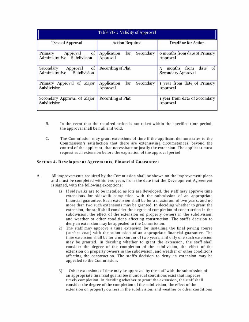
B. In the event that the required action is not taken within the specified time period, the approval shall be null and void.
C. The Commission may grant extensions of time if the applicant demonstrates to the
Commission’s satisfaction that there are extenuating circumstances, beyond the control of the applicant, that necessitate or justify the extension. The applicant must request such extension before the expiration of the approval period.
Section 4. Development Agreements, Financial Guarantees
A. All improvements required by the Commission shall be shown on the improvement plans
and must be completed within two years from the date that the Development Agreement is signed, with the following exceptions:
1) If sidewalks are to be installed as lots are developed, the staff may approve time extensions for sidewalk completion with the submission of an appropriate financial guarantee. Each extension shall be for a maximum of two years, and no more than two such extensions may be granted. In deciding whether to grant the extension, the staff shall consider the degree of completion of construction in the subdivision, the effect of the extension on property owners in the subdivision, and weather or other conditions affecting construction. The staff's decision to deny an extension may be appealed to the Commission.
2) The staff may approve a time extension for installing the final paving course (surface coat) with the submission of an appropriate financial guarantee. The time extension shall be for a maximum of two years, and only one such extension may be granted. In deciding whether to grant the extension, the staff shall consider the degree of the completion of the subdivision, the effect of the extension on property owners in the subdivision, and weather or other conditions affecting the construction. The staff's decision to deny an extension may be appealed to the Commission.
3) Other extensions of time may be approved by the staff with the submission of
an appropriate financial guarantee if unusual conditions exist that impedes timely completion. In deciding whether to grant the extension, the staff shall consider the degree of the completion of the subdivision, the effect of the extension on property owners in the subdivision, and weather or other conditions

affecting the construction. The staff's decision to deny an extension may be appealed to the Commission.
4) The staff may grant extensions of time if the developer demonstrates to the
staff’s satisfaction that there are extenuating circumstances beyond the control of the applicant that necessitates or justifies the extension.
B. A Development Agreement must be executed between the developer and the County prior to the commencement of work in any subdivision. Such agreement shall set forth the improvements to be completed, which shall include, but are not limited to, grading, street construction, sanitary sewers, storm sewers, sidewalks, drainage, landscaping and erosion control. It also shall set forth the terms and conditions under which the work is to be performed. A subdivision plat may be recorded only after secondary approval has been given as specified in this chapter. Final plat shall not be recorded until one of the following has been accomplished:
1) The completion of all improvements in accordance with the approved plans and
the Development Agreement, and the acceptance by Floyd County or other proper authority;
2) The posting of financial guarantees in an amount equal to one hundred twenty-
five percent of the cost of the improvements as specified by the Development Agreement. The form and length of the guarantees must be acceptable to the County attorney and shall be specified in the Development Agreement. If time extensions are granted under subsection A of this section, the cost estimate must be reviewed and the amount of the guarantee increased if necessary.
C. As a condition of the acceptance of improvements and/or release of financial guarantees posted under the terms of this section, the developer shall post with the Commissioners and/or utilities service board financial guarantees ensuring maintenance of the improvements in good repair. These guarantees shall be in an amount equal to twenty-five percent of the estimated cost of all improvements as specified in the Development Agreement. The form and length of the guarantee shall be specified in the Development Agreement, but in no case shall the guarantee be for less than one year nor more than five years.
D. The Commissioners may grant a partial release from a financial guarantee for portions of the improvements which are complete and accepted by such Commissioners, provided that the maintenance guarantee as specified in subsection B of this section is posted for such portion of the improvements. The conditions under which partial release of the guarantees will be permitted shall be specified in the Development Agreement.
E. After completion of all public improvements and prior to the release of the performance bond on the improvements, the developer shall provide drawings showing the actual location of all installed street improvements, sanitary and storm sewer improvements, water mains, fire hydrants, improvements, valves and stubs, monuments and markers, drainage facilities and other installed permanent improvements. This map shall be certified by a registered engineer or land surveyor. One copy of these plans shall be submitted to the County engineer and one copy shall be submitted to the Department.
Section 5. Inspection
A. Preconstruction. Before beginning any work within the subdivision, the person designated in the Development Agreement to be responsible for installation of

improvements shall meet on the site with specified representatives of the County.
B. Construction. The County representatives designated in the Development Agreement shall inspect and require that the installation of all improvements take place in accordance with plans approved by the Commission. The County representatives shall have authority as specified in the Development Agreement over the schedule of construction, materials used, methods of construction, and workmanship to ensure compliance with the approved plans and terms of the agreement.
Section 6. Fees
Article VII Remedies
Section 1. Right of entry
Upon representation of his official credentials, the enforcement officer, or his deputies, may enter during reasonable hours any premises covered by these regulations to perform the duties imposed upon him by these regulations. Section 2. Stop orders Upon notice from the enforcement officer that any subdivision is being constructed contrary to the provisions of these regulations or contrary to any approved plans, being maintained contrary to the provisions of these regulations, such violations shall be stopped immediately. Notice shall be in writing and shall be given to the owner of the property or his agent, or to the person so developing the property, and shall state specifically the regulation or approved plan being violated. Said notice may be given by registered mail to the person so developing the property after two reasonable efforts personally to serve the notice have failed.