as topographic maps - u.s. geological survey · pdf filethe geological survey was ......
TRANSCRIPT

As the Nation's principal conservation agency, the Department of the Interior has responsibility for most of our nationally owned public lands and natural resources. This includes fostering the wisest use of our land and water resources, protecting our fish and wildlife, preserving the environmental and cultural values of our national parks and historical places, and providing for the enjoy ment of life through outdoor recreation. The Department assesses our energy and mineral resources and works to assure that their development is in the best interests of all our people. The Depart ment also has a major responsibility for American Indian reservation communities and for people who live in Island Territories under U.S. administration.
yf.":^
Topographic Maps:Tools for Planning
Topographic Maps:Tools for Planning
by George A. Kaufman
One of the principal objectives of the U.S. Geological Survey is to provide general-pur pose topographic maps of appropriate scale and accuracy for all of the country.
The Geological Survey was established by Congress in 1879 to consolidate four earlier or ganizations that had been engaged in topo graphic and geologic mapping and in the collec tion of information regarding the public lands. It soon became evident that no adequate classifi cation of lands or conclusive geologic determi nations could be made without suitable base maps. In 1882, a general plan was adopted for the Survey to produce a standard series of top ographic maps. This original plan has been ex panded to meet the needs of a growing Nation.
More than 7 million copies of maps of the National Topographic Map Series are distrib uted annually by the Geological Survey to engi neers, scientists, industrial planners, real-estate dealers, hunters, fishermen, and other map users in all walks of life. About three-quarters of the maps are sold, and about one-quarter are made available free on request to educational institutions, public libraries, and government agencies.
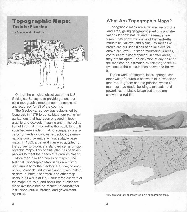
What Are Topographic Maps?Topographic maps are a detailed record of a
land area, giving geographic positions and ele vations for both natural and man-made fea tures. They show the shape of the land the mountains, valleys, and plains by means of brown contour lines (lines of equal elevation above sea level). In steep mountainous areas, contours are closely spaced; in flatter areas, they are far apart. The elevation of any point on the map can be estimated by referring to the el evations of the contour lines above and below it.
The network of streams, lakes, springs, and other water features is shown in blue; woodland features, in green; and the principal works of man, such as roads, buildings, railroads, and powerlines, in black. Urbanized areas are shown in a red tint.
How features are represented on a topographic map.

Topographic maps are an inventory of the physical features of the Earth's surface, includ ing the names of many features. They clearly show the topography to the map reader, whether he is standing in the area or sitting in his home or in an office a thousand miles away.
The 7 1/2-minute quadrangle map at 1:24,000 scale is the backbone of the National Topo graphic Program conducted by the Geological Survey. At this scale, 1 inch on the map repre sents 24,000 inches or 2,000 feet on the ground. This map covers a four-sided, almost rectangular area bounded by IVz minutes of longitude and 7 1/2 minutes of latitude. Because of the converging longitude lines, the actual area covered ranges from approximately 70 square miles in the south to 50 square miles along the Canadian border.
Topographic mapping in the 7 1/2-minute se ries or in the 15-minute series (1 inch repre sents approximately 1 mile) is available for more than three-quarters of the United States. The entire country will eventually be covered by quadrangle maps in either of these two series.
Several series of small-scale and special maps are published to meet modern require ments. These include
1:250,000 scale (1 inch on the map repre sents about 4 miles on the ground) for use as topographic bases for other types of maps and for regional planning.
State maps, at 1:500,000 scale (1 inch represents 8 miles) for use as wall maps and for statewide planning.
Shaded-relief maps, at various scales for exhibits, for training in map reading, and for terrain study.
National park maps, at various scales for park management and development and for tourist guides.
Antarctic topographic maps, at various scales for scientific research.
The same features represented on a topographic map (top) and on a shaded-relief map (bottom).
International Map of the World (IMW), at 1:1,000,000 scale for broad geographic studies.
United States base maps, at various scales for regional and countrywide stud ies and for classroom instruction.
National Atlas of the United States, with maps at various scales for geographic reference purposes.

Who Uses Topographic Maps?The people who use topographic maps do
not fit into any one category, and yet they all have one thing in common: each user wants in formation about the surface of the Earth infor mation that can best be shown on a topo graphic map. Map users include:
ArcheologistsArchitectsAssessorsBiologistsBorder patrol officersChemistsClimatologistsConservationistsEconomistsEngineersEntomologistsEthnologistsForestersGeographersGeologistsHealth officialsIndustrial engineersInsurance agentsLand appraisersLand managersLawyers
Map librariansMeteorologistsMilitary personnelNaturalistsOceanographersPlannersPolice and security
agentsPredator and rodent
controllersReal-estate devel
opersRecreationistsRegistrarsSalesmenSportsmenStatisticiansStudentsSurveyorsTeachers
How Are Topographic Maps Used?
Almost any project dealing with shape, size, location, slope, or configuration of land can be aided by topographic maps. A poll of map users listed more than a thousand varied purposes for which topographic maps are useful.
Bases for other mapsIndustries and planning agencies use stand
ard-accuracy topographic maps of the Geologi cal Survey as bases for more specialized maps. Scale and detail can be adjusted to suit individual needs. Specialized data can be su perimposed directly on the topographic base map. Some of the special adaptations of topo graphic maps are:
National park maps Population maps Physiographic maps Road maps Shaded-relief maps Soil maps Weather maps
Aeronautical charts Census maps County planning maps Drainage basin maps Flood zoning maps Geologic maps Industrial zoning maps Land ownership maps Land-use and crop
maps
Highway planningThe planner of major highways knows that
good topographic maps provide ready-made field reconnaissance. If the maps are available, he studies them carefully before selecting a preliminary route for a new highway. A topo graphic map will tell him about the features of the land, approximate amount of cut and fill, drainage, where bridges may be needed, de gree of economic development of the area, and other useful information such as the location of gravel pits. Topographic maps are also used in planning minor roads, such as logging, ranch, access, and national forest roads.

Selecting airport sitesAirports must be located near population cen
ters and must be accessible by road; yet they must be far enough away from populated areas so that air traffic will not present a city hazard and land can be acquired at reasonable cost. Obviously the topographic characteristics of the land are of prime importance in selecting suita ble sites for landing strips and assuring a loca tion of maximum visibility. Topographic maps are a valuable source of information about these and other factors in airport planning.
Selecting industrial sitesBefore an industry invests money in a new
plant, it needs much information that can be
supplied by topographic maps. Of great interest is the amount of water available for industrial purposes. Geological Survey quadrangle maps can be used as aids in water-supply studies and in computing potential water storage.
Topographic maps are useful in selecting un developed land that can be acquired at minimal cost, in estimating the cut or fill necessary to prepare a site, and in planning sewer systems and access roads. The cost of building on a particular site as estimated from topographic maps is an important factor in selection. Grow ing communities and railroads seeking to attact new industry to an area often prepare bro chures containing photographs and maps of in dustrial sites.
How topographic maps are used for planning development.

Selecting pipeline and powerline routesPrivate and public utility companies use topo
graphic maps for preliminary planning in the of fice. Planners may select the general route of the proposed line on 1:250,000-scale maps, each covering about 6,000 square miles. For detailed study and estimates of right-of-way costs, 1:24,000-scale maps are used. An ap proximate idea of the most economical route can be obtained from topographic maps before going to the field.
Making cadastral (property) surveysTopographic maps show fence lines and tim
ber-cutting lines, as well as section lines and corners. Boundary lines and some located- boundary markers are shown for cities, coun ties, States, and national parks and forests. One important use of such boundary informa tion is in logging operations, to avoid possible trespass. Many private surveyors use topo graphic maps to spot boundaries and corner markers in an unfamiliar area.
Map control points indicate the height of land features.
True north is marked.
Locating communication facilitiesTelevision stations, radio stations, and radar
installations all require an unobstructed site for transmission and reception of signals. Profiles determined from topographic maps permit eco nomical selection of sites where signals will have the greatest possible range.
For agricultural researchTopographic maps have many uses in agri
cultural research such as the preparation of maps showing areas of climatic and soil condi tions best suited for specific crops. Soil scien tists study these plant-climate maps to find drainage patterns, sheltered areas, and the ele vation at which freezing will occur.
10 11

Exploring
How topographic maps are used for planning recreation.
A hike is planned.
Planning recreation areasCareful and imaginative planning is needed
to create an enjoyable recreation area, and top ographic maps can be useful at every stage of the selection and construction. Planners study maps to find promising spots for fishing, camp ing, skiing, or other facilities, and to find possi ble access routes into these areas. If locations pass this preliminary test, the maps are exam ined more closely to evaluate the water supply, fire hazard, and relative safety of the site. Then shelters and other conveniences are con structed where they will be most useful.
Planning personal recreationAnyone planning a camping, fishing, hiking,
or boating trip will find that topographic maps are a practical guide. Many hunters use topo graphic maps to plan their hunting trips from their armchairs. Even a simple walk through the woods can be more enjoyable and adventurous with a topographic map.
Assessing and managing natural resourcesTopographic maps are used as bases to
show the location, extent, and availability of such natural resources as water, minerals, and timber. To experts, such maps indicate prob lems and potentialities of resources.
Topographic maps are important aids for people who are concerned with problems of water and its distribution. The hydrologist can obtain information concerning watersheds and distribution of runoff. The engineer can use them in determining size and positioning of dams for water storage or flood control. They are sources of basic data for studies of all aspects
12 13

of the hydrologic cycle from precipitationuntil the water is absorbed into the atmosphereor discharged into the sea.
Since 1897, when the Geological Survey co operated with the Department of Agriculture in a special survey of potential sites for national forests, the topographic map has become an increasingly valuable tool in the development, use, and conservation of the Nation's forest lands. All phases of timber management, from planning current and future operations to main taining records of past activities, require the constant use of maps. They are useful in plan ning access roads, in developing reforestation, and in planning insect-control measures. In fire control and firefighting, they are used to locate sites for fire towers and to select the proper geographic positions for constructing firebreaks. In the event of fire, maps supply the topo graphic information needed to determine proba ble fire behavior and to show firefighting crews how to reach an area and where to work.
Every well-planned geologic investigation de pends upon a prior topographic survey geo logic maps are plotted on topographic bases and exploration for minerals depends upon top ographic maps. In mining operations, engineers may use topographic maps to plan restoration of land that has been torn apart by strip mining and to predict how the ground will settle when a large mass of ore is removed.
How To Obtain Topographic Maps
Indexes showing published maps for areas east of the Mississippi River, including Minne sota, Puerto Rico, and the Virgin Islands are available free on request to the:
Branch of Distribution U.S. Geological Survey 1200 South Eads St. Arlington, VA 22202
Indexes showing published maps for areas west of the Mississippi River, including Alaska, Hawaii, Louisiana, Guam, and American Samoa are free on request to the:
Branch of Distribution U.S. Geological Survey Box 25286, Federal Center Denver, CO 80225
Residents of Alaska may request indexes di rectly from:
Distribution Section U.S. Geological Survey Federal Bldg., Box 12 101 12th Avenue Fairbanks, AK 99701
These indexes list special maps, addresses of local map reference libraries, local map dealers, and Federal map distribution centers. An order blank showing prices and giving detailed in structions for ordering maps is included with each index.
This publication is one of a series of general interest pub lications prepared by the U.S. Geological Survey to provide information about the earth sciences, natural resources, and the environment. To obtain a catalog of additional titles in the series "Popular Publications of the U.S. Geological Sur vey," write to either one of the above Branches of Distribu tion.
Pinpointing a smoke location on a topographic map by using an alidade.
14 15 ir U.S GOVERNMENT FEINTING OFFICE: 1980-311-348/53