asia - freshwater agreements
DESCRIPTION
Historical Developments and Future OpportunitiesTRANSCRIPT

Agreements � Asia 51
ASIA

52 Atlas of International Freshwater Agreements
Amur River. Photo credit:Mikhail A. Yatskov.
Amur*
Total area: 2,085,900 km2
Area of Basin in CountryCountries km2 %
Russia 1,006,100 48.23China 889,100 42.62Mongolia 190,600 9.14Korea, Democratic People�s Republic of (North) 100 0.01
Date Treaty Basin Signatories Treaty Name
February 11, 1995 Amur, Har Us Nur,Jenissei, LakeBaikal, Lake Ubsa-Nur, Onon, Pu LunT'o, Selenga
Mongolia;RussianFederation
Agreement between the government of Mongolia andthe government of the Russian Federation on theprotection and use of transboundary waters
April 29, 1994 Bor Nor Lake, Bulgan, Halaha,Kerulen/Herlen He
China, People'sRepublic of;Mongolia
Agreement between the government of the People'sRepublic of China and the government of Mongolia onthe protection and utilization of transboundary waters
August 18, 1956 Amur, Arugun China, People'sRepublic of;Union ofSoviet SocialistRepublics
Agreement between the Union of Soviet SocialistRepublics and the People's Republic of China on jointresearch operations to determine the natural resourcesof the Amur River Basin and the prospects fordevelopment of its productive potentialities and onplanning and survey operations to prepare a schemefor the multi-purpose exploitation of the Arugun Riverand the Upper Amur River

Agreements � Asia 53
An Nahr Al KabirTotal area: 1,300 km2
Area of Basin in CountryCountries km2 %
Syria 900 67.60Lebanon 400 31.70
Lake Baikal. Photocredit: Robert Buckman
Date Treaty Basin Signatories Treaty Name
April 20, 2002 Al-Kaber Al-Janoubi
LebaneseRepublic; SyrianArab Republic
An agreement between the Syrian Arab Republic and theLebanese Republic for the sharing of the Great SouthernRiver Basin water and building joint dam on themaincourse of the river
54 Atlas of International Freshwater Agreements
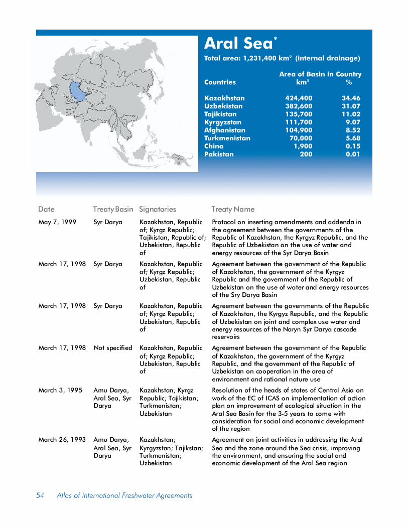
Aral Sea*
Total area: 1,231,400 km2 (internal drainage)
Area of Basin in CountryCountries km2 %
Kazakhstan 424,400 34.46Uzbekistan 382,600 31.07Tajikistan 135,700 11.02Kyrgyzstan 111,700 9.07Afghanistan 104,900 8.52Turkmenistan 70,000 5.68China 1,900 0.15Pakistan 200 0.01
Date Treaty Basin Signatories Treaty Name
May 7, 1999 Syr Darya Kazakhstan, Republicof; Kyrgz Republic;Tajikistan, Republic of;Uzbekistan, Republicof
Protocol on inserting amendments and addenda inthe agreement between the governments of theRepublic of Kazakhstan, the Kyrgyz Republic, and theRepublic of Uzbekistan on the use of water andenergy resources of the Syr Darya Basin
March 17, 1998 Syr Darya Kazakhstan, Republicof; Kyrgz Republic;Uzbekistan, Republicof
Agreement between the government of the Republicof Kazakhstan, the government of the KyrgyzRepublic and the government of the Republic ofUzbekistan on the use of water and energy resourcesof the Sry Darya Basin
March 17, 1998 Syr Darya Kazakhstan, Republicof; Kyrgz Republic;Uzbekistan, Republicof
Agreement between the governments of the Republicof Kazakhstan, the Kyrgyz Republic, and the Republicof Uzbekistan on joint and complex use water andenergy resources of the Naryn Syr Darya cascadereservoirs
March 17, 1998 Not specified Kazakhstan, Republicof; Kyrgz Republic;Uzbekistan, Republicof
Agreement between the government of the Republicof Kazakhstan, the government of the KyrgyzRepublic, and the government of the Republic ofUzbekistan on cooperation in the area ofenvironment and rational nature use
March 3, 1995 Amu Darya,Aral Sea, SyrDarya
Kazakhstan; KyrgzRepublic; Tajikistan;Turkmenistan;Uzbekistan
Resolution of the heads of states of Central Asia onwork of the EC of ICAS on implementation of actionplan on improvement of ecological situation in theAral Sea Basin for the 3-5 years to come withconsideration for social and economic developmentof the region
March 26, 1993 Amu Darya,Aral Sea, SyrDarya
Kazakhstan;Kyrgyzstan; Tajikstan;Turkmenistan;Uzbekistan
Agreement on joint activities in addressing the AralSea and the zone around the Sea crisis, improvingthe environment, and ensuring the social andeconomic development of the Aral Sea region

Agreements � Asia 55
Asi/OrontesTotal area: 37,900 km2
Area of Basin in CountryCountries km2 %
Turkey 18,900 49.94Syria 16,800 44.32Lebanon 2,200 5.74
Tigris tributary (left); Mahabad River. Photo credits: Babak Sedighi.
Date Treaty Basin Signatories Treaty Name
August 23, 2001 Frontier orshared waters
Syria, ArabRepublic of;Turkey,Republic of
Joint communique between Republic of Turkey PrimeMinistry Southeastern Anatolia Project RegionalDevelopment Administration (GAP) and Arab Republic ofSyria Ministry of Irrigation General Organization for LandDevelopment (GOLD)
September 20, 1994 Al-Asi/Orontes LebaneseRepublic;Syrian ArabRepublic of
Bilateral agreement, Act No. 15 concerning the divisionof the water of Al-Asi River (Orontes) between the SyrianArab Republic and the Lebanese Republic
56 Atlas of International Freshwater Agreements
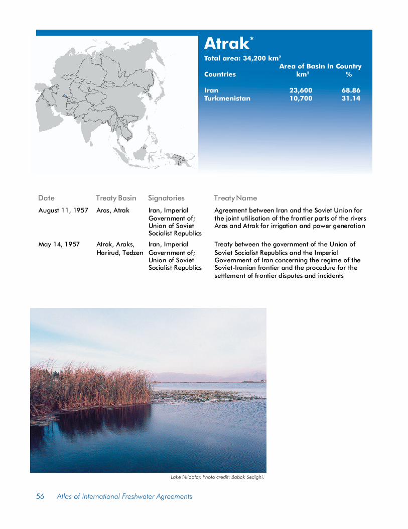
Atrak*
Total area: 34,200 km2
Area of Basin in CountryCountries km2 %
Iran 23,600 68.86Turkmenistan 10,700 31.14
Lake Niloofar. Photo credit: Babak Sedighi.
Date Treaty Basin Signatories Treaty Name
August 11, 1957 Aras, Atrak Iran, ImperialGovernment of;Union of SovietSocialist Republics
Agreement between Iran and the Soviet Union forthe joint utilisation of the frontier parts of the riversAras and Atrak for irrigation and power generation
May 14, 1957 Atrak, Araks,Harirud, Tedzen
Iran, ImperialGovernment of;Union of SovietSocialist Republics
Treaty between the government of the Union ofSoviet Socialist Republics and the ImperialGovernment of Iran concerning the regime of theSoviet-Iranian frontier and the procedure for thesettlement of frontier disputes and incidents

Agreements � Asia 57
FenneyTotal area: 2,800 km2
Area of Basin in CountryCountries km2 %
India 1,800 65.83Bangladesh 1,000 34.17
Simareh River (left). Photo credit: Babak Sedighi. AmurRiver. Photo credit: Mikhail A. Yatskov.
Date Treaty Basin Signatories Treaty Name
January 18, 1986 Frontier orshared waters
Bangladesh; India Summary record of discussions of the first meetingof the Joint Committee of Experts held in Dhakabetween 16-18 January, 1986

58 Atlas of International Freshwater Agreements
FlyTotal area: 64,600 km2
Area of Basin in CountryCountries km2 %
Papua New Guinea 60,400 93.40Indonesia 4,300 6.60
Tonle Sap. Photo credit: M. Giordano.
Dates Treaty Basin Signatories Treaty Name
November 13, 1973 Sepik, Fly Australia; Australiaacting on the behalfof Papua NewGuinea; Indonesia
Agreement between the government of Australia(acting on its own behalf and on behalf of thegovernment of Papua New Guinea) and thegovernment of Indonesia concerningadministrative arrangements as to the borderbetween Papua New Guinea and Indonesia
Agreements � Asia 59
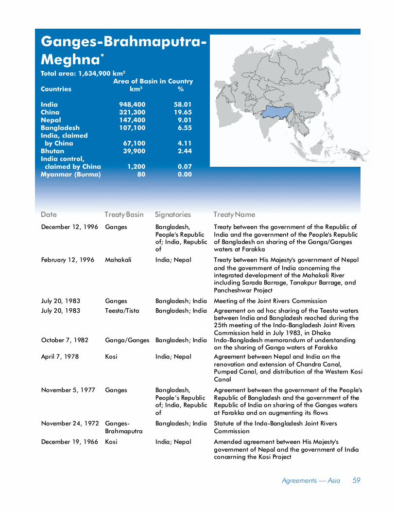
Ganges-Brahmaputra-Meghna*
Total area: 1,634,900 km2
Area of Basin in CountryCountries km2 %
India 948,400 58.01China 321,300 19.65Nepal 147,400 9.01Bangladesh 107,100 6.55India, claimed by China 67,100 4.11Bhutan 39,900 2.44India control, claimed by China 1,200 0.07Myanmar (Burma) 80 0.00
Date Treaty Basin Signatories Treaty Name
December 12, 1996 Ganges Bangladesh,People's Republicof; India, Republicof
Treaty between the government of the Republic ofIndia and the government of the People's Republicof Bangladesh on sharing of the Ganga/Gangeswaters at Farakka
February 12, 1996 Mahakali India; Nepal Treaty between His Majesty's government of Nepaland the government of India concerning theintegrated development of the Mahakali Riverincluding Sarada Barrage, Tanakpur Barrage, andPancheshwar Project
July 20, 1983 Ganges Bangladesh; India Meeting of the Joint Rivers Commission
July 20, 1983 Teesta/Tista Bangladesh; India Agreement on ad hoc sharing of the Teesta watersbetween India and Bangladesh reached during the25th meeting of the Indo-Bangladesh Joint RiversCommission held in July 1983, in Dhaka
October 7, 1982 Ganga/Ganges Bangladesh; India Indo-Bangladesh memorandum of understandingon the sharing of Ganga waters at Farakka
April 7, 1978 Kosi India; Nepal Agreement between Nepal and India on therenovation and extension of Chandra Canal,Pumped Canal, and distribution of the Western KosiCanal
November 5, 1977 Ganges Bangladesh,People�s Republicof; India, Republicof
Agreement between the government of the People'sRepublic of Bangladesh and the government of theRepublic of India on sharing of the Ganges watersat Farakka and on augmenting its flows
November 24, 1972 Ganges-Brahmaputra
Bangladesh; India Statute of the Indo-Bangladesh Joint RiversCommission
December 19, 1966 Kosi India; Nepal Amended agreement between His Majesty'sgovernment of Nepal and the government of Indiaconcerning the Kosi Project

60 Atlas of International Freshwater Agreements
Har Us NurTotal area: 185,300 km2
Area of Basin in CountryCountries km2 %
Mongolia 179,300 96.81Russia 5,600 3.04China 300 0.15
Amur tributary. Photocredit: Mikhail A. Yatskov
Date Treaty Basin Signatories Treaty Name
February 11, 1995 Amur, Har Us Nur,Jenissei, Lake Baikal,Lake Ubsa-Nur, Onon,Pu Lun T'o, Selenga
Mongolia;RussianFederation
Agreement between the government of Mongoliaand the government of the Russian Federationon the protection and use of transboundarywaters
April 29, 1994 Bulgan, Bor Nor Lake,Halaha, Kerulen/Herlen He
China, People'sRepublic of;Mongolia
Agreement between the government of thePeople's Republic of China and the governmentof Mongolia on the protection and utilization oftransboundary waters

Agreements � Asia 61
HelmandTotal area: 353,500 km2
Area of Basin in CountryCountries km2 %
Afghanistan 288,200 81.53Iran 54,900 15.52Pakistan 10,400 2.95
Water lilies, Tigris River tributary.Photo credit: Babak Sedighi.
Date Treaty Basin Signatories Treaty Name
September 7, 1950 Helmand Afghanistan; Iran Terms of reference of the Helmand River DeltaCommission and an interpretive statement relativethereto, agreed by conferees of Afghanistan and Iran

62 Atlas of International Freshwater Agreements
Ili/Kunes HeTotal area: 161,200 km2
Area of Basin in CountryCountries km2 %
Kazakhstan 97,100 60.24China 55,300 34.32Kyrgyzstan 8,800 5.44
Tibetan highlands tributary. Photo credit: Robert Buckman.
Date Treaty Basin Signatories Treaty Name
June 12, 1915 Horgos, Ili China; Russia, ImperialGovernment of
Protocol between China and Russia for the delimitationof the frontier along the River Horgos

Agreements � Asia 63
Indus*
Total area: 1,138,800 km2
Area of Basin in CountryCountries km2 %
Pakistan 597,700 52.48India 381,600 33.51China 76,200 6.69Afghanistan 72,100 6.33Chinese control, claimed by India 9,600 0.84Indian control, claimed by China 1,600 0.14Nepal 10 0.00
Date Treaty Basin Signatories Treaty Name
September 19, 1960 Indus India;InternationalBank forReconstructionandDevelopment;Pakistan
Indus waters treaty 1960 between the governmentof India, the government of Pakistan and theInternational Bank for Reconstruction andDevelopment
January 11, 1960 Indus India; Pakistan Agreement between Pakistan and India on WestPakistan-India border disputes
October 23, 1959 Indus East Pakistan;India
Indo-Pakistan agreement (with appendices) on EastPakistan border disputes
May 4, 1948 Indus India; Pakistan Inter-dominion agreement between the governmentof India and the government of Pakistan on thecanal water dispute between East and West Punjab
November 22,1921 Kabul Afghanistan;Great Britain
Treaty between the government of Afghanistan andHis Britannic Majesty's Government for theestablishment of neighbourly relations
February 23, 1904 Sirhind Canal Great Britain;Jind, State of;Nabha, State of;Patiala, State of
Final working agreement relative to the SirhindCanal between Great Britain and Patiala, Jind andNabha
September 16, 1892 Indus Great Britain;Jind, State of
Amended terms of agreement between the BritishGovernment and the State of Jind, for regulatingthe supply of water for irrigation from the WesternJumana Canal
July 20, 1874 Hathmatee Edur; GreatBritain
Articles of agreement between the Edur Durbar andthe British government
February 18, 1873 Indus Great Britain;Jind, State of;Nabha, State of;Patiala, State of
Terms of agreement between Great Britain and theStates of Patiala, Jhind, and Nabha regarding theSirhind Canal

64 Atlas of International Freshwater Agreements
Jenisej/YeniseyTotal area: 2,557,800 km2
Area of Basin in CountryCountries km2 %
Russia 2,229,800 87.17Mongolia 327,900 12.82
Jordan River. Photocredit: Aaron T. Wolf.
Date Treaty Basin Signatories Treaty Name
February 11, 1995 Amur, Har Us Nur,Jenissei, Lake Baikal,Lake Ubsa-Nur, Onon,Pu Lun T'o, Selenga
Mongolia;RussianFederation
Agreement between the government ofMongolia and the government of the RussianFederation on the protection and use oftransboundary waters

Agreements � Asia 65
Jordan*
Total area: 42,800 km2
(Dead Sea internal drainage)Area of Basin in Country
Countries km2 %
Jordan 20,600 48.13Israel 9,100 21.26Syria 4,900 11.45West Bank 3,200 7.48Egypt 2,700 6.31Golan Heights 1,500 3.50Lebanon 600 1.33
Date Treaty Basin Signatories Treaty Name
September 28, 1995 Jordan Israel; PalestineLiberationOrganization
Israeli-Palestinian interim agreement on theWest Bank and the Gaza Strip, with Annexes I toVII.
October 26, 1994 Araba/Aravagroundwater,Jordan, Yarmuk
Israel; Jordan Treaty of peace between the State of Israel andthe Hashemite Kingdom of Jordan, done atArava/Araba crossing point
December 31, 1955 Jordan Israel; Jordan;Lebanon; Syria
Johnston Negotiations
June 4, 1953 Yarmuk Jordan, HashemiteKingdom of; Syria,Republic of
Agreement between the Republic of Syria andthe Hashemite Kingdom of Jordan concerningthe utilization of the Yarmuk waters.
February 2, 1926 Jordan Great Britain, onbehalf of Territoriesof Palestine; France,on behalf of GreatLebanon and Syria
Agreement of good neighbourly relationsconcluded between the British and Frenchgovernments on behalf of the territories ofPalestine, on the one part, and on behalf ofSyria and Great Lebanon, on the other part
March 7, 1923 Jordan, Yarmouk France; Great Britain Exchange of notes constituting an agreementbetween the British and French governmentsrespecting the boundary line between Syria andPalestine from the Mediterranean to El Hamme
December 23, 1920 Jordan, Tigris-Euphrates,Yarmuk
France; Great Britain Franco-British convention on certain pointsconnected with the mandates for Syria and theLebanon, Palestine and Mesopotamia

66 Atlas of International Freshwater Agreements
KarnaphuliTotal area: 12,500 km2
Area of Basin in CountryCountries km2 %
Bangladesh 7,400 58.78India 5,100 41.14Myanmar (Burma) 10 0.09
Er Lake, fish traps. Photo credit: M. Giordano.
Date Treaty Basin Signatories Treaty Name
January 18, 1986 Frontier orshared waters
Bangladesh; India Summary record of discussions of the first meetingof the Joint Committee of Experts held in Dhakabetween 16-18 January, 1988

Agreements � Asia 67
Kura-Araks*
Total area: 193,200 km2
Area of Basin in CountryCountries km2 %
Azerbaijan 56,600 29.28Iran 39,700 20.55Armenia 34,800 18.03Georgia 34,300 17.77Turkey 27,700 14.32Russia 60 0.03
Sirwan River (left); Lake Niloofar. Photo credits: Babak Sedighi.
Date Treaty Basin Signatories Treaty Name
August 11, 1957 Aras, Atrak Iran, ImperialGovernment of; Unionof Soviet SocialistRepublics
Agreement between Iran and the Soviet Union forthe joint utilisation of the frontier parts of therivers Aras and Atrak for irrigation and powergeneration
May 14, 1957 Araks, Atrak,Harirud,Tedzen
Iran, ImperialGovernment of; Unionof Soviet SocialistRepublics
Treaty between the government of the Union ofSoviet Socialist Republics and the ImperialGovernment of Iran concerning the regime of theSoviet-Iranian frontier and the procedure for thesettlement of frontier disputes and incidents

68 Atlas of International Freshwater Agreements
Lake Ubsa-NurTotal area: 62,800 km2
Area of Basin in CountryCountries km2 %
Mongolia 47,600 75.78Russia 15,200 24.22
Lake Baikal. Photo credits: Mikhail A. Yatskov.
Date Treaty Basin Signatories Treaty Name
February 11, 1995 Amur, Har Us Nur,Jenissei, Lake Baikal,Lake Ubsa-Nur, Onon,Pu Lun T'o, Selenga
Mongolia;RussianFederation
Agreement between the government ofMongolia and the government of the RussianFederation on the protection and use oftransboundary waters
Agreements � Asia 69
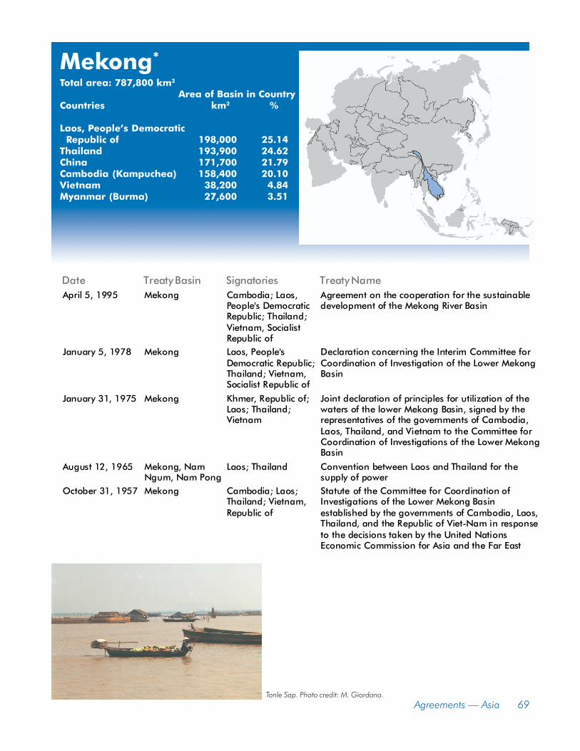
Mekong*
Total area: 787,800 km2
Area of Basin in CountryCountries km2 %
Laos, People�s Democratic Republic of 198,000 25.14Thailand 193,900 24.62China 171,700 21.79Cambodia (Kampuchea) 158,400 20.10Vietnam 38,200 4.84Myanmar (Burma) 27,600 3.51
Tonle Sap. Photo credit: M. Giordano.
Date Treaty Basin Signatories Treaty NameApril 5, 1995 Mekong Cambodia; Laos,
People's DemocraticRepublic; Thailand;Vietnam, SocialistRepublic of
Agreement on the cooperation for the sustainabledevelopment of the Mekong River Basin
January 5, 1978 Mekong Laos, People'sDemocratic Republic;Thailand; Vietnam,Socialist Republic of
Declaration concerning the Interim Committee forCoordination of Investigation of the Lower MekongBasin
January 31, 1975 Mekong Khmer, Republic of;Laos; Thailand;Vietnam
Joint declaration of principles for utilization of thewaters of the lower Mekong Basin, signed by therepresentatives of the governments of Cambodia,Laos, Thailand, and Vietnam to the Committee forCoordination of Investigations of the Lower MekongBasin
August 12, 1965 Mekong, NamNgum, Nam Pong
Laos; Thailand Convention between Laos and Thailand for thesupply of power
October 31, 1957 Mekong Cambodia; Laos;Thailand; Vietnam,Republic of
Statute of the Committee for Coordination ofInvestigations of the Lower Mekong Basinestablished by the governments of Cambodia, Laos,Thailand, and the Republic of Viet-Nam in responseto the decisions taken by the United NationsEconomic Commission for Asia and the Far East

70 Atlas of International Freshwater Agreements
Nahr El KebirTotal area: 1,500 km2
Area of Basin in CountryCountries km2 %
Syria 1,300 85.61Turkey 200 13.87
Mekong River. Photo credit: M. Giordano.
Date Treaty Basin Signatories Treaty Name
August 23, 2001 Frontier orshared waters
Syria, ArabRepublic of;Turkey, Republicof
Joint communique between Republic of Turkey PrimeMinistry Southeastern Anatolia Project RegionalDevelopment Administration (GAP) and Arab Republic ofSyria Ministry of Irrigation General Organization for LandDevelopment (GOLD)

Agreements � Asia 71
Ob*
Total area: 2,950,800 km2
Area of Basin in CountryCountries km2 %
Russia 2,192,700 74.31Kazakhstan 743,800 25.21China 13,900 0.47Mongolia 200 0.01
Tonle Sap. Photo credit: M. Giordano.
Date Treaty Basin Signatories Treaty Name
August 27, 1992 Irtysh, Ishim,Tobol, Ural
Kazakhstan, Republicof; RussianFederation
Agreement between the government of the Republicof Kazakhstan and the government of the RussianFederation concerning the joint use and protection oftransboundary waters
72 Atlas of International Freshwater Agreements
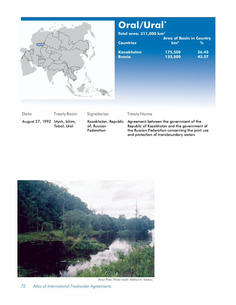
Oral/Ural*
Total area: 311,000 km2
Area of Basin in CountryCountries km2 %
Kazakhstan 175,500 56.43Russia 135,500 43.57
Amur River. Photo credit: Mikhail A. Yatskov.
Date Treaty Basin Signatories Treaty Name
August 27, 1992 Irtysh, Ishim,Tobol, Ural
Kazakhstan, Republicof; RussianFederation
Agreement between the government of theRepublic of Kazakhstan and the government ofthe Russian Federation concerning the joint useand protection of transboundary waters

Agreements � Asia 73
Pu Lun T�oTotal area: 89,000 km2
Area of Basin in CountryCountries km2 %
China 77,800 87.39Mongolia 11,100 12.48Russia 80 0.09Kazakhstan 30 0.04
Tributary of Amur (left); Khor River. Photo credits: Mikhail A. Yatskov.
Date Treaty Basin Signatories Treaty Name
February 11, 1995 Amur, Har Us Nur,Jenissei, Lake Baikal,Lake Ubsa-Nur, Onon,Pu Lun T'o, Selenga
Mongolia;RussianFederation
Agreement between the government of Mongoliaand the government of the Russian Federation onthe protection and use of transboundary waters
April 29, 1994 Bor Nor Lake, Bulgan,Halaha,Kerulen/Herlen He
China,People'sRepublic of;Mongolia
Agreement between the government of thePeople's Republic of China and the government ofMongolia on the protection and utilization oftransboundary waters
August 27, 1992 Irtysh, Ishim, Tobol,Ural
Kazakhstan,Republic of;RussianFederation
Agreement between the government of theRepublic of Kazakhstan and the government of theRussian Federation concerning the joint use andprotection of transboundary waters

74 Atlas of International Freshwater Agreements
SepikTotal area: 73,400 km2
Area of Basin in CountryCountries km2 %
Papua New Guinea 71,000 96.81Indonesia 2,300 3.19
Date Treaty Basin Signatories Treaty Name
November 13, 1973 Fly, Sepik Australia; Australiaacting on the behalfof Papua NewGuinea; Indonesia
Agreement between the government of Australia(acting on its own behalf and on behalf of thegovernment of Papua New Guinea) and thegovernment of Indonesia concerning administrativeborder arrangements as to the border betweenPapua New Guinea and Indonesia

Tigris-Euphrates-Shatt al Arab*
Total area: 789,000 km2
Area of Basin in CountryCountries km2 %
Iraq 319,400 40.48Turkey 195,700 24.80Iran 155,400 19.70Syria 116,300 14.73Jordan 2,000 0.25Saudi Arabia 80 0.01
Far left to right: Ravansar fountain; Simareh River; Mahabad River; Gharasoo River. Photo credits: Babak Sedighi.
Date Treaty Basin Signatories Treaty Name
August 23, 2001 Frontier or sharedwaters
Syria, ArabRepublic of;Turkey,Republic of
Joint communique between Republic of Turkeyprime ministry Southeastern Anatolia ProjectRegional Development Administration (GAP) andArab Republic of Syria Ministry of Irrigation GeneralOrganization for Land Development (GOLD)
October 20, 1998 Not specified Syria; Turkey Minutes between Syria and Turkey on cooperationin fighting terrorism, signed at Adana, includingAnnex 2
April 17, 1989 Euphrates Iraq; Syria Joint minutes concerning the provisional division ofwaters of the Euphrates River
December 26, 1975 Alvend, Bnava Suta,Cham, Duverij,Gangir, Kanjan,Qurahtu, Tib
Iran, ImperialGovernmentof; Iraq
Agreement between Iran and Iraq concerning theuse of frontier watercourses, and protocol
June 13, 1975 Shatt al'Arab Iran; Iraq Treaty concerning the state frontier and neighbourlyrelations between Iran and Iraq and protocol
March 29, 1946 Euphrates, Tigris Iraq; Turkey Treaty of friendship and neighbourly relations, andsix annexed protocols, signed at Ankara

76 Atlas of International Freshwater Agreements