assembly design: devising a planting strategy for...
TRANSCRIPT

1
ASSEMBLY DESIGN: DEVISING A PLANTING STRATEGY FOR LIBERTY HILLS AT LIBERTY STATE PARK
Alisa StanislawMLA Design Project 2013Rutgers Department of Landscape Architecture
2
Acknowledgements:
Chair: Kathleen John-AlderCommittee:Frank GallagherTobiah HortonRichard BartoloneStudio Professor:Holly Nelson
It is a pleasure for me to thank my chair and committee members for their guidance through-out the process of this design project, it would have been impossible without their advice and support.
3
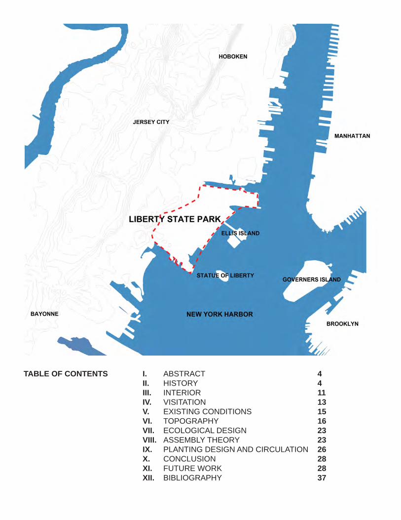
TABLE OF CONTENTS ABSTRACTHISTORYINTERIORVISITATIONEXISTING CONDITIONSTOPOGRAPHYECOLOGICAL DESIGNASSEMBLY THEORYPLANTING DESIGN AND CIRCULATIONCONCLUSIONFUTURE WORKBIBLIOGRAPHY
I. II. III. IV. V. VI. VII. VIII. IX. X. XI. XII.
4 4 11 13 15 16 23 23 26 28 28 37
4
I. ABSTRACT
Redevelopment and restoration of derelict land-scapes into green space has become a pressing issue in urbanized areas, due to the exponential rise in population. Providing spaces for people to enjoy, as well as offering ecological benefits in urban areas has become a concern within land-scape architecture. This design project examines these issues through an analysis of topography, hydrology, vegetation and circulation on the site of Liberty Hills within Liberty State Park in Jersey City, New Jersey that will accommodate 67,000 cubic yards of soil from future construction proj-ects, and a much larger quantity in the future calling for an interim strategy. A historical inquiry of how the site has changed over time from an oyster bed, the industrial revolution and into the present day interior and park helps to design the manufactured site. An investigation of the con-cept of novel plant assemblages informs a plant-ing design on the 24-acre site of Liberty Hills, as well as creating a meaningful human experience.
II. HISTORY
Communipaw Cove once consisted of salt marsh-es, mud flats and oyster beds, brimming with aquatic life and a source of food for Native Ameri-cans, the first Dutch settlers in the 1600’s, and the English (Liberty State Park 1). The harbor was a mode of transportation for commuting and industry since 1661 when the Dutch established the first ferry service from Pavonia to Manhattan, and the site itself still is a very important connec-tion to Manhattan, Brooklyn, Governors Island, Ellis Island and the Statue of Liberty. Liberty State Park has a colorful history, dating to having the highest concentration of railroads in the north-east from 1884 to 1911 when the rail changed over from commerce to commuting, while also connecting immigrants from Ellis Island to New Jersey. This project analyzes how the land was created-by filling in the salt marshes with six mil-lion cubic yards of various materials.
In 1909 Clifton Johnson wrote a book titled The Picturesque Hudson, which illustrated how pres-ent day Liberty State Park, known as Commu-nipaw Cove, appeared. After reading the History
of New York by Washington Irving he added, “When the first ship from Holland bringing colo-nists to this country came to anchor at the mouth of the Hudson, there was on the Jersey shore ‘a small Indian village pleasantly embowered in a grove of spreading elms.’” Following Dutch colo-nization within the cove, the place was described as:
“’The softness of the soil was wonderfully adapt-ed to the driving of piles, the swamps and marsh-es afforded ample opportunities for the construct-ing of dykes and dams; the shallowness of the shore was peculiarly favorable to the building of docks:--in a word, this spot abounded with all of the requisites for the foundation of a great Dutch city’” (Johnson 58).
European settlers began to alter the land to serve their needs, following the Native Americans who used the cove predominately for fishing and as a mode of transport. After conveying these images, Johnson describes his personal experience at Communipaw Cove during 1909:
“With Communipaw’s past in mind I crossed the river hoping that some remnants of the once serene little Dutch village might still survive; but shipping is omnipresent along the shore, and the land is almost monopolized by the railways. I fol-lowed the one highway back till I tired of its grim monotony and the lack of promise that it would lead to anything better. Along either side stalked a great row of telegraph poles bearing aloft a maze of wires, there were multitudinous railway tracks, and freight and passenger cars and noisy engines, mountainous heaps of coal…while the air was laden with odors of gas and smoke. So I retraced my steps, regretting not a little the re-gion’s modern aspect as compared to what it had been” (Johnson 64).
From Johnson’s time on, the area of Commu-nipaw Cove was filled and more railways were constructed to support the heightened need to transport goods to and from the land and water.
This land was created quickly to accommo-date industrial rails along the Hudson River and Estuary, without consideration to how it would
5
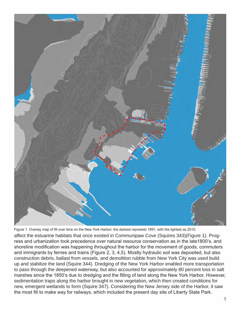
Figure 1. Overlay map of fill over time on the New York Harbor; the darkest represets 1891, with the lightest as 2010.
affect the estuarine habitats that once existed in Communipaw Cove (Squires 343)(Figure 1). Prog-ress and urbanization took precedence over natural resource conservation as in the late1800’s, and shoreline modification was happening throughout the harbor for the movement of goods, commuters and immigrants by ferries and trains (Figure 2, 3, 4,5). Mostly hydraulic soil was deposited, but also construction debris, ballast from vessels, and demolition rubble from New York City was used build up and stabilize the land (Squire 344). Dredging of the New York Harbor enabled more transportation to pass through the deepened waterway, but also accounted for approximately 80 percent loss in salt marshes since the 1850’s due to dredging and the filling of land along the New York Harbor. However, sedimentation traps along the harbor brought in new vegetation, which then created conditions for new, emergent wetlands to form (Squire 347). Considering the New Jersey side of the Harbor, it saw the most fill to make way for railways, which included the present day site of Liberty State Park.
6
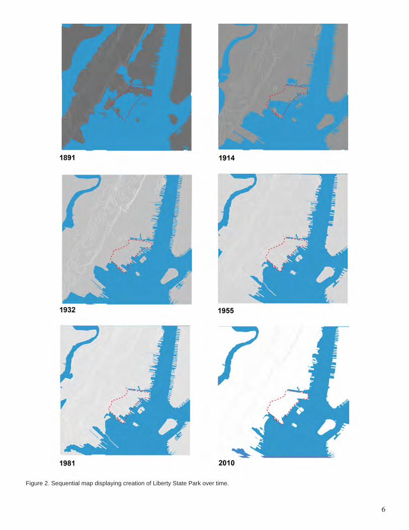
Figure 2. Sequential map displaying creation of Liberty State Park over time.
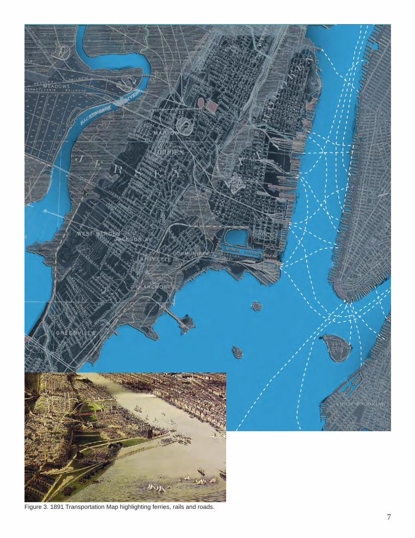
7Figure 3. 1891 Transportation Map highlighting ferries, rails and roads.
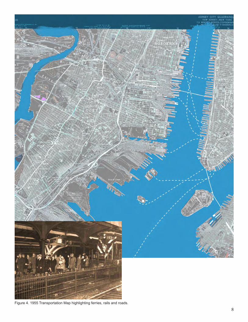
8Figure 4. 1955 Transportation Map highlighting ferries, rails and roads.
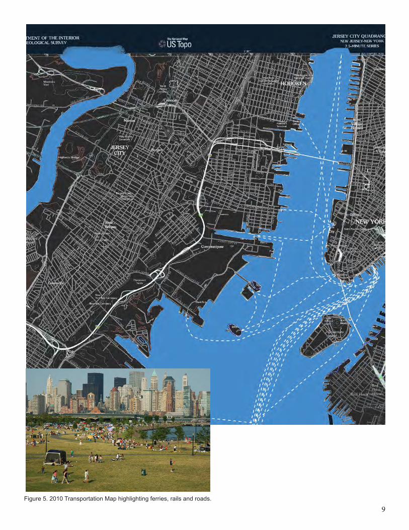
9Figure 5. 2010 Transportation Map highlighting ferries, rails and roads.
10
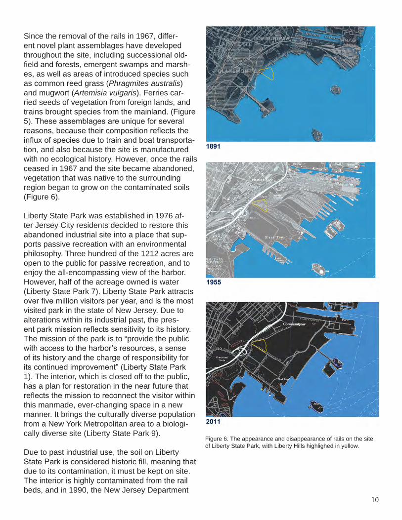
Figure 6. The appearance and disappearance of rails on the site of Liberty State Park, with Liberty Hills highlighed in yellow.
Since the removal of the rails in 1967, differ-ent novel plant assemblages have developed throughout the site, including successional old-field and forests, emergent swamps and marsh-es, as well as areas of introduced species such as common reed grass (Phragmites australis) and mugwort (Artemisia vulgaris). Ferries car-ried seeds of vegetation from foreign lands, and trains brought species from the mainland. (Figure 5). These assemblages are unique for several reasons, because their composition reflects the influx of species due to train and boat transporta-tion, and also because the site is manufactured with no ecological history. However, once the rails ceased in 1967 and the site became abandoned, vegetation that was native to the surrounding region began to grow on the contaminated soils (Figure 6).
Liberty State Park was established in 1976 af-ter Jersey City residents decided to restore this abandoned industrial site into a place that sup-ports passive recreation with an environmental philosophy. Three hundred of the 1212 acres are open to the public for passive recreation, and to enjoy the all-encompassing view of the harbor. However, half of the acreage owned is water (Liberty State Park 7). Liberty State Park attracts over five million visitors per year, and is the most visited park in the state of New Jersey. Due to alterations within its industrial past, the pres-ent park mission reflects sensitivity to its history. The mission of the park is to “provide the public with access to the harbor’s resources, a sense of its history and the charge of responsibility for its continued improvement” (Liberty State Park 1). The interior, which is closed off to the public, has a plan for restoration in the near future that reflects the mission to reconnect the visitor within this manmade, ever-changing space in a new manner. It brings the culturally diverse population from a New York Metropolitan area to a biologi-cally diverse site (Liberty State Park 9).
Due to past industrial use, the soil on Liberty State Park is considered historic fill, meaning that due to its contamination, it must be kept on site. The interior is highly contaminated from the rail beds, and in 1990, the New Jersey Department
11
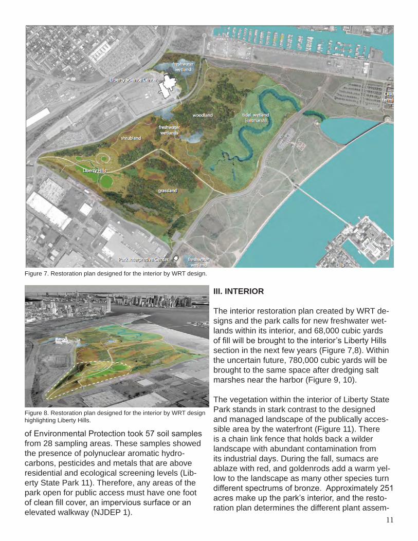
Figure 7. Restoration plan designed for the interior by WRT design.
Figure 8. Restoration plan designed for the interior by WRT design highlighting Liberty Hills.
of Environmental Protection took 57 soil samples from 28 sampling areas. These samples showed the presence of polynuclear aromatic hydro-carbons, pesticides and metals that are above residential and ecological screening levels (Lib-erty State Park 11). Therefore, any areas of the park open for public access must have one foot of clean fill cover, an impervious surface or an elevated walkway (NJDEP 1).
III. INTERIOR
The interior restoration plan created by WRT de-signs and the park calls for new freshwater wet-lands within its interior, and 68,000 cubic yards of fill will be brought to the interior’s Liberty Hills section in the next few years (Figure 7,8). Within the uncertain future, 780,000 cubic yards will be brought to the same space after dredging salt marshes near the harbor (Figure 9, 10).
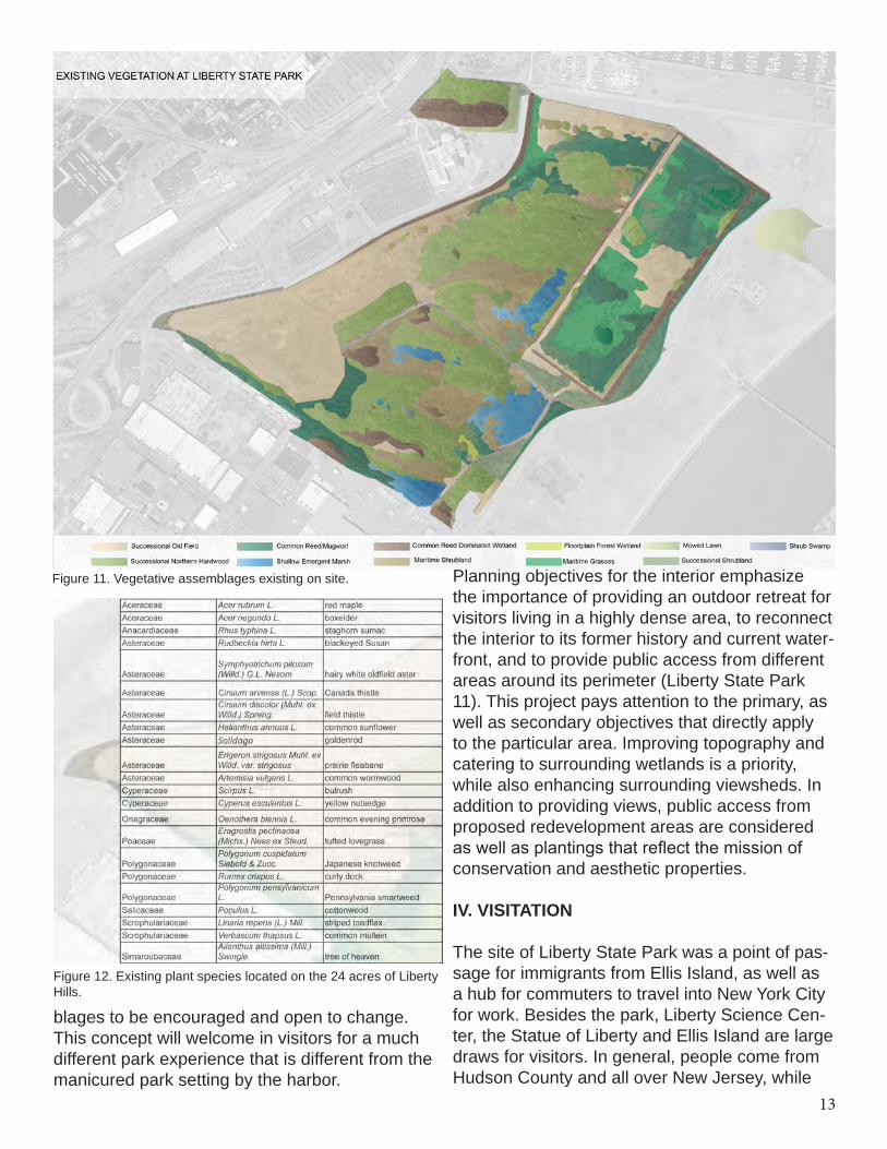
The vegetation within the interior of Liberty State Park stands in stark contrast to the designed and managed landscape of the publically acces-sible area by the waterfront (Figure 11). There is a chain link fence that holds back a wilder landscape with abundant contamination from its industrial days. During the fall, sumacs are ablaze with red, and goldenrods add a warm yel-low to the landscape as many other species turn different spectrums of bronze. Approximately 251 acres make up the park’s interior, and the resto-ration plan determines the different plant assem-
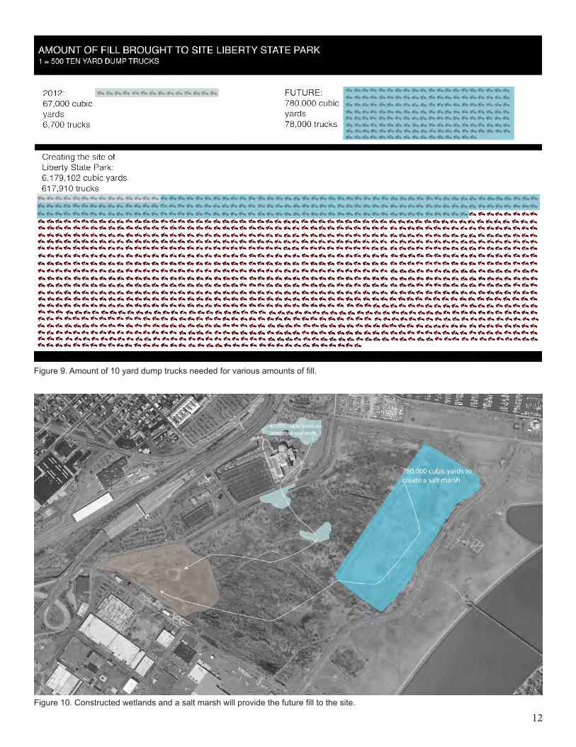
12Figure 10. Constructed wetlands and a salt marsh will provide the future fill to the site.
Figure 9. Amount of 10 yard dump trucks needed for various amounts of fill.
13
Planning objectives for the interior emphasize the importance of providing an outdoor retreat for visitors living in a highly dense area, to reconnect the interior to its former history and current water-front, and to provide public access from different areas around its perimeter (Liberty State Park 11). This project pays attention to the primary, as well as secondary objectives that directly apply to the particular area. Improving topography and catering to surrounding wetlands is a priority, while also enhancing surrounding viewsheds. In addition to providing views, public access from proposed redevelopment areas are considered as well as plantings that reflect the mission of conservation and aesthetic properties.
IV. VISITATION
The site of Liberty State Park was a point of pas-sage for immigrants from Ellis Island, as well as a hub for commuters to travel into New York City for work. Besides the park, Liberty Science Cen-ter, the Statue of Liberty and Ellis Island are large draws for visitors. In general, people come from Hudson County and all over New Jersey, while
blages to be encouraged and open to change. This concept will welcome in visitors for a much different park experience that is different from the manicured park setting by the harbor.
Figure 11. Vegetative assemblages existing on site.
Figure 12. Existing plant species located on the 24 acres of Liberty Hills.
14
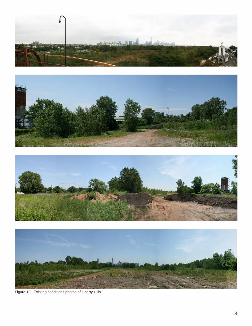
Figure 13. Existing conditions photos of Liberty Hills.
15
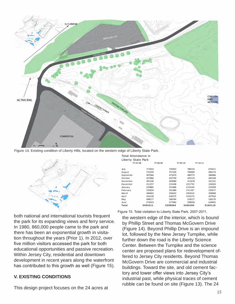
both national and international tourists frequent the park for its expanding views and ferry service. In 1980, 860,000 people came to the park and there has been an exponential growth in visita-tion throughout the years (Prior 1). In 2012, over five million visitors accessed the park for both educational opportunities and passive recreation. Within Jersey City, residential and downtown development in recent years along the waterfront has contributed to this growth as well (Figure 15).
V. EXISTING CONDITIONS
This design project focuses on the 24 acres at
Figure 14. Existing condition of Liberty Hills, located on the western edge of Liberty State Park.
Figure 15. Total visitation to Liberty State Park, 2007-2011.
Total Attendance in Liberty State Park
FY 07-‐08 FY 08-‐09 FY 09-‐10 FY 10-‐11
July 717033 735953 780153 674311August 721039 757339 796999 696174September 407066 471670 480775 380086October 427886 432749 445123 465338November 301530 303080 311678 321521December 211257 215448 220750 226263January 223885 231486 223648 219109February 235824 241486 241487 235677March 360663 356632 380818 358968April 416128 426575 426676 427910May 498577 548784 559217 536270June 573423 577482 599056 618491Total 5094311 5298684 5466380 5160118
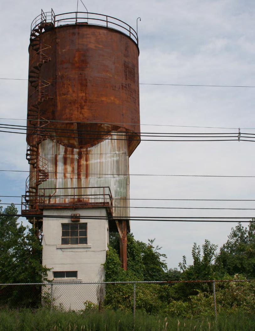
the western edge of the interior, which is bound by Phillip Street and Thomas McGovern Drive (Figure 14). Beyond Phillip Drive is an impound lot, followed by the New Jersey Turnpike, while further down the road is the Liberty Science Center. Between the Turnpike and the science center are proposed plans for redevelopment of-fered to Jersey City residents. Beyond Thomas McGovern Drive are commercial and industrial buildings. Toward the site, and old cement fac-tory and tower offer views into Jersey City’s industrial past, while physical traces of cement rubble can be found on site (Figure 13). The 24
16
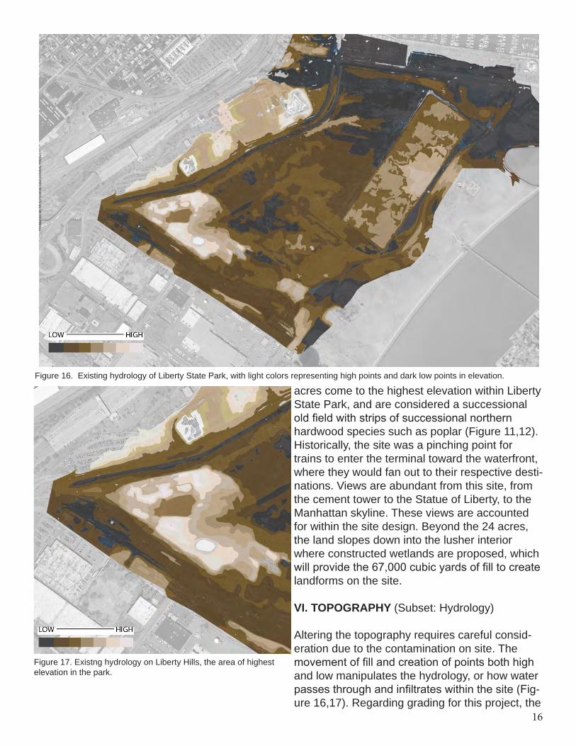
Figure 17. Existng hydrology on Liberty Hills, the area of highest elevation in the park.
acres come to the highest elevation within Liberty State Park, and are considered a successional old field with strips of successional northern hardwood species such as poplar (Figure 11,12). Historically, the site was a pinching point for trains to enter the terminal toward the waterfront, where they would fan out to their respective desti-nations. Views are abundant from this site, from the cement tower to the Statue of Liberty, to the Manhattan skyline. These views are accounted for within the site design. Beyond the 24 acres, the land slopes down into the lusher interior where constructed wetlands are proposed, which will provide the 67,000 cubic yards of fill to create landforms on the site.
VI. TOPOGRAPHY (Subset: Hydrology)
Altering the topography requires careful consid-eration due to the contamination on site. The movement of fill and creation of points both high and low manipulates the hydrology, or how water passes through and infiltrates within the site (Fig-ure 16,17). Regarding grading for this project, the
Figure 16. Existing hydrology of Liberty State Park, with light colors representing high points and dark low points in elevation.
17
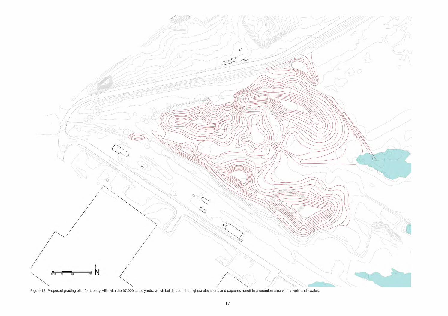
Figure 18. Proposed grading plan for Liberty Hills with the 67,000 cubic yards, which builds upon the highest elevations and captures runoff in a retention area with a weir, and swales.
18
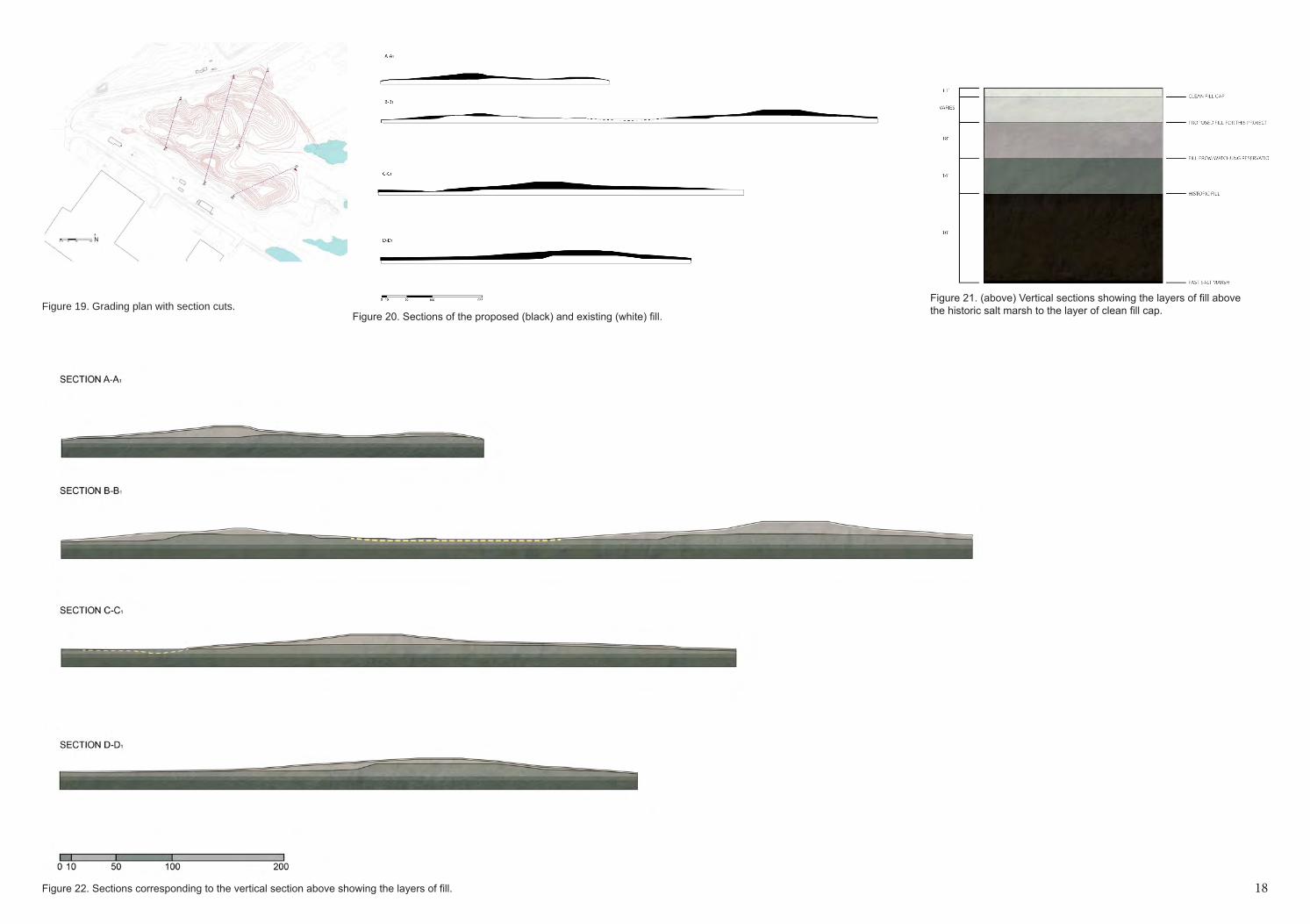
Figure 19. Grading plan with section cuts. Figure 20. Sections of the proposed (black) and existing (white) fill.
Figure 21. (above) Vertical sections showing the layers of fill above the historic salt marsh to the layer of clean fill cap.
18Figure 22. Sections corresponding to the vertical section above showing the layers of fill.
19
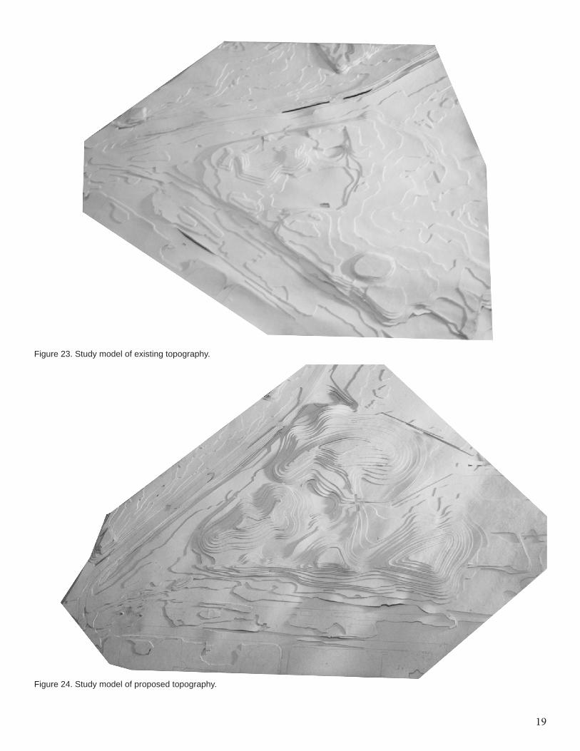
Figure 23. Study model of existing topography.
Figure 24. Study model of proposed topography.
20
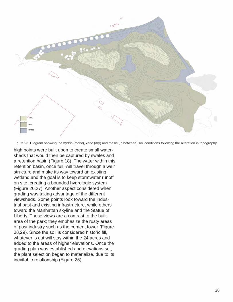
Figure 25. Diagram showing the hydric (moist), xeric (dry) and mesic (in between) soil conditions following the alteration in topography.
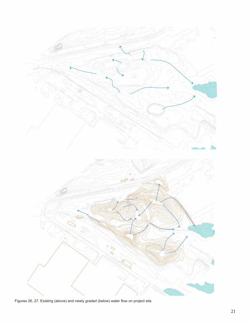
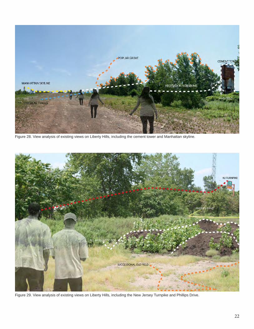
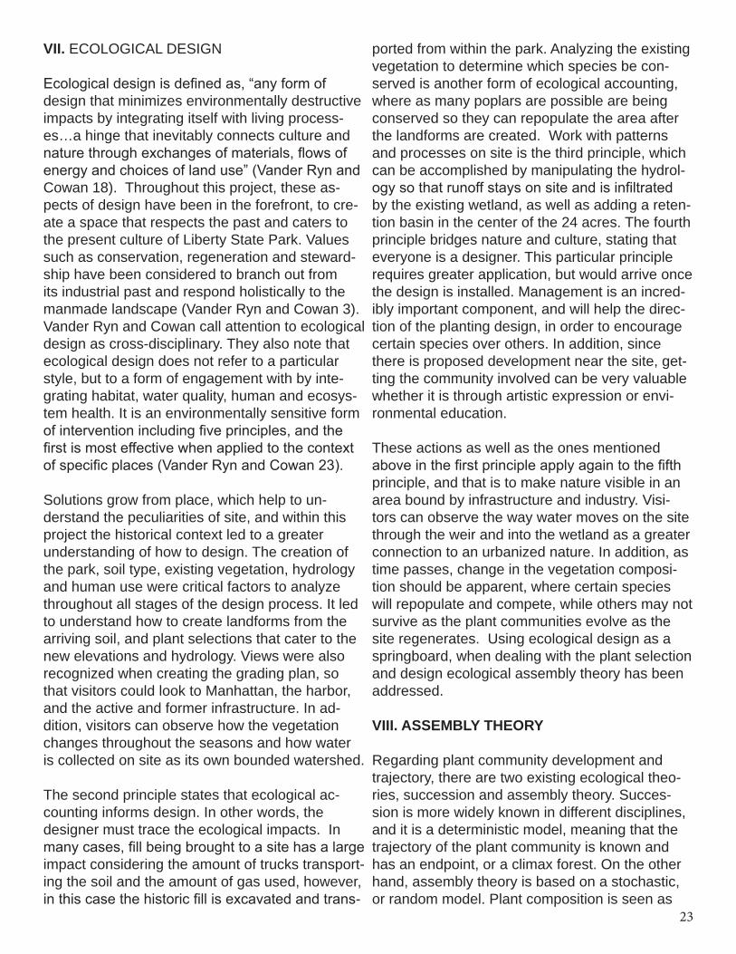
high points were built upon to create small water-sheds that would then be captured by swales and a retention basin (Figure 18). The water within this retention basin, once full, will travel through a weir structure and make its way toward an existing wetland and the goal is to keep stormwater runoff on site, creating a bounded hydrologic system (Figure 26,27). Another aspect considered when grading was taking advantage of the different viewsheds. Some points look toward the indus-trial past and existing infrastructure, while others toward the Manhattan skyline and the Statue of Liberty. These views are a contrast to the built area of the park; they emphasize the rusty areas of post industry such as the cement tower (Figure 28,29). Since the soil is considered historic fill, whatever is cut will stay within the 24 acres and added to the areas of higher elevations. Once the grading plan was established and elevations set, the plant selection began to materialize, due to its inevitable relationship (Figure 25).
21
Figures 26, 27. Existing (above) and newly graded (below) water flow on project site.
22
Figure 28. View analysis of existing views on Liberty Hills, including the cement tower and Manhattan skyline.
Figure 29. View analysis of existing views on Liberty Hills, including the New Jersey Turnpike and Phillips Drive.
23
VII. ECOLOGICAL DESIGN
Ecological design is defined as, “any form of design that minimizes environmentally destructive impacts by integrating itself with living process-es…a hinge that inevitably connects culture and nature through exchanges of materials, flows of energy and choices of land use” (Vander Ryn and Cowan 18). Throughout this project, these as-pects of design have been in the forefront, to cre-ate a space that respects the past and caters to the present culture of Liberty State Park. Values such as conservation, regeneration and steward-ship have been considered to branch out from its industrial past and respond holistically to the manmade landscape (Vander Ryn and Cowan 3). Vander Ryn and Cowan call attention to ecological design as cross-disciplinary. They also note that ecological design does not refer to a particular style, but to a form of engagement with by inte-grating habitat, water quality, human and ecosys-tem health. It is an environmentally sensitive form of intervention including five principles, and the first is most effective when applied to the context of specific places (Vander Ryn and Cowan 23).
Solutions grow from place, which help to un-derstand the peculiarities of site, and within this project the historical context led to a greater understanding of how to design. The creation of the park, soil type, existing vegetation, hydrology and human use were critical factors to analyze throughout all stages of the design process. It led to understand how to create landforms from the arriving soil, and plant selections that cater to the new elevations and hydrology. Views were also recognized when creating the grading plan, so that visitors could look to Manhattan, the harbor, and the active and former infrastructure. In ad-dition, visitors can observe how the vegetation changes throughout the seasons and how water is collected on site as its own bounded watershed.
The second principle states that ecological ac-counting informs design. In other words, the designer must trace the ecological impacts. In many cases, fill being brought to a site has a large impact considering the amount of trucks transport-ing the soil and the amount of gas used, however, in this case the historic fill is excavated and trans-
ported from within the park. Analyzing the existing vegetation to determine which species be con-served is another form of ecological accounting, where as many poplars are possible are being conserved so they can repopulate the area after the landforms are created. Work with patterns and processes on site is the third principle, which can be accomplished by manipulating the hydrol-ogy so that runoff stays on site and is infiltrated by the existing wetland, as well as adding a reten-tion basin in the center of the 24 acres. The fourth principle bridges nature and culture, stating that everyone is a designer. This particular principle requires greater application, but would arrive once the design is installed. Management is an incred-ibly important component, and will help the direc-tion of the planting design, in order to encourage certain species over others. In addition, since there is proposed development near the site, get-ting the community involved can be very valuable whether it is through artistic expression or envi-ronmental education.
These actions as well as the ones mentioned above in the first principle apply again to the fifth principle, and that is to make nature visible in an area bound by infrastructure and industry. Visi-tors can observe the way water moves on the site through the weir and into the wetland as a greater connection to an urbanized nature. In addition, as time passes, change in the vegetation composi-tion should be apparent, where certain species will repopulate and compete, while others may not survive as the plant communities evolve as the site regenerates. Using ecological design as a springboard, when dealing with the plant selection and design ecological assembly theory has been addressed.
VIII. ASSEMBLY THEORY
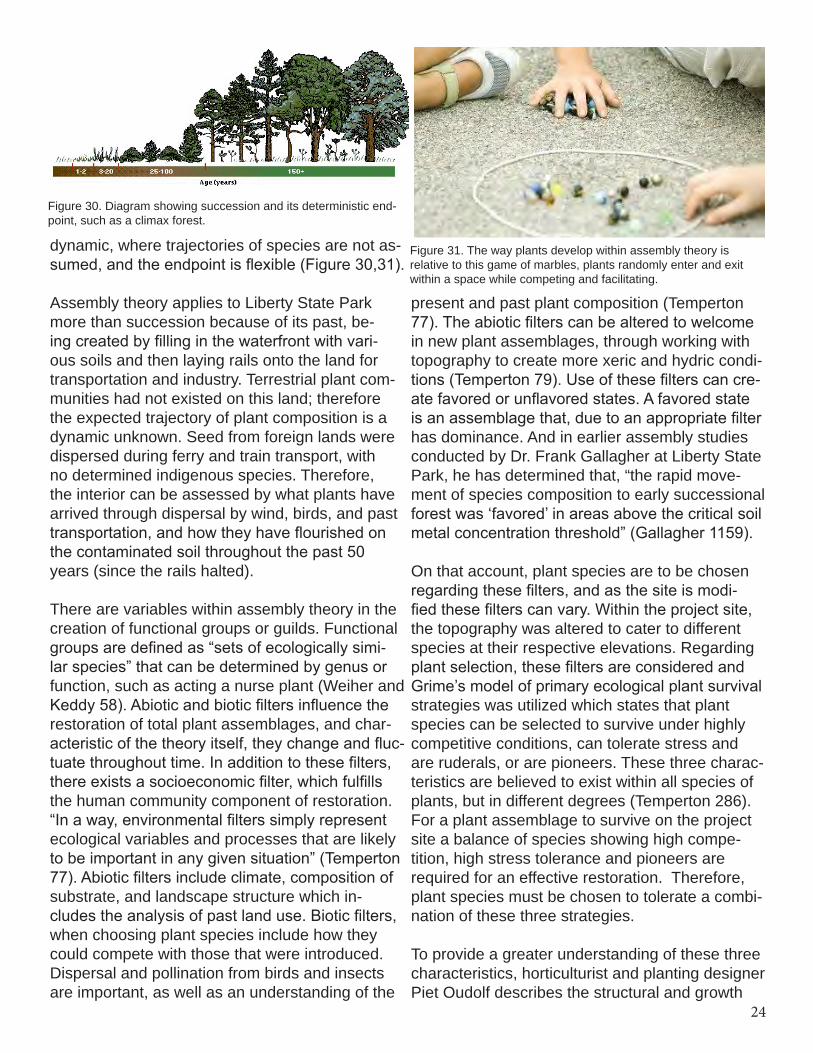
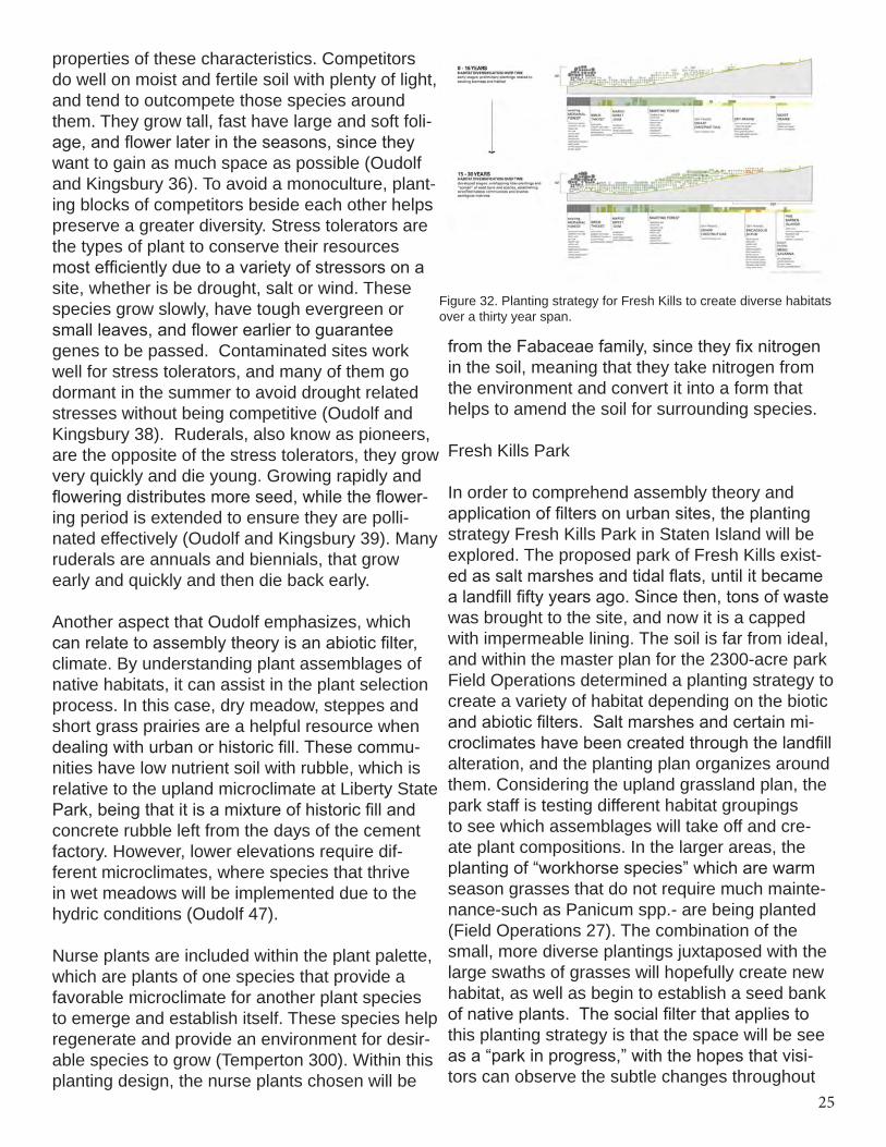
Regarding plant community development and trajectory, there are two existing ecological theo-ries, succession and assembly theory. Succes-sion is more widely known in different disciplines, and it is a deterministic model, meaning that the trajectory of the plant community is known and has an endpoint, or a climax forest. On the other hand, assembly theory is based on a stochastic, or random model. Plant composition is seen as
24
dynamic, where trajectories of species are not as-sumed, and the endpoint is flexible (Figure 30,31).
Assembly theory applies to Liberty State Park more than succession because of its past, be-ing created by filling in the waterfront with vari-ous soils and then laying rails onto the land for transportation and industry. Terrestrial plant com-munities had not existed on this land; therefore the expected trajectory of plant composition is a dynamic unknown. Seed from foreign lands were dispersed during ferry and train transport, with no determined indigenous species. Therefore, the interior can be assessed by what plants have arrived through dispersal by wind, birds, and past transportation, and how they have flourished on the contaminated soil throughout the past 50 years (since the rails halted).
There are variables within assembly theory in the creation of functional groups or guilds. Functional groups are defined as “sets of ecologically simi-lar species” that can be determined by genus or function, such as acting a nurse plant (Weiher and Keddy 58). Abiotic and biotic filters influence the restoration of total plant assemblages, and char-acteristic of the theory itself, they change and fluc-tuate throughout time. In addition to these filters, there exists a socioeconomic filter, which fulfills the human community component of restoration. “In a way, environmental filters simply represent ecological variables and processes that are likely to be important in any given situation” (Temperton 77). Abiotic filters include climate, composition of substrate, and landscape structure which in-cludes the analysis of past land use. Biotic filters, when choosing plant species include how they could compete with those that were introduced. Dispersal and pollination from birds and insects are important, as well as an understanding of the
present and past plant composition (Temperton 77). The abiotic filters can be altered to welcome in new plant assemblages, through working with topography to create more xeric and hydric condi-tions (Temperton 79). Use of these filters can cre-ate favored or unflavored states. A favored state is an assemblage that, due to an appropriate filter has dominance. And in earlier assembly studies conducted by Dr. Frank Gallagher at Liberty State Park, he has determined that, “the rapid move-ment of species composition to early successional forest was ‘favored’ in areas above the critical soil metal concentration threshold” (Gallagher 1159).
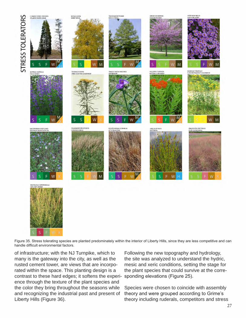
On that account, plant species are to be chosen regarding these filters, and as the site is modi-fied these filters can vary. Within the project site, the topography was altered to cater to different species at their respective elevations. Regarding plant selection, these filters are considered and Grime’s model of primary ecological plant survival strategies was utilized which states that plant species can be selected to survive under highly competitive conditions, can tolerate stress and are ruderals, or are pioneers. These three charac-teristics are believed to exist within all species of plants, but in different degrees (Temperton 286). For a plant assemblage to survive on the project site a balance of species showing high compe-tition, high stress tolerance and pioneers are required for an effective restoration. Therefore, plant species must be chosen to tolerate a combi-nation of these three strategies.
To provide a greater understanding of these three characteristics, horticulturist and planting designer Piet Oudolf describes the structural and growth
Figure 30. Diagram showing succession and its deterministic end-point, such as a climax forest.
Figure 31. The way plants develop within assembly theory is relative to this game of marbles, plants randomly enter and exit within a space while competing and facilitating.
25
Figure 32. Planting strategy for Fresh Kills to create diverse habitats over a thirty year span.
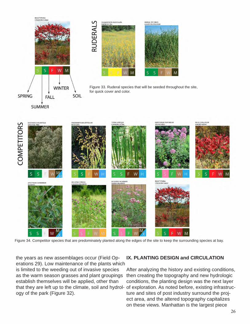
properties of these characteristics. Competitors do well on moist and fertile soil with plenty of light, and tend to outcompete those species around them. They grow tall, fast have large and soft foli-age, and flower later in the seasons, since they want to gain as much space as possible (Oudolf and Kingsbury 36). To avoid a monoculture, plant-ing blocks of competitors beside each other helps preserve a greater diversity. Stress tolerators are the types of plant to conserve their resources most efficiently due to a variety of stressors on a site, whether is be drought, salt or wind. These species grow slowly, have tough evergreen or small leaves, and flower earlier to guarantee genes to be passed. Contaminated sites work well for stress tolerators, and many of them go dormant in the summer to avoid drought related stresses without being competitive (Oudolf and Kingsbury 38). Ruderals, also know as pioneers, are the opposite of the stress tolerators, they grow very quickly and die young. Growing rapidly and flowering distributes more seed, while the flower-ing period is extended to ensure they are polli-nated effectively (Oudolf and Kingsbury 39). Many ruderals are annuals and biennials, that grow early and quickly and then die back early.
Another aspect that Oudolf emphasizes, which can relate to assembly theory is an abiotic filter, climate. By understanding plant assemblages of native habitats, it can assist in the plant selection process. In this case, dry meadow, steppes and short grass prairies are a helpful resource when dealing with urban or historic fill. These commu-nities have low nutrient soil with rubble, which is relative to the upland microclimate at Liberty State Park, being that it is a mixture of historic fill and concrete rubble left from the days of the cement factory. However, lower elevations require dif-ferent microclimates, where species that thrive in wet meadows will be implemented due to the hydric conditions (Oudolf 47).
Nurse plants are included within the plant palette, which are plants of one species that provide a favorable microclimate for another plant species to emerge and establish itself. These species help regenerate and provide an environment for desir-able species to grow (Temperton 300). Within this planting design, the nurse plants chosen will be
from the Fabaceae family, since they fix nitrogen in the soil, meaning that they take nitrogen from the environment and convert it into a form that helps to amend the soil for surrounding species.
Fresh Kills Park
In order to comprehend assembly theory and application of filters on urban sites, the planting strategy Fresh Kills Park in Staten Island will be explored. The proposed park of Fresh Kills exist-ed as salt marshes and tidal flats, until it became a landfill fifty years ago. Since then, tons of waste was brought to the site, and now it is a capped with impermeable lining. The soil is far from ideal, and within the master plan for the 2300-acre park Field Operations determined a planting strategy to create a variety of habitat depending on the biotic and abiotic filters. Salt marshes and certain mi-croclimates have been created through the landfill alteration, and the planting plan organizes around them. Considering the upland grassland plan, the park staff is testing different habitat groupings to see which assemblages will take off and cre-ate plant compositions. In the larger areas, the planting of “workhorse species” which are warm season grasses that do not require much mainte-nance-such as Panicum spp.- are being planted (Field Operations 27). The combination of the small, more diverse plantings juxtaposed with the large swaths of grasses will hopefully create new habitat, as well as begin to establish a seed bank of native plants. The social filter that applies to this planting strategy is that the space will be see as a “park in progress,” with the hopes that visi-tors can observe the subtle changes throughout
26
Figure 33. Ruderal species that will be seeded throughout the site, for quick cover and color.
Figure 34. Competitor species that are predominately planted along the edges of the site to keep the surrounding species at bay.
the years as new assemblages occur (Field Op-erations 29). Low maintenance of the plants which is limited to the weeding out of invasive species as the warm season grasses and plant groupings establish themselves will be applied, other than that they are left up to the climate, soil and hydrol-ogy of the park (Figure 32).
IX. PLANTING DESIGN and CIRCULATION
After analyzing the history and existing conditions, then creating the topography and new hydrologic conditions, the planting design was the next layer of exploration. As noted before, existing infrastruc-ture and sites of post industry surround the proj-ect area, and the altered topography capitalizes on these views. Manhattan is the largest piece
27
Figure 35. Stress tolerating species are planted predominately within the interior of Liberty Hills, since they are less competitive and can handle difficult environmental factors.
of infrastructure; with the NJ Turnpike, which to many is the gateway into the city, as well as the rusted cement tower, are views that are incorpo-rated within the space. This planting design is a contrast to these hard edges; it softens the experi-ence through the texture of the plant species and the color they bring throughout the seasons while and recognizing the industrial past and present of Liberty Hills (Figure 36).
Following the new topography and hydrology, the site was analyzed to understand the hydric, mesic and xeric conditions, setting the stage for the plant species that could survive at the corre-sponding elevations (Figure 25).
Species were chosen to coincide with assembly theory and were grouped according to Grime’s theory including ruderals, competitors and stress
28
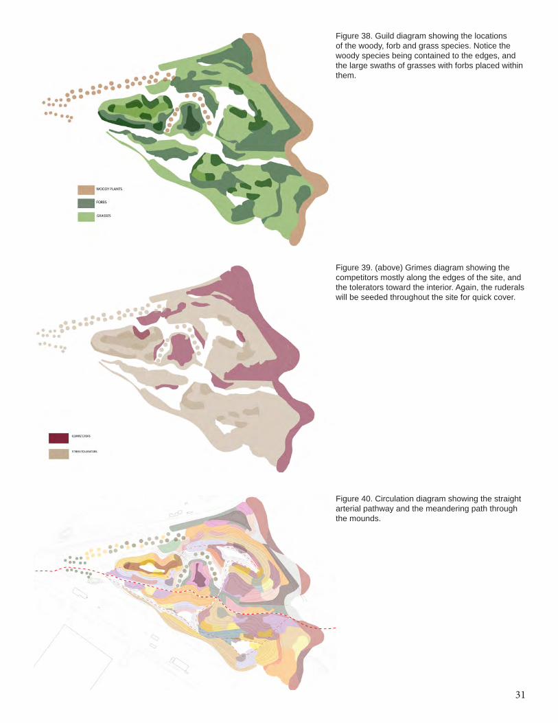
tolerators. The majority of the species were pulled from the park’s existing vegetation, to create a new assemblage within the interior where com-petition and facilitation is encouraged (Figure 33,34,35). Ruderals that will come up the first year are partridge pea (Chamaecrista fascicu-lata) and annual rye grass (Lolium multiflorum). These species will create space and be seeded all over the site to cover ground, as well as dying back which offers organic mulch to encourage the slower growers. Competitors were planted along the edges of the site, bordering up against the existing assemblages within the interior in order to create a competitive boundary (Figure 39). The stress tolerators were planted toward the interior of the site, mostly consisting of large swaths of grasses with forbs planted within them (Figure 38).
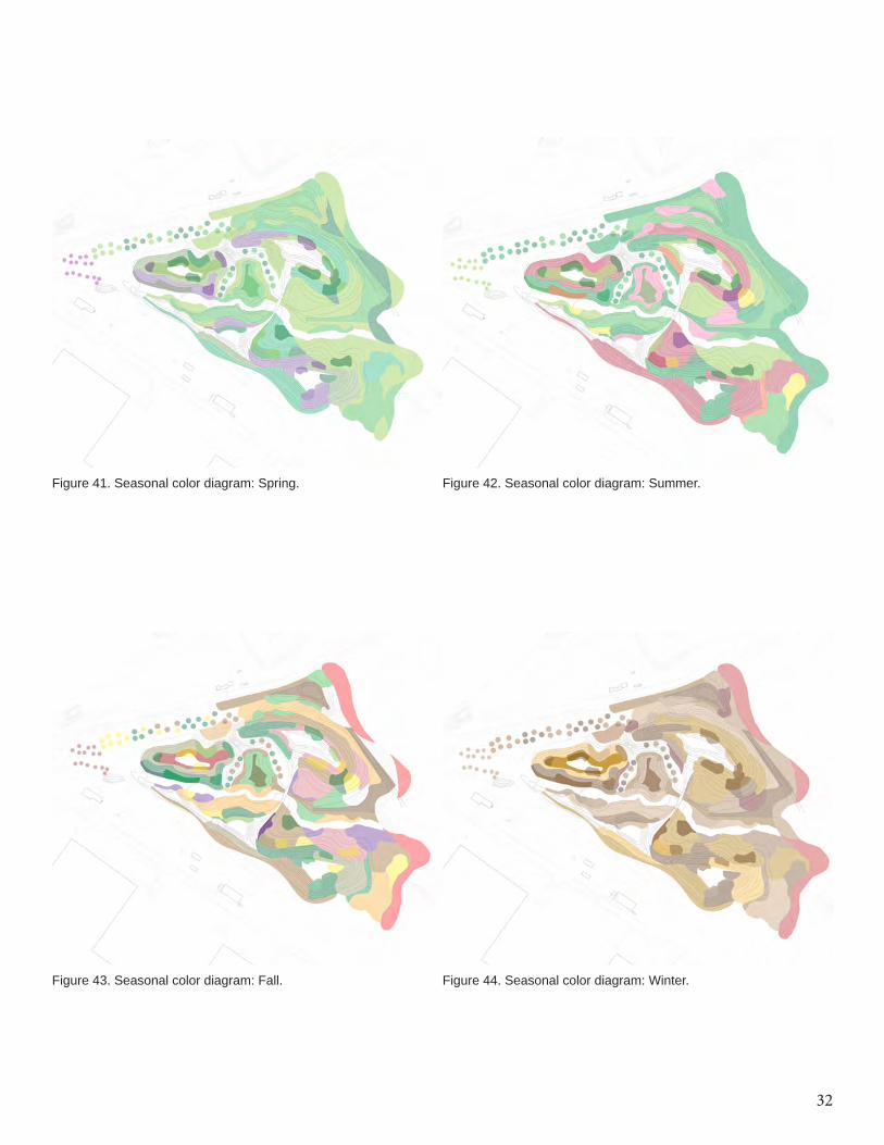
Woody plant species are seen along the edges acting as a vegetative screening, as well as sur-rounding the central low point to provide some shade for visitors. On the planting plan, lawn is represented as white, where people can gather alongside and throughout the assemblage while looking to the surrounding views (Figure 37). Sea-sonal interest was considered in the choice and placement of plant species, where forbs can offer bright flowers through spring and into fall, and the grasses turn ranges of gold to bronze in the colder months (Figure 41-44).
Pathways lead through the site on a 12’ wide main artery that consists of recycled concrete, and provides enough space for pedestrians and bikers to walk comfortably. This path is reminiscent of the past rails, and cement rubble from the existing site is used to create this path as homage to its industrial past. As for the narrower 6’ pathways, crushed shell is utilized for a softer, more mean-dering experience that is sometimes bordered by lawn space at the high points, while others are completely surrounded by plant species (Pages 32-36). Regarding visitation, although there are millions of visitors per year it is expected that a small fraction will visit Liberty Hills at once, con-sidering the other varying experiences that the park offers throughout the seasons (Figure 15).
X. CONCLUSION
Designing a planting strategy on a manufactured site is a complex undertaking that requires an understanding of the historic and physical pro-cesses. Assembly theory offers a different design lens for planting scenarios on post-industrial landscapes. The biotic and abiotic filters were a driving force on what to alter on the site, whether it be soil, hydrology, or plant materials. Analyzing the existing conditions and plant species within the surrounding assemblages was a helpful pro-cess to begin to see how a different assemblage can form at Liberty Hills. Beyond the physical processes, the visitor experience was incorpo-rated to offer views as homage to the surrounding infrastructure and bring people through the plant species on site to experience their seasonality, texture and color.
XI. FUTURE WORK
As this project illustrates, planting design is much more than the artful composition of plants. After devising a plan incorporating views and circula-tion, it is only the beginning of the entire process. Plant species will be seeded and planted, and after many years will the assemblage begin to change, facilitate and compete. Change is en-couraged, and Liberty Hills will not be managed as a static form with defined planting beds and edges. Management strategies will be a future measure to take as opposed to mowing all of the grasses, weeding out woody plants and pulling out “invasive” species. It will depend on different species and how they interact with each other on site, and which ones will be encouraged to com-pete or facilitate. XII. BIBLIOGRAPHY
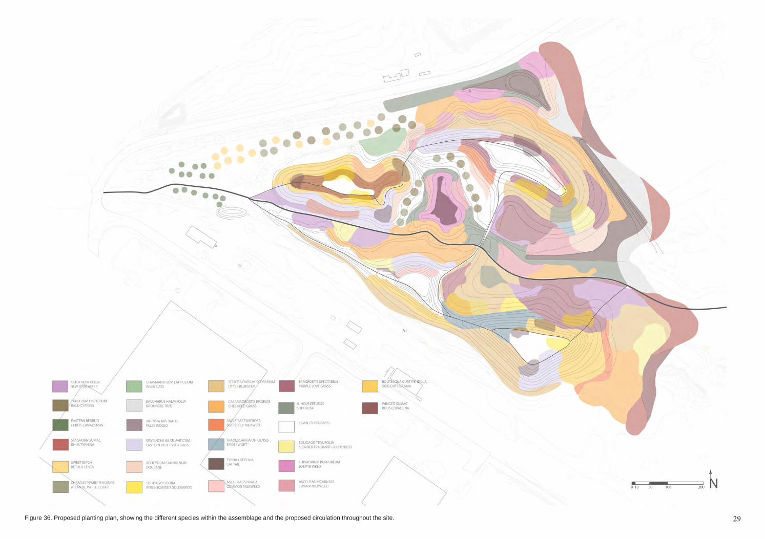
29Figure 36. Proposed planting plan, showing the different species within the assemblage and the proposed circulation throughout the site. 29
30
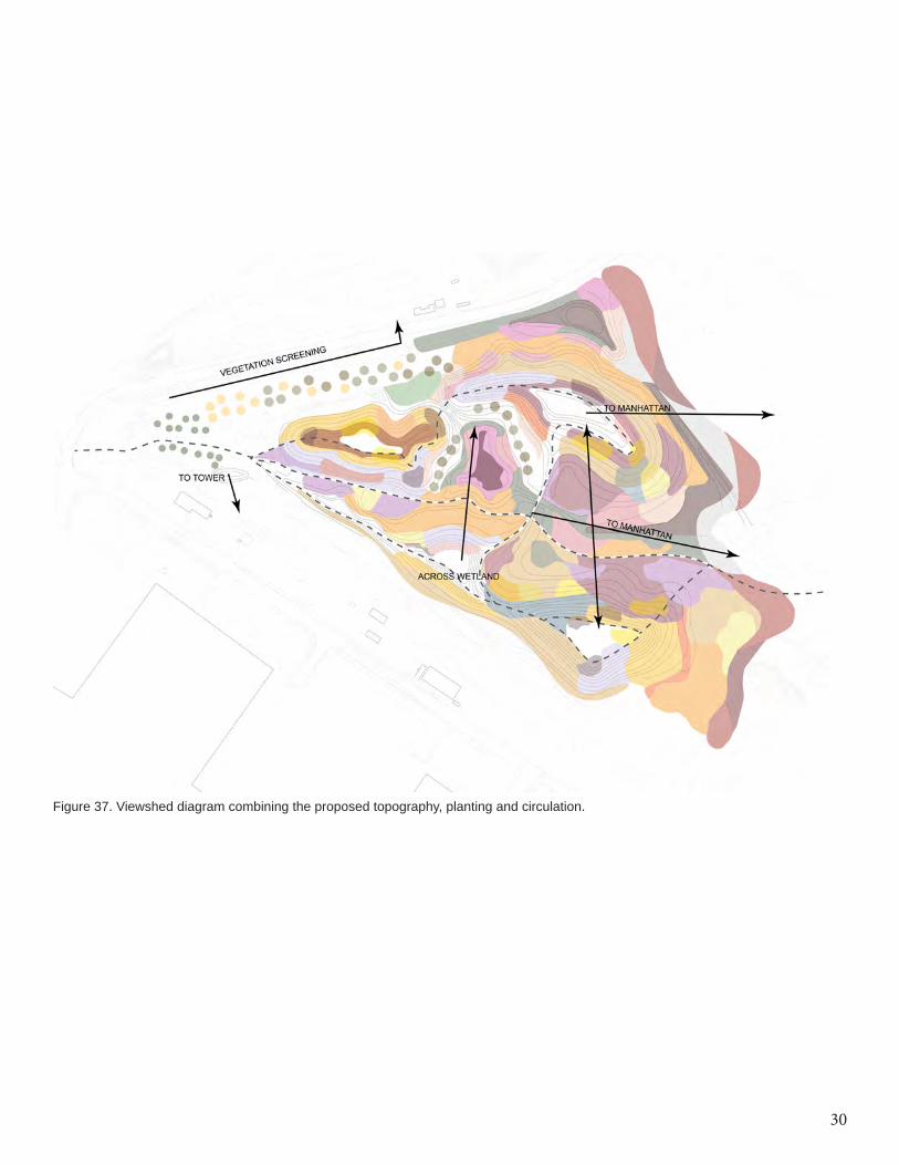
Figure 37. Viewshed diagram combining the proposed topography, planting and circulation.
31
Figure 38. Guild diagram showing the locations of the woody, forb and grass species. Notice the woody species being contained to the edges, and the large swaths of grasses with forbs placed within them.
Figure 39. (above) Grimes diagram showing the competitors mostly along the edges of the site, and the tolerators toward the interior. Again, the ruderals will be seeded throughout the site for quick cover.
Figure 40. Circulation diagram showing the straight arterial pathway and the meandering path through the mounds.
32
Figure 41. Seasonal color diagram: Spring. Figure 42. Seasonal color diagram: Summer.
Figure 43. Seasonal color diagram: Fall. Figure 44. Seasonal color diagram: Winter.
33
VIEW TO POPLAR GROVEVIEW ACROSS SITE
VIEW INTO INTERIOR AND MANHATTAN
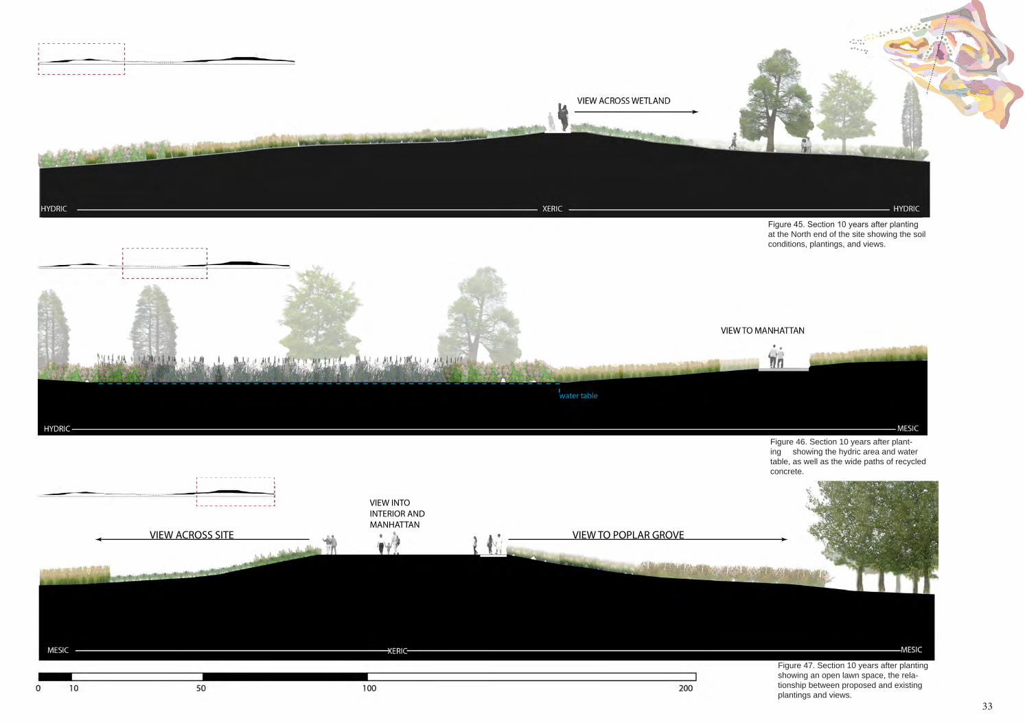
Figure 45. Section 10 years after planting at the North end of the site showing the soil conditions, plantings, and views.
Figure 46. Section 10 years after plant-ing showing the hydric area and water table, as well as the wide paths of recycled concrete.
Figure 47. Section 10 years after planting showing an open lawn space, the rela-tionship between proposed and existing plantings and views.
33
34
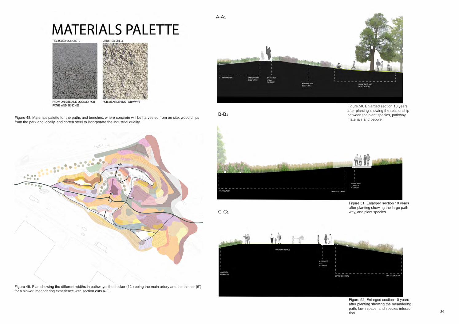
Figure 49. Plan showing the different widths in pathways, the thicker (12’) being the main artery and the thinner (6’) for a slower, meandering experience with section cuts A-E.
Figure 48. Materials palette for the paths and benches, where concrete will be harvested from on site, wood chips from the park and locally, and corten steel to incorporate the industrial quality.
Figure 51. Enlarged section 10 years after planting showing the large path-way, and plant species.
Figure 50. Enlarged section 10 years after planting showing the relationship between the plant species, pathway materials and people.
Figure 52. Enlarged section 10 years after planting showing the meandering path, lawn space, and species interac-tion.
A-A1
B-B1
C-C1
34
35
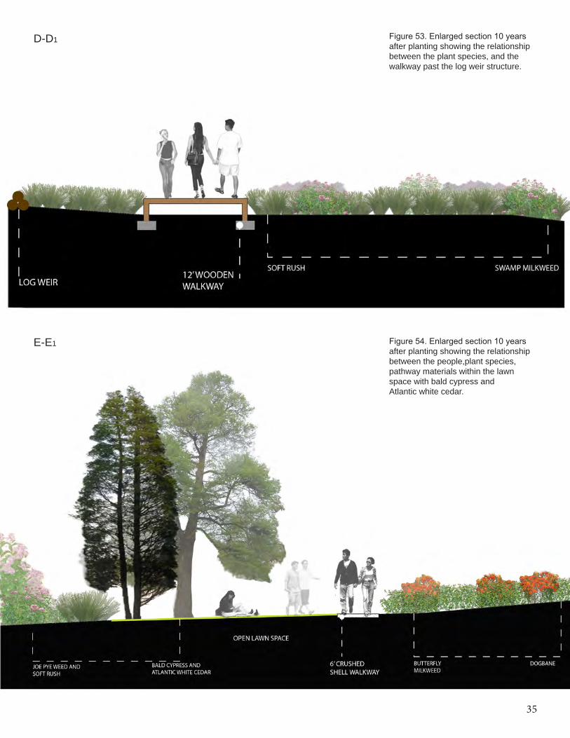
Figure 53. Enlarged section 10 years after planting showing the relationship between the plant species, and the walkway past the log weir structure.
Figure 54. Enlarged section 10 years after planting showing the relationship between the people,plant species, pathway materials within the lawn space with bald cypress andAtlantic white cedar.
D-D1
E-E1
36
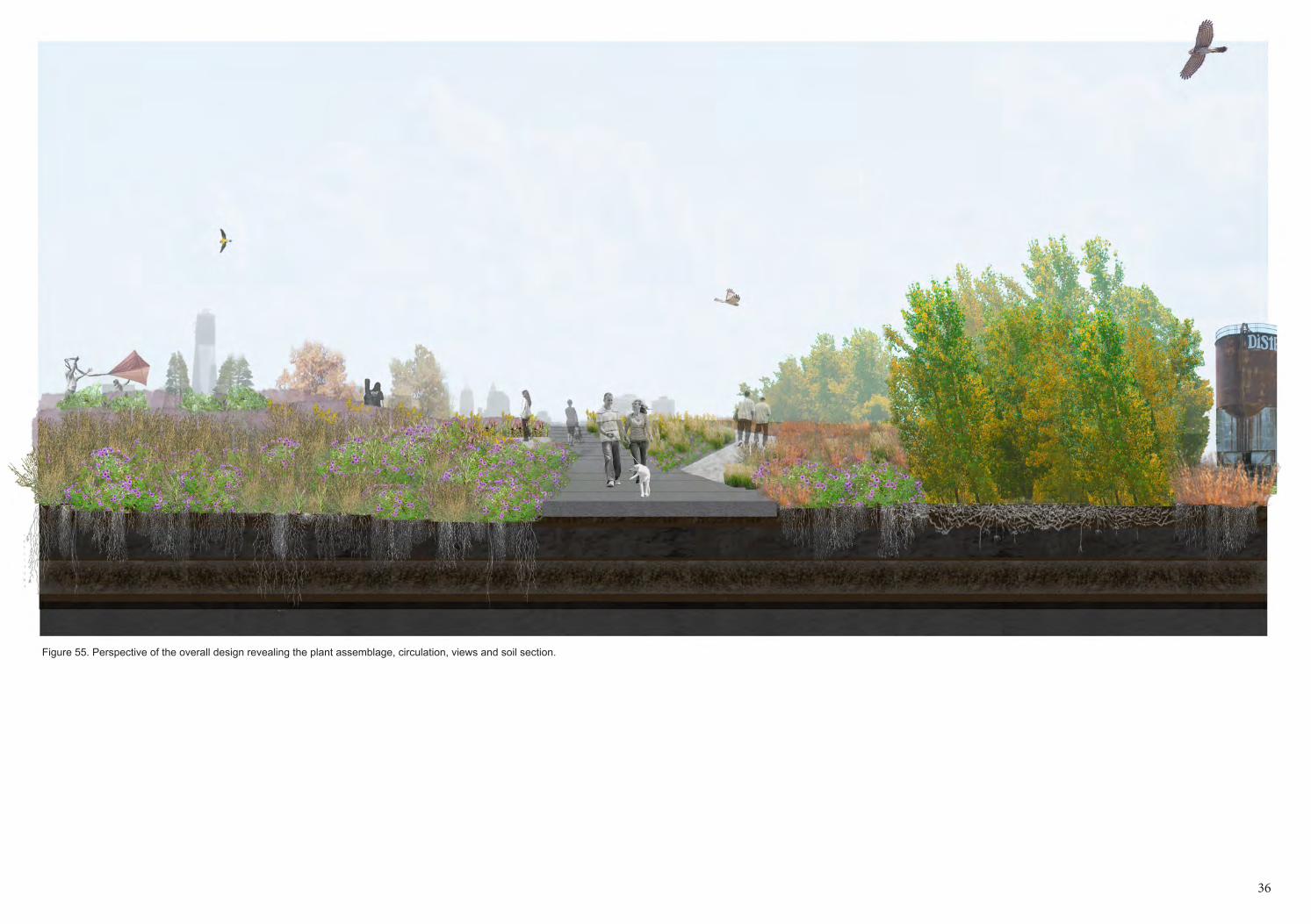
Figure 55. Perspective of the overall design revealing the plant assemblage, circulation, views and soil section.
36
37
Clifton Johnson, The Picturesque Hudson (Springfield: Mac-millan Company, 1909).
Evan Weiher and Paul Keddy, ed., Ecological Assembly Rules: Perspective, advances, retreats” (Cambridge: Cam-bridge University Press, 1999).
Frank Gallagher, “The Role of Soil Metal Contaminations in the Vegetative Assemblage Development of an Urban Brownfield,” (PhD dissertation, Rutgers University, 2008).
Gallagher, F.J., Pechmann, I. Holzapfel, C., Grabosky, J. Evidence for the Alternate Stable State Theory within the Vegetative Assemblages of an Urban Brownfield. Environ-mental Pollution. 159 (2011) 1159-1166
Friends of Liberty State Park. 2012. “Interior.” http://www.folsp.org/interior/interior.htm.Vicky M. Temperton et. al, ed., Assembly Rules and Resto-ration Ecology (Washington: Island Press, 2004).
James T. Prior, New Jersey Business, January 1999.
Liberty State Park, “The Future of Liberty State Park,” 1-24.
Joan Iverson Nassauer, “Messy Ecosystems, Orderly Frames,” Landscape Journal 14, no.2 (1995): 161-170.
Mary Carol Hunter, “Using Ecological Theory to Guide Urban Planting Design: An adaption strategy for climate change.” Landscape Journal, 30, no.2 (2011): 174-193.
Donald F. Squires, “Quantifying Anthropogenic Shoreline Modification of the Hudson River and Estuary from the Eu-ropean Contact to Modern Time,” Coastal Management 20 (1992): 343-354, accessed March 3, 2013.
Timothy J. Iannuzzi and David F. Ludwig, “An Interdisciplin-ary Investigation of Ecological History and Environmental Restoration Objectives in an Urban Landscape,” Ecological Restoration 23, no. 3 (2005): 157-166, accessed March 3, 2013.
Mattias Qviström, “Network Ruins and Green Structure Development: An Attempt to Trace Relational Spaces of a Railway Ruin,” Landscape Research 37, no.3 (2011): 257-275, accessed Februrary 21, 2013.
US Army Corps of Engineers and The Port Authority of NY & NJ, “Liberty State Park Environmental Resources Inventory,” (2004): accessed February 13, 2013.
Wilschut, M., et al., Phytoremediative urban design: Trans-forming a derelict and polluted harbour area into a green and productive neighbourhood, Environmental Pollution (2013): accessed March 5, 2013, http://dx.doi.org/10.1016/j.envpol.2013.01.033.Erik A. De Jong, “Aesthetics and Ecology, Emotion and
Reason. Perennials and a New Landscape Design: The Work of Piet Oudolf,” Landscape Legacy: Landscape Ar-chitecture and Planning Between Art and Science (2010): 149-50.
Piet Oudolf and Noel Kingsbury, Designing with Plants (Portland: Timber Press, 2007).
Piet Oudolf and Noel Kingsbury, Planting Design (Portland: Timber Press, 2005). Piet Oudolf, Landscapes in Landscapes, (New York: Mona-celli Press, 2010).
Piet Oudolf and Michael King, Gardening with Grasses, (Portland: Timber Press, 1998).
Piet Oudolf and Henk Gerritsen, Dreamplants for the Natu-ral Garden, (Portland: Timber Press, 2003).
Sim Van der Ryn and Stuart Cowan, Ecological Design, (Washington D.C.: Island Press, 1996).
Photo Credits
Figure 3. http://www.lhry.org/Images/ (historic photo)
Figure 4. http://www.lhry.org/Images/ (historic photo)
Figure 5. http://www.state.nj.us/dep/parksandforests/parks/market_parks.htm (historic photo)
Figure 7,8. WRTdesign.com
Figure 15. Liberty State Park.
Figure 29. http://www.tutorialz360.com/wp-content/up-loads/2013/02/ecological-succession1.gif
Figure 30. http://2.bp.blogspot.com/_FqFDV-L66EI/TP-j2ORGkpMI/AAAAAAAAW0U/W_tp-49n1n0/s400/marbles.jpg
Figure 31. http://www.nycgovparks.org/park-features/fresh-kills-park
4