assessment for the role of park and ride in the
TRANSCRIPT

Assessment for the Role of Park and Ride in the
Greater Dublin Area Transport Strategy
i
TP Technical Advisory Services Framework
Project no: Project Number
Document title: Assessment for the Role of Park and Ride in the Greater Dublin Area Transport Strategy
Document No.:
Revision: Final Report
Date: 19 August 2015
Client name: National Transport Authority
Client no: TP005
Project manager: Dieckmann Cogill
Author: Colm O'Dea
File name: TP-005 Final Draft Report Issued.docx
Jacobs Engineering Ireland Limited
Merrion House
Merrion Road
D4 Dublin
Ireland
T +353 1 269 5666
F +353 1 269 5497
www.jacobs.com
© Copyright 2015 Jacobs Engineering Ireland Limited. The concepts and information contained in this document are the property of Jacobs. Use
or copying of this document in whole or in part without the written permission of Jacobs constitutes an infringement of copyright.
Limitation: This report has been prepared on behalf of, and for the exclusive use of Jacobs’ Client, and is subject to, and issued in accordance with, the
provisions of the contract between Jacobs and the Client. Jacobs accepts no liability or responsibility whatsoever for, or in respect of, any use of, or reliance
upon, this report by any third party.
Document history and status
Revision Date Description By Review Approved
01 May 15,
2015
Working Draft for Initial Client Review Colm O’Dea
02 May 26,
2015
Draft Report Colm O’Dea
03 June 4, 2015 Draft Report
04 August 19,
2015
Final Draft Report Dieckmann
Cogill
Brian Sloey Brian
Sloey

Assessment for the Role of Park and Ride in the
Greater Dublin Area Transport Strategy
ii
Contents
Executive Summary .............................................................................................................................................. iv
1. Introduction ................................................................................................................................................ 1
1.1 Overview ...................................................................................................................................................... 1
1.2 Scope of the Report ..................................................................................................................................... 1
1.3 Structure of the Report ................................................................................................................................ 1
2. Integration of Park and Ride within the GDA Strategy .......................................................................... 2
3. Recommended Park and Ride Policy for the Greater Dublin Area Strategy 2035 .............................. 4
3.1 Best Practice Policy in GDA Context ........................................................................................................... 4
3.2 Rail Based Park and Ride Policy for the GDA............................................................................................. 5
3.3 Bus Based Park and Ride Policy for the GDA............................................................................................. 6
4. Recommended Park and Ride Criteria for the GDA 2035 ...................................................................... 8
4.1 Review of Case Study Park and Ride Criteria............................................................................................. 8
4.2 Criteria for Park and Ride Assessment ..................................................................................................... 10
5. Existing Park and Ride Facilities ........................................................................................................... 12
5.1 Overview of the existing facilities .............................................................................................................. 12
6. Stakeholder Engagement: Summary of Discussions Regarding Possible Future Park and Ride ........................................................................................................................................................... 14
6.1 Dublin City Council (DCC) ......................................................................................................................... 14
6.2 Fingal County Council (FCC) .................................................................................................................... 14
6.3 South Dublin County Council (SDCC) ....................................................................................................... 14
6.4 Dun Laoghaire-Rathdown County Council (DLRC) ................................................................................... 14
6.5 Meath County Council (MCC) ................................................................................................................... 15
6.6 Kildare County Council (KCC) ................................................................................................................... 15
6.7 Wicklow County Council (WCC) ................................................................................................................ 15
6.8 The Railway Procurement Agency (RPA) ................................................................................................. 15
6.9 Irish Rail (IR) .............................................................................................................................................. 15
6.10 Locations of Planned Park and Ride ......................................................................................................... 16
7. Future Transport Schemes – 2035 Strategy Transport Network ........................................................ 18
8. Facility Identification ............................................................................................................................... 20
8.1 Phase 1: Development of Inclusive Park and Ride Site List ..................................................................... 20
8.2 Phase 2: Evaluation of Road Network Characteristics and Constraints ................................................... 21
8.3 Sites Not Carried Beyond Initial Evaluation .............................................................................................. 24
8.4 Phase 3: Park and Ride Demand Modelling Evaluation ........................................................................... 26
8.5 Phase 4: Application of Evaluation Criteria to Identified Park and Ride Sites .......................................... 30
9. Identified Park and Ride for the GDA .................................................................................................... 43
9.1 Rail based Park and Ride .......................................................................................................................... 44
9.2 Bus based Park and Ride .......................................................................................................................... 45
Appendix A. Review of Park and Ride Policy and Best Practice
Appendix B. Review of Park and Ride International Case Studies

Assessment for the Role of Park and Ride in the
Greater Dublin Area Transport Strategy
iii
Assessment for the Role of Park and Ride in the
Greater Dublin Area Transport Strategy
iv
Executive Summary
This report was commissioned by the National Transport Authority to examine the role of Park and Ride in the
Greater Dublin Area Transport Strategy up to the year 2035. The purpose of this report was to review Park and
Ride policies and best practices locally and internationally to provide recommendations for Park and Ride within
the Greater Dublin Area. The information obtained was used to identify suitable areas for new Park and Ride
facilities or the expansion of existing facilities within the GDA.
Research was conducted using previous GDA studies and Case Study analysis for successful Park and Ride
facilities in 7 metropolitan cities. Engagement with Local Authorities and Transport Operators was also
undertaken to collect planning and policy information relating to future Park and Ride locations. The 2035
Transport Strategy for the GDA was consulted to identify future public transport schemes that were included in
the development of recommended locations.
Following a review of these research methods, a recommendation for Park and Ride Policy was established for
the Greater Dublin Area. It was found that Park and Ride in the GDA must be divided into two facility categories,
rail based and bus based. These are then divided further by usage category, strategic or local. Strategic
facilities generally refer to those located on the outskirts of urban areas before congestion commences. Local
sites are located closer to the origin of the trip, intercepting cars at the beginning of their journeys. It was
established that rail is usually the most practical mode for strategic sites whereas local sites could be supported
through a combination of modes.
The recommended facilities were obtained using 4 phases of identification. Phase 1 included developing an
inclusive Park and Ride site list using existing locations, potential locations identified through stakeholder
engagement and potential locations identified through public transport network expansion. Phase 2 involved the
evaluation of the road network characteristics and constraints. Using a Saturn Model, the growth in Queued
Flow and Demand Flow was estimated from 2011 to 2023 during the AM peak hours within a Do Nothing
Scenario. This showed significant increases within the M50, on the M50 and on the corridors towards the M50.
Phase 3 comprised of a demand modelling evaluation, using a spreadsheet-based logit model. This model
compared the cost of travelling via each Park and Ride site to carrying out the whole journey by car. Phase 4
combined the identified sites into a refined list, eliminating the various locations that came out as unsuitable in
Phase 2 and 3. The refined list was analysed against specific criteria. The specific criteria were established for
Rail Strategic, Rail Local and Bus Strategic facilities. The criteria were categorised into Demand, Location,
Public Transport Service and Policy. The recommended sites meet at least 2/3rds of these criteria.
From this evaluation, a refined list of 18 proposed locations has been established for further consideration. The
10 suggested sites for new Park and Ride facilities are included in Table 1.1. Prospective expansions of 8
existing facilities include the Park and Ride locations summarised in Table 1.2.
Strategic Local
Charlestown
Cherrywood M50/M11/N11
Lucan
Lucan West
N2
Swords North
Woodbrook/Bray
Ballymun North
Cherrywood
Swords South
Table 1.1 : Recommended locations for new Park and Ride facilities

Assessment for the Role of Park and Ride in the
Greater Dublin Area Transport Strategy
v
Strategic Local
Carrickmines
Greystones
M3 Parkway
Red Cow
Balbriggan
Malahide
Maynooth
Rush and Lusk
Table 1.2 : Recommended upgrades to Existing Park and Ride facilities
These recommended locations should be considered closely as they have been identified as key areas with
high demand and a strong likelihood for success. Park and Ride at these locations would provide increased
opportunity to shift away from single occupancy vehicles to the public transport network. This is in keeping with
the Greater Dublin Area Strategy, as growth within the city centre must be accommodated through modes other
than the car.
Figure 1-1: Existing and Identified Rail and Bus Based Park and Ride Sites

Assessment for the Role of Park and Ride in the
Greater Dublin Area Transport Strategy
1
1. Introduction
1.1 Overview
The National Transport Authority (NTA) is preparing a new transport strategy for the Greater Dublin Area (GDA)
which will consider the future of the transport system in the GDA for the period up to year 2035. As a means
towards informing the direction of the new strategy the NTA has defined eight Study Areas to be assessed for
this review in order to understand more fully the 2035 travel demand coming from the Study Areas into Dublin
City Centre, and the public transport services that will be required to effectively meet that demand. To
complement these studies, the NTA has also commissioned assessments regarding Park and Ride and
Demand Management.
Jacobs Engineering Ireland (Jacobs) and SYSTRA provide consultancy services to the NTA through a Public
Transport Technical Advisory Services Framework. By this means Jacobs and SYSTRA were commissioned by
the NTA to undertake a desktop transport assessment of Park and Ride and Demand Management Policy
within the GDA.
This report focuses on Park and Ride.
1.2 Scope of the Report
The scope of the report is as follows:
Review current research, local/ international best practices and policies for Park and Ride facilities;
Discuss and record any current proposals for new Park and Ride facilities or modifications to existing Park
and Ride facilities with relevant stakeholders;
Develop recommendations on suitable best practices and policies for the GDA;
Identification of possible areas within the GDA where new Park and Ride facilities may be suitable;
Identification of existing facilities that may be suitable for expansion; and
Recommendation of Park and Ride policy to be included in Transport Strategy.
The following considerations have not been taken into account in the preparation of this report:
The report does not take account of or review the financial viability of any new or existing facilities;
Data has been sourced from the relevant stakeholders (where available). Confirmation and verification of
this data has not been carried out; and
The report does not consider or assess informal parking and its requirements.
1.3 Structure of the Report
The report is structured as follows:
Section 2 is a discussion of the integration of Park and Ride within the overall GDA strategy;
Section 3 recommends Park and Ride policy for the GDA based on the results from case study analysis
given in Appendix A and Appendix B;
Section 4 recommends Park and Ride assessment criteria;
Section 5 is a discussion of existing park and ride facilities and capacity;
Section 6 is a summary of stakeholder engagement;
Section 7 is a discussion of future transport schemes being considered as part of the future GDA Transport
strategy;
Section 8-9 provides detail regarding site selection and criteria and ends with proposed Park and Ride
locations;
Appendix A details Park and Ride policy and best practises. This includes a local and international
assessment as well as previous studies conducted within the GDA; and
Appendix B performs case studies of 7 cities with successful Park and Ride programmes.
Assessment for the Role of Park and Ride in the
Greater Dublin Area Transport Strategy
2
2. Integration of Park and Ride within the GDA Strategy
Park and Ride, as identified in the Greater Dublin Area Strategy, serves to provide increased opportunity for
transfer to the public transport network. The facilities are meant to help encourage a mode shift away from
single occupancy vehicle, and toward rail, light rail, BRT or bus.
The road network within the Greater Dublin Area is constrained in such a way, that growth in demand to the city
centre over the life of the GDA strategy must be accommodated through modes other than the car.
Park and Ride can be both formal and informal and can be considered an intermodal transfer facility. They can
serve an important role in a transport network as they provide opportunity for transfer between the single
occupancy vehicle to other modes of travel. Park and Ride can also support transfer with other modes such as
bicycle, pedestrian, and carpool. Park and Ride facilities can successfully encourage a mode shift away from
the single occupancy vehicle if properly integrated into a comprehensive transport network. Based on research
undertaken by Colin Buchannan for the Tayside and Central Transport Partnership (TACTRAN) Park and Ride
strategy, the 2002 Dublin Transportation Office (DTO) report “Bus Based Park & Ride - A Pilot Scheme”, and
the 2004 report “Rail Park and Ride Strategy for the Greater Dublin Area” by the DTO, Park and Ride can
deliver the following benefits:
Bring economic vitality and improve overall accessibility in a town or city centre;
Reduce road traffic congestion on radial routes;
Improve mobility by reducing congestion, thereby increasing the attractiveness of town and city centres to
visitors and shoppers;
Meet shortfalls in projected parking capacity in an urban area;
Increase the effective catchment area of the public transport network;
Transfer commuting trips from private car to public transport;
Improve access for those living on the city edge and in low density suburbs; and
Maximise the growth of Public Transport patronage.
Park and Ride as a component of the GDA strategy is a means of increasing the accessibility of the transport
network to a population that might not otherwise access the network through modes such as walking or cycling
or bus transfer. Park and Ride can strengthen the public transport system and support a more robust public
transport network if implemented without compromising access for other modes of travel.
The Park and Ride strategy has been developed to complement and enhance the schemes that have
developed as part of the GDA Transport Strategy. A constrained road network, an increase of parking costs
within the city centre, and an increase in tolling on the motorways will significantly increase the costs of driving
to the City Centre in the future. Increased public transport services, coupled with projects that enhance access
to the public transport network will successfully cater for the increased demand that is generated by the growing
population and economy. Park and Ride is a component of these improvements that are necessary to remove
trips from the constrained road network.
The following is a summary of the GDA strategy and a description of how the Park and Ride Strategy relates.
Swiftway BRT - Three BRT routes have been studied for possible future implementation. Shown in the
figure below are Clongriffin to Tallaght, Blanchardstown to University College Dublin. There was also a
Swords/Airport to City Centre alignment proposed. This option has not been mapped because of the
overlap between this and Metro North. There is a possibility that this will be implemented as an interim
measure between the existing and the future Metro North scheme. There are no Park and Ride locations
identified based on the implementation of future BRT. This is based on results from demand forecasting
exercises that indicate that capacity on BRT will be full on these services.

Assessment for the Role of Park and Ride in the
Greater Dublin Area Transport Strategy
3
Metro North – Proposed from Swords to the City Centre and could also connect to Metro South. There are
three Park and Ride locations based on the provision of this service. A strategic location at the Northern
Terminus would attract demand from the M1. Additionally there are two local Park and Rid sites identified,
one in Swords, and one in Ballymun. These would attract demand locally and from immediately adjacent
communities.
Metro South – Proposed to follow the existing Luas alignment with the possibility of a Bray extension and
connection to the DART. Three Park and Ride locations have been identified to complement the Metro
South service; Carrickmines which will draw demand from the N11/M11, Cherrywood which will serve
future demand from the Cherrywood SDZ, and Bray which will serve growth in the Bray area. Although the
Bray location may be able to attract demand, further study will be required for site identification and traffic
impact analysis.
Luas West – This is proposed to intersect with the Luas Red Line at the Blackhorse station and extend
west to Lucan. There are two Park and Ride locations identified to complement this service. Precise
locations have not been identified for either and further study would be required for traffic impact analysis.
One strategic location that could be in the vicinity of the Liffey Valley Shopping Centre, directly off of the
N4. A second local park and ride facility would be located off of the R120.
Finglas Luas – This proposed line will extend the current Luas from Broombridge north to Charlestown.
This service is anticipated to operate with spare capacity in 2035. A strategic Park and Ride facility has
been identified along the North Road, Charlestown, to complement this future service.
Core Bus Network – The proposed core bus network comprises of the major radial bus routes into Dublin
City Centre. The proposed upgrades involve the provision of full bus lane priority in both directions along all
the radial routes inside the M50. There are three locations that would complement the Core Bus Network.
However further study would be required to determine the viability of bespoke bus services related to these
locations. This would be on the N2 possibly in Navan, on the N7 possibly at Brown’s Barn or Garter’s Lane
Gap, and at the M50/M11/N11 interchange. Any consideration of bespoke bus services for park and ride
would have to be assessed against the primary purpose of the core bus network and the safeguarding of
capacity for scheduled services serving local catchments along these routes and any additional demand
associated with interchange between services or between modes, for trips made across the wider network.
Demand Management Measures:
- Encourage land use policies which support the provision of new development in locations and at
densities which enable the efficient provision of public transport services;
- Seek the application of maximum parking standards for all new developments, with the level of parking
provision applied being based on the level of public transport accessibility;
- Reductions in the availability of workplace parking in urban areas where appropriate public transport is
available;
- Introduce demand management measures, to address congestion issues, on the M50 and radial
national routes to maintain necessary capacities to fulfil their strategic functions;
- Implement on-street parking controls and charging to reduce commuter parking, contributing to a great
parking turnover for non-commuting purposes;
- Introduction of parking charges at out-of-town retail centres to reduce congestion potential; and
- Facilitate the expansion of workplace travel plans for large employers, travel planning information for
residential areas, travel plans for education campuses and car club schemes and car sharing.
Implementation of these demand management measures will increase the costs (including time) associated with
travelling by car and consequently makes public transport more attractive. Park and Ride facilities provide the
infrastructure that will help support the transition from car to public transport.

Assessment for the Role of Park and Ride in the
Greater Dublin Area Transport Strategy
4
3. Recommended Park and Ride Policy for the Greater Dublin Area Strategy 2035
3.1 Best Practice Policy in GDA Context
Drawing on the best practice guidance and the findings of case study review, relevant policy has been distilled
for the development and assessment of a Park and Ride strategy for the Greater Dublin Area. The
recommended policy is as follows.
An essential prerequisite of Park and Ride provision is that such facilities improve public transport accessibility
without unduly worsening road congestion, or increasing the total distance travelled by car within the GDA. This
means that Park and Ride should be located in areas where the road network has the capacity to absorb the
impact of car traffic and should not be located where they might encourage people who would otherwise access
public transport locally, to drive further to access a site, thus adding to the GDA congestion.
Park and Ride within the Greater Dublin Area shall complement the primary objectives of the Public Transport
mode that it supports. In the case of rail services this is to cater for demand within the local walking catchment
(about 1 km) of each station, the local cycling catchment, demand arising from interchange with bus, and where
appropriate, demand arising from interchange with Park and Ride if location and available capacity merit this.
The primary objective of bus services is to cater for demand from within local walking catchment (about 500
metres) of each stop and also interchange between bus or rail services. In certain limited instances, park and
ride may be considered, where location, service type and available capacity merit this.
The future role of Park and Ride in the GDA is expected to:
Maximize the demand potential and public transport ridership throughout the public transport network;
Promote access to public transport for pedestrian and cycling as well as motor vehicles;
Provide easy interchange for route to route transfers and overall public transport system optimization at
appropriate locations without worsening road congestion, or increasing car travel distance;
Minimize the cost to public agencies and promote the use of joint use facilities;
Implement suitable charging structures for Park and Ride facilities to make it more likely that those who
most need the service (i.e. those outside walking distance and where alternative public transport options
are not available), will obtain parking; and
Link communities to regional transport network.
Park and Ride facilities in the GDA can be divided into two facility types, rail based, and bus based. They can
further be identified by usage category - strategic, and local.
Local sites are generally located closer to the origin of the trip than to the destination. They intercept car trips
close to the start of the journey. The primary function of local sites is to serve the demand for public transport
within a local catchment, where non-car modes do not present a feasible or attractive alternative for
interchange, and where the use of alternative modes to the car is not feasible at the point of origin.
Assessment for the Role of Park and Ride in the
Greater Dublin Area Transport Strategy
5
Strategic sites are generally located on the outskirts of the contiguous built up area, or prior to the start of
where significant congestion levels occur on the strategic road network. These sites are also located on the
main orbital route to the city and close to strategic radial routes prior to congestion commencing. The primary
function of such sites is to intercept car trips from the adjacent radial route, attracting trips from a number of
origins. Their location is such that it should minimise abstraction from existing public transport services. The
strategic category is based on location of the service, rather than the scale of demand. An example of such
sites would be the Red Cow Luas Park and Ride.
Analysis of the likely catchments (new and existing) along with the public transport capacity available to
accommodate park and ride-related demand suggests that rail is generally the most feasible mode to support
strategic park and ride. This general conclusion is driven largely by:
the likely distances involved from peripheral sites, for which rail is likely to offer the only attractive onward
journey time, comparable to private car even when the interchange and waiting time penalties are
considered;
the need for a consistent and reliable public transport component, which is challenging in the
circumstances posed by many of Dublin’s radial road corridors, and therefore bus-based park and ride may
be ineffectual;
in the case of dedicated shuttle bus links, the potential policy conflict that may arise with the provision of
improved scheduled bus services, associated with the allocation of scarce available road capacity, even
where QBCs exists; and
Limited capacity on existing bus services, particularly faced with significant growth in demand on many
corridors, whereas some rail routes may be capable of accommodating park and ride traffic within existing
(or planned future) capacity.
Of course this is only a general rule, and there may well be circumstances where either rail is not available or
where the apparent disadvantages of bus-based Park and Ride for longer journeys can be mitigated or
overcome.
In the case of both strategic and local Park and Ride, the key quality features that will attract car users must not
be compromised, namely:
Journey speed (including minimizing wait times through high frequencies);
Journey reliability;
Journey quality (in-vehicle experience, waiting facilities at both ends of the route, Wi-Fi, etc);
Site location (conveniently close to a strong traffic flow which is adversely impacted by congestion); and
Adequate information provision, marketing and signage.
3.2 Rail Based Park and Ride Policy for the GDA
The primary objective is to consider the GDA rail network as a basis for Park and Ride facility locations, aiming
to expand and enhance rail based Park and Ride facilities within the GDA. The following list outlines the rail
based Park and Ride Policy developed for the GDA.
The GDA rail network in general, operates at a high frequency during the peak hours. Park and Ride
facilities at key strategic and local locations can expand the rail catchment and attract new public transport
users. Consider Park and Ride Facilities at rail stations with high frequency service;
Existing rail stations generally offer good links to the pedestrian, cycle and bus networks. Provision of Park
and Ride facilities must not compromise this access;
Rail based Park and Ride should be considered in locations where there is available capacity on the public
transport service and where it will not absorb capacity which would otherwise be available to public
transport users linking from other modes, including those within walking catchment;

Assessment for the Role of Park and Ride in the
Greater Dublin Area Transport Strategy
6
Optimize the rail station facilities to act as an intermodal transfer facility between the single occupant
vehicle and rail;
Without compromising service or access for other users, attract car users by ensuring that the key quality
features are present at proposed Park and Ride sites: competitive journey time, journey reliability, journey
quality, convenient location, and adequate information provision; and
Identify rail services and stations where there will be available capacity. Consider the provision of Park and
Ride facilities where users are not sufficiently able to access the station through walking, cycling, or bus
interchange, and where the primary objectives of the public transport service will not be compromised by
increasing motor vehicle access.
Strategic Rail based Park and Ride Policy
These locations should:
- intercept trips before they enter the congested urban area;
- have easy access to/from key radial routes without impacting congestion on local road networks;
- comply with and complement local area objectives and complement the primary objectives of the rail
service; and
- have adequate available capacity to accommodate the additional demand without displacing public
transport users accessing the station by other modes of travel.
Park and Ride facility identification should be followed by a systematic evaluation process analysing the
critical aspects of the public transport service provided, the location of the site in relation to the public
transport and Roadway network, and the success of the site as reflected by parking demand.
Local Rail based Park and Ride Policy
These locations should:
- intercept trips close to the journey origin;
- not be located along a key radial route or a main access route;
- comply with and complement local objectives and the primary objectives of the public transport
service;
- not cause congestion on the local road network or impact station access for other modes of travel
such as walking, cycling or bus;
- have adequate available capacity to accommodate the additional demand without displacing public
transport users accessing the station by other modes of travel; and
Park and Ride facility identification should be followed by a systematic evaluation process analysing the
critical aspects of the public transport service provided, the location of the site in relation to the public
transport and Roadway network, and the success of the site as reflected by parking demand.
3.3 Bus Based Park and Ride Policy for the GDA
Bus based Park and Ride has limited applicability in the GDA due to journey times, available capacity on bus
services, frequency of service, land use patterns and organizational/financial hurdles. For this reason, only a
policy for strategic bus based Park and Ride is recommended. Park and Ride needs a consistent and reliable
public transport service, which is challenging in the circumstances posed by many of Dublin radial road
corridors, and therefore bus-based park and ride may be ineffectual. Service types that must be in place to
justify consideration of a bus based park and ride include a Bus Rapid Transit Service (BRT), or a frequent
express service along a route with a dedicated bus lane. Care is required, as the demand attracted to a bus
based Park and Ride could impact the aim of the service, if for example the demand at the Park and Ride takes
up all capacity on the service, which is intended to provide capacity for communities along the corridor. If
dedicated bus services are provided for the Park and Ride facilities, again care must be taken if these shuttle
services could impact, or be impacted by existing bus services.

Assessment for the Role of Park and Ride in the
Greater Dublin Area Transport Strategy
7
Strategic Bus based Park and Ride Policy
These locations should:
- intercept trips before they enter the congested urban area;
- have easy access to/from key radial routes without impacting congestion on local road networks;
- comply with and complement local area objectives and complement the primary objectives of the bus
service;
- have adequate available capacity to accommodate the additional demand without displacing public
transport users accessing the bus services by other modes of travel;
Park and Ride facility identification should be followed by a systematic evaluation process analysing the
critical aspects of the public transport service provided, the location of the site in relation to the public
transport and road network, and the success of the site as reflected by parking demand. Bus service
frequency and journey time as compared with a motor vehicle trip are important factors which often limit the
viability of bus based facilities; and
Attract car users by ensuring that the key quality features are present at recommended Park and Ride
sites: competitive journey time, journey time reliability, journey quality (i.e. in-vehicle experience and
waiting facilities), convenient location, and adequate information provision such as marketing and signage.
Assessment for the Role of Park and Ride in the
Greater Dublin Area Transport Strategy
8
4. Recommended Park and Ride Criteria for the GDA 2035
4.1 Review of Case Study Park and Ride Criteria
Appendix A and Appendix B review 7 Case Studies and Park and Ride Policy Best Practice in a number of
metropolitan areas. From this analysis, criteria to identify locations for Park and Ride improvements have been
developed. In general, it has been found that cities with successful Park and Ride facilities have implemented
almost all of the following elements listed in Table 4-1 below. This has been developed to highlight packages of
criteria that were used successfully within each of the representative Case Studies. It is clear that implementing
the majority of these items is required for a successful programme. However some exceptions can be seen.
For example, Scotland and Auckland which have placed Park and Ride within urban areas and not just on the
periphery. They have been affected by not being able to provide all day high frequencies and competitive
journey times with car for a number of their sites. Where they have been successful they have focused on
longer distance journeys from towns outside the main urban area where land has been available to create large
sites such as at Fort Road Bridge.
The ability to implement city centre parking and congestion strategies does not appear in all strategies.
However it does appear as key criteria for success as it is applied in three very successful case study cities,
Stockholm, Portland and Perth. Whilst Stockholm has a congestion charge, Perth and Portland have been able
to increase city centre parking charges to a high level.
Notable within the table is which criteria were met by all Case Study Cities. All cities located Park and Ride
where there was sufficient demand. Convenient access to main roads was provided in all cities. All 7 of the
Case Study Cities provided Park and Ride at locations with competitive journey times to the car. All cities
located the sites outside of radial route congestion and at locations with unconstrained access and egress.
Lastly, Park and Ride sites in the successful Case Study cities complemented the existing public transport
network.

Assessment for the Role of Park and Ride in the Greater Dublin Area Transport Strategy
9
Table 4-1 : Criteria Analysis for Case Study Cities
Criteria for Success
Gen
erat
e su
ffic
ien
t d
eman
d
PT
jou
rney
tim
e to
be
com
pet
itiv
e w
ith
car
jou
rney
tim
e
Loca
tio
n a
t th
e ed
ge o
f b
uilt
up
are
as
Loca
te c
lose
to
key
rad
ial r
ou
tes
Loca
ted
ou
tsid
e R
adia
l Ro
ute
Co
nge
stio
n
Loca
ted
on
or
nea
r m
ain
acc
ess
rou
tes
Un
con
gest
ed a
cces
s an
d e
gres
s.
Loca
ted
aw
ay f
rom
res
iden
tial
are
as
Hig
h f
req
uen
cy P
T se
rvic
e
Hig
h q
ual
ity
PT
serv
ice
Free
cap
acit
y o
n P
T se
rvic
e
Co
nn
ecte
d t
o t
he
exis
tin
g P
T se
rvic
es
Suff
icie
nt
lan
d a
vaila
bili
ty
Stro
ng
pri
ori
ty m
easu
res
in p
lace
fo
r P
T se
rvic
e
Co
mp
lem
enta
ry t
o e
xist
ing
PT
net
wo
rk
Co
nsi
der
atio
n o
f fa
re b
ou
nd
arie
s
Co
nsi
der
mu
lti-
pu
rpo
se lo
cati
on
s
Ad
equ
ate
Par
kin
g p
olic
y at
fac
ility
an
d t
arge
t d
esti
nat
ion
City
Stockholm P P P P P P P P P P P P P P P P
Adelaide P P P P P P P P P P P P P P P P
Scotland P P P P P P P P P P P P P
Auckland P P P P P P P P P P P P
Portland P P P P P P P P P P P P P P P P P P
Vancouver P P P P P P P P P P P P P P P P P P
Perth P P P P P P P P P P P P P P P P P
Proposed Criteria for
DublinP P P P P P P P P P P P P P P P P P

Assessment for the Role of Park and Ride in the Greater
Dublin Area Transport Strategy
10
4.2 Criteria for Park and Ride Assessment
Moving forward to the Park and Ride recommendations for the GDA Transport Strategy, the criteria detailed in Table 4-2,
Table 4-3 and Table 4-4 were used to identify and evaluate rail and bus based Park and Ride locations.
Implementation of these criteria has been proven to have the most influence on delivering a successful Park
and Ride programme. The recommended sites meet at least 2/3rds of the criteria.
Policy Mode Evaluation Criteria
RAIL
STRATEGIC
Demand Generate Sufficient Demand
Location
Locations at the edge of built up areas.
Locate close to key radial routes.
Locate away from residential areas.
Locate on or near main access routes.
Uncongested access and egress.
Sufficient land availability.
Does not degrade rail access for other modes
Public Transport Service
Complementary to existing public transport network
High frequency public transport service.
High quality in-service experience and waiting facilities.
Available capacity on public transport service.
Connected to the existing public transport services.
Public Transport journey time to be competitive with the
equivalent journey taken by car, to certain destinations such as
the City Centre.
Does not conflict with objectives of public transport service such
as walking and cycling to and from services.
Policy
Consideration of fare boundaries.
Adequate Parking-policy at facility and destination. This could
include parking fees or regulations limiting supply within the City
Centre.
Table 4-2: Rail Based Strategic Assessment Criteria

Assessment for the Role of Park and Ride in the Greater
Dublin Area Transport Strategy
11
Policy Mode Evaluation Criteria
RAIL LOCAL
Demand Generate Sufficient Demand
Location
Located close to journey origin
Uncongested access and egress
Sufficient land availability.
Does not degrade rail access for other modes
Public Transport Service
Complementary to existing rail network
High frequency rail service.
High quality rail service.
Available capacity on rail service.
Rail journey time to be competitive with car journey time.
Does not conflict with objectives of rail service.
Policy
Consideration of fare boundaries.
Strong priority measures in place for public transport service.
Adequate Parking policy at facility and destination.
Table 4-3: Rail Based Local Assessment Criteria
Policy Mode Evaluation Criteria
BUS
STRATEGIC
Demand Generate Sufficient Demand
Location
Locations at the edge of built up areas.
Uncongested access and egress.
Sufficient land availability.
Does not degrade public transport access for other modes
Public Transport Service
Complementary to existing public transport network
High frequency public transport services BRT or Express Bus
with dedicated Bus Lane.
High quality in-service experience and waiting facilities.
Available capacity on public transport service.
Public Transport journey time competitive with the journey taken
by car, to certain destinations such as the City Centre.
Does not conflict with objectives of public transport service such
as walking and cycling to and from services.
Does not degrade public transport access for other modes.
Policy
Consideration of fare boundaries.
Strong priority measures in place for public transport service.
Adequate Parking-policy at facility and destination. This could
include parking fees/regulations limiting supply in the City Centre.
Table 4-4: Bus Based Strategic Assessment Criteria

Assessment for the Role of Park and Ride in the Greater
Dublin Area Transport Strategy
12
5. Existing Park and Ride Facilities
5.1 Overview of the existing facilities
The existing Park and Ride facilities within the GDA have been compiled and are illustrated in Figure 5.1. The
site data has been gathered from the freely available information and also through discussions with the relevant
service providers and/or local authority. There are a total of 10,886 spaces at Park and Ride sites throughout
the GDA. The majority of these sites are rail based. There are 4 Park and Ride lots along the Luas Green Line,
and two Park and Ride lots on the Luas Red Line – a total capacity of 2200 vehicles. The remaining sites are
located at rail stations. The largest site is at the M3 Parkway station with a capacity of 1200 vehicles. There is
also a large Park and Ride Facility at the Red Cow Luas station, with a capacity of 727 vehicles. The M3
parkway Park and Ride is located immediately after a motorway toll which significantly impacts on its
attractiveness due to cost required to be paid on motorway that keeps people in their cars. The strategic
importance of this facility would significantly increase if the toll location was altered. Table 6.1 : Irish Rail Park
and Ride Facilities still outstanding details the existing Park and Ride facilities in relation to public transport
mode, location category, Park and Ride category (strategic/rail), capacity, usage and the service frequency
during the peak hours.
Figure 5.1 : Existing Park and Ride Locations

Assessment for the Role of Park and Ride in the Greater
Dublin Area Transport Strategy
13
Table 5.1 : Details of Existing Park and Ride Locations
Location Rail/Bus Mode
Location
Category
P&R Category
(Strategic / Local)
2015 P&R
Capacity
Trains
Per Peak
Hour
Adamstown Rail Train UL Local 200 7
Athy Rail Train RL Local 90 4
Balally Rail Luas UL Local 421 4
Balbriggan Rail Train RL Local 99 7
Blackrock Rail DART/Bus UL Local 70 18
Bootersown Rail DART UL Local 130 18
Bray Rail DART/Train RL Local 100 16
Carrickmines Rail Luas PS Strategic 352 15
Cheeverstown Rail Luas UL Strategic 312 6
Clondalkin Fonthill Rail Train UL Local 150 6
Clongriffin Rail DART/Train UL Local 400 7
Clontarf Rail DART UL Local 117 15
Coolmine Rail Train UL Local 170 11
Connolly Rail Train/DART UL Local 460
Dalkey Rail DART UL Local 70 15
Donabate Rail Train UL Local 210 9
Drogheda Rail Train RL Local 300 10
Dunboyne Rail Train RL Local 300 7
Enfeild Rail Train RL Strategic 120 4
Gormanston Rail Train RL Local 137 6
Greystones Rail DART/Train RL Strategic 400 10
Hansfeild Station Rail Train UL Local 60 7
Heuston Rail Train/Luas UL Local 480
Hazel Hatch and Celbridge Rail Train RL Local 400 9
Howth Rail DART UL Local 10 9
Kilcoole Rail Train RL Local 15 2
Kildare Rail Train RL Local 260 10
Killiney Rail DART UL Local 4 13
Laytown Rail Train RL Local 23 6
Leixlip Rail Train RL Local 40 8
Leixlip Louisa Bridge Rail Train PS Local 270 8
M3 Parkway (PACE) Rail Train PS Strategic 1200 7
Malahide Rail DART/Train UL Local 130 14
Maynooth Rail Train RL Local 180 11
Monasterevin Rail Train RL Local 43 4
Mullingar Rail Train RL Local 60 4
Navan Road Parkway Rail Train PS Local 103 10
Newbridge Rail Train RL Local 253 9
Portmarnock Rail DART/Train UL Local 278 12
Red Cow Rail Luas PS Strategic 727 20
Rusk and Lusk Rail Train RL Local 260 8
Sallins Rail Train RL Local 260 11
Salthill and Monkstown Rail DART UL Local 100 15
Sandyford Rail Luas UL Local 47 20
Shankill Rail DART UL Local 100 14
Silver Tankard Bus Bus RL Local 20
Skerries Rail Train RL Local 200 9
Stillorgan Rail Luas UL Local 341 20
Sutton Rail Train UL Local 120 9
Garlow Cros Bus Bus RL Local 25
Ross Cross Bus Bus RL Local

Assessment for the Role of Park and Ride in the Greater
Dublin Area Transport Strategy
14
6. Stakeholder Engagement: Summary of Discussions Regarding Possible Future Park and Ride
Planning and policy information relating to possible future Park and Ride locations has been collected from the
GDA Local Authorities and Transport Operators as described in the following section and Section A.5.
Stakeholder engagement was undertaken with the following local authorities/bodies: • Dublin City Council; • Fingal County Council; • South Dublin County Council; • Dun-Laoghaire Rathdown County Council; • Meath County Council; • Kildare County Council; • Wicklow County Council; • Rail Procurement Agency; and • Irish Rail. The outcome of this engagement highlighted that no stakeholders are considering or requesting the implementation of Express Bus services in conjunction with the proposed Park and Ride facilities.
6.1 Dublin City Council (DCC)
Dublin City is regarded as the urban centre of the GDA and therefore Park and Ride facilities would not be an
appropriate strategy within the DCC area. There are no plans for the provision of any new facilities or
modifications to existing facilities within the DCC area. DCC noted that they would support the provision of
appropriate Park and Ride facilities that would lead to better management of the traffic and congestion into the
DCC area.
6.2 Fingal County Council (FCC)
FCC noted that they have no current plans for the implementation of any new Park and Ride facilities or
modifications to existing facilities. They highlighted that a number of previous proposed facilities had been
shelved as part of the Metro North scheme. This included Lissenhall, Fosterstown and Metro Park. They also
noted that a planned facility at Clongriffin Train Station had not been completed as the development associated
with the station had stalled. Lastly, FCC noted that in the past Blanchardstown Shopping Centre car park has
been used by people to access the bus service to the city centre. During holiday periods, such as Christmas,
this had led to issues with commuter parking competing with retail parking. This had eased in the recent times
due to the downturn in the economy, but it would be expected to re-emerge upon a return to growth.
6.3 South Dublin County Council (SDCC)
SDCC indicated that they are not aware of any proposals for new Park and Ride facilities or modifications to
existing facilities. They noted that sites at the Lucan Spa Hotel area and the Kingswood area had previously
been considered, but due to the lack of competitive onward travel times by the available public transport
services the sites were no longer considered. SDCC noted that some ad hoc Park and Ride had been
witnessed in the Templeogue and Rathfarnham areas, but once pay and display was introduced this stopped.
Nevertheless the behaviour indicated that a Park and Ride site might be feasible at these locations since a
demand had been noted. Lastly, similar to Blanchardstown Shopping Centre, SDCC noted that ad hoc Park and
Ride has been witnessed in the Liffey Valley Shopping Centre car park adjacent to the bus stop facilities.
6.4 Dun Laoghaire-Rathdown County Council (DLRC)
DLRC noted that they are not aware of any proposals for new Park and Ride facilities or modifications to any
existing facilities.

Assessment for the Role of Park and Ride in the Greater
Dublin Area Transport Strategy
15
6.5 Meath County Council (MCC)
MCC are not aware of any current plans for new Park and Ride facilities or modifications to any existing
facilities. MCC noted that to date Park and Ride facilities have been provided in a more reactive manner than
strategic: i.e. where ad hoc Park and Ride had been noted Park and Ride facilities had been provided to
improve safety. MCC noted that a strategic facility had been due to be constructed on the Navan inner relief
road but this never came to fruition. MCC also noted that they were in the very early stages of a proposal for a
new bus station for the Navan area. They would expect that a Park and Ride facility would form a part of this
proposal if it is to be taken forward.
6.6 Kildare County Council (KCC)
KCC indicated they would not be able to respond to Park and Ride queries in their area. Therefore any
information on future proposals for Park and Ride facilities within the KCC area was not obtained for this report.
6.7 Wicklow County Council (WCC)
WCC noted that Wexford Bus have sought planning permission for the construction of a 78 space Park and
Ride facility at junction 20 of the N11. Permission was granted but it is currently being reviewed by An Bord
Pleanala. WCC noted that a study which includes parking is currently being carried out on Bray Train Station.
They are still waiting for the outcome of this report. WCC also noted that the existing Greystones Train Station
P&R is approaching capacity. WCC are considering in carrying out a review to increase the provision at the
station. Lastly, they noted that a transport interchange was intended at Rathnew. This was to be associated with
future development but as this development has yet to occur, the facility has not been put in place.
6.8 The Railway Procurement Agency (RPA)
The RPA noted that the existing Park and Ride facility at Carrickmines is a temporary facility for which planning
permission expires in October 2016 and the lease agreement with the land owner expires in November 2016.
The RPA intends to seek an extension to the planning permission for the temporary facility and has entered
negotiations with the land owner with a view to extending the lease. RPA also intends to seek planning
permission for a permanent 350 spaces Park and Ride site at this location with a view to constructing it in
2018/2019. The RPA do not note any other plans for new facilities or alterations to existing facilities on the
current Luas network.
6.9 Irish Rail (IR)
IR noted that up on till 2011 they had been engaged in a programme to upgrade a number of Park and Ride
facilities on the rail network. This ceased as capital investment was no longer available. Since that time no
further assessment has been made by IR on the needs for Park and Ride improvements. IR noted that the
remainder of the works which were not completed in 2011 may give the best indication of what IR might
consider implementing if and when the opportunity arises. Table 6.1 below lists works identified by IR that were
still to be completed as part of their previous capital investment programme within the GDA area
Station Upgrades Description
Maynooth Upgrade upside & new car park 38 spaces on downside – planning granted by An Bord Pleanala 12 July 2011
Bray 100 space extension & re-configuration of existing car park
Skerries Small 50 space extension
Sallins and Naas 100 space extension upside
Balbriggan Small 60 space car park extension
Table 6.1 : Irish Rail Park and Ride Facilities still outstanding

Assessment for the Role of Park and Ride in the Greater
Dublin Area Transport Strategy
16
6.10 Locations of Planned Park and Ride
A total of 21 sites were identified by the stakeholders above as desirable Park and Ride sites. These sites are generally earmarked as sites with good potential or awaiting financial approval. A few of these sites have been approved through the planning stage. The sites are identified by location, public transport mode, relevant authority and category type. Table 6.2 lists the location of these sites with a map of the sites on the following page, Figure 6.1.
Authority Location Public Transport Mode Public Transport Service
FCC Lissenhall Bus Future Metro
Dublin Bus 33, 33A, 33B, 33N, 33X, 41N. Future Metro North
FCC Fosterstown Bus Future Metro
Dublin Bus 33, 33A, 33B, 33N, 33X, 41N. Future Metro North
FCC Blanchardstown Shopping Centre Bus Future BRT
Dublin Bus: 17A, 37, 39, 39A, 76A, 220, 236, 238, 239, 270 Blanchardstown Centre Bus terminus
SDCC Templeogue Bus Dublin Bus 54A, 65, 150
SDCC Rathfarnham Bus Dublin Bus15B, 16, 16C, 17
SDCC Liffey Valley Shopping Centre Bus Dublin Bus 40
SDCC Clondalkin Village Bus Dublin Bus 13, 51D, 69
SDCC Walkinstown Roundabout Bus Dublin Bus: 9, 27, 56A, 77A, 77X,
SDCC Garters Lane LAP Bus Future LRT Luas City West, Dublin Bus 69
SDCC Lucan N4 Bus Dublin Bus 25X, 66, 66A, 66B, 66X, 67, 67X
SDCC N7 Brown's Barn Bus Bus Eireann 126, 130
MCC Navan Inner Relief Road Bus Bus Eireann 109, 109A
MCC Navan Rail/Bus Station Bus Bus Eireann 109, 109A
Wicklow N11 Junction 20 Bus Bus Eireann 740
Wicklow Greystones Station Train Train
Wicklow Rathnew Bus Bus Eireann 133
Irish Rail Maynooth Train Train
Irish Rail Bray Station Train Train
Irish Rail Skerries Train Train
Irish Rail Sallins & Naas Train Train
Irish Rail Balbriggan Train Train
Table 6.2 : P&R Locations Identified through Stakeholder Outreach

Assessment for the Role of Park and Ride in the Greater
Dublin Area Transport Strategy
17
Figure 6.1 : Park and Ride Facilities Identified Through Stakeholder Outreach

Assessment for the Role of Park and Ride in the Greater
Dublin Area Transport Strategy
18
7. Future Transport Schemes – 2035 Strategy Transport Network
As the 2035 public transport strategy for the GDA evolves, a number of public transport schemes are being
evaluated. It is recommended that Park and Ride facilities are included in the early phases of project
development and modelling. This will ensure that public transport facility catchment and intermodal
effectiveness is maximised, as is its connectivity to the existing road network and public transport network.
Future Rail and BRT public transport network expansion for consideration in the 2035 GDA Transport Strategy
are as follows:
Swiftway BRT: Three BRT routes have been studied for possible future implementation. Shown in the
figure below are Clongriffin to Tallaght, Blanchardstown to University College Dublin. There was also a
Swords/Airport to City Centre alignment proposed. This option has not been mapped because of the
overlap between this and Metro North. Based demand and capacity forecasts show that these services are
operating at or over capacity in the future year. For this reason, park and ride is not proposed based on
these services;
Metro North –Proposed from Swords to the City Centre and could also connect to Metro southeast. This
service will operate with spare capacity in 2035 as a metro service.
Metro South – Proposed to follow the existing Luas alignment with the possibility of a Bray extension and
connection to the DART. This service will operate with spare capacity in 2035;
Outer Orbital Bus Scheme – This proposal would incorporate bus services between 5 and 10 minute
frequencies from Donaghmede to Blanchardstown, Blanchardstown to Tallaght, Tallaght to Dundrum, and
Dundrum to Dun Laoghaire. This service will operate with spare capacity in 2035;
Luas West – This is proposed to intersect with the Luas Red Line at the Blackhorse station and extend
west to Lucan. This service will operate with spare capacity in 2035;
Finglas Luas – This proposal will extend the Luas from the current northern terminus at Broombridge north
to Charlestown. This service will operate with spare capacity in 2035; and
Core Bus Network – The proposed core bus network comprises of the major radial bus routes into Dublin
City Centre. The proposed upgrades involve the provision of full bus lane priority in both directions along all
the radial routes inside the M50.

Assessment for the Role of Park and Ride in the Greater
Dublin Area Transport Strategy
19
Figure 7.1 : Public Transport Network Expansion

Assessment for the Role of Park and Ride in the Greater
Dublin Area Transport Strategy
20
8. Facility Identification
The initial phases of Park and Ride facility identification for the GDA 2035 Transport Strategy was inclusive of a
wide range of possible sites. The sites were then narrowed based on, demand modelling, road network
congestion and constraints, and lastly, the selection criteria identified in Section 4. This section describes
Phase 1: the development of Park and Ride site list;
Phase 2 : Forecasting locations of peak hour delay/congestion on the road network;
Phase 3: Park and Ride demand modelling for existing and future scenarios; and
Phase 4: Evaluating the remaining sites against the GDA Criteria for Park and Ride Assessment.
8.1 Phase 1: Development of Inclusive Park and Ride Site List
The initial phase of Park and Ride facility identification included the locations from the following sources:
1. Existing rail and bus based Park and Ride sites as described in Section 5. These sites were included to evaluate if public transport access and demand could be increased if facilities were expanded or enhanced.
2. Potential rail and bus based Park and Ride identified by local authorities and relevant stakeholders as detailed in Section 6. These are sites that stakeholders have identified as having potential to be successful based on the local knowledge of travel patterns, congestion and public transport level of service.
3. Potential rail and bus based Park and Ride sites identified because of their relationship with Public Transport Network Expansion under consideration in the GDA 2035 Transport Strategy, as described in Section 7.
The map in Figure 8.1 shows the location of all the sites included in the initial phase of evaluation.

Assessment for the Role of Park and Ride in the Greater
Dublin Area Transport Strategy
21
Figure 8.1 : All Phase 1 P&R Sites
8.2 Phase 2: Evaluation of Road Network Characteristics and Constraints
Figure 8.2 shows the changes in queued flow from 2011 to 2023 during the AM peak that occurs within a Do
Nothing Scenario. It also shows the location of all evaluated Park and Ride sites in relation to the road network
segments projected to have significant congestion. Queued flow is defined as the difference between the traffic
demand and the actual traffic flow able to pass through a junction. The green bandwidths represent the varying
increases in delay. The thicker the bandwidth the greater the increase in delay is. Figure 8.2 shows the model
forecasts minor queued flow increases within the M50 and significant growth in queued flow on the M50 and on
the corridors towards the M50; in particular the M7, M3 and M1. Specifically:
• from North Donabate onto the M1 towards the M50;
• from Ashbourne onto the M2 towards the M50;
• from Naas onto the N7 towards the M50; and
• from North Blessington onto the N81 towards the M50.

Assessment for the Role of Park and Ride in the Greater
Dublin Area Transport Strategy
22
The Criteria for Park and Ride Assessment suggests that strategic Park and Ride sites be located at the edge of
congested radial routes. Journey time for public transport often only becomes competitive if trips are intercepted
before congested road segments, on which vehicles travel at low speeds due to traffic volumes exceeding the
roadway capacity. Figure 8.2 highlights the Park and Ride locations that are under consideration in relation to
the additional queued flow outputs from the Saturn Model. The figure shows that all locations inside the M50
would not be successful because of congestion on the M50 and the radial routes approaching the M50. Figure
8.2 also highlights that Park and Ride on the M1, N3, N4, M11 could be successful. These locations could
facilitate significant journey time reductions if rail based services, or bus based services with significant priority
could be provided.
Figure 8.2 : Park and Ride Strategy – Additional Queued Flow
Figure 8.3 illustrates the growth in Demand Flow from 2011 to 2023 during the AM peak that occurs within the
Do Nothing Scenario. The Demand Flow is the total traffic flow that wishes to travel along a link during a period.
The largest traffic flow increases are experienced on the M50 and the arterial routes towards the city centre
particularly on the M7, M4, M3, M2 and M1.
Park and Ride Assessment Criteria also suggest that facility locations should be in areas where sufficient
demand can be generated and where sufficient capacity exists, over and above that required to meet demand
arising from non-park and ride users. The identified locations can generate sufficient demand as an attractive
alternative to use of congested arterial routes, particularly in the cases of the M1, N3, and M11.

Assessment for the Role of Park and Ride in the Greater
Dublin Area Transport Strategy
23
Figure 8.3 : Park and Ride Strategy – Additional Demand Flow
Assessment for the Role of Park and Ride in the Greater
Dublin Area Transport Strategy
24
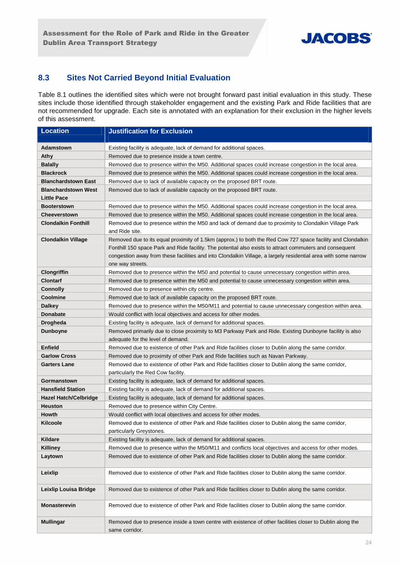
8.3 Sites Not Carried Beyond Initial Evaluation
Table 8.1 outlines the identified sites which were not brought forward past initial evaluation in this study. These
sites include those identified through stakeholder engagement and the existing Park and Ride facilities that are
not recommended for upgrade. Each site is annotated with an explanation for their exclusion in the higher levels
of this assessment.
Location Justification for Exclusion
Adamstown Existing facility is adequate, lack of demand for additional spaces.
Athy Removed due to presence inside a town centre.
Balally Removed due to presence within the M50. Additional spaces could increase congestion in the local area.
Blackrock Removed due to presence within the M50. Additional spaces could increase congestion in the local area.
Blanchardstown East Removed due to lack of available capacity on the proposed BRT route.
Blanchardstown West
Little Pace
Removed due to lack of available capacity on the proposed BRT route.
Booterstown Removed due to presence within the M50. Additional spaces could increase congestion in the local area.
Cheeverstown Removed due to presence within the M50. Additional spaces could increase congestion in the local area.
Clondalkin Fonthill Removed due to presence within the M50 and lack of demand due to proximity to Clondalkin Village Park
and Ride site.
Clondalkin Village Removed due to its equal proximity of 1.5km (approx.) to both the Red Cow 727 space facility and Clondalkin
Fonthill 150 space Park and Ride facility. The potential also exists to attract commuters and consequent
congestion away from these facilities and into Clondalkin Village, a largely residential area with some narrow
one way streets.
Clongriffin Removed due to presence within the M50 and potential to cause unnecessary congestion within area.
Clontarf Removed due to presence within the M50 and potential to cause unnecessary congestion within area.
Connolly Removed due to presence within city centre.
Coolmine Removed due to lack of available capacity on the proposed BRT route.
Dalkey Removed due to presence within the M50/M11 and potential to cause unnecessary congestion within area.
Donabate Would conflict with local objectives and access for other modes.
Drogheda Existing facility is adequate, lack of demand for additional spaces.
Dunboyne Removed primarily due to close proximity to M3 Parkway Park and Ride. Existing Dunboyne facility is also
adequate for the level of demand.
Enfield Removed due to existence of other Park and Ride facilities closer to Dublin along the same corridor.
Garlow Cross Removed due to proximity of other Park and Ride facilities such as Navan Parkway.
Garters Lane Removed due to existence of other Park and Ride facilities closer to Dublin along the same corridor,
particularly the Red Cow facility.
Gormanstown Existing facility is adequate, lack of demand for additional spaces.
Hansfield Station Existing facility is adequate, lack of demand for additional spaces.
Hazel Hatch/Celbridge Existing facility is adequate, lack of demand for additional spaces.
Heuston Removed due to presence within City Centre.
Howth Would conflict with local objectives and access for other modes.
Kilcoole Removed due to existence of other Park and Ride facilities closer to Dublin along the same corridor,
particularly Greystones.
Kildare Existing facility is adequate, lack of demand for additional spaces.
Killiney Removed due to presence within the M50/M11 and conflicts local objectives and access for other modes.
Laytown Removed due to existence of other Park and Ride facilities closer to Dublin along the same corridor.
Leixlip Removed due to existence of other Park and Ride facilities closer to Dublin along the same corridor.
Leixlip Louisa Bridge Removed due to existence of other Park and Ride facilities closer to Dublin along the same corridor.
Monasterevin Removed due to existence of other Park and Ride facilities closer to Dublin along the same corridor.
Mullingar Removed due to presence inside a town centre with existence of other facilities closer to Dublin along the
same corridor.

Assessment for the Role of Park and Ride in the Greater
Dublin Area Transport Strategy
25
Location Justification for Exclusion
N11 Junction 20 Removed due to its distance from Dublin, existence of other Park and Ride facilities closer to Dublin along the same corridor and low level of transit service in the area.
N7 Brown’s Barn There is a facility possibly warranted on the N7, it has not been identified whether there is sufficient demand
to justify additional bus services or whether this specific location will be optimal.
Navan Inner Relief
Road
Removed due to existence of other Park and Ride facilities closer to Dublin along the same corridor,
particularly the M3 Parkway facility.
Navan Parkway Removed due to its presence inside the M50 circle, proximity to central areas of Dublin and potential to
entice commuters to drive as close as possible to Dublin City if introduced. The lower levels of flow and
demand from within the M50 identified in Saturn modelling and higher levels along and outside the M50 will
warrant a higher focus of Park and Ride Facilities outside the M50.
Navan Rail/Bus Station Removed due to existence of other Park and Ride facilities closer to Dublin along the same corridor,
particularly the M3 Parkway facility.
Newbridge Removed due to existence of other Park and Ride facilities closer to Dublin along the same corridor.
Portmarnock Removed due to existence of other Park and Ride facilities closer to Dublin along the same corridor.
Rathfarnham Removed due to its presence inside the M50, proximity to central areas of Dublin and potential to entice
commuters to drive as close as possible to Dublin City if introduced. The lower levels of flow and demand
from within the M50 identified in Saturn modelling and higher levels along and outside the M50 will warrant a
higher focus of Park and Ride Facilities outside the M50.
Rathnew Removed due to its distance from Dublin, existence of other Park and Ride facilities closer to Dublin along
the same corridor and low level of transit service in the area.
Ross Cross Removed due to distance from Dublin and existence of other facilities closer to Dublin with better transit
services.
Sallins Removed due to existence of other Park and Ride facilities closer to Dublin along the same corridor.
Salthill and Monkstown Removed due to existence of other Park and Ride facilities closer to Dublin along the same corridor.
Sandyford Removed due to presence within the M50 circle.
Shankill Removed due to existence of other Park and Ride facilities closer to Dublin along the same corridor.
Silver Tankard Removed due to existence of other Park and Ride facilities closer to Dublin along the same corridor.
Skerries Removed due to existence of other Park and Ride facilities closer to Dublin along the same corridor,
particularly Malahide.
Stillorgan Removed due to presence within the M50.
Tallaght Removed due to the ability of the Cheeverstown Park and Ride site to sufficiently accommodate strategic
Park and Ride from both the N81 and potentially the N7. Tallaght has sufficient bus access to generate
demand through the walking, cycling and bus catchments.
Templeogue Removed due to its presence inside the M50, proximity to central areas of Dublin and potential to entice
commuters to drive as close as possible to Dublin City if introduced. The lower levels of flow and demand
from within the M50 identified in Saturn modelling and higher levels along and outside the M50 will warrant a
higher focus of Park and Ride Facilities outside the M50.
Walkinstown
Roundabout
Removed due to its presence inside the M50, proximity to central areas of Dublin and potential to entice
commuters to drive as close as possible to Dublin City if introduced. The lower levels of flow and demand
from within the M50 identified in Saturn modelling and higher levels along and outside the M50 will warrant a
higher focus of Park and Ride Facilities outside the M50.
Table 8.1 : Sites Excluded Beyond Initial Evaluation

Assessment for the Role of Park and Ride in the Greater
Dublin Area Transport Strategy
26
8.4 Phase 3: Park and Ride Demand Modelling Evaluation
The Park and Ride model is a spreadsheet-based logit model. The model examines the cost of travelling via
each Park and Ride site compared to making the whole journey by car. The cost of travel via each Park and
Ride site is calculated as the cost to travel by car from the trip’s origin zone to the Park and Ride zone, plus the
cost to travel by public transport from the Park and Ride zone to the trip’s destination zone. An interchange
penalty is added to represent the time taken to park the car and walk to the public transport stop.
The logit model is hierarchical as there is a choice between car and Park and Ride and then a further choice
between individual sites. The choice between the individual sites is calculated first, to give the proportion of
Park and Ride users which go via each site. This also allows the calculation of a “composite” cost via any Park
and Ride site. The second choice function then works out the proportion of all trips which are made by Park and
Ride by comparing the cost of car with the composite cost from the first choice model. The number of trips made
via an individual Park and Ride site can then be worked out by multiplying the demand by the proportion from
both choice models. All calculations are done separately for every combination of origin and destination zone.
In order to reduce the number of calculations, catchment areas are used to remove trips which are unlikely to
use a particular site. Each Park and Ride site has an origin catchment and a destination catchment. Only trips
which start in the origin catchment and end in the destination catchment will be considered for that site. Where a
trip falls within the catchment of multiple sites then that trip will still get a choice between those sites.
The modelling exercise indicates that throughout the GDA in the 2035 “Do Nothing” Scenario we could expect
to attract in the order of 12,000 public transport trips through the provision of Park and Ride. The current supply
of Park and Ride is 10,886, leaving a park and ride facility gap of just over 1000 spaces. Demand generated
inside the M50 has been removed from consideration in this calculation due to the primary goal of encouraging
public transport within the M50.
Figure 8.4 shows the general location of demand potential with an overlay of the Park and Ride sites under
consideration.
Also included is the list of existing and proposed locations, with an estimate of future demand based on the
above described logit model in Table 8.2. This is a conservative estimate of the demand. With the addition of
the demand management elements of the “Do Strategy” Scenario the costs associated with driving into the city
centre will increase and demand for Park and Ride could increase.
Table 8.2 outlines the potential of each site depending on the modelled demand and initial or estimated capacity
levels. Sites with greater demand levels than capacity are looked in further detail as potential Park and Ride
locations.
Many of these sites are placed inside the M50, an area that is generally avoided within this study. Existing sites
such as Shankill, Salthill and Monkstown, Balally, Booterstown, Blackrock, Clontarf and Clongriffin demonstrate
higher demand numbers than capacity levels. Since they are located well within the M50, they should not be
considered for Park and Ride if a modal shift from walking or cycling was to arise.
Some of these locations that show large demand levels should not be ignored. In particular, the existing nearby
Park and Ride sites at Stillorgan and Sandyford, show an accumulated demand of 804 and an implied
occupancy level of 207 per cent. These sites are located inside the M50, just off Junction 14, with excellent links
to the existing Luas line. The modelling exercise shows that trips coming from the M50 aim to get as close to
the city centre as possible before using Park and Ride facilities. Due to their proximity to the M50, these sites
are ideal for this and would generate sufficient demand. One or both of the existing facilities should be
considered for future upgrade, provided they do not degrade active mode shares within the local area.

Assessment for the Role of Park and Ride in the Greater
Dublin Area Transport Strategy
27
Table 8.2 shows a number of sites further away from Dublin with large demand levels. Specifically, the modelled
demand for Silver Tankard is 161, much greater than the current 20 space capacity. The site is situated along
the R147 with ample Greenfield space. It is currently served by the frequent 109 bus service from Cavan to
Dublin City Centre daily. Silver Tankard Park and Ride has the greatest modelled demand along this corridor,
which indicates its potential upgrade. Sites such as Monasterevin and Mullingar show high modelled demand
levels but are difficult to justify for Park and Ride due to their distance from Dublin City Centre.
The proposed sites outlined in Section 8.5 all show high demand from this modelling exercise. Each site has
more demand than there is capacity demonstrating their likelihood for success.

Assessment for the Role of Park and Ride in the Greater
Dublin Area Transport Strategy
28
Figure 8.4 : Park and Ride Demand Potential
Figure 8.5 : Modelled Demand for Park and Ride Sites
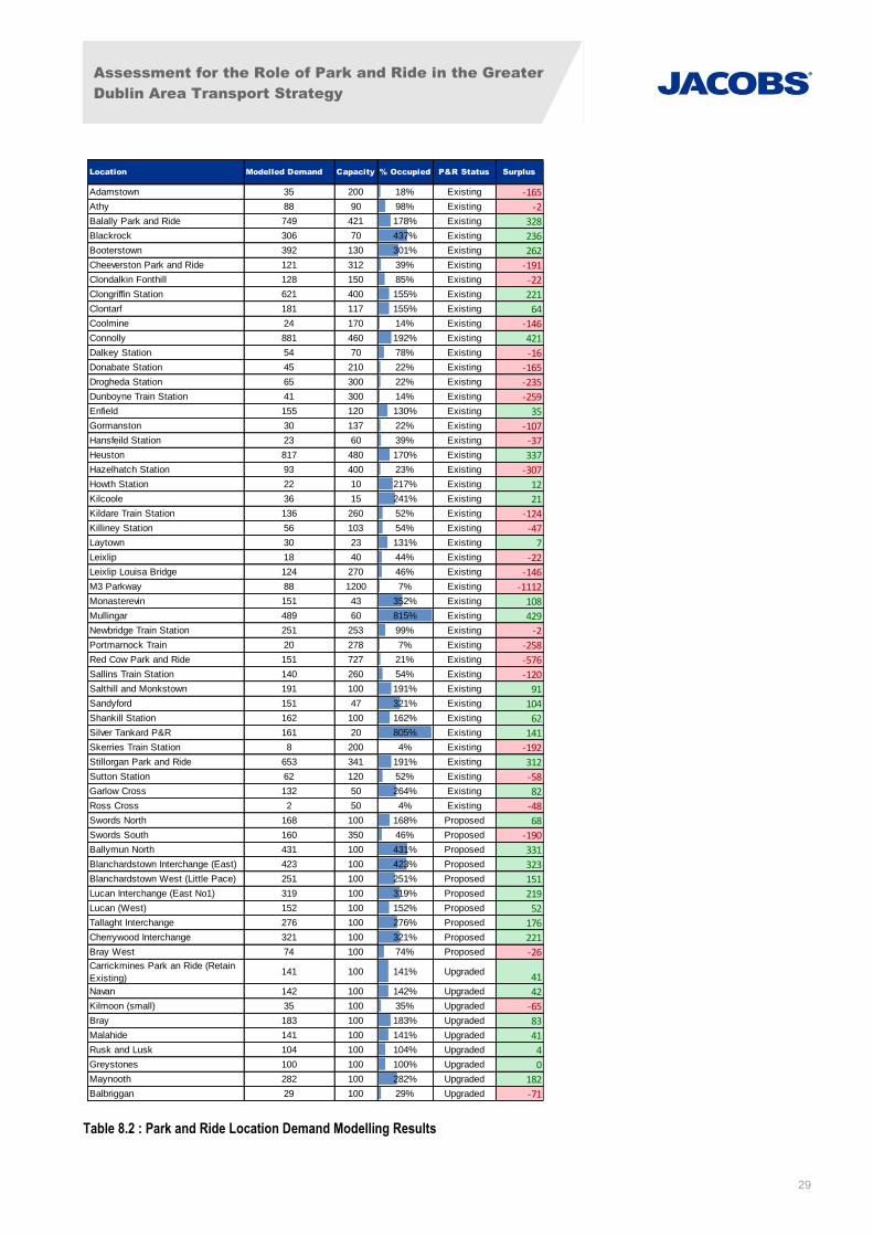
Assessment for the Role of Park and Ride in the Greater
Dublin Area Transport Strategy
29
Table 8.2 : Park and Ride Location Demand Modelling Results
Location Modelled Demand Capacity % Occupied P&R Status Surplus
Adamstown 35 200 18% Existing -165
Athy 88 90 98% Existing -2
Balally Park and Ride 749 421 178% Existing 328
Blackrock 306 70 437% Existing 236
Booterstown 392 130 301% Existing 262
Cheeverston Park and Ride 121 312 39% Existing -191
Clondalkin Fonthill 128 150 85% Existing -22
Clongriffin Station 621 400 155% Existing 221
Clontarf 181 117 155% Existing 64
Coolmine 24 170 14% Existing -146
Connolly 881 460 192% Existing 421
Dalkey Station 54 70 78% Existing -16
Donabate Station 45 210 22% Existing -165
Drogheda Station 65 300 22% Existing -235
Dunboyne Train Station 41 300 14% Existing -259
Enfield 155 120 130% Existing 35
Gormanston 30 137 22% Existing -107
Hansfeild Station 23 60 39% Existing -37
Heuston 817 480 170% Existing 337
Hazelhatch Station 93 400 23% Existing -307
Howth Station 22 10 217% Existing 12
Kilcoole 36 15 241% Existing 21
Kildare Train Station 136 260 52% Existing -124
Killiney Station 56 103 54% Existing -47
Laytown 30 23 131% Existing 7
Leixlip 18 40 44% Existing -22
Leixlip Louisa Bridge 124 270 46% Existing -146
M3 Parkway 88 1200 7% Existing -1112
Monasterevin 151 43 352% Existing 108
Mullingar 489 60 815% Existing 429
Newbridge Train Station 251 253 99% Existing -2
Portmarnock Train 20 278 7% Existing -258
Red Cow Park and Ride 151 727 21% Existing -576
Sallins Train Station 140 260 54% Existing -120
Salthill and Monkstown 191 100 191% Existing 91
Sandyford 151 47 321% Existing 104
Shankill Station 162 100 162% Existing 62
Silver Tankard P&R 161 20 805% Existing 141
Skerries Train Station 8 200 4% Existing -192
Stillorgan Park and Ride 653 341 191% Existing 312
Sutton Station 62 120 52% Existing -58
Garlow Cross 132 50 264% Existing 82
Ross Cross 2 50 4% Existing -48
Swords North 168 100 168% Proposed 68
Swords South 160 350 46% Proposed -190
Ballymun North 431 100 431% Proposed 331
Blanchardstown Interchange (East) 423 100 423% Proposed 323
Blanchardstown West (Little Pace) 251 100 251% Proposed 151
Lucan Interchange (East No1) 319 100 319% Proposed 219
Lucan (West) 152 100 152% Proposed 52
Tallaght Interchange 276 100 276% Proposed 176
Cherrywood Interchange 321 100 321% Proposed 221
Bray West 74 100 74% Proposed -26Carrickmines Park an Ride (Retain
Existing)141 100 141% Upgraded
41
Navan 142 100 142% Upgraded 42
Kilmoon (small) 35 100 35% Upgraded -65
Bray 183 100 183% Upgraded 83
Malahide 141 100 141% Upgraded 41
Rusk and Lusk 104 100 104% Upgraded 4
Greystones 100 100 100% Upgraded 0
Maynooth 282 100 282% Upgraded 182
Balbriggan 29 100 29% Upgraded -71

Assessment for the Role of Park and Ride in the
Greater Dublin Area Transport Strategy
30
8.5 Phase 4: Application of Evaluation Criteria to Identified Park and Ride Sites
A refined list of Park and Ride sites likely to be successful was developed based on modelled demand and
relationship with the road network (phase 2 and 3 above). All locations inside the M50 were eliminated for
consideration because of the results of road network constraints. All bus based Park and Ride proposals that
are not related to future improvements relating the service quality and frequency were also eliminated.
In this section, these refined locations are evaluated against the criteria adopted in Section 4. This analysis
produced a final recommendation for a Park and Ride programme for the GDA 2035 Transport Strategy.
Table 8.3 is a binary analysis of each identified Park and Ride strategic location in relation to the 18 Criteria of
successful Park and Ride given in Section 4.2. The table outlines the results from a scoring analysis for both rail
and bus based Park and Ride. The scoring system depends upon each location meeting the given criteria and
assigning specific symbols to highlight this result. The green circles indicate locations which meet the criteria
successfully; the orange circles show the locations which do not meet criteria entirely, while the red circles
specify the locations that do not meet the criteria at all. In Table 8.3, there are four areas that are of significant
importance highlighted in red text. It is recommended that the chosen locations must:
generate sufficient demand;
have uncongested access and egress;
not degrade rail/public transport access for other modes; and
not conflict with objectives of public transport services.
Meeting these specific criteria will allow for successful implementation of Park and Ride in each location. Table
8.3 demonstrates clearly that the chosen locations have scored highly in all of these areas.
The locations are then ranked based on their total score, demonstrating a strong likelihood of success. Table
8.3 shows that sites Swords North, Lucan and Carrickmines came out on top and also met the four highlighted
criteria. Therefore these locations are highly recommended for further investigation.
Table 8.4 is similar to Table 8.3, applying a score to each location based on the criteria met and weighted by
demand level. An equal weighting is applied across all criteria. Table 8.4 outlines the results for the local
location assessment criteria adopted in Section 4.2 previously. The key criteria are highlighted in red text as
with Table 8.3. It is suggested that the selected sites should:
generate sufficient demand;
not degrade rail access for other modes; and
not conflict with objectives of rail service.
Table 8.4 shows that the chosen sites score well overall in these key criteria, suggesting the possible success
of implementation of Park and Ride at these locations. The locations are given a ranking in the same way as in
Table 8.3, with proposed sites Swords South, Ballymun North and Cherrywood placing the highest.

Assessment for the Role of Park and Ride in the Greater Dublin Area Transport Strategy
31
Table 8.3 : Rail/Bus Based Strategic Location Assessment Criteria
Ge
ne
rate
su
ffic
ien
t d
em
and
Loca
tio
ns
at t
he
ed
ge o
f b
uil
t u
p a
reas
Loca
te c
lose
to
ke
y ra
dia
l ro
ute
s
Loca
te a
way
fro
m r
esi
de
nti
al a
reas
Loca
te o
n o
r n
ear
mai
n a
cce
ss r
ou
tes
Un
con
gest
ed
acc
ess
an
d e
gre
ss
Suff
icie
nt
lan
d a
vail
abil
ity
Do
es
no
t d
egr
ade
rai
l/P
T ac
cess
fo
r o
the
r m
od
es
Co
mp
lem
en
tary
to
exi
stin
g P
T n
etw
ork
Hig
h f
req
ue
ncy
PT
serv
ice
(B
us:
BR
T o
r Ex
pre
ss B
us
wit
h d
ed
icat
ed
Bu
s La
ne
)
Hig
h q
ual
ity
PT
serv
ice
Ava
ilab
le c
apac
ity
on
PT
serv
ice
Co
nn
ect
ed
to
th
e e
xist
ing
PT
serv
ice
s
PT/
Rai
l jo
urn
ey
tim
e t
o b
e c
om
pe
titi
ve w
ith
car
jou
rne
y ti
me
Do
es
no
t co
nfl
ict
wit
h o
bje
ctiv
es
of
PT
serv
ice
s
Do
es
no
t d
egr
ade
PT
acce
ss f
or
oth
er
mo
de
s
Co
nsi
de
rati
on
of
fare
bo
un
dar
ies
Stro
ng
pri
ori
ty m
eas
ure
s in
pla
ce f
or
PT
serv
ice
Ad
eq
uat
e p
arki
ng
po
licy
at
faci
lity
an
d d
est
inat
ion
Ass
essm
ent C
rite
ria
Location PT Service PolicyDemand
P&R Status Park and Ride Site PT Mode
Swords North Metro North 95%
Charlestown New Luas 95%
Lucan New Luas 89%
Woodbrook/Bray
Train/ DART/
Metro South 88%
Red Cow Luas 84%
M3 Parkway Train 81%
Carrickmines Metro South 95%
N2 Express Bus 72%
M50/M11/N11 Express Bus 69%Strategic Bus Proposed
Location PT Service Policy
Scoring
Strategic Rail
Proposed
Upgraded

Assessment for the Role of Park and Ride in the Greater Dublin Area Transport Strategy
32
Table 8.4 : Rail Based Local Location Assessment Criteria
Ge
ne
rate
su
ffic
ien
t d
em
and
Loca
te c
lose
to
jou
rne
y o
rigi
n
Un
con
gest
ed
acc
ess
an
d e
gre
ss
Suff
icie
nt
lan
d a
vail
ibil
ity
Do
es
no
t d
egr
ade
rai
l acc
ess
fo
r o
the
r m
od
es
Co
mp
lem
en
tary
to
exi
stin
g ra
il n
etw
ork
Hig
h f
req
ue
ncy
rai
l se
rvic
e
Hig
h q
ual
ity
rail
se
rvic
e
Ava
ilab
le C
apac
ity
on
rai
l se
rvic
e
Rai
l jo
urn
ey
tim
e t
o b
e c
om
pe
titi
ve w
ith
car
jou
rne
y ti
me
Do
es
no
t co
nfl
ict
wit
h o
bje
ctiv
es
of
rail
se
rvic
e
Co
nsi
de
rati
on
of
fare
bo
un
dar
ies
Stro
ng
pri
ori
ty m
eas
ure
s in
pla
ce f
or
PT
serv
ice
Ad
eq
uat
e p
arki
ng
po
licy
at
faci
lity
an
d d
est
inat
ion
Demand
P&R Status Park and Ride Site PT Mode
Swords South Metro North 100%
R108 Ballymun North Metro North 100%
Lucan West New Luas 92%
Cherrywood Metro South 100%
Malahide Train/DART 77%
Rusk & Lusk Train/DART 84%
Greystones Train/DART 75%
Maynooth Train 87%
Balbriggan Train 76%
Scoring
Proposed
Ass
essm
ent C
rite
ria
Location PT Service Policy
Upgraded
Local Rail

Assessment for the Role of Park and Ride in the
Greater Dublin Area Transport Strategy
33
The tables below elaborate on the application of evaluation criteria summarized above. Each table provides
detail regarding the site location, Park and Ride category (strategic/local), modal connectivity (bus/rail), and
rationale for the site selection.
The following 10 tables outline the proposed locations for new Park and Ride facilities.
Name Swords North Location
Mode Future: Metro North or BRT
Classification Strategic Rail
Ranking Strong likelihood for success
Site Description
The site is located east of the
Estuary Roundabout adjacent to
the R132 on the grounds of a
public park. The site has good
links to the strategic network as
the R132 connects to the R125
which joins the M1 allowing for
onward connection to the N1
serving the city centre.
Rationale for Site
Selection
Under current public transport provision, this location does not warrant the installation of a Park and Ride. This
site was selected because of the possibility for future Metro or BRT. If the Metro North Terminates here at
Lissenhall, this location would meet almost all criteria. Under the Metro North scenario, this site has the potential
to offer a competitive journey time into the city centre. Allowing users to bypass congestions on the M1/N1 and
the R132. The location was raised during stakeholder engagement. This is a strategic site and would be
designed to attract trips from the adjacent radial routes. It is important to acknowledge that Swords BRT may not
have the capacity to accommodate the additional trips generated by Park and Ride. Metro North would have to
include additional capacity to accommodate these trips. Careful design would have to be implemented to assure
attractive access for pedestrians, cyclists and other public transport users.
Table 8.5 : Swords North Park and Ride

Assessment for the Role of Park and Ride in the
Greater Dublin Area Transport Strategy
34
Name Swords South Location
Mode Future: Metro North
Classification Local Rail
Ranking Potential Role Further Study
Needed
Site Description
The site is located east of the
Pinnock Hill Roundabout on the
grounds of a greenfield site. The
site has good links to the strategic
road network with the R125
adjacent to the site. The R125
connects to the M1 which allows
for onward connection to the N1
serving the city centre.
Rationale for Site
Selection
The site is selected to be included in the development of future transport expansion of either BRT or Metro North.
Assuming future Metro is installed, the site meets the majority of the selection criteria for either a strategic or a
local site. With a focus on the competitive journey time, high level of public transport services, and strategic
location. The location was raised during stakeholder engagement. It is important to acknowledge that Swords
BRT may not have the capacity to accommodate the additional trips generated by Park and Ride.
Table 8.6 : Swords South Park and Ride
Name Ballymun North Location
Mode Future: Metro North
Classification Local Rail
Ranking Potential Role Further Study Needed
Site Description
The site would be located north of Jn
4 on the M50 on the R132, possibly
on the grounds of a greenfield site.
The site has good links to the
strategic road network with the M50
adjacent to the site. The M50 allows
for onward connection to the city
centre.
Rationale for Site
Selection
This site is identified for a local Park and Ride under future conditions with the provision of Metro North.
Interestingly, based on the results of the modelling exercise, this site could be successful even under current
conditions. Assuming future Metro is installed the site meets the majority of the selection criteria. With a focus on
the competitive journey time, high level of public transport services, and strategic location. The location was
raised during stakeholder engagement. There is potential for this site to become a public transport hub, with
access to metro north, and access from the M50.
Table 8.7 : Ballymun North Park and Ride
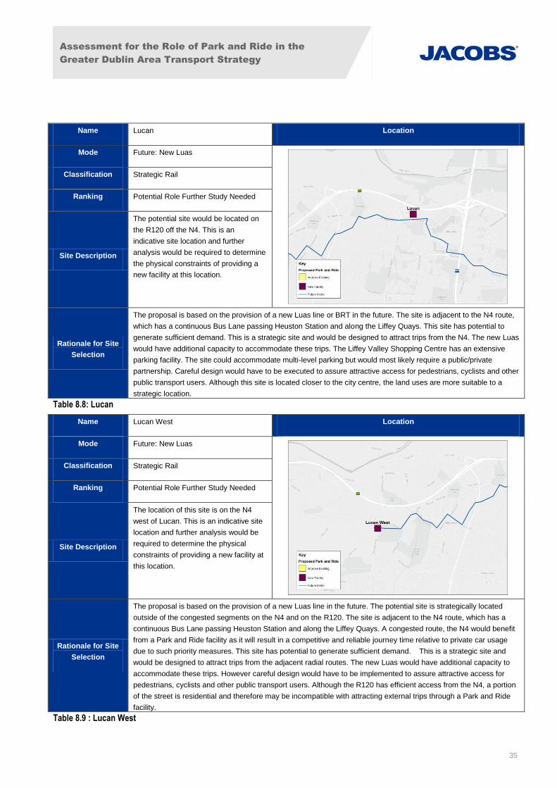
Assessment for the Role of Park and Ride in the
Greater Dublin Area Transport Strategy
35
Name Lucan Location
Mode Future: New Luas
Classification Strategic Rail
Ranking Potential Role Further Study Needed
Site Description
The potential site would be located on
the R120 off the N4. This is an
indicative site location and further
analysis would be required to determine
the physical constraints of providing a
new facility at this location.
Rationale for Site
Selection
The proposal is based on the provision of a new Luas line or BRT in the future. The site is adjacent to the N4 route,
which has a continuous Bus Lane passing Heuston Station and along the Liffey Quays. This site has potential to
generate sufficient demand. This is a strategic site and would be designed to attract trips from the N4. The new Luas
would have additional capacity to accommodate these trips. The Liffey Valley Shopping Centre has an extensive
parking facility. The site could accommodate multi-level parking but would most likely require a public/private
partnership. Careful design would have to be executed to assure attractive access for pedestrians, cyclists and other
public transport users. Although this site is located closer to the city centre, the land uses are more suitable to a
strategic location.
Table 8.8: Lucan
Name Lucan West Location
Mode Future: New Luas
Classification Strategic Rail
Ranking Potential Role Further Study Needed
Site Description
The location of this site is on the N4
west of Lucan. This is an indicative site
location and further analysis would be
required to determine the physical
constraints of providing a new facility at
this location.
Rationale for Site
Selection
The proposal is based on the provision of a new Luas line in the future. The potential site is strategically located
outside of the congested segments on the N4 and on the R120. The site is adjacent to the N4 route, which has a
continuous Bus Lane passing Heuston Station and along the Liffey Quays. A congested route, the N4 would benefit
from a Park and Ride facility as it will result in a competitive and reliable journey time relative to private car usage
due to such priority measures. This site has potential to generate sufficient demand. This is a strategic site and
would be designed to attract trips from the adjacent radial routes. The new Luas would have additional capacity to
accommodate these trips. However careful design would have to be implemented to assure attractive access for
pedestrians, cyclists and other public transport users. Although the R120 has efficient access from the N4, a portion
of the street is residential and therefore may be incompatible with attracting external trips through a Park and Ride
facility.
Table 8.9 : Lucan West

Assessment for the Role of Park and Ride in the
Greater Dublin Area Transport Strategy
36
Name Cherrywood Location
Mode Metro South/Luas
Classification Local Rail
Ranking Potential Role Further Study Needed
Site Description
The Park and Ride site is located at the
terminus station (Brides Glen) on the
green line. The site is a brownfield site
located beside the R118 and is adjacent
to the N11 and the M50.
Rationale for Site
Selection
This site is identified as a local site to be consistent with the community goals of Cherrywood SDZ relating to
walking, cycling and public transport. Increasing congestion from motor vehicles generated outside of the local area
is not encouraged. However, Park and Ride will provide convenient access for local trips within 5km. High level of
Luas Green line segregation will create competitive journey times and a high level of connection which will be
increased upon opening of Luas Cross City. This site should only be considered for inclusion in the strategy as part
of the Metro South scheme.
Table 8.10 : Cherrywood
Name Cherrywood M50/M11/N11 Location
Mode Future: N11 QBC
Classification Strategic Bus
Ranking
Potential to fulfil a role in the Park and
Ride strategy but a precise location has
not been identified and analysis
regarding the viability of express bus
service has not yet been conducted.
Site Description
Located adjacent to the N11 radial
route, this Park and ride would serve
longer distance commuters along the
N11 corridor as well as new residents
within the area around Fassaroe.
Rationale for Site
Selection
This site was selected as a site for further analysis due to the increase in congestion as demonstrated in the 2023
Do Nothing Highways Model. This location is based on the identification of an Express Bus service that would go
directly from this location to the City Centre. This is identified as a possibility in relation to possible future
development in the Fassaroe area. The area is well connected to the existing highway network at the M50 and N11.
Bus priority along the N11 QBC will also add to available public transport priority from this location and provide
competitive journey times.
Table 8.11 : Cherrywood M50/M11/N11

Assessment for the Role of Park and Ride in the
Greater Dublin Area Transport Strategy
37
Name N2 Location
Mode Express Bus
Classification Strategic Bus
Ranking
Potential to fulfil a role in the Park and
Ride strategy but a precise location has
not been identified and analysis
regarding the viability of express bus
service has not yet been conducted.
Site Description
This is an indicative location to capture
trips along the N2 radial corridor. This
area is currently served by a number of
bus routes.
Rationale for Site
Selection
This site was included for consideration because of congestion forecasted along the N2 in the highway model. This
location is based on the identification of an express bus service that would go directly from this location to the City
Centre with dedicated bus lanes. It is unknown at this time if there is adequate demand for this service in this
location. However it is identified for further study. There are a number of existing Park and Ride facilities along the
corridor suggesting that there could be additional latent demand. This site was not modelled using the Demand
Modelling Evaluation as described in Section 8.4.
Table 8.12 : N2
Name Charlestown Location
Mode New Luas
Classification Strategic Rail
Ranking Potential Role Further Study Needed
Site Description
The proposed Park and Ride site is
located along the North Road. It is
inside the M50, located just off Jn 5.
The suggested Park and Ride would be
positioned on an existing greenfield site.
Rationale for Site
Selection
The proposal of this site is based on the future provision of the new LRT line from Broombridge through Finglas.
This future line would connect the existing and cross city Luas. The site is directly accessible from the strategic road
network and existing public transport services. The area is served by a number of Dublin Bus routes, 40B, 83, 83A
and 9; connecting Charlestown to the City Centre and South Dublin. This site was not modelled using the Demand
Modelling Evaluation as described in Section 8.4.
Table 8.13 : Charlestown

Assessment for the Role of Park and Ride in the
Greater Dublin Area Transport Strategy
38
The following 8 tables outline the proposed upgrades to existing Park and Ride facilities.
Name Carrickmines Location
Mode Metro South
Classification Strategic Rail
Ranking Strong Likelihood for Success
Site Description
The Park and Ride site is located on the
green line. It is easily accessed from the
M50. The site currently has a Park and
Ride capacity of 352 spaces.
Rationale for Site
Selection
The location of the site in relation to the congestion on the M50 is the main rational for the site location. This site has
excellent connections to both the existing highway network and the transport system. This location allows drivers
smooth intermodal transition between driving and the Luas Green. Future enhancements to the Luas regarding
capacity and frequency will create competitive journey times. The site must be reviewed carefully in relation to the
available capacity. Under existing conditions, capacity is not available to accommodate additional Park and Ride
trips. However with future Metro South, additional capacity will be available.
Table 8.14 : Carrickmines
Name Woodbrook/Bray Location
Mode DART/Metro South
Classification Strategic Rail
Ranking
Potential to fulfil a role in the Park and
Ride strategy but a precise location has
not been identified and analysis
regarding the viability of express bus
service has not yet been conducted.
Site Description
This site is located in the Woodbrook
area with access from the N11 at
Wilford Interchange. This site is
identified based on the provison of a
new rail station to connect the facility to
DART and rail services.
Rationale for Site
Selection
This site was identified based on the future available capacity on the DART line and the possibility of extending
Luas/Metro South from Brides Glen to Bray. This service is high quality and high frequency. It is also identified
based on the growth in road network demand in the Woodbrook and Bray areas. Care must be taken in this location
to be consistent with local requirements and goals relating to congestion on local streets. This site is identified in
order to increase access to the DART services without impacting walking, cycling and bus access. Localised traffic
impacts would need to be assessed before implementation.
Table 8.15 : Bray

Assessment for the Role of Park and Ride in the
Greater Dublin Area Transport Strategy
39
Name Malahide Location
Mode Train/DART
Classification Local Rail
Ranking
Potential to fulfil a role in the Park and
Ride strategy but a precise location has
not been identified and analysis
regarding the viability of express bus
service has not yet been conducted.
Site Description
The Park and Ride site is currently in
operation and this proposal seeks to
improve the facility by increasing the
capacity.
Rationale for Site
Selection
The site is the first stop on the DART Line. High frequency and Direct Dart service during the peak hour makes this
site attractive for Park and Ride expansion. Journey times to the city centre are competitive with the car. Care must
be taken in this location to be consistent with local requirements and goals relating to congestion on local streets.
This site is identified in order to increase access to the DART services without impacting walking, cycling and bus
access.
There is a vacant site on Gaysard Lane that could be developed into a multi-level car park with complementary
residential or office uses. Localised traffic impacts would need to be assessed before implementation.
Table 8.16 : Malahide
Name Rush & Lusk Location
Mode Train/DART
Classification Local Rail
Ranking Strong Likelihood for Success
Site Description
The Park and Ride site is currently in
operation and this proposal seeks to
improve the facility. There are 260
spaces in this Park and Ride facility and
it is operating at capacity.
Rationale for Site
Selection
This site was selected as a site for further analysis due to the increase in congestion as demonstrated in the 2023
Do Nothing Highways Model. The site is located on a main access road for both Rush and Lusk and is away from
residential areas with uncongested access and egress. Sufficient land availability as well as high quality and
frequency transport at the site will facilitate expansion at this site.
Table 8.17 : Rush & Lusk

Assessment for the Role of Park and Ride in the
Greater Dublin Area Transport Strategy
40
Name Greystones Location
Mode Train/DART
Classification Strategic Rail
Ranking
Potential to fulfil a role in the Park and
Ride strategy but a precise location has
not been identified and analysis
regarding the viability of express bus
service has not yet been conducted.
Site Description
The Park and Ride site, 2km from the
N11, is currently in operation and this
proposal seeks to improve the facility.
Rationale for Site
Selection
This site was selected as a site for further analysis due to the increase in congestion along the M11 as
demonstrated in the 2023 Do Nothing Highways Model. Located on a main access road close to the centre of
Greystones, this location facilitates uncongested access and egress and is sufficiently close to residential areas to
effectively benefit from expansion. Albeit at a lesser frequency than those at Bray, DART services provide High
quality services and the site compliments existing public transport services. Proximity to retail and leisure facilities
can demark this location as multi-purpose. Future improvements to the DART will result in available capacity. Park
and Ride will serve to increase ridership to fill this capacity. Care must be taken at this location to mitigate
congestion on local streets to be consistent with local requirements and goals. This site is identified in order to
increase access to the DART services without impacting walking, cycling and bus access.
Table 8.18 : Greystones
Name Maynooth Location
Mode Train
Classification Local Rail
Ranking Potential Role Further Study Needed
Site Description
The Park and Ride site is currently in
operation and this proposal seeks to
improve the facility.
Rationale for Site
Selection
This site was selected as a site for further analysis due to the increase in congestion as demonstrated in the 2023
Do Nothing Highways Model. Proximity to trip generators in Maynooth including university facilities and a small clinic
identify this site as a multi-purpose location. Its location south of the canal on a main access road to the larger
residential areas of the town will help to generate adequate demand while a high quality rail service with adequate
capacity is already in place. Heavy congestion on the main M/N4 route into Dublin (particularly near Lucan) from the
area will result in a competitive journey time relative to car.
Table 8.19 : Maynooth

Assessment for the Role of Park and Ride in the
Greater Dublin Area Transport Strategy
41
Name Balbriggan Location
Mode Train/DART
Classification Local Rail
Ranking
Potential to fulfil a role in the Park and
Ride strategy but a precise location has
not been identified and analysis
regarding the viability of express bus
service has not yet been conducted.
Site Description
The Park and Ride site is currently in
operation and this proposal seeks to
improve the facility by increasing the
capacity.
Rationale for Site
Selection
This site was selected as a site for further analysis due to the increase in congestion as demonstrated in the 2023
Do Nothing Highways Model. Proximity to the retail facilities and Balbriggan beach meant that this location can be
considered a multi-purpose location. Heavy congestion on the main M1 route into Dublin from the area will result in a
competitive journey time relative to the private car. The town’s large residential areas are also close by. Care must
be taken to mitigate congestion on local streets in this location to be consistent with local requirements and goals.
This site is identified in order to increase access to the train services without impacting walking, cycling and bus
access.
Table 8.20 : Balbriggan
Name M3 Parkway Location
Mode Train
Classification Strategic Rail
Ranking Potential Role Further Study Needed
Site Description
This proposal aims to improve the
existing Park and Ride facility at M3
Parkway. The site is accessible from the
N3 and is situated at the M3 Parkway
rail station.
Rationale for Site
Selection
This site was chosen for consideration for further expansion due to its proximity to Dunboyne and the M3 motorway
link to Navan and surrounding areas. The current Park and Ride facility serves frequent rail services to the City
Centre, terminating at the Docklands. The facility is also served directly by the 111 bus from Cavan to the City
Centre.
Table 8.21 : M3 Parkway

Assessment for the Role of Park and Ride in the
Greater Dublin Area Transport Strategy
42
Name Red Cow Location
Mode Luas
Classification Strategic Rail
Ranking Potential Role Further Study Needed
Site Description
The existing Park and Ride site at Red
Cow is proposed for upgrade. The
existing facility is located outside the
M50 at Junction 9.
Rationale for Site
Selection
The Red Cow Park and Ride is recommended for further analysis due to its existence outside the M50. The current
facility is located along the Luas Red line. The attractiveness of this Park and Ride facility is expected to increase
with the implementation of the Luas Cross City. Congestion within the M50 would be avoided with the use of this
facility, thus the journey time would be competitive to that of the private car. Care must be taken be taken to mitigate
further congestion in the area which may be caused by the expanded facility.
Table 8.22 : Red Cow
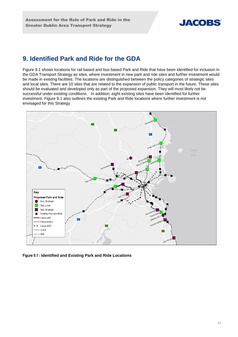
Assessment for the Role of Park and Ride in the
Greater Dublin Area Transport Strategy
43
9. Identified Park and Ride for the GDA
Figure 9.1 shows locations for rail based and bus based Park and Ride that have been identified for inclusion in
the GDA Transport Strategy as sites, where investment in new park and ride sites and further investment would
be made in existing facilities. The locations are distinguished between the policy categories of strategic sites
and local sites. There are 10 sites that are related to the expansion of public transport in the future. These sites
should be evaluated and developed only as part of the proposed expansion. They will most likely not be
successful under existing conditions. In addition, eight existing sites have been identified for further
investment. Figure 9.1 also outlines the existing Park and Ride locations where further investment is not
envisaged for this Strategy.
Figure 9.1 : Identified and Existing Park and Ride Locations

Assessment for the Role of Park and Ride in the
Greater Dublin Area Transport Strategy
44
9.1 Rail based Park and Ride
Table 9.1 presents the locations of the rail based Park and Ride sites that have been identified for inclusion in
the GDA Transport Strategy. These are further distinguished by their facility category (local or strategic) and
illustrated in Table 9.1. These sites were chosen based on the criteria outlined in Chapter 8 of the report. This
includes demand modelling, 2023 roadway characteristics, and criteria assessment.
It is important to note that the locations associated with Metro North and Metro South have been recommended
based on the provision of these services. In the interim, the Metro South is served by the Luas Green Line
which is at capacity and could not accommodate additional demand facilitated by Park and Ride. Metro North
may be served by a BRT before a metro service. It is projected that this service would be operating at capacity
without the provision of Park and Ride. However it is recommended that Park and Ride facilities be considered
as the BRT services are being developed.
Category Name Targeted Radial Route
Type Public Transport Mode Indicative Size
Strategic Swords North M1 New Metro North 200
Local Swords South Local / M1 New Metro North 200
Local Ballymun Local/ M1/M50 New Metro North 350
Strategic Lucan N4 New New Luas 350
Strategic Lucan West N4 New New Luas 200
Local Cherrywood Local/M11/M50 New Metro South 350
Strategic Charlestown N3 New New Luas 150
Strategic Carrickmines M50/N11 Retain Temporary Facility
Metro South 150
Strategic Woodbrook/Bray M11/N11 Improve Existing
Train/Metro South 200
Local Malahide Local / M1 Improve Existing
Train/Dart 150
Local Rusk and Lusk Local/M1 Improve Existing
Train/Dart 120
Strategic Greystones Local Improve Existing
Train/Dart 120
Local Balbriggan Local / M1/N11 Improve Existing
Train Under 150
Local Maynooth Local/N4 Improve Existing
Train 300
Strategic M3 Parkway M3/N3 Improve Existing
Train 1200
Strategic Red Cow N7 Improve Existing
Luas 750
Table 9.1 : Identified Rail Based Park and Ride Sites
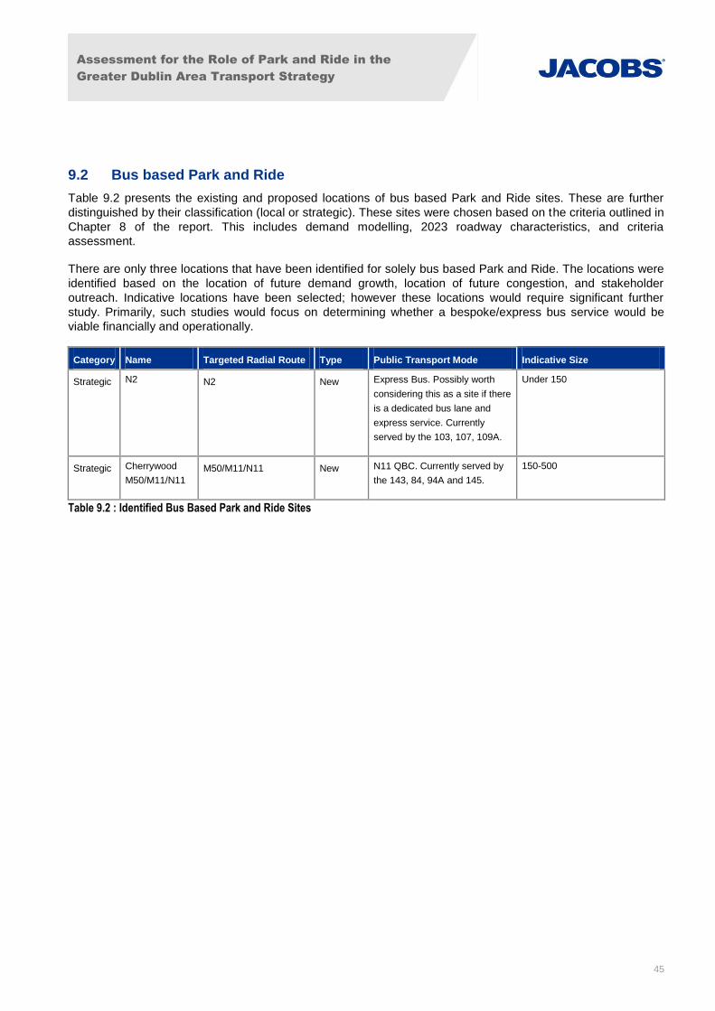
Assessment for the Role of Park and Ride in the
Greater Dublin Area Transport Strategy
45
9.2 Bus based Park and Ride
Table 9.2 presents the existing and proposed locations of bus based Park and Ride sites. These are further
distinguished by their classification (local or strategic). These sites were chosen based on the criteria outlined in
Chapter 8 of the report. This includes demand modelling, 2023 roadway characteristics, and criteria
assessment.
There are only three locations that have been identified for solely bus based Park and Ride. The locations were
identified based on the location of future demand growth, location of future congestion, and stakeholder
outreach. Indicative locations have been selected; however these locations would require significant further
study. Primarily, such studies would focus on determining whether a bespoke/express bus service would be
viable financially and operationally.
Category Name Targeted Radial Route Type Public Transport Mode Indicative Size
Strategic N2 N2 New Express Bus. Possibly worth
considering this as a site if there
is a dedicated bus lane and
express service. Currently
served by the 103, 107, 109A.
Under 150
Strategic Cherrywood
M50/M11/N11
M50/M11/N11 New N11 QBC. Currently served by
the 143, 84, 94A and 145.
150-500
Table 9.2 : Identified Bus Based Park and Ride Sites

Assessment for the Role of Park and Ride in the
Greater Dublin Area Transport Strategy
46
Appendix A. Review of Park and Ride Policy and Best Practice
A.1 Park and Ride Benefits
Park and Ride can be both formal and informal and can be considered an intermodal transfer facility. They can
serve an important role in a transport network as they provide opportunity for transfer between the single
occupancy vehicle to other modes of travel. Park and Ride can also support transfer with other modes such as
bicycle, pedestrian, and carpool. Park and Ride facilities can successfully encourage a mode shift away from
the single occupancy vehicle if properly integrated into a comprehensive transport network. Based on research
undertaken by Colin Buchannan for the Tayside and Central Transport Partnership (TACTRAN) Park and Ride
strategy, the 2002 Dublin Transportation Office (DTO) report “Bus Based Park & Ride - A Pilot Scheme”, and
the 2004 report “Rail Park and Ride Strategy for the Greater Dublin Area” by the DTO, Park and Ride can
deliver the following benefits:
Bring economic vitality and improve overall accessibility in a town or city centre;
Reduce road traffic congestion on radial routes;
Improve mobility by reducing congestion, thereby increasing the attractiveness of town and city centres to
visitors and shoppers;
Meet shortfalls in projected parking capacity in an urban area;
Increase the effective catchment area of the public transport network;
Transfer commuting trips from private car to public transport;
Improve access for those living on the city edge and in low density suburbs; and
Maximise the growth of Public Transport patronage.
A.2 Benchmarked Metropolitan Areas of Interest
For this study, the Dublin Metropolitan Area was benchmarked against cities of similar size, population, and
layout. According to the Census 2011 figures, the Greater Dublin Metropolitan Area has a population of 1.8
million people, of which 1.2 million are within the Dublin Urban Area and 530,000 are within the City of Dublin.
The last published study that recorded Park and Ride capacity in the Dublin Metropolitan Area was conducted
by the Dublin Transport Office in 2004. At that time there were 6,800 Park and Ride spaces at 45 rail stations
out of a total of 85 stations. This would give Dublin a rating of .004 Park and Ride spaces per capita. Bus Park
and Ride was not accounted for in this study.
These Park and Ride numbers have been reassessed for this study using readily available information on the
Irish Rail and Luas web sites. This review yielded a total 10,800 spaces within 52 rail/light rail stations, and .006
Park and Ride spaces per capita.
Jacobs undertook research for Auckland Transport (AT) in 2014. Included in this research was the table shown
in Table A.1 in AT’s “Parking Discussion Document” which outlined metropolitan areas of a similar size to
Dublin. The can be seen as a good benchmark for Dublin when researching Metropolitan Park and Ride
policies.

Assessment for the Role of Park and Ride in the
Greater Dublin Area Transport Strategy
47
Table A.1: Rail Park and Ride Provision in Comparative Cities
City Population Rail Park and
Ride Spaces
Number of
Stations
Stations with
Park and Ride
% of Total
Stations with
Park and Ride
Park and Ride
Spaces per
Station
Wellington 487,700 5,201 49 38 77% 106
Calgary 1,265,100 13,170 36 19 52% 366
Auckland 1,486,000 2,202 41 18 44% 54
Portland 1,583,138 10,239 63 28 44% 151
Perth 1,740,000 16,658 68 48 70% 245
Brisbane 2,043,000 20,745 145 124 85% 143
Vancouver 2,419,700 5,853 55 9 16% 106
San
Francisco
3,228,605 49,640 44 33 75% 1,128
Atlanta 3,499,840 24,000 38 23 60% 632
Melbourne 4,077,000 34,461 219 174 79% 157
Dublin 1,800,000 10886 85 52 61% 128
Dublin
Ranking
(from
lowest)
6th 5th 9th 9th 6th 4th
Table A.1 shows that Dublin has developed Park and Ride sites at approximately 60% of its rail stations. This is
significantly higher than cities such as Vancouver, Auckland and Portland. Brisbane has the highest number of
stations with Park and Ride at 85%, followed by Melbourne and Wellington. This may indicate that there’s still
scope for expansion.
In order to fully evaluate the differences in Park and Ride policy, the total number of public transport trips needs
to also be considered. Table A.2 calculates the number of annual public transport journeys and annual journeys
per capita for the GDA in 2013. The table shows that for 2013 Dublin had an average of 99 public transport
journeys made per capita. (source: Rail Statistics for Ireland NTA June 2014, Rail Census 2013, NTA 2014, Bus Statistics for Ireland
– State Funded Services NTA June 2014)

Assessment for the Role of Park and Ride in the
Greater Dublin Area Transport Strategy
48
Table A.2 : 2013 GDA Annual Public Transport Journeys
Annual Journeys
DART/Commuter 29,127,362
Luas 30,051,000
Dublin Bus 112,490,000
Bus Éireann Dublin Commuter 6,947,460
Total 178,615,822
GDA Population 1,800,000
Journeys per Capita per Annum 99
Figure A.1 combines Park and Ride spaces per capita with annual Public Transport trips per capita. Dublin
appears to be middle ranked on public transport journeys and Park and Ride per capita. City regions such as
Vancouver and the West Midlands have used a limited amount of Park and Ride to increase public transport
trips. In contrast cities such as Ottawa and Melbourne appear to actively use Park and Ride in order to increase
the number of public transport journeys. Brisbane, though it has significantly developed its Park and Ride
system is behind Dublin on the number of public transport journeys per capita.
As a result, Dublin may potentially have scope to increase public transport journeys by using Park and Ride.
However this needs to be considered against its other public transport provision as having a high number of
Park and Ride spaces does not directly correlate with having a high number of public transport journeys.

Assessment for the Role of Park and Ride in the
Greater Dublin Area Transport Strategy
49
Figure A.1: P&R Spaces per Capita in Relation to Public Transport Trips per Capita on P&R Serviced Modes
A.3 Previous Park and Ride Studies for the GDA
There have been two reports relating to Dublin Park and Ride, both published over a decade ago. The first one
was focused on bus based Park and Ride and was completed in 2002. The second report was focused on rail
based Park and Ride and was completed in 2004.
A.3.1 Bus Based Park and Ride a Pilot Scheme, A Report to the Dublin Transport Office (DTO) – 2002
This report was commissioned by the DTO to investigate the potential of a bus based Park and Ride strategy
within the GDA. The following is a summary of the findings and recommendations contained within the report.
The report stated that although acceptable distances and therefore journey times by bus vary according to the
size of the urban area, all successful Park and Ride operations had the following characteristics:
A maximum distance by bus of 5km;
A maximum journey time of 15-20 minutes; and
A maximum overall P&R time including waiting and parking time of approximately 22 minutes.
The report relied on previous best practice developed in the UK and noted that the UK had very few examples
of bus based Park and Ride locations similar to Dublin where traffic congestion tended to start much further out
from the city centre. The report noted that at the time of writing only three Park and Ride operations in the UK
were operated on a completely commercial basis; Cambridge, Oxford and York.
As part of the report 40 sites in the Greater Dublin Area were considered as potential locations for bus based
Park and Ride. These sites were sub-divided into two distinct groups (a map was included in the report):
Outer or ‘Satellite’ Sites (greater than 20km from Dublin City Centre); and
Inner Sites (less than 20km from Dublin City Centre and within the built up area surrounding Dublin).
Dublin

Assessment for the Role of Park and Ride in the
Greater Dublin Area Transport Strategy
50
A total of 13 sites fell within the category of Outer or Satellite Park and Ride. Outer or Satellite Park and Ride
sites were regarded as more appropriate when:
Projected demand was low and trip patterns diffuse in nature;
Bus travel distances were long, rendering it uneconomic to provide an attractive level of frequency with a
bespoke service;
Land for parking was either expensive or unavailable; and
There were environmental concerns about the local traffic impacts of the construction of large Park and
Ride car parks.
Principal disadvantages/weaknesses of satellite Park and Ride locations were:
Traffic congestion was not necessarily severe enough at the point of the site location;
The urban centre is less likely to be the ultimate destination; and
Longer bus journey time which was less attractive to users.
A total of 26 locations fell within the category of Inner Park and Ride sites as defined in the report. The report
noted that the demand of Park and Ride operations was affected by:
Overall distance from city centre;
Absolute value of total traffic flow; and
Comparable journey time by bus and car.
The study concludes that conventional bus-based Park and Ride has a limited role in Dublin due to the size of
the city. Bus-based Park and Ride is ideally suited to urban areas of less than 200,000 inhabitants and the size
(and therefore travel distances) diminish its effectiveness. However, the 2002 study identified three sites with
the highest potential car transfers to bus-based Park and Ride: N4/2 – Lucan (Fonthill Road), N3/1 –
Castleknock / M50 junction, and N11/1 – Cornelscourt. A pilot scheme was developed in detail for the Fonthill
Road site but was never implemented.
A.3.2 Rail Park and Ride Strategy for Greater Dublin Area, Dublin Transport Office – 2004
The aim of the study was to develop a Park and Ride Strategy for the GDA, recommending a set of locations
where investment in the provision of additional Park and Ride spaces would contribute to the achievement of
the transport objectives.
The report divided the GDA into two parts; the Metropolitan Area and the Hinterland area. The report noted that
given the nature of the GDA in terms of the population and employment, there were significant movements from
the Hinterland Area into the Metropolitan and city centre areas.
Some characteristics of the GDA network and Park and Ride facilities, according to the above study, were:
Road Network: A series of radial routes from the Hinterland Area boundary to the Metropolitan Area
boundary and to the M50;
Suburban Rail Network: The existing suburban rail network within the GDA was sparse, and there were
large sections of the GDA that were not served by the rail network. There were 62 rail stations of which 32
locations provide 4,750 Park and Ride spaces;
Luas: Luas Red Line had 23 stops of which two had Park and Ride facilities. The Luas Green Line had 13
stops, of which three had Park and Ride facilities. In total there were five Park and Ride sites on Luas
network offering 2,055 parking spaces;
Metro: A light rail system similar to Luas, but completely segregated from other traffic, i.e. it had no on-
street sections;
Assessment for the Role of Park and Ride in the
Greater Dublin Area Transport Strategy
51
Heavy Rail Network: It consisted of DART, Northern Suburban, South Eastern Suburban, South
Western/Arrow and Western Suburban. The report noted the following regarding existing Park and Ride
facilities (DART and suburban rail);
- 37 rail Park and Ride sites in GDA offering 6,805 spaces (a map with the existing and proposed Park
and Ride was included in the report);
- No control mechanisms were in place in GDA to ensure that only rail passengers were using those
facilities;
- Dublin commuters were well catered for with Rail Park and Ride in terms of parking spaces per 1000
population; and
- Park and Ride facilities offered the opportunity to potential users to use rail for a proportion of their
travel.
The key facilities and advantages of the Rail Park and Ride sites for users were:
Cycle parking;
Pedestrian access to public transport services;
Operational requirements for public transport vehicles (taxis, buses, etc.) and ticketing systems; and
Car passenger drop-off and pick-up facilities.
The report noted that rail capacity was generally insufficient to meet peak hour demand. The evaluation process
indicated a requirement for additional Park and Ride, so therefore the proposed facilities and enhancements to
the infrastructure (DART and suburban rail – Luas Red and Green Line) were:
Park and Ride facilities at 22 sites in GDA (7 strategic sites; where the national road meets the rail network
and 15 local sites; demand for parking from the surrounding area – a map is included in the report); and
Sites were allocated based on their location within the GDA; inner sites (inside M50) and outer sites
(outside M50).
The main policies and principles of Rail based Park and Ride facilities in GDA included:
The continuous improvement of rail accessibility and complementary parking controls in the area;
Improve rail accessibility without increasing road congestion;
Rail users only should use Park and Ride spaces, and may have to pay to use them;
Complementary parking controls in the areas around stations may be required;
Rail fares generally should not be increased to pay for Park and Ride;
Those who benefit from Park and Ride should contribute to the cost of it; and
Rail service must be able to serve the demand generated by Park and Ride provision.
A.4 Park and Ride Best Practice Review
The following section details the main points of published best practices guidance for Park and Ride facilities.
This exercise will directly inform the development of the GDA Policy for Park and Ride for the 2035 Transport
Strategy, provided in Section 4 of the report.
It should be noted that much of the previous Park and Ride research and best practice has focused on the bus-
based P&R schemes in small UK cities such as Oxford, Cambridge and York, cities of fewer than 500,000
inhabitants, which may not be transferable to metropolitan areas of the size of the GDA.
Within our analysis of each publication, we have highlighted the best practices that could apply specifically to
Dublin.

Assessment for the Role of Park and Ride in the
Greater Dublin Area Transport Strategy
52
A.4.1 British Parking Association Parking Practice Notes – TRL Limited - 2005 UK
This document was published by the British Parking Association and TRL Limited to detail what Park and Ride
facilities were and how best to setup/operate them. While the document covers rail and Park and Ride sites, its
primary focus is on bus facilities. The following summary, based on Parking Practice Notes, February 2005
(TRL Limited), provides a brief introduction to best practices, which can then be related to the Case Studies
described below, to provide some strategic guidance to Park and Ride locations around Dublin.
Park and Ride sites should be located:
At the edge of built-up areas: car traffic must be intercepted directly from inter-urban and rural roads before
it comes into the town;
On or near main access routes: to avoid increased mileage to reach Park and Ride sites. Many Park and
Ride sites are near ring-road intersections (Oxford, Swindon, York) or at the periphery of major airports;
Away from residential areas: to minimise abstraction of passengers from local buses and disturbance to
residents;
Where sufficient land is available: car parks take up a lot of space. A typical Park and Ride site can
accommodate 50-100 cars per hectare, so a site of up to 10 hectares may be needed for a viable Park and
Ride car park with 500-700 spaces;
With good road or rail access to town centre: direct, un-congested route right into the town centre, with bus
priority as appropriate [Bristol,A4 Bath Road route; Newcastle, Park and Ride from Tyne & Wear Metro
stations]; and
At a multi-purpose location to attract two-way patronage: suit users in both directions, enable multi-purpose
trips, provide access without a car to out-of-town commercial centres [superstore, college at York Ascomb
Bar].
Characteristics of a successful Park and Ride service:
Large enough to support a frequent bus service: around 500-700 spaces should be provided to ensure
sufficient passenger throughput to justify a turn-up-and-go bus service. Concentrating on short duration
parking increases daily usage of the site in terms of the number of users and demand for the bus service. A
smaller car park may be acceptable at a rail Park and Ride site, if the station also caters for non- Park and
Ride passengers;
Pattern of bus services: many Park and Ride bus services operate across town, e.g. from a site on the
north to one on the south. This avoids the need for terminus sites in the town centre and makes for efficient
scheduling. Good town centre penetration is afforded, and the routes may serve several town centre stops
[e.g. Oxford, Swindon, York]. Bus services must be reliable;
Hours of opening: balance must be achieved between length of day wanted by customers [early morning
until mid or late evening] and reasonable viability and security. Typical hours: 0700/0730 to 1830/2000,
later in a few places [e.g. Oxford 2330] to cater for the evening leisure market;
Signage and information: Sites must be easy to find and use, clearly signed in advance from access routes
and on site [including price, payment system, local and service information]. Recognised Park and Ride
signage should be used; and
Uncongested access: intercept inter-urban and rural traffic before it reaches congested urban area.

Assessment for the Role of Park and Ride in the
Greater Dublin Area Transport Strategy
53
Connections to the city centre by public transport could include rail, LRT (Luas), or bus. In the case of buses,
essential features of a successful Park and Ride bus service are:
Modern, clean, pleasant easy access: image and ambience to compete with the car; step-free entry for
families and people encumbered with shopping;
Walk-on service: frequent and reliable — always a bus ready to board;
Welcoming: bus doors open for passengers to board immediately; customer focused driver
Centrally located town centre stops: stops must be pleasant, well signed, easily identifiable, conveniently
located in the hearts of towns (as well as or better than the town centre car parks) and feature local and
tourist information ; and
Avoid taking passengers away from other bus services: Site Park and Ride terminals so as to minimise
opportunities for abstraction from rural and other local buses. Encourage upgrading of local bus network to
make diversion to Park and Ride less likely and afford opportunities to integrate Park and Ride with other
local services without dilution of quality [e.g. First Group Metro services aim to achieve Park and Ride
quality on all key routes, York Park and Ride bus services have been integrated with the new, high quality
mainstream network].
The guidance concludes with some dos and don’ts:
Don’t encourage extra car mileage: Park and Ride sites to intercept main access routes and discourage
circling the ring road to reach the Park and Ride car park. A single site on one access route will be
insufficient; a strategy covering all key routes must be prepared;
Conserve Green Belt land: seek sites on lower grade land (York Designer Outlet Park and Ride site is at
a former isolation hospital site, now McArthur Glen Designer Outlet retail complex);
Not too many sites: retain green links to rural hinterland; no ring of concrete around the town;
Minimise traffic congestion: avoid routes through known bottlenecks, to ensure free-flowing access;
Distance from town centre: site must be far enough out to make modal change worthwhile, e.g. 2-4
miles; a 10-15 minute bus ride (this may make Park and Ride unattractive for some smaller towns);
Multi-use sites: beware of potential conflict with site’s primary business (e.g. evening peak parking
demand at cinemas and entertainment complexes);
Parking at rail stations: prevent parking in adjacent streets instead of an official car park. Remedies
include yellow lines, junction closures, access restrictions, residents parking zones and part-day parking
bans to prevent all-day commuter parking;
Financial health warning: most Park and Ride services are subsidised by parent local authorities:
financial viability without external support cannot be guaranteed. Bus services should be awarded on
quality not just price.
A.4.2 Park and Ride, Planning and Design Guidelines, Robert J. Spillar, P.E. – 1997 USA
This report was published in the US to provide planning and design guidelines for the development of park-and-
ride facilities. The primary focus of the report was the assimilation of reliable methods for selecting optimum
locations for park-and-ride facilities in terms of maximizing demand and promoting community integration. Below
is a summary of the salient points discussed in the report.
Park and Ride facilities: They could be defined as intermodal transfer facilities between the single occupant
vehicle (SOV) and other higher occupancy vehicle (HOV or carpools) modes. Other modes supported by P&R
sites were bike, intercity bus, public transport, airport service, carpool, intercity rail etc.
Assessment for the Role of Park and Ride in the
Greater Dublin Area Transport Strategy
54
Park and Ride facilities by function consisted of:
Informal Park and Ride Lots – Public transport stop where motorists could drive their cars and leave them
parked on-street. Other informal lots could be locations where carpool or vanpool formation takes place;
Joint Use Lots – Share facility with another activity such as church, shopping mall etc. They were usually
low cost facilities;
Park and Pool Lots – They were constructed exclusively for the use of carpool and vanpool formation;
Suburban Park and Ride Lots – They were located at the outer edges of the urban landscape. These
facilities relied on the private automobile as the collection and distribution mode;
Public transport Centres – It was an interchange between local and express public transport services; and
Satellite parking lots – They were placed at the edge of an activity centre and it was characterised by its
proximity to the destination end.
Park and Ride facilities by distance to the destination market consisted of:
Suburban Park and Ride lots – They were typically between 6.4 and 48.3 kilometres from CBD (Central
Business District);
Remote Long-Distance Lots - Distances between the remote long-distance lot and the primary destination
was typically 64.4 to 128.7 kilometres;
Local Urban Park-and-Ride Lots – They were usually between 1.6 and 6.4 kilometres and these lots filled
the gap between the suburban market and CBD within the metropolitan area; and
Peripheral Park-and-Ride Lots – These lots were located at the edge or periphery of a business district to
provide additional parking just beyond the business district core.
Park and Ride facility should be followed by a systematic evaluation process analysing the critical aspects of the
public transport service provided, the security attributes of the site and design, the maintenance costs and
savings provided by the design, and the success of the site as reflected by parking demand.
One main factor was determining the right location for a proposed Park and Ride facility; optimising the location
was quite complicated as site options are limited due to existing land use developments, lack of alternate sites
etc. The site selection criteria included; strong patronage demand, providing for integration with the community
and reducing implantation costs and financial risk.
For the development and design of a successful Park and Ride facility the following components were
considered as significant:
Designing a community of integrated P&R facility;
Providing design needs of pedestrians and cyclists;
Providing design requirements of public transport vehicles; and
Providing design requirements for cars.
A.4.3 TACTRAN Park and Ride Strategy Best Practice Review
TACTRAN prepared a Regional Transport Strategy setting out a vision and objectives for improving Tayside
and Central Scotland transport infrastructure, services and facilities in accordance with the Transport (Scottish)
ACT 2005. The above document formed part of the overall strategy and below are the main points regarding
Park and Ride implementation and operation.

Assessment for the Role of Park and Ride in the
Greater Dublin Area Transport Strategy
55
According to the TACTRAN Park and Ride strategy “Best practice review” of April 2008, its guidance states that
Bus, Strategic Bus and Rail based Park and Ride sites should be:
Well signed;
Adjacent to a major radial approach route;
On the edge of the built up area;
Safe and easy to access;
Outside any congested area to maximise the advantages of bus priority;
Located to reduce the likelihood of abstraction from conventional bus services;
Surrounded by land which could be used for expansion;
In keeping with surrounding land usage;
Cost effective and competitive with the cost of central parking and the perceived cost of extra distance
which would be driven to reach the centre;
Adjacent to trip attractors if there is a desire to attract non Park and Ride;
A site of 500 – 600 spaces is considered necessary for a cost effective, efficient and viable bus operation
with 400 spaces being a minimum;
Offer overall time savings or comparable travel times in combination with reduced journey stress;
Frequent, reliable, modern, accessible and with well-maintained public transport service identifying the
Park and Ride system as a high quality public transport mode;
In general a ten minute service frequency is considered the minimum for local bus-based Park and Ride;
Bus type services to have limited stops;
Service central set down points which are well located and signed in relation to commercial and retail
centres;
A parking restraint policy that has control over a significant proportion of central parking stock together with
residential parking schemes; and
Public transport priority measures in place.
A.5 Current National and Local Park and Ride Policy
The following lists the Local Authorities in and around Dublin City and the Grater Dublin Area that provide policy
guidance on the provision of Park and Ride:
Dublin City Council;
Dun Laoghaire-Rathdown County Council;
South Dublin County Council;
Fingal County Council;
Meath County Council;
Kildare County Council; and
Wicklow County Council.

Assessment for the Role of Park and Ride in the
Greater Dublin Area Transport Strategy
56
A.5.1 Dublin City Council
Table A.3 summarises the Park and Ride policy for Dublin City Council.
Table A.3 : Dublin City Council Park and Ride PolicyTable
Council Name Dublin City Council
Development Plan Adopted Dublin City Development Plan 2011 – 2017
Summary of Park and Ride Policies/Objectives
SIO6: To promote Park and Ride at suitable locations in co-operation with
neighbouring local authorities
Sustainable Development: A
Strategy for Ireland (1997):
To develop park and ride facilities at carefully chosen locations
A.5.2 Dun Laoghaire-Rathdown County Council
Table A.4 summarises the Park and Ride policy for Dun Laoghaire-Rathdown County Council.
Table A.4 : Dun Laoghaire-Rathdown County Council Park and Ride Policy
Council Name Dun Laoghaire-Rathdown County Council
Development Plan Adopted Development Plan 2010-2016
Development Plan 2016-2022 (initial draft out)
Summary of Park and Ride Policies/objectives
Policy T7 Park and Ride: It is Council policy to facilitate the provision of Park and Ride
in appropriate locations along strategic transport corridors. Park and Ride
locations will generally be chosen on the periphery of the County and at
public transport nodes where they can contribute significantly to a modal shift
to public transport and at locations that reduce the impact on existing on-
street parking demand measures within the County, in particular in residential
areas. Temporary Park and Ride sites will also be encouraged as part of the
development management process near public transport terminus points to
meet any potential shortfall in patronage as a consequence of delays in the
development of key growth nodes.

Assessment for the Role of Park and Ride in the
Greater Dublin Area Transport Strategy
57
A.5.3 South Dublin County Council
Table A.5 summarises the Park and Ride policy for South Dublin County Council.
Table A.5: South Dublin County Council Park and Ride Policy
Council Name South Dublin County Council
Development plan Adopted • Development Plan 2010-2016 • Development Plan 2016-2022(initial draft out)
Summary of Park and Ride Policies/Objectives
Transport 21 Transport21 is the capital investment framework agreed by Government
under the National Development Plan for the development of transport
infrastructure for the period 2006 to 2015. This framework provides for
investment in national roads and public transport and is made up of two
investment programmes – a national programme and a programme for the
Greater Dublin Area (GDA).
• Develop Park and Ride facilities at carefully chosen locations;
Policy T20 Park and Ride Facilities It is the policy of the Council to support and facilitate
the provision of Park and Ride facilities in appropriate locations along
strategic transport corridors.
It is an objective of the Council to facilitate the provision of Park and Ride at
the locations listed in Table 1 below. Additional locations will be investigated
and may be designated during the lifetime of this plan.
Table 1
Location Proposal
Clondalkin Village Investigate the availability of a site for the provision of a multi-storey carpark
Walkinstown Roundabout
Investigate the availability of a site for the provision of a multi-storey carpark
Garters Lane
LAP
Facilitate a site to be provided in conjunction with a Luas City West station at
this location
Lucan N4 Investigate location on N4/M4
N7 In the vicinity of Browne’s Barn

Assessment for the Role of Park and Ride in the
Greater Dublin Area Transport Strategy
58
A.5.4 Fingal County Council
Table A.6 summarises the Park and Ride policy for South Dublin County Council.
Table A.6: Fingal County Council Park and Ride Policy
Council Name Fingal County Council
Development Plan Adopted DEVELOPMENT PLAN 2011-2017
Development Plan 2017 – 2023- consultation start
Summary of Park and Ride Policies/Objectives
Objective BALBRIGGAN 5 Promote and facilitate the operation of two local interconnecting bus
services connecting the residential area to the town centre, commuter rail
and bus services and the industrial areas at Stephens’s town, and facilitate
the provision of a Park and Ride facility at an appropriate location adjacent
to the interconnecting bus routes.
Objective SKERRIES 9 Prepare a Master plan for the ‘Ballast Pit’ lands, to incorporate mixed–use
development including community/recreational uses and park and ride
facilities to serve the railway station.
Objective TO18 Promote and support the provision of Park and Ride facilities at suitable
interchange points within the County.
A.5.5 Meath County Council
Table A.7 summarises the Park and Ride policy for Meath County Council.
Table A.7: Meath County Council Park and Ride Policy
Council Name Meath County Council
Development Plan Adopted Development Plan 2013-2019
Summary of Park and Ride Policies/Objectives
Land Use/Transportation: LU OBJ
2
To reserve an area for Park and Ride facilities adjacent to the R1 “Rail
Corridor” reservation identified with a G1 “Community infrastructure”
land use zoning objective to ensure that an area is protected for such
uses adjacent to the railway line.
Movement and Access: MA OBJ
1
To facilitate the development of a railway station, Park and Ride facility
and associated infrastructure as part of the delivery of Phase II of the
Navan Rail Line.

Assessment for the Role of Park and Ride in the
Greater Dublin Area Transport Strategy
59
A.5.6 Kildare County Council
Table A.8 summarises the Park and Ride policy for Kildare County Council.
Table A.8: Kildare County Council Park and Ride Policy
Council Name Kildare County Council
Development Plan Adopted Development Plan 2011-2017
Summary of Park and Ride Policies/Objectives
NR 9: To co-operate with other agencies in the provision of additional links between
the national road network and public transport especially rail and bus
transport including Strategic Park and Ride facilities.
GT 4 To prepare parking strategies and investigate the appropriate locations for
vehicular, bicycle and Park and Ride facilities within the county. The Council
will seek to provide these.
A.5.7 Wicklow County Council
Table A.9 summarises the Park and Ride policy for Wicklow County Council.
Table A.9: Wicklow County Council Park and Ride Policy
Council Name Wicklow County Council
Development Plan Adopted Development Plan 2010-2016
Summary of Park and Ride Policies/Objectives
PT2 To promote the development of transport interchanges and ‘nodes’ where a number of transport types can interchange with ease. In particular to facilitate the development of park and ride facilities at appropriate locations along strategic transport corridors;
to enhance existing parking facilities at and/or the improvement of bus links to the train stations in Bray, Greystones, Wicklow and Arklow;
to promote the linkage of the Luas extension to Bray DART;
to promote integrated ticketing between transport types;
to encourage the improvement of bicycle parking facilities at all transport interchanges;
to improve existing and provide new footpath/footway linkages to existing / future transport interchange locations;
to allow for the construction of bus shelters, particularly where they incorporate bicycle parking facilities.

Assessment for the Role of Park and Ride in the
Greater Dublin Area Transport Strategy
60
A.5.8 Greater Dublin Area Draft Transport Strategy 2011-2030
Table A.10 summarises the Park and Ride policy within the Greater Dublin Area Transport Strategy 2011 –
2030.
Table A.10: Greater Dublin Area Draft Transport Strategy 2011-2030 Park and Ride Policy
Name Greater Dublin Area Draft Transport Strategy 2011-2030
Summary of Park and Ride Policies/Objectives
Measure INT 2 The Authority will seek the use of the Smartcard ticket over time to pay for other
transport services, including Park and Ride, taxi fares and public cycle hire.
Measure INT 5 The Authority will:
• Seek the provision of larger Strategic rail based Park and Ride facilities at
appropriate points where rail services intersect with National Primary roads outside
the M50, with a phased approach to parking provision at each site and monitoring to
ensure unintended consequences such as significant additional congestion or car
travel do not arise, before further expansion is considered;
• Seek the provision of local Park and Ride schemes in outer parts of the Metropolitan
area and in the Hinterland area, where they improve public transport accessibility
without worsening road congestion, or increasing car travel distance;
• Consider the potential for bus-based Park and Ride, particularly close to high quality
road corridors leading from Hinterland towns, with good bus priority to commuter
destinations in the Metropolitan Area, and will seek the provision of such facilities
where appropriate and feasible; and
• Seek suitable charging structures for Park and Ride facilities to make it more likely
that those who most need the service (those outside walking distance) will obtain
parking
Measure ROAD 11
The Authority will:
• Support the provision of electric vehicle charging points on-street, at Park and Ride
sites and elsewhere as appropriate in the Greater Dublin Area;
• Support greater use of electric taxis and goods vehicles, especially in urban areas;
and
• Support training and provision of information in relation to ‘eco-driving’ techniques.
Park and Ride
Car Park and Ride facilities help those in outer areas who are not well served by public transport to access
public transport connections. It is important that Park and Ride facilities improve public transport accessibility
without unduly worsening road congestion, or increasing the total distance travelled by car. In practice, this
means that Park and Ride car parks should be located in outer areas where the road network has capacity to
absorb the impact of car park traffic. It also means that Park and Ride sites should not be located where they
might encourage people who would otherwise access public transport locally to drive further to access a site,
adding to congestion. Any necessary improvements to the onward public transport service will need to be
identified and developed in conjunction with any decision to proceed with a Park and Ride facility.
Complementary parking controls or charging on roads in the vicinity of Park and Ride car parks may be
required, particularly in the case where the car park is charged for, or it is oversubscribed. Cycle parking

Assessment for the Role of Park and Ride in the
Greater Dublin Area Transport Strategy
61
Name Greater Dublin Area Draft Transport Strategy 2011-2030
should also be provided at rail stations and tram stops, and provision for carriage of cycles on train services
should be made where space is available. More details are included in Chapter 9 Cycling and Walking.

Assessment for the Role of Park and Ride in the
Greater Dublin Area Transport Strategy
62
Appendix B. Review of Park and Ride International Case Studies
The following chapter gives a brief overview of seven locations where Park and Ride has been successfully
implemented. These locations have also been deemed to be similar in nature as the GDA, at a sufficient level to
inform how Park & Ride could provide a role within Dublin.
B.1 Case Study 1: Auckland Transport
B.1.1 Auckland Transport Park and Ride Criteria
Auckland has a population of approximately 1,486,000 over an area of 4,894 sq/km with 2,202 Park and Ride
spaces.
Auckland Transport (AT) is in a similar situation to Dublin in that they are appraising the need to develop further
Park and Ride sites. In a report worked on with Jacobs, they concluded that by 2040 they potentially could need
an additional 10,000 spaces. The work identified several criteria in order to prioritise Park and Ride investment.
These include:
Park and Ride is planned as an integral part of the public transport network as it extends the public
transport customer base and encourages public transport patronage;
Potential sites are located to intercept commuter trips from catchment areas that have a high Park and
Ride potential, based on assessed demand;
Park and Ride facilities are located to relieve congestion by intercepting commuter traffic, and to ensure
that vehicles accessing the facilities do not worsen local traffic congestion;
New Park and Ride facilities are focused on outer areas where public transport services are limited, or to
serve areas that are beyond the walk-up catchment of the rapid and frequent service network;
Timing of Park and Ride facilities should be planned alongside improvements to public transport services;
Park and Ride is avoided in metropolitan and town centres, except as part of a staged transition to other
uses;
Park and Ride locations take fare zone boundaries into account; and
Proximity to a key radial route should minimise the time lost due to using Park and Ride (Higginson, 2001).
B.1.2 Context for GDA
Similar to the Auckland, the GDA may be suitable for a strategy that focuses Park and Ride facilities at outer
areas where public transport is limited and outside urban areas whilst taking account of fare zones to avoid trips
trying to go to the next station to save on the cost of the train bus ticket and being located close to radial routes
and or arterial routes.
Most of the Auckland Park and Ride sites would generally service local urban centres with Park and Ride, as
they are generally located at urban public transport stops. Some of these would also have a multi-use parking
function.
A Park and Ride site that could be considered to be of a strategic nature would be the Albany Park and Ride
site (to the far north). This provides direct access from State Highway 1 (SH1) to large Park and Ride site, and
capture trips from State Highway road network before it travels closer to Auckland City Centre. This Park and
Ride site is serviced by a segregated, direct, expressway bus service, which has dedicated off and on-ramps
from the SH1 motorway. Parking at the Park and Ride is free of charge. This site is well used and is generally
at full occupancy by the end of the AM peak period and is considered an excellent example of a Strategic
Peripheral Park and Ride. Error! Reference source not found. summarises the existing Park and Ride
facilities in Auckland.

Assessment for the Role of Park and Ride in the
Greater Dublin Area Transport Strategy
63
Figure B.1: Park and Ride Facilities in Auckland
Assessment for the Role of Park and Ride in the
Greater Dublin Area Transport Strategy
64
B.2 Case Study 2: Portland, Oregon, USA (TriMET, 2009)
B.2.1 Portland Park and Ride Criteria
Portland has a population of 1,583,138 and 10,239 Park and Ride spaces. This is a synopsis of their Park and
Ride Policy as presented by the transport operator, TriMET.
Goal 1: Location & Design
Location
Put Park and Ride where they make sense;
Regional development;
Accessible to under-served residents of the transport network; and
on good services.
Design
Allow and incorporate Transit Orientated Development (TOD);
Encourage compatible land uses;
Park & Ride as land resources for TOD;
Seek joint development opportunities;
Seek input from community;
Leverage public and private partnerships;
Minimise impacts on neighbourhoods; other services and amenities; and
Safety, Convenience, and Circulation.
Goal 2: Resources
Long-range strategy for maximum cost-effectiveness;
Top priority to shared use Joint development;
Longer term planning for facilities; and
Look at full range of sources such as public/private.
Goal 3: Management
Encourage use by “under-served”;
Manage capacity;
Use existing space; 24-hour; off-peak; carpool;
Mitigate impacts to neighbourhoods;
Consider charging at specific locations if appropriate; and
Enforcement to support policies.
Assessment for the Role of Park and Ride in the
Greater Dublin Area Transport Strategy
65
B.2.2 Context for the GDA
Portland again points towards locating Park and Ride in areas that are attractive for those currently under
served by public transport and that promote mixed use sites.
B.3 Case Study 3: Vancouver Park and Ride Policy – 2012
B.3.1 Vancouver Park and Ride Criteria
Vancouver has a population of 2,419,700 and has 5,853 Park and Ride spaces. It also has a high public
transport ridership per capita, especially compared to other cities of its size.
The purpose of the Vancouver Park and Ride policy is to bring consistent approach to Park and Ride
Management and establish clear planning principles to guide decision makers.
Vancouver identifies Park and Ride as an important form of accessing the public transport network and
improving options for customers that cannot effectively or efficiently use other modes to access public transport.
Vancouver aims to achieve the following through the implementation of Park and Ride:
Greater equity in the regional transportation system;
Cost recovery to contribute to the cost of operation and construction of Park and Ride facilities;
Revenue Generation;
Improved efficiency of the regional transportation system;
Successful opportunities to realise the potential for land development to become more public transport
supportive; and
Support major projects to maximize the return on investment.
Decisions regarding pricing, supply and management will be context sensitive to take into account of the local
market characteristics, including consideration of:
Location
Type and frequency of public transport service
Accessibility to the public transport network
Utilisation patterns of the facility
Future uses of the land and surrounding lands
On the supply side, Translink expands and contracts Park and Ride facilities in order to meet the agency’s
strategic goals
Park and Ride will only be provided where it is cost effective and can provide efficient access to the public
transport network. The level of motor vehicle supply and location of Park and Ride should positively
support Translink’s goals and objectives and represent the highest and best use of land. Translink will take
an overview of the whole transportation system when identifying opportunities to enable the correct level of
supply to be delivered.
All TransLink-controlled Park and Ride facilities will adopt variable paid parking. Variable pricing will be
implemented to:
- Ensure revenue contributes to costs;
- Encourage efficient travel;
- Provide incentives for sustainable travel behaviour; and
- Be convenient and simple for customers to understand.

Assessment for the Role of Park and Ride in the
Greater Dublin Area Transport Strategy
66
B.3.2 Context for the GDA
Vancouver looks in particular to develop mixed use sites as well as using Park and Ride to complement the
existing public transport network. Sites are located away from urban centres and are aimed at attracting those
on the periphery of the transport system. This is particularly relevant for the GDA as Vancouver has been
successful in generating high public transport use and have been keen on strong site research before opening.
B.4 Case Study 4: Perth, Australia
B.4.1 Perth Park and Ride Provision
Transperth have released some figures behind their provision and operations:
Transperth system has 400,000 one way trips per day - 60% of these on the bus system, 40% on the rail
system;
Users pay $2 per day to park at the numerous Park and Ride facilities located at the vast majority of
railway stations;
20,000 car park spaces are provided on the network and 18,000-19,000 cars use the spaces per day;
Assuming that each user (note price is per car rather than per passenger, so have assumed some cars
have more than one person) makes a return trip on the rail system (only a small proportion of Park and
Ride users are likely to use the bus), this means that Park and Ride users generate 40,000 trips, so 10% of
total network trips are Park and Ride trips; and
Key reasons that people use Park and Ride is high cost of parking in CBD and the train is much quicker,
with Freeway speeds very slow in peak hour.
B.4.2 Context for the GDA
Perth illustrates the need to control city centre parking in the GDA. It also reinforces the need for Park and Ride
journey times to be competitive in comparison with the full car trip.
B.5 Case Study 5: Adelaide, South Australia
B.5.1 Comparison with Dublin
The cities have comparable populations with 1,110,627 people living within the Dublin Urban Area and
1,291,666 living within the Adelaide Urban Area.
Adelaide occupies a larger area than Dublin, albeit with the inner urban core at much higher density with an
area of 3,258 sq km in comparison with Dublin’s 318 sq km. The surrounding topography of Adelaide results in
the city expanding only Northwards and Southwards, becoming more linear over time.
Both are coastal cities and surrounded by a large rural area where many travelling city-bound originate from.
Both cities have several motorways leaving the urban area on radial routes with a circular ring road intersecting
them, although the ring road in Dublin acts as one road in its own right whereas in Adelaide it is a series of
roads which form the ring.

Assessment for the Role of Park and Ride in the
Greater Dublin Area Transport Strategy
67
B.5.2 Adelaide Park and Ride Provision
Adelaide has substantial Park and Ride facilities on almost all roads entering the wider urban area with 72
current facilities available, totalling 10,800 parking spaces. The largest park and ride facilities are mostly
concentrated in the North west and South west peripheries of the city. The largest park and ride has 1426
spaces (although also serves as parking for a large entertainment complex) and charges AUD 4 per day
between 05:00 and 18:30, although entry must be before 17:00 and AUD 12 for parking between 17:00 and
05:00
Park and ride facilities in Adelaide are linked in with the Metrocard, a public transport top-up card with credit
loaded, which offers reduced rates on all modes of public transport throughout the city.
Swiping the card at entry of a park and ride facility and then again on any subsequent mode of transport city-
bound results in a fare of just AUD 2 per day. Some transport links such as the trams connecting the
Entertainment Centre car park to the city are free of charge.
B.5.3 Application of Best Practice
Adelaide has a large number of sites which give good geographical coverage, but this is at a variety of
distances from the city centre. Some sites are multi-use, and all have good public transport links; some are of
limited size, predominantly those at outer suburban locations. As with Stockholm, most locations are generally
on or very close to major roads with good access to and from the Park and Ride facilities. Locations with
multiple land uses have been exploited.
B.5.4 Context for the GDA
Elements of the Adelaide approach which the GDA may consider would include ensuring facilities have a good
coverage to provide access across the hinterland of the GDA and reduce circulating traffic along routes like the
M50. Figure B.2 summarises the Park and Ride facilities in Adelaide. Sites should be located on high capacity
public transport services to maximise trips and travel time, close to the major arterial routes to maximise car trip
attraction. Finally consideration may be made for sites that may have capacity for dual use parking such as
large shopping areas.

Assessment for the Role of Park and Ride in the
Greater Dublin Area Transport Strategy
68
Figure B.2: Park and Ride Facilities in Adelaide
B.6 Case Study 6: Stockholm, Sweden
B.6.1 Comparison with Dublin
While Stockholm was not identified in the earlier benchmarking exercise, it is comparable to Dublin in the
following manner.
The cities have similar populations. 1,110,627 people reside within the Dublin Urban Area. 1,372,565 people
live in the Stockholm Urban Area. Stockholm occupies a slightly larger area than Dublin, but both areas are
comparable. Dublin spans 318 sq km. Stockholm spans 381 sq km. Both cities also have a clearly defined
circular boundary around their central zones, marked by a ring shaped motorway which joins onto several other
regional roads and motorways travelling on radial routes.
Both are coastal cities and surrounded by a large rural area where many travelling city-bound originate from.
B.6.2 Stockholm Park and Ride Provision
Congestion charges are in operation within the inner city between the hours of 06:30 and 18:29. Only Swedish
registered vehicles pay the charge. Eco-vehicles are excluded. Road toll cameras register vehicles and an
invoice is sent to the vehicle owner at the end of the month. Each trip in or out of the inner city costs SEK 10, 15
or 20 depending on the time of day. There is a daily cap of SEK 60.

Assessment for the Role of Park and Ride in the
Greater Dublin Area Transport Strategy
69
On the periphery of the inner city area, there are 23 (although reports range from 21-25) Park and Ride
facilities, close to public transport. In order to get the lowest daily charge for using the Park and Ride, motorists
must arrive at the facilities between 05:00 and 09:00. The total number of parking spaces available is 3,189.
Figure 9-2 summarises the total Park and Ride facilities in Stockholm.
Figure 9-2 : Park and Ride Facilities in Stockholm
B.6.3 Application of Best Practice
20-25 sites give good geographical coverage, but this is at a variety of distances from the city centre. Some
sites are multi-use, and all have good public transport links often associated with Stockholm’s comprehensive
suburban rail network (S-Tog and T-Bana) which has significant penetration to the hinterland of Stockholm.
Locations are generally on or very close to major roads with good access to and from the facilities. These
coupled together with a congestion charge makes the use of public transport services an attractive option and in
turn promotes the use of Park and Ride facilities.
B.6.4 Context for GDA
Stockholm has followed best practice by placing Park and Ride on high capacity public transport services with
wide ranging coverage across the region often close to major arterial highway routes to maximize extraction of
car trips. Further incentive is provided with the policy mechanism of a congestion charge to limit traffic to the city
core. Elements of this approach that could be considered for the GDA would be the placing Park and Ride on
existing or future high capacity lines with varying coverage across the GDA and close to major arterial routes.
Such demand management measures are being considered, specifically the addition of 4 toll locations along the
M50.

Assessment for the Role of Park and Ride in the
Greater Dublin Area Transport Strategy
70
B.6.5 Case Study 7: Bus for Scotland: Park and Ride for Buses, A National Framework, Smarter
Scotland, Scottish Government, 2009
In this case study, Scotland identified bus Park and Ride as contributing to the provision of appropriate public
transport solutions to address, local and national environmental objective. The sites were
Of the Scottish Government’s five strategic objectives, the provision of Park and Ride facilities:
Helped communities to become a stronger and safer place to live;
Improved natural and built environment and the sustainable use and enjoyment fit;
Helped people to improve their health ensuring better and faster access to health care;
Reduced the driver journeys delays due to traffic congestion; and
Increased the number of journeys made by public transport and active travel.
Park and Ride was defined as an integrated transport option where users could park their vehicles at a
dedicated car park space and travel onwards to another destination using public or other modes of transport.
Inner Park and Ride locations were located just outside city centre (urban areas) and were served by bus
services to city centre. The principal challenge was to ensure that this option clearly offset any usage of cars
to/from city centre.
Outer Park and Ride locations were located further out and were designed to relieve traffic congestion along the
road leading to city centre. They seemed to be very popular in Edinburgh and increased the usage rates by
approximately 10% per month.
The Park and Ride developments worked well with wider multi-modal options, such as “car sharing” and “bike
and ride”. Table B.1 summarises the Park and Ride Provision for Edinburgh and Error! Reference source not
found. provides a visual representation of the location of Park and Ride sites across Edinburgh.
Table B.1 : Edinburgh Park and Ride Provision
Location Capacity Service Type Cost Comments
Ingliston 1085 Bus, Rail,Tram Free
Hemiston 450 Bus Free Serviced by 5 bus routes during the day, 2 Night Service
Neweraghall 565 Bus, Rail 50p
Ferrytoll 1040 Bus Free Region Bus Service to major towns
Sherifhall 561 Bus Free Serviced by 2 Bus routes, 8 services an hour off peak more during
peak hour
Straton 600 Bus Free Serviced by 3 bus routes
Wallyingford 300 Bus, Rail Free Serviced by 4 bus services at 10 minute intervals

Assessment for the Role of Park and Ride in the
Greater Dublin Area Transport Strategy
71
Figure B.4 : Park and Ride facilities in Edinburgh
B.6.6 Application of Best Practice
The most successful Park and Ride site is located at Fort Road Bridge (ferry toll) which is the major link from
Fife to Edinburgh. It is essentially a regional bus station with express buses going to various locations on
separate routes to and from Edinburgh i.e. not just the city centre. The site has a multi-storey car park. It has
limited stops on the routes to minimize journey time. Edinburgh does suffer from congestion but its urban
footprint is smaller than Dublin allowing quick times for bus routes into the centre (express bus). This model may
not be applicable to the GDA. The Forth Road Bridge creates a barrier at which the cost of travel can be
controlled. Dublin does not have such a structure.
B.6.7 Context for the GDA
It may be of consideration to provide a regional bus station with suitably sized Park and Ride facilities for towns
such as Navan which have no rail links and rely on bus.
Edinburgh similar to other case studies shows the need for the GDA to have a good spread of facilities,
locations outside urban areas to avoid congestion and minimise extraction from existing public transport
services, location with good access to and from major arterial routes services by multiple mode public transport
and service with multiple routes and destinations to give a good spread of destination to attracted not solely for
city centre destinations.