assessment of fish populations in the moorabool river to
TRANSCRIPT

Assessment of fish populations in the Moorabool River to inform environmental flows
Raymond, S.
October 2015
Arthur Rylah Institute for Environmental Research
Unpublished Client Report for the Corangamite Catchment Management Authority


Assessment of fish populations in the Moorabool River to inform environmental flows
Raymond, S.
Arthur Rylah Institute for Environmental Research 123 Brown Street, Heidelberg, Victoria 3084
October 2015
Arthur Rylah Institute for Environmental Research Department of Environment, Land, Water and Planning
Heidelberg, Victoria

Report produced by: Arthur Rylah Institute for Environmental Research Department of Environment, Land, Water and Planning PO Box 137 Heidelberg, Victoria 3084 Phone (03) 9450 8600 Website: www.delwp.vic.gov.au
Raymond, S. (2015). Assessment of fish populations in the Moorabool River to inform environmental flows. Arthur Rylah Institute for Environmental Research Unpublished Client Report for the Corangamite Catchment Management Authority.
Front cover photo: Moorabool River at Batesford (S. Vermeeren 2014).
© The State of Victoria Department of Environment, Land, Water and Planning 2015
This work is licensed under a Creative Commons Attribution 3.0 Australia licence. You are free to re-use the work under that licence, on the
condition that you credit the State of Victoria as author. The licence does not apply to any images, photographs or branding, including the Victorian
Coat of Arms, the Victorian Government logo, the Department of Environment, Land, Water and Planning logo and the Arthur Rylah Institute logo.
To view a copy of this licence, visit http://creativecommons.org/licenses/by/3.0/au/deed.en
Printed by Arthur Rylah Institute, Department of Environment, Land, Water and Planning, Heidelberg, Victoria
ISBN 978-1-74146-608-9 (print), ISBN 978-1-74146-609-6 (pdf)
Accessibility
If you would like to receive this publication in an alternative format, please telephone the DELWP Customer Service Centre on 136 186, email
[email protected] or contact us via the National Relay Service on 133 677 or www.relayservice.com.au. This document is also
available on the internet at www.delwp.vic.gov.au
Disclaimer
This publication may be of assistance to you but the State of Victoria and its employees do not guarantee that the publication is without flaw of any kind or is wholly appropriate for your particular purposes and therefore disclaims all liability for any error, loss or other consequence which may arise from you relying on any information in this publication.

1
Contents
Acknowledgements 4
Summary 5
1 Introduction 6
1.1 Flows in the Moorabool River system 6
1.2 Project objectives 7
2 Methodology 8
2.1 Study area 8
2.2 Fishes of the Moorabool River 10
2.3 Survey sites 10
2.4 Water quality characteristics 12
3 Results 14
3.1 Fish surveys 14
3.2 Exotic species abundance, distribution and recruitment 19
3.3 Hydrology and water quality 20
4 Discussion 21
5 Conclusion 25
References 27
Appendix 1. Individual fish species sample locations 2014 29
Appendix 2. Water quality parameters for each Moorabool River sample site 2014 37
Appendix 3. Moorabool River Aquatic Fauna Survey data, 2014 38

Moorabool River Aquatic sampling program 2014/15 2
Tables
Table 1. Fish species collected from the Moorabool River and their conservation status ............................. 10
Table 2. Sampling methods used at each site in this study ............................................................................. 11
Table 3. Abundance (observed and collected), mean length and length range of fish species collected during
the 2014 Moorabool River Aquatic Fauna Survey. ............................................................................. 15
Table 4. Distribution of fish species between sites and river Reaches of the Moorabool River 2014. The blue
square represents the sample location of the endangered Yarra pygmy perch. ............................... 16
Table 5. Abundance of fish species sampled from the Moorabool River in 2008 and 2014. Survey methods
and site locations differed between years. The 2014 survey represents collected and observed fish
while the 2008 study contains only fish collected. ............................................................................ 17
Figures
Figure 1. Moorabool and Barwon rivers sample sites (numbered 1 to 21) within Reach 1 (blue), Reach 3a
(orange), Reach 3b (green) and Reach 4 (red). Major structures on the river include She Oaks Weir
(pink circle), Batesford Weir (blueline) and Batesford quarry (red circle) with additional weirs
indicated by a black line. Site 15 and site 16 are separated by the Batesford Weir. Barwon River
sample sites (18 to 21) were included to assess the presence of fish above and below the
Barwon/Moorabool confluence. .......................................................................................................... 8
Figure 2. Collapsed concrete lining on the Moorabool River undertaken by Batesford quarry in the 1980s to
stop groundwater intrusion into the quarry pit. (S. Vermeeren 2014) ................................................ 9
Figure 3. A large pool on the Moorabool River near Batesford quarry, following a 2014 summer fresh flow
to reconnect this 2km of river habitat linkage with the Barwon River. (S. Vermeeren 2014) ............. 9
Figure 4. ARI staff undertaking boat and backpack electrofishing (S. Vermeeren; S. Raymond 2014). ......... 13
Figure 5. Length frequency (%) data for native fish collected in the Moorabool River system in 2014.
Histogram bars representing the smallest age classes indicate the presence of recent recruits and
the proportion of recruits within a population. ................................................................................. 18
Figure 6. Length frequency (%) data for exotic fish collected in the Moorabool River system 2014. Histogram
bars representing the smallest age classes indicate the presence of recruits and the proportion of
recruits within a population. .............................................................................................................. 19

Moorabool River Aquatic sampling program 2014/15 3
Figure 7. Water discharge from Batesford Weir (Gauge 232202) on the Moorabool River and the
contribution of natural flows (black line) and e-flows (red line) (ML/d) to total river discharge from
2008 to 2015. ...................................................................................................................................... 20
Figure 8. Water discharge from Batesford Weir (Gauge 232202) on the Moorabool River and the
contribution of natural flows (black line) and e-flows (red line) (ML/d) to total river discharge from
2013 to 2014. ...................................................................................................................................... 20

Moorabool River Aquatic sampling program 2014/15 4
Acknowledgements
Funding and project management was provided by the Corangamite Catchment Management Authority (CCMA), through the Victorian Environmental Waterholder (VEWH). VEWH, the Project Control Group (Saul Vermeeren, Mark Toomey and Denis Lovric), Barwon Water and Central Highlands Water are thanked for technical support. The following staff from the Arthur Rylah Institute for Environmental Research (ARI), Department of Environment, Land, Water and Planning (DELWP) are thanked for their contribution to field work: Mike Nicol, Graeme Hackett, Andrew Pickworth and Jason Lieschke. Adrian Kitchingman (ARI, DELWP) produced the base map for the Moorabool River system. Our thanks are also extended to the many landholders along the Moorabool River for river access and historical data. John Koehn, Justin O’Connor, Phil Papas, Wayne Koster and Jason Lieschke (ARI, DELWP) provided useful comments on the draft report. Sampling within Victorian waterways was undertaken under Fisheries Victoria Permit RP 827 and National Parks Victoria (Flora and Fauna Guarantee Act 1988) Permit 10002155. Animal Care and Ethics Approval was granted under the Victorian DELWP ethics permit AEC 10/13.

Moorabool River Aquatic sampling program 2014/15 5
Summary
Key messages from the 2014 Moorabool River fish surveys:
The ecological health of the Moorabool River system (as determined by fish diversity, abundance, distribution, size class and ratio of native and introduced fish species) improved from 2008 to 2014
There is a continued need for environmental flows (e.g. spring 'freshes') to encourage and promote movement of fish associated with spawning, dispersal and recolonization, within the Moorabool River system
Environmental flow releases in 2013 and 2014 provided through the environmental entitlement have increased river heights and flooded weirs in Reach 4 and have provided connectivity in this reach
High flows associated with floods in 2010/11 and late 2012 and environmental water allocations have maintained the diversity and abundance of native fish in the Moorabool River system since 2010
The environmental watering program and recent high flows have improved connectivity around Batesford quarry and provided an opportunity for diadromous species (that migrate between freshwater and the sea) to access new upstream habitats. This includes species such as common galaxias, spotted galaxias and tupong
The threatened Yarra pygmy perch was collected in Sutherland Creek. This indicates the species has persisted through the millennium drought. Yarra pygmy perch has a strong preference for abundant aquatic vegetation in slow flowing water. Maintaining and protecting this vegetation in pool habitats is therefore an important consideration for the conservation of this species in the study area and may be suited to a translocation program in an attempt to improve the resilience of the species within the system
The decline in the abundance and distribution of the introduced Eastern gambusia may be associated with higher flows from floods and additional water from environmental flows as this species has a preference for still waters
Survey results suggest that the fish community in the lower reaches of the Moorabool River is fragmented and depauperate in species. Diadromous species are, however, largely absent from the middle and upper reaches. This is likely a result of poor fish passage associated with physical barriers. This will need to be addressed before these species can extend to these reaches. Environmental flows may improve passage over the smaller structures that are present in these lower reaches
The nationally threatened Australian grayling was not recorded in the current surveys. Recent monitoring indicates however they are present in the Barwon River. Their absence in the lower Moorabool is likely associated with impaired fish passage and unsuitable water quality.
Moorabool River Aquatic sampling program 2014/15 6
1 Introduction
1.1 Flows in the Moorabool River system
The Moorabool River system is one of the most flow stressed river systems in Victoria (SKM 2004). The river has been heavily impacted by changes to natural flows due to fluctuating climatic conditions, farming and high levels (up to 86%) of surface water extraction. An annual average 20,000 ML shortfall of water is required to meet recommended environmental flows (CCMA 2006). Flow regulation within the system is largely driven on the requirements of stock, industry and the growing domestic water demand of Ballarat and Geelong (Zampatti and Grgat 2004; McGuckin and Ryan 2009). The Corangamite Catchment Management Authority (CCMA) is responsible for the management of the Moorabool River Environmental Entitlement 2010 (the entitlement) in partnership with the Victorian Environmental Water Holder (VEWH). The entitlement is held In Lal Lal Reservoir and can therefore only be delivered to Reaches 3A, 3B and 4 of the Moorabool River, between the Lal Lal Reservoir outlet and the confluence with the Barwon River in Geelong. A maximum 7,086 ML of environmental water can be stored in Lal lal Reservoir. The entitlement also consists of passing flows at Lal la Reservoir. Central Highlands Water (CHW) manages the reservoirs water resources on behalf of all Lal Lal Reservoir entitlement holders, which includes Barwon Water and the Corangamite CMA. The entitlement is subject to delivery rules (a maximum of 7,500 ML over three consecutive years) which provides an average of 2,500 ML per year. The use of water in one year will determine the water available in subsequent years.
Since the entitlement was established in 2010 there has been no assessment of fish populations in the Moorabool River. This has resulted in a significant lack of data to help guide and improve strategic planning and future environmental water management. In the absence of this data it has also been difficult to communicate the outcomes of environmental watering to VEWH, Department of Environment, Land Water and Planning (DELWP), Barwon Water, Central Highlands Water, and community members (S. Vermeeren 2014).
The Moorabool River system has undergone extended periods of low flows and reduced flow variability (compared with natural flows) that has resulted in declining dissolved oxygen (DO) concentrations and increased temperatures and salinity (SKM 2004; McGuckin and Ryan 2009; CCMA 2011). Low flows have also resulted in the loss of connectivity between aquatic environments within the Moorabool River system, isolating fish populations and habitats. Connectivity within the Moorabool River has also been heavily impacted by on-stream storages (dams and weirs) that act as barriers to fish migration, particularly in Reach 4 of the river (CCMA 2005; 2006). These barriers impact diadromous fish species that require access between fresh and estuarine waters as part of their life cycle. These impacts resulted in an Index of Stream Condition (ISC) rating of very poor to poor for sites within the Moorabool River system (CCMA 2011). Despite these signficant threats, a survey completed in 2008 during the peak of the millenium drought recorded 1,021 native fish from five different species (along with 1,037 exotic fish from four species) and highlighted that some native fish persisted in remnant habitat pools in the middle and lower reaches of the Moorabool River (downstream of Lal Lal Reservoir). However, the report also highlighted that native fish recruitment was very limited (McGuckin and Ryan 2009). During this period small environmental water releases, otherwise known as trigger-based freshes, were released from Lal Lal Reservoir to improve water quality and reduce stress on biota dependant on these pools for habitat, although the role these freshes played in maintaining fish populations is unknown (S.Vermeeren, Pers comm). An aquatic fauna survey conducted in 2008 (McGuckin and Ryan 2009) found the lower Moorabool River (Reaches 3A, 3B and 4) to be in very poor ecological health based on water quality parameters and fish. As a result, environmental flows were recommended to ameliorate the potential loss of fish species due to the impact of low DO, rising water temperatures and increasing salinity. Environmental flows were also recommended to restore connectivity and to facilitate migratory fish passage into and within the system.

Moorabool River Aquatic sampling program 2014/15 7
The study highlighted the possibility of the local extinction of the entire lower Moorabool River native fish faunal assemblage if conditions remained unchanged. As a result of consumptive water releases from Lal Lal Reservoir and the subsequent extraction of water at She Oaks Weir for Geelong’s water supply, Reach 4 (Figure 1) is often subject to artificially low flows, whilst Reach 3 is subject to moderate flows through summer and early autumn (January to April) (Zampatti and Grgat 2004). The impact of these hydrological changes on the natural timing and magnitude of flows to fish species is likely to be detrimental to their long-term sustainability as a result of restricted access to habitats required for spawning, recruitment and survival. Flow conditions within the Moorabool River system have improved since the 2008 aquatic survey, largely as a result of drought-breaking rain in 2010, the establishment of the entitlement 2010 and the 2011 Batesford quarry Discharge Licence which is currently providing daily flows into the bottom of Reach 4 of the Moorabool River. Furthermore, the environmental entitlement from Lal Lal Reservoir has provided the CCMA with the capacity to manage daily flows downstream of Lal Lal Reservoir in Reaches 3a, 3b and 4. This has allowed the CCMA to create pulse-flows, freshes and prolonged flows required to maintain water quality and connectivity.
1.2 Project objectives
The objectives of this project are to determine the ecological health of the Moorabool River using distribution, diversity and relative abundance of fish species and to provide baseline information to determine future flow recommendations. The results of the project will provide information that may be used to improve outcomes for managing environmental water. For example, the provision of sufficient flows to maintain river connectivity around the Batesford quarry. In addition this project will also provide the information required to demonstrate the ongoing need for additional environmental water for the Moorabool River system to restore and protect its significant environmental, social and recreational values.

Moorabool River Aquatic sampling program 2014/15 8
2 Methodology
2.1 Study area
The Moorabool River catchment covers an area of approximately 2,000km2, draining waters from the Great Dividing Range south of Ballarat to the Barwon River west of Geelong (Figure 1). The lower catchment has been extensively cleared for cropping and grazing while the mid reach is less disturbed and includes significant areas of remnant vegetation. Batesford quarry is located adjacent to the Moorabool River, three kilometres downstream of Batesford Weir (Figures 2 and 3). At this point the river seeps into groundwater sinkholes and into the Batesford quarry. Since 2011, water has been pumped from the Batesford quarry back into the Moorabool River, 1-2 km downstream of the sinkholes. However, this 1-2 km reach of river is devoid of water for extended periods which impacts on aquatic values including acting as a barrier to fish movement. Notwithstanding, flows from Lal Lal Reservoir (>30ML day) can provide connectivity through the reach (S. Vermeeren Pers. Comm) (Figure 3). The Moorabool River flows into the Barwon River, which then flows into the ocean at Barwon Heads. The Barwon River therefore provides connectivity between the Moorabool River and the estuarine and marine environments.
Figure 1. Moorabool and Barwon rivers sample sites (numbered 1 to 21) within Reach 1 (blue), Reach 3a (orange), Reach 3b (green) and Reach 4 (red). Major structures on the river include She Oaks Weir (pink circle), Batesford Weir (blue line) and Batesford quarry (red circle) with additional weirs indicated by a black line. Site 15 and site 16 are separated by the Batesford Weir. Barwon River sample sites (18 to 21) were included to assess the presence of fish above and below the Barwon/Moorabool confluence.

Moorabool River Aquatic sampling program 2014/15 9
Figure 2. Collapsed concrete lining on the Moorabool River undertaken by Batesford quarry in the 1980s to stop groundwater intrusion into the quarry pit (S. Vermeeren 2014).
Figure 3. A large pool on the Moorabool River near Batesford quarry, following a 2014 summer fresh flow to reconnect this 2km of river habitat linkage with the Barwon River (S. Vermeeren 2014).

Moorabool River Aquatic sampling program 2014/15 10
2.2 Fishes of the Moorabool River
Twenty two fish species have been recorded from the Moorabool River system (Victorian Aquatic Fauna Database 2005), including 15 native and seven exotic species (Table 1). Two native fish species (Australian grayling and Yarra pygmy perch) previously recorded within the Moorabool River system are considered nationally vulnerable under the Environmental Protection of Biodiversity and Conservation Act (EPBC Act 1999) and threatened within the state of Victoria’s Flora and Fauna Guarantee Act (FFG Act 1998). Table 1. Fish species collected from the Moorabool River and their conservation status
Scientific name Common name Conservation status
Native
Anguilla australis Short-finned Eel Common
Gadopsis marmoratus River Blackfish Common
Galaxias brevipinnis Climbing galaxias Common
Galaxias maculatus Common galaxias Common
Galaxias olidus Mountain galaxias Common
Galaxias truttaceus Spotted galaxias Common
Nannoperca australis Southern Pygmy Perch Common
Nannoperca obscura Yarra Pygmy Perch Vulnerable (EPBC)
Pseudogobius sp. 9 Blue-spotted gudgeon Common
Philypnodon grandiceps Flat-headed gudgeon Common
Pseudaphritis urvillii Tupong Common
Retropinna semoni Australian smelt Common
Mordacia mordax Shortheaded lamprey Common
Geotria australis Pouched lamprey Common
Prototroctes maraena Australian grayling Vulnerable (EPBC)
Exotic
Carassius auratus Goldfish Common
Cyprinus carpio Common carp Common
Gambusia holbrooki Eastern gambusia Common
Perca fluvialtilis Redfin Common
Salmo trutta Brown trout Common
Tinca tinca Tench Common
Rutilus rutilus Roach Common
Data obtained in the Victorian Aquatic Fauna Database, DSE (2005; 2013), FFG Act (1998) and the EPBC Act (1999).
2.3 Survey sites
Seventeen sites within the Moorabool River system were surveyed in November and December 2014 (Figure 1, Table 2). Sites were chosen based on; previous survey locations (Zampatti and Grgat 2004;
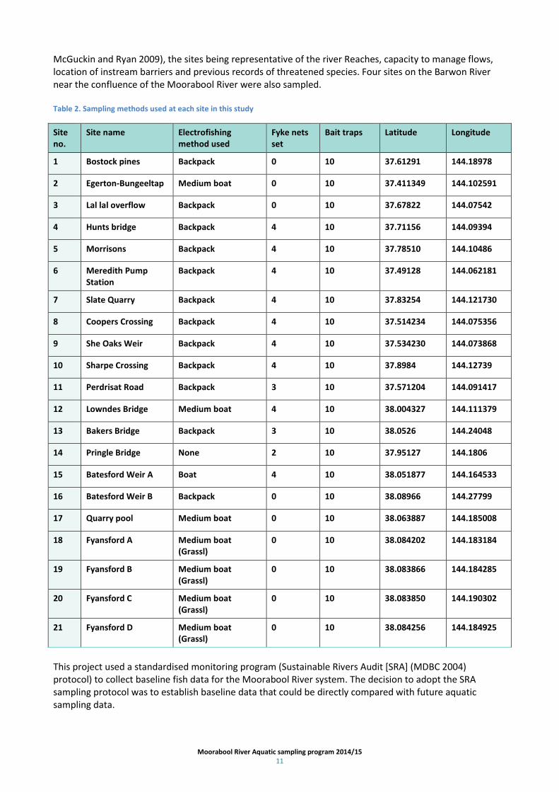
Moorabool River Aquatic sampling program 2014/15 11
McGuckin and Ryan 2009), the sites being representative of the river Reaches, capacity to manage flows, location of instream barriers and previous records of threatened species. Four sites on the Barwon River near the confluence of the Moorabool River were also sampled. Table 2. Sampling methods used at each site in this study
Site no.
Site name Electrofishing method used
Fyke nets set
Bait traps Latitude Longitude
1 Bostock pines Backpack 0 10 37.61291 144.18978
2 Egerton-Bungeeltap Medium boat 0 10 37.411349 144.102591
3 Lal lal overflow Backpack 0 10 37.67822 144.07542
4 Hunts bridge Backpack 4 10 37.71156 144.09394
5 Morrisons Backpack 4 10 37.78510 144.10486
6 Meredith Pump Station
Backpack 4 10 37.49128 144.062181
7 Slate Quarry Backpack 4 10 37.83254 144.121730
8 Coopers Crossing Backpack 4 10 37.514234 144.075356
9 She Oaks Weir Backpack 4 10 37.534230 144.073868
10 Sharpe Crossing Backpack 4 10 37.8984 144.12739
11 Perdrisat Road Backpack 3 10 37.571204 144.091417
12 Lowndes Bridge Medium boat 4 10 38.004327 144.111379
13 Bakers Bridge Backpack 3 10 38.0526 144.24048
14 Pringle Bridge None 2 10 37.95127 144.1806
15 Batesford Weir A Boat 4 10 38.051877 144.164533
16 Batesford Weir B Backpack 0 10 38.08966 144.27799
17 Quarry pool Medium boat 0 10 38.063887 144.185008
18 Fyansford A Medium boat (Grassl)
0 10 38.084202 144.183184
19 Fyansford B Medium boat (Grassl)
0 10 38.083866 144.184285
20 Fyansford C Medium boat (Grassl)
0 10 38.083850 144.190302
21 Fyansford D Medium boat (Grassl)
0 10 38.084256 144.184925
This project used a standardised monitoring program (Sustainable Rivers Audit [SRA] (MDBC 2004) protocol) to collect baseline fish data for the Moorabool River system. The decision to adopt the SRA sampling protocol was to establish baseline data that could be directly compared with future aquatic sampling data.

Moorabool River Aquatic sampling program 2014/15 12
Both active and passive fish collection techniques were used to monitor the fish assemblage within the Moorabool River system. Boat and backpack electrofishing was undertaken as the active component of the survey (Figure 4). A Smith-Root 5GPP boat electrofisher (settings: 1,000 volts, 38Hz, pulse DC) and a Halltech backpack electro-fisher was operated (settings: 250 volts, 60 Hz, pulse DC) following the Sustainable Rivers Audit (SRA) protocol (eight, 150 second shots [power on time] at each site for backpack and 12, 90 second shots per site for the boat)(MDBC 2004). The electrofishing operator fished in an upstream direction, fishing all accessible habitats. The Halltech backpack electrofisher was chosen as it is capable of fishing in waters of 3,000 µS/cm. Sites 18 to 21 were fished with a Grassl 20GPP boat electrofisher using the same settings as the Smith-Root boat (see above).
Fyke nets and bait-traps were used for the passive collection of fish. Two single-winged larval fyke-nets (5m long, 0.8m high, 3mm mesh size) were set in the late afternoon and early evening to sample for fish moving at night. Nets were set in pairs at the head and/or the tail-end of pools: each net was set to face downstream on a 45 degree angle from the bank with a float attached to the cod end (top) to ensure survival of any trapped mammals. Variation in the numbers of fyke nets used at sites 11 and 13 was the result of interference with nets during the survey. In addition, 10 unbaited bait-traps were set at each site for 2hrs to sample small fish not collected during routine electrofishing. At the completion of each operation, all fish were identified to species, counted (maximum of 50 individuals per species per site) and measured for total length (to the nearest mm). Once processed, all fish were returned to the site of capture.
The 2008 aquatic survey of the Moorabool River (McGuckin and Ryan 2009) was undertaken using a methodology determined by drought conditions such as high salinities and availability of equipment. While this methodology was useful in establishing the presence/absence of species much of the methods are unclear and are subject to interpretation (eg. 50 min dip netting) and do not adhere to a standardized sampling protocol. In addition, nine of the 22 sites surveyed in 2008 were found to be dry in 2014 and were replaced with additional sites located below Batesford Weir (the most downstream site sampled in 2008). Given the variation between 2008 and 2014 survey methodology and survey site locations, the ability to compare datasets to determine the effectiveness of the environmental watering program since 2010, notwithstanding the impacts of drought and flood, is severely limited. Therefore, indirect comparison between the current dataset and the 2008 dataset (McGuckin and Ryan 2009) may provide general information on changes in species distributions within replicate sample sites, however, direct comparison of the two datasets are excluded from analysis.
2.4 Water quality characteristics
Water quality parameters were recorded using a portable TPS water quality meter (Conductivity, Temperature, Dissolved Oxygen, pH, and Turbidity). Spot measurements were taken at a single location for each survey site. The aim of the water quality testing was to document extreme declines in water quality and to provide information used to determine electrofishing settings. Hydrological data was provided by the CCMA from gauging stations located within the Moorabool River system. Site specific water quality parameters are provided in Appendix 2.

Moorabool River Aquatic sampling program 2014/15 13
Figure 4. ARI staff undertaking boat and backpack electrofishing (S. Vermeeren; S. Raymond 2014).

Moorabool River Aquatic sampling program 2014/15 14
3 Results
A river ecosystem is deemed ‘healthy’ when its native flora and fauna is maintained over time compared with the reference condition which refers to the condition that would be likely to prevail had there been no significant human intervention in that region. Fish populations are a component of the ecosystem and ecological health of fish populations can be assessed by diversity, abundance, distribution, size class and ratio of native and introduced fish species. For example, losses of native flora and fauna are a form of imbalance, and the effects are compounded when these are replaced by alien species. An unhealthy system is one substantially changed from its natural state that may have lost native and gained alien species. The Moorabool River fish population has been impacted by various threats including barriers to fish movement, changed habitat conditions and altered flow regimes which have transformed the structure of the fish community. However, rehabilitation actions including the installation of fishways (e.g. lower Barwon breakwater), riparian improvement works and utilisation of environmental water are useful tools that are improving the health of the Moorabool River fish population.
3.1 Fish surveys
A total of 7,935 fish, representing nine native and six exotic species, were captured and observed in the 2014 survey (Table 3). Of these, 7,237 (92%) were native and 690 (8%) introduced and represent 60 and 86% of native and exotic species, respectively, previously recorded from the reach. Small-bodied natives, common galaxias (n=1,335), flat-headed gudgeon (n=870) and Australian smelt (n=816) dominated the sample accounting for 38% of the total fish numbers. Distribution and recruitment data for each species are compared with 2008 records where possible (Table 4, figures 5 and 6). The percentage of native fish collected in 2014 (92%) was comparatively higher than the 50% reported for the 2008 study. This was largely the result of large numbers of common galaxias, flat-headed gudgeon and Australian smelt collected in the lower Reach (Reach 4) of the Moorabool River and Barwon River sites which were not sampled in 2008. Three additional native fish species (common and spotted galaxias and tupong) and two additional exotic species (common carp and goldfish) were collected in 2014 and absent from the 2008 study. Individual species collection location maps are located in Appendix 1. Short-finned eel was the most widely distributed (all 21 sites) fish species within the Moorabool River system, consistent with 2008 findings (Table 4). The size of Short finned eels (fish < 150mm TL) indicates that they are recruiting into the population, also consistent with 2008 survey data. River blackfish were present at 50% of sites within Reaches 1, 3A, 3B and 4 but were not collected at sites located downstream of Batesford Weir (Table 4). Half of the river blackfish were collected from two sites (Sites 4 and 7). Length frequency plots show a wide range of cohorts, consistent with successful recruitment in previous years (Figure 5). Yarra pygmy perch were collected in low numbers (n=6) from a single location (Site 14) in Sutherland Creek, restricted to a single deep pool with abundant emergent vegetation. This was compared with the capture of 11 individuals in 2008 (Table 5). Length frequency plots indicate that there has been some recent recruitment (fish < 40mm TL) of this species (Figure 5). A total of 228 Southern pygmy perch were collected in 2014, from six sites (four above Batesford Weir, one site in Sutherland Creek and from one site directly below Batesford Weir). In comparison, 329 southern pygmy perch were captured in 2008, with the majority of these collected from sites that were dry in 2014. In 2014, southern pygmy perch were collected from sites containing abundant emergent vegetation such as Tryglochin sp. and from sites with comparatively less flow than upstream sites. The southern pygmy perch population have successfully recruited (fish < 40mm TL) in 2014 (Figure 5) indicating that suitable conditions were present over the previous two months (October and November 2014)for successful spawning and larval survival.

15
Table 3. Abundance (observed and collected), mean length and length range of fish species collected during the 2014 Moorabool River Aquatic Fauna Survey.
Common name Scientific name Sum of Collected Sum of Observed Mean length (mm) Range (mm)
Native
Short finned eel Anguilla australis 51 283 408 115-700
River blackfish Gadopsis marmoratus 79 9 211 56-394
Common galaxiid Galaxias maculatus 1335 1131 69 40-147
Spotted galaxiid Galaxias truttaceus 1 — 1 119
Southern pygmy perch Nannoperca australis 219 9 51 24-87
Yarra pygmy perch Nannoperca obscura 6 — 49 38-64
Flatheaded gudgeon Philypnodon grandiceps 870 497 58 21-115
Tupong Pseudaphritis urvillii 27 15 157 46-273
Australian smelt Retropinna semoni 816 1889 50 20-75
Sub-total 3404 3833
Introduced
Goldfish Carassius auratus 9 — 228 126-321
Common carp Cyprinus carpio 23 111 563 472-668
Eastern gambusia Gambusia holbrooki 28 373 36 12-62
Redfin Perca fluvialtilis 82 5 210 46-378
Brown trout Salmo trutta 25 4 130 54-365
Tench Tinca tinca 29 1 187 48-460
Sub-total 196 494
Total collected and observed 3605 4330

Moorabool River Aquatic sampling program 2014/15 16
Table 4. Distribution of fish species between sites and river Reaches of the Moorabool River 2014. The blue square represents the sample location of the endangered Yarra pygmy perch.

17
Table 5. Abundance of fish species sampled from the Moorabool River in 2008 and 2014. Survey methods and site locations differed between years. The 2014 survey represents collected and observed fish while the 2008 study contains only fish collected.
Common name 2014 study 2008 study
Native
Short finned eel 334 150
River blackfish 88 63
Common galaxiid 2466 0
Spotted galaxiid 1 0
Southern pygmy perch 228 329
Yarra pygmy perch 6 11
Flat-headed gudgeon 1367 405
Tupong 42 0
Australian smelt 2705 270
Introduced
Goldfish 9 0
Common carp 134 0
Eastern gambusia 401 968
Redfin 87 17
Brown trout 29 1
Tench 30 63
Total 7935 2277
Forty two tupong were collected in 2014 but were absent in the 2008 survey. Thirty five individuals were collected from sites located below the Batesford Weir, while seven individuals were collected above the weir. A range of size class was present, with small fish (fish < 50mm TL) indicating successful recruitment into the system in recent years (Figure 5). No tupong were recorded upstream of She Oaks Weir in 2014. Large numbers of Australian smelt (n=2,705), common galaxias (n=2,466) and flat-headed gudgeon (n=1,367) were collected in 2014. Australian smelt were broadly distributed within Reaches 3 and 4, common galaxias were only collected from Reach 4, however the presence of this species upstream of the Batesford quarry and weir indicates that there has been some connectivity around this area. Flat-headed gudgeon were recorded throughout Reaches 1, 3 and 4. A single adult spotted galaxid was recorded immediately above the Batesford Weir (Site 15).

Moorabool River Aquatic sampling program 2014/15 18
Figure 5. Length frequency (%) data for native fish collected in the Moorabool River system in 2014. Histogram bars representing the smallest age classes indicate the presence of recent recruits and the proportion of recruits within a population.
0
20
40
60
80
100
0-100 101-200 201-300 301-400 401-500 501-600 601-700
Short-finned eel
0
20
40
60
80
100
0-100 101-200 201-300 301-400 401-500
River blackfish
0
20
40
60
80
100
0-50 51-100 101-150 151-200
Common galaxias
0
20
40
60
80
100
0-20 21-40 41-60 61-80 81-100 101-120
0
20
40
60
80
100
0-50 51-100 101-150 151-200 201-250 251-300
Tupong
Flat-headed gudgeon
0
20
40
60
80
100
0-20 21-40 41-60 61-80 81-100 101-120
Australian smelt
0
20
40
60
80
100
0-20 21-40 41-60 61-80 81-100 101-120
Southern pygmy perch
0
20
40
60
80
100
0-20 21-40 41-60 61-80 81-100 101-120
Yarra pygmy perch
Length (mm)
Perc
enta
ge f
req
ue
ncy
(%
)
n = 51 n = 79
n = 1,335 n = 870
n = 27 n = 816
n = 6 n = 219

Moorabool River Aquatic sampling program 2014/15 19
3.2 Exotic species abundance, distribution and recruitment
Four of the six exotic species (brown trout, tench, Eastern gambusia and redfin perch) showed evidence of recent recruitment while goldfish and common carp did not (Figure 6). Common carp, goldfish and redfin perch were predominantly sampled from the lower Reach, below Batesford quarry. Eastern gambusia were widely distributed throughout the sample Reaches and tench were most numerous within the She Oaks weirpool. Abundances of Eastern gambusia and tench were comparatively lower than the 2008 survey and may reflect changed hydrological conditions, habitat preferences and species preference for specific flows.
Figure 6. Length frequency (%) data for exotic fish collected in the Moorabool River system 2014. Histogram bars representing the smallest age classes indicate the presence of recruits and the proportion of recruits within a population.
0
20
40
60
80
100
0-100 101-200 201-300 301-400 401-500 501-600 601-700
Common carp
0
20
40
60
80
100
0-50 51-100 101-150 151-200 201-250 251-300 301-350
Goldfish
0
20
40
60
80
100
0-75 76-150 151-225 226-300 300-375
Brown trout
0
20
40
60
80
100
0-75 76-150 151-225 226-300 300-375 376-450 451-525
Tench
Length (mm)
Perc
enta
ge f
req
ue
ncy
(%
)
0
20
40
60
80
100
0-20 21-40 41-60 61-80 81-100
Eastern gambusia
0
20
40
60
80
100
0-75 76-150 151-225 226-300 300-375 376-450 451-525
Redfin perch
n = 23 n = 9
n = 25 n = 29
n = 28 n = 82

Moorabool River Aquatic sampling program 2014/15 20
3.3 Hydrology and water quality
Moorabool River water quality was considered within acceptable levels for the fish fauna collected in 2014 (Appendix 2). Extensive and severe drought conditions prevailed in south-eastern Australia from 2000 to 2010. Drought breaking rains and successive years of moderate to high flows occurred from late 2010 to late 2012 with a return to lower flow conditions from 2013 onward (Figure 7). The proportional contribution of e-flows provided through the entitlement was greatest in 2013 and 2014 (Figure 8).
Figure 7. Water discharge from Batesford Weir (Gauge 232202) on the Moorabool River and the contribution of natural flows (black line) and e-flows (red line) (ML/d) to total river discharge from 2008 to 2015.
Figure 8. Water discharge from Batesford Weir (Gauge 232202) on the Moorabool River and the contribution of natural flows (black line) and e-flows (red line) (ML/d) to total river discharge from 2013 to 2014.
Dis
char
ge (
ML/
d)
0
1000
2000
3000
4000
5000
1/1/2008 1/1/2009 1/1/2010 1/1/2011 1/1/2012 1/1/2013 1/1/2014 1/1/2015
e-flows
discharge
Date

4 Discussion
A significant finding of the recent surveys was the collection of tupong, common galaxias and spotted galaxias upstream of Batesford Weir, indicating that suitable reconnecting flows have recently facilitated fish passage around this structure and provided diadromous species with access to new upstream habitats. The environmental watering program has delivered connecting flows ‘freshes’ in recent years that are critical to fish migration and dispersal. The watering entitlement has supplemented daily flows throughReach 3 of the Moorabool River and has on a number of occasions provided the only flows to the system.
Corangamite CMA Environmental Watering Program:
Environmental flow releases in 2013 and 2014 provided through the environmental entitlement haveincreased river heights and flooded weirs in Reach 4 and have improved connectivity in this reach. This has been validated by the collection of short lived diadromous fish species such as the common galaxias (3 years, Pollard 1971) indicates that connectivity through this reach was facilitated by four freshes (> 30ML/d) provided between January and July 2013 and the large (>65ML/d) winter fresh in 2014, managed by the CCMA. This is consistent with the presence of tupong (155 to 273mm) and small (< 116 mm) short-finned Eels, however, the ability of the latter to traverse instream structures over land is noted.
Diadromous fish were not collected by McGuckin and Ryan (2009), probably as a result of enduring drought conditions, absence of survey locations in the lower reaches and the lack of connectivity between marine, estuarine and fresh waters (prior to construction of lower Barwon vertical-slot fishway and only intermittent connectivity at the Batesford quarry). Their presence in the Moorabool River system in the 2014 surveys demonstrated that the construction of the lower Barwon vertical-slot fishway, along with improved flow conditions since 2011, have provided some connectivity within the system.
Batesford Quarry and the Moorabool River diversion channel:
Re-establishment of connectivity around the Batesford quarry is a priority within the Moorabool River system. This 2km stretch of river only reconnects when flows greater than 30ML/d are provided from Lal Lal Reservoir (S.Vermeeren Pers Comm). Currently these types of flows are absent for most of the year causing a significant barrier to fish migration, particularly for diadromous species. This barrier may prevent the long-term sustainability of threatened native fish such as the Australian grayling within the Moorabool River system.Further geomorphological and hydrological assessments are required to ameliorate the negative impacts of sinkholes on fish within this reach . In addition, weirs between the quarry and She Oaks Weir present a barrier to fish movement and their removal should also be considered. The comparatively higher species richness of the 2014 (15 species) study compared with the 2008 survey (10 species) was largely due to the addition of migratory native fish species from the lower reach (below Batesford quarry) of the Moorabool and Barwon river sites which were not sampled in 2008. Connectivity of the Moorabool River around the Batesford quarry during spring would benefit native species through access to more habitats and provide a conduit for species that undertake spawning migrations. Connectivity for juvenile dispersal should also be considered but this life history strategy varies widely for different species.
Weirs
Diadromous native fish were absent from sites above She Oaks Weir. The inability of fish to traverse this 4m high structure has likely excluded them from the upper reaches of the Moorabool River. Migratory fish species will remain absent from the upper reaches of the Moorabool River system until movement past She Oaks Weir is provided through the installation of a fish ladder. In contrast, Batesford Weir does not appear to be a permanent barrier to fish movement as indicated by the presence of migratory species. It is noted that the current annual water entitlement (exclusive of passing flows) for the Moorabool River system is approximately 2,500ML (dependent on inflows) and is therefore unable to provide permanent connectivity past this structure by providing drown out flows. Therefore, consideration should be given to the installation of a fish passage on this structure to reinstate permanent connectivity.

Moorabool River Aquatic sampling program 2014/15 22
Barriers to fish movement are widely acknowledged as a major threat to fish populations and play a significant role in the distribution of fish within the Moorabool River catchment (Raadik and Koster 2000; Hindell et al. A detailed study of instream structures and their impacts within Reaches 3 and 4 of the Moorabool River is recommended.
The frequency of high flows recorded at Batesford Weir has increased since 2009 (eg. 2011 and 2012 floods and 65ML/D winter fresh environmental Water Entitlement in 2013 and 2014) and need to be maintained as part of future flow management strategies to facilitate the passage of fish species throughout Reaches 3 and 4 of the Moorabool River.
Water Quality Considerations: Low flows pose a threat to native fish through the effects of low (>2 -4 mg/L) to hypoxic (>0 to 2.0 mg/L) dissolved oxygen (DO) concentrations with impacts ranging from altered behavioural responses to death, with effects of low DO on fish dependent on exposure duration, species and life stage (Small et al 2014). Sub-lethal responses of Australian smelt, southern pygmy perches and river blackfish were recorded at 2.5, 2.3 mg/L, and <4mg/L, respectively, with lethal impacts for river blackfish below 2 mg/L (Whiterod and Hammer 2012) and Australian grayling between 4 and 6 ppm DO (Koehn and O’Connor 1990; McNeil andCloss 2007; Small et al 2014). These findings highlight the need to maintain suitable flows through the Moorabool River to ameliorate the threat of low DO to fish. The literature indicates that alarm (4mg/L) and critical (3 mg/L) thresholds for DO be set to limit sub-lethal and lethal impacts to fish. These trigger values should be incorporated into the management of flows in the Moorabool River to maintain suitable water quality for fish. Fish Ecology in the Moorabool River: Fish species richness (diversity) was comparatively higher in Reach 4 compared with Reaches 1 and 3 and species richness within Reach 4 was greatest downstream of Batesford Weir. The hydrodynamic diversity below Batesford Weir provides a combination of lotic and lentic habitats capable of supporting a variety of species with preferences for different flows and habitat types. As this is the first study to complete a comprehensive assessment of the fish community in the lower reach of the Moorabool River we were unable to compare species richness with past diversity. However, more than 100 individuals of diadromous galaxias and non-migratory flat-headed gudgeon were collected in 2014, attributed, in part, to the newly constructed fishway downstream of the Moorabool/Barwon river confluence (O’Connor and Pickworth 2015). In addition, recently improved flow management may have also contributed to increased species richness. No Australian grayling were captured in the 2014 Moorabool River Aquatic Fauna survey, however, the species was recorded from the Moorabool River in 2003 (Zampatti and Grgat 2004) and from the Barwon River in 2014 (O’Connor and Pickworth 2015). Improved flow management may attract the species into the Moorabool River in subsequent years. Recruitment of native fish species highlights the true defined population which is important for allocating limited resources such as flows to maintain suitable habitat. For example, river blackfish was sampled above and below She Oaks Weir; however, recruitment was restricted to upstream sites and thus reflects the location of the true population with a lack of recruits below the weir assigning these individuals as a sink or reservoir for the species. The preference of river blackfish for faster flowing clear waters suggests that flow conditions (and habitat) above She Oaks Weir are more suitable for this species and should be maintained to ensure their long-term sustainability. In contrast, southern pygmy perch was restricted to sites downstream of She Oaks Weir and may reflect the species’ preference for slower flowing waters with emergent and surface vegetation (along with a lack of predatory fish such as Redfin) (Allen et al 2003). These observations are consistent with minimum length data provided by McGuckin and Ryan (2009) and highlight the importance of habitat protection and the maintenance of flows for different fish species, particularly for non-migratory species with limited capacity to escape unfavourable conditions.
Moorabool River Aquatic sampling program 2014/15 23
The nationally listed Yarra pygmy perch was restricted to a single site on Sutherland Creek, a tributary of the Moorabool River, consistent with 2008 findings (McGuckin and Ryan 2009). Low sample abundances, and the inability to provide flow management, suggest that this population may be at threat of localised extinction. Their preference for abundant aquatic vegetation in slow flowing waters highlights that maintenance and protection of aquatic vegetation within pool habitats is an important consideration for the preservation of the species in the study area. The proportion of exotic species recruiting and the level of recruitment of those species were lower than that observed in native fish populations. This indicates that recent conditions were less favourable for exotic fish species and that improved flow management within the system may provide benefits for native species. The absence of young-of-the-year carp and goldfish from the Moorabool River system is likely the result of a lack of recent flooding, often cited as a trigger for common carp spawning (Koehn et al 2000). Declining numbers of exotic species will likely benefit native fishes as some species such as brown trout and redfin perch are known to predate on small-bodied native fish (Cadwallader 1996), and as such, pose a threat to the long-term survival of native river blackfish, flat-headed gudgeon and Australian smelt. The observation that river blackfish and flat-headed gudgeon abundances were greater in sites where redfin perch and brown trout were absent indicates that the presence of these introduced species may be responsible for reduced native fish abundances. The ecological health of the Moorabool River system (as determined by fish diversity, abundance, distribution, size class and ratio of native and introduced fish species) improved from 2008 to 2014.
Waterway management and flow recommendations to maintain and improve fish diversity and ecological function of the Moorabool RIver The current study has highlighted the need to develop a number of waterway management strategies to support and improve the health of the environmental assets of the Moorabool River into the future. The following management strategies are recommended and have been provided in priority order:
Secure more environmental water within the environmental entitlement to restoresuitable flows to maintain water quality, particularly during summer low flows
Restoration of suitable flows for movement of target fish species, often undertaken in late winter and spring (species specific)
Provide flows to facilitate fish passage (short term action) for migratory species
Ameliorate the loss of water into the Batesford quarry and reinstate connectivity around the quarry
Remove significant barriers, including quarry channel weirs and Batesford Weir that impede fish passage with removal prioritised in an upstream direction
Investigate attractant flows required to facilitate movement of Australian grayling and other diadromous species into the Moorabool River
Investigate the re-instatement of fish passage up to She Oaks Weir We recommend that future flow regimes focus on using available water to provide continuous connectivity within the Moorabool River including past the Batesford quarry to facilitate fish movement. We also recommend incorporating attractant flows to the Moorabool River particularly for migrating juvenile diadromous species. Flows targeted at attracting species such as common galaxias and Australian graying into the Moorabool River need to be provided during spring and timed to coincide with appropriate flows in the Barwon River. While attractant flows are required to facilitate the movement of migratory fish species into the lower Moorabool River, it is crucial that flows to maintain sufficient water quality are also provided year round. While non-migratory fish (eg. river blackfish and southern pygmy perch) require sufficient flows to prevent poor water quality, migratory species (eg. common galaxias, Australian grayling, tupong and short-headed

Moorabool River Aquatic sampling program 2014/15 24
lamprey) require more specific flows to facilitate their lifecycles. For example Australian grayling breed in Autumn/Winter with young dispersing to the sea and migrating back into freshwater during spring as part of the annual whitebait migration. All key aspects of their life history are driven by flow (Koster et al 2013). While current water availability is insufficient to satisfactorily meet all the biological and ecological requirement of Australian grayling future acquisition of additional water will benefit the species.
Waterway rehabilitation measures:
A range of waterway rehabilitation measures are also available to maintain and enhance native fish populations within the Moorabool River system. These measures may include:
Maintenance of native aquatic vegetation in sites occupied by pygmy perch species
Provision of additional woody instream habitat for river blackfish and tupong, particularly within the concrete lined river channel adjacent to the Batesford quarry
Translocation of Yarra pygmy perch (from genetically similar populations) to establish additional
populations should be investigated.

Moorabool River Aquatic sampling program 2014/15 25
5 Conclusion
The management of flows is a critical component of the long-term sustainability of fish populations. Within the Moorabool River system flows are managed to provide benefits for fish through:
Access to suitable habitat for survival, growth, feeding and reproduction
Access to refugia during low/no flow events
Maintenance of suitable water quality
Cues for movement and migration for spawning, dispersal and recruitment.
Highlights from the current study and benefits to native fishes within the Moorabool River system as a result of increased flows and managed environmental entitlement flows included:
The ecological health of the Moorabool River system (as determined by fish diversity, abundance, distribution, size class and ratio of native and introduced fish species) improved from 2008 to 2014
There is a continued need for environmental flows (e.g. spring 'freshes') to encourage and promote movement of fish into and throughout the Moorabool River
Environmental flow releases in 2013 and 2014 provided through the environmental entitlement have increased river heights and flooded weirs in Reach 4 and have improved connectivity in this reach
High flows associated with floods in 2010/11 and late 2012 and environmental water allocations have maintained the diversity and abundance of native fish in the Moorabool River system since 2010
The environmental watering program and recent high flows have improved connectivity around Batesford quarry and provided an opportunity for diadromous species (that migrate between freshwater and the sea) to access new upstream habitats. This includes species such as common galaxias, spotted galaxias and tupong
The threatened Yarra pygmy perch was collected in Sutherland Creek. This indicates the species has persisted through the millennium drought. Yarra pygmy perch has a strong preference for abundant aquatic vegetation in slow flowing water. Maintaining and protecting this vegetation in pool habitats is therefore an important consideration for the conservation of this species in the study area and may be suited to a translocation program in an attempt to improve the resilience of the species within the system
The decline in the abundance and distribution of the introduced Eastern gambusia may be associated with high flows from floods and additional water from environmental flows
Survey results suggest that the fish community in the lower reaches of the Moorabool River closely resembles that which is expected. Diadromous species are, however, largely absent from the middle and upper reaches. This is likely a result of poor fish passage associated with physical barriers. This will need to be addressed before these species can extend to these reaches. Environmental flows haveimproved passage over smaller structures that are present in these lower reaches
The nationally threatened Australian grayling was not recorded in the current surveys. Recent monitoring indicates however they are present in the Barwon River. Their absence in the lower Moorabool is likely associated with impaired fish passage and unsuitable water quality

Moorabool River Aquatic sampling program 2014/15 26
This study provides baseline data for additional monitoring of fish populations in the Moorabool River system in the future.

Moorabool River Aquatic sampling program 2014/15 27
References
Allen, G.R., Midgley, S.H., and Allen, M. (2003). Field guide to the freshwater fishes of Australia (Revised Edition). Quality Press, Perth, Western Australia.
Cadwallader, P.L. (1996) Overview of the Impacts of Introduced Salmonids on Australian Native Fauna. Australia Nature Conservation Agency, Canberra.
CCMA. (2005). River health implications of water transfers in the flow stressed Moorabool River catchment. Colac, Australia.
CCMA. (2006). Corangamite River Health Strategy. Colac, Australia.
CCMA. (2011). Corangamite River Health Strategy. Colac, Australia.
Department of Sustainability and Environment (2005). Victorian Aquatic Fauna Database. Fish data. River Basin 32 – Moorabool. Freshwater Ecology. Arthur Rylah Institute, DSE, Victoria. Environment Protection and Biodiversity Conservation Act (1999). List of threatened fauna. Department of Environment, Water, Heritage and the Arts. Australian Government. Flora and Fauna Guarantee Act (1998). Threatened List. Department of Sustainability and Environment. Victorian Government. Hindell, J.S., Stuart I., and Jones, M. (2008). Assessment and recommendations on restoring fish passage across the Lower Barrage Tidal Barrage of the Barwon River. Arthur Rylah Institute for Environmental Research Technical Report Series No. 2008/98. Department of Sustainability and Environment, Heidelberg, Victoria Koehn, J. D. and O’Connor, W.G. (1990). Biological information for Management of Native Freshwater fish in Victoria. Jean Gordon Government Printer, Melbourne. Koehn, J.D., Gehrke, P., and Brumley, A. (2000). Managing the impacts of Carp. Bureau of Rural Sciences, Canberra. 249pp.
McGuckin, J. and T. Ryan. (2009). Moorabool River fish survey – measuring the impact of dry inflow conditions. Report prepared for Corangamite CMA.
McNeil, F.D., and G.P. Closs. (2007). Behavioural responses of a south-east Australian floodplain fish community to gradual hypoxia Freshwater biology 52(3): 412–420.
Murray Darling Basin Commission. (2004). Fish Theme Pilot audit Technical Report. Sustainable River Audit. Canberra, Murray-Darling Basin Commission. O’Connor, J., and Pickworth, A. (2015). Assessment of the Barwon River barrage vertical slot fishway. Arthur Rylah Institute for Environmental Research. Unpublished Client Report for Corangamite CMA.
Pollard, D.A. (1971). The biology of a landlocked form of the normally catadromous salmoniform fish Galaxias maculatus (Jenyns). I. Life cycle and origin. Marine and Freshwater Research 22(2): 91-124 .

Moorabool River Aquatic sampling program 2014/15 28
Raadik, T., and Koster, W. (2000). Pre and post fishway construction assessments – Barwon and Moorabool Rivers and Otway streams. Client Report for CCMA by Arthur Rylah Institute for Environmental Research. Department of Natural Resources and Environment, Heidelberg, Victoria. Small, K., Kopf, R.K., Watts, R.J., and Howitt, J. (2014). Hypoxia, blackwater and fish kills: Experimental lethal oxygen thresholds in juvenile predatory lowland river fishes. PLOS ONE 9(4): 1-10. SKM (2004). Moorabool River Water Resource Assessment. Report for the Corangamite Catchment Management Authority. Victorian Aquatic Fauna Database, DSE (2005). Fish data. River Basin 32 - Moorabool. Freshwater Ecology, Arthur Rylah Institute, DSE, Victoria.
Whiterod, N, & Hammer, M (2012). Conservation and Management of River Blackfish in Rodwell Creek, 2011-12. Report to the Foundation for Australia's Most Endangered Species Ltd (FAME), Goolwa to Wellington LAP and the South Australian Murray-Darling Basin NRM Board. Aquasave Consultants, Adelaide. 31 p. Zampatti, B., and Grgat, L. (2004). An assessment of Environmental flow requirements for the Moorabool River: A component of the Moorabool River Streamflow Management Plan. Arthur Rylah Institute. Department of Natural Resources and Environment, Heidelberg, Victoria.
29
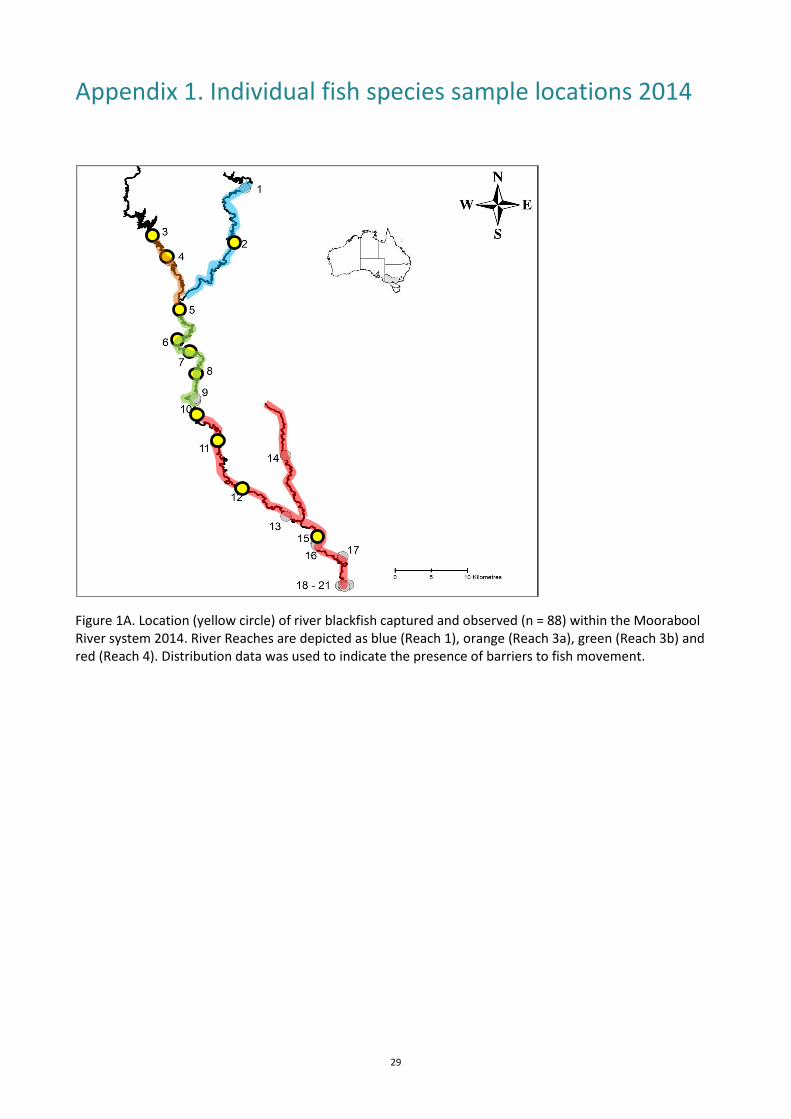
Appendix 1. Individual fish species sample locations 2014
Figure 1A. Location (yellow circle) of river blackfish captured and observed (n = 88) within the Moorabool River system 2014. River Reaches are depicted as blue (Reach 1), orange (Reach 3a), green (Reach 3b) and red (Reach 4). Distribution data was used to indicate the presence of barriers to fish movement.

Moorabool River Aquatic sampling program 2014/15 30
Figure 2A. Location (yellow circle) of Yarra pygmy perch captured and observed (n = 6) within the Moorabool River system 2014. River Reaches are depicted as blue (Reach 1), orange (Reach 3a), green (Reach 3b) and red (Reach 4). Distribution data was used to indicate the presence of barriers to fish movement. Figure 3A. Location (yellow circle) of southern pygmy perch captured and observed (n = 228) within the Moorabool River 2014. River Reaches are depicted as blue (Reach 1), orange (Reach 3a), green (Reach 3b) and red (Reach 4). Distribution data was used to indicate the presence of barriers to fish movement.

Moorabool River Aquatic sampling program 2014/15 31
Figure 4A. Location (yellow circles) of tupong captured and observed (n = 42) within the Moorabool River 2014. River Reaches are depicted as blue (Reach 1), orange (Reach 3a), green (Reach 3b) and red (Reach 4). Distribution data was used to indicate the presence of barriers to fish movement.
Figure 5A. Location (yellow circles) of Australian smelt captured and observed (n = 2705) within the Moorabool River 2014. River Reaches are depicted as blue (Reach 1), orange (Reach 3a), green (Reach 3b) and red (Reach 4). Distribution data was used to indicate the presence of barriers to fish movement.

Moorabool River Aquatic sampling program 2014/15 32
Figure 6A. Location (yellow circles) of common galaxias captured and observed (n = 2,496) within the Moorabool River 2014. River Reaches are depicted as blue (Reach 1), orange (Reach 3a), green (Reach 3b) and red (Reach 4). Distribution data was used to indicate the presence of barriers to fish movement. Figure 7A. Location (yellow circles) of flat-headed gudgeon captured and observed (n = 1367) within the Moorabool River 2014. River Reaches are depicted as blue (Reach 1), orange (Reach 3a), green (Reach 3b) and red (Reach 4). Distribution data was used to indicate the presence of barriers to fish movement.
Moorabool River Aquatic sampling program 2014/15 33
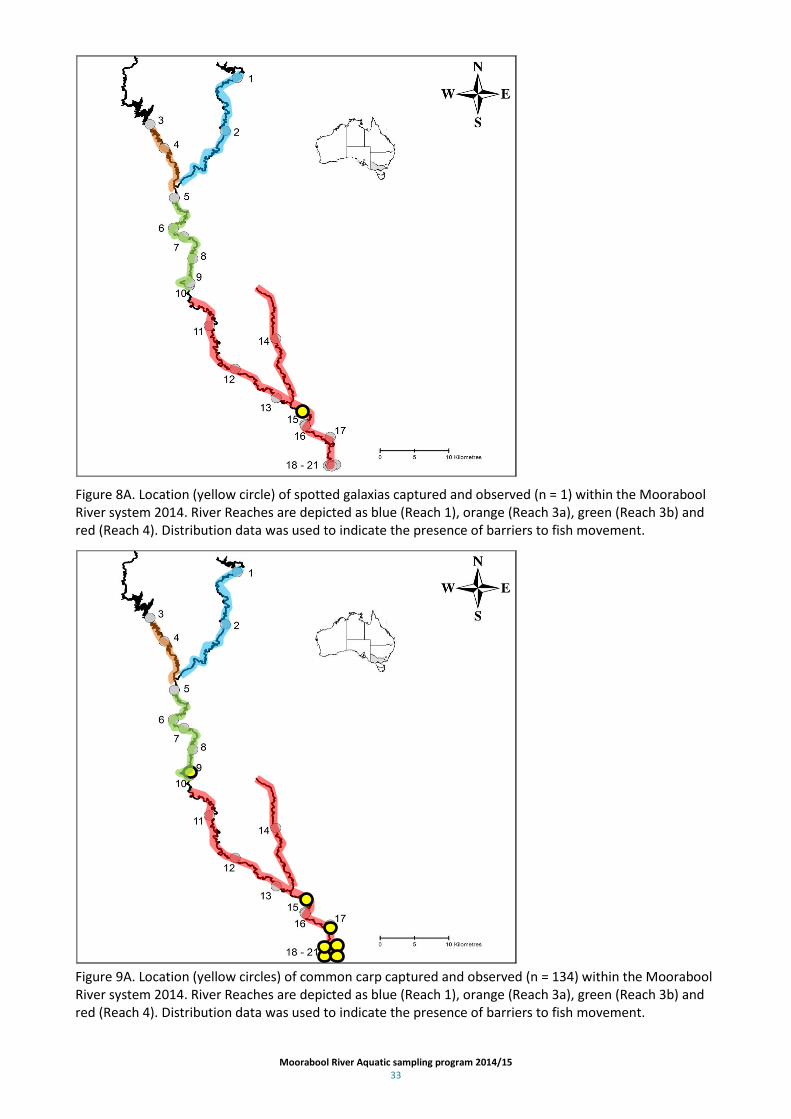
Figure 8A. Location (yellow circle) of spotted galaxias captured and observed (n = 1) within the Moorabool River system 2014. River Reaches are depicted as blue (Reach 1), orange (Reach 3a), green (Reach 3b) and red (Reach 4). Distribution data was used to indicate the presence of barriers to fish movement. Figure 9A. Location (yellow circles) of common carp captured and observed (n = 134) within the Moorabool River system 2014. River Reaches are depicted as blue (Reach 1), orange (Reach 3a), green (Reach 3b) and red (Reach 4). Distribution data was used to indicate the presence of barriers to fish movement.

Moorabool River Aquatic sampling program 2014/15 34
Figure 10A. Location (yellow circles) of brown trout captured and observed (n = 29) within the Moorabool River system 2014. River Reaches are depicted as blue (Reach 1), orange (Reach 3a), green (Reach 3b) and red (Reach 4). Distribution data was used to indicate the presence of barriers to fish movement.
Figure 11A. Location (yellow circles) of redfin perch captured and observed (n = 87) within the Moorabool River system 2014. River Reaches are depicted as blue (Reach 1), orange (Reach 3a), green (Reach 3b) and red (Reach 4). Distribution data was used to indicate the presence of barriers to fish movement.

Moorabool River Aquatic sampling program 2014/15 35
Figure 12A. Location (yellow circles) of goldfish captured and observed (n = 9) within the Moorabool River system 2014. Goldfish were sampled from sites 18, 19 and 20. River Reaches are depicted as blue (Reach 1), orange (Reach 3a), green (Reach 3b) and red (Reach 4). Distribution data was used to indicate the presence of barriers to fish movement.
Figure 13A. Location (yellow circles) of tench captured and observed (n = 30) within the Moorabool River system 2014. River Reaches are depicted as blue (Reach 1), orange (Reach 3a), green (Reach 3b) and red (Reach 4). Distribution data was used to indicate the presence of barriers to fish movement.

Moorabool River Aquatic sampling program 2014/15 36
Figure 14A. Location (yellow circles) of Eastern gambusia captured and observed (n = 401) within the Moorabool River system 2014. River Reaches are depicted as blue (Reach 1), orange (Reach 3a), green (Reach 3b) and red (Reach 4). Distribution data was used to indicate the presence of barriers to fish movement.

Moorabool River Aquatic sampling program 2014/15 37
Appendix 2. Water quality parameters for each Moorabool River sample site 2014
Site number
Site name Temperature (0C) DO (mg/L) EC (µS/cm) Ph
1 Bostock pines 14.8 8.3 565 6.94
2 Egerton-Bungeeltap rd. bridge
3 Lal lal overflow [Bungal dam rd.] 14.7 10.96 405 7.79
4 Hunts bridge [Elaine-Egerton rd.] 17.7 10.1 527 8.01
5 Ballan - Meredith Road, Morrisons 16.7 9.08 471 7.74
6 Meredith Pump Station 17.1 9.6 1190 7.76
7 Slate Quarry Road, Meredith 18.1 9.75 1173 7.87
8 Steiglitz Road, Meredith 19.2 9.83 1226 7.86
9 Sheoak Weir (above weir) 19 8.94 1281 7.88
10 Sharpe Road 18.5 9 1284 8.31
11 Perdrisat Road, Maude 18.2 8.19 1486 7.55
12 Parkers Road (rob @ Leoh Clyde) 17 6.01 2307 7.44
13 Bakers Bridge Road 14.5 6.5 2060 7.43
14 To north of Pringle Bridge Road 16.3 4.5 4261 7.84
15 Above bridge on Batesford rd. 17.4 6.55 2228 7.7
16 Batesford quarry 19.9 10.76 4275 7.9
17 Below bridge on Batesford rd. 14.7 5.74 1890 7.34
18 Fyansford A 20.4 5.9 3439 7.77
19 Fyansford B 20.5 6.4 2200 7.75
20 Fyansford C 22.9 8.34 1216 7.9
21 Fyansford D 20.6 9.9 1873 7.84

Moorabool River Aquatic sampling program 2014/15 38
Appendix 3. Moorabool River Aquatic Fauna Survey data, 2014
Site number Sum of
Collected Sum of
Observed
1 10 3
Anguilla australis 10 3
2 12 180
Anguilla australis 1 Gadopsis marmoratus 1 Gambusia holbrooki 3 180
Perca fluvialtilis 2 Philypnodon grandiceps 3 Tinca tinca 2 3 21 37
Anguilla australis 4 36
Gadopsis marmoratus 6 Philypnodon grandiceps 2 Salmo trutta 9 1
4 29 7
Anguilla australis 2 3
Gadopsis marmoratus 24 3
Salmo trutta 3 1
5 27 Anguilla australis 4 Gadopsis marmoratus 2 Philypnodon grandiceps 3 Retropinna semoni 1 Salmo trutta 6 Tinca tinca 11 6 29 35
Anguilla australis 3 3
Gadopsis marmoratus 4 1
Gambusia holbrooki 3 Philypnodon grandiceps 6 Retropinna semoni 10 30
Tinca tinca 3 1
7 53 51
Anguilla australis
6
Gadopsis marmoratus 20 5
Gambusia holbrooki 2 40
Philypnodon grandiceps 8 Retropinna semoni 18 Tinca tinca 5 8 131 100
Anguilla australis 1

Moorabool River Aquatic sampling program 2014/15 39
Gadopsis marmoratus 7 Retropinna semoni 119 100
Salmo trutta 2 Tinca tinca 2 9 76 116
Anguilla australis 5 27
Cyprinus carpio 5 Gambusia holbrooki 1 70
Perca fluvialtilis 4 Philypnodon grandiceps 58 2
platypus
2
Retropinna semoni 1 15
Tinca tinca 1 turtle 1 10 25 34
Anguilla australis 8 2
Gadopsis marmoratus 1 Perca fluvialtilis 1 Philypnodon grandiceps 6 Retropinna semoni 2 30
Salmo trutta 5 2
Tinca tinca 2 11 85 16
Anguilla australis
10
Gadopsis marmoratus 12 Nannoperca australis 65 6
Philypnodon grandiceps 3 Retropinna semoni 5 12 133 165
Anguilla australis
44
Gadopsis marmoratus 1 Gambusia holbrooki
41
Nannoperca australis 12 Perca fluvialtilis 3 1
Philypnodon grandiceps 57 platypus
1
Retropinna semoni 58 78
Tinca tinca 2 13 91 28
Anguilla australis 5 24
Galaxias maculatus 6 1
Gambusia holbrooki 4 Nannoperca australis 70 3
Philypnodon grandiceps 3 turtle 3 14 101 Anguilla australis 5 Nannoperca australis 26

Moorabool River Aquatic sampling program 2014/15 40
Nannoperca obscura 6 Philypnodon grandiceps 63 turtle 1 15 66 177
Anguilla australis
26
Cyprinus carpio 5 2
Gadopsis marmoratus 1 Galaxias maculatus 8 7
Galaxias truttaceus 1 Nannoperca australis 1 Perca fluvialtilis 1 Philypnodon grandiceps 39 Pseudaphritis urvillii 7 2
Retropinna semoni 2 140
Tinca tinca 1 16 33 763
Anguilla australis
40
Cyprinus carpio 12 5
Galaxias maculatus 11 Gambusia holbrooki
32
Philypnodon grandiceps 2 4
Pseudaphritis urvillii 8 2
Retropinna semoni
680
17 61 27
Anguilla australis
27
Galaxias maculatus 9 Nannoperca australis 45 Philypnodon grandiceps 7 18 606 393
Anguilla australis 2 1
Carassius auratus 6 Cyprinus carpio 1 15
Galaxias maculatus 328 170
Gambusia holbrooki 7 Perca fluvialtilis 4 Philypnodon grandiceps 175 80
Pseudaphritis urvillii 2 Retropinna semoni 81 127
19 574 384
Anguilla australis
3
Carassius auratus 2 Cyprinus carpio
10
Galaxias maculatus 278 198
Perca fluvialtilis 3 Philypnodon grandiceps 170 94
Pseudaphritis urvillii 1 Retropinna semoni 120 79
20 569 710

Moorabool River Aquatic sampling program 2014/15 41
Anguilla australis 1 3
Carassius auratus 1 Cyprinus carpio
70
Galaxias maculatus 307 425
Gambusia holbrooki 2 Perca fluvialtilis 36 Philypnodon grandiceps 44 32
Pseudaphritis urvillii 1 Retropinna semoni 177 180
21 871 1104
Anguilla australis
25
Cyprinus carpio
9
Galaxias maculatus 386 330
Gambusia holbrooki 6 10
Perca fluvialtilis 28 4
Philypnodon grandiceps 221 285
Pseudaphritis urvillii 8 11
Retropinna semoni 222 430
(blank) 2 Galaxias maculatus 2 Grand Total 3605 4330

Moorabool River Aquatic sampling program 2014/15 42
www.delwp.vic.gov.au