assessment of geological investigations on bw i e …
TRANSCRIPT

32E13NWM18 2.5194 HOPPER LAKE 010
ASSESSMENT OF GEOLOGICAL
INVESTIGATIONS ON
WHOPPER PROPERTY,
BURNTBUSH-DETOUR LAKES AREA,
NTS 32E13/32L4
bW i e
MINING

32E13NW88I8 8.5)94 HOPPER LAKE 010C
TABLE OF UJN.LX,WTO
PAGE
LOCATION AND ACCESS l
PROPERTY DESCRIPTION . 2
PREVIOUS WORK 6
PRESENT STUDY 9
Geology of the Whopper Area - Results from Drilling 10
a) General Geology and the Character of Mineralization 10
b) Stratigraphy and Structure 15c) Correlation of Geology and Geophysics 17d) Geochemistry of Sulfide-Rich Strata 18e) Dimensions of Inhalative Sulfide Mineralization 21f) Interpretation of Whole Rock Geochemistry 24
SUMMARY AND INTERPRETATION 26
RECOMMENDATIONS 27
REFERENCES 29
APPENDIX I - Petrographic Descriptions 30
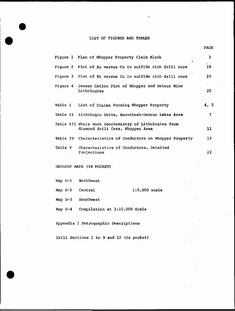
LIST OF FIGURES AND TABLES
PAGE
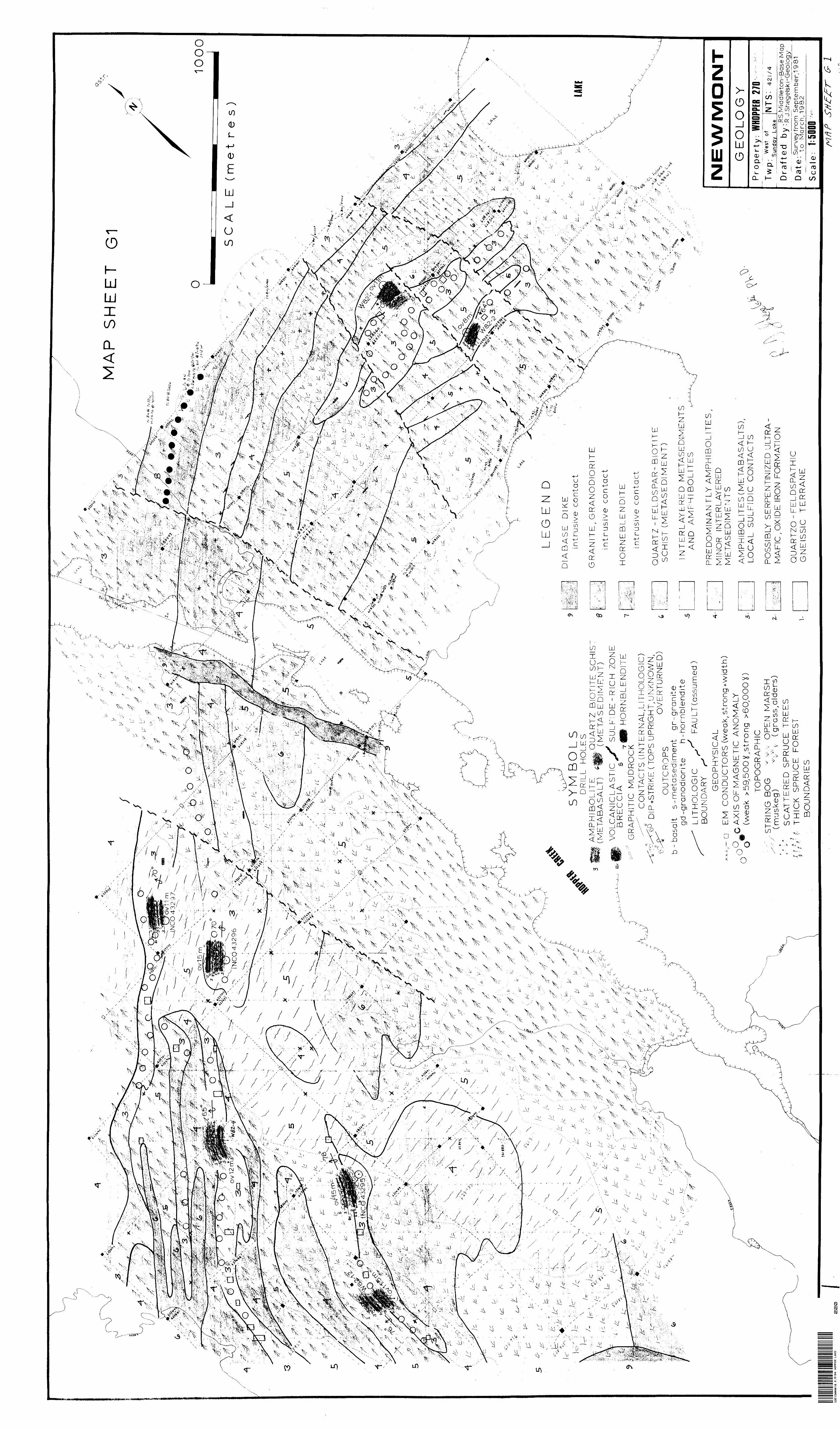
Figure l Plan of Whopper Property Claim Block 3
Figure 2 Plot of Au versus Cu in sulfide rich drill core 19
Figure 3 Plot of Ni versus Cu in sulfide rich drill core 20
Figure 4 Jensen Cation Plot of Whopper and Detour MineLithologies 25
Table I List of claims Forming Whopper Property 4, 5
Table II Lithologic Units, Burntbush-Detour Lakes Area 7
Table III Whole Rock Geochemistry of Lithologies fromdiamond drill Core, Whopper Area 11
Table IV Characteristics of Conductors on Whopper Property 12
Table V Characteristics of Conductors, DetailedProjections 22
GEOLOGY MAPS (IN POCKET) :
Map G-l Northeast
Map G-2 Central 1:5,000 scale
Map G-3 Southwest
Map G-4 Compilation at 1:10,000 Scale
Appendix I Petrographic Descriptions
Drill Sections l to 9 and 12 (in pocket)

QUALIFICATIONS OF THE WRITER
EDUCATION:
Hon. B.Se., Lakehead University, Thunder Bay, 1971 M. Se., Ph. D., University of Toronto, 1978
EXPERIENCE:
Assistant Professor of Geology , Lakehead University, 1977 to 1981 Summers 1971-1980: mapping for Geological Survey ofCanada, Dept. of Indian and Northern Affairs, Noranda Exploration, New Insco Mines, Ontario Geological Survey and National Science and Engineering Research Council.
May 1981 to present: Project Geologist, Newmont Exploration of Canada Limited, Timmins, Ontario.
PROFESSIONAL AFFILIATIONS:
Canadian Institute of Mining and Metallurgy Geological Association of Canada.
R.J. Shegelski, Ph. D.

- l -
LOCATION AND ACCESS
A contiguous 216 claim block staked by Newmont Exploration
is located in the northern Abitibi greenstone belt approximately
200 km northeast of Timmins, Ontario in the West of Sunday Lake-
Hopper Lake area. The property is situated north and north
east of Hopper Lake and lies in the northwest corner of
Map 2453 (Johns, 1982).
The area is accessible in winter by ski equipped, fixed
wing aircraft or by winter road which passes through the
southwest corner of the property. Summer access is limited to
helicopter and float equipped aircraft on the larger, deeper
lakes. Much of the area is string bog and open marsh which
are not easily traversed in the summer. A new all-weather
gravel road to Detour Mine is presently being constructed and '
will be completed in the near future.
- 2 -
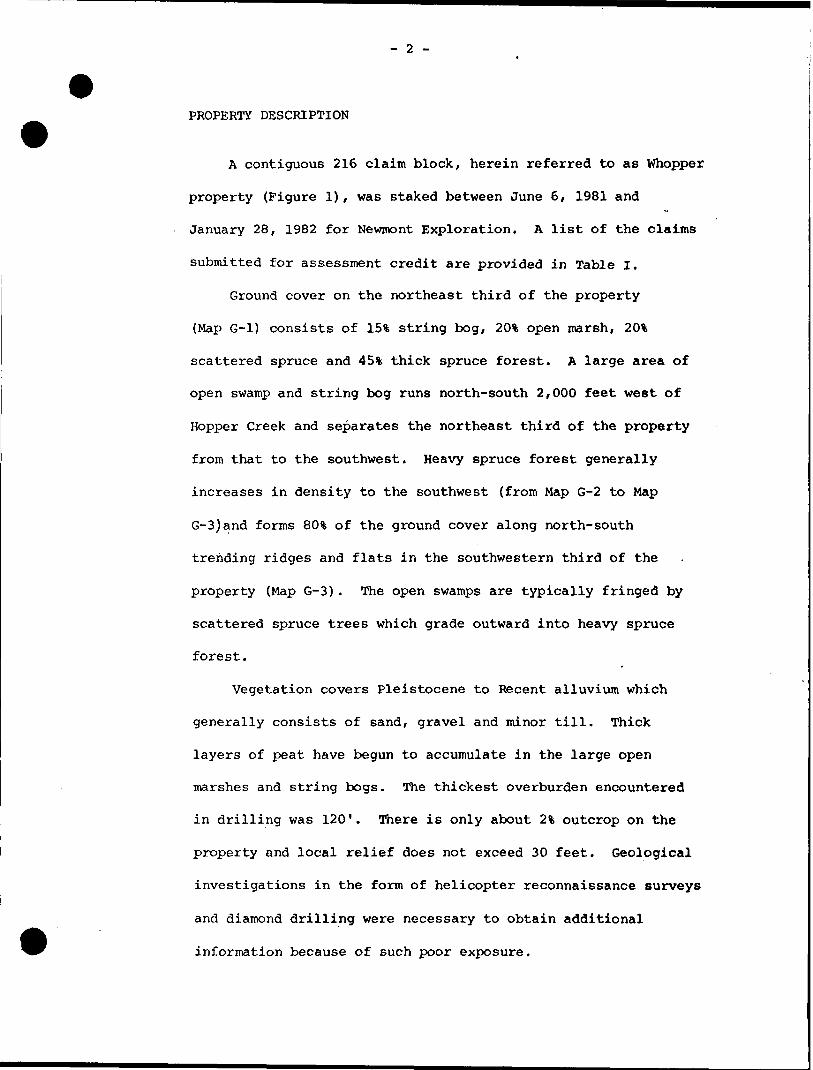
PROPERTY DESCRIPTION
A contiguous 216 claim block, herein referred to as Whopper
property (Figure 1), was staked between June 6, 1981 and
January 28, 1982 for Newmont Exploration. A list of the claims
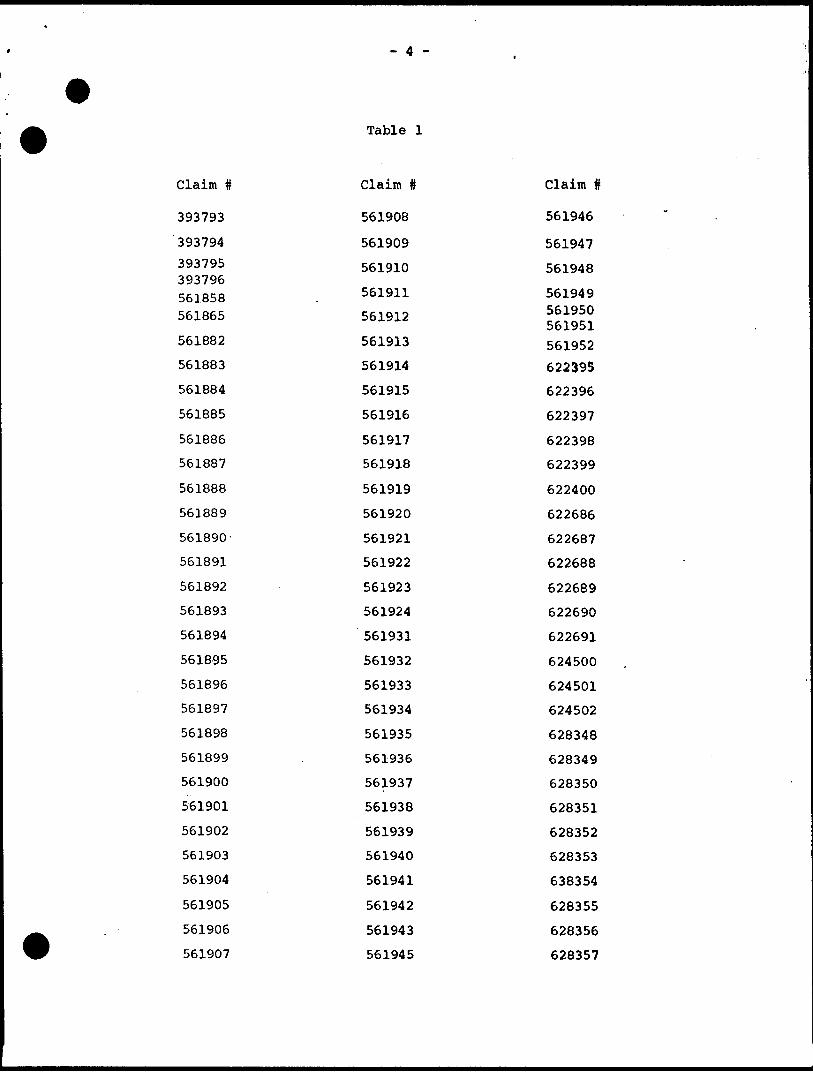
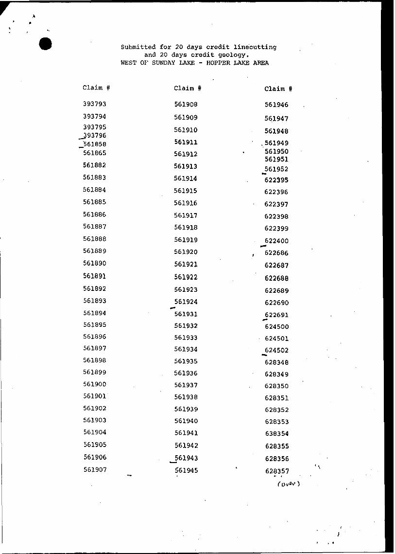
submitted for assessment credit are provided in Table I.
Ground cover on the northeast third of the property
(Map G-l) consists of 15% string bog, 2(^ open marsh, 2(^
scattered spruce and 45% thick spruce forest. A large area of
open swamp and string bog runs north-south 2,000 feet west of
Hopper Creek and separates the northeast third of the property
from that to the southwest. Heavy spruce forest generally
increases in density to the southwest (from Map G-2 to Map
G-3)and forms 80% of the ground cover along north-south
trending ridges and flats in the southwestern third of the
property (Map G-3). The open swamps are typically fringed by
scattered spruce trees which grade outward into heavy spruce
forest.
Vegetation covers Pleistocene to Recent alluvium which
generally consists of sand, gravel and minor till. Thick
layers of peat have begun to accumulate in the large open
marshes and string bogs. The thickest overburden encountered
in drilling was 120'. There is only about 23, outcrop on the
property and local relief does not exceed 30 feet. Geological
investigations in the form of helicopter reconnaissance surveys
and diamond drilling were necessary to obtain additional
information because of such poor exposure.
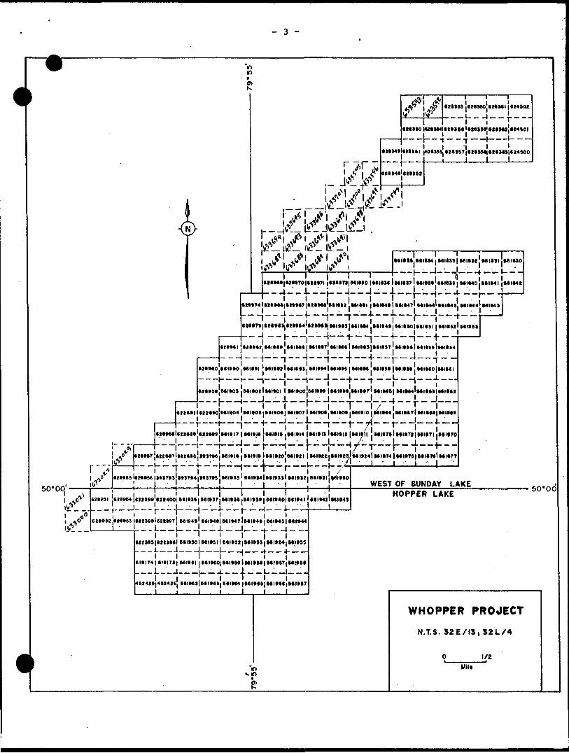
- 3 -
O)
4^
•HM*l*Mltl |eHJSSJ*2*JSr!*2*J9*|*2*MJ|e24SOO, r r j , ! i i i(2*14*1*2*3*2
rt-
*i i
MIIU. t*l*M j MltJ! j Mlltt MIIII JMItaO
i i'i' i i i 'i i i|(t*Mt|UI*70|*2**7l|*2**7S|MIMO|MIM*lMI*S7lMIIM MMS* j Mt*40JMI*4l |MI*42
i i i i i itM*74ltt*M*|*MMr|tt*MeWtMt2 j 1*1*11 |MIM( 11(1 K T 1 MIMS'MIM* Ml*44' MI*4S
C2t*t i C2OC2.--J--h--i—|—t --j—+--H--t--
-- --- ' MIM* j MIM71 MIM* l MIM5J K 1(97 ' MO9(i MIUslMIIM'j'l i l j l --J-.., —— ^ ——— j ——— t —— .}.--4. —— 1 ——— —— T ..
C2IMO t*l**0 .KIMI ' MUM l Milt li MKM l Ml**9 | MIIK MKM j MUM MIMOjMIiei
———— l ———— f--., ———— j ———— ,--J ——— ^-. T --j ————— I--J- ———
*M*5* MIKliteitOtlMltOI l MI*OOJMII*t iMIItt.MIMT) MIMftl MIM^l-
50'00
it
-.. __ __ i.-i _ __ i.^ _ L--.-" -J——(22*111U2MOiMlt04 'M 1*09|MltO*| MWO71 MI*O*.MI*Ot |MltlO | **IM( .MIMTJ MIMI| MIM*
— r—1---{
I(*9TJtZi*(7i(ttMe|(tST*6|Mltlt|MI*l(lttl*tOJMIttl-^-4--— ---l--- 1 —— r--"---7
MltlJ
4-j MIIM |MI**( j *(l*40| M 1*41 j MIMll MI*4J
j Ml*4*l *(I*4*1MIM7U(IM*| MIM9| M21
(22X9|(22I*tl 9*19901 MI*9I l tCI*9219*I*9S l MI994j MI999 --- 1 — — J— — J__—L-— -l — —^.— — ^-—--J
(1*174 ) (1(171 f Kl*(l |MIMO|MltMlMI*M|MI*S7|Ml*S(
4. — J. —' — L. ^ J _ — Jl T l lf *(IM4 |MI*(*|MI*M|Mt*(7l l II
' l l l i l l[**4*l*I2**e|*2IM9JMI*l7 | Ml*)* JMI9I9 |MI*I4 |MI*II iMItlt jMltll j MUTll **I*72|MI*7I i((1*70
l- ' - l -l -' ' 'l 1 l 1 ./' '1 l--i—j---]—j--t—i--f--|--y-r— l— 4—i—Ei((7l(2t((e M*miMltltlMt*ral*tl*20 MIMI |MI*22|MI*2S M 1*241 Ml*74 |MIIT(IMI*T*I Ml*77MI*t4lMltT4|MIIT*|MI*TtlMI*TT
WEST OF SUNDAY LAKEHOPPER LAKE
50 C 0
if)
WHOPPER PROJECT
N.T.S. S2EXI3,S2LX4
1/2Mil*
- 4 -
Table l
Claim #
393793
393794
393795 393796 561858 561865
561882
561883
561884
561885
561886
561887
561888
561889
561890
561891
561892
561893
561894
561895
561896
561897
561898
561899
561900
561901
561902
561903
561904
561905
561906
561907
Claim #
561908
561909
561910
561911
561912
561913
561914
561915
561916
561917
561918
561919
561920
561921
561922
561923
561924
561931
561932
561933
561934
561935
561936
561937
561938
561939
561940
561941
561942
561943
561945
Claim #
561946
561947
561948
561949 561950 561951
561952
622395
622396
622397
622398
622399
622400
622686
622687
622688
622689
622690
622691
624500
624501
624502
628348
628349
628350
628351
628352
628353
638354
628355
628356
628357

- 5 -
Table l (continued)
Claim ft Claim ft Claim ft
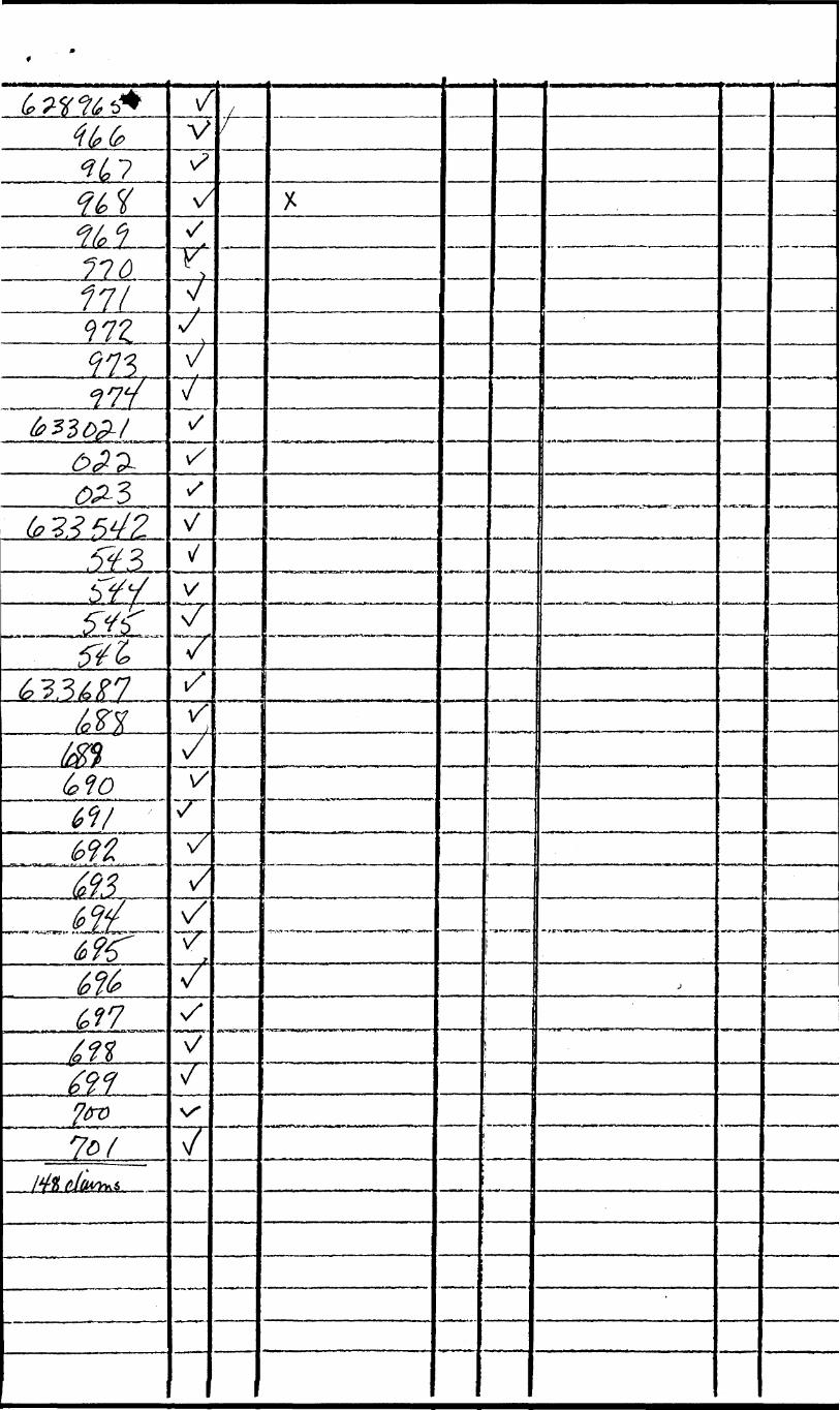
628358 628963 633545
628359 628964 633546
628360 628965 633687
628361 628966 633688
628362 628967 633689
628363 628968 633690
628951 628969 633691
628952 628970 633692
628953 628971 633693
628954 628972 633694
628955 628973 633695
628956 628974 633696
628957 633021 633697
628958 633022 633698
628959 633023 633699
628960 633542 633700
628961 633543 633701
628962 633544
- 6 -
PREVIOUS WORK
The Whopper project area is reasonably remote and was
only mapped on reconnaissance scale in 1967 by G. Bennett50^000 -.^' *#-'
et. al. This survey was followed by 1:15,840 scale mapping
under supervision of G.W. Johns in 1978. The Whopper area is
indicated as having almost no outcrop on Johns' map and there
is certainly less than 3% rock exposure in the field. A table
of lithologic units has therefore been constructed based upon
general geology throughout the broader area (Johns, 1982) but
has been modified based upon drilling results in the Whopper -
area (Table II).
Previous diamond drill programmes combined with the present
drilling have allowed geological interpretation over most of
the Whopper area. In 1971, three diamond drill holes were :
filed by INCO for assessment and were spotted on the basis of
previously defined coincident magnetic anomalies and EM
conductors. Hole 43297 intersected amphibolite metavolcanics
and metasediments. The conductor was 5.3 feet of graphitic,
sulfidic mudrock from 257.5 to 262.8 feet. Hole 43296
intersected amphibolite metavolcanics with sulfide rich flow
tops from 180 to 190 feet and from 219.8 to 236.9 feet. Hole
43295 intersected more amphibolite metavolcanics with a distinct
sulfide concentration PO-70%) from 231.0 to 238.6 feet. All^
drilling was conducted in the west of Sunday Lake Area and is
located on Map G-l.

- 7 -
TABLE II
LITHOLOGIC UNITS, BURNTBUSH-DETOUR LAKES AREA *
PHANEROZOICCENOZOIC
QUATERNARYRecent swamp, stream and lacustrine deposits Pleistocene till, gravel, sand and clay
Unconformity
PRECAMBRIANPROTEROZOIC
Quartz Diabase Dikes
Intrusive Contact
ARCHEANDiorite Intrusions and Felsic to Intermediate Intrusions (quartz monzonite, granodiorite, granite, quartz diorite, feldspar porphyry, quartz-feldspar porphyry, gneiss, pegmatite, felsite, trondjhemite)
Intrusive Contact
Mafic and Ultramafic Intrusions (gabbro, amphibolite, porphyritic gabbor, hornblendite, ultramafic rocks)
Intrusive Contact
Metasediments (chemical chert and iron formation; clastic wacke, arenite, arkose, calc-silicate rocks, grit, graphitic mudrock, tuff as schists)
Metavolcanics
Felsic to Intermediate (flows, porphyritic flows and pyroclastic or volcaniclastic rocks)
Mafic to Intermediate (massive, pillowed and porphyritic flows with flow top breccias and minor fragmentals of equivalent composition, as amphibolites)
* (modified from Johns, 1982)
- 8 -
In 1976, Patino Mines drilled three holes in the property
after conducting a ground EM Survey. Hole No. l intersected
both metavolcanic and metasedimentary layers. A graphitic
sulfidic (24-3(^) mudrock from 200 to 201.5 feet was apparently
the conductor being drilled for. Hole No. 2 intersected three
anphibolite basalt flows and a thin metasediment layer from
125.5 to 166 feet. The conductor was a 3.5' width of 20%
pyrrhotite near the top of a flow 240 feet down the hole. None
of these sulfide rich zones returned good assays in Cu, Ag,
Au and Zn.
- 9 -
PRESENT STUDY
In early September, 1981, Newmont Exploration conducted
a three day helicopter geological reconnaissance survey in the
area and collected rock samples from more than a dozen sites.
Five typical lithologies were selected for thin sectioning
and petrographic descriptions of these are presented in
Appendix I. Newmont Exploration staked 216 claims between
June 6, 1981 and January 28, 1982. An airborne magnetometer
and EM survey was flown over 210 line miles of ground on
August 18, 1981 by Renting Earth Sciences Ltd., Ottawa. Line-
cutting (170.76 miles) commenced by Ingamar Explorations,
Connaught on September 12, 1981 and was completed December
17, 1981. Lines were both summer and winter cut, base lines
contained 25 metre pickets, cross lines were spaced 100 metres
apart with pickets on cross lines at 25 metre intervals. The
extension grid between the northeast area (Map G-l) and the
area to the southwest (Maps G-2, G-3) was the only exception
where cross lines were spaced at 200 metre intervals instead
of 100 metre intervals. Tie lines were cut parallel to each
baseline and run along the boundaries of the property. Ground
geophysical surveys were conducted by Rayan Exploration,
North Bay, using MP-2 magnetometer and MAX MIN II and were
conducted soon after and in conjuction with the linecutting.
Ground geophysical surveys terminated December 21, 1981.
These surveys were augmented by geological examination
- 10 -
of all available outcrops on the property using airphotos to
locate outcrops and cut lines for ground control. In addition/
a ten hole diamond drill programme was conducted by Norex
Drilling, Timmins and MSW Drilling, Earlton, from February
22, 1982 to March 4, 1982. The 4,049 feet of core obtained
were logged in detail and a large number of sulfide rich
intervals were split and assayed. Detailed cross sections
were then constructed and geochemical data analysed during
the remainder of March, 1982. Twelve representative samples
were selected from drill core and analysed for whole rock
abundances (see Table III) in order to better characterize
lithologies on the property.
Geology of the Whopper Area - Results from Drilling
a) General Geology and the Character of Mineralization
Details of location, depth, inclination and character
of each major conductor are included in Table IV. Supra
crustal rocks drilled include submarine basalt flows,
greywack-arenite-siltstone sequences, minor graphitic
sulfidic mudrock, minor mafic tuff and rare felsic tuffs
which are probably reworked. No felsic volcanic flow rocks
or fragmentals were observed and their absence suggests
that the environment investigated is that of a submarine
basalt shield complex.
A series of lithologic cross sections corresponding to
the appropriate drill holes (W 82-1 is SECTION l, etc...)

- 11 -
Table III
Whole Rock Geochemistry of Lithologies from Diamond Drill Core, Whopper Area
Sample
Si02
A1203
CaO
MgO
Na20
K20
Fe203
MnO
Ti02
P205
Cr203
LOI
TOTAL
Rb
Sr
Zr
7016
47.8
11.4
13.1
15.3
1.39
0.74
7.77
0.13
0.30
0.04
0.11
0.77
98.8
50
60
0
7013
47.7
11.2
10.7
10.2
1.82
0.68
14.2
0.25
0.95
0.10
0.09
0.54
98.4
20
80
40
7009
49.7
15.2
11.9
6.36
2.01
0.25
12.4
0.27
0.87
0.07
0.02
0.47
99.6
tf)
90
40
7001
50.3
12.6
11.3
6.30
2.38
0.42
13.4
0.32
1.31
0.07
0.03
0.08
98.4
0
180
30
7004
50.7
11.3
11.5
10.5
1.82
1.40
9.71
0.17
0.56
0.22
0.17
0.62
98.8
50
540
50
7017
51.0
19.5
9.14
6.13
3.42
1.56
7.68
0.12
0.43
0.18
0.00
0.77
100.0
50
380
60
7006
51.1
13.6
10.8
7.48
2.61
0.25
12.4
0.29
1.07
0.15
0.05
0.54
100.4
0
200
70
7007
54.5
15.3
8.37
4.13
3.34
0.43
11.2
0.23
1.54
0.19
0.02
0.47
99.8
0
130
90
7010
53.8
14.8
8.54
4.44
2.66
1.31
10.5
0.27
0.93
0.08
0.02
1.93
99.3
180
80
50
7002
55.0
15.4
7.45
3.44
1.36
3.31
9.21
0.17
1.09
0.09
0.02
2.62
99.2
70
90
50
7005
58.4
5.10
2.86
3.03
0.26
0.04
24 .6
2.28
0.08
0.04
0.02
2.16
98.9
0
0
0
7011
62.2
16.1
2.70
2.90
3.91
2.63
7.59
0.09
0.58
0.14
0.02
0.93
99.8
90
230
120
7016 - hornblendite intrusion; 7013 - hornblendite dyke; 7009 -fine, grained chill base, basalt flow; 7001, 7004, 7017, 7006 and 7007 - fine grained dark green amphibolites (metabasalt); 7010 - silicified flow base (metabasalt); 7002 - silicified, sulfidized amphibolite (metabasalt); 7005 - garnet porphyritic amphibolite, Pe metasomatized basalt; 7011 - quartz, feldspar, biotite schist (metasediment) .
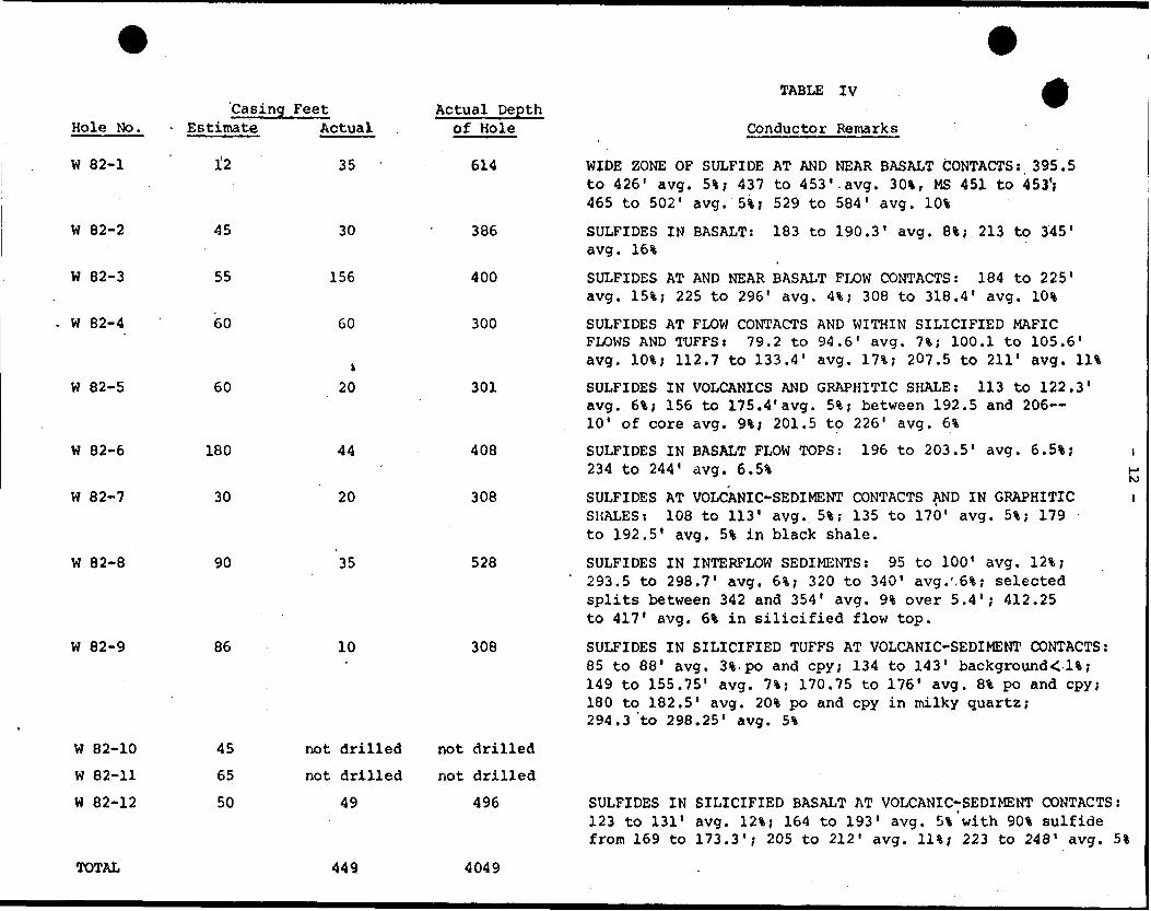
'Casing Feet Hole No. - Estimate Actual
W 82-1 l'2 35
W 82-8
W 82-9
W 82-10
W 82-11
W 82-12
90
86
45
65
50
35
10
not drilled
not drilled
49
Actual Depth of Hole
614
W 82-2
W 82-3
W 82-4
W 82-5
W 82-6
W 82-7
45
55
60
60
180
30
30
156
60
k20
44
20
386
400
300
301
408
308
528
308
not drilled
not drilled
496
TABLE IV
Conductor Remarks
WIDE ZONE OF SULFIDE AT AND NEAR BASALT CONTACTS: 395.5 to 426' avg. 51; 437 to 453'.avg. 301, MS 451 to 453'; 465 to 502' avg
SULFIDES IN BASALT: avg. 16%
51; 529 to 584' avg.
183 to 190.3' avg. 81; 213 to 345'
K)
i
SULFIDES AT AND NEAR BASALT FLOW CONTACTS: 184 to 225' avg. 151; 225 to 296' avg. 41; 308 to 318.4' avg. 101
SULFIDES AT FLOW CONTACTS AND WITHIN SILICIFIED MAFIC FLOWS AND TUFFS: 79.2 to 94.6' avg. 71; 100.1 to 105.6' avg. 101; 112.7 to 133.4' avg. 171; 207.5 to 211' avg. Ill
SULFIDES IN VOLCANICS AND GRAPHITIC SHALE: 113 to 122.3' avg. 61; 156 to 175.4'avg. 51; between 192.5 and 206 10' of core avg. 91; 201.5 to 226' avg. 61
SULFIDES IN BASALT FLOW TOPS: 196 to 203.5' avg. 6.51; 234 to 244' avg. 6.51
SULFIDES AT VOLCANIC-SEDIMENT CONTACTS AND IN GRAPHITIC SHALES: 108 to 113' avg. 51; 135 to 170' avg. 51; 179 to 192.5' avg. 51 in black shale.
SULFIDES IN INTERFLOW SEDIMENTS: 95 to 100' avg. 121; 293.5 to 298.7' avg. 61; 320 to 340' avg.'.61; selected splits between 342 and 354' avg. 91 over 5.4'; 412.25 to 417' avg. 61 in silicified flow top.
SULFIDES IN SILICIFIED TUFFS AT VOLCANIC-SEDIMENT CONTACTS: 85 to 88' avg, 31 po and cpy; 134 to 143' background<li; 149 to 155.75' avg. 71; 170.75 to 176' avg. 81 po and cpy; 180 to 182.5' avg. 201 po and cpy in milky quartz; 294.3 to 298.25' avg. 51
SULFIDES IN SILICIFIED BASALT AT VOLCANIC-SEDIMENT CONTACTS: 123 to 131' avg. 121; 164 to 193' avg. Sl'with 901 sulfide from 169 to 173.3'; 205 to 212' avg. Ill; 223 to 248' avg. 51
TOTAL 449 4049

- 13 -
included in a back pocket for reference. Examination of sections
reveals that the two common lithologies in the area are submarine
basalt flows now present as amphibolites and deep marine sediments
represented by biotite-feldspar-quartz schists. These two
major lithologies are interlayered to varying degrees with a
generally observed trend of thicker basalt flows and heavier
pyrrhotite mineralization in the northeast portion of the property.
SECTIONS l, 2, 4 and 12 in particular all contain horizons of
massive pyrrhotite in a milky quartz matrix which are presently
interpreted as inhalative sulfide deposits {i.e. syngenetic
mineralization which occurs within porous rock media after the
rock is deposited and prior to compaction). None of the other
sections have encountered this specific type of massive sulfide
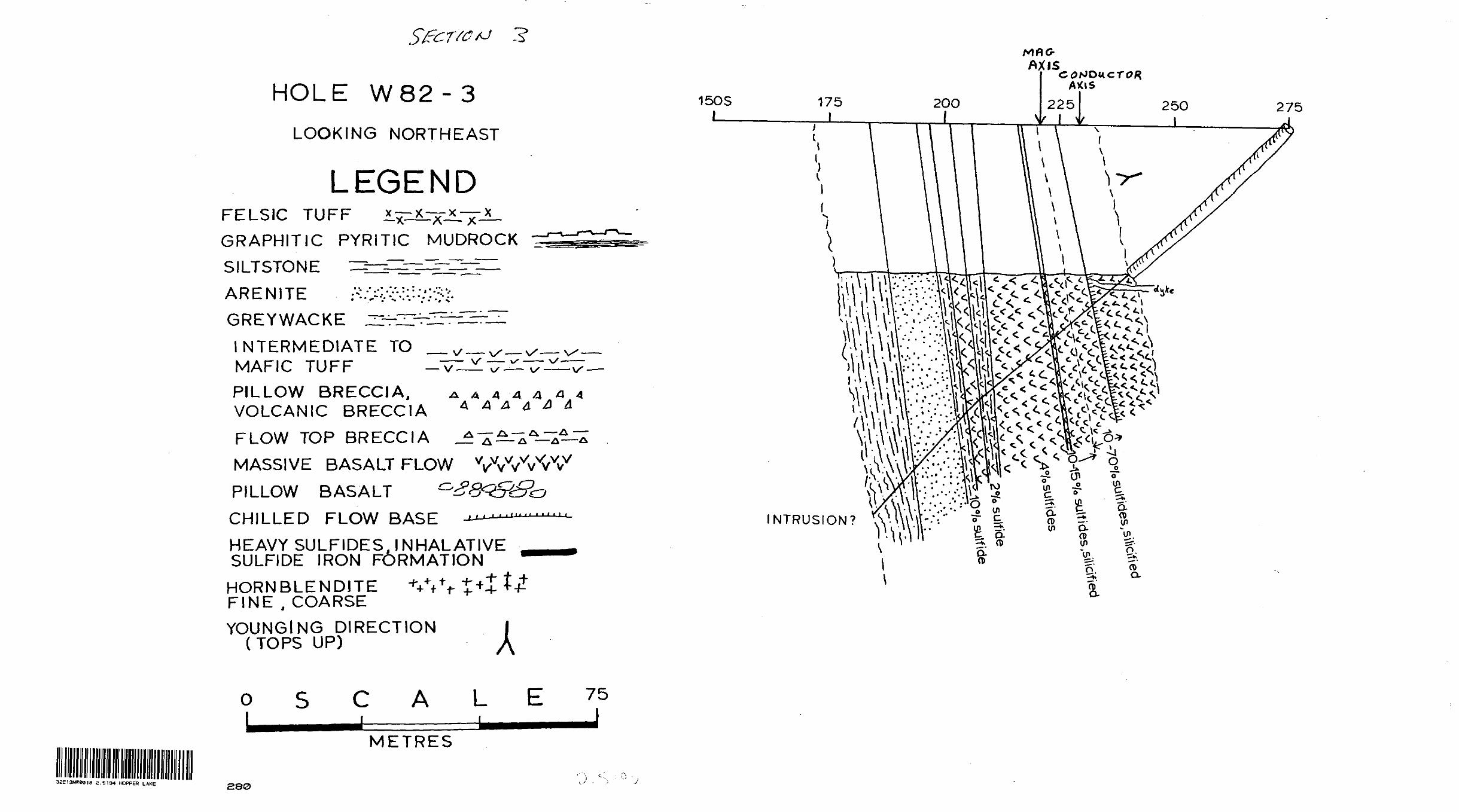
deposit but hole W82-3 contains up to 7(H sulfides in altered
mafic volcanics and most closely approaches this type of
deposit.
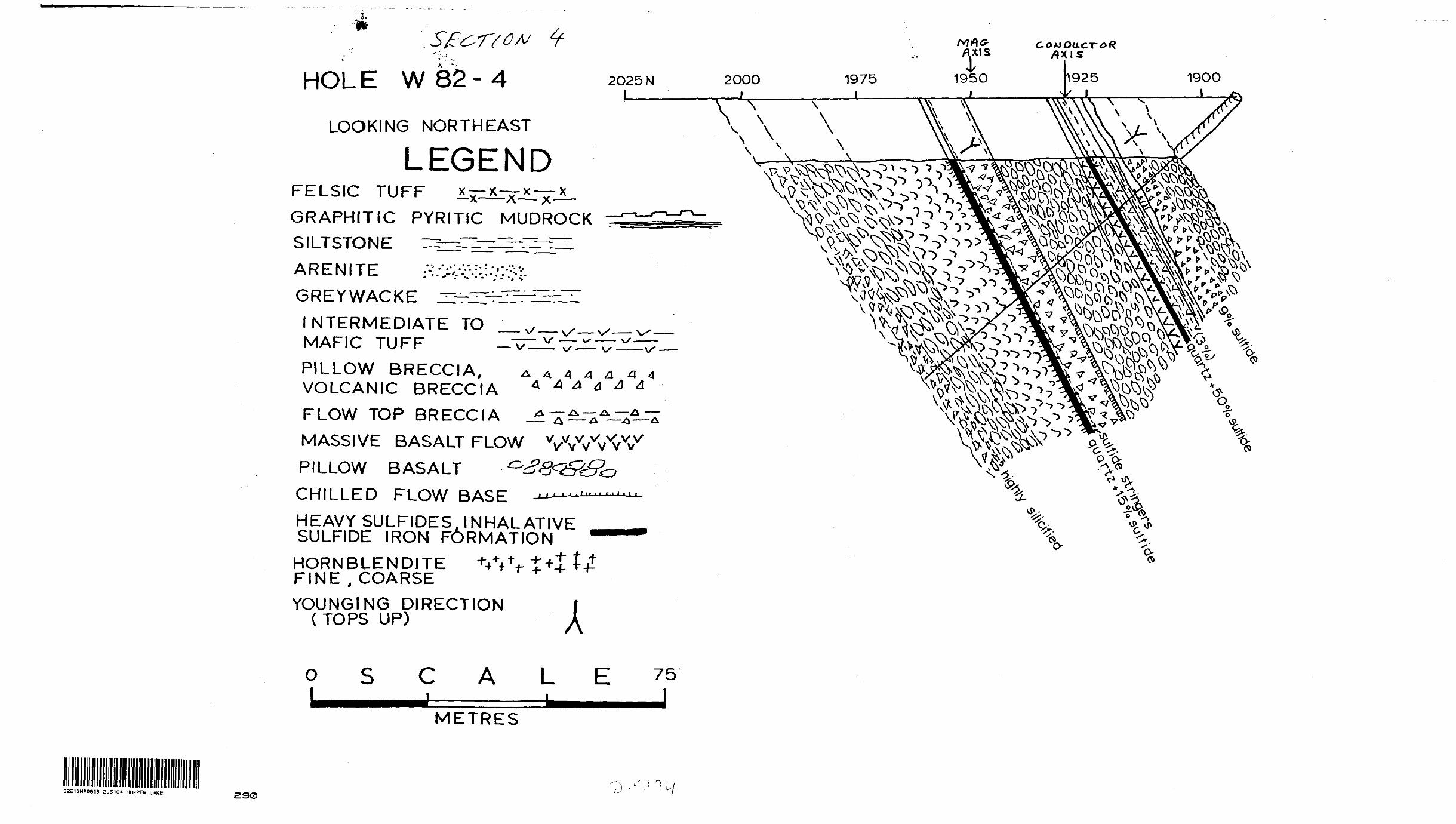
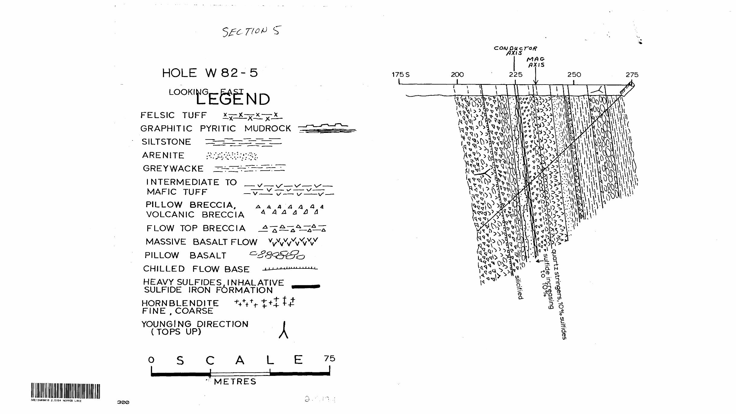
The holes to the southwest generally consist of inter
layered sediments and volcanics except for W-82-3 which is
transitional with the set described above and W82-9 which drilled
through basalts into a small pluton with a hornblendite margin.
These remaining holes (W82-5, 6, 7 and 8) contain conductors in
the form of graphitic, sulfidic (S-12%) mudrock with some possible
magnetite component:or highly silicified flow contacts with up
to 9*; sulfide. The graphitic sulfidic mudrock is interpreted as
a synsedimentary biogenic accumulation in felsic volcanic tuff
whereas the sulfidization alpng basalt contacts is interpreted
- 14 -
f
to be late deuteric to early diagenetic metasomatism which occurred
during cooling of the volcanic pile. This metasomatism affects
both the underlying and overlying flow and thus appears to be
related to natural inhalative processes generated by deposition
of volcanic flows. No anomalous gold values were found in these
metasomatized contacts nor should any be expected because this
sulfidization lacks the extraordinary processes required for ore
formation. The graphitic sulfidic mudrock does not contain
anomalous gold values either and the absence is explained by the
fact that these biochemical sediments are non-exhalative. In
short, the conductors in the southeast portion of the property are
caused by natural depositional processes and do not appear to
warrant further exploration. The conductor associated with hole
W82-3 is the exception because it consists of an abnormally thick
sequence of silicified, sulfidized basalt suggesting prolonged
hydrothermal activity and a split containing quartz veining in
this zone ran 208 ppb gold.
Holes W82-1, 2, 4 and 12 to the northeast do not contain
anomalous gold values in spite of an abundance of pyrrhotite
(some pyrite) and the local occurrence of trace chalcopyrite.
The sulfides are massive and penetrate as disseminations into
both underlying and overlying strata. They are preferentially
located within porous host rocks which they variably replace
and unfortunately they are barren of gold and base metals. I
interpret these sulfide concentrations as inhalative sulfide
iron formations (i.e. epigenetic massive sulfides formed by
- 15 -
lateral migration of metal-rich fluids along porous horizons
within the rock rather than at the rock - sea water interface).
Although this inhalative mineralization is barren, the
process is unusual and indicates active mobilization of iron"
sulfur and silica. Gold is not concentrated in the exhalites
but could potentially be redistributed laterally or, underlying
stratigraphic sequences might be more favourable for gold
mineralization. With regard to this last alternative it is
worth while to examine the plan view geology, structure and
stratigraphy to determine whether any stratigraphic sequences
remain to be tested.
b) Stratigraphy and Structure
Younging has been determined from graded bedding in
greywackes and to a greater degree from morphology of basalt
flows. Gradational transitions from a chilled base through
massive to pillowed flow to flow top breccia provide very
reliable younging (Dimiroth et al., 1978). Younging directions,
including those deduced from Patino and Inco holes suggest
that the Supracurstals are isoclinally folded (Map G-4) . In
particular hole W82-8 contains opposing younging directions
which are separated by an axial planar mylonite zone thereby
defining a fold closure (SECTION 8). In the northeast all
strata dip 60-80 south-southeast but holes W82-1 young south
whereas W82-4, W82-12 and all Inco holes young north and are
overturned. The trace of an axial surface therefore lies

- 16 -
between these two sets of holes.
The sequence of interlayered mafic volcanics and
sedimentary rocks to the southwest represented by Patino holes
l to 3 plus holes W82-3, 5, 6, 7, 8 and 9 outline an extremely
complex structural picture in which bedding dips steeply both
north and south and younging directions change both within holes
and between adjacent holes. Such structural complexity is
typical of sediment-rich supracrustal sequences in Archean
greenstones.
From the limited geological information available from
drilling and outcrops there are a number of potential inter
pretations for stratigraphic superposition but the general
trend from predominantly mafic strata in holes W82-1, 2, 4,
12 and Inco holes suggests that these strata underly the
basalt-sediment sequence outlined to the southwest. The
predominantly mafic strata lie northwest of the Patino holes
and holes W82-6 to W82-9 and contain a high magnetic signature.
Furthermore, the magnetic field rapidly increases near the
northwest boundary of the property and here there are local
conductors along magnetic highs which may represent a separate,
underlying stratigraphic sequence which probably contains
basalts with oxide iron formations and/or ultramafic horizons.
In view of the geology of Detour Lake Mine (see Figure 7 of
Johns, 1982), it would appear necessary to locate a basalt-
ultramafic contact in order to increase chances of finding
gold ore.

- 17 -
c) Correlation of Geology and Geophysics
Detailed examination of the ground magnetometer survey
outlines five separate ranges of magnetic intensity which
appear to generally characterize lithological associations in
the Whopper area. Lithologies inferred from magnetic inten
sities and drilling appear in Map G-4. Intensities of lees
than 59,400 gammas are attributed to greywackes with low
pyrrhotite and low magnetite. Intensities between 59,400 and
59,500 gammas probably represent sedimentary rocks with minor
mafic volcanic flows and/or minor interlayers of sedimentary
pyrrhotite and magnetite. Magnetic intensities between 59,500
and 59,800 are likely to be intermediate to mafic volcanics
with minor disseminated pyrrhotite and/or magnetite. Intensities
between 59,600 and 60,000 gammas have been the main drill
targets where they have corresponding short, intense conductors.
These zones are generally narrow and are surrounded by rocks
with lower magnetic intensities. These conductors are graphitic
sulfidic mudrock, interflow diagenetic pyrrhotite or sulfide
inhalite deposits. The background magnetic intensity increases
towards the northwest edge of the property and passes into a
broad high mag terrane (above 59,600 gammas) at both the
southwest and northeast ends of the northwest edge of the
property. Within this high mag terrane there are linear/
zones with magnetic intensities greater than 59,800 gammas.
It is this terrane which is interpreted to be underlying strata.

- 18 -
Part of it is undoubtedly gneissic particularly further to the
northwest but the narrower more magnetic area could represent
basalts with oxide iron formation and/or ultramafic rocks.
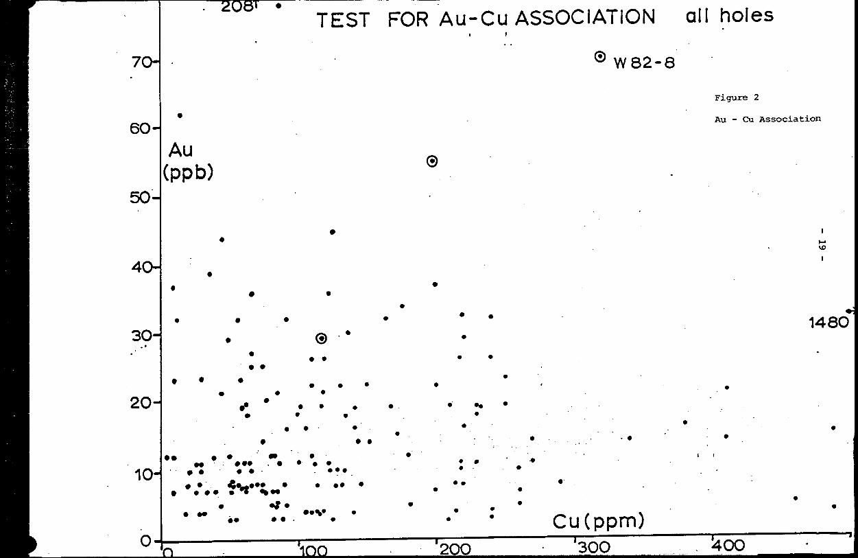
d) Geochemistry of Sulfide-rich Strata
Sludges, sulfide-rich samples and milky quartz concentra
tions were analysed for Au, Ag, Ni, and Cu in an attempt to
delineate any anomalous gold. Although abundant pyrrhotite-
quartz mineralization was found in several holes, anomalous
gold was found only in W82-3 from 63.93 to 65.52 metres
(208 ppb) and in selected milky quartz veins in W82-7 from
7.77 to 8.22 metres (137 ppb). The Detour Lake Mine contains
anomalous copper and copper was analysed as a tracer at Whopper
to detect any gold-copper association which might be present.
A plot of gold (ppb) versus copper (ppm) is presented in
Figure 2 and suggests that there is no :gold-copper association
in the sulfide-rich mineralization. The only exceptions are
in some samples from hole W82-2 and more obviously from
hole W82-8 (circled in Figure 2). Sample distribution instead
suggests an antipathetic relationship of high gold-low copper
and visa versa. A plot of nickel (ppm) versus copper (ppm)
is presented in Figure 3 for those holes containing concentra
ted inhalative sulfides. This plot demonstrates an excellent
correlation between copper and nickel in the sulfides and
argues for simultaneous inhalative leaching of both copper
and nickel from the basalts. The process of pure dilution

- 21 "
through high volume replacement would thereby account for the
low abundances of gold in these inhalites. In general, those
samples with higher sulfide content are also those which
contain higher copper and nickel contents but no such associa"-
tion is observed with gold. This observation further supports
an inhalative leaching process. It is obvious, therefore, that
gold is not directly associated with copper or with sulfides
in the inhalite horizons where they have presently been drilled.
Twelve samples of "fresh" rock were selected from core
drilled this past field season and were submitted to X-Ray
Laboratories for trace Au, Ni, Cu, Zn, As and for whole rock
analysis. Background gold values are all c 3 ppb whereas
sulfide rich samples average out to approximately 15 ppb. It
is questionable whether this difference is significant and
represents an enrichement in the latter lithology.
e) Dimensions of Inhalative Sulfide Mineralization
A review of the average % sulfide and aggregate widths
from diamond drilling and lengths of conductors as projected
from geophysical surveys provides the following information
which is summarized in Table V.
Inhalative sulfide mineralization collects in two
separate environments, flow top breccias in basalts and porous
arenaceous sections of turbidite metasediments. Sulfide
mineralization in basalts is predominantly pyrrhotite forming
aggregate widths of up to 137 feet of 13% sulfide. Within

- 22 -
Table V
Characteristics of Conductors, Detailed Projections
Drill Holeson Zone
AverageSulfide
% AggregateWidth (ft.)
ProjectedLength {ft
Predominantly Volcanic Host
INCO 43296,W82-4
INCO 43295,W82-12
W82-3, W82-5
INCO 43297
W82-1, W82-2
Patino #2i
11
8
7
3
13
20
2
Predominantly
W82-6
W82-7
W82-8
Patino #1
Patino #3
6.5
5
8
25
3.5
20
2
45
73
10.7
9
137
3.5AND
50
Sedimentary Host
17.5
53.5
39
1.5AND
29
3.5AND
50
11,000
7,900
5,900
2,300
1,640
2,625
2,625
2,625
2,625
2,625
2,625
2,625
- 23 -
this aggregate thickness, there are local massive sulfide layers,
These volcanic hosted, inhalative sulfide iron formations are
laterally continuous for up to 11,000 feet but massive sulfide
zones are less continuous whereas disseminated sulfides are "
for more widespread. Inhalite horizons are characterized by
long zones of relatively strong conductivity coincident with
long linear magnetic highs.
The second type of inhalite is hosted in arenite but there
are also occurrences of syngenetic sulfides in graphitic
mudrock which have been encountered in drilling. Sulfides in
the former host generally consist of pyrite and pyrrhotite
scattered throughout the sediment with local thin layers of
20-25% sulfides. Pyrite is the predominant sulfide in the
graphitic mudrocks. The lengths of sulfide rich zones hosted
in metasediments is shorter than those in basalts but this
may be due in part to tectonism because younging indicators
in the sedimentary-rich strata indicate complex isoclinal
folding.
The average basalt-hosted inhalite is predominantly
composed of pyrrhotite with minor pyrite and trace chalcopyrite.
It contains 8% sulfide over a 70' aggregate width and a 5,200'
projected length. In contrast, the average sediment-hosted
inhalite is composed of pyrrhotite and/or pyrite with rare
chalcopyrite and averages 4-5% sulfide over a 5' aggregate
width and a 2,600' projected length.
- 24 -
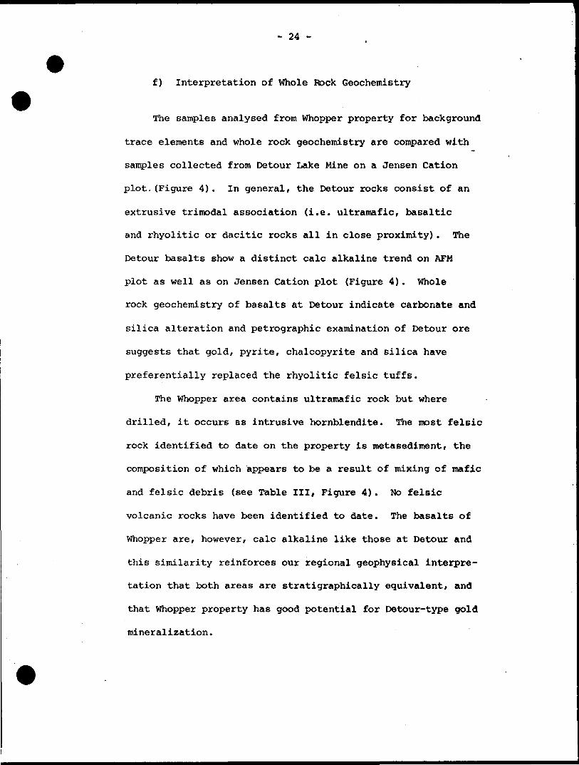
f) Interpretation of Whole Rock Geochemistry
The samples analysed from Whopper property for background
trace elements and whole rock geochemistry are compared with
samples collected from Detour Lake Mine on a Jensen Cation
plot.(Figure 4). In general, the Detour rocks consist of an
extrusive trimodal association (i.e. ultramafic, basaltic
and rhyolitic or dacitic rocks all in close proximity). The
Detour basalts show a distinct calc alkaline trend on AFM
plot as well as on Jensen Cation plot (Figure 4). Whole
rock geochemistry of basalts at Detour indicate carbonate and
silica alteration and petrographic examination of Detour ore
suggests that gold, pyrite, chalcopyrite and silica have
preferentially replaced the rhyolitic felsic tuffs.
The whopper area contains ultramafic rock but where
drilled, it occurs as intrusive hornblendite. The most felsic
rock identified to date on the property is metasediment, the
composition of which appears to be a result of mixing of mafic
and felsic debris (see Table III, Figure 4). No felsic
volcanic rocks have been identified to date. The basalts of
Whopper are, however, calc alkaline like those at Detour and
this similarity reinforces our regional geophysical interpre
tation that both areas are stratigraphically equivalent, and
that Whopper property has good potential for Detour-type gold
mineralization.

FF.CH-FE2Q31-TI02
JENSEN CRTIQN PLOTS M 6 O L S , l
10
60
70
60
90
a
o
o-f-
Figure 4
Whole Rock Comparison - Detour Lake and Whopper
RL2CJ3 30 HGO
ito
- 26 -
SUMMARY AND INTERPRETATION
Whopper area is a submarine basalt shield complex con
taining a lower stratigraphic sequence with high magnetic
response which is tentatively interpreted to be flood basalts
containing oxide iron formation and/or serpentinized ultra
mafic rocks. This lower sequence is overlain by a thick
sequence of basaltic flows with minor interflow sediments
and contains inhalative sulfide mineralization which is corn-
commonly localized at flow contacts as intersected in holes
W82-1, 2, 4 and 12. The inhalative deposits in these basalts
were likely derived by simultaneous leaching of Cu and Ni from
the flows with massive addition of Fe and sulfur from infil
trating hydrothermal fluids. Resulting deposits are pyrr
hotite and form long relatively wide conductors with corres
ponding linear magnetic highs. Less intense inhalative
sulfides in basalts are likely caused by late deuteric or
diagenetic metasomatism and may be a result of natural subma
rine weathering. A more diverse volcanic-sedimentary sequence
overlies the basalt flows and contains inhalative sulfide
mineralization (pyrite-pyrrhotite) in both basalts and arenaceous
metasediments as well as synsedimentary graphitic pyritic
mudrocks. Conductors in these strata are narrower, contain
less pyrrhotite and have shorter strike lengths but this
latter feature may be a result of tectonic dislocation.

- 27 -
RECOMMENDATIONS
Mineralization at Detour Lake Mine is concentrated within
a relatively narrow zone (maximum 670 feet) of strata with a
trimodal rock association which immediately underlies a thick
sequence of calc alkaline basalt flows. The similarity in
whole rock geochemistry between Detour Mine and Whopper
property is encouraging and there is a distinct possibility
that the highly magnetic terrane at Whopper contains a
trimodal zone. The presence of abnormal quantities of sulfide
mineralization formed by contemporaneous leaching of elements
from basaltic host rock indicate active processes on Whopper
property which, in a gold enriched protore, could produce an
ore deposit. I would therefore maintain that the key processes
necessary for ore formation have been indicated by drilling.
I recommend that a terrane with a trimodal association
be sought on the property and if found be intensively explored.
In this regard, the highly magnetic terrane at the northwest
edge of the property appears to have the best potential. Two
conductors at or near the southern contact of this terrane
remain as yet untested and could be explored by our second
priority holes W82-10 and W82-11 which were not drilled last
season. Long holes should be drilled through the conductors
and at least one more drill hole should be designed to
identify the lithology which solely contains high magnetism.
Drilling should be oriented to provide a complete stratigraphic
- 28 -
cross section of the highly magnetic terrane and thereby
establish the presence or. absence of a trimodal association.
There are several other conductors on the property which
could also be tested, particularly in areas of low magnetic "
background. Here, gold deposits associated with disseminated
sulfides and hosted in felsic volcanic rocks might be found.
I would recommend detailed IP surveys over these conductors
prior to drilling in order to establish priorities. This is
necessary due of our limited geological information and lack
of lithogeochemical data because of widespread overburden.
- 29 -
REFERENCES
Bennett, G., Brown, D.D., George, P.T. and Leahy, E.J., 1967Operation Kapuskasing; Ontario Dept. Mines, Misc. Paper 10, 98 pp.
Dimroth, E., Cousineau, P., Leduc, M. and Sanshagrin, Y., 1978 Structure and Organization of Archean Subaqueous Basalt Flows, Rouyn-Noranda Area, Quebec, Canada; Can. Journ. of Earth Sci., Vol. 15, No. 6, P902-918.
Johns, G.W., 1982Geology of the Burntbush-Detour Lakes Area, District of Cochrane; Ontario Geological Survey Report 199, 82 pp.

- 30 -
APPENDIX I
PETROGRAPHIC DESCRIPTIONS OF SAMPLES FROM WHOPPER AND SURROUNDING AREA *
SAMPLE 7018 DIORITE
LOCATION: North end of Hopper Lake
TEXTURE: Coarse equigranular with intergrowths and sutured contacts, local hornblende coronas on fine-grained, complex cores suggest prograde metamorphism, inter locking hornblende and biotite suggest simultaneous crystallization, rare myrmekitic quartz-feldspar intergrowths.
ESTIMATED MODE
Plagioclase 6(HMicrocline 9%Biotite IStHornblende 15SiQuartz AS \\
* For field locations see Map G-4
- 31 -
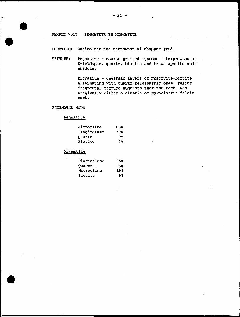
SAMPLE 7019 PEGMATITE IN MIGMATITE
LOCATION: Gneiss terrane northwest of Whopper grid
TEXTURE: Pegmatite - coarse grained igneous intergrowths of K-feldspar, quartz, biotite and trace apatite and ~ epidote.
Migmatite - gneissic layers of muscovite-biotite alternating with quartz-feldspathic ones, relict fragmental texture suggests that the rock was originally either a clastic or pyroclastic felsic rock.
ESTIMATED MODE
Pegmatite
Microcline Plagioclase Quartz 9% Biotite It
Migmatite
Plagioclase 25*Quartz 55%Microcline 15%Biotite 5%
- 32 -
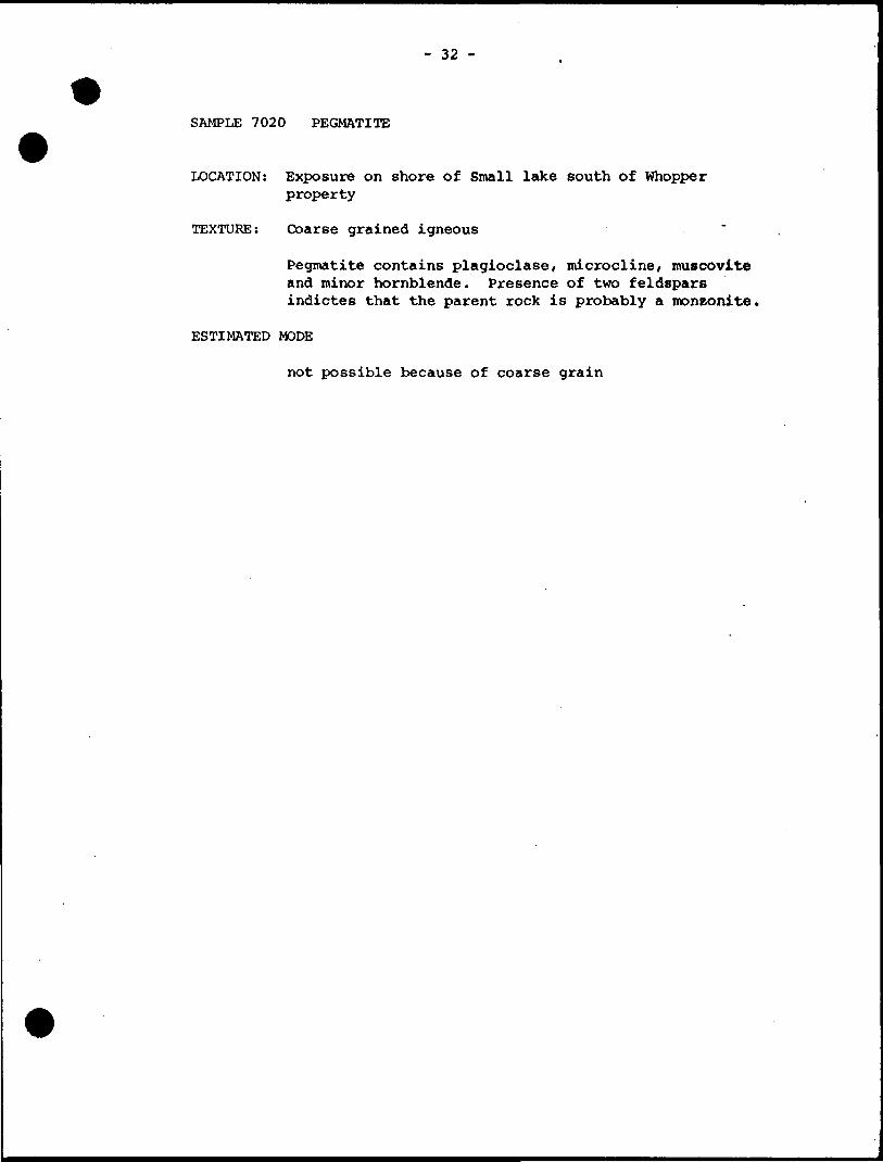
SAMPLE 7020 PEGMATITE
LOCATION: Exposure on shore of Small lake south of Whopper property
TEXTURE: Coarse grained igneous
Pegmatite contains plagioclase, microcline, muscovite and minor hornblende. Presence of two feldspars indictes that the parent rock is probably a monzonite,
ESTIMATED MODE
not possible because of coarse grain
- 33 -
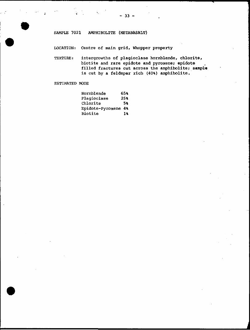
SAMPLE 7021 AMPHIBOLITE (METABASALT)
LOCATION: Centre of main grid, Whopper property
TEXTURE: intergrowths of plagioclase hornblende, chlorite, biotite and rare epidote and pyroxene; epidote filled fractures cut across the amphibolite; sample is cut by a feldspar rich (4C^) amphibolite.
ESTIMATED MODE
Hornblende 65% Plagioclase 25% Chlorite 5"* Epidote-Pyroxene 4% Biotite U

TEST FOR Ni-Cu ASSOCIATION holes W82-1,2,4and12
si to8*Yo sulfide r 9to14 07o sulfide
300i
Ni(ppm)
A*14to95 07o sulfide
2d
200HA
(Oo
1OCH A .
*A
Cu(ppm)
Figure 3
Ni-Cu Association
'1QQ :OO 400
70H
6OHAu
l(ppb)50H
4CH
TEST FOR Au-Cu ASSOCIATION ail holes
0 W82-8
Figure 2
Au-Cu Association
vo
30H148O
20H
10H 99
Cu(ppm)1OO 200^
'300

rOntario
Ministryoi Report of WorkNatural ,- , . . r. . . . Resources (Geophysical, Geological,
Geochemical and Expenditures)32E13NWMI8 a.5194 HOPPER LAKE
The Mining Act 1900
— Do not use shaded areas below.Type of Survey(s)
Claim HoideTTsTct*rrsv6-
Address
Township or Area
\HlA__ . _ProspectorT Licence No.
Survey CompanyT/WM/A/S,
Name and Address of Author (of Geo-Technlcal report)
R- T, ^Xa/srXV A*r 'Y3fi
Date of Survey (fromiurvey (from Si ip) .09 8i n /2 0/Mo. l Yr. Day | Mo. | Yr.
Total Miles of line Cut
s 4 7^2-Credits Requested por Each Claim in Columns at right
ipcicial Provisions
For first survey:Enter 40 days. (This includes line cutting)
For each additional survey: using the same grid:
Enter 20 days (for each)
Man Days
Complete reverse side and enter total(s) here
Airborne Credits
Note: Special provisions crediu do not apply to Airborne Surveys.
Geophysical
- Electromagnetic
- Magnetometer
- Radiometric
- Other
Geological
Geochemical
Geophysical
- Electromagnetic
- Magnetometer
- Radiometric
- Other
Geological
Geochemical
Electromagnetic
Magnetometer
Radiometric
Days per Claim
Days per Claim
Days perClaim
Mining Claims Traversed (List in numerical sequen
Expend ftitres-f.exglfld'e,!' 'py.yyer, jjfrjppi ng)Typo of Work Performed , ,l ; .. x i^ /'T\ L
Performe i\plaim(s)
PM
Total ExpendituresTotal
Days Credits
H- 15 *
InstructionsTotal Days Credits may bo apportioned at the claim holder's choice. Enter number of days credits per claim selected in columns at right.
MiningPrefix
P
,,
Claim *Number
UCC-C—
ctkbJUIjfof)f
^
— '
RECC
SEPReceipt No
Expend, Days Cr,
-
t
)Rf
24 19
d52
Mining ClaimPrefix
f
MTNIf
D
ft W*
Number
C^* c i \f^cLfcy VOCT 1 9 19ft
'G LANDS SE
expend. Days Cr.
:TJON
\V .
11Total number of mining claims covered by this report of work.
Recorded Holder o ignature)
Certification Verifying Report ofJWarKl hereby certify that l have a personal and intimate knowledge of the facts setjforth in the Report of Work annexed hereto, having performed the work or witnessed same during and/or after its completion and the annexed report is true.
Name and Postal Address of Person
Date Certified Certified by (Siri
ufe)
rSubmitted for 20 days credit linecutting
and 20 days credit geology. WEST OF SUNDAY LAKE - HOPPER LAKE AREA
Claim #
393793
393794
393795 ^393796 ^561858561865
561882
561883
561884
561885
561886
561887
561888
561889
561890
561891
561892
561893
561894
561895
561896
561897
561898
561899
561900
561901
561902
561903
561904
561905
561906
561907
Claim #
561908
561909
561910
561911
561912
561913
561914
561915
561916
561917
561918
561919
561920
561921
561922
561923
561924
561931
561932
561933
561934
561935
561936
561937
561938
561939
561940
561941
561942
J161943
561945
Claim ft
561946
561947
561948
, 561949561950 561951J61952
622395
622396
- 622397
622398
622399
622400
, 622686
622687
622686
622689
622690
622691
624500
624501
^24502
628348
628349
628350
628351
628352
628353
638354
628355
628356
628357

Claim # Claim ft Claim #
628358
628359
628360
628361
628362
628363*
628951
628952
628953
628954
628955
628956
628957
628958
628959
628960
628961
628962
628963
628964
628965
628966
628967
628968
628969
628970
628971
628972
628973
^628974
633021
633022 .
633023
*633542
633543
633544
633545
^33546
633687
63368B
633689
633690
633691
633692
633693
633694
633695
633696
633697
' 633698
633699
633700
633701

Ontario
Ministry of Natural Resources
GEOPHYSICAL - GEOLOGICAL - GEOCHEMICAL TECHNICAL DATA STATEMENT
File.
TO BE ATTACHED AS AN APPENDIX TO TECHNICAL REPORTFACTS SHOWN HERE NEED NOT BE REPEATED IN REPORT
TECHNICAL REPORT MUST CONTAIN INTERPRETATION, CONCLUSIONS ETC.
Type of Survey(s) GEOLOGICALTownship or Area West of Sunday Lake - Hopper Lake
Claim Holder(s) NEWMONT EXPLORATION OF CANADA LTD.
Survey Company NEWMONT EXPLORATION OF CANADA LTD.
Author of Report Dr. R.J. Shegelski.————..——————Address of Author Box 1430. Tiirimins. Ontario P4N 7N2Covering Dates of Survey Sept. 12. 1981 to Nov. 10. 1982
(linecutting to office)
Total Miles of Line Cut______170.76_________________
SPECIAL PROVISIONS CREDITS REQUESTED
ENTER 40 days (includes line cutting) for first survey.
ENTER 20 days for each additional survey using same grid.
Geophysical
—Electromagnetic.
—Magnetometer.——Radiometric———Other—————
DAYS per claim
Geological.Geochemical.
40
AIRBORNE CREDITS (Special provision credits do not apply to airborne surveys)
Magnetometer. .Electromagnetic. . Radiometric
DATE:.
(enter days per claim)
SIGNATURE:
Res. Geol.. .Qualifications.Previous Surveys
File No. Type Date Claim Holder
Arftfcfbr^f Report or Agent
MINING CLAIMS TRAVERSED List numerically
*.t*i*******t***t************ •T*t*T* l *t*T* f * ft *T* riVi 9m c
(prefix) (number)
(see attached list)
i
TOTAL CLAIMS.
837 (5/79)
GEOPHYSICAL TECHNICAL DATA
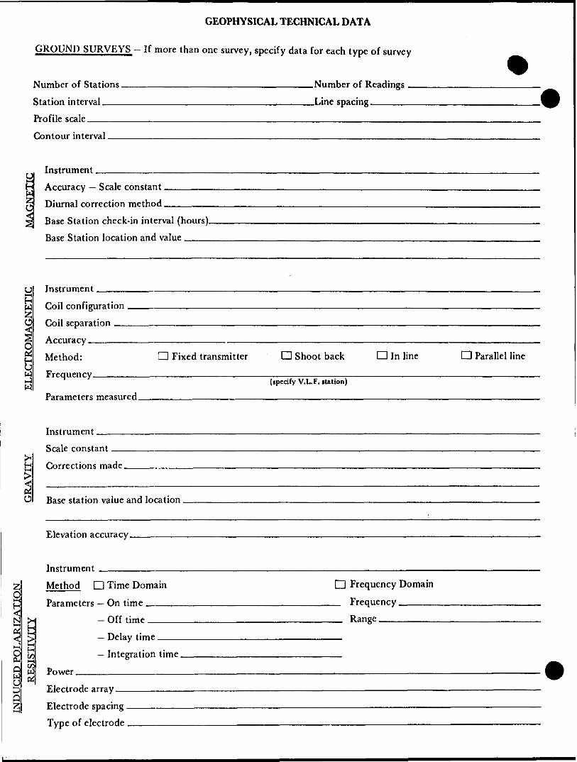
GROUND SURVEYS - If more than one survey, specify data for each type of survey
Number of Stations —————————————————————————Number of Readings — Station interval .—-———-———^————--——^——--^———Line spacing ———.——. Profile scale ———-—-—.——————^———-——-—...——....™.--.-——.—..^.——.Contour interval.
Instrument _
ogl
O
Q
H
gco*-4co W
Accuracy — Scale constant. Diurnal correction method.Base Station check-in interval (hours). Base Station location and value ^^^
InstrumentCoil configuration
separationAccuracy —————————————————————————————————————————————————————————— Method: CD Fixed transmitter d Shoot back D In line CD Parallel line
w J W
Parameters measured.(specify V.L.F. rtation)
Instrument.Scale constant.Corrections made.
Base station value and location.
Elevation accuracy.
Instrument ——————————————————————————————————————————— Z Method D Time Domain D Frequency DomainQ —————
Parameters - On time __________________________ Frequency ——————Off time__________________________ Range.— Delay time ————————————————————————— Integration time _____________________
Power.g X
Electrode array.Electrode spacing . Type of electrode
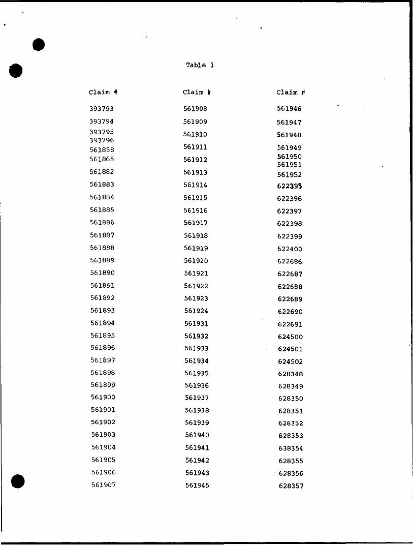
Table l
Claim ft
393793
393794
393795 393796 561858 561865
561882
561883
561884
561885
561886
561887
561888
561889
561890
561891
561892
561893
561894
561895
561896
561897
561898
561899
561900
561901
561902
561903
561904
561905
561906
561907
Claim ft
561908
561909
561910
561911
561912
561913
561914
561915
561916
561917
561918
561919
561920
561921
561922
561923
561924
561931
561932
561933
561934
561935
561936
561937
561938
561939
561940
561941
561942
561943
561945
Claim ft
561946
561947
561948
561949 561950 561951561952
622393
622396
622397
622398
622399
622400
622686
622687
622688
622689
622690
622691
624500
624501
624502
628348
628349
.628350
628351
628352
628353
638354
628355
628356
628357

Table l (continued)
Claim # Claim # Claim
628358
628359
628360
628361
628362
628363
628951
628952
628953
628954
628955
628956
628957
628958
628959
628960
628961
628962
628963
628964
628965
628966
628967
628968
628969
628970
628971
628972
628973
628974
633021
633022
633023
633542
633543
633544
633545
633546
633687
633688
633689
633690
633691
633692
633693
633694
633695
633696
633697
633698
633699
633700
633701

SELF POTENTIALInstrument__________—————————————————————————————— Range.Survey Method _______———————————————————————————————————
Corrections made.
RADIOMETRICInstrument ———-Values measured.
Energy windows (levels)________________________________________ Height of instrument____________________________Background Count.
Size of detector——————————————————————————————————————————
Overburden .^——..—---—^——-——^^-——-—---—.—.^——--.^^..-.-—-..—.——.^.—(type, depth — include outcrop map)
OTHERS (SEISMIC, DRILL WELL LOGGING ETC.) Type of survey-—————-————————^^———— Instrument ————————————————————————— Accuracy——————————————————————————Parameters measured.
Additional information (for understanding results).
Type of survey(s) Instmment(s)
(specify for each type of survey) Accuracy_________________
(specify for each type of survey) Aircraft used.^^-——————————-——————-—-——^——.—.—.Sensor altitude-Navigation and flight path recovery method.
Aircraft altitude-————....——-—.^———..—.———...—.^——.Line Sparing Miles flown over total area__________________________Over claims only.
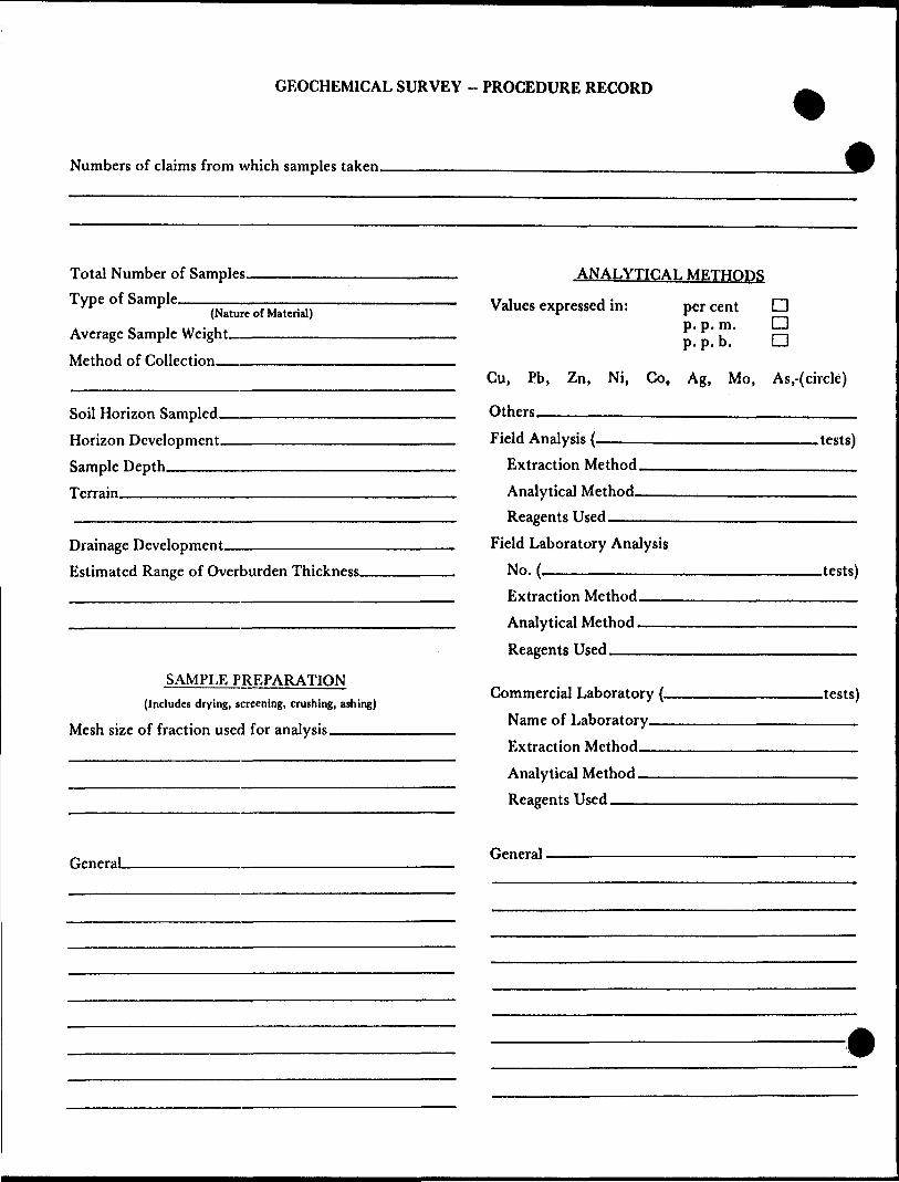
GEOCHEMICAL SURVEY - PROCEDURE RECORD
Numbers of claims from which samples taken.
Total Number of Samples- Type of Sample.
(Nature of Material) Average Sample Weight———————
Method of Collection_——————
Soil Horizon Sampled. Horizon Development- Sample Depth——-—. Terrain————————
Drainage Development———————————— Estimated Range of Overburden Thickness.
jiNALYTICALMETHODS
Values expressed in: per cent p. p. m. p. p. b.
a a a
Cu, Pb,
Others_
Zn, Ni, Co, Ag, Mo, As.-(circle)
Field Analysis (~Extraction Method. Analytical Method- Reagents Used ——
Field Laboratory AnalysisNo. .—-————-——
SAMPLE PREPARATION(Includes drying, screening, crushing, ashing)
Mesh size of fraction used for analysis____
Extraction Method. Analytical Method - Reagents Used——
Commercial Laboratory (- Name of Laboratory— Extraction Method—— Analytical Method —— Reagents Used ————
.tests)
.tests)
-tests)
General. General.

Ministryof GeotechnicalSees Report
Ontario Approval
File
Mining Lands Comments
To: Geophysics
Comments
(J Approved Q Wish to see again with correctionsDate Signature
[7\ To: Geology- Expenditures
Comments
l C f j, c
.f /o p*) 9 rc*s
j Approved | | Wish to see again with correctionsDate
To: Geochemistry
Comments
f] Approved [ j Wish to see again with correctionsDate Signature
j |To: Mining Lands Section, Room 6462, Whitney Block. (Tel: 5-1380)
1693 (B1/10)
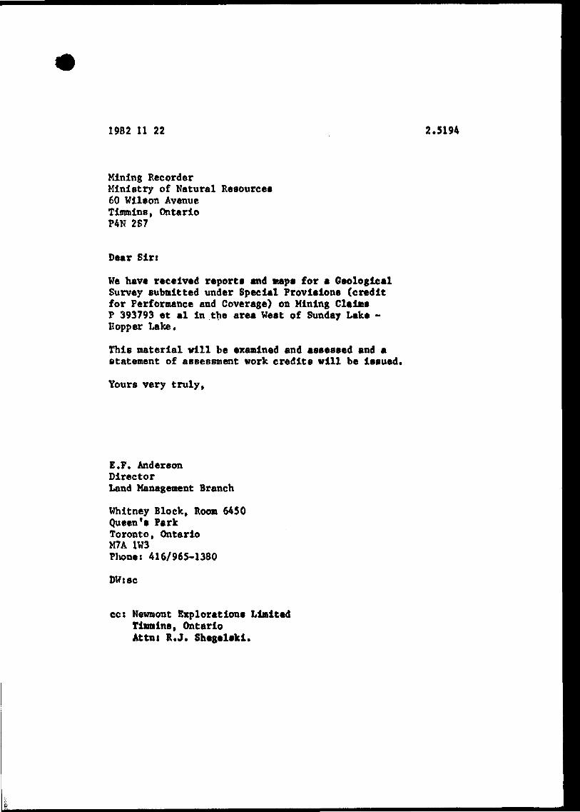
1982 11 22 2.5194
Mining RecorderMinistry of Natural Resource*60 Wilson AvenueTimmins, OntarioP4N 2S7
Dear Sirt
We have received reports and maps for a Geological Survey submitted under Special Provisions (credit for Performance and Coverage) on Mining Claims P 393793 et al in the area West of Sunday Lake - Hopper Lake.
This material will be examined and assessed and a statement of assessment work credits will be issued.
Yours very truly,
E.F. AndersonDirectorLand Management Branch
Whitney Block, Room 6450Queen's ParkToronto, OntarioM7A 1W3Phone: 416/965-1380
DW:sc
cc: Hewmont Exploration* Limited Tinmins, Ontario Attnt R.J. Shegelski.

Telephone (705) 264-4709 Telex 067-81612
NEWMONT EXPLORATION OF CANADA LIMITEDHollinger Office Building
P.O. Box 1430 TIMMINS, ONTARIO P4N7N2
November 15, 1982
RECEIVEDNOV l 6 1982
LANDS SECTION
Mr. Fred MatthewsMinistry of Natural ResourcesLands Administration BranchMining Lands SectionsRoom 1617, Whitney BlockQueen's ParkTORONTO, OntarioM7A 1W3
Dear Mr. Matthews,
Enclosed are two (2) copies of an assessment of geological
investigations on the Whopper property, Burntbush-Detour Lakes Area.
The geological data sheets are at the end of the reports as required.
Thank you for your service.
Sincerely yours,
R.J. Shegelski, Project Geologist
RJS/sd
Encl.

•7TT
loJ*
5*6/^51?
t/v/
f/7 •7-f/
v/i
j/: v~7~V\
rf/ Vs
V"\/ V
V lrr? Zl iKMBTK^U
V
Q.r?/
i/36"
V/
v/m V •i- P/
Vy V l/
Vv/
r?? \/2*:L
v/v/
v/
V
f) 7
SVV
\/ V
V 397 v" S/
Vli/
A/•g^i .•i i -
\/
V
\/V v'
VV?
•r
\/
770-y
972
f?/b 33 02- 1
v/v/
N/V'
V
"7
-
Vyv~7~
692 v/
VV" 7*
1,17V
l l

WEST OF SUNDAY LAKE G-168080?00
50 0 OQ'" D r
ie)
u
c/)ID Orr
49052'30"
s/361 940 ( 561 94 l
——. -^— ——— T— ~— ——— ^——.
'586852 {586847)586644 'sSftgSS .586636 5 867 45 l— •J|-.~|crr -T
l .58659E 1586646 .5866451568438 '58(6637l l ' ' ^ 5B6BS3 566746 l 'l . —*R*iaf\ .
l _____ J*T7 Z-* S-J.8 *185?. —— -4- —— -,!- - - 4- — - 4- - —-r- - - -T- ~ ~r;—, P f P TP ' P T" ^p T p T p Tp T p
561961 '561960,561959 (56SI958 M2B4 IS24B7 9 1524274 524 2 44 l 5 2 4 2 4 5 | 524251 .524264 '524263 i5 2 4 2 6 6 l 52 4 267, S2 42 68 |~ — J- — — -L. — ~4- — — —— ~~ T — ~ "T- ~~~ "t" — — r- — ~~ T — ~~*" D~ ~ —
IP j \P P !P 'P .P ! p |P , p . p
I524B78 '5 24'V8 7 3
——r--^——f—i----tIP IP 'p , "'v i p 7 i p \; p i p p |P ' p - p '
1324200 1524195 524190)5 .452426 ' jSbissa j -—^———t~*pX , 6619 6 6 l 56 1967 ,
524249| 5242S3 |524254 | 52 4 255 | ^ Z 42 56 j1524252 l l i \_ -l————————_-———————————. ————— .—— \——
: i i549931 1549930 1549927 | 5 499 2 6 549923 J5499
1 li l W 76 'S24271 l— — -^-^J — —— —|— —— T" - - ,P | p ~"p 1 p l l rli l l
|52427Sl 524270 'l Tc
: ;j'524 304 l 524303 ! 524306 ]524307 . 5 2 4 308
j P l P , P ] P j P
' ' l
l 524222 924227|524232|524237J524302i __ i Jt. "t t. i i
~""~----l ) l 35338515533^90 1549918l-
j ^———————'——i——- —— l ' J 5242 29 5 24 2 34 K24239i5Z43l8 1524319 |5E4320|52432I | 324322)5243231
-- 4- -4-"i i i i j i .ai^at^at^otvav-P--P --T7-1--- Tr — rr--r-,~~tr~ .7""^"^"" 1GI l l l 553335y553 366 l 553373 .533384|3Ojjaj^-jj-| v'jv|jjrf^irf i
I52424OI524327 I58432B '524329.524330 524331 i 52 4 33 2 l a 2 43S 3 l 52 4 33 4 K.2 *i 5 i f l l l2 435 3 l 32 4 53 4 fill-— 4—— -f-^hs-r*-*-——f———--i——————"- ————
, 5""6 """ ""T * """524336 5 2 4 3 37 52 4 3 38 5 2 4 3 39 5 24 3 4 O 5 2 434 I 524342 IM4948 524344
----- — J---4--4- ---L. — ^-- — ^ -—j.—P l p ,P IP |P , P 'P
l j j l
r — Tr~?—t"-P~-~t~T I
14 345 l 524346 |52 43 473243 48 132 434 9 .52433O|52435l '5243521 Q) I333337'553364J55337:/ 1353382^ 353393 [953400
P l P |P IP U Tp l P 'P "j P ,.r^~""P Mu^-' l P l P
524354 1324355 | 524 336 '324337 '324358 l 3 24 SsH 3 2 4 3 601 S 5 " 5fl ! 5533 * 3 '"3576 I9533BI J5S3394 1*53399l __ t ____ l ___ . ' ,,
P TP plpT p lpl l l
illin In l "~ ~ ^^""T ^ ^
533377 l 55 3380 i 55339 5 1353398
'-'57776, '3 1577762
-——---—i377764 |577765 L577766 .3(77767
J—Li-.!
58'57 56
LITTLE DETOUR LAKE G-164532E13NW9016 2.5194 HOPPER LAKE 200 498794
REFERENCES
AREAS WITHDRAWN FROM DISPOSITION
M.R.O. - MINING RIGHTS ONLY
S.R.O. - SURFACE RIGHTS ONLY
M.+ S. - MINING AND SURFACE RIGHTS
Description Order No.NR W. 1/81
Datei s/i/e i
DispositionSR
File188511
SAND AND GRAVEL
QUARRY PERMIT
DATE OF ISSUE
MAY - 4 1883
Minis'ryof Ka!uralR:cour;jsTORONTO
LEGENDHIGHWAY AND ROUTE No
OTHER ROADS
TRAILS
SURVEYED LINES:TOWNSHIPS, BASE LINES, ETC.LOTS, MINING CLAIMS, PARCELS. ETC
UNSURVEYED LINES:LOT LINESPARCEL BOUNDARYMINING CLAIMS tTC
RAILWAY AND RIGHT OF WAY
UTILITY LINES
NON-PERENNIAL STREAM
FLOODING OR FLOODING RIGHTS
SUBDIVISION OR COMPOSITE PLAN
RESERVATIONS
ORIGINAL SHORELINE
MARSH OR MUSKEG
MINES
TRAVERSE MONUMENT
' l ' t IE
DISPOSITION OF CROWN LANDS
TYPE OF DOCUMENT
PATENT. SURFACE fii MINING RIGHTS
, SURFACE RIGHTS ONLY.....
, MINING RIGHTSONLY ......
LEASE, SURFACE 8t MINING RIGHTS-
" , SURFACE RIGHTS ONLY......." , MINING RIGHTSONLY. ......,.
LICENCE OF OCCUPATION .._.....^
ORDER IN-COUNCIL ,..................RESERVATION .__...................
CANCELLED .....,........^^^....
SAND S GRAVEL ..^..................
SYMBOL
eQ
.... H
.... Q—. V—. OC
NOTE: MINING RIGHTS IN PARCELS PATENTED PRIOR TO MAY 6, 1913. VESTED IN ORIGINAL PATENTEE BY THE PUBLIC LANDS ACT. R.S.O 1970. CHAP. 380, SEC 63, SUBSEC 1.
SCALE: 1 INCH * 40 CHAINS
FEETO 10OO 2OOO 4OOO SOOO 8OOQ
O 20X1 METRES
100011 KM]
20OO(2 KM)
AREA
HOPPER LAKEM.N.R. ADMINISTRATIVE DISTRICT
COCHRANEMINING DIVISION
PORCUPINELAND TITLES/ REGISTRY DIVISION
COCHRANE
Ministryof LandNatural Management
Resources BranchOntario
Datt DECEMBER I9B2•(••her
G-1636

KATTAWAGAMI RIVER G-1639
80900
50007'30'-
00inco
UJ UJo: o
LU
50000—
524477 |524476 I52V1475 1524474 , 52447X3
r — -X^-|_____L.D \.l O l 524L59Z 5E4593 524594 l 524595
—————— --~——*—52-4459 l 524460
524589 [5Z45BB 324587 524586
83*3 1624600 524455 524454 i 524453 521452 524451———— ———J———— ———————— L^ ——————————
____L______f ^ —— ^ P P P r P !~T
U9 l 63354* 45 663044 524433 524432 l 524431 524430 l 524429 524426 5244271524426 1524425
J ! '-4———1———i———i——— 524543 524544 l 524545 \524546 524547
244I7 l 524418 524419 524420663054 663055 663056 524412 524413 524414 -J___l__.— ——!———L——i—r i -—\— p i p i p 524541 524540 524539-r-rr-
663059 663058 , 663057 j 5244|| | 5244IO i 524409 1 524408 |52~l ___ __ l_______ __L ___ ___ __
\r/ P l P ) Ji eUaeB? 6336BB l 633^89 63*6:l-p— +-P—t-—r
663168 663167 l 539575561831 1561830 524608 663169 524606 J i 524607, 524378 524379^____J____————^ -\——4-———
*969 628VO 162*9/1 j 62W"56.841 561842 508555 508554 . 508553 508552 539574 524376 524375 52437472 56IB80 |/561836
524496 l 524497 l 52449:—l—~—i———i——— p p i p539573 539572 539571 1539570 l P561845 561844 , 561843esegree l seiesa l seiaai l 56i84s
l l __ __ ^ _ _ l _ _ j j li l~""~ i ~ ~~-~~-— — ~-i _ _ _ ___ _l ~p~T p i i p y r \ —— — i—
524493 l 524492 l 524491 524490 l 524489 524468561852 i 561853 l 508559
1—-p J p i p l p
655,561854 576951 |584MI [584IOO584098- — —— -r™ p i p i p
P 12(310 jp 42I3H IP42ISI? .P 421313i l\ —— H ————————h-k-
561860 1^561861 576952 | 584110 584101 j 584099 | 5O855I J50NB55O
CLM 229
P 421840 P4ZIS20 l P 42 l 321 l p 421 322 Ip 4! 1525
-H—r-Hl Q J O l P
421324
PJ? 421326 |P4^l3^7jP4^t3^8 K42I329
561869 ! 576954 |584108\ 584103 j 652594 j 6525955618661561867861868_______ i —X^4v.—.i T^ - ~\-. .ka06 l 5617 ,V ! \n ' ___ L _ _ — ———— - —— — r~ —— , — ~ B ——— — r — TL _____ Jll ——— -4 ————— — —— — —————— r ! l 1 i o !
f. I56N/5 l 56.V
-V————rt—r9 508600 l 508601 Q- g
561874 56IB75 561676 , 561877 576956 | 584106
——————P l P Vi
58684)9 i 586842 l 586841 l 586834
530304 530305 5Q l 595002 S08S09 49'5086101 50861 l | 577570 4Q 5775691 577568l l ....L ..J__ .1___..l ____L —-l______J
—500 00
79045
HOPPER LAKE G-163632EI3NWTO18 2.5194 HOPPER LAKE
50I794
REFERENCES
AREAS WITH DRAWN FROM DISPOSITION
M.R.O. -MINING RIGHTS ONLY
S.R.O. -SURFACE RIGHTS ONLY
M.-f S. - MINING AND SURFACE RIGHTS
Description Order No. Date Disposition File
DATE OF ISSUE
MAY - 4 883
Minis' ry of Kalurai RosourwsTORONTO ____
LEGENDHIGHWAY AND ROUTE No.
OtHER ROADS
TRAILS
SURVEYED LINES:TOWNSHIPS, BASE LINES, ETC.LOTS, MINING CLAIMS, PARCELS, ETC.
UNSURVEYED LINES.LOT LINESPARCEL BOUNDARYMINING CLAIMS ETC
RAILWAY AND RIGHT OF WAY
UTILITY LINES
NON-PERENNIAL STREAM
FLOODING OR FLOODING RIGHTS
SUBDIVISION OR COMPOSITE PLAN
RESERVATIONS
ORIGINAL SHORELINE
MARSH OR MUSKEG
MINES
TRAVERSE MONUMENT
DISPOSITION OF CROWN LANDS
TYPE OF DOCUMENT
PATENT, SURFACE 8t MINING RIGHTS" .SURFACE RIGHTS ONLY." .MINING RIGHTS ONLY..
LEASE, SURFACE 8t MINING RIGHTS." , SURFACE RIGHTS ONLY.......................... B" .MINING RIGHTS ONLY....^....................^. Q
LICENCE OF OCCUPATION ..__.....................m. TORDER-IN-COUNCIL —.,..^......^..................... OCRESERVATION ...™.............,...,......m.......-, (J)CANCELLED __........__........,................... ®
SAND St GRAVEL ._...,.__.............,..........^.. ©
NOTE: MINING RIGHTS IN PARCELS PATENTED PRIOR TO MAY 6. 1913. VESTED IN ORIGINAL PATENTEE BY THE PUBLIC LANDS ACT, R.S O 1970, CHAP. 38O, SEC. 63. SUBSEC 1.
SCALE: 1 INCH ^ 40 CHAINS
O 1OOO 2OOO 4OOO 600O 8OOO
O 200 METRES
10OOn KM)
2 OOO(2 KM)
AREA
WEST OF SUNDAY LAKE
M.N.R. ADMINISTRATIVE DISTRICT
COCHRANEMINING DIVISION
PORCUPINELAND TITLES/ REGISTRY DIVISION
COCHRANE
MinistryofNatural Management Resources Branch
Ontario
DattDECEMBER I962
G-1680
hZD og•^•^•w^^^^^^
^
UJZ
oJoLJo
'' : OJ
CM
ae^^g•^•M
1-*
^
C/)1-
Za;
JCa
M- .J o-*- oen -a0) ,-
0) : enQ. Y ;
^ *
OJ 0
C. L
•D ai-0 CD
2 (-0 w .
SCTiL."
0)JD
Eg-OO
f r\ O*—— ' ' \S t ^i
OO"1 c -0:0: u ^^^
J3
"D
0)
O TO ^. S i-
i— J^O ut- t-
^1^0
0)-*-* TOQ
La-
^^^^S3CS3
mB B
O)
U 00
^ VW ;-'V /' v , w t-
. i' '' -,^ ' ,.'H i'X-1 ; \\' ,; ' ,^i'-^^'^r^ ^V^Yte•!' "T ' \Nj^.l' c-' ' "Vi- '
' 'N. .v ,' Tt*iv - V- j,;)-- ,.' ' t'-'i-- i- 1 ',' VIS**-'-.!
^^^^Mi^
^ v 0-— " t \ i 1

TfojfSfJ
7
LEG ENDDIABASE DIKE
intrusive contact
GRANITE GRANODIORITE
intrusive contact
HORNEBLENDITE
intrusive contact
QUARTZ -F ELDS PAR-BIOTITE SCHIST (METASEDIMENT)
INTERLAYERED METASEDIMENTS AND AMPHIBOLITES
PREDOMINANTLY AMPHIBOLITES, MINOR INTERLAYERED METASEDIMENTS
AMPHIBOLITES (METABASALTS), LOCAL SULF DIG CONTACTS
POSSIBLY SERPENTINIZED ULTRA MAFIC, OXIDE IRON FORMATION
QUARTZO - FELDSPATHIC GNEISSIC TERRANE
b
SYMBOLSDRILL HOLES
AMPHIBOLITE , ^QUARTZ BIOTITE SCHIS (METABASALT) (METASEDIMENT)VOLCANICLASTIC/ SULFIDE-RICH ZONE
BRECCIA s 7^| HORNBLENDITE GRAPHITIC MUDROCK^ CONTACTS (INTERNAL,LITHOLOGIC)
' DIP*STRIKE(TOPSUPRIGHT,UNKNOWN,OVERTURNED)
OUTCROPS-basalt s-metasediment gr-granite
gd-granodiorite h-hornblenditeLITHOLOGIC ^ FAULT (assumed) BOUNDARY ^
GEOPHYSICAL-D EM CONDUCTORS (weak,strong
O OO Q AXIS OFMAGNETIC ANOMALY
0Q
* l A
(weak >59,500 i,strong ^0,0002, TOPOGRAPHIC
STRING BOG * ^v OPEN MARSH (muskeg) Vt (grass,alders)SCATTERED SPRUCE TREES
f THICK SPRUCE FOREST BOUNDARIES
/
•':NV:, i. v
i
s r A
O
L
metres
1000
•b.
3, A
• '
,,,^. :y•t
V
\x ,/
A
vV
V
— \
\ \
\f/
V7',
\
4L \'9-
^rO
i, y
V
v
to
O
tfi\b
VV
,\j V
\. A\
\
v
vY
V, /K.
3•4:
\fi : A-' ' " ff ' "^ -" .r '/"f*. ^ \ t- * '-.•V--*^ X' ' r - '•-'•W- \ - '--' -- *'-vAf-' - ^- - W'\ ' :'^\ *- ' ."/j ,. , . -.-i-f \... 1 1\ .\'--* ft ' -\ x-' ' "A ^' x" •^ /'- --: \; ; . -.--' /iL. \ -,.-—
:- -* ' t ' \ ' VJ\ V•"v /'.IxY.-'/i rl v4;'M^/'*' ^- *
•i^.-
t^l^V':^':-^
^i^: -;'.2N!-^:^"''."' "^'' X '4"/v.\ v\
^ . A^ ' -'^\ A \
y - \ A
••A
* ^ f
-/^ X
.o iA
-b
V8
32E13NWC018 2.5194 HOPPER LAKE

Ul Q
OZ
'A x. xVv/ x X. x
.^0 y //,
X\Xx
32LL crLO
yLL
X
V X ^/'-Ij ^
-KX
X
rx/ft^)g
A
X
sVx.
N) J ^
V. v.y,
i\ j v—®tft 4 '7
y'L
•x
'J.
4 ^O J J
/UJ nS-4j;
'X
o
-oV
•x" i/
uiH
cr OQO
^ X s
^dT/.-/v/-/// ;^ UJ
Q
;M 7
/•VV.
' y '/V
s i^
^/'iS*x'? l ki^/iy/ \ LO
CDLil
s' //
• /.^
I-*
>
y\v
**
-r Y
r x \ ' t'^J
bK,
•^ P
•Vi\''' v '^\ \^l - - l ''.'/'/"i 1 j W.''"
//
X
-L- -v- H-
>>|> ^
> S
tf P >
\ ^\
v S' N x \ \
v VN
N N
N
\•s
V
^S
S
s
/
>
x //
x •i, / \
i in1CD
\\V .\ \ * k \ \
\ " \ X ^k. ^-,—,—* 7 * l V * * I J ' "^
\^\W^VK\\\\\\A^'\v\-\-VHT^A.M-VA
/ \/
\
^ v
•l\\^ h
^y. x.
^^ s^~?
rt^\\
^.
v
X.
00 -O
^^\^ f V
•/•/•l-l•/•'.l \-
/'
^' y^
A^
-O
l
^
V \\
•v ^?
^
")
x-^
\
•s?\\V\\ V: ;(, ' \2/^
V
\x r
l fo1
~5VN ^\N
\\' ^'
•^ \ -)\
\^ A\\ ^\ \ i\ ^
^^
v \\^V ^V\^xx"\\\,\V,lv4v\\\\\v
yV,X \\ \ .\A \^
V^ ^
^^
S*^P
S^'
^^r
^lll'l'll-'fillip- -m\i ^m-.*'-'*W\jl m-:;l{ K- ;: --'-
Jte-ife:'-i i
X S./
^ ^— x XV —
//
x //
,^
V/
//
/
b
\S^ /\\v x
Vs) ^vs'^ A^ *
- \s^s^'^ x^X\^^ss^.\v\••vW. \-\V\ O V\*
'^Wty^^^^i^^^y/^^/^^^^^^^i^^tZ' WAs&f^^siS^if^
YC\JO
iff. ^ xX
/^ v X
x vi
;\ j j^ 7^
t i
\
* t
- -/^
* >,
^
>
v
*> } tl' *
N\
1^'N
1^ r-^
^'
^
^ ;.\-Xy
X
v
V
\X
x
x7 >
o
>^9
V v^
\\ .y
4-
^ h by 7T\ ;-iS
•/y
^c/) -V—^ '-t-' x X
X
^i
^b
ih,j y/;/, x
^ x \
U
UJh-QZ Ul-1CD LUZcr Oi
UlH-i __ ^^
Q^CO <
i Ho: z< Ul^ 1LO ±Q Q-J LU LU toLL ~
LO ,LO to 5: <IT to ^- 2 CL ^^ ui^2 O ^ ^n1 h- T Ul Q < 7^ -71 ID Ul QO -i S; n t- HLO Q ^ ^5
r
r lr !~^ < -Z CL— X"~N ^*.
J O ^^ r- Qy ^LU CD? ^ 5 -"H XH ^y n^1 LLJIZ i- ^r; ^^ LL^- ir. ^H LU Mer ^is ?i p 12 s
_ <^ i — ' — 7- i ——- ^. ^xJ ^^ Wi
I S~~ ' ^
Q o — ' Oi ^i L, U l— LJ ^^ ^-* rW CD g U ^^cc — ^ o: tr ^ L ^S ^^ 5^ l5 T ^5 oy -
— -7 i
u ^ crLO <to: D u- Q
LU :LU^ Q y zN H ^5 6^ 55 SX ^^
t^ ^ P,u 5^ ^0 uia< I^ UO ^
I-T 7r^ 25 occ zaE! (x? ^y s. o o^
l--I-
i- 01
en
.^"00 V,
01
•^ •^•f-
; \ i >
^ ^
jtf
V .* >'^ vT v x
x
^ ^h ^. -V x
vV>
i s^ \\aX O)
X
xx
x
s
fU4^
i \ i
4. A'(D"S1
v
•f:A\i
•^\>
"K s.
t-/
^^x
,L >
-h i i j3 ^
-h
4.
•K
4-
b l
h
4TJ
X OX
01,
•s; X
//
X, //
[^Oj
i ^
5 ^
^J
Xx O
O/
Xx.
^nv
^
\ /
+HAE
CMae at
^Wi'W i-\'"'-'-' •-/. ;r/y///'//' '/i i 'i'HvA' ' .^N- ' ' .w/^•f/fffyMsjt&'jiifry/X/vy
//
/cr dU' cr> o
o<
u E
o
i-
(Dt! (D
OEU)(DQ.
l
O)(D Q.
(U -Mi^O"D
"D
//x
xX
W^J^CL^^
-JQ. XUJ
H ZOS
UJZ
WKcsQCUJ
i ^^^^
i : ^^^^
CO
^ x
S 2 o
-J H ^
22^515*5 < —^^c/) o ^
^\
QZO 2<Q
l
CL Ocr uH 13O
^
^.u OS-
i- O
-4-JC(DETJ(D(O
COCO'0
C O)
(D-M'cOLD)
(D-^ 'i-
OTJ OCai-D)
i
\
t/ 1 L- O1 en

l
HOLE W 82-1LOOKING EAST
475
LEGEND
A A 4
4 4
FELSIC TUFF L^J^J^JC— ' GRAPHITIC PYRITIC MUDROCK
SILTSTONE ^Zzz^^I^^^ZARENITE ^.-A'C-:--:;;^:. GREYWACKE Z^ZT-r-^rfEr-Ii:
INTERMEDIATE TO _< MAFIC TUFF -VPILLOW BRECCIA, VOLCANIC BRECCIA
FLOW TOP BRECCIA j*^
MASSIVE BASALT FLOW
PILLOW BASALT
CHILLED FLOW BASEHEAVY SULFIDESJNHALATIVE SULFIDE IRON FORMATION
HORNBLENDITE FINE , COARSEYOUNGING DIRECTION
(TOPS UP)
XX
v v v v V,v vvv v v v
VtV
A^c t C s7^ ^ C c\V,
METRESO
32E13NW00I8 2.5194 HOPPER LAKE 260

4XISCONDUCTOR
7ON BL J
LOOKING EAST
HOLE W82-2
LEGENDFELSIC TUFF L-^rj^r^JL.
GRAPHITIC PYRITIC MUDROCK SILTSTONE —zz^^S^
ARENITE r^Ax;.;.:
GREYWACKE ^-~-•* -v
INTERMEDIATE TO MAFIC TUFF — v v
PILLOW BRECCIA, VOLCANIC BRECCIA
A A 4 4 ^ 44 4 4 A 4 A A
FLOW TOP BRECCIA
MASSIVE BASALT FLOW
PILLOW BASALT ^
CHILLED FLOW BASE ' """
HEAVY SULFIDESJNHALATIVE SULFIDE IRON FORMATION
HORNBLENDITE VtV t FINE , COARSE
YOUNGING DIRECTION (TOPS UP) A
L
METRES
32E13NW0818 2.5194 HOPPER LAKE 270
HOLE W82-3
LOOKING NORTHEAST
LEGENDFELSIC TUFF JL^JL^-Ji.-^-^- GRAPHITIC PYRITIC MUDROCK SILTSTONE 3^-rC^^-Z^H
ARENITE r^^iO-V;-;^. GREYWACKE jz^ZTHr^f^IT
INTERMEDIATE TO —V7 — MAFIC TUFF -V71^
150S1
175l
\ \
Mf A,
20O
1C- OS
COMOWCTOR AKlS
225 f 1 ^^
\\\l VA ;'\\ v \ S -^
PILLOW BRECCIA, ^ VOLCANIC BRECCIAFLOW TOP BRECCIA
MASSIVE BASALT FLOW
PILLOW BASALT
CHILLED FLOW BASE
A A -a /i -a 4A 4 A 4 4 4
250 275
INTRUSION?
HEAVY SULFIDES JNHALATIVE SULFIDE IRON F6RMATION
HORNBLENDITE V+ FINE , COARSE
YOUNGING DIRECTION (TOPS UP) A
O A
METRES
32E13NWM18 2.5194 HOPPER LAKE 280
HOLE W 82-4
LOOKING NORTHEAST
LEGENDFELSIC TUFF xtzzXrsr x ^r x
^v ^\ ~~ J^ ~
GRAPHITIC PYRITIC MUDROCK SILTSTONE 3^-^^^^C^^l
ARENITE :'^AXV-:V;-^- GREYWACKE ^I--—~^r^^-IT
INTERMEDIATE TO _^ MAFIC TUFF -^
PILLOW BRECCIA, VOLCANIC BRECCIA
FLOW TOP BRECCIA
MASSIVE BASALT FLOW
PILLOW BASALT
CHILLED FLOW BASE
HEAVY SULFIDESJNHALATIVE SULFIDE IRON FORMATION
HORNBLENDITE V* FINE , COARSE
YOUNGING DIRECTION (TOPS UP)
A A A 4 A Q, 4 4 A A A A
\f V V V V V W V V V V
.*^*-i*-" t- ' ' ' l t
Mf\0 AXIS
CONDUCTORIS
2O25N l
2OOO 1975 l
4,195O 1925 19OO
l A
\MS^vMS*^
o
METRES
L
32E13NW00I8 2.5194 HOPPER LAKE 230
o i
coA/oacrotf /JX/s
HOLE W 82 -5 175 Sl
2OO 2/IMS
25 25O 2:
LOOKING,- E^LE K . -^ND*olFELSIC TUFF x.^x^x.—JL
GRAPHITIC PYRITIC MUDROCK SILTSTONE IZrziZr^qr^^z:
ARENITE
GREYWACKE ZZ—Zr-^rrf^r^
INTERMEDIATE TO MAFIC TUFFPILLOW BRECCIA. VOLCANIC BRECCIA
FLOW TOP BRECCIA MASSIVE BASALT FLOW PILLOW BASALT CHILLED FLOW BASE
A A A A /a -a 4A A A A A 4
—— /\ — A. —A — ^ —— A ——A——A
VWvW
J II II l l l * Ij.
HEAVYSULFIDESJNHALATIVE SULFIDE IRON FORMATION
HORNBLENDITE W FINE . COARSE
YOUNGING DIRECTION (TOPS UP) A a
'METRES
32ei3NW0ei8 3.5194 HOPPER LAKE300

HOLE W 82-6LOOKING NORTHEAST
LEGENDFELSIC TUFF 2L7zArirx.ir-A-A. S\ A
GRAPHITIC PYRITIC MUDROCK SILTSTONE ~—^^L^-Z^gH
ARENITE :'^AVV-
GREYWACKE JH-HT
55ON
INTERMEDIATE TO MAFIC TUFF
PILLOW BRECCIA, VOLCANIC BRECCIA
\/
A A 4 4 4A 4 ^ 4
FLOW TOP BRECCIA
MASSIVE BASALT FLOW
PILLOW BASALT ^ CHILLED FLOW BASEHEAVY SULFIDESJNHALATIVE SULFIDE IRON FORMATION
A
4 4
A —— A —— A
HORNBLENDITE V* FINE , COARSEYOUNGING DIRECTION
(TOPS UP)
-f- 1 -it~-
A
525 1
CONDUCTOR AXIS
50 O' \' 1
4751
\l l i
45O
it . \
V\\-V x * x \ . '*\ * \ \ . v \ *\V\\vo-\\v\\V.V\\-.OA\Nm
\\ N^ '
METRES32Et3NWaei8 2.5194 HOPPER LAKE 310 c-1

t* 7
20O
FLOW TOP BRECCIA
MASSIVE BASALT FLOW
PILLOW BASALT
CHILLED FLOW BASE
dvwiiiii
OLE W 82 - 7LOOKING NORTHEAST
LEGENDFELSIC TUFF 2L^z
GRAPHITIC PYRITIC MUDROCK
SILTSTONE
ARENITE
GREYWACKE
INTERMEDIATE TO MAFIC TUFF
PILLOW BRECCIA, VOLCANIC BRECCIA
v v v v y.vvV V V V V V
( , f 11 f f J l l l l l
HEAVY SULFIDESJNHALATIVE SULFIDE IRON FORMATION
HORNBLENDITE Vf FINE , COARSE
YOUNGING DIRECTION (TOPS UP) A
>-
O C A L
METRES
32E13NW8d18 2.5194 HOPPER LAKE
75

y . LEGENDFELSIC TUFF ^ GRAPHITIC PYRITIC
SILTSTONE — zz^ ARENITE :'^A'C-:
MUDROCK
. -* -t
V
A A 4 4 A
GREYWACKE ^r^~
INTERMEDIATE TO MAFIC TUFFPILLOW BRECCIA, A VOLCANIC BRECCIAFLOW TOP BRECCIA
MASSIVE BASALT FLOW
PILLOW BASALT CHILLED FLOW BASEHEAVY SULFIDESJNHALATIVE SULFIDE IRON F6RMATION
HORNBLENDITE V+V t+J FINE . COARSEYOUNGING DIRECTION
(TOPS UP)
A4
METRES
32EI3NWa818 2.5194 HOPPER LAKE 330

300 S 325
CONDUCTOR
35O
K^^ . ^^\^*Kl^Z*^^1:^
HIG-H PsA
375l
400
-t
Q.(D
HOLE W 82 - 9—————————— LOOKING NORTHEAST
LEGENDFELSIC TUFF ^Lj^-JL^-^
INTRUSIVE GRAPHITIC PYRIT1C MUDROCK
SILTSTONE -^^^^^^^L
ARENITE :X:^V:: v:;:;:-;v.?. GREYWACKE ZI—~—^-^~~
PLUG ?
INTERMEDIATE TO MAFIC TUFF
PILLOW BRECCIA, VOLCANIC BRECCIA
\/V
XX-———
V
A A 4 4 /A 4 4 4 4 ^ 4 .4 A
AFLOW TOP BRECCIA
MASSIVE BASALT FLOW
PILLOW BASALT
CHILLED FLOW BASE
HEAVY SULF1DESJNHALATIVE SULFIDE IRON FORMATION
HORNBLENDITE VtV t+J FINE . COARSE
VvVvW
YOUNGING DIRECTION (TOPS UP) A
32613N*eei8 2.5194 HOPPER LAKE 340
O c A L E 75
rssaMETRES
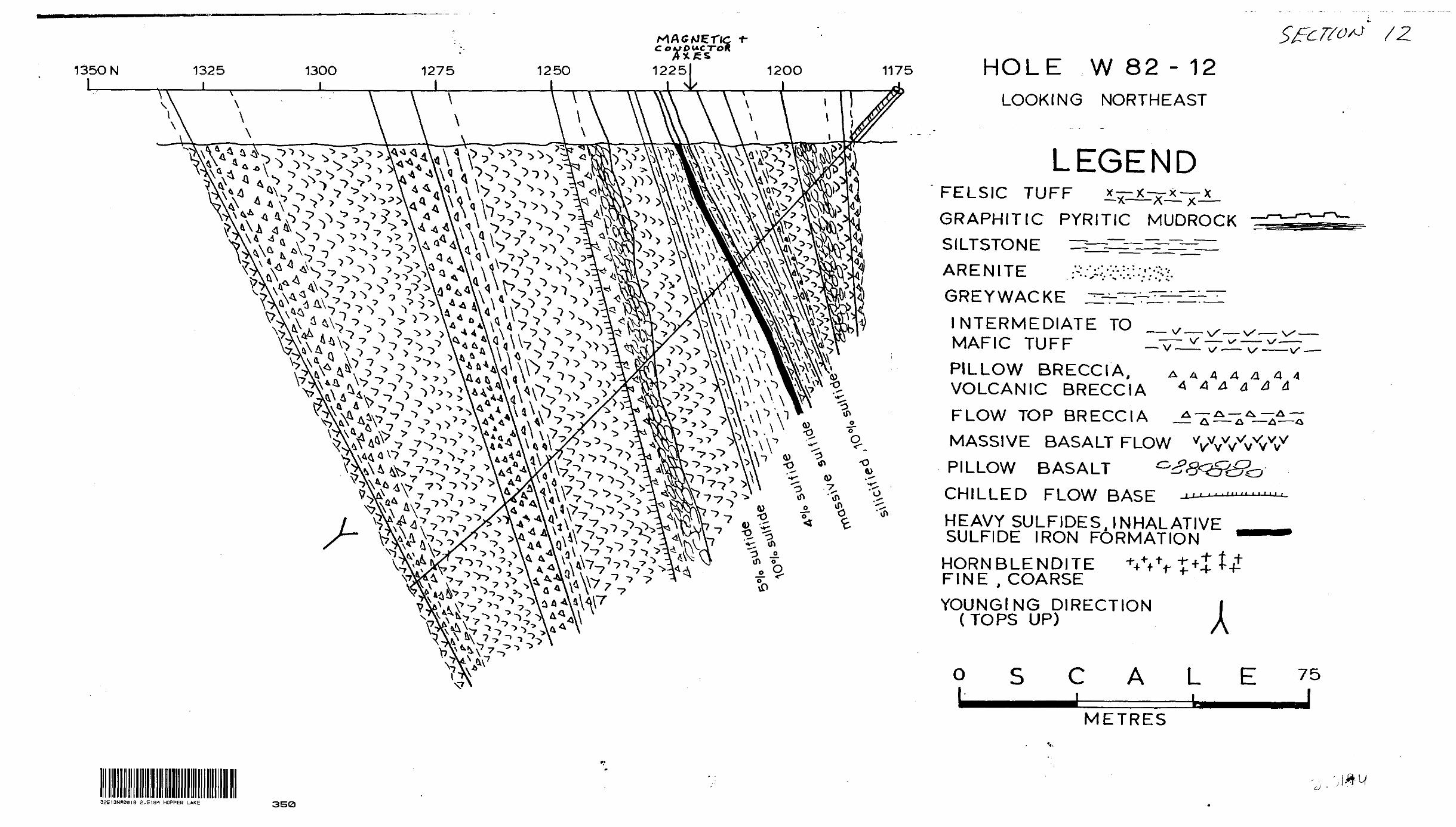
135ONl
1325 l
13OO l
1275 l
125O l
12,251 12OO 117 l A
HOLE W 82 - 12LOOKING NORTHEAST
LEGENDFELSIC TUFF ^^^J^J^
GRAPHITIC PYRITIC MUDROCK SILTSTONE IZ^j^^Z^-Z^Il
ARENITE .:--.-^.v--: :.--,'.--; --
GREYWACKE ^rr~—^-^r-~
INTERMEDIATE TO MAFIC TUFF
PILLOW BRECCIA, VOLCANIC BRECCIA
V
A A A 4 4 a A4 A A a A A
FLOW TOP BRECCIA
MASSIVE BASALT FLOW
PILLOW BASALT G
CHILLED FLOW BASE -^—
HEAVY SULFIDESJNHALATIVE SULFIDE IRON FORMATION
HORNBLENDITE W -t"* FINE , COARSE
YOUNGING DIRECTION (TOPS UP)
VvVvW
AO L
METRES
32E13NW00I8 2.5194 HOPPER LAKE 350
u

y*
;,A.-"X:^; ;^•'••^••;-v ;Q *''. -" ,:HT? *
1VQ^;- : l :^^^i*:f^ x~' il/t
v" l AiV. 'A^'fM^M'^/ ^ ,- 4?-.i'- '
O
i * , -s , - ,' rv*, :- , ' -.v-' K) * ' \ l - a fl B "x. :1 'V 7 ^ f -iv ^, f 'If * '" *^ x ' I*
MW*li\WJ*•t.\ V" ' :" •B' . '. - :
••''frV ' di *' W'" "^•A- : \.. 5fi '••Xia. ^ : ,; ,
*W*i^a
:^.|N
^••"^^IIKit \tX-v A ^:^lwp|p,'|^|Nr'y *
•4^^'V^^'^K 1^iiiiiil^
W Jf
^,," T^*-^rA'''^V ^v3^'.r. C • ( '^V'^-*'*i fAI Y/'- - *sai^^faR.tiii5^Si* SNS ^ i\,,, X A, v,;..V -. \' -1 N \^ ^ V^ 7(^UfV''-- ; - r X. ; ' '•^••-\'..j.'-'
, V \ ^^\-v •'-?W^'J'^ ^v\.- ^-.:-.V Nj'^-i1 \ : . . ,f .W1 -" ^ ,- - ..^••V' i' vj 'i v r* -* .-rt*
^'W.-*^:^^;^: -r ;\sm ,*v:Hir' ' ; .vX-' T!I- : V.'- ."'V;.v,. Vp^^r'C '^rr,^^:^:^P^.;,a-S* fe
tS^pp|p:,i|^rfS^-^^'•rz^tdji&t^'-^^ ^ ^m\ ^^^^''\IA,'' .-.-••p-^.-'.-i" 4-- .uJr^Vi x/^^^•^"-TT'y*''^^ *- :*SJ^Pv -, "i' .''' ' V- '' -.-f'' v " ' "*k V/-v^i
MAP SHEET 62
O
o
V
C A L
1000
metres
Q
v.ii-.
JY/^^^
.i'*?y?x!Xs,xi!/; X^^*J -5 7^;; ';--s5.^Ux' \f- . ~,^^^^i.-Ttfi'-\-,.\V-S?i^^S' V*.,. ..4.
,;;l - xw s- ffw^':k; .f|'*^f f* T;, ; ,^ T . v ^ ; . . - .--^...f , : ,*
M.iflt.^yJiil&ilfe^^
D;
sXTW , " \J~*2 ! l •••?''f-'- \ -/-l ,'f'7 i.-"-A'"*V/ i.^A^^'^- \'\V#?t
;.;^,,v;^,,^-;,,-, rv,,,;:yw^ --^^,,,,^v.- "- O^P\W?*f: 'V^fe '^^^Ute^P
^Sfflf^^ikfs--\^^fe^^^fe^L.-4-'- . 3;fitl^^^fe' '^^dv:^S^^^\
W-:*'.-1'
W. - ,*? \ .L-*J?V!**3Si.J '' .T\k.vjT?.i,-*r-! .-y/i' . -; \ :. Mf: •.••c*. V -'"i* .': i., . .1 V'SJ'- .^,X.'.,. .^.^Lw-lS-S tPfel 3 ,S'^- *4jftH, -, ,-TT*- '-. .,\l-i^W^^
-O
-5
f^lV.-iJS••ttof&M ti^ -—^: 'i
J Q
o.-4
V-^ -^m'o' ^S^'*^ iWSW^ffi^B''i: ''" : ^
^R V
5R \;,W*K;, ,(^iiiisapa*H^gss'": /.
-V^
: '/-:o.f O
' . -' - " - ' f-.-l' - -~L. - - * ' '\ .i/'W""- ;', ''i\y^;;.-:-^ - -;^v '7v/: - -^-•-:^^^ Vv.;;--*:/' : v
*0
W^W^^'-^w •^.-^'m^. : ^ y-"i " S JP ; J-'-V ~-i'.. : . : ' \ -' - , J ' L - J, . ' V ..- - i.- t r* -.i1 l-'**^--;'-^i^*----":; -; -
' 'li•f^^&M 1 ' f'^\Jr*rf'^ l^1' *^''' ^''^sV^^^'j '^ '* C*'^v9i^i''"xJ' '* if!iitfjffl''yS3E'r*''* :~'''' '"*l rlf '5^''" ^K'*'"''"•""l"*"" ^ ' X ''-T' i1 ^ 1"" 'W'"' '''''"' 1 "f 1 ' ~ -' ' 7 '
^ v'
WFiM/y-^yp-''-?
VOLCANICLASTIC BRECCIA s
Q
o,?.-
^*^-''msms1 ,"-, -i i*". :V. 'rtV -. '
' ^- 1 4-( ' ; \ MV l.kv- w.,"? '; "Vu"3 ^-r -, x * /fr^trf*r w*.x'ML ..-ii'T^-",^ Aj.-'"w ,'T:-^*-'^'-'ti: ^tx K'--' ^" 'y-vv-it-v?™^''-j
i2j'l'^-':'''-" f }^Wty'': V' -ffi ~ ^'"
A :^'-' *^*t, A'^/wr {B^^^m#*r:"teff'".4\mmM"y--, y l
^f,;:|PxfSHIf**^
^:|ftpf:M;i^ .--x-.-. 1- m^m^l^-^M\ . ' jfc.^i',
8?*?
D
5YM BOLSDRILL HOLES
AMPHIBOLITE ,g^QUARTZ BIOTITE SCHIST ' (METABASALT) 6 'W (METASEDIMENT)
SULFIDE-R CH ZONE7 Hi HORNBLENDITE
GRAPHITIC MUDROCK'/^ CONTACTS (INTERNAL,LITHOLOGIC)
eP DIP+STRIKEdOPSUPRIGHLUNKNOWN,OVERTURNED)
OUTCROPSb-basalt s-metasediment gr-granite
gd-granodiorite h-hornblenditeLITHOLOGIC ^ FAULT (assumed) BOUNDARY /^
GEOPHYSICAL EM CONDUCTORS (weak,strong^width)
O AXIS OF MAGNETIC ANOMALY (weak >59,500tf.strong ^O,000tf)
TOPOGRAPHICSTRING BOG v- v v OPEN MARSH (muskeg) V'v (grass.alders)SCATTERED SPRUCE TREES THICK SPRUCE FOREST
BOUNDARIES
XA/IVIGEOLO C-
Property: WHOPPER 270Twp; ,Sunday Lake
NTS: 421/4hx/-Dy .. P Belanger-Base Map
R. J. Shegelski - Geology
- Survey from September.lQSI* .1 k A —. k A /"S ^N ^^_____to March.1982
Scale: 1:5000M /f P SfltFr
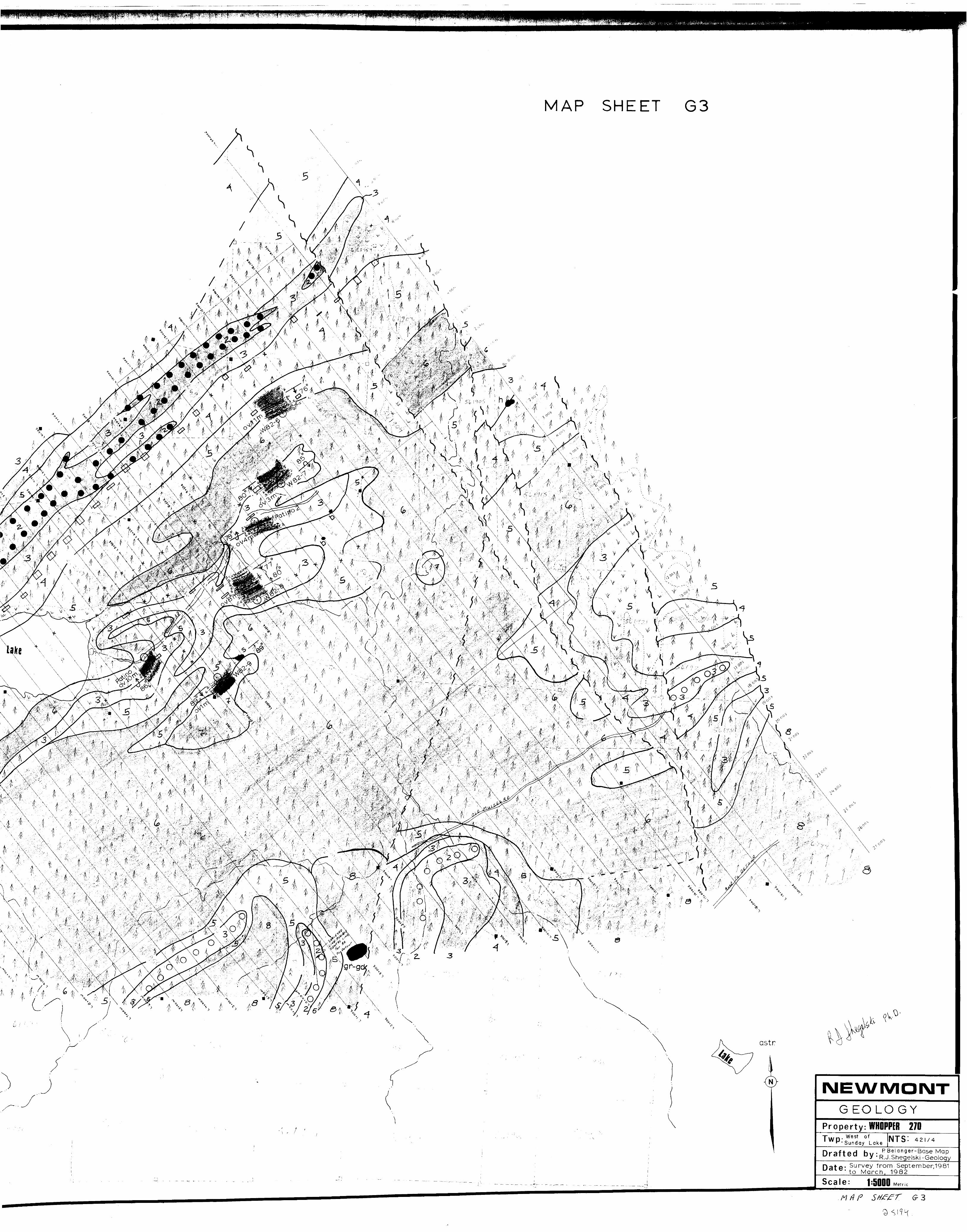
MAP SHEET 63
iv v**v.,.-.'7it.;,v,Wi, . . ;,:i s /.diP#t*:#-" ; V-*-' : :"^\[V C* M-i;*; - :r.A'-"',-^~v - i- ' "••**^i\ ^;fe^-,:A:.r A .*j ,^ /"i -S *-^\s*X--ifi.v -' ••'-v:f . v A, ,- i -c* /'^ -s: V-\^/^^-:A,iJ^;7t ^2-'^•-yj\3rx".' - i'Jsi'^iV"' ^'-'' ••'-'s '- " ^r--1 \•^W^^aS'- 4|; l'-.' ^ ^i W-'-^^v^i^^-wts/^iV^.- 1 ^ J -.r
v^-A^yy^^,^; ^r. -4-•:!A -T':^'^.-'*^c-: ; ",.v- .'^ ^-^ '
w ^
iMEXA/MOIMTGEOLOGY
Property: WHOPPER 270Two- we1 ^^-SunWest of
Lake NTS'- 421/4
u PBelanger-Base Map u V - R.J.Shegelski -Geology
- Survey from September,1981 to March, 1982
.— - . M _ .^ —,^-^ Scale: 1=5000 Metric
G-3