assessment of water availability and...
TRANSCRIPT
ASSESSMENT OF WATER AVAILABILITY AND EVALUATION OF TRADITIONAL RUDH-KOHI IRRIGATION SYSTEM IN DERA ISMAIL KHAN
cooperation
ASSESSMENT OF WATER AVAILABILITY AND EVALUATION OF TRADITIONAL RUDH-KOHI IRRIGATION SYSTEM IN DERA ISMAIL KHAN
CREDITS Authors Prof. Engr. Muhammad Jamal Khan Chairman Water Management Department, Agricultural University Peshawar Prof. Dr. Muhammad lqbal Marwat (Late) Institute of Developmental Studies, Agricultural University Peshawar Munawar Khan Khattak Team Leader, Water for Livelihood Project Intercooperation Pakistan
Edited by Muhammad Asad Salim Junior Programme Officer Intercooperation Pakistan
Fatima Daud Kamal Consultant Knowledge Management
Design and layout by Salman Beenish
Printed by PanGraphics (Pvt) Ltd. Islamabad
Any part of this report can be reproduced with prior permission and proper citation in favour of the author and Intercooperation Pakistan©2013
2 ASSESSMENT OF WATER AVAILABILITY AND EVALUATION OF TRADITIONAL RUDH-KOHI IRRIGATION SYSTEM IN DERA ISMAIL KHAN
TABLE OF CONTENTS
LIST OF ACRONYMS 3
GLOSSARY OF ENCHORIAL WORDS 4
FOREWORD 5
MOW 1. EXECUTIVE SUMMARY 6
ACKNOWLEDGEMENTS 8
• 2. INTRODUCTION 9
3. METHODOLOGY 12
MIMI 4. SOCIO-ECONOMIC PROFILE 15
5. QUALITY AND ASSESSMENT OF WATER RESOURCES 20
6. WATER MANAGEMENT PRACTICES 25
7. WATER STORAGE PONDS 28
8. LAND LEVELING STATUS 29
MEM 9. WATER RIGHTS AND DISTRIBUTION SYSTEMS 32
1111111111111 10. OPERATION AND MAINTENANCE COST OF RUDH-KOHI IRRIGATION SYSTEM 40
MIME 11. PROBLEMS AND CONSTRAINTS OF RUDH-KOH I IRRIGATION SYSTEM 43
RECOMMENDATIONS 46
REFERENCES 47
ASSESSMENT OF WATER AVAILABILITY AND EVALUATION OF TRADITIONAL RUDH-KOHI IRRIGATION SYSTEM IN DERA ISMAIL KHAN
LIST OF ACRONYMS
3
AUP C CA CIS CRBC DCO DG Khan EAC IC IDS KDZ KPI NGO NRM NWFP O&M PLI R&D RIS SDC SPO SPSS WUA
Agricultural University Peshawar Cultivable Command Area Chhal Irrigation System Chashma Right Bank Canal District Coordination officer Dera Ghazi Khan Extra Assistant Commissioner Intercooperation Pakistan Institute of Developmental Studies Kalapani Daraban Zam Kalapani Irrigation System Non Governmental Organization Natural Resource Management North West Frontier Province Operation and Management Project for Livelihood Improvement Research and Development Rudh Kohi Irrigation System Swiss Agency for Development and Cooperation Strengthening Participatory Organization Statistical Package for Social Sciences Water User Association
4 ASSESSMENT OF WATER AVAILABILITY AND EVALUATION OF TRADITIONAL RUDH-KOHI IRRIGATION SYSTEM IN DERA ISMAIL KHAN
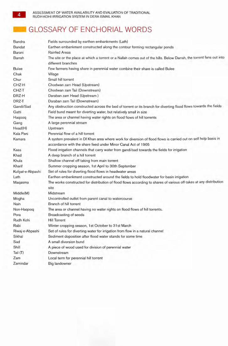
GLOSSARY OF ENCHORIAL WORDS
Bandra Fields surrounded by earthen embankments (Lath)
Bandat Earthen embankment constructed along the contour forming rectangular ponds
Baran i Rainfed Areas
Barrah The site or the place at which a torrent or a Nallah comes out of the hills. Below Darrah, the torrent fans out into
different branches
Bulee Few farmers having share in perennial water combine their share is called Bulee
Chak Village
Chur Small hill torrent
CHZ-H Chodwan zam Head (Upstream)
CHZ-T Chodwan zam Tail (Downstream)
DRZ-H Daraban zam Head (Upstream )
DRZ-T Daraban zam Tail (Downstream)
Gandi/Sad Any obstruction constructed across the bed of torrent or its branch for diverting flood flows towards the fields
Gatti Field bund meant for diverting water, but relatively small in size
Haqoog The area or channel having water rights on flood flows of hill torrents
Gang A large perennial stream
Head(H) Upstream
Kala Pani Perennial flow of a hill torrent
Kamara A system prevalent in DI Khan area where work for diversion of flood flows is carried out on self help basis in
accordance with the share fixed under Minor Canal Act of 1905 Kass Flood irrigation channels that carry water from gandi/sad towards the fields for irrigation
Khad A deep branch of a hill torrent
Khula Shallow channel off taking from main torrent
Kharif Summer cropping season, 1st April to 30th September
Kuliyat-e-Abpashi Set of rules for diverting flood flows in headwater areas
Lath Earthen embankment constructed around the fields to hold floodwater for basin irrigation
Magasma The works constructed for distribution of flood flows according to shares of various off-takes at any distribution
site
Middle(M) Midstream
Mogha Uncontrolled outlet from parent canal to watercourse
Nain Branch of hill torrent
Non-Hagooq The area or channel having no water rights on flood flows of hill torrents.
Pora Broadcasting of seeds
Rudh Kohi Hill Torrent
Rabi Winter cropping season, 1st October to 31st March
Riwaj-e-Abpashi Set of rules for diverting water for irrigation from flow in a natural channel
Sikhal Sediment deposition after flood water stands for some time
Sad A small diversion bund
Shill A piece of wood used for division of perennial water
Tail (T) Downstream
Zam Local term for perennial hill torrent
Zamindar Big landowner
ASSESSMENT OF WATER AVAILABILITY AND EVALUATION OF TRADITIONAL RUDH-KOHI IRRIGATION SYSTEM IN DERA ISMAIL KHAN
5
I FOREWORD
This is an important study, and probably first of its kind, conducted in DI Khan in collaboration with the experts from Agricultural University
Peshawar. The history of development cooperation from Intercooperation in DI Khan goes back to the year 2003 when the first project
(Project for Livelihood Improvement) was launched in the field with the funding from Swiss Agency of Development and Cooperation
(SDC). As of today, Intercooperation has fielded Water for Livelihood Project which is built on earlier experiences of Intercooperation and
other partners (including Pakistan Agricultural Research Council and local NGO partners VEER and SPO).
This study was conducted few years back during the PLI tenure; however it was not published at that time. It is however important to
mention that the study provided relevant and useful material for inspiring project interventions and therefore the study document was well
in use during the planning process of later project interventions. Water for Livelihood Project has now taken the initiative to publish the
study after necessary editing. We believe that it will be useful as a reference for development activists, water experts and farmers in Rudh Kohi areas.
We wish to thank all those who contributed to the completion of the study.
Dr. Arjumand Nizami
6 ASSESSMENT OF WATER AVAILABILITY AND EVALUATION OF TRADITIONAL RUDH-KOHI IRRIGATION SYSTEM IN DERA ISMAIL KHAN
1. EXECUTIVE SUMMARY
ASSESSMENT OF WATER AVAILABILITY AND EVALUATION OF TRADITIONAL RUDH-KOHI IRRIGATION SYSTEM IN DI KHAN
Rudh-kohi irrigation system is being practiced in different parts of Pakistan. In the North West Frontier Province (NWFP)' theRudh-kohi irrigation is practiced in Dera Ismail Khan (DI Khan), Tank, Kohat and Karak districts. DI Khan division is situated at the southern part of North West Frontier Province (NWFP) of Pakistan. The Rudh-kohi irrigation system is being practiced in the area for centuries and water distribution laws (Kuliyat and Riwajat) were formulated during the British era before independence of Pakistan.
The Rudh-kohi irrigation system has been functioning quite satisfactorily for a longer period, due to siltation of irrigation channels, unreliable water availability, uneven distribution of water in the main Rudhs and weak Kamara system. These have created serious problem for overall management of the system. Due to siltation, the capacity of the irrigation channels has reduced which in turn cannot handle the abnormally excessive flood discharge and water over-spilling the banks, causing loss of precious water and damaging properties as well as infrastructures. Due to lack of proper maintenance, it has deteriorated during the last four decades and the irrigated area has reduced to about 50%.
For the economic uplift of Daman Area of DI Khan, the Intercooperation (IC), a Swiss Development Foundation, on behalf of the Swiss
Agency for Development and Cooperation (SDC) is implementing a projeOt for livelihood improvement since 2003. One of the objectives of the project is the capacity building of local communities for better Natural Resources Management.
For improvement of Rudh-kohi irrigation system, Intercooperation planned to conduct water assessment and distribution study in Chodwan and Daraban zams. The study was conducted at Daraban and Chodwan zams. For the study, some Rudhs and Sads/Gandies were selected as samples. Two teams (technical and social) which were fully equipped, comprising of eight individuals including local resource persons completed the study. The team of AUP held validation workshop at the two zams on December 15 and 16, 2004 at Daraban and Chodwan zams along with partner NGOs and Project for Livelihood Improvement staff of Intercooperation.
This report describes the research findings of the study "Water availability Assessment and evaluation of the traditional Rudh-kohi irrigation system of DI Khan" during the period July-December, 2004. Main objectives of the research were: to assess the availability of water in Daraban and Chodwan zams; find the yield of major crops; to understand the water distribution system and to find the strengths and weaknesses of the traditional Rudh-kohi irrigation system; to determine the depth of water application, status and cost of land leveling as well as maintenance cost of the Rudh-kohi irrigation system.
A detailed questionnaire was developed with the help of which technical and socio-economic data was collected. This report describes the results of research studies conducted at the above mentioned sites during the period July-December, 2004. The report consists of eleven chapters, the first chapter serves as introduction, while the 2nd deals with methodology. Chapter 3 describes the salient features of the two selected zams, 4th chapter deals with socio-economics, Chapter 5 is about water resource assessment, 6th explains the water management practices, 7th describes water storage ponds. Chapter 8 deals with land levelling status of fields, while chapter 9 talks about water rights and distribution system, 11th deals with operation and maintenance cost of RIS, and the last section summarizes the conclusions and recommendations.
This report describes research findings conducted during the period July-December, 2004 at two sites (Daraban and Chodwan zams of District DI Khan) in NWFP (now Khyber Pakhtunkhwa), Pakistan under the Project for Livelihood Improvement of Intercooperation Pakistan. Main focus of the study was on flood water assessment and water right for better management of Rudh-kohi irrigation management. The overall objectives of the project are development of technology packages for enhancement of agricultural production through participatory approach mainly for increasing the farmers' income, since they face such a harsh environment. Water distribution and the maintenance condition of existing Rudh-kohi irrigation system was thoroughly studied and management strategies were also developed. Socio-economic baseline survey was conducted to assess the current status and future impact. Main findings of the study are as follows.
MAIN FINDINGS OF STUDY 1. Rudh-kohi area of DI Khan is prone to drought. During the period 1950-2000 four severe droughts occurred in summer season
(Kharif) and eight in winter (Rabi). At the same time, Rudh-Kohi area faces the problem of irregular floods and at times flash floods that cannot be controlled by farmers, damaging their livelihoods
2. The water availability decreases from upstream towards downstream along the flow in the Rudh (Flood channel). At the downstream of the Rudh (Flood channel) the farmers receive flood water twice in ten years as compared to the head reaches where the farmers receive water six years out of ten
'Later renamed as Khyber Pakhtunkhwa (2011)
ASSESSMENT OF WATER AVAILABILITY AND EVALUATION OF TRADITIONAL RUDH-KOHI IRRIGATION SYSTEM IN DERA ISMAIL KHAN
7
3. Water quality of perennial streams and ground water is marginal with ECw greater than one dS/m; on the other hand the flood water
has relatively good quality with ECw less than one dS/m
4. The cropping intensity is relatively low due to scarce water resources and the yields of major crops are less than national average. In Daraban zam the cultivated area with water rights ranged from 80 to 100%, while in Chodwan zam it varied from 49 to 100%. In general, Daraban zam has more area with water than Chodwan zam. About 46% of the respondents reported that there exist salinity tracks in their fields
5. The fields under the flood irrigation system are not adequately leveled resulting in significant variation in relative elevations. 66% of the respondents reported that their fields are not properly leveled and the same was conformed from the survey data. About 710/o of
respondents reported that they utilize tractors for leveling of their fields and about 31% still use traditional method for land leveling
6. Average depth of flood water applied by farmers ranged from 40 to 80 cm in both zams. Infiltration rate ranged from 0.2 to 1.2 mm / hr in the selected zams. The area of the fields (bundras) ranged from 1.5 to 3 hectares in average in Daraban and 2.4 to 5 hectare in Chodwan zam. The height of the field banks (bundras) ranged from 0.9 to 1.3 m. the average depth of deposited sediment in the field after flood water irrigation ranged from 2 to 3.5 cm
7. Average volume of cut in the field for land leveling in Daraban zam is more as compared to Chodwan zam
8. 54% of the respondents2 mentioned that they would like to receive training for enhancement of their capability in Agriculture and other enterprises
9. 67% of the total respondents received Rudh-kohi water in 2003, while in 2004 the percentage was 79%. About 92% of respondents reported the existence of informal WUAs in the system. For management of flood and perennial water (Kalapani) also Water Users Association (WUA) exists in both zams. In Kalapani area, they are relatively stronger as compared to flood irrigated areas
10. In case of perennial water (Kalapani) distribution laws (Kuliyat and Riwajat) are strictly followed as mentioned by the respondent, however, in the case of flood water management the organizational structures are relatively weak
11. About 61% of total respondents replied that they attend regular WUA meetings which show that people in this part of project area are very keen on involving themselves in system improvement and important decision-making regarding efficient usage
12. In Chodwan 63% of respondents told that Kuliyat and Riwajat are followed, while in Daraban it was 76%
13. 84% of the respondents reported decrease in flood irrigation water during the last ten years. About 81% of the respondents reported that main decision-making authority lies in the hands of the WUAs members
14. Landholding per household under perennial command area in Daraban zam was 42.37ha per household, while in Chodwan zam it was reported 32.64ha
15. About 78% of the respondents recognize that their irrigation system needs improvement. This shows general tendency of the locals towards better system management and development
16. The fluctuations in the discharge of perennial streams are very small as reported by 75% of the respondents
17. Most of the respondents (66%) reported that usually they don't exchange Rudh-kohi water with each other, showing a general trend that uncertainty in the water availability compels them not to exchange water with each other
18. About the tempering of Kalapani, overall 91% of total respondents in both zams reported that their Kalapani is tempered and/or stolen by one way or the other. About 59% of respondents in both zams answered in affirmative regarding selling of their Kalapani water. This percentage, is high in Chodwan area probably because they have water rights but no specific/identified fields to irrigate. Wherever there is consistent/ perennial water flow, there must be some system for arranging, organizing and distributing the water in a systematic way
'There exist many tribes in the project area. Baloch are dominant among them, comprising 34% of the sample respondents.
8 ASSESSMENT OF WATER AVAILABILITY AND EVALUATION OF TRADITIONAL RUDH-KOHI IRRIGATION SYSTEM IN DERA ISMAIL KHAN
ACKNOWLEDGEMENTS
This report is a cumulative team effort, reflecting the encouragement, thinking and achievement of colleagues, resource persons, farmer!
and various department associates. The study team would like to thank Mr. Arshad Haroon who was the Project Coordinator of the Project
for Livelihoods Improvement (PLI) during the tenure of the study and Mr. Munawar Khan Khattak for giving the team the opportunity to work
on such a challenging project in the Daman area of DI Khan. A full support was extended to the study team by the IC staff based in DI Khan
Special thanks also go to the partner NGOs: Mr. Faheem lqbal Miankhel from VEER Development Organization (VDO) and Ejaz Qasirr
Strengthening Participatory Organization (SPO). Thematic support and ideas were provided by Mr. Denis Bugnard, Country Director SDC
and Ms. Arjumand Nizami and several other colleagues from Intercooperation. Their support, guidance and encouragement throughout
the study have been highly useful. We are thankful to the partner NGOs for their assistance in the formulation of methodology and data
collection during the study period.
We are particularly grateful to Assistant Commissioner Rudh-Kohi Department, Director Agriculture Department, Section head Meteorology
Department DI Khan and other institutes who provided valuable data and information related to the study. Thanks are also due to Executive
Engineer, Flood Section WAPDA for his generous help.
The hard work of the project staff in collection, compilation, analysis of field data and report write-up is highly appreciated.
Finally, we highly acknowledge the assistance received from SDOs and Patwaries of Irrigation and Drainage Division, DI Khan. The financial
assistance of IC through PLI, is acknowledged with thanks. We also owe a great debt of appreciation and gratitude to all team members,
without their help and cooperation the study was unlikely to be completed.
At the end, special thanks are extended to team members of Water Study, for their highly professional dedication in bringing the report to a
tangible form. Their hard work, patience and professionalism in the face of many deadlines and their deeply burdened schedule are greatly
admired for conducting this study and compiling the report in the given time frame.
The study Team
1. Prof. Engr. Mohammad Jame! Khan, Chairman Water Management Department AUP
2. Dr. Muhammad lqbal Marwat (Late) Professor, Institute of Development Studies — AUP
3. Engr. Abdus Subhan (Field Engineer)
4. Engr. Zulfiqar Ali Khan (Field Engineer)
5. Mr. Gulfam Ali (Sociologist)
6. Mr. Kamran Sadiq (Sociologist)
ASSESSMENT OF WATER AVAILABILITY AND EVALUATION OF TRADITIONAL RUDH-KOHI IRRIGATION SYSTEM IN DERA ISMAIL KHAN
9
Mill 2. INTRODUCTION
Rudh-kohi (Torrent) irrigation system is mostly practiced in Kohat, Lakki Marwat, DI Khan, Tank, DG Khan, Larkana, Dadu and some parts of Baluchistan for agricultural production. In NWFP, the largest area under this system of irrigation lies in DI Khan and Tank Districts. Rudh means the main torrent bed, Kohi means mountains and in local language this system of irrigation is called Wandhara. Rainfall in the upper catchments, which extend up to Baluchistan, Afghanistan, Suleiman range, Sherani hills and Batani range result in runoff and water rushing into various torrents in the foothill plains of DI Khan and Tank districts. The flood water flows in different torrents known as zams and Rudhs in these districts. The flowing seasonal streams or Rudhs (Nullahs) are blocked in the bed of the torrent with a temporary diversion structure (dams or earthen bunds) which are also called Sads or Gandi or Ghatti in local language. The flood water is then diverted through field irrigation channels called
Khulas and trail dikes (pal) prepared for this purpose of irrigation of fields.
Up to the year 1905, there was no provincial or imperial establishment for irrigation in this district for management of flood irrigation system. Later, in 1908 the famous Bolton report was written about the Rudh-Kohi irrigation system which even today is considered the most authentic and detailed report. He formulated water rights for the farmers of the area. These water rights are locally known as Kuliyat and Riwajat-e-Abpashi. The system is composed of basically two types of flow (a) perennial water flow from springs which is locally called Kala Pani (b) Flood water flow from the upstream hills, locally called Sufaid Pani. At present, the flood water right of Rudh-kohi irrigation system is regulated by
Revenue Bondu Basti (Land Settlement) system.
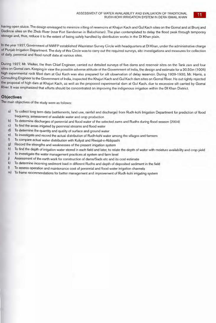
In DI Khan and Tank districts a total 0.69 Million ha of land is available for cultivation, out of which about 0.26 Mha are under Rudh-kohi agriculture with perennial (zams) and non-perennial (Nullahs). Out of twenty five Nullahs, five are Nullahs/zams (Tank zam, Gomal zam, Sheikh Haider zam. Daraban zam and Chodwan zam) (Figure 1). Out of the five zams the last two lie under the Project for Livelihood Improvement
(PLI) and are described in detail (Table 1).
TABLE 1. TOTAL CATCHMENT AREA OF MAJOR ZAMS IN DI KHAN AND TANK DISTRICTS
Name of zam
Tank
Catchment Area Discharge perennial stream
Sq. Km Cms Cfs
2357 1.13 40
Gomal
Sheikh Haider
36000
453
2.83 100
1.00 35
Chodwan 912 0.57 20
Daraban 1095 0.28 10
Total: 40,817 5.81 205
Rudh-Kohi Irrigation, 1990 by Syed Badar-ud-Din, Deputy Director, Agriculture, DI Khan.
This system of diversion continues till either the flood flows are completely exhausted or all the fields are filled. The zams have some perennial flows aggregating to about six cubic meters per sec (cms), as detailed below, which is used for cultivation of about 28,000 hectares (ha) or about 70000 acres.
According to conservative estimate significant (more than 50%) of flood water is allowed to escape and fall into Indus. The remaining more than 2/3 is wasted and not properly used for irrigation. The conditions are no doubt bleak but are not hopeless. A lot can be done for improvement in the livelihood of the poverty stricken community. In this regard, Project for Livelihood Improvement is working for the improvement of the Rudh-kohi irrigation system.
Daraban zam Daraban zam originates from Koh-e-Aspana (white mountain) which is situated 48 km from Tuman Sain Abakhel and Tuman Shiranian. Besides the flood water due to rains, the zam also has a flow of perennial water from many springs in the said mountain on the eastern side when water from the springs passes through Koh-e-Kala (Black Mountain) also known as Koh-e-Suleiman. That is when the main spring near Gut merges with the said spring water. Shiranian and Abakhel irrigate their lands up in Darah and then this water collectively flows in a channel called Gudh to irrigate the lands of village Daraban. That is the reason the zam is known as Daraban zam. Flood water of Daraban zam is distributed in three branches i.e. in the south Gudh, in the north Shakh Shumali named as Toya and the middle Lohra. Gudh also receives 9/16th share of flood water from Chodwan zam at Wandhara (Water distribution point). Daraban zam has two flood seasons, the flood of July-Sep. used for Rabi cultivation and of March-April used for the Kharif Crops. The catchment area of Daraban zam is 1,095 km2.This zam has three irrigation systems,
1. Rudh-kohi Irrigation System (RIS) from flood water, the peak discharge of flood water in Daraban zam is 50,000 cusecs 2. Kalapani Irrigation System (KIS) from perennial water, the discharge of perennial water in Chodwan zam is 35 cusecs 3. Chhal Irrigation System (CIS) from water by overflow
10 ASSESSMENT OF WATER AVAILABILITY AND EVALUATION OF TRADITIONAL RUDH-KOHI IRRIGATION SYSTEM IN DERA ISMAIL KHAN
Chodwan zam This zam receives rainwater from Qaisa Mountain. Perennial water comes from springs through different Rudhs in Sherani area and then all tl water merges at a point which is known as Dumanda. When this water comes out of Chodwan zam, it distributes in Kalapani (Perennial Wat( and Sufaidpani (Flood Water). The flood water irrigates the land through different Rudhs also called Lahries. Maximum discharge of flood wat and perennial water in Chodwan zam are 31,000 cusecs and 10 cusecs respectively. The catchment area of Chodwan zam is 912 km2. The:
Lahries are further distributed according to area with local names. Chodwan area has the following six Lahries, 1. Lahrtayo known as Rodan 2. Lahri Gara Wand known as Rati Kamar 3. Khochki 4. Lahri Torazia 5. Shakh Torazia Khurd 6. Shakh Torazia Shumali
Similarly Gara Nahr has the following Lahries. 1. Lahri Jandwali 2. Lahri Nirmal Wali 3. Lahri Makh Chera 4. Shakh
FIGURE- 1. CATCHMENT AREA OF DARABAN AND CHODWAN ZAMS
Proper resettlement of the RIS has been made by the Administrative Authorities of the British Government in 1905-1908. For running proper discharge in RIS, Kuliyat-e-Abbpashi have been made. Similarly for the distribution of water within the village, Riwajat-e-Abbpashi been written. Presently the incharge of RIS on district level is also called Collector or Extra Assistant Commissioner (EAC), who enfo the Kuliyat, Riwajat and Operation & Maintenance (O&M) of the system with the help of Special Tehsildar Irrigation, two Naib Tehsildars, Kanungos and fourteen Patwaris.
Review of Literature and Data Any available information and data related to rainfall discharge, sediment load, soil texture and crops were collected. For collection of a mentioned data, visits were paid to the Department of Rudh-kohi Irrigation System, Universities, Research Institutes, Irrigation Depart including Federal Flood Commission, WAPDA, ISRIP, WRRI, NESPAK and Soil Survey of Pakistan.
Different agencies in the past have conducted preliminary investigations and planning for controlling the flood flows of the zams to faci irrigation in a regular and controlled manner. Brief description of these zams with the work done in the past is summarized as under:
In 1927-28, a Survey Circle was established which continued up to 1932. The circle team carried out surveys on four zams i.e. Goma1,1 Daraban and Chodwan, and performed preliminary studies.
In 1927, Mr. S. Walker, S.E. and Secretary Irrigation NWFP conceived the idea of constructing delay action reservoirs, with check d
ASSESSMENT OF WATER AVAILABILITY AND EVALUATION OF TRADITIONAL RUDH-KOHI IRRIGATION SYSTEM IN DERA ISMAIL KHAN 11
having open sluice. The design envisaged to minimize silting of reservoirs at Khajuri Kach and Gul Kach sites on the Gomal and at Brunj and Dadinzai sites on the Zhob River (near Fort Sandeman in Balochistan). The plan contemplated to delay the flood peak through temporary storage and, thus, reduce it to the extent of being safely handled by distribution works in the DI Khan plain.
In the year 1927, Government of NWFP established Waziristan Survey Circle with headquarters at DI Khan, under the administrative charge of Punjab Irrigation Department. The duty of this Circle was to carry out the required surveys, site investigations and measures for collection of daily, perennial and flood runoff data at various sites.
During 1927, Mr. Walker, the then Chief Engineer, carried out detailed surveys of five dams and reservoir sites on the Tank zam and four sites on Gomal zam. Keeping in view the possible adverse attitude of the Government of India, the design and estimate for a 30.50m (100ft) high experimental rock filled dam at Gul Kach was also prepared for silt observation of delay reservoir. During 1929-1930, Mr. Harris, a Consulting Engineer to the Government of India, inspected the Khajuri Kach and Gul Kach dam sites on Gomal River. He out rightly rejected the proposal of high dam at Khajuri Kach, as well as the proposed experimental dam at Gul Kach, due to excessive silt carried by Gomal River. It was emphasized that efforts should be concentrated on improving the indigenous irrigation within the DI Khan District.
Objectives The main objectives of the study were as follows:
a) To collect long term data (settlements, land use, rainfall and discharge) from Rudh-kohi Irrigation Department for prediction of flood frequency, assessment of available water and crop production
b) To determine discharges of perennial and flood water of the selected zams and Rudhs during flood season (2004) c) To find the areas irrigated by perennial streams and flood water d) To determine the quantity and quality of surface and ground water e) To investigate and record the actual distribution of Rudh-kohi water among the villages and farmers f) To compare actual water distribution with Kuliyat and Riwajat-e-Abbpashi g) Record the strengths and weaknesses of the present irrigation system h) To find the depth of irrigation water stored in each field and later, to relate the depth of water with moisture availability and crop yield i) To investigate the water management practices at system and farm level j) Assessment of the earth work for construction of dams/Sads etc and its cost estimate k) To determine incoming sediment load in different Rudhs and depth of deposited sediment in the field I) To assess operation and maintenance cost of perennial and flood water irrigation channels m) To frame recommendations for better management and improvement of Rudh-kohi irrigating system
12 ASSESSMENT OF WATER AVAILABILITY AND EVALUATION OF TRADITIONAL RUDH-KOHI IRRIGATION SYSTEM IN DERA ISMAIL KHAN
3. METHODOLOGY
Description of the Project Site The study was conducted during July-December, 2004 at two zams (Daraban and Chodwan) of district DI Khan, which receive perenni as well as flood water from the upper catchments for irrigation. The area lies in DI Khan District and located between altitude 31 ° 15' N 32°31'N and Longitude between 70°05'E and 71°22' (Figure 2). The area consists of four main land form unit i.e. piedmont plain, gravell fan/apron, rough broken land and mountain. The potential evaporation is about 1500 mm per year. June and July are the hottest month with mean temperature of 42 °C, January is the coldest month with an average temperature of 15 °C. The climate of the project area is ari
to semi-arid, sub-tropical continental with mean annual precipitation ranging from 108 mm to 305 mm. The main crops grown in the projei area are wheat, gram and oil seed in Rabi and sorghum, millet in Kharif. About 57% of the land can be classified as Class I and II i.e. very goo
and good agricultural land.
FIGURE 2. MAP OF KYBER PAKHTUNKHWA SHOWING THE STUDY AREA
Sample Rudhs Selection On Daraban and Chodwan zams, two Rudhs (Gudh/Lohra and Valahri) were selected along the flow direction. On each Rudh th Gandies/Bunds/Sads were randomly selected at the head, middle and tail. Data from fifteen respondents were collected from the selected Gandi/Bund/Sad (Figure 3).
The Selected Gandies/Sads/Bunds for the study are given below:
Name of the zam
Name of the Sad/Gandi along the flow direction on the main Rudhs i.e. Gudh/ Lohra and Valahri
Head Middle Tail
Daraban Sad Swad Sad Rab Nawaz Sad Dinga
Chodwan Gandi Abdullah Gandi Bhooki Gandi Malawali
Development of Detailed Questionnaire for the Study A detailed questionnaire was developed for collection of socio-technical data related to Rudh-kohi irrigation system, water distribution, irrig area, crop production, depth and time of water application and water management practices at the system and farm level. Besides that b information related to Kuliyat and Riwajat for flood water, the distribution system was also collected and analyzed.
Chodwan zam Daraban zam
Valahri
FIGURE 3. A SHEMATIC DIAGRAM SHOWING THE LAYOUT OF RUDHS
ASSESSMENT OF WATER AVAILABILITY AND EVALUATION OF TRADITIONAL RUDH-KOHI IRRIGATION SYSTEM IN DERA ISMAIL KHAN
13
Technical Data Technical data on two sample Rudhs/nullahs related to length, width of Rudhs, discharge, embankment height, type of soil, and bed slope
of the flood irrigation channel were determined.
Land Leveling and Depth of Water Application The topographic survey of the 35 sampled fields in both zams was conducted to find the elevation difference, cost of land leveling and size of the fields. The purpose of this study was to assess the status of land levelness of fields under the Rudh-kohi irrigation system. The data was collected on length and width of the field, besides that the field were divided into equal grids of 20 m x 20 m and relative elevations of each grid were determined with the help of automatic level. Later, volume of cut and fill were calculated and finally the cost of land leveling per ha was determined. Measurement of depth of water applied at these grid points were also determined and later related to crop production. The rate of infiltration in each field was determined by scaled Rudh and the rate of infiltration with time was noted for five hours.
Sediment Deposition in the Field Data related to deposited sediment in the field after irrigation with flood water were collected from 35 fields at five locations in each field. The G PS; farmer identification; elevation at five spots in the fields; depth of sediment deposited; moisture content in one meter depth of soil; infiltration rate; initial date of irrigation; size of bundra and depth of standing water were noted.
Suspended Sediment Load in the main Rudh For assessment of suspended sediment load, sediment samples were collected at regular interval during the initial, peak period and at the end of the flood. At least 10 samples were collected during flood events by using depth integrating method.
Climate in the project area varies from arid to semi-arid. Summers are hot and dry in June, humid in July and August while winters are mild. One cusec of perennial water command 30 acres of 100% cropping intensity while flood water, being seasonal, should cover 10 to 12 acres. On this basis, the perennial water of 205 cusecs will cover 60,000 acres and floods of 2 lac cusecs should supply irrigation for around 20 lac acres.
One cusec of perennial water command 30 acres of 100% cropping intensity while flood water, being seasonal, should cover 10 to 12 acres. On this base, the perennial water of 205 cusecs will cover 60,000 acres and floods of 2 lac cusecs should supply irrigation for around 20 lac
acres.
Determination of Electrical Conductivity (Ec) and pH ECw of the surface, flood and ground water was determined with the help of EC meter.
The pH of water was measured by pH meter. The pH meter was first calibrated with buffer solutions of known pH. The reading was recorded to the nearest one decimal place. pH of water was determined directly by immersing the probe of pH meter in water samples. The researchers have used different limits for EC, SAR for water classification for agricultural use. The different parametric limits adopted
by WAPDA (1974), Pakistan, for the classification of water into different classes are given in Table 2.
14 ASSESSMENT OF WATER AVAILABILITY AND EVALUATION OF TRADITIONAL RUDH-KOHI IRRIGATION SYSTEM IN DERA ISMAIL KHAN
TABLE 2. PERMISSIBLE LIMITS OF EC AND SAR FOR IRRIGATION WATER
Parameters Usable Marginal Hazardous
EC (dS/m) 0-1.5 1.5-2.7 >2.7
SAR 0-10 10-18 >18
Source: WAPDA (1974)
Flood Discharge Measurement The discharge of perennial streams as well as flood irrigation channels was measured during the study period by velocity area-metho with the help of current meter. The propeller type of current meter was used. When current meter is immersed in flowing water, its innpell revolves at a speed that is proportional to the water velocity. The water velocity was determined using calibration curve that relates th speed of meter to water velocity. The width of water surface in the canal was measured through a measuring tape. Width was divided int a number of segments and depth of each segment was noted. In each segment the number of readings depends on the depth of water i it, if the depth is greater than or equal to 0. 25 m then two readings at 0.8 and 0.2 of the water depth are taken, whereas if depth is le•
than 0. 25 m, only one reading at 0.6 of the water depth is taken.
Each reading consisted of a minimum of three sets of observations. Revolution of the current meter per minute was noted. In the even when these 3 observations vary by more than ± 5%, further observations were required until variation between readings was less th.
± 5%. The velocity for each segment was determined from current meter table that are different for different sizes of propeller numb Depth and width of each segment were determined and drawn on a paper and correctional area of each segment was calculated by usi
appropriate formulas. The discharge of each segment was calculated as:
Q. = V. A. Where
Cli = Discharge of the segment; V, = Velocity of the segment; and Ai = Area of the segment.
40
35
30
25
20
15
10
5
0
Rai
nfe
d a
rea (
ha)
■ Daraban ■ Chodwan
Upstream Midstream Downstream Mean
Location on the zam
Rudh-kohi area 55%
Rainfed area 21%
a. Daraban zam b. Chodwan zam
Upstream Midstream Downstream Mean Location on the zam
1 ■ Daraban ■ Chodwan
Rud
h-k
ohi a
rea
( ha)
80
70
60
50
40
30
20
10
0
ASSESSMENT OF WATER AVAILABILITY AND EVALUATION OF TRADITIONAL RUDH-KOHI IRRIGATION SYSTEM IN DERA ISMAIL KHAN
- 4. SOCIO-ECONOMIC PROFILE
A base line survey questionnaire was developed to assess the social and
economic status of the farmers in the selected zams (Appendix A). The
form was divided into the following sections: 1) General, 2) Land holding
and its condition, 3) Cropping Pattern and yield 4) Water distribution
system 5) Salinity/Water logging: Causes and its reclamation, 6) Crop
production practices and 7) Farm irrigation practices. Sixty (60) farmers
from each section were interviewed at Daraban and Chodwan zam while
thirty five (15) each in perennial stream command area at both sites. The
data collected were analyzed and are presented in chapter 5.
A detailed questionnaire proforma was developed to assess the socio-
economic status of the farmers at the project site during July-December,
2004 (Annex-D). Forty-five (45) farmers in each zam (Daraban and
Chodwan) were interviewed in Rudh-kohi command area and fifteen (15) each in perennial streams command area. According to the general survey, most of the farmers are poor and have relatively large land
holdings but unreliable water supply due to which the agricultural production is very low. Majority of the population depends on agriculture
and livestock. However, off-farm enterprises, small business employments in public and private organizations are also providing sources of
income. There is a formal WUA in the project area for management of both perennial streams as well as for the management of Rudh-kohi
irrigation system. The farmers of the project area are co-operative and willing to work with the development agencies.
Land Holdings The cultivated area under Rudh-kohi was 55 and 50% at Daraban and Chodwan zams respectively, followed by rainfed (34%) at Daraban
zam. The range/waste land was higher (24%) in Daraban as compared to Chodwan zam (Figure 4).
15
FIGURE 4. PERCENT LANDHOLDING OF DIFFERENT CATEGORIES IN THE SELECTED ZAMS
The average cultivated area under Rudh-kohi at the upstream
was 77.23 and 49.65 ha per farmer at Daraban and Chodwan
accordingly. In general, the landholdings at the midstream
were relatively small (12.58 and 7.76 ha). The overall mean
landholdings in the selected zams were 46.77 and 45.04 ha at
Daraban and Chodwan zam respectively (Figure 5).
FIGURE 5. AVERAGE CULTIVATED LAND PER HOUSEHOLD UNDER RUDH-KOHI IRRIGATION SYSTEM IN THE SELECTED ZAMS
The average rainfed cultivated land in the upstream at Daraban
was 18.89 ha and for Chodwan 39.96 ha per farmer, which
is 53% more than the former one. In general, the rainfed
cultivated area was 41% more in Chodwan than Daraban zam (Fig. 6).
FIGURE 6. CROPPING PATTERN OF RABI SEASON AT DARABAN IN RUDH-KOHI IRRIGATED AREA
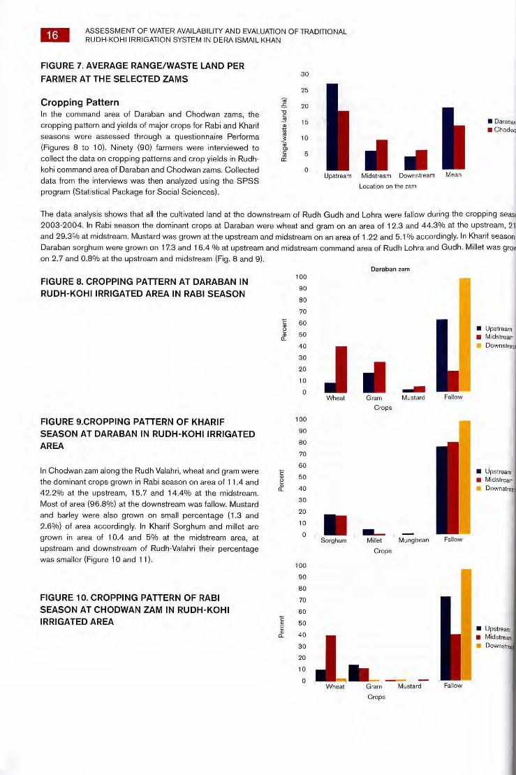
The average range/waste land in the upstream at Daraban zam was 440/0 more than Chodwan zam. The mean range/waste
land were 20.45 ha and 14.85 ha at Daraban and Chodwan respectively (Figure 7).
25
Range
/waste
land
(ha)
20
10
15
5 111 .11 0 Upstream Midstream Downstream
Location on the zam
■ Daraban ■ Chodwa
Mean
FIGURE 8. CROPPING PATTERN AT DARABAN IN
RUDH-KOHI IRRIGATED AREA IN RABI SEASON
C
100
90
80
70
60 0
50 0
40
30
20
10
0
FIGURE 9.CROPPING PATTERN OF KHARIF 100
SEASON AT DARABAN IN RUDH-KOHI IRRIGATED 90
AREA 80
70
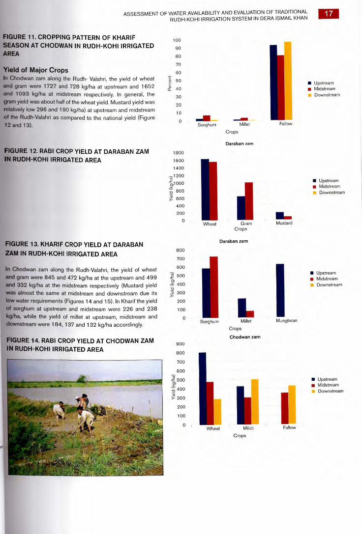
60 In Chodwan zam along the Rudh Valahri, wheat and gram were
the dominant crops grown in Rabi season on area of 11.4 and 50
42.2% at the upstream, 15.7 and 14.4% at the midstream. 40
Most of area (96.8%) at the downstream was fallow. Mustard 30
and barley were also grown on small percentage (1.3 and 20
2.6%) of area accordingly. In Kharif Sorghum and millet are 10
grown in area of 10.4 and 5% at the midstream area, at
upstream and downstream of Rudh-Valahri their percentage
was smaller (Figure 10 and 11).
0
100
90
80
FIGURE 10. CROPPING PATTERN OF RABI 70
SEASON AT CHODWAN ZAM IN RUDH-KOHI 60
IRRIGATED AREA 4) 50
0 40
30
20
10
0
■ Upstream
■ Midstream
it Downstre.
Sorghum Millet Mungbean Fallow
Crops
■ Upstream ■ Midstream
Downstrev
Wheat Gram Mustard Fallow
Crops
Daraban zam
111 =AM Gram Mustard
Crops
■ Upstream ■ Midstream
Downstream
Wheat Fallow
16 ASSESSMENT OF WATER AVAILABILITY AND EVALUATION OF TRADITIONAL
RUDH-KOHI IRRIGATION SYSTEM IN DERA ISMAIL KHAN
FIGURE 7. AVERAGE RANGE/WASTE LAND PER
FARMER AT THE SELECTED ZAMS 30
Cropping Pattern In the command area of Daraban and Chodwan zams, the
cropping pattern and yields of major crops for Rabi and Kharif
seasons were assessed through a questionnaire Performa
(Figures 8 to 10). Ninety (90) farmers were interviewed to
collect the data on cropping patterns and crop yields in Rudh-
kohi command area of Daraban and Chodwan zams. Collected
data from the interviews was then analyzed using the SPSS
program (Statistical Package for Social Sciences).
The data analysis shows that all the cultivated land at the downstream of Rudh Gudh and Lohra were fallow during the cropping seas
2003-2004. In Rabi season the dominant crops at Daraban were wheat and gram on an area of 12.3 and 44.3% at the upstream, 21
and 29.3% at midstream. Mustard was grown at the upstream and midstream on an area of 1.22 and 5.1% accordingly. In Kharif season
Daraban sorghum were grown on 17.3 and 16.4 % at upstream and midstream command area of Rudh Lohra and Gudh. Millet was groin
on 2.7 and 0.8% at the upstream and midstream (Fig. 8 and 9).
Sorghum Millet
Fallow
Crops
Daraban zam
Wheat Gram Mustard Crops
800
700
600
500
400 -o co 300
200
100
0 Sorghum
L Millet
Chodwan zam
Fallow Wheat
900
800
700
600 is -E 500 _Ne
400 To
300
200
100
0 Millet
Crops
1800
1600
1400
1200
)1000 _Ne
Daraban zam
800
600
400
200
0
100
90
80
70
60
■i; 50
40
30
20
10
; -
FrAhs.W.
ASSESSMENT OF WATER AVAILABILITY AND EVALUATION OF TRADITIONAL RUDH-KOHI IRRIGATION SYSTEM IN DERA ISMAIL KHAN
17
FIGURE 11. CROPPING PATTERN OF KHARIF
SEASON AT CHODWAN IN RUDH-KOHI IRRIGATED
AREA
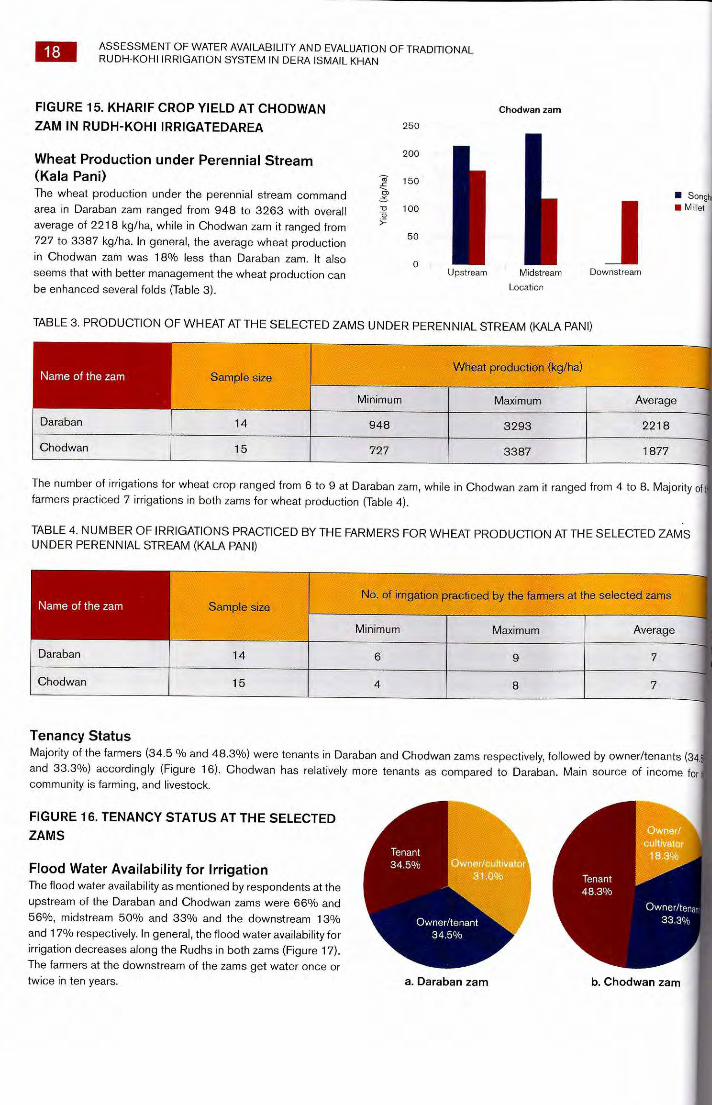
Yield of Major Crops In Chodwan zam along the Rudh- Valahri, the yield of wheat
and gram were 1727 and 728 kg/ha at upstream and 1652
and 1093 kg/ha at midstream respectively. In general, the
gram yield was about half of the wheat yield. Mustard yield was
relatively low 296 and 190 kg/ha) at upstream and midstream
of the Rudh-Valahri as compared to the national yield (Figure 12 and 13).
■ Upstream ■ Midstream
Downstream
FIGURE 12. RABI CROP YIELD AT DARABAN ZAM
IN RUDH-KOHL IRRIGATED AREA
FIGURE 13. KHARIF CROP YIELD AT DARABAN
ZAM IN RUDH-KOHI IRRIGATED AREA
In Chodwan zam along the Rudh-Valahri, the yield of wheat and gram were 845 and 472 kg/ha at the upstream and 499
and 332 kg/ha at the midstream respectively (Mustard yield
was almost the same at midstream and downstream due its
low water requirements (Figures 14 and 15). In Kharif the yield
of sorghum at upstream and midstream were 226 and 238
kg/ha, while the yield of millet at upstream, midstream and downstream were 184, 137 and 132 kg/ha accordingly.
FIGURE 14. RABI CROP YIELD AT CHODWAN ZAM
IN RUDH-KOHI IRRIGATED AREA
■ Upstream ■ Midstream
Downstream
■ Upstream ■ Midstream
Downstream
■ Upstream ■ Midstream
Downstream
a. Daraban zam
b. Chodwan zam
Tenant
48.3%
18 ASSESSMENT OF WATER AVAILABILITY AND EVALUATION OF TRADITIONAL RUDH-KOHI IRRIGATION SYSTEM IN DERA ISMAIL KHAN
FIGURE 15. KHARIF CROP YIELD AT CHODWAN
ZAM IN RUDH-KOHI IRRIGATEDAREA
Wheat Production under Perennial Stream (Kala Pani) The wheat production under the perennial stream command
area in Daraban zam ranged from 948 to 3263 with overall
average of 2218 kg/ha, while in Chodwan zam it ranged from
727 to 3387 kg/ha. In general, the average wheat production
in Chodwan zam was 18% less than Daraban zam. It also
seems that with better management the wheat production can
be enhanced several folds (Table 3).
Chodwan zam
111 Midstream
Location
250
200
~~ 150 rn -o 100 a
50
0 Upstream
■ Songh ■ Millet
Downstream
TABLE 3. PRODUCTION OF WHEAT AT THE SELECTED ZAMS UNDER PERENNIAL STREAM (KALA PANI)
Name of the zam Sample size Wheat production (kg/ha)
Minimum Maximum Average
Daraban 14 948 3293 2218
Chodwan 15 727 3387 1877
The number of irrigations for wheat crop ranged from 6 to 9 at Daraban zam, while in Chodwan zam it ranged from 4 to 8. Majority of farmers practiced 7 irrigations in both zams for wheat production (Table 4).
TABLE 4. NUMBER OF IRRIGATIONS PRACTICED BY THE FARMERS FOR WHEAT PRODUCTION AT THE SELECTED ZAMS UNDER PERENNIAL STREAM (KALA PANI)
Name of the zam Sample size No. of irrigation practiced by the farmers at the selected zams
Minimum Maximum Average
Daraban 14 6 9 7
Chodwan 15 4 8 7
Tenancy Status Majority of the farmers (34.5 % and 48.3%) were tenants in Daraban and Chodwan zams respectively, followed by owner/tenants (34 and 33.3%) accordingly (Figure 16). Chodwan has relatively more tenants as compared to Daraban. Main source of income for community is farming, and livestock.
FIGURE 16. TENANCY STATUS AT THE SELECTED ZAMS
Flood Water Availability for Irrigation The flood water availability as mentioned by respondents at the
upstream of the Daraban and Chodwan zams were 66% and
56%, midstream 50% and 33% and the downstream 13%
and 17% respectively. In general, the flood water availability for
irrigation decreases along the Rudhs in both zams (Figure 17).
The farmers at the downstream of the zams get water once or twice in ten years.
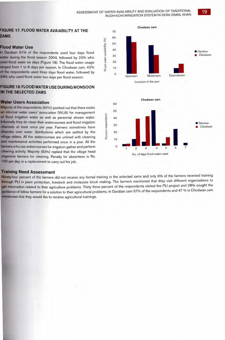
FIGURE 1 7. FLOOD WATER AVAIABILITY AT THE
ZAMS
Flood Water Use In Daraban 51% of the respondents used four days flood
water during the flood season 2004, followed by 23% who
used flood water six days (Figure 18). The flood water usage
ranged from 1 to 8 days per season. In Chodwan zam, 42%
of the respondents used three days flood water, followed by 39% who used flood water two days per flood season.
FIGURE 18. FLOODWATER USE DURING MONSOON IN THE SELECTED ZAMS
Water Users Association Majority of the respondents (92%) pointed out that there exists
an informal water users' association (WUA) for management
of flood irrigation water as well as perennial stream water.
Informally they do clean their watercourses and flood irrigation
channels at least once per year. Farmers sometimes have
disputes over water distributions which are settled by the
village elders. All the watercourses are unlined with cleaning
and maintenance activities performed once in a year. All the
farmers v. ho use watercourses for irrigation gather and perform cleaning activity. Majority (830/o) replied that the village head organizes farmers for cleaning. Penalty for absentees is Rs.
100 per day or a replacement to carry out his job.
Flo
od w
ater
ava
ilabi
lity
(Wo)
ce
nt r
esp
ond
ents
ASSESSMENT OF WATER AVAILABILITY AND EVALUATION OF TRADITIONAL RUDH-KOHI IRRIGATION SYSTEM IN DERA ISMAIL KHAN
19
Chodwan zam
70
60
50
40 ■ Daraban
30 ■ Chodwan
20
10
0 Midstream Downstream Upstream
Location of the zam
Chodwan zam
60
50
40
■ Daraban 30
■ Chodwan
20
10
a 0
1 2 3 4 5 7
No. of days flood water used
Training Need Assessment Ninety-four percent of the farmers did not receive any formal training in the selected zams and only 6% of the farmers received training
through PLI in plant protection, livestock and molasses block making. The farmers mentioned that they visit different organizations to
get information related to their agriculture problems. Thirty three percent of the respondents visited the PLI project and 28% sought the
guidance of fellow farmers for a solution to their agricultural problems. In Daraban zam 57% of the respondents and 47 % in Chodwan zam
mentioned that they would like to receive agricultural trainings.
Total rainfall in Moonsoon season observed in mm
1111■—.111
111
August September October November December Month of occurance
150
Milli
met
er o
f rai
nfal
l
100
50
■D OD
Mc
Month wise 30 years average rainfall (mm) at DI Khan District
I I 111 I I I / ....., II
I 2 -ti; 8 8 8 8 3 _0 -0 -0 -0 a 0, E 0 E E - $2
UN o_ 0 o a> ° a) z ❑ r.n
70 60 50 40 30 20 10 0
as 3 3 as
a
Aver
age
rain
fall (
mm
)
20 ASSESSMENT OF WATER AVAILABILITY AND EVALUATION OF TRADITIONAL RUDH-KOHI IRRIGATION SYSTEM IN DERA ISMAIL KHAN
5. QUALITY AND ASSESSMENT OF WATER RESOURCES
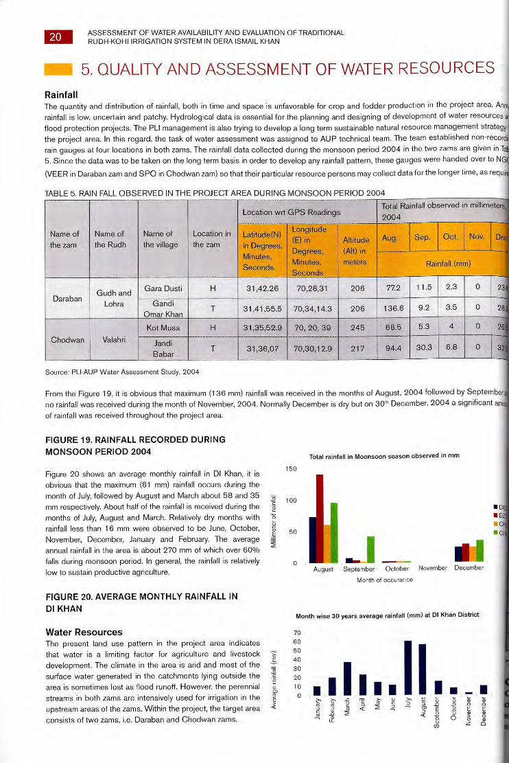
Rainfall The quantity and distribution of rainfall, both in time and space is unfavorable for crop and fodder production in the project area. Annu
rainfall is low, uncertain and patchy. Hydrological data is essential for the planning and designing of development of water resources ar
flood protection projects. The PLI management is also trying to develop a long term sustainable natural resource management strategy the project area. In this regard, the task of water assessment was assigned to AUP technical team. The team established non-record
rain gauges at four locations in both zams. The rainfall data collected during the monsoon period 2004 in the two zams are given in Ta
5. Since the data was to be taken on the long term basis in order to develop any rainfall pattern, these gauges were handed over to NG
(VEER in Daraban zam and SPO in Chodwan zam) so that their particular resource persons may collect data for the longer time, as requir
TABLE 5. RAIN FALL OBSERVED IN THE PROJECT AREA DURING MONSOON PERIOD 2004
Name of
the zam
Name of
the Rudh
Name of
the village
Location in
the zam
Location wrt G PS Readings Total Rainfall observed in millimeters,
2004
Latitude(N)
in Degrees,
Minutes,
Seconds
Longitude
(E) in
Degrees,
Minutes,
Seconds
Altitude
(Alt) in
meters
Aug. Sep. Oct. Nov. De
Rainfall (mm)
Daraban Gudh and
Lohra
Gara Dusti H 31,42,26 70,28,31 206 77.2 11.5 2.3 0 23.
Gandi
Omar Khan T 31,41,55.5 70,34,14.3 206 136.6 9.2 3.5 0 28
Chodwan Valahri
Kot Musa H 31,35,52.9 70, 20, 39 245 66.5 5.3 4 0
Jandi
Babar T 31,36,07 70,30,12.9 217 94.4 30.3 6.8 0
Source: PLI-AUP Water Assessment Study, 2004
From the Figure 19, it is obvious that maximum (136 mm) rainfall was received in the months of August, 2004 followed by September
no rainfall was received during the month of November, 2004. Normally December is dry but on 30th December, 2004 a significant am
of rainfall was received throughout the project area.
FIGURE 19. RAINFALL RECORDED DURING MONSOON PERIOD 2004
Figure 20 shows an average monthly rainfall in DI Khan, it is
obvious that the maximum (61 mm) rainfall occurs during the
month of July, followed by August and March about 58 and 35
mm respectively. About half of the rainfall is received during the
months of July, August and March. Relatively dry months with
rainfall less than 16 mm were observed to be June, October,
November, December, January and February. The average
annual rainfall in the area is about 270 mm of which over 60%
falls during monsoon period. In general, the rainfall is relatively
low to sustain productive agriculture.
FIGURE 20. AVERAGE MONTHLY RAINFALL IN DI KHAN
Water Resources The present land use pattern in the project area indicates
that water is a limiting factor for agriculture and livestock
development. The climate in the area is arid and most of the
surface water generated in the catchments lying outside the
area is sometimes lost as flood runoff. However, the perennial
streams in both zams are intensively used for irrigation in the
upstream areas of the zams. Within the project, the target area
consists of two zams, i.e. Daraban and Chodwan zams.
ASSESSMENT OF WATER AVAILABILITY AND EVALUATION OF TRADITIONAL RUDH-KOHI IRRIGATION SYSTEM IN DERA ISMAIL KHAN
21
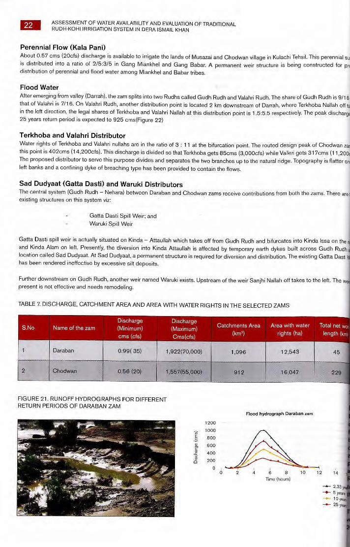
Daraban zam Daraban zam located near Daraban Town and Darazinda, after emerging from hills, trifurcates into three creeks viz Toya, Lohra and Gudh.
The annual run-off of about 3,700 Ha-m (30,000 AF) has been estimated with a perennial discharge of about 1.00cms (35cfts). The
ever recorded flow is 1,980cms (70,00cfs). Area under zam is about 1,012ha (2,500acres). Nature has it that the Daraban Nallah, after
emergence from the gorge divides into two branches. The left branch named Toya-2 has a peak discharge of 120cms (4,200cfs) while
Lohra on the rights takes 850cms (30,000cfs) of the 25-year flood peak (Figure21).
Perennial Flow (Kala Pani) A few springs originate from koh Apna (Barghyensi) at a distance of 90 km from Tuman San Khel, Aba Khel and Tuman Sherani. A few
springs are also located at a distance of 32 km on east side of Koh Apna. All these springs join at Muza Gut in Koh-Suleiman where a little
large capacity stream Gut joins in. In the Darrah, small patches of lands are irrigated by Tuman San Khel, Aba Khel and Tuman Shiranian. The
remaining water comes out from Daraban Gorge flowing in the area downstream in Lohra. About 1000 ha (2,469 acres) of land is irrigated
through a perennial stream of about 1 cms (35 cfs).
Flood Flow The flood water emerging from Darrah is further divided into three branches, Toya-1, Lohra and Gudh, there is no definite division in these
three branches. Water finds its way into any of these branches, being considered the fated share of that particular branch. During the period
1982 to 1988 the discharge of Daraban zam ranged from 1450 cfs to 8510 cfs (Table 6).
Southern branch of Sheikh Haider zam called Toya-I joins Gudh Nallah downstream of Darrah, up to this point there is no irrigation from its water. Lohara branch contains perennial as well flood water, there is no irrigation from flood water up to Daraban village. After the final
point Lohra branch rejoins Gudh branch and travel up to Gatti Dusti spill weir. Gudh Nallha is southern branch of Daraban zam and takes its discharge without any prescribed water rights, after irrigating on the way, it joins Lohra branch (central) at Gatta Dasti spill weir. About
1,145 ha (2,830 ha) is irrigated by Daraban zam in the upper reaches through flood irrigation. The remaining irrigation is done jointly by
Daraban and Chodwan zams.
Gudh Toya emerges from Sheikh Haider zam to join Daraban zam and then Swan Rudh. Kauri Rudh from Lohra Nallah also joins Gudh Toya.
Finally it crosses CRBC through siphon drainage structures.
TABLE 6. FLOOD FREQUENCY ANALYSIS — ANNUAL MAXIMUM FLOODS LINEAR G UMBEL DISTRIBUTION — DARABAN ZAM AT Z.AM TOWER
River
Site
Period of Data Available Number of years Records (N)
Year
1982
Probability Analysis
Discharge in descending order
(Cusecs) (Cumecs) Year
1981
Peak discharge
in cusecs
1450
Rank
1
Return period
(Year)
9.00 8510 241
1982 8510 1983 6000 170 2 4.50
3.00 1983 6000 1985 4050 115 3
1984 3520 1984 3520 100 4 2.25
1985 4050 1988 3370 95 5 1.80
1986 2908 1986 2908 82 6 1.50
1987 1800 1987 1800 51 7 1.29
1988 3370 1981 1450 41 8 1.13
• Source, WAPDA
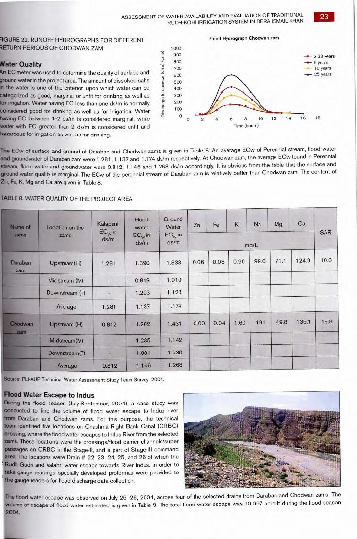
Chodwan zam Chodwan zam first splits into two branches downstream of the Darrah and then the right branch further divides into two, about 1.5Km
downstream. The upstream left offshoot is known as Gudh Rudh which is the main nallah contributing to Daraban - Chodwan central
system. Of the downstream two branches, the right one is known as Valleri while the left is called Terkhoba, which also joins the central
system at a downstream location.
Daraban
zam Tower
1981 to 1988
8
Chodwan
5
TABLE 7. DISCHARGE, CATCHMENT AREA AND AREA WITH WATER RIGHTS IN THE SELECTED ZAMS
Discharge Discharge S.No Name of the zam (Minimum) (Maximum)
cms (cfs) Cms(cfs)
Catchments Area Area with water Total net wo
(km2) rights (ha) length (krrl
Daraban 0.99( 35) 1,922(70,000) 1,096 12,543 1
912 16,047 229 0.56 (20) 1,557(55,000)
14
—4— 2.33 y —IP,— 5 years
10 ye --s— 25 ye
10 12 4 6 8 Time (hours)
Dis
char
g e (em
s)
1 200
1 000
800
600
400
200
0 0
22 ASSESSMENT OF WATER AVAILABILITY AND EVALUATION OF TRADITIONAL RUDH-KOHI IRRIGATION SYSTEM IN DERA ISMAIL KHAN
Perennial Flow (Kala Pani) About 0.57 ems (20cfs) discharge is available to irrigate the lands of Musazai and Chodwan village in Kulachi Tehsil. This perennial sub is distributed into a ratio of 2/5:3/5 in Gang Miankhel and Gang Babar. A permanent weir structure is being constructed for prc distribution of perennial and flood water among Miankhel and Babar tribes.
Flood Water After emerging from valley (Darrah), the zam splits into two Rudhs called Gudh Rudh and Valahri Rudh. The share of Gudh Rudh is 9/16 that of Valahri is 7/16. On Valahri Rudh, another distribution point is located 2 km downstream of Darrah, where Terkhoba Nallah off to in the left direction, the legal shares of Terkhoba and Valahri Nallah at this distribution point is 1.5:5.5 respectively. The peak discharge 25 years return period is expected to 925 cms(Figure 22)
Terkhoba and Valahri Distributor Water rights of Terkhoba and Valahri nullahs are in the ratio of 3 : 11 at the bifurcation point. The routed design peak of Chodwan zan this point is 402cms (14,200cfs). This discharge is divided so that Terkhoba gets 85cms (3,000cfs) while Valleri gets 317cms (11,200c The proposed distributor to serve this purpose divides and separates the two branches up to the natural ridge. Topography is flatter on left banks and a confining dyke of breaching type has been provided to contain the flows.
Sad Dudyaat (Gatta Dasti) and Waruki Distributors The central system (Gudh Rudh — Nehara) between Daraban and Chodwan zams receive contributions from both the zams. There area existing structures on this system viz:
Gatta Dasti Spill Weir; and Waruki Spill Weir
Gatta Dasti spill weir is actually situated on Kinda — Attaullah which takes off from Gudh Rudh and bifurcates into Kinda Issa on the ri and Kinda Alam on left. Presently, the diversion into Kinda Attaullah is affected by temporary earth dykes built across Gudh Rudh location called Sad Dudyaat. At Sad Dudyaat, a permanent structure is required for diversion and distribution. The existing Gatta Dash has been rendered ineffective by excessive silt deposits.
Further downstream on Gudh Rudh, another weir named Waruki exists. Upstream of the weir Sanjhi Nallah off takes to the left. The we present is not effective and needs remodeling.
FIGURE 21. RUNOFF HYDROGRAPHS FOR DIFFERENT RETURN PERIODS OF DARABAN ZAM
Flood hydrograph Daraban zam
ASSESSMENT OF WATER AVAILABILITY AND EVALUATION OF TRADITIONAL RUDH-KOHI IRRIGATION SYSTEM IN DERA ISMAIL KHAN
23
Dis
char
ge in
cu
mec
s (c
ms) (cm
s)
9GURE 22. RUNOFF HYDROGRAPHS FOR DIFFERENT RETURN PERIODS OF CHODWAN ZAM
Water Quality An EC meter was used to determine the quality of surface and ground water in the project area. The amount of dissolved salts in the water is one of the criterion upon which water can be categorized as good, marginal or unfit for drinking as well as for irrigation. Water having EC less than one ds/m is normally considered good for drinking as well as for irrigation. Water having EC between 1-2 ds/m is considered marginal, while water with EC greater than 2 ds/m is considered unfit and hazardous for irrigation as well as for drinking.
Flood Hydrograph Chodwan zam
1000
900 2.33 years 800 5 years 700 10 years
600 -A.- 25 years
500
400
300
200
100
0 0 2 4 6 8 10 12 14 16 18
Time (hours)
The ECw of surface and ground of Daraban and Chodwan zams is given in Table 8. An average ECw of Perennial stream, flood water and groundwater of Daraban zam were 1.281, 1.137 and 1.174 ds/m respectively. At Chodwan zam, the average ECw found in Perennial stream, flood water and groundwater were 0.812, 1.146 and 1.268 ds/m accordingly. It is obvious from the table that the surface and ground water quality is marginal. The ECw of the perennial stream of Daraban zam is relatively better than Chodwan zam. The content of
Zn, Fe, K, Mg and Ca are given in Table 8.
TABLE 8. WATER QUALITY OF THE PROJECT AREA
Name of zams
Location on the zams
Kalapani ECw in ds/m
Flood water
ECw in ds/m
Ground Water ECw in ds/m
Zn Fe K Na Mg Ca
SAR
mg/L
Daraban zam
Upstream(H) 1.281 1.390 1.833 0.06 0.08 0.90 99.0 71.1 124.9 10.0
Midstream (M) - 0.819 1.010
Downstream (T) - 1.203 1.128
Average 1.281 1.137 1.174
Chodwan 1
Upstream (H) 0.812 1.202 1.431 0.00 0.04 1.60 191 49.8 135.1 19.8
Midstream(M) - 1.235 1.142
Downstream(T) - 1.001 1.230
Average 0.812 1.146 1.268
Source: PLI-AUP Technical Water Assessment Study Team Survey, 2004.
Flood Water Escape to Indus During the flood season (July-September, 2004), a case study was conducted to find the volume of flood water escape to Indus river from Daraban and Chodwan zams. For this purpose, the technical team identified five locations on Chashma Right Bank Canal (CRBC) crossing, where the flood water escapes to Indus River from the selected zams. These locations were the crossings/flood carrier channels/super passages on CRBC in the Stage-II, and a part of Stage-III command area. The locations were Drain # 22, 23, 24, 25, and 26 of which the Rudh Gudh and Valahri water escape towards River Indus. In order to take gauge readings specially developed proformas were provided to the gauge readers for flood discharge data collection.
The flood water escape was observed on July 25 -26, 2004, across four of the selected drains from Daraban and Chodwan zams. The volume of escape of flood water estimated is given in Table 9. The total flood water escape was 20,097 acre-ft during the flood season 2004.

24 ASSESSMENT OF WATER AVAILABILITY AND EVALUATION OF TRADITIONAL RUDH-KOHI IRRIGATION SYSTEM IN DERA ISMAIL KHAN
TABLE 9. FLOOD WATER ESCAPE FROM THE PROJECT AREA INTO THE INDUS RIVER
S.No Dates where flood arrived Drain No. Volume of water Escaped
in m3
Volume of Water Escape (Acre-feet)
1 July25-26,2004 Drain No 22 24440158 561
2 Ju1y25-26,2005 Drain No. 23 103204786. 2,369
3 July25-26,2006 Drain No. 24 -
4 July25-26,2007 Drain No. 25 465074593 10,677
5 Ju1y25-26,2008 Drain No. 26 282689191 6490
Total Floodwater escaped on the above date 87,5408,728 20,097
Source: PLI-AUP Technical Water Assessment Study Team Survey, 2004
Height of banks of bundras in both zams
2
Hei
ght o
f ba
nks
of bu
ndra
s in
met
ers
1.5
0.5
1 ■ Maximum ■ Minimum ■ Average
Areas of bundras observed in both zams
LI L „„ Daraban Chodwan
Location HMT of zams
20.00
18.00
16.00
`s
■ Maximum ■ Minimum
Average
212.00
!10.00 a -12 8.00
6.00 0 ,fif, 4.00
2.00
0
ASSESSMENT OF WATER AVAILABILITY AND EVALUATION OF TRADITIONAL
6. WATER MANAGEMENT
RUDH-KOHI IRRIGATION SYSTEM IN DERA ISMAIL KHAN
PRACTICES
25
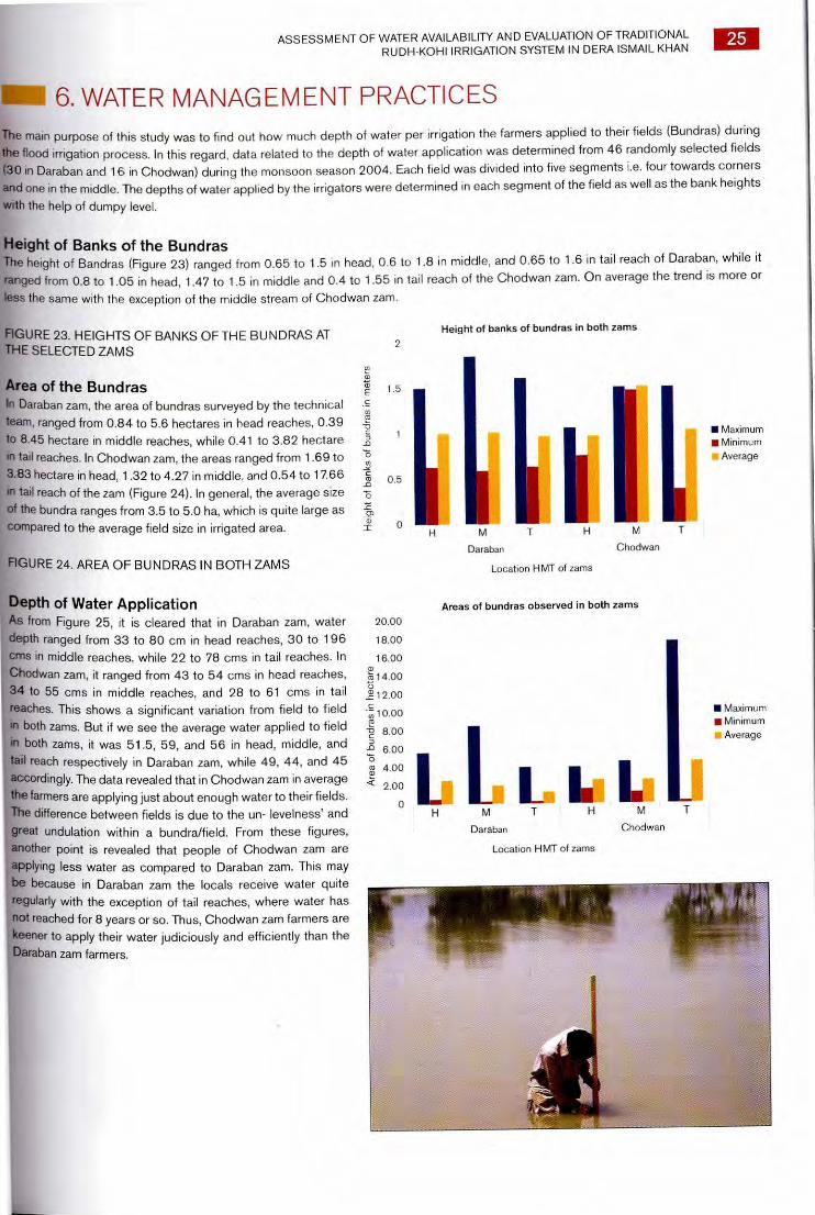
The main purpose of this study was to find out how much depth of water per irrigation the farmers applied to their fields (Bundras) during
the flood irrigation process. In this regard, data related to the depth of water application was determined from 46 randomly selected fields
(30 in Daraban and 16 in Chodwan) during the monsoon season 2004. Each field was divided into five segments i.e. four towards corners
and one in the middle. The depths of water applied by the irrigators were determined in each segment of the field as well as the bank heights
with the help of dumpy level.
Height of Banks of the Bundras The height of Bandras (Figure 23) ranged from 0.65 to 1.5 in head, 0.6 to 1.8 in middle, and 0.65 to 1.6 in tail reach of Daraban, while it
ranged from 0.8 to 1.05 in head, 1.47 to 1.5 in middle and 0.4 to 1.55 in tail reach of the Chodwan zam. On average the trend is more or
less the same with the exception of the middle stream of Chodwan zam.
FIGURE 23. HEIGHTS OF BANKS OF THE BUNDRAS AT THE SELECTED ZAMS
Area of the Bundras In Daraban zam, the area of bundras surveyed by the technical
team, ranged from 0.84 to 5.6 hectares in head reaches, 0.39
to 8.45 hectare in middle reaches, while 0.41 to 3.82 hectare
in tail reaches. In Chodwan zam, the areas ranged from 1.69 to
3.83 hectare in head, 1.32 to 4.27 in middle, and 0.54 to 17.66
in tail reach of the zam (Figure 24). In general, the average size
of the bundra ranges from 3.5 to 5.0 ha, which is quite large as
compared to the average field size in irrigated area.
FIGURE 24. AREA OF BUNDRAS IN BOTH ZAMS Daraban Chodwan
Location HMT of zams
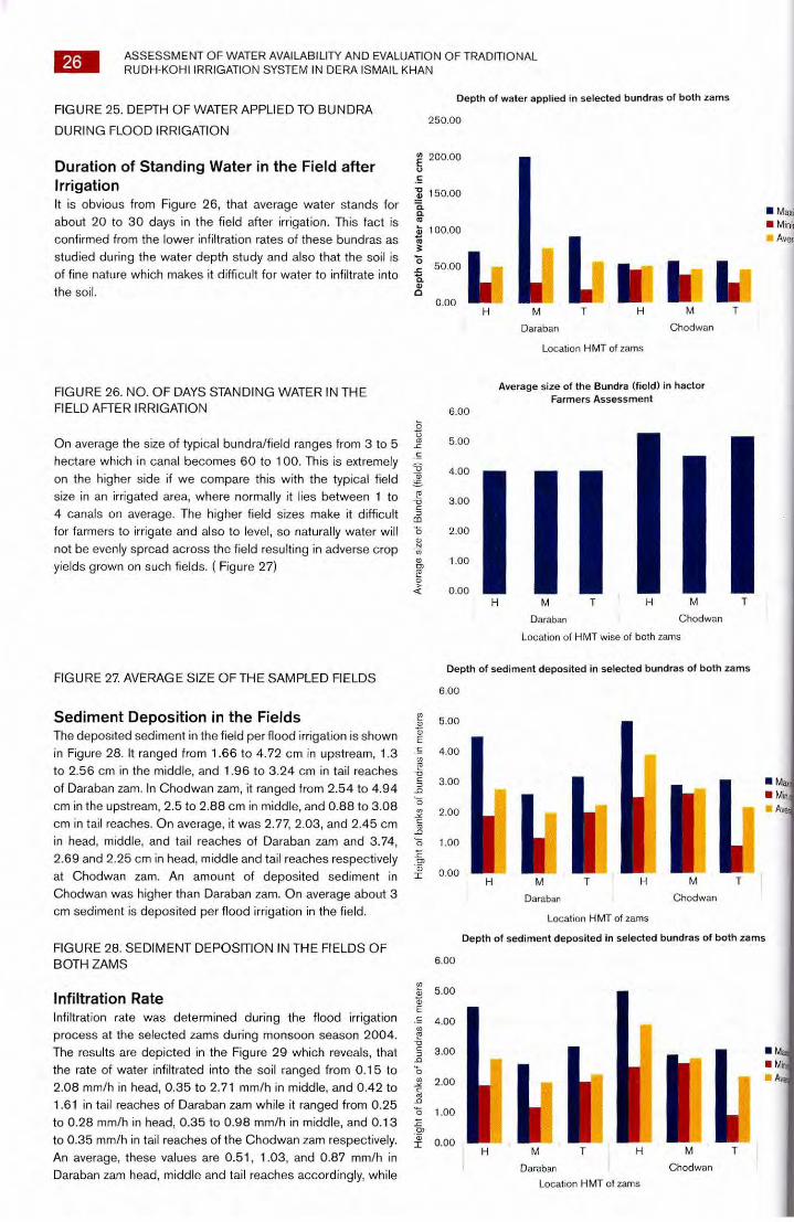
Depth of Water Application As from Figure 25, it is cleared that in Daraban zam, water
depth ranged from 33 to 80 cm in head reaches, 30 to 196
cms in middle reaches, while 22 to 78 cms in tail reaches. In
Chodwan zam, it ranged from 43 to 54 cms in head reaches,
34 to 55 cms in middle reaches, and 28 to 61 cms in tail
reaches. This shows a significant variation from field to field in both zams. But if we see the average water applied to field in both zams, it was 51.5, 59, and 56 in head, middle, and tail reach respectively in Daraban zam, while 49, 44, and 45
accordingly. The data revealed that in Chodwan zam in average the farmers are applying just about enough water to their fields.
The difference between fields is due to the un- levelness' and
great undulation within a bundra/field. From these figures,
another point is revealed that people of Chodwan zam are
applying less water as compared to Daraban zam. This may be because in Daraban zam the locals receive water quite
regularly with the exception of tail reaches, where water has not reached for 8 years or so. Thus, Chodwan zam farmers are
keener to apply their water judiciously and efficiently than the
Daraban zam farmers.
L M
Daraban
Location HMT of zams
■ Maxi' ■ Minn
Aver,
Chodwan
II I L M T
Chodwan
■ M. ■ Min
A
26
ASSESSMENT OF WATER AVAILABILITY AND EVALUATION OF TRADITIONAL RUDH-KOHI IRRIGATION SYSTEM IN DERA ISMAIL KHAN
Depth of water applied in selected bundras of both zams FIGURE 25. DEPTH OF WATER APPLIED TO BUNDRA
250.00 DURING FLOOD IRRIGATION
200.00 Duration of Standing Water in the Field after
.s Irrigation 0 150.00 . It is obvious from Figure 26, that average water stands for a
a about 20 to 30 days in the field after irrigation. This fact is ct,
100.00 confirmed from the lower infiltration rates of these bundras as -co
a studied during the water depth study and also that the soil is 15
_ 50.00 of fine nature which makes it difficult for water to infiltrate into Is the soil.
0.00
Ave
rage
siz
e o
f Bun
dra
(fie
ld) i
n h
acto
r
FIGURE 26. NO. OF DAYS STANDING WATER IN THE FIELD AFTER IRRIGATION
On average the size of typical bundra/field ranges from 3 to 5 hectare which in canal becomes 60 to 100. This is extremely on the higher side if we compare this with the typical field size in an irrigated area, where normally it lies between 1 to 4 canals on average. The higher field sizes make it difficult for farmers to irrigate and also to level, so naturally water will not be evenly spread across the field resulting in adverse crop yields grown on such fields. ( Figure 27)
FIGURE 27. AVERAGE SIZE OF THE SAMPLED FIELDS
Average size of the Bundra (field) in hactor Farmers Assessment
6.00
5.00
4.00
3.00
2.00
1.00
0.00 ...._ H M T H M T
Daraban Chodwan
Location of HMT wise of both zams
Depth of sediment deposited in selected bundras of both zams
6.00
Hei
ght
of b
anks
of b
und
ras
in m
ete
rs
Hei
g ht of ba
nks
of b
undr
as in
me
ters
Sediment Deposition in the Fields The deposited sediment in the field per flood irrigation is shown in Figure 28. It ranged from 1.66 to 4.72 cm in upstream, 1.3 to 2.56 cm in the middle, and 1.96 to 3.24 cm in tail reaches of Daraban zam. In Chodwan zam, it ranged from 2.54 to 4.94 cm in the upstream, 2.5 to 2.88 cm in middle, and 0.88 to 3.08 cm in tail reaches. On average, it was 2.77, 2.03, and 2.45 cm in head, middle, and tail reaches of Daraban zam and 3.74, 2.69 and 2.25 cm in head, middle and tail reaches respectively at Chodwan zam. An amount of deposited sediment in Chodwan was higher than Daraban zam. On average about 3 cm sediment is deposited per flood irrigation in the field.
FIGURE 28. SEDIMENT DEPOSITION IN THE FIELDS OF BOTH ZAMS
Infiltration Rate Infiltration rate was determined during the flood irrigation process at the selected zams during monsoon season 2004. The results are depicted in the Figure 29 which reveals, that the rate of water infiltrated into the soil ranged from 0.15 to 2.08 mm/h in head, 0.35 to 2.71 mm/h in middle, and 0.42 to 1.61 in tail reaches of Daraban zam while it ranged from 0.25 to 0.28 mm/h in head, 0.35 to 0.98 mm/h in middle, and 0.13 to 0.35 mm/h in tail reaches of the Chodwan zam respectively. An average, these values are 0.51, 1.03, and 0.87 mm/h in Daraban zam head, middle and tail reaches accordingly, while
5.00
4.00
3.00
2.00
1.00
0.00 H M
Daraban
Location HMT of zams
Depth of sediment deposited in selected bundras of both zams
6.00
5.00
4.00
3.00
■ M ■ Mi
2.00 A
1.00
0.00 M T H M T
Daraban Chodwan
Location I-1MT of zams
Infiltration rates observed on selected bundras of both zams
M T
Daraban Location H MT of zams
■ Maximum ■ Minimum
Average
M .
Chodwan
Infiltra
tion ra
tes in m
m/h
r 3.00
2.50
2.00
1.50
1.00
.50
0.00
ASSESSMENT OF WATER AVAILABILITY AND EVALUATION OF TRADITIONAL RUDH-KOHI IRRIGATION SYSTEM IN DERA ISMAIL KHAN
27
0.26, 0.66 and 0.21 mm/h in Chodwan zam head, middle
and tail reaches respectively. From the above results, it can
be concluded that in Chodwan area's infiltration rate was
relatively low as compared to Daraban zam. In general, the
infiltration rate is very low due to the fine texture of the soil and
the water stands in the fields for longer time (20 to 30 days) and a lot of water is lost by evaporation.
FIGURE 29. INFILTRATION RATE OF WATER OBSERVED
IN BOTH ZAMS
Conclusions From the above results few common points can be extracted as conclusions are given below: • An average the depth of water applied, deposited
sediment, and infiltration rate were higher in Daraban as
compared to Chodwan zam • Farmers in general are applying just about reasonable
water to their fields with the exception of some extreme
cases where they have applied more water than required.
It shows that farmers of the project area are using the flood water reasonable well
• Due to fine texture of the soil, the infiltration rates are quite
and water stands in the field for about a month that results
a lot of evaporation losses
ASSESSMENT OF WATER AVAILABILITY AND EVALUATION OF TRADITIONAL RUDH-KOHI IRRIGATION SYSTEM IN DERA ISMAIL KHAN
7. WATER STORAGE PONDS
Due to scarce and poor ground water quality the villagers have
constructed water storage ponds for human and animal drinking
purposes in both zams. An attempt was made to assess the
capacity and status of these ponds during this study. From
Tables 10 and 11, it is obvious that flood water storage ponds
exist in some shape in almost all villages. Some of them are in
good shape, while others need repair and rehabilitation. If these
ponds are improved, then they will be a good source of drinking
water for human and livestock consumption, particularly in the
drought periods or in winter months, where practically, there is
no rainfall or flood water at all. As far as the public health water
storage tanks it was observed, that most of them were either
non-functional due to one reason or the other or if functional
then their operational time is low and can not meet the demand
of the population. The distribution and operation of government
schemes are mainly on the political power and social status of the village inhabitants. In general, the political, the stronger and we
have more control over the water distribution and operation of public health. Engineering water supply schemes and the poor have ver
control on that and rely on water storage ponds for their water needs for livestock and human consumption.
TABLE 10. WATER STORAGE PONDS AND TANKS IN DARABAN ZAM
S.No Name of Village No. of Ponds Average Capacity
(m3)
No. of Water
Storage Tanks
Average Capat
(m3)
1 Gara Mehrban 1 6,143 - -
2 Gara Sheikh 1 7,800 - .
3 Garah Dusti 1 4,988 1 15
4 Garah Ghulam Sadique 1 4,410 - -
5 Gara Jut 2 5,574 -
6 Gandi Isab 1 13,728 - -
7 Garah Mir Alam 2 19,964 7 12
8 Gandi Omar Khan 3 24,551 2 53
Source: PLI -AUP Technical Study, 2004
TABLE 11. WATER STORAGE PONDS AND TANKS IN CHODWAN ZAM
S.No Name of Village No. of Ponds Average Capacity No. of Water Storage Average Capaci
(m3) Tanks (m3)
1 Gara Abdullah 1 6,523 - - _
2 Bhooki 1 3,528 1 12 _
3 Jat 1 1,472 1 12 _ 4 Kot Musa 1 5,168 1 24.
5 Jandi Babar 1 8,856 1 40 -
Source: PLI -AUP Technical Study, 2004
28
ASSESSMENT OF WATER AVAILABILITY AND EVALUATION OF TRADITIONAL RUDH-KOHI IRRIGATION SYSTEM IN DERA ISMAIL KHAN
29
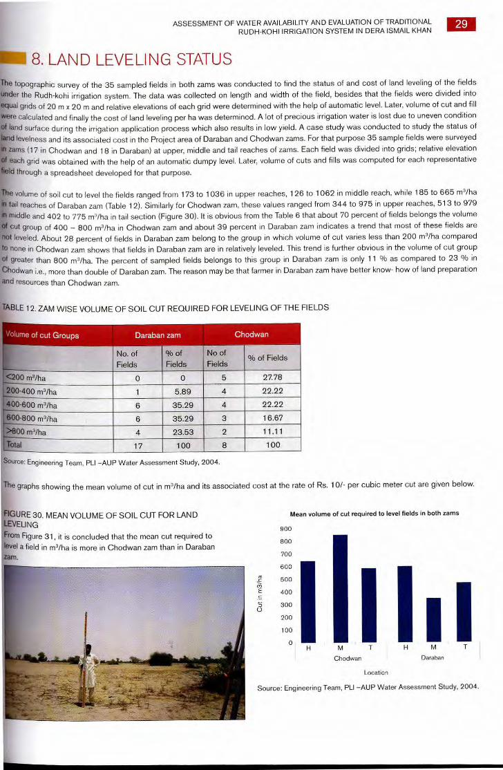
in 8. LAND LEVELING STATUS
[
The topographic survey of the 35 sampled fields in both zams was conducted to find the status of and cost of land leveling of the fields
under the Rudh-kohl irrigation system. The data was collected on length and width of the field, besides that the fields were divided into
equal grids of 20 m x 20 m and relative elevations of each grid were determined with the help of automatic level. Later, volume of cut and fill
were calculated and finally the cost of land leveling per ha was determined. A lot of precious irrigation water is lost due to uneven condition of land surface during the irrigation application process which also results in low yield. A case study was conducted to study the status of
ned levelness and its associated cost in the Project area of Daraban and Chodwan zams. For that purpose 35 sample fields were surveyed
zams (17 in Chodwan and 18 in Daraban) at upper, middle and tail reaches of zams. Each field was divided into grids; relative elevation
each grid was obtained with the help of an automatic dumpy level. Later, volume of cuts and fills was computed for each representative
Id through a spreadsheet developed for that purpose.
e volume of soil cut to level the fields ranged from 173 to 1036 in upper reaches, 126 to 1062 in middle reach, while 185 to 665 m3/ha
tail reaches of Daraban zam (Table 1 2). Similarly for Chodwan zam, these values ranged from 344 to 975 in upper reaches, 513 to 979
middle and 402 to 775 m3/ha in tail section (Figure 30). It is obvious from the Table 6 that about 70 percent of fields belongs the volume
Cut group of 400 — 800 m3/ha in Chodwan zam and about 39 percent in Daraban zam indicates a trend that most of these fields are
hot leveled. About 28 percent of fields in Daraban zam belong to the group in which volume of cut varies less than 200 m3/ha compared
to none in Chodwan zam shows that fields in Daraban zam are in relatively leveled. This trend is further obvious in the volume of cut group of greater than 800 m3/ha. The percent of sampled fields belongs to this group in Daraban zam is only 11 % as compared to 23 % in
Chodwan i.e., more than double of Daraban zam. The reason may be that farmer in Daraban zam have better know- how of land preparation
and resources than Chodwan zam.
TABLE 12. ZAM WISE VOLUME OF SOIL CUT REQUIRED FOR LEVELING OF THE FIELDS
Volume of cut Groups Daraban zam Chodwan
No. of
Fields
% of
Fields
No of
Fields % of Fields
<200 m3/ha 0 0 5 27.78
200-400 m3/ha 1 5.89 4 22.22
400-600 m3/ha 6 35.29 4 22.22
600-800 m3/ha 6 35.29 3 16.67
>800 m3/ha 4 23.53 2 11.11
Total 17 100 8 100
Source: Engineering Team, PLI —AUP Water Assessment Study, 2004.
The graphs showing the mean volume of cut in m3/ha and its associated cost at the rate of Rs. 101- per cubic meter cut are given below.
Cut
in m
3/h
a
FIGURE 30. MEAN VOLUME OF SOIL CUT FOR LAND LEVELING
From Figure 31, it is concluded that the mean cut required to level a field in m3/ha is more in Chodwan zam than in Daraban zam.
Mean volume of cut required to level fields in both zams
900
800
700
600
500
400
300
200
100
0
Chodwan Daraban
Location
Source: Engineering Team, PLI —AUP Water Assessment Study, 2004.
1
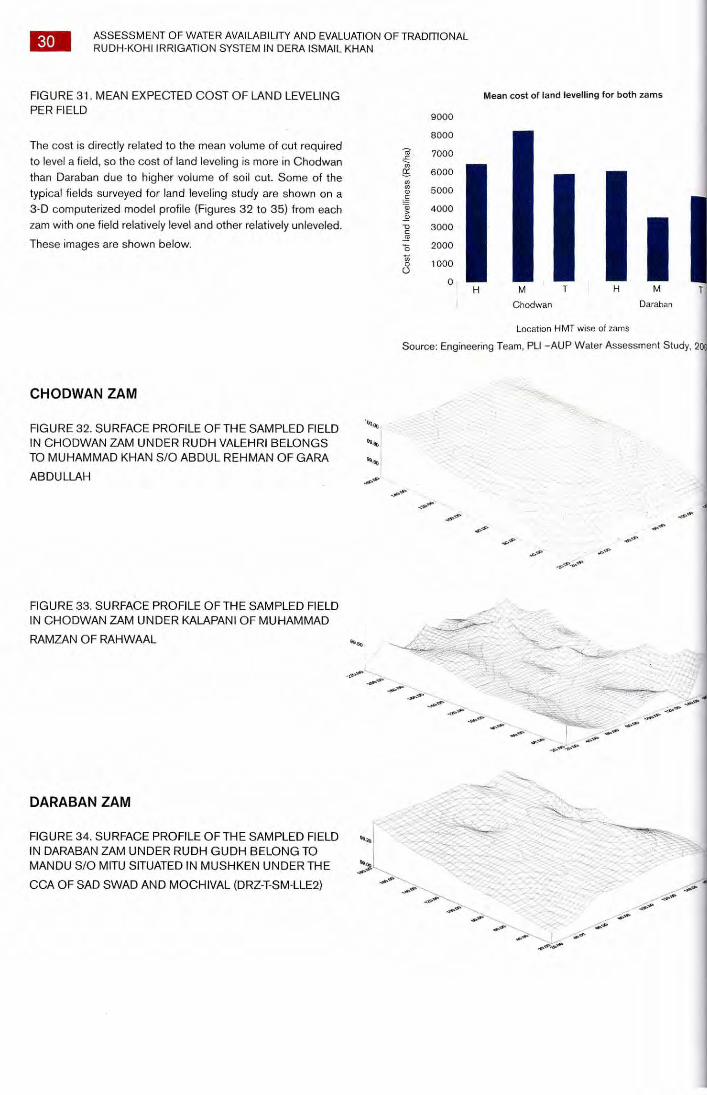
.05
9
<6.
.30
43.
30 ASSESSMENT OF WATER AVAILABILITY AND EVALUATION OF TRADITIONAL RUDH-KOHI IRRIGATION SYSTEM IN DERA ISMAIL KHAN
FIGURE 31. MEAN EXPECTED COST OF LAND LEVELING Mean cost of land levelling for both zams PER FIELD 9000
8000
7000
6000
5000
4000
3000
2000
1000
0
Co
st of la
nd le
velli
ne
ss (
Rs/
ha) The cost is directly related to the mean volume of cut required
to level a field, so the cost of land leveling is more in Chodwan than Daraban due to higher volume of soil cut. Some of the typical fields surveyed for land leveling study are shown on a 3-D computerized model profile (Figures 32 to 35) from each zam with one field relatively level and other relatively unleveled.
These images are shown below.
I H M T H M T
Chodwan Daraban
Location H MT wise of zams
Source: Engineering Team, PLI -AUP Water Assessment Study, 20
CHODWAN ZAM
FIGURE 32. SURFACE PROFILE OF THE SAMPLED FIELD IN CHODWAN ZAM UNDER RUDH VALEHRI BELONGS TO MUHAMMAD KHAN S/O ABDUL REHMAN OF GARA
ABDULLAH
FIGURE 33. SURFACE PROFILE OF THE SAMPLED FIELD IN CHODWAN ZAM UNDER KALAPANI OF MUHAMMAD
RAMZAN OF RAHWAAL
-‘9
DARABAN ZAM
FIGURE 34. SURFACE PROFILE OF THE SAMPLED FIELD g.„ IN DARABAN ZAM UNDER RUDH GUDH BELONG TO MANDU S/0 MITU SITUATED IN MUSHKEN UNDER THE
CCA OF SAD SWAD AND MOCHIVAL (DRZ-T-SM-LLE2)
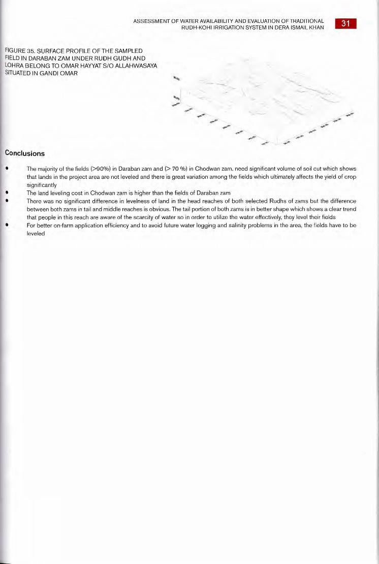
ASSESSMENT OF WATER AVAILABILITY AND EVALUATION OF TRADITIONAL RUDH-KOHI IRRIGATION SYSTEM IN DERA ISMAIL KHAN
31
FIGURE 35. SURFACE PROFILE OF THE SAMPLED FIELD IN DARABAN ZAM UNDER RUDH GUDH AND LOHRA BELONG TO OMAR HAYYAT S/O ALLAHWASAYA SITUATED IN GANDI OMAR
Conclusions
• The majority of the fields (>90%) in Daraban zam and (> 70 %) in Chodwan zam, need significant volume of soil cut which shows that lands in the project area are not leveled and there is great variation among the fields which ultimately affects the yield of crop significantly
• The land leveling cost in Chodwan zam is higher than the fields of Daraban zam • There was no significant difference in levelness of land in the head reaches of both selected Rudhs of zams but the difference
between both zams in tail and middle reaches is obvious. The tail portion of both zams is in better shape which shows a clear trend that people in this reach are aware of the scarcity of water so in order to utilize the water effectively, they level their fields
• For better on-farm application efficiency and to avoid future water logging and salinity problems in the area, the fields have to be leveled
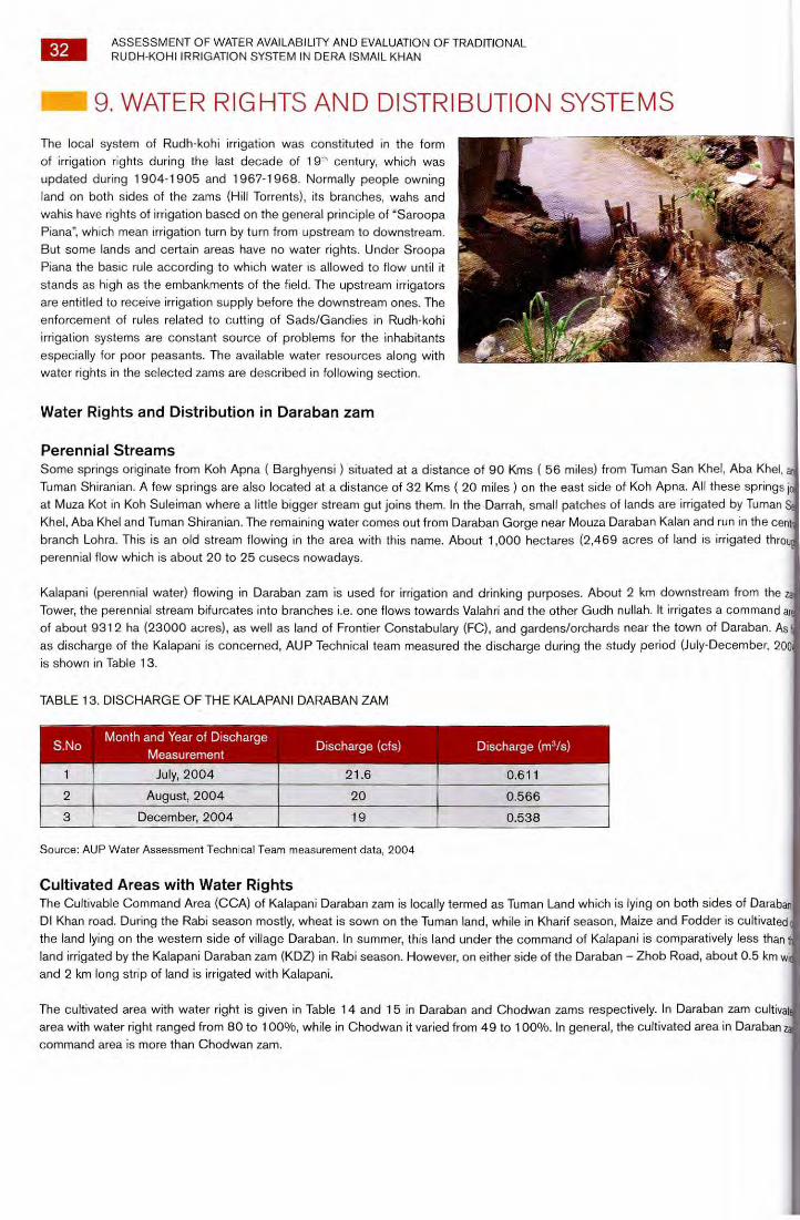
32 ASSESSMENT OF WATER AVAILABILITY AND EVALUATION OF TRADITIONAL RUDH-KOHI IRRIGATION SYSTEM IN DERA ISMAIL KHAN
9. WATER RIGHTS AND DISTRIBUTION SYSTEMS
The local system of Rudh-kohi irrigation was constituted in the form of irrigation rights during the last decade of 19'h century, which was updated during 1904-1905 and 1967-1968. Normally people owning land on both sides of the zams (Hill Torrents), its branches, wahs and wahis have rights of irrigation based on the general principle of "Saroopa Piana", which mean irrigation turn by turn from upstream to downstream. But some lands and certain areas have no water rights. Under Sroopa Piana the basic rule according to which water is allowed to flow until it stands as high as the embankments of the field. The upstream irrigators are entitled to receive irrigation supply before the downstream ones. The enforcement of rules related to cutting of Sads/Gandies in Rudh-kohi irrigation systems are constant source of problems for the inhabitants especially for poor peasants. The available water resources along with water rights in the selected zams are described in following section.
Water Rights and Distribution in Daraban zam
Perennial Streams Some springs originate from Koh Apna ( Barghyensi ) situated at a distance of 90 Kms ( 56 miles) from Tuman San Khel, Aba Khel. Tuman Shiranian. A few springs are also located at a distance of 32 Kms ( 20 miles ) on the east side of Koh Apna. All these springs I at Muza Kot in Koh Suleiman where a little bigger stream gut joins them. In the Darrah, small patches of lands are irrigated by Tuman Khel, Aba Khel and Tuman Shiranian. The remaining water comes out from Daraban Gorge near Mouza Daraban Kalan and run in the cent branch Lohra. This is an old stream flowing in the area with this name. About 1,000 hectares (2,469 acres of land is irrigated thro perennial flow which is about 20 to 25 cusecs nowadays.
Kalapani (perennial water) flowing in Daraban zam is used for irrigation and drinking purposes. About 2 km downstream from the z Tower, the perennial stream bifurcates into branches i.e. one flows towards Valahri and the other Gudh nullah. It irrigates a command ai of about 9312 ha (23000 acres), as well as land of Frontier Constabulary (FC), and gardens/orchards near the town of Daraban. As as discharge of the Kalapani is concerned, AUP Technical team measured the discharge during the study period (July-December, 200 is shown in Table 13.
TABLE 13. DISCHARGE OF THE KALAPANI DARABAN ZAM
S.No
1
Month and Year of Discharge Measurement
July, 2004
Discharge (cfs) Discharge (m3/s)
0.611 21.6
2 August, 2004 20 0.566
3 December, 2004 19 0.538
Source: AUP Water Assessment Technical Team measurement data, 2004
Cultivated Areas with Water Rights The Cultivable Command Area (CCA) of Kalapani Daraban zam is locally termed as Tuman Land which is lying on both sides of Daraban DI Khan road. During the Rabi season mostly, wheat is sown on the Tuman land, while in Kharif season, Maize and Fodder is cultivated the land lying on the western side of village Daraban. In summer, this land under the command of Kalapani is comparatively less than land irrigated by the Kalapani Daraban zam (KDZ) in Rabi season. However, on either side of the Daraban — Zhob Road, about 0.5 km w and 2 km long strip of land is irrigated with Kalapani.
The cultivated area with water right is given in Table 14 and 15 in Daraban and Chodwan zams respectively. In Daraban zam cultivat area with water right ranged from 80 to 100%, while in Chodwan it varied from 49 to 100%. In general, the cultivated area in Daraban z command area is more than Chodwan zam.
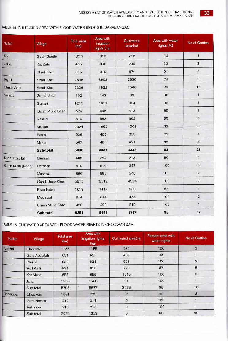
ASSESSMENT OF WATER AVAILABILITY AND EVALUATION OF TRADITIONAL RUDH-KOHI IRRIGATION SYSTEM IN DERA ISMAIL KHAN
33
TABLE 14. CULTIVATED AREA WITH FLOOD WATER RIGHTS IN DARABAN ZAM
Nallah Area with
Villa Total area Cultivated Area with water
ge (ha)
irrigation rights (ha)
area(ha) rights (%) No of Gatties
Jind Gudh(South) 1,012 810 712 80 1
Lohra Kot Zafar 405 336 290 83 3
Shadi Khel 895 810 574 91 4
Toya-I Shadi Khel 4858 3603 2850 74 6
Chute Wae Shadi Khel 2328 1822 1560 78 17
Nehara Gandi Umar 162 142 99 88 1
Sarkari 1215 1012 954 83 1
Garah Murid Shah 526 445 413 85 1
Rashid 810 688 602 85 6
Malkani 2024 1660 1509 82 5
Paroa 526 405 355 77 4
Makar 567 486 421 86 3
Sub-total 5830 4838 4352 83 21
Kand Attaullah Musazai 405 324 243 80 1
Gudh Rudh (North) Daraban 510 510 287 100 5
Musazai 896 896 540 100 2
Gandi Umar Khan 551 2 5512 4534 100 7
Kiran Fateh 1619 1417 930 88 1
Mochiwal 814 814 455 100 2
Garah Murid Shah 420 420 219 100 1
Sub-total 9351 9148 6747 98 17
TABLE 15. CULTIVATED AREA WITH FLOOD WATER RIGHTS IN CHODWAN ZAM
Nallah Village Total area
(ha)
Area with irrigation rights
(ha)
Cultivated area(ha Percent area with
water rights No of Gatties
Valahri Chodwan 1155 1155 239 100 3
Gara Abdullah 651 651 486 100 1
Bhukki 838 838 528 100 2
Mail Wali 931 810 729 87 6
Kot-Musa 655 655 1515 100 3
Jandi 1568 1568 91 100 1
Sub-total 5798 5677 3588 98 16
Terkhoba Chodwan 1621 789 0 49 2
Gara Hamza 219 219 0 100 1
Terkhoba 215 215 0 100 1
Sub-total 2055 1223 0 60 90
Wa
ter
law
s fo
llow
ed (
%)
100
90
80
70
60
50
40
30
20
10
0
■ Daraban ■ Chodwan
Upstream
Mildstream Downstream
Location on the zam
34 ASSESSMENT OF WATER AVAILABILITY AND EVALUATION OF TRADITIONAL RUDH-KOHI IRRIGATION SYSTEM IN DERA ISMAIL KHAN
Water Distribution Laws The water distribution laws (Kuliyat and Riwajat) are strictly followed in perennial streams command areas in both the zams (Daraban and Chodwan) as mentioned by majority of the respondents. Most of the respondents (88 and 63%) in Daraban and Chodwan zams mentioned that water laws (Kuliyat and Riwajat) are followed, while 22 and 37% showed dissatisfaction and pointed out the water laws are not followed. In general the farmers at downstream were relatively less satisfied with the flood water distribution system as compared to the upstream ones (Figure 36). About 90% of the farmers mentioned that the water distribution system needs improvement.
FIGURE 36. STATUS OF FLOOD WATER LAWS IN
PERENNIAL STREAM COMMAND AREAS
Flood Water Floodwater spilled out from Darrah is further bifurcated into three branches, Toya —I, Lohra and Gudh. There is no definite division in these three branches. Water going in each branch, is considered as the share of that particular branch. Southern branch of sheikh Hayder zam called Toya —I joins Gudh nullah, downstream of Darrah. Up to the point of confluence, there is no irrigation from Toya-I.
Lohra branch contains perennial as well as flood supply. There is retrogressed channel and there is no irrigation up to Daraban village. After last point Lohra branch rejoins Gudh branch and travels up to Gatta Dasti spill weir. Gudh nullah is southern branch of Daraban zam and takes its discharge without any prescribed rights. After irrigating on the way, it joins Lohra branch (central) at Gatta Dasti Spill Weir. About 1,145 hectare (2,830 acres) is irrigated by the Daraban zam in the upper reach through flood irrigation and joins Chodwan zam system. The remaining irrigation is done jointly by Daraban and Chodwan zams.
Water Rights and Distribution in Chodwan zam
Perennial Streams About 45 cusecs of perennial discharge is available to irrigate lands of Musazai and Chodwan village in Kulachi Tehsil (Table 16). This perennial supply is roughly distributed in the ratio of 2/5: 3 /5 in gang (Kalapani water channel) Miankhel and Gang Babar. The distributio structure for this is currently under progress near the Chodwan zam head. The area, on the perennial flow is roughly 1,713 hectare (4,23 acres).
Discharge of perennial water/Kalapani of Chodwan zam was also measured during the study period by members of technical team. The used float method as well as current meter and flow stream in the upper reach near the distributor under construction. The following resu were obtained.
TABLE 16. DISCHARGE OF THE KALAPANI CHODWAN ZAM
Month and year of Discharge S.No
Discharge (cfs) Discharge (m3/s) Measurement
1 July, 2004 52 1.47
2 August, 2004 45.5 1,29
3 December, 2004 45 1.27
Source: AUP Water Assessment Technical Team measurement data, 2004
The discharge of Kalapani of Chodwan zam on the upstream of Chodwan zam at Dumanda site which is 13 Km from the Chodwa
Distributor was recorded as 48 cusecs.
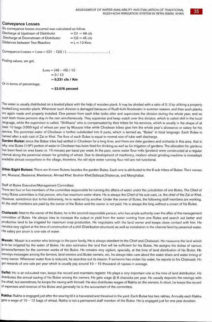
ASSESSMENT OF WATER AVAILABILITY AND EVALUATION OF TRADITIONAL RUDH-KOHI IRRIGATION SYSTEM IN DERA ISMAIL KHAN 35
Conveyance Losses So conveyance losses occurred was calculated as follow. Discharge at Upstream of Distributor = 01 = 48 cfs Discharge at Downstream of Distributor = 02 = 45 cfs Distances between Two Reaches = L = 13 Kms
Conveyance Losses = Loss = (Q1 - 02) / L
Putting values, we get,
Loss = (48 — 45) / 13 = 3 / 13 = 0.231 cfs Km
Or in terms of percentage, = 23.076 percent
The water is usually distributed on a leveled place with the help of wooden plank. It may be divided with a ratio of 2: 3 by utilizing a properly leveled long wooden plank. Whenever such division is damaged because of Rudh-kohi floodwater in summer season, and then such planks are again made and properly installed. One person from each tribe looks after and supervises the division during the whole year, and as such both these persons stay in the zam simultaneously. They supervise and keep watch over this division, which is called shill in the local language, while the supervisor is called, "Shillbana" who is compensated by their tribes for his services, which is usually in the shape of at least 10 bags (1000 kgs) of wheat per year by Musazai tribe while Chodwan tribes give him the whole year's allowance or salary for his service. The perennial water of Chodwan is further subdivided into 9 parts, which is termed as, "Bulee" in local language. Each Bulee is named after a sub cast of Zai or Khel. The flow of each Bulee is equal to normal size of tube well discharge. Garden Bulee: since the Babar tribe had settled in Chodwan for a long time, and there are date gardens and orchards in this area, that is why, one Bulee (1/9th) portion of water in Chodwan has been fixed for drinking as well as for irrigation of gardens. The allocation for gardens has been fixed on area basis i.e. 15 minutes per kanal per week. In the past, some water flour mills (jandars) were constructed at a regular interval along the perennial stream for grinding of wheat. Due to development of machinery, modern wheat grinding machine is nowadays available almost everywhere in the village, therefore, the old style water running flour mill are not functional.
Other Eight Bulees: There are 8 more Bulees besides the garden Bulee. Each one is attributed to the 8 sub tribes of Babar. Their names
are; Musazai; Badanzai; Mardanzai; Ahmad Khel; Ibrahim Khel;Safarzai;Shakerzai, and Manghalzai.
Staff of Bulee Executive/Management Committee: There are four or five members of the committee responsible for running the affairs of water under the jurisdiction of one Bulee. The Chief of every Bulee committee is that person, who has maximum water share. He is always the Chief of his sub cast, i.e. the chief of the Zai or Khel. However, sometimes due to his dishonesty, he is replaced by another. Under the owner of Bulee, the following staff members are working. All the staff members are paid by the owner of the Bulee and the owner is not paid. He is always the king without a crown of his Bulee.
Chalwasti: Next to the owner of the Bulee, he is the second responsible person, who has ample authority over the affair of the management committee of Bulee. He always tries to increase the output or yield from the water coming from one Bulee and search out better and productive land to be irrigated for maximum crop production. He negotiates with the land owner and keeps close contact with him. He remains very vigilant at the time of construction of a shill (Distribution structure) as well as installation in the channel feed by perennial water. His salary per anum is one vale of water.
Musair: Musair is a worker who belongs to the poor family. He is always obedient to the Chief and Chalwasti. He measures the land which is to be irrigated by the water of Bulee. He also estimates the land that will be sufficient for his Bulee. He assigns the duties of various Persons/farmers for the common works of the Bulee. He remains very vigilant, specially, at the time of land distribution of his Bulee. He conveys messages among the farmers, land owners and Bulee owners, etc. he always take care about the water share and water timing of every owner. Whenever water flow is reduced, he searches out its reason. If someone has stolen his water, he reports to his Chalwasti. He get rewards of one vale per year which is usually pay around 10 - 15 thousand of rupees in average.
Daftri: He is an educated man, keeps the record and maintains register. He plays a very important role at the time of land distribution. He distributes the annual saving of his Bulee among the owners. He gets wage @ 8 charocka per year. He usually deposits the savings with the chief, but sometimes, he keeps the saving with himself. He also distributes wages of Rakha on the owners. In short, he keeps the record of expenses and revenue of his Bulee and generally he is the accountant of the committee.
Rakha: Rakha is engaged just after the sowing till it is harvested and threshed in the yard. Each Bulee has two rakhas. Annually each Rakha gets a wage of 10 - 12 bags of wheat. Rakha is not a permanent staff member of the Bulee. He is engaged just for one year duration.

36 ASSESSMENT OF WATER AVAILABILITY AND EVALUATION OF TRADITIONAL RUDH-KOHI IRRIGATION SYSTEM IN DERA ISMAIL KHAN
Shill Bana: Besides the two shill banas at the zam head, additional shill banas are appointed where water distribution is needed with the help of a shill. He is paid by the Bulee owners @ 5 - 6 bags of wheat per year from the common funds of a Bulee. The above discussed staff of the management committee of a Bulee is shown in the following organizational chart (Figure 37).
HIEF OF THE BULEE
CHALWASTI
DAFTRI OR TREASURER
SHILL BANA
RAKHA # 2 0 GUARD # 2
M USAIR
FIGURE 37. ORGANIZATIONAL CHART OF THE BULEE'AND MANAGEMENT COMMITTEE
Quantification of Bulee Water
Vale and Its Relationship For every Bulee, the numbers of vales are not the same; rather they are different for different Bulee. Some Bulee have more vales and are therefore called big and confirmed Bulees. From the sunrise to the sunset, when all the water of a Bulee is completely used, this is then called one vale. Similarly, from the sunset up to sunrise, there is another vale of water consumed. Thus one vale is equivalent to the 12 hours flow of a Bulee. If a Bulee is of 30 vales, then after every 15 days of irrigation, next turn will come for a farmer. Every vale has 16 charocka, Each charocka is of 45 minutes. Four charocka makes one Pehr which is equivalent to three hours of time.
So, One Vale of Water = 4 Pehr One Pehr = 4 Charocka One Vale = 16 Charockas One Charocka = 45 minutes of flowing water. One vale = One normal size tube well water.
Haq-UI-Arz or Land Right Whenever the land of an owner is used for cultivation, he is paid for his land by the organization of the Bulee. The land owner is paid @ 1/8th part of Bulee water. This reward is called, "Haq-Ul-Arz or Land Right". For example, a Bulee has 24 vales, then its land right will be 24/8, 3 vales. The allocated land which has been measured by the musair will be divided by 24 + 3 = 27 vales. For example, a land piece having dimensions of 2160 karam * 100 karam Piece of land for one vale will be = (2160*100)/27 = 8000 square Karam
= 242000 square feet = 888.89 Marlas =44 Kanals - 9 Marlas.
Thus production of land right from the one vale will be 44 Kanals and 9 Marlas.
Income and Expenditure of a Bulee Every Bulee generates its own income which is then spent on its improvement. Income and expenditure is calculated annually. If there a saving in the budget of a balance, then this is utilized on its repair and maintenance.
Sources of Income •
For income generation, the number of vales of a Bulee is increased. Say from 20 to 24. 4 of these vales are sold and thus the income is generated. For example, annual selling price of a vale is Rs. 10,000/-, then at this rate, the Bulee will earn Rs, 40,000/- per year. It should however be noted, that when the Bulee was divided into 20 vales, then after every 10 days a farmer got his water turn. But when the Bulee was divided into 24 vales, then each farmer got his share/ turn after 12 days The second source of income of a Bulee is that when there is a drought and Rudh-kohi water is scarce, then before sowing Rabi crops, Kalapani is used for Kharif crops. Landowners purchase water from Bulee owners. For example, price of one vale is Rs. 200/-, then in 24 hours earning of one Bulee is 2 * 200 = Rs. 400/-, therefore, earning of one Bulee for one week will be Rs. 2800/- (400*7). If we further extend these earnings, for one season, a Bulee will earn Rs. 46,000/- (12.*2800),
ASSESSMENT OF WATER AVAILABILITY AND EVALUATION OF TRADITIONAL RUDH-KOHI IRRIGATION SYSTEM IN DERA ISMAIL KHAN
37
Expenditure of Bulee Following are the main heads of the expenditures of a Bulee
i. Construction and maintenance of water channels for Bulee water from source to the land to be irrigated. For this purpose
tractor and labourers are hired
ii. Timber of wooden planks is purchased for making shill/distribution structure
iii. Shill Bana is being paid for his service
iv. On the day of land distribution (gin in local language), lunch for skilled and un-skilled labour and for revenue people is
arranged
v. For preparing papers of Bulees in the revenue department
vi. For running suits in the civil courts
vii. For example, if a Bulee has made an income of Rs. 46,000/- per year and its expenses are 41,200/- then its net income
is Rs. 4,800/- and will be distributed among the owners of 24 vales of water. Thus in other words, the annual net income
/saving of this Bulee will be Rs. 200/- per vale
Competition Among Bulees Every Bulee/amount of water for one sub tribe competes with its rival Bulee holders in terms of yield and profit/income generation. It also
tries to increase the average production per vale. Whenever the owner of Bulee committee remains committed and dutiful, then crop yield
from such Bulees are comparatively more. Similarly yield per vale is also high for these Bulee. Water rates of such productive Bulee are also
high comparatively. Water rates of those Bulee whose staff is not active and hardworking are usually low. The prevailing rates of a Bulee
are as under.
Minimum Rate of a Bulee = Rs. 6,000/-
Maximum Rate of a Bulee = Rs. 12,000/- Besides that, the Kalapani water rights are also permanently sold to the owners through registry or lniqaal, whose prevailing rate per
charocka is Rs. 10,000/- to 15,000/-.
Share Of Cultivator In the Kalapani irrigated area, there are only a few owners who cultivate their land by themselves. Most of these owners give their land to
their tenants. According to the owner — tenant farming system, following pattern is used.
i. Owner give 1/4th part of the crop or grains to tenant
ii. Owner give 1/3rd part of the crop a fodder
iii. Owner also pays for seed (100 percent). For ploughing etc. threshing cost and cost of tractor is equally distributed among
the owner and tenant
iv. Owner also pays for fertilizer in 1 : 4 or 1/4th part
FIGURE 38. SKETCH OF A SHILL HAVING TWO BULEES
FIGURE 38. TYPICAL SKETCH OF A SHILL/DISTRIBUTION STRUCTURE
The arrow sign shows the water flow, one upstream and other two downstream of the structure. The holes shown here are used to insert or
install the structure in the soil. The line showing the distribution d/s between Bulee 1 and 2 is actually the division made through wooden
blocks or other material strong enough to resist the flow. The water then is diverted to two channels as shown by 1 and 2.
Now in the above Figure: 38, two Bulees of tribes Mardanzai and Ahmad Khel are shown. Its division is made as follow.
Bulee No. 1 = Bulee Mardanzai = 24 vale
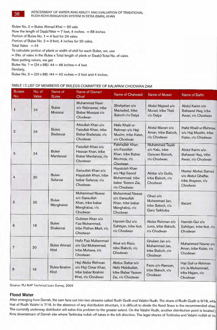
38 ASSESSMENT OF WATER AVAILABILITY AND EVALUATION OF TRADITIONAL RUDH-KOHI IRRIGATION SYSTEM IN DERA ISMAIL KHAN
Bulee No. 2 = Bulee Ahmad Khel = 20 vale Now the length of Daab/Weir = 7 feet, 4 inches. = 88 inches Portion of Bulee No. 1 = 4 feet for 24 vales Portion of Bulee No. 2 = 3 feet, 4 inches for 20 vales. Total Vales = 44
To calculate portion of plank or width of shill for each Bulee, we, use = (No. of vales in the Bulee x Total length of plank or Daab)/Total No. of vales Now putting values, we get Bulee No. 1 = (24 x 88)/ 44 = 48 inches = 4 feet Similarly,
Bulee No. 2 = (20 x 88) /44 = 40 inches = 3 feet and 4 inches.
likliLt 17. LI6 I OF MEMBERS OF BULEES COMMITTEE OF KALAPANI CHODWAN ZAM
Bulaee No.
No. of Name of Name of Owner/ Vales Bulee Chief
Name of Chalwasti Name of Musair Name of Daftri
1 24 Bulee Musazai
Muhammad Nasir s/o Rabnawaz, tribe Babar Musazai r/o Chodwan
Shahjehan s/o Mauladad, tribe Baloch r/o Dalya
Abdul Majeed s/o Murad, tribe Thali r/o Dalya
Abdul Karim s/o Bahawal Haq, tribe Awan, r/o Chodwan
2 24 Bulee Badanzai
Attaullah Khan s/o Faizullah Khan, tribe Babar Badanzai, r/o Chodwan
Hafiz Khalil-ur-Rehman s/o Haji Muslim, tribe Kalan, r/o Chodwan
Abdul Manan s/o Aman, tribe Baloch, r/o Chodwan
Hafiz Khalikur-Rehmai s/o Haji Muslim, tribe Kalan, r/o Chodwan
3 24 Bulee Mardanzai
Faizullah Khan s/o Hassan Khan, tribe Babar Mardanzai, r/o Chodwan
Fatehullah Khan s/o Faizullah Khan, tribe Babar Mochizai, r/o Chodwan
Muhammad Tayab s/o Kalu, tribe Qaisrani Baloch, r/o Chodwan.
Abdul Karim s/o Bahawal Haq, tribe Awan, r/o Chodwan
4 20 Bulee Safarzai
Sanaullah Khan s/o Hayatulah Khan, tribe babar Safarzai, r/o Chodwan
Hayatulah Khan s/o Haji Saeed Muhammad, tribe babar Yaseen Zai, r/o Chodwan
Akhtar s/o Gullo, tribe Baloch, r/o Chodwan
Master Abdus Samad s/o Abdul Ghaffar, tribe Arayeen, r/o Chodwan
5 20 Bulee Manghalzai
Muhammad Nawaz s/o Sanaullah Khan, tribe babar Manghalzai, r/o Chodwan
Muhammad Nawaz s/o Sanaullah Khan, tribe babar Manghalzai, r/o Chodwan
Ghazi s/o Muhammad Jan, tribe Baloch, r/o Gara Tarkhoba
Vacant
6 18 Bulee Shakerzai
Gulistan Khan s/o Faiz Muhammad, tribe Pathan Maril, r/o Chodwan
Hamish Gul s/o Sahibjan, tribe Isot, r/o Chodwan
Abdur Rehman s/o Juma, tribe Baloch, r/o Chodwan
Hamish Gul s/o Sahibjan, tribe Isot, r/c Chodwan
7 20 Bulee Ahmad Khel
Hafiz Faiz Muhammad s/o Gul Muhammad, tribe Muhana, r/o Chodwan
Afzal s/o Razu, tribe Baloch, r/o Chodwan
Ghulam Jan s/o Muhammad Jan, tribe Baloch, r/o Chodwan
Muhammad Nawaz s/c Aman, tribe Kalan, r/o Chodwan
8 18 Bulee Ibrahim Khel
Haji Abdur Rehman s/o Haji Omar Khan, tribe babar Ibrahim Khel, r/o Chodwan
Abdus Sattar s/o Hafiz Habibullah, tribe Babar Yaseen Zai, r/o Chodwan
Faizu s/o Ramzan , tribe Baloch, r/o Chodwan
Haji Saif-ur-Rehman s/o Ja Muhammad, tribe Hajam, r/o Chodwan
Source: PLI-AUP Technical team Survey, 2004
Flood Water After emerging from Darrah, the zam fans out into two streams called Rudh Gudh and Valahri Rudh. The share of Rudh Gudh is 9/16, while that of Rudh Valahri is 7/16. In the absence of any distribution structure, it is difficult to divide the flood flows in the recommended share. The currently underway distributor will solve this problem to the greater extent. On the Valahri Rudh, another distribution point is located 2
Kms downstream of Darrah site where Terkhoba nullah off takes in the left direction. The legal shares of Terkhoba and Valahri nullah at this
ASSESSMENT OF WATER AVAILABILITY AND EVALUATION OF TRADITIONAL RUDH-KOHI IRRIGATION SYSTEM IN DERA ISMAIL KHAN
39
point are 1.5: 5.5 respectively.
Part of flow of Rudh Gudh and Lohra of the Daraban zam joins Rudh Gudh of Chodwan zam above Gatta Dasti spill weir where Gandi Attaullah is the right off-shoot. Upstream Waruki spill weir, sanji nullah irrigates the lands on the left side. At Waruki spill weir, the off taking channels are chotewah, Jandi, Nehara and tail of Terkhoba which joins Nehara about 5 km downstream of waruki spill weir. Nehara nullah irrigates the lands on the way and escapes into Indus river after crossing CRBC. Total area on the flood irrigation for Daraban and Chodwan zams, having irrigation rights, is about 28,590 hectare (70,617 acres).
Fluctuations in Perennial Streams Kalapani (Perennial water) flows in both zams (Daraban and Chodwan), but the amount of water availability slightly fluctuates due to the following reason.
• When the rainfall in the upper mountains is below its normal level, then the discharge of perennial streams also decreases accordingly
• During the hot weather, the evaporation increases and accordingly the availability of water in streams decrease • There are some mountains whose soil is fine in texture and whenever rainfall occurs on those areas then comparatively muddy
flood water emerge and block the pores of the soil which generate springs and thus the discharge of spring water decreases • Similarly on the other side, there are mountains whose water flows with great velocity across these springs which further cuts
the ground and flow of the streams increases slightly • Due to population pressure and more demand and use of water in the upper reaches has resulted in a decrease in the
availability of water downstream. Few tube wells have been installed in the upper reaches which also resulted in a decline in spring water downstream
Conclusion For management of perennial streams at both zams, well established water rights and distributions system exist for management of water;
however, yield of major crops in the area is less than their potential yield.
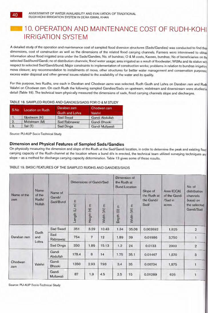
Daraban zam Chodwan zam
Gudh and Lohra Valehri Upstream (H) Sad Swad Gandi Abdullah
2. Midstream (M) Sad Rabnawaz Gandi Bhooki 3 Tail (T) Sad Dinqa Gandi Mullawali
S.No Location on Rudh
40 ASSESSMENT OF WATER AVAILABILITY AND EVALUATION OF TRADITIONAL RUDH-KOHI IRRIGATION SYSTEM IN DERA ISMAIL KHAN
10. OPERATION AND MAINTENANCE COST OF RUDH-KOHI IRRIGATION SYSTEM
A detailed study of the operation and maintenance cost of sampled flood diversion structures (Sads/Gandies) was conducted to find their
dimensions, cost of construction as well as the dimensions of the related flood carrying channels. Farmers were interviewed to obtain
information about flood irrigated area under the Sads/Gandies, No. of bundras; 0 & M costs, Kasses, bundras; No of beneficiaries on the
selected Sad/bund/Gandi; no of distribution channels; flood water usage; area irrigated as a result of floodwater; WUAs and its status with
respect to selected Sad/Gandi/bund; Major constraints to implementation of construction works; problems in relation to bundras irrigation,
mova closure; any recommendation to installments of mova, other structures for better water management and conservation purposes;' excess water disposal and other general issues related to the availability of the water and its quality.
For this purpose, two Rudhs, one each in Daraban and Chodwan zams was selected. Rudh Gudh and Lohra on Daraban zam and Rudh
Valahri on Chodwan zam. On each Rudh the following sampled Gandies/Sads on upstream, midstream and downstream were studied in
detail (Table 18). The technical team physically measured the dimensions of sads, flood carrying channels slope and discharges.
TABLE 18. SAMPLED RUDHS AND GANDIES/SADS FOR 0 & M STUDY
Source: PLI-AUP Socio-Technical Study
Dimension and Physical Features of Sampled Sads/Gandies On physically measuring the dimension and slope of the Rudh at the Sad/Gandi location, in order to determine the peak and existing flood
carrying capacity of the Rudh-channel at the location where a bund d/s is erected, the technical team utilized surveying techniques and slope — as a method for discharge carrying capacity determination. Table 13 gives some of these results.
TABLE 19. BASIC FEATURES OF THE SAMPLED RUDHS AND GANDIES/SADS
Name of the
zam
Name
of the
Rudh/
Nullah
Name of
Gandi/
Sad/Bund
Dimensions of Gandi/Sad Dimension of
the Rudh at
Bund Location Slope of
the Rudh at
the Gandi/
Sad/
Area (CCA)
of the Gandi
/Sad in
acres
No, of
distribution
channels
(kass) on
the selectee
Gandi/Sad
Le
ngt
h (
L) m
) m
Heig
ht (
H) m
Wid
t h (W
) m
De
pth
(D
) m
Wid
th (W
) m
Daraban zam
Gudh
and
Lohra
Sad Swad 351 3.29 10.43 1.34 35.06 0.003692 1,625 2
Sad
Rabnawaz 754 7 12 1.89 39 0.01986 3,750 1
Sad Dinga 330 1.89 15.13 1.2 24 0.0133 2000 2
Chodwan zam
Valehri
Gandi
Abdullah 178.4 8 14 1.75 35.1 0.01467 1,570 3
Gandi
Bhooki 1350 2.93 7.93 3.4 35 0.00734 1,875 1
Gandi
Mullawali 87 1.9 4.5 2.5 15 0.01289 625 1
Source: PLI-AUP Socio-Technical Study
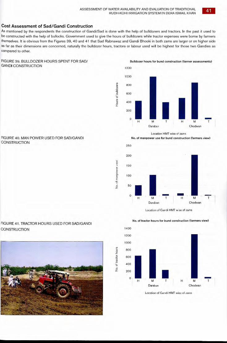
FIGURE 41. TRACTOR HOURS USED FOR SAD/GANDI
CONSTRUCTION
No.
of t
ract
or h
ours
1400
1200
1000
800
600
400
200
0 M
Daraban
■
No. of tractor hours for bund construction (farmers view)
H M T
Chodwan
Location of Gandi HMT wise of zams
ASSESSMENT OF WATER AVAILABILITY AND EVALUATION OF TRADITIONAL RUDH-KOHI IRRIGATION SYSTEM IN DERA ISMAIL KHAN
41
Cost Assessment of Sad/Gandi Construction As mentioned by the respondents the construction of Gandi/Sad is done with the help of bulldozers and tractors. In the past it used to be constructed with the help of bullocks. Government used to give the hours of bulldozers while tractor expenses were borne by farmers themselves. It is obvious from the Figures 39, 40 and 41 that Sad Rabnawaz and Gandi Bhooki in both zams are larger or on higher side as far as their dimensions are concerned, naturally the bulldozer hours, tractors or labour used will be highest for those two Gandies as compared to other.
FIGURE 39. BULLDOZER HOURS SPENT FOR SAD/ Bulldozer hours for bund construction (farmer assessments) GANDI CONSTRUCTION
Location HMT wise of zams
FIGURE 40. MAN POWER USED FOR SAD/GANDI No. of manpower use for bund construction (farmers view)
CONSTRUCTION
250
200
150
100
50
0
No.
of m
anp
owe
r use
d
Daraban
Chodwan
Location of Gandi HMT wise of zams
1200
1000
800
600
400
200
0
Hou
rs o
f bu
ldoz
e rs
M
Daraban
M T
Chodwan
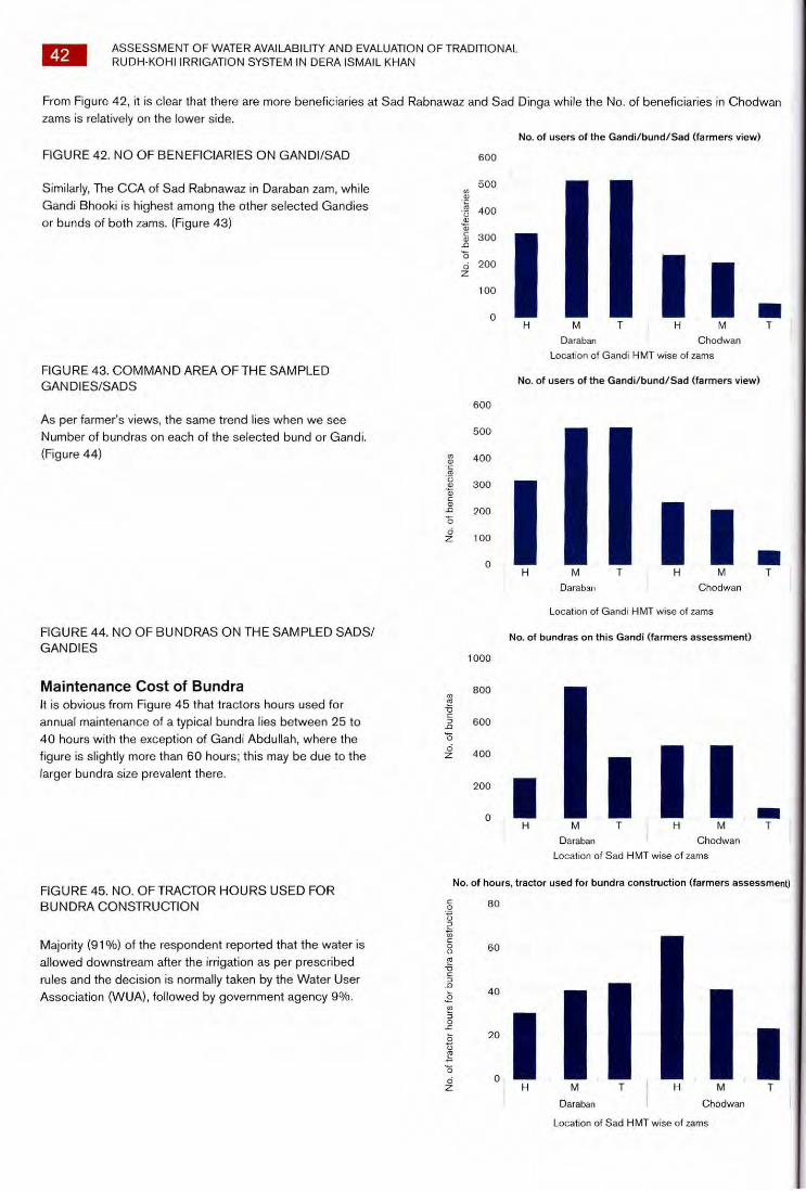
No
. of benef
ec
iarie
s
600
500
400
300
200
100
0
Chodwan
No
. of
bu
ndra
s
1000
800
600
400
200
0
42 ASSESSMENT OF WATER AVAILABILITY AND EVALUATION OF TRADITIONAL RUDH-KOHI IRRIGATION SYSTEM IN DERA ISMAIL KHAN
From Figure 42, it is clear that there are more beneficiaries at Sad Rabnawaz and Sad Dinga while the No. of beneficiaries in Chodwan zams is relatively on the lower side.
No. of users of the Gandi/bund/Sad (farmers view)
T
FIGURE 42. NO OF BENEFICIARIES ON GANDI/SAD
Similarly, The CCA of Sad Rabnawaz in Daraban zam, while
Gandi Bhooki is highest among the other selected Gandies
or bunds of both zams. (Figure 43)
FIGURE 43. COMMAND AREA OF THE SAMPLED GAN DIES/SADS
H M T
Daraban
Location of Gandi HMT wise of zams
No. of users of the Gandi/bund/Sad (farmers view)
I As per farmer's views, the same trend lies when we see
Number of bundras on each of the selected bund or Gandi.
(Figure 44)
600
500
400
300
200
100
0
No. of be
nefe
ciar
ies
II I I IIII H M T
Chodwan
M T
Daraban
Location of Gandi HMT wise of zams
FIGURE 44. NO OF BUNDRAS ON THE SAMPLED SADS/ GANDIES
Maintenance Cost of Bundra It is obvious from Figure 45 that tractors hours used for
annual maintenance of a typical bundra lies between 25 to
40 hours with the exception of Gandi Abdullah, where the
figure is slightly more than 60 hours; this may be due to the
larger bundra size prevalent there.
No. of bundras on this Gandi (farmers assessment)
I
Chodwan
M
Daraban
Location of Sad HMT wise of zams
No
. of
tra
cto
r h
ours
fo
r b
und
ra c
on
stru
ctio
n FIGURE 45. NO. OF TRACTOR HOURS USED FOR
BUNDRA CONSTRUCTION
Majority (91%) of the respondent reported that the water is
allowed downstream after the irrigation as per prescribed
rules and the decision is normally taken by the Water User
Association (WUA), followed by government agency 9%.
No. of hours, tractor used for bundra construction (farmers assessment)
80
I H M
Chodwan
Location of Sad HMT wise of zams
60
40
20
0
M T
Daraban
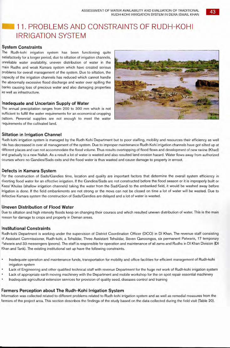
ASSESSMENT OF WATER AVAILABILITY AND EVALUATION OF TRADITIONAL RUDH-KOHI IRRIGATION SYSTEM IN DERA ISMAIL KHAN
43
11. PROBLEMS AND CONSTRAINTS OF RUDH-KOHI IRRIGATION SYSTEM
System Constraints The Rudh-kohi irrigation system has been functioning quite satisfactorily for a longer period, due to siltation of irrigation channels, unreliable water availability, uneven distribution of water in the main Rudhs and weak Kamara system which have created serious problems for overall management of the system. Due to siltation, the capacity of the irrigation channels has reduced which cannot handle the abnormally excessive flood discharge and water over spilling the banks causing loss of precious water and also damaging properties as well as infrastructure.
Inadequate and Uncertain Supply of Water The annual precipitation ranges from 200 to 300 mm which is not sufficient to fulfill the water requirements for an economical cropping pattern. Perennial supplies are not enough to meet the water requirements of the cultivated land.
Siltation in Irrigation Channel Rudh-kohi irrigation system is managed by the Rudh-Kohi Department but to poor staffing, mobility and resources their efficiency as well role has decreased in over all management of the system. Due to improper maintenance Rudh-Kohi irrigation channels have got silted up at different places and can not accommodate the flood volume. Thus results overtopping of flood flows and development of new ravine (Khad) and gradually to a new Nallah. As a result a lot of water is wasted and also resulted land erosion hazard. Water flows away from authorized courses where no Gandies/Sads exits and the flood water is thus wasted and cause damage to property in enroot.
Defects in Kamara System For the construction of Sads/Gandies time, location and quality are important factors that determine the overall system efficiency in diverting flood water for an effective irrigation. If the Gandies/Sads are not constructed before the flood season or it is improperly built or Kass/ Khulas (shallow irrigation channels) taking the water from the Sad/Gandi to the embanked field, it would be washed away before irrigation is done. If the field embankments are not strong or the mova can not be closed on time a lot of water will be wasted. Due to defective Kamara system the construction of Sads/Gandies are delayed and a lot of water is wasted.
Uneven Distribution of Flood Water Due to siltation and high intensity floods keep on changing their courses and which resulted uneven distribution of water. This is the main reason for damage to crops and property in Deman areas.
li Institutional Constraints Rudh-kohi Department is working under the supervision of District Coordination Officer (DCO) in DI Khan. The revenue staff consisting of Assistant Commissioner, Rudh-kohi, a Tehsildar, Three Assistant Tehsildar, Seven Qanoongos, six permanent Patwaris, 17 temporary Patwaris and 33 messengers (peons). The staff is responsible for operation and maintenance of all zams and Rudhs in DI Khan Division (DI Khan and Tank). The existing institutional set up have the following constraints.
• Inadequate operation and maintenance funds, transportation for mobility and office facilities for efficient management of Rudh-kohi irrigation system
• Lack of Engineering and other qualified technical staff with revenue Department for the huge net work of Rudh-kohi irrigation system ~~ Lack of appropriate earth moving machinery with the Department and mobile workshop for the on spot repair essential machinery • Inadequate agricultural extension services for provision of quality seed, diseases control and training
Farmers Perception about The Rudh-Kohi Irrigation System Information was collected related to different problems related to Rudh-kohi irrigation system and as well as remedial measures from the farmers of the project area. This section describes the findings of the study based on the data collected during the field visit (Table 20).
44 ASSESSMENT OF WATER AVAILABILITY AND EVALUATION OF TRADITIONAL RUDH-KOHI IRRIGATION SYSTEM IN DERA ISMAIL KHAN
TABLE 20. FARMERS PERCEPTION ABOUT THE PROBLEMS OF RUDH-KOHI IRRIGATION SYSTEM.
S.No Question asked Respondents Reply
1 Is there any overtopping from the Gandi/bund/Sad?
About 67% of the respondents replied in affirmative, while 33% mentioned no overtopping from the Sads/Gandies
2 If yes, then why? Give reasons Most of the respondents replied the main reason of overtopping were weak banks, non-uniformity in the Bund of the Sad/Gandi and lack of proper compaction and design of Sad/Gandies
3 Is the Rudh full supply level high enough to irrigate the whole command area?
About 83% of the respondents replied in affirmative, i.e., according to them in their reach, the Rudh FSL is high enough to irrigate their fields. While only 17 percent replied in negative
4 If No, what percentage of the command area can be irrigated?
The only case of Gandi Bhooki where this problem was reported. Farmers mentioned that about 25-50% of the land is still not receiving the water as per water right
5
In construction of Gandi/bund /sad user's participation is obligatory, and then how is the arrangement enforced?
All the respondents reported that they have some sort of arrangement in the shape of a committee in which they propose senior members and then collect funds as per share of their land holdings. Also provide labour for the process. In short all cases reported that they cooperate in the construction phase with the government/and other executing agency
6
What is the Penalty for the water user who does not participate in construction work of Gandi/bund/Sad?
About 50 percent of respondents reported that the penalty system exist in some form. First of all they try to convince the respective farmer to give his share in the construction fund, then try to eliminate his queries, but if still he is not convinced then they warn him that in case of non-compliance water of his share will not be given.
Other 50 percent cases reported that there is no penalty system and they cooperate with the farmer in every way and collect the fund on their behalf, thus not halt the process of construction
7 What are the main problems, if any, in the enforcement of construction works rules?
Only one case in Gandi Abdullah reported a problem, i.e. non-provision of hours of bulldozers by the government, while rest of the cases gave us answers describing and pinpointing many or multiple problems hindering the enforcement of construction phase. These are given in the second column under the heading of possible answers
8 Give your suggestion to overcome the problem of construction rule enforcement
About 84% respondents reported that a sense of realization is the solution to the problem
9 Do you face any problems while irrigating field (bundra)?
About 84% of the respondents pointed that they face hardship in irrigation of their fields due to non-availability of flow control structures (mova etc)
10 If Yes, How it can be overcome?
About 84% of cases reported that they need Pacca movas on priority basis so that they may feel a little bit of comfort while irrigating their bundras. While 67% of total respondent also gave suggestion that flow control should be regularized in addition to Pacca movas provisions. Other 33% also added development of flood monitoring system and allocation of funds to users as a major suggestion for overcoming the problems of irrigating their fields
11 Would you prefer to install permanent inlet structures (mova) at the field inlet?
All of respondents in both zams replied that they will prefer to install permanent structures like Pacca movas at their farm gate
12
For better flow control, the permanent structures on each Gatti/Gandi will be useful or not?
Only respondents of Sad Rabnawaz replied that they feel that Pacca or permanent structures will not be useful according to their view as it will make a more influential farmer close and open gates at his will and thus deprive lower farmers of their due share
13 If not, then give reasons? This question is explained above
ASSESSMENT OF WATER AVAILABILITY AND EVALUATION OF TRADITIONAL RUDH-KOHI IRRIGATION SYSTEM IN DERA ISMAIL KHAN
14 Water Users Associations for Better management will be useful or not?
All of the cases reported that they need trainings and for this purpose the development and strengthening of WUAs will be helpful for better management of
the Rudh-kohi system
15 Are you satisfied with the arrangement of Rudh-Kohi irrigation system?
About 67% of the respondents in Chodwan zam were satisfied with the arrangement of the Rudh-kohi irrigation system, while all in Daraban zam were
satisfied with the existing system
16 If not, give reasons? All these mentioned answers were given by 33 percent of the total cases where farmers said that they are not satisfied with the existing system
17
How the Rudh-Kohi irrigation system can be improved, give suggestions?
About 33% of respondents said that proper drainage in the bundras should be
provided for improvements of RIS About 50% added water distribution as key issue for RIS improvement About 33% added pacca movas provision, 50% added Desilting in water channels, 50% reported that proper design of the system, 67% of those also added system rehabilitation, 33% added proper coordination between community and line agencies, 17 percent added elimination of political influence, equal and equitable distribution of maintenance funds, WUAs strengthening, land leveling funds allocation should be just Thus overall 13% regards of the Rudh-kohi irrigation system improvement was pin pointed by all the six Gandies respondents
18 Did you remove extra water from your Bundra?
About 84 percent of cases responded that they remove extra water from their fields. If the floodwater comes to their fields late, they usually have little time left before sowing. So they are left with no option but to withdraw this water so that they may be able to prepare their fields well in time for sowing
Source: PLI-AUP Socio-Technical Study
45
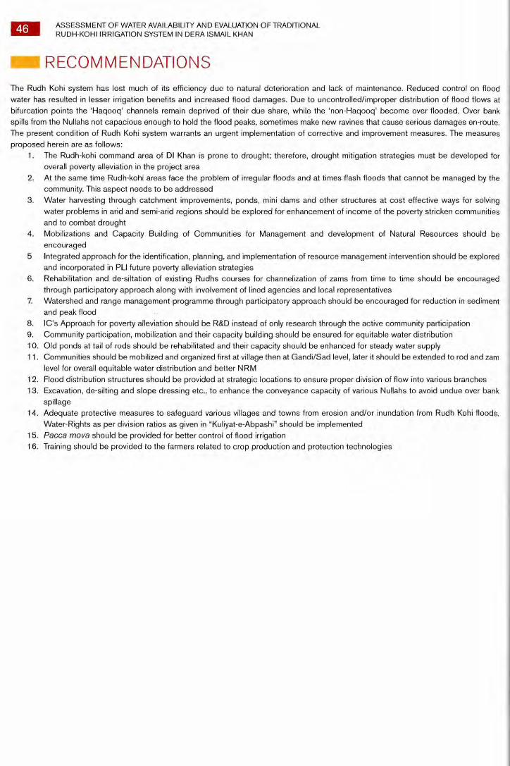
46 ASSESSMENT OF WATER AVAILABILITY AND EVALUATION OF TRADITIONAL RUDH-KOHI IRRIGATION SYSTEM IN DERA ISMAIL KHAN
RECOMMENDATIONS
The Rudh Kohi system has lost much of its efficiency due to natural deterioration and lack of maintenance. Reduced control on flood water has resulted in lesser irrigation benefits and increased flood damages. Due to uncontrolled/improper distribution of flood flows at bifurcation points the 'Haqooq' channels remain deprived of their due share, while the 'non-Haqooq' become over flooded. Over bank spills from the Nullahs not capacious enough to hold the flood peaks, sometimes make new ravines that cause serious damages en-route. The present condition of Rudh Kohi system warrants an urgent implementation of corrective and improvement measures. The measures proposed herein are as follows:
1. The Rudh-kohi command area of DI Khan is prone to drought; therefore, drought mitigation strategies must be developed for overall poverty alleviation in the project area
2. At the same time Rudh-kohi areas face the problem of irregular floods and at times flash floods that cannot be managed by the community. This aspect needs to be addressed
3. Water harvesting through catchment improvements, ponds, mini dams and other structures at cost effective ways for solving water problems in arid and semi-arid regions should be explored for enhancement of income of the poverty stricken communities and to combat drought
4. Mobilizations and Capacity Building of Communities for Management and development of Natural Resources should be encouraged
5 Integrated approach for the identification, planning, and implementation of resource management intervention should be explored and incorporated in PLI future poverty alleviation strategies
6. Rehabilitation and de-siltation of existing Rudhs courses for channelization of zams from time to time should be encouraged through participatory approach along with involvement of lined agencies and local representatives
7. Watershed and range management programme through participatory approach should be encouraged for reduction in sediment and peak flood
8. IC's Approach for poverty alleviation should be R&D instead of only research through the active community participation 9. Community participation, mobilization and their capacity building should be ensured for equitable water distribution 10. Old ponds at tail of rods should be rehabilitated and their capacity should be enhanced for steady water supply 1 1 . Communities should be mobilized and organized first at village then at Gandi/Sad level, later it should be extended to rod and zam
level for overall equitable water distribution and better NRM 1 2. Flood distribution structures should be provided at strategic locations to ensure proper division of flow into various branches 13. Excavation, de-silting and slope dressing etc., to enhance the conveyance capacity of various Nullahs to avoid undue over bank
spillage 14. Adequate protective measures to safeguard various villages and towns from erosion and/or inundation from Rudh Kohi floods.
Water-Rights as per division ratios as given in "Kuliyat-e-Abpashi" should be implemented 15. Pacca mova should be provided for better control of flood irrigation 16. Training should be provided to the farmers related to crop production and protection technologies

ASSESSMENT OF WATER AVAILABILITY AND EVALUATION OF TRADITIONAL RUDH-KOHI IRRIGATION SYSTEM IN DERA ISMAIL KHAN
47
REFERENCES Bhatti, A.U. and H. Nawaz. 1984. Categorization and reclamation of salt affected soils of DI Khan. Pak. J.Sci. Ind. Res. 27 (3): 188-190.
Mengel, K.; Kirkby, E.A. 1987 Principles of Plant Nutrition. Intl. Potash Inst. Switzerland. ; 385-399.
Mian, A. and Y.J. Mirza. 1993. Pakistan's soil resources. Environmental and Urban Affairs Division, Govt. of Pakistan, Islamabad.
National Engineering Services of Pakistan, 1993. Flood protection Sector Project Feasibility Study for flood management of Gomal and
Tank zams.
National Engineering Services of Pakistan, 1993. Development of Rudh-kohi schemes in DI Khan.
Rafique, M. 1990. Soil resources and soil related problems in Pakistan. In: M. Ahmad, M.e. Akhtar and M. I. Nizami (Eds), Soil physics
application under Stress Environments. BARD, PARC, Islamabad: 16-23.
Tisdale, S.L.; Nelson, W.L.; Beaton, J.D. 1985. Soil Fertility and Fertilizers. Macmillan pub. Co NY. 75-79.