assessment_drainage_and_stormwater_20134254156.pdf
TRANSCRIPT
Plaquemines Parish Comprehensive Master Plan Community Assessment – Technical Addendum Section 7: Drainage and Stormwater Management Facilities
Page 1 of 26
7 Drainage and Stormwater Management Facilities
Introduction
The purpose of this element of the Technical Addendum to the Community Assessment is to provide an overview of the current state of Drainage and Stormwater Management Facilities and Strategies in Plaquemines Parish. As in most communities, drainage of all developed areas is of significant concern in terms of providing a livable community. Poor drainage can lead to inconveniences such as street flooding or even massive economic damage due to loss of flooded structures. This section provides an overview and understanding of current drainage issues and flood control capacity and facilities as well as to lay the groundwork for development of a long range drainage and stormwater management strategy for Plaquemines Parish. The Drainage and Stormwater element of the Community Assessment section is organized as follows:
7.1 – Summary of Existing Drainage System and Strategies 7.2 – Inventory of Drainage Districts and Drainage Assets in Plaquemines Parish 7.3 – Summary of Drainage Challenges Facing Plaquemines Parish 7.4 – Recent Investments 7.4 – Future Investments
7.1. Summary of Existing Drainage System and Strategies
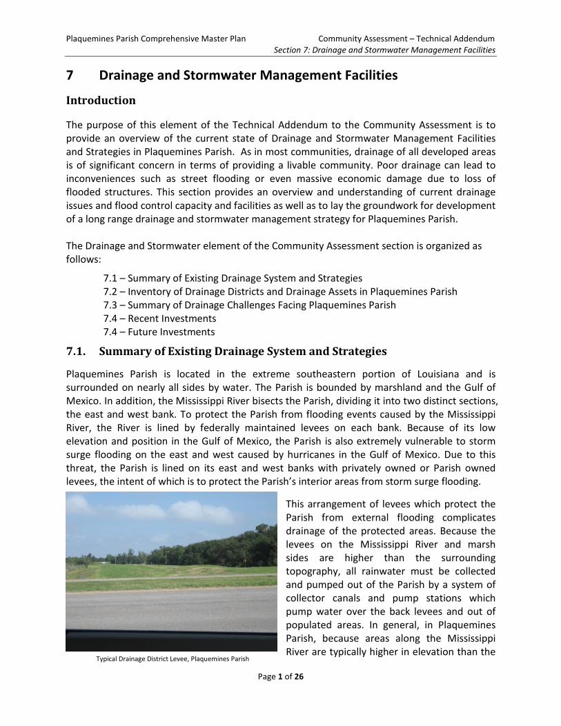
Plaquemines Parish is located in the extreme southeastern portion of Louisiana and is surrounded on nearly all sides by water. The Parish is bounded by marshland and the Gulf of Mexico. In addition, the Mississippi River bisects the Parish, dividing it into two distinct sections, the east and west bank. To protect the Parish from flooding events caused by the Mississippi River, the River is lined by federally maintained levees on each bank. Because of its low elevation and position in the Gulf of Mexico, the Parish is also extremely vulnerable to storm surge flooding on the east and west caused by hurricanes in the Gulf of Mexico. Due to this threat, the Parish is lined on its east and west banks with privately owned or Parish owned levees, the intent of which is to protect the Parish’s interior areas from storm surge flooding.
This arrangement of levees which protect the Parish from external flooding complicates drainage of the protected areas. Because the levees on the Mississippi River and marsh sides are higher than the surrounding topography, all rainwater must be collected and pumped out of the Parish by a system of collector canals and pump stations which pump water over the back levees and out of populated areas. In general, in Plaquemines Parish, because areas along the Mississippi River are typically higher in elevation than the
Typical Drainage District Levee, Plaquemines Parish
Plaquemines Parish Comprehensive Master Plan Community Assessment – Technical Addendum Section 7: Drainage and Stormwater Management Facilities
Page 2 of 26
areas closer to the back levees, stormwater flows downhill to the back levees where most of the drainage pump stations and major drainage canals are located.
The strategy of drainage and stormwater management in Plaquemines Parish is common to southeastern Louisiana. As in neighboring Lafourche, Terrebonne, Orleans, Jefferson, and St. Bernard Parishes, the collector canals and drainage pumps stations form the defensive system against interior flooding caused by precipitation events. Because these mechanized drainage pump stations must be externally powered they are susceptible to failure during violent weather events such as hurricanes as these significant weather events cause the greatest chance for mechanical failures or power interruption.
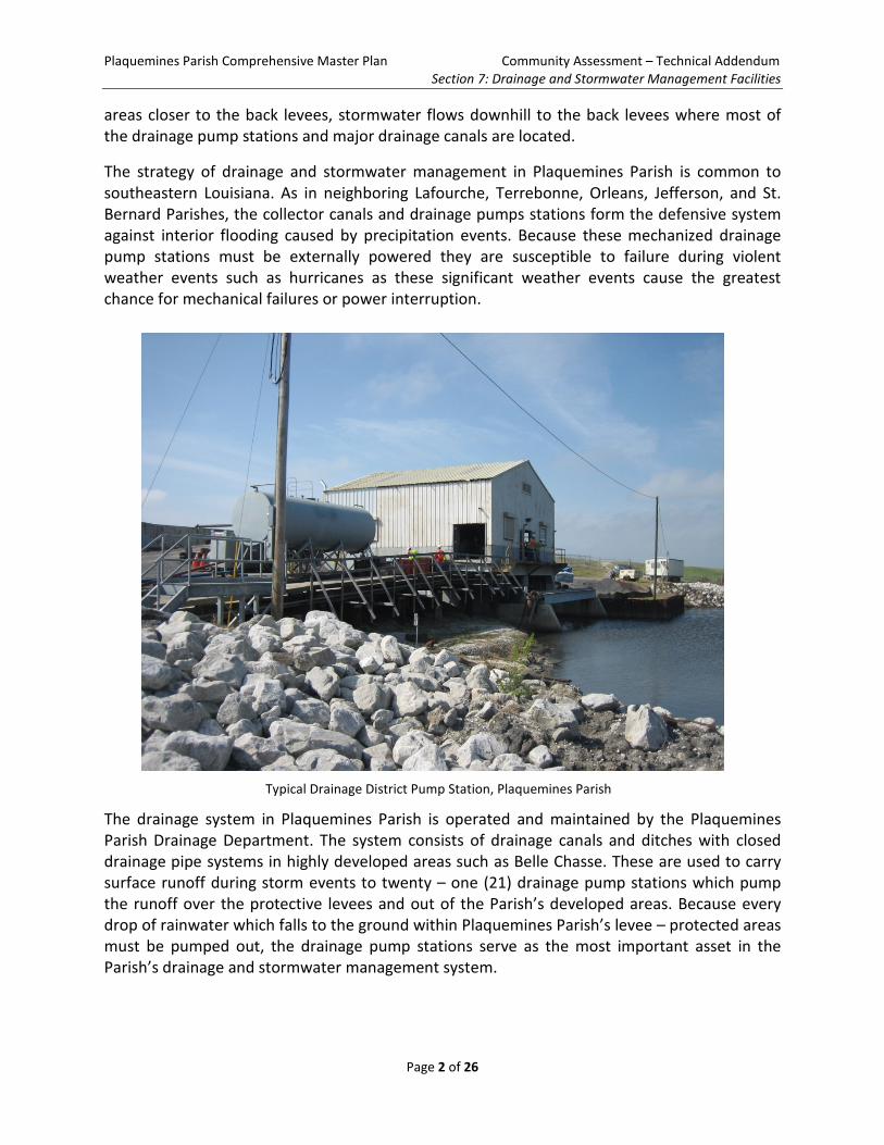
The drainage system in Plaquemines Parish is operated and maintained by the Plaquemines Parish Drainage Department. The system consists of drainage canals and ditches with closed drainage pipe systems in highly developed areas such as Belle Chasse. These are used to carry surface runoff during storm events to twenty – one (21) drainage pump stations which pump the runoff over the protective levees and out of the Parish’s developed areas. Because every drop of rainwater which falls to the ground within Plaquemines Parish’s levee – protected areas must be pumped out, the drainage pump stations serve as the most important asset in the Parish’s drainage and stormwater management system.
Typical Drainage District Pump Station, Plaquemines Parish
Plaquemines Parish Comprehensive Master Plan Community Assessment – Technical Addendum Section 7: Drainage and Stormwater Management Facilities
Page 3 of 26
7.2 Inventory of Drainage Districts and Drainage Assets in Plaquemines Parish
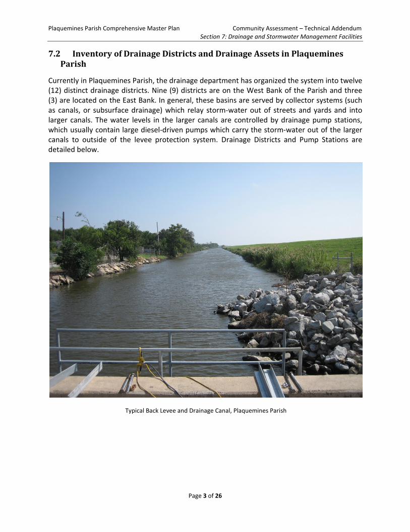
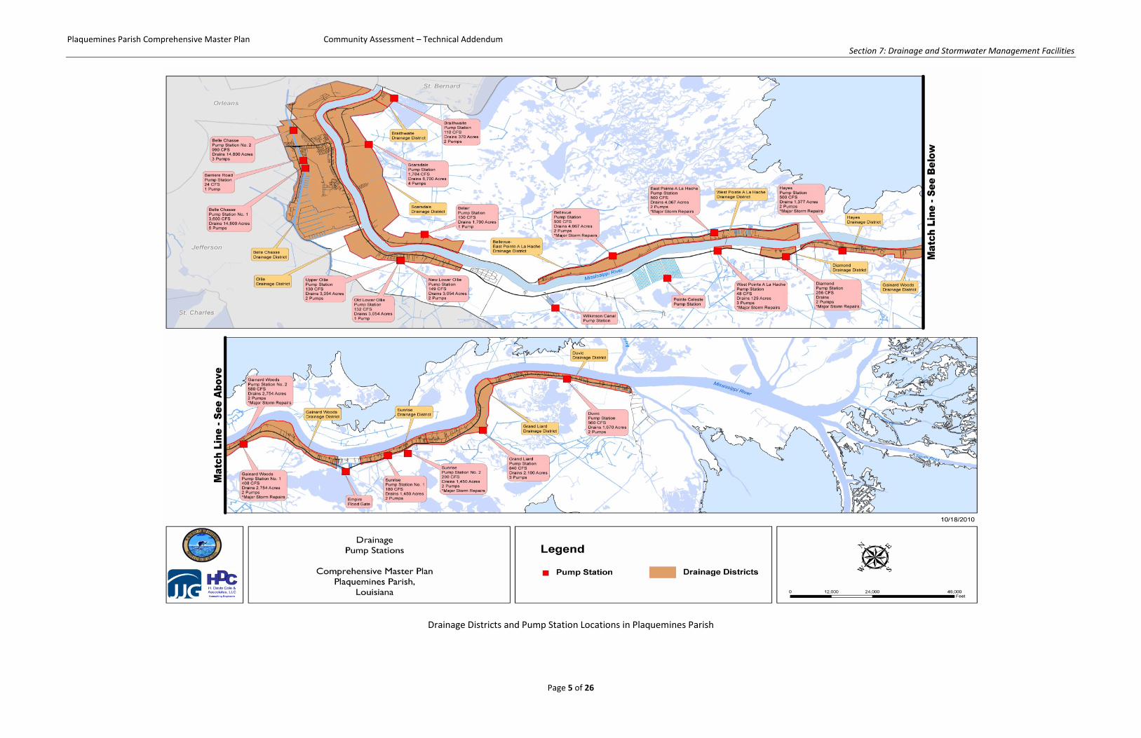
Currently in Plaquemines Parish, the drainage department has organized the system into twelve (12) distinct drainage districts. Nine (9) districts are on the West Bank of the Parish and three (3) are located on the East Bank. In general, these basins are served by collector systems (such as canals, or subsurface drainage) which relay storm-water out of streets and yards and into larger canals. The water levels in the larger canals are controlled by drainage pump stations, which usually contain large diesel-driven pumps which carry the storm-water out of the larger canals to outside of the levee protection system. Drainage Districts and Pump Stations are detailed below.
Typical Back Levee and Drainage Canal, Plaquemines Parish
Plaquemines Parish Comprehensive Master Plan Community Assessment – Technical Addendum Section 7: Drainage and Stormwater Management Facilities
Page 4 of 26
This page was intentionally left blank for two-sided printing.
Plaquemines Parish Comprehensive Master Plan Community Assessment – Technical Addendum Section 7: Drainage and Stormwater Management Facilities
Page 5 of 26
Drainage Districts and Pump Station Locations in Plaquemines Parish
Plaquemines Parish Comprehensive Master Plan Community Assessment – Technical Addendum Section 7: Drainage and Stormwater Management Facilities
Page 6 of 26
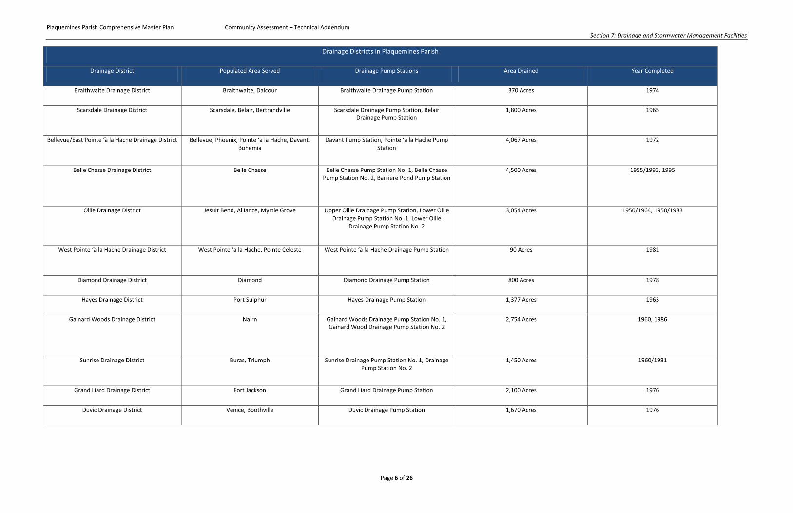
Drainage Districts in Plaquemines Parish
Drainage District Populated Area Served Drainage Pump Stations Area Drained Year Completed
Braithwaite Drainage District Braithwaite, Dalcour Braithwaite Drainage Pump Station 370 Acres 1974
Scarsdale Drainage District Scarsdale, Belair, Bertrandville Scarsdale Drainage Pump Station, Belair Drainage Pump Station
1,800 Acres 1965
Bellevue/East Pointe ‘à la Hache Drainage District Bellevue, Phoenix, Pointe ‘a la Hache, Davant, Bohemia
Davant Pump Station, Pointe ‘a la Hache Pump Station
4,067 Acres 1972
Belle Chasse Drainage District Belle Chasse Belle Chasse Pump Station No. 1, Belle Chasse Pump Station No. 2, Barriere Pond Pump Station
4,500 Acres 1955/1993, 1995
Ollie Drainage District Jesuit Bend, Alliance, Myrtle Grove Upper Ollie Drainage Pump Station, Lower Ollie Drainage Pump Station No. 1. Lower Ollie
Drainage Pump Station No. 2
3,054 Acres 1950/1964, 1950/1983
West Pointe ‘à la Hache Drainage District West Pointe ‘a la Hache, Pointe Celeste West Pointe ‘à la Hache Drainage Pump Station 90 Acres 1981
Diamond Drainage District Diamond Diamond Drainage Pump Station 800 Acres 1978
Hayes Drainage District Port Sulphur Hayes Drainage Pump Station 1,377 Acres 1963
Gainard Woods Drainage District Nairn Gainard Woods Drainage Pump Station No. 1, Gainard Wood Drainage Pump Station No. 2
2,754 Acres 1960, 1986
Sunrise Drainage District Buras, Triumph Sunrise Drainage Pump Station No. 1, Drainage Pump Station No. 2
1,450 Acres 1960/1981
Grand Liard Drainage District Fort Jackson Grand Liard Drainage Pump Station 2,100 Acres 1976
Duvic Drainage District Venice, Boothville Duvic Drainage Pump Station 1,670 Acres 1976
Plaquemines Parish Comprehensive Master Plan Community Assessment – Technical Addendum Section 7: Drainage and Stormwater Management Facilities
Page 7 of 26
Another important asset in the overall stormwater management strategy of Plaquemines Parish is a set of manually operated sluice gates that are utilized as “equalizers” between districts. For instance, if one district is overwhelmed by more stormwater than it can pump out, the interconnecting sluice gate to the adjacent district can be opened to allow water to spill over to the adjacent district which has available pumping capacity. The sluice gates located within the Parish are detailed in the table below.
Interconnecting Sluice Gates in Plaquemines Parish
Structure Connection Pipe/Gate Size
Amoretta/Happy Jack Diamond Drainage Canal to Hayes Drainage Canal
Two (2) 54” Gates
Boothville Fort Jackson Borrow Pits and Grand Liard Drainage Canal to Duvic Venice Drainage Canal
Two (2) 72” Gates
Braithwaite Braithwaite Drainage Canal to Scarsdale Drainage Canal
Two (2) 60” Gates
Empire Basin Empire Basin to Sunrise Drainage Canal
Two (2) 36” Gates
The most important asset in the Plaquemines Parish Drainage and Stormwater Management is the twenty – one (21) drainage pump stations which pump rainwater out of levee protected interior areas. As these station are the only means of removing rainwater from the interior populated areas of the Parish, their importance cannot be overstated. In addition, the stations are typically used for unwatering flooded areas after coastal flooding events. All twenty – one (21) stations were damaged in some manner during Hurricane Katrina in 2005 and received some form of repairs. Eight (8) stations underwent major repairs including rebuilding and/or replacing key pump components. The table below provides an overview of the drainage pump station assets currently operated by the Plaquemines Parish Drainage Department.
Plaquemines Parish Comprehensive Master Plan Community Assessment – Technical Addendum Section 7: Drainage and Stormwater Management Facilities
Page 8 of 26
This page was intentionally left blank for two-sided printing.
Plaquemines Parish Comprehensive Master Plan Community Assessment – Technical Addendum Section 7: Drainage and Stormwater Management Facilities
Page 9 of 26
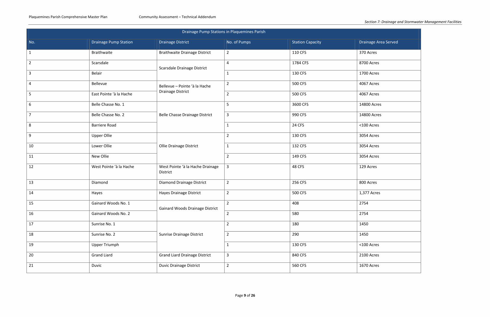
Drainage Pump Stations in Plaquemines Parish
No. Drainage Pump Station Drainage District No. of Pumps Station Capacity Drainage Area Served
1 Braithwaite Braithwaite Drainage District 2 110 CFS 370 Acres
2 Scarsdale Scarsdale Drainage District
4 1784 CFS 8700 Acres
3 Belair 1 130 CFS 1700 Acres
4 Bellevue Bellevue – Pointe ‘à la Hache Drainage District
2 500 CFS 4067 Acres
5 East Pointe ‘à la Hache 2 500 CFS 4067 Acres
6 Belle Chasse No. 1
Belle Chasse Drainage District
5 3600 CFS 14800 Acres
7 Belle Chasse No. 2 3 990 CFS 14800 Acres
8 Barriere Road 1 24 CFS <100 Acres
9 Upper Ollie
Ollie Drainage District
2 130 CFS 3054 Acres
10 Lower Ollie 1 132 CFS 3054 Acres
11 New Ollie 2 149 CFS 3054 Acres
12 West Pointe ‘à la Hache West Pointe ‘à la Hache Drainage District
3 48 CFS 129 Acres
13 Diamond Diamond Drainage District 2 256 CFS 800 Acres
14 Hayes Hayes Drainage District 2 500 CFS 1,377 Acres
15 Gainard Woods No. 1 Gainard Woods Drainage District
2 408 2754
16 Gainard Woods No. 2 2 580 2754
17 Sunrise No. 1
Sunrise Drainage District
2 180 1450
18 Sunrise No. 2 2 290 1450
19 Upper Triumph 1 130 CFS <100 Acres
20 Grand Liard Grand Liard Drainage District 3 840 CFS 2100 Acres
21 Duvic Duvic Drainage District 2 560 CFS 1670 Acres
Plaquemines Parish Comprehensive Master Plan Community Assessment – Technical Addendum Section 7: Drainage and Stormwater Management Facilities
Page 10 of 26
Represents back of table
Plaquemines Parish Comprehensive Master Plan Community Assessment Section F: Drainage and Stormwater Management
Page 11 of 26
7.2.2 East Bank Drainage Districts
Braithwaite Drainage District
The Braithwaite Drainage District is the northernmost drainage district on the east bank of the Parish. Braithwaite is the most densely populated area on the east bank of the Parish. Braithwaite is served by the Braithwaite Drainage Pump Station, which uses extensive retention “lagoons” throughout the area to reduce the loads on the station. The Braithwaite Drainage District is bounded by the Mississippi River on the North, the Caernarvon Freshwater Diversion on the East, Big Mar on the South and the Scarsdale Drainage District on the West. The district includes the populated area of Braithwaite.
The district contains one drainage pump station, the Braithwaite Drainage Pump Station, which was constructed in 1974 and was upgraded as part of a Hazard Mitigation Grant Program funded project after 2009. The district is also connected to the adjacent Scarsdale Drainage district by two (2) 54” diameter culverts with slide gates which allow for interconnection of the districts.
Drainage Study and Report for Eastbank Braithwaite Park Drainage District completed by Prescott Follett & Associates, Inc. in 1998 evaluated the district’s existing drainage system infrastructure and concluded that the combination of large lagoons and the drainage pump station would be capable of providing “excellent flood protection” provided that the pump station would be continuously operable during the 100 year storm. The study also concluded that the interconnecting culverts and slide gates, if in working order, would guard against flooding in either district in the event of a levee breach in one or the other districts.
The Braithwaite Drainage District has suffered dramatic hurricane flooding losses in recent years due to storm surge flooding from Hurricanes Katrina in 2005 and Isaac in 2012; however, these losses were due to overtopping of the protective back levees and not related to drainage pump station failure.
Plaquemines Parish Comprehensive Master Plan Community Assessment Section F: Drainage and Stormwater Management
Page 12 of 26
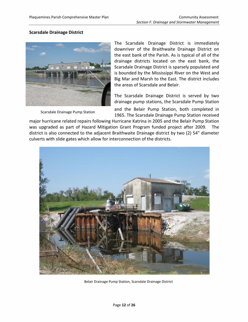
Scarsdale Drainage District
The Scarsdale Drainage District is immediately downriver of the Braithwaite Drainage District on the east bank of the Parish. As is typical of all of the drainage districts located on the east bank, the Scarsdale Drainage District is sparsely populated and is bounded by the Mississippi River on the West and Big Mar and Marsh to the East. The district includes the areas of Scarsdale and Belair.
The Scarsdale Drainage District is served by two drainage pump stations, the Scarsdale Pump Station
and the Belair Pump Station, both completed in 1965. The Scarsdale Drainage Pump Station received
major hurricane related repairs following Hurricane Katrina in 2005 and the Belair Pump Station was upgraded as part of Hazard Mitigation Grant Program funded project after 2009. The district is also connected to the adjacent Braithwaite Drainage district by two (2) 54” diameter culverts with slide gates which allow for interconnection of the districts.
Belair Drainage Pump Station, Scarsdale Drainage District
Scarsdale Drainage Pump Station
Plaquemines Parish Comprehensive Master Plan Community Assessment Section F: Drainage and Stormwater Management
Page 13 of 26
Bellevue-Pointe a la Hache Drainage District
The Bellevue-Pointe a la Hache Drainage District is the farthest down-river drainage district on the east bank of Plaquemines Parish. As with all of the east bank drainage districts, the land is predominantly rural in character and does not appear poised for major development within the foreseeable future. The district is bounded by the Mississippi River on the West and marshland on the East.
The Bellevue – Pointe a la Hache Drainage District is served by two drainage pump stations, the Bellevue (Davant) and Pointe ‘a la Hache Drainage Stations. These stations were completed in 1972 and both received major storm – related repairs following Hurricane Katrina in 2005.
Drainage Study and Report for Eastbank Bellevue and East Pointe a la Hache Drainage District prepared by Prescott Follett and Associates in 1998 evaluated the district’s current drainage system infrastructure to determine if the base flood elevation as prescribed by FEMA was appropriate to prevent flooding and if additional pumping capacity was necessary. The study concluded that the existing pumping capacity was sufficient to maintain flood waters below the 100 – year storm. The study recommended that in the future, the district’s main drainage canal be pumped down to a prescribed level of -3.0 National Geodetic Vertical Datum (NGVD) prior to rain events prior to storms and that the pumps at the Pointe ‘a la Hache and Bellevue Pump Stations be operated at full capacity at all times during a storm.
7.2.3 West Bank Drainage Districts
Belle Chasse Drainage District
The Belle Chasse Drainage District on the West Bank of Plaquemines Parish is the most densely populated drainage district in the Parish. The district is also the most densely urbanized and developed district. Unsurprisingly, the Belle Chasse Drainage District experiences the majority of the repetitive flooding problems experienced within the Parish. The district is roughly bounded by the Mississippi River, the Intracoastal Waterway, the Mero Canal, and the Algiers Outfall Canal and presently is comprised of approximately 14,800 acres of commercial, residential, and industrial land.
The Belle Chasse area was first leveed off and provided with pumped drainage in 1915. The original system included the Hero Pump Station which pumped stormwater runoff into Bayou Barataria. During the early days, the system was managed by the now defunct Jefferson – Plaquemines Drainage District (JPDD). In the early 1940s, Planters Canal was extended to provide drainage to the area now occupied by the Tulane University Research Center. Planters Canal drained this area by conveying stormwater to the Hero Pump Station. By the 1950’s, Hero Drainage Pump Station served Belle Chasse, Harvey, and Gretna.
The construction of the Intracoastal Waterway between 1947 and 1956 divided the JPDD into two distinct sections, prompting the United States Army Corps of Engineers (USACE) to begin construction of a network of pump stations and canals to provide drainage for the two separate
Plaquemines Parish Comprehensive Master Plan Community Assessment Section F: Drainage and Stormwater Management
Page 14 of 26
sections of the District. Generally, this separated areas on the west side of the new canal from the rest of the JPDD. By 1952, the Plaquemines Pumping Station was under construction to drain areas in Belle Chasse previously drained by the Hero Canal and Hero Pump Station. This station would eventually be known as Belle Chasse Pump Station No. 1.
The 1953 authorization and post-1954 construction of the Joint Air Reserve Training Center (JARTC), now known as Naval Air Station (NAS) New Orleans and associated development increased the drainage capacity requirements for the district by the conversion of previously undeveloped areas to heavy airbase development. Accordingly in 1960 modifications to the Plaquemines Pumping Station were undertaken. Completed in 1964, the modified pumping station became known as Belle Chasse Pump Station No. 1.
By 1969, the JPDD was dissolved and the remnants of the infrastructure in Plaquemines Parish were absorbed into the Belle Chasse Drainage District. By 1996, an additional pump station in Belle Chasse, Belle Chasse Pump Station No. 2 was online, bringing additional pumping capacity to the District.
Various drainage studies have been conducted throughout recent years to propose and evaluate potential solutions to the repetitive street flooding experienced in the District. A major focus of these studies included improvements to the canal system and improvements to drainage pump stations.
Hydrologic Study and Report of Districts 2, 3 & 4 for Plaquemines Parish Government prepared by Professional Engineering and Environmental Consultants, Inc. (PEEC) in 2007 indicated the following challenges facing the Belle Chasse Drainage District:
1) Diminished capacity and/or capability due to various problems associated with the existing drainage network
2) The need for new drainage canals and additional pumping capacity 3) Lessons learned from Hurricane Katrina which indicated that those drainage systems
protected by flood control structures or levees must elevate their base flood elevation and/or incorporate the risk of structural failures
Recently, Plaquemines Parish has acquired around 400 areas of land adjacent to the Joint Reserve Naval Base. This land is to be used primarily for recreational use, but can also be used for storm-water retention and management. In the late 1990’s, this concept was studied in Drainage Study and Report for Belle Chasse Drainage District, Belle Chasse, Louisiana prepared by Prescott Follett and Associates, Inc. in 1998, and the study concluded that in order to maintain flood protection for 100 – year storms that additional storage area would be needed, given the existing pumping capacity already in the system.
Plaquemines Parish Comprehensive Master Plan Community Assessment Section F: Drainage and Stormwater Management
Page 15 of 26
The Belle Chasse Drainage District suffers from repetitive flooding in several areas which have been the subject of several drainage studies in recent years. First, the area west of the Intracoastal Waterway along Engineers Road and Fort St. Leon Subdivision has experienced repeated flooding since the 1960’s as detailed in Hydraulic Study West of Intracoastal Waterway Along Engineers Road and Fort St. Leon Subdivision prepared by Professional Engineering and Environmental Consultants, Inc. (PEEC) in 2008. Other areas of concern include areas around the Naval Air Station, West First Street (detailed in West First Street Canal Drainage Study by PEEC, 2001), areas near Avenue G in Belle Chasse (detailed in West Drainage Study for Improvements to Hunt Street by PEEC, 2001) and areas along Cazalard and Engineer’s Road (detailed in Drainage Study for Engineers Road – Cazalard Drainage Pump, Plaquemines Parish, Louisiana by PEEC).
In most of the cases above, drainage issues were related to infrastructure capacity, particularly canal and pipe improvements. In the case of Engineers Road and Cazalard Road, both pump improvements and culvert replacement were recommended. A discussion of potential and recommended improvements is included in the Community Agenda.
Ollie Drainage District
The Ollie Drainage District is located just down-river of the Belle Chasse Drainage District. The District’s character is less urban than the Belle Chasse District. Storm-water outfall travels along the Ollie Canal and is pumped out of the basin via the Upper, Lower, and New Ollie Pump Stations. The district is bounded by marshland on the west and the Mississippi River on the east and includes the populated area of Jesuit Bend.
The Ollie Drainage District is served by three Pump Stations, Upper Ollie Pump Station, Lower Ollie Pump Station, and the New Ollie Pump Station (Lower Ollie Pump Station No. 2). The Upper Ollie Pump Station was completed in 1950 and upgraded in 1964, and the Lower Ollie and New Ollie Pump Stations were completed in 1950 and 1983 respectively.
Hydrologic Analysis to Determine Appropriate Canal Sizes to Handle 10 and 25 Year Rainfall Events on the West Bank of Plaquemines Parish, Louisiana prepared by Prescott Follett & Associates, Inc. in 1997 concluded that no canal or pumping station improvements would be required for the canal and pump stations to prevent flooding during the 10-year and 25-year storm events. The study did not evaluate the capacity of the district’s infrastructure to prevent flooding during the 50-year or 100-year events.
Plaquemines Parish Comprehensive Master Plan Community Assessment Section F: Drainage and Stormwater Management
Page 16 of 26
West Pointe a’ la Hache Drainage District
The West Pointe a’ la Hache Drainage District is a small drainage district composed of approximately 130 acres of land of a decidedly rural character located down-river from Belle Chasse and the Ollie Drainage District. While one of the smaller drainage districts in the Parish, the capacity provided by the current drainage system is inadequate for even the 10 – year and 25 – year storm event.
The West Pointe ‘a la Hache District is currently served by one drainage pump station, the West Pointe ‘a la Hache Drainage Pump Station. This station was completed in 1981 and received major storm damage repairs following Hurricane Katrina in 2005.
In the mid – 1990’s, a study concluded that additional pumping capacity required for the 10 – year storm and 25 – year storm would require widening the outfall canal by approximately 100 feet, and would require dramatic increases to the pump station capacity.
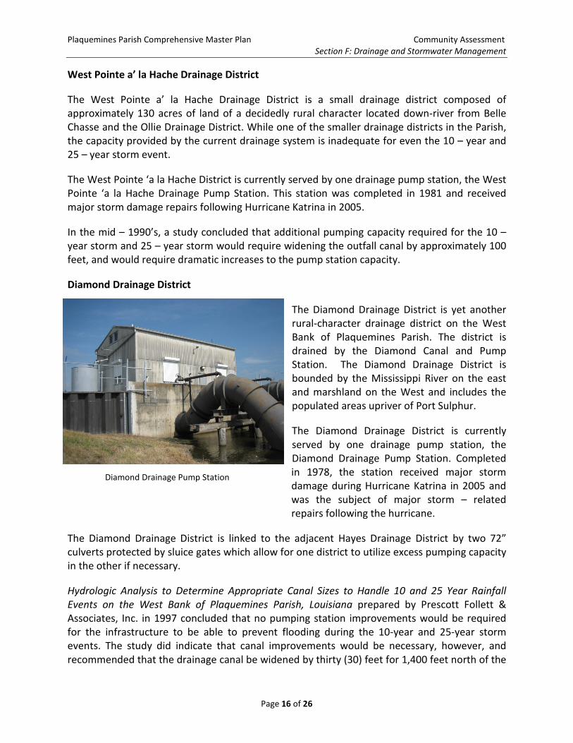
Diamond Drainage District
The Diamond Drainage District is yet another rural-character drainage district on the West Bank of Plaquemines Parish. The district is drained by the Diamond Canal and Pump Station. The Diamond Drainage District is bounded by the Mississippi River on the east and marshland on the West and includes the populated areas upriver of Port Sulphur.
The Diamond Drainage District is currently served by one drainage pump station, the Diamond Drainage Pump Station. Completed in 1978, the station received major storm damage during Hurricane Katrina in 2005 and was the subject of major storm – related repairs following the hurricane.
The Diamond Drainage District is linked to the adjacent Hayes Drainage District by two 72” culverts protected by sluice gates which allow for one district to utilize excess pumping capacity in the other if necessary.
Hydrologic Analysis to Determine Appropriate Canal Sizes to Handle 10 and 25 Year Rainfall Events on the West Bank of Plaquemines Parish, Louisiana prepared by Prescott Follett & Associates, Inc. in 1997 concluded that no pumping station improvements would be required for the infrastructure to be able to prevent flooding during the 10-year and 25-year storm events. The study did indicate that canal improvements would be necessary, however, and recommended that the drainage canal be widened by thirty (30) feet for 1,400 feet north of the
Diamond Drainage Pump Station
Plaquemines Parish Comprehensive Master Plan Community Assessment Section F: Drainage and Stormwater Management
Page 17 of 26
pump station. The study did not recommend any canal improvements to the south of the station nor did it include an evaluation of the capacity of the district’s infrastructure to prevent flooding during the 50-year or 100-year events.
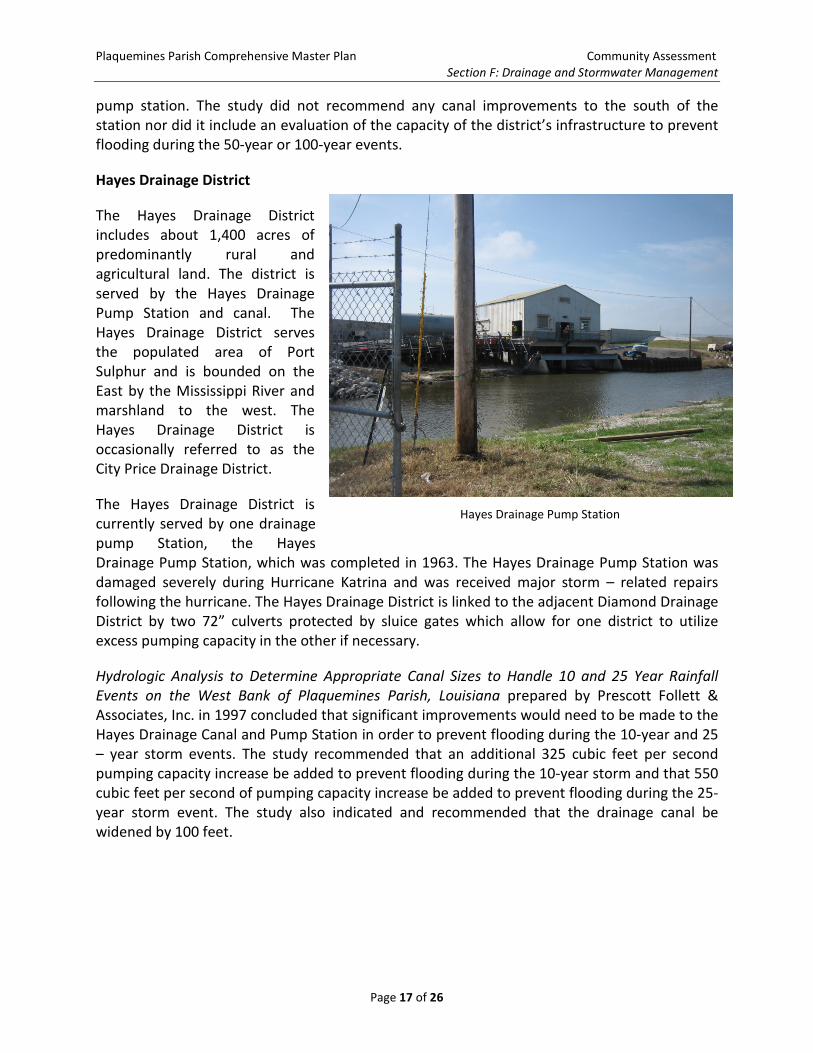
Hayes Drainage District
The Hayes Drainage District includes about 1,400 acres of predominantly rural and agricultural land. The district is served by the Hayes Drainage Pump Station and canal. The Hayes Drainage District serves the populated area of Port Sulphur and is bounded on the East by the Mississippi River and marshland to the west. The Hayes Drainage District is occasionally referred to as the City Price Drainage District.
The Hayes Drainage District is currently served by one drainage pump Station, the Hayes Drainage Pump Station, which was completed in 1963. The Hayes Drainage Pump Station was damaged severely during Hurricane Katrina and was received major storm – related repairs following the hurricane. The Hayes Drainage District is linked to the adjacent Diamond Drainage District by two 72” culverts protected by sluice gates which allow for one district to utilize excess pumping capacity in the other if necessary.
Hydrologic Analysis to Determine Appropriate Canal Sizes to Handle 10 and 25 Year Rainfall Events on the West Bank of Plaquemines Parish, Louisiana prepared by Prescott Follett & Associates, Inc. in 1997 concluded that significant improvements would need to be made to the Hayes Drainage Canal and Pump Station in order to prevent flooding during the 10-year and 25 – year storm events. The study recommended that an additional 325 cubic feet per second pumping capacity increase be added to prevent flooding during the 10-year storm and that 550 cubic feet per second of pumping capacity increase be added to prevent flooding during the 25-year storm event. The study also indicated and recommended that the drainage canal be widened by 100 feet.
Hayes Drainage Pump Station
Plaquemines Parish Comprehensive Master Plan Community Assessment Section F: Drainage and Stormwater Management
Page 18 of 26
Gainard Woods Drainage District
The Gainard Woods Drainage District Consists of nearly 3,000 acres of rural and agricultural land. The district is bounded on the north by the Mississippi River and on the South by marshland.
The district is served by the Gainard Woods Drainage District Canal and Gainard Woods Pump Stations No. 1 and No. 2. Gainard Woods Drainage Pump Station No. 1 was completed in 1960, and was expanded in 1986 by the construction of an adjacent drainage pump station. Gainard Woods Drainage Pump Station No. 2 was the recipient of major storm – related repairs following Hurricane Katrina in 2005. Gainard Woods Drainage Pump Station No. 2 was upgraded as part of Hazard Mitigation Grant Program funded project after 2009.
Hydrologic Analysis to Determine Appropriate Canal Sizes to Handle 10 and 25 Year Rainfall Events on the West Bank of Plaquemines Parish, Louisiana prepared by Prescott Follett & Associates, Inc. in 1997 concluded that significant improvements would need to be made to the Gainard Woods Drainage Canal and Pump Stations in order to prevent flooding during the 10-year and 25 – year storm events. The study recommended that an additional 387 cubic feet per second pumping capacity increase be added to prevent flooding during the 10-year storm and that 737 cubic feet per second of pumping capacity increase be added to prevent flooding during the 25-year storm event. The study also indicated and recommended that the drainage canal be widened by 70 feet.
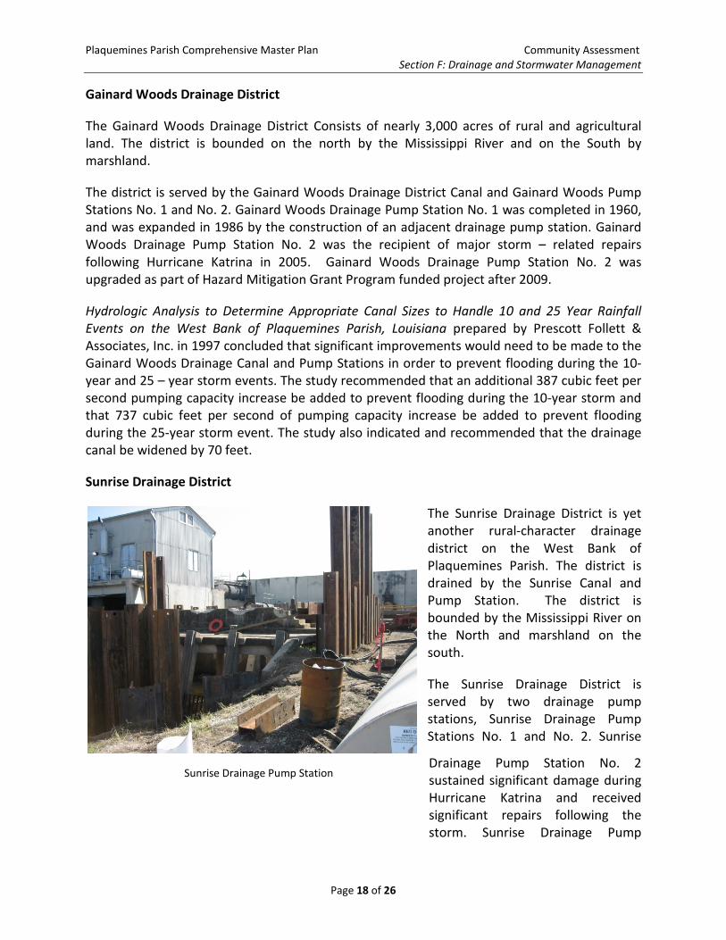
Sunrise Drainage District
The Sunrise Drainage District is yet another rural-character drainage district on the West Bank of Plaquemines Parish. The district is drained by the Sunrise Canal and Pump Station. The district is bounded by the Mississippi River on the North and marshland on the south.
The Sunrise Drainage District is served by two drainage pump stations, Sunrise Drainage Pump Stations No. 1 and No. 2. Sunrise
Drainage Pump Station No. 2 sustained significant damage during Hurricane Katrina and received significant repairs following the storm. Sunrise Drainage Pump
Sunrise Drainage Pump Station
Plaquemines Parish Comprehensive Master Plan Community Assessment Section F: Drainage and Stormwater Management
Page 19 of 26
Station No. 1 was the subject of a Hazard Mitigation Grant Program Project after 2009. The District is interconnected to the adjacent Empire Basin by two 36” culverts protected by sluice gates. This allows the Sunrise Drainage District to pump stormwater out of the Empire Basin when needed.
Hydrologic Analysis to Determine Appropriate Canal Sizes to Handle 10 and 25 Year Rainfall Events on the West Bank of Plaquemines Parish, Louisiana prepared by Prescott Follett & Associates, Inc. in 1997 concluded that significant improvements would need to be made to the Sunrise Drainage Canal and Pump Stations in order to prevent flooding during the 10-year and 25 – year storm events. The study recommended that an additional 325 cubic feet per second pumping capacity increase be added to prevent flooding during the 10-year storm and that 550 cubic feet per second of pumping capacity increase be added to prevent flooding during the 25-year storm event. The study also indicated and recommended that the drainage canal be widened by nearly 90 feet.
Grand Liard Drainage District
The Grand Liard Drainage District Consists of nearly 2,100 acres of rural and agricultural land. The district is bounded on the north by the Mississippi River and on the South by marshland.
The district is served by the Grand Liard Drainage Canal and the Grand Liard Drainage Pump Station in combination with the Triumph Drainage Pump Station. The Stations were on line in 1976 and received major storm damage repairs to the station structures, electrical, and pumping systems following Hurricane Katrina in 2005. The district is interconnected to the adjacent Duvic Drainage District by two (2) 72” culverts protected by sluice gates which allow one district to utilize available pumping capacity in the adjacent district.
Hydrologic Analysis to Determine Appropriate Canal Sizes to Handle 10 and 25 Year Rainfall Events on the West Bank of Plaquemines Parish, Louisiana prepared by Prescott Follett & Associates, Inc. in 1997 concluded that no pumping station improvements would be required to prevent flooding during the 10-year and 25-year storm events. However, the study indicated that the Grand Liard Drainage Canal would need to be widened by 50’ to allow for the district’s infrastructure to be able to perform adequately during the 10-year and 25-year storm events. The study did not evaluate the capacity of the district’s infrastructure to prevent flooding during the 50-year or 100-year events.
Plaquemines Parish Comprehensive Master Plan Community Assessment Section F: Drainage and Stormwater Management
Page 20 of 26
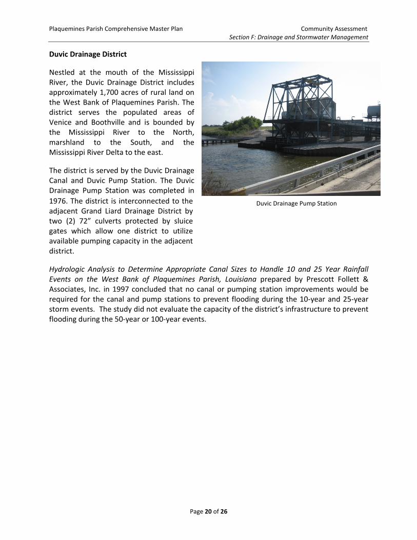
Duvic Drainage District
Nestled at the mouth of the Mississippi River, the Duvic Drainage District includes approximately 1,700 acres of rural land on the West Bank of Plaquemines Parish. The district serves the populated areas of Venice and Boothville and is bounded by the Mississippi River to the North, marshland to the South, and the Mississippi River Delta to the east.
The district is served by the Duvic Drainage Canal and Duvic Pump Station. The Duvic Drainage Pump Station was completed in 1976. The district is interconnected to the adjacent Grand Liard Drainage District by two (2) 72” culverts protected by sluice gates which allow one district to utilize available pumping capacity in the adjacent district.
Hydrologic Analysis to Determine Appropriate Canal Sizes to Handle 10 and 25 Year Rainfall Events on the West Bank of Plaquemines Parish, Louisiana prepared by Prescott Follett & Associates, Inc. in 1997 concluded that no canal or pumping station improvements would be required for the canal and pump stations to prevent flooding during the 10-year and 25-year storm events. The study did not evaluate the capacity of the district’s infrastructure to prevent flooding during the 50-year or 100-year events.
Duvic Drainage Pump Station
Plaquemines Parish Comprehensive Master Plan Community Assessment Section F: Drainage and Stormwater Management
Page 21 of 26
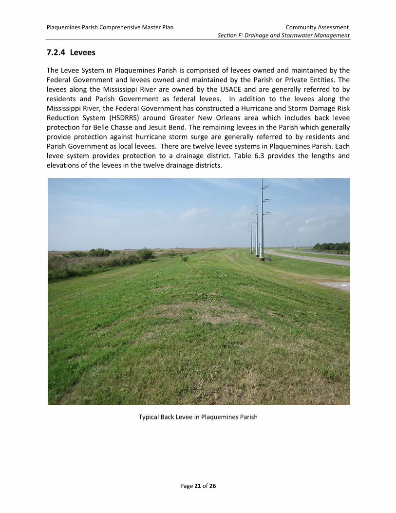
7.2.4 Levees
The Levee System in Plaquemines Parish is comprised of levees owned and maintained by the Federal Government and levees owned and maintained by the Parish or Private Entities. The levees along the Mississippi River are owned by the USACE and are generally referred to by residents and Parish Government as federal levees. In addition to the levees along the Mississippi River, the Federal Government has constructed a Hurricane and Storm Damage Risk Reduction System (HSDRRS) around Greater New Orleans area which includes back levee protection for Belle Chasse and Jesuit Bend. The remaining levees in the Parish which generally provide protection against hurricane storm surge are generally referred to by residents and Parish Government as local levees. There are twelve levee systems in Plaquemines Parish. Each levee system provides protection to a drainage district. Table 6.3 provides the lengths and elevations of the levees in the twelve drainage districts.
Typical Back Levee in Plaquemines Parish
Plaquemines Parish Comprehensive Master Plan Community Assessment Section F: Drainage and Stormwater Management
Page 22 of 26
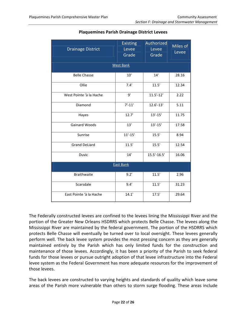
Plaquemines Parish Drainage District Levees
Drainage District Existing Levee Grade
Authorized Levee Grade
Miles of Levee
West Bank
Belle Chasse 10' 14' 28.16
Ollie 7.4' 11.5' 12.34
West Pointe ‘à la Hache 9' 11.5'-12' 2.22
Diamond 7'-11' 12.6'-13' 5.11
Hayes 12.7' 13'-15' 11.75
Gainard Woods 13' 13'-15' 17.58
Sunrise 11'-15' 15.5' 8.94
Grand DeLiard 11.5' 15.5' 12.54
Duvic 14' 15.5'-16.5' 16.06
East Bank
Braithwaite 9.2' 11.5' 2.96
Scarsdale 9.4' 11.5' 31.23
East Pointe ‘à la Hache 14.1' 17.5' 29.64
The Federally constructed levees are confined to the levees lining the Mississippi River and the portion of the Greater New Orleans HSDRRS which protects Belle Chasse. The levees along the Mississippi River are maintained by the federal government. The portion of the HSDRRS which protects Belle Chasse will eventually be turned over to local oversight. These levees generally perform well. The back levee system provides the most pressing concern as they are generally maintained entirely by the Parish which has only limited funds for the construction and maintenance of those levees. Accordingly, it has been a priority of the Parish to seek federal funds for those levees or pursue outright adoption of that levee infrastructure into the Federal levee system as the Federal Government has more adequate resources for the improvement of those levees.
The back levees are constructed to varying heights and standards of quality which leave some areas of the Parish more vulnerable than others to storm surge flooding. These areas include
Plaquemines Parish Comprehensive Master Plan Community Assessment Section F: Drainage and Stormwater Management
Page 23 of 26
the Braithwaite and Dalcour areas on the east bank of the Parish and a stretch along the west bank of the Parish from Alliance to West Pointe ‘a la Hache. These areas are only protected by a small “potato” levee.
Communities such as Braithwaite on the east bank and Oakville, Ironton, Pointe Celeste, and West Pointe ‘a la Hache on the west bank suffered dramatic storm surge flooding and losses during Hurricane Isaac in 2012 due to the inadequate levee protection. Further exacerbating the situation, FEMA in early 21012 indicated that dramatic increases and flood insurance rates were imminent. Without a resolution to this situation, the very existence and livability of these communities may be in jeopardy.
7.3 Summary of Major Drainage Challenges Facing Plaquemines Parish
One of the major challenges facing Plaquemines Parish Government is the challenge of maintaining effective and reliable drainage of interior protected areas for its citizens. When drainage systems work improperly, the consequences could present only minor inconveniences, like street flooding, or flooding in low lying areas of yards. Or, more dramatically, failures in drainage systems can lead to more drastic consequences, such as house flooding, and loss of property or life. Drainage systems and storm-water management policies are incredibly important, because they can affect anyone both physically and economically, as has been seen in recent years.
The geography and location of Plaquemines Parish presents major drainage and stormwater management challenges. Plaquemines Parish is a long peninsula which reaches into the Gulf of Mexico which is bisected roughly in half by the Mississippi River. In order to protect the Parish from these external threats, a complex system of levees has been constructed throughout the history of the Parish. These levees are much higher than the adjacent land, and for this reason, require all precipitation runoff to be collected on the protected side of the levee and pumped over the levee to the marsh. These levees which protect the Parish from external flooding threats on a daily basis complicate drainage greatly as all rainwater must be removed by mechanical means, which is prone to failure during extreme weather events.
Plaquemines Parish drainage is further complicated by several other matters. First, like most of South Louisiana, the area is prone to intense rainfall from thunderstorms. Further, severe weather events such as hurricanes frequently impact Plaquemines Parish. To match this load, drainage systems in Plaquemines Parish must have the ability to carry off a large amount of water in a short amount of time to prevent flooding.
Another factor which complicates drainage in the Parish is the relatively flat terrain, coupled with the fact that many areas in the Parish are at or below sea level. As water seeks to run downhill, the generally flat land does not provide a natural route to exit developed areas.
Plaquemines Parish Comprehensive Master Plan Community Assessment Section F: Drainage and Stormwater Management
Page 24 of 26
Like most Parishes in Southeastern Louisiana which face the same challenges and complications, Plaquemines Parish has elected to utilize a stormwater management of storage and pumping water from the Parish. Recent capital investments related to storm damage have increased pumping capacity at storm damaged stations, but the Parish will need to ultimately make future investments in both capital improvements and operational policies to ensure the success of its stormwater and drainage management strategy in the future.
Another pressing challenge is the minimal hurricane levee protection in many rural areas in the southern reaches of the Parish. This challenge threatens the very existence of many rural communities in the rural downriver portions of the Parish.
7.4 Recent Investments in the Plaquemines Parish Drainage System
The drainage pump stations operated by the Parish have all received varying degrees of capital investment in recent years in order to remediate damages caused by hurricanes and to mitigate future failures. Following Hurricane Katrina in 2005, all twenty – one (21) drainage pump stations operated by the drainage department were repaired. Eight of the stations underwent major storm related repairs. These stations are Diamond Drainage Pump Station, Hayes Drainage Pump Station, Gainard Woods Drainage Pump Station No. 2, Sunrise Drainage Pump Station No. 2, Scarsdale Drainage Pump Station, Bellevue (Davant) Drainage Pump Station, East Pointe ‘a la Hache Drainage Pump Station, and West Pointe ‘a la Hache Drainage Pump Station.
In addition to these storm repairs, five drainage pump stations were modified to comply with Advisory Base Flood Elevation (ABFE) requirements using 2009 funding assistance provided by the Federal Emergency Management Agency (FEMA). This $46.5 million investment will add new pump capacity. The pump station investments include: $7.6 million for Triumph Drainage Pump Station (Upper), $8.0 million for Braithwaite Drainage Pump Station, $7.7 million to the Belair Drainage Pump Station, $7.4 million to the Sunrise #1 Drainage Pump Station, and $15.8 million to the Gainard Woods #1 Drainage Pump Station. FEMA also provided $6.5 million for installation of temporary pumps in the Parish.
7.5 Future Investments in the Plaquemines Parish Drainage System
In its current state, the drainage and stormwater system currently operated in Plaquemines Parish does not always meet the needs of residents and businesses in the Parish. Accordingly, several large concepts to guide future investments were developed. These concepts and recommendations related to them are discussed in more detail in the Community Agenda. However, the broad needs of the Parish are hardening of the pump station infrastructure to guard against failure and increasing of canal capacity for additional storage,
The largest need identified for the Plaquemines the Plaquemines Drainage Department is to undergo a storm-proofing or hardening program throughout the 21 drainage pump stations, much like the programs that are currently being installed throughout Orleans and Jefferson Parishes. These hardening projects, with an estimated cost of $46.2 million, would increase the
Plaquemines Parish Comprehensive Master Plan Community Assessment Section F: Drainage and Stormwater Management
Page 25 of 26
probability of the stations remaining in service during significant storm events. The types of projects would include:
- Installation of safe houses to protect the operators during severe storms - Hardening of the buildings which are currently rated for 120 mph winds, but not the
150 mph winds of a Category 5 hurricane - Mechanical bar screens to prevent damage to pumps during storm events - Reinforcement and protection of fuel tanks from storm – related damage.
Another need is to develop a strategy to enhance the conveyance capacity in parish canals and to add new pump stations. Improve canal maintenance through dredging and cleaning, reshaping, sheet piling, and control structure modifications. Some canal systems need to be extended for improved efficiency. A related concept is for the Parish to pursue servitude agreement to bring private drainage ditches into Parish system to ensure proper maintenance and flood protection.
Future investments will need to be coordinated carefully with coastal restoration programs as the two go hand in hand with one another.
Plaquemines Parish Comprehensive Master Plan Community Assessment Section F: Drainage and Stormwater Management
Page 26 of 26
This page was intentionally left blank for two-sided printing.