assignment reoort for internal use 3p/1d81 …unesdoc.unesco.org/images/0005/000558/055865eo.pdf ·...
TRANSCRIPT

Assignment Reoort 3P/1D81-1983/2/7.3/03 Increasing the capacity of Member States to assess their water resources and to manage them on a scientific basis, and promotion of water policies for economic and social development
FOR INTERNAL USE NOT FOR GENERAL DISTRIBUTION
Z A M B I A
PROBLEMS OF WATER RESOURCES DEVELOPMENT IN RURAL AREAS
by E. Stretta
United Nations Educational, Scientific and Cultural Organization
Paris, April 1983
Serial No. F M R / S C / H Y D / 8 3 / 1 1 7
Assignment Report RP/1981-1983/2/7.3/03 FMR/SC/HYD/8 3/117 (Stretta ) 15 April 1983

(i)
\ m
9
»
i
^^
~ -V
09
NO
Í
M
° m
o
m
z
1
° 1
u
m
o
m
•
r"V
-
c~»
\
« />
< 1
À
•*« -
--
y-
/'
i
-i \
\\
\ I • k\
j )
" \
/ • *****•,
"' 1
1
/ í̂"""̂
* */
ï N
\ J
rr—i
.
o
0
1
•
> í
•
^
y »
SHEDS
u
1 <
o
?|
•-
N
3
0
V
* ^
-J
\ ^
o
2K
«o w
a
0
X
> a
c
) ^ \
>
i fe
t
/^ SCALE 1 4.6O0O0I
> Y
m
« * M
t-0 •

(ü)
PREFACE
The mission described in the present report was carried out from 20 April 1982 to 13 May 1982 at the request of the Government of Zambia, and was funded by Unesco under its Regular Programme for 1981-1983.
The purpose of the mission was:
(a) to review with the National Council for Scientific Research and the Department of Water Affairs the present status of water problems, in particular in rural areas;
(b) to evaluate the national activities related to water resources assessment, in particular as regards groundwater;
(c) to take stock of present methods of obtaining water by rural communities;
(d) to come to an agreement with the Zambian authorities on the participation of Zambia in the Unesco Major Regional Project on the rational utilization and conservation of water resources in rural areas in Africa;
(e) to determine in consultation with the national authorities the need for assistance in the field of water resources assessment and development, especially related to the needs of rural areas;
(f) to take stock, in co-operation with the Resident Representative of the United Nations Development Programme in Zambia, of actual and planned assistance in the field of water resources;
(g) to continue, in consultation with the Regional Office of Science and Technology for Africa, the preparation of the Fourth Regional Training Course for Hydrology Technicians.
The designations employed and the presentation of the material in this document do not imply the expression of any opinion whatsoever on the part of the United Nations Educational, Scientific and Cultural Organization concerning the legal or constitutional status of any country, territory or sea area, or concerning the delimitation of frontiers.

(iü)
TABLE OF CONTENTS
Page
Preface (ii)
INTRODUCTION 1
ELEMENTS UNDERLYING THE PROBLEM OF WATER RESOURCES 2
A. Surface water 2
B. Groundwater 3
C. Present status of water availability in rural areas 4
PRESENT SITUATION OF NATIONAL AGENCIES
RESPONSIBLE FOR RESOURCES DEVELOPMENT 5
A. Department of Water Affairs 5
B. National Council for Scientific
Research (NCSR) 5
C. University of Zamb ia 6
D. Other agencies 7
GOVERNMENT PROJECTS AND INTERNATIONAL CO-OPERATION 7
A. Data gathering and water resources inventory 8
B. Manpower and modern methods of research
and development 9
GENERAL CONCLUSIONS AND RECOMMENDATIONS 10
ANNEX

- 1 -
INTRODUCTION
1. The hydrological characteristics, surface as well as underground, depend directly upon the geography and climatology of the country. We begin with a brief review of the basic geographical data of Zambia.
2. The entire country lies on an eroded plateau between 900 and 1,500 m. above sea level, and the highest points are not above 2,150 m. This eroded plateau forms 'terrasses' at several levels, the oldest lies about 1,900 m. and a second at about 1,300 m. The main cities including the capital Lusaka, are located on the latter.
3. The climatic variations of the Quaternary led to a slight modification in the relief of the plateau through the accumulation of sand in lower areas, to the development of karst phenomena in limestone and to fissuration of the pre-Cambrian rocks.
4. The gentle slopes of the country give rise to many small local depressions swamps and dombos, which facilitate the interpretation of hydrological conditions of the country.
5. It is well known that the general drainage pattern of the country is towards the south-east, the lowest point of the Zambezi Basin in Zambia being near the artificial lake created by the Kariba Dam. The only exceptions are found in the northern part of the country where one finds closed interior basins and some drainage towards the Congo Basin and towards Lake Tanganyika.
6. The peculiar climatology of Zambia, combined with its physical configuration, determines the specific hydrological regime of the country. In contrast to many African countries, Zambia has only one rainy season between October and March, that is, four to four and a half months long, the rest of the year being absolutely without rain.
7. The average annual rainfall oscillates around 1,500 mm. in the north-west province, 900 mm. in the central region and 600 mm. in the southern region. The overall runoff is generally very heavy during the rainy seasons, tapering off at the end, and at the end of the dry season water can be found only in the largest streams.
8. The temperature is in general not high, and the range of temperatures is not wide (between 20 and 33 C). Evapotranspiration however is relatively high because of the great length of the dry season.
9. The population density is relatively small and uniform, except in the extreme West and the extreme East provinces: 5.7 million inhabitants live in an area of 750,000 km.2 (that is, 7 per km2), 2.1 million people live in urban areas and the remaining 3.5 million live in rural areas but cultivate only 7% of the land. Although 70% of the active population is engaged in agriculture, it contributes only 15% of the GNP, while 40% comes from the mining sector, mainly copper.
10. Copper constitutes 80 per cent of the annual export of the country. Although the GNP per capita is small ($450) it is twice that of neighbouring Tanzania, but only a third of Namibia's.
11. The overall deficit in agriculture indicates the low level of national agriculture production.
- 2 -
ELEMENTS UNDERLYING THE PROBLEM OF WATER RESOURCES
12. This flows directly from the main characteristics of the country as described above:
Large runoff due to relatively abundant rainfall in an eroded and pene-planized country with a dense and balanced drainage network filling the upper basins of the two main rivers of Central Africa, the Congo and the Zambezi.
Existence of many swampy regions which are temporarily filled during and after the rainy season, some of them in the centre and north-east of the country, play an important role in the general hydrological balance of these two river basins.
Continuous and abundant water-tables are practically non-existent, except perhaps in the Western province (Kalahari sands) because the impermeable basement complex (Gondwana continent) is mostly very close to, and even on the surface, with very localized exceptions.
Great seasonal variations of the volume of surface water arising from small undergound storage capacity, the impermeability of the basement rocks, the immediate runoff in the rainy season, and the high potential évapotranspiration during the long dry season.
A. Surface water
13. Surface water is distributed among six main river basins. The three largest river basins are drained into the Zambezi, and the three smaller basins belong to the hydrological system of the Congo river.
14. Kafue Basin. Lying completely in Zambia, it includes the richest and the most highly developed part of the country, most of the urban areas, the copper belt and 30 per cent of the population.
15. In this basin one finds two great hydroelectric dams, and between them there is an immense flat region, 300 kms. in length, swampy in places, called the 'Kafue flats' which has an enormous agricultural potential. Upstream of the Itezhi-Tezhi dam a large area of swamps and lakes, partly temporary, forms an 'hydraulic buffer', the hydrological characteristics of which are still not well understood.
16. The agricultural development of this region is one of the stated priorities of the government. A good hydrological model of this region would elucidate the main hydrological characteristics, including of course its water balance, which is a prerequisite for any further planning.
17. Zambezi Basin. In itself, includes the major part of the western and southern provinces of the country. The Zambian part of this basin is situated entirely upstream of the Kariba dam, and includes the famous Victoria Falls.
18. The government hopes to mount a substantial programme of water and agricultural development in the western provinces, still sparsely populated but rich in both surface and groundwater.
19. The northern part of the basin where surface water is abundant, has a great hydroelectrical potential, while the plain surrounding Mongo, capital of the

- 3 -
province, has an agricultural potential as yet unexploited. Two big irrigated state farms are planned in this region.
20. Most of the western province consists of surface deposits (the Kalahari sands) which may be potentially rich in groundwaters.
21. In the southern part of the basin, on the north slope of Lake Kariba, rainfall is only half of that observed further north, and the perennial runoff is less, which reduces the eventual agricultural potential of this region.
22. The Langwa Basin in the Eastern province also drains into the Zambezi river and lies entirely within Zambia. The population is sparse, the hydrometric stations on the river are very few in number, and surface waters are relatively heavily loaded with sediments. This basin includes the greatest wildlife reserve of the country: the population of elephants alone is estimated to be 100,000.
23. The Chambeshi Basin is entirely located in the north-east part of the country and leads into a region of lakes and swamps, which in turn feed the Luapula River, Mureru Lake, and finally the Congo River. This region too has an important agricultural potential already exploited in part with the cultivation of tea and coffee. This region constitutes a way out towards the Indian Ocean port of Dars-el-Saman, via Tanzania by road and railroad.
24. The Basin of Lake Tanganyika. A small part of it lies in the northwest province of Zambia and could become a wheat producing area. These three river basins have an abundant rainfall averaging twice that of the Lusaka region (1,500 m/m per year).
B. Groundwater
25. The study of geological formations, including lithology and structure, allows us to deduce the characteristics of groundwater occurrence of the country.
26. In general, three-quarters of the country has geological formations with slight permeability, therefore not very receptive to infiltration of rain water. This is perhaps the most important hydrogeological feature of Zambia. The low permeability is the uniform characteristic of the Cambrian basement complex made up of gneiss, schists, migmatites, amplibolites, and very few cristaline limestones. This formation outcrops specially in the eastern and southern parts of the country. The yield of wells and boreholes is relatively small and rarely exceeds 1 to 2 1/s.
27. The basement complex is often covered by more recent formations, such as paleozoic, known by geologists as the 'Katanga System'. Sandstones, quartzites and shales are associated with occurrences of limestones, dolomites and fluvioglacial beds. The 'Katanga System' covers 30 per cent of the country, but water bearing limestones and dolomites constitute only 5 per cent of this formation. Where they exist, they are often exploited, especially around Lusaka and in the Copper belt. The yield is good, from 15 to 30 1/s per well in that formation, as compared to 3 to 5 1/s in the conglomerate and quartzites.
28. In the more recent geological succession one finds a complex of volcanic and detritic rocks such as sandstone, grit, marls and mudstones, which are known as the 'Karoo System' which includes permian, triassic and Jurassic, whose average water potential is similar to' that of the basement complex (1 to 2 1/s per well). The 'Karoo System' covers about 5 per cent of the country.
- 4 -
29. As an additional information, we note the presence of sandstone and shales of cretaceous, compact, and very poor in groundwater.
30. Among the more recent formations the 'Kalahari System1 of Pleistocerne could be a typical aquifer. It is formed of very thick layers of sand, sometimes compact (100 to 200 m), alternated with thin layers of clay. This aquifer remains unexploited because it requires advanced drilling techniques and special equipment. Lying in the western region of the country it covers about 20 per cent of the national territory, and its groundwater potential (15 to 20 1/s per well, given by several hydrogeologists as possible after going deep enough) must be added to the surface water potential mentioned above in the Zambezi Basin, and specially in the Mongo region.
31. Igneous and volcanic rocks of all ages appear in many places and are generally almost impermeable. On the other hand, the recent alluvial deposits of the fluvial terrasses and of flat regions may be the source of clear and unpolluted groundwater reserves potentially useful for water supplies of human settlements.
32. We can conclude that most of the boreholes already made have reached all the geological formations of the country. With the exception of the Kalahari Sands, their hydrological properties can be taken as given, always admitting isolated exceptions. Nevertheless, the aquifers already being exploited should be studied in detail in order to intensify and rationalize their use without endangering the reserves, specially in limestone and dolomite formations around Lusaka.
C. Present status of water availability in rural areas
33. The following information was supplied by the two main national institutions dealing with water resources development in the country: the National Centre of Scientific Research (NCSR), attached to the Prime Minister's Cabinet, and the Department of Water Affairs of the Ministry of Agriculture and Water Development.
34. In the provinces and districts domestic water supply is the responsibility of the Department of Water Affairs for general planning and investment activities. Irrigation and use of surface water in agriculture is the responsibility of the Department of Agriculture.
35. Among other institutions which have a substantial role, one may mention the Community Development Department of the Ministry of Labour and Social Affairs. The integrated and comprehensive development of the water resources of Zambia is now the responsibility of a Water Development Board which, according to the law, 'considers and decides upon applications for water rights made by persons or institutions'. This Water Development Board consists of a chairman and four principal members appointed by the Minister of Rural Development. At present, the Water Board provides an adequate mechanism for the co-ordination of various departments and local authorities concerned with the development of different water uses.
36. It appears that Zambia has an adequate system for co-ordination and decisionmaking for water resources development and management. Curiously enough, this system at present deals only with surface water, but it should be extended soon to groundwater.
37. It is estimated that 70 per cent of the rural population, including the population of satellite towns of large cities, is inadequately supplied with drinking
- 5 -
water. But even in the cities only about 20 per cent of the population have access to proper water supply derived from wells, boreholes or treated surface water. Only 20 per cent of the rural population is supplied with safe drinking water by wells or boreholes. This shows the measure of the work that remains to be done' in the country. Outside the cities, mechanical or electric pumping is very rarely seen. Boreholes are generally equipped with hand-pumps domestically made and reasonably reliable, but wells are mostly open and equipped only with buckets and windlasses which, of course, give rise to pollution. Windmills are very few in number, and are mostly installed in private commercial farms. Windmills should be manufactured locally and used much more frequently, because they are simple to make, reliable and relatively inexpensive.
PRESENT SITUATION OF NATIONAL AGENCIES RESPONSIBLE FOR WATER RESOURCES DEVELOPMENT
38. The national administrative structures appear to be quite adequate for the purpose for which they are intended, and present water development projects are in principle based upon a certain knowledge of water regime of the country. Incomplete as this knowledge is, it is adequate to permit progress at least in certain areas.
A. Department of Water Affairs
39. The Ministry of Agriculture and Water Development is the key of the entire system because it is either directly responsible for every irrigation project, or for projects of hydraulic works including water supply, or it is automatically consulted on the technical level as soon as water is concerned.
40. The Department of Water Affairs was the point of contact of the present mission, and together with the National Centre of Scientific Research (NCSR), guided its activities. The administrative structure of this department is functional and balanced with data and planning service, water supply service, as well as administrative and financial service.
41. The data and planning service has a surface hydrology section, an hydrogeo-logical section, and a drilling section. The water-supply service is responsible for the functioning of nine provincial services (one per administrative province) and for a central workshop and chemical laboratory.
42. The weakness of this organization, excellent in its structure, lies in the scarcity of qualified manpower, many high level posts (around twenty) being unfilled. For example, the post of chief engineer in charge of data and planning service, responsible for co-ordiñating all activities concerning surface water and groundwater, is unfilled. The situation is equally critical in provincial offices where half of the engineering posts are vacant. Furthermore, if we note that many of the experienced engineers and scientists serving in Zambia are expatriates recruited abroad (on long-term contracts) we will understand the great need for training national staff.
B. National Council for Scientific Research (NCSR)
43. Scientific research both basic and applied is the responsibility of the NCSR. The council seems appropriately organized to deal with the scientific problems of economic development of the country such as the preservation and rational use of natural resources. Out of eight research units two are concerned with
- 6 -
water resources: the water resources unit itself and the environmental research unit.
The water-resources unit has a surface hydrology section, a hydrogeology section, and a special section devoted to the study of representative hydro-logical basins, the Luano Catchments Research Project.
The environmental research unit has a water chemistry section, an air pollution section, and a soil science section.
44. An annual bulletin of the Council publishes a compiled report of its research activities.
45. Here too, many foreign scientists have been recruited to fill posts which will eventually be taken by Zambians now studying abroad for post-graduate degrees (M.Sc. and Ph.D.). As an example, the inventory of groundwater resources began at NCSR by the Unesco-Norway Project (1975-1978) was interrupted when the expert left. This essential task may be resumed when a Zambian hydrogeologist returns to Zambia after completing his studies abroad.
C. University of Zambia
46. A summary of the current activities of the University of Zambia related to the urgent manpower needs of the above-mentioned institutions is given:
47. The School of Engineers offers a five-year course of studies, of which the last two years are for specialization in electrical, mechanical or civil engineering. The engineering degree corresponds to the B.Sc, and the graduates are obliged to seek their higher degrees abroad.
48. The University has a 'staff development fellows' programme' intended to train Zambians abroad eventually to assume teaching responsibilities in the University.
49. Graduate civil engineers are expected to join a government agency, i.e. the Department of Water Affairs among other agencies. The government awards one or two fellowships a year for two or three years of study abroad, mostly to obtain a Master degree, rarely a Ph.D.
5C. Student engineers at the University receive scholarships from the government but private companies, notably the mining companies, offer their own scholarships, often under more favourable terms, to attract the people they need. This competition reduces the number of graduates available for the civil service and specially the number of civil engineers, because the mining industries seek mainly mechanical and electrical engineers.
51. An average of five to six civil engineers which may rise to twelve to fifteen by 1983 come to the market each year, which is obviously insufficient to satisfy the needs of the country.
52. If, on one hand it seems necessary to increase the number of fellowships to study abroad, it is, on the other hand, necessary to institute training for the Master's degree in the University of Zambia, at least in those disciplines for which there is great demand, including water resources. The University expects to implement such courses in the future.
- 7 -
53. From time to time the School of Engineers offers training for hydrology and hydraulics and water quality technicians at middle and upper levels, which attracts about ten students in each course. This programme should be made a permanent feature of the School of Engineers to satisfy the increasing demand for middle-level personnel.
54. In conclusion, the problem of training of national staff is a crucial one, and many of the present difficulties of the country cannot be resolved otherwise. This is specially important for water resources, and efforts must be made to attract more young engineers into national services.
D. Other agencies
55. The shortage of trained manpower at every level coupled with inadequate budgets is a handicap to every agency concerned with rural development.
56. Topographical maps are available for the whole country on a scale of 1/250,000, but this is inadequate for any development planning for the sparsely populated regions. Some excellent maps at 1/50,000 published many years ago cover the best developed regions. The coverage at 1/50,000 should be extended to the whole country with priority given to the regions where, for instance, state farms are planned, because irrigation works cannot be designed without adequate topographic data.
57. Thematic maps (soils, water, vegetation, etc.) are available only on a small scale, in relatively small numbers and without common symbols.
58. The Rural Community Development Department which we visited have field projects and activities which are directly related to the welfare of the rural population. We found that the equipment, budget and specialized staff of the Department are very limited in view of the responsibilities given to them.
59. The Meteorological Service gathers meteorological data from a network of stations altogether too few in number, considering the size of the country. Meteorological data are processed using the central computer service of the Ministry of Finance, which is inadequate to meet all the demands of the government. As a result, meteorological data computing as well as their publication are delayed, which has an adverse effect on the planning and design of agricultural projects.
60. As an example of a research problem which cannot be tackled because of lack of computing power, we indicate the fact that the rainfall of the 1981/1982 season was much below average in the southern part of the country as well as in the extreme north. A similar phenomenon occurred about ten years ago. A comparative study would be extremely enlightening with regard to the hydrological and hydrogeological effects.
GOVERNMENT PROJECTS AND INTERNATIONAL CO-OPERATION
61. Without attempting to summarize current government projects, many of which are the subject of international co-operation or bilateral assistance, it is sufficient to mention those which ought to be financed immediately because of current priorities, or because of temporary manpower difficulties.

- 8 -
A. Data gathering and water resources inventory
62. For various reasons systematic gathering of data is very poor and intermittent, which makes it impossible to plan with any confidence for the rational use of water resources, and especially surface water.
Hydrometeorological data, especially rainfall
63. It has been remarked above that the network consists of only thirty-four fully equipped stations and that this number should be substantially increased. Systematic publication of data is delayed (at present six years in arrears) although a general description of the climatology of the country was published in 1981.
64. The National Meteorological Service certainly needs more technical staff, better equipment, far more stations and adequate modern computer facilities.
Hydrometrie data
65. The government intends to increase the number of stations and to have a better coverage of the country. For instance, the western province has until now had totally inadequate hydrometric coverage for agricultural projects which the government expects to start in the near future.
66. More automatic stations are to be installed and regular measurements of sediments made especially in the Longwa River Basin in the northern province.
67. But the most urgent need is to modernize the data centre of the Department of Water Affairs where a team of about a dozen persons process the surface hydrology data of the country by hand. The publication of the hydrological yearbooks is five years late. The consultant believes that the purchase of mini-computers jointly with the organization of a short training course in their use would be a great step forward.
Systematic observation of groundwaters
68. This began at NCSR by specialists trained under the Unesco NORWAY project but was stopped in 1978. Some test wells were drilled, but their regular observation has not been continued. Although it would be desirable to reinstitute a regular programme of observations, the peculiar hydrogeology of Zambia is such that the necessary data may be gathered in an easier way.
69. As a first step, it would be adequate to make regular observations of the most typical aquifers of the country as described in paragraph II.B, where groundwaters normally occur even when the water-table is not continuous. Thus, with a few observation wells one would immediately obtain the general characteristics of the main aquifers of the country. Such an operation should be undertaken with priority given to two major aquifers: the Kalahari sands and the limestones and dolomites formations.
70. In addition to this information about the main aquifers, a systematic full chemical analysis must be made, not only in respect to potability and pollution, but also to determine the origin and age of groundwaters (jointly with radioisotope studies). These investigations must be planned and carried out in the
- 9 -
laboratories of the NCSR. For this purpose the laboratory of environmental hydrology of NCSR would need trained staff and should be equipped with a complete mobile laboratory.
71. To complement this work the Department of Water Affairs must be strengthened and especially the post of chief chemist must be filled.
B. Manpower and modern methods of research and development
Trained manpower
72. We have seen above that the systematic development of water resources is practically paralysed by the absence of trained manpower at every level, and specially in numerous key posts in the government services.
73. The mission was encouraged to see that the necessary administrative structures exist and that the available technical staff appears to accomplish miracles. This also serves to emphasize the fact that engineers and scientists must go abroad for their final professional training and that the absence of financial resources and lack of essential equipment remain an evident handicap.
74. In view of the government's priorities for agricultural development and the urgency of extending irrigated areas (only 25,000 ha. are presently irrigated in Zambia) we conclude that the training of water resources engineers, hydrologists and hydrogeologists, at least to the Master degree level, is absolutely essential. For this purpose the government must call upon international or bilateral assistance to train more water scientists abroad or to institute advanced training courses in the University of Zambia.
75. The training of technicians seems to be an easier problem. The School of Engineers is prepared to offer suitable courses more frequently, with a wide variety. International organizations should offer more national or regional training courses, such as the regional Unesco/Norway course to be held from July to September 1982 at Lusaka, with the expected participation of about ten Zambian technicians.
Research equipment and modern methods of water research and development
76. Another weak point is the absence of modern equipment for water investigations and the availability of the modern techniques of system analysis.
77. Complete development of water resources depends also upon the availability and use of simple and reliable equipment which can be locally produced and easily repaired. This implies the availability of financial resources for construction and the development of production and maintenance facilities.
78. The most urgent equipment needs include:
suitable transport for staff and equipment;
better supply of flow measuring equipment;
special equipment for investigation of water quality and chemical studies;
high speed computing facilities for water balance studies and modelling.

- 10 -
79. Transposing the surface and groundwater data bases to the computer requires a certain minimum of high-speed calculating equipment such as any modern water resources research unit should have. Otherwise it seems unrealistic to think of making adequate hydrological balance studies such as that required, for instance, on the northern half of the Kafue River Basin where a large scale irrigation scheme is proposed, and for which the Department of Water Affiars is seeking an eighteen-month mission of a water-resources engineer specialized in surface water management.
80. For the exploitation of groundwaters in the western province where Norway is preparing a drilling programme of 1,000 boreholes, very specialized drilling equipment and highly-trained drillers are needed because the sandy aquifers lie relatively deep. These aquifers also require special care in the installation of any pumping system as well as in the 'development' of each well.
81. To properly locate the boreholes the advice of an experienced hydrogeologist is also required. The NCSR, in their request for multilateral assistance (see Annex I), have indicated the urgent need for such a specialist.
82. The mission observed that Swedish and EEC drilling programmes should be based upon a better understanding of the hydrogeology of the country, and that these boreholes should in turn contribute, with systematic drilling and pumping data, to improve the hydrogeological inventory of the country.
83. Finally, in the rural areas, where groundwater is adequate only for domestic purposes, and this is the case for 80 per cent of the country areas and villages and townships, agriculture will depend upon irrigation. For this purpose impounded surface waters are to be envisaged, which implies in turn a systematic programme of small earth dams and a few irrigation canals.
84. This combination of dams and wells or boreholes has been systematically applied in Zimbabwe, where the geological structure and the hydrological conditions are similar.
85. The application of this method in most rural centres of Zambia should lead to an immediate pay-off, but large flat areas require more modern irrigation networks. In the northern part of the country this latter system is being adopted for areas of up to a thousand hectares, but this system of agricultural development could be used in many places for smaller schemes.
86. On the other hand, when a large yield water-table is detected, as in the region around Lusaka, a different agricultural policy must be applied.
GENERAL CONCLUSIONS AND RECOMMENDATIONS
87. We have seen above that the development of rural agriculture requires an harmonious use of both surface and groundwater. This is dictated by the hydro-meteorological conditions of the country in which a relatively large rainfall is concentrated in a single short rainy season, followed by a long (eight months) dry season.
88. In 80 per cent of the country groundwater supplies are adequate only for domestic purposes, and a single borehole can support only 200 to 300 persons. In such regions the use of surface water must be developed for irrigation with the construction of dams and irrigation canals of various dimensions.

- 11 -
89. Where shallow lying limestone and dolomite aquifers are found the problem is different, as well as for areas with sandy aquifers. In these cases complete studies must be made. Practically none have been made to date.
Recommendation I
The general inventory of surface and groundwater should be expanded and prepared for the computer. In certain regions such as the Kafue Basin adequate mathematical models should be constructed.
The water-bearing characteristics of the most common geological formations should be studied as best they can with existing wells and boreholes while waiting for a more complete observation network to be developed. These studies should be carried out for typical aquifers of both large and small yields.
A project for foreign assistance of this nature was prepared by the NCSR and should be considered most carefully by the Government Planning Office with a view to obtaining multilateral aid. This project covers all the assistance necessary to carry out this recommendation (see Annex).
The modern approach to the problem of water use includes such subjects as environmental hydrology, chemical and bacteriological quality of drinking water, chemical studies as a tool to determine velocity of infiltration and underground water flows, radio-isotopes for determination of the age of water, and other nuclear techniques for water studies.
These subjects are practically untouched in Zambia although some efforts have been made by the NCSR. On the other hand, the existing laboratories have only out-of-date equipment and require re-equipping.
Recommendation II
The laboratory of environmental hydrology requires modernization, its staff needs to be increased, and it should be given better facilities for field work.
The NCSR has already prepared and submitted a request for a mobile water laboratory equipped for chemical and physical studies and eventually pollution studies.
This modest request could possibly be financed by one of the international organizations or by a bilateral programme of assistance.
A nuclear laboratory could also be considered at some later date.
* * *
The development of surface water for agricultural needs, especially in the Kafue Basin, is a high government priority. Water balance studies in the basin and its surrounding lakes and swamps are necessary, as well as a detailed study of the influence upon the water balance of two existing hydroelectric dams.

- 12 -
Recommendation III
These studies could be included in the NCSR request mentioned above in recommendation II.
This water balance study would cost about $150,000 for a water resources engineer for eighteen months minimum, and some corresponding equipment. The services of this expert are badly needed, as well as those of the hydrogeologist.
In this case, the water resources engineer would work more closely with the Department of Water Affairs while maintaining contact with the NCSR. This arrangement would necessarily lead to better co-ordination between these two institutions.
* * *
This mission has noted a shortage of scientifically and technically qualified staff at all levels and in every discipline, both at decision levels and among technicians.
While the government makes great efforts to send Zambian students abroad for advance training, the number that can be trained is inadequate, and both short-term and long-term solutions need to be found.
Recommendation IV
It is important that more student-engineers be encouraged to enter civil engineering: this could include the provision of suitable career opportunities, as well as payment of salaries comparable with private and 'para-statal' industry.
The only short-term solution would be to send more students abroad and to establish a coherent programme of training and career development for civil service engineers.
The long-term solution would be to develop a modern programme of postgraduate studies at the University of Zambia. This would require specialized laboratories and training abroad of the Zambian teaching staff. A project embodying these components could be developed by the university and presented for external financing.
It would be advisable for the government to take steps to avoid duplication of efforts by the agencies responsible for water resources investigations. This would alleviate the difficulties observed by the mission in laboratory facilities, field transportation and utilization of trained staff.
Recommendation V
It would be preferable for the Department of Water Affairs, which gathers hydrometric and hydrogeological data, and the NCSR, which undertakes general or special studies, to work even more closely together and be considered as a single unit dedicated to the study and the development of water resources.
- 13 -
The NCSR should be considered the studying and advisory branch of the Department of Water Affairs, not only in the capital but also in each province.
A water scientist, preferably a hydrologist, should work closely with the water engineer in each provincial office of the Department of Water Affairs.
This recommendation can be put progressively into effect, province by province, as qualified staff becomes available, taking into account, of course, the development priorities established by the government. (For instance, the Kafue Basin should be the first.)
Such a regional organization would eliminate many transport and communications problems which arise from the execution of scientific field studies from a central base. It would associate more closely together in the field, the water scientist and the water engineer.
Annex I
ANNEX I
REQUEST FOR MULTILATERAL ASSISTANCE TO STRENGTHEN THE WATER • RESOURCES RESEARCH UNIT OF THE NATIONAL COUNCIL FOR
SCIENTIFIC RESEARCH, ZAMBIA(l)
(Document prepared by the National Council for Scientific Research on 29 April 1982)
1. The NCSR confirms the priority status of the project 'Inventory of Water Resources of Zambia' upon which the request for assistance was submitted initially to Unesco in 1978 and then to the UNDP-Interim Fund for Science and Technology for Development. The justification is adequately given in the original project document submitted to Unesco and UNDP. Specifically, the project shall:
(a) provide information for the elaboration of a national water resource master plan;
(b) be executed in close liaison with immediate agricultural development schemes (irrigation schemes) and schemes for improving drinking water supplies to rural as well as urban communities.
2. While the NCSR wishes to retain the descriptions and explanations contained in the original documents submitted to Unesco and UNDP, It recognizes the need to execute the project in phases:
(i) The first phase to run for three years from 1983 to 1985 and to cover:
(a) water resources assessment of the Kafue in relation to current water resources distribution and management problems;
(b) planning and establishment of an appropriate network for the study of groundwater resources of the Zambezi Basin (Kalahari Sands Basin);
(ii) The second phase to start in 1986 shall be planned to cover:
(a) monitoring and assessment of the water resources of the Zambezi;
(b) establishment of an appropriate network for groundwater resources of the Chambeshi Basin and assessment of groundwater resources of the Basin in relation to the surface water resources of the region.
3. The Kafue Basin is a central basin and its proximity to the railway line which has been the focal region of development, has made the basin as a major target for development—hydroelectricity generation, major irrigation scheme, wildlife conservation areas, fisheries, etc., and its flat plain has been the traditional cattle grazing area of the local people. It is also speculated that the Zambezi and Kafue Basin may have some hydrogeological relationships.
(1) The present text constitutes part of the project plans and does not commit Unesco or the United Nations Development Programme to provide any assistance.

Annex I - page 2
4. The requested input for the First Phase is as follows:
(a) Assignment of Personnel
(i) Expert in Hydrogeology
Eighteen man-months during which the expert, in consultation with the Secretary-General of the National Council for Scientific Research and in co-operation with the staff of the Water Resources Research Unit, shall have the following duties:
to plan and establish an appropriate geophysical studies and groundwater observation network in the Kafue and Zambezi basins;
establish and train local staff in modern techniques for monitoring and assessing groundwater resources;
to evaluate and advise on the progress of the activities to elaborate the geophysical characteristics of the two basins in regard to their groundwater resources;
to advise on the composing of the technical report on the groundwater resources of the two basins;
to advise on investigations of hydrogeological problems related to specific projects commissioned to the Water Resources Research Unit;
when requested, to advise the government agency responsible for water resources development on evaluation and management of groundwater resources of specific areas.
The expert should be an experienced hydrogeologist (geohydrologist) with experience in modern techniques of groundwater survey and assessment. He should also be an active field investigator prepared to spend 50 per cent of his time in the field.
(ii) Expert in Environmental Hydrology
Six man-months during which the expert, in consultation with the Secretary-General of the National Council for Scientific Research and in collaboration with the staff of the Water Resources Research Unit, shall have the following duties:
advise on the adequacy or otherwise of the existing gauging network, in the Kafue River Basin and recommend appropriate improvements where necessary;
to plan and establish methodologies for the assessment and distribution and management of water resources of the Kafue Basin;
train the local staff assigned to the project in the modern techniques and methodologies for the elaboration of. systematic hydrolo-gical water balances for the Kafue Basin in relation to the current and potential development projects in the basin;

Annex I - page 3
evaluate and advise on the progress of the activities to elaborate the surface water resources of the Kafue Basin;
advise on the composing of the technical report on the surface water resources of the Kafue Basin;
when requested, to advise on the evaluation and management of surface water resources of any given area.
The expert should be a water resources scientist with wide experience in surface water resources assessment and management and adequately experienced in modern data processing techniques, preferably including at least five years professional activities in semi-arid or arid regions. He should be an active field worker willing to devote about 25-30 per cent of his time in the field.
(b) Equipment
Field and laboratory equipment, including equipment for geophysical measurements, hydrometeorological gauging equipment, computing equipment and a Land Rover for field trips.
(c) Contractual Services
The cost of geophysical studies, drilling wells and boreholes and aquifer tests and short-term consultancy when necessary.
(d) Operational Costs
Cost of fuel, lubricants, vehicle maintenance, field subsistence allowances, chemicals, computer time charges, preparation ôf maps and reports.
(e) Fellowship
Forty-eight man-months for two university graduate training (one in hydrogeology or geophysics and one in environmental hydrology);
Twelve man-months for short-term technician's fellowships (hydrological data processing and geophysical techniques).
(f) Contingency
To cover any project operation's contingent expenses such as spare parts and repair of equipment, unexpected price rises during the course of the three years.

Annex I - page 4
SUMMARY QF INPUT
PHASE I
Man- Total Man- 1983 Man- 1984 Man- 1985 Months Months Months Months
Expert (PS) 18 90 10 50 4 20 4 20 Hydrogeology
Environmental 6 30 3 15 1 5 2 10 Hydrology
Other 2 - 1 - 1
Sub-total 26 120 13 65 6 25 7 30
Geophysical - 50 - 30 - 20
Studies Borehole - 300 - 200 - 100
Programme
Operational Costs - 12.5 4 4.5 - 4
Preparation of - 10 _ _ _ _ _ io maps and reports
Sub-total
Fellowships
Equipment
Contingency
-
60
-
-
372.5
50
87.5
5
-
-
-
-
34
10
47.5
1
-
-
-
-
224.5
30
30
3
-
-
-
-
114
10
10
1
Grand Total 86 635 13 157.5 6 312.5 7 165

Annex II
ANNEX II
STRENGTHENING THE ENVIRONMENTAL RESEARCH LABORATORY OF THE NATIONAL COUNCIL FOR SCIENTIFIC RESEARCH TO INCREASE ITS CAPACITY
IN POLLUTION MONITORING SERVICES(1)
SUMMARY
For prevention and control of health hazards associated with water-borne diseases and water pollution, it has been planned to develop a thorough surveillance and monitoring programme of water quality and pollution trends in Zambia. But limited resources do not permit us to develop a network of the monitoring laboratories.
An economical and effective alternative of acquiring a mobile laboratory unit has been suggested in this project. It will achieve the following objectives:
(i) to ascertain the quality of natural water in the Republic of Zambia;
(ii) to determine the level of pollution in domestic and industrial effluents;
(iii) to identify the sources and nature of pollutants and their effect on man and environment; and
(iv) to correlate monitoring data with epidemiological findings, so that health authorities can take appropriate measures to prevent water-borne diseases.
The mobile laboratory will be equipped with the equipment, glassware and chemicals, etc., essential to carry out on the spot analysis of water. This includes temperature, pH, acidity/alkalinity, colour, organic pollutants, oxygen demanding parameters, residual chlorine and various microbiological tests. The rest of the sample will be preserved to carry out analysis at the Environmental Research Laboratory.
Project requirements
(i) Local input
(a) facilities at the Environmental Research Laboratory; and
(b) maintenance and running costs of mobile unit, manpower, equipment, chemicals glassware and transport.
ANNUAL EXPENSES K30.000
(ii) Requested input
Land Rover and trailer equipped with laboratory equipment, chemicals, glassware, etc., costing U.S. $67,000.
(1) Document prepared by the National Council for Scientific Research, 3 May 1982.
Annex II - page 2
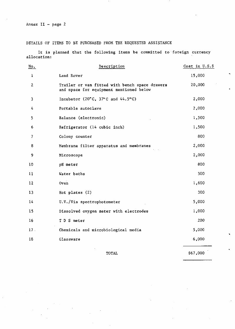
DETAILS OF ITEMS TO BE PURCHASED FROM THE REQUESTED ASSISTANCE
It is planned that the following items be committed to foreign currency allocation:
No. Description Cost in U.S.$
1 Land Rover 15,000
2 Trailer or van fitted with bench space drawers 20,000 and space for equipment mentioned below
3 Incubator (20'C, 37°C and 44.5°C) 2,000
4 Portable autoclave 2,000
5 Balance (electronic) 1,500
6 Refrigerator (14 cubic inch) 1,500
7 Colony counter 800
8 Membrane filter apparatus and membranes 2,000
9 Microscope 2,000
10 pH meter 800
11 Water baths 300
12 Oven 1,600
13 Hot plates (2) 300
14 U.V./Vis spectrophotometer 5,000
15 Dissolved oxygen meter with electrodes 1,000
16 T D S meter 200
17 Chemicals and microbiological media 5,000
18 Glassware 6,000
TOTAL $67,000