asx: znc li2 o for personal use only · contact details level 2/33 ord street west perth, wa, 6005...
TRANSCRIPT

2nd February 2016
High-Grade Lithium up to 4.05% Li2O - Mt Alexander Project
High-grade lithium samples (up to 4.05% Li2O) at Zenith’s 100% owned Mt Alexander
Project;
Seven rock chip samples with lithium oxide assays ranging from 3.38%Li2O to 4.05%
Li2O and tantalum oxide assays from 0.023% Ta2O5 to 0.034%Ta2O5 from a reported
lepidolite rich pegmatite dyke;
The pegmatite dyke that has been sampled is one of more than 100 pegmatite and
granite dykes that form a 2 kilometre x 2.5 kilometre radiating swarm surrounding the
Mortgage Monzonite intrusive stock. The other pegmatite dykes do not appear to
have been systematically mapped or sampled for lithium or tantalum;
The seven samples are from a batch of only 10 samples known to have been analysed
for lithium from the Mt Alexander Project, where the recent focus by Zenith has been
on iron ore; and
Surface mapping and sampling along with an assessment of existing drill samples is
planned as pegmatite was recorded in multiple drill holes during the Mt Alexander
iron ore resource drilling programs.
Zenith Minerals Limited (Zenith or the Company) is pleased to advise that high-grade lithium occurs in surface samples collected at the 100% Zenith owned Mt Alexander project, located in Western Australia (Figure 1).
Figure 1: Photo of a polished rock specimen containing high-grade lithium from the Mt Alexander Project (purple coloured mineral is the lithium rich mica – lepidolite)
Corporate Details
ASX: ZNC
Issued Shares 128.6 m
Unlisted options 1.1 m
Mkt. Cap. ($0.037) A$ 4.8m
Cash 31st
Dec 15 A$0.43M
Debt Nil
Directors
Michael Clifford: Managing Director
Mike Joyce: Non Exec Chairman
Stan Macdonald: Non Exec Director
Julian Goldsworthy: Non Exec Director
Major Shareholders
HSBC Custod. Nom 8.4%
Nada Granich 6.2%
GDR PL 4.8%
Miquilini 4.6%
Citicorp Nominees 3.9%
Contact Details
Level 2/33 Ord Street
West Perth, WA, 6005
Mail: PO Box 1426
West Perth, WA, 6872
T: +61 8 9226 1110
F: +61 8 9481 0411
E: [email protected] W: www.zenithminerals.com.au
For
per
sona
l use
onl
y
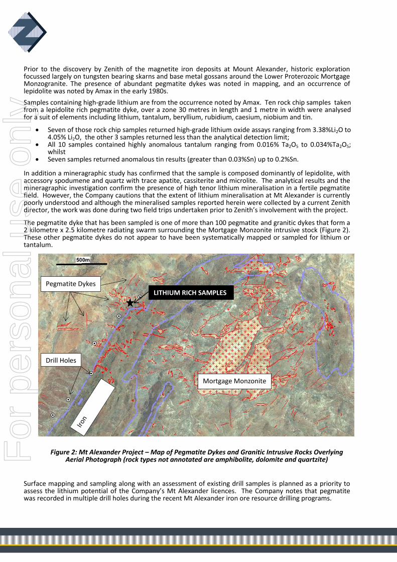
Prior to the discovery by Zenith of the magnetite iron deposits at Mount Alexander, historic exploration focussed largely on tungsten bearing skarns and base metal gossans around the Lower Proterozoic Mortgage Monzogranite. The presence of abundant pegmatite dykes was noted in mapping, and an occurrence of lepidolite was noted by Amax in the early 1980s.
Samples containing high-grade lithium are from the occurrence noted by Amax. Ten rock chip samples taken from a lepidolite rich pegmatite dyke, over a zone 30 metres in length and 1 metre in width were analysed for a suit of elements including lithium, tantalum, beryllium, rubidium, caesium, niobium and tin.
Seven of those rock chip samples returned high-grade lithium oxide assays ranging from 3.38%Li2O to 4.05% Li2O, the other 3 samples returned less than the analytical detection limit;
All 10 samples contained highly anomalous tantalum ranging from 0.016% Ta2O5 to 0.034%Ta2O5; whilst
Seven samples returned anomalous tin results (greater than 0.03%Sn) up to 0.2%Sn.
In addition a mineragraphic study has confirmed that the sample is composed dominantly of lepidolite, with accessory spodumene and quartz with trace apatite, cassiterite and microlite. The analytical results and the mineragraphic investigation confirm the presence of high tenor lithium mineralisation in a fertile pegmatite field. However, the Company cautions that the extent of lithium mineralisation at Mt Alexander is currently poorly understood and although the mineralised samples reported herein were collected by a current Zenith director, the work was done during two field trips undertaken prior to Zenith’s involvement with the project.
The pegmatite dyke that has been sampled is one of more than 100 pegmatite and granitic dykes that form a 2 kilometre x 2.5 kilometre radiating swarm surrounding the Mortgage Monzonite intrusive stock (Figure 2). These other pegmatite dykes do not appear to have been systematically mapped or sampled for lithium or tantalum.
Figure 2: Mt Alexander Project – Map of Pegmatite Dykes and Granitic Intrusive Rocks Overlying Aerial Photograph (rock types not annotated are amphibolite, dolomite and quartzite)
Surface mapping and sampling along with an assessment of existing drill samples is planned as a priority to assess the lithium potential of the Company’s Mt Alexander licences. The Company notes that pegmatite was recorded in multiple drill holes during the recent Mt Alexander iron ore resource drilling programs.
Mortgage Monzonite
Pegmatite Dykes LITHIUM RICH SAMPLES
Drill Holes
For
per
sona
l use
onl
y

Background on Mt Alexander Project
The Mount Alexander Project is 120 km from the port of Onslow, and 260 km south west of Karratha in the West Pilbara region of Western Australia, close to the Pilbara coast, the sealed North West Coastal Highway and the Dampier Bunbury gas pipeline. Planned rail from the nearby West Pilbara Iron Project (Baosteel/AMCI JV) to a new port development at Anketell Point provides a possible alternative infrastructure solution.
Zenith discovered magnetite iron mineralisation occurs in a banded iron formation (BIF) associated with a sequence of amphibolite, dolomite, schist and quartzite of Proterozoic age in the northern Gascoyne Province.
In May 2013 the Company announced an Inferred Mineral resource for magnetite iron at Mount Alexander of 535 million tonnes @ 30.0% Fe. This mineral resource was updated and reported in June 2015 to include magnetite iron zones that extend on to an exploration licence acquired post that May 2013 resource estimate. The new Inferred Mineral resource (JORC12) for magnetite iron at Mount Alexander is: 565.7 million tonnes @ 30.0% Fe. The resource is the total of the 2013 Inferred Mineral Resource (535.1Mt @ 30.0%Fe) and the updated BIF extensions of the central and south west domains (30.6Mt @ 30.0% Fe). Details are included in JORC Code Reporting Criteria Section 2 of the June 2015 Quarterly Report.
Mount Alexander BIF Inferred Mineral Resource estimate as at June 2015
Head Grade
Classification Tonnes (Mt) Fe % SiO2 % Al2O3 % LOI % P % S %
Inferred
565.7 30.0 48.1 2.2 -0.4 0.1 0.46
DTR DTR Concentrate Grade
Mass Recovery % Fe % SiO2 % Al2O3 % LOI % P % S %
24.8 69.9 2.4 0.1 -2.7 0.01 1.1
In addition the Company reported a maiden Inferred Mineral resource estimate for magnetite iron at the Mt Alexander West prospect in June 2015. That Inferred Mineral resource (JORC12) for magnetite iron at Mount Alexander West is: 25.9 million tonnes @ 22.7% Fe. The resource is classified as Inferred based on confidence in, and continuity of, the results from the drilling campaigns, detailed aeromagnetic data and detailed structural surface mapping. Details are included in JORC Code Reporting Criteria Section 2 of the June 2015 Quarterly Report.
Mount Alexander West BIF Inferred Mineral Resource estimate as at June 2015 (18%Fe cut-off)
Head Grade
Classification Tonnes (Mt) Fe % SiO2 % Al2O3 % LOI % P % S %
Inferred 25.9 22.7 50.0 7.9 0.27 0.35 0.04
Substantial additional potential exists for increased tonnage at both Mt Alexander and Mt Alexander West with only ~55% of target BIF drill tested to date. The Company reported in June 2015 a revised additional Exploration Target of 510 to 620 million tonnes @ 25 to 35% Fe (excluding the Inferred Resources), in accordance with Section 17 and Section 38 of the JORC Guidelines 2012. The potential quantity and grade of this Exploration Target is conceptual in nature. There has been insufficient exploration to define a Mineral Resource and it is uncertain if further exploration will result in the determination of a Mineral Resource. The Exploration Target has been estimated on the basis of 3D modelling of the along strike extensions of resource wireframes at Mt Alexander and Mt Alexander West by using outcrop mapping (by Zenith and by Jigsaw Geoscience, assays from outcrop rock chip samples taken by Zenith, magnetic susceptibility measurements, 2.5D profile and 3D inversion modelling of detailed ground (~100-200m line spacing) and airborne magnetic (~50m line spacing) survey data by Core Geophysics,. A volume for the magnetite mineralisation was
For
per
sona
l use
onl
y

calculated to -100mRL and a bulk density range of 3.1g/cc to 3.7g/cc (consistent with a grade of 25-35wt% iron as magnetite) was applied to the volume derived from the modelling. Further drilling to test the validity of the Exploration Target is planned within the next 2 years subject to receipt of the necessary permits and approvals, and the availability of funding.
A Scoping Study by consultants ProMet was reported to ASX on 10 May 2011. The Study assessed the basic mining, processing and infrastructure requirements, and estimated Capital Costs and Operating Costs. Based on detailed test work on diamond drill core the Study applied a weight recovery of 30.2% at p80 minus 40 micron grind and a DTR concentrate grade of 69.9% Fe and 3.0% SiO2. The Base Case selected included processing by crushing, grinding, wet magnetic separation. The Base Case transport option for the concentrate was by slurry pipeline 120 km to the coast near Onslow, and transport by barge to an offshore mooring for transfer into ships for export (transhipment).
* The Scoping Study referred to in this report is based on low-level technical and economic assessments, and is insufficient to support estimation of Ore Reserves or to provide assurance of an economic development case at this stage, or to provide certainty that the conclusions of the Scoping Study will be realised.
Pre-feasibility study elements undertaken aimed at de-risking the project include; finalised Level 1 and Level 2 flora & flora surveys (which did not identify any major environmental triggers), work on securing access to a project water supply, and investigation of export infrastructure options and bulk material transhipment technology.
The Company noted that during the past 12 months there has been a significant fall in iron prices, the flow on effect has impacted iron ore producers and developers. As a direct result of the change in iron ore market conditions the Company has reduced its iron ore related land holdings and has filed applications for retention licences/retention status over its two iron ore Mineral Resources at Mt Alexander, the latter if successful will allow Zenith to hold the resources and reduce Department of Mines statutory annual expenditure requirements for those licences.
Competent Persons Statement The information in this report that relates to Mineral Resources at Zenith’s Mt Alexander project and Mt Alexander West project is based on information compiled by Mr Rodney Michael Joyce, a Competent Person who is a director of the Company and a Member of the AusIMM. Mr Joyce has sufficient experience relevant to the style of mineralisation and type of deposit under consideration and to the activity which he is undertaking to qualify as a Competent Person as defined in the 2012 Edition of the “Australasian Code for Reporting of Mineral Resources and Ore Reserves”. Mr Joyce consents to the inclusion of such information in this report in the form and context in which it appears. The information in this report that relates to Zenith Exploration Targets at Mt Alexander is based on information compiled by R M Joyce, who is a director of the Company and a Member of the AusIMM. Mr Joyce has sufficient experience which is relevant to the style of mineralisation and type of deposit under consideration and to the activity which he is undertaking to qualify as a Competent Person as defined in the 2012 Edition of the 'Australasian Code for Reporting of Exploration Results, Mineral Resources and Ore Reserves'. Mr Joyce consents to the inclusion in the report of the matters based on his information in the form and context in which it appears. This information was prepared and first disclosed under the JORC Code 2004. It has not been updated since to comply with the JORC Code 2012 on the basis that the information has not materially changed since it was last reported. The information in this report that relates to Exploration Results is based on information compiled by Mr Michael Clifford, who is a Member of the Australian Institute of Geoscientists and an employee of Zenith Minerals Limited. Mr Clifford has sufficient experience which is relevant to the style of mineralisation and type of deposit under consideration and to the activity which he is undertaking to qualify as a Competent Person as defined in the 2012 Edition of the 'Australasian Code for Reporting of Exploration Results, Mineral Resources and Ore Reserves'. Mr Clifford consents to the inclusion in the report of the matters based on his information in the form and context in which it appears.
2nd February 2016
For
per
sona
l use
onl
y

For further information contact:
Zenith Minerals Limited Media and Broker Enquiries
Directors Michael Clifford or Mike Joyce Andrew Rowell
E: [email protected] E: [email protected] Phone +61 8 9226 1110 Ph +61 8 6314 6300
About Zenith
Zenith is advancing its project portfolio of high-quality, gold, base metal and manganese
projects whilst building a superior project base of high-quality advanced exploration
assets:
Kavaklitepe Gold Project, Turkey (Teck earning 70%)
Recent (2013) grass roots gold discovery in Tethyan Belt – (“elephant” terrain)
Large, virtually drill-ready, high order gold soil / IP anomaly >1km strike
Rock chip traverses to 54m @ 3.33g/t gold, including 21.5m @ 7.2 g/t gold
Trenching and drilling (permitting in progress)
Develin Creek Copper-Zinc-Silver-Gold, QLD (ZNC initial 51%, option for 100%)
3 known VHMS massive sulphide deposits with JORC resources, 50km of strike of host
volcanics
2011 drilling outside resource; 13.2 metres @ 3.3% copper, 4.0% zinc, 30g/t silver and
0.4g/t gold
Drilling to extend known deposits, geophysics, geochemistry to detect new targets
Mt Minnie Gold Project, WA (ZNC 100%)
Major regional fault. Alteration, geochemistry, rock samples 64.2 and 21.5 g/t Au
Drill testing planned 2016
Earaheedy Manganese (and Pb,Zn) Project, WA (ZNC 100%)
New manganese province discovered by ZNC, potential DSO drill intersections (+40%Mn)
Mt Alexander Iron Ore, WA (ZNC 100%)
JORC magnetite Resource 566 Mt @ 30.0% Fe close to West Pilbara coast, 50% of target
untested.
Seeking development partner/ buyer for iron project
Other
Evaluating new project opportunities (acquire at bottom of the cycle)
For
per
sona
l use
onl
y

Section 1 Sampling Techniques and
Data
(Criteria in this section apply to all succeeding sections.)
Criteria JORC Code explanation Commentary
Sampling techniques
Nature and quality of sampling (e.g. cut channels, random chips, or specific specialised industry standard measurement tools appropriate to the minerals under investigation, such as down hole gamma sondes, or handheld XRF instruments, etc.). These examples should not be taken as limiting the broad meaning of sampling.
Samples were collected by hand, at the surface, from in-situ outcrops.
Include reference to measures taken to ensure sample representivity and the appropriate calibration of any measurement tools or systems used.
Grab samples are believed to be representative of the outcrops they come from.
Aspects of the determination of mineralisation that are Material to the Public Report. In cases where ‘industry standard’ work has been done this would be relatively simple (e.g. ‘reverse circulation drilling was used to obtain 1 m samples from which 3 kg was pulverised to produce a 30 g charge for fire assay’). In other cases more explanation may be required, such as where there is coarse gold that has inherent sampling problems. Unusual commodities or mineralisation types (e.g. submarine nodules) may warrant disclosure of detailed information.
1-2kg rock samples were collected by a prospector, samples were generally broken using a hammer from outcrop. Rock samples were crushed in the laboratory and then pulverised before analysis.
Drilling techniques
Drill type (e.g. core, reverse circulation, open-hole hammer, rotary air blast, auger, Bangka, sonic, etc.) and details (e.g. core diameter, triple or standard tube, depth of diamond tails, face-sampling bit or other type, whether core is oriented and if so, by what method, etc.).
No Drilling For
per
sona
l use
onl
y

Drill sample recovery
Method of recording and assessing core and chip sample recoveries and results assessed.
No Drilling
Measures taken to maximise sample recovery and ensure representative nature of the samples.
No Drilling
Whether a relationship exists between sample recovery and grade and whether sample bias may have occurred due to preferential loss/gain of fine/coarse material.
No Drilling
Logging
Whether core and chip samples have been geologically and geotechnically logged to a level of detail to support appropriate Mineral Resource estimation, mining studies and metallurgical studies.
Rock samples were geologically described including mineragraphic report by consultant mineralogist Roger Townend and Associates.
Whether logging is qualitative or quantitative in nature. Core (or costean, channel, etc.) photography.
Qualitative logging, but supported by quantative analyses using the CSIRO SEM/EDS confirming the presence of fluorine, rubidium, caesium and manganese in the lepidolite minerals
The total length and percentage of the relevant intersections logged.
No Drilling
Sub-sampling techniques and sample preparation
If core, whether cut or sawn and whether quarter, half or all core taken.
No Drilling
If non-core, whether riffled, tube sampled, rotary split, etc. and whether sampled wet or dry.
No Drilling
For all sample types, the nature, quality and appropriateness of the sample preparation technique.
Samples were analysed at Ultratrace Laboratories in Perth (now Bureau Veritas), the samples were crushed, pulverised and assayed by ICP.
Quality control procedures adopted for all sub-sampling stages to maximise representivity of samples.
~2kg of rock was crushed and pulverised and a sub-sample was taken in the laboratory and sent for analysis.
Sub-sampling techniques and sample preparation - continued
Measures taken to ensure that the sampling is representative of the in situ material collected, including for instance results for field duplicate/second-half sampling.
Sampling was selective and based on geological observations.
For
per
sona
l use
onl
y

Whether sample sizes are appropriate to the grain size of the material being sampled.
Each sample was 1kg to 2kg in weight which is appropriate to test for the grain size of material (average 5-7mm)
Quality of assay data and laboratory tests
The nature, quality and appropriateness of the assaying and laboratory procedures used and whether the technique is considered partial or total.
The samples were crushed and assayed by ICP
For geophysical tools, spectrometers, handheld XRF instruments, etc., the parameters used in determining the analysis including instrument make and model, reading times, calibrations factors applied and their derivation, etc.
No geophysical handheld tools used
Nature of quality control procedures adopted (e.g. standards, blanks, duplicates, external laboratory checks) and whether acceptable levels of accuracy (i.e. lack of bias) and precision have been established.
5 laboratory standards were included in the sample batch
Verification of sampling and assaying
The verification of significant intersections by either independent or alternative company personnel.
Two company personnel have observed the polished remnant of the assayed sample
The use of twinned holes. No drilling
Documentation of primary data, data entry procedures, data verification, data storage (physical and electronic) protocols.
Field data were all recorded on hardcopies and then entered into a database
Discuss any adjustment to assay data. No adjustments were made.
Location of data points
Accuracy and quality of surveys used to locate drill holes (collar and down-hole surveys), trenches, mine workings and other locations used in Mineral Resource estimation.
Sample location is based on aerial photographs in an area of abundant topographic and cultural features, allowing registration accuracy of +-20m
Specification of the grid system used. The grid system used to compile data was MGA94 Zone 50
Location of data points - continued
Quality and adequacy of topographic control.
Topography control is plus/minus 10m.
Data spacing and distribution
Data spacing for reporting of Exploration Results.
Samples were taken over a length of 30m and width of 1m
Whether the data spacing and distribution is sufficient to establish the degree of geological and grade continuity appropriate for the Mineral Resource and Ore Reserve estimation
The data alone will not be used to estimate mineral resource or ore reserve
For
per
sona
l use
onl
y
procedure(s) and classifications applied.
Whether sample compositing has been applied.
No compositing applied
Orientation of data in relation to geological structure
Whether the orientation of sampling achieves unbiased sampling of possible structures and the extent to which this is known, considering the deposit type.
Samples were taken randomly
If the relationship between the drilling orientation and the orientation of key mineralised structures is considered to have introduced a sampling bias, this should be assessed and reported if material.
No drilling
Sample security The measures taken to ensure sample security.
Samples were kept in numbered bags until delivered to the laboratory
Audits or reviews
The results of any audits or reviews of sampling techniques and data.
Sampling techniques are consistent with industry standards
For
per
sona
l use
onl
y

Section 2 Reporting of Exploration
Results
(Criteria listed in the preceding section also apply to this section.)
Criteria JORC Code explanation Commentary
Mineral tenement and land tenure status
Type, reference name/number, location and ownership including agreements or material issues with third parties such as joint ventures, partnerships, overriding royalties, native title interests, historical sites, wilderness or national park and environmental settings.
The Mt Alexander Project is located within the 100% Zenith owned exploration licences E08/1410, which is subject to a retention licence application.
Zenith has heritage agreements with the Thalyanji People whose Native Title claim covers the tenement.
The project is located within a pastoral lease.
The security of the tenure held at the time of reporting along with any known impediments to obtaining a licence to operate in the area.
All tenements are 100% held by Zenith and are in good standing with no known impediment to future granting of a mining lease.
Exploration done by other parties
Acknowledgment and appraisal of exploration by other parties.
The tenements have not been systematically explored for lithium in the past. Lepidolite mineralisation was reported by Amax Exploration at Mt Alexander.
Geology Deposit type, geological setting and style of mineralisation.
The lithium bearing pegmatite dyke that has been sampled is one of more than 100 pegmatite and granitic dykes that form a 2 kilometre x 2.5 kilometre radiating swarm surrounding the Mortgage Monzonite intrusive stock that intrudes banded iron formation (BIF) associated with a sequence of amphibolite, dolomite, schist and quartzite of Proterozoic age in the northern Gascoyne Province.
Drill hole Information
A summary of all information material to the understanding of the exploration results including a tabulation of the following information for all Material drill holes:
No drilling
o easting and northing of the drill hole collar
o elevation or RL (Reduced Level – elevation above sea level in metres) of the drill hole collar
o dip and azimuth of the hole
o down hole length and interception depth
o hole length.
If the exclusion of this information is justified on the basis that the information is not Material and this exclusion does not detract from the understanding of the report, the Competent Person should clearly explain why this is the
For
per
sona
l use
onl
y

case.
Data aggregation methods
In reporting Exploration Results, weighting averaging techniques, maximum and/or minimum grade truncations (e.g. cutting of high grades) and cut-off grades are usually Material and should be stated.
No high-grade cutting
Where aggregate intercepts incorporate short lengths of high grade results and longer lengths of low grade results, the procedure used for such aggregation should be stated and some typical examples of such aggregations should be shown in detail.
No aggregation used
Data aggregation methods - continued
The assumptions used for any reporting of metal equivalent values should be clearly stated.
No metal equivalents used.
Relationship between mineralisation widths and intercept lengths
These relationships are particularly important in the reporting of Exploration Results.
No drilling
If the geometry of the mineralisation with respect to the drill hole angle is known, its nature should be reported.
No drilling
If it is not known and only the down hole lengths are reported, there should be a clear statement to this effect (e.g. ‘down hole length, true width not known’).
No drilling
Diagrams
Appropriate maps and sections (with scales) and tabulations of intercepts should be included for any significant discovery being reported These should include, but not be limited to a plan view of drill hole collar locations and appropriate sectional views.
Refer to descriptions and diagrams in body of text
Balanced reporting
Where comprehensive reporting of all Exploration Results is not practicable, representative reporting of both low and high grades and/or widths should be practiced to avoid misleading reporting of Exploration Results.
All results reported
Other substantive exploration data
Other exploration data, if meaningful and material, should be reported including (but not limited to): geological observations; geophysical survey results; geochemical survey results; bulk samples – size and method of treatment; metallurgical test results; bulk density, groundwater, geotechnical and rock characteristics; potential deleterious or contaminating substances.
Follow-up mapping and sampling is required to define the extents and continuity of the lithium oxide mineralisation.
For
per
sona
l use
onl
y

Further work
The nature and scale of planned further work (e.g. tests for lateral extensions or depth extensions or large-scale step-out drilling).
Surface mapping and sampling along with an assessment of existing drill samples is planned as a priority to assess the lithium potential of the Company’s Mt Alexander licences. The Company notes that pegmatite was recorded in multiple drill holes during the recent Mt Alexander iron ore resource drilling programs.
Diagrams clearly highlighting the areas of possible extensions, including the main geological interpretations and future drilling areas, provided this information is not commercially sensitive.
Refer to text in body of report.
For
per
sona
l use
onl
y