at north-south expressway (kuala lumpur to tangkak)
TRANSCRIPT
PERPUSTAKAAN UMP
1 fill III Ill III Ill I II fill fill II 0000073710
EFFECT OF WIND L - AT NORTH-SOUTH
EXPRESSWAY (KUALA LUMPUR TO TANGKAK)
SITI NATRAH BINTI MUSA
A thesis submitted in partial fulfillment of the
requirements for the award of the degree of
Bachelor of Civil Engineering
Faculty of Civil Engineering & Earth Resources
University Malaysia Pahang
JUNE 2012

ABSTRACT
In becoming a develop country, Malaysia government had built infrastructure
including highway for easy commute. Hence of that, North-South Expressway was
built from Kuala Lumpur to Tangkak. This expressway was built through variation of
roughness of Land Use Land Cover (LULC), terrain and topography. From this
situation will make cross wind phenomena occurred along the road. Consequently,
road accident could be happen due to the phenomena of cross wind. Therefore, in
this study terrain database along North-South Expressway was established and
relationship between slope topographic factor and wind speed was derived.
Furthermore, access possibilities of the accident prone-location due to wind speed
induced were identified. The GIS technique was used to establish database of study
area and analysis information of topographic effect. The database demonstrate the
system analyze in spatial analysis to obtain spatial variation of slope along that area.
Indirectly, this technique has enabled GIS database showing the system analysis for
the effect of topographic variation in slope was established. In conclusion, the
objectives prove successful in the relation between data information and slope
topographic effect of that area. Therefore, the result for this study can be made as a
guideline for road construction and improvement in safety of the road users.

ABSTRAK
Dalam usaha menjadi sebuah Negara yang membangun, kerajaanMalaysia
telah memperluaskan penggunaan infrastruktur termasuklah lebuhraya untuk
kemudahan rakyat Malaysia. Oleh itu, Lebuhraya Utara Selatan telah dibina dan
Kuala Lumpur ke Tangkak, Johor bagi memudahkan dan memendekkan masa
perjalanan. Lebuhraya mi dibina melalui kawasan yang mempunyai topografi yang
berbeza. Keadaan mi menyebabkan kejadian angin lintang di sepanjang lebuhraya.
Kejadian angin lintang boleh mengakibatkan kemalangan jalan raya. Oleh itu,
pangkalan data bagi bentuk muka bumi sepanjang lebuhraya dan hubungan antara
factor kecerunan dan kelajuan angin telah dapat dihasilkan dalam kajian mi.
Disamping itu, lokasi yang mempunyai kecenderungan tinggi berlakunya
kemalangan disebabkan angin lintang telah dikenalpasti. Teknik GIS telah
diaplikasikan untuk menghasilkan pangkalan data bentuk muka bumi dan makiumat
analisis dari kajian kesan bentuk muka bumi di kawasan- kawasan yang terlibat.
Sistem analisis yang ada pada pangkalan data membolehkan 'Spatial Analysis' untuk
menghasilkan kecerunan sepanjang lebuhraya. Secara tidak langsung, analisis kesan
bentuk muka bumi telah dihasilkan dengan aplikasi GIS. Kesimpulannya, objektif
kajian telah tercapai dengan terhasilnya hubungan antara bentuk muka bumi dan
kelajuan angin dan kesan perubahan bentuk muka bumi di kawasan yang terlibat.
OIeh itu, hasil kajian mi boleh dijadikan sebagai garis panduan bagi pembinaan jalan
raya dan meninglcatkan taraf keselamatan pengguna jalan raya pada masa hadapan.

TABLE OF CONTENTS
CHAPTER TITLE PAGE
DECLARATION H
DEDICATION iii
ACKNOWLEDGMENT iv
ABSTRACT v
ABSTRAIC vi
TABLE OF CONTENTS vii
LIST OF TABLES xi
LIST OF FIGURE xii
LIST OF SYMBOLS xiii
I INTRODUCTION
1.1 Introduction 1-2
1.2 Problem Statement and Justification 3
1.3 Objectives of the Study 3
1.4 Scope and Limitation of Study 3
1.6 Study Area 4
1.7 Significance of Study 4
1.8 Thesis Layout 5
viii
II
LITERATURE REVIEW
2.1 Introduction 6
2.2 Road in Malaysia 6-8
2.3 North-South Expressway (Kuala Lumpur to Tangkak) 9-10
2.3.1 Road Accident 10-12
2.4 Wind 13-14
2.4.1 Wind Speed 14-15
2.4.2 Wind Effect 16-17
2.5 Terrain Effect 17-18
2.5.1 Terrain Roughness 18-19
2.5.2 Calculation Method of Wind 19-20
2.5.3 General Effect of Topography 20-23
2.5.4 Topographic Effect Model 23-25
2.5.5 Change of Terrain 25-27
2.6 Principal Function of GIS 28-29
2.6.1 Data Input 29
2.6.2 Data Output 30
2.6.3 Data Storage and Management 30-31
2.6.4 Data Manipulating and Analysis 31
2.7 Digital Elevation Model (DEM) 31-32
2.7.1 Data Sources for Generating DEM 32
2.7.1.1 Ground Surveys 32
2.7.1.2 Photogrammetric Data Capture 32-33
2.7.1.3 Digitizing Existing Map 33-34
2.8 Conclusion of Literature Review 34
III METHODOLOGY
3.1 Introduction 35-36
3.2 Data Collecting 37
3.3 Pre-processing 38
IA
3.3.1 Image Capture
3.3.2 Insert Image into ArcMap
3.3.3 Edit Image using ArcCatalog
3.13.1 Create a Line and Point
3.3.3.2 Slope
3.4 Attribute Table
3.5 Analyze Data
3.6 Conclusion
38
39-40
40-41
41
42-43
43-44
44
44
RESULTS & DISCUSSIONS
4.1 Introduction
4.2 Establishment of Slope
4.3 Slope Analysis
4.4 Prone Location
4.5 Conclusion
45
45-48
49-51
52-53
54
Iv
V CONCLUSION & RECOMMENDATIONS
5.1 Summary
5.2 Evaluation for Objectives
5.2.1 Objective 1
5.2.2 Objective 2
5.2.3 Objective 3
5.3 Conclusion
5.4 Recommendations
55
56
56
56
57
57-58
59
REFERENCES 60-62

LIST OF TABLES
TABLE NO. TITLE PAGE
2.1 Statistics of Road Accidents for 5 years 10 2.2 Road Fatality Statistic 11 2.3 Design Speed Base on Nature of Terrain 18 2.4 Topographic Factor for Slopes 23 2.5 Terrain Category Description 26 2.6 The Variation of the Exponent According To Type of Terrain 27 4.1 New Wind Speed 50
xi
LIST OF FIGURES
FIGURE NO. TITLE PAGE
1.1 Location of Study Image 4
2.1 Major Road Network in Malaysia 8
2.2 North-South Expressway 10
2.3 Wind Speed 15
2.4 Wind Velocity Profile in Variation of Roughness 19
2.5 The Impact of Geography can have on Wind Direction 21
2.6 Wind Flow over Shallow Escarpment and Shallow Hill 22
2.7 Wind Flow over Steep Escarpment and Ridge 23
2.8 Speed-up Description on Escarpment 24
2.9 Speed-up Description on Hill and Ridge 25
3.1 Methodology of Reseacrh Flowchart 36
3.2 Map Location of Expressway from Google Earth 37
3.3 Satellite Image Data from Google Earth 38
3.4 The List of Image Data 40
3.5 Satellite Image Basemap for Study Area 40
3.6 Line Feature for PLUS Road 40
3.7 The Point that have been Created 41
3.8 Variation of DEM over Study Area 42
3.9 Variation of Slope Area
3.10 Attribute Table 43
4.1 First layer —The created Line and Point 46
4.2 The created point along the Road 47
xl'

LIST OF SYMBOLS / SHORT FORMS
GIS = Geographical Information System
KM = Kilometer
PWD = Public Work of Department
PLUS = Projek Lebuhraya Utara Selatan
NSE North-South Expressway
RJvIP = Royal Malaysia Police
COG Centre of Gravity
JICA = Japan International Cooperation Agency
TEM = Topographic Effect Model
DEM Digital Elevation Model
GPS = Global Positioning System
MS = Malaysia Standard
TM = Thematic Mapper
LULC = Land Use Land Cover
JUPEM = Jabatan Ukur dan Pemetaan Malaysia
Vref = Basic wind speed at 1 Om height
b = Constant Value Depending in Terrain Category
a Constant Value Depending on Terrain Category
Z = Height Above the Ground Surface
Zref Reference Height Taken as lOm Above The Ground
Surface
= Slope
H Height of Hill or Escarpment Relative to The
Upwind Terrain
Lh Distance upwind of crest to where the difference.
xlii

CHAPTER 1
INTRODUCTION
1.0 Introduction
Transport and communication is catalyst or rapid economic growth.
Infrastructures facilitate adequate and efficient movement of resources between the
central production and consumption. It also has played an important role in
promoting the development of rural areas population to participate in this growth
process. This rapid growth in various economic sectors has also established greater
demand on distribution, capacity and efficiency transport and communication
network in the country. For that purpose, Malaysia introduced North-South
Expressway project (PLUS), cross the country from North to South.
North-South Expressway was officially established on 1994. The overall
length of the expressway is over 823 km from Thai border to Singapore and starts
from Bukit Kayu Hitam and ends in Johor Bahru. It connects all the major cities on
the West Coast, the peninsular Malaysia. The purpose of this project is to improve
the country's economic future, which create new cities as urban growth and
development. Unfortunately, these infrastructures give a higher rate in road accident.
I

2
From road accident statistic year 2000 until year 2006, showed that the
increase number of road accidents and death. In year's 2000, the total of number of
road accident is 250,429 cases and in year 2006 it is increase to 341,252 cases. The
cases are increase about 26% in 6 years. For road death cases in year 2000 is 6035
cases and in year 2006 is 6287 cases. From the statistic, it showed that the number of
accident increase year by year. (Royal Malaysia Police, 2011)
The increase of road accident is in link with the rapid growth in population,
economic in development, industrialization and motorization encountered by the
country. Beyond all of that reason, environment or weather factors such as wind can
lead to increasing the road accidents. Moreover, a considerable portion of road
accidents has adverse weather for example strong winds as a primary or a
contributing cause of accidents. Vehicles in coastal regions or in a valley area
sometimes deviate from their desired path because of the strong crosswind
accelerated by the concentration of flow over the bridges or valleys. Continual
compensation of the steering wheel against the crosswind causes stress for the driver,
leading to an increase of accident risk. The incident was occur because of the cross
wind along the expressway.
In understanding the source of road accidents, data needs to be studied and
analyzed in a proper manner. In turn, data accuracy plays a vital role in making road
accident data analysis. The aim of this study is to analysis cross-wind effect spatially
over PLUS highway. GIS technique have used in this study.

3
1.2 Problem Statement
Road accident cases are increasingly time by time. Almost accident cases
occur due to weather condition such as strong wind. It is because the expressway in
Malaysia is along coastal region, cross over variation of roughness or terrain and
valley that exposed to strong cross wind. The accident can be controlled with the
vehicle speed limit, to negotiate with cross wind condition.
1.3 Objectives of the Study
The objectives of this study are:-
I. To establish terrain database along North-South Expressway Southern Route
(NSE)
II. To identify relationship between slope factor and wind speed analysis.
III. To identify and access possibility of the accident prone location due to wind
speed induced.
1.4 Scope and Limitation of Study
This study is limited to the following:
a. Study area was along southern route North-South Expressway (PLUS),
Kuala Lumpur to Tangkak stretch.
b. Slope analysis over the study area was conducted using GIS technique.

4
1.5 Study Area
The research area or location is at southern route of expressway from Kuala
Lumpur to Tangkak, Johor. This road through several states which are Selangor,
Negeri Sembilan, Malacca and Johor. The length of this expressway is about 313
kilometre.
-MI
-' SembII.r, -
- . * ,Ie,npol / - '. tkompin''0ht'
'r.rnba,, K.,.ln Pilap, - Ci,.l. 011.1,.-V • -. --V - - - / -,'
111151 0.11fl.11 . -
I' 1 0 n Age I
VO n•_. ç :.;/
A!CrGSjkh.,.- II1U -- ,'," ' _ 11' l•' -
r flKfl i'?laal-V. --1,; -
•OM,I.,k.. - , - c:-V-, ,.L.
VVV__ , l..:"V
•V
- - ' - i -,- -
_ KIaIalo'\,
a.,,, *,-
I
_Joho, 13,
Figure 1.1: Location of study image
1.6 Significance of Study
At the end of this research, from the data that we 'have got and analyze from
GIS software, we can formulate the mitigation for public people. The mitigation such
as give warning and awareness to people about the current condition of winds at
precise location of expressway and can decrease the accident cases. Besides that, we
can help the involves parties that in charge in the expressway to put the warning
signboard in the area that high possibility for accident to happen.
5
1.7 Thesis Layout
The contents of each chapter are introduction, literature review, methodology,
result and analysis, conclusion and recommendation and references. In introduction
will include background, problem statement and justification, objectives of the study,
scope and limitation of study and study area. The literature review will review about
wind speed and road accident analysis background, the definition, the materials, the
methods and summary of literature review. In the methodology, it will show the
method that has been used from start to end of this project run and method of using
the GIS software. The next chapter is about the GIS wind speed and road accident
analysis and result. The result will be presenting as slope database maps and
discussion. In the conclusions and recommendation, it will be present the summary
of conclusion and recommendation for the future. After conclusion there will be
references or sources to run this research.

CHAPTER 2
LITERATURE REVIEW
2.1 Introduction
In this literature review, there is a survey and discussion of the literature in a
given area of the study. The purpose of literature review is written to highlight
specific arguments and ideas in a field of study. By highlighting these arguments, it
will show what has been studied in the field, also where the weaknesses, gaps, and
areas needed in the studied. This literature review is described in detail about the one
of the factor that induced to road accident.
2.2 Road in Malaysia
Road is play an important role in transportation in development country as in
Malaysia. Each road has its function according to its role either in the National
Network, Regional Network, State Network or City Town Network. This can be
U
/
further divided into two functions that are mobility and accessibility and this function
can be divided into rural and urban areas. The road can be categorized into three (3)
roads, namely Highway, Federal Road and State Road (Figure 2.1). The length of all
road in Malaysia is 82,144km include 61, 420 km state roads and municipality roads,
18,904 km Federal Roads and 1820 km Toll Highways. Most roads in Malaysia
paved with flexible or rigid pavement. Construction of roads. in Malaysia
implemented mainly by the Federal Government and State Government. However,
since the mid-1980s, construction of toll roads has been started by private
companies, PLUS, whom then authorized by the government to charge tolls to road
users. Federal roads are the major interurban roads joining the state capitals and
roads leading to points to entry to and exit from the country. State roads generally
comprises of the primary roads providing intra-state travel between the district
administrative centers. They included urban collector roads under the municipalities
and other minor roads within the villages and the rural inhabited areas under the
District Offices (Public Works Department, PWD).
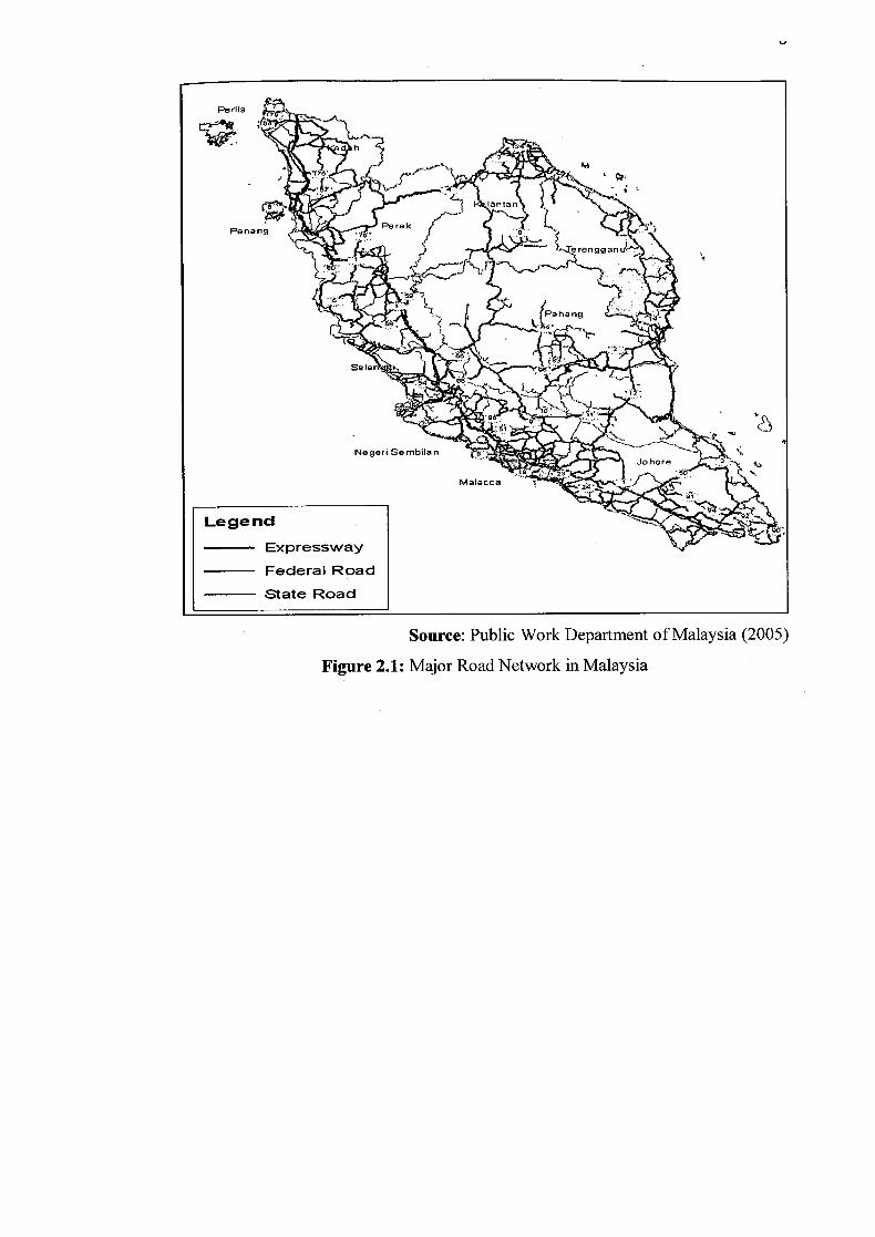
Source: Public Work Department of Malaysia (2005)
Figure 2.1: Major Road Network in Malaysia

2.3 North-South Expressway (Kuala Lumpur to Tangkak)
The research area or location is at southern route of expressway from Kuala
Lumpur to Tangkak, Johor. This road through several states which are Selangor,
Negeri Sembilan, Malacca and Johor. Generally, the topography along the proposed
highway is hilly and slightly sloping. The highest contour is near the Ukay Perdana
Interchange with 200-300 meters. The route through several major rivers and streams
such as: -
Sungai Merbau
Sungai Long
Sungai Sekamat
> Sungai Langat
Sungai Sub
Sungai Michu
> Sungai Gahal
> Sungai Kelang
> Sungai Ampang
> Sungai Pandang
> Sungai Kemesah
> Sungai Telok
> SungaiSelek
> Sungai Batang Pusu.
The main land use along the project alignment is made up of vegetation and
development (settlement). The majority of the affected forest areas are forest reserve
which is Hulu Gombak Forest Reserve, Ampang Forest Reserve and Hulu Langat
Forest Reserve the land use of the development such as residential, industry and
Institutional that are directly involved with the proposed project is minimal.

LU
Source: Google Earth
Figure 2.2: North-South Expressway
2.3.1 Road Accident
Road accident is one of the major problems in Malaysia. According to
Malaysian Road Safety Council statistic, death caused by road accident have
increased to 5891 people in year 2002, followed by 6286 death in 2003, 6223 (2004),
6188 (2005), 6287 (2006) and 6282 (2007) which amounted to 37157 death within
just 6 years. Table 3.0 below showed the statistic of road accident along south-north
expressway in 5 years. (Table 2.1)
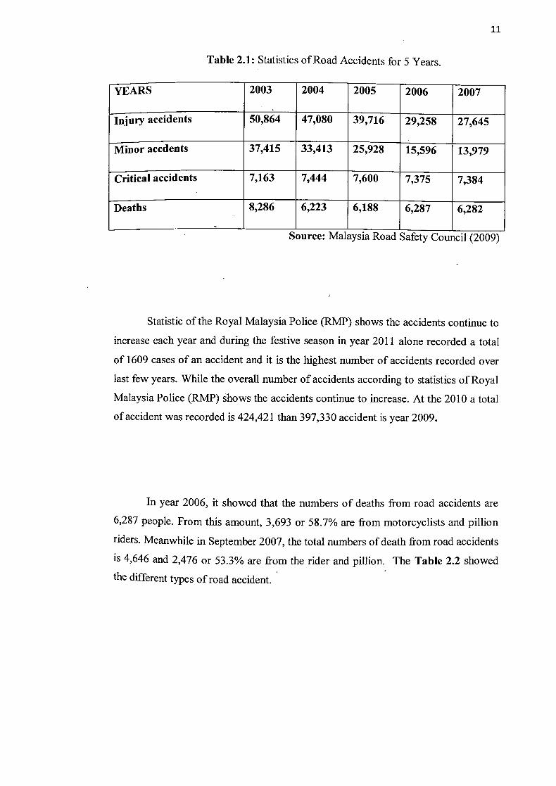
:ii
Table 2.1: Statistics of Road Accidents for 5 Years.
YEARS 2003 2004 2005 2006 2007
Injury accidents 50,864 47,080 39,716 - 29,258 27,645
Minor accdents 37,415 33,413 25,928 - 15,596 13,979
Critical accidents 7,163 7,444 7,600 7,375 7,384
Deaths 8,286 6,223 6,188 6,287 6,282
Source: Malaysia Road Safety Council (2009)
Statistic of the Royal Malaysia Police (RMP) shows the accidents continue to
increase each year and during the festive season in year 2011 alone recorded a total
of 1609 cases of an accident and it is the highest number of accidents recorded over
last few years. While the overall number of accidents according to statistics of Royal
Malaysia Police (RMP) shows the accidents continue to increase. At the 2010 a total
of accident was recorded is 424,421 than 397,330 accident is year 2009.
In year 2006, it showed that the numbers of deaths from road accidents are
6,287 people. From this amount, 3,693 or 58.7% are from motorcyclists and pillion
riders. Meanwhile in September 2007, the total numbers of death from road accidents
is 4,646 and 2,476 or 53.3% are from the rider and pillion. The Table 2.2 showed
the different types of road accident.

IL
Table 2.2: Road Fatality Statistic
CATEGORIES 2006 Jan-Sept' 06 Jan-Sept' 07
passenger 1215 920 1113
i7iillion riders 3693 2736 2476
pedestrian 595 438 482
pillion rider bicycles 242 183 141
Driver/ bus passenger 39 26 64
Driver/ lorry attendant 229 174 145
Driver/van attendant 103 73 101
Driver/4-whee drive attendant 110 73 65
Others 61 48 59
Totals 6287 4671 4646
Source: Malaysia Road Safety Council (2007)
There are several factors that cause road accident. The main factor that
contributes in increasing to road accident is because of the roadway environment that
leads to uncontrolled the speed of transport (BAEK, Seungkirl et al 2005). This was
accentuated by the fact that the capability or human failure has been identified as the
cause of which has contributed more than 90 percent of the causes of road accident
(Austroad 1989).
i-i
2.4 Wind
In meteorological aspect state that wind is air movement relative to the earth,
driven by several different forces, especially pressure differences in the atmosphere,
which are they produced by differential solar heating of different parts of the earth's
surface, and forces generated by the rotation of the earth. Wind, with regard to road
safety, can be divided into two categories. First, the gust of wind as the result of the
movement of ambient air, and the second one is the blow of air generated by moving
vehicles. Both types of wind can affect the stability and control of vehicles in
motion. (Bjorn Olafson, 2008)
The natural wind blows in many directions, and when matched with the
direction of traffic or vehicles on the road, it can be described in different terms, that
are headwind, crosswind and tailwind. The different winds give a different impact to
the vehicles. Usually, headwind and tailwind will not be a major safety issue. They
only affect the performance of longitudinal vehicle speed, either by pushing back or
pushing forward (Baker, 1988).
For crosswind, which blows from the sides, has a greater impact on vehicles
especially those with high centre of gravity (COG) and large flat surface. These
vehicles are highly prone to the effects of crosswind in terms of stability and control.
The crosswind or side wind can cause vehicles such as buses, trucks transporting
containers (semi-trailers and trailers), bonded pickups and vans to roll over
(SWOF2007) From overview weather as a Road Safety Hazard in Malaysia, it is
stated that, besides the aerodynamic and stability issues, wind also blows obstacles
debris and sand onto the road and the presence of the precipitation with significant
wind speed will make the situation more disorienting for drivers.
The (Skuli Thordarson, Bjorn Olafson) said that adverse weather such as
strong wind, snow and ice can be one of the factor that contribute in increasing road

14
accident. In future climate, wind will probably appear as a more serious and frequent
threat to road traffic that in present climate.
2.4.1 Wind Speed
Wind speed is the speed of wind, the movement of air or other gases in an
atmosphere. Wind speed also can be defined as the rate of flow of the wind
undisturbed by obstacles. It can be measured in meters per second or knots. Calm is
reported when the wind speed is less than 0.5 meters per second or less than one
knot. The climate of Malaysia is driven by its equatorial position, extensive
coastlines on tropical sees and monsoonal winds. The monsoon wind is the
prevailing wind trend in Malaysia that blows in the range between 10 to 30 knots (18
to 55km/h).
A strong wind speed will cause an accident to occur. This statement has not
being denied by PLUS and RCA in which they have recognized some locations
along the north-south highway as cross wind areas at Kilometer 2441-244.6, 213.0-
213.5, 211.2-211.9, 200.4-200.8 and 196.6-197.0(PLUS). From the analysis, the
location is potential to be exposed to the strong gale, especially during north-east
monsoon (January-March). The strongest wind speed has been recorded is 13.5m/s
that is measured at the height of 5 meters. The Figure 2.3 showed one of analysis
wind speed data at one of location in North-South Expressway that is Malacca
(Figure 2.3).

mph And Speed ijblnd Gust
15.0 Iiitt 1-i I Ij' tLUI t^4 10.0
0.01 2 3 4 5 6 7 8 9 1011 12 13 14 1516 1118 19 20 21 22 2324 25 26 27 28 29 30 31
360.0 270.0 180.0
90.0 nn
1 2 3 4 5 6 i 8 9 10 111213 14 15 16 17 1 1920 21 22 2324 25262128 2930
Source: Wunderground, Malacca (2011)
Figure 2.3: Wind Speed
Wind induced accidents. From the research, it is said that wind effect causing
extremely hazardous condition on the road. The higher wind gust can be as high as
2.5 times of 1 5mIs higher than the mean wind speed that caching drivers off-guard,
despite variable message signs indicating the wind speed on the site. It is well known
that vehicle characteristic is important regarding stability during windy conditions.
Once an accident has happened, the chances that recorded mean wind speed is 1 Om!s
or more, are double for high —sided vehicles such as trucks and trailer, than for
passenger cars. (Ljubljana, 2008).
Wind speed is affected by a factors and situations, operating on varying
scales including:-
mb
32 24 16
8 0
a) Pressure gradient is a term to describe the difference in air pressure between
two points in the atmosphere or on the surface of the earth. It is vital to wind