attachment 2 6b.21.067 - page 1 of 31
TRANSCRIPT

Attachment 2 6b.21.067 - Page 1 of 31

6b.21.067 - Page 2 of 31

6b.21.067 - Page 3 of 31

6b.21.067 - Page 4 of 31

6b.21.067 - Page 5 of 31
6b.21.067 - Page 6 of 31

6b.21.067 - Page 7 of 31

6b.21.067 - Page 8 of 31

6b.21.067 - Page 9 of 31

6b.21.067 - Page 10 of 31

6b.21.067 - Page 11 of 31
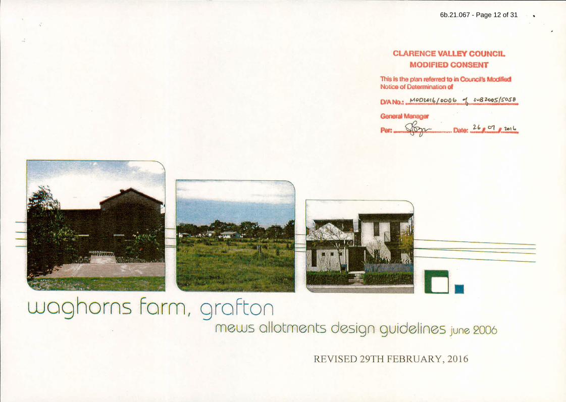
6b.21.067 - Page 12 of 31

6b.21.067 - Page 13 of 31

6b.21.067 - Page 14 of 31

6b.21.067 - Page 15 of 31

6b.21.067 - Page 16 of 31

6b.21.067 - Page 17 of 31

6b.21.067 - Page 18 of 31
Version: 1, Version Date: 09/06/2021Document Set ID: 2236114
This information is provided by Clarence Valley Council
Print Date: 15 September 2021, 9:52 AM
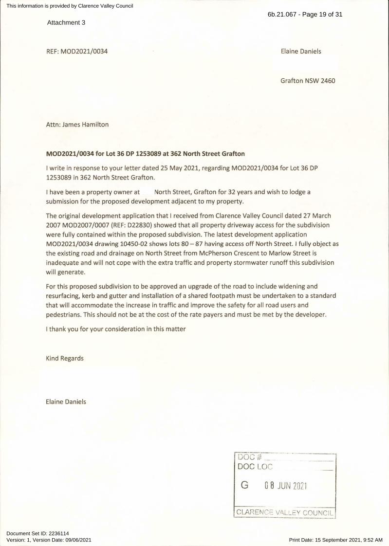
Attachment 36b.21.067 - Page 19 of 31

Version: 1, Version Date: 09/06/2021Document Set ID: 2236601
This information is provided by Clarence Valley Council
Print Date: 15 September 2021, 9:52 AM
From: Sent: Wed, 9 Jun 2021 15:44:11 +1000To: Council EmailCc: James HamiltonSubject: Development Application : MOD2021 / 0034Attachments: 20210609_Objection to Development Application_Stage 4.pdf
Please find attached my my objection to the Development Application in relation to Stage 4 of theMarlowvale Estate located at 362 North Street Grafton.
Yours faithfully,
Sharon Hillery
6b.21.067 - Page 20 of 31
P a g e 1 | 3
1. Unauthorised Earthworks
The site of the proposed Stage 4 has, over the last couple of weeks, had extensive earthworks being
undertaken to raise the level of the site. Numerous requests have been made to Council over the last 21
months to supply documentation where the Developer has provided an application to change the height of the
development site in relation to Stages 2, 3 and now 4, as well as documentation from the Council approving
such an application. None of the documents provided by Council up to this point of time show any application
being made nor any approval being granted by Council in relation to the raised height of the development.
Therefore it is considered that the earthworks that have been undertaken in Stages 2, 3 and 4 by the
Developer are not approved by Council.
If Council believe the earthworks had been granted approval for Stages 2 & 3, as a result of a Public
Consultation process such as the one currently underway for Stage 4, then when and how was the public
notified of such a consultation process.
As a result of the unauthorised earthworks which has substantially raised the ground level of the building lots
in Stages 2, 3 and 4, any building now constructed on those lots will be in contravention of the Waghorns Farm
Mews Allotments Design Guidelines dated June 2006 and revised 29th February 2016, which states :
“Building and structures on the mews allotments must not cause loss of amenity to adjacent land and
dwellings, with regard to overshadowing, privacy, views and vistas, building character and appearance and
building massing and scale as seen from neighbouring premises.”
2. Drainage and Stormwater
Para 33 of the Notice of Determination of Application, dated 23 April 2009, states
“The filling of the site is not to adversely affect adjacent properties or local drainage patterns. Provision is to be
made for the free passage of surface stormwater away from the affected sites.”
Version: 1, Version Date: 09/06/2021Document Set ID: 2236601
This information is provided by Clarence Valley Council
Print Date: 15 September 2021, 9:52 AM
P.O. Box 1125, GRAFTON. NSW 2460
9 June 2021
Clarence Valley Council
2 Prince Street,
GRAFTON. NSW 2460
Development Application : MOD2021 / 0034
Attention : Mr James Hamilton
I would like to submit my objection to the
abovenamed Development Application in relation to Stage 4 of the
Marlowvale Estate located at 362 North Street Grafton.
6b.21.067 - Page 21 of 31

P a g e 2 | 3
Further to the issue of the unauthorised raising of the ground height on the development, residents have a
VERY strong concern of the stormwater run off that will occur from the development. Again a number of
attempts have been made over the last 21 months to raise our concerns with Council.
The Stormwater Management Plan for the Waghorn Farm Development prepared by GeoLINK, dated
September 2005 is a totally flawed document. It has also made assumptions based on a Development
Application prepared in 2005 that has now changed significantly to the development currently being
undertaken.
Page 3 of the S.W. Plan states
“The site predominantly drains via overflow to the north east corner”, “About 82% of the site drains to the
north east”.
No where in the subsequent pages of the report does it make reference to the development site being
changed to increase the ground levels and therefore the “natural” flow of the site being changed.
The report does not address any fill to the areas of the north east and south east corners being predominately
of a clay substance therefore having a direct impact on how the site could sustain substantial rainfall.
Residents witnessed, and have photos of the clay substance being dumped in these areas.
The report does not address the impact of raised building lots on the increased flow of water into the
stormwater system. It is acknowledged that it is a requirement for the buildings to have water tanks but once
they are full all water will quickly flow into the stormwater system as the water will not be able to seep into
the clay based building lots and due to the height of those lots, will flow straight onto the street level.
Page 26 of the S.W. Plan states
“The modelling indicates that post development discharge flow rates and volumes will be less than the pre-
development conditions.”
Again this assumption is not correct based on the changes to the original Development Application, that being
the enormous amount of a clay substance fill used to have raised the building lots. Pre development the land
was predominately alluvial soil used for farming and therefore had a very high capacity to hold/seep
rainwater.
Page 27 of the S.W. Plan states
“During extreme storm events the proposed weir structure will retain the increased runoff volumes and limit
the discharges downstream to existing conditions.”
It is felt that this in one of the biggest flaws in this report. The report has not addressed the situation when
the area is in flood and the flood gates are closed. The Eyre Street Canal fills very quickly, this was evident in
March this year when Grafton had minor flooding. The new stormwater drain opening into the Eyre Street
Canal was blocked by the canals’ rising water. The Residents have raised with Council on a number of
occasions that the stormwater measures from the development will have a direct impact on their properties.
When there is a severe weather event the outflow from 90+ building lots into the new stormwater drain, into
a full Eyre Street Canal will result in rising water back up the drain to the inspection pit with potential to
damage the Residents property and if/when the flood gates do require closing then there will be a definite
issue with rising water, which hasn’t been a problem prior to the North Street Development.
3. Failure to meet Pre-existing Conditions
It is felt that the Council should not grant any further approvals on the development site until all pre-existing
approval conditions have been met. It is unclear as why these conditions have not been met. Is it a case that
Version: 1, Version Date: 09/06/2021Document Set ID: 2236601
This information is provided by Clarence Valley Council
Print Date: 15 September 2021, 9:52 AM
6b.21.067 - Page 22 of 31

P a g e 3 | 3
the Developer has been allowed to continue without the Council overseeing the development and enforcing
the conditions of approval. Or is it a case that the Council has allowed the Developer to forgo meeting those
requirements or making changes without an open and transparent consultation process with the Public.
Just some of those conditions that appear to have not been met or changed, with no reasoning as to why are:
• Para 13 e) of the Notice of Determination of Application, dated 23 April 2009. There has been issues
with the drainage trenches, especially those at the intersection of Carr and Earl Streets and the
stormwater drain on the north verge of Earl Street. This has been reported a number of times to
Council where it is clearly evident the pipes have not been “bedded, laid and jointed in accordance
with the specifications..”
• Para 19 of the Notice of Determination of Application, dated 23 April 2009, states “The developer shall
provide at full cost to the developer, an off road shared cycleway/pedestrian path along the frontage of
the development in North Street and Earl Street…..”, however on the drawing 0466/C1070 of the
Marlowvale Development GeoLINK diagrams it shows a bitumen path on the opposite side of Earl
Street. Where will the path be located? If the path is to go as per the diagram then have the
residents/ratepayers been advised of this and asked for their submission about the change.
• Para 20 of the Notice of Determination of Application, dated 23 April 2009, states “Prior to
development of the site beyond 50 lots, an on road cycleway shall be constructed, at full cost to the
developer, from the south east corner of the development to connect with the North Street on road
cycleway at the intersection of North and Cranworth Streets”. When will Council enforce this condition
on the Developer. Stage 1 and 2 are complete as residences are in place. Stage 3 is clearly in
development stage as roads are marked, drainage has been put in place and lots have been marked.
Therefore this now meets this condition of 50 lots, so the Developer should be putting in the cycleway
now, before any more work is allowed to be done on Stage 4.
• Para 23 of the Notice of Determination of Application, dated 23 April 2009, makes reference to the
Developer being required to construct a dedicated left turn lane into North Street PRIOR to the release
of the linen plan for Stage 1. Why has this Developer been able to ignore the Traffic Impact Report by
Roadnet that stated the turn lane was a safety issue and why has the Council not addressed this?
• Page 9 – note 8, of the Stormwater Management Plan for the Waghorn Farm Development prepared
by GeoLINK, dated September 2005, states Imported fill must be certified. Numerous request have
been made to Council to confirm these test have been undertaken, especially in relation to the
relocation of soil from the Eyre Street Canal to the development site. Council has stated they have not
been unable to locate any record on file, why has the Developer been allowed to not meet this
requirement, especially as the soil from the Eyre Street Canal has had a direct impact on the residents
of Carr Street.
• Page 3 of the Waghorns Farm Mews Allotments Design Guidelines dated June 2006 and revised 29th
February 2016 states “Colourbond panels will not be permitted for any fencing”, when was the Public
advised of this change, driving through the development every house has colourbond panels as
fencing.
Thankyou for giving me the opportunity to raise my objections to this Development Application. I hope that we
can get some answers to the points raised above as the Residents/Ratepayers of Carr Street have had great
difficulty in obtaining documents, information or answers to many more issues from the Council for the last 21
months.
Yours faithfully,
Sharon Hillery
Version: 1, Version Date: 09/06/2021Document Set ID: 2236601
This information is provided by Clarence Valley Council
Print Date: 15 September 2021, 9:52 AM
6b.21.067 - Page 23 of 31

SECTION 4.55 AMENDMENTFILE REPORT FORM
FILE NO: SUB2005/5058APPLICATION: MOD2021/0034APPLICANT: O'Donohue Hanna & Associates Pty LtdOWNER: Dougherty Bros Pty LtdLEGAL DESCRIPTION: Lot 36 DP 1253089POPERTY ADDRESS: 362 North Street GRAFTON NSW 2460APPROVED DEVELOPMENT: 98 Lot Subdivision
REQUESTED AMENDMENT: The applicant has requested an Amendment under Section 4.55 (1A) of the Environmental Planning & Assessment Act, in relation to amend the layout of an approved 98 lot residential subdivision under SUB2005/5058.
The modification will require an amendment to Condition 1 and deletion of Condition 9 which relates to the design guidelines for the Mews Lots. The Applicant also seeks to amend Conditions 20 and delete conditions 19 and 29 which read as follows:
19. The developer shall provide at full cost to the developer, an off road shared cycleway/pedestrian path along the frontage of the development in North Street and Earl Street. The cycleway/pedestrian path shall commence from the point at which the internal cycleway meets those streets and extend to the southeast corner of the development. (Reason: To provide for and encourage the use of cycles and public amenity).
20. Prior to development of the site beyond 50 lots, an on road cycleway shall be constructed, at full cost to the developer, from the south east corner of the development to connect with the North Street on road cycleway at the intersection of North and Cranworth Streets.(Reason: To provide for and encourage the use of cycles and public amenity).
29. All pathways in the subdivision are to be provided with a concrete or brick paved surface with minimum 1.2 metres width in accordance with Council’s Development Specification – Aus-Spec.(Reason:To ensure pathways are provided in accordance with Council policy).
In lieu of deleting Conditions 19 and 29, the Applicant is proposing to amend Condition 20 to extend the on-road cycleway further west to Flame Street and also provide the on-road cycleway on the southern side of North Street to the intersection with Cranworth Street.
ADVERTISING REQUIRED UNDER DCP OR REGULATION?
Yes, the application was advertised and notified in accordance with the Community Participation Plan.
DETAILS:
BACKGROUND OF DEVELOPMENT CONSENT:
Version: 2, Version Date: 15/09/2021Document Set ID: 2271229
This information is provided by Clarence Valley Council
Print Date: 15 September 2021, 9:52 AM
Attachment 46b.21.067 - Page 24 of 31

The subdivision was granted approval under SUB2005/5058 on 25 July 2006. The Application has subsequently been modified by Court Order in 2009 which changed the requirement to provide a turning lane into North Street from Turf Street to make a monetary contribution to Council for the required works. The development has been subject to 2 previous modification applications being:
1. MOD2009/0054 – This application amended the telecommunication type required to service the development.
2. MOD2016/0006 – This application resulted in removal of the ‘Mews’ style lots in Stages 2 and 3 of the development and reverting back to a more conventional subdivision layout. This modification resulted in a reduction in lot yield of 1, dropping from 99 to 98 lots.
SECTION 4.15 EVALUATION: (1) Matters for consideration—general
In determining a development application, a consent authority is to take into consideration such of the following matters as are of relevance to the development the subject of the development application:
(a) the provisions of: (i) any environmental planning instrument, and
The application was assessed under the provisions of the Grafton Local Environmental Plan (1988). The assessment concluded the development was consistent with the zone objectives for land zoned 2(a) Living Area. Clause 42: Land in North Street, Grafton – restrictions on development of the LEP also applied.
The modifications now proposed are not considered to alter the assessment undertaken for the development under SUB2005/5058 in relation to compliance with the LEP and do not affect compliance with the matter nominated in Clause 42 relating to Stormwater Management and contamination.
(ii) any draft environmental planning instrument that is or has been placed on public exhibition and details of which have been notified to the consent authority (unless the Director-General has notified the consent authority that the making of the draft instrument has been deferred indefinitely or has not been approved), and
(iii) any development control plan, and
The application was assessed under the provisions of the Grafton Residential Zones DCP No.4, Grafton DCP No.9 Development controls in Flood liable land, and CVC DCP No.1 Engineering Standards.
The only matter to consider is the change in lot sizes from the amendments proposed. All of the lots to be amended will only increase in size. No lots will be reduced in size. The lot sizes are considered to be consistent with the intent of the DCP.
Version: 2, Version Date: 15/09/2021Document Set ID: 2271229
This information is provided by Clarence Valley Council
Print Date: 15 September 2021, 9:52 AM
6b.21.067 - Page 25 of 31

The building height, landscaping, car parking, sitting, floor heights, flood controls and engineering standard assessments are unchanged by the modification. Revised engineering and detailed drawings will be necessary to accommodate the revised layout.
(iiia) any planning agreement that has been entered into under section 7.4, or any draft planning agreement that a developer has offered to enter into under section 7.4, and
The Applicant has not entered into a voluntary planning agreement.
(iv) the regulations (to the extent that they prescribe matters for the purposes of this paragraph), that apply to the land to which the development application relates
MOD2021/0034 has been lodged under Section 4.55 (1A) of the Environmental Planning and Assessment Act 1979 (EP&A Act) which reads as follows:
(1A) Modifications involving minimal environmental impact A consent authority may, on application being made by the applicant or any other person entitled to act on a consent granted by the consent authority and subject to and in accordance with the regulations, modify the consent if—(a) it is satisfied that the proposed modification is of minimal environmental
impact, and(b) it is satisfied that the development to which the consent as modified relates is
substantially the same development as the development for which the consent was originally granted and before that consent as originally granted was modified (if at all), and
(c) it has notified the application in accordance with—(i) the regulations, if the regulations so require, or(ii) a development control plan, if the consent authority is a council that has
made a development control plan that requires the notification or advertising of applications for modification of a development consent, and
(d) it has considered any submissions made concerning the proposed modification within any period prescribed by the regulations or provided by the development control plan, as the case may be.
Subsections (1), (2) and (5) do not apply to such a modification.
Consideration of whether the proposed modification is substantially the same development needs to be assessed against the original approved development and not the current modified development. Comparison of the qualitative and quantitative changes is required to determine whether the proposed modification is substantially the same development. Focus is to be given on the particular elements that are being changed, especially where that component is an essential component of the development. The key difference proposed by the applicant is the complete removal of the Mews Lots and proposed access from North Street.
Version: 2, Version Date: 15/09/2021Document Set ID: 2271229
This information is provided by Clarence Valley Council
Print Date: 15 September 2021, 9:52 AM
6b.21.067 - Page 26 of 31
The Applicant has provided the following justification in support of the application to demonstrate the proposed modification is substantially the same development as approved:
a) The reduction in public areas (roads and open space) results in a lower maintenance cost to Council.
b) The larger lots provide greater flexibility in development potential for single level dwellings compared to the restrictive Mews Guidelines which would generally require 2 storey developments to meet the provisions resulting in increased construction costs.
c) The changes from Mews Lots to traditional lots will facilitate provision of higher density development and provision of more affordable housing resulting in greater utilisation of available services in accordance with the concept of urban consolidation.
d) The Mews Lots present servicing issues for utilities, stormwater management and waste collection due to the narrow 6.5m rear laneways which over time could become an issue.
e) The Mews Lots were not proposed as affordable housing lots despite what State Policy suggested at the time of the DA.
f) The modified layout will result in a traditional style estate which replicates the characteristics of the estate to be consistent throughout.
g) The proposal will not present issues with provision of services.
CommentDevelopment Application SUB2005/5058 was approved by Council at their meeting of 25 July 2006 and has subsequently been modified by Court Order and further Council meetings (MOD2016/0006 – Item No. 14.063/16). The initial approval granted a subdivision for 99 lots and included Mews Style lots throughout the subdivision layout. The modification by Court Order and MOD2009/0054 did not change the fundamental layout of the development and was considered substantially the same. MOD2016/0006 gave approval to amend the subdivision layout for 12 lots and reduce the number of mews lots from 37 to 28.
The main amendment to the development is the change of access for lots that had frontage to North Street, with removal of the rear laneways a total of 9 lots will gain direct access from North Street. The frontage of the development in North Street is recognised by Council’s Open Spaces Manager as an emerging avenue of significance regarding the Jacarandas once canopies on either side of the road combine. The Applicant has demonstrated that these lots will not result in the removal of any Jacaranda trees for the provision of driveways, other than what has already been approved for the new intersections on North Street to service the development.
The removal of the Mews Lots and reconfiguration of Stage 4 of the estate will not increase the number of lots, however will result in less public open space between the Mews Lots. The provision of public open space was provided to compensate for the small Mews Lots and guidelines which required less private open space in comparison to the Development Control Plan. Development of the reconfigured lots will need to comply with current Private Open Space and Landscaped Area provisions which are not considered to increase the density of developed areas of Stage 4. A further consequence of the proposed amendment will also be the removal of the rear laneways
Version: 2, Version Date: 15/09/2021Document Set ID: 2271229
This information is provided by Clarence Valley Council
Print Date: 15 September 2021, 9:52 AM
6b.21.067 - Page 27 of 31

and footpaths for pedestrian access through the open space areas for visitors to access the Mews Lots. Overall it is considered that the proposed modification will not create additional impacts that are not able to be satisfactorily mitigated through further detailed design of stormwater management and assessed as part of future development applications for each lot.
Taking into account the changes to the development and no greater impact as a result of the proposal it is considered that Council has the ability to determine MOD2021/0034 under Section 4.55 (1A) as the development is substantially the same development as approved.
(b) the likely impacts of that development, including environmental impacts on both the natural and built environments, and social and economic impacts in the locality,
An assessment of the impacts of the development was undertaken under SUB2005/5058 and that assessment is unaffected by the amendments now proposed. The modification to the layout of some of the lots is not considered to result in additional impacts resulting from the development.
(c) the suitability of the site for the development,
An assessment of the suitability of the site for the development was undertaken under SUB2005/5058 and that assessment is unaffected by the amendments now proposed.
(d) any submissions made in accordance with this Act or the regulations,
The proposed modification was advertised and notified in accordance with the Community Participation Plan, two submissions were received during the notification period. The majority of issues raised in the submissions received do not solely relate to the proposed modification. A summary of the issues is provided below with a relevant comment.
a) The filling of the land is unauthorised earthworks.Comment: Filling of the land was proposed as part of the initial subdivision application, filling works have been subsequently undertaken for each stage of the development with appropriate civil construction approvals issued for bulk earthworks or was inclusive in the overall civil works for the respective stage. Material imported for Stage 3 and Stage 4 footprint is primarily quarry material, with minor quantities sourced from the South Grafton Golf Club. The fill was authorised under each respective Construction Certificate.
b) Filling of the land and further development of the site will increase runoff resulting in drainage and stormwater issues.Comment: Stormwater modelling and assessment considered the completed development and demonstrated no additional runoff from the site. This may need to be upgraded/amended with the future construction of the subdivision to account for the amended design.
Version: 2, Version Date: 15/09/2021Document Set ID: 2271229
This information is provided by Clarence Valley Council
Print Date: 15 September 2021, 9:52 AM
6b.21.067 - Page 28 of 31

c) Provision of access to North Street will compromise the existing drainage network and result in additional traffic, the developer should be required to widen the road and provide kerb and gutter and provision of a footpath.Comment: Although all internal roads are serviced by kerb and gutter requiring the provision of kerb and gutter on North Street due to direct change in access would be out of character with the surrounds. The development has not been required to provide kerb and gutter in Marlow Street or Earl Street where direct access was proposed. The Applicant will construct an inter allotment drainage line to direct stormwater north/north-east to the Ayr Street Reserve, therefore no additional water from the development with the exception of new driveways on North Street will drain to the existing grass swale. Requiring kerb and gutter and associated road widening may result in the majority of Jacarandas in this locality needing to be removed. The applicant will be widening North Street to provide an on-road cycleway however, no additional traffic will be created by the reconfiguration of the lots. Therefore, the provision of kerb and gutter in North Street is not required.
d) Compliance with consent Conditions: Incorrect construction of stormwater line:
Comment: Stormwater drainage infrastructure was constructed in accordance with the applicable engineering standards. All infrastructure adopted by Council is independently certified prior to acceptance.
Provision of off-road footpath on North and Earl Streets for the development frontage and On-Road Cycleway.Comment: The Applicant will be required to provide an on-road cycleway prior to the release of the subdivision certificate in the current stage under construction as the 50 lot threshold will be triggered. The developer currently is only required to provide the cycleway on the northern side. Should Council resolve to approve the modification application the cycleway will be extended from the Earl/North Street intersection further west to Flame Street and also be provided on both sides of the road. The developer has offered this additional length as an offset for removal of the off-street footpaths in North Street, Earl Street and through the subdivision.
Provision of turning lane on Turf Street Comment: This matter was the subject of the Court Order. The Court ruled in the favour of the developer and instead of constructing the turning lane, the developer was required to pay Council a contribution towards the upgrade. This was paid to Council before the release of Subdivision Certificate for the First Stage.
Certification of Fill Material: Comment: Council has been provided with the relevant Natural Excavated Natural Material and Excavated Natural Material Certificates for the source of fill associated with Stage 2, 3 and 4 of the Development.
Colorbond panels not permitted: Comment: The restriction on colorbond panels only applies to the ‘Mews Lots” of which the developer has modified the subdivision to remove these lots from the first 3 stages of the development. Should this application be approved, this will delete the remaining ‘Mews Lots’ in the subdivision
(e) the public interest.
Version: 2, Version Date: 15/09/2021Document Set ID: 2271229
This information is provided by Clarence Valley Council
Print Date: 15 September 2021, 9:52 AM
6b.21.067 - Page 29 of 31

The public interest is not significantly affected by the modification proposed.
SECTION: Section 4.55 provides that where the development, the subject of consent, will be substantially the same, the consent may be amended. The requested amendment is reasonable and does not substantially change the approved development. In this instance the consent can therefore be amended under section 4.55 (1A).
RECOMMENDATION: It is recommended that the consent granted on 25 July 2006 be amended, pursuant to section 4.55 (1A) of the Environmental Planning and Assessment Act 1979, by the following:
Amended Conditions
1. The development being completed in conformity with the Environmental Planning & Assessment Act, 1979, the Regulations thereunder, the Building Code of Australia and being generally in accordance with plans as provided in the Statement of Environmental Effects dated November 2005 and prepared by Stephen J Conelly, Town Planner, and the amended lot layout plan for lots 27-30, 57-61 and 68-71 only, drawing number 10450-01, dated 26 February 2016, one (1) sheet, prepared by Bothamley and O’Donohue Pty Ltd, and plan titled Marlowvale Estate – Stage 4, dated 14 May 2021, one (1) sheet and drawn by O’Donohue Hanna & Associates Pty Ltd, or as modified by any conditions of this consent.
20. Prior to development of the site beyond 50 lots, an on road cycleway on both side of North Street shall be constructed, at full cost to the developer, from the south east corner of the development Flame Street to connect with the North Street on road cycleway at the intersection of North and Cranworth Streets.(Reason: To provide for and encourage the use of cycles and public amenity).
Delete
9. The applicant shall at the time of registration place a covenant on the title of each of the mews lots requiring all dwelling houses to be constructed in accordance with the document entitled "Waghorns Farm, Grafton Mews Allotments Design Guidelines, June 2006", and as revised on 29 February 2016. And all mews lots within the development are to be developed with single residences. No mews lot(s) shall be consolidated or further subdivided. The council shall be the only authority authorised to release vary or modify such covenant provisions.
19. The developer shall provide at full cost to the developer, an off road shared cycleway/pedestrian path along the frontage of the development in North Street and Earl Street. The cycleway/pedestrian path shall commence from the point at which the internal cycleway meets those streets and extend to the southeast corner of the development. (Reason: To provide for and encourage the use of cycles and public amenity).
Version: 2, Version Date: 15/09/2021Document Set ID: 2271229
This information is provided by Clarence Valley Council
Print Date: 15 September 2021, 9:52 AM
6b.21.067 - Page 30 of 31
29. All pathways in the subdivision are to be provided with a concrete or brick paved surface with minimum 1.2 metres width in accordance with Council’s Development Specification – Aus-Spec.(Reason:To ensure pathways are provided in accordance with Council policy).
A new notice of consent outlining the amended conditions and/or new stamped plans are to be issued.
Report prepared by: James Hamilton, Development PlannerDate: 14 September 2021
Version: 2, Version Date: 15/09/2021Document Set ID: 2271229
This information is provided by Clarence Valley Council
Print Date: 15 September 2021, 9:52 AM
6b.21.067 - Page 31 of 31