attachment a: sight line assessment plans
TRANSCRIPT

11 200642_Tallarook_Sight Line Assessment ltr_FINAL_210416
ATTACHMENT A: Sight line Assessment Plans
Figure A1: Sight line plan for proposed access driveway to Lots 1 and 2
This co
pied d
ocum
ent is
mad
e ava
ilable
for th
e sole
purpo
se
of en
ablin
g its
cons
iderat
ion & re
view as
part o
f a pl
annin
g
proce
ss un
der th
e Plan
ning a
nd Env
ironm
ent A
ct 19
87.
This do
cumen
t mus
t not
be us
ed fo
r any
purpo
se w
hich m
ay
breac
h any
copy
right.
200642_Tallarook_Sight Line Assessment ltr_FINAL_210416
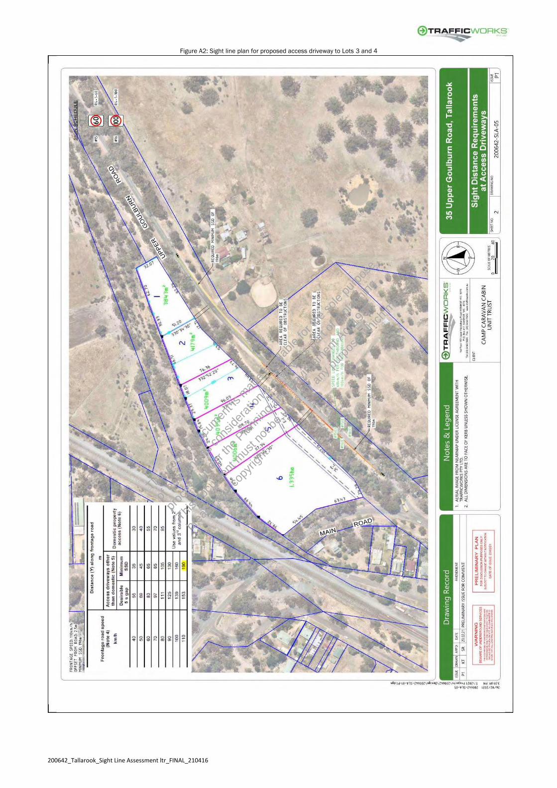
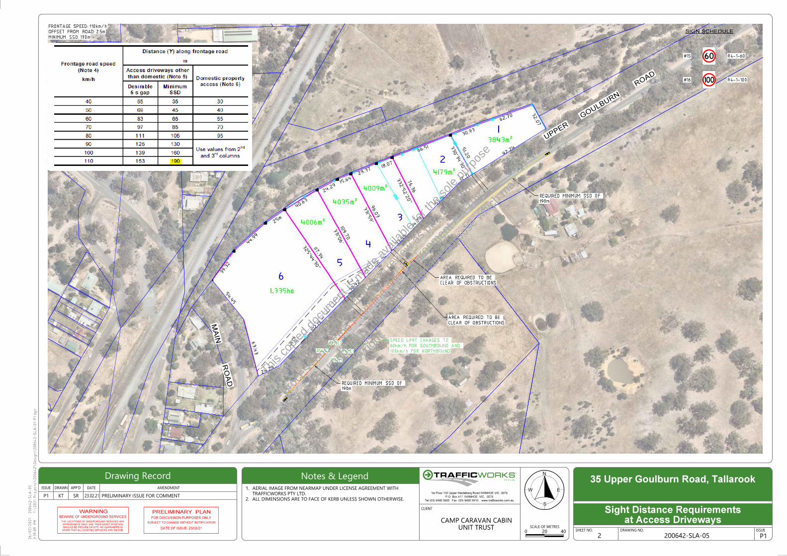
Figure A2: Sight line plan for proposed access driveway to Lots 3 and 4
This co
pied d
ocum
ent is
mad
e ava
ilable
for th
e sole
purpo
se
of en
ablin
g its
cons
iderat
ion & re
view as
part o
f a pl
annin
g
proce
ss un
der th
e Plan
ning a
nd Env
ironm
ent A
ct 19
87.
This do
cumen
t mus
t not
be us
ed fo
r any
purpo
se w
hich m
ay
breac
h any
copy
right.

200642_Tallarook_Sight Line Assessment ltr_FINAL_210416
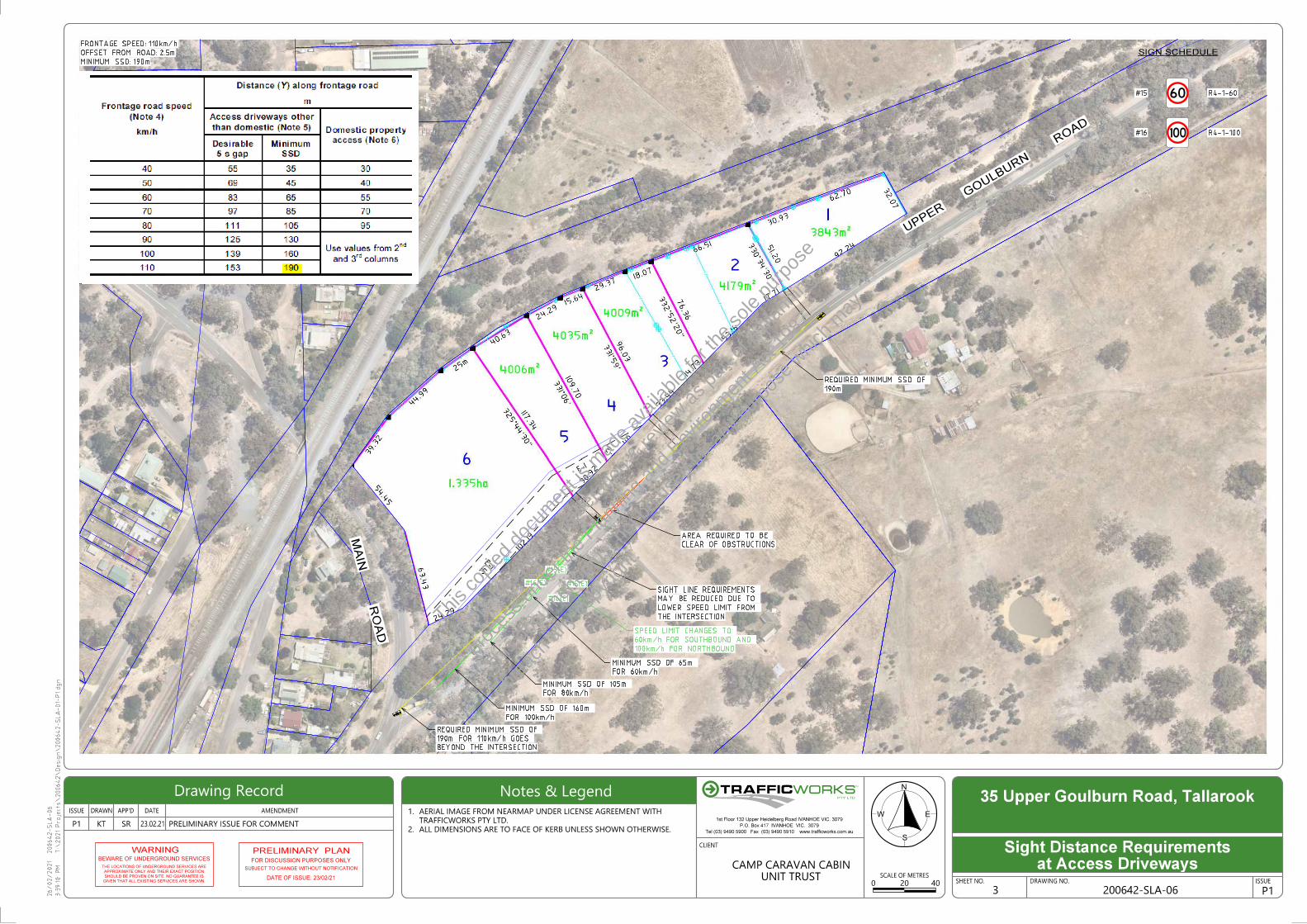
Figure A3: Sight line plan for proposed access driveway to Lots 5 and 6
This co
pied d
ocum
ent is
mad
e ava
ilable
for th
e sole
purpo
se
of en
ablin
g its
cons
iderat
ion & re
view as
part o
f a pl
annin
g
proce
ss un
der th
e Plan
ning a
nd Env
ironm
ent A
ct 19
87.
This do
cumen
t mus
t not
be us
ed fo
r any
purpo
se w
hich m
ay
breac
h any
copy
right.

200642_Tallarook_Sight Line Assessment ltr_FINAL_210416
ATTACHMENT B: VICROADS GUIDELINE DRAWING
This co
pied d
ocum
ent is
mad
e ava
ilable
for th
e sole
purpo
se
of en
ablin
g its
cons
iderat
ion & re
view as
part o
f a pl
annin
g
proce
ss un
der th
e Plan
ning a
nd Env
ironm
ent A
ct 19
87.
This do
cumen
t mus
t not
be us
ed fo
r any
purpo
se w
hich m
ay
breac
h any
copy
right.

UPPER GOULB
URN ROAD
EFFLUENT EXCLUSION ZONE
LOT 2
LOT 3
LOT 4
LOT 5
LOT 630M OFFSET
FROM CREEK450M2 IRRIGATION FIELD
375M2 IRRIGATION FIELD
300M2 IRRIGATION FIELDCREEK
RAIL TRAIL
EXISTING
DWELLING
LOT 1
10001000
250
Natural surface
Fall
This document is copyright protected and may only be used for the purpose for which it was intended. Unauthorised use is strictly prohibited.
SCALE: As indicated @ A3
FOR APPROVAL
SITE PLAN ANDPROPOSED WORKS
PROPOSED WORKS
CAMP CARAVAN
DRAWN BY: JSL
CHECKED BY: GPT
A40135 Upper Goulburn Road, Tallarook
NORTH
1 : 1250
Site Plan
TITLE PARTICULARS
LOT 32 TP071256A
35 UPPER GOULBURN ROAD
TALLAROOK
AREA: 3.347ha
REV. DESCRIPTION DATE
1 FOR APPROVAL 12/08/20
1 : 50
Typical Cut - off Drain Section
This co
pied d
ocum
ent is
mad
e ava
ilable
for th
e sole
purpo
se
of en
ablin
g its
cons
iderat
ion & re
view as
part o
f a pl
annin
g
proce
ss un
der th
e Plan
ning a
nd Env
ironm
ent A
ct 19
87.
This do
cumen
t mus
t not
be us
ed fo
r any
purpo
se w
hich m
ay
breac
h any
copy
right.

Inspection chamber
Inlet pipe
Distribution pit
3/90mm PVC slotted distributrion pipe
Sand filter outline
Varies (Refer to Site plan and proposed works)
End cap
Inspection/Pump chamber
Top soil
Distribution pit, minimum internal width 250mm
100mm PVC slotted
collection pipe, 1:200 Fall
(not 90mm slotted pipe)
Emergency capacity
Ground levelTop soil
Geotextile layer (100g/m²) or paper
surface mound to restrict ingress
of surface water
Natural
Ground
50 layer of 5-10 aggregate
Filter sand
50 layer of 5-10 aggregate 100mm PVC slotted collection pipe,
1:200 Fall (not 90mm slotted pipe)
3/90mm PVC slotted distributrion pipe
Impermeable membrane, PVC liner to be protected
from any rock encountered during excavation
200 layer of 20-25 aggregate
Filter sand
Sealed with mortar
1200
Impermeable membrane, PVC liner
to be protected from any rock
encountered during excavation
Sand Filter Notes:
All filter sand to be clean washed sand with:
1) Effective size between 0.40 and 1.00mm; maximum particle size
of the smallest 10% (D10) by mass of the sand
2) Uniformity co-efficient less than 4; the ratio of the maximum
particle size of the smallest 60% by mass of the sand to the
maximum particle size of the smallest 10% by mass of the sand
3) Clay and fine silt less than 5% by volume.
Pressure main to irrigation field, min. 40mm
Min. 200 layer of 20-25 aggregate Min. 750mm Filter Sand to AS1547 Standard
Distribution Lines to be spaced 500mm off walls of filter, middle distribution line to be placed centrally
500
1000
1000
500
Self priming submersible pump to have
sufficent capacity for normal and emergency
storage (to plumbers specifications)
Non-Return Valve
Float Switch
Min. 750mm
High level audio/visual alarm, located at
suitable poistion to inform the house hold
Min
. 250
Septic Tank
Retention capacity one hour peak flow
100
Septic Tank Notes:
1) Septic Tank to be installed on min 100mm of sand, and to be
surrounded by sand or compacted soil;
2) The inlet pipe to the septic tanks shall be a minimum 1:60;
3) All septic Tanks to be installed a minimum 4m from any
foundations on nearby buildings;
4) Septic Tanks must be All-waste type
5) Fall from top of septic tank to top of sand filter to be min. 250mm
To inline disc filter located above ground
90mm PVC
90mm PVC
From Septic Tank Sand Filter
Concrete
Pump Pit
0.60 m
Min. 6m
Flush discharge trench subsoil drain
Min. 400 layer of 20-25 aggregate
Air/vacuum relief
Flush Control
Typ
. 1m
Su
pply
Hea
der
Slo
pe D
own
hill
Note:
1. Dripper/sprinkler spacing as per manufacturers specifications
2. All lines must be installed parallel to the contours
3. Drip lines to be installed 150mm below the surface, first 100mm
of soil should be tilled for line installation
4. Gypsum shall be apply at 1kg/3m2
5. Selected vegetation shall be planted with min. 220kg/ha/yr of
Nitrogen uptake, e.g ryegrass, clover or lucerne.
6. Delivery/Flush line to be 25mm-30mm, irrigation line diameter to
be 12-16mm, plumber to provide specifications
Disc Filter
Drip lines with pressure compensating drip emitters
Refer to Site Plan and Proposed Works for quantity and length of driplines required
Alte
rnat
ive
Flu
sh C
ont
rol t
o re
turn
to s
eptic
tan
k in
let
Max
. 3m
Fal
l ove
r an
y zo
ne
Alternative Location (only one
required) Air/vacuum relief
This document is copyright protected and may only be used for the purpose for which it was intended. Unauthorised use is strictly prohibited.
SCALE: As indicated @ A3
FOR APPROVAL
SAND FILTER ANDIRRIGATION DETAIL
PROPOSED WORKS
CAMP CARAVAN
DRAWN BY: JSL
CHECKED BY: GPT
A40235 Upper Goulburn Road, Tallarook
1 : 50
Typical Sand Filter Detail
REV. DESCRIPTION DATE
1 FOR APPROVAL 12/08/20
1 : 100
Typical Drip Irrigation Detail
This co
pied d
ocum
ent is
mad
e ava
ilable
for th
e sole
purpo
se
of en
ablin
g its
cons
iderat
ion & re
view as
part o
f a pl
annin
g
proce
ss un
der th
e Plan
ning a
nd Env
ironm
ent A
ct 19
87.
This do
cumen
t mus
t not
be us
ed fo
r any
purpo
se w
hich m
ay
breac
h any
copy
right.

B99
STANDARDS 2004 (A
U_NZ)
(c) 2021 Transoft Solutions, Inc. All rights reserved.
B99
STANDARDS 2004 (AU_NZ)
(c) 2021 Transoft Solutions, Inc. All rights reserved.
B99
STANDA
RDS
2004 (
AU_NZ)
(c) 2021 Trans
oft Solutions,
Inc. All rights
reserved.
26/02/2021
3:3
9:0
7 P
M
200642-S
LA-04
T:\
2021
Proje
cts\200642\
Desig
n\200642-S
LA-01-
P1.dgn
CLIENT
DRAWING NO.SCALE OF METRES
ISSUE DATE AMENDMENTAPP'DDRAWN
SHEET NO. ISSUE
P1 PRELIMINARY ISSUE FOR COMMENTALL DIMENSIONS ARE TO FACE OF KERB UNLESS SHOWN OTHERWISE.2.
TRAFFICWORKS PTY LTD.
AERIAL IMAGE FROM NEARMAP UNDER LICENSE AGREEMENT WITH 1. EW
N
S
P10
23.02.21
35 Upper Goulburn Road, Tallarook
KT SR
4020UNIT TRUST
CAMP CARAVAN CABIN
RO
AD
MAIN
ROAD
GO
ULBURN
UPPER
190m
REQUIRED MINIMUM SSD OF
CLEAR OF OBSTRUCTIONS
AREA REQUIRED TO BE
CLEAR OF OBSTRUCTIONS
AREA REQUIRED TO BE
190m
REQUIRED MINIMUM SSD OF
MINIMUM SSD: 190m
OFFSET FROM ROAD: 2.5m
FRONTAGE SPEED: 110km/h
200642-SLA-041
at Access DrivewaysSight Distance Requirements
SIGN SCHEDULE
#15 R4-1-60
#16 R4-1-100
#15(E)
#15(E)
#16(E)
#16(E)
100km/h FOR NORTHBOUND
60km/h FOR SOUTHBOUND AND
SPEED LIMIT CHANGES TO
Drawing Record Notes & LegendPTY LTD
TM
Tel (03) 9490 5900 Fax (03) 9490 5910 www.trafficworks.com.au
P.O. Box 417 IVANHOE VIC. 3079
1st Floor 132 Upper Heidelberg Road IVANHOE VIC. 3079
WARNINGBEWARE OF UNDERGROUND SERVICES
GIVEN THAT ALL EXISTING SERVICES ARE SHOWN.
SHOULD BE PROVEN ON SITE. NO GUARANTEE IS
APPROXIMATE ONLY AND THEIR EXACT POSITION
THE LOCATIONS OF UNDERGROUND SERVICES ARE
FOR DISCUSSION PURPOSES ONLY
SUBJECT TO CHANGE WITHOUT NOTIFICATION
PRELIMINARY PLAN
DATE OF ISSUE: 23/02/21
This co
pied d
ocum
ent is
mad
e ava
ilable
for th
e sole
purpo
se
of en
ablin
g its
cons
iderat
ion & re
view as
part o
f a pl
annin
g
proce
ss un
der th
e Plan
ning a
nd Env
ironm
ent A
ct 19
87.
This do
cumen
t mus
t not
be us
ed fo
r any
purpo
se w
hich m
ay
breac
h any
copy
right.
B99
STANDARDS 2004 (AU_NZ)
(c) 2021 Transoft Solutions, Inc. All rights reserved.
B99
STANDARDS 2004 (AU_NZ)
(c) 2021 Transoft Solutions, Inc. All rights reserved.
B99
STANDA
RDS
2004 (
AU_NZ)
(c) 2021 Trans
oft Solutions,
Inc. All rights
reserved.
26/02/2021
3:3
9:0
9 P
M
200642-S
LA-05
T:\
2021
Proje
cts\200642\
Desig
n\200642-S
LA-01-
P1.dgn
CLIENT
DRAWING NO.SCALE OF METRES
ISSUE DATE AMENDMENTAPP'DDRAWN
SHEET NO. ISSUE
P1 PRELIMINARY ISSUE FOR COMMENTALL DIMENSIONS ARE TO FACE OF KERB UNLESS SHOWN OTHERWISE.2.
TRAFFICWORKS PTY LTD.
AERIAL IMAGE FROM NEARMAP UNDER LICENSE AGREEMENT WITH 1. EW
N
S
P10
23.02.21
35 Upper Goulburn Road, Tallarook
KT SR
4020UNIT TRUST
CAMP CARAVAN CABIN
RO
AD
MAIN
ROAD
GO
ULBURN
UPPER
190m
REQUIRED MINIMUM SSD OF
CLEAR OF OBSTRUCTIONS
AREA REQUIRED TO BE
CLEAR OF OBSTRUCTIONS
AREA REQUIRED TO BE
190m
REQUIRED MINIMUM SSD OF
MINIMUM SSD: 190m
OFFSET FROM ROAD: 2.5m
FRONTAGE SPEED: 110km/h
2 200642-SLA-05
at Access DrivewaysSight Distance Requirements
SIGN SCHEDULE
#15 R4-1-60
#16 R4-1-100
#15(E)
#15(E)
#16(E)
#16(E) 100km/h FOR NORTHBOUND
60km/h FOR SOUTHBOUND AND
SPEED LIMIT CHANGES TO
Drawing Record Notes & LegendPTY LTD
TM
Tel (03) 9490 5900 Fax (03) 9490 5910 www.trafficworks.com.au
P.O. Box 417 IVANHOE VIC. 3079
1st Floor 132 Upper Heidelberg Road IVANHOE VIC. 3079
WARNINGBEWARE OF UNDERGROUND SERVICES
GIVEN THAT ALL EXISTING SERVICES ARE SHOWN.
SHOULD BE PROVEN ON SITE. NO GUARANTEE IS
APPROXIMATE ONLY AND THEIR EXACT POSITION
THE LOCATIONS OF UNDERGROUND SERVICES ARE
FOR DISCUSSION PURPOSES ONLY
SUBJECT TO CHANGE WITHOUT NOTIFICATION
PRELIMINARY PLAN
DATE OF ISSUE: 23/02/21
This co
pied d
ocum
ent is
mad
e ava
ilable
for th
e sole
purpo
se
of en
ablin
g its
cons
iderat
ion & re
view as
part o
f a pl
annin
g
proce
ss un
der th
e Plan
ning a
nd Env
ironm
ent A
ct 19
87.
This do
cumen
t mus
t not
be us
ed fo
r any
purpo
se w
hich m
ay
breac
h any
copy
right.
B99
STANDARDS 2004 (AU_NZ)
(c) 2021 Transoft Solutions, Inc. All rights reserved.
B99
STANDARDS 2004 (A
U_NZ)
(c) 2021 Transoft Solution
s, Inc. All rights reserved.
B99
STANDARDS 2004 (AU_NZ)
(c) 2021 Transoft Solutions, Inc. All rights reserved.
26/02/2021
3:3
9:10 P
M
200642-S
LA-06
T:\
2021
Proje
cts\200642\
Desig
n\200642-S
LA-01-
P1.dgn
CLIENT
DRAWING NO.SCALE OF METRES
ISSUE DATE AMENDMENTAPP'DDRAWN
SHEET NO. ISSUE
P1 PRELIMINARY ISSUE FOR COMMENTALL DIMENSIONS ARE TO FACE OF KERB UNLESS SHOWN OTHERWISE.2.
TRAFFICWORKS PTY LTD.
AERIAL IMAGE FROM NEARMAP UNDER LICENSE AGREEMENT WITH 1. EW
N
S
P10
23.02.21
35 Upper Goulburn Road, Tallarook
KT SR
4020UNIT TRUST
CAMP CARAVAN CABIN
RO
AD
MAIN
ROAD
GO
ULBURN
UPPER
190m
REQUIRED MINIMUM SSD OF
CLEAR OF OBSTRUCTIONS
AREA REQUIRED TO BE
MINIMUM SSD: 190m
OFFSET FROM ROAD: 2.5m
FRONTAGE SPEED: 110km/h
3 200642-SLA-06
at Access DrivewaysSight Distance Requirements
SIGN SCHEDULE
#15 R4-1-60
#16 R4-1-100
#15(E)
#15(E)
#16(E)
#16(E)
THE INTERSECTION
LOWER SPEED LIMIT FROM
MAY BE REDUCED DUE TO
SIGHT LINE REQUIREMENTS
FOR 60km/h
MINIMUM SSD OF 65m
100km/h FOR NORTHBOUND
60km/h FOR SOUTHBOUND AND
SPEED LIMIT CHANGES TO
FOR 80km/h
MINIMUM SSD OF 105m
BEYOND THE INTERSECTION
190m FOR 110km/h GOES
REQUIRED MINIMUM SSD OF
FOR 100km/h
MINIMUM SSD OF 160m
Drawing Record Notes & LegendPTY LTD
TM
Tel (03) 9490 5900 Fax (03) 9490 5910 www.trafficworks.com.au
P.O. Box 417 IVANHOE VIC. 3079
1st Floor 132 Upper Heidelberg Road IVANHOE VIC. 3079
WARNINGBEWARE OF UNDERGROUND SERVICES
GIVEN THAT ALL EXISTING SERVICES ARE SHOWN.
SHOULD BE PROVEN ON SITE. NO GUARANTEE IS
APPROXIMATE ONLY AND THEIR EXACT POSITION
THE LOCATIONS OF UNDERGROUND SERVICES ARE
FOR DISCUSSION PURPOSES ONLY
SUBJECT TO CHANGE WITHOUT NOTIFICATION
PRELIMINARY PLAN
DATE OF ISSUE: 23/02/21
This co
pied d
ocum
ent is
mad
e ava
ilable
for th
e sole
purpo
se
of en
ablin
g its
cons
iderat
ion & re
view as
part o
f a pl
annin
g
proce
ss un
der th
e Plan
ning a
nd Env
ironm
ent A
ct 19
87.
This do
cumen
t mus
t not
be us
ed fo
r any
purpo
se w
hich m
ay
breac
h any
copy
right.

39.32
44.99
24.2915.64
29.37
66.51
62.70
25.00
40.63
18.07
30.93
92.24
17.71
53.16
14.73
40.00
30.92
102.19
33.44
24.29
54.45
63.43
96.03
51.20
32.07
EXISTING 2.5m WIDE
GRAVEL RAIL TRAIL
GOULBURN
ROAD
EXISTING RESIDENCE
109.70
117.34
76.36
LOT 13843m2
LOT 24179m2
LOT 34009m2
LOT 44035m2LOT 5
4006m2
LOT 61.335ha
CONCEPT PLANBEWARE OF UNDERGROUND SERVICES
WARNING!!
The locations type and depth of underground
services shown are approximate only and are
based on authority records. The exact position
of these services is to be proven on site and site
locations obtained from the relevant authorities
before commencement of any works. No
guarantee is given that all existing underground
services are shown.
REF
EREN
CES
PLAN No. TITLE
REV
ISIO
NS
No. DATE DESCRIPTION APP'D
A1-576-01MITCHELL SHIRE COUNCIL
DRAWN:
CHECKED:
DESIGNED:
ULTIMATE SUBDIVISIONAL CONSTRUCTION WORKS
CONCEPT PLAN
DRAWING No. REV.
A.C.N. 063 010 444
Email:[email protected]
P.O.Box 388, ALEXANDRA 3714
Ph. 03-57723200
Fax 03-5723222
20/08/19 K. RHODES
20/08/19 L. BOŠNJAK0 PRELIMINARY ISSUE
K.R.
PLANNING PERMIT NO.
A1-576-01 REV0
0-35 UPPER GOULBURN ROAD, TALLAROOK
20/08/19
20/08/19 K. RHODES
SCALE: 1:500
LEGENDE E
EXISTING ELECTRICITY
EXISTING WATERMAIN
PROPOSED WATERMAIN
PROPOSED DRIVEWAYS
PROPOSED BUILDING
ENVELOPE
Driveway 1
Driveway 2
Driveway 3
Appendix 2
This co
pied d
ocum
ent is
mad
e ava
ilable
for th
e sole
purpo
se
of en
ablin
g its
cons
iderat
ion & re
view as
part o
f a pl
annin
g
proce
ss un
der th
e Plan
ning a
nd Env
ironm
ent A
ct 19
87.
This do
cumen
t mus
t not
be us
ed fo
r any
purpo
se w
hich m
ay
breac
h any
copy
right.

This co
pied d
ocum
ent is
mad
e ava
ilable
for th
e sole
purpo
se
of en
ablin
g its
cons
iderat
ion & re
view as
part o
f a pl
annin
g
proce
ss un
der th
e Plan
ning a
nd Env
ironm
ent A
ct 19
87.
This do
cumen
t mus
t not
be us
ed fo
r any
purpo
se w
hich m
ay
breac
h any
copy
right.

This co
pied d
ocum
ent is
mad
e ava
ilable
for th
e sole
purpo
se
of en
ablin
g its
cons
iderat
ion & re
view as
part o
f a pl
annin
g
proce
ss un
der th
e Plan
ning a
nd Env
ironm
ent A
ct 19
87.
This do
cumen
t mus
t not
be us
ed fo
r any
purpo
se w
hich m
ay
breac
h any
copy
right.