attachments booklet part 2 - wollondilly shire · attachments booklet part 2 ordinary meeting of...
TRANSCRIPT
Attachments Booklet
Part 2
Ordinary Meeting of Council
Monday 21 August 2017 Includes PE5, PE6, GO2, GO4 and CO2
PE5 Attachments 1. Submission to Department of Planning and Environment2. Draft Planning Proposal3. Draft Indicative Layout Plan4. Draft Land Zoning Map5. Correspondence from DPE6. Proposed Road Layout Plan (Dated 29/6/2017)
Monday 21 August 2017
PE5 – Planning Proposal – Wilton Town Centre Precinct
102
Submission
NSW Department of Planning & Environment
Governor’s Hill Proposal for Wilton Town Centre Precinct
Planning Framework
Council notes that the NSW Department of Planning & Environment is currently preparing a Land Use and Infrastructure Implementation Strategy (LUIIP) to provide a framework for development of Wilton New Town. It is noted that this LUIIP and the supporting technical studies that guide this document, including those containing infrastructure servicing plans, are not yet finalised.
The LUIIP is a critical guiding planning strategy that is expected to be given statutory weight through the preparation of a Section 117 Direction and amendment to the SEPP (Growth Centres). The LUIIP is intended to provide guidance on:
o Transport infrastructure o Health infrastructure o Education infrastructure o Cultural needs o Biodiversity o Housing density and typology o Affordable housing o Economic and retail growth o Employment targets o Pedestrian and cycleway networks o Open space and recreation o Activation and amenity o Air and water quality o Noise attenuation o Bushfire protection o Heritage o Mining coexistence
The LUIIP is in preliminary draft form and is incomplete. The Department has
advised that the LUIIP is not in a form sufficient to be formally reported to Council or subject to public consultation at this time. However, it will be completed and ready for public exhibition soon.
Without the LUIIP and supporting technical studies being completed, Council is unable to undertake a comprehensive assessment of the proposal.
Council will continue to work with the NSW Department of Planning & Environment to finalise the LUIIP and resolve outstanding issues ahead of supporting any rezoning of land at Wilton.
103
Documentation Consistency
The proposal refers to a number of technical studies which have also been submitted to the NSW Government as part of the earlier SEPP-based rezoning proposal lodged by the Wilton Junction Landowner Group.
It is unclear as to whether these studies are have been satisfactorily updated to
reflect the requirements of Council and the NSW Department of Planning & Environment. The technical reports date back to the middle of 2014 and in many parts incorrectly cites a revised masterplan concept that has not been endorsed by Council.
DPE have procured their own studies to inform the finalisation of the LUIIP which are
currently being undertaken.
Strategic Planning Framework Consistency
The Metropolitan Strategy and the draft South West District Plan are high level strategic plans which set the general direction for release of land in the region. The planning proposal rightly highlights the many actions contained within both strategies yet does not expressly assess their proposal against these objectives. The proposal while stating that it is consistent with the actions needs to directly respond to each action and demonstrate consistency in each instance.
The Land Use and Infrastructure Implementation Plan (LUIIP) has not yet been finalised which contains the Structure Plan for the Wilton Priority Growth Area which includes West Wilton.
Likewise, there is no draft Section 117 Direction made available to assess the consistency of the proposal with the strategic planning framework. Further, the strategic planning framework has not yet been opened to public scrutiny and adopted by the NSW Government or Wollondilly Shire Council. This raises potential governance and probity issues.
All documentation needs to be updated and reflect the endorsed masterplan or draft LUIIP for consistency and transparency. Council does not support the public exhibition of any documentation that does not accurately reflect the endorsed masterplan and subsequent LUIIP. It is of critical importance to Council that all documentation is clear and consistent and illustrates endorsed masterplans supported by Government and Council.
Land Use
The proposal seeks to rezone the subject site from RU2 Rural Landscape to a number of zones including:
o R1 – General Residential o B3 – Commercial Core o B4 – Mixed Use o B5 – Business Development o IN2 – Light Industrial o E2 – Environmental Conservation
104
The proposed land zoning map is not consistent with the Wilton Junction Masterplan as adopted by Council in December 2012. Differences include:
o The town centre is located slightly further south of the endorsed masterplan location. At its meeting in December 2016, Council resolved to support the proposed new town centre location.
o A large Bulky Goods Retail and Highway Services precinct fronting Picton Road and Hume Highway originally proposed is now proposed to be R1 General Residential. Any decision to not provide bulky goods retail in this high visibility area with excellent access to the highway interchange cannot be supported unless a detailed economic assessment of the overall job generation level for the Wilton Priority Growth Area can demonstrate that the 1:1 job to housing target has been achieved. Further there needs to be a corresponding assessment of the health impacts of building medium density residential development in close proximity to the interchange. At minimum such a study should identify a suitable open space buffer from the interchange to ensure that appropriate separation is maintained from residential development and the interchange to protect residents from noise and pollution.
o A new B4 Mixed Precinct is proposed abutting the Hume Highway o There is extensive land identified for ‘residential development’ along the south
side of Picton Road which was identified as an ‘Open Space’ approximately 300 metres in length which formed part of a bicycle corridor roughly 250 metres in width linking the gorge west along the ridgeline. This corresponded to a natural ridgetop that would provide excellent views across the district and hence was intended to remain as a large passive open space area.
o The open space area is now only 100 metres in length along Picton Road and now 50 metres in width in the corridor back to the gorge. A larger space is required.
Council notes an overall significant up scaling of density in this and other precincts
proposed by the Wilton Junction Landowner’s Group. Development of this intensity necessitates the provision of a passenger rail public transport solution.
Proposed Development Standards – Minimum Lot Sizes
The planning proposal proposes a blanket minimum lot size of 125m2. Council would consider such a minimum lot size in this precinct owing to its containing the town centre and close proximity to a future rail corridor. However, if these are not suitably resolved, Council will need to consider a more appropriate minimum lot size.
The planning proposal proposes a Maximum Building Height as follows:
o Strategic Centre Precinct (B3 zone): 70 metres (up to 20 storeys); o Medium Density Residential (R1), Mixed Use (B4), Highway Services (B5): 16
metres; o Industrial (IN2) Precinct: N/A (as current); and o Low Density Residential Precinct: 9.5 metres.
Council is opposed to the building heights proposed as the economic assessments
undertaken to date do not support development of this scale being supported in the near future. Council supports a dense built form in the Wilton Town Centre Precinct however, a suitable density can be achieved without requiring building heights which
105

are not sympathetic to the surrounding landscape.
The submission proposes a floor space ratio of 6:1 in the Strategic Centre Precinct (B3 zone). It is noted that this provides 2.22 million square metres of floor space yet the economic studies undertaken suggest that only 135,000m2 may be supported.
The proposal states that of the 2.22 million square metres of floor space,
approximately 1.5 million square metres will be for commercial and retail purposes with the balance being for a school and residential apartments. This leaves capacity of approximately 700,000 square metres of floor space that may be used for residential purposes. Accordingly, in addition to the 1,550 dwellings proposed in the zoned residential areas, the town centre provides theoretical capacity for between 6,000 and 8,000 residential apartments. While it may be unlikely that is commercially viable even over the long term, it raises significant issues with planning of infrastructure to support growth and the overall suitability of development of this height and density.
Similar to the maximum building height control, Council is opposed to the FSR as
proposed as the economic assessments undertaken to date do not support development of this scale being supported in the near future. Council supports a dense built form in the Wilton Town Centre Precinct however, a suitable density can be achieved without requiring floor space ratios which are not sympathetic to the surrounding landscape.
Further urban design and economic modeling is required to arrive at a sustainable
floor space ratio that maintains a compact yet sympathetically scaled built form that allows excellent natural light enjoyment of the surrounding landscape.
Open Space
The open space network suggests that there will be “connected open space corridors for fauna movements”. There is currently no reference to where or how these networks will be created to link spaces east/west and north/south.
Staging and Sequencing
There is no staging plan included in the proposal documentation and Council does not support the proposal proceeding without provision of a staging plan unless it is first agreed to by Council and the NSW Department of Planning & Environment and integrated with the LUIIP.
Employment Generation
In 2012 when Council resolved to support a master planned new town at Wilton, a job to house ratio of 1:1 was adopted to ensure that employment opportunities would be provided locally to avoid forcing residents to burden long commutes for work which has economic, environmental and social implications.
Council has consistently advocated for the establishment of an appropriate
mechanism to ensure that adequate employment opportunities are created to match housing supply. Council and the Department of Planning & Environment have agreed to work with landowners and part of developing the LUIIP to arrive at such a mechanism. A series of workshops are currently being negotiated with the Department to resolve this issue.
106
Council does not support any rezoning of land until there is an appropriate
mechanism in place to ensure that adequate local employment opportunities are created to support housing growth.
Given the overall scale of development with the Wilton Priority Growth Area, the
Wilton Town Centre Precinct, a Strategic Centre, is a critical destination of retail, commercial, culture, health and education. To support the development of a centre of this scale a new trains station and passenger rail services is required on the Maldon – Dombarton Railway line. This needs to be integrated with a bus interchange at the new station to ensure that local bus services are integrated with other modes of transport.
To support the emergence and viability of the centre and its critical role in generating
local employment opportunities the density of residential development within the immediate 10 minute walking catchment of the town centre and passenger rail station (roughly 800 metres) needs to achieve the most efficient density within the Wilton Priority Growth Area that can be absorbed into the landscape. For this reason, low density residential development would be unsuitable within the Wilton Town Centre Precinct.
Transport Infrastructure
Council notes an overall significant up scaling of density in this and other precincts proposed by the Wilton Junction Landowner’s Group. Development of this intensity necessitates the provision of a passenger rail public transport solution. A train station and passenger rail service must be provided at the town centre along with an integrated bus interchange. The Wilton Junction Landowner’s Group and the NSW Government must undertake a study into the feasibility of such a transport solution before any land within the Wilton Priority Growth Area is rezoned. The costs for the delivery of passenger rail infrastructure should form part of a State Infrastructure Contribution Levy and other funding mechanisms such as value capture considered.
Should passenger rail services be found not to be feasible then all densities across the Wilton Priority Growth Areas must be reduced to low density residential development with a minimum lot size of 700m2 and restricted use of density except for shop-top housing in certain neighbourhood locations. This is consistent with the strategic directions contained in the Metropolitan Strategy and Draft District Plan.
The revised indicative road layout needs to be reviewed by the NSW Government’s
appointed traffic consultants and evaluated as part of an overall road network for Wilton which should be identified within the LUIIP.
It is important that the relocation of the interchange accessing Picton Road closest to
the Hume interchange is considered against the ease of heavy vehicle movements from the West Wilton Precinct and proposed employment land around the Hume Highway interchange. Any solution must ensure that heavy vehicle movements are not impeded by slope or direct access to the Hume Highway.
Public Transport
The TMAP found that “Improvements to public transport services and infrastructure are recommended to reduce the amount of car use and meet State Government targets for sustainable transport. The major component of the public transport
107
network would be a greatly expanded bus network, with a mixture of regional, local, school and rural services and service levels commensurate with a town of the size planned for Wilton Junction”. These should be put in place before the first building is occupied in this precinct.
As previously alluded to this assessment did not take into consideration the current estimated dwelling yield for Wilton of 16,600 as outlined in the Greater Macarthur Land Release Investigation - Preliminary Strategy & Action Plan. Nor does it considered the implications of the Greater Macarthur Consultation update which foreshadowed a further 18,000 homes at West Appin by 2046.
The TMAP only considering the lower dwelling yield of 11,000-13,000 is deficient and does not accurately consider the real development potential of Wilton and surrounding growth planned for West Appin as identified in the Greater Macarthur Land Release Investigation Preliminary Strategy & Action Plan.
The TMAP proposed a bus network plan which provided for:
o bus routes, service frequencies and journey time estimates o estimates of the bus fleet required to service the bus plan o interchange and layover focused within the Town Centre o facilities for passengers at the Town Centre, neighbourhood centres and
along the bus routes.
The TMAP and supporting documentation provided as part of proposal does not fully articulate the timing for delivery of a bus network and the location of a bus interchange. This needs to be resolved as part of the LUIIP before being placed on public exhibition.
Council is concerned that the issue of public transport has not been adequately
resolved and that rezoning should not occur until the LUIIP has finalised an integrated public transport plan that provides for the logical establishment of early priority bus services and interchange and the planned introduction of passenger rail services to meet growth as it occurs over time.
Council notes that a proposed local bus network has been submitted as part of the
proposal however this needs to be considered in tandem with the LUIIP and involve discussion with local bus service providers and Transport for NSW.
While bus services are appropriate in the short to medium term in the development of
Wilton New Town it is the strong view of the Council that passenger rail would provide the best outcome for Wilton New Town.
The Department of Planning & Environment in consultation with Council must review
options to imbed the use of value capture funding models (including, but not limited to the SIC) for the provision of heavy rail and ensure that such a funding framework is supported by the LUIIP.
Educational Facilities
Provision is made for land for a K-12 School on the Wilton Town Centre Precinct. The location and the size of the land allocation needs to be approved by the Department of Education and Department of Planning & Environment and specified through the LUIIP. The LUIIP must also identify a dwelling threshold by which the
108
new school must be delivered so that the release of land for residential development is aligned with planned infrastructure delivery.
The LUIIP needs to include clear thresholds for the establishment of a K-12 Public
School and must designate the spatial location for such a school within the LUIIP and demonstrate how it integrates with the overall masterplan for Wilton New Town.
Council does not support the ad hoc approach to the provision of educational
facilities and expects that the LUIIP structure planning process presents the optimal opportunity to reach agreement with relevant agencies to identify community educational needs over time and coordinate planned rollout of infrastructure to meet those needs in a way which complements the masterplanned approach. This must consider the significant gaps in public school services across the Shire and at minimum commit to one new K-12 Public School before further land is released for housing at Wilton.
Health Care Facilities
Council supported the allocation of a health and wellbeing precinct being integrated with the town centre and future public transport services once operational. However, Council requires the Department of Health and Department of Planning & Environment to assess the long-term needs of the residents at Wilton to ensure that the land allocation is sufficient to accommodate the needs of the community at full development across all three tiers of health care to ultimately a hospital being provided.
Council does not support the view of the NSW Department of Planning & Environment that Wilton can access hospital facilities at Campbelltown up to and including full development of approximately 50,000-60,000 people. This would result in an unacceptable situation where a City the size of Wagga Wagga would not have access to tertiary public health care services within 30 kilometres. At today’s current driving times this is still roughly 30 minutes to access essential health services in an emergency. As Wilton continues to grow however, traffic congestion is likely to see travel times increase beyond 30 minutes, particularly in the morning and afternoon peaks.
Walking and Cycling
The planning proposal includes dual access walkways and cycleways as part of the document. Council will work with the proponent to ensure that these are incorporated as part of the DCP and funded by the developer.
The Road Layout plans and designs need to provide sufficient width to accommodate these dual use paths and ensure they are provide on all crossings of Picton Road and the Hume Highway.
Housing Choice and Affordability
Council has prepared a Social Planning Strategy (adopted Nov 2016) which has identified that the current homogenous stock of traditional detached forms of housing as a risk to affordability across the Shire. The masterplanned approach to Wilton is a strategic opportunity to set appropriate targets for a mix of housing typologies that provide affordable choices for first home buyers and low income households with equitable access to local services and amenities.
109
A report prepared by MacroPlan Dimasi for the Wilton Junction Landowners Group
dated May 2014 states that greenfield areas typically exhibit a preference for detached dwelling stock versus townhouses, villas apartments etc. It is proposed that across the masterplanned area, 84% of all dwelling stock will be of a detached nature. Council does not support adoption of such high proportion of detached dwelling stock without a supporting strategy that demonstrates that adequate affordable and lifestyle housing choices are being provided.
Council does not support this approach and emphasises that the masterplanned
approach provides the most appropriate mechanism to plan for a mix of housing typologies and implement those though the land zone and minimum lot size map in Wollondilly LEP 2011.
The LUIIP should provide further guidance and requirements for adoption of principles to support a range of housing choices but in the right locations.
The LUIIP should establish clear targets to support a greater mix of housing types and choices to accommodate a range of segments of the market. This is an important consideration intended to ensure that affordable housing choices are provided and cater for a broader demographic.
Targets for retirement living and aged care should be identified in the LUIIP. There is
reference to employment being generated by aged care but no plan in the proposal which identifies locations of such facilities or the number of units which should be provided to accommodate this important demographic. As yet there is no way to assess whether sufficient provision of aged care and retirement living are being provided.
Affordable Housing
Affordable housing has not been adequately considered as part of the proposal. Council expects that the LUIIP will set appropriate targets and principles to require adequate provision of affordable housing. The LUIIP should be informed by the Draft South West District Plan and Council’s Social Planning Strategy (adopted Nov 2016).
It should be noted that the Wilton Town Centre Precinct should contain a significant portion of housing for low income and moderate income households given its excellent access to public transport, health care, education and employment.
Heat Island Mitigation
Council is strongly concerned with the effects of creating heat islands. Further consideration should be undertaken to setting appropriate targets in the LUIIP to control the heat island effect and mechanisms to ensure these targets are achieved included in a new DCP for Wilton New Town.
As part of addressing this issue, the proposal for the Wilton Town Centre Precinct should include a landscape masterplan with a planting guide to assist in providing adequate shading to public places and roads, cycleways and footpaths to limit heat retention. This will be needed as part of the detailed precinct planning stage.
Mining Coexistence
110
Council notes that Governor’s Hill have negotiated a commercial agreement with South32 to relinquish their mining rights under the Wilton Town Centre Precinct.
The commercial agreement between South 32 and Governor’s Hill should not be to
the detriment of providing any state or local infrastructure either through a SIC or a VPA. The adequate provision of infrastructure to support urban growth at Wilton is a critical success factor to Wilton New Town delivering the vision contained in the Masterplan and Council’s continuing support.
Council do not support the rezoning of any land within the Wilton Priority Growth Area unless mining coexistence issues are resolved. Council’s initial support for the NSW Government’s Potential Homesites Program which initiated the Wilton new Town Project has always been contingent upon mining coexistence issues being resolved across the entire masterplanned area.
The NSW Government must provide cabinet support for the cancellation of mining
licenses through commercial agreements with landowners in relation to any land within the Wilton Priority Growth Area before any land is rezoned.
Local Infrastructure Services
Governor’s Hill has not submitted with its planning proposal a Voluntary Planning Agreement to provide local infrastructure funding. Such an agreement would need to be negotiated in order to accommodate any rezoning.
Community Consultation and Public exhibition
It is noted that as this planning proposal is considered to be a submission to the draft LUIIP and that the NSW Department of Planning & Environment is the relevant planning authority.
Accordingly, Council requests that these issues be fully resolved before the draft LUIIP is placed on public exhibition.
Further it is critical that no urban capable zonings occur until after the finalisation of
the LUIIP. Other issues:
The draft LUIIP needs to consider the needs for additional cemetery services to meet planned growth needs.
The draft LUIIP needs to consider the needs for additional waste disposal to meet planned growth needs.
111
The Wilton Strategic CentreA Vision of Community for the 21st Century
A Rezoning Proposalfor ConsiderationA generation from now our nation’s communities can befar better places to live and work in, than they are today.This document introduces you to the vision for the new Wilton Strategic Centre; a vision worth striving for.
112
Project Management
Town Planning and Urban Design
Architecture and Master Planning
Economic, Employment and Housing
Project Consulting Team
Ecology, Riparian and Bushfire
Civil, Hydrology, Traffic and Transport
Infrastructure Services
Graphic Design byEvoke Visual Creations
The Wilton Strategic CentreA Vision of Community for the 21st Century17th May 2017 - Version 1
The Wilton Strategic Centre 2113
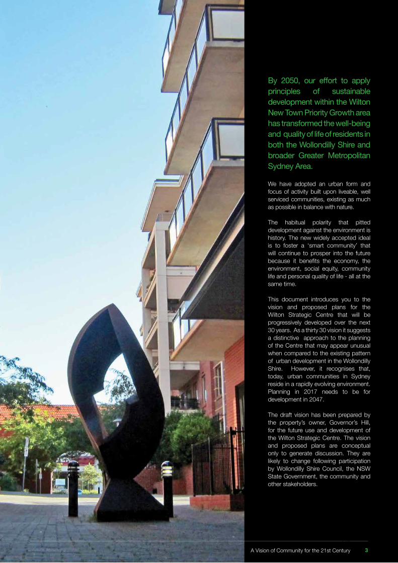
By 2050, our effort to apply principles of sustainable development within the Wilton New Town Priority Growth area has transformed the well-being and quality of life of residents in both the Wollondilly Shire and broader Greater Metropolitan Sydney Area.
We have adopted an urban form and focus of activity built upon liveable, well serviced communities, existing as much as possible in balance with nature.
The habitual polarity that pitted development against the environment is history. The new widely accepted ideal is to foster a ‘smart community’ that will continue to prosper into the future because it benefits the economy, the environment, social equity, community life and personal quality of life - all at the same time.
This document introduces you to the vision and proposed plans for the Wilton Strategic Centre that will be progressively developed over the next 30 years. As a thirty 30 vision it suggests a distinctive approach to the planning of the Centre that may appear unusual when compared to the existing pattern of urban development in the Wollondilly Shire. However, it recognises that, today, urban communities in Sydney reside in a rapidly evolving environment. Planning in 2017 needs to be for development in 2047. The draft vision has been prepared by the property’s owner, Governor’s Hill, for the future use and development of the Wilton Strategic Centre. The vision and proposed plans are conceptual only to generate discussion. They are likely to change following participation by Wollondilly Shire Council, the NSW State Government, the community and other stakeholders.
A Vision of Community for the 21st Century 3114
EXECUTIVE SUMMARY 6
Part 1. The Vision For The Wilton 9Strategic Centre
1. INTRODUCTION 101.1 Background 101.2 This document 131.3 Previous investigations 131.4 The Scope and Objectives of the Vision 14
2. THE DEVELOPMENT CONTEXT 152.1 Carbon Emissions and Climate Change 152.2 The Need for Future Proofing 162.3 The Wilton Strategic Centre in Greater Macarthur 172.4 Initial Wollondilly Council & Community Objectives 192.5 Employment and the Economy 20
3. THE PLACE 223.1 Location and Description 223.2 Character, Land Uses and Activities 243.3 Access and Transport 253.4 Site Capability 283.5 Vegetation and Hydrology 303.6 Heritage and Archaeology 303.7 The Site’s Neighbours 313.8 Infrastructure Services 32
4. CONTEMPORARY PLANNING 33 FRAMEWORK4.1 A New Approach 334.2 Transit Oriented Development 344.3 The Compact City 364.4 A Smart City 39
5. THE VISION AND ITS PRINCIPLES 415.1 The Proposed Vision 415.2 Planning Principles 425.3 The Draft Structure Plan 435.4 The Draft Concept Master Plan 465.5 Mix and Match: Land Use in the Centre 475.6 The Soul of the Site: Parks and Green Spaces 525.7 Place Making: The approach to Build Form 53 and Landscape 5.8 The Working Heart: Employment Capacity 555.9 Places to Live: A Variety of Housing Types 565.10 Moving Around: Connectivity and Usability 585.11 Healthy Living: Environment and Exercise 605.12 One Step at a Time: Staging 61
Table of Contents
Part 2. The Rezoning Proposal 63
6. REZONING OBJECTIVES AND 64 INTENDED OUTCOMES6.1 Objectives 646.2 Intended Outcomes 64
7. EXPLANATION OF PROVISIONS 657.1 Zoning 657.2 Height, Minimum Lot Size and Floor Space 677.3 Other Zoning Proposals 677.4 Development Controls and Strategies 697.5 Provision of Local and State Infrastructure 70
8. JUSTIFICATION 71Section A: Need for the Planning Proposal 71Section B: Relationship to Strategic Planning Framework 72Section C: Environmental, Social & Economic Impact 82Section D: State and Commonwealth Interests 83
Appendices
Appendix 1 Deep End Services, Economic and 85 Employment SummaryAppendix 2 GHD, Infrastructure Feasibility Investigation 97
The Wilton Strategic Centre 4115
Table of Figures
Figure 1 Location of Wilton in the Wollondilly Shire and Sydney’s 10 Macarthur RegionFigure 2 Wilton at the Crossroads of Southern Sydney 11Figure 3 Location of Governor’s Hill Site in Wilton 12Figure 4 Wilton Junction Landowners’ Group 2014 Master Plan 17Figure 5 The Governor’s Hill Site in the NSW Government Greater 18 Macarthur Investigation Area Suitability MapFigure 6 The Governor’s Hill Site in the NSW Government Greater 19 Macarthur Investigation Area Vision Structure PlanFigure 7 The Centres Hierarchy Plan; SGS Economics & Planning 2015 21Figure 8 The location of the site in Wilton 22Figure 9 Cadastral Plan Illustration the Formal Description of the Site 23Figure 10 Comparison of scale of site to Ryde and Gungahlin 23Figure 11 Aerial photo of site illustrating site Character 24Figure 12 Views of Site 24Figure 13 Access and transport around the Site 26Figure 14 Potential location for ‘park and ride’ commuter railway station 27Figure 15 Landform Character and Views into and within the Site 28Figure 16 Plan of Proposed Longwall Mining under Site 29Figure 17 Development and Activities Surrounding the Site 31Figure 18 Draft Broader Structure Plan for the Wilton New Town Priority 43 Growth Area Incorporating the Wilton Strategic CentreFigure 19 Draft Structure Plan Incorporating the Wilton Strategic Centre 44 as it applies to the Governor’s Hill siteFigure 20 Draft Concept Master Plan for the Governor’s Hill land 45 incorporating the Wilton Strategic CentreFigure 21 Draft Detailed Concept Master Plan of the Wilton Strategic Centre 46Figure 22 Wilton Strategic Centre Land Use Precincts Plan 47Figure 23 The Network of Parks and Green Spaces 52Figure 24 The Place making Framework in the Concept Master Plan 53Figure 25 Employment Precincts 54Figure 26 Potential Employment floor space potential in the Strategic Centre 55Figure 27 Residential Precincts 56Figure 28 The Movement Network within the Governor’s Hill site 58Figure 29 The Movement Network Beyond the Site in the Broader 59 Wilton New TownFigure 30 Indicative Staging of Development of the Governor’s Hill Site 61Figure 31 Proposed Configuration of Land Use Zones across the Site 65Figure 32 Proposed Location of SP2 Infrastructure Zone 68Figure 33 Extract of the Plan for Growing Sydney Illustrating the 72 Macarthur Investigation AreaFigure 34 The Wollondilly Growth Management Strategy (GMS) 2011 74
A Vision of Community for the 21st Century 5116
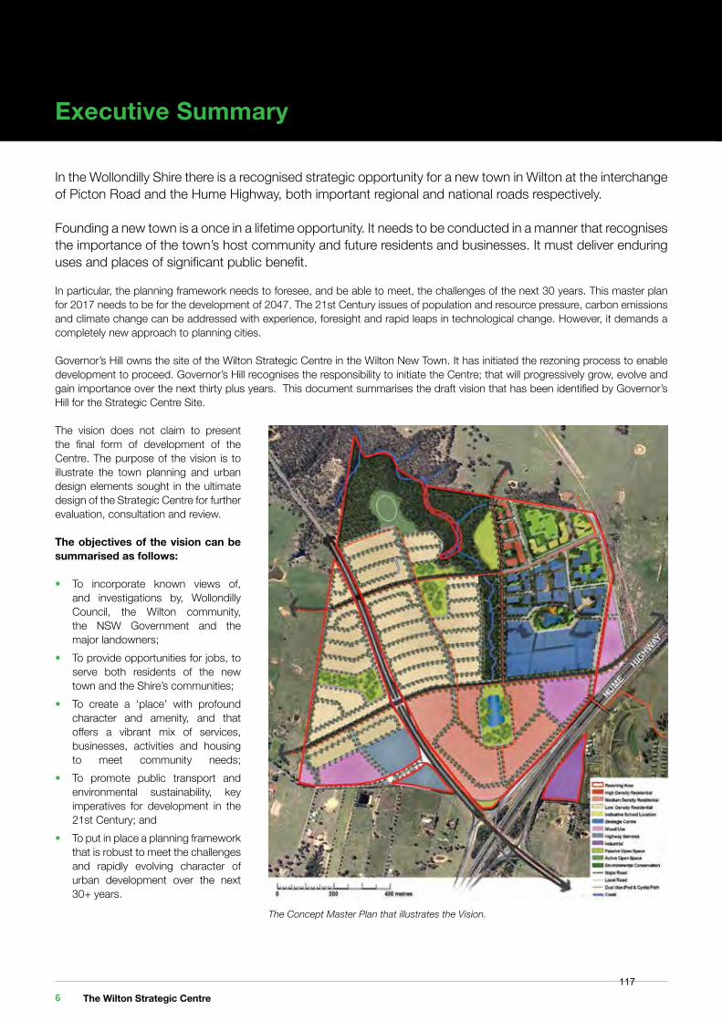
Executive Summary
In the Wollondilly Shire there is a recognised strategic opportunity for a new town in Wilton at the interchange of Picton Road and the Hume Highway, both important regional and national roads respectively.
Founding a new town is a once in a lifetime opportunity. It needs to be conducted in a manner that recognises the importance of the town’s host community and future residents and businesses. It must deliver enduring uses and places of significant public benefit.
In particular, the planning framework needs to foresee, and be able to meet, the challenges of the next 30 years. This master plan for 2017 needs to be for the development of 2047. The 21st Century issues of population and resource pressure, carbon emissions and climate change can be addressed with experience, foresight and rapid leaps in technological change. However, it demands a completely new approach to planning cities.
Governor’s Hill owns the site of the Wilton Strategic Centre in the Wilton New Town. It has initiated the rezoning process to enable development to proceed. Governor’s Hill recognises the responsibility to initiate the Centre; that will progressively grow, evolve and gain importance over the next thirty plus years. This document summarises the draft vision that has been identified by Governor’s Hill for the Strategic Centre Site.
The vision does not claim to present the final form of development of the Centre. The purpose of the vision is to illustrate the town planning and urban design elements sought in the ultimate design of the Strategic Centre for further evaluation, consultation and review.
The objectives of the vision can be summarised as follows:
• To incorporate known views of, and investigations by, Wollondilly Council, the Wilton community, the NSW Government and the major landowners;• To provide opportunities for jobs, to serve both residents of the new town and the Shire’s communities;• To create a ‘place’ with profound character and amenity, and that offers a vibrant mix of services, businesses, activities and housing to meet community needs; • To promote public transport and environmental sustainability, key imperatives for development in the 21st Century; and• To put in place a planning framework that is robust to meet the challenges and rapidly evolving character of urban development over the next 30+ years.
The Concept Master Plan that illustrates the Vision.
The Wilton Strategic Centre 6117
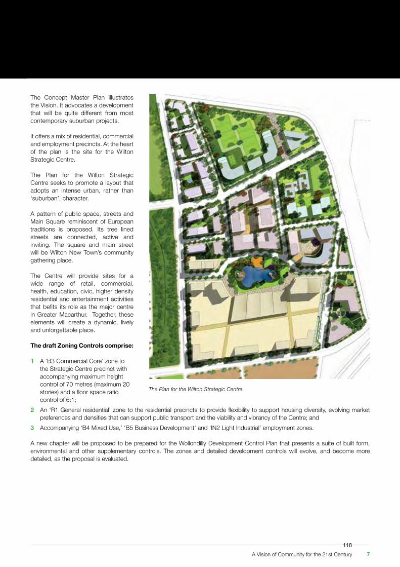
The Concept Master Plan illustrates the Vision. It advocates a development that will be quite different from most contemporary suburban projects.
It offers a mix of residential, commercial and employment precincts. At the heart of the plan is the site for the Wilton Strategic Centre.
The Plan for the Wilton Strategic Centre seeks to promote a layout that adopts an intense urban, rather than ‘suburban’, character.
A pattern of public space, streets and Main Square reminiscent of European traditions is proposed. Its tree lined streets are connected, active and inviting. The square and main street will be Wilton New Town’s community gathering place.
The Centre will provide sites for a wide range of retail, commercial, health, education, civic, higher density residential and entertainment activities that befits its role as the major centre in Greater Macarthur. Together, these elements will create a dynamic, lively and unforgettable place.
The draft Zoning Controls comprise:
1 A ‘B3 Commercial Core’ zone to the Strategic Centre precinct with accompanying maximum height control of 70 metres (maximum 20 stories) and a floor space ratio control of 6:1;2 An ‘R1 General residential’ zone to the residential precincts to provide flexibility to support housing diversity, evolving market preferences and densities that can support public transport and the viability and vibrancy of the Centre; and3 Accompanying ‘B4 Mixed Use,’ ‘B5 Business Development’ and ‘IN2 Light Industrial’ employment zones.
A new chapter will be proposed to be prepared for the Wollondilly Development Control Plan that presents a suite of built form, environmental and other supplementary controls. The zones and detailed development controls will evolve, and become more detailed, as the proposal is evaluated.
The Plan for the Wilton Strategic Centre.
A Vision of Community for the 21st Century 7118

119
Part 1The Vision
For The WiltonStrategic Centre
120
1. Introduction
1.1 Background
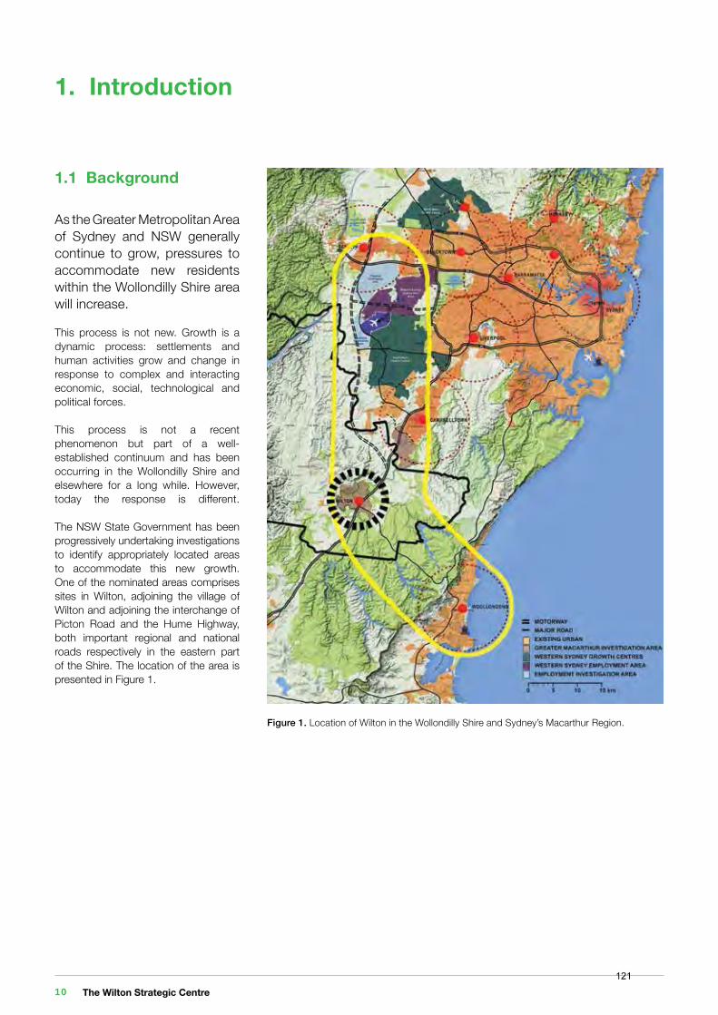
As the Greater Metropolitan Area of Sydney and NSW generally continue to grow, pressures to accommodate new residents within the Wollondilly Shire area will increase.
This process is not new. Growth is a dynamic process: settlements and human activities grow and change in response to complex and interacting economic, social, technological and political forces.
This process is not a recent phenomenon but part of a well-established continuum and has been occurring in the Wollondilly Shire and elsewhere for a long while. However, today the response is different. The NSW State Government has been progressively undertaking investigations to identify appropriately located areas to accommodate this new growth. One of the nominated areas comprises sites in Wilton, adjoining the village of Wilton and adjoining the interchange of Picton Road and the Hume Highway, both important regional and national roads respectively in the eastern part of the Shire. The location of the area is presented in Figure 1.
Figure 1. Location of Wilton in the Wollondilly Shire and Sydney’s Macarthur Region.
The Wilton Strategic Centre 10121
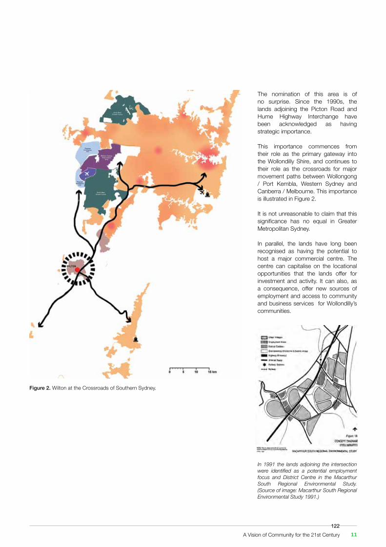
Figure 2. Wilton at the Crossroads of Southern Sydney.
In 1991 the lands adjoining the intersection were identified as a potential employment focus and District Centre in the Macarthur South Regional Environmental Study. (Source of image: Macarthur South Regional Environmental Study 1991.)
The nomination of this area is of no surprise. Since the 1990s, the lands adjoining the Picton Road and Hume Highway Interchange have been acknowledged as having strategic importance. This importance commences from their role as the primary gateway into the Wollondilly Shire, and continues to their role as the crossroads for major movement paths between Wollongong / Port Kembla, Western Sydney and Canberra / Melbourne. This importance is illustrated in Figure 2.
It is not unreasonable to claim that this significance has no equal in Greater Metropolitan Sydney.
In parallel, the lands have long been recognised as having the potential to host a major commercial centre. The centre can capitalise on the locational opportunities that the lands offer for investment and activity. It can also, as a consequence, offer new sources of employment and access to community and business services for Wollondilly’s communities.
A Vision of Community for the 21st Century 11122
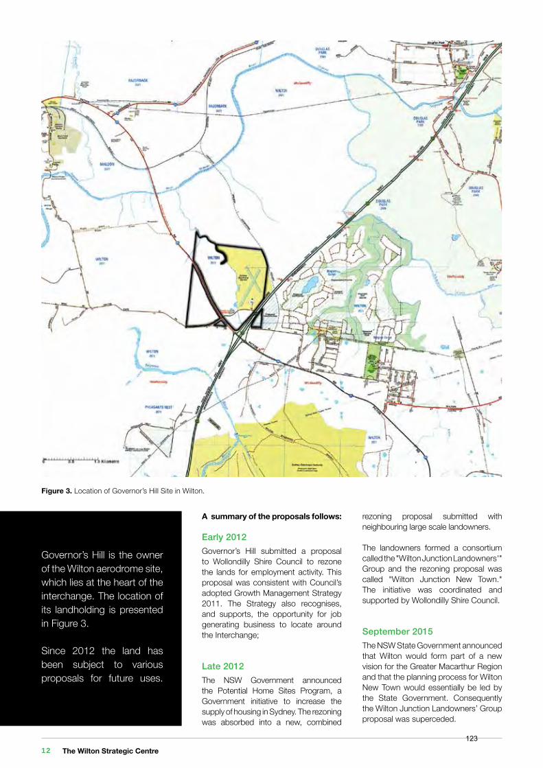
Figure 3. Location of Governor’s Hill Site in Wilton.
A summary of the proposals follows:
Early 2012 Governor’s Hill submitted a proposal to Wollondilly Shire Council to rezone the lands for employment activity. This proposal was consistent with Council’s adopted Growth Management Strategy 2011. The Strategy also recognises, and supports, the opportunity for job generating business to locate around the Interchange;
Late 2012The NSW Government announced the Potential Home Sites Program, a Government initiative to increase the supply of housing in Sydney. The rezoning was absorbed into a new, combined
rezoning proposal submitted with neighbouring large scale landowners.
The landowners formed a consortium called the "Wilton Junction Landowners'" Group and the rezoning proposal was called "Wilton Junction New Town." The initiative was coordinated and supported by Wollondilly Shire Council.
September 2015The NSW State Government announced that Wilton would form part of a new vision for the Greater Macarthur Region and that the planning process for Wilton New Town would essentially be led by the State Government. Consequently the Wilton Junction Landowners’ Group proposal was superceded.
Governor’s Hill is the owner of the Wilton aerodrome site, which lies at the heart of the interchange. The location of its landholding is presented in Figure 3.
Since 2012 the land has been subject to various proposals for future uses.
The Wilton Strategic Centre 12123

October 2015The Government’s vision for the region and Wilton was laid out in the Greater Macarthur Land Release Investigation Preliminary Strategy and Action Plan. The vision recognises Wilton New Town as a Priority Growth Area in the Macarthur region and proposes a number of actions for the NSW Government to advance the new town at Wilton. The Strategy was publicly exhibited in November 2015 and an amendment was subsequently made to the Growth Centres’ State Environmental Planning Policy (SEPP) to designate Wilton as a Priority Growth Area.
Late 2016The State Government invited the major landowners to submit individual rezoning proposals for large strategically significant parcels of land subject to the satisfaction of a number of requirements beforehand. These requirements encompassed environmental, mining co-existence and infrastructure criteria.
Governor’s Hill considers that it has satisfied the requirements of the State Government’s invitation in 2016 and has prepared and submitted its request to rezone its land holding.
1.2 This document
This document comprises the rezoning submission and presents the Vision that Governor’s Hill has for the development of the Wilton Strategic Centre.
It commences by analysing the characteristics of the site and its context. It proceeds to present and describe an illustrative vision for the site and explains the adopted approach and rationale that supports it.
It is appropriate to note that the vision is neither a detailed design for subdivision nor a development application. It does not purport to present the final form of development of the Centre. The purpose of the vision in this document is to illustrate the urban design elements sought in the ultimate design of the Strategic Centre should its development be supported by the subsequent investigation process and accepted by Council and the NSW State Government.
1.3 Previous Investigations
A number of investigations were commissioned by the Wilton Junction Landowners' Group between 2012 and 2015. Additional investigations commissioned by the NSW State Government are, at this time of writing, underway.
The studies either address the Wilton New Town area or the broader Greater Macarthur Investigation Area. Many of the studies commissioned by the Landowner Group have been superseded. That said, their findings are considered to be sufficiently robust to provide guidance for more detailed studies that will need to be undertaken by Governor’s Hill for its land, should Council and the NSW Government support the rezoning of the property.
For brevity the previous investigations have not been included in this rezoning submission. However:
• Their findings (where they are relevant to the Governor’s Hill site) are summarised in this document; and• As noted above, they will serve to guide further detailed site specific investigations that will be exhibited with a detailed rezoning proposal that may follow.
A Vision of Community for the 21st Century 13124
1.4 The Scope and Objectives of the VisionThe scope of the Vision in this document and its primary objectives are to:
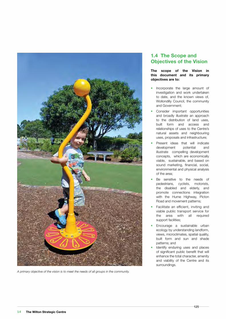
• Incorporate the large amount of investigation and work undertaken to date, and the known views of, Wollondilly Council, the community and Government;• Consider important opportunities and broadly illustrate an approach to the distribution of land uses, built form and access and relationships of uses to the Centre’s natural assets and neighbouring uses, proposals and infrastructure;• Present ideas that will indicate development potential and illustrate compelling development concepts, which are economically viable, sustainable, and based on sound marketing, financial, social, environmental and physical analysis of the area;• Be sensitive to the needs of pedestrians, cyclists, motorists, the disabled and elderly, and promote connections integration with the Hume Highway, Picton Road and movement patterns;• Facilitate an efficient, inviting and viable public transport service for the area with all required support facilities;• Encourage a sustainable urban ecology by understanding landform, views, microclimates, spatial quality, built form and sun and shade patterns; and• Identify enduring uses and places of significant public benefit that will enhance the total character, amenity and viability of the Centre and its surroundings.
A primary objective of the vision is to meet the needs of all groups in the community.
The Wilton Strategic Centre 14125
In the 21st Century, any proposal for a change in land use from rural to urban activities requires investigations that must look beyond the confines of the site.
Development can no longer take a myopic view of its relationships with its neighbours or its environmental context.
Fundamentally, planning must now be considered as strategic asset management and “adding value”.
The value adding process will obviously apply to private and public investment in infrastructure and civic services and facilities. However, if an urban environment at Wilton is to be successful, it must also positively impact on the quality of life of the Wollondilly Community and its host environment.
Today, planning for development needs to extend its attention to the following considerations:
• Carbon Emissions and Climate Change;• The Need for Future Proofing;• The Centre in Greater Macarthur; and• Employment and the Economy.
2.1 Carbon Emissions and Climate Change
The cost of extracting energy from most fossil fuel sources is expected to rise dramatically within the next 30-50 years as the cost of reducing carbon emissions are incorporated into energy production and use.
Fossil fuel use has increased five-fold over the past half century and provides 85% of the world’s commercial energy. It is therefore important to acknowledge the dependence of urban areas on inexpensive power for all infrastructure, construction, lighting, air conditioning, computing, telecommunications and transportation.
If the challenges imposed by rising energy costs are not effectively met, the financial impact will deeply affect the way of life, well-being and amenity of urban residents. If, on the other hand, the response is proactive, economic development and maintenance of quality of life is better assured.
Energy issues have thus now taken centre stage. Strategies that reduce energy consumption will be vitally important to a city’s future. At the same time, global climate change is emerging as a long term effect of the worldwide use of fossil fuels. As primary energy consumers, cities are the largest single sources of CO2 equivalent greenhouse gas emissions.
The end of cheap energy and global climate change will require concerted attention to improving energy efficiency and making changes to energy production and use. These factors are expected to influence the form of urban development. Importantly, significant energy savings can come from altering transportation and land-use patterns.
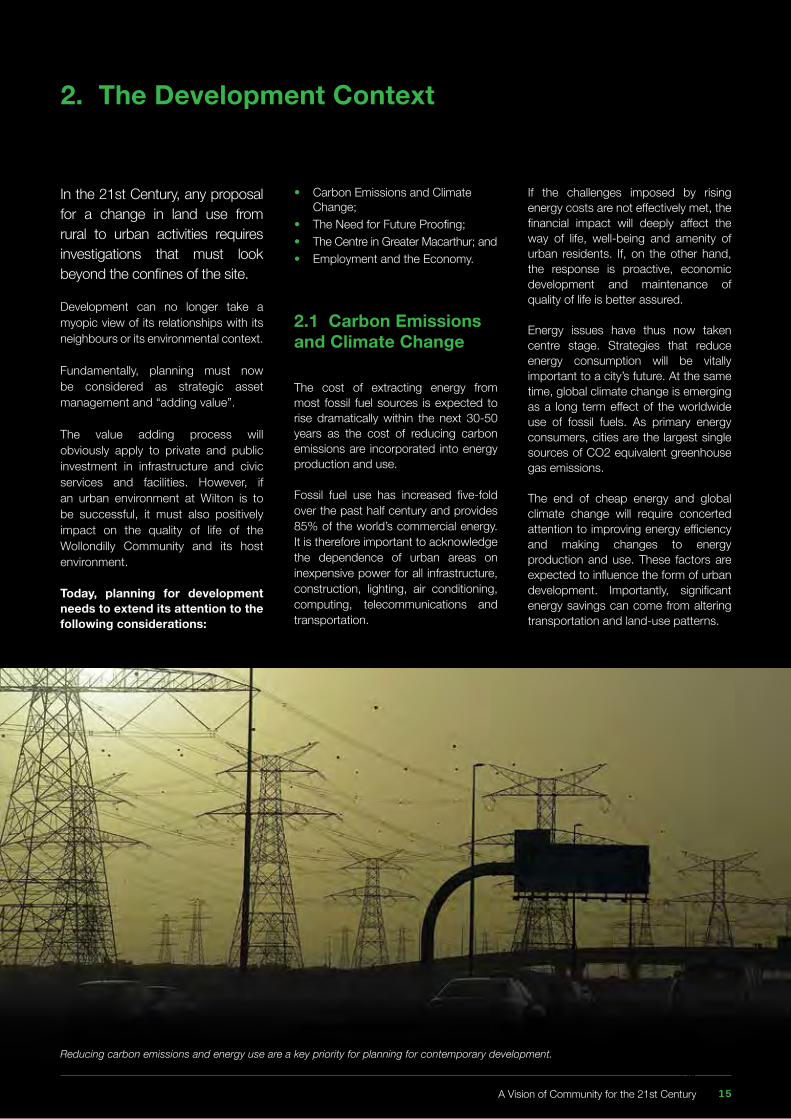
Reducing carbon emissions and energy use are a key priority for planning for contemporary development.
2. The Development Context
A Vision of Community for the 21st Century 15126
2.2 The Need for Future Proofing
Urban development is confronting many challenges as we progress through the 21st Century. For probably the first time ever in our existence the next 50 to 80 years are going to bring profound changes to the way that we live, work and play.
The challenges are numerous:
1. How do we house growing and aging populations, together with evolving and broadening household types?2. How do we meet the challenges of making housing more affordable, so that current and future generations can enjoy access to homes and living environment similar to that enjoyed by generations in the past?3. How do we protect the amenity, quality of life and economy of local communities as Sydney gets larger and services and employment get potentially more distant and separated? That is, how do we keep the local, local and reduce the need to travel long distances? And,
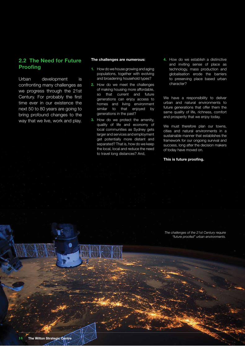
The challenges of the 21st Century require “future proofed” urban environments.
4. How do we establish a distinctive and inviting sense of place as technology, mass production and globalisation erode the barriers to preserving place based urban character?
We have a responsibility to deliver urban and natural environments to future generations that offer them the same quality of life, richness, comfort and prosperity that we enjoy today.
We must therefore plan our towns, cities and natural environments in a sustainable manner that establishes the framework for our ongoing survival and success, long after the decision makers of today have moved on.
This is future proofing.
The Wilton Strategic Centre 16127
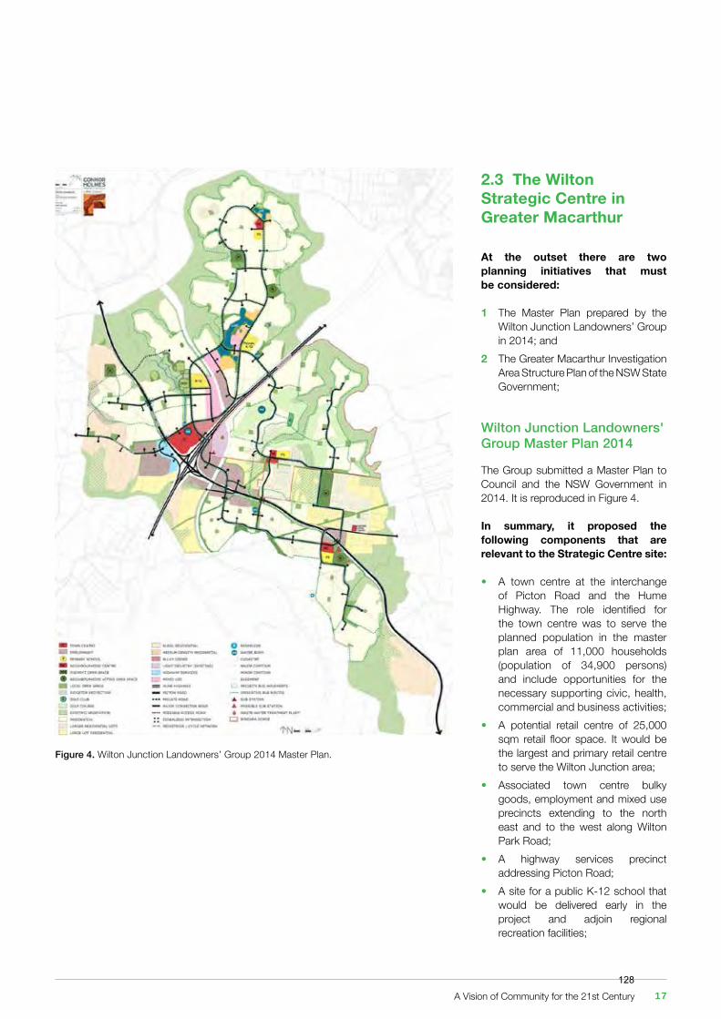
2.3 The Wilton Strategic Centre in Greater Macarthur
At the outset there are two planning initiatives that must be considered:
1 The Master Plan prepared by the Wilton Junction Landowners’ Group in 2014; and2 The Greater Macarthur Investigation Area Structure Plan of the NSW State Government;
Wilton Junction Landowners' Group Master Plan 2014
The Group submitted a Master Plan to Council and the NSW Government in 2014. It is reproduced in Figure 4.
In summary, it proposed the following components that are relevant to the Strategic Centre site:
• A town centre at the interchange of Picton Road and the Hume Highway. The role identified for the town centre was to serve the planned population in the master plan area of 11,000 households (population of 34,900 persons) and include opportunities for the necessary supporting civic, health, commercial and business activities;• A potential retail centre of 25,000 sqm retail floor space. It would be the largest and primary retail centre to serve the Wilton Junction area;• Associated town centre bulky goods, employment and mixed use precincts extending to the north east and to the west along Wilton Park Road;• A highway services precinct addressing Picton Road;• A site for a public K-12 school that would be delivered early in the project and adjoin regional recreation facilities;
Figure 4. Wilton Junction Landowners’ Group 2014 Master Plan.
A Vision of Community for the 21st Century 17128
• A new, north facing intersection to the Hume Highway immediately north of the existing Picton / Hume interchange. The western exit of the intersection would provide direct access to the town centre; while the eastern exit would provide connectivity for future housing areas to the south east;• The upgrading of the Hume/Picton Interchange primarily comprised of a south east to north flyover to cater for both current northbound traffic volumes and future traffic volumes added by the Wilton Junction development;• The provision of a signalised intersection providing access to the site and Wilton Park Road in a location to the north of the current intersection; and• Preservation of the majority of the existing Byrne’s Creek riparian corridor and woodland assets within the site.
The Landowners' Group also prepared a Draft S.94 Contributions Plan for consideration by Council and a draft offer to fund and construct specific items of State Infrastructure.
This plan has now been superceded by subsequent decisions and views by both Council and The NSW State Government.
The Greater Macarthur Investigation Area
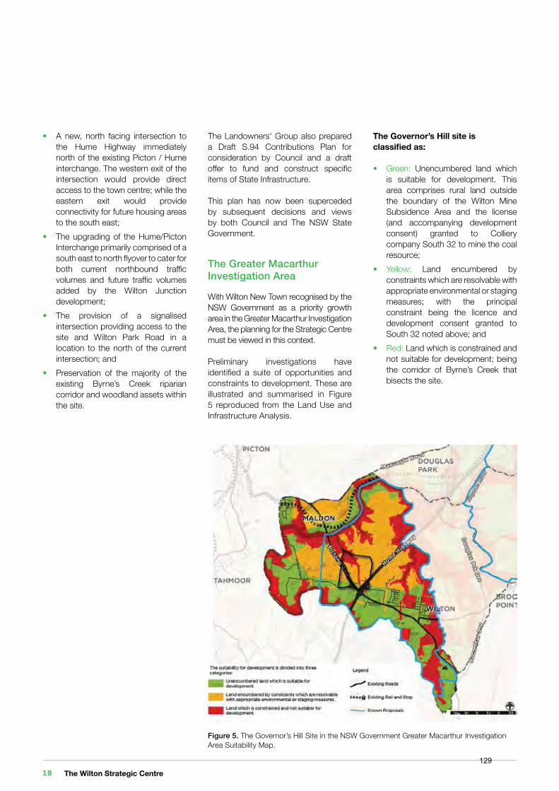
With Wilton New Town recognised by the NSW Government as a priority growth area in the Greater Macarthur Investigation Area, the planning for the Strategic Centre must be viewed in this context.
Preliminary investigations have identified a suite of opportunities and constraints to development. These are illustrated and summarised in Figure 5 reproduced from the Land Use and Infrastructure Analysis.
Figure 5. The Governor’s Hill Site in the NSW Government Greater Macarthur Investigation Area Suitability Map.
The Governor’s Hill site is classified as:
• Green: Unencumbered land which is suitable for development. This area comprises rural land outside the boundary of the Wilton Mine Subsidence Area and the license (and accompanying development consent) granted to Colliery company South 32 to mine the coal resource;• Yellow: Land encumbered by constraints which are resolvable with appropriate environmental or staging measures; with the principal constraint being the licence and development consent granted to South 32 noted above; and• Red: Land which is constrained and not suitable for development; being the corridor of Byrne’s Creek that bisects the site.
The Wilton Strategic Centre 18129
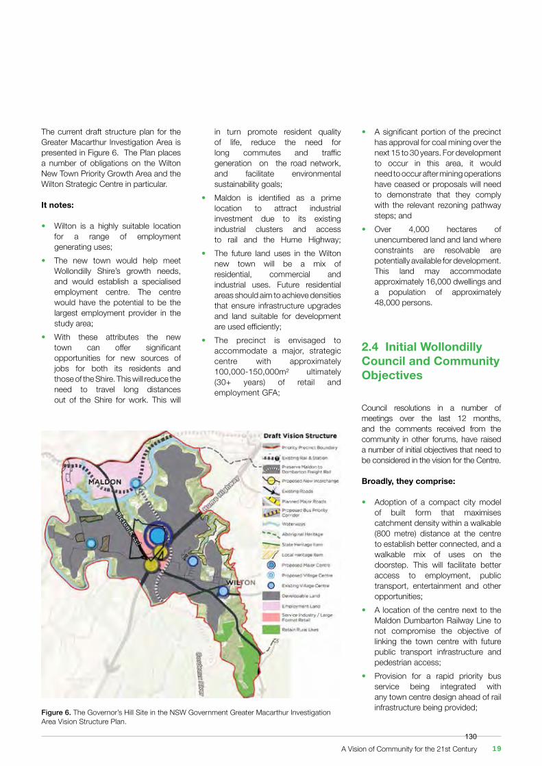
Figure 6. The Governor’s Hill Site in the NSW Government Greater Macarthur Investigation Area Vision Structure Plan.
The current draft structure plan for the Greater Macarthur Investigation Area is presented in Figure 6. The Plan places a number of obligations on the Wilton New Town Priority Growth Area and the Wilton Strategic Centre in particular.
It notes:
• Wilton is a highly suitable location for a range of employment generating uses;• The new town would help meet Wollondilly Shire’s growth needs, and would establish a specialised employment centre. The centre would have the potential to be the largest employment provider in the study area; • With these attributes the new town can offer significant opportunities for new sources of jobs for both its residents and those of the Shire. This will reduce the need to travel long distances out of the Shire for work. This will
in turn promote resident quality of life, reduce the need for long commutes and traffic generation on the road network, and facilitate environmental sustainability goals;• Maldon is identified as a prime location to attract industrial investment due to its existing industrial clusters and access to rail and the Hume Highway; • The future land uses in the Wilton new town will be a mix of residential, commercial and industrial uses. Future residential areas should aim to achieve densities that ensure infrastructure upgrades and land suitable for development are used efficiently;• The precinct is envisaged to accommodate a major, strategic centre with approximately 100,000-150,000m² ultimately (30+ years) of retail and employment GFA;
• A significant portion of the precinct has approval for coal mining over the next 15 to 30 years. For development to occur in this area, it would need to occur after mining operations have ceased or proposals will need to demonstrate that they comply with the relevant rezoning pathway steps; and• Over 4,000 hectares of unencumbered land and land where constraints are resolvable are potentially available for development. This land may accommodate approximately 16,000 dwellings and a population of approximately 48,000 persons.
2.4 Initial Wollondilly Council and Community Objectives
Council resolutions in a number of meetings over the last 12 months, and the comments received from the community in other forums, have raised a number of initial objectives that need to be considered in the vision for the Centre.
Broadly, they comprise:
• Adoption of a compact city model of built form that maximises catchment density within a walkable (800 metre) distance at the centre to establish better connected, and a walkable mix of uses on the doorstep. This will facilitate better access to employment, public transport, entertainment and other opportunities; • A location of the centre next to the Maldon Dumbarton Railway Line to not compromise the objective of linking the town centre with future public transport infrastructure and pedestrian access;• Provision for a rapid priority bus service being integrated with any town centre design ahead of rail infrastructure being provided;
A Vision of Community for the 21st Century 19130
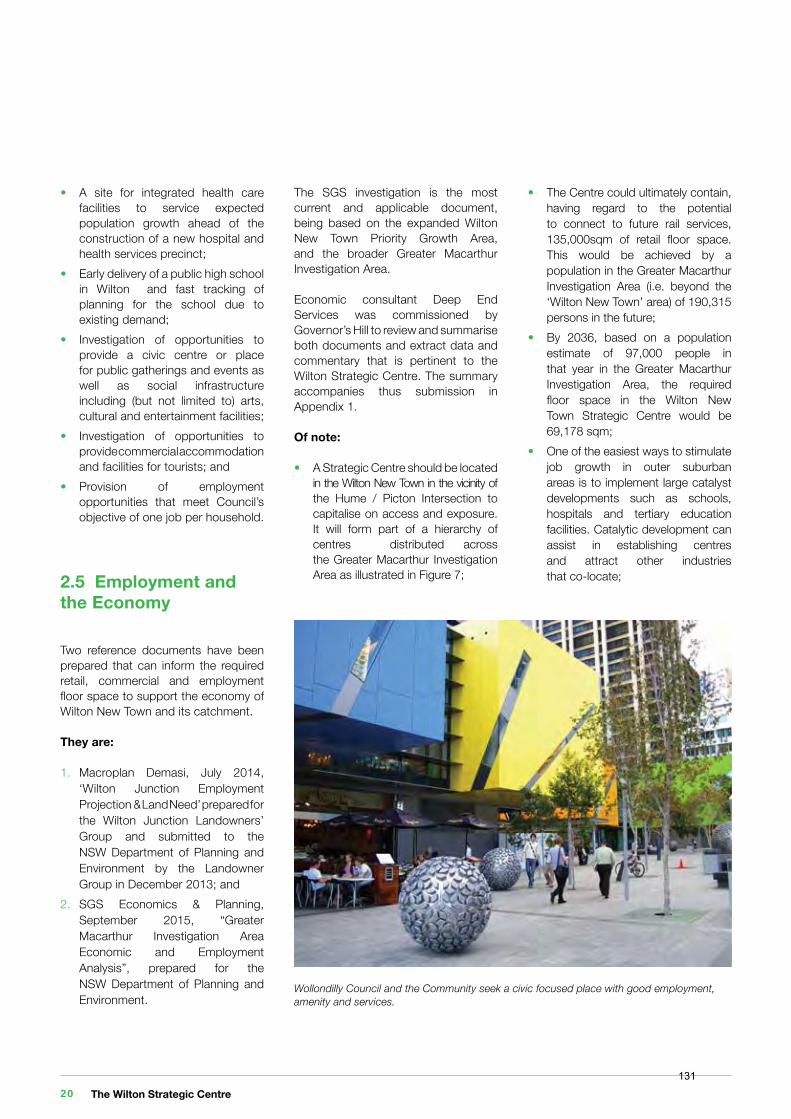
Wollondilly Council and the Community seek a civic focused place with good employment, amenity and services.
The SGS investigation is the most current and applicable document, being based on the expanded Wilton New Town Priority Growth Area, and the broader Greater Macarthur Investigation Area.
Economic consultant Deep End Services was commissioned by Governor’s Hill to review and summarise both documents and extract data and commentary that is pertinent to the Wilton Strategic Centre. The summary accompanies thus submission in Appendix 1.
Of note:
• A Strategic Centre should be located in the Wilton New Town in the vicinity of the Hume / Picton Intersection to capitalise on access and exposure. It will form part of a hierarchy of centres distributed across the Greater Macarthur Investigation Area as illustrated in Figure 7;
• The Centre could ultimately contain, having regard to the potential to connect to future rail services, 135,000sqm of retail floor space. This would be achieved by a population in the Greater Macarthur Investigation Area (i.e. beyond the ‘Wilton New Town’ area) of 190,315 persons in the future;• By 2036, based on a population estimate of 97,000 people in that year in the Greater Macarthur Investigation Area, the required floor space in the Wilton New Town Strategic Centre would be 69,178 sqm;• One of the easiest ways to stimulate job growth in outer suburban areas is to implement large catalyst developments such as schools, hospitals and tertiary education facilities. Catalytic development can assist in establishing centres and attract other industries that co-locate;
• A site for integrated health care facilities to service expected population growth ahead of the construction of a new hospital and health services precinct; • Early delivery of a public high school in Wilton and fast tracking of planning for the school due to existing demand;• Investigation of opportunities to provide a civic centre or place for public gatherings and events as well as social infrastructure including (but not limited to) arts, cultural and entertainment facilities;• Investigation of opportunities to provide commercial accommodation and facilities for tourists; and• Provision of employment opportunities that meet Council’s objective of one job per household.
2.5 Employment and the Economy
Two reference documents have been prepared that can inform the required retail, commercial and employment floor space to support the economy of Wilton New Town and its catchment.
They are:
1. Macroplan Demasi, July 2014, ‘Wilton Junction Employment Projection & Land Need’ prepared for the Wilton Junction Landowners’ Group and submitted to the NSW Department of Planning and Environment by the Landowner Group in December 2013; and2. SGS Economics & Planning, September 2015, “Greater Macarthur Investigation Area Economic and Employment Analysis”, prepared for the NSW Department of Planning and Environment.
The Wilton Strategic Centre 20131
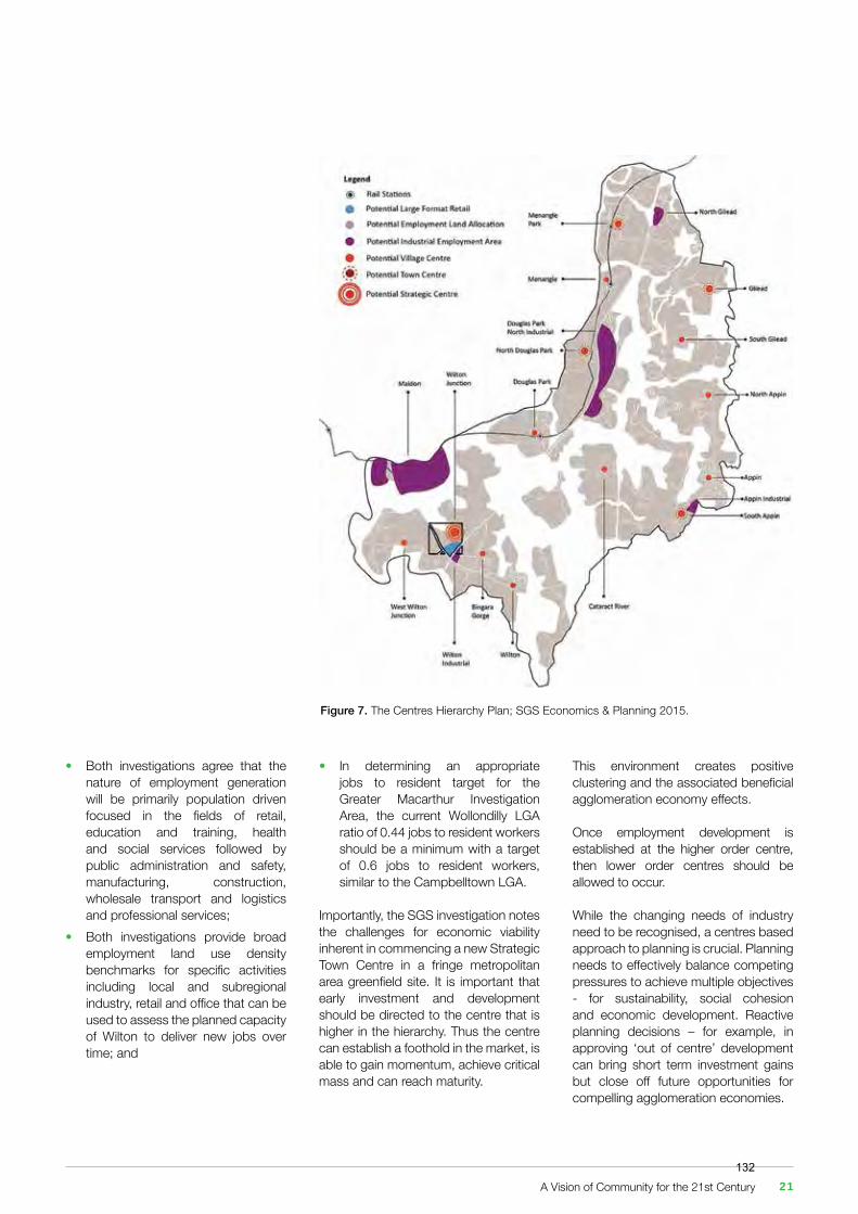
Figure 7. The Centres Hierarchy Plan; SGS Economics & Planning 2015.
• Both investigations agree that the nature of employment generation will be primarily population driven focused in the fields of retail, education and training, health and social services followed by public administration and safety, manufacturing, construction, wholesale transport and logistics and professional services;• Both investigations provide broad employment land use density benchmarks for specific activities including local and subregional industry, retail and office that can be used to assess the planned capacity of Wilton to deliver new jobs over time; and
• In determining an appropriate jobs to resident target for the Greater Macarthur Investigation Area, the current Wollondilly LGA ratio of 0.44 jobs to resident workers should be a minimum with a target of 0.6 jobs to resident workers, similar to the Campbelltown LGA.
Importantly, the SGS investigation notes the challenges for economic viability inherent in commencing a new Strategic Town Centre in a fringe metropolitan area greenfield site. It is important that early investment and development should be directed to the centre that is higher in the hierarchy. Thus the centre can establish a foothold in the market, is able to gain momentum, achieve critical mass and can reach maturity.
This environment creates positive clustering and the associated beneficial agglomeration economy effects.
Once employment development is established at the higher order centre, then lower order centres should be allowed to occur.
While the changing needs of industry need to be recognised, a centres based approach to planning is crucial. Planning needs to effectively balance competing pressures to achieve multiple objectives ‐ for sustainability, social cohesion and economic development. Reactive planning decisions – for example, in approving ‘out of centre’ development can bring short term investment gains but close off future opportunities for compelling agglomeration economies.
A Vision of Community for the 21st Century 21132
A detailed look at the site of the future Wilton Strategic Centre requires attention to the following considerations:
• The site’s location and description;• It's existing character, land uses and activities;• Access and transport;• Geology, mining and landform;• Vegetation and hydrology;• Heritage and archaeology; and• It’s neighbours.
3.1 Location and Description
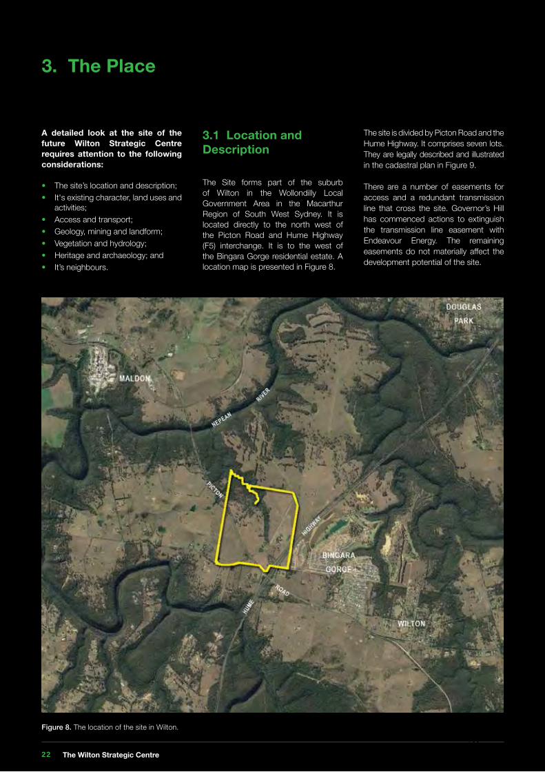
The Site forms part of the suburb of Wilton in the Wollondilly Local Government Area in the Macarthur Region of South West Sydney. It is located directly to the north west of the Picton Road and Hume Highway (F5) interchange. It is to the west of the Bingara Gorge residential estate. A location map is presented in Figure 8.
3. The Place
Figure 8. The location of the site in Wilton.
The site is divided by Picton Road and the Hume Highway. It comprises seven lots. They are legally described and illustrated in the cadastral plan in Figure 9.
There are a number of easements for access and a redundant transmission line that cross the site. Governor’s Hill has commenced actions to extinguish the transmission line easement with Endeavour Energy. The remaining easements do not materially affect the development potential of the site.
The Wilton Strategic Centre 22133
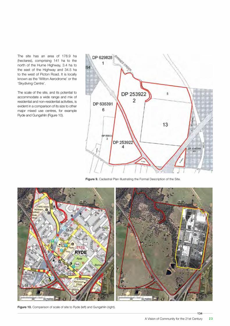
The site has an area of 178.9 ha (hectares), comprising 141 ha to the north of the Hume Highway, 3.4 ha to the east of the Highway and 34.5 ha to the west of Picton Road. It is locally known as the ‘Wilton Aerodrome’ or the ‘Skydiving Centre’.
The scale of the site, and its potential to accommodate a wide range and mix of residential and non-residential activities, is evident in a comparison of its size to other major mixed use centres, for example Ryde and Gungahlin (Figure 10).
Figure 9. Cadastral Plan Illustrating the Formal Description of the Site.
Figure 10. Comparison of scale of site to Ryde (left) and Gungahlin (right).
A Vision of Community for the 21st Century 23134
3.2 Character, Land Uses and Activities
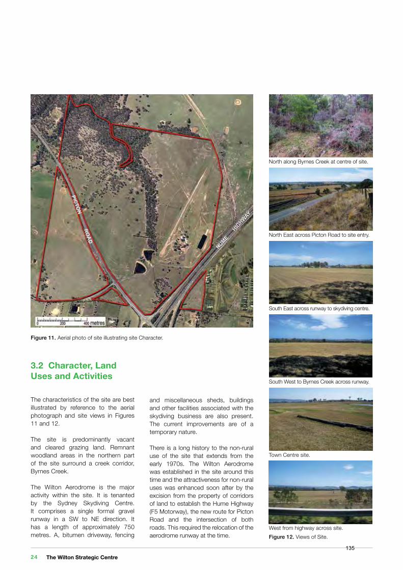
The characteristics of the site are best illustrated by reference to the aerial photograph and site views in Figures 11 and 12.
The site is predominantly vacant and cleared grazing land. Remnant woodland areas in the northern part of the site surround a creek corridor, Byrnes Creek.
The Wilton Aerodrome is the major activity within the site. It is tenanted by the Sydney Skydiving Centre. It comprises a single formal gravel runway in a SW to NE direction. It has a length of approximately 750 metres. A, bitumen driveway, fencing
North along Byrnes Creek at centre of site.
South East across runway to skydiving centre.
Town Centre site.
North East across Picton Road to site entry.
South West to Byrnes Creek across runway.
West from highway across site.
Figure 11. Aerial photo of site illustrating site Character.
Figure 12. Views of Site.
and miscellaneous sheds, buildings and other facilities associated with the skydiving business are also present. The current improvements are of a temporary nature.
There is a long history to the non-rural use of the site that extends from the early 1970s. The Wilton Aerodrome was established in the site around this time and the attractiveness for non-rural uses was enhanced soon after by the excision from the property of corridors of land to establish the Hume Highway (F5 Motorway), the new route for Picton Road and the intersection of both roads. This required the relocation of the aerodrome runway at the time.
The Wilton Strategic Centre 24135
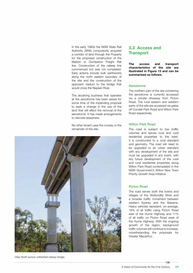
View North across unfinished railway bridge.
In the early 1980s the NSW State Rail Authority (SRA) compulsorily acquired a corridor of land through the Property for the proposed construction of the Maldon to Dumbarton Freight Rail line. Construction of the railway line commenced but was not completed. Early actions include bulk earthworks along the north eastern boundary of the site and the construction of the approach viaduct to the bridge that would cross the Nepean River.
The skydiving business that operates at the aerodrome has been aware for some time of the impending proposal to seek a change in the use of the land that will affect the removal of the aerodrome. It has made arrangements to relocate elsewhere.
No other tenant uses the runway or the remainder of the site.
3.3 Access and Transport
The access and transport characteristics of the site are illustrated in Figure 13 and can be summarised as follows.
AerodromeThe northern part of the site containing the aerodrome is currently accessed via a private driveway from Picton Road. The rural eastern and western parts of the site are accessed via gates off Condell Park Road and Wilton Park Road respectively.
Wilton Park RoadThe road is subject to low traffic volumes and serves rural and rural residential properties to the west. It is constructed to a rural standard and geometry. The road will need to be upgraded to an urban standard with any development of the site and must be upgraded in any event, with any future development of the rural and rural residential properties along Wilton Park Road contemplated in the NSW Government’s Wilton New Town Priority Growth Area Initiative.
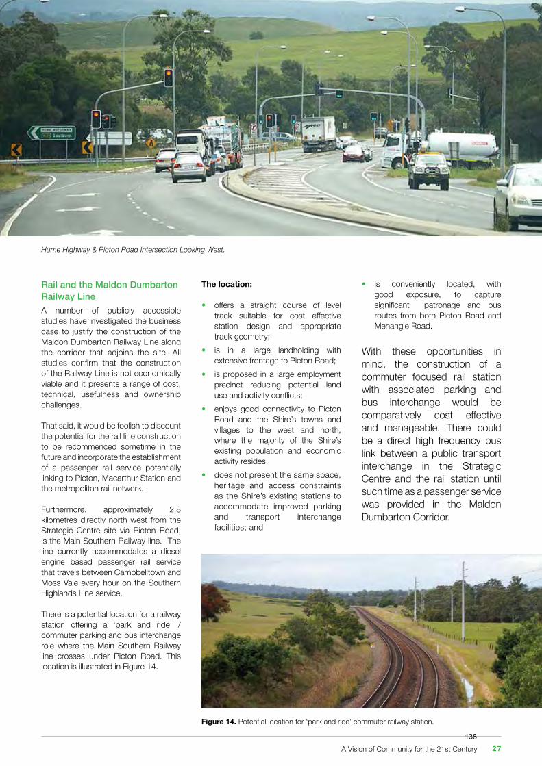
Picton RoadThe road serves both the towns and villages of the Wollondilly Shire and a broader traffic movement between western Sydney and the Illawarra. Heavy vehicles represent, on average, 18% of all traffic using Picton Road east of the Hume Highway and 11% of all traffic on Picton Road west of the Hume Highway. With the ongoing growth of the region, background traffic volumes will continue to increase, notwithstanding the proposals for Greater Macarthur.
A Vision of Community for the 21st Century 25136

Figure 13. Access and transport around the Site.
Hume Highway (F5) / Picton Road InterchangeThe interchange directly adjoins the site. Currently, traffic volumes along the full extent of Hume corridor are growing at approximately 3% per year and the interchange experiences congestion at peak times. It has recently been upgraded with traffic signals.
This congestion is forecast to increase in the future. Several proposals have been tabled to upgrade the intersection over the years, the most recent being the flyover arrangement proposed by the Wilton Junction Landowners’ Group.
Wilton Park Road and Picton Road Intersection The intersection is some 300 metres to the north west of the Hume Highway / Picton Road interchange. The intersection is also directly opposite the entrance driveway to the eastern part of the site and aerodrome. With ongoing increases in traffic using all roads in Wilton, together with the potential development of the site and proposals for development on neighbouring sites, the current arrangement of the Wilton Park Road and Aerodrome site access is unsustainable in the long term. The current intersection is too close to the interchange to provide for appropriate acceleration / deceleration distances. There is insufficient separation between intersection and interchange and the cross movement of traffic generates access and safety issues.
Picton Road Public TransportPicton Bus Lines Route 901 travels along Picton Road. The service runs four times daily and provides a link between Picton and Wilton via Douglas Park.
The Wilton Strategic Centre 26137
Rail and the Maldon Dumbarton Railway LineA number of publicly accessible studies have investigated the business case to justify the construction of the Maldon Dumbarton Railway Line along the corridor that adjoins the site. All studies confirm that the construction of the Railway Line is not economically viable and it presents a range of cost, technical, usefulness and ownership challenges.
That said, it would be foolish to discount the potential for the rail line construction to be recommenced sometime in the future and incorporate the establishment of a passenger rail service potentially linking to Picton, Macarthur Station and the metropolitan rail network.
Furthermore, approximately 2.8 kilometres directly north west from the Strategic Centre site via Picton Road, is the Main Southern Railway line. The line currently accommodates a diesel engine based passenger rail service that travels between Campbelltown and Moss Vale every hour on the Southern Highlands Line service.
There is a potential location for a railway station offering a ‘park and ride’ /commuter parking and bus interchange role where the Main Southern Railway line crosses under Picton Road. This location is illustrated in Figure 14.
The location:
• offers a straight course of level track suitable for cost effective station design and appropriate track geometry;• is in a large landholding with extensive frontage to Picton Road;• is proposed in a large employment precinct reducing potential land use and activity conflicts; • enjoys good connectivity to Picton Road and the Shire’s towns and villages to the west and north, where the majority of the Shire’s existing population and economic activity resides;• does not present the same space, heritage and access constraints as the Shire’s existing stations to accommodate improved parking and transport interchange facilities; and
Figure 14. Potential location for ‘park and ride’ commuter railway station.
Hume Highway & Picton Road Intersection Looking West.
• is conveniently located, with good exposure, to capture significant patronage and bus routes from both Picton Road and Menangle Road.
With these opportunities in mind, the construction of a commuter focused rail station with associated parking and bus interchange would be comparatively cost effective and manageable. There could be a direct high frequency bus link between a public transport interchange in the Strategic Centre and the rail station until such time as a passenger service was provided in the Maldon Dumbarton Corridor.
A Vision of Community for the 21st Century 27138
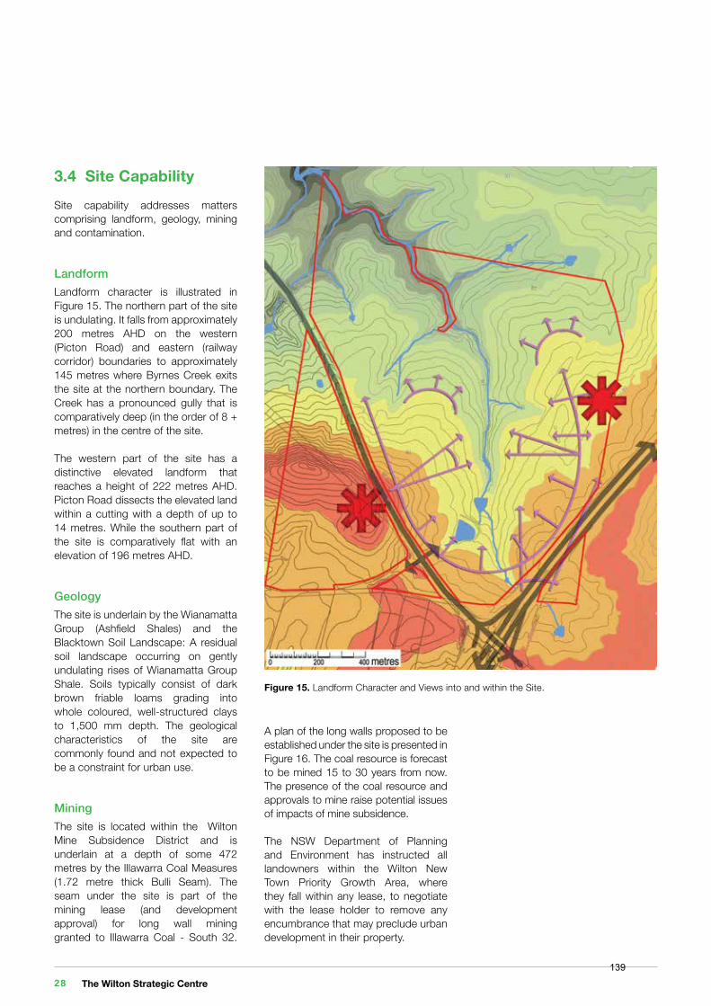
Figure 15. Landform Character and Views into and within the Site.
3.4 Site CapabilitySite capability addresses matters comprising landform, geology, mining and contamination.
LandformLandform character is illustrated in Figure 15. The northern part of the site is undulating. It falls from approximately 200 metres AHD on the western (Picton Road) and eastern (railway corridor) boundaries to approximately 145 metres where Byrnes Creek exits the site at the northern boundary. The Creek has a pronounced gully that is comparatively deep (in the order of 8 + metres) in the centre of the site.
The western part of the site has a distinctive elevated landform that reaches a height of 222 metres AHD. Picton Road dissects the elevated land within a cutting with a depth of up to 14 metres. While the southern part of the site is comparatively flat with an elevation of 196 metres AHD.
GeologyThe site is underlain by the Wianamatta Group (Ashfield Shales) and the Blacktown Soil Landscape: A residual soil landscape occurring on gently undulating rises of Wianamatta Group Shale. Soils typically consist of dark brown friable loams grading into whole coloured, well-structured clays to 1,500 mm depth. The geological characteristics of the site are commonly found and not expected to be a constraint for urban use.
MiningThe site is located within the Wilton Mine Subsidence District and is underlain at a depth of some 472 metres by the Illawarra Coal Measures (1.72 metre thick Bulli Seam). The seam under the site is part of the mining lease (and development approval) for long wall mining granted to Illawarra Coal - South 32.
A plan of the long walls proposed to be established under the site is presented in Figure 16. The coal resource is forecast to be mined 15 to 30 years from now. The presence of the coal resource and approvals to mine raise potential issues of impacts of mine subsidence.
The NSW Department of Planning and Environment has instructed all landowners within the Wilton New Town Priority Growth Area, where they fall within any lease, to negotiate with the lease holder to remove any encumbrance that may preclude urban development in their property.
The Wilton Strategic Centre 28139
To remove the potential for such issues, Governor’s Hill has entered into a formal agreement with Illawarra Coal to cancel the Mining Lease Area as it impacts the site in the area indicated in Figure 16.
Mine subsidence will not be an issue under the site of the Wilton Strategic Centre.
ContaminationSome minor contamination may be present in the vicinity of the aerodrome complex. However the history of the predominant use of the site suggests that there will be no significant contamination issues to address.
Contamination is not expected to be a constraint for urban use. Figure 16. Plan of Proposed Longwall Mining under Site. (Image source: South 32.)
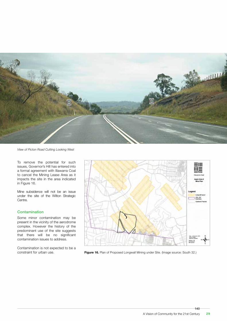
View of Picton Road Cutting Looking West
A Vision of Community for the 21st Century 29140
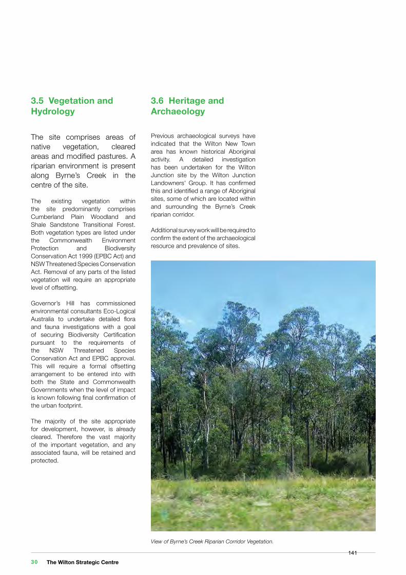
3.5 Vegetation and Hydrology
The site comprises areas of native vegetation, cleared areas and modified pastures. A riparian environment is present along Byrne’s Creek in the centre of the site.
The existing vegetation within the site predominantly comprises Cumberland Plain Woodland and Shale Sandstone Transitional Forest. Both vegetation types are listed under the Commonwealth Environment Protection and Biodiversity Conservation Act 1999 (EPBC Act) and NSW Threatened Species Conservation Act. Removal of any parts of the listed vegetation will require an appropriate level of offsetting.
Governor’s Hill has commissioned environmental consultants Eco-Logical Australia to undertake detailed flora and fauna investigations with a goal of securing Biodiversity Certification pursuant to the requirements of the NSW Threatened Species Conservation Act and EPBC approval. This will require a formal offsetting arrangement to be entered into with both the State and Commonwealth Governments when the level of impact is known following final confirmation of the urban footprint.
The majority of the site appropriate for development, however, is already cleared. Therefore the vast majority of the important vegetation, and any associated fauna, will be retained and protected.
3.6 Heritage and Archaeology
Previous archaeological surveys have indicated that the Wilton New Town area has known historical Aboriginal activity. A detailed investigation has been undertaken for the Wilton Junction site by the Wilton Junction Landowners' Group. It has confirmed this and identified a range of Aboriginal sites, some of which are located within and surrounding the Byrne’s Creek riparian corridor.
Additional survey work will be required to confirm the extent of the archaeological resource and prevalence of sites.
View of Byrne’s Creek Riparian Corridor Vegetation.
The Wilton Strategic Centre 30141
3.7 The Site’s Neighbours
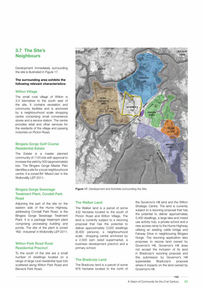
Development immediately surrounding the site is illustrated in Figure 17.
The surrounding area exhibits the following relevant characteristics:
Wilton VillageThe small rural village of Wilton is 3.3 kilometres to the south east of the site. It contains recreation and community facilities and is anchored by a neighbourhood scale shopping centre comprising small convenience stores and a service station. The centre provides retail and other services for the residents of the village and passing motorists on Picton Road;
Bingara Gorge Golf Course Residential EstateThe Estate is a master planned community of 1120 lots with approval to increase the yield by 500 (approximately) lots. The Bingara Gorge Master Plan identifies a site for a local neighbourhood centre. It is zoned B4 ‘Mixed Use’ in the Wollondilly LEP 2011;
Bingara Gorge Sewerage Treatment Plant, Condell Park RoadAdjoining the part of the site on the eastern side of the Hume Highway, addressing Condell Park Road, is the Bingara Gorge Sewerage Treatment Plant. It is a package treatment plant comprising processing building and ponds. The site of the plant is zoned ‘IN2 - Industrial’ in Wollondilly LEP 2011;
Wilton Park Road Rural Residential PrecinctTo the south of the site are a small number of dwellings located on a range of large rural residential type lots scattered along Wilton Park Road and Berwick Park Road;
The Walker LandThe Walker land is a parcel of some 432 hectares located to the south of Picton Road and Wilton Village. The land is currently subject to a rezoning proposal that has the potential to deliver approximately 3,000 dwellings (8,400 persons), a neighbourhood scale shopping centre anchored by a 2,500 sqm sized supermarket, a business development precinct and a primary school;
The Bradcorp LandThe Bradcorp land is a parcel of some 876 hectares located to the north of
the Governor’s Hill land and the Wilton Strategic Centre. The land is currently subject to a rezoning proposal that has the potential to deliver approximately 5,400 dwellings, a large lake and mixed use activity hub, a private school and a new access ramp to the Hume Highway utilising an existing cattle bridge and Fairway Drive in neighbouring Bingara Gorge. The rezoning application also proposes to rezone land owned by Governor’s Hill. Governor’s Hill does not accept the inclusion of its land in Bradcorp’s rezoning proposal and this submission by Governor’s Hill supersedes Bradcorp’s proposal where it impacts on the land owned by Governor’s Hill.
Figure 17. Development and Activities surrounding the Site.
A Vision of Community for the 21st Century 31142
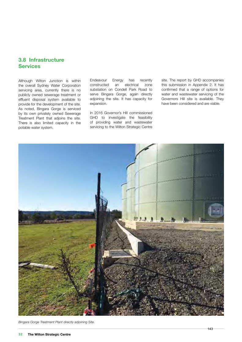
3.8 Infrastructure Services
Although Wilton Junction is within the overall Sydney Water Corporation servicing area, currently there is no publicly owned sewerage treatment or effluent disposal system available to provide for the development of the site. As noted, Bingara Gorge is serviced by its own privately owned Sewerage Treatment Plant that adjoins the site. There is also limited capacity in the potable water system.
Endeavour Energy has recently constructed an electrical zone substation on Condell Park Road to serve Bingara Gorge, again directly adjoining the site. It has capacity for expansion.
In 2016 Governor’s Hill commissioned GHD to investigate the feasibility of providing water and wastewater servicing to the Wilton Strategic Centre
Bingara Gorge Treatment Plant directly adjoining Site.
site. The report by GHD accompanies this submission in Appendix 2. It has confirmed that a range of options for water and wastewater servicing of the Governors Hill site is available. They have been considered and are viable.
The Wilton Strategic Centre 32143
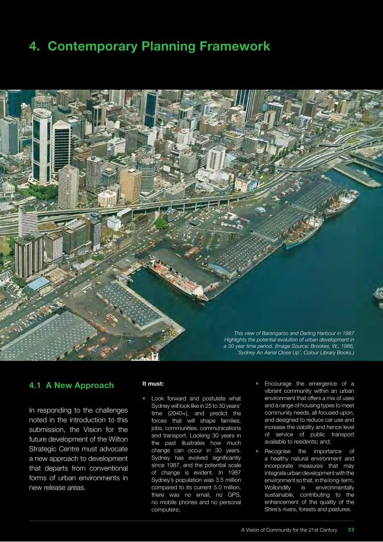
4. Contemporary Planning Framework
It must:
• Look forward and postulate what Sydney will look like in 25 to 30 years’ time (2040+), and predict the forces that will shape families, jobs, communities, communications and transport. Looking 30 years in the past illustrates how much change can occur in 30 years. Sydney has evolved significantly since 1987, and the potential scale of change is evident. In 1987 Sydney’s population was 3.5 million compared to its current 5.0 million, there was no email, no GPS, no mobile phones and no personal computers;
• Encourage the emergence of a vibrant community within an urban environment that offers a mix of uses and a range of housing types to meet community needs, all focused upon, and designed to reduce car use and increase the viability and hence level of service of public transport available to residents; and;• Recognise the importance of a healthy natural environment and incorporate measures that may integrate urban development with the environment so that, in the long-term, Wollondilly is environmentally sustainable, contributing to the enhancement of the quality of the Shire’s rivers, forests and pastures.
This view of Barangaroo and Darling Harbour in 1987 Highlights the potential evolution of urban development in a 30 year time period. (Image Source: Brookes, W., 1986,
‘Sydney An Aerial Close Up’, Colour Library Books.)
4.1 A New Approach
In responding to the challenges noted in the introduction to this submission, the Vision for the future development of the Wilton Strategic Centre must advocate a new approach to development that departs from conventional forms of urban environments in new release areas.
A Vision of Community for the 21st Century 33144
4.2 Transit Oriented Development
A ‘Transit Oriented’ approach to planning for development has been acknowledged as having the potential to promote an urban environment that can effectively respond to the challenges of this century.
‘Transit Oriented Development’ (TOD) focuses investment and development around a region’s public transport network. It has, as its principal goal, the promotion of pedestrian friendly mixed use development within easy walking distance of a public transport stop.
This approach increases the viability and level of service that public transport can offer residents. Furthermore, it simultaneously promotes environmental objectives through a reduction in car use and improvements in air quality.
At the heart of the approach is the need for public transport to be competitive with the private car. Today, the significant cost of owning and running a car is far outweighed by the perceived inconvenience and discomfort of using public transport. To make public transport attractive requires sufficient densities of people to support a frequent service and a high standard of infrastructure (quality of buses/trains, transit stops, security, information, etc.).
In Wilton, the structure of a ‘Transit Oriented Centre’ would comprise:
• A choice of dwelling types. Dwellings would be within comfortable and convenient walking distance from a high frequency public transport stop to meet housing need and promote a balanced community. Residential densities would generally be higher than the prevailing suburban “norm” and would achieve two aims: > Provide a range of dwelling types increasing housing choice and affordability; and > Support viable public transport in terms of service frequency and coverage.• The promotion of a mix of land uses that establish a genuine ‘centre’ for local residents and workers to gravitate to. It would comprise an integration of open space, commercial, recreation, civic and residential life focused upon public transport. The Centre would be the “heart” of the Wilton New Town. It would meet the town’s day to day needs and it is where residents would have a high degree of perceived ownership of the place - and symbolically, and proudly, call it “home”.• The area surrounding the public transport stop would become a natural neighbourhood. It would contain a wide range and mix of land uses including higher density residential uses all within comfortable and convenient walking distance. Thus it would generate a fairly high degree of self-reliance/self- containment within the town in terms of its potential to meet housing, employment, civic and human and commercial service needs. A commonly accepted walking distance is 400 metres from the bus / tram transit stop and 800 metres from a rail based transit stop. This represents a 5-10 minute pedestrian walk and is considered to be the limit of convenient and acceptable effort by a pedestrian.
Christopher Beed (in McLoughlin B; and Huxley M (Eds) “Urban Planning in Australia” Longman Cheshire 1986) summarises the potential outcome of this approach well:
“Since settlement densities would be higher than prevailing outer-suburban norms, public utility costs could fall. Higher densities increase the chances for public transport to compete with private transport so that total transport costs, especially social and energy costs may go down. With the same effect, opportunities for private non-motor transport (walking and cycling) would be enhanced. If all this eventuated, less land would be consumed by transport. As higher-density buildings can be more energy efficient than low density ones, built form energy costs may abate. Since people would live and work closer together, less land would be used by buildings; more green space could be preserved, natural urban creek valleys disturbed less, more untouched landscape kept for recreation in the city, more urban forests plants” (p 300).
The Wilton Strategic Centre 34145
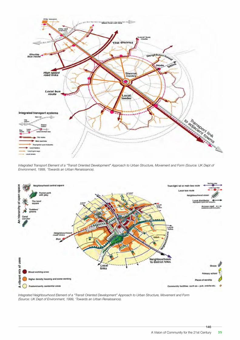
Integrated Transport Element of a “Transit Oriented Development” Approach to Urban Structure, Movement and Form (Source: UK Dept of Environment, 1999, ‘Towards an Urban Renaissance).
Integrated Neighbourhood Element of a “Transit Oriented Development” Approach to Urban Structure, Movement and Form(Source: UK Dept of Environment, 1999, ‘Towards an Urban Renaissance).
A Vision of Community for the 21st Century 35146
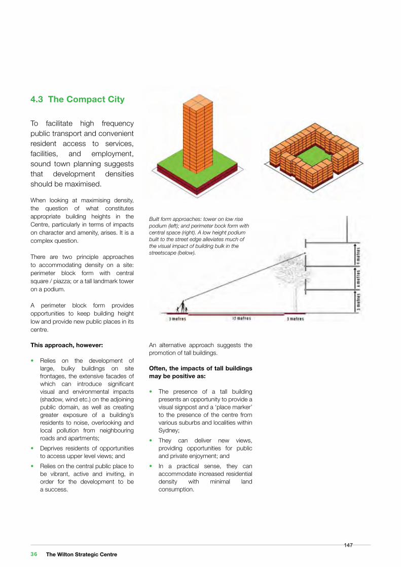
4.3 The Compact City
To facilitate high frequency public transport and convenient resident access to services, facilities, and employment, sound town planning suggests that development densities should be maximised.
When looking at maximising density, the question of what constitutes appropriate building heights in the Centre, particularly in terms of impacts on character and amenity, arises. It is a complex question.
There are two principle approaches to accommodating density on a site: perimeter block form with central square / piazza; or a tall landmark tower on a podium.
A perimeter block form provides opportunities to keep building height low and provide new public places in its centre.
This approach, however:
• Relies on the development of large, bulky buildings on site frontages, the extensive facades of which can introduce significant visual and environmental impacts (shadow, wind etc.) on the adjoining public domain, as well as creating greater exposure of a building’s residents to noise, overlooking and local pollution from neighbouring roads and apartments;• Deprives residents of opportunities to access upper level views; and• Relies on the central public place to be vibrant, active and inviting, in order for the development to be a success.
Built form approaches: tower on low rise podium (left); and perimeter bock form with central space (right). A low height podium built to the street edge alleviates much of the visual impact of building bulk in the streetscape (below).
An alternative approach suggests the promotion of tall buildings.
Often, the impacts of tall buildings may be positive as:
• The presence of a tall building presents an opportunity to provide a visual signpost and a ‘place marker’ to the presence of the centre from various suburbs and localities within Sydney;• They can deliver new views, providing opportunities for public and private enjoyment; and• In a practical sense, they can accommodate increased residential density with minimal land consumption.
The Wilton Strategic Centre 36147
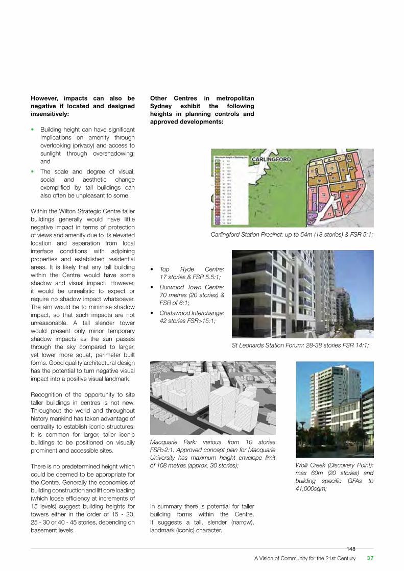
However, impacts can also be negative if located and designed insensitively:
• Building height can have significant implications on amenity through overlooking (privacy) and access to sunlight through overshadowing; and• The scale and degree of visual, social and aesthetic change exemplified by tall buildings can also often be unpleasant to some.
Within the Wilton Strategic Centre taller buildings generally would have little negative impact in terms of protection of views and amenity due to its elevated location and separation from local interface conditions with adjoining properties and established residential areas. It is likely that any tall building within the Centre would have some shadow and visual impact. However, it would be unrealistic to expect or require no shadow impact whatsoever. The aim would be to minimise shadow impact, so that such impacts are not unreasonable. A tall slender tower would present only minor temporary shadow impacts as the sun passes through the sky compared to larger, yet lower more squat, perimeter built forms. Good quality architectural design has the potential to turn negative visual impact into a positive visual landmark.
Recognition of the opportunity to site taller buildings in centres is not new. Throughout the world and throughout history mankind has taken advantage of centrality to establish iconic structures. It is common for larger, taller iconic buildings to be positioned on visually prominent and accessible sites.
There is no predetermined height which could be deemed to be appropriate for the Centre. Generally the economies of building construction and lift core loading (which loose efficiency at increments of 15 levels) suggest building heights for towers either in the order of 15 - 20, 25 - 30 or 40 - 45 stories, depending on basement levels.
Other Centres in metropolitan Sydney exhibit the following heights in planning controls and approved developments:
In summary there is potential for taller building forms within the Centre. It suggests a tall, slender (narrow), landmark (iconic) character.
Macquarie Park: various from 10 stories FSR>2:1. Approved concept plan for Macquarie University has maximum height envelope limit of 108 metres (approx. 30 stories);
Carlingford Station Precinct: up to 54m (18 stories) & FSR 5:1;
• Top Ryde Centre: 17 stories & FSR 5.5:1;• Burwood Town Centre: 70 metres (20 stories) & FSR of 6:1;• Chatswood Interchange: 42 stories FSR>15:1;
Wolli Creek (Discovery Point): max 60m (20 stories) and building specific GFAs to 41,000sqm;
St Leonards Station Forum: 28-38 stories FSR 14:1;
A Vision of Community for the 21st Century 37148
4.4 A Smart City
Today, urban centres exist in an era associated with rapid change and increased expectations by residents in terms of the environment in which they work, live and play. It creates new influences on the potential role, or lack of it, of a centre. Centres that have prospered in this era have done so by promptly responding to the changes that they confront. Nowhere is this more relevant than in the field of Information and communication technology.
The technology for permanent internet access first became available in Australia to universities in 1989. Eleven years later (2000), 32% of the population had access to the internet. Last year, in 2016, it has been estimated that 81% of the population had access to technology that used the internet. Given that the remaining 19% of the population comprise aged or the young. It is fair to say that we all live in a smart technology, interconnected world.
It is likely that most readers of this document will have access to at least two forms of smart communications with instantaneous access to the internet: a phone and a personal computer. It is also more likely than not that this document is being read right now on a mobile phone, tablet or laptop.
Deakin and Al Wear list four factors that contribute to a definition of the term:
1 The application of a wide range of electronic and digital technologies to communities and cities;2 The use of Information and communication technology to transform life and working environments within the region;3 The embedding of Information and communication technology in government systems;4 The territorialisation of practices that brings Information and communication technologies and people together to enhance the innovation and knowledge that they offer.
(Deakin, Mark; Al Waer, Husam, 2011, “From Intelligent to Smart Cities”. Journal of Intelligent Buildings International: From Intelligent Cities to Smart Cities, Vol 3, Issue 3.)
The Commonwealth Department of the Prime Minister and Cabinet has prepared a good summary of the opportunities of a ‘smart city’ approach to urban development in its 2016 “Smart Cities Plan.”
“Australia’s growth as a knowledge based economy, and the prosperity this offers, goes hand in hand with the growth of our cities and the regions surrounding them.
Knowledge based industries rely on the successful concentration of industries and organisations in particular locations.
To succeed in the 21st Century economy our cities need to be productive and accessible, but they also need to be liveable with a clear focus on serving their citizens.
Great cities attract, retain and develop increasingly mobile talent and organisations, encouraging them to innovate, create jobs and support growth.
The opportunities that smart technology may offer urban environments has only recently begun to be recognised and its application is evolving under the banner term of “Smart Cities.”
By taking advantage of the unprecedented pace of technological progress, governments and the community can make cities more prosperous and sustainable.
Real time data and smart technology will lead to better utilisation of infrastructure, clean energy and energy efficiency, improvements in services and better benchmarking of cities performance.”
It is early days yet to come to any firm conclusions as to what quantifiable benefits can be derived from the application of smart technology to the quality of life, economy, and sustainability of Wilton, except to say that the benefits will most likely be substantial, given the pace of change and improvement over the last 30 years.
Such benefits can include:
• Incentives for investment and economic productivity to settle and cluster in Wilton, given its role as a local servicing and regional transport hub;• Greater efficiency of, and attractiveness to adopt, other forms of public transport in lieu of the car. Public transport is not merely buses and trains, it can be Uber type Apps, taxis, and mini buses etc. that, through the use of technology, can promote the ‘shared economy’ to deliver customised private transportation;• Support for businesses and doing business by facilitating access to big data and high quality communications, particularly for ‘start-up’ and home businesses;• Greater efficiency in the use of land, particularly use of land for parking, sports and recreation and leisure / entertainment and the use of road space by ‘smart’ automated cars;• Assisting in the up-skilling of Wollondilly’s workforce by access to new learning environments and ‘virtual’ teaching facilities;
The Wilton Strategic Centre 38149
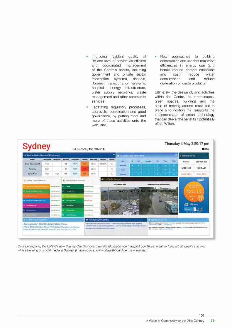
• Improving resident quality of life and level of service via efficient and coordinated management of the Centre’s assets, including government and private sector information systems, schools, libraries, transportation systems, hospitals, energy infrastructure, water supply networks, waste management and other community services;• Facilitating regulatory processes, approvals, coordination and good governance, by putting more and more of these activities onto the web; and
On a single page, the UNSW’s new Sydney City Dashboard details information on transport conditions, weather forecast, air quality and even what’s trending on social media in Sydney. (Image source: www.citydashboard.be.unsw.edu.au.)
• New approaches to building construction and use that maximise efficiencies in energy use (and hence reduce carbon emissions and cost), reduce water consumption and reduce generation of waste products.
Ultimately, the design of, and activities within the Centre, its streetscapes, green spaces, buildings and the ease of moving around must put in place a foundation that supports the implementation of smart technology that can deliver the benefits it potentially offers Wilton.
A Vision of Community for the 21st Century 39150

The Wilton Strategic Centre 40151

5. The Vision and Its Principles
5.1 The Proposed Vision
Picture yourself in 2041 living in Wilton New Town. You could be part of a family with children or, based on estimated statistics, you may well be living on your own, or in a two-person household without children. You may be close to retirement age.
You may be living within a terrace house, conventional home or apartment located within comfortable walking distance of a vibrant main street that connects to the busy Wilton Public Transport Interchange.
Other homes, terraces or apartments will surround you and you will know your neighbours. You will look out of your window and be greeted by a verdant green, tree lined streetscape which leads to the Byrne’s Creek wildlife corridor beyond, eventually joining the Nepean River. The trees, together with creeks and man-made water features in the public domain will counter the effects of urban heat island conditions.
On the corner of your road, or at street level of your apartment block, will be shops and cafés. You can walk to your local shop to get your day to
day groceries and newspaper, or walk to your local café for a quiet meal or quick coffee. The restaurant proprietor will greet you by name and your order could even be served without you asking, having been made on the internet in advance.
A quick cycle ride, bus trip or walk will take you to your place of employment in the Centre or adjoining employment precincts. You may work in the Centre’s main street, within the many restaurants, shops, entertainment, offices, education and community facilities that work together to create a genuine community identity, life and character.
The main street will have wide footpaths containing trees, tables and chairs. Traffic volumes will be low and unobtrusive and you will be able to meander at will, comfortable and safe in a pleasant environment.
You could walk to the Wilton Public Transport Interchange that will provide you with direct and express access to a high frequency rail service at a new railway station at Maldon, a mere 10 minutes bus traveling time. From the station you will enjoy high-speed train access to Campbelltown, the new
Artists Impressions of the Wilton Strategic Centre as it could possible look in the future.
Western Sydney Airport at Badgery’s Creek or places and employment in between and beyond.
In your spare time you and your family and friends may cycle along a safe dedicated green corridor to large parklands and neighbouring recreation facilities that are embedded in the Centre’s lifestyle offer.
Many areas surrounding the Centre will be conservation areas associated with the Nepean River and adjoining woodlands and you will be able to experience the presence, touch and feel of birds, marsupials and plants and flowers at close hand. You will enjoy the natural smells of woodland and river, which may permeate your home if you live close.
You will not use your car very often. Instead you will walk or cycle to work and other activities or take the bus or train.
It is very possible that you could even work from home, telecommuting via the Internet and nipping around to the corner to the café to get your lunch.
The Wilton Strategic Centre will offer you everything.
A Vision of Community for the 21st Century 41152
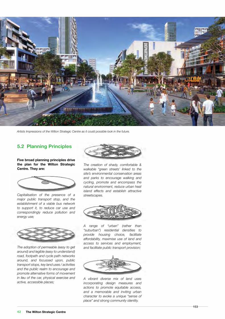
5.2 Planning Principles
Five broad planning principles drive the plan for the Wilton Strategic Centre. They are:
Capitalisation of the presence of a major public transport stop, and the establishment of a viable bus network to support it, to reduce car use and correspondingly reduce pollution and energy use;
The adoption of permeable (easy to get around) and legible (easy to understand) road, footpath and cycle path networks around, and focussed upon, public transport stops, key land uses / activities and the public realm to encourage and promote alternative forms of movement in lieu of the car, physical exercise and active, accessible places;
The creation of shady, comfortable & walkable “green streets’ linked to the site’s environmental conservation areas and parks to encourage walking and cycling, promote and encompass the natural environment, reduce urban heat island effects and establish attractive streetscapes.
A range of “urban” (rather than “suburban”) residential densities to provide housing choice, facilitate affordability, maximise use of land and access to services and employment, and facilitate public transport provision;
A vibrant diverse mix of land uses incorporating design measures and actions to promote equitable access, and a memorable and inviting urban character to evoke a unique “sense of place” and strong community identity.
Artists Impressions of the Wilton Strategic Centre as it could possible look in the future.
The Wilton Strategic Centre 42153
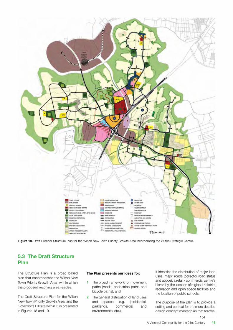
Figure 18. Draft Broader Structure Plan for the Wilton New Town Priority Growth Area incorporating the Wilton Strategic Centre.
The Plan presents our ideas for:
1 The broad framework for movement paths (roads, pedestrian paths and bicycle paths); and2 The general distribution of land uses and spaces, e.g. (residential, parklands, commercial and environmental etc.).
It identifies the distribution of major land uses, major roads (collector road status and above), a retail / commercial centre’s hierarchy, the location of regional / district recreation and open space facilities and the location of public schools.
The purpose of the plan is to provide a setting and context for the more detailed design concept master plan that follows.
5.3 The Draft Structure Plan
The Structure Plan is a broad based plan that encompasses the Wilton New Town Priority Growth Area within which the proposed rezoning area resides.
The Draft Structure Plan for the Wilton New Town Priority Growth Area, and the Governor’s Hill site within it, is presented in Figures 18 and 19.
A Vision of Community for the 21st Century 43154
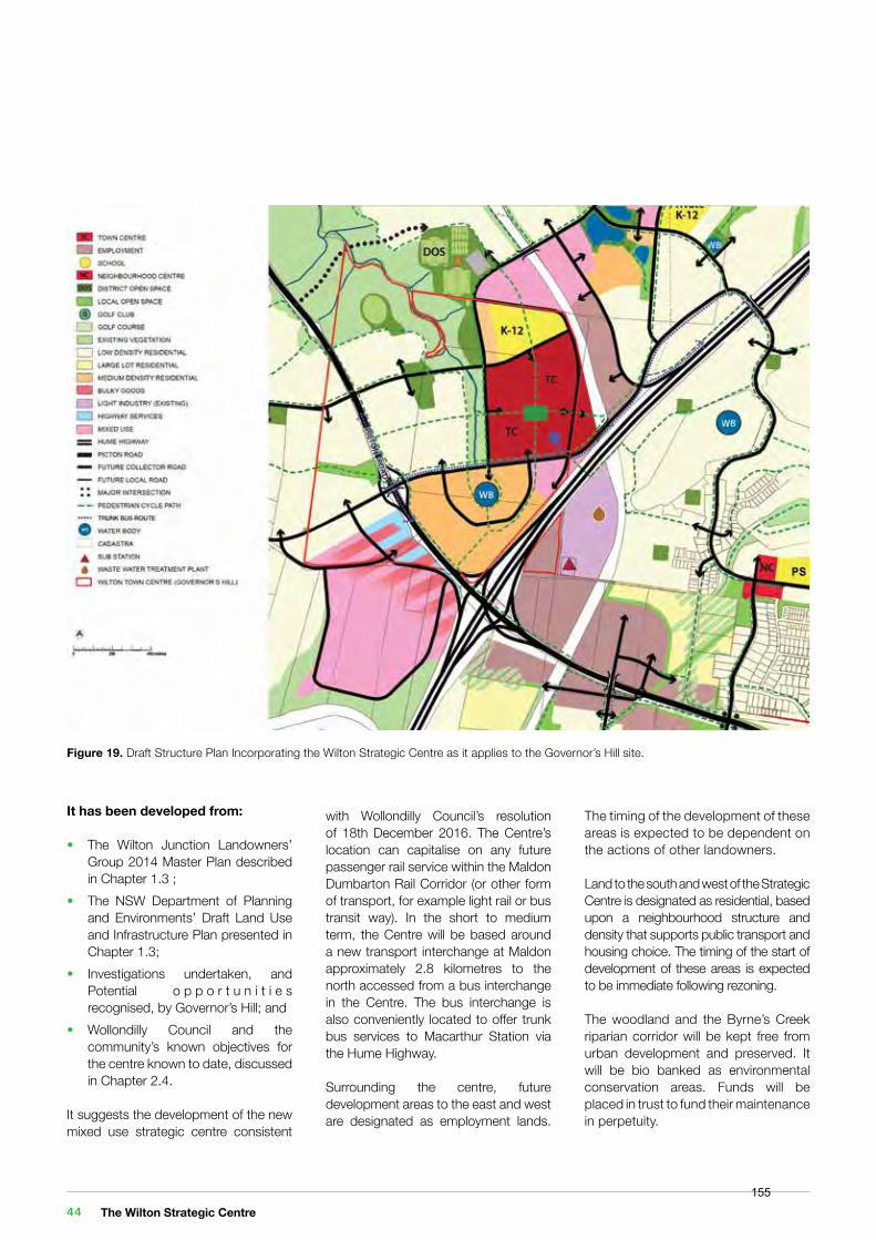
It has been developed from: • The Wilton Junction Landowners’ Group 2014 Master Plan described in Chapter 1.3 ;• The NSW Department of Planning and Environments’ Draft Land Use and Infrastructure Plan presented in Chapter 1.3;• Investigations undertaken, and Potential o p p o r t u n i t i e s recognised, by Governor’s Hill; and• Wollondilly Council and the community’s known objectives for the centre known to date, discussed in Chapter 2.4.
It suggests the development of the new mixed use strategic centre consistent
with Wollondilly Council’s resolution of 18th December 2016. The Centre’s location can capitalise on any future passenger rail service within the Maldon Dumbarton Rail Corridor (or other form of transport, for example light rail or bus transit way). In the short to medium term, the Centre will be based around a new transport interchange at Maldon approximately 2.8 kilometres to the north accessed from a bus interchange in the Centre. The bus interchange is also conveniently located to offer trunk bus services to Macarthur Station via the Hume Highway.
Surrounding the centre, future development areas to the east and west are designated as employment lands.
Figure 19. Draft Structure Plan Incorporating the Wilton Strategic Centre as it applies to the Governor’s Hill site.
The timing of the development of these areas is expected to be dependent on the actions of other landowners.
Land to the south and west of the Strategic Centre is designated as residential, based upon a neighbourhood structure and density that supports public transport and housing choice. The timing of the start of development of these areas is expected to be immediate following rezoning.
The woodland and the Byrne’s Creek riparian corridor will be kept free from urban development and preserved. It will be bio banked as environmental conservation areas. Funds will be placed in trust to fund their maintenance in perpetuity.
The Wilton Strategic Centre 44155
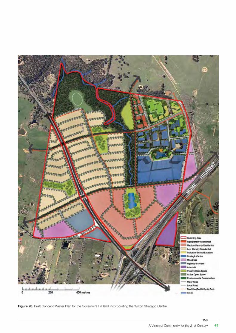
Figure 20. Draft Concept Master Plan for the Governor’s Hill land incorporating the Wilton Strategic Centre.
A Vision of Community for the 21st Century 45156
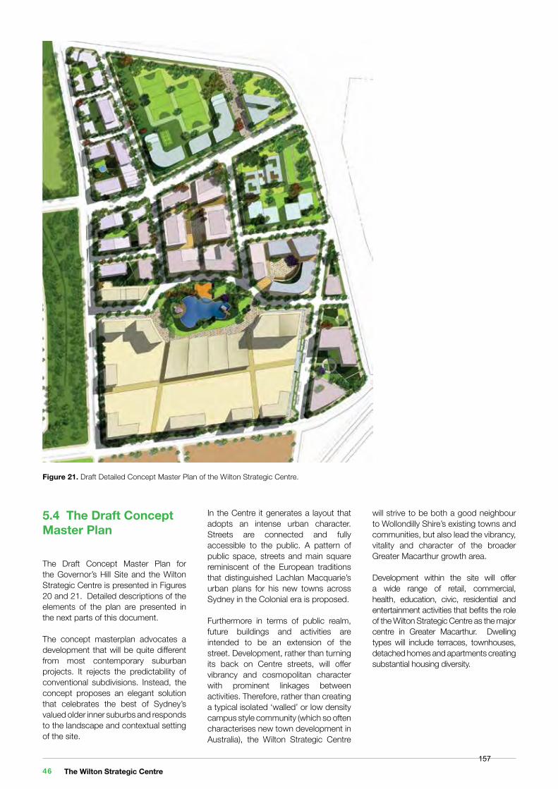
5.4 The Draft Concept Master Plan
The Draft Concept Master Plan for the Governor’s Hill Site and the Wilton Strategic Centre is presented in Figures 20 and 21. Detailed descriptions of the elements of the plan are presented in the next parts of this document.
The concept masterplan advocates a development that will be quite different from most contemporary suburban projects. It rejects the predictability of conventional subdivisions. Instead, the concept proposes an elegant solution that celebrates the best of Sydney’s valued older inner suburbs and responds to the landscape and contextual setting of the site.
Figure 21. Draft Detailed Concept Master Plan of the Wilton Strategic Centre.
In the Centre it generates a layout that adopts an intense urban character. Streets are connected and fully accessible to the public. A pattern of public space, streets and main square reminiscent of the European traditions that distinguished Lachlan Macquarie’s urban plans for his new towns across Sydney in the Colonial era is proposed.
Furthermore in terms of public realm, future buildings and activities are intended to be an extension of the street. Development, rather than turning its back on Centre streets, will offer vibrancy and cosmopolitan character with prominent linkages between activities. Therefore, rather than creating a typical isolated ‘walled’ or low density campus style community (which so often characterises new town development in Australia), the Wilton Strategic Centre
will strive to be both a good neighbour to Wollondilly Shire’s existing towns and communities, but also lead the vibrancy, vitality and character of the broader Greater Macarthur growth area.
Development within the site will offer a wide range of retail, commercial, health, education, civic, residential and entertainment activities that befits the role of the Wilton Strategic Centre as the major centre in Greater Macarthur. Dwelling types will include terraces, townhouses, detached homes and apartments creating substantial housing diversity.
The Wilton Strategic Centre 46157
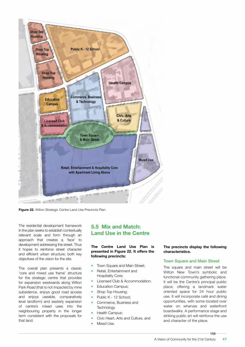
5.5 Mix and Match: Land Use in the Centre
The Centre Land Use Plan is presented in Figure 22. It offers the following precincts:
• Town Square and Main Street;• Retail, Entertainment and Hospitality Core;• Licensed Club & Accommodation;• Education Campus;• Shop Top Housing;• Public K - 12 School;• Commerce, Business and Technology• Health Campus;• Civic Heart, Arts and Culture, and• Mixed Use.
Figure 22. Wilton Strategic Centre Land Use Precincts Plan.
The precincts display the following characteristics.
Town Square and Main Street The square and main street will be Wilton New Town’s symbolic and functional community gathering place. It will be the Centre’s principal public place; offering a landmark water oriented space for 24 hour public use. It will incorporate café and dining opportunities, with some located over water on wharves and waterfront boardwalks. A performance stage and striking public art will reinforce the use and character of the place.
The residential development framework in the plan seeks to establish contextually relevant scale and form through an approach that creates a ‘face’ to development addressing the street. Thus it hopes to reinforce street character and efficient urban structure; both key objectives of the vision for the site.
The overall plan presents a classic ‘core and mixed use frame’ structure for the strategic centre that provides for expansion westwards along Wilton Park Road (that is not impacted by mine subsidence, enjoys good road access and enjoys useable, comparatively level landform) and easterly expansion of centre’s mixed uses into the neighbouring property in the longer term consistent with the proposals for that land.
A Vision of Community for the 21st Century 47158
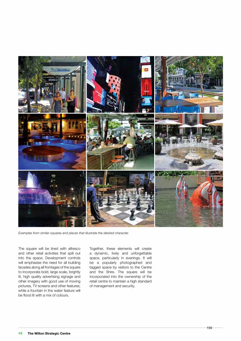
Examples from similar squares and places that illustrate the desired character.
The square will be lined with alfresco and other retail activities that spill out into the space. Development controls will emphasise the need for all building facades along all frontages of the square to incorporate bold, large scale, brightly lit, high quality advertising signage and other imagery with good use of moving pictures, TV screens and other features; while a fountain in the water feature will be flood lit with a mix of colours.
Together, these elements will create a dynamic, lively and unforgettable space, particularly in evenings. It will be a popularly photographed and tagged space by visitors to the Centre and the Shire. The square will be incorporated into the ownership of the retail centre to maintain a high standard of management and security.
The Wilton Strategic Centre 48159
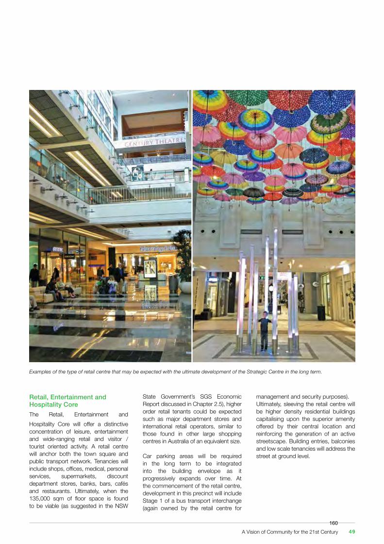
Retail, Entertainment and Hospitality CoreThe Retail, Entertainment and Hospitality Core will offer a distinctive concentration of leisure, entertainment and wide-ranging retail and visitor / tourist oriented activity. A retail centre will anchor both the town square and public transport network. Tenancies will include shops, offices, medical, personal services, supermarkets, discount department stores, banks, bars, cafés and restaurants. Ultimately, when the 135,000 sqm of floor space is found to be viable (as suggested in the NSW
management and security purposes). Ultimately, sleeving the retail centre will be higher density residential buildings capitalising upon the superior amenity offered by their central location and reinforcing the generation of an active streetscape. Building entries, balconies and low scale tenancies will address the street at ground level.
Examples of the type of retail centre that may be expected with the ultimate development of the Strategic Centre in the long term.
State Government’s SGS Economic Report discussed in Chapter 2.5), higher order retail tenants could be expected such as major department stores and international retail operators, similar to those found in other large shopping centres in Australia of an equivalent size.
Car parking areas will be required in the long term to be integrated into the building envelope as it progressively expands over time. At the commencement of the retail centre, development in this precinct will include Stage 1 of a bus transport interchange (again owned by the retail centre for
A Vision of Community for the 21st Century 49160
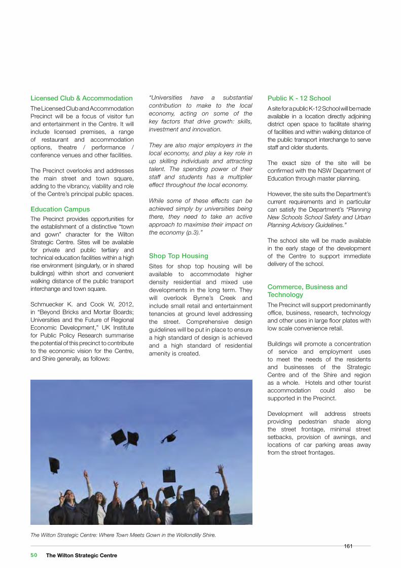
Licensed Club & AccommodationThe Licensed Club and Accommodation Precinct will be a focus of visitor fun and entertainment in the Centre. It will include licensed premises, a range of restaurant and accommodation options, theatre / performance / conference venues and other facilities.
The Precinct overlooks and addresses the main street and town square, adding to the vibrancy, viability and role of the Centre’s principal public spaces.
Education CampusThe Precinct provides opportunities for the establishment of a distinctive “town and gown” character for the Wilton Strategic Centre. Sites will be available for private and public tertiary and technical education facilities within a high rise environment (singularly, or in shared buildings) within short and convenient walking distance of the public transport interchange and town square.
Schmuecker K. and Cook W, 2012, in “Beyond Bricks and Mortar Boards; Universities and the Future of Regional Economic Development,” UK Institute for Public Policy Research summarise the potential of this precinct to contribute to the economic vision for the Centre, and Shire generally, as follows:
The Wilton Strategic Centre: Where Town Meets Gown in the Wollondilly Shire.
“Universities have a substantial contribution to make to the local economy, acting on some of the key factors that drive growth: skills, investment and innovation.
They are also major employers in the local economy, and play a key role in up skilling individuals and attracting talent. The spending power of their staff and students has a multiplier effect throughout the local economy.
While some of these effects can be achieved simply by universities being there, they need to take an active approach to maximise their impact on the economy (p.3).”
Shop Top HousingSites for shop top housing will be available to accommodate higher density residential and mixed use developments in the long term. They will overlook Byrne’s Creek and include small retail and entertainment tenancies at ground level addressing the street. Comprehensive design guidelines will be put in place to ensure a high standard of design is achieved and a high standard of residential amenity is created.
Public K - 12 SchoolA site for a public K-12 School will be made available in a location directly adjoining district open space to facilitate sharing of facilities and within walking distance of the public transport interchange to serve staff and older students.
The exact size of the site will be confirmed with the NSW Department of Education through master planning. However, the site suits the Department’s current requirements and in particular can satisfy the Department’s “Planning New Schools School Safety and Urban Planning Advisory Guidelines.”
The school site will be made available in the early stage of the development of the Centre to support immediate delivery of the school.
Commerce, Business and TechnologyThe Precinct will support predominantly office, business, research, technology and other uses in large floor plates with low scale convenience retail.
Buildings will promote a concentration of service and employment uses to meet the needs of the residents and businesses of the Strategic Centre and of the Shire and region as a whole. Hotels and other tourist accommodation could also be supported in the Precinct.
Development will address streets providing pedestrian shade along the street frontage, minimal street setbacks, provision of awnings, and locations of car parking areas away from the street frontages.
The Wilton Strategic Centre 50161
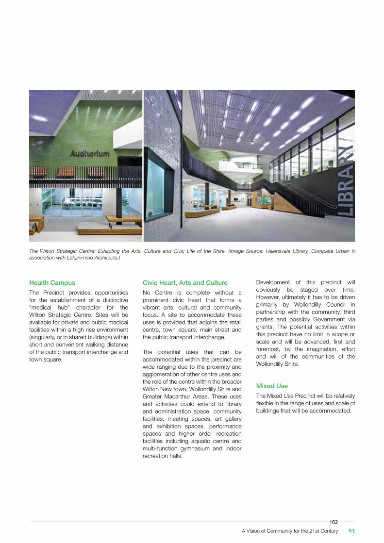
The Wilton Strategic Centre: Exhibiting the Arts, Culture and Civic Life of the Shire. (Image Source: Helensvale Library, Complete Urban in association with Lahznimmo Architects.)
Health CampusThe Precinct provides opportunities for the establishment of a distinctive “medical hub” character for the Wilton Strategic Centre. Sites will be available for private and public medical facilities within a high rise environment (singularly, or in shared buildings) within short and convenient walking distance of the public transport interchange and town square.
Development of this precinct will obviously be staged over time. However, ultimately it has to be driven primarily by Wollondilly Council in partnership with the community, third parties and possibly Government via grants. The potential activities within this precinct have no limit in scope or scale and will be advanced, first and foremost, by the imagination, effort and will of the communities of the Wollondilly Shire.
Mixed UseThe Mixed Use Precinct will be relatively flexible in the range of uses and scale of buildings that will be accommodated.
Civic Heart, Arts and CultureNo Centre is complete without a prominent civic heart that forms a vibrant arts, cultural and community focus. A site to accommodate these uses is provided that adjoins the retail centre, town square, main street and the public transport interchange.
The potential uses that can be accommodated within the precinct are wide ranging due to the proximity and agglomeration of other centre uses and the role of the centre within the broader Wilton New town, Wollondilly Shire and Greater Macarthur Areas. These uses and activities could extend to library and administration space, community facilities, meeting spaces, art gallery and exhibition spaces, performance spaces and higher order recreation facilities including aquatic centre and multi-function gymnasium and indoor recreation halls.
A Vision of Community for the 21st Century 51162
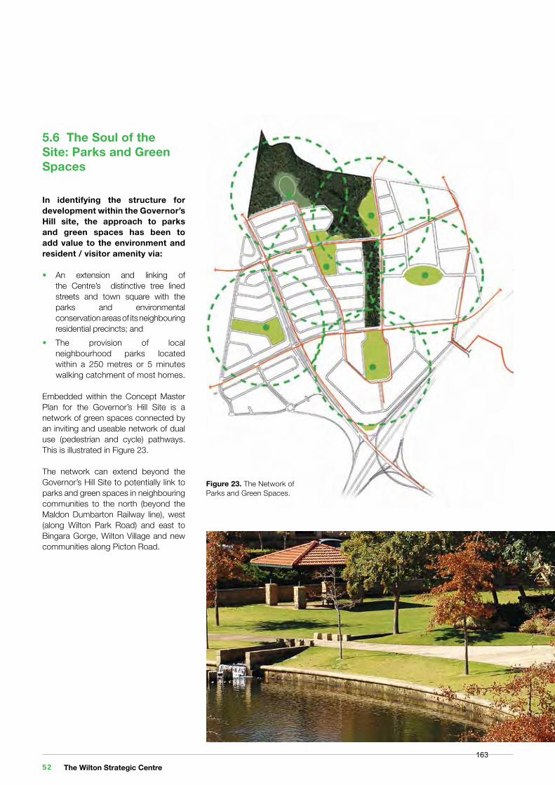
5.6 The Soul of the Site: Parks and Green Spaces
In identifying the structure for development within the Governor’s Hill site, the approach to parks and green spaces has been to add value to the environment and resident / visitor amenity via:
• An extension and linking of the Centre’s distinctive tree lined streets and town square with the parks and environmental conservation areas of its neighbouring residential precincts; and• The provision of local neighbourhood parks located within a 250 metres or 5 minutes walking catchment of most homes.
Embedded within the Concept Master Plan for the Governor’s Hill Site is a network of green spaces connected by an inviting and useable network of dual use (pedestrian and cycle) pathways. This is illustrated in Figure 23.
The network can extend beyond the Governor’s Hill Site to potentially link to parks and green spaces in neighbouring communities to the north (beyond the Maldon Dumbarton Railway line), west (along Wilton Park Road) and east to Bingara Gorge, Wilton Village and new communities along Picton Road.
Figure 23. The Network ofParks and Green Spaces.
The Wilton Strategic Centre 52163
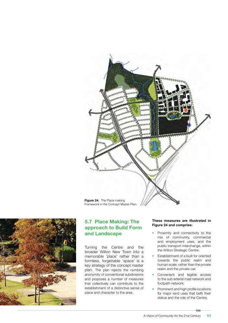
Figure 24. The Place making Framework in the Concept Master Plan.
5.7 Place Making: The approach to Build Form and Landscape
Turning the Centre and the broader Wilton New Town into a memorable ‘place’ rather than a formless, forgettable ‘space’ is a key strategy of the concept master plan. The plan rejects the numbing anonymity of conventional subdivisions and proposes a number of measures that collectively can contribute to the establishment of a distinctive sense of place and character to the area .
These measures are illustrated in Figure 24 and comprise:
• Proximity and connectivity to the mix of community, commercial and employment uses, and the public transport interchange, within the Wilton Strategic Centre;• Establishment of a built for oriented towards the public realm and human scale, rather than the private realm and the private car;• Convenient and legible access to the sub arterial road network and footpath network;• Prominent and high profile locations for major land uses that befit their status and the role of the Centre;
A Vision of Community for the 21st Century 53164
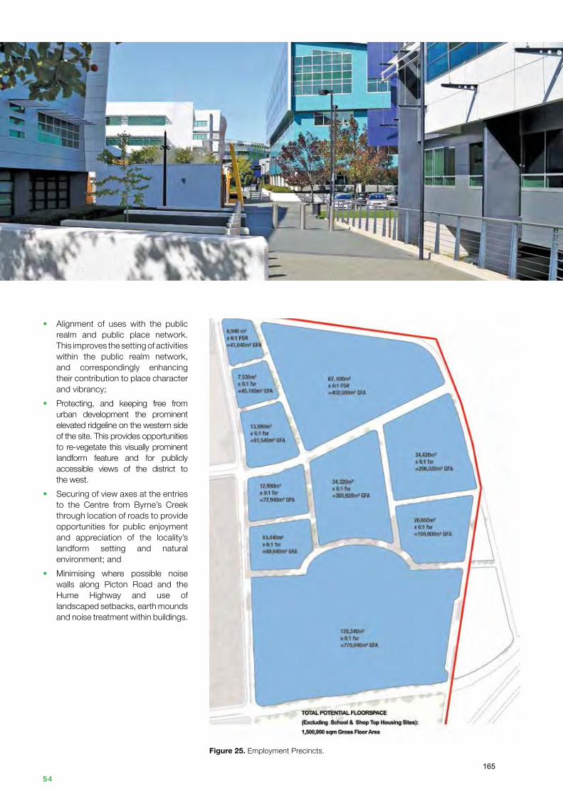
Figure 25. Employment Precincts.
• Alignment of uses with the public realm and public place network. This improves the setting of activities within the public realm network, and correspondingly enhancing their contribution to place character and vibrancy;• Protecting, and keeping free from urban development the prominent elevated ridgeline on the western side of the site. This provides opportunities to re-vegetate this visually prominent landform feature and for publicly accessible views of the district to the west.• Securing of view axes at the entries to the Centre from Byrne’s Creek through location of roads to provide opportunities for public enjoyment and appreciation of the locality’s landform setting and natural environment; and• Minimising where possible noise walls along Picton Road and the Hume Highway and use of landscaped setbacks, earth mounds and noise treatment within buildings.
The Wilton Strategic Centre 54165
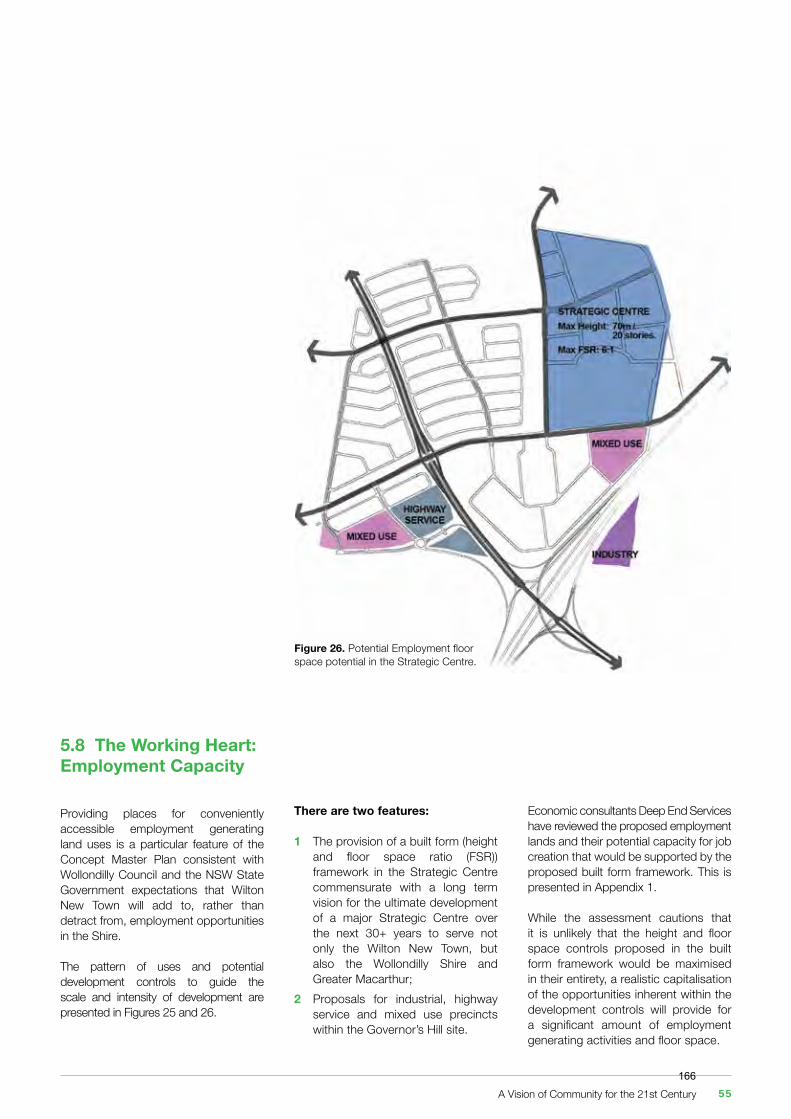
5.8 The Working Heart: Employment Capacity
Providing places for conveniently accessible employment generating land uses is a particular feature of the Concept Master Plan consistent with Wollondilly Council and the NSW State Government expectations that Wilton New Town will add to, rather than detract from, employment opportunities in the Shire.
The pattern of uses and potential development controls to guide the scale and intensity of development are presented in Figures 25 and 26.
Figure 26. Potential Employment floor space potential in the Strategic Centre.
There are two features:
1 The provision of a built form (height and floor space ratio (FSR)) framework in the Strategic Centre commensurate with a long term vision for the ultimate development of a major Strategic Centre over the next 30+ years to serve not only the Wilton New Town, but also the Wollondilly Shire and Greater Macarthur;2 Proposals for industrial, highway service and mixed use precincts within the Governor’s Hill site.
Economic consultants Deep End Services have reviewed the proposed employment lands and their potential capacity for job creation that would be supported by the proposed built form framework. This is presented in Appendix 1.
While the assessment cautions that it is unlikely that the height and floor space controls proposed in the built form framework would be maximised in their entirety, a realistic capitalisation of the opportunities inherent within the development controls will provide for a significant amount of employment generating activities and floor space.
A Vision of Community for the 21st Century 55166
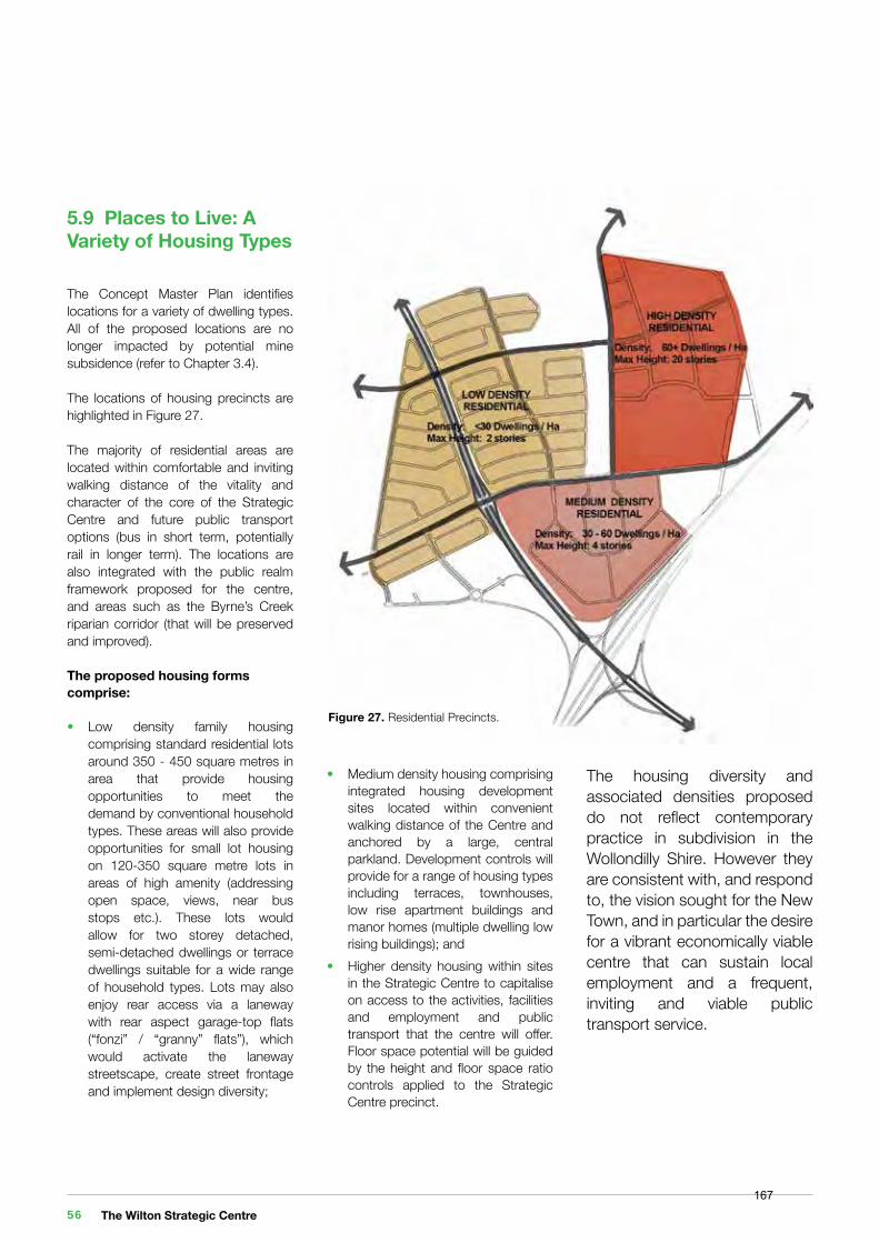
5.9 Places to Live: A Variety of Housing Types
The Concept Master Plan identifies locations for a variety of dwelling types. All of the proposed locations are no longer impacted by potential mine subsidence (refer to Chapter 3.4).
The locations of housing precincts are highlighted in Figure 27.
The majority of residential areas are located within comfortable and inviting walking distance of the vitality and character of the core of the Strategic Centre and future public transport options (bus in short term, potentially rail in longer term). The locations are also integrated with the public realm framework proposed for the centre, and areas such as the Byrne’s Creek riparian corridor (that will be preserved and improved).
The proposed housing forms comprise:
• Low density family housing comprising standard residential lots around 350 - 450 square metres in area that provide housing opportunities to meet the demand by conventional household types. These areas will also provide opportunities for small lot housing on 120-350 square metre lots in areas of high amenity (addressing open space, views, near bus stops etc.). These lots would allow for two storey detached, semi-detached dwellings or terrace dwellings suitable for a wide range of household types. Lots may also enjoy rear access via a laneway with rear aspect garage-top flats (“fonzi” / “granny” flats”), which would activate the laneway streetscape, create street frontage and implement design diversity;
Figure 27. Residential Precincts.
• Medium density housing comprising integrated housing development sites located within convenient walking distance of the Centre and anchored by a large, central parkland. Development controls will provide for a range of housing types including terraces, townhouses, low rise apartment buildings and manor homes (multiple dwelling low rising buildings); and• Higher density housing within sites in the Strategic Centre to capitalise on access to the activities, facilities and employment and public transport that the centre will offer. Floor space potential will be guided by the height and floor space ratio controls applied to the Strategic Centre precinct.
The housing diversity and associated densities proposed do not reflect contemporary practice in subdivision in the Wollondilly Shire. However they are consistent with, and respond to, the vision sought for the New Town, and in particular the desire for a vibrant economically viable centre that can sustain local employment and a frequent, inviting and viable public transport service.
The Wilton Strategic Centre 56167
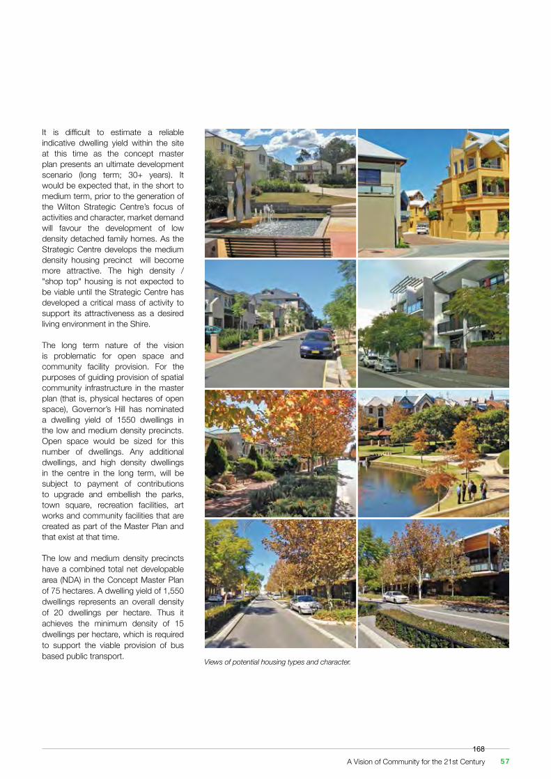
It is difficult to estimate a reliable indicative dwelling yield within the site at this time as the concept master plan presents an ultimate development scenario (long term; 30+ years). It would be expected that, in the short to medium term, prior to the generation of the Wilton Strategic Centre’s focus of activities and character, market demand will favour the development of low density detached family homes. As the Strategic Centre develops the medium density housing precinct will become more attractive. The high density / "shop top" housing is not expected to be viable until the Strategic Centre has developed a critical mass of activity to support its attractiveness as a desired living environment in the Shire.
The long term nature of the vision is problematic for open space and community facility provision. For the purposes of guiding provision of spatial community infrastructure in the master plan (that is, physical hectares of open space), Governor’s Hill has nominated a dwelling yield of 1550 dwellings in the low and medium density precincts. Open space would be sized for this number of dwellings. Any additional dwellings, and high density dwellings in the centre in the long term, will be subject to payment of contributions to upgrade and embellish the parks, town square, recreation facilities, art works and community facilities that are created as part of the Master Plan and that exist at that time.
The low and medium density precincts have a combined total net developable area (NDA) in the Concept Master Plan of 75 hectares. A dwelling yield of 1,550 dwellings represents an overall density of 20 dwellings per hectare. Thus it achieves the minimum density of 15 dwellings per hectare, which is required to support the viable provision of bus based public transport.
Views of potential housing types and character.
A Vision of Community for the 21st Century 57168
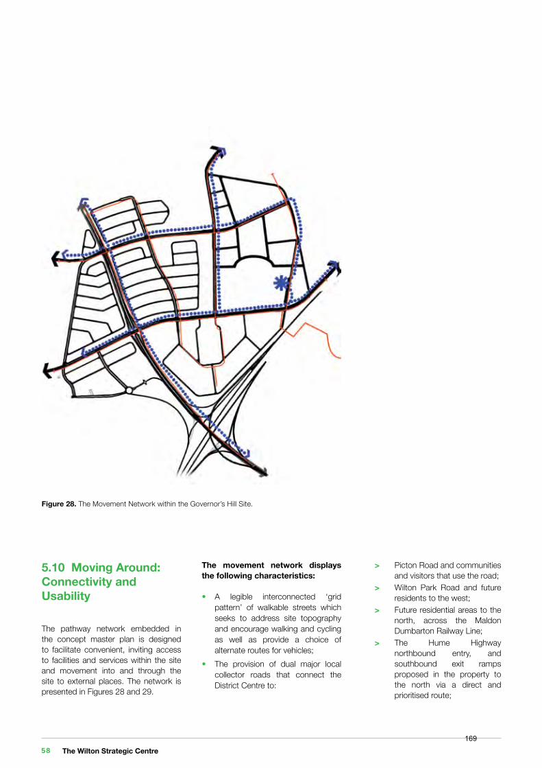
Figure 28. The Movement Network within the Governor’s Hill Site
Figure 29. The Movement Network Beyond the Site in the Broader Wilton New Town
Figure 28. The Movement Network within the Governor’s Hill Site.
5.10 Moving Around: Connectivity and Usability
The pathway network embedded in the concept master plan is designed to facilitate convenient, inviting access to facilities and services within the site and movement into and through the site to external places. The network is presented in Figures 28 and 29.
The movement network displays the following characteristics:
• A legible interconnected ‘grid pattern’ of walkable streets which seeks to address site topography and encourage walking and cycling as well as provide a choice of alternate routes for vehicles;• The provision of dual major local collector roads that connect the District Centre to:
> Picton Road and communities and visitors that use the road; > Wilton Park Road and future residents to the west; > Future residential areas to the north, across the Maldon Dumbarton Railway Line; > The Hume Highway northbound entry, and southbound exit ramps proposed in the property to the north via a direct and prioritised route;
The Wilton Strategic Centre 58169
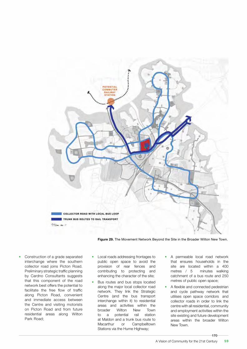
• Local roads addressing frontages to public open space to avoid the provision of rear fences and contributing to protecting and enhancing the character of the site;• Bus routes and bus stops located along the major local collector road network. They link the Strategic Centre (and the bus transport interchange within it) to residential areas and activities within the broader Wilton New Town to a potential rail station at Maldon and a trunk bus route to Macarthur or Campbelltown Stations via the Hume Highway;
• Construction of a grade separated interchange where the southern collector road joins Picton Road. Preliminary strategic traffic planning by Cardno Consultants suggests that this component of the road network best offers the potential to facilitate the free flow of traffic along Picton Road, convenient and immediate access between the Centre and visiting motorists on Picton Road and from future residential areas along Wilton Park Road;
Figure 29. The Movement Network Beyond the Site in the Broader Wilton New Town.
• A permeable local road network that ensures households in the site are located within a 400 metres / 5 minutes walking catchment of a bus route and 250 metres of public open space;• A flexible and connected pedestrian and cycle pathway network that utilises open space corridors and collector roads in order to link the centre with all residential, community and employment activities within the site existing and future development areas within the broader Wilton New Town.
A Vision of Community for the 21st Century 59170
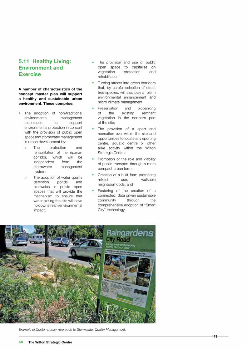
5.11 Healthy Living: Environment and Exercise
A number of characteristics of the concept master plan will support a healthy and sustainable urban environment. These comprise;
• The adoption of non-traditional environmental management techniques to support environmental protection in concert with the provision of public open space and stormwater management in urban development by: > The protection and rehabilitation of the riparian corridor, which will be independent from the stormwater management system; > The adoption of water quality detention ponds and bioswales in public open spaces that will provide the mechanism to ensure that water exiting the site will have no downstream environmental impact;
• The provision and use of public open space to capitalise on vegetation protection and rehabilitation;• Turning streets into green corridors that, by careful selection of street tree species, will also play a role in environmental enhancement and micro climate management;• Preservation and biobanking of the existing remnant vegetation in the northern part of the site;• The provision of a sport and recreation oval within the site and opportunities to locate any sporting centre, aquatic centre or other alike activity within the Wilton Strategic Centre;• Promotion of the role and viability of public transport through a more compact urban form;• Creation of a built form promoting mixed use, walkable neighbourhoods; and• Fostering of the creation of a connected, data driven sustainable community through the comprehensive adoption of “Smart City” technology.
Example of Contemporary Approach to Stormwater Quality Management.
The Wilton Strategic Centre 60171
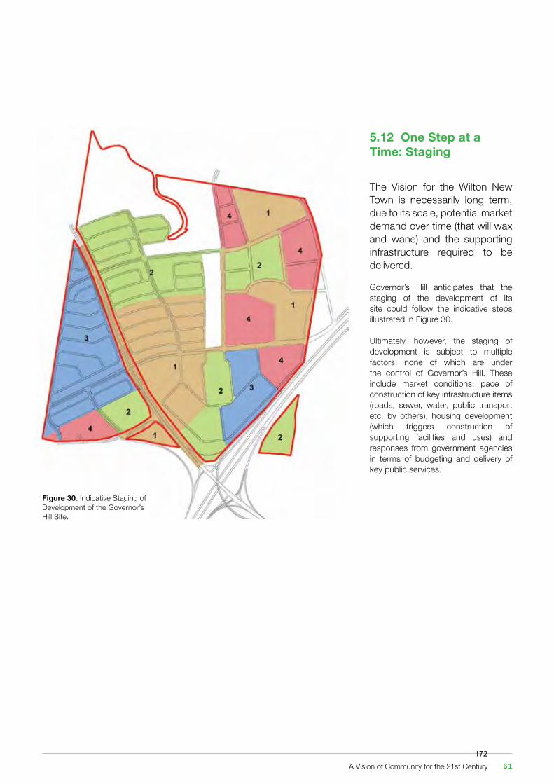
Figure 30. Indicative Staging of Development of the Governor’s Hill Site.
5.12 One Step at a Time: Staging
The Vision for the Wilton New Town is necessarily long term, due to its scale, potential market demand over time (that will wax and wane) and the supporting infrastructure required to be delivered.
Governor’s Hill anticipates that the staging of the development of its site could follow the indicative steps illustrated in Figure 30.
Ultimately, however, the staging of development is subject to multiple factors, none of which are under the control of Governor’s Hill. These include market conditions, pace of construction of key infrastructure items (roads, sewer, water, public transport etc. by others), housing development (which triggers construction of supporting facilities and uses) and responses from government agencies in terms of budgeting and delivery of key public services.
A Vision of Community for the 21st Century 61172
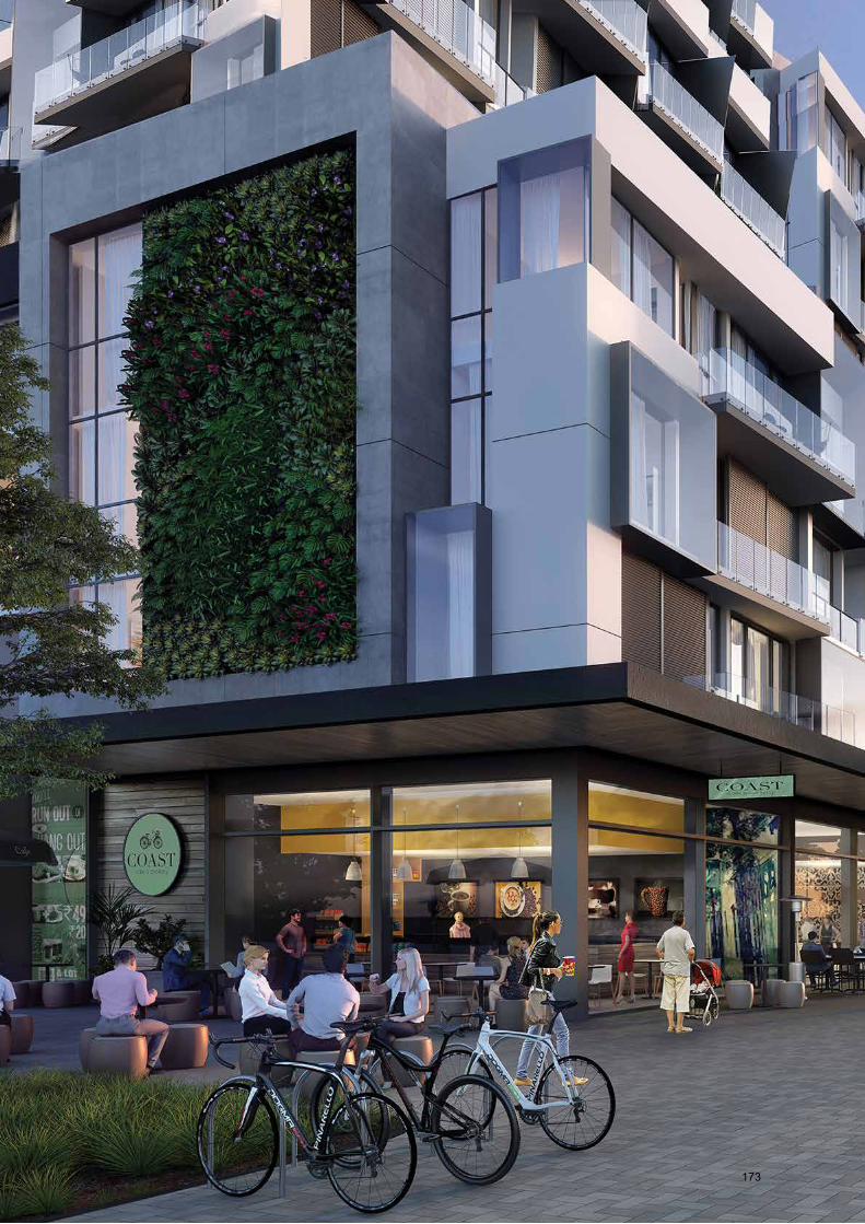
173
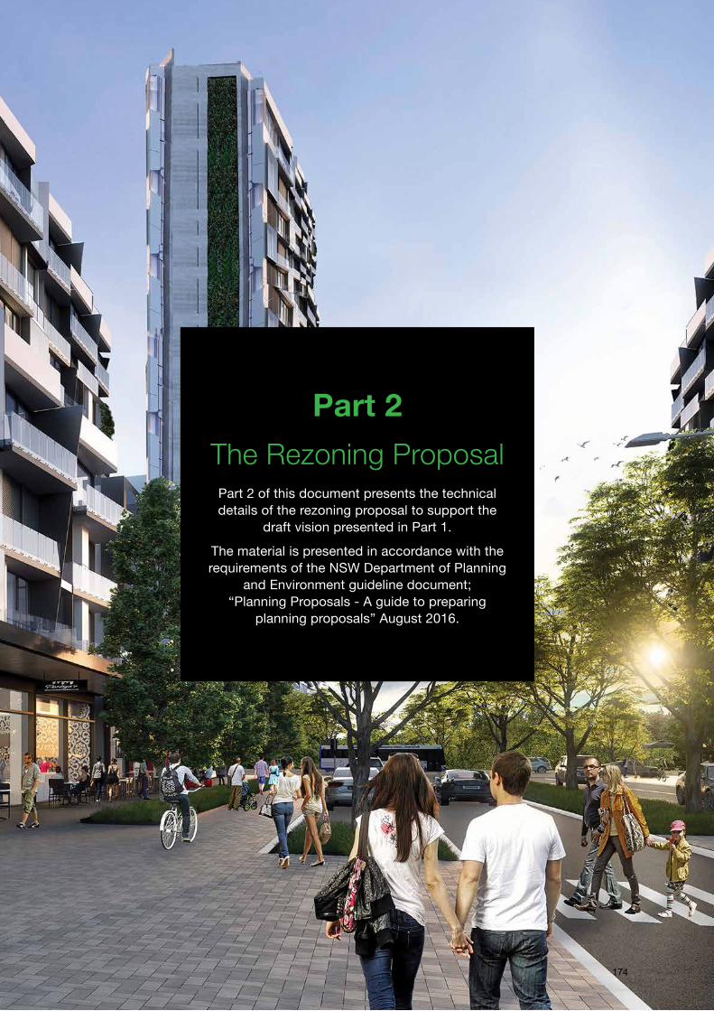
Part 2The Rezoning Proposal
Part 2 of this document presents the technical details of the rezoning proposal to support the
draft vision presented in Part 1.
The material is presented in accordance with the requirements of the NSW Department of Planning
and Environment guideline document;“Planning Proposals - A guide to preparing
planning proposals” August 2016.
174
6. Rezoning Objectives and Intended Outcomes
6.1 Objectives
It is the appreciation of the opportunities for the development of the Site to achieve Wollondilly Council and State Government objectives and deliver significant public benefits with minimal environmental and positive economic impacts that is the genesis of the draft Local Environmental Plan (LEP) contained in this rezoning proposal.
The fundamental objectives of the rezoning are:
• To enable the development of the Wilton Strategic Centre and adjoining lands within the Governor’s Hill property, collectively known as No. 745 Picton Road Wilton NSW 2571;• To satisfy State Government objectives in “The Plan for Growing Sydney”, the “Draft South West District Plan” and the “Greater Macarthur Investigation Area” planning initiatives to provide new communities and employment lands in Greater Macarthur;• To satisfy Wollondilly Shire Council objectives to address the shortfall in employment opportunities in the Shire to increase the ratio of local jobs for local residents, improving employment containment and reducing personal and environmental costs in commuting long distances for work; and• To amend the Wollondilly Local Environmental Plan 2011 and add a site specific chapter to the Wollondilly Development Control Plan to achieve the objectives and enable the development described in this proposal to proceed.
6.2 Intended Outcomes
The site offers a number of opportunities for development. These include connections with neighbouring activities, a size that enables the provision of new public realm places for public enjoyment, protection of areas with environmental value, provision of civil infrastructure and establishment of a wide range and mix of land uses. The presence of the Hume Highway also provides the opportunity for broader range of uses that may capitalise on the economic opportunities generated by potential expenditure from substantial volumes of passing motorists and freight transport.
Not only will these economic opportunities provide local employment, they will contribute to the provision of additional facilities and activities that would ordinarily be denied to the residents of Wollondilly Shire due to its comparatively small population and fragmented and low density nature of the settlement pattern.
An Indicative Structure Plan and Concept Master Plan Vision for the development of the site are presented in Chapter 5 of this document.
The Plans respond to the site’s physical opportunities and constraints, the planning context and Wollondilly’s economic context. They propose a mix of uses that best responds to the employment and living opportunities identified for the Shire, including activities and places oriented towards both residents of Wilton New Town and the Shire, and passing motorists to improve both employment and facilities to serve the Shire’s existing and new communities.
The Wilton Strategic Centre 64175
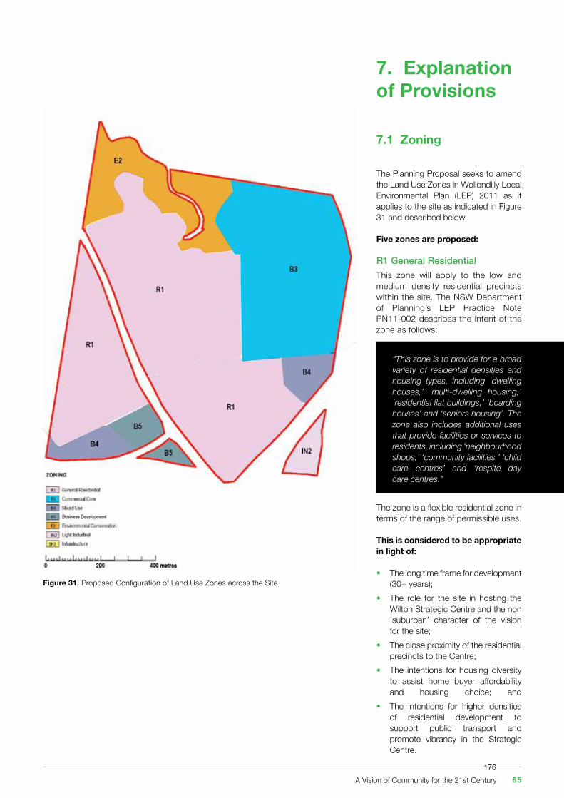
7. Explanation of Provisions
Figure 31. Proposed Configuration of Land Use Zones across the Site.
7.1 Zoning
The Planning Proposal seeks to amend the Land Use Zones in Wollondilly Local Environmental Plan (LEP) 2011 as it applies to the site as indicated in Figure 31 and described below.
Five zones are proposed:
R1 General ResidentialThis zone will apply to the low and medium density residential precincts within the site. The NSW Department of Planning’s LEP Practice Note PN11-002 describes the intent of the zone as follows:
The zone is a flexible residential zone in terms of the range of permissible uses.
This is considered to be appropriate in light of:
• The long time frame for development (30+ years);• The role for the site in hosting the Wilton Strategic Centre and the non ‘suburban’ character of the vision for the site;• The close proximity of the residential precincts to the Centre;• The intentions for housing diversity to assist home buyer affordability and housing choice; and • The intentions for higher densities of residential development to support public transport and promote vibrancy in the Strategic Centre.
“This zone is to provide for a broad variety of residential densities and housing types, including ‘dwelling houses,’ ‘multi-dwelling housing,’ ‘residential flat buildings,’ ‘boarding houses’ and ‘seniors housing’. The zone also includes additional uses that provide facilities or services to residents, including ‘neighbourhood shops,’ ‘community facilities,’ ‘child care centres’ and ‘respite day care centres.”
A Vision of Community for the 21st Century 65176
Consistent with common practice, and the guidance provided by the NSW Department of Planning and Environment, the Byrne’s Creek Corridor and all open space areas will be zoned R1 (as it is the adjoining zone to the land). However there would be no possibility of the creek ever being removed and parks not being provided. Accompanying development controls and contributions plans will ensure that all aspects of the vision will be delivered.
The zone is not currently contained within the Land Use Table in the Wollondilly LEP. A new section for the R1 zone would be inserted in the Table.
B3 Commercial CoreThis zone will apply to the Strategic Centre Precinct. The NSW Department of Planning’s LEP Practice Note PN11-002 describes the intent of the zone as follows:
“This zone is for major centres that provide a wide range of uses including large-scale retail, office, businesses, entertainment and community uses directly linked to major transport routes. These centres are intended to meet the needs of a wider region as well as those of the local community. The zone should be applied in major metropolitan or regional centres only where the focus is on the provision of employment and services. In some areas inclusion of higher density residential accommodation that would activate the area outside of working hours, may be appropriate depending on the scale, role and location of the commercial core.”
Thus the zone provides for a wide range and scale of permissible uses to suit, and is considered to be appropriate for, the NSW Government’s intended role of the Strategic Centre to serve both the Shire and broader Greater Macarthur Area.
Consistent with common practice, and the guidance provided by the NSW Department of Planning and Environment, the Town Square and all
open space areas would be zoned B3 (as it is the adjoining zone to the land). However there would be no possibility of the town square and parks not being provided. Accompanying development controls and contributions plans will ensure that all aspects of the vision will be delivered.
The zone is not currently contained within the Land Use Table in the Wollondilly LEP. A new section for the B3 zone would be inserted in the Table.
B4 Mixed UseThis zone will apply to the mixed use precincts. The NSW Department of Planning’s LEP Practice Note PN11-002 describes the intent of the zone as follows:
“This zone is generally used where a wide range of land uses are to be encouraged, including commercial, residential, tourist and visitor and community uses.”
Thus the zone provides for a wide range of permissible uses and is considered to be appropriate in light of the intended role of the precinct to support the Strategic Centre.
The zone is contained within the Land Use Table in the Wollondilly LEP.
The objectives of the zone are:
• “To provide a mixture of compatible land uses;• To integrate suitable business, office, residential, retail and other development in accessible locations so as to maximise public transport patronage and encourage walking and cycling;• To encourage local employment by facilitating home-based business and employment opportunities”.
The current permissibility of land uses in the zone is very wide-ranging and an additional objective will be added to the Land Use Table for Zone B4 as follows:
“To ensure that the scale and timing of Commercial premises; Entertainment facilities; Function centres; Tourist and visitor accommodation, Registered clubs and Health services facilities in the Wilton New Town Priority Growth Area on land within zone B4 Mixed Use does not conflict with the viability of establishing Commercial premises; Entertainment facilities; Function centres; Tourist and visitor accommodation, Registered clubs and Health services facilities development on land zoned B3 Commercial Core;”
B5 Business DevelopmentThis zone will apply to the highway services precinct. The NSW Department of Planning’s LEP Practice Note PN11-002 describes the intent of the zone as follows:
“This zone is to provide for business, warehouse and bulky goods retail uses that require a large floor area, in locations that are close to, and that support the viability of, centres. This zone provides for employment generating uses such as ‘warehouses or distribution centres,’ ‘bulky goods premises,’ ‘hardware and building supplies,’ ‘landscaping material supplies’ and ‘garden centres.”
Thus the zone provides for a wide range of permissible uses and is considered to be appropriate in light of the intended role of the precinct to support the Strategic Centre.
The zone is contained within the Land Use Table in the Wollondilly LEP.
The objectives of the zone are:
• To enable a mix of business and warehouse uses, and bulky goods premises that require a large floor area, in locations that are close to, and that support the viability of, centres;• To maintain the economic strength of centres by limiting retail activity;• To provide a mixture of compatible land uses;
The Wilton Strategic Centre 66177
• To enable other land uses that provide facilities or services to meet the day to day needs of workers in the area.
An additional objective will be added to the Land Use Table for the B5 zone as follows:
“To ensure that the scale and timing of Entertainment facilities; Function centres; office premises and Health services facilities in the Wilton New Town Priority Growth Area on land within zone B5 Mixed Use does not conflict with the viability of establishing Entertainment facilities; Function centres; office premises and Health services facilities development on land zoned B3 Commercial Core;”
The Land Use Table that applies to the B5 zone in the Wollondilly LEP prohibits ‘Highway Services Centres.’ The table will be amended by making ‘highway services centres’ a permissible use in the B5 zone.
The definition of ‘Highway Service Centre’ is as follows:
• Highway service centre: Means a building or place used to provide refreshments and vehicle services to highway users. It may include any one or more of the following: > a restaurant or café, > take away food and drink premises, > service stations and facilities for emergency vehicle towing and repairs, > parking for vehicles, > rest areas and public amenities.
IN2 Light IndustrialThis zone will apply to the industrial precinct adjoining the Bingara Gorge Wastewater Treatment Plant. The NSW Department of Planning’s LEP Practice Note PN11-002 describes the intent of the zone as follows:
“This zone is for land that provides a range of ‘light industry’, ‘warehouse or distribution centres’ and ‘depots.’ Vehicle trade and other service industries may also be considered appropriate. The types of uses need to be ‘light’ in nature, meaning they will not cause nuisance or adversely affect the surrounding amenity for example by way of noise or emissions.”
Thus the zone is considered to be appropriate in light of the location of the precinct and the nature of adjoining uses, particularly the adjoining Wastewater Treatment Plant that is similarly zoned IN2 in the Wollondilly LEP 2011.
The objectives of zone in the Land Use Table in the Wollondilly LEP 2011 are:
• To provide a wide range of light industrial, warehouse and related land uses;• To encourage employment opportunities and to support the viability of centres;• To minimise any adverse effect of industry on other land uses;• To enable other land uses that provide facilities or services to meet the day to day needs of workers in the area;• To support and protect industrial land for industrial uses;• To ensure development does not impact on the viability of land within Zone B1 Neighbourhood Centre.
7.2 Height, Minimum Lot Size and Floor Space
The following ancillary zoning controls are proposed:
• Maximum Building Height: > Strategic Centre Precinct (B3 zone): 70 metres; > Medium Density Residential (R1), Mixed Use (B4), Highway Services (B5): 16 metres; > Industrial (IN2) Precinct: N/A (as current); and > Low Density Residential Precinct: 9.5 metres.• A minimum lot size of 125 square metres is proposed across the site.• A floor space ratio of 6:1 is proposed in the Strategic Centre Precinct (B3 zone).
7.3 Other Zoning Proposals
The Economic Viability of the Strategic CentreThe SGS Economics & Planning Economic Analysis, (“Greater Macarthur Investigation Area Economic and Employment Analysis September 2015”), prepared for the NSW Department of Planning and Environment, notes the need to ensure that the economic viability of the Strategic Centre is supported. It is important that early investment and development should be directed to the Centre so it can establish a foothold in the market, gain momentum, achieve critical mass and can reach maturity. This environment creates positive clustering and the associated beneficial agglomeration economy effects.
A Vision of Community for the 21st Century 67178
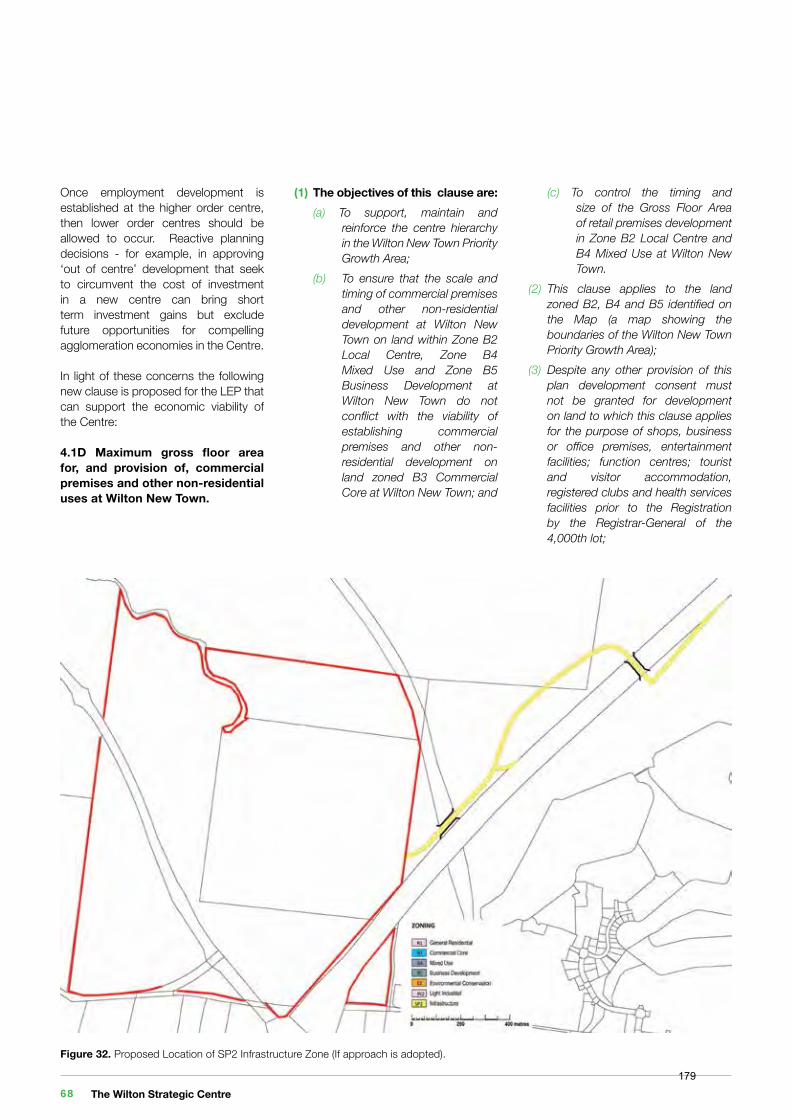
Figure 32. Proposed Location of SP2 Infrastructure Zone (If approach is adopted).
Once employment development is established at the higher order centre, then lower order centres should be allowed to occur. Reactive planning decisions - for example, in approving ‘out of centre’ development that seek to circumvent the cost of investment in a new centre can bring short term investment gains but exclude future opportunities for compelling agglomeration economies in the Centre.
In light of these concerns the following new clause is proposed for the LEP that can support the economic viability of the Centre:
4.1D Maximum gross floor area for, and provision of, commercial premises and other non-residential uses at Wilton New Town.
(1) The objectives of this clause are: (a) To support, maintain and reinforce the centre hierarchy in the Wilton New Town Priority Growth Area; (b) To ensure that the scale and timing of commercial premises and other non-residential development at Wilton New Town on land within Zone B2 Local Centre, Zone B4 Mixed Use and Zone B5 Business Development at Wilton New Town do not conflict with the viability of establishing commercial premises and other non- residential development on land zoned B3 Commercial Core at Wilton New Town; and
(c) To control the timing and size of the Gross Floor Area of retail premises development in Zone B2 Local Centre and B4 Mixed Use at Wilton New Town.(2) This clause applies to the land zoned B2, B4 and B5 identified on the Map (a map showing the boundaries of the Wilton New Town Priority Growth Area);(3) Despite any other provision of this plan development consent must not be granted for development on land to which this clause applies for the purpose of shops, business or office premises, entertainment facilities; function centres; tourist and visitor accommodation, registered clubs and health services facilities prior to the Registration by the Registrar-General of the 4,000th lot;
The Wilton Strategic Centre 68179
(4) In this clause “the 4,000th lot” means the 4,000th lot created for development for residential purposes within the Map pursuant to development consents granted for subdivision since the date that this clause was first inserted in the plan;(5) Notwithstanding subclause (3) development consent may be granted for shops, business or office premises, entertainment facilities; function centres; tourist and visitor accommodation, registered clubs and health services facilities on land identified in the Map if the total amount of Gross Floor Area does not exceed 400m2;(6) In this clause, the provisions of Clause 4.6 are excluded.
Road CorridorsWollondilly Council and the NSW State Government is being requested by the developer of the site to the north of Governor’s Hill to expand its rezoning proposal to include the zoning of road corridors as ‘SP2 Infrastructure’ across the Governor’s Hill site.
The Department of Planning’s LEP Practice Note PN 08-002 provides the following guidance on this matter:
(i) ‘Special purpose’ zones are not required in LEPs to permit infrastructure that is already permitted on all land. It is not necessary to include these infrastructure types as permitted uses in the LEP zoning table - they are automatically permitted through the Infrastructure SEPP;
(ii) Land for infrastructure or services (e.g. roads, railway lines, pipelines etc.), should be zoned the same as the adjacent land;(iii) Applying the adjacent zone type to public infrastructure land follows a basic planning principle of aligning land uses;(iv) It is established practice to refer to the zoning of adjoining land when seeking to establish an appropriate zoning for land. In many cases the infrastructure land would have been zoned the same as the adjoining land if it had not been used instead for an infrastructure purpose;(v) This approach avoids the need for spot rezoning when the infrastructure use ceases or is downsized in the future. It is preferable that the land use zone be the same as the adjacent zoning, so that future uses are compatible with existing surrounding uses.
Should Council accede to the request to apply the ‘SP2 Infrastructure’ zone on road corridors to serve the Wilton Strategic Centre, this rezoning proposal would include a similar proposal (for consistency) to apply the ‘SP2 Infrastructure’ zone across the land to the north and east of the site to link the Centre with the Hume Highway northbound entry and south bound exit ramps as indicated in Figure 32.
Heritage and Natural ResourcesIt is possible that additional LEP maps may be required to address any heritage or natural resource matters that emerge following the detailed environmental investigations that will be required to be done in the event that the rezoning of the site is supported.
7.4 Development Controls and Strategies
It is proposed that a site specific chapter of the Wollondilly Development Control Plan (DCP) be prepared. It will apply to the assessment of future development applications within the Governor’s Hill site. It will present objectives for development and development controls on a range of matters including (but not limited to) the following provisions (where relevant) that will supplement the general controls in the DCP:
1. Precincts: Division of the Development Control; Plan area into Precincts; Preferred Land Uses and Activities; and Desired Future Built Form Character. 2. Built Form: Materials, Style, Character and Colours; Site Planning, Building Envelopes, Setbacks; Advertising Signage; Facades and Roof Design; Ground Floor Interface; Designing for Noise; Designing for Safety and Security; and Designing for Microclimate.
3. Environment: Stormwater Management; Woodland Protection; Bushfire Asset Protection Zones; and Development on Steep Slopes.
4. Landscaping: Centre Gateways and Entrances; Green Streets and Town Square; Street Furniture and Public Art; and Parklands and Paths.
5. Roads and Access Road Network and Sections; Pedestrian and Cycle Networks and Facilities; Parking and Servicing; and Public Transport.
A Vision of Community for the 21st Century 69180
7.5 Provision of Local and State Infrastructure
The proponent for the proposed rezoning, Governor’s Hill, will work with Wollondilly Shire Council to prepare a local Contributions Plan in accordance with S.94 of the Environmental Planning and Assessment Act.
The Contributions Plan will present a schedule of local works required to support, and meet the demand generated by, the development. These works will include on-site infrastructure such as drainage basins, parks, recreation ovals and roads, through to higher order community and civic facilities such as community halls, libraries, indoor recreation centres, aquatic centres and the like (on or off-site).
The Environmental Planning and Assessment Act also provides opportunities for developers to enter into agreements with Council to construct these works on behalf of Council at no cost to Council. This is in lieu of paying contributions to Council to do the works. These agreements are known as “Voluntary Planning Agreements” (VPAs) and Governor’s Hill will make an offer at the appropriate time to enter into a VPA with Council to deliver specific on-site works.
A similar situation exists with State Infrastructure. Governor’s Hill will be required to make contributions to fund state infrastructure that is required to meet the additional demand generated by the proposed development. State infrastructure includes land for schools and emergency services, public transport and new or upgraded roads.
Governor’s Hill will work with the Department of Education, Transport for NSW, the RMS and emergency service agencies to identify additional state infrastructure that will be required to meet the demands generated by the development.
As above, Governor’s Hill will make an offer to enter into a ‘Voluntary Planning Agreement’ with the NSW Minister for Planning to provide land and / or construct infrastructure at no cost to Government in lieu of making contributions.
The items to be offered in both the local infrastructure (Council) and State infrastructure (NSW Government) agreements will be identified during the course of detailed investigations, analysis and discussions to follow should the rezoning proposal be supported.
The Wilton Strategic Centre 70181
8. Justification
Section A: Need for the planning proposal
Question 1. Is The Planning Proposal a Result of any Strategic Study or Report?
Yes. The proposal directly responds to The Greater Macarthur Preliminary Land Release Strategy.
The Draft Greater Macarthur Preliminary Land Release Strategy is described in Chapter 2.3 of this proposal. It identifies Wilton as a Priority Growth Area with potential to accommodate 16,000 new homes by 2036 and a new major centre.
The Strategy identifies the following actions to achieve land release in Wilton:
• Commence the process to rezone land at Wilton for urban development in partnership with Wollondilly Shire Council;• Define thresholds for the delivery of infrastructure needed to support stages of population growth;• Establish infrastructure funding arrangements, such as through a Special Infrastructure Contribution; and• Establish a planning and development pathway for land that is constrained by underground mining, to manage risks to Government and the community.
This rezoning proposal responds to the NSW Government’s planning strategy for Wilton and facilitates all of the identified actions summarised above. By proposing the mechanism to deliver the major centre together with associated offers to fund certain infrastructure (to be confirmed), it is consistent with the strategic direction being pursued.
Question 2. Is The Planning Proposal The Best Means of Achieving The Objectives or Intended Outcomes, or is There a Better Way?
Yes. The planning proposal to amend the zoning maps and clauses in the Wollondilly LEP 2011 via State Environmental Planning Policy (Sydney Region Growth Centres) 2006 is the most appropriate method to enable development applications to be submitted for development within the site. Other methods investigated will not achieve the intended result that is sought.
Other options identified comprise:
(i) Introduction into the State Environmental Planning Policy (Sydney Region Growth Centres) 2006
While this planning proposal seeks to rezone land within the Wilton Priority Growth Area pursuant to State Environmental Planning Policy (Sydney Region Growth Centres) 2006 (known as the Growth Centres SEPP), the Wollondilly LEP 2011 remains the Environmental Planning Instrument that applies land use zoning to the land.
As such Governor’s Hill, following discussions with both Wollondilly Shire Council and the NSW Department of Planning and Environment, seeks to use the Growth Centre SEPP only as the instrument to amend the Wollondilly LEP. This approach is known as the “24 Hour SEPP.” Rather than introduce detailed zoning maps and relevant clauses into the SEPP itself, the amending SEPP is in force for only a very short time with its sole purpose to implement the amendments to the Wollondilly LEP. Once the Wollondilly LEP is amended, the SEPP is repealed.
(ii) A site specific provision enabled by inclusion of the site in Schedule 1 of Wollondilly LEP 2011.
This option was considered. However, due the geographical size of the area, the complexity of the proposal and the precedent such an approach would set, the approach advocated in the Planning Proposal was considered to be the most appropriate method.
(iii) Await a review of the Wollondilly LEP 2011 in the future.
This option was considered. However, the process whereby the proponent awaits a review at an unknown time introduces too much uncertainty in terms of timeframe and outcome. The uncertainty jeopardises the opportunity for the achievement of the objectives identified in Chapter 6 in the short term.
Rather, it is considered that the progress of this Planning Proposal is the most suitable mechanism to achieve the objectives in Chapter 6.
A Vision of Community for the 21st Century 71182
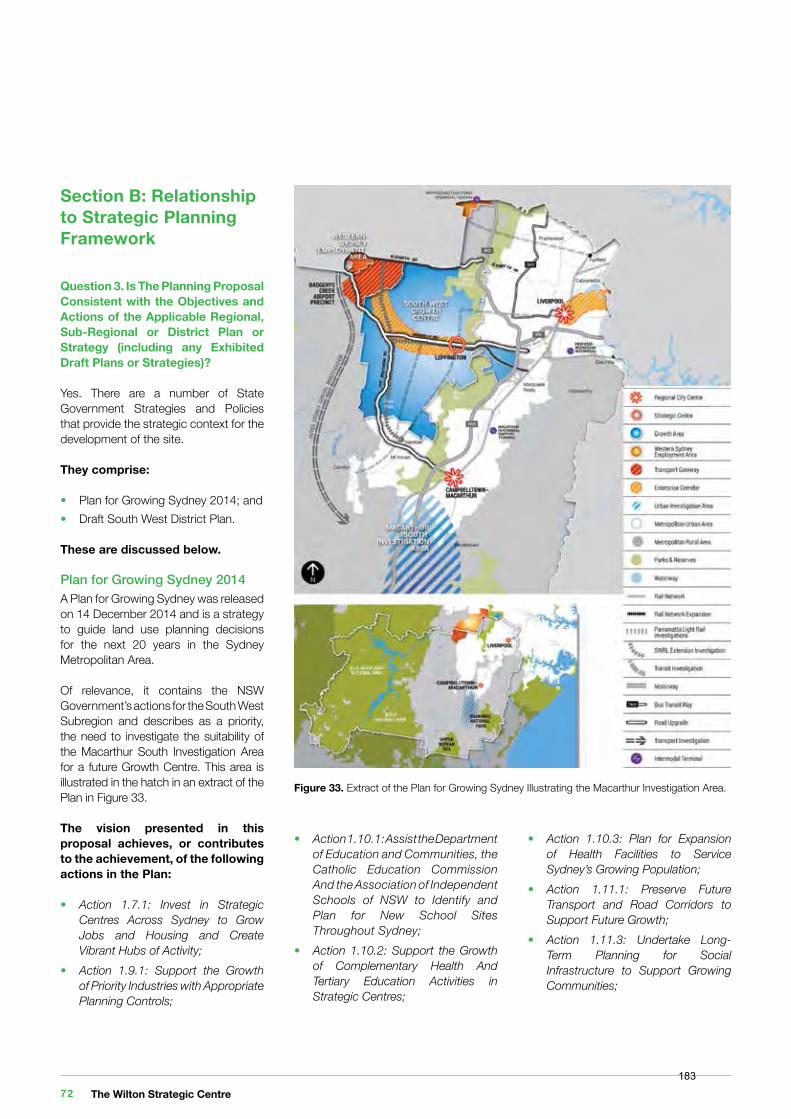
Section B: Relationship to Strategic Planning Framework
Question 3. Is The Planning Proposal Consistent with the Objectives and Actions of the Applicable Regional, Sub-Regional or District Plan or Strategy (including any Exhibited Draft Plans or Strategies)?
Yes. There are a number of State Government Strategies and Policies that provide the strategic context for the development of the site.
They comprise:
• Plan for Growing Sydney 2014; and• Draft South West District Plan.
These are discussed below.
Plan for Growing Sydney 2014 A Plan for Growing Sydney was released on 14 December 2014 and is a strategy to guide land use planning decisions for the next 20 years in the Sydney Metropolitan Area.
Of relevance, it contains the NSW Government’s actions for the South West Subregion and describes as a priority, the need to investigate the suitability of the Macarthur South Investigation Area for a future Growth Centre. This area is illustrated in the hatch in an extract of the Plan in Figure 33.
The vision presented in this proposal achieves, or contributes to the achievement, of the following actions in the Plan:
• Action 1.7.1: Invest in Strategic Centres Across Sydney to Grow Jobs and Housing and Create Vibrant Hubs of Activity;• Action 1.9.1: Support the Growth of Priority Industries with Appropriate Planning Controls;
• Action 1.10.1: Assist the Department of Education and Communities, the Catholic Education Commission And the Association of Independent Schools of NSW to Identify and Plan for New School Sites Throughout Sydney;• Action 1.10.2: Support the Growth of Complementary Health And Tertiary Education Activities in Strategic Centres;
• Action 1.10.3: Plan for Expansion of Health Facilities to Service Sydney’s Growing Population;• Action 1.11.1: Preserve Future Transport and Road Corridors to Support Future Growth;• Action 1.11.3: Undertake Long- Term Planning for Social Infrastructure to Support Growing Communities;
Figure 33. Extract of the Plan for Growing Sydney Illustrating the Macarthur Investigation Area.
The Wilton Strategic Centre 72183
• Action 2.1.1: Accelerate Housing Supply and Local Housing Choices;• Action 2.4.2: Develop a Framework for the Identification of New Growth Centres;• Action 3.4.3: Target Investment in Local Arts and Culture in Priority Precincts;• Action 4.1.1: Protect and Deliver a Network of High Conservation Value Land by Investing in Green Corridors and Protecting Native Vegetation and Biodiversity;• Action 4.3.1: Apply Urban Green Cover Technical Guidelines.
The Plan defines Strategic centres as:
Draft South West District Plan The South West District Plan was released by the Greater Sydney Commission in November 2016. The plan identifies a vision for south western Sydney over the next 20 years. The planning proposal and subsequent site specific development controls are consistent with the plan and can facilitate the following priorities and actions:• IM1: Align land use planning and infrastructure planning;• P10: Encourage and support the use of public transport;
• P11: Develop specific guidelines to inform the planning of new communities in land release areas;• P18: Plan for and facilitate the attraction of new jobs in Wilton New Town;• P21: Leverage the South West District’s potential as a visitor destination;• L2: Identify the opportunities to create the capacity to deliver 20 year strategic housing supply targets;• L4: Encourage housing diversity;• L11: Provide design-led planning to support high quality urban design;• L12: Develop guidelines for safe and healthy built environments;• L13: Conserve and enhance environmental heritage including Aboriginal, European and natural;• L15: Support planning for shared spaces;• L16: Support planning for school facilities;• L18: Support planning for emergency services;• S4: Improve the management of waterways in Priority Growth Areas;• S13: Support the development of initiatives for a sustainable low carbon future; and• S15: Incorporate the mitigation the of urban heat island effect into planning for urban renewal projects and Priority Growth Areas.
Question 4. Is The Planning Proposal Consistent with a Local Council’s Local Strategy, or Other Local Strategic Plan?
Yes. There are three relevant Wollondilly Shire Strategic Plans: • The Wollondilly Growth Management Strategy (GMS) 2011;• The Wollondilly Economic Development Strategy 2015; and• Wollondilly Community Strategic Plan 2033.
The Wollondilly Growth Management Strategy (GMS) 2011The Wollondilly GMS 2011 is the overarching strategic document that provides the basis for all Council planning strategic direction in growth management. It sets out the vision, the issues, the objectives and the actions that will guide Council planning to 2030-2035.
Relevant aims include:
• To outline clear policy directions on growth issues;• To provide Council and the community with a strategic framework against which to consider planning proposals;• To achieve a long-term sound and sustainable approach to how this Shire develops and changes into the future; • To provide our strategy/response for how we see the State Government’s Metropolitan and subregional planning strategies being implemented at the local level.
There are three key policy directions regarding employment:
P15 Council will plan for new employment lands and other employment generating initiatives in order to deliver positive local and regional employment outcomes.
P16 Council will plan for different types of employment lands to be in different locations in recognition of the need to create employment opportunities in different sectors of the economy in appropriate locations.
P17 Council will not support residential and employment lands growth unless increased infrastructure and servicing demands can be clearly demonstrated as being able to be delivered in a timely manner without imposing unsustainable burdens on Council or the Shire’s existing and future community.
(GMS 2011:10)
“The largest centres in the Sydney Metropolitan Area, when developed. They contain mixed-use activity of an amount, density and diversity that is of metropolitan significance, including commercial (office, business and retail), civic and cultural uses; government services; and higher density housing. They are typically on the passenger rail network or serviced by other high frequency public transport. Strategic centres typically contain at least 10,000 jobs, with the potential to accommodate ongoing jobs growth over the long-term. They are priority locations for employment and retail activity.”
A Vision of Community for the 21st Century 73184
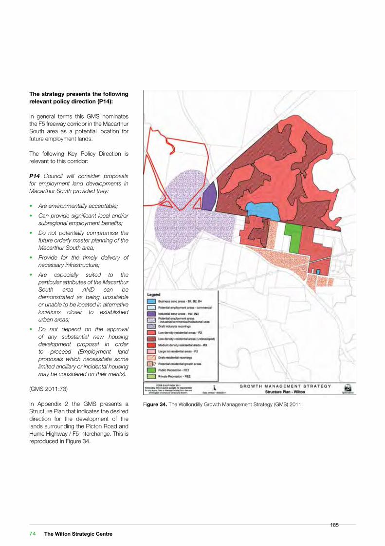
Figure 34. The Wollondilly Growth Management Strategy (GMS) 2011.
The strategy presents the following relevant policy direction (P14):
In general terms this GMS nominates the F5 freeway corridor in the Macarthur South area as a potential location for future employment lands.
The following Key Policy Direction is relevant to this corridor:
P14 Council will consider proposals for employment land developments in Macarthur South provided they:
• Are environmentally acceptable;• Can provide significant local and/or subregional employment benefits;• Do not potentially compromise the future orderly master planning of the Macarthur South area;• Provide for the timely delivery of necessary infrastructure;• Are especially suited to the particular attributes of the Macarthur South area AND can be demonstrated as being unsuitable or unable to be located in alternative locations closer to established urban areas;• Do not depend on the approval of any substantial new housing development proposal in order to proceed (Employment land proposals which necessitate some limited ancillary or incidental housing may be considered on their merits).
(GMS 2011:73)
In Appendix 2 the GMS presents a Structure Plan that indicates the desired direction for the development of the lands surrounding the Picton Road and Hume Highway / F5 interchange. This is reproduced in Figure 34.
The Wilton Strategic Centre 74185
The proposed rezoning achieves the requirements of the policy direction P14 as follows:
Policy Direction Planning Proposal ConsistentAre environmentally acceptable; The concept vision for the site seeks to preserve and protect riparian
environments and adjoining woodland areas within the site.Yes
Can provide significant local and/or subregional employment benefits;
The planning proposal requests four employment zones: ‘B3 Commercial Core’, ‘B4 - Mixed Use’ ‘B5 Business Development’ and ‘IN2 - Light Industrial to enable occupation by a mix of employment generating land uses within the site.
Yes
Do not potentially compromise the future orderly master planning of the Macarthur South area;
Previous investigations in the 1990s undertaken as part of the Regional Environmental Study for Macarthur South noted the suitability of the site for a new District Centre in association with employment uses. The current Greater Macarthur Preliminary Land Release Strategy supercedes the 1990s work.
However both documents consistently support a centre for employment and services in the site of the propose Wilton Strategic Centre.
The adoption of the proposed zones provides the flexibility for land uses to evolve over the long term.
Yes
Provide for the timely delivery of necessary infrastructure;
All necessary infrastructure will be provided to the site. Yes
Are especially suited to the particular attributes of the Macarthur South area AND can be demonstrated as being unsuitable or unable to be located in alternative locations closer to established urban areas;
The site is one of the best strategically located and unencumbered parcels of land within Greater Macarthur and the Wollondilly Shire to provide employment generating uses. It adjoins a major interchange of two regional roads. The uses proposed within the site offer high density employment and seek to capitalise on the excellent access and exposure that the opportunity presents.
Yes
Do not depend on the approval of any substantial new housing development proposal in order to proceed (Employment land proposals which necessitate some limited ancillary or incidental housing may be considered on their merits).
The Vision for the site includes a component of residential use. The purpose of the residential activity is to promote public transport provision and activate and create vibrancy in the public realm, both important objectives. As a supporting activity, the residential use is ancillary to the primary aim of the LEP, to enable the development of the Wilton Strategic Centre to commence.
Yes
A Vision of Community for the 21st Century 75186
The Wollondilly Economic Development Strategy 2015The purpose of the Economic Development Strategy is to understand the current economic structure and future trends and growth drivers so that a clear direction forward for the local economy can be established.
The strategy has three principal objectives for its economic vision:
• Economic Diversity: Ensuring that the economy is diverse will ensure future sustainability and help to create a vibrant economy.• More Jobs: Creating more local jobs will create opportunities for more residents to work closer to home.• More Investment: Recruiting new capital investments that will support future jobs growth and diversification.
This proposal assists (or will be able to assist) in the delivery of the following strategies:
• 1: Managing growth through the planning system;• 2.11: Work with partners to offer high quality information, advice and support to business start-ups and entrepreneurs;• 3.1: Confirm Brand identity for Wollondilly/ Develop strong identity & effective brand;• 3.4: Create web portal and digital strategy for business, tourism and economic development;• 3.5: Market the Shire as ‘Open for Business’ to create an attractive business friendly city;• 3.6: Develop marketing campaigns to raise awareness of Wollondilly & Local advantages;• 4.2: Identify investment ready development opportunities in the Shire;• 4.4: Identify prospective investors in targeted sectors (through research and networking) and circulate business case;
• 4.5: Identify and engage with key partners (i.e. real estate, developers, bankers, etc.);• 4.6: Develop suite of marketing material and individual business case documents to support existing and emerging industry priority sectors identified opportunities; and• 4.7: Encourage employment diversity and further grow opportunities through engaging emerging development proponents.
Wollondilly Community Strategic Plan 2033The Wollondilly Community Strategic Plan 2033 was adopted by Council 17 June 2013. It is Council’s primary, guiding strategic plan and sets out the aspirations of the community for Wollondilly for the next 20 years.
The plan is focused on five themes:
1. Looking after the Community;2. Accountable and Transparent Governance;3. Caring for the Environment;4. Building a strong local Economy; and5. Management and provision of Infrastructure.
Each theme is supported by identified outcomes and strategies that express in broad terms what is to be achieved and how. These themes are, in part, delivered through a number of key supporting strategies, plans and policies which have been prepared by the Council.
This proposal assists in the delivery of the following strategies:
• CO1: Deliver a range of community programmes, services, facilities and events which strengthen the capacity, well-being and cultural identity of our community;
• GO3: Deliver responsive and helpful services to all our customers;• GO6: Be efficient and effective in the use of Council resources and provide value for money in the delivery of services;• EN1: Protect and conserve biodiversity and natural resources, including waterways, riparian lands and groundwater dependant ecosystems;• EN2: Apply best practice environmental principles to the management of future growth;• EN7: Educate, promote and support low consumption, sustainable lifestyles and lowering of the Shire’s carbon footprint;• EC1: Enhance economic development in Wollondilly Shire through innovative engagement and ongoing promotion of our strengths;• EC2: Strengthen and diversify Wollondilly’s economic base by attracting and supporting the development of a diverse range of industries;• EC3; Encourage and manage growth to ensure that it contributes to economic well-being;• EC4: Manage and regulate land use and development in order to achieve a high quality built environment which contributes to economic well-being;• EC5: Protect natural resources so as to contribute to the Shire’s economic well-being;• IN2: Manage the road network to respond to community needs, growth in the Shire, improving road safety and improving transport choices; and• IN3: Provide a range of recreation and community facilities to meet the needs of the community.
The Wilton Strategic Centre 76187
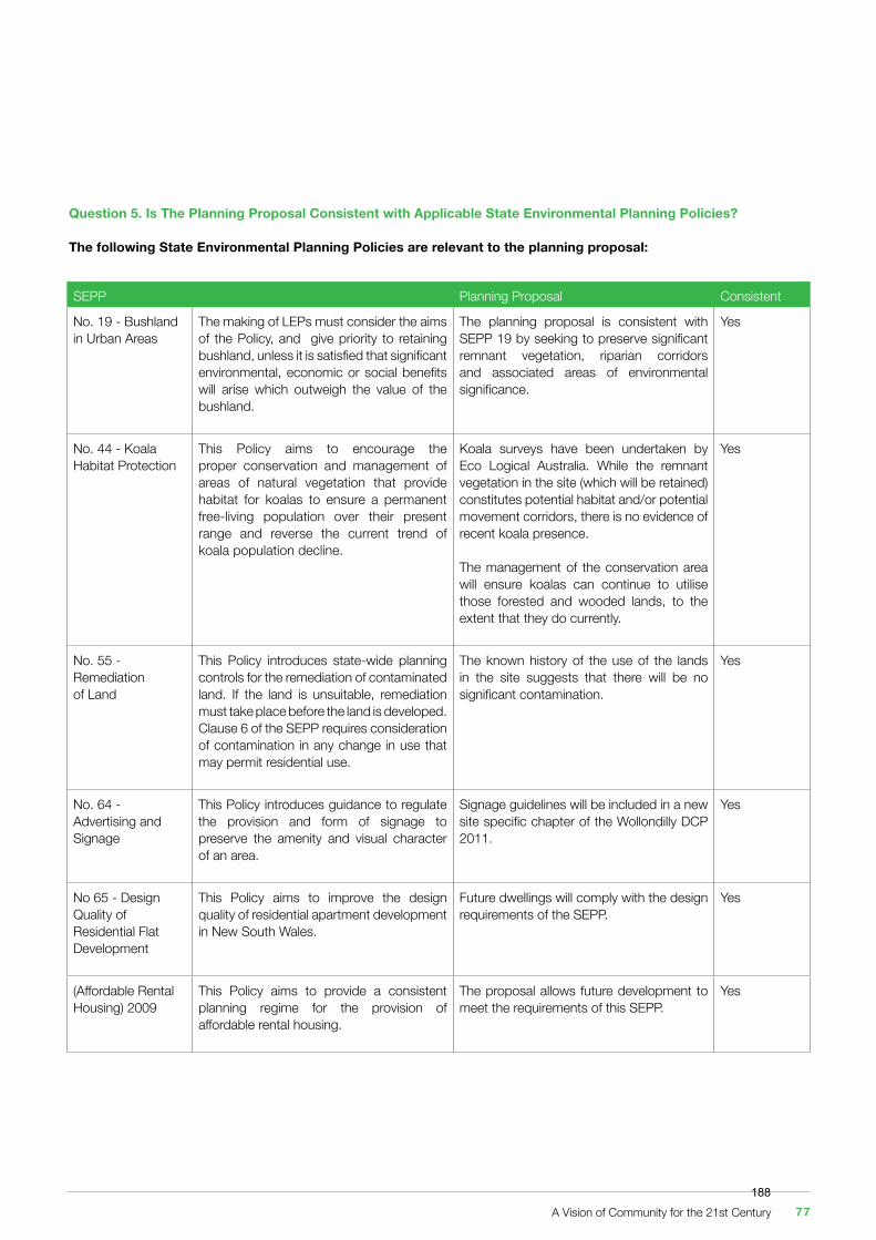
Question 5. Is The Planning Proposal Consistent with Applicable State Environmental Planning Policies?
The following State Environmental Planning Policies are relevant to the planning proposal:
SEPP Planning Proposal Consistent
No. 19 - Bushland in Urban Areas
The making of LEPs must consider the aims of the Policy, and give priority to retaining bushland, unless it is satisfied that significant environmental, economic or social benefits will arise which outweigh the value of the bushland.
The planning proposal is consistent with SEPP 19 by seeking to preserve significant remnant vegetation, riparian corridors and associated areas of environmental significance.
Yes
No. 44 - Koala Habitat Protection
This Policy aims to encourage the proper conservation and management of areas of natural vegetation that provide habitat for koalas to ensure a permanent free-living population over their present range and reverse the current trend of koala population decline.
Koala surveys have been undertaken by Eco Logical Australia. While the remnant vegetation in the site (which will be retained) constitutes potential habitat and/or potential movement corridors, there is no evidence of recent koala presence.
The management of the conservation area will ensure koalas can continue to utilise those forested and wooded lands, to the extent that they do currently.
Yes
No. 55 - Remediation of Land
This Policy introduces state-wide planning controls for the remediation of contaminated land. If the land is unsuitable, remediation must take place before the land is developed. Clause 6 of the SEPP requires consideration of contamination in any change in use that may permit residential use.
The known history of the use of the lands in the site suggests that there will be no significant contamination.
Yes
No. 64 - Advertising and Signage
This Policy introduces guidance to regulate the provision and form of signage to preserve the amenity and visual character of an area.
Signage guidelines will be included in a new site specific chapter of the Wollondilly DCP 2011.
Yes
No 65 - Design Quality of Residential Flat Development
This Policy aims to improve the design quality of residential apartment development in New South Wales.
Future dwellings will comply with the design requirements of the SEPP.
Yes
(Affordable Rental Housing) 2009
This Policy aims to provide a consistent planning regime for the provision of affordable rental housing.
The proposal allows future development to meet the requirements of this SEPP.
Yes
A Vision of Community for the 21st Century 77188
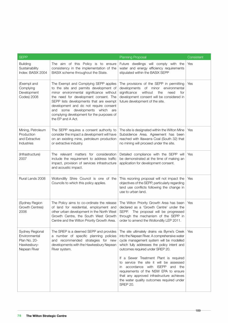
SEPP Planning Proposal Consistent
Building SustainabilityIndex: BASIX 2004
The aim of this Policy is to ensure consistency in the implementation of the BASIX scheme throughout the State.
Future dwellings will comply with the water and energy efficiency requirements stipulated within the BASIX SEPP
Yes
(Exempt and Complying Development Codes) 2008
The Exempt and Complying SEPP applies to the site and permits development of minor environmental significance without the need for development consent. The SEPP lists developments that are exempt development and do not require consent and some developments which are complying development for the purposes of the EP and A Act.
The provisions of the SEPP in permitting developments of minor environmental significance without the need for development consent will be considered in future development of the site.
Yes
Mining, Petroleum Production and Extractive Industries
The SEPP requires a consent authority to consider the impact a development will have on an existing mine, petroleum production or extractive industry.
The site is designated within the Wilton Mine Subsidence Area. Agreement has been reached with Illawarra Coal (South 32) that no mining will proceed under the site.
Yes
(Infrastructure) 2007
The relevant matters for consideration include the requirement to address traffic impact, provision of services infrastructure and acoustic impact.
Detailed compliance with the SEPP will be demonstrated at the time of making an application for development consent.
Yes
Rural Lands 2008 Wollondilly Shire Council is one of the Councils to which this policy applies.
This rezoning proposal will not impact the objectives of the SEPP, particularly regarding land use conflicts following the change in use to urban land.
Yes
(Sydney Region Growth Centres)2006
The Policy aims to co-ordinate the release of land for residential, employment and other urban development in the North West Growth Centre, the South West Growth Centre and the Wilton Priority Growth Area.
The Wilton Priority Growth Area has been declared as a ‘Growth Centre’ under the SEPP. The proposal will be progressed through the mechanism of the SEPP in order to amend the Wollondilly LEP 2011.
Yes
Sydney Regional Environmental Plan No. 20- Hawkesbury-Nepean River
The SREP is a deemed SEPP and provides a number of specific planning policies and recommended strategies for new developments with the Hawkesbury Nepean River system.
The site ultimately drains via Byrne’s Creek into the Nepean River. A comprehensive water cycle management system will be modelled which fully addresses the policy intent and outcomes required under SREP 20.
If a Sewer Treatment Plant is required to service the site it will be assessed in accordance with ISEPP and the requirements of the NSW EPA to ensure that any approved infrastructure achieves the water quality outcomes required under SREP 20.
Yes
The Wilton Strategic Centre 78189
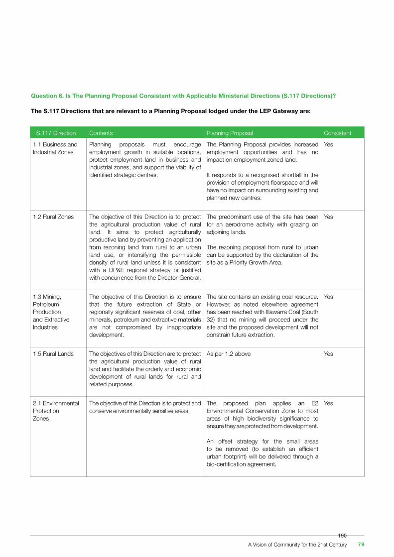
Question 6. Is The Planning Proposal Consistent with Applicable Ministerial Directions (S.117 Directions)?
The S.117 Directions that are relevant to a Planning Proposal lodged under the LEP Gateway are:
S.117 Direction Contents Planning Proposal Consistent
1.1 Business and Industrial Zones
Planning proposals must encourage employment growth in suitable locations, protect employment land in business and industrial zones, and support the viability of identified strategic centres.
The Planning Proposal provides increased employment opportunities and has no impact on employment zoned land.
It responds to a recognised shortfall in the provision of employment floorspace and will have no impact on surrounding existing and planned new centres.
Yes
1.2 Rural Zones The objective of this Direction is to protect the agricultural production value of rural land. It aims to protect agriculturally productive land by preventing an application from rezoning land from rural to an urban land use, or intensifying the permissible density of rural land unless it is consistent with a DP&E regional strategy or justified with concurrence from the Director-General.
The predominant use of the site has been for an aerodrome activity with grazing on adjoining lands.
The rezoning proposal from rural to urban can be supported by the declaration of the site as a Priority Growth Area.
Yes
1.3 Mining, Petroleum Production and Extractive Industries
The objective of this Direction is to ensure that the future extraction of State or regionally significant reserves of coal, other minerals, petroleum and extractive materials are not compromised by inappropriate development.
The site contains an existing coal resource. However, as noted elsewhere agreement has been reached with Illawarra Coal (South 32) that no mining will proceed under the site and the proposed development will not constrain future extraction.
Yes
1.5 Rural Lands The objectives of this Direction are to protect the agricultural production value of rural land and facilitate the orderly and economic development of rural lands for rural and related purposes.
As per 1.2 above Yes
2.1 Environmental ProtectionZones
The objective of this Direction is to protect and conserve environmentally sensitive areas.
The proposed plan applies an E2 Environmental Conservation Zone to most areas of high biodiversity significance to ensure they are protected from development.
An offset strategy for the small areas to be removed (to establish an efficient urban footprint) will be delivered through a bio-certification agreement.
Yes
A Vision of Community for the 21st Century 79190
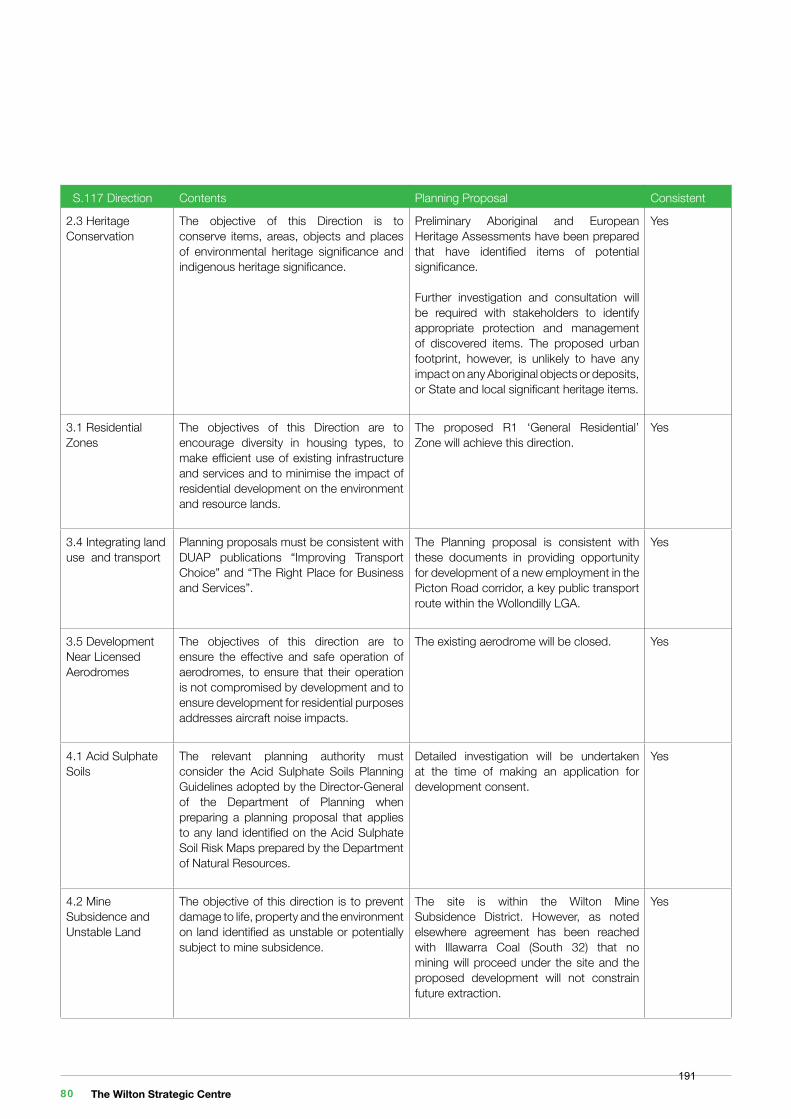
S.117 Direction Contents Planning Proposal Consistent
2.3 Heritage Conservation
The objective of this Direction is to conserve items, areas, objects and places of environmental heritage significance and indigenous heritage significance.
Preliminary Aboriginal and European Heritage Assessments have been prepared that have identified items of potential significance.
Further investigation and consultation will be required with stakeholders to identify appropriate protection and management of discovered items. The proposed urban footprint, however, is unlikely to have any impact on any Aboriginal objects or deposits, or State and local significant heritage items.
Yes
3.1 Residential Zones
The objectives of this Direction are to encourage diversity in housing types, to make efficient use of existing infrastructure and services and to minimise the impact of residential development on the environment and resource lands.
The proposed R1 ‘General Residential’ Zone will achieve this direction.
Yes
3.4 Integrating land use and transport
Planning proposals must be consistent with DUAP publications “Improving Transport Choice” and “The Right Place for Business and Services”.
The Planning proposal is consistent with these documents in providing opportunity for development of a new employment in the Picton Road corridor, a key public transport route within the Wollondilly LGA.
Yes
3.5 Development Near Licensed Aerodromes
The objectives of this direction are to ensure the effective and safe operation of aerodromes, to ensure that their operation is not compromised by development and to ensure development for residential purposes addresses aircraft noise impacts.
The existing aerodrome will be closed. Yes
4.1 Acid Sulphate Soils
The relevant planning authority must consider the Acid Sulphate Soils Planning Guidelines adopted by the Director-General of the Department of Planning when preparing a planning proposal that applies to any land identified on the Acid Sulphate Soil Risk Maps prepared by the Department of Natural Resources.
Detailed investigation will be undertaken at the time of making an application for development consent.
Yes
4.2 Mine Subsidence and Unstable Land
The objective of this direction is to prevent damage to life, property and the environment on land identified as unstable or potentially subject to mine subsidence.
The site is within the Wilton Mine Subsidence District. However, as noted elsewhere agreement has been reached with Illawarra Coal (South 32) that no mining will proceed under the site and the proposed development will not constrain future extraction.
Yes
The Wilton Strategic Centre 80191
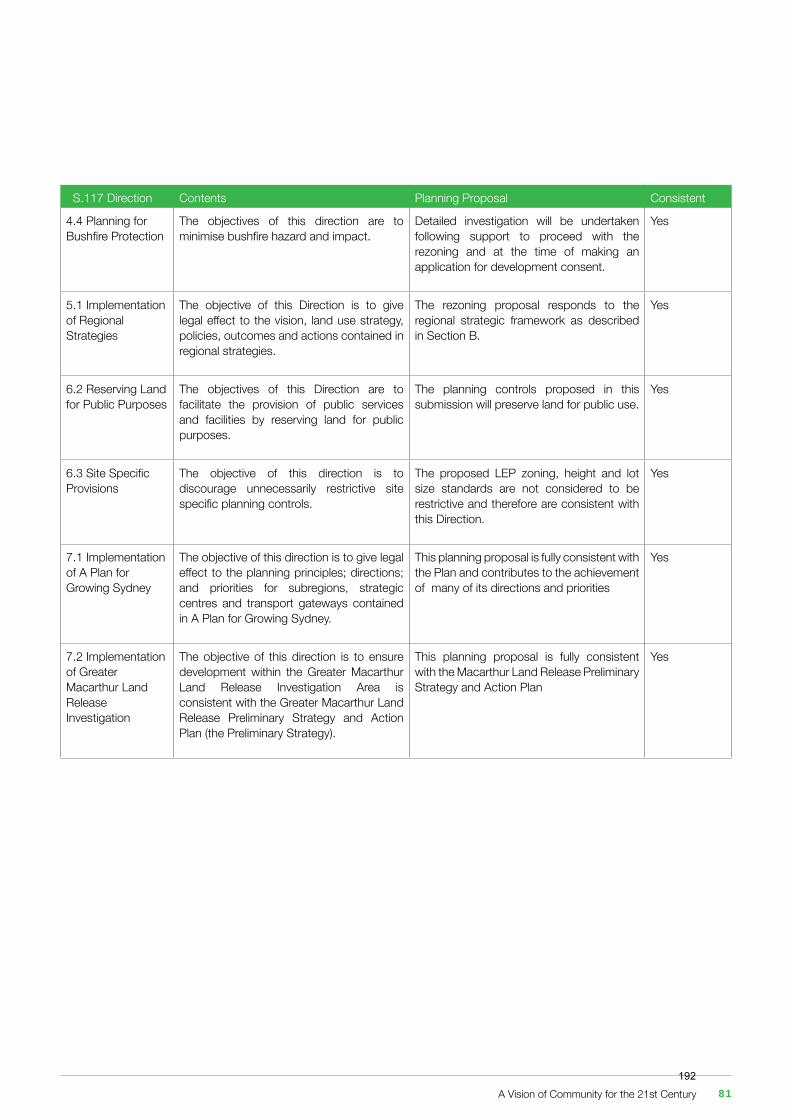
S.117 Direction Contents Planning Proposal Consistent
4.4 Planning for Bushfire Protection
The objectives of this direction are to minimise bushfire hazard and impact.
Detailed investigation will be undertaken following support to proceed with the rezoning and at the time of making an application for development consent.
Yes
5.1 Implementation of Regional Strategies
The objective of this Direction is to give legal effect to the vision, land use strategy, policies, outcomes and actions contained in regional strategies.
The rezoning proposal responds to the regional strategic framework as described in Section B.
Yes
6.2 Reserving Land for Public Purposes
The objectives of this Direction are to facilitate the provision of public services and facilities by reserving land for public purposes.
The planning controls proposed in this submission will preserve land for public use.
Yes
6.3 Site Specific Provisions
The objective of this direction is to discourage unnecessarily restrictive site specific planning controls.
The proposed LEP zoning, height and lot size standards are not considered to be restrictive and therefore are consistent with this Direction.
Yes
7.1 Implementation of A Plan for Growing Sydney
The objective of this direction is to give legal effect to the planning principles; directions; and priorities for subregions, strategic centres and transport gateways contained in A Plan for Growing Sydney.
This planning proposal is fully consistent with the Plan and contributes to the achievement of many of its directions and priorities
Yes
7.2 Implementation of Greater Macarthur Land ReleaseInvestigation
The objective of this direction is to ensure development within the Greater Macarthur Land Release Investigation Area is consistent with the Greater Macarthur Land Release Preliminary Strategy and Action Plan (the Preliminary Strategy).
This planning proposal is fully consistent with the Macarthur Land Release Preliminary Strategy and Action Plan
Yes
A Vision of Community for the 21st Century 81192
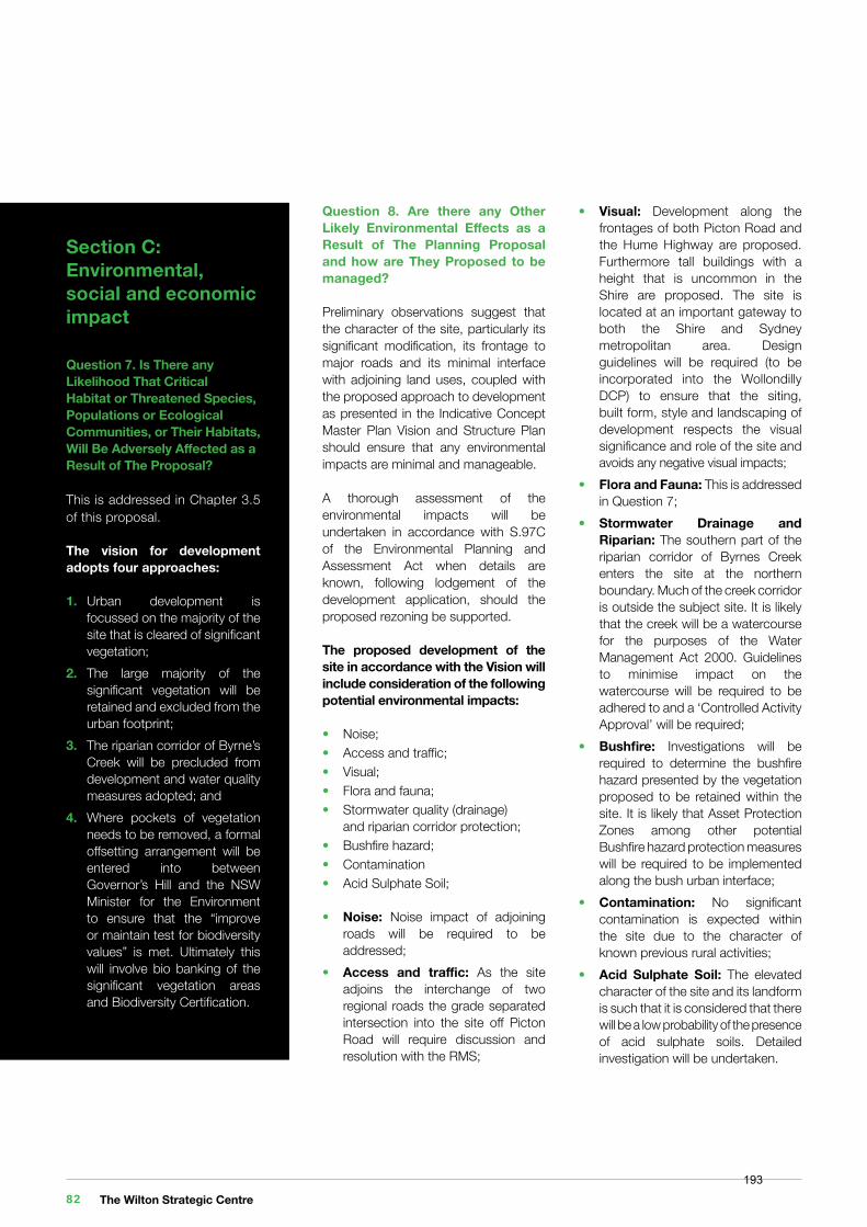
Section C: Environmental, social and economic impact
Question 7. Is There any Likelihood That Critical Habitat or Threatened Species, Populations or Ecological Communities, or Their Habitats, Will Be Adversely Affected as a Result of The Proposal?
This is addressed in Chapter 3.5 of this proposal.
The vision for development adopts four approaches:
1. Urban development is focussed on the majority of the site that is cleared of significant vegetation;2. The large majority of the significant vegetation will be retained and excluded from the urban footprint;3. The riparian corridor of Byrne’s Creek will be precluded from development and water quality measures adopted; and4. Where pockets of vegetation needs to be removed, a formal offsetting arrangement will be entered into between Governor’s Hill and the NSW Minister for the Environment to ensure that the “improve or maintain test for biodiversity values” is met. Ultimately this will involve bio banking of the significant vegetation areas and Biodiversity Certification.
Question 8. Are there any Other Likely Environmental Effects as a Result of The Planning Proposal and how are They Proposed to be managed?
Preliminary observations suggest that the character of the site, particularly its significant modification, its frontage to major roads and its minimal interface with adjoining land uses, coupled with the proposed approach to development as presented in the Indicative Concept Master Plan Vision and Structure Plan should ensure that any environmental impacts are minimal and manageable.
A thorough assessment of the environmental impacts will be undertaken in accordance with S.97C of the Environmental Planning and Assessment Act when details are known, following lodgement of the development application, should the proposed rezoning be supported.
The proposed development of the site in accordance with the Vision will include consideration of the following potential environmental impacts:
• Noise;• Access and traffic;• Visual;• Flora and fauna;• Stormwater quality (drainage) and riparian corridor protection;• Bushfire hazard;• Contamination• Acid Sulphate Soil;
• Noise: Noise impact of adjoining roads will be required to be addressed;• Access and traffic: As the site adjoins the interchange of two regional roads the grade separated intersection into the site off Picton Road will require discussion and resolution with the RMS;
• Visual: Development along the frontages of both Picton Road and the Hume Highway are proposed. Furthermore tall buildings with a height that is uncommon in the Shire are proposed. The site is located at an important gateway to both the Shire and Sydney metropolitan area. Design guidelines will be required (to be incorporated into the Wollondilly DCP) to ensure that the siting, built form, style and landscaping of development respects the visual significance and role of the site and avoids any negative visual impacts;• Flora and Fauna: This is addressed in Question 7;• Stormwater Drainage and Riparian: The southern part of the riparian corridor of Byrnes Creek enters the site at the northern boundary. Much of the creek corridor is outside the subject site. It is likely that the creek will be a watercourse for the purposes of the Water Management Act 2000. Guidelines to minimise impact on the watercourse will be required to be adhered to and a ‘Controlled Activity Approval’ will be required;• Bushfire: Investigations will be required to determine the bushfire hazard presented by the vegetation proposed to be retained within the site. It is likely that Asset Protection Zones among other potential Bushfire hazard protection measures will be required to be implemented along the bush urban interface;• Contamination: No significant contamination is expected within the site due to the character of known previous rural activities; • Acid Sulphate Soil: The elevated character of the site and its landform is such that it is considered that there will be a low probability of the presence of acid sulphate soils. Detailed investigation will be undertaken.
The Wilton Strategic Centre 82193
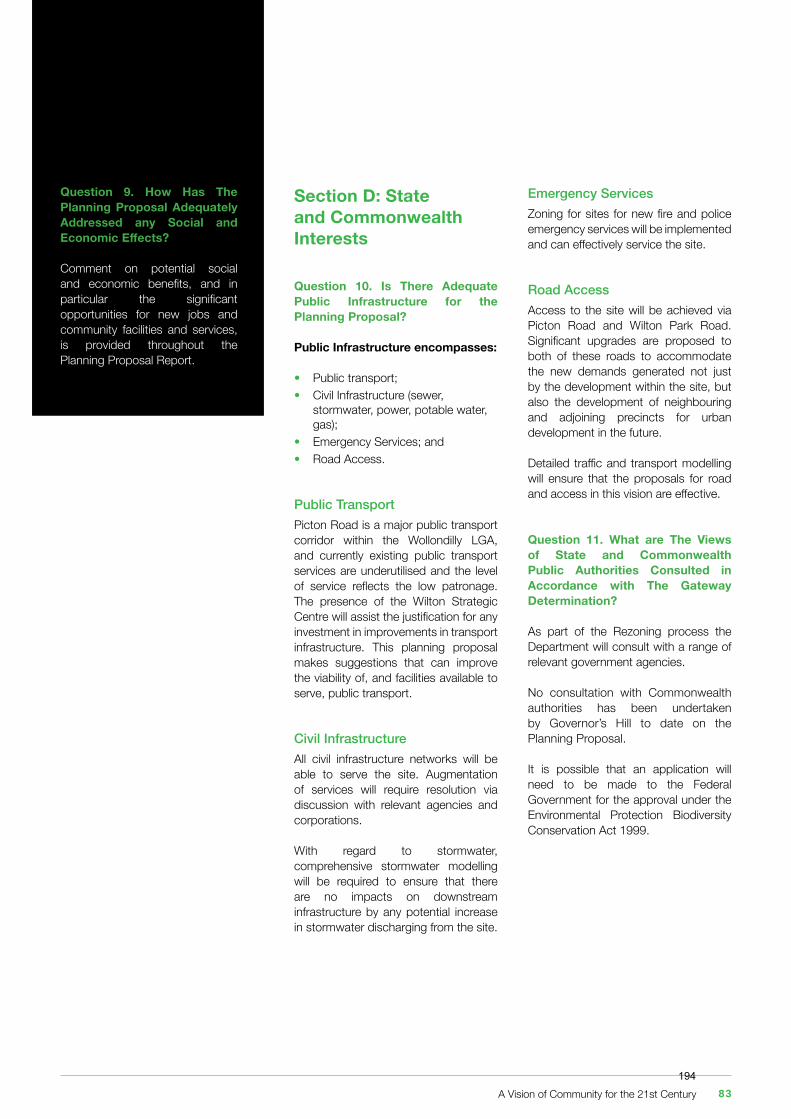
Section D: State and Commonwealth Interests
Question 10. Is There Adequate Public Infrastructure for the Planning Proposal?
Public Infrastructure encompasses:
• Public transport;• Civil Infrastructure (sewer, stormwater, power, potable water, gas);• Emergency Services; and• Road Access.
Public TransportPicton Road is a major public transport corridor within the Wollondilly LGA, and currently existing public transport services are underutilised and the level of service reflects the low patronage. The presence of the Wilton Strategic Centre will assist the justification for any investment in improvements in transport infrastructure. This planning proposal makes suggestions that can improve the viability of, and facilities available to serve, public transport.
Civil InfrastructureAll civil infrastructure networks will be able to serve the site. Augmentation of services will require resolution via discussion with relevant agencies and corporations.
With regard to stormwater, comprehensive stormwater modelling will be required to ensure that there are no impacts on downstream infrastructure by any potential increase in stormwater discharging from the site.
Emergency ServicesZoning for sites for new fire and police emergency services will be implemented and can effectively service the site.
Road AccessAccess to the site will be achieved via Picton Road and Wilton Park Road. Significant upgrades are proposed to both of these roads to accommodate the new demands generated not just by the development within the site, but also the development of neighbouring and adjoining precincts for urban development in the future.
Detailed traffic and transport modelling will ensure that the proposals for road and access in this vision are effective.
Question 11. What are The Views of State and Commonwealth Public Authorities Consulted in Accordance with The Gateway Determination?
As part of the Rezoning process the Department will consult with a range of relevant government agencies.
No consultation with Commonwealth authorities has been undertaken by Governor’s Hill to date on the Planning Proposal.
It is possible that an application will need to be made to the Federal Government for the approval under the Environmental Protection Biodiversity Conservation Act 1999.
Question 9. How Has The Planning Proposal Adequately Addressed any Social and Economic Effects?
Comment on potential social and economic benefits, and in particular the significant opportunities for new jobs and community facilities and services, is provided throughout the Planning Proposal Report.
A Vision of Community for the 21st Century 83194
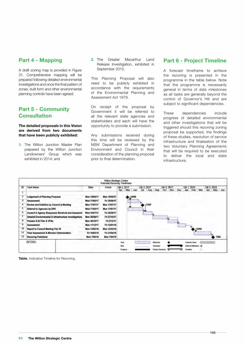
Part 4 - MappingA draft zoning map is provided in Figure 31. Comprehensive mapping will be prepared following detailed environmental investigations and once the final pattern of zones, built form and other environmental planning controls have been agreed.
Part 5 - Community Consultation The detailed proposals in this Vision are derived from two documents that have been publicly exhibited:
1. The Wilton Junction Master Plan prepared by the Wilton Junction Landowners’ Group which was exhibited in 2014; and
2. The Greater Macarthur Land Release Investigation, exhibited in September 2015.
This Planning Proposal will also need to be publicly exhibited in accordance with the requirements of the Environmental Planning and Assessment Act 1979.
On receipt of the proposal by Government it will be referred to all the relevant state agencies and stakeholders and each will have the opportunity to provide a submission.
Any submissions received during this time will be reviewed by the NSW Department of Planning and Environment and Council in their consideration of the planning proposal prior to final determination.
Table. Indicative Timeline for Rezoning.
Part 6 - Project Timeline A forecast timeframe to achieve the rezoning is presented in the programme in the table below. Note that the programme is necessarily general in terms of date milestones as all tasks are generally beyond the control of Governor’s Hill and are subject to significant dependencies.
These dependencies include progress of detailed environmental and other investigations that will be triggered should this rezoning zoning proposal be supported, the findings of these studies, resolution of service infrastructure and finalisation of the two Voluntary Planning Agreements that will be required to be executed to deliver the local and state infrastructure.
The Wilton Strategic Centre 84195
Appendix
Appendix 1. Deep End ServicesEconomic and Empolyment Summary
1 of 12
Deep End Services Pty Ltd Suite 304 PO Box 6035 T +61 3 8825 5888 ABN 60 301724 090 9-11 Claremont Street Chapel Street North F +61 3 9826 5331 South Yarra VIC 3141 South Yarra VIC 3141 deependservices.com.au
Dear Stephen
Assessment of Wilton Town Centre Masterplan
This letter presents a review of the draft Wilton Town Centre Masterplan prepared by Woods Bagot on behalf of Governors Hill, drawing on economic analysis contained in recent reports that have informed planning for the area.
Wilton Town Centre is planned as the business and community hub for Wilton New Town, which was included as an amendment to the State Environmental Planning Policy (Sydney Region Growth Centres) 2006 as the ‘Wilton Priority Growth Area’. The Wilton PGA is within a wider Greater Macarthur Investigation Area (‘GMIA’), for which planning and economic investigations have been undertaken in recent years.
Economic analysis has also been undertaken on behalf of the Wilton Junction Landowners Group (‘WJLG’) and Wollondilly Shire to identify opportunities for employment generation within the local area.
This letter of advice summarises the background economic reports prepared on behalf of WJLG and the Department of Planning and Environment (‘DPE’), and examines whether the proposed draft Masterplan facilitates the economic and employment outcomes promoted in those reports.
The background reports comprise:
• Wilton Junction Employment Projections and Land Need (MacroPlan Dimasi, July 2014) prepared for the Wilton Junction Landowners’ Group; and
• Greater Macarthur Investigation Area Economic and Employment Analysis (SGS Economics & Planning, September 2015) prepared for DPE.
Key aspects of these reports in relation to development and employment expectations at Wilton Town Centre are summarised in the following sections.
28 April 2017
Governors Hill c/-Stephen McMahon Macarthur Developments 1150 Camden Valley Way Leppington NSW 2179
Background
A Vision of Community for the 21st Century 85196
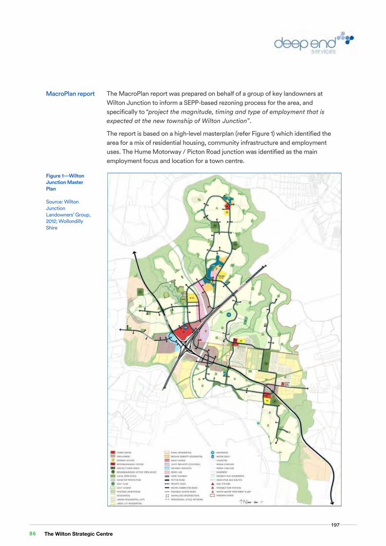
2 of 12
The MacroPlan report was prepared on behalf of a group of key landowners at Wilton Junction to inform a SEPP-based rezoning process for the area, and specifically to “project the magnitude, timing and type of employment that is expected at the new township of Wilton Junction”.
The report is based on a high-level masterplan (refer Figure 1) which identified the area for a mix of residential housing, community infrastructure and employment uses. The Hume Motorway / Picton Road junction was identified as the main employment focus and location for a town centre.
MacroPlan report
Figure 1—Wilton Junction Master Plan
Source: Wilton Junction Landowners’ Group, 2012; Wollondilly Shire
3 of 12
The MacroPlan analysis was conducted for the area shown in Figure 1, in which an estimated 11,000 residential lots would be delivered, accommodating an eventual population of 34,955 residents – noting that the study area boundary is slightly different to the land eventually identified in the SEPP as the Wilton PGA.
Analysis in the MacroPlan report includes:
• Examination of current employment pattern and trends in Wollondilly Shire, including estimates of employment self-containment and self-sufficiency
• Projections of likely future employment opportunities within the Study Area, including composition by industry type
• Indication of potential staging of employment growth • Assessment of employment land need • Analysis of retail floorspace (traditional and large format) potentially supportable
at Wilton Junction.
The analysis does not specifically identify the employment potential within the Governor’s Hill site which is generally located to the north-west of the Picton Road interchange. A large share of the employment opportunities, particularly the less-intensive jobs in transport and manufacturing, are expected to be accommodated on other nearby land parcels.
The report’s key findings can be summarised as follows:
1. The study area will accommodate a mix of land uses, with the residential housing component consisting of 11,000 dwelling lots. This will generate a residential population of 34,955 persons at full development capacity.
2. Wilton is located within Wollondilly Shire which had a population of around 44,000 in 2011 spread across a number of small towns. A new urban area at Wilton would therefore significantly change the population and employment characteristics of the Shire.
3. Wollondilly Shire’s job containment rate is at 28% (i.e. almost 6,000 of the 21,300 working residents in Wollondilly work within the LGA), while its employment self-sufficiency rate is 61% (i.e. of the almost 10,000 local jobs, approximately 6,000 of them are filled by local residents). The latter figure is comparatively high reflecting the ‘standalone’ nature of the Shire’s character.
4. While the local mining and manufacturing sectors are significant employment industries, future Wilton residents will work in a range of service-related sectors and those that reflect the locational characteristics of the area.
5. The total number of employed residents at Wilton is forecast to be around 12,000 to 13,200, of which 70% (or 8,400 to 9,240 people) would be working within the Wilton area based on current patterns and comparisons with example regions.
6. A forecast 1,566 to 1,766 local residents would be working from home, with the remaining 6,834 to 7,474 working in the town centre and designated employment lands.
7. The total number of jobs at Wilton, including those travelling into the area from other parts of Wollondilly and beyond, is forecast to be 10,440 to 11,770 jobs across a range of industry sectors.
The Wilton Strategic Centre 86197

2 of 12
The MacroPlan report was prepared on behalf of a group of key landowners at Wilton Junction to inform a SEPP-based rezoning process for the area, and specifically to “project the magnitude, timing and type of employment that is expected at the new township of Wilton Junction”.
The report is based on a high-level masterplan (refer Figure 1) which identified the area for a mix of residential housing, community infrastructure and employment uses. The Hume Motorway / Picton Road junction was identified as the main employment focus and location for a town centre.
MacroPlan report
Figure 1—Wilton Junction Master Plan
Source: Wilton Junction Landowners’ Group, 2012; Wollondilly Shire
3 of 12
The MacroPlan analysis was conducted for the area shown in Figure 1, in which an estimated 11,000 residential lots would be delivered, accommodating an eventual population of 34,955 residents – noting that the study area boundary is slightly different to the land eventually identified in the SEPP as the Wilton PGA.
Analysis in the MacroPlan report includes:
• Examination of current employment pattern and trends in Wollondilly Shire, including estimates of employment self-containment and self-sufficiency
• Projections of likely future employment opportunities within the Study Area, including composition by industry type
• Indication of potential staging of employment growth • Assessment of employment land need • Analysis of retail floorspace (traditional and large format) potentially supportable
at Wilton Junction.
The analysis does not specifically identify the employment potential within the Governor’s Hill site which is generally located to the north-west of the Picton Road interchange. A large share of the employment opportunities, particularly the less-intensive jobs in transport and manufacturing, are expected to be accommodated on other nearby land parcels.
The report’s key findings can be summarised as follows:
1. The study area will accommodate a mix of land uses, with the residential housing component consisting of 11,000 dwelling lots. This will generate a residential population of 34,955 persons at full development capacity.
2. Wilton is located within Wollondilly Shire which had a population of around 44,000 in 2011 spread across a number of small towns. A new urban area at Wilton would therefore significantly change the population and employment characteristics of the Shire.
3. Wollondilly Shire’s job containment rate is at 28% (i.e. almost 6,000 of the 21,300 working residents in Wollondilly work within the LGA), while its employment self-sufficiency rate is 61% (i.e. of the almost 10,000 local jobs, approximately 6,000 of them are filled by local residents). The latter figure is comparatively high reflecting the ‘standalone’ nature of the Shire’s character.
4. While the local mining and manufacturing sectors are significant employment industries, future Wilton residents will work in a range of service-related sectors and those that reflect the locational characteristics of the area.
5. The total number of employed residents at Wilton is forecast to be around 12,000 to 13,200, of which 70% (or 8,400 to 9,240 people) would be working within the Wilton area based on current patterns and comparisons with example regions.
6. A forecast 1,566 to 1,766 local residents would be working from home, with the remaining 6,834 to 7,474 working in the town centre and designated employment lands.
7. The total number of jobs at Wilton, including those travelling into the area from other parts of Wollondilly and beyond, is forecast to be 10,440 to 11,770 jobs across a range of industry sectors.
A Vision of Community for the 21st Century 87198
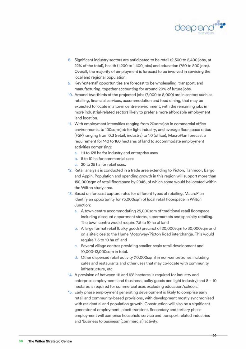
4 of 12
8. Significant industry sectors are anticipated to be retail (2,300 to 2,400 jobs, at 22% of the total), health (1,200 to 1,400 jobs) and education (750 to 800 jobs). Overall, the majority of employment is forecast to be involved in servicing the local and regional population.
9. Key ‘external’ opportunities are forecast to be wholesaling, transport, and manufacturing, together accounting for around 20% of future jobs.
10. Around two-thirds of the projected jobs (7,000 to 8,000) are in sectors such as retailing, financial services, accommodation and food dining, that may be expected to locate in a town centre environment, with the remaining jobs in more industrial-related sectors likely to prefer a more affordable employment land location.
11. With employment intensities ranging from 20sqm/job in commercial office environments, to 100sqm/job for light industry, and average floor space ratios (FSR) ranging from 0.3 (retail, industry) to 1.0 (office), MacroPlan forecast a requirement for 140 to 160 hectares of land to accommodate employment activities comprising: a. 111 to 128 ha for industry and enterprise uses b. 8 to 10 ha for commercial uses c. 20 to 25 ha for retail uses.
12. Retail analysis is conducted in a trade area extending to Picton, Tahmoor, Bargo and Appin. Population and spending growth in this region will support more than 150,000sqm of retail floorspace by 2046, of which some would be located within the Wilton study area.
13. Based on forecast capture rates for different types of retailing, MacroPlan identify an opportunity for 75,000sqm of local retail floorspace in Wilton Junction: a. A town centre accommodating 25,000sqm of traditional retail floorspace
including discount department stores, supermarkets and specialty retailing. The town centre would require 7.5 to 10 ha of land
b. A large format retail (bulky goods) precinct of 20,000sqm to 30,000sqm and on a site close to the Hume Motorway/Picton Road interchange. This would require 7.5 to 10 ha of land
c. Several village centres providing smaller-scale retail development and 10,000-12,000sqm in total.
d. Other dispersed retail activity (10,000sqm) in non-centre zones including cafés and restaurants and other uses that may co-locate with community infrastructure, etc.
14. A provision of between 111 and 128 hectares is required for industry and enterprise employment land (business, bulky goods and light industry) and 8 – 10 hectares is required for commercial uses excluding education/schools.
15. Early phase employment generating development is likely to comprise early retail and community-based provisions, with development mostly synchronised with residential and population growth. Construction will also be a significant generator of employment, albeit transient. Secondary and tertiary phase employment will comprise household service and transport related industries and ‘business to business’ (commercial) activity.
5 of 12
The SGS report was prepared as input to the Greater Macarthur Land Release Investigation – Land Use and Infrastructure Analysis conducted by DPE in 2015. The report considered a larger study area comprising the Greater Macarthur Investigation Area (‘GMIA’) which extends north to include Gilead and Menangle Park, and included:
• An examination of demand for retail and other employment activities
• Analysis of the land and floorspace requirements for future employment activities
• Identification of preferred locations for employment-generating activities.
The main relevant conclusions arising from the SGS report are as follows:
1. The GMIA is projected to have a potential capacity population of around 190,000 people and a forecast population of 97,400 people at 2036.
2. Retail demand is forecast by projecting expenditure rates and apportioning to ‘levels’ in the retail hierarchy according to past research conducted by SGS, then allowing for escape spending to centres outside the GMIA, and converting to floorspace demand by applying average turnover densities.
3. According to the analysis, supportable retail floorspace within the GMIA would be 218,000sqm at 2036 and ultimately more than 425,000sqm at capacity.
4. A broad retail hierarchy is identified consisting of: a. A future Strategic Centre at Wilton Junction having regard to the potential
to connect to future rail services, containing 135,000sqm retail floorspace b. Three to four town centres containing 100,000sqm c. Approximately 11 village centres containing 100,000sqm d. Approximately 90,000sqm of large format retailing, with Wilton Junction
identified as an appropriate location for a significant share of this floorspace 5. Staged development would see the Wilton Strategic Centre reach around
69,000sqm by 2036. 6. Employment forecasts for non-retail uses have been developed using official
government employment forecasts by BTS (former Bureau of Transport Statistics, now Transport Performance & Analytics), with an alternative ‘project case’ developed by SGS to reflect local GMIA housing outcomes. The analysis separates population-driven employment categories from strategic employment, noting that the GMIA would have a focus on attracting population-servicing employment demands.
7. Total employment within the GMIA is forecast to reach 17,000 by 2036, and around 30,000 at full capacity. Key sectors are Retail (22% to 24%), Accommodation and food services (17% to 19%) and Education and training (10% to 11%).
SGS report
The Wilton Strategic Centre 88199
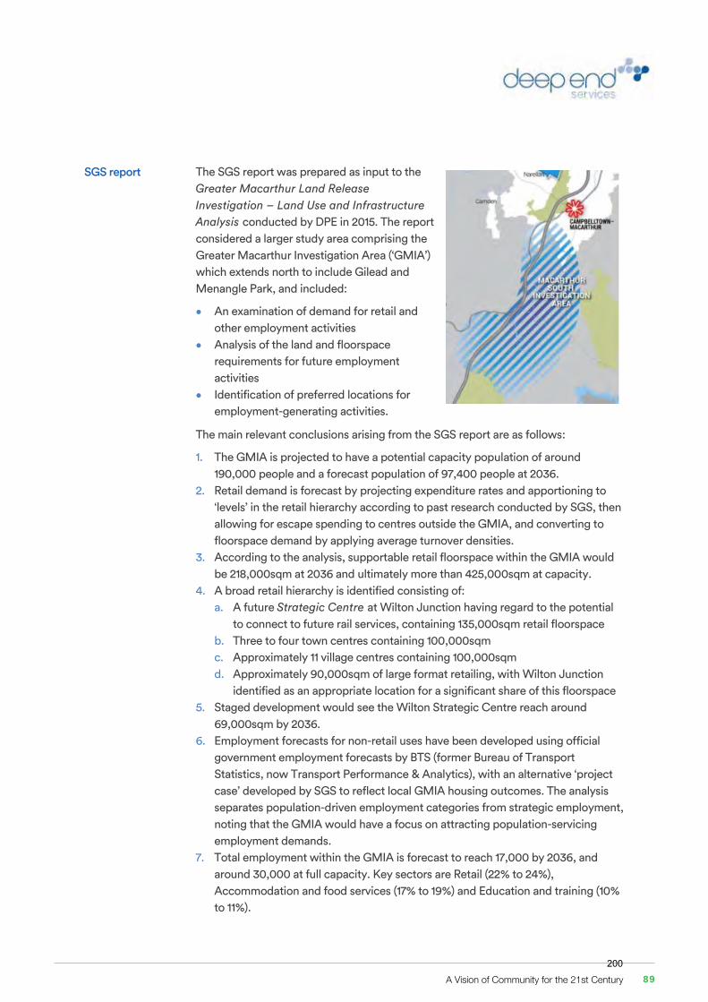
4 of 12
8. Significant industry sectors are anticipated to be retail (2,300 to 2,400 jobs, at 22% of the total), health (1,200 to 1,400 jobs) and education (750 to 800 jobs). Overall, the majority of employment is forecast to be involved in servicing the local and regional population.
9. Key ‘external’ opportunities are forecast to be wholesaling, transport, and manufacturing, together accounting for around 20% of future jobs.
10. Around two-thirds of the projected jobs (7,000 to 8,000) are in sectors such as retailing, financial services, accommodation and food dining, that may be expected to locate in a town centre environment, with the remaining jobs in more industrial-related sectors likely to prefer a more affordable employment land location.
11. With employment intensities ranging from 20sqm/job in commercial office environments, to 100sqm/job for light industry, and average floor space ratios (FSR) ranging from 0.3 (retail, industry) to 1.0 (office), MacroPlan forecast a requirement for 140 to 160 hectares of land to accommodate employment activities comprising: a. 111 to 128 ha for industry and enterprise uses b. 8 to 10 ha for commercial uses c. 20 to 25 ha for retail uses.
12. Retail analysis is conducted in a trade area extending to Picton, Tahmoor, Bargo and Appin. Population and spending growth in this region will support more than 150,000sqm of retail floorspace by 2046, of which some would be located within the Wilton study area.
13. Based on forecast capture rates for different types of retailing, MacroPlan identify an opportunity for 75,000sqm of local retail floorspace in Wilton Junction: a. A town centre accommodating 25,000sqm of traditional retail floorspace
including discount department stores, supermarkets and specialty retailing. The town centre would require 7.5 to 10 ha of land
b. A large format retail (bulky goods) precinct of 20,000sqm to 30,000sqm and on a site close to the Hume Motorway/Picton Road interchange. This would require 7.5 to 10 ha of land
c. Several village centres providing smaller-scale retail development and 10,000-12,000sqm in total.
d. Other dispersed retail activity (10,000sqm) in non-centre zones including cafés and restaurants and other uses that may co-locate with community infrastructure, etc.
14. A provision of between 111 and 128 hectares is required for industry and enterprise employment land (business, bulky goods and light industry) and 8 – 10 hectares is required for commercial uses excluding education/schools.
15. Early phase employment generating development is likely to comprise early retail and community-based provisions, with development mostly synchronised with residential and population growth. Construction will also be a significant generator of employment, albeit transient. Secondary and tertiary phase employment will comprise household service and transport related industries and ‘business to business’ (commercial) activity.
5 of 12
The SGS report was prepared as input to the Greater Macarthur Land Release Investigation – Land Use and Infrastructure Analysis conducted by DPE in 2015. The report considered a larger study area comprising the Greater Macarthur Investigation Area (‘GMIA’) which extends north to include Gilead and Menangle Park, and included:
• An examination of demand for retail and other employment activities
• Analysis of the land and floorspace requirements for future employment activities
• Identification of preferred locations for employment-generating activities.
The main relevant conclusions arising from the SGS report are as follows:
1. The GMIA is projected to have a potential capacity population of around 190,000 people and a forecast population of 97,400 people at 2036.
2. Retail demand is forecast by projecting expenditure rates and apportioning to ‘levels’ in the retail hierarchy according to past research conducted by SGS, then allowing for escape spending to centres outside the GMIA, and converting to floorspace demand by applying average turnover densities.
3. According to the analysis, supportable retail floorspace within the GMIA would be 218,000sqm at 2036 and ultimately more than 425,000sqm at capacity.
4. A broad retail hierarchy is identified consisting of: a. A future Strategic Centre at Wilton Junction having regard to the potential
to connect to future rail services, containing 135,000sqm retail floorspace b. Three to four town centres containing 100,000sqm c. Approximately 11 village centres containing 100,000sqm d. Approximately 90,000sqm of large format retailing, with Wilton Junction
identified as an appropriate location for a significant share of this floorspace 5. Staged development would see the Wilton Strategic Centre reach around
69,000sqm by 2036. 6. Employment forecasts for non-retail uses have been developed using official
government employment forecasts by BTS (former Bureau of Transport Statistics, now Transport Performance & Analytics), with an alternative ‘project case’ developed by SGS to reflect local GMIA housing outcomes. The analysis separates population-driven employment categories from strategic employment, noting that the GMIA would have a focus on attracting population-servicing employment demands.
7. Total employment within the GMIA is forecast to reach 17,000 by 2036, and around 30,000 at full capacity. Key sectors are Retail (22% to 24%), Accommodation and food services (17% to 19%) and Education and training (10% to 11%).
SGS report
A Vision of Community for the 21st Century 89200
6 of 12
8. Land area requirements associated with these local employment requirements have been examined by considering: a. Employment demand by industry (as described above) b. Land use constraints c. Suitability mapping for different land use categories d. Precinct development opportunities
9. By applying employment land use density benchmarks ranging from 30 sqm/job for strategic centre retail and office jobs, to 150 sqm/job for footloose industry enterprises, this process leads to an allocation of land area across the GMIA for different employment categories.
10. Wilton Junction Strategic Centre is expected to accommodate: a. 16 ha for Strategic Centre retail and office uses b. 21 ha for large format retail c. 20 ha for ‘dispersed’ uses consisting of industry-related activities that don’t
serve local markets but cannot be identified as ‘footloose’ – freight transport services may be considered an example potentially suitable for Wilton Junction in the longer term.
11. This theoretical land allocation would enable 7,390 jobs to be generated at Wilton Junction.
12. The Wilton Strategic Centre is recommended to be located to the north-west of the Hume Motorway – Picton Road interchange.
13. The land to the west and east of the Picton Road - Hume Motorway junction is highly suitable for most of the employment land use types, especially the industrial and large format industries. This is due to the high connectivity with road infrastructure, the existing large lot structure and the separation from existing population.
14. Employment development sequencing is anticipated to follow residential development outcomes as most uses will be associated with population-servicing activities.
15. Demand for smaller centres or convenience retail and services will transpire first, with development to be encouraged at centres that are identified for higher-order future roles (including Wilton Junction Strategic Centre).
The Wilton Strategic Centre 90201
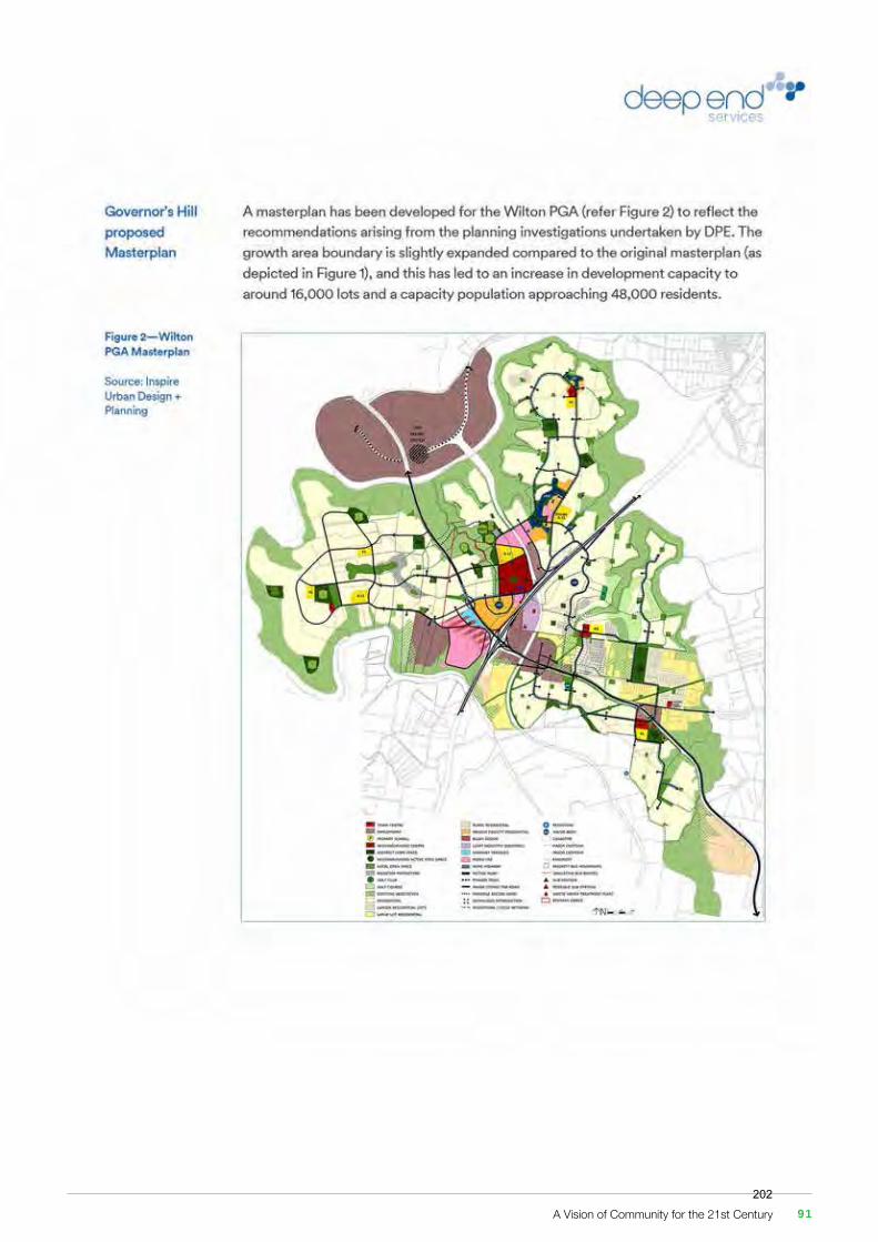
6 of 12
8. Land area requirements associated with these local employment requirements have been examined by considering: a. Employment demand by industry (as described above) b. Land use constraints c. Suitability mapping for different land use categories d. Precinct development opportunities
9. By applying employment land use density benchmarks ranging from 30 sqm/job for strategic centre retail and office jobs, to 150 sqm/job for footloose industry enterprises, this process leads to an allocation of land area across the GMIA for different employment categories.
10. Wilton Junction Strategic Centre is expected to accommodate: a. 16 ha for Strategic Centre retail and office uses b. 21 ha for large format retail c. 20 ha for ‘dispersed’ uses consisting of industry-related activities that don’t
serve local markets but cannot be identified as ‘footloose’ – freight transport services may be considered an example potentially suitable for Wilton Junction in the longer term.
11. This theoretical land allocation would enable 7,390 jobs to be generated at Wilton Junction.
12. The Wilton Strategic Centre is recommended to be located to the north-west of the Hume Motorway – Picton Road interchange.
13. The land to the west and east of the Picton Road - Hume Motorway junction is highly suitable for most of the employment land use types, especially the industrial and large format industries. This is due to the high connectivity with road infrastructure, the existing large lot structure and the separation from existing population.
14. Employment development sequencing is anticipated to follow residential development outcomes as most uses will be associated with population-servicing activities.
15. Demand for smaller centres or convenience retail and services will transpire first, with development to be encouraged at centres that are identified for higher-order future roles (including Wilton Junction Strategic Centre).
A Vision of Community for the 21st Century 91202
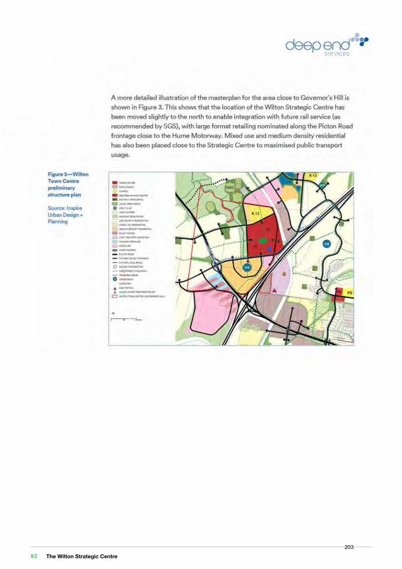
9 of 12
Preliminary draft planning controls for land within Governor’s Hill have been developed by Inspire Urban Design + Planning and Woods Bagot, with Figure 4 overleaf depicting the location of the town centre and the anticipated development outcomes. In this plan, the maximum height for the town centre land would be 70 metres or 20 storeys, with an FSR of 6:1.
Figure 5 on the following page identifies the theoretical development capacity in terms of maximum GFA that could be built within the town centre at the proposed FSR.
According to the development capacity plan, the total area of developable land within the town centre precinct (ie excluding local roads) totals 370,180sqm (37 ha). If the FSR of 6:1 is applied across the precinct, this land has a theoretical development capacity of 2.22 million sqm.
It is recognised of course that this amount of development will never occur for a whole range of reasons, such as differences in actual built outcomes, allowance for setbacks, podium style developments, some developments that do not extend to the property boundary, market conditions at the time of development, and so on. Moreover, some of the sites developed within the town centre will accommodate a mix of uses including in the long term some high density residential apartments.
Nevertheless, the plan shows that the land set aside for the town centre is significantly larger than the allocation of 17 ha identified by SGS as being required to support future retail and commercial office uses, and would easily accommodate a retail centre of 135,000sqm as projected in their report.
The amount of land set aside for town centre uses is also significantly greater than the suggested requirement of 7.5 to 10 ha identified in the MacroPlan report.
Overall, it is clear that the preliminary draft planning controls would accommodate sufficient development (subject to market demand and other constraints at the time) to achieve or exceed the projected employment targets identified by SGS and MacroPlan for the Wilton Junction town centre.
The Wilton Strategic Centre 92203
9 of 12
Preliminary draft planning controls for land within Governor’s Hill have been developed by Inspire Urban Design + Planning and Woods Bagot, with Figure 4 overleaf depicting the location of the town centre and the anticipated development outcomes. In this plan, the maximum height for the town centre land would be 70 metres or 20 storeys, with an FSR of 6:1.
Figure 5 on the following page identifies the theoretical development capacity in terms of maximum GFA that could be built within the town centre at the proposed FSR.
According to the development capacity plan, the total area of developable land within the town centre precinct (ie excluding local roads) totals 370,180sqm (37 ha). If the FSR of 6:1 is applied across the precinct, this land has a theoretical development capacity of 2.22 million sqm.
It is recognised of course that this amount of development will never occur for a whole range of reasons, such as differences in actual built outcomes, allowance for setbacks, podium style developments, some developments that do not extend to the property boundary, market conditions at the time of development, and so on. Moreover, some of the sites developed within the town centre will accommodate a mix of uses including in the long term some high density residential apartments.
Nevertheless, the plan shows that the land set aside for the town centre is significantly larger than the allocation of 17 ha identified by SGS as being required to support future retail and commercial office uses, and would easily accommodate a retail centre of 135,000sqm as projected in their report.
The amount of land set aside for town centre uses is also significantly greater than the suggested requirement of 7.5 to 10 ha identified in the MacroPlan report.
Overall, it is clear that the preliminary draft planning controls would accommodate sufficient development (subject to market demand and other constraints at the time) to achieve or exceed the projected employment targets identified by SGS and MacroPlan for the Wilton Junction town centre.
A Vision of Community for the 21st Century 93204
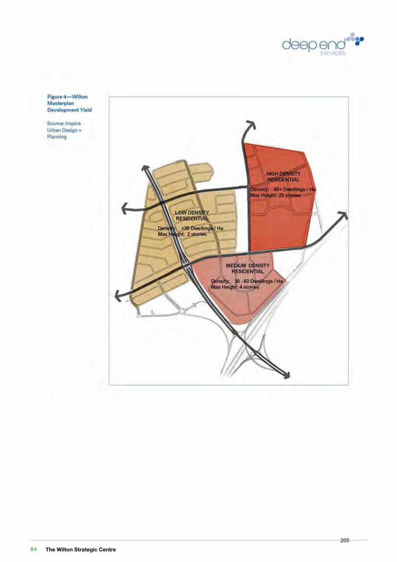
The Wilton Strategic Centre 94205
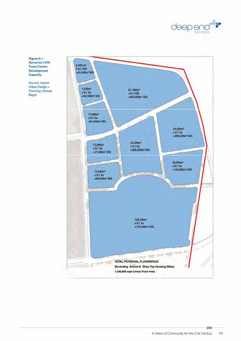
A Vision of Community for the 21st Century 95206

12 of 12
In conclusion, this review of the draft Wilton town centre masterplan indicates that the proposed planning controls would be able to accommodate sufficient development (subject to market demand and other constraints at the time) to achieve or exceed the projected employment targets identified by SGS and MacroPlan for the Wilton Junction town centre.
I trust this letter satisfies your requirements at this time, but please contact me it you wish to discuss further.
Kind regards
Matthew Lee Principal
Conclusions
1 of 12
Deep End Services Pty Ltd Suite 304 PO Box 6035 T +61 3 8825 5888 ABN 60 301724 090 9-11 Claremont Street Chapel Street North F +61 3 9826 5331 South Yarra VIC 3141 South Yarra VIC 3141 deependservices.com.au
Dear Stephen
Assessment of Wilton Town Centre Masterplan
This letter presents a review of the draft Wilton Town Centre Masterplan prepared by Woods Bagot on behalf of Governors Hill, drawing on economic analysis contained in recent reports that have informed planning for the area.
Wilton Town Centre is planned as the business and community hub for Wilton New Town, which was included as an amendment to the State Environmental Planning Policy (Sydney Region Growth Centres) 2006 as the ‘Wilton Priority Growth Area’. The Wilton PGA is within a wider Greater Macarthur Investigation Area (‘GMIA’), for which planning and economic investigations have been undertaken in recent years.
Economic analysis has also been undertaken on behalf of the Wilton Junction Landowners Group (‘WJLG’) and Wollondilly Shire to identify opportunities for employment generation within the local area.
This letter of advice summarises the background economic reports prepared on behalf of WJLG and the Department of Planning and Environment (‘DPE’), and examines whether the proposed draft Masterplan facilitates the economic and employment outcomes promoted in those reports.
The background reports comprise:
• Wilton Junction Employment Projections and Land Need (MacroPlan Dimasi, July 2014) prepared for the Wilton Junction Landowners’ Group; and
• Greater Macarthur Investigation Area Economic and Employment Analysis (SGS Economics & Planning, September 2015) prepared for DPE.
Key aspects of these reports in relation to development and employment expectations at Wilton Town Centre are summarised in the following sections.
28 April 2017
Governors Hill c/-Stephen McMahon Macarthur Developments 1150 Camden Valley Way Leppington NSW 2179
Background
This document is in draft form. The contents, including any opinions, conclusions or recommendations contained in, or which may be implied from, this draft document must not be relied upon. GHD reserves the right, at any time, without notice, to modify or retract any part or all of the draft document. To the maximum extent permitted by law, GHD disclaims any responsibility or liability arising from or in connection with this draft document.
Governors HillWilton Priority Land Release Stage 1 Planning
Governors Hill Water and Wastewater Servicing Feasibility Report
December 2016This document is in draft form. The contents, including any opinions, conclusions or recommendations contained in, or which may be implied from, this draft document must not be relied upon. GHD reserves the right, at any time, without notice, to modify or retract any part or all of the draft document. To the maximum extent permitted by law, GHD disclaims any responsibility or liability arising from or in connection with this draft document.
Governors HillWilton Priority Land Release Stage 1 Planning
Governors Hill Water and Wastewater Servicing Feasibility Report
December 2016
The Wilton Strategic Centre 96207
12 of 12
In conclusion, this review of the draft Wilton town centre masterplan indicates that the proposed planning controls would be able to accommodate sufficient development (subject to market demand and other constraints at the time) to achieve or exceed the projected employment targets identified by SGS and MacroPlan for the Wilton Junction town centre.
I trust this letter satisfies your requirements at this time, but please contact me it you wish to discuss further.
Kind regards
Matthew Lee Principal
Conclusions
1 of 12
Deep End Services Pty Ltd Suite 304 PO Box 6035 T +61 3 8825 5888 ABN 60 301724 090 9-11 Claremont Street Chapel Street North F +61 3 9826 5331 South Yarra VIC 3141 South Yarra VIC 3141 deependservices.com.au
Dear Stephen
Assessment of Wilton Town Centre Masterplan
This letter presents a review of the draft Wilton Town Centre Masterplan prepared by Woods Bagot on behalf of Governors Hill, drawing on economic analysis contained in recent reports that have informed planning for the area.
Wilton Town Centre is planned as the business and community hub for Wilton New Town, which was included as an amendment to the State Environmental Planning Policy (Sydney Region Growth Centres) 2006 as the ‘Wilton Priority Growth Area’. The Wilton PGA is within a wider Greater Macarthur Investigation Area (‘GMIA’), for which planning and economic investigations have been undertaken in recent years.
Economic analysis has also been undertaken on behalf of the Wilton Junction Landowners Group (‘WJLG’) and Wollondilly Shire to identify opportunities for employment generation within the local area.
This letter of advice summarises the background economic reports prepared on behalf of WJLG and the Department of Planning and Environment (‘DPE’), and examines whether the proposed draft Masterplan facilitates the economic and employment outcomes promoted in those reports.
The background reports comprise:
• Wilton Junction Employment Projections and Land Need (MacroPlan Dimasi, July 2014) prepared for the Wilton Junction Landowners’ Group; and
• Greater Macarthur Investigation Area Economic and Employment Analysis (SGS Economics & Planning, September 2015) prepared for DPE.
Key aspects of these reports in relation to development and employment expectations at Wilton Town Centre are summarised in the following sections.
28 April 2017
Governors Hill c/-Stephen McMahon Macarthur Developments 1150 Camden Valley Way Leppington NSW 2179
Background
Appendix
Appendix 2. GHDInfrastructure Feasibility Investigation
This document is in draft form. The contents, including any opinions, conclusions or recommendations contained in, or which may be implied from, this draft document must not be relied upon. GHD reserves the right, at any time, without notice, to modify or retract any part or all of the draft document. To the maximum extent permitted by law, GHD disclaims any responsibility or liability arising from or in connection with this draft document.
Governors HillWilton Priority Land Release Stage 1 Planning
Governors Hill Water and Wastewater Servicing Feasibility Report
December 2016
This document is in draft form. The contents, including any opinions, conclusions or recommendations contained in, or which may be implied from, this draft document must not be relied upon. GHD reserves the right, at any time, without notice, to modify or retract any part or all of the draft document. To the maximum extent permitted by law, GHD disclaims any responsibility or liability arising from or in connection with this draft document.
Governors HillWilton Priority Land Release Stage 1 Planning
Governors Hill Water and Wastewater Servicing Feasibility Report
December 2016This document is in draft form. The contents, including any opinions, conclusions or recommendations contained in, or which may be implied from, this draft document must not be relied upon. GHD reserves the right, at any time, without notice, to modify or retract any part or all of the draft document. To the maximum extent permitted by law, GHD disclaims any responsibility or liability arising from or in connection with this draft document.
Governors HillWilton Priority Land Release Stage 1 Planning
Governors Hill Water and Wastewater Servicing Feasibility Report
December 2016
This document is in draft form. The contents, including any opinions, conclusions or recommendations contained in, or which may be implied from, this draft document must not be relied upon. GHD reserves the right, at any time, without notice, to modify or retract any part or all of the draft document. To the maximum extent permitted by law, GHD disclaims any responsibility or liability arising from or in connection with this draft document.
Governors HillWilton Priority Land Release Stage 1 Planning
Governors Hill Water and Wastewater Servicing Feasibility Report
December 2016
A Vision of Community for the 21st Century 97208
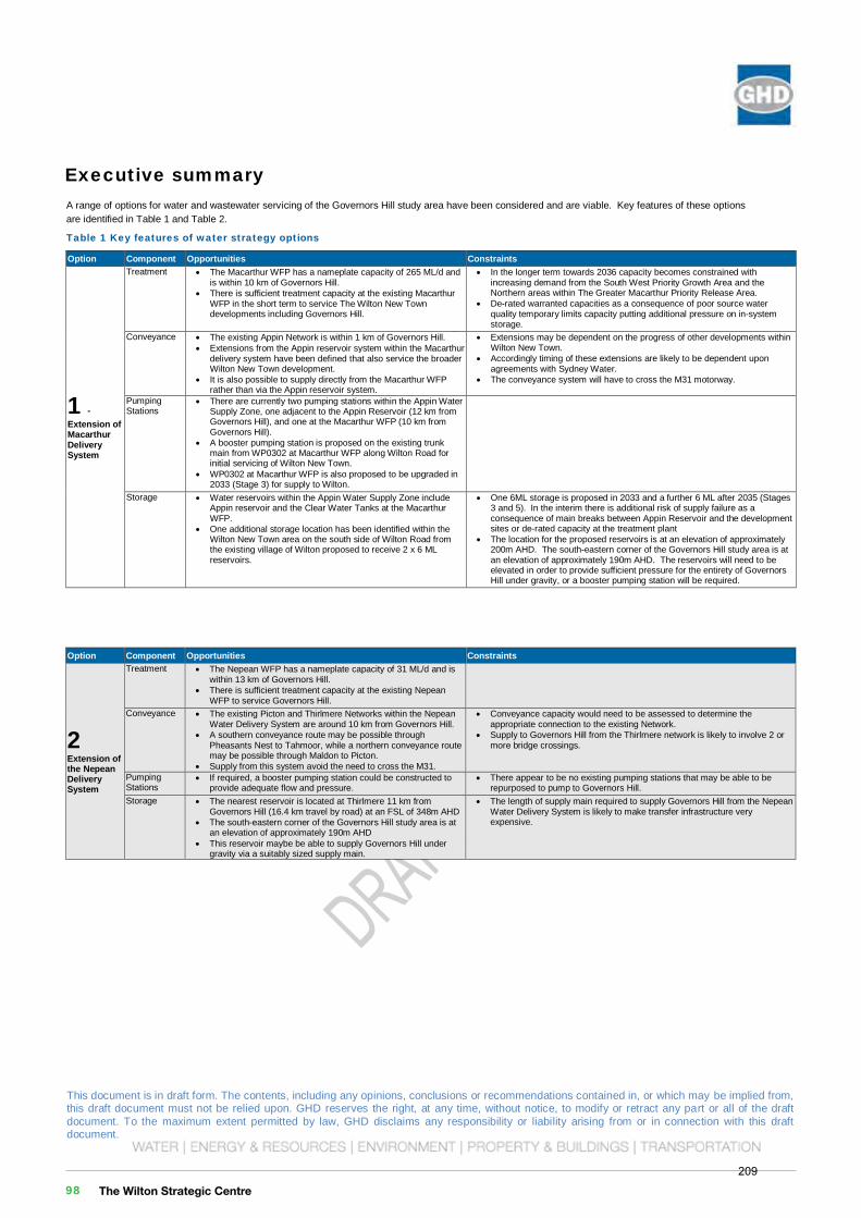
This document is in draft form. The contents, including any opinions, conclusions or recommendations contained in, or which may be implied from, this draft document must not be relied upon. GHD reserves the right, at any time, without notice, to modify or retract any part or all of the draft document. To the maximum extent permitted by law, GHD disclaims any responsibility or liability arising from or in connection with this draft document.
Governors HillWilton Priority Land Release Stage 1 Planning
Governors Hill Water and Wastewater Servicing Feasibility Report
December 2016
This document is in draft form. The contents, including any opinions, conclusions or recommendations contained in, or which may be implied from, this draft document must not be relied upon. GHD reserves the right, at any time, without notice, to modify or retract any part or all of the draft document. To the maximum extent permitted by law, GHD disclaims any responsibility or liability arising from or in connection with this draft document. ii | GHD | Report for Governors Hill - Wilton Priority Land Release Stage 1 Planning, 21/25722
Option Component Opportunities Constraints
2Extension of the Nepean Delivery System
Treatment The Nepean WFP has a nameplate capacity of 31 ML/d and is within 13 km of Governors Hill.
There is sufficient treatment capacity at the existing Nepean WFP to service Governors Hill.
Conveyance The existing Picton and Thirlmere Networks within the Nepean Water Delivery System are around 10 km from Governors Hill.
A southern conveyance route may be possible through Pheasants Nest to Tahmoor, while a northern conveyance route may be possible through Maldon to Picton.
Supply from this system avoid the need to cross the M31.
Conveyance capacity would need to be assessed to determine the appropriate connection to the existing Network.
Supply to Governors Hill from the Thirlmere network is likely to involve 2 or more bridge crossings.
Pumping Stations
If required, a booster pumping station could be constructed to provide adequate flow and pressure.
There appear to be no existing pumping stations that may be able to be repurposed to pump to Governors Hill.
Storage The nearest reservoir is located at Thirlmere 11 km from Governors Hill (16.4 km travel by road) at an FSL of 348m AHD
The south-eastern corner of the Governors Hill study area is at an elevation of approximately 190m AHD
This reservoir maybe be able to supply Governors Hill under gravity via a suitably sized supply main.
The length of supply main required to supply Governors Hill from the Nepean Water Delivery System is likely to make transfer infrastructure very expensive.
This document is in draft form. The contents, including any opinions, conclusions or recommendations contained in, or which may be implied from, this draft document must not be relied upon. GHD reserves the right, at any time, without notice, to modify or retract any part or all of the draft document. To the maximum extent permitted by law, GHD disclaims any responsibility or liability arising from or in connection with this draft document. GHD | Report for Governors Hill - Wilton Priority Land Release Stage 1 Planning, 21/25722 | i
Executive summary A range of options for water and wastewater servicing of the Governors Hill study area have been considered and are viable. Key features of these options are identified in Table 1 and Table 2.
Table 1 Key features of water strategy options
Option Component Opportunities Constraints
1 -Extension of Macarthur Delivery System
Treatment The Macarthur WFP has a nameplate capacity of 265 ML/d and is within 10 km of Governors Hill.
There is sufficient treatment capacity at the existing Macarthur WFP in the short term to service The Wilton New Town developments including Governors Hill.
In the longer term towards 2036 capacity becomes constrained with increasing demand from the South West Priority Growth Area and the Northern areas within The Greater Macarthur Priority Release Area.
De-rated warranted capacities as a consequence of poor source water quality temporary limits capacity putting additional pressure on in-system storage.
Conveyance The existing Appin Network is within 1 km of Governors Hill. Extensions from the Appin reservoir system within the Macarthur delivery system have been defined that also service the broader Wilton New Town development.
It is also possible to supply directly from the Macarthur WFP rather than via the Appin reservoir system.
Extensions may be dependent on the progress of other developments within Wilton New Town.
Accordingly timing of these extensions are likely to be dependent upon agreements with Sydney Water.
The conveyance system will have to cross the M31 motorway.
Pumping Stations
There are currently two pumping stations within the Appin Water Supply Zone, one adjacent to the Appin Reservoir (12 km from Governors Hill), and one at the Macarthur WFP (10 km from Governors Hill).
A booster pumping station is proposed on the existing trunk main from WP0302 at Macarthur WFP along Wilton Road for initial servicing of Wilton New Town.
WP0302 at Macarthur WFP is also proposed to be upgraded in 2033 (Stage 3) for supply to Wilton.
Storage Water reservoirs within the Appin Water Supply Zone include Appin reservoir and the Clear Water Tanks at the Macarthur WFP.
One additional storage location has been identified within the Wilton New Town area on the south side of Wilton Road from the existing village of Wilton proposed to receive 2 x 6 ML reservoirs.
One 6ML storage is proposed in 2033 and a further 6 ML after 2035 (Stages 3 and 5). In the interim there is additional risk of supply failure as a consequence of main breaks between Appin Reservoir and the development sites or de-rated capacity at the treatment plant
The location for the proposed reservoirs is at an elevation of approximately 200m AHD. The south-eastern corner of the Governors Hill study area is at an elevation of approximately 190m AHD. The reservoirs will need to be elevated in order to provide sufficient pressure for the entirety of Governors Hill under gravity, or a booster pumping station will be required.
This document is in draft form. The contents, including any opinions, conclusions or recommendations contained in, or which may be implied from, this draft document must not be relied upon. GHD reserves the right, at any time, without notice, to modify or retract any part or all of the draft document. To the maximum extent permitted by law, GHD disclaims any responsibility or liability arising from or in connection with this draft document. iv | GHD | Report for Governors Hill - Wilton Priority Land Release Stage 1 Planning, 21/25722
Option Component Opportunities Constraints Conveyance The proposed location for the new WRP, adjacent to the existing
Bingara Gorge WRP is within 1 km of the Governors Hill development.
The proposed location for the new WRP, adjacent to the existing Bingara Gorge WRP is on the opposite side of the Hume Highway (M31) from Governors Hill.
A transfer main will be required to convey wastewater from the larger Governors Hill area beneath the Hume Highway to the new Wilton New Town WRP.
Conveyance of disposal to the constructed wetlands (if available) will also be required involving a pumping station, transfer main and potentially storage structures.
Pumping Stations
The Governors Hill area topography enables efficient layout of Sewage Pumping Stations to service the area.
A pumping station will be required to convey wastewater to the Bingara Gorge WRP.
3 Picton WRP
Treatment The existing plant capacity at Picton is being increased from 2.6 ML/d ADWF to 4 ML/d ADWF to cater for growth within the Picton system.
This WRP expansions has been approved by the EPA.
Loads from Governors Hill have not been considered within the planned Picton WRP expansion.
Governors Hill loads may trigger additional expansion earlier than planned.
Effluent Management
The effluent management capacity at Picton is being increased to cater for growth.
The EPA are yet to agree with the effluent management strategy being developed at Picton.
Loads from Governors Hill have not been considered within the planned Picton effluent management expansions.
Governors Hill loads may trigger additional expansion earlier than planned.
Conveyance The Picton WRP is within 12 km (by road) of Governors Hill and a new rising main will be required.
Transfer from Governors Hill to the Picton STP is likely to involve 2 bridge crossings.
Pumping Stations
A pumping station will be required to convey wastewater to the Bingara Gorge WRP
The Wilton Strategic Centre 98209
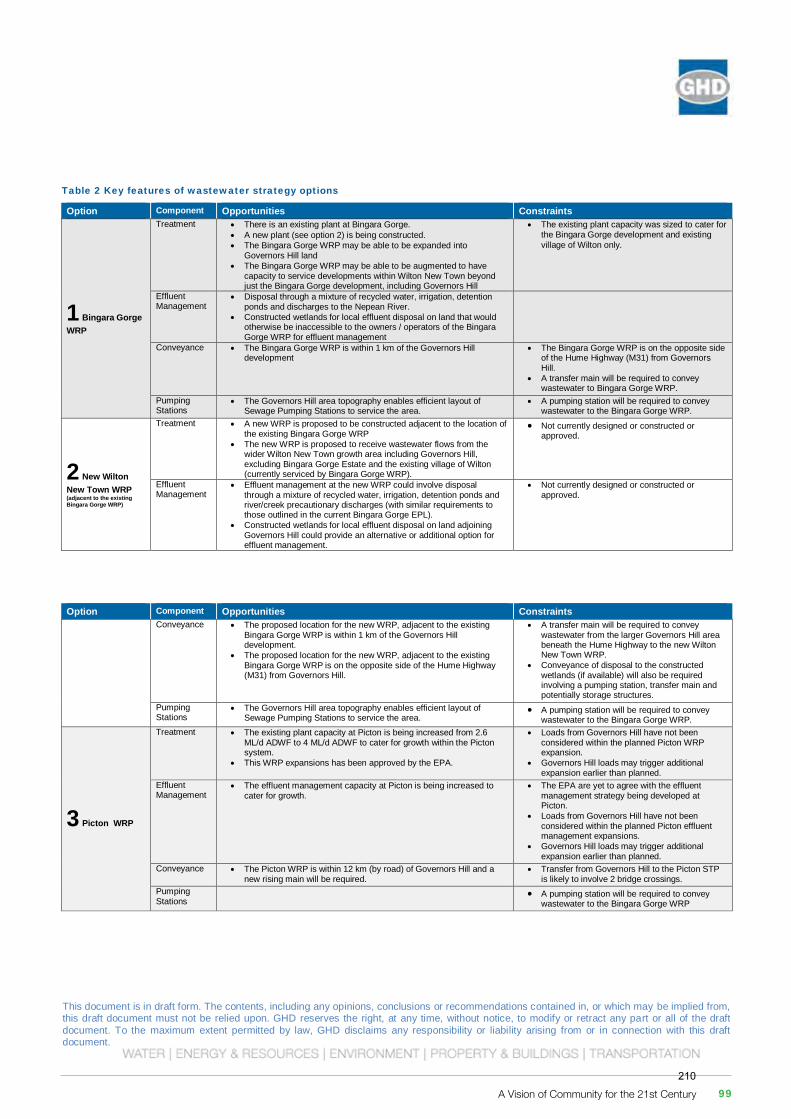
This document is in draft form. The contents, including any opinions, conclusions or recommendations contained in, or which may be implied from, this draft document must not be relied upon. GHD reserves the right, at any time, without notice, to modify or retract any part or all of the draft document. To the maximum extent permitted by law, GHD disclaims any responsibility or liability arising from or in connection with this draft document.
Governors HillWilton Priority Land Release Stage 1 Planning
Governors Hill Water and Wastewater Servicing Feasibility Report
December 2016
This document is in draft form. The contents, including any opinions, conclusions or recommendations contained in, or which may be implied from, this draft document must not be relied upon. GHD reserves the right, at any time, without notice, to modify or retract any part or all of the draft document. To the maximum extent permitted by law, GHD disclaims any responsibility or liability arising from or in connection with this draft document. GHD | Report for Governors Hill - Wilton Priority Land Release Stage 1 Planning, 21/25722 | iii
Table 2 Key features of wastewater strategy options
Option Component Opportunities Constraints
1 Bingara Gorge WRP
Treatment There is an existing plant at Bingara Gorge. A new plant (see option 2) is being constructed. The Bingara Gorge WRP may be able to be expanded into
Governors Hill land The Bingara Gorge WRP may be able to be augmented to have
capacity to service developments within Wilton New Town beyond just the Bingara Gorge development, including Governors Hill
The existing plant capacity was sized to cater for the Bingara Gorge development and existing village of Wilton only.
Effluent Management
Disposal through a mixture of recycled water, irrigation, detention ponds and discharges to the Nepean River.
Constructed wetlands for local effluent disposal on land that would otherwise be inaccessible to the owners / operators of the Bingara Gorge WRP for effluent management
Conveyance The Bingara Gorge WRP is within 1 km of the Governors Hill development
The Bingara Gorge WRP is on the opposite side of the Hume Highway (M31) from Governors Hill.
A transfer main will be required to convey wastewater to Bingara Gorge WRP.
Pumping Stations
The Governors Hill area topography enables efficient layout of Sewage Pumping Stations to service the area.
A pumping station will be required to convey wastewater to the Bingara Gorge WRP.
2 New Wilton New Town WRP (adjacent to the existing Bingara Gorge WRP)
Treatment A new WRP is proposed to be constructed adjacent to the location of the existing Bingara Gorge WRP
The new WRP is proposed to receive wastewater flows from the wider Wilton New Town growth area including Governors Hill, excluding Bingara Gorge Estate and the existing village of Wilton (currently serviced by Bingara Gorge WRP).
Not currently designed or constructed or approved.
Effluent Management
Effluent management at the new WRP could involve disposal through a mixture of recycled water, irrigation, detention ponds and river/creek precautionary discharges (with similar requirements to those outlined in the current Bingara Gorge EPL).
Constructed wetlands for local effluent disposal on land adjoining Governors Hill could provide an alternative or additional option for effluent management.
Not currently designed or constructed or approved.
This document is in draft form. The contents, including any opinions, conclusions or recommendations contained in, or which may be implied from, this draft document must not be relied upon. GHD reserves the right, at any time, without notice, to modify or retract any part or all of the draft document. To the maximum extent permitted by law, GHD disclaims any responsibility or liability arising from or in connection with this draft document. iv | GHD | Report for Governors Hill - Wilton Priority Land Release Stage 1 Planning, 21/25722
Option Component Opportunities Constraints Conveyance The proposed location for the new WRP, adjacent to the existing
Bingara Gorge WRP is within 1 km of the Governors Hill development.
The proposed location for the new WRP, adjacent to the existing Bingara Gorge WRP is on the opposite side of the Hume Highway (M31) from Governors Hill.
A transfer main will be required to convey wastewater from the larger Governors Hill area beneath the Hume Highway to the new Wilton New Town WRP.
Conveyance of disposal to the constructed wetlands (if available) will also be required involving a pumping station, transfer main and potentially storage structures.
Pumping Stations
The Governors Hill area topography enables efficient layout of Sewage Pumping Stations to service the area.
A pumping station will be required to convey wastewater to the Bingara Gorge WRP.
3 Picton WRP
Treatment The existing plant capacity at Picton is being increased from 2.6 ML/d ADWF to 4 ML/d ADWF to cater for growth within the Picton system.
This WRP expansions has been approved by the EPA.
Loads from Governors Hill have not been considered within the planned Picton WRP expansion.
Governors Hill loads may trigger additional expansion earlier than planned.
Effluent Management
The effluent management capacity at Picton is being increased to cater for growth.
The EPA are yet to agree with the effluent management strategy being developed at Picton.
Loads from Governors Hill have not been considered within the planned Picton effluent management expansions.
Governors Hill loads may trigger additional expansion earlier than planned.
Conveyance The Picton WRP is within 12 km (by road) of Governors Hill and a new rising main will be required.
Transfer from Governors Hill to the Picton STP is likely to involve 2 bridge crossings.
Pumping Stations
A pumping station will be required to convey wastewater to the Bingara Gorge WRP
A Vision of Community for the 21st Century 99210
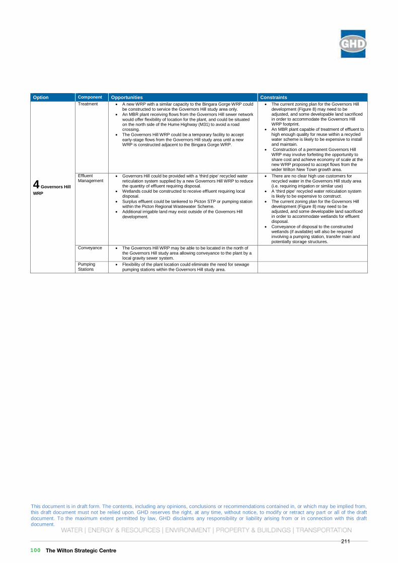
This document is in draft form. The contents, including any opinions, conclusions or recommendations contained in, or which may be implied from, this draft document must not be relied upon. GHD reserves the right, at any time, without notice, to modify or retract any part or all of the draft document. To the maximum extent permitted by law, GHD disclaims any responsibility or liability arising from or in connection with this draft document.
Governors HillWilton Priority Land Release Stage 1 Planning
Governors Hill Water and Wastewater Servicing Feasibility Report
December 2016
This document is in draft form. The contents, including any opinions, conclusions or recommendations contained in, or which may be implied from, this draft document must not be relied upon. GHD reserves the right, at any time, without notice, to modify or retract any part or all of the draft document. To the maximum extent permitted by law, GHD disclaims any responsibility or liability arising from or in connection with this draft document. GHD | Report for Governors Hill - Wilton Priority Land Release Stage 1 Planning, 21/25722 | v
Option Component Opportunities Constraints
4 Governors Hill WRP
Treatment A new WRP with a similar capacity to the Bingara Gorge WRP could be constructed to service the Governors Hill study area only.
An MBR plant receiving flows from the Governors Hill sewer network would offer flexibility of location for the plant, and could be situated on the north side of the Hume Highway (M31) to avoid a road crossing.
The Governors Hill WRP could be a temporary facility to accept early-stage flows from the Governors Hill study area until a new WRP is constructed adjacent to the Bingara Gorge WRP.
The current zoning plan for the Governors Hill development (Figure 8) may need to be adjusted, and some developable land sacrificed in order to accommodate the Governors Hill WRP footprint.
An MBR plant capable of treatment of effluent to high enough quality for reuse within a recycled water scheme is likely to be expensive to install and maintain.
Construction of a permanent Governors Hill WRP may involve forfeiting the opportunity to share cost and achieve economy of scale at the new WRP proposed to accept flows from the wider Wilton New Town growth area.
Effluent Management
Governors Hill could be provided with a ‘third pipe’ recycled water reticulation system supplied by a new Governors Hill WRP to reduce the quantity of effluent requiring disposal.
Wetlands could be constructed to receive effluent requiring local disposal.
Surplus effluent could be tankered to Picton STP or pumping station within the Picton Regional Wastewater Scheme.
Additional irrigable land may exist outside of the Governors Hill development.
There are no clear high use customers for recycled water in the Governors Hill study area (i.e. requiring irrigation or similar use)
A ‘third pipe’ recycled water reticulation system is likely to be expensive to construct.
The current zoning plan for the Governors Hill development (Figure 8) may need to be adjusted, and some developable land sacrificed in order to accommodate wetlands for effluent disposal.
Conveyance of disposal to the constructed wetlands (if available) will also be required involving a pumping station, transfer main and potentially storage structures.
Conveyance The Governors Hill WRP may be able to be located in the north of the Governors Hill study area allowing conveyance to the plant by a local gravity sewer system.
Pumping Stations
Flexibility of the plant location could eliminate the need for sewage pumping stations within the Governors Hill study area.
The Wilton Strategic Centre 100211
This document is in draft form. The contents, including any opinions, conclusions or recommendations contained in, or which may be implied from, this draft document must not be relied upon. GHD reserves the right, at any time, without notice, to modify or retract any part or all of the draft document. To the maximum extent permitted by law, GHD disclaims any responsibility or liability arising from or in connection with this draft document.
Governors HillWilton Priority Land Release Stage 1 Planning
Governors Hill Water and Wastewater Servicing Feasibility Report
December 2016This document is in draft form. The contents, including any opinions, conclusions or recommendations contained in, or which may be implied from, this draft document must not be relied upon. GHD reserves the right, at any time, without notice, to modify or retract any part or all of the draft document. To the maximum extent permitted by law, GHD disclaims any responsibility or liability arising from or in connection with this draft document. GHD | Report for Governors Hill - Wilton Priority Land Release Stage 1 Planning, 21/25722 | i
Table of contents 1. Scope and limitations ................................................................................................................ 3
2. Purpose .................................................................................................................................... 4
3. Introduction ............................................................................................................................... 5
3.1 Greater Macarthur ........................................................................................................... 5
3.2 Wilton New Town ............................................................................................................ 5
3.3 Governors Hill ................................................................................................................. 5
4. Existing Services ..................................................................................................................... 10
4.1 Water ............................................................................................................................ 10
4.2 Wastewater ................................................................................................................... 12
5. Proposed Services for Wilton New Town ................................................................................. 13
5.1 Water ............................................................................................................................ 13
5.2 Wastewater ................................................................................................................... 13
6. Governors Hill ......................................................................................................................... 17
6.1 Water ............................................................................................................................ 17
6.2 Wastewater ................................................................................................................... 17
7. Potential Servicing .................................................................................................................. 19
7.1 Local Systems ............................................................................................................... 19
7.2 Synergy with Wilton New Town schemes ....................................................................... 19
7.3 Other options................................................................................................................. 19
8. Conclusion .............................................................................................................................. 23
Table index Table 1 Key features of water strategy options ..................................................................................... i
Table 2 Key features of wastewater strategy options .......................................................................... iii
Table 3 Estimated potable water demand for the Governors Hill study area ....................................... 17
Table 4 Estimated wastewater load for the Governors Hill study area ................................................ 17
Table 5 Assumptions supporting potable water demand estimate ...................................................... 25
Table 6 Assumptions supporting wastewater load estimate ............................................................... 26
Figure indexFigure 1 Greater Macarthur PLR locality .............................................................................................. 6
Figure 2 Wilton New Town growth area boundary ................................................................................ 8
Figure 3 Wilton New Town and Governors Hill study area ................................................................... 9
A Vision of Community for the 21st Century 101212
This document is in draft form. The contents, including any opinions, conclusions or recommendations contained in, or which may be implied from, this draft document must not be relied upon. GHD reserves the right, at any time, without notice, to modify or retract any part or all of the draft document. To the maximum extent permitted by law, GHD disclaims any responsibility or liability arising from or in connection with this draft document.
Governors HillWilton Priority Land Release Stage 1 Planning
Governors Hill Water and Wastewater Servicing Feasibility Report
December 2016
This document is in draft form. The contents, including any opinions, conclusions or recommendations contained in, or which may be implied from, this draft document must not be relied upon. GHD reserves the right, at any time, without notice, to modify or retract any part or all of the draft document. To the maximum extent permitted by law, GHD disclaims any responsibility or liability arising from or in connection with this draft document. ii | GHD | Report for Governors Hill - Wilton Priority Land Release Stage 1 Planning, 21/25722
Figure 4 Existing water infrastructure................................................................................................. 11
Figure 5 Existing wastewater infrastructure ....................................................................................... 13
Figure 6 Wilton New Town preferred water strategy – MWH .............................................................. 15
Figure 7 Wilton New Town preferred wastewater strategy – MWH ..................................................... 16
Figure 8 Governors Hill study area zoning ......................................................................................... 18
Figure 9 Governors Hill rendered topographical map ......................................................................... 23
This document is in draft form. The contents, including any opinions, conclusions or recommendations contained in, or which may be implied from, this draft document must not be relied upon. GHD reserves the right, at any time, without notice, to modify or retract any part or all of the draft document. To the maximum extent permitted by law, GHD disclaims any responsibility or liability arising from or in connection with this draft document. GHD | Report for Governors Hill - Wilton Priority Land Release Stage 1 Planning, 21/25722 | i
Table of contents 1. Scope and limitations ................................................................................................................ 3
2. Purpose .................................................................................................................................... 4
3. Introduction ............................................................................................................................... 5
3.1 Greater Macarthur ........................................................................................................... 5
3.2 Wilton New Town ............................................................................................................ 5
3.3 Governors Hill ................................................................................................................. 5
4. Existing Services ..................................................................................................................... 10
4.1 Water ............................................................................................................................ 10
4.2 Wastewater ................................................................................................................... 12
5. Proposed Services for Wilton New Town ................................................................................. 13
5.1 Water ............................................................................................................................ 13
5.2 Wastewater ................................................................................................................... 13
6. Governors Hill ......................................................................................................................... 17
6.1 Water ............................................................................................................................ 17
6.2 Wastewater ................................................................................................................... 17
7. Potential Servicing .................................................................................................................. 19
7.1 Local Systems ............................................................................................................... 19
7.2 Synergy with Wilton New Town schemes ....................................................................... 19
7.3 Other options................................................................................................................. 19
8. Conclusion .............................................................................................................................. 23
Table index Table 1 Key features of water strategy options ..................................................................................... i
Table 2 Key features of wastewater strategy options .......................................................................... iii
Table 3 Estimated potable water demand for the Governors Hill study area ....................................... 17
Table 4 Estimated wastewater load for the Governors Hill study area ................................................ 17
Table 5 Assumptions supporting potable water demand estimate ...................................................... 25
Table 6 Assumptions supporting wastewater load estimate ............................................................... 26
Figure indexFigure 1 Greater Macarthur PLR locality .............................................................................................. 6
Figure 2 Wilton New Town growth area boundary ................................................................................ 8
Figure 3 Wilton New Town and Governors Hill study area ................................................................... 9
The Wilton Strategic Centre 102213
This document is in draft form. The contents, including any opinions, conclusions or recommendations contained in, or which may be implied from, this draft document must not be relied upon. GHD reserves the right, at any time, without notice, to modify or retract any part or all of the draft document. To the maximum extent permitted by law, GHD disclaims any responsibility or liability arising from or in connection with this draft document.
Governors HillWilton Priority Land Release Stage 1 Planning
Governors Hill Water and Wastewater Servicing Feasibility Report
December 2016This document is in draft form. The contents, including any opinions, conclusions or recommendations contained in, or which may be implied from, this draft document must not be relied upon. GHD reserves the right, at any time, without notice, to modify or retract any part or all of the draft document. To the maximum extent permitted by law, GHD disclaims any responsibility or liability arising from or in connection with this draft document. GHD | Report for Governors Hill - Wilton Priority Land Release Stage 1 Planning, 21/25722 | 3
1. Scope and limitations This report has been prepared by GHD for LAC-GREW PTY LTD & WILTON DEVELOPMENTS PTY LTD trading as 'Governors Hill' (Governors Hill) and may only be used and relied on by Governors Hill for the purpose agreed between GHD and the Governors Hill as set out in Section 2 of this report.
GHD otherwise disclaims responsibility to any person other than Governors Hill arising in connection with this report. GHD also excludes implied warranties and conditions, to the extent legally permissible.
The services undertaken by GHD in connection with preparing this report were limited to those specifically detailed in the report and are subject to the scope limitations set out in the report.
The opinions, conclusions and any recommendations in this report are based on conditions encountered and information reviewed at the date of preparation of the report. GHD has no responsibility or obligation to update this report to account for events or changes occurring subsequent to the date that the report was prepared.
The opinions, conclusions and any recommendations in this report are based on assumptions made by GHD described in this report. GHD disclaims liability arising from any of the assumptions being incorrect.
GHD has prepared this report on the basis of information provided by Governors Hill and others who provided information to GHD (including Government authorities), which GHD has not independently verified or checked beyond the agreed scope of work. GHD does not accept liability in connection with such unverified information, including errors and omissions in the report which were caused by errors or omissions in that information.
A Vision of Community for the 21st Century 103214
This document is in draft form. The contents, including any opinions, conclusions or recommendations contained in, or which may be implied from, this draft document must not be relied upon. GHD reserves the right, at any time, without notice, to modify or retract any part or all of the draft document. To the maximum extent permitted by law, GHD disclaims any responsibility or liability arising from or in connection with this draft document.
Governors HillWilton Priority Land Release Stage 1 Planning
Governors Hill Water and Wastewater Servicing Feasibility Report
December 2016This document is in draft form. The contents, including any opinions, conclusions or recommendations contained in, or which may be implied from, this draft document must not be relied upon. GHD reserves the right, at any time, without notice, to modify or retract any part or all of the draft document. To the maximum extent permitted by law, GHD disclaims any responsibility or liability arising from or in connection with this draft document. 4 | GHD | Report for Governors Hill - Wilton Priority Land Release Stage 1 Planning, 21/25722
2. Purpose The purpose of this report is to:
Introduce the Governors Hill development area within the context of regional and other local water and wastewater servicing,
Summarise estimates of water and wastewater loading anticipated for the development area,
Identify existing water and wastewater infrastructure in the vicinity of the study area and planned or proposed augmentations and additions to that infrastructure,
Identify preliminary feasible options for servicing the study area with water and wastewater, including the potential for recycled water.
The information presented in this report has been gathered from existing reports and publically available information and is therefore preliminary by nature. Costs presented are estimates only and are not intended to be relied upon for any purpose beyond high level options consideration.
The Wilton Strategic Centre 104215
This document is in draft form. The contents, including any opinions, conclusions or recommendations contained in, or which may be implied from, this draft document must not be relied upon. GHD reserves the right, at any time, without notice, to modify or retract any part or all of the draft document. To the maximum extent permitted by law, GHD disclaims any responsibility or liability arising from or in connection with this draft document.
Governors HillWilton Priority Land Release Stage 1 Planning
Governors Hill Water and Wastewater Servicing Feasibility Report
December 2016This document is in draft form. The contents, including any opinions, conclusions or recommendations contained in, or which may be implied from, this draft document must not be relied upon. GHD reserves the right, at any time, without notice, to modify or retract any part or all of the draft document. To the maximum extent permitted by law, GHD disclaims any responsibility or liability arising from or in connection with this draft document. GHD | Report for Governors Hill - Wilton Priority Land Release Stage 1 Planning, 21/25722 | 5
3. Introduction 3.1 Greater Macarthur
The Greater Macarthur Priority Land Release (PLR) (Figure 1 and Figure 2) forms part of the NSW Government’s strategy for accommodating residential and commercial growth within a 20-year horizon. The Greater Macarthur PLR area is located approximately 40 km south-west of the Sydney CBD, centred on the suburb of Campbelltown and is aligned with the rail corridor from Glenfield to Wilton. Ultimately, this PLR area is planned to receive up to 50,000 new homes and create up to 30,000 new employment opportunities.
Three major growth areas have been identified within the Greater Macarthur PLR in Menangle Park, Mount Gilead and Wilton New Town. West Appin has also been identified as a potential residential growth area further into the future, with the suggestion that this growth area could be accelerated to accommodate higher than expected demand for housing with adequate support for infrastructure from the private sector.
3.2 Wilton New Town
Wilton New Town, previously referenced as The Wilton New Town growth area (Figure 3), lies within the Greater Macarthur PLR and the Wollondilly Shire LGA, and is approximately bounded by the Nepean River to the north and south-west and Allens Creek to the east. The growth area includes the existing village of Wilton and the Bingara Gorge Estate. The Wilton New Town area covers approximately 4,000 Ha, 2,700 Ha of which are represented by the consolidated holdings of recognised developers. The four of the major landowners within the Wilton New Town area, recognised as the ‘Wilton Landowners Group’ are:
Bradcorp Pty Ltd
Walker Corporation
Governors Hill
Lend Lease
Wilton New Town is planned to receive up to 13,000 (recently upgraded to 16,000) new dwellings and create up to 11,000 new employment opportunities.
The Bingara Gorge Estate, developed by Lend Lease, is located in the central-east of the Wilton New Town growth area. This 455 Ha development is currently planned to receive 1,165 residential dwellings, with the potential to increase to 2,000 residential dwellings.
The Metropolitan Development Program (MDP) released by the Department of Planning and Environment (DPE) forecasts residential population within Wilton New Town, including Bingara Gorge to reach 7,400 by 2020 and then 35,500 by 2036.
3.3 Governors Hill
“Governors Hill” (Figure 4), comprises approximately 180 Ha and is located to the north-west of the intersection of Picton Road and the Hume Highway, immediately to the west of the Bingara Gorge Estate.
The development area is planned to include the Wilton New Town town centre and a school, and be otherwise comprised of residential areas, parklands, playing fields, mixed use and employment areas.
A Vision of Community for the 21st Century 105216
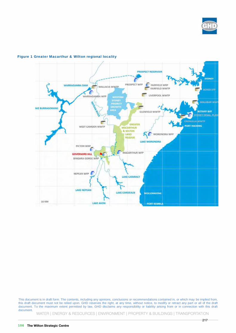
This document is in draft form. The contents, including any opinions, conclusions or recommendations contained in, or which may be implied from, this draft document must not be relied upon. GHD reserves the right, at any time, without notice, to modify or retract any part or all of the draft document. To the maximum extent permitted by law, GHD disclaims any responsibility or liability arising from or in connection with this draft document.
Governors HillWilton Priority Land Release Stage 1 Planning
Governors Hill Water and Wastewater Servicing Feasibility Report
December 2016
This document is in draft form. The contents, including any opinions, conclusions or recommendations contained in, or which may be implied from, this draft document must not be relied upon. GHD reserves the right, at any time, without notice, to modify or retract any part or all of the draft document. To the maximum extent permitted by law, GHD disclaims any responsibility or liability arising from or in connection with this draft document. 6 | GHD | Report for Governors Hill - Wilton Priority Land Release Stage 1 Planning, 21/25722
Figure 1 Greater Macarthur & Wilton regional locality
The Wilton Strategic Centre 106217
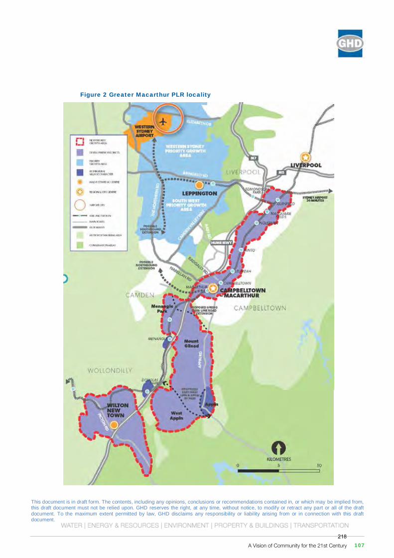
This document is in draft form. The contents, including any opinions, conclusions or recommendations contained in, or which may be implied from, this draft document must not be relied upon. GHD reserves the right, at any time, without notice, to modify or retract any part or all of the draft document. To the maximum extent permitted by law, GHD disclaims any responsibility or liability arising from or in connection with this draft document.
Governors HillWilton Priority Land Release Stage 1 Planning
Governors Hill Water and Wastewater Servicing Feasibility Report
December 2016
This document is in draft form. The contents, including any opinions, conclusions or recommendations contained in, or which may be implied from, this draft document must not be relied upon. GHD reserves the right, at any time, without notice, to modify or retract any part or all of the draft document. To the maximum extent permitted by law, GHD disclaims any responsibility or liability arising from or in connection with this draft document. GHD | Report for Governors Hill - Wilton Priority Land Release Stage 1 Planning, 21/25722 | 7
Figure 2 Greater Macarthur PLR locality
A Vision of Community for the 21st Century 107218
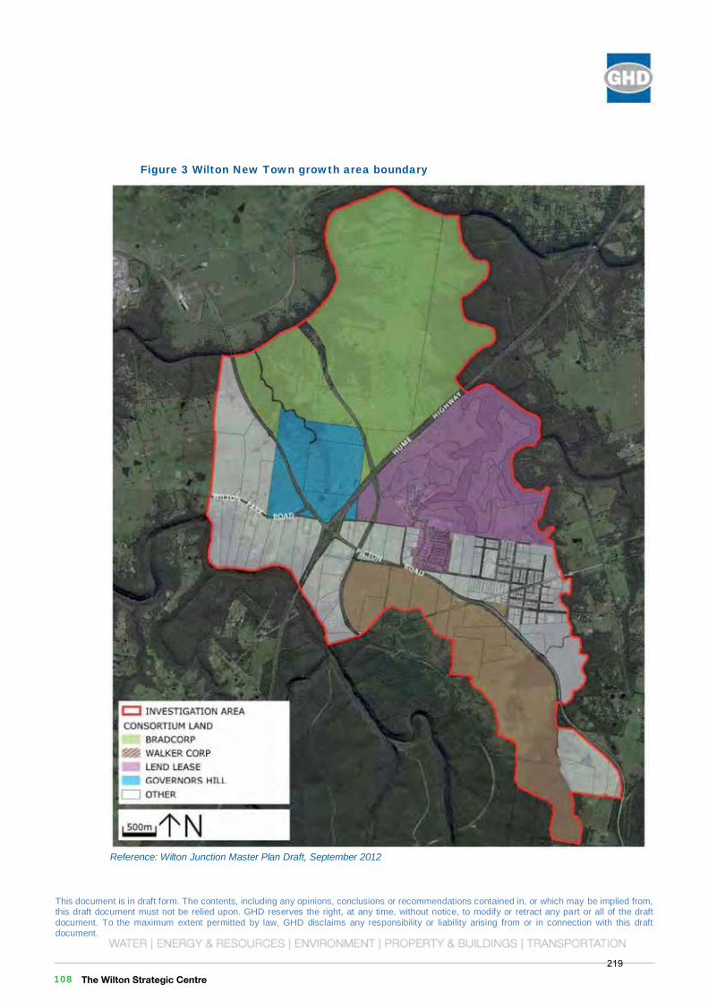
This document is in draft form. The contents, including any opinions, conclusions or recommendations contained in, or which may be implied from, this draft document must not be relied upon. GHD reserves the right, at any time, without notice, to modify or retract any part or all of the draft document. To the maximum extent permitted by law, GHD disclaims any responsibility or liability arising from or in connection with this draft document.
Governors HillWilton Priority Land Release Stage 1 Planning
Governors Hill Water and Wastewater Servicing Feasibility Report
December 2016
This document is in draft form. The contents, including any opinions, conclusions or recommendations contained in, or which may be implied from, this draft document must not be relied upon. GHD reserves the right, at any time, without notice, to modify or retract any part or all of the draft document. To the maximum extent permitted by law, GHD disclaims any responsibility or liability arising from or in connection with this draft document. 8 | GHD | Report for Governors Hill - Wilton Priority Land Release Stage 1 Planning, 21/25722
Figure 3 Wilton New Town growth area boundary
Reference: Wilton Junction Master Plan Draft, September 2012
The Wilton Strategic Centre 108219
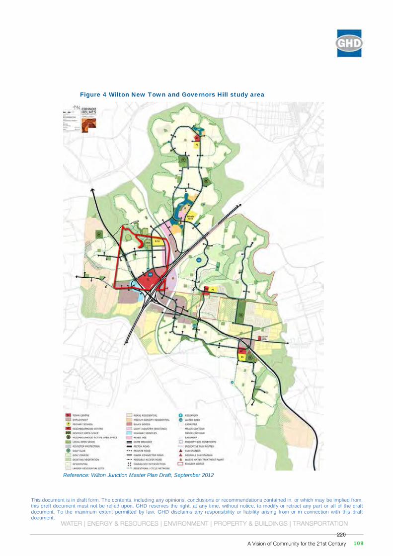
This document is in draft form. The contents, including any opinions, conclusions or recommendations contained in, or which may be implied from, this draft document must not be relied upon. GHD reserves the right, at any time, without notice, to modify or retract any part or all of the draft document. To the maximum extent permitted by law, GHD disclaims any responsibility or liability arising from or in connection with this draft document.
Governors HillWilton Priority Land Release Stage 1 Planning
Governors Hill Water and Wastewater Servicing Feasibility Report
December 2016
This document is in draft form. The contents, including any opinions, conclusions or recommendations contained in, or which may be implied from, this draft document must not be relied upon. GHD reserves the right, at any time, without notice, to modify or retract any part or all of the draft document. To the maximum extent permitted by law, GHD disclaims any responsibility or liability arising from or in connection with this draft document. GHD | Report for Governors Hill - Wilton Priority Land Release Stage 1 Planning, 21/25722 | 9
Figure 4 Wilton New Town and Governors Hill study area
Reference: Wilton Junction Master Plan Draft, September 2012
A Vision of Community for the 21st Century 109220
This document is in draft form. The contents, including any opinions, conclusions or recommendations contained in, or which may be implied from, this draft document must not be relied upon. GHD reserves the right, at any time, without notice, to modify or retract any part or all of the draft document. To the maximum extent permitted by law, GHD disclaims any responsibility or liability arising from or in connection with this draft document.
Governors HillWilton Priority Land Release Stage 1 Planning
Governors Hill Water and Wastewater Servicing Feasibility Report
December 2016
This document is in draft form. The contents, including any opinions, conclusions or recommendations contained in, or which may be implied from, this draft document must not be relied upon. GHD reserves the right, at any time, without notice, to modify or retract any part or all of the draft document. To the maximum extent permitted by law, GHD disclaims any responsibility or liability arising from or in connection with this draft document. GHD | Report for Governors Hill - Wilton Priority Land Release Stage 1 Planning, 21/25722 | 11
Figure 5 Existing water and wastewater infrastructure
This document is in draft form. The contents, including any opinions, conclusions or recommendations contained in, or which may be implied from, this draft document must not be relied upon. GHD reserves the right, at any time, without notice, to modify or retract any part or all of the draft document. To the maximum extent permitted by law, GHD disclaims any responsibility or liability arising from or in connection with this draft document. 10 | GHD | Report for Governors Hill - Wilton Priority Land Release Stage 1 Planning, 21/25722
4. Existing Services 4.1 Water
Water infrastructure in the vicinity of the study area is shown in Figure 5.
Governors Hill is situated near two Water Delivery Systems, Nepean to the west and Macarthur to the east.
The Macarthur Delivery System is supplied by the Macarthur WFP (10 km east of Governors Hill) which filters water extracted at Broughtons Pass Weir. The Macarthur trunk water network currently services the water supply zone of Appin to the east of the study area including the existing village of Wilton and the Bingara Gorge Estate.
The Macarthur WFP has a nameplate capacity of 265 ML/d. The maximum day demand of the existing Macarthur Delivery System is 124 ML/d (MWH, May 2014) and is forecast to be 244 ML/d in 2036 based on DPE population forecasts within the South West Priority Growth Area. These forecasts exclude Wilton New Town and Bingara Gorge developments.
The Nepean Delivery System is supplied by the Nepean WFP (13 km south of Governors Hill) which filters water extracted at the Nepean Dam. The Nepean trunk water network current services the water supply zones of Picton to the north-west, Thirlmere to the west and Nepean to the south-west of the study area. The Nepean WFP has a maximum operating capacity of 31 ML/d (MWH, May 2014). The Nepean Delivery System maximum day demand was 18 ML/d in 2014 and is forecast to be 26 ML/d in 2036. Accordingly, the Nepean WFP is estimated to have a current spare capacity of 13 ML/d and 5 ML/d at 2036.
The nearest Nepean Delivery System trunk water mains are further from the Governors Hill study are than trunk water mains supplied by the Macarthur Delivery System.
The Wilton Strategic Centre 110221
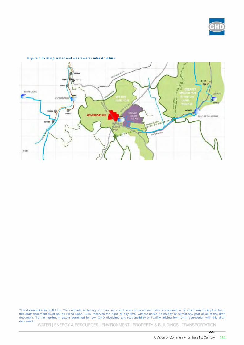
This document is in draft form. The contents, including any opinions, conclusions or recommendations contained in, or which may be implied from, this draft document must not be relied upon. GHD reserves the right, at any time, without notice, to modify or retract any part or all of the draft document. To the maximum extent permitted by law, GHD disclaims any responsibility or liability arising from or in connection with this draft document.
Governors HillWilton Priority Land Release Stage 1 Planning
Governors Hill Water and Wastewater Servicing Feasibility Report
December 2016
This document is in draft form. The contents, including any opinions, conclusions or recommendations contained in, or which may be implied from, this draft document must not be relied upon. GHD reserves the right, at any time, without notice, to modify or retract any part or all of the draft document. To the maximum extent permitted by law, GHD disclaims any responsibility or liability arising from or in connection with this draft document. GHD | Report for Governors Hill - Wilton Priority Land Release Stage 1 Planning, 21/25722 | 11
Figure 5 Existing water and wastewater infrastructure
A Vision of Community for the 21st Century 111222
This document is in draft form. The contents, including any opinions, conclusions or recommendations contained in, or which may be implied from, this draft document must not be relied upon. GHD reserves the right, at any time, without notice, to modify or retract any part or all of the draft document. To the maximum extent permitted by law, GHD disclaims any responsibility or liability arising from or in connection with this draft document.
Governors HillWilton Priority Land Release Stage 1 Planning
Governors Hill Water and Wastewater Servicing Feasibility Report
December 2016
This document is in draft form. The contents, including any opinions, conclusions or recommendations contained in, or which may be implied from, this draft document must not be relied upon. GHD reserves the right, at any time, without notice, to modify or retract any part or all of the draft document. To the maximum extent permitted by law, GHD disclaims any responsibility or liability arising from or in connection with this draft document. 12 | GHD | Report for Governors Hill - Wilton Priority Land Release Stage 1 Planning, 21/25722
4.2 Wastewater
Wastewater infrastructure in the vicinity of the study area is shown in Figure 5.
The Governors Hill study area is in the regional vicinity of four existing Sewer Catchment Areas:
Picton Regional Wastewater Scheme to the west,
Douglas Park Priority Sewerage Area to the north-east,
Bingara Gorge Scheme to the south-east, and
Appin to the far east.
The Picton Regional Wastewater Scheme involves a network of gravity mains, sewage pumping stations and rising mains. Wastewater is treated at the Picton Wastewater Recycling Plant (WRP) where it is treated and discharged to the Nepean River via Stonequarry Creek. The Picton Scheme is approximately 12 km from Governors Hill.
Douglas Park is a small pressure sewer system (approximately 200 lots) that discharges to a tank that is tankered to an existing wastewater pumping station.
The Bingara Gorge Scheme provides the existing village of Wilton with wastewater servicing by means of a pressure sewer system. The Wilton village pressure sewer system transfers wastewater to the existing Bingara Gorge WRP situated to the west of the Bingara Gorge development. The WRP also receives wastewater flows from Bingara Gorge Estate. The existing WRP is situated on land that adjoins land owned by Governors Hill on the east side of the Hume Motorway (M31).
An Environmental Impact Statement (EIS) (Planit Consulting Pty Ltd, December 2013) for the Bingara Gorge WRP describes construction of the plant in three stages, ultimately achieving a plant capacity of 2,000 Equivalent Tenements (ET) with more than four membrane bioreactor (MBR) trains, and producing class A+ recycled water for delivery via a new ‘third pipe’ recycled water reticulation network within Bingara Gorge Estate.
Appin is a mix of pressure and gravity sewers servicing approximately 1,000 properties that pumps to a transfer main to Glenfield wastewater system approximately 15 km away.
The Wilton Strategic Centre 112223
This document is in draft form. The contents, including any opinions, conclusions or recommendations contained in, or which may be implied from, this draft document must not be relied upon. GHD reserves the right, at any time, without notice, to modify or retract any part or all of the draft document. To the maximum extent permitted by law, GHD disclaims any responsibility or liability arising from or in connection with this draft document.
Governors HillWilton Priority Land Release Stage 1 Planning
Governors Hill Water and Wastewater Servicing Feasibility Report
December 2016
This document is in draft form. The contents, including any opinions, conclusions or recommendations contained in, or which may be implied from, this draft document must not be relied upon. GHD reserves the right, at any time, without notice, to modify or retract any part or all of the draft document. To the maximum extent permitted by law, GHD disclaims any responsibility or liability arising from or in connection with this draft document. GHD | Report for Governors Hill - Wilton Priority Land Release Stage 1 Planning, 21/25722 | 13
5. Proposed Services for Wilton New Town In 2014, Water and Sewer Strategy reports for the Wilton New Town growth area (now called Wilton New Town) were prepared for Wilton Landowners Group. The reports identified preferred options for water and wastewater servicing of the growth area including the Governors Hill study area. Works required by these strategies are not confirmed, but form part of the broader context of water and wastewater planning for the Governors Hill study area.
5.1 Water
The Wilton Junction Water Strategy report prepared by MWH outlined a preferred strategy for the water supply to the Wilton New Town area, shown in Figure 6.
Key features of the strategy include:
Supply to Wilton New Town to be from the Appin Water Supply Zone within the Macarthur Water Delivery System
Existing pumping station at Macarthur WFP (WP0302) to be upgraded
A booster pumping station to be installed on the existing trunk main from WP0302 at Macarthur WFP along Wilton Road
Duplication of the existing trunk main from WP0302 at Macarthur WFP along Wilton Road to Ashwood Road with a 450 mm diameter main, including second crossings at Broughtons Pass and Clements Creek
2 x 6 ML reservoirs on the southern side of Picton road from the existing village of Wilton to service the Wilton New Town area
A number of lead-in mains from the new Wilton New Town reservoirs and Bingara Gorge Estate into the Governors Hill and Bradcorp consortium lands, including crossing the Hume Highway in two locations
5.2 Wastewater
Existing Bingara Gorge WRP
The existing Bingara Gorge WRP, currently servicing Bingara Gorge Estate and the existing village of Wilton, was proposed to be augmented in response to growth within the Bingara Gorge Estate. The EIS prepared by Planit Consulting Pty Ltd in December 2013 describes a temporary 150 kL per day capacity ‘Ecodisk’ treatment plant with tertiary membrane filtration that was to be decommissioned after the Bingara Gorge WRP was commissioned. The Bingara Gorge WRP was planned to be constructed in three stages:
Stage 1: 900ET capacity plant using a 2 train MBR
Stage 2: plant capacity augmented to 1,540ET using a 4 train MBR
Stage 3: plant capacity augmented to 2,000ET using additional MBR trains.
Timeline for the successive stages of construction are unknown at this time. Living Utilities Lendlease have advised that plant augmentation will be scheduled to meet growth within Bingara Gorge development.
A Vision of Community for the 21st Century 113224
This document is in draft form. The contents, including any opinions, conclusions or recommendations contained in, or which may be implied from, this draft document must not be relied upon. GHD reserves the right, at any time, without notice, to modify or retract any part or all of the draft document. To the maximum extent permitted by law, GHD disclaims any responsibility or liability arising from or in connection with this draft document.
Governors HillWilton Priority Land Release Stage 1 Planning
Governors Hill Water and Wastewater Servicing Feasibility Report
December 2016
This document is in draft form. The contents, including any opinions, conclusions or recommendations contained in, or which may be implied from, this draft document must not be relied upon. GHD reserves the right, at any time, without notice, to modify or retract any part or all of the draft document. To the maximum extent permitted by law, GHD disclaims any responsibility or liability arising from or in connection with this draft document. GHD | Report for Governors Hill - Wilton Priority Land Release Stage 1 Planning, 21/25722 | 15
Figure 6 Wilton New Town preferred water strategy – MWH
Reference: Wilton Junction Rezoning – Water Strategy, May 2014
This document is in draft form. The contents, including any opinions, conclusions or recommendations contained in, or which may be implied from, this draft document must not be relied upon. GHD reserves the right, at any time, without notice, to modify or retract any part or all of the draft document. To the maximum extent permitted by law, GHD disclaims any responsibility or liability arising from or in connection with this draft document. 14 | GHD | Report for Governors Hill - Wilton Priority Land Release Stage 1 Planning, 21/25722
Wilton New Town WRP
The Average Dry Weather Flow rate for the Wilton New Town wastewater system, exclusive of Bingara Gorge Estate and the existing village of Wilton, is estimated to be 62 L/s or 5.4 ML/d (MWH, May 2014).
The Wilton Junction Wastewater Strategy report prepared by MWH considered both low infiltration gravity and pressure sewer options for the Wilton New Town area and outlined a preferred strategy for the wastewater servicing for the Wilton New Town area, shown in Figure 7. Key features of the strategy include:
A new Membrane Bio-Reactor (MBR) WRP located near but separate to the Bingara Gorge WRP with tertiary media filters and an ultimate capacity of 5.4 ML/d
21 independent pressure sewer reticulation networks, 5 of which are partially or wholly contained within the Governors Hill study area
6 sewage pumping stations (SPS), none of which are located within the Governors Hill study area
A number of pressure discharge structures and gravity mains enabling parts of the network to operate under gravity flowing to SPSs or to the STP.
The preference for a pressure sewer system over a low infiltration gravity sewer system was based on an NPV analysis for the two options. In addition, the following advantages of a pressure sewer system over low infiltration gravity sewer system were noted:
Very unlikely to experience stormwater inflow or infiltration
Pipelines are kept to a minimal diameter and minimal depth and it is therefore unlikely to strike difficult ground conditions such as rock or water charged ground during construction.
Significantly reduced potential for overflows due to reduced likelihood of root intrusions
Power outages are unlikely to result in overflows as the system is designed with 24 hours of storage
The Wilton Strategic Centre 114225

This document is in draft form. The contents, including any opinions, conclusions or recommendations contained in, or which may be implied from, this draft document must not be relied upon. GHD reserves the right, at any time, without notice, to modify or retract any part or all of the draft document. To the maximum extent permitted by law, GHD disclaims any responsibility or liability arising from or in connection with this draft document.
Governors HillWilton Priority Land Release Stage 1 Planning
Governors Hill Water and Wastewater Servicing Feasibility Report
December 2016
This document is in draft form. The contents, including any opinions, conclusions or recommendations contained in, or which may be implied from, this draft document must not be relied upon. GHD reserves the right, at any time, without notice, to modify or retract any part or all of the draft document. To the maximum extent permitted by law, GHD disclaims any responsibility or liability arising from or in connection with this draft document. GHD | Report for Governors Hill - Wilton Priority Land Release Stage 1 Planning, 21/25722 | 15
Figure 6 Wilton New Town preferred water strategy – MWH
Reference: Wilton Junction Rezoning – Water Strategy, May 2014
This document is in draft form. The contents, including any opinions, conclusions or recommendations contained in, or which may be implied from, this draft document must not be relied upon. GHD reserves the right, at any time, without notice, to modify or retract any part or all of the draft document. To the maximum extent permitted by law, GHD disclaims any responsibility or liability arising from or in connection with this draft document. GHD | Report for Governors Hill - Wilton Priority Land Release Stage 1 Planning, 21/25722 | 15
Figure 6 Wilton New Town preferred water strategy – MWH
Reference: Wilton Junction Rezoning – Water Strategy, May 2014
A Vision of Community for the 21st Century 115226
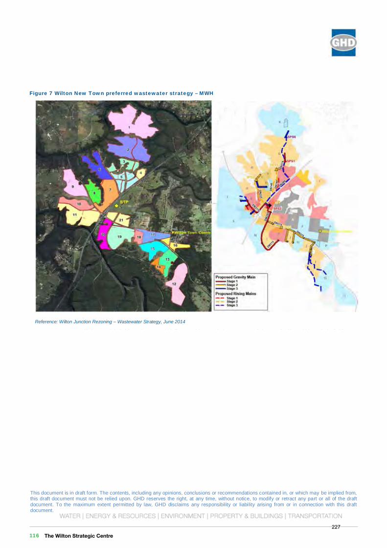
This document is in draft form. The contents, including any opinions, conclusions or recommendations contained in, or which may be implied from, this draft document must not be relied upon. GHD reserves the right, at any time, without notice, to modify or retract any part or all of the draft document. To the maximum extent permitted by law, GHD disclaims any responsibility or liability arising from or in connection with this draft document.
Governors HillWilton Priority Land Release Stage 1 Planning
Governors Hill Water and Wastewater Servicing Feasibility Report
December 2016
This document is in draft form. The contents, including any opinions, conclusions or recommendations contained in, or which may be implied from, this draft document must not be relied upon. GHD reserves the right, at any time, without notice, to modify or retract any part or all of the draft document. To the maximum extent permitted by law, GHD disclaims any responsibility or liability arising from or in connection with this draft document. 16 | GHD | Report for Governors Hill - Wilton Priority Land Release Stage 1 Planning, 21/25722
Figure 7 Wilton New Town preferred wastewater strategy – MWH
Reference: Wilton Junction Rezoning – Wastewater Strategy, June 2014
The Wilton Strategic Centre 116227
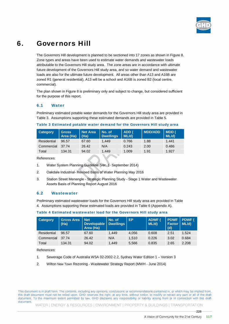
This document is in draft form. The contents, including any opinions, conclusions or recommendations contained in, or which may be implied from, this draft document must not be relied upon. GHD reserves the right, at any time, without notice, to modify or retract any part or all of the draft document. To the maximum extent permitted by law, GHD disclaims any responsibility or liability arising from or in connection with this draft document. 16 | GHD | Report for Governors Hill - Wilton Priority Land Release Stage 1 Planning, 21/25722
Figure 7 Wilton New Town preferred wastewater strategy – MWH
Reference: Wilton Junction Rezoning – Wastewater Strategy, June 2014
This document is in draft form. The contents, including any opinions, conclusions or recommendations contained in, or which may be implied from, this draft document must not be relied upon. GHD reserves the right, at any time, without notice, to modify or retract any part or all of the draft document. To the maximum extent permitted by law, GHD disclaims any responsibility or liability arising from or in connection with this draft document.
Governors HillWilton Priority Land Release Stage 1 Planning
Governors Hill Water and Wastewater Servicing Feasibility Report
December 2016This document is in draft form. The contents, including any opinions, conclusions or recommendations contained in, or which may be implied from, this draft document must not be relied upon. GHD reserves the right, at any time, without notice, to modify or retract any part or all of the draft document. To the maximum extent permitted by law, GHD disclaims any responsibility or liability arising from or in connection with this draft document. GHD | Report for Governors Hill - Wilton Priority Land Release Stage 1 Planning, 21/25722 | 17
6. Governors Hill The Governors Hill development is planned to be sectioned into 17 zones as shown in Figure 8. Zone types and areas have been used to estimate water demands and wastewater loads attributable to the Governors Hill study area. The zone areas are in accordance with ultimate future development of the Governors Hill study area, and so water demand and wastewater loads are also for the ultimate future development. All areas other than A13 and A16B are zoned R1 (general residential), A13 will be a school and A16B is zoned B2 (local centre, commercial).
The plan shown in Figure 8 is preliminary only and subject to change, but considered sufficient for the purpose of this report.
6.1 Water
Preliminary estimated potable water demands for the Governors Hill study area are provided in Table 3. Assumptions supporting these estimated demands are provided in Table 5.
Table 3 Estimated potable water demand for the Governors Hill study area
Category Gross Area (Ha)
Net Area (Ha)
No. of Dwellings
ADD ( ML/d)
MDD/ADD MDD ( ML/d)
Residential 96.57 67.60 1,449 0.766 1.88 1.441 Commercial 37.74 26.42 N/A 0.243 2.00 0.486 Total 134.31 94.02 1,449 1.009 1.91 1.927
References:
1. Water System Planning Guideline (ver. 1- September 2014)
2. Oakdale Industrial- Revised Basis of Water Planning May 2016
3. Station Street Menangle - Strategic Planning Study - Stage 1 Water and Wastewater Assets Basis of Planning Report August 2016
6.2 Wastewater
Preliminary estimated wastewater loads for the Governors Hill study area are provided in Table 4. Assumptions supporting these estimated loads are provided in Table 6 (Appendix A).
Table 4 Estimated wastewater load for the Governors Hill study area
Category Gross Area (Ha)
Net Developable Area (Ha)
No. of Dwellings
EP ADWF ( ML/d)
PDWF Factor (d)
PDWF ( ML/d)
Residential 96.57 67.60 1,449 4,056 0.608 2.51 1.524 Commercial 37.74 26.42 N/A 1,510 0.226 3.02 0.684 Total 134.31 94.02 1,449 5,566 0.835 2.65 2.208
References:
1. Sewerage Code of Australia WSA 02-2002-2.2, Sydney Water Edition 1 – Version 3
2. Wilton New Town Rezoning - Wastewater Strategy Report (MWH - June 2014)
A Vision of Community for the 21st Century 117228
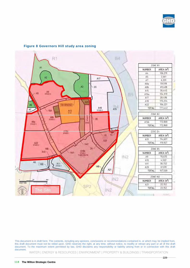
This document is in draft form. The contents, including any opinions, conclusions or recommendations contained in, or which may be implied from, this draft document must not be relied upon. GHD reserves the right, at any time, without notice, to modify or retract any part or all of the draft document. To the maximum extent permitted by law, GHD disclaims any responsibility or liability arising from or in connection with this draft document.
Governors HillWilton Priority Land Release Stage 1 Planning
Governors Hill Water and Wastewater Servicing Feasibility Report
December 2016
This document is in draft form. The contents, including any opinions, conclusions or recommendations contained in, or which may be implied from, this draft document must not be relied upon. GHD reserves the right, at any time, without notice, to modify or retract any part or all of the draft document. To the maximum extent permitted by law, GHD disclaims any responsibility or liability arising from or in connection with this draft document. 18 | GHD | Report for Governors Hill - Wilton Priority Land Release Stage 1 Planning, 21/25722
Figure 8 Governors Hill study area zoning
The Wilton Strategic Centre 118229
This document is in draft form. The contents, including any opinions, conclusions or recommendations contained in, or which may be implied from, this draft document must not be relied upon. GHD reserves the right, at any time, without notice, to modify or retract any part or all of the draft document. To the maximum extent permitted by law, GHD disclaims any responsibility or liability arising from or in connection with this draft document.
Governors HillWilton Priority Land Release Stage 1 Planning
Governors Hill Water and Wastewater Servicing Feasibility Report
December 2016This document is in draft form. The contents, including any opinions, conclusions or recommendations contained in, or which may be implied from, this draft document must not be relied upon. GHD reserves the right, at any time, without notice, to modify or retract any part or all of the draft document. To the maximum extent permitted by law, GHD disclaims any responsibility or liability arising from or in connection with this draft document. GHD | Report for Governors Hill - Wilton Priority Land Release Stage 1 Planning, 21/25722 | 19
7. Potential Servicing 7.1 Local Systems
7.1.1 Water
The most feasible option for water supply to the Governors Hill area appears to be to provide connectivity with the Appin Water Supply Zone within the Macarthur Water Delivery System.
Staging of trunk water assets indicated in the Wilton Junction Water Strategy report suggest that the south-eastern corner of the Governors Hill study area is proposed to receive DN375 lead-in mains around 2018/19. A booster pumping station is also proposed to be installed on the existing trunk main from WP0302 at Macarthur WFP along Wilton Road at this time.
7.1.2 Wastewater
The preferred option for wastewater servicing of the Wilton New Town growth area identified in the Wilton Junction Wastewater Strategy report is to provide the growth area with a number of independent pressure sewer reticulation networks, and to construct a new Wilton New TownWRP adjacent to the existing Bingara Gorge WRP to accept wastewater flows from the Wilton New Town growth area.
7.2 Synergy with Wilton New Town schemes
7.2.1 Water – extension from the Appin Water System
Under the preferred option for water supply to the Governors Hill study area outlined in the Wilton Junction Water Strategy report, the trunk water network supplying the Governors Hill study area utilises trunk assets currently servicing Bingara Gorge Estate. In particular, both consortium lands will benefit from installation of the booster pumping station to be installed on the existing trunk main from WP0302 at Macarthur WFP along Wilton Road as part of the initial servicing arrangement proposed in the MWH Water Strategy report, and from enhanced supply capacity and resilience of the duplication of that trunk main as part of proposed works distributed between Stages 1 to 5 of the preferred strategy.
7.2.2 Wastewater – new Wilton New Town WRP adjacent to the Bingara Gorge WRP, local reuse and discharge
The Wilton Junction Wastewater Strategy report proposes a new WRP to be constructed adjacent to the existing Bingara Gorge WRP to the south-east of the Governors Hill study area.
The capacity of the plant will be sized to accommodate growth and the effluent management strategy shall provide an integrated stormwater reticulation and treatment system to achieve a neutral or beneficial impact on the quality of stormwater leaving the site. Similar requirements to these are outlined in the current Bingara Gorge EPL.
7.3 Other options
Broadly, the opportunities for water and wastewater servicing of the Governors Hill study area are represented on
A Vision of Community for the 21st Century 119230
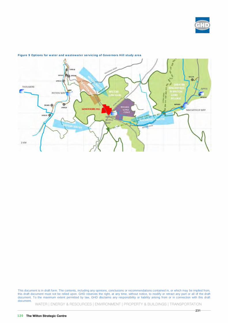
This document is in draft form. The contents, including any opinions, conclusions or recommendations contained in, or which may be implied from, this draft document must not be relied upon. GHD reserves the right, at any time, without notice, to modify or retract any part or all of the draft document. To the maximum extent permitted by law, GHD disclaims any responsibility or liability arising from or in connection with this draft document.
Governors HillWilton Priority Land Release Stage 1 Planning
Governors Hill Water and Wastewater Servicing Feasibility Report
December 2016
This document is in draft form. The contents, including any opinions, conclusions or recommendations contained in, or which may be implied from, this draft document must not be relied upon. GHD reserves the right, at any time, without notice, to modify or retract any part or all of the draft document. To the maximum extent permitted by law, GHD disclaims any responsibility or liability arising from or in connection with this draft document. 20 | GHD | Report for Governors Hill - Wilton Priority Land Release Stage 1 Planning, 21/25722
Figure 9 Options for water and wastewater servicing of Governors Hill study area
This document is in draft form. The contents, including any opinions, conclusions or recommendations contained in, or which may be implied from, this draft document must not be relied upon. GHD reserves the right, at any time, without notice, to modify or retract any part or all of the draft document. To the maximum extent permitted by law, GHD disclaims any responsibility or liability arising from or in connection with this draft document.
GHD | Report for Governors Hill - Wilton Priority Land Release Stage 1 Planning, 21/25722
7.3.1 Water: Nepean delivery system
The only clear alternative drinking water supply for the Governors Hill study area, apart from supply via the Macarthur Water Delivery System, is the Nepean Water Delivery System. The ultimate development maximum day demand for the Governors Hill study area, 1.9 ML/d is within the estimated spare capacity of the Nepean WFP at 2036, 5 ML/d.
Enabling drinking water supply to the Governors Hill study area from the Nepean Water Delivery System would require approximately 10 km or more of DN200 water main, including 2 or more bridge crossings. This is likely to be more expensive than the preferred Appin / Macarthur supply option.
7.3.2 Wastewater: Integrated scheme, constructed wetlands, Governors Hill WRP or Picton WRP
Alternatives to construction of a new WRP adjacent to Bingara Gorge WRP include:
Integrated Wilton New Town wastewater servicing scheme (including Bingara Gorge)
Augmentation or expansion of the existing Bingara Gorge WRP to a capacity sufficient for the needs of developments within Wilton New Town additional to the Bingara Gorge Estate including Governors Hill
o Augmentation or expansion of the existing Bingara Gorge WRP could make use of the Governors Hill land adjoining the Bingara Gorge WRP site
o A broader wastewater servicing scheme could involve the construction of wetlands for local effluent disposal and treatment on land that would otherwise be inaccessible to the owners / operators of the Bingara Gorge WRP for effluent management
o This option would require the cooperation of the current owners / operators of Bingara Gorge WRP and of the owners of land potentially to be used for constructed wetlands.
Wilton New Town WRP constructed wetlands
The Wilton New Town WRP described in the Wilton Junction Wastewater Strategy report could be replaced or enhanced through provision of constructed wetlands for local effluent disposal and treatment.
Governors Hill WRP
Construction of a new WRP to service Governors Hill only.
o The estimated wastewater load for the Governors Hill study area is of a similar scale to the ultimate capacity of the Bingara Gorge WRP. A new WRP with a similar capacity to the Bingara Gorge WRP could be constructed to service the Governors Hill study area only.
Recycled water supply for the Governors Hill study area to reduce volume of disposal
o As currently implemented within the Bingara Gorge Estate, the Governors Hill study area could be provided with a ‘third pipe’ recycled water reticulation system. Wastewater would still require treatment to a high quality before it could be returned to the Governors Hill study area for reuse, and so a wastewater treatment plant with capacity to accept flows from the study area would still be required. A recycled water system would, however, reduce the quantity of treated effluent released to the environment.
The Governors Hill study area naturally drains to the north, away from the location of the existing Bingara Gorge WRP and proposed location of the new WRP. It may be possible to
The Wilton Strategic Centre 120231
This document is in draft form. The contents, including any opinions, conclusions or recommendations contained in, or which may be implied from, this draft document must not be relied upon. GHD reserves the right, at any time, without notice, to modify or retract any part or all of the draft document. To the maximum extent permitted by law, GHD disclaims any responsibility or liability arising from or in connection with this draft document.
Governors HillWilton Priority Land Release Stage 1 Planning
Governors Hill Water and Wastewater Servicing Feasibility Report
December 2016This document is in draft form. The contents, including any opinions, conclusions or recommendations contained in, or which may be implied from, this draft document must not be relied upon. GHD reserves the right, at any time, without notice, to modify or retract any part or all of the draft document. To the maximum extent permitted by law, GHD disclaims any responsibility or liability arising from or in connection with this draft document.
GHD | Report for Governors Hill - Wilton Priority Land Release Stage 1 Planning, 21/25722
7.3.1 Water: Nepean delivery system
The only clear alternative drinking water supply for the Governors Hill study area, apart from supply via the Macarthur Water Delivery System, is the Nepean Water Delivery System. The ultimate development maximum day demand for the Governors Hill study area, 1.9 ML/d is within the estimated spare capacity of the Nepean WFP at 2036, 5 ML/d.
Enabling drinking water supply to the Governors Hill study area from the Nepean Water Delivery System would require approximately 10 km or more of DN200 water main, including 2 or more bridge crossings. This is likely to be more expensive than the preferred Appin / Macarthur supply option.
7.3.2 Wastewater: Integrated scheme, constructed wetlands, Governors Hill WRP or Picton WRP
Alternatives to construction of a new WRP adjacent to Bingara Gorge WRP include:
Integrated Wilton New Town wastewater servicing scheme (including Bingara Gorge)
Augmentation or expansion of the existing Bingara Gorge WRP to a capacity sufficient for the needs of developments within Wilton New Town additional to the Bingara Gorge Estate including Governors Hill
o Augmentation or expansion of the existing Bingara Gorge WRP could make use of the Governors Hill land adjoining the Bingara Gorge WRP site
o A broader wastewater servicing scheme could involve the construction of wetlands for local effluent disposal and treatment on land that would otherwise be inaccessible to the owners / operators of the Bingara Gorge WRP for effluent management
o This option would require the cooperation of the current owners / operators of Bingara Gorge WRP and of the owners of land potentially to be used for constructed wetlands.
Wilton New Town WRP constructed wetlands
The Wilton New Town WRP described in the Wilton Junction Wastewater Strategy report could be replaced or enhanced through provision of constructed wetlands for local effluent disposal and treatment.
Governors Hill WRP
Construction of a new WRP to service Governors Hill only.
o The estimated wastewater load for the Governors Hill study area is of a similar scale to the ultimate capacity of the Bingara Gorge WRP. A new WRP with a similar capacity to the Bingara Gorge WRP could be constructed to service the Governors Hill study area only.
Recycled water supply for the Governors Hill study area to reduce volume of disposal
o As currently implemented within the Bingara Gorge Estate, the Governors Hill study area could be provided with a ‘third pipe’ recycled water reticulation system. Wastewater would still require treatment to a high quality before it could be returned to the Governors Hill study area for reuse, and so a wastewater treatment plant with capacity to accept flows from the study area would still be required. A recycled water system would, however, reduce the quantity of treated effluent released to the environment.
The Governors Hill study area naturally drains to the north, away from the location of the existing Bingara Gorge WRP and proposed location of the new WRP. It may be possible to
A Vision of Community for the 21st Century 121232
This document is in draft form. The contents, including any opinions, conclusions or recommendations contained in, or which may be implied from, this draft document must not be relied upon. GHD reserves the right, at any time, without notice, to modify or retract any part or all of the draft document. To the maximum extent permitted by law, GHD disclaims any responsibility or liability arising from or in connection with this draft document.
Governors HillWilton Priority Land Release Stage 1 Planning
Governors Hill Water and Wastewater Servicing Feasibility Report
December 2016
This document is in draft form. The contents, including any opinions, conclusions or recommendations contained in, or which may be implied from, this draft document must not be relied upon. GHD reserves the right, at any time, without notice, to modify or retract any part or all of the draft document. To the maximum extent permitted by law, GHD disclaims any responsibility or liability arising from or in connection with this draft document.
22 | GHD | Report for Governors Hill - Wilton Priority Land Release Stage 1 Planning, 21/25722
design a low infiltration gravity sewer system to capture the majority of flows within the Governors Hill study area at a single sewage pumping station and construct a rising main from that location to the location of a new Governors Hill WRP. The new Governors Hill WRP location would not be constrained by the location of the existing Bingara Gorge WRP.
The small area in the south-west corner of the study area (zone A2 in Figure 8) could be serviced by a smaller low infiltration gravity system and pumping station / rising main transferring flows either to the larger gravity system to the east of Picton Road, or directly to the new WRP. Alternatively, this small area could be provided with a pressure sewer reticulation system transferring flows either to the larger gravity system to the east of Picton Road, or directly to the new WRP.
Transfer to Picton WRP
Construction of a transfer system from the Governors Hill study area to the Picton WRP
o Infrastructure required is likely to include a sewage pumping station and 8.5 km or more of DN200 transfer main.
o Picton WRP is planned to be upgraded in response to forecast wastewater load increases within the next 5 years.
Tankering of wastewater from the Governors Hill study area to the Picton WRP
o Similar to the previous alternative, this would involve transfer of wastewater to Picton WRP or a pumping station within the Picton Regional Wastewater Scheme by road tanker and would require construction of one or more extraction points. This option requires minimal capital expenditure, but has a much higher associated operating cost than a pump station and transfer main would. Transfer of wastewater to Picton WRP as a temporary solution until a local WRP is constructed may be more preferable than construction of a temporary transfer system.
This document is in draft form. The contents, including any opinions, conclusions or recommendations contained in, or which may be implied from, this draft document must not be relied upon. GHD reserves the right, at any time, without notice, to modify or retract any part or all of the draft document. To the maximum extent permitted by law, GHD disclaims any responsibility or liability arising from or in connection with this draft document.
GHD | Report for Governors Hill - Wilton Priority Land Release Stage 1 Planning, 21/25722 | 23
8. Conclusion The Governors Hill study area has the potential for water and wastewater servicing.
The most feasible water supply option appears to be to provide the Governors Hill study area with connectivity to the Appin Water Supply Zone within the Macarthur Water Delivery System. DN375 lead-in mains between Governors Hill and Bingara Gorge Estate, and a booster pumping station are proposed in the MWH Water Strategy report for 2018/19.
There are numerous options for wastewater servicing of the Governors Hill study area. These options include:
Augmentation or expansion of the existing Bingara Gorge WRP with enhanced effluent management including one or more of the following:
o Constructed wetlands
o Additional irrigation
o Reuse
Construction of a new Wilton New Town WRP possibly though not necessarily within the Governors Hill parcel of land adjoining the existing Bingara Gorge WRP site
Transfer of wastewater to the existing Picton WRP to be augmented or expanded by Sydney Water to have suitable capacity for servicing Governors Hill.
The most feasible wastewater servicing option within the Governors Hill study area appears to be installation of a pressure sewer system consistent with the preferred option for wastewater servicing of the Wilton New Town growth area identified in the Wilton Junction Wastewater Strategy report.
The Wilton Strategic Centre 122233
This document is in draft form. The contents, including any opinions, conclusions or recommendations contained in, or which may be implied from, this draft document must not be relied upon. GHD reserves the right, at any time, without notice, to modify or retract any part or all of the draft document. To the maximum extent permitted by law, GHD disclaims any responsibility or liability arising from or in connection with this draft document.
Governors HillWilton Priority Land Release Stage 1 Planning
Governors Hill Water and Wastewater Servicing Feasibility Report
December 2016This document is in draft form. The contents, including any opinions, conclusions or recommendations contained in, or which may be implied from, this draft document must not be relied upon. GHD reserves the right, at any time, without notice, to modify or retract any part or all of the draft document. To the maximum extent permitted by law, GHD disclaims any responsibility or liability arising from or in connection with this draft document.
GHD | Report for Governors Hill - Wilton Priority Land Release Stage 1 Planning, 21/25722 | 23
8. Conclusion The Governors Hill study area has the potential for water and wastewater servicing.
The most feasible water supply option appears to be to provide the Governors Hill study area with connectivity to the Appin Water Supply Zone within the Macarthur Water Delivery System. DN375 lead-in mains between Governors Hill and Bingara Gorge Estate, and a booster pumping station are proposed in the MWH Water Strategy report for 2018/19.
There are numerous options for wastewater servicing of the Governors Hill study area. These options include:
Augmentation or expansion of the existing Bingara Gorge WRP with enhanced effluent management including one or more of the following:
o Constructed wetlands
o Additional irrigation
o Reuse
Construction of a new Wilton New Town WRP possibly though not necessarily within the Governors Hill parcel of land adjoining the existing Bingara Gorge WRP site
Transfer of wastewater to the existing Picton WRP to be augmented or expanded by Sydney Water to have suitable capacity for servicing Governors Hill.
The most feasible wastewater servicing option within the Governors Hill study area appears to be installation of a pressure sewer system consistent with the preferred option for wastewater servicing of the Wilton New Town growth area identified in the Wilton Junction Wastewater Strategy report.
A Vision of Community for the 21st Century 123234

This document is in draft form. The contents, including any opinions, conclusions or recommendations contained in, or which may be implied from, this draft document must not be relied upon. GHD reserves the right, at any time, without notice, to modify or retract any part or all of the draft document. To the maximum extent permitted by law, GHD disclaims any responsibility or liability arising from or in connection with this draft document.
Governors HillWilton Priority Land Release Stage 1 Planning
Governors Hill Water and Wastewater Servicing Feasibility Report
December 2016
This document is in draft form. The contents, including any opinions, conclusions or recommendations contained in, or which may be implied from, this draft document must not be relied upon. GHD reserves the right, at any time, without notice, to modify or retract any part or all of the draft document. To the maximum extent permitted by law, GHD disclaims any responsibility or liability arising from or in connection with this draft document.
24 | GHD | Report for Governors Hill - Wilton Priority Land Release Stage 1 Planning, 21/25722
Appendices
This document is in draft form. The contents, including any opinions, conclusions or recommendations contained in, or which may be implied from, this draft document must not be relied upon. GHD reserves the right, at any time, without notice, to modify or retract any part or all of the draft document. To the maximum extent permitted by law, GHD disclaims any responsibility or liability arising from or in connection with this draft document.
GHD | Report for Governors Hill - Wilton Priority Land Release Stage 1 Planning, 21/25722 | 25
Appendix A
Table 5 Assumptions supporting potable water demand estimate
Item Design criteria
Units Water Planning Criteria Reference
Number of Residential Dwellings
Residential Dwellings per Ha
Dwellings/Ha Number of residential dwellings is calculated using the gross hectares.
No. of Residential Dwellings: 15 Dwellings/Gross Ha
Assumed based on previous planning projects
Residential Average Day Demand
Average Day demand (ADD)
ML/d ADD is calculated from the forecast development yield and average per dwellings rate. i.e. Current residential average day demand 1
Single dwellings: 529 L/dwellings/d
Reference 3
Residential Max Day Demand
Max Day Demand (MDD)
ML/d MDD is calculated based on the ADD and the peaking factor.
MDD/ADD = 1.88
Reference 3
Commercial Average Day Demand
Average Day demand (ADD)
kL/NHa/d ADD is calculated using net hectares.
Commercial 2: 9.2 kL/NHa/d
Assumed the same as industrial ADD & Reference 2
Commercial Max Day Demand
Max Day Demand (MDD)
kL/NHa/d MDD will is calculated based on the ADD and the peaking factor.
MDD/ADD = 2.00
Reference 1
1. Calculated based on Camden Park evidence-base single residential demand data (i.e. 5-year CUGS data)
The Wilton Strategic Centre 124235
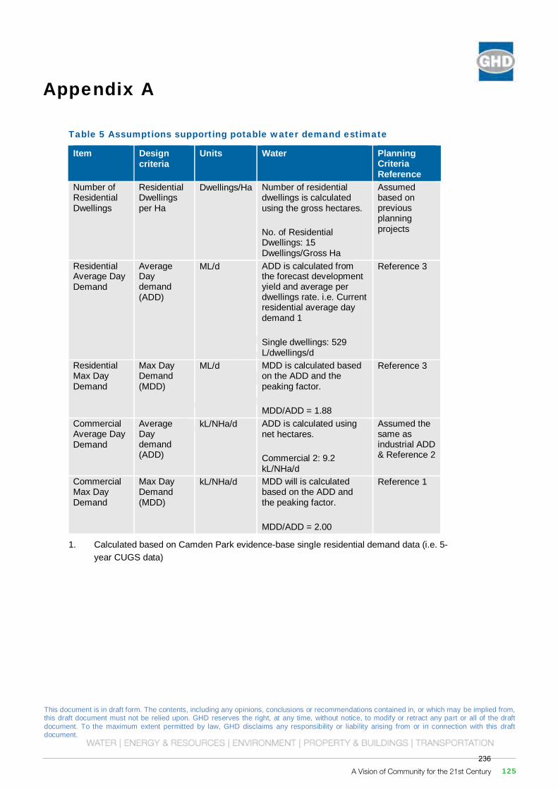
This document is in draft form. The contents, including any opinions, conclusions or recommendations contained in, or which may be implied from, this draft document must not be relied upon. GHD reserves the right, at any time, without notice, to modify or retract any part or all of the draft document. To the maximum extent permitted by law, GHD disclaims any responsibility or liability arising from or in connection with this draft document.
Governors HillWilton Priority Land Release Stage 1 Planning
Governors Hill Water and Wastewater Servicing Feasibility Report
December 2016
This document is in draft form. The contents, including any opinions, conclusions or recommendations contained in, or which may be implied from, this draft document must not be relied upon. GHD reserves the right, at any time, without notice, to modify or retract any part or all of the draft document. To the maximum extent permitted by law, GHD disclaims any responsibility or liability arising from or in connection with this draft document.
GHD | Report for Governors Hill - Wilton Priority Land Release Stage 1 Planning, 21/25722 | 25
Appendix A
Table 5 Assumptions supporting potable water demand estimate
Item Design criteria
Units Water Planning Criteria Reference
Number of Residential Dwellings
Residential Dwellings per Ha
Dwellings/Ha Number of residential dwellings is calculated using the gross hectares.
No. of Residential Dwellings: 15 Dwellings/Gross Ha
Assumed based on previous planning projects
Residential Average Day Demand
Average Day demand (ADD)
ML/d ADD is calculated from the forecast development yield and average per dwellings rate. i.e. Current residential average day demand 1
Single dwellings: 529 L/dwellings/d
Reference 3
Residential Max Day Demand
Max Day Demand (MDD)
ML/d MDD is calculated based on the ADD and the peaking factor.
MDD/ADD = 1.88
Reference 3
Commercial Average Day Demand
Average Day demand (ADD)
kL/NHa/d ADD is calculated using net hectares.
Commercial 2: 9.2 kL/NHa/d
Assumed the same as industrial ADD & Reference 2
Commercial Max Day Demand
Max Day Demand (MDD)
kL/NHa/d MDD will is calculated based on the ADD and the peaking factor.
MDD/ADD = 2.00
Reference 1
1. Calculated based on Camden Park evidence-base single residential demand data (i.e. 5-year CUGS data)
A Vision of Community for the 21st Century 125236
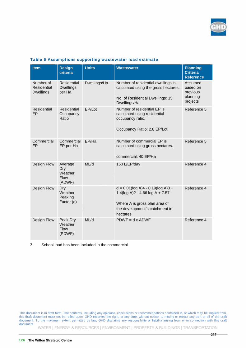
This document is in draft form. The contents, including any opinions, conclusions or recommendations contained in, or which may be implied from, this draft document must not be relied upon. GHD reserves the right, at any time, without notice, to modify or retract any part or all of the draft document. To the maximum extent permitted by law, GHD disclaims any responsibility or liability arising from or in connection with this draft document.
Governors HillWilton Priority Land Release Stage 1 Planning
Governors Hill Water and Wastewater Servicing Feasibility Report
December 2016
This document is in draft form. The contents, including any opinions, conclusions or recommendations contained in, or which may be implied from, this draft document must not be relied upon. GHD reserves the right, at any time, without notice, to modify or retract any part or all of the draft document. To the maximum extent permitted by law, GHD disclaims any responsibility or liability arising from or in connection with this draft document.
26 | GHD | Report for Governors Hill - Wilton Priority Land Release Stage 1 Planning, 21/25722
Table 6 Assumptions supporting wastewater load estimate
Item Design criteria
Units Wastewater Planning Criteria Reference
Number of Residential Dwellings
Residential Dwellings per Ha
Dwellings/Ha Number of residential dwellings is calculated using the gross hectares.
No. of Residential Dwellings: 15 Dwellings/Ha
Assumed based on previous planning projects
Residential EP
Residential Occupancy Ratio
EP/Lot Number of residential EP is calculated using residential occupancy ratio.
Occupancy Ratio: 2.8 EP/Lot
Reference 5
Commercial EP
Commercial EP per Ha
EP/Ha Number of commercial EP is calculated using gross hectares.
commercial: 40 EP/Ha
Reference 5
Design Flow Average DryWeather Flow (ADWF)
ML/d 150 L/EP/day Reference 4
Design Flow DryWeather Peaking Factor (d)
d = 0.01(log A)4 - 0.19(log A)3 + 1.4(log A)2 - 4.66 log A + 7.57
Where A is gross plan area of the development’s catchment in hectares
Reference 4
Design Flow Peak Dry Weather Flow (PDWF)
ML/d PDWF = d x ADWF Reference 4
2. School load has been included in the commercial
This document is in draft form. The contents, including any opinions, conclusions or recommendations contained in, or which may be implied from, this draft document must not be relied upon. GHD reserves the right, at any time, without notice, to modify or retract any part or all of the draft document. To the maximum extent permitted by law, GHD disclaims any responsibility or liability arising from or in connection with this draft document.
GHD
133 Castlereagh St Sydney NSW 2000 -T: +61 2 9239 7100 F: +61 2 9239 7199 E: [email protected]
© GHD 2016
This document is and shall remain the property of GHD. The document may only be used for the purpose for which it was commissioned and in accordance with the Terms of Engagement for the commission. Unauthorised use of this document in any form whatsoever is prohibited. G:\21\25722\WP\20160812 - Governers Hill Servicing Feasibility Report - 217242.docx
Document Status
Revision Author Reviewer Approved for Issue Name Signature Name Signature Date
A A Peaston M Healey On File M Healey On File 28/09/2016
B A Peaston M Healey M Healey 02/12/2016
The Wilton Strategic Centre 126237
This document is in draft form. The contents, including any opinions, conclusions or recommendations contained in, or which may be implied from, this draft document must not be relied upon. GHD reserves the right, at any time, without notice, to modify or retract any part or all of the draft document. To the maximum extent permitted by law, GHD disclaims any responsibility or liability arising from or in connection with this draft document.
Governors HillWilton Priority Land Release Stage 1 Planning
Governors Hill Water and Wastewater Servicing Feasibility Report
December 2016This document is in draft form. The contents, including any opinions, conclusions or recommendations contained in, or which may be implied from, this draft document must not be relied upon. GHD reserves the right, at any time, without notice, to modify or retract any part or all of the draft document. To the maximum extent permitted by law, GHD disclaims any responsibility or liability arising from or in connection with this draft document.
GHD
133 Castlereagh St Sydney NSW 2000 -T: +61 2 9239 7100 F: +61 2 9239 7199 E: [email protected]
© GHD 2016
This document is and shall remain the property of GHD. The document may only be used for the purpose for which it was commissioned and in accordance with the Terms of Engagement for the commission. Unauthorised use of this document in any form whatsoever is prohibited. G:\21\25722\WP\20160812 - Governers Hill Servicing Feasibility Report - 217242.docx
Document Status
Revision Author Reviewer Approved for Issue Name Signature Name Signature Date
A A Peaston M Healey On File M Healey On File 28/09/2016
B A Peaston M Healey M Healey 02/12/2016
A Vision of Community for the 21st Century 127238

239
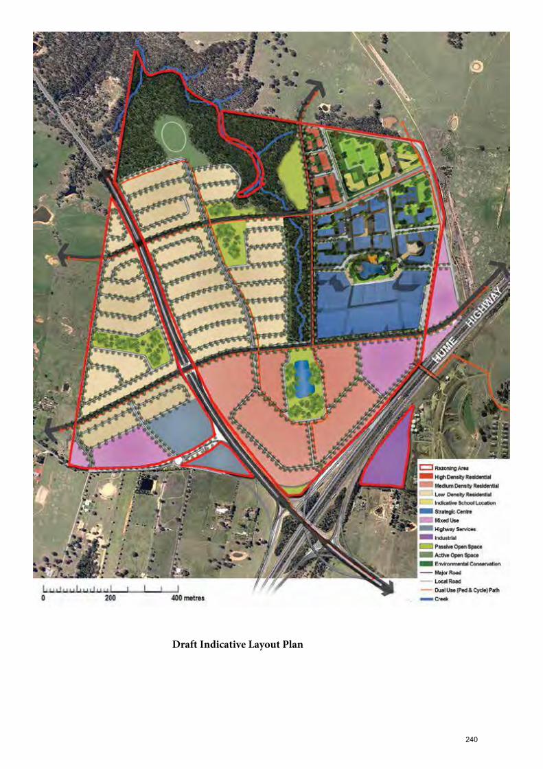
Draft Indicative Layout Plan
240
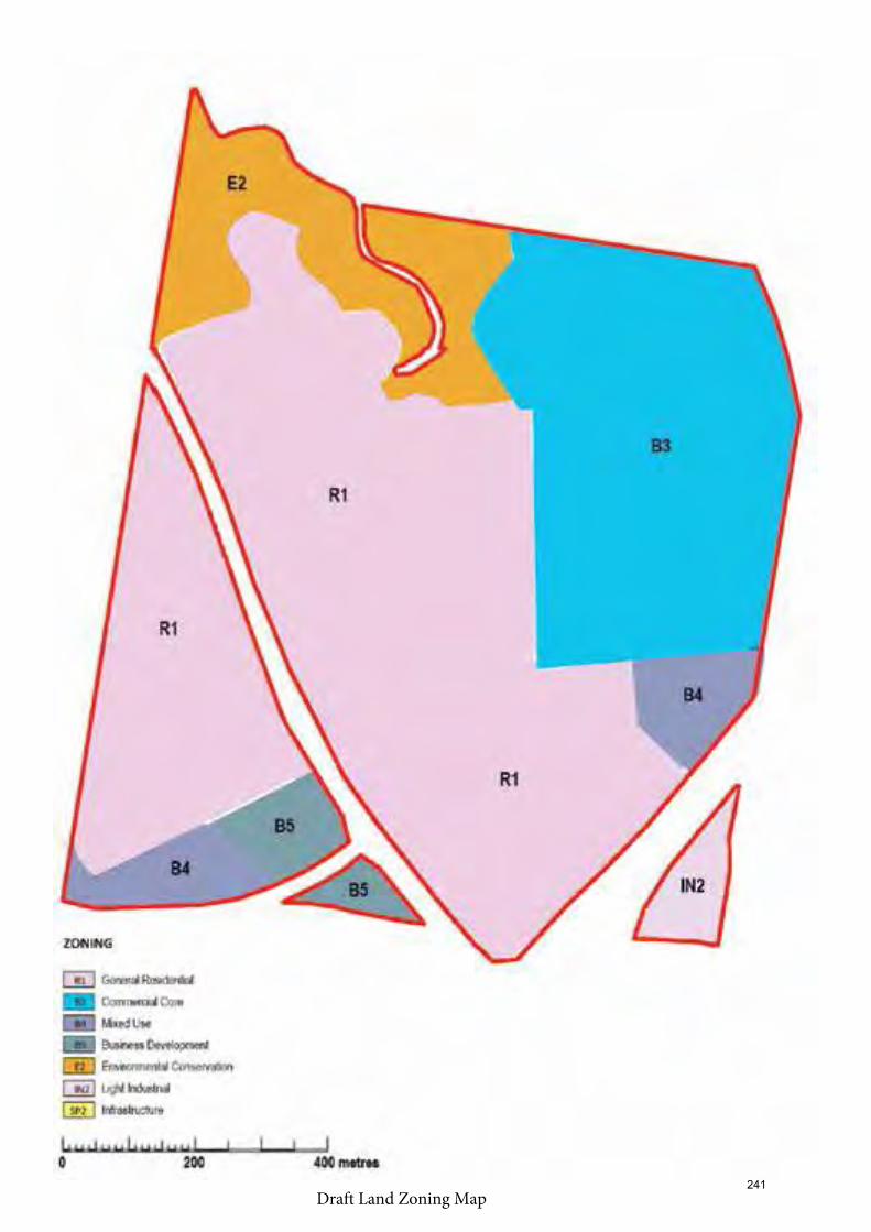
Draft Land Zoning Map241
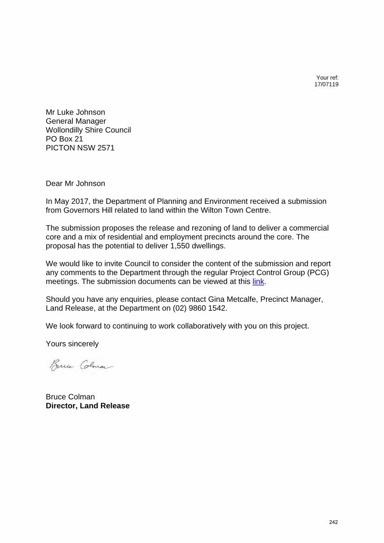
Your ref:
17/07119
Mr Luke Johnson General Manager Wollondilly Shire Council PO Box 21 PICTON NSW 2571 Dear Mr Johnson In May 2017, the Department of Planning and Environment received a submission from Governors Hill related to land within the Wilton Town Centre. The submission proposes the release and rezoning of land to deliver a commercial core and a mix of residential and employment precincts around the core. The proposal has the potential to deliver 1,550 dwellings. We would like to invite Council to consider the content of the submission and report any comments to the Department through the regular Project Control Group (PCG) meetings. The submission documents can be viewed at this link. Should you have any enquiries, please contact Gina Metcalfe, Precinct Manager, Land Release, at the Department on (02) 9860 1542. We look forward to continuing to work collaboratively with you on this project. Yours sincerely
Bruce Colman Director, Land Release
242
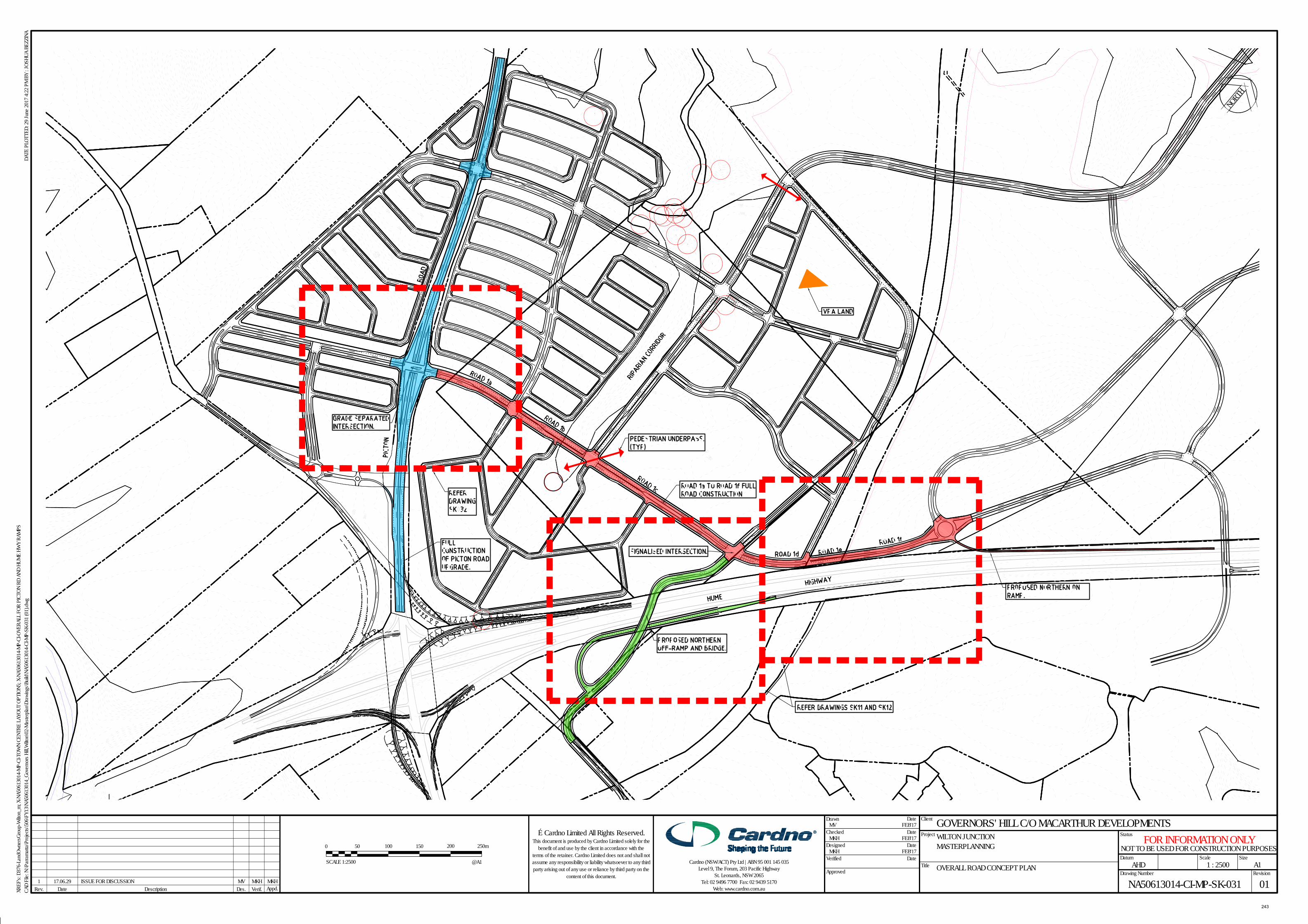
DateRev. Verif. Appd.
Scale
Status
Client
XREF
's: D
376-
Land
Owne
rsGro
up-W
ilton_
m; X
-NA5
0613
014-
MP-C
I-TOW
N CE
NTRE
LAYO
UT O
PTIO
N5; X
-NA5
0613
014-
MP-C
I-OVE
RALL
FOR
PIC
TON
RD A
ND H
UME
HWY
RAMP
S
Drawing Number Revision
DATE
PLO
TTED
: 29 J
une 2
017 4
:22 P
M BY
: JOS
HUA
BEZZ
INA
Des.
Size
Project
Title
Drawn Date
Checked
Date
Date
DateVerified
Approved
Description
A1
CAD
File:
N:\P
arra
matta
\Pro
jects\
506\F
Y13\N
A506
1301
4_Go
vern
ors H
ill,W
ilton\0
2-Ma
sterp
lan\D
rawi
ngs\B
uild\N
A506
1301
4-CI
-MP-
SK-0
31 (0
1).dw
g
GOVERNORS' HILL C/O MACARTHUR DEVELOPMENTSWILTON JUNCTION MASTERPLANNING
OVERALL ROAD CONCEPT PLANDatum
AHD 1 : 2500
NA50613014-CI-MP-SK-031 01
MV FEB'17
MKH FEB'17
MKH FEB'17Designed
© Cardno Limited All Rights Reserved.This document is produced by Cardno Limited solely for the
benefit of and use by the client in accordance with theterms of the retainer. Cardno Limited does not and shall notassume any responsibility or liability whatsoever to any thirdparty arising out of any use or reliance by third party on the
content of this document.
Cardno (NSW/ACT) Pty Ltd | ABN 95 001 145 035Level 9, The Forum, 203 Pacific Highway
St. Leonards, NSW 2065Tel: 02 9496 7700 Fax: 02 9439 5170
Web: www.cardno.com.au1 17.06.29 ISSUE FOR DISCUSSION MV MKH MKH
NOT TO BE USED FOR CONSTRUCTION PURPOSESFOR INFORMATION ONLY
0 50 200
SCALE 1:2500
100 150 250m
@A1
NORTH
243
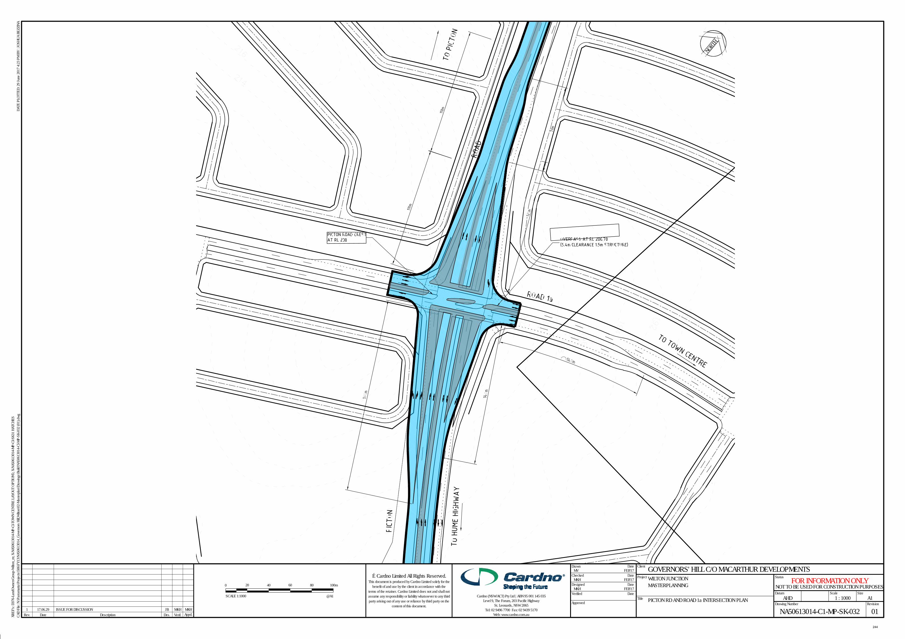
DateRev. Verif. Appd.
Scale
Status
Client
XREF
's: D
376-
Land
Owne
rsGro
up-W
ilton_
m; X
-NA5
0613
014-
MP-C
I-TOW
N CE
NTRE
LAYO
UT O
PTIO
N5; X
-NA5
0613
014-
MP-C
I-SK3
1 HAT
CHES
Drawing Number Revision
DATE
PLO
TTED
: 29 J
une 2
017 4
:23 P
M BY
: JOS
HUA
BEZZ
INA
Des.
Size
Project
Title
Drawn Date
Checked
Date
Date
DateVerified
Approved
Description
A1
CAD
File:
N:\P
arra
matta
\Pro
jects\
506\F
Y13\N
A506
1301
4_Go
vern
ors H
ill,W
ilton\0
2-Ma
sterp
lan\D
rawi
ngs\B
uild\N
A506
1301
4-CI
-MP-
SK-0
32 (0
1).dw
g
GOVERNORS' HILL C/O MACARTHUR DEVELOPMENTSWILTON JUNCTION MASTERPLANNING
PICTON RD AND ROAD 1a INTERSECTION PLANDatum
AHD 1 : 1000
NA50613014-C1-MP-SK-032 01
MV FEB'17
MKH FEB'17
MKH FEB'17Designed
© Cardno Limited All Rights Reserved.This document is produced by Cardno Limited solely for the
benefit of and use by the client in accordance with theterms of the retainer. Cardno Limited does not and shall notassume any responsibility or liability whatsoever to any thirdparty arising out of any use or reliance by third party on the
content of this document.
Cardno (NSW/ACT) Pty Ltd | ABN 95 001 145 035Level 9, The Forum, 203 Pacific Highway
St. Leonards, NSW 2065Tel: 02 9496 7700 Fax: 02 9439 5170
Web: www.cardno.com.au1 17.06.29 ISSUE FOR DISCUSSION JB MKH MKH
NOT TO BE USED FOR CONSTRUCTION PURPOSESFOR INFORMATION ONLY
0 4020
SCALE 1:1000
60 80 100m
@A1
NORTH
244
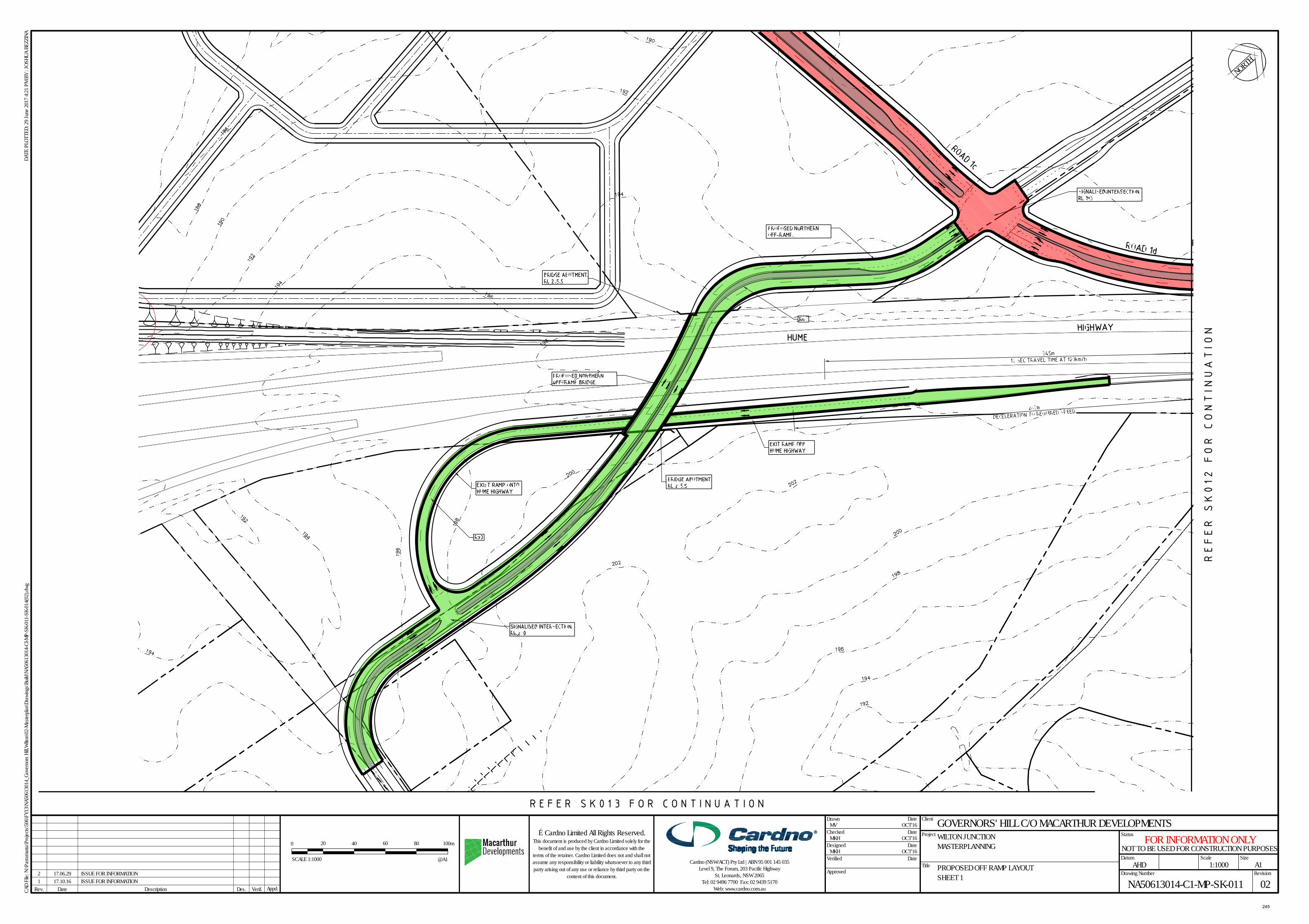
GOVERNORS' HILL C/O MACARTHUR DEVELOPMENTSWILTON JUNCTIONMASTERPLANNING
PROPOSED OFF RAMP LAYOUTSHEET 1
DatumAHD 1:1000
NA50613014-C1-MP-SK-011 02
MV OCT'16
MKH OCT'16
MKH OCT'16Designed
1 17.10.16 ISSUE FOR INFORMATION2 17.06.29 ISSUE FOR INFORMATION
NOT TO BE USED FOR CONSTRUCTION PURPOSESFOR INFORMATION ONLY
NORTH
Size
Project
Title
Drawn Date
Checked
Date
Date
DateVerified
Approved
DateRev. Verif. Appd.
Scale
Status
Client
Drawing Number Revision
DATE
PLO
TTED
: 29 J
une 2
017 4
:21 P
M BY
: JOS
HUA
BEZZ
INA
Des.Description
A1
CAD
File:
N:\P
arra
matta
\Pro
jects\
506\F
Y13\N
A506
1301
4_Go
vern
ors H
ill,W
ilton\0
2-Ma
sterp
lan\D
rawi
ngs\B
uild\N
A506
1301
4-CI
-MP-
SK-0
11-S
K-01
4(02
).dwg
© Cardno Limited All Rights Reserved.This document is produced by Cardno Limited solely for the
benefit of and use by the client in accordance with theterms of the retainer. Cardno Limited does not and shall notassume any responsibility or liability whatsoever to any thirdparty arising out of any use or reliance by third party on the
content of this document.
Cardno (NSW/ACT) Pty Ltd | ABN 95 001 145 035Level 9, The Forum, 203 Pacific Highway
St. Leonards, NSW 2065Tel: 02 9496 7700 Fax: 02 9439 5170
Web: www.cardno.com.au
0 4020
SCALE 1:1000
60 80 100m
@A1
245
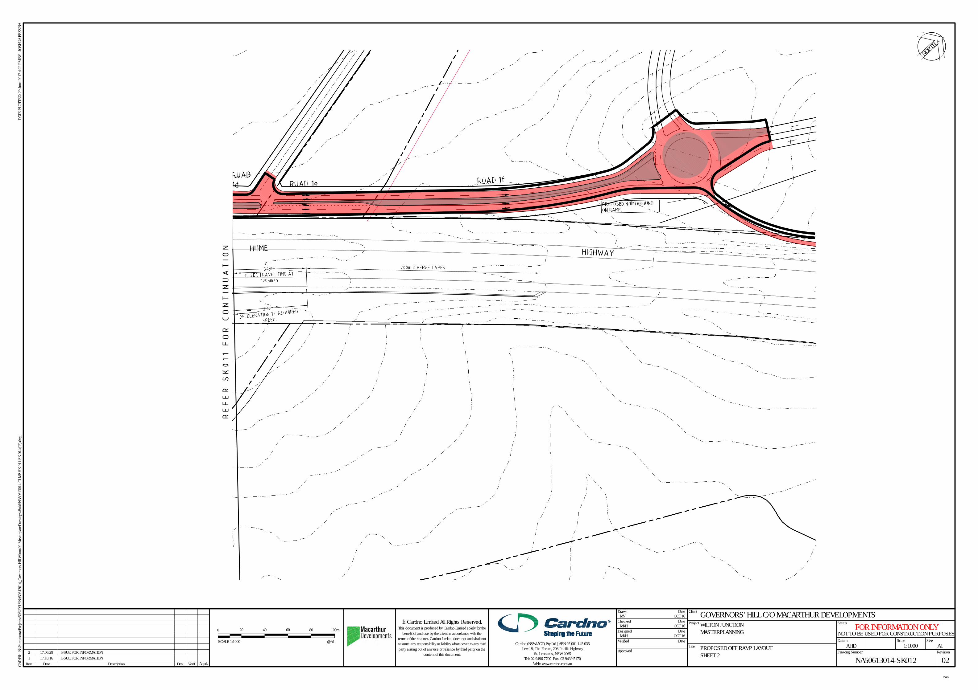
GOVERNORS' HILL C/O MACARTHUR DEVELOPMENTSWILTON JUNCTIONMASTERPLANNING
PROPOSED OFF RAMP LAYOUTSHEET 2
DatumAHD 1:1000
NA50613014-SK012 02
MV OCT'16
MKH OCT'16
MKH OCT'16Designed NOT TO BE USED FOR CONSTRUCTION PURPOSES
FOR INFORMATION ONLY
NORTH
Size
Project
Title
Drawn Date
Checked
Date
Date
DateVerified
Approved
DateRev. Verif. Appd.
Scale
Status
Client
Drawing Number Revision
DATE
PLO
TTED
: 29 J
une 2
017 4
:22 P
M BY
: JOS
HUA
BEZZ
INA
Des.Description
A1
CAD
File:
N:\P
arra
matta
\Pro
jects\
506\F
Y13\N
A506
1301
4_Go
vern
ors H
ill,W
ilton\0
2-Ma
sterp
lan\D
rawi
ngs\B
uild\N
A506
1301
4-CI
-MP-
SK-0
11-S
K-01
4(02
).dwg
© Cardno Limited All Rights Reserved.This document is produced by Cardno Limited solely for the
benefit of and use by the client in accordance with theterms of the retainer. Cardno Limited does not and shall notassume any responsibility or liability whatsoever to any thirdparty arising out of any use or reliance by third party on the
content of this document.
Cardno (NSW/ACT) Pty Ltd | ABN 95 001 145 035Level 9, The Forum, 203 Pacific Highway
St. Leonards, NSW 2065Tel: 02 9496 7700 Fax: 02 9439 5170
Web: www.cardno.com.au
0 4020
SCALE 1:1000
60 80 100m
@A1
1 17.10.16 ISSUE FOR INFORMATION2 17.06.29 ISSUE FOR INFORMATION
246
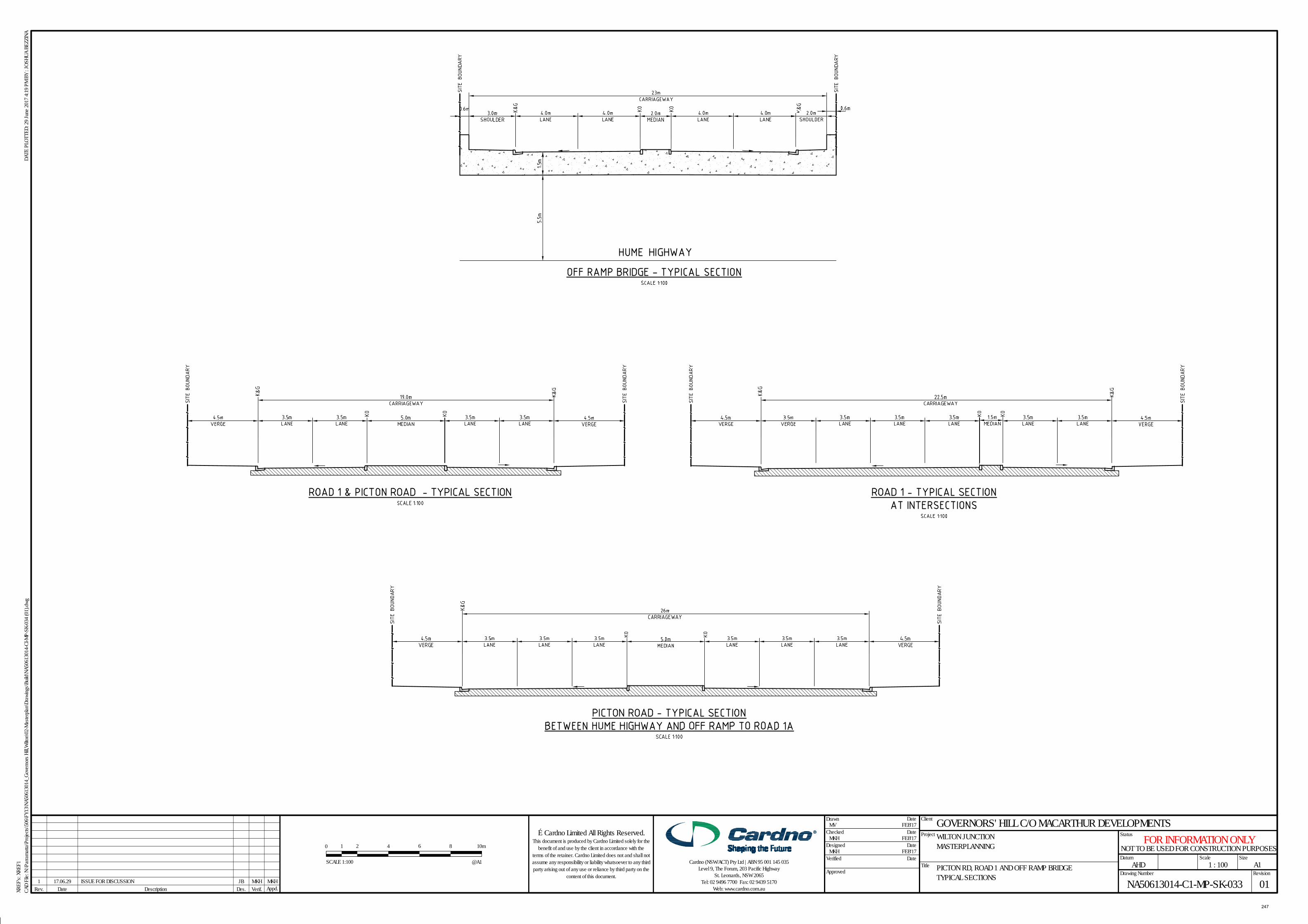
DateRev. Verif. Appd.
Scale
Status
Client
XREF
's: X
REF1
Drawing Number Revision
DATE
PLO
TTED
: 29 J
une 2
017 4
:19 P
M BY
: JOS
HUA
BEZZ
INA
Des.
Size
Project
Title
Drawn Date
Checked
Date
Date
DateVerified
Approved
Description
A1
CAD
File:
N:\P
arra
matta
\Pro
jects\
506\F
Y13\N
A506
1301
4_Go
vern
ors H
ill,W
ilton\0
2-Ma
sterp
lan\D
rawi
ngs\B
uild\N
A506
1301
4-CI
-MP-
SK-0
34 (0
1).dw
g
GOVERNORS' HILL C/O MACARTHUR DEVELOPMENTSWILTON JUNCTION MASTERPLANNING
PICTON RD, ROAD 1 AND OFF RAMP BRIDGETYPICAL SECTIONS
DatumAHD 1 : 100
NA50613014-C1-MP-SK-033 01
MV FEB'17
MKH FEB'17
MKH FEB'17Designed
© Cardno Limited All Rights Reserved.This document is produced by Cardno Limited solely for the
benefit of and use by the client in accordance with theterms of the retainer. Cardno Limited does not and shall notassume any responsibility or liability whatsoever to any thirdparty arising out of any use or reliance by third party on the
content of this document.
Cardno (NSW/ACT) Pty Ltd | ABN 95 001 145 035Level 9, The Forum, 203 Pacific Highway
St. Leonards, NSW 2065Tel: 02 9496 7700 Fax: 02 9439 5170
Web: www.cardno.com.au1 17.06.29 ISSUE FOR DISCUSSION JB MKH MKH
NOT TO BE USED FOR CONSTRUCTION PURPOSESFOR INFORMATION ONLY
0 1 2
SCALE 1:100
4 6 8 10m
@A1
247
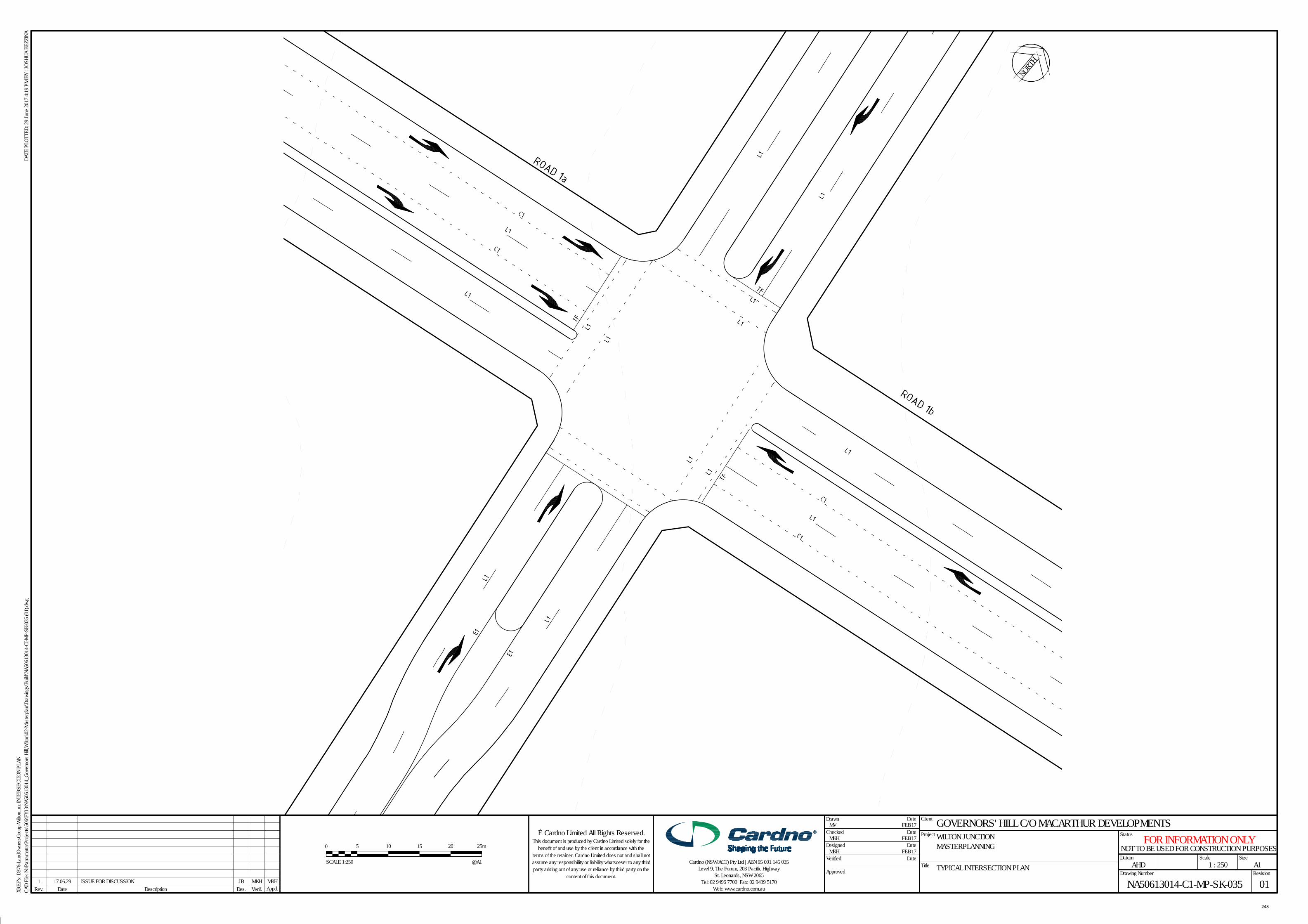
DateRev. Verif. Appd.
Scale
Status
Client
XREF
's: D
376-
Land
Owne
rsGro
up-W
ilton_
m; IN
TERS
ECTI
ON P
LAN
Drawing Number Revision
DATE
PLO
TTED
: 29 J
une 2
017 4
:19 P
M BY
: JOS
HUA
BEZZ
INA
Des.
Size
Project
Title
Drawn Date
Checked
Date
Date
DateVerified
Approved
Description
A1
CAD
File:
N:\P
arra
matta
\Pro
jects\
506\F
Y13\N
A506
1301
4_Go
vern
ors H
ill,W
ilton\0
2-Ma
sterp
lan\D
rawi
ngs\B
uild\N
A506
1301
4-CI
-MP-
SK-0
35 (0
1).dw
g
GOVERNORS' HILL C/O MACARTHUR DEVELOPMENTSWILTON JUNCTION MASTERPLANNING
TYPICAL INTERSECTION PLANDatum
AHD 1 : 250
NA50613014-C1-MP-SK-035 01
MV FEB'17
MKH FEB'17
MKH FEB'17Designed
© Cardno Limited All Rights Reserved.This document is produced by Cardno Limited solely for the
benefit of and use by the client in accordance with theterms of the retainer. Cardno Limited does not and shall notassume any responsibility or liability whatsoever to any thirdparty arising out of any use or reliance by third party on the
content of this document.
Cardno (NSW/ACT) Pty Ltd | ABN 95 001 145 035Level 9, The Forum, 203 Pacific Highway
St. Leonards, NSW 2065Tel: 02 9496 7700 Fax: 02 9439 5170
Web: www.cardno.com.au1 17.06.29 ISSUE FOR DISCUSSION JB MKH MKH
NOT TO BE USED FOR CONSTRUCTION PURPOSESFOR INFORMATION ONLY
0 15105
SCALE 1:250
20 25m
@A1
NORTH
248
PE6 Attachments 1. Report to Ordinary Meeting of Council 20 March 20172. Proposed Wollondilly DCP amendment for Volume 33. Proposed Wollondilly DCP amendment for Volume 44. Appin mail box drop for notification
Monday 21 August 2017
PE6 – Macquariedale Road Development Control Plan Amendment
249
WOLLONDILLY SHIRE COUNCIL Report of Planning and Economy to the Ordinary Meeting of Council held on Monday 20 March 2017
PE1 - Draft Planning Agreement for Macquariedale Rd South Appin
Plan
ning
& E
cono
my
PLANNING AND ECONOMY PE1 Draft Planning Agreement for Macquariedale Road, South Appin
263081 TRIM 4985-1 EXECUTIVE SUMMARY
This report advises Council about a revised Draft Voluntary Planning Agreement prepared for Macquariedale Rd Planning Proposal.
The Draft Planning Agreement is associated with a planning proposal to allow the development of the site for approximately 215 dwellings. It is substantially different to an earlier draft Planning Agreement and Planning Proposal for this land which was exhibited in August 2014.
In particular the scale of development allowable under the planning proposal has been reduced from 250 to approximately 215 dwellings. However the benefits to the community under the revised Planning Agreement have increased from about $5.5 million to approximately $9.55 million.
The report also discusses other outstanding matters in relation to the Planning proposal following the report to Council’s on 18 April 2016.
This report recommends that the Council agree to the following: Public exhibition of the revised Draft Planning Agreement
concurrently with the Planning Proposal, Biocertification Application and other relevant documentation when these are ready for exhibition;
A community engagement plan be prepared for the exhibition exercise;
Consider a further report following the completion of the public exhibition period.
REPORT
BACKGROUND At its meeting on 18 April 2016 Council considered a report that provided an update on a Draft Planning Proposal and associated Draft Planning Agreement for land at Macquariedale Road, Appin. These were both exhibited in 2014, but further consideration of these matters at the time was deferred following announcements by the State Government of their investigations into the Greater Macarthur Investigation Area.
250
WOLLONDILLY SHIRE COUNCIL Report of Planning and Economy to the Ordinary Meeting of Council held on Monday 20 March 2017
PE1 - Draft Planning Agreement for Macquariedale Rd South Appin
Plan
ning
& E
cono
my
At the April 2016 meeting, Council made the following resolution in relation to the Draft Planning Agreement:
“If a formal letter of offer is made by the proponent to amend the draft planning agreement that this be considered by staff in accordance with the Planning Agreements Policy and further advice provided to Council. If following this process the draft planning proposal (sic) is acceptable to Council it should be exhibited at the same time as the amended planning proposal” (Council minute 53/2016).
The Letter of Offer foreshadowed by this resolution has now been submitted by Walker Corporation and is attached. Also attached is a Draft Planning Agreement that has been prepared and which is consistent with the offer. THE REVISED DRAFT VOLUNTARY PLANNING AGREEMENT The revised Draft Voluntary Planning Agreement is significantly different to the version that was exhibited in 2014. The Proponent has advised that they have amended the Draft Agreement to address feedback received from the community to the first exhibition held in 2014. Walkers also requested some amendments to the planning proposal, with the most significant being a reduction in the lot yield from 250 to approximately 215 lots. The minimum lot size has also been increased so that at least 70% of lots will not be less than 700 sq metres, and dual occupancies are to be prohibited. The revised Draft Agreement proposes total benefits of over $9.55 million (equating to approximately $44,250 per lot) as against $5.5 million offered through the exhibited Draft Agreement. The Table below summarises the benefits to be provided under the revised Draft Agreement and compares it against what had been proposed under the exhibited Draft Agreement.
Category Amount Under
Revised Draft VPA
Amount under Exhibited Draft VPA
Comments
Cycleways (3 separate stages, providing to connections to existing cycle ways)
$700,000 $700,000
Undergrounding of power lines in Appin Rd and Macquariedale Rd
$1,400,000 See column four
The revised VPA includes this item separately. Under the exhibited VPA, it was included within the Appin Road Improvements.
251
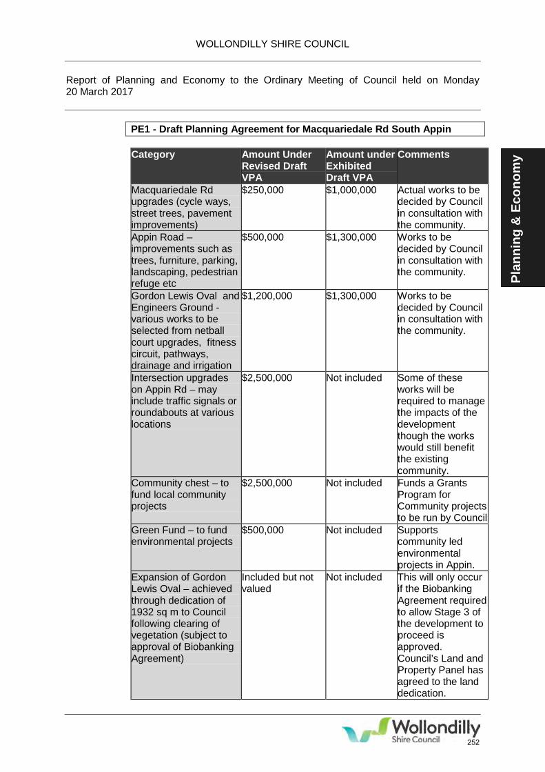
WOLLONDILLY SHIRE COUNCIL Report of Planning and Economy to the Ordinary Meeting of Council held on Monday 20 March 2017
PE1 - Draft Planning Agreement for Macquariedale Rd South Appin
Plan
ning
& E
cono
my Category Amount Under
Revised Draft VPA
Amount under Exhibited Draft VPA
Comments
Macquariedale Rd upgrades (cycle ways, street trees, pavement improvements)
$250,000 $1,000,000 Actual works to be decided by Council in consultation with the community.
Appin Road – improvements such as trees, furniture, parking, landscaping, pedestrian refuge etc
$500,000 $1,300,000 Works to be decided by Council in consultation with the community.
Gordon Lewis Oval and Engineers Ground -various works to be selected from netball court upgrades, fitness circuit, pathways, drainage and irrigation
$1,200,000 $1,300,000 Works to be decided by Council in consultation with the community.
Intersection upgrades on Appin Rd – may include traffic signals or roundabouts at various locations
$2,500,000 Not included Some of these works will be required to manage the impacts of the development though the works would still benefit the existing community.
Community chest – to fund local community projects
$2,500,000 Not included Funds a Grants Program for Community projects to be run by Council
Green Fund – to fund environmental projects
$500,000 Not included Supports community led environmental projects in Appin.
Expansion of Gordon Lewis Oval – achieved through dedication of 1932 sq m to Council following clearing of vegetation (subject to approval of Biobanking Agreement)
Included but not valued
Not included This will only occur if the Biobanking Agreement required to allow Stage 3 of the development to proceed is approved. Council’s Land and Property Panel has agreed to the land dedication.
252
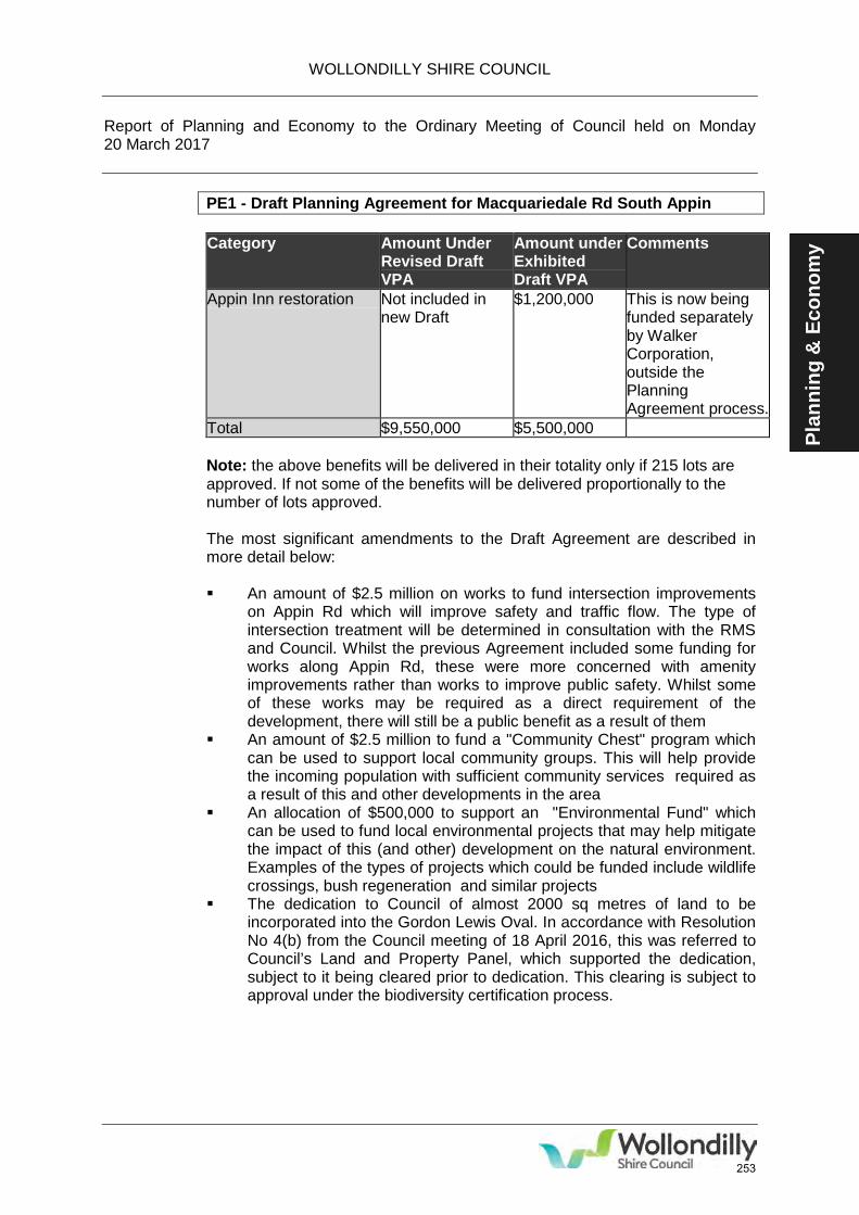
WOLLONDILLY SHIRE COUNCIL Report of Planning and Economy to the Ordinary Meeting of Council held on Monday 20 March 2017
PE1 - Draft Planning Agreement for Macquariedale Rd South Appin
Plan
ning
& E
cono
my Category Amount Under
Revised Draft VPA
Amount under Exhibited Draft VPA
Comments
Appin Inn restoration Not included in new Draft
$1,200,000 This is now being funded separately by Walker Corporation, outside the Planning Agreement process.
Total $9,550,000 $5,500,000 Note: the above benefits will be delivered in their totality only if 215 lots are approved. If not some of the benefits will be delivered proportionally to the number of lots approved. The most significant amendments to the Draft Agreement are described in more detail below:
An amount of $2.5 million on works to fund intersection improvements
on Appin Rd which will improve safety and traffic flow. The type of intersection treatment will be determined in consultation with the RMS and Council. Whilst the previous Agreement included some funding for works along Appin Rd, these were more concerned with amenity improvements rather than works to improve public safety. Whilst some of these works may be required as a direct requirement of the development, there will still be a public benefit as a result of them
An amount of $2.5 million to fund a "Community Chest" program which can be used to support local community groups. This will help provide the incoming population with sufficient community services required as a result of this and other developments in the area
An allocation of $500,000 to support an "Environmental Fund" which can be used to fund local environmental projects that may help mitigate the impact of this (and other) development on the natural environment. Examples of the types of projects which could be funded include wildlife crossings, bush regeneration and similar projects
The dedication to Council of almost 2000 sq metres of land to be incorporated into the Gordon Lewis Oval. In accordance with Resolution No 4(b) from the Council meeting of 18 April 2016, this was referred to Council’s Land and Property Panel, which supported the dedication, subject to it being cleared prior to dedication. This clearing is subject to approval under the biodiversity certification process.
253
WOLLONDILLY SHIRE COUNCIL Report of Planning and Economy to the Ordinary Meeting of Council held on Monday 20 March 2017
PE1 - Draft Planning Agreement for Macquariedale Rd South Appin
Plan
ning
& E
cono
my
Most of the benefits identified in the above table will be delivered as works by the proponent, with the timing of delivery specified in the Agreement and matching the completion of various stages of the development proposal. There is some flexibility as to the specific works that are to be delivered, allowing Council and the community to consider what specific facilities in a particular category they prefer. The Draft Agreement also provides for money from one category to be transferred to another in cases where the cost of delivering the benefits in one category falls short of the estimated value. In summary, the benefits proposed under the revised Draft Planning Agreement represent a generous offer and will deliver significant benefits to the Appin community. The applicant could have elected to pay only the Section 94 contribution of about $20,000 per lot (totalling approximately $4.3 million), but has offered instead to enter into a Planning Agreement to ensure that the development is provided with adequate infrastructure and services, and to help to address the community concerns about the development expressed through the previous exhibition. The value of the contribution is more than double what would be received under the Section 94 contributions. It is recommended that Council agree to the re-exhibition of the Draft Planning Agreement concurrently with the revised Planning Proposal and the Biocertification application as well as other relevant documentation. PLANNING AGREEMENTS POLICY Council's Planning Agreements Policy only applies to Draft Planning Agreements that have not been exhibited at the date of adoption of the Policy. As this Draft Planning Agreement has already been exhibited and this is a re-exhibition, Council's Planning Agreements Policy does not strictly apply. However the Council resolution from 18 April 2016 quoted at the start of the report requested that any revised letter be considered against the Policy, As a result, a consideration of the Draft Agreement against the Checklist included in the Policy has been undertaken and is attached. In summary this consideration has found the Draft Agreement to be consistent with the Policy. SUMMARY OF PREVIOUS COMMUNITY CONSULTATION It is relevant to note that the previous draft Planning Agreement and Planning Proposal attracted significant community opposition when placed on exhibition. Concerns were raised about a range of matters, particularly the following:
254
WOLLONDILLY SHIRE COUNCIL Report of Planning and Economy to the Ordinary Meeting of Council held on Monday 20 March 2017
PE1 - Draft Planning Agreement for Macquariedale Rd South Appin
Plan
ning
& E
cono
my
the number of small lots - this has been addressed by an amendment to the planning proposal so that 70% of the lots are of at least 700 sq metres
the impact on Gordon Lewis Oval; - this has been addressed by removing the Appin Bypass from the planning proposal, which was thought by the community to be the main likely culprit for any future impacts to Gordon Lewis Oval. As mentioned above, the Draft Agreement also provides for the addition of almost 2000 sq metres to the Oval which should further safeguard and improve its amenity
Impacts on the environment - this has been addressed by the inclusion in the Draft Planning Agreement of a Green Fund worth $500,000 to help fund projects to help mitigate the impacts of development on the natural environment
improve infrastructure (water and roads) - the VPA includes a significant amount to improve intersection performance and safety along Appin Road, subject to the approval of RMS. Walkers have undertaken investigations with Sydney Water that verified that some locations have water pressure issues. The augmentation of the water supply system is an issue to be dealt with at Development Application stage. Clearance (i.e. Section 73 Certificate) from Sydney Water for development to proceed will not be issued until agreement is reached regarding infrastructure improvements
Restoration of the Appin Inn - There were concerns about this item being included in the earlier Draft Planning Agreement and a Section 94 offset allowed. Walkers has agreed to restore the Inn outside the Planning Agreement process and has commenced an archaeological survey of the site.
If Council agrees to the exhibition of the revised Draft Agreement this will provide further opportunity for public comment about the revised proposal and will allow Council to gauge whether the revised proposal has addressed the community's concerns about these matters. UPDATE ON PREVIOUS COUNCIL RESOLUTION Council made several other resolutions at its meeting of April 2016 regarding the Macquariedale Rd Planning Proposal. An update is provided below outlining what actions have been taken in relation to these resolutions:
255
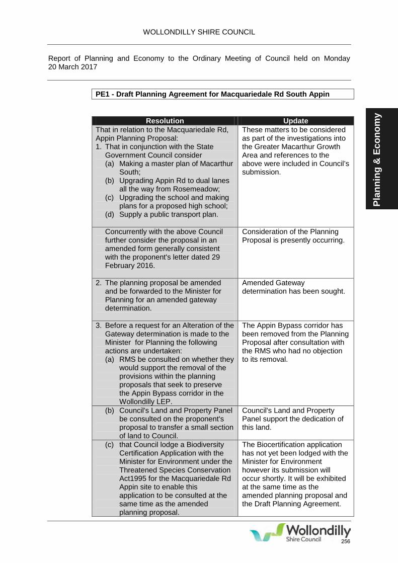
WOLLONDILLY SHIRE COUNCIL Report of Planning and Economy to the Ordinary Meeting of Council held on Monday 20 March 2017
PE1 - Draft Planning Agreement for Macquariedale Rd South Appin
Plan
ning
& E
cono
my
Resolution Update That in relation to the Macquariedale Rd, Appin Planning Proposal: 1. That in conjunction with the State
Government Council consider (a) Making a master plan of Macarthur
South; (b) Upgrading Appin Rd to dual lanes
all the way from Rosemeadow; (c) Upgrading the school and making
plans for a proposed high school; (d) Supply a public transport plan.
These matters to be considered as part of the investigations into the Greater Macarthur Growth Area and references to the above were included in Council’s submission.
Concurrently with the above Council further consider the proposal in an amended form generally consistent with the proponent's letter dated 29 February 2016.
Consideration of the Planning Proposal is presently occurring.
2. The planning proposal be amended and be forwarded to the Minister for Planning for an amended gateway determination.
Amended Gateway determination has been sought.
3. Before a request for an Alteration of the Gateway determination is made to the Minister for Planning the following actions are undertaken: (a) RMS be consulted on whether they
would support the removal of the provisions within the planning proposals that seek to preserve the Appin Bypass corridor in the Wollondilly LEP.
The Appin Bypass corridor has been removed from the Planning Proposal after consultation with the RMS who had no objection to its removal.
(b) Council's Land and Property Panel be consulted on the proponent's proposal to transfer a small section of land to Council.
Council's Land and Property Panel support the dedication of this land.
(c) that Council lodge a Biodiversity Certification Application with the Minister for Environment under the Threatened Species Conservation Act1995 for the Macquariedale Rd Appin site to enable this application to be consulted at the same time as the amended planning proposal.
The Biocertification application has not yet been lodged with the Minister for Environment however its submission will occur shortly. It will be exhibited at the same time as the amended planning proposal and the Draft Planning Agreement.
256
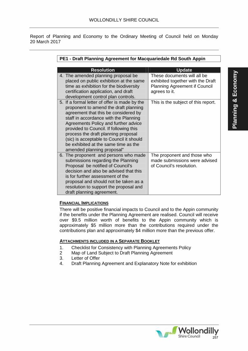
WOLLONDILLY SHIRE COUNCIL Report of Planning and Economy to the Ordinary Meeting of Council held on Monday 20 March 2017
PE1 - Draft Planning Agreement for Macquariedale Rd South Appin
Plan
ning
& E
cono
my Resolution Update
4. The amended planning proposal be placed on public exhibition at the same time as exhibition for the biodiversity certification application, and draft development control plan controls.
These documents will all be exhibited together with the Draft Planning Agreement if Council agrees to it.
5. If a formal letter of offer is made by the proponent to amend the draft planning agreement that this be considered by staff in accordance with the Planning Agreements Policy and further advice provided to Council. If following this process the draft planning proposal (sic) is acceptable to Council it should be exhibited at the same time as the amended planning proposal”
This is the subject of this report.
6. The proponent and persons who made submissions regarding the Planning Proposal be notified of Council's decision and also be advised that this is for further assessment of the proposal and should not be taken as a resolution to support the proposal and draft planning agreement.
The proponent and those who made submissions were advised of Council’s resolution.
FINANCIAL IMPLICATIONS There will be positive financial impacts to Council and to the Appin community if the benefits under the Planning Agreement are realised. Council will receive over $9.5 million worth of benefits to the Appin community which is approximately $5 million more than the contributions required under the contributions plan and approximately $4 million more than the previous offer. ATTACHMENTS INCLUDED IN A SEPARATE BOOKLET 1. Checklist for Consistency with Planning Agreements Policy 2 Map of Land Subject to Draft Planning Agreement 3. Letter of Offer 4. Draft Planning Agreement and Explanatory Note for exhibition
257
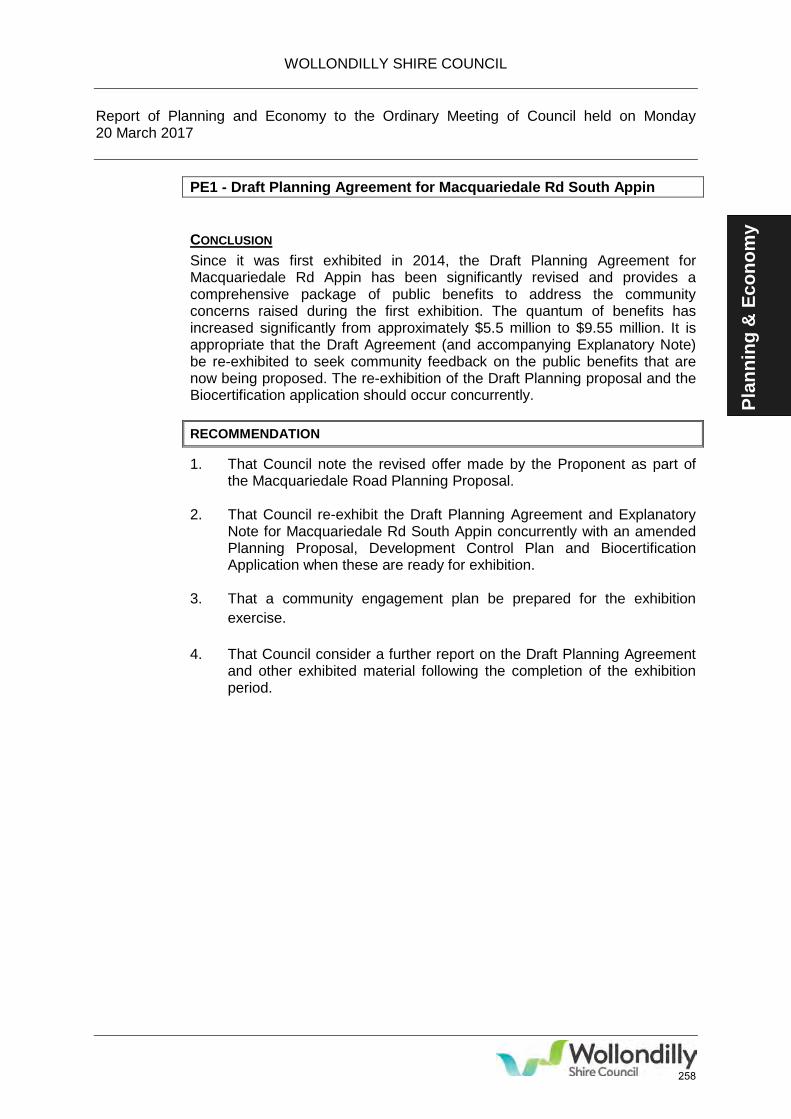
WOLLONDILLY SHIRE COUNCIL Report of Planning and Economy to the Ordinary Meeting of Council held on Monday 20 March 2017
PE1 - Draft Planning Agreement for Macquariedale Rd South Appin
Plan
ning
& E
cono
my
CONCLUSION Since it was first exhibited in 2014, the Draft Planning Agreement for Macquariedale Rd Appin has been significantly revised and provides a comprehensive package of public benefits to address the community concerns raised during the first exhibition. The quantum of benefits has increased significantly from approximately $5.5 million to $9.55 million. It is appropriate that the Draft Agreement (and accompanying Explanatory Note) be re-exhibited to seek community feedback on the public benefits that are now being proposed. The re-exhibition of the Draft Planning proposal and the Biocertification application should occur concurrently. RECOMMENDATION
1. That Council note the revised offer made by the Proponent as part of the Macquariedale Road Planning Proposal.
2. That Council re-exhibit the Draft Planning Agreement and Explanatory Note for Macquariedale Rd South Appin concurrently with an amended Planning Proposal, Development Control Plan and Biocertification Application when these are ready for exhibition.
3. That a community engagement plan be prepared for the exhibition exercise.
4. That Council consider a further report on the Draft Planning Agreement and other exhibited material following the completion of the exhibition period.
258
Development Control Plan 2016
Volume 3 – Subdivision of Land
259
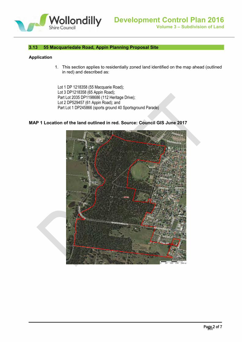
Page 2 of 7
Development Control Plan 2016 Volume 3 – Subdivision of Land
3.13 55 Macquariedale Road, Appin Planning Proposal Site Application
1. This section applies to residentially zoned land identified on the map ahead (outlined in red) and described as:
Lot 1 DP 1218358 (55 Macquarie Road); Lot 3 DP1218358 (65 Appin Road); Part Lot 2035 DP1198686 (112 Heritage Drive); Lot 2 DP529457 (61 Appin Road); and Part Lot 1 DP245866 (sports ground 40 Sportsground Parade)
MAP 1 Location of the land outlined in red. Source: Council GIS June 2017
260
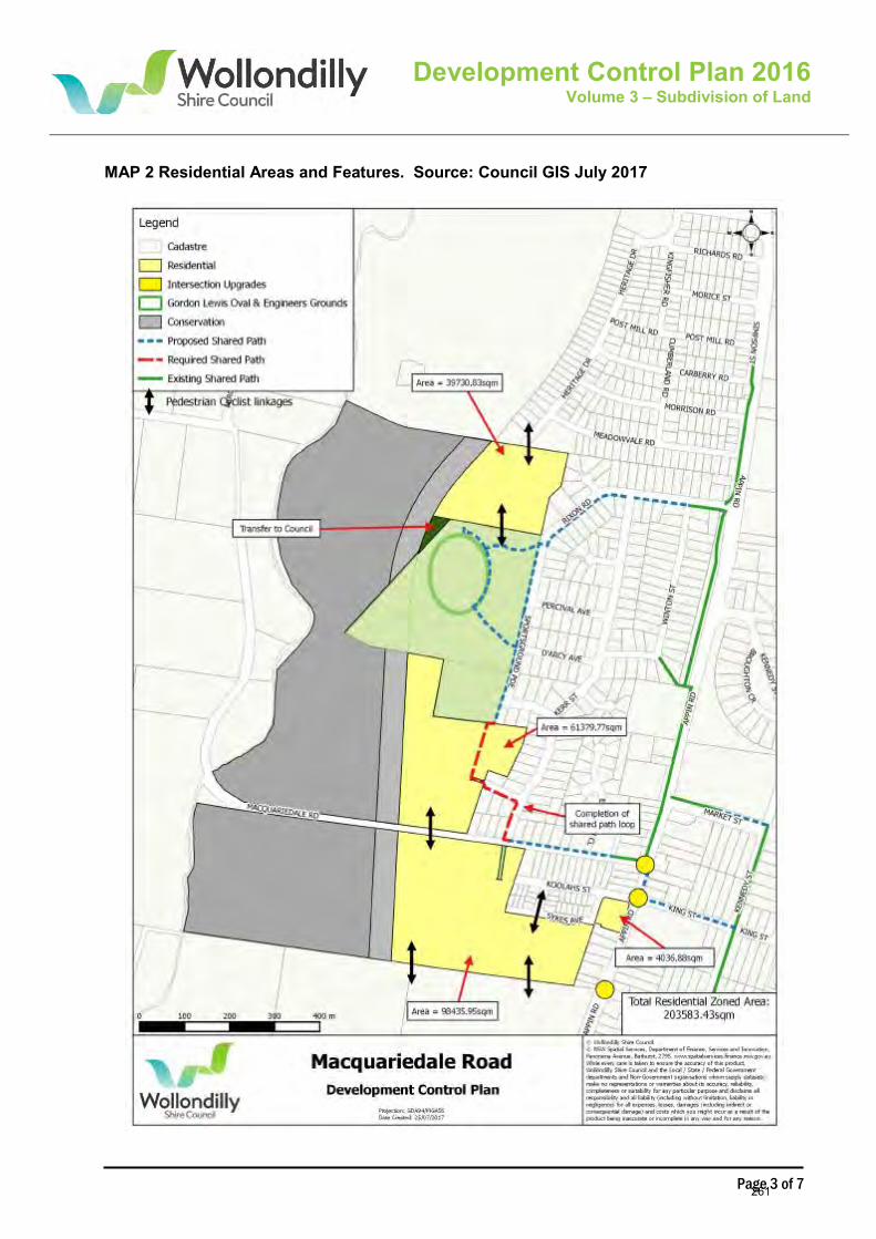
Page 3 of 7
Development Control Plan 2016 Volume 3 – Subdivision of Land
MAP 2 Residential Areas and Features. Source: Council GIS July 2017
261
Page 4 of 7
Development Control Plan 2016 Volume 3 – Subdivision of Land
Note: The controls in this section override controls in other sections of this DCP if there is a conflict.
Overall Objectives
1. To encourage initiatives to empower a sustainable, physically active and healthy community 2. To facilitate an environmentally sensitive development outcome 3. To ensure that the rural, scenic and historic character of Appin is maintained and enhanced 4. To ensure Aboriginal and European environmental heritage is protected 5. To acknowledge the value of existing, significant native vegetation 6. To recognise the value of Ousedale Creek as part of a wider ecological corridor 7. To ensure the protection of the riparian environment 8. To reduce the impact of climate change 9. To acknowledge the important role that the heavily vegetated land to the west of the residential
area plays as an enclosing buffer, both visually and climatically
Controls Subdivision Layout Objectives
1. To provide a high level of amenity for future residents, including efficient access to available goods and services
2. To establish an aesthetically pleasing streetscape that compliments the existing village of Appin
3. To provide infrastructure to support the provision of public transport and other services required by new residents
4. To provide a variety of lot sizes appropriate to the visual character of the site and proximity to existing recreation and urban services
5. To ensure roads and shared pathways are provided with direct links to the existing road network
6. To ensure contaminated land is suitably assessed and remediated prior to residential development
7. To provide infrastructure to support the provision of public and alternative modes of transport
8. To reduce the long term cost of maintenance on the community 9. To reduce the width of streets where there is no use by public transport, to create a sense
of enclosure and provide increased opportunities for planting and landscaping 10. To ensure development is well staged in terms of infrastructure use and provision 11. To ensure future subdivision of the land has regard to the capacity of downstream
stormwater infrastructure.
Controls
1. The subdivision shall be designed to maximise building frontages orientated to and accessed by pedestrians to existing streets
2. The number of lots within this site fronting Macquariedale Road is limited to 25. 3. A vegetation buffer using existing trees and vegetation along both sides of Macquariedale
Road shall be retained within the road reserve and in the reasonable front setback of future
262
Page 5 of 7
Development Control Plan 2016 Volume 3 – Subdivision of Land
lots. Further landscaping shall be provided in this area if required. A detailed landscaping plan identifying the trees and vegetation that shall be retained, those to be removed, and any additional planting required overlaid on the proposed lot boundaries shall be submitted with the Development Application for subdivision.
4. A vegetation buffer using existing trees and vegetation shall be retained within all future linkages and recreation areas. Further landscaping shall be provided in these areas.
5. All landscaping shall include mid and understory plants which are typical of the identified EEC on the overall Macquariedale Road site. Refer to the Species List at the end of this section.
6. Any controls that require ongoing action on behalf of or by future landowners following the registration of separate titles shall be noted in either a restrictive or positive covenant relating to the land. Draft wording for such covenants shall be submitted with the development application. The final version of the covenant must be submitted with the application for subdivision certificate and registered on the certificates of title.
7. Generally, there will be larger lots on the western side of the site near the Asset Protection Zone (APZ) and the E2 zoned land. This will be complemented by areas of smaller lot and medium density housing in close proximity to resources such as the Gordon Lewis Oval, the existing commercial centre of Appin and Appin Public School.
8. Opportunities for narrower than typical Appin streets, one way configurations and rear laneways should be presented to create visual interest, a variety of housing as well as providing an enclosed, safe residential environment.
9. All services shall be underground.
Road Transport Infrastructure and Pedestrian Access Objectives
1. To provide adequate and safe vehicular access 2. To provide good pedestrian, wheelchair, pram and cyclist access via shared pathways and
safe linkages 3. To ensure infrastructure is delivered prior to the completion of housing 4. To reduce the impact of additional traffic caused by the development onto Appin Road 5. To maximise walkability and connectivity for future residents
Controls
1. Cul-de-sacs are to be avoided. 2. Shared pathways shall be provided that link to the existing shared pathway system. 3. Roads and pathways shall be provided generally in accordance with Map 2 to
enable direct links to the external road network and within the site. 4. Each existing lot shall fully construct and upgrade the public road for any part of its
existing road frontages that have not been constructed to the standard specified in Council’s Engineering Design Specification.
Linkages and Connectivity Objectives
1. To increase opportunities for safe access and healthy exercise within the land
263
Page 6 of 7
Development Control Plan 2016 Volume 3 – Subdivision of Land
2. To connect existing recreation and commercial features to new residents Controls
1. An additional north south road linkage and passive recreation space connecting the Oval with and extending south of Macquariedale Road is required. This corridor shall be in public ownership.
2. Additional road, lane and shared path linkages within and without the site will be required from east to west, as well as north to south. This will be via a series of interconnecting shared pathways, suitable for a multitude of users; pedestrians, prams, wheelchairs and cyclists. It is envisaged that these links will be integrated with the overall shared pathway and Appin Nature Trail.
Landscaping Controls
1. To ensure Aboriginal heritage is protected. 2. To mitigate the risks of development on Aboriginal artefacts and sacred sites. 3. To ensure that required infrastructure is provided if development is staged. 4. To ensure water quality is maintained and improved. 5. To retain existing vegetation where appropriate, both in the private and public domains
Controls
1. Prior to the grant of consent for any subdivision of land to which this clause applies must demonstrate that all downstream stormwater infrastructure, including culverts, are adequate for post development flows or can and will be upgraded to accommodate such flows.
2. All stormwater treatment systems shall be maintained and monitored by the developer for a period of 5 years after construction of the subdivision is completed for the whole site and these systems shall be demonstrated to be functioning effectively before being handed over to Council.
3. Existing vegetation shall be retained along both sides of the Macquariedale Road Frontage and within all future linkages and recreation areas. A minimum clearance zone of 3 metres shall be provided for development around the drip zone of all mature trees fronting Macquariedale Road. Details of this building restriction shall be included within a Section 88B instrument to be lodged with any application for a subdivision certificate and shall be registered on the title of all lots.
4. An overall, integrated Landscaping Plan is required for public land. Species selection shall be based on the Species List at the end of this section.
5. An overall Fencing Plan to create a consistent appearance shall be provided with the subdivision application.
Vegetation Species List for Planting Street trees: Brachychiton populneus Malaleuca linariifolia Leptospermum petersonii (small tree/large shrub) Podocarpus elatus (larger street tree but slow growing)
264
Page 7 of 7
Development Control Plan 2016 Volume 3 – Subdivision of Land
Elaeocarpus retiuculatus Acacia binervia Shrubs groundcovers and grasses: Bursaria spinosa (spikey, not near paths etc) Hakea serecia (spikey, not near paths etc) Hakea salicifolia Hakea dactyloides Indigophora australis Acacia floribunda Acacia longifolia Acacia terminalis Acacia fimbriata Lomandra longifolia Dianella caerulia Poa labillardiera Dichondra repens Viuola hederacae Pratia purpurescense Myoporum parvifolium Syzigium paniculatum Backhousia myrtifolia Melaleuca thymifolia
265

Development Control Plan 2016
Volume 4 – Residential Development
266
Page 2 of 2
Development Control Plan 2016 Volume 4 – Residential Development
4.6 Macquariedale Road, Appin
Application
1. This section applies to the following allotments:
1. This section applies to the land identified in Map 1, Section 3.13 in Chapter 3 of this DCP, and described as:
Lot 1 DP 1218358 (55 Macquarie Road); Lot 3 DP1218358 (65 Appin Road); Part Lot 2035 DP1198686 (112 Heritage Drive); Lot 2 DP529457 (61 Appin Road); and Part Lot 1 DP245866 (sports ground 40 Sportsground Parade)
Note: The controls in this section override controls in other sections of this DCP if there is a conflict Objectives
1. To ensure that new development contributes positively to the adjacent neighbouring residential area.
2. To retain the low scale of the Appin Village.
Controls
1. Development fronting Macquariedale Road shall provide a front boundary setback of 8 metres.
267
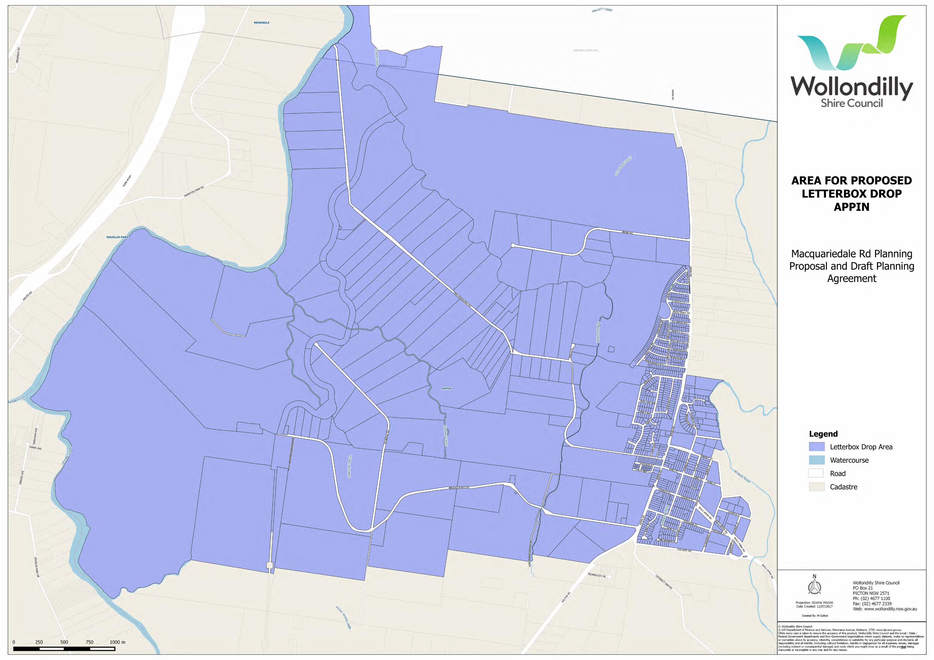
268
GO2 Attachment
1. Investments as at 30 June 2017
Monday 21 August 2017 GO2 – Investment of Funds as at 30 June 2017
269

Reporting Period: 1-Jun-17 to 30-Jun-17
Investment Institution Face Value Current Value Percentage Interest
Rating 30-Jun-17 30-Jun-17 Holding %p.a.Received / Accrued Maturity
CASH INVESTMENTSNational Australia BankGeneral Account Balance (for information only. Not included in Total Cash Plus Investments) 357,235
11AM At call A-1+ 3,156,000 3,156,000 5.48% 1.55 8,691 At Call
Term DepositsNational Australia Bank (Matured) A-1+ 307 05-Jun-17Bank of Queensland (Matured) A-2 962 14-Jun-17National Australia Bank A-1+ 1,000,000 1,028,110 1.79% 2.85 2,342 05-Jul-17Suncorp A-1 1,000,000 1,015,803 1.76% 2.80 2,301 12-Jul-17ME Bank A-2 500,000 504,845 0.88% 2.70 1,110 19-Jul-17National Australia Bank A-1+ 1,000,000 1,025,468 1.78% 2.80 2,301 02-Aug-17Bendigo & Adelaide Bank A-2 1,000,000 1,024,489 1.78% 2.95 2,425 29-Aug-17Bank of Queensland A-1+ 1,000,000 1,008,858 1.75% 2.65 2,178 05-Sep-17Westpac Group AA- 1,000,000 1,024,904 1.78% 3.00 2,466 13-Sep-17Westpac Group AA- 500,000 512,740 0.89% 3.00 1,233 27-Sep-17Westpac Group AA- 1,000,000 1,024,822 1.78% 3.10 2,466 27-Sep-17Westpac Group AA- 1,000,000 1,023,836 1.78% 3.00 2,466 04-Oct-17ME Bank A-2 1,000,000 1,001,211 1.74% 2.60 1,211 11-Oct-17ME Bank A-2 750,000 753,975 1.31% 2.65 1,634 18-Oct-17Credit Union Australia A-2 2,000,000 2,023,671 3.51% 2.88 4,734 01-Nov-17Bendigo & Adelaide Bank A-2 500,000 508,815 0.88% 2.75 1,130 08-Nov-17Bank of Queensland A-2 1,000,000 1,009,986 1.75% 2.70 2,219 15-Nov-17ME Bank A-2 1,000,000 1,008,858 1.75% 2.65 2,178 06-Dec-17ME Bank A-2 1,000,000 1,001,923 1.74% 2.70 1,923 06-Dec-17Bank of Queensland A-2 1,000,000 1,015,266 1.76% 2.80 2,301 13-Dec-17ME Bank A-2 1,000,000 1,001,258 1.74% 2.70 1,258 13-Dec-17Bank of Queensland A-2 1,000,000 1,014,805 1.76% 2.80 2,301 20-Dec-17ME Bank A-2 1,000,000 1,006,510 1.75% 2.70 2,219 02-Jan-18Commonwealth Bank of Australia A-1+ 1,000,000 1,008,495 1.75% 2.72 2,236 10-Jan-18Bank of Queensland A-2 1,000,000 1,010,060 1.75% 2.70 2,219 14-Feb-18Rural Bank A-2 1,000,000 1,008,951 1.75% 2.70 2,219 05-Mar-18Commonwealth Bank of Australia A-1+ 1,000,000 1,008,558 1.75% 2.74 2,252 07-Mar-18Bank of Queensland A-2 1,000,000 1,001,888 1.74% 2.65 1,888 07-Mar-18Bank of Queensland A-2 1,000,000 1,001,234 1.74% 2.65 1,234 14-Mar-18ME Bank A-2 1,000,000 1,004,882 1.74% 2.70 2,219 24-Apr-18Credit Union Australia A-2 1,000,000 1,002,967 1.74% 2.85 2,342 23-May-18Bendigo & Adelaide Bank A-2 1,000,000 1,002,293 1.74% 3.05 2,219 30-May-18Bendigo & Adelaide Bank A-2 1,000,000 1,001,923 1.74% 2.70 1,923 06-Jun-18Westpac Group AA- 1,000,000 1,026,499 1.78% 3.10 2,548 23-Aug-18Bendigo & Adelaide Bank A-2 1,000,000 1,025,821 1.78% 3.05 2,507 27-Aug-18Westpac Group AA- 1,000,000 1,025,734 1.78% 3.10 2,548 12-Sep-18Bendigo & Adelaide Bank A-2 2,000,000 2,007,151 3.48% 2.90 4,767 17-May-19Westpac Group AA- 1,000,000 1,028,581 1.79% 3.20 2,630 09-Aug-19
TOTAL CASH PLUS INVESTMENTS 39,406,000 39,861,188 69.21% 90,108
Investment Institution Face Value Current Value Percentage Interest
Rating 30-Jun-17 30-Jun-17 Holding %p.a.Received / Accrued Maturity
INVESTMENT SECURITIESCorporate BondCommonwealth Bank of Australia AA- 2,000,000 1,973,160 3.43% 7.17 22-Jan-18
Floating Rate NotesCUA Snr FRN BBB+ 500,000 507,364 0.88% 3.40 1,395 01-Apr-19Westpac Banking Corporation AA- 1,000,000 1,012,956 1.76% 2.74 2,248 10-May-19AMP Snr FRN A+ 750,000 754,988 1.31% 2.82 1,757 11-Jun-19Members Equity Bank Pty Ltd BBB+ 1,000,000 1,010,288 1.75% 3.22 2,642 18-Jul-19Bendigo Bank Senior FRN A- 1,000,000 1,000,901 1.74% 2.65 2,215 17-Sep-19ANZ Snr FRN AA- 1,000,000 1,010,052 1.75% 2.59 2,125 11-Nov-19Greater Building Society Snr FRN BBB+ 500,000 498,564 0.87% 3.24 1,332 29-Nov-19Westpac Banking Corporation AA- 1,000,000 1,012,108 1.76% 2.65 2,174 22-Jan-20Bendigo Bank Senior FRN A- 500,000 502,583 0.87% 2.84 1,165 21-Feb-20Macquarie Bank A 1,000,000 1,008,986 1.75% 2.83 2,332 03-Mar-20CUA Snr FRN BBB+ 750,000 749,505 1.30% 3.02 1,891 20-Mar-20CBA Snr FRN AA- 1,000,000 1,012,143 1.76% 2.66 2,190 17-Jul-20Bendigo Bank Senior FRN A- 1,000,000 1,004,938 1.74% 2.84 2,330 18-Aug-20Suncorp Senior FRN A+ 1,000,000 1,017,408 1.77% 3.00 2,466 20-Oct-20CBA Snr FRN AA- 500,000 510,420 0.89% 2.92 1,198 18-Jan-21Bendigo Bank Senior FRN A- 500,000 509,451 0.88% 3.21 1,319 20-Apr-21Westpac Banking Corporation AA- 1,000,000 1,016,626 1.77% 2.90 2,390 03-Jun-21AMP Snr FRN A+ 500,000 500,588 0.87% 2.76 1,168 30-Mar-22
Mortgage Backed SecuritiesEmerald Reverse Mortgage Series 2007-1 Class B AA 1,000,000 604,474 1.05% 2.30 1,890 21-Jul-27Emerald Reverse Mortgage Series 2006-1 Class A AAA 653,644 517,944 0.90% 2.19 1,174 22-Aug-22
18,153,644 17,735,446 30.79% 37,401TOTAL CASH & INVESTMENT SECURITIES $57,559,644 $57,596,635 100.00% $127,509
INVESTMENTS AS AT 30 JUNE 2017
270
GO4 Attachment
1. Plan of proposed road closure and road opening, land swap arrangement
Monday 21 August 2017 GO4 – Permanent Closure of Road Reserves, Opening of
Road Reserves and Land Swap – Spring Creek Road, Mt Hunter
271
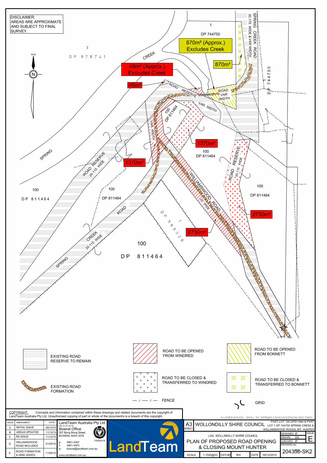
272
CO2 Attachments
1. Maps of Alcohol Free Zones including new zones at Wilton, an extension at Oakdale and Picton
Monday 21 August 2017 CO2 – Re-establishment of Alcohol Free Zones and
Information on Alcohol Prohibited Areas
273
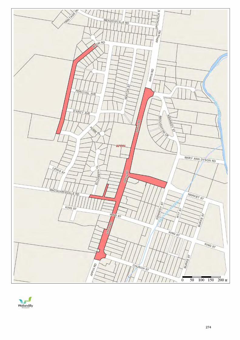
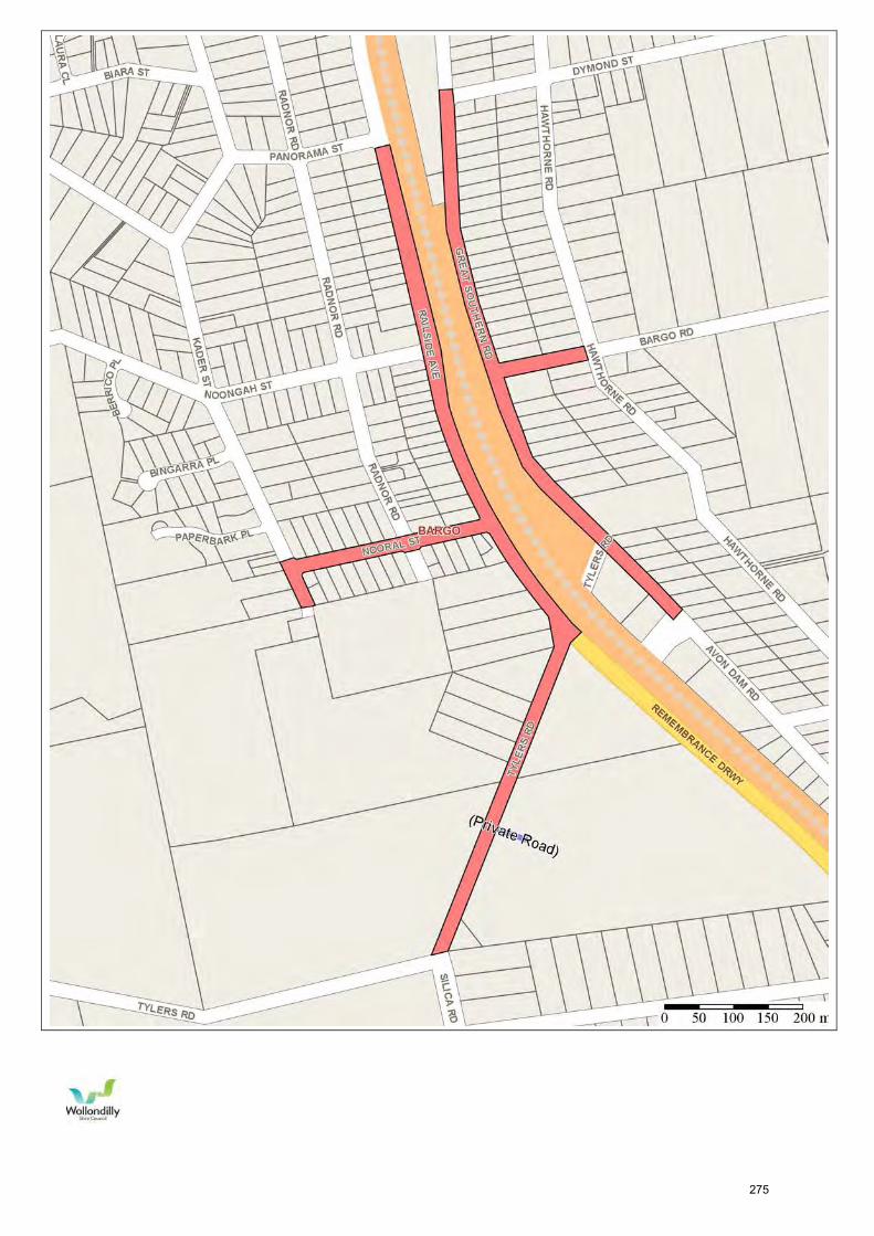
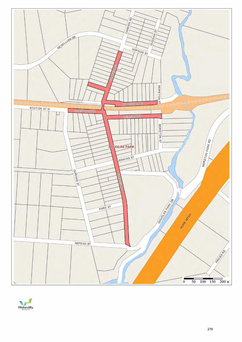
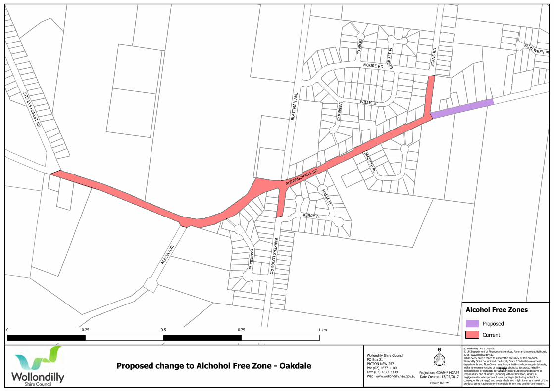
© Wollondilly Shire Council. © LPI Department of Finance and Services, Panorama Avenue, Bathurst,2795. www.lpi.nsw.gov.au.While every care is taken to ensure the accuracy of this product,Wollondilly Shire Council and the Local / State / Federal Governmentdepartments and Non-Government organisations whom supply datasets,make no representations or warranties about its accuracy, reliability,completeness or suitability for any particular purpose and disclaims allresponsibility and all liability (including without limitation, liability innegligence) for all expenses, losses, damages (including indirect orconsequential damage) and costs which you might incur as a result of theproduct being inaccurate or incomplete in any way and for any reason.
Projection: GDA94/ MGA56Date Created: 13/07/2017
Proposed change to Alchohol Free Zone - Oakdale
Created By: PW
Proposed
Current
Alcohol Free Zones
Wollondilly Shire CouncilPO Box 21PICTON NSW 2571Ph: (02) 4677 1100Fax: (02) 4677 2339 Web: www.wollondilly.nsw.gov.au
0 0.25 0.5 0.75 1 km
277
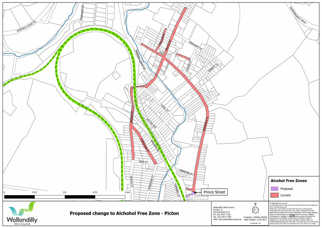
© Wollondilly Shire Council. © LPI Department of Finance and Services, Panorama Avenue, Bathurst,2795. www.lpi.nsw.gov.au.While every care is taken to ensure the accuracy of this product,Wollondilly Shire Council and the Local / State / Federal Governmentdepartments and Non-Government organisations whom supply datasets,make no representations or warranties about its accuracy, reliability,completeness or suitability for any particular purpose and disclaims allresponsibility and all liability (including without limitation, liability innegligence) for all expenses, losses, damages (including indirect orconsequential damage) and costs which you might incur as a result of theproduct being inaccurate or incomplete in any way and for any reason.
Projection: GDA94/ MGA56Date Created: 21/07/2017
Proposed change to Alchohol Free Zone - Picton
Created By: MS
Proposed
Current
Alcohol Free Zones
Wollondilly Shire CouncilPO Box 21PICTON NSW 2571Ph: (02) 4677 1100Fax: (02) 4677 2339 Web: www.wollondilly.nsw.gov.au
0 0.25 0.5 0.75 1 km Prince Street
278
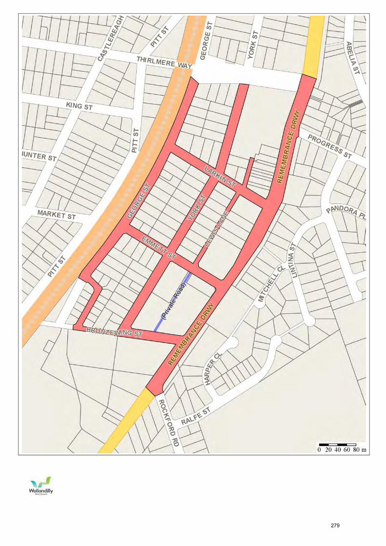
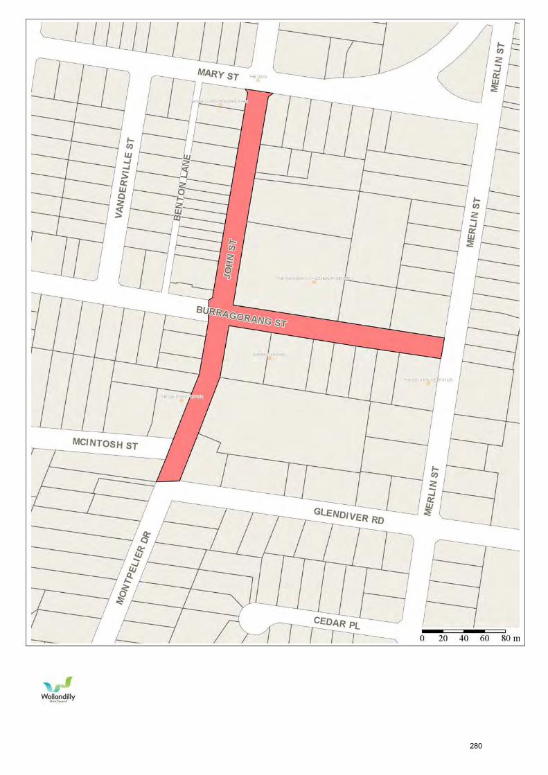
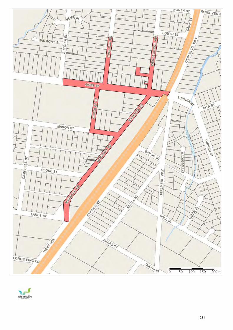
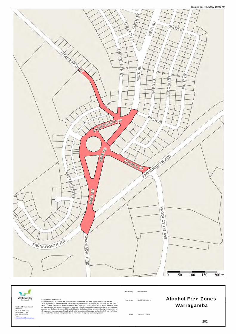
Created on 7/03/2017 10:01 AM
Wollondilly Shire CouncilPO Box 21PICTON NSW 2571Ph: (02) 4677 1100Fax: (02) 4677 2339Web: www.wollondilly.nsw.gov.au
© Wollondilly Shire Council.© LPI Department of Finance and Services, Panorama Avenue, Bathurst, 2795. www.lpi.nsw.gov.au.While every care is taken to ensure the accuracy of this product, Wollondilly Shire Council and the Local / State / Federal Government departments and Non-Government organisations whom supply datasets, make no representations or warranties about its accuracy, reliability, completeness or suitability for any particular purpose and disclaims all responsibil ity and all liability (including without limitation, liability in negligence) for all expenses, losses, damages (including indirect or consequential damage) and costs which you might incur as a result of the product being inaccurate or incomplete in any way and for any reason.
Created By: Sharon Hartnett
Alcohol Free Zones
Warragamba
Projection: GDA94 / MGA zone 56
Date: 7/03/2017 10:01 AM
282
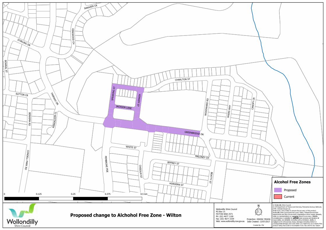
© Wollondilly Shire Council. © LPI Department of Finance and Services, Panorama Avenue, Bathurst,2795. www.lpi.nsw.gov.au.While every care is taken to ensure the accuracy of this product,Wollondilly Shire Council and the Local / State / Federal Governmentdepartments and Non-Government organisations whom supply datasets,make no representations or warranties about its accuracy, reliability,completeness or suitability for any particular purpose and disclaims allresponsibility and all liability (including without limitation, liability innegligence) for all expenses, losses, damages (including indirect orconsequential damage) and costs which you might incur as a result of theproduct being inaccurate or incomplete in any way and for any reason.
Projection: GDA94/ MGA56Date Created: 13/07/2017
Proposed change to Alchohol Free Zone - Wilton
Created By: PW
Wollondilly Shire CouncilPO Box 21PICTON NSW 2571Ph: (02) 4677 1100Fax: (02) 4677 2339 Web: www.wollondilly.nsw.gov.au
0 0.125 0.25 0.375 0.5 km
Proposed
Current
Alcohol Free Zones
283
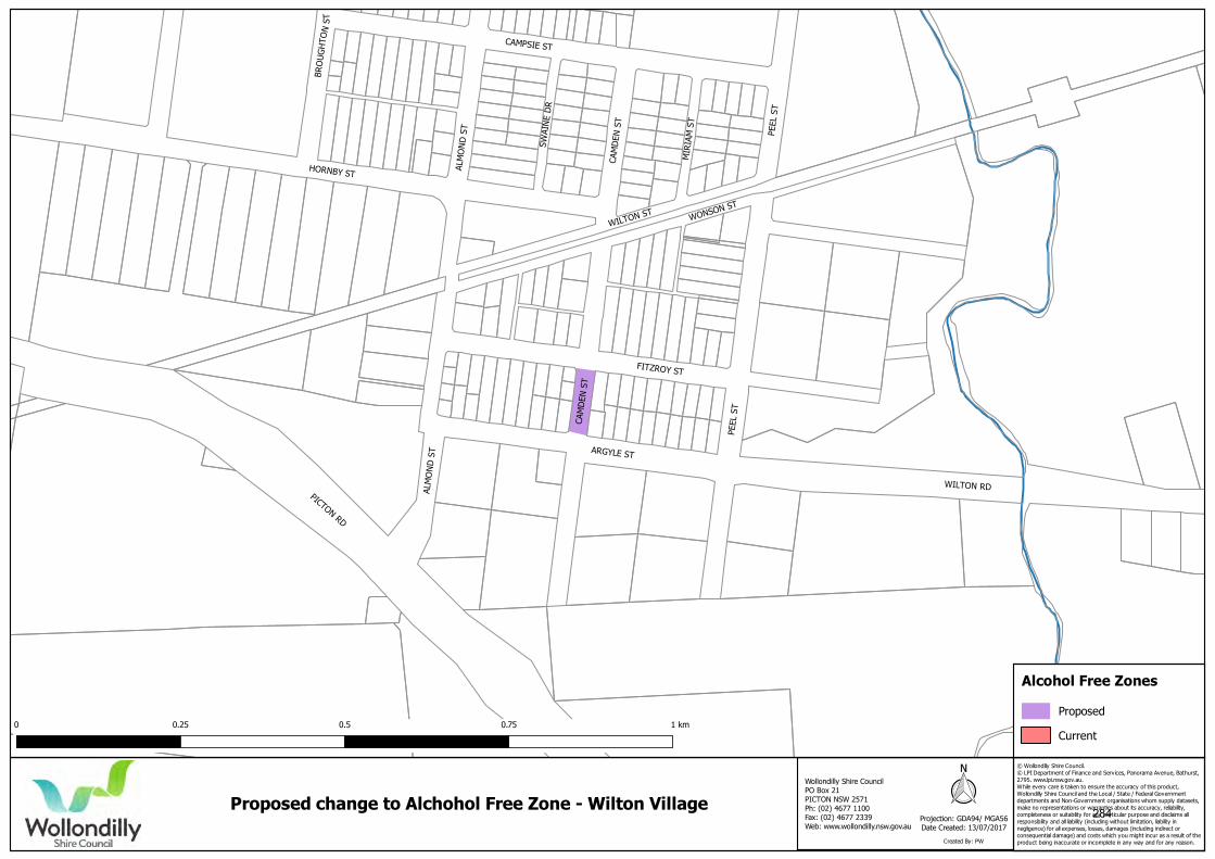
© Wollondilly Shire Council. © LPI Department of Finance and Services, Panorama Avenue, Bathurst,2795. www.lpi.nsw.gov.au.While every care is taken to ensure the accuracy of this product,Wollondilly Shire Council and the Local / State / Federal Governmentdepartments and Non-Government organisations whom supply datasets,make no representations or warranties about its accuracy, reliability,completeness or suitability for any particular purpose and disclaims allresponsibility and all liability (including without limitation, liability innegligence) for all expenses, losses, damages (including indirect orconsequential damage) and costs which you might incur as a result of theproduct being inaccurate or incomplete in any way and for any reason.
Projection: GDA94/ MGA56Date Created: 13/07/2017
Proposed change to Alchohol Free Zone - Wilton Village
Created By: PW
Wollondilly Shire CouncilPO Box 21PICTON NSW 2571Ph: (02) 4677 1100Fax: (02) 4677 2339 Web: www.wollondilly.nsw.gov.au
0 0.25 0.5 0.75 1 kmProposed
Current
Alcohol Free Zones
284