auckland future urban land supply strategy · future urban land supply strategy is to identify the...
TRANSCRIPT

Auckland Future Urban Land Supply Strategy
July 2017

Page 2 of 36

Page 3 of 36
Table of Contents
Table of Contents ....................................................................................................... 3
1. Introduction ......................................................................................................... 4
2. Scale and context ................................................................................................ 7
3. Structure planning ............................................................................................... 8
4. The Programme - sequencing of the future urban areas ................................... 12
5. Anticipated welling and employment capacities for future urban areas ............. 18
6. Anticipated cost of the infrastructure network for future urban areas ................ 20
7. Monitoring and Review ...................................................................................... 21
APPENDIX 1 - The Principles applied to underpin sequencing decisions ................ 23
APPENDIX 2 - A brief overview of the areas considered ......................................... 25
The North .............................................................................................................. 26
Key considerations for the North ....................................................................... 27
The North-west ..................................................................................................... 28
Key considerations for the North-west .............................................................. 29
The South ............................................................................................................. 30
Key considerations for the South ...................................................................... 32
APPENDIX 3 - Glossary ........................................................................................... 34

Page 4 of 36
1. Introduction Auckland is projected to reach a population of more than 2.4 million by 2047. Currently, it is anticipated that capacity for up to 400,000 new dwellings and 277,000 additional jobs will be needed. The Auckland Plan sets Auckland Council’s (the council’s) strategic direction on how this growth will be accommodated. As part of a quality compact approach to growth, the Auckland Plan anticipates that up to 70 per cent of new dwellings will be built within the existing urban area and up to 40 per cent outside of this. The Auckland Plan also stresses the importance of providing a pipeline of land supply in both brownfields and greenfields.1
The Auckland Unitary Plan identifies approximately 15,000 hectares of rural land for future urbanisation with the potential to accommodate approximately 137,000 dwellings and 67,000 jobs (see Map 1). Future urban land forms an important component of the overall strategy for enabling Auckland’s growth (Figure 1).
In line with Auckland Plan guidance, the future urban land identified also includes approximately 1,400 hectares for new business land.
Figure 1: Distribution of growth anticipated from the Auckland Plan
This strategy identifies a programme to sequence future urban land over 30 years and will assist with the ongoing supply of greenfield land for development2. It has been updated to reflect recent changes to the Unitary Plan, new demand for development and further technical work undertaken by Council to gain a greater understanding of the requirements for development (e.g. Supporting Growth and Whenuapai Structure Plan).
The strategy is a long-term and proactive approach to delivering land that is ‘ready to go’ in these future urban areas (see Figure 4). As this land is predominantly rural and has not previously been identified for urbanisation, bulk infrastructure has to be provided. This programme will help provide greater clarity and certainty to landowners, iwi, developers, infrastructure providers and council about when future urban land will have bulk infrastructure in place and be ready for urban development.
1 The Auckland Plan is being updated during 2017 - 2018
2 This strategy deals exclusively with greenfield land, which is identified as future urban zone in the Unitary Plan
or is rural land that has a live urban zone in the Unitary Plan. Future urban areas identified in Rural Settlements are included in this strategy.
The primary purpose of the
Future Urban Land Supply
Strategy is to identify the
sequencing and timing of
future urban land for
development readiness over
30 years. It does not
determine the location of the
Rural Urban Boundary or
future urban zoned land.
This is identified in the
Unitary Plan. The strategy
has been amended to reflect
the recent changes to the
Operative Unitary Plan.

Page 5 of 36
The programme specifically helps to inform:
council’s infrastructure asset planning and management and its infrastructure funding priorities and sequencing that inform the council’s future Long-term Plans and the Annual Plans
central government, such as the Ministry of Education, with medium to long-term projections, location and investment decisions
private sector infrastructure providers with forward planning and investment decisions.
Other council documents such as the Auckland Plan, the Auckland Unitary Plan, and the 30-year Infrastructure Strategy have close links with this strategy. The strategy informs the greenfield element of the Auckland Plan Development Strategy which makes up a portion of the overall growth anticipated over the next 30 years.
There are also links with relevant transport documents such as the National Land Transport Programme, Integrated Transport Programme, Regional Land Transport Plan, Auckland Transport Alignment Project and Supporting Growth.
This strategy also addresses the council’s obligations under The National Policy Statement on Urban Development Capacity which requires the council to ensure there is greater focus on enabling urban development and that there is sufficient capacity for housing and businesses. This strategy is a live document and will be reviewed as part of an overall monitoring strategy.
Section 7 of this strategy outlines how the council will monitor the supply and uptake of capacity.
The following diagram illustrates the relationship between relevant council documents and the strategy.
Figure 2: Relationship between the Future Urban Land Supply Strategy and other council documents

Page 6 of 36
Map 1: Location of future urban areas (Auckland Unitary Plan)

Page 7 of 36
2. Scale and context
The scale of the planned rezoning (from rural to urban) over the next thirty years is significant and will make an important contribution to accommodating Auckland’s growth.
The urban area of Hamilton provides a useful comparison to understand the scale of growth
anticipated within Auckland’s future urban areas. The 15,000 hectares of future urban land is
equivalent to approximately two times the urban area of Hamilton. The type of development
anticipated for the future urban areas will vary depending on location and context, but will
generally be based around a network of centres with a mix of various urban developments
such as housing, marae, shops, parks, employment areas, schools, hospitals and other
community facilities. Housing will include a range of types and densities from apartments
and attached town houses to detached single family homes. Figure 3 below provides some
examples of the range of urban developments anticipated in the future urban areas.
Apartments and attached housing – medium to high density
Attached and detached - medium density
Detached - medium to low density
Town and local centres, parks, open space and employment
Figure 3: Examples of urban development anticipated in future urban areas

Page 8 of 36
The infrastructure investment required in these areas includes transport facilities (public transport including rail and bus, roads, cycle facilities and footpaths), water, wastewater, stormwater and community infrastructure. This is of such magnitude that any ad-hoc or out of sequence approach to development will have major funding implications for all providers, affect the ability to coordinate delivery and is likely to have major implications on the ability to service other areas. This in turn may have significant consequences on the ability to provide sufficient development capacity across Auckland.
The analysis done for this strategy is of sufficient scale and specificity to broadly determine bulk infrastructure requirements. As Figure 4 shows, more detailed planning of these areas through structure planning, and bulk infrastructure planning and build, are two parallel and inter-dependent processes to get land ready for development. This is the approach taken to determine the programme of sequencing and timing. The design, consenting and build of infrastructure of this scale takes time and, together with funding considerations, have been main determinants of the programme.
Figure 4: An integrated planning approach - coordinating planning and infrastructure processes
3. Structure planning
This strategy determines sequencing and timing for when future urban areas will be ready for development to commence which requires necessary underpinning zoning and bulk infrastructure to be in place.
The Unitary Plan requires that before any future urban zone is zoned as being ready for urban development, a structure plan will be completed.
Structure plans are an important method for establishing the pattern of land use and the transport and services network within a defined area. They can provide a detailed examination of the opportunities and constraints relating to the land including its suitability for various activities, infrastructure provision, geotechnical issues and natural hazards. They should identify, investigate and address the potential effects of urbanisation and development on natural and physical resources in the structure plan area and in neighbouring areas, particularly those that have been scheduled in the Unitary Plan in relation to natural heritage, Mana Whenua, natural resources, coastal environment, historic heritage and special character.

Page 9 of 36
Structure plans should explain how future development will give effect to the regional policy statement and how any adverse effects of land use and development are to be avoided, remedied or mitigated by proposed plan provisions. This will ensure that all the effects of development are addressed in advance of development occurring. A structure plan is an appropriate foundation for the plan change process required to rezone land.
The Unitary Plan requires a structure plan to identify, investigate and address the following matters3:
urban growth (e.g, future supply and projected demand for residential and business land, phases and timing for the staged release of land in coordination with infrastructure, the location, type and form of the urban edge, linkages and integration with existing urban-zoned and/or rural-zoned land adjoining the structure plan area and, opportunities to improve access to landlocked parcels, including Māori land)
natural Resources (e.g, the protection, maintenance and enhancement of natural resources, integration of green networks with open space and pedestrian and cycle networks, measure to manage natural hazards and contamination and the location of mineral resources)
natural and built heritage (The existence of natural and physical resources that have been scheduled in the Unitary Plan in relation to natural heritage, Mana Whenua, natural resources, coastal environment, historic heritage and special character)
use and activity (e.g, contribution to a compact urban form and the efficient use of land)
urban development (e.g, a desirable urban form at the neighbourhood scale)
transport networks (e.g, integration of land use and development with the local and strategic transport network)
infrastructure (e.g, location and protection of existing and planned infrastructure)
feedback from stakeholders.
Figure 5 illustrates how a structure plan might look.
3 Refer to Appendix 1 of the Auckland Unitary Plan (Structure Plan Guidelines) for a complete list of
matters to be identified, investigated and addressed in a structure plan. The matters included here provide an indication only and are not intended to be a full and complete list.

Page 10 of 36
Figure 5: Example of a structure plan
As part of preparing future urban areas to be ready for development, structure planning will generally commence approximately three years prior to the timeframe that has been identified in this strategy. Where this strategy has identified different timeframes within a large future urban area (e.g. Warkworth and Drury West/Opaheke Drury) and the area would benefit from comprehensive planning (e.g. environmental and urban form outcomes), a structure plan may be prepared for the whole area.
Due to the large scale of the future urban areas, structure plans will determine the appropriate staging and timeframes of subsequent plan changes to ‘live zone’ areas within the structure plan area to ensure the efficient and logical roll out of local infrastructure to these areas. Staging of areas for plan changes will generally follow the sequence and timeframes identified in the Future Urban Land Supply Strategy, unless an alternative staging is considered appropriate through the structure planning process.

Page 11 of 36
The plan change process to ‘live zone’ the first stage identified in the structure plan will follow immediately after the structure plan is complete so that development is able to commence within the timeframes specified in this strategy for that area.
Due to the large scale of areas sequenced, council will lead (or work in partnership with others) the structure planning process. This is the stage of the process where local boards, mana whenua and communities will be involved in the detailed planning of these areas.

Page 12 of 36
4. The Programme - sequencing of the future urban areas
The programme of sequencing the future urban areas spans over 30 years from 2017 – 2047. The timeframe is split into three decades and each decade into five year intervals. Distributing the live zoning of future urban areas over this timeframe enables them to be proactively planned in an orderly and cost efficient way, ensuring the areas are ‘ready to go’ with the required bulk infrastructure and able to deliver the quality urban outcomes anticipated in the Auckland Plan and Unitary Plan. Development capacity provided through this strategy needs to be considered in context with the overall development capacity provided across Auckland. The agreed sequencing of the future urban areas has therefore taken into account the feasible development capacity provided in the existing urban area.
A suite of principles (Appendix 1) were developed to help underpin the sequencing rationale. However, the principles were not applied to the areas prioritised between 2012 and 2017 as these priorities were determined through separate Special Housing Area and Unitary Plan processes.
Table 1 identifies the sequencing and timing of the large future urban areas and Table 2 identifies the sequencing and timing of the rural settlement future urban areas. Special Housing Areas and live urban zones under the Unitary Plan play a significant role in the first five years of the sequencing and are part of the transition to longer-term, proactive planning by the second and third decades.
A brief overview of the areas and a description of key considerations behind the sequencing is provided in Appendix 2.

Page 13 of 36
Proposed timing – Development ready (Large future urban
areas)
Area^
Actuals, contracted or planned
2012 - 2017
Live Zoned Areas and Special Housing Areas
Warkworth North Wainui East Whenuapai Scott Point
Red Hills Kumeu Huapai
Puhinui Hingaia
Takanini (Walters Rd) Bellfield Rd (Opaheke)
Drury South Bremner Rd (Drury West)
Wesley (Paerata) Belmont (Pukekohe)
Decade One 1st half
2018 – 2022
Warkworth North* Silverdale - Dairy Flat (business)
Whenuapai Stage 1 Drury West Stage 1* Paerata (remainder)
Decade One 2nd half
2023 - 2027
Pukekohe Cosgrave Rd (Takanini)
Decade Two 1st half
2028 - 2032
Warkworth South Whenuapai Stage 2
Red Hills North Kumeu Huapai Riverhead
Puhinui (remainder) Opaheke Drury
Drury West Stage 2
Decade Two 2nd half
2033 - 2037
Warkworth North East Wainui East (remainder)
Silverdale Dairy Flat (remainder)
Decade Three 1st half
2038 – 2042
Decade Three 2nd half
2043 - 2047
Takanini# Yet to be determined – new growth areas
*Warkworth North and Drury West Stage 1 development ready from 2022
^Refer sequencing maps for location of areas #Significant flooding and geotech constraints - further technical investigations required
Table 1: The sequencing and timing of the large future urban areas

Page 14 of 36
Proposed timing – Development ready
(Rural Settlement future urban areas)
Area^
Actuals, contracted or planned
2012 - 2017
Live Zoned Areas and Special Housing Areas
Hibiscus Coast (Silverdale) Hibiscus Coast (Red Beach)
Hatfields Beach 1 Albany Village 1
Waimauku Swanson
Maraetai 1 Oruarangi 1
Clevedon Waterways Clevedon
Karaka North Kingseat
Clarks Beach 1 Glenbrook Beach 1
Patumahoe
Decade One 1st half
2018 – 2022
Oruarangi 2
Decade One 2nd half
2023 - 2027
Wellsford Algies Bay
Albany Village 2 Helensville 1
Clarks Beach 2 Glenbrook Beach 2
Decade Two 1st half
2028 - 2032
Helensville 2 Hatfields Beach 2
Maraetai 2
Decade Two 2nd half
2033 - 2037
Decade Three 1st half
2038 – 2042
Decade Three 2nd half
2043 - 2047
^Refer sequencing maps for location of areas Table 2: The sequencing and timing of the Rural Settlement future urban areas

Page 15 of 36
Map 2: Regional Sequencing and timing

Page 16 of 36
Map 3: Large future urban areas sequencing and timing

Page 17 of 36
Map 4: Rural Settlement (north and west) sequencing and timing
Map 5: Rural settlements (south) sequencing and timing

Page 18 of 36
5. Anticipated dwelling and employment capacities for future urban areas
The tables below provide the anticipated dwelling and employment capacities for the future urban areas.
Proposed timing – development
ready
Area^ Anticipated dwelling
capacity for each area (approx.)
Anticipated dwelling capacity subtotals (approx.)
Anticipated Employment
(jobs) (approx.)#
Actuals, contracted or planned 2012 - 2017
Live zoned areas and SHAs
31,590 15,350
Warkworth North Business
Wainui East 4,500
Whenuapai 1,150
Scott Point 2,600
Red Hills 3,600 (SHA) +
7,050 (live zone)
Puhinui Business
Kumeu Huapai 1,400
Hingaia 3,070
Wesley (Paerata) 4,550
Belmont (Pukekohe) 720
Drury South 1,000
Bremner Rd (Drury West) 1,350
Bellfield Rd (Opaheke) 300
Walters Rd (Takanini) 300
Decade One 1
st half
2018 – 2022
Warkworth North* 2,300
14,300
27,250
Paerata (remainder) 1,800
Whenuapai (Stage 1) 6,000
Silverdale West / Dairy Flat (business land)
Business
Drury West Stage 1* 4,200
Decade One 2
nd half
2023 – 2027 Pukekohe 7,200
7,700
Cosgrave Rd, Takanini 500
Decade Two 1
st half
2028 - 2032
Kumeu Huapai Riverhead 6,600 3,700 11,600 5,700 7,900 1,400
Business
36,900
21,350
Warkworth South
Whenuapai (Stage 2)
Drury West (Stage 2)
Opaheke Drury
Red Hills North
Puhinui
Decade Two 2
nd half
2033 – 2037
Silverdale Dairy Flat (remainder)
20,400
29,400 Wainui East (remainder) 7,400
Warkworth North East 1,600
Decade Three 1
st half
2038 – 2042
50 Decade Three 2
nd half
2043 – 2047
Takanini+
Yet to be determined new growth areas
4,500 4,500
Total 124,390 64,000
^Refer sequencing maps for staging/areas
* Drury West (Stage 1) and Warkworth North development ready from 2022 # Anticipated employment figures do not include anticipated employment in centres
+Significant flooding and geotech constraints – further technical investigations required
Table 3: Large future urban areas anticipated dwelling and employment capacities
Page 19 of 36
Proposed timing – development
ready
Area Anticipated dwelling
capacity for each area (approx.)
Anticipated dwelling capacity subtotals (approx.)
Anticipated Employment
(jobs) (approx.)
Actuals, contracted or planned 2017
Live zoned areas and SHAs
8,236 1,000
Hatfields Beach 1 9
Hibiscus Coast (Silverdale) 963
Hibiscus Coast (Red Beach) 570
Albany Village 1 4
Waimauku 231
Swanson 290
Maraetai 1 110
Oruarangi 1 480
Clevedon Waterways 350
Clevedon 1041
Karaka North 744
Kingseat 1,842
Clarks Beach 1 650
Glenbrook Beach 1 843
Patumahoe 109
Decade One 1
st half
2018 – 2022
Oruarangi 2 258
258
2,100
Decade One 2
nd half
2023 – 2027
Wellsford 832
2,717
Algies Bay 455
Albany Village 2 450
Helensville 1 72
Clarks Beach 2 701
Glenbrook Beach 2 207
Decade Two 1
st half
2028 – 2032
Hatfields Beach 2 671
1,250
0
Helensville 2 362
Maraetai 2 217
Decade Two 2
nd half
2033 – 2037
Decade Three 1
st half
2038 – 2042
Decade Three 2
nd half
2043 – 2047
Total
12,461
3,100
^Refer sequencing maps for staging/areas
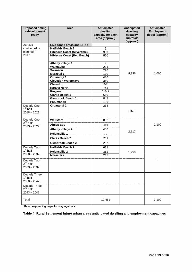
Table 4: Rural Settlement future urban areas anticipated dwelling and employment capacities

Page 20 of 36
6. Anticipated cost of the infrastructure network for future urban areas
The timing and sequencing outlined in this strategy will require significant investment in bulk infrastructure. Table 5 below provides high-level, indicative and inflated capital estimates for the future urban area bulk infrastructure costs. The estimated costs include projects within, or strongly related to, enabling development of the future urban areas. These costs are included in the strategy for the purpose of providing an indication of the scale of investment in bulk infrastructure required for the greenfield areas, however they do not represent the entire cost of servicing these areas and are not intended to be used for any other purpose. This is because:
some projects also benefit existing communities, and therefore not all the costs are attributable to growth in the future urban areas
the share of costs to increase capacity in some infrastructure networks to meet regional demand are excluded, such as upgrades to regional treatment plants
the costs to provide local networks in the future urban areas, such as local streets and small stormwater treatment devices, are excluded.
Funding of the council investment in bulk infrastructure for future urban areas will be confirmed through future Long-term Plans.
High-level bulk infrastructure costs Indicative, inflated capital costs prior to any detailed design. Note that for areas to be development ready in any given decade, some infrastructure costs will be incurred in the previous decade. Costs per decade are therefore not directly correlated to the number of houses provided in each decade.
Decade 1 2018 - 2028
Decade 2 2029 - 2038
Decade 3 2039 - 2048
$20 billion
$6.7 billion
$9.3 billion $3.9 billion
Transport $3,000m Transport $6,500m Transport $1,800m
Water / Wastewater
$2,400m Water / Wastewater
$1,000m Water / Wastewater
$100m
Stormwater $200m Stormwater $300m Stormwater $1200m
Parks & Community
$1,200m Parks & Community
$1,500m Parks & Community
$800m
Costs by sub-region
North $6.7 billion
North-west $5.8 billion
South $7.4 billion
Notes 1. Due to the smaller scale of growth anticipated in Rural Settlements, infrastructure needs are
generally of a local scale which are not included in the indicative bulk infrastructure costs. 2. Transport costs include NZTA and Kiwi Rail investment as per Supporting Growth programme. Table 5: High-level bulk infrastructure costs

Page 21 of 36
7. Monitoring and Review
To ensure responsiveness and the ability to deliver an adequate supply of development-
ready land in the right location and at the right time, specific monitoring will be undertaken on
the strategy as part of a wider monitoring framework.
The National Policy Statement for Urban Development Capacity 2016 sets monitoring and
information requirements for the council. The intention of these is to ensure that planning
decisions in urban environments are well-informed, timely and responsive to changing
population growth demands, market conditions and infrastructure delivery.
The strategy will be monitored as part of the Auckland Plan Development Strategy Annual
Implementation Update. This update will report on the number of new dwellings consented
across the region against actual and projected population growth. It will be expected to
cover a comprehensive set of key indicators on growth drivers, growth management, and the
spatial distribution of growth.
The focus for monitoring across the region will include:
patterns and composition of population change and growth
balance of growth inside and outside the existing urban area
shifts in housing preferences, including location and typology
key bulk infrastructure delivery and funding availability
changes in strategic direction and/or priorities.
For each of the future urban areas identified in the strategy, the annual update will track the
delivery of land for new communities in seven steps:
1. Future urban zoned land in the Unitary Plan
Planning phase 2. Structure planning completed
3. Land rezoned for urban uses
4. Bulk infrastructure provision Infrastructure phase
5. New parcels created (subdivision)
Development phase 6. New dwellings consented
7. New dwellings completed
This analysis will include the area (hectares) identified for future development in the planning
phase and the development capacity (potential dwellings and employment) in the
development phase. Supporting commentary will provide context and detail to the
quantitative reporting.
The infrastructure phase will be a qualitative tracking measure of lead infrastructure planning
and delivery against development ready timeframes. While bulk infrastructure provision is

Page 22 of 36
shown as step four, in practice infrastructure planning and delivery will occur concurrently,
throughout all steps of the planning and development phases.
At the completion of steps one to four the area will be considered development ready.
Progress will be measured against the anticipated growth patterns and targets identified by
the Auckland Plan Development Strategy, as well as the indicative timeframes for structure
planning and infrastructure provision set out in this strategy.
Changes in the growth pattern reported in the Annual Implementation Update will help
understand the strategy’s contribution to the objectives of the Auckland Plan Development
Strategy. This may trigger a review process to ensure the strategy is responsive and keeps
pace with the changing development context and trends over the medium to long-term.
A review will be based on evidence, including monitoring data, observed over time and the
overall assessed impact these factors might have on future development.
The reporting timeframe will be annually and be from July to June, consistent with the
Auckland Plan Development Strategy Annual Implementation Update.

Page 23 of 36
APPENDIX 1 - The principles applied to underpin sequencing decisions
This strategy has been underpinned by a suite of principles to assist with understanding
which areas will achieve the greatest benefits for Auckland over the short, medium and long
term timeframes of the strategy. These principles were not applied to the areas prioritised
between 2012 and 2017 as these priorities were determined through separate Special
Housing Area and Unitary Plan processes.
The principles are as follows:
1. Optimise the outcomes from investment 2. Supply land on time 3. Support uplifting Māori social, environmental, economic and cultural wellbeing 4. Create good quality places 5. Work collaboratively in partnership
1. Optimising the outcomes from investment will be achieved by:
selecting areas that are adjacent to the existing metropolitan urban areas because it
is often the most cost effective when extending infrastructure networks
leveraging existing investment in the Auckland Council spatial priority areas and other key projects such as Special Housing Areas where focused investment is currently occurring
undertaking integrated planning and infrastructure decision making to distribute significant costs of bulk infrastructure projects over time
encouraging efficient and cost effective infrastructure solutions, investment and delivery.
2. Providing the supply of land on time will be achieved by:
maintaining a development pipeline with sufficient supply of land to be re-zoned as
urban at the right time, e.g. the areas have bulk infrastructure in place and are ready
to be developed
selecting areas that are market attractive will assist with take-up of this land
starting with areas that have fewer known and costly constraints as they are easier to
develop and have more reliable development timeframes. Areas with significant
constraints (e.g. flooding and geotechnical issues) may, in time, benefit from
technology advances which will improve the yields and development outcomes.
3. Supporting lifting Maori social, economic, environmental and cultural wellbeing which will
be achieved by:
recognising the principles of the Treaty of Waitangi under section 4 of the Local
Government Act 2002 and the obligations of the council under Part 2 of the Resource
Management Act 1991
engaging with mana whenua on a case-by-case basis to discuss options for the
future use and development of Treaty of Waitangi settlement land

Page 24 of 36
encouraging the use of appropriate design, materials and techniques in the provision
of infrastructure in areas of known historic settlement and occupation patterns
offering support for Māori development aspirations by providing clarity about when
land will be bulk-serviced and ready for development.
4. Creating good quality places will be achieved by:
selecting areas that connect new communities in close proximity to existing social
infrastructure and services to provide an opportunity for these areas to leverage off
and maximise use of this existing infrastructure
delivering economies of scale as larger areas can be more readily planned with a full
range of land use that a community needs, including a range of dwelling types, jobs
and social infrastructure and provide better overall development yield for the required
infrastructure investment
safeguarding enough business land to support and balance residential supply. The
Auckland Plan requires at least 1400 hectares of additional greenfield land for
business activities. This includes approximately 1,000 hectares of industrial land with
specific requirements. A further 400 hectares of land will be required for commercial
activities.
5. Working collaboratively in partnership by:
working on a regular basis with key stakeholders including neighbouring local
authorities (Waikato Regional Council, Waikato District Council, Northland Regional
Council, Hamilton City Council, Kaipara District Council, Whangarei District Council),
central government (e.g. Kiwi Rail), developers and other infrastructure providers
recognising cross boundary infrastructure requirements and funding implications.

Page 25 of 36
APPENDIX 2 - A brief overview of the areas considered
The future urban land addressed in this strategy is predominantly located in three geographic areas: the north, the north-west; and the south. The total gross area of the future urban land is approximately 15,000 hectares including future urban land in rural settlements.
The adoption of the Unitary Plan resulted in live zoning approximately 26 per cent of future urban land included in the strategy, and has determined the initial sequencing and the council’s priorities for infrastructure servicing. The sequencing of other areas has, in part, been influenced by the quantum of land live zoned (i.e. available development capacity through live zoning) and ability to provide infrastructure. A brief summary of the key rationale for timing and sequencing in the strategy is provided below. This summary informs the sequencing table and maps.
Rural settlements and other ‘standalone’ areas have been sequenced according to the anticipated availability of bulk infrastructure services and anticipated timing of structure planning and plan change processes.
Additional information about the anticipated scale of development is also provided for each area including:
the total gross hectares
anticipated new dwellings
the approximate number of anticipated new jobs
the number and type of anticipated new centres.

Page 26 of 36
The North
The North includes the large future urban areas of Warkworth, Wainui and Silverdale-Dairy Flat as well as future urban land in the existing urban area of Hibiscus Coast. It also includes the rural settlement areas of Wellsford, Algies Bay, Hatfields Beach and Albany Village. Together they comprise a land area of 4,992 hectares. The majority of the northern future urban area had not previously been considered for urban development although legacy planning had been undertaken for Warkworth and the Silverdale West “triangle”. Special Housing Areas and subsequent live zoning through the Unitary Plan feature strongly in the Wainui area in the first year of sequencing. The areas are characterised by predominantly rural activities with some countryside living around the Dairy Flat area.
Wainui East 306 ha Approx. 4,500 dwellings 1 neighbourhood centre Silverdale West / Dairy Flat business 617 ha Silverdale Dairy Flat (remainder) / Wainui East / Upper Orewa (remainder) 2,800 ha Approx. 28,400 dwellings 1 town centre, 3 local centres and 1 neighbourhood centre
NORTH
Wellsford 109 ha Approx. 832 dwellings
Warkworth North 324 ha 69 ha business (live zone) Approx. 2,300 dwellings No centres Warkworth North East 192 ha Approx. 1,600 dwellings No centres Warkworth South 493 ha Approx. 3,700 dwellings 1 local centre
North summary Total hectares: 4,992 ha Live zoned area: 485ha Total dwellings: Approx. 44,454 Total jobs: Approx. 23,750
Rural Settlements Albany Village 29 ha Approx. 454 dwellings Hatfields Beach 57 ha Approx. 680 dwellings Hibiscus Coast 102 ha Approx. 1,533 dwellings Algies Bay 39ha Approx. 455 dwellings

Page 27 of 36
Key considerations for the North
Warkworth
The Unitary Plan identifies 69 hectares of live zoned business land in the north of Warkworth which results in this being sequenced for 2017.
A new wastewater treatment plant at Snells Beach, along with an associated new pipeline from Warkworth and upgraded outfall, is required to service development in the rest of Warkworth North. This work is currently being consented, and expected to be implemented over the next five to six years. The Ara Tūhona Pūhoi to Warkworth Road of National Significance is expected to be completed in 2021, and associated upgrades to the local roading network align with the sequencing of Warkworth North.
The later sequencing of Warkworth South provides for the efficient staging of wastewater infrastructure. Warkworth North East is sequenced later to enable connections to the town centre to be adequately addressed.
Wainui East, Silverdale and Dairy Flat
A Special Housing Area was confirmed in 2016 for an area of land in Wainui East. The Unitary Plan now identifies a live zone for this area and an additional area to the west so that the total area of live zoning in Wainui East is now 306 hectares. This area is therefore sequenced for 2017. Interim water and wastewater solutions can provide capacity in the short term to service this live zoned area at Wainui East. There is currently a cap of 2,000 dwellings applying to the Special Housing Area.
Sequencing of the remaining areas reflects the need for significant new bulk water and wastewater infrastructure, including a new water main from Albany and additional wastewater conveyance and treatment capacity at Army Bay. The proposed business area in Silverdale – Dairy Flat is sequenced early to provide local employment opportunities and address demand on transport infrastructure. It is likely that structure planning for this business area will need to occur soon to enable some business land to be live zoned as required in the short-term.
Rural Settlements
Wellsford: Further geotech testing will be required due to ground instability in some areas. A new water source will be required to service the future urban zone areas. These areas will also require an upgrade to the wastewater plant, which is likely to take until the early 2020’s.
Algies Bay: Upgrades to the wastewater outfall pipe will be necessary to service new connections outside the existing service area.
Albany Village: Full buildout of the future urban areas will require new water services capacity (North Harbour watermain) and road upgrading.
Hatfields Beach: Wastewater upgrades are necessary to service new development and are likely to take until the early 2020’s. With limited water supply, large scale development will require new transmission lines from Albany, which is likely to take ten years following commencement of design.

Page 28 of 36
The North-west
The North-west includes the large future urban areas of Whenuapai, Scott Point, Red Hills, Kumeu-Huapai and Riverhead and the rural settlements of Helensville, Waimauku and Swanson. These areas total 3,225 hectares including 938 hectares of live zoned land in Redhills, Kumeu and Whenuapai and the rural settlements. A structure plan for Whenuapai was adopted in 2016 and a plan change is currently being prepared which will enable 401 hectares to be developed as the first stage of the wider area including some business land.
NORTH-WEST
Kumeu-Huapai and Riverhead 992 ha 8,000 dwellings 1 local centre
Whenuapai Live zone 50 ha 1,150 dwellings Stage 1 401 ha Approx. 6,000 dwellings Stage 2 745 ha Approx. 11, 600 dwellings Expanding local centres
Red Hills Live zone area 594 ha 10,650 dwellings Expanding local centres Red Hills North 191 ha 1,400 dwellings 1 local centre
North-west summary Total hectares: 3,225 ha Live zoned area: 938 ha Total dwellings: Approx.42,355 Total jobs: Approx. 13,000
Scott Point 152 ha Approx. 2,600 dwellings
Rural Settlements Helensville 44 ha Approx. 434 dwellings Waimauku 29 ha Approx. 231 dwellings Swanson 27 ha Approx. 290 dwellings

Page 29 of 36
Key considerations for the North-west
Kumeu-Huapai, Riverhead, Whenuapai, Scott Point and Red Hills
The sequencing of the north-west is dependent on completion of the Northern Interceptor in 2025, which is needed to provide bulk wastewater capacity to this area. Interim solutions can provide wastewater for initial development in the live zoned area of Red Hills and first stage of Whenuapai until the Northern Interceptor is completed.
Kumeu, Huapai and Riverhead are sequenced later to align with the timing of transport improvements needed to address safety and capacity issues on State Highway 16, and the completion of the Northern Interceptor.
Rural Settlements
Helensville (Stages 1 and 2): Further geotechnical investigation is likely to be necessary to manage slope stability issues and ensure effective drainage to overland flow paths and streams. The Helensville wastewater plant has recently been upgraded and can accommodate approximately 6,000 people. This provides sufficient capacity for the existing urban zoned areas, and part of the future urban zoned area. The Helensville stage 1 area is the closest future urban zone area to the wastewater plant. Watercare will monitor growth and review additional upgrade options when population nears the treatment plant capacity.

Page 30 of 36
The South
The South includes the large future urban areas of Puhinui, Takanini, Hingaia, Opaheke-Drury, Drury West and Pukekohe-Paerata. The rural settlements in the south include Oruarangi, Maraetai, Clevedon, Clevedon Waterways, Karaka North, Kingseat, Clarks Beach, Glenbrook Beach and Patumahoe. Together, they comprise a large land area of approximately 6,706 hectares with an anticipated dwelling capacity of 50,600 and an anticipated employment capacity of 30,300.
The south makes up the largest proportion of future urban areas in Auckland (45 percent). Of the total future urban land area in the south, Opaheke-Drury and Drury West comprise 2,180 hectares and Paerata and Pukekohe comprise 1,704 hectares. Special Housing Areas and subsequent live zoning through the Unitary Plan feature strongly in the first year of sequencing in the south including at Hingaia, Paerata, Pukekohe, Drury West and Drury South.
The amount of land identified in the Unitary Plan for future urbanisation in the Rural Settlements significantly contributes to the overall supply of land in the south. Together these areas total 1,046 hectares and will contribute approximately 7,550 dwellings. Much of this land is already live zoned (781 hectares).
While the areas in the south present significant opportunities for development, areas such as Takanini and Opaheke are significantly constrained by flooding and geotechnical issues and will require further investigation to identify comprehensive solutions before development can commence. The south also requires significant investment in transport and wastewater infrastructure.

Page 31 of 36
Puhinui 479 ha (business)
Takanini 591 ha Approx. 4,500 dwellings Live zone 20 ha 295 dwellings Cosgrave Rd Area 56 ha Approx. 515 dwellings 1 local centre
Drury West Live zone 87 ha 1,350 dwellings Stage 1 392 ha Approx. 4,200 dwellings Stage 2
552 ha
Approx. 5,650 dwellings
1 town and 2 local centres
Paerata Live zone 326 ha Approx. 4,550 dwellings Remaining area 201 ha Approx. 1,800 dwellings 1 local centre
Pukekohe 1,088 ha Approx.7,200 dwellings Live zone 89 ha Approx. 720 dwellings No new centres
Opaheke/Drury 1,149 ha Approx. 8,200 dwellings 1 town and 2 local centres
Hingaia 264ha Approx. 3,070 dwellings
SOUTH
Drury South 366 ha (including business) 1000 dwellings
South summary Total hectares: 6,706 ha Live zoned area: 2,370 Total dwellings: Approx. 50,600 Total jobs: Approx. 30,300
Rural Settlements Maraetai 89 ha Approx. 327 dwellings Oruarangi 154 ha Approx. 738 dwellings Karaka North
115 ha Approx. 744 dwellings Kingseat 298 ha Approx. 1,842 dwellings Glenbrook Beach 89 ha Approx. 1,050 dwellings Patumahoe 10 ha Approx. 109 dwellings Clarks Beach 122 ha Approx. 1,351 dwellings Clevedon 109 ha Approx. 1,041 dwellings Clevedon Waterways 60 ha Approx. 350 dwellings

Page 32 of 36
Key considerations for the South
Takanini
The future urban zone in Takanini is located within the large Papakura Stream catchment and the majority of the area is low lying and subject to significant flooding hazards. Much of the area is also subject to significant geotechnical constraints due to peat soils.
Initial cost estimates to provide a comprehensive stormwater solution to the area were considered to be high with a relatively low to moderate dwelling yield. This was considered to make development possible in the medium to longer term. Since the adoption of the Future Urban Land Supply Strategy in 2015, further analysis of recent stormwater project costs in the Takanini area have been undertaken. The results of this analysis indicate that stormwater costs for the future urban zone remain high and further work is required to understand the viability of development in this area in the medium to long term. The Takanini future urban area has therefore been sequenced in the second half of the third decade (2043 – 2047). However, the future urban area at Cosgrave Road, Takanini, comprising 56 hectares, has been sequenced earlier as it is able to be serviced by the Cascades Road conveyance channel. A 2023 – 2027 timeframe for this area also enables transport solutions to be developed.
Hingaia, Opaheke-Drury and Drury West
Proposed interim solutions provide wastewater capacity for initial development in the live zoned areas of Hingaia, Drury West and Drury South as well as Drury West Stage 1 from 2022.
In the longer term, augmentation of the South and Southwestern Interceptors is required to provide wastewater capacity for the full build-out of Drury West Stage 2 and Opaheke-Drury which are sequenced between 2028 and 2032. Complex inter-catchment floodplain interactions require that all four affected stormwater catchments are considered together to ensure that early development in one area does not preclude the remainder of the future urban zone. A comprehensive catchment-wide and potentially cross-catchment solution for the flooding constraints in Opaheke-Drury, in combination with the completion of the final wastewater infrastructure, is required before development can occur in this area.
The later sequencing of Drury West Stage 2 also allows for the provision of a new expressway between Drury, Paerata and Pukekohe, which is required to alleviate capacity and safety issues on State Highway 22.
Pukekohe and Paerata
Paerata includes a 328 hectare Special Housing Area at Wesley which is expected to provide around 4,550 dwellings over the next 25 years. A further 1,800 dwellings, outside the Special Housing Area, are expected to be provided in the wider Paerata area. Pukekohe has had comprehensive legacy planning and is expected to provide around 8,000 dwellings and a number of employment opportunities, leveraging off the existing town.
Upgrades to water, wastewater and stormwater are required to enable large scale development to proceed. Construction of additional water reservoir capacity is planned as well as upgrades to the Pukekohe wastewater treatment plant and expanded wastewater networks to service growth in the area. Pukekohe and Paerata require less stormwater investment compared to Takanini, Opaheke and Drury.
The transport network has not been designed for the anticipated growth but this being addressed through Auckland Transport’s Supporting Growth project. The existing rail network connects Pukekohe with the rest of Auckland. The network will be strengthened by the extension of electric trains to Pukekohe and by the addition of extra rail capacity. A new train station at Paerata will improve access to trains through the southern corridor. A new

Page 33 of 36
expressway between Pukekohe, Paerata and Drury will link to State Highway 1. Planned safety improvements and upgrades on State Highway 22 will improve travel between Drury and Paerata and a bypass will be constructed south of Pukekohe Town Centre for trucks and other traffic.
The Wesley Special Housing Area has been live zoned through the Unitary Plan process and is therefore has the appropriate zoning in place. The remainder of the Paerata area has been sequenced in the first half of decade one as the second phase of growth at Paerata.
Pukekohe is sequenced in the second half of decade one (2023 – 2027), excluding most of Belmont (Pukekohe) which is already live zoned. The early sequencing of Pukekohe will allow for the development of a comprehensive structure plan for the entire future urban area. A structure plan for the whole of Pukekohe will enable efficient and integrated land use and infrastructurere solutions to be found.
Rural Settlements
Maraetai: the wastewater treatment plant will be upgraded as required in order to maintain discharge compliance and to accommodate growth.
Oruarangi: The area has sufficient water and wastewater bulk capacity. Structure planning will need to take cultural heritage and landscape values into account, consistent with the Mangere Gateway Precinct.
Puhinui: The remaining future urban zone is not anticipated to be development ready until 2030 due to transport constraints and anticipated market readiness.
Clarks Beach: A new wastewater outfall at Clarks Beach will be required to service new development, subject to a sub-regional wastewater discharge consent which has currently been applied for.
Glenbrook Beach: New development will depend on the new Clarks Beach wastewater outfall, and structure planning for the new area to be developed as a gateway to, and logical extension of, the existing village.

Page 34 of 36
APPENDIX 3 - Glossary4
Brownfield Urbanised land able to be redeveloped, often for more intensive or different land use.
Business Commercial and industrial activities, excluding centres and activities in centre zones.
Community and social infrastructure The following definition of community infrastructure has been taken from the Unitary Plan: Facilities for the well-being of a community, generally on a not for profit basis.
Includes:
arts and cultural centres (including art galleries and museums);
places of worship
community centres
halls
libraries
marae
Citizens Advice Bureaux
justice facilities. Excludes:
entertainment facilities
care centres
healthcare facilities.
However, for the purposes of this strategy, community and social infrastructure also includes:
hospitals and healthcare facilities
education facilities and early childhood learning services.
Future urban zone The future urban zone is applied to greenfield land that has been identified as suitable for urbanisation. The future urban zone is a transitional zone and will remain in place until a structure plan and concurrent plan change re-zones the land to the appropriate urban zone (e.g. residential or business). Land may be used for a range of general rural activities but cannot be used for urban activities until the site is re-zoned for urban purposes.
Greenfield Rural land identified or used for urban development (eg. residential, business or industrial) that has not been previously developed.
Infrastructure The facilities, services and installations that enables a community to function, comprising of:
airports
airport approach surfaces
water supply and wastewater (including storage and treatment facilities)
broadcasting
defence
electricity generation, transmission and distribution
4 Where the same terms have been defined in the Unitary Plan, the Unitary Plan definitions have been
used for the purposes of consistency.

Page 35 of 36
irrigation
transmission, distribution and storage of gas liquid fuels or geothermal energy
motorways and roads
walkways and cycleways
ports
public transport
railways
solid waste disposal
existing class 1 regional landfills
stormwater
telecommunication and radio communication
air quality and meteorological services
anything described as a network utility operation in regulations made for the purposes of the definition of network utility operator in section 166 of the RMA.
Live zoned Land that was previously zoned future urban under the Auckland Proposed Unitary Plan and now has an urban zone (residential or business) in the Operative Unitary Plan. In a small number of cases, a live zone (residential or business) has been allocated to land that was previously zoned rural.
Open Space Land zoned to provide for public use and access, for both recreational and passive activities. Open space also includes general infrastructure located in Open Space zones to support management of, and access to open space.
Rural Urban Boundary The Rural Urban Boundary identifies land potentially suitable for urban development. The location of the Rural Urban Boundary is a district plan land use rule pursuant to section 9(3) of the Resource Management Act 1991.
Satellite towns Towns in the region which function semi-independently from the Auckland metropolitan area, providing a full range of services and employment opportunities to the surrounding rural areas. It applies to the towns of Pukekohe and Warkworth.
Structure Plan Structure plans establish the spatial development pattern of land use and the transport and services network within a defined area. A detailed examination of the opportunities and constraints relating to the land is required and will ensure the effects of development are addressed in advance of development occurring. Appendix 1 of the Unitary Plan provides guidance on the preparation of structure plans.

Page 36 of 36
www.aucklandcouncil.govt.nz