aura technical report july 2008 -...
TRANSCRIPT

SUITE 900 - 390 BAY STREET, TORONTO ONTARIO, CANADA M5H 2Y2 Telephone (1) (416) 362-5135 Fax (1) (416) 362 5763
AURA MINERALS INC.
NI 43-101 TECHNICAL REPORT AND AUDIT OF THE
PRELIMINARY RESOURCE ESTIMATE ON THE
ARANZAZU PROPERTY ZACATECAS STATE,
MEXICO
William J. Lewis B.Sc., P.Geo.
July 15, 2008

i
TABLE OF CONTENTS
Page
1.0 SUMMARY ............................................................................................................1
2.0 INTRODUCTION AND TERMS OF REFERENCE ........................................9
3.0 RELIANCE ON OTHER EXPERTS ................................................................12
4.0 PROPERTY DESCRIPTION AND LOCATION ............................................14
5.0 ACCESSIBILITY, CLIMATE, LOCAL RESOURCES, INFRASTRUCTURE AND PHYSIOGRAPHY...............................................20
6.0 HISTORY .............................................................................................................23 6.1 CONCEPCIÓN DEL ORO MINING DISTRICT AND THE
ARANZAZU PROPERTY.................................................................................23 6.2 HISTORICAL EXPLORATION .......................................................................25 6.3 HISTORICAL MINING.....................................................................................27 6.4 HISTORICAL PRODUCTION..........................................................................30 6.5 HISTORICAL RESOURCE AND RESERVE ESTIMATES ...........................32
6.5.1 Historic December 31, 1993 Arroyos Azules Mine Reserve Estimate..........32
7.0 GEOLOGICAL SETTING.................................................................................35 7.1 REGIONAL GEOLOGY ...................................................................................35 7.2 PROPERTY GEOLOGY ...................................................................................38
7.2.1 Structure .........................................................................................................38
8.0 DEPOSIT TYPES ................................................................................................40
9.0 MINERALIZATION...........................................................................................42
10.0 EXPLORATION..................................................................................................43 10.1 EXPLORATION TARGETS AND POTENTIAL ............................................43
11.0 DRILLING ...........................................................................................................50
12.0 SAMPLING METHOD AND APPROACH .....................................................51 12.1 PRELIMINARY ZACORO SAMPLING METHOD AND APPROACH........51 12.2 AURA SAMPLING METHOD AND APPROACH .........................................52
13.0 SAMPLE PREPARATION, ANALYSES AND SECURITY..........................54 13.1 ZACORO SAMPLE PREPARATION, ANALYSIS AND SECURITY
PROTOCOLS.....................................................................................................54

ii
14.0 DATA VERIFICATION .....................................................................................55 14.1 SEPTEMBER, 2006 SITE VISIT ......................................................................55 14.2 FEBRUARY/MARCH, 2007 MICON AUDIT OF ZACORO’S
PRELIMINARY RESOURCE ESTIMATE ......................................................58 14.3 JUNE, 2008 REVIEW OF AURA ACQUISITION OF THE
ARANZAZU PROPERTY.................................................................................60
15.0 ADJACENT PROPERTIES ...............................................................................61
16.0 MINERAL PROCESSING AND METALLURGICAL TESTING................63
17.0 MINERAL RESOURCE AND MINERAL RESERVE ESTIMATES...........66 17.1 ZACORO RESOURCE ESTIMATE .................................................................66
17.1.1 Database Preparation .....................................................................................66 17.1.2 Resource Estimation Procedure .....................................................................67
17.2 GENERAL RESOURCE ESTIMATE DISCUSSION ......................................81 17.2.1 General Discussion ........................................................................................81 17.2.2 Previous Mining.............................................................................................87 17.2.3 Stockpiles .......................................................................................................88
17.3 RESOURCE SUMMARY..................................................................................89
18.0 OTHER RELEVANT DATA AND INFORMATION .....................................92
19.0 INTERPRETATION AND CONCLUSIONS ...................................................93 19.1 CONCLUSIONS ................................................................................................95
20.0 RECOMMENDATIONS.....................................................................................97
21.0 REFERENCES...................................................................................................100
APPENDIX
Appendix 1 ALS Chemex Laboratories Assay Certificate for
Micon’s Chip/Grab Samples from the Aranzazu Property Zacatecas State Mexico....................................... At end of Report

iii
LIST OF TABLES Page
Table 1.1 Preliminary Resource Estimate for the Copper on the
Aranzazu Property (0.5% Cut-off Grade) ...................................................4
Table 2.1 List of the Abbreviations ............................................................................9
Table 4.1 Summary of the Exploitation Concession Information for the Aranzazu Project .......................................................................................17
Table 6.1 Historical Drilling Programs for the Aranzazu Project.............................25
Table 6.2 Summary of the Significant Drill Hole intercepts for the Aranzazu Project. ......................................................................................26
Table 6.3 Summary of the Production for the Aranzazu Property (Arroyos Azules mine 1962 to 1992)........................................................31
Table 6.4 Summary of the Historic December 31, 1993 “In-situ Reserves” (Diluted) for the Aranzazu Project...........................................33
Table 6.5 Summary of the Stockpiled Material for the Aranzazu Project................34
Table 10.1 Aranzazu Property Exploration Targets....................................................44
Table 14.1 Results for Micon’s Aranzazu Check Samples.........................................59
Table 16.1 Metallurgical Sample Descriptions for the Aranzazu Property ................63
Table 16.2 Metallurgical Sample Assays for the Aranzazu Property .........................65
Table 16.3 Metallurgical Rougher Recovery for the Metallurgical Samples from the Aranzazu Property .......................................................65
Table 17.1 Drill Hole Collar Conversion Factors from Local to UTM Coordinates ...............................................................................................67
Table 17.2 Assay File - Minimum and Maximum Assay Intervals and Assay Values.............................................................................................69
Table 17.3 Assay File Data Inclusion and Statistics...................................................69
Table 17.4 Composite File – Item Description...........................................................70
Table 17.5 Five Metre Composite File Data Inclusion and Statistics.........................70
Table 17.6 Two and Three Metre Composite File Data Inclusion and Statistics ....................................................................................................70
Table 17.7 Aranzazu Project Block Model Dimensions.............................................75
Table 17.8 Variogram Model Parameters ...................................................................76
Table 17.9 Variogram Model Parameters ...................................................................76
Table 17.10 Correlation Coefficients............................................................................80

iv
Table 17.11 Specific Gravity Measurements from PRA’s Testwork ...........................81
Table 17.12 Comparison of the Composited Assay Values for the Drilling ................82
Table 17.13 Comparison for Varying Kriging Parameters for the Indicated Copper Resources .....................................................................................83
Table 17.14 Indicated and Inferred Copper Resources at Cut-off Grades ranging from 0.01% to 0.5% Copper ........................................................83
Table 17.15 Conceptual Mineralized Solid Volume, Tonnage and Average Grade based on Drill Hole Intercepts, for Comparison with the Preliminary Resource Block Model Only.................................................85
Table 17.16 Summary of the Material Contained in the Stockpiles on the Aranzazu Property.....................................................................................89
Table 17.17 Preliminary Resource Estimate for the Copper on the Aranzazu Property (0.5% Cut-off Grade) .................................................90
Table 19.1 Aranzazu Property Proposed Exploration Budget (2 Years) (Expenditures in US $)..............................................................................94
Table 19.2 Aranzazu Property Proposed Operational Work Budget (1 Year) (Expenditures in US $)..................................................................94
Table 19.3 Preliminary Resource Estimate for the Copper on the Aranzazu Property (0.5% Cut-off Grade) .................................................95

v
LIST OF FIGURES Page
Figure 4.1 Aranzazu Project Location Map ...............................................................14
Figure 4.2 Mine with the Town of Concepción del Oro in the Background and to the Left ...........................................................................................15
Figure 4.3 Aranzazu Project Mineral Concessions Map............................................16
Figure 5.1 View of the Aranzazu Property.................................................................22
Figure 6.1 Ruins of the Burned Headframe at Aranzazú ...........................................28
Figure 6.2 The Cabrestante Headframe......................................................................29
Figure 6.3 Arroyos Azules Open Pit and Underground Access Points within the Pit .............................................................................................29
Figure 6.4 Open Stope Underground in the Mexicana Mine .....................................30
Figure 7.1 Regional Geology Map for the Concepción del Oro Mining District.......................................................................................................36
Figure 7.2 Generalized Stratigraphic Column in the Concepción del Oro Mining District ..........................................................................................37
Figure 7.3 Aranzazu Property Geology Map .............................................................39
Figure 10.1 Exploration Target Concepts in the Concepcion del Oro Area ................45
Figure 10.2 Induced Polarization Survey Results in the Arroyos Azules Area...........................................................................................................47
Figure 10.3 Induced Polarization Survey Results in the Aranzazu Area .....................48
Figure 14.1 Underground Location of Micon Sample #62101 ....................................55
Figure 14.2 Underground Location of Micon Sample #62102 ....................................56
Figure 14.3 Underground Location of Micon Sample #62103 ....................................56
Figure 14.4 Surface Location of Micon Sample #62104 .............................................57
Figure 15.1 Adjacent Mineral properties or Mines in the Region surrounding Concepción del Oro ..............................................................62
Figure 17.1 Project Area and Drill Hole Location .......................................................68
Figure 17.2 Copper Assay Histogram ..........................................................................71
Figure 17.3 Copper Composite Histogram...................................................................71
Figure 17.4 Gold Assay Histogram..............................................................................72
Figure 17.5 Gold Composite Histogram ......................................................................72
Figure 17.6 Silver Assay Histogram ............................................................................73
Figure 17.7 Silver Composite Histogram.....................................................................73

vi
Figure 17.8 Oblique View Arroys Azules North Skarn from the BW Body to the Cabrestante Shaft ............................................................................74
Figure 17.9 Copper Variogram for Model 1 ................................................................76
Figure 17.10 Copper Variogram for Model 2 ................................................................77
Figure 17.11 Copper Variogram for Model 3 ................................................................77
Figure 17.12 Copper Variogram for Model 4 ................................................................78
Figure 17.13 Gold Variogram for Model 1 ....................................................................78
Figure 17.14 Gold Variogram for Model 4 ....................................................................79
Figure 17.15 Silver Variogram for Model 1...................................................................79
Figure 17.16 Silver Variogram for Model 4...................................................................80
Figure 17.17 Three Dimensional View of the Indicated Resource Block Model for >0.5% Copper ..........................................................................84
Figure 17.18 Distribution of Resource Block Model within the Conceptual Deposit Model...........................................................................................84
Figure 17.19 View of the Historical and Recent Mining vs the Drilling .......................85
Figure 17.20 Gold Block Model Diagram for the Arroys Azules Model Area..............86
Figure 17.21 Silver Block Model Diagram for the Arroys Azules Model Area...........................................................................................................86
Figure 17.22 Distribution of Drill Holes with Zinc Assays (Red, Grey, and Black Intercepts) .......................................................................................87
Figure 17.23 Long Section View of the Various Underground Workings and Stopes, Looking North ..............................................................................88
Figure 17.24 Oblique View of the Various Underground Workings and Stopes, Looking North ..............................................................................88

1
1.0 SUMMARY Aura Minerals Inc. (Aura) has acquired a 100% interest in all of the assets related to the Aranzazu project (formerly known as the El Cobre project) located in the northeastern portion of the State of Zacatecas in Mexico. As a result Aura has retained Micon International Limited (Micon) to review and revise the March 30, 2007 Technical Report originally written for Zacoro Metals Corp. (Zacoro). The report was entitled “NI 43-101 Technical Report and Audit of the Preliminary Resource Estimate on the El Cobre Property, Zacatecas State, Mexico”, and was prepared by William J. Lewis, B.Sc., P.Geo. (the 2007 Zacoro Technical Report), a copy of which can be found on the Canadian Securities Administrators (CSA) System for Electronic Document Analysis and Retrieval (SEDAR) under Vistior Capital Limited. The review and revision of the March 30, 2007 Technical Report is being performed in support of Aura’s acquisition of the Aranzazu project. The primary objectives of this report are to review and assess the preliminary mineral resources, the potential to expand economic copper-gold mineralization, and to evaluate Aura’s proposed exploration program to investigate the property’s mineral potential. This report documents and summarizes the historic geological work conducted by the previous operators and comments on the proposed 2008 to 2009 exploration program by Aura. This report also constitutes a review and audit by Micon of the January, 2007 preliminary mineral resource estimate for the Aranzazu project which was conducted by Zacoro, and the details of which are set out in the 2007 Zacoro Technical Report. Zacoro undertook the preliminary resource estimate to upgrade the historical December 31, 1993 resource and reserve estimate into one that follows the Canadian Institute of Mining, Metallurgy and Petroleum (CIM) standards and definitions for resource estimates, as required by Canadian National Instrument 43-101 (NI 43-101). The preliminary resource estimate was conducted as part of an option to earn a 50% interest in the Aranzazu project. Zacoro was unable to complete the option and in March, 2008 Zacoro’s option expired. Aura has received permission from Zacoro to use its preliminary resource estimate and the supporting 2007 Zacoro Technical Report as part of its supporting documentation for the acquisition of the Aranzazu property. Aura advises that it holds the Aranzazu project indirectly through its 100% owned subsidiary Newington Corporation S.L (Newington) which in turn holds 100% of the project through its Mexican subsidiary Aranzazu Holding S.A. de C.V. (Aranzazu Holding). Aura acquired the property (including all concessions, all interests in real property, including buildings, improvements, fixtures, licenses, leases, rights of way, surface rights, water use rights and all other easements or other real property interests, and all interests in machinery, tools, equipment, and other personal property, in each case related to the Aranzazu project on June 5, 2008 from Clapham Luxembourg Holding S.a.r.L for US $70,000,000. Aura also acquired data and equipment relating to the Aranzazu project by Zacoro for US $3,000,000 Most of the mineral concessions are contiguous and vary in size, for a total property area of 1,443.08 ha. All concessions are subject to a bi-annual fee (i.e., twice per year) and the filing of reports in May of each year covering the work accomplished on the property between

2
January and December of the preceding year. It should be noted that as of December 21, 2005 (by means of an amendment made on April 28, 2005 to the Mexican mining law) there is only one type of mining concession in Mexico and these are valid for a period of 50 years. The Aranzazu project is located within the Municipality of Concepción del Oro in the State of Zacatecas, Mexico, near its northern boarder with the State of Coahuila. The project is accessed either from the city of Zacatecas located 250 km southwest or from the city of Saltillo located 112 km to the northeast. Both Zacatecas and Saltillo have modern airports with daily flights to and from Mexico City and portions of the United States. The Aranzazu project is located in a rugged mountainous area with the higher points reaching 3,300 m above sea level. The term “Aranzazu project” refers to the immediate area surrounding the open pit and underground workings of the Arroyos Azules mine, which were the focus of previous mining and of Zacoro’s preliminary resource estimate. The term “Aranzazu property” refers to the entire land package acquired by Aura. Mining activities began in the district in 1548 soon after the arrival of the Spanish and continued sporadically through the 16th, 17th and 18th centuries. In 1891, the Mazapil Copper Company of Manchester, England began operations and worked through to 1962. From 1962 various companies have run the Aranzazu project; ASARCO (1962 to 1980), Fomento Minero (1980 to 1989) and Macocozac S.A. de C.V. (from 1989 to 2008). Early historical production records appear not to have survived the passage of time and records of the concentrate shipped to the smelters are available only from 1962 to 1992. Production at the Aranzazu project ceased in 1999 due to low metal prices and a labour dispute. Various companies have conducted due diligence data reviews and drilling programs on the Aranzazu property since 1998; however, the projects were not completed due either to insufficient funds or other obligations which forced the companies to withdraw from the project. The Aranzazu mineral deposits occur as skarns, mantos and chimneys around the main intrusive complex. The mineralized skarns occur adjacent to portions of the intrusive complex with intense stockwork veining of quartz, orthoclase and sericite in the Tajo Arroyos Azules area. Skarn mineralization in the historic Aranzazu area, 2.5 km northwest of Tajo Azules, occurs on the margin of a large, orthoclase, secondary biotite and sericite altered, iron-stained zone. Several other areas of strong iron-staining, mineralized skarn, or mineralized veins and chimneys, occur throughout the area and have not received systematic exploration. Copper-gold skarns are important economic deposits and are often associated with porphyry copper deposits or calcic to calc-alkalic igneous rocks. Gold, molybdenum and silver are common primary or by-products of these deposits where they generally occur in variable concentrations. Copper-gold skarns generally form in moderately oxidizing to reducing hydrothermal or magmatic conditions and usually contain magnetite, hematite, pyrite or pyrrhotite. The metal assemblage associated with copper-gold skarns is generally simple and includes copper, gold, molybdenum and silver, with elevated trace element suites containing bismuth, arsenic and tellurium (Myers, 2002). The calc-silicate mineralogy of copper skarns is andradite garnet dominant with lesser amounts of light to dark green diopsidic to

3
hedenbergitic pyroxene. Retrograde alteration is generally limited to pyroxene altering to actinolite or garnet altering to calcite, quartz, iron oxide and clay. The discussions related to resource and reserve estimates contained in this report refer to both the historical estimates conducted prior to February 1, 2001 and to Zacoro’s preliminary 2007 resource estimate based on previous drilling data only. The historic resource and reserve estimates discussed in this report may have been prepared according to the accepted standards for the mining industry for the periods to which they refer, but they do not comply with the current CIM standards and definitions for estimating resources and reserves as required by NI 43-101 regulations. The preliminary resource estimate conducted by Zacoro in January, 2007 and audited by Micon is CIM compliant. The latest historical reserve estimate conducted on the Aranzazu property was completed as of December 31, 1993. No further resource estimates were conducted by the Mexican owner after 1993 due to erratic production resulting from fluctuating metal prices. All operations at the Aranzazu project finally ceased in 1999. However, with the increase in metal prices beginning in late 2004 and 2005, limited operations were restarted by the Mexican owners in July, 2007. The historical reserve estimate as of December 31, 1993 totalled 15,974,574 t grading 1.3% copper, including 11,797,200 t in the Arroyos Azules area averaging 0.29 g/t gold, 12 g/t silver and 1.14% copper. The December, 1993 numbers were reported as “positive reserves”, “probable reserves” and “possible reserves” (“reservas positivas,” “reservas probables” and “reservas posibles”) and incorporated a 10% mining dilution. The “reserves”, except for an insignificant amount, are made up of sulphide material. Additionally, the Mexican owner reported 11.25 million tonnes of stockpiled material containing 1.21% copper and unknown gold, silver and zinc. Micon has not audited the stockpiled material and, in light of the need to conduct further sampling and metallurgical testing to define the grade and recoverability, this material cannot be considered as compliant resources under NI 43-101 regulations and should not be relied upon. In January, 2007, a preliminary resource estimate for the Aranzazu project area was conducted by Zacoro and audited by Micon. This preliminary estimate was prepared from first principles using a block model created with the Gemcom mining software package (GEMS). A series of north-south, east-west, and plan views were developed as the basis of the block model interpretation upon which the preliminary resource estimate is based. Zacoro has indicated to Micon that Aura has the authorization to use the 2007 Zacoro Technical Report written for it by Micon. The Aranzazu project hosts significant copper resources with undefined concentrations of gold, silver, zinc, molybdenum, and possibly other metals such as iron, bismuth, and sulphur in pyrite which may be recoverable. The 2007 preliminary resource estimate only estimated the copper mineralization due to the erratic distribution and incomplete database for the other metals.

4
The preliminary copper resource estimate does not include material mined in the open pit and underground workings. The open pit material was removed by eliminating blocks above the present topography in the volumetric calculations in the GEMS software. The underground workings were digitized and a solid was extruded to approximate the shape and volume of the mined bodies and access tunnels. The average grade and volume of these stopes was compared to the available production records. Aura believes that 3 million tonnes averaging 0.8% copper for approximately 53 million pounds of copper is a reasonable estimate of previous production based on reported pounds of copper produced from concentrate and company records of estimated head grades and estimated production. The estimated volume of the stopes was removed from the final preliminary resource estimate, which is summarized in Table 1.1 (0.5% cut-off grade) for the in-situ mineralization.
Table 1.1 Preliminary Resource Estimate for the Copper on the Aranzazu Property (0.5% Cut-off Grade)
Resource Category Tonnes Grade (% copper)
Contained Copper (t)
Contained Copper (lbs)
Indicated 25,683,000 1.02 268,568 591,924,00 Indicated Total 25,683,000 1.02 268,568 591,924,000 Inferred 8,787,000 0.81 70,912 156,248,000 Inferred Total 8,787,000 0.81 70,912 156,248,000
Table reproduced from the 2007 Zacoro Technical Report. The figures in Table 1.1 have been rounded to reflect that the mineral resource estimate is an approximation. Micon believes that no environmental, permitting, legal, title, taxation, socio-economic, marketing or political issues exist which would adversely affect the mineral resources estimated above. However, mineral resources that are not mineral reserves do not have demonstrated economic viability. There are currently no mineral reserves on the Aranzazu project or property. Given the widely spaced nature of the drill holes relative to the distribution of the copper mineralization, Micon considers that it was appropriate to classify the lower portion of the Arroyos Azules mine area below approximately the 1850 level in the Arroyos Azules North zone as belonging to the Inferred Resources category, according to the definition below:
“An ‘Inferred Mineral Resource’ is that part of a Mineral Resource for which quantity and grade or quality can be estimated on the basis of geological evidence and limited sampling and reasonably assumed, but not verified, geological and grade continuity. The estimate is based on limited information and sampling gathered through appropriate techniques from locations such as outcrops, trenches, pits, workings and drill holes.”
Due to the greater density of drilling and mine workings relative to the distribution of the copper mineralization, Micon considers it appropriate to classify portions of the preliminary mineral resources within the Arroyo Azules North zone on the Aranzazu property as Indicated Resources according to the definition below:

5
“An ‘Indicated Mineral Resource’ is that part of a Mineral Resource for which quantity, grade or quality, densities, shape and physical characteristics, can be estimated with a level of confidence sufficient to allow the appropriate application of technical and economic parameters, to support mine planning and evaluation of the economic viability of the deposit. The estimate is based on detailed and reliable exploration and testing information gathered through appropriate techniques from locations such as outcrops, trenches, pits, workings and drill holes that are spaced closely enough for geological and grade continuity to be reasonably assumed.”
The 2007 preliminary resource estimate completed by Zacoro has been reviewed and audited by Micon. It is Micon’s opinion that the preliminary resource estimate has been compiled in accordance with the CIM standards and definitions for resource estimates and that Aura can use the resource estimate as a basis for further exploration and economic evaluation of the Aranzazu property. Zacoro conducted an exploration program on the Aranzazu property from January, 2007 to February, 2008, which consisted of 147 diamond core holes totalling 41,200 m. Aura is in the process of reviewing this work and undertaking its own Quality Assurance/Quality Control (QA/QC) program. Once Aura has completed this program, the Zacoro drilling will be included in the data set pertaining to the Aranzazu property along with work conducted by Aura. The results of this work will be discussed and added to any further relevant Technical Reports which Aura may undertake as a result of its programs on the Aranzazu property. The Mexican owners restarted mining operations on a limited scale in 2007 at approximately 600 tonnes per day (t/d) with an average head grade of 0.8% copper, 0.28 grams per tonne (g/t) gold and 12 g/t silver. From July, 2007 through May, 2008, 5,650 t of copper concentrate were reported shipped to the Trafigura Smelting Company facility in Manzanillo, Mexico. The copper concentrate averaged 24.3% copper, 4.2 g/t gold and 258 g/t silver. Associated recoveries averaged 84% copper, 40% gold and 61% silver. Aura is in the transitional phase in its takeover of the Aranzazu property which is expected to take 2 to 3 months. This will include transfer of all mining and operating permits. Aura plans to conduct a Phase 1 exploration program on the Aranzazu property beginning in August, 2008. The program will be comprised of surface and underground mapping and sampling, followed by both surface and underground diamond drilling, and surface reverse circulation (RC) drilling. It is estimated that one RC drill rig and two diamond drill rigs will be required (one drill working on surface and one drill working underground). The immediate focus of the drilling will be to better define data in the BW-Mexicana area to bring existing resources into a mine plan, leading to an updated resource estimate, followed by resource definition drilling along strike from the BW zone to Cabrestante. A district wide exploration program will also be implemented. The total expenditure for the Phase 1 exploration program is estimated to be US $5,068,800. In addition to the Phase 1 exploration program, Aura intends to conduct an operations work program. This program will be comprised of a metallurgical testwork program, capital investment in equipment and underground development, a review of the engineering involved to expand the underground mine, certain plant upgrades and environmental impact

6
studies. Total expenditure for the operations work program is estimated to be US $10,710,000. A Phase 2 exploration program will focus on continued exploration and in-fill drilling and will be dependent on the results of the Phase 1 exploration program. This phase will include metallurgical testing depending on the outcome of the drilling to identify further potentially economic zones of mineralization. The total estimated budget for the Phase 2 exploration program is US $6,686,000. If the two year exploration program and the operations work program are completed as envisioned in the proposed budget, the expenditures on the Aranzazu property will be approximately US $22,464,800. The exact timing of the programs will be dependent on permitting, weather, availability of manpower and drilling equipment, and results of Phase 1 programs. Through its acquisition of the Aranzazu property, Aura has acquired a historical Mexican mining property with the potential to yield significant gold and copper mineralization. Micon agrees with the general direction of Aura’s exploration and development program for the property and makes the following additional recommendations:
1) Micon recommends that Aura completes the compilation and conversion of Macocozac’s paper database into a computer database for the Aranzazu property as soon as possible. Conversion of the paper database into a computer database will greatly assist in defining exploration targets and in future resource estimates. The compilation and conversion of the database can be completed in conjunction with surface geochemistry surveys and geological mapping or proposed drilling programs.
2) Micon recommends that Aura applies its company-wide QA/QC program to the
exploration campaigns which it conducts on the Aranzazu property. The company’s QA/QC program should address all aspects of the exploration program from initial project investigation to major drilling programs. This QA/QC program should be added as an appendix to any future exploration reports.
3) Micon recommends that Aura completes its review of the work conducted by
Zacoro on the Aranzazu property and undertakes a QA/QC review on the Zacoro work.
4) Micon recommends that Aura uses the current Macocozac database and the results
of the 2007 Zacoro drill program to identify zonation of the various economic minerals within the deposit and “ore” types. The zonation will be important not only to identify any associations between the various economic minerals which may assist in identifying new areas of mineralization but also to identify any areas where detrimental mineralization to the milling process may be concentrated which will create the need for blending of any production material.

7
5) Micon recommends that, during the drilling program, Aura twins a number of historical drill holes to confirm the mineralization contained in the historical underground and surface holes. This drilling may confirm the assay results of the previous drilling as well as assist in confirming both the estimated grades and tonnages for the individual zones contained in the historical 1993 reserve statement and for Zacoro’s 2007 preliminary resource estimate which was based on the historic drilling. Twinning some drill holes will allow Aura to determine if there is a large variability in the assays at the same down-hole location, when comparing the two drill holes. In-fill drilling on the historic reserve blocks will assist in identifying if the historic information used to determine the grade and tonnage of the blocks was adequate or not.
6) Micon recommends that during Aura’s drilling program it continues to log the drill
holes to production standard rather than exploration standards. Determinations such as the rock quality designation/designator (RQD), fracture/fault patterns and major fault or gouge zones should continue to be noted and entered into the computer database to assist in future mine planning.
7) Micon recommends that all drill holes have a down-hole survey conducted on them
and that selected holes have a second survey conducted upon them using a second down-hole survey method to check the accuracy of the first test.
8) A blank sample should be generated from the un-mineralized rock formations
within the district. Enough material should be acquired to generate a blank sample for use throughout the QA/QC program for all future exploration drilling campaigns planned by Aura.
9) Micon recommends that a cavity monitor system (CMS) be used to conduct
surveys of the underground workings in the older portions of the mines which may be opened or compromised by further open pit mining. These surveys will also assist in determining the volume of material removed by previous mining accurately and will assist in creating a 3 dimensional model of the mine workings which, when superimposed over a model of the existing resources, will assist in verifying previous resource or reserve estimates. This model will also assist in future mine planning.
10) Micon recommends that for future resource estimates, Aura incorporates
information derived from the currently planned metallurgical testwork programs into the block model.
` Given the amount of historical mining conducted on the Aranzazu property, the extent of the remaining mineralization within the known mining areas, and the lack of a modern comprehensive exploration program covering the entire property in the past, the property has the potential to host additional zones or lenses of copper, gold, silver and zinc mineralization, similar in character and grade to that exploited in the past, outside the present resource base.

8
Given the prospective nature of the Aranzazu property and the recent positive changes in metal prices, it is Micon’s opinion that the property is worthy of further exploration work. The Aranzazu property should be considered as a producing Mexican mine with advanced stage exploration. Aura plans to explore the possibility of expanding the existing historical resource base with a surface and underground exploration program in order to convert Indicated and Inferred resources to Measured and Indicated resources and to upgrade the lower confidence resources into the Measured and Indicated classifications. Given the recent sustained increase in metal prices the Aranzazu property has seen a significant enhancement in its economic potential since the previous operation was closed in 1999. It is Micon’s opinion that a program of compilation and analysis of the existing data followed by a focused exploration program to follow-up on the known occurrences and anomalies is both warranted and justified. Micon has reviewed the proposed exploration program for Aura’s Aranzazu property and, in light of the observations made in the Conclusions and Recommendations Section of this report, supports the concepts contained therein. It is Micon’s opinion that Aura’s property merits further exploration and that Aura’s proposed exploration plan is properly conceived and justified.

9
2.0 INTRODUCTION AND TERMS OF REFERENCE At the request of Mr. Patrick Downey (P.Eng.), President and Chief Executive Officer of Aura Minerals Inc. (Aura), Micon International Limited (Micon) has been retained to provide an independent summary and review of the previous exploration on the Aranzazu property (formerly known as the El Cobre property), to review its audit of the 2007 preliminary resource estimate conducted by Zacoro Metals Corp. (Zacoro) and to comment on the propriety of Aura’s proposed exploration plan and budget for this project. This report presents a review of the previous work in order to offer an opinion as to whether the project merits the exploration and rehabilitation expenditures proposed by Aura. The geological setting of the property, mineralization style and occurrences, and exploration history were described in reports prepared by Lewis (2007), Myers (2006), Vargas et al (1992) and in various government and other publications listed in Section 21 “References”. The relevant sections of those reports are reproduced herein. Aura’s database for the Aranzazu project is comprised of not only Zacoro’s database for the project, but also the extensive mining database compiled by Macocozac S.A. de C.V. (Macocozac) during its mining operations. Macocozac’s database is comprised entirely of paper files and Zacoro was in the process of converting this database into a digital format prior to completing its 2007 preliminary resource estimate. Aura is in the process of completing the conversion of the paper database Aura has not performed substantial physical work on the property to date as the company is in the process of conducting a comprehensive review of all the available data and then plans to commence an exploration program covering the mineral leases. Aura’s first substantial field program will begin in August, 2008. Aura advises that access and permitting approvals by the Mexican authorities are currently in place. All currency amounts are stated in US dollars or Mexican pesos, as specified, with costs and commodity prices typically expressed in US dollars. Quantities are generally stated in metric (SI) units, the standard Canadian and international practice, including metric tons (tonnes, t) and kilograms (kg) for weight, kilometres (km) or metres (m) for distance, hectares (ha) for area, grams (g) and grams per metric tonne (g/t) for gold and silver grades (g/t Au, g/t Ag). Wherever applicable, imperial units have been converted to Système International d’Unités (SI) units for reporting consistency. Precious metal grades may be expressed in parts per million (ppm) or parts per billion (ppb) and their quantities may also be reported in troy ounces (ounces, oz), a common practice in the mining industry. Table 2.1 provides a list of the various abbreviations used throughout this report.
Table 2.1 List of the Abbreviations
Name Abbreviation
American Smelting & Refining Company ASARCO Aura Minerals Inc. Aura BSI Laboratories BSI

10
Name Abbreviation Aranzazu Holding S.A. de C.V. Aranzazu Holding Canadian Institute of Mining, Metallurgy and Petroleum CIM Canadian National Instrument 43-101 NI 43-101 Carbon in leach CIL Centimetre(s) cm Clapham Luxembourg S. àr. L. Clapham Day d Degree(s) o Degrees Celsius oC Digital elevation model DEM Dirección General de Minas DGM Dollar(s), Canadian and US $, Cdn$ and US$ Environmental Resources Management ERM Gram(s) g Grams per metric tonne g/t Greater than > Hectare(s) ha Internal rate of return IRR Kilogram(s) kg Kilometre(s) km Less than < Litre(s) L Macocozac S.A. de C.V Macocozac Mazapil Copper Company Ltd. Mazapil Copper Metre(s) m Mexican Peso Peso Micon International Limited Micon Million tonnes Mt Million ounces Moz Million years Ma Million metric tonnes per year Mt/y Milligram(s) Mg Millimetre(s) mm Minera Ameca S.A. de C.V. Minera Ameca North American Datum NAD Net present value NPV Net smelter return NSR Not available/applicable n.a. Newington Corporation S. L. Newington Ounces oz Ounces per year oz/y Parts per billion ppb Parts per million ppm Percent(age) % Qualified Person QP Quality Assurance/Quality Control QA/QC Process Research Associates PRA Second s Specific gravity SG Système International d’Unités SI Tonne (metric) t Tonnes (metric) per day t/d Universal Transverse Mercator UTM World Geodetic System 1984 datum WGS 84 Year y Zacoro Metals Corp. Zacoro
11
Micon visited the Aranzazu property on September 16 and 17, 2006. Micon was accompanied during the visit Zacoro personnel. During the site visit four grab samples were taken to independently verify the mineralization on the property. Micon reviewed and extensively audited Zacoro’s preliminary resource estimate from February 19 to 23, 2007 and completed a final review on March 5, 2007. The review of the Aranzazu project was based on published material researched by Micon, as well as data, professional opinions and unpublished material submitted by the professional staff of Aura or its consultants. Much of the data came from reports prepared and provided by Zacoro and Aura or the original property vendor Macocozac. The review and audit of the preliminary resource estimate was conducted using the Gemcom mining software package (GEMS) and the database which has been created for the Aranzazu project by Zacoro. Aura is continuing to convert to electronic form the extensive Macocozac paper database. This work was begun by Zacoro. Micon is pleased to acknowledge the helpful cooperation of Aura’s management and personnel, as well as Macocozac’s personnel, all of whom made any and all data requested available and responded openly and helpfully to all questions, queries and requests for material. The Qualified Person responsible for the preparation of this report and the opinion on the propriety of the proposed exploration program is William J. Lewis, B.Sc., P.Geo., a senior geologist with Micon in Toronto. Mr. Lewis visited the Aranzazu property where the open pit and underground mine workings as well as various documents from the latest period of mining were reviewed. Micon did not conduct a site visit to the Aranzazu property in conjunction with writing this report for Aura. The site visit was conducted for the original 2007 Zacoro Technical Report. Although Zacoro has completed its exploration drilling program since the report was completed, Aura is in the process of reviewing the Zacoro work as part of the transition phase following Aura’s purchase of the property and in conjunction with the beginning of Aura’s own exploration program. Further site visits will be required for any updates to this or other Technical Reports which Aura may undertake.
12
3.0 RELIANCE ON OTHER EXPERTS Micon has reviewed and analyzed data originally provided by Zacoro, its consultants and previous operators of the Aranzazu property, and has drawn its own conclusions therefrom, augmented by its direct field examination. Micon has not carried out any independent exploration work, drilled any holes or carried out any extensive program of sampling and assaying on the property. However, during the field visit for Zacoro, Micon did collect 4 grab samples from underground and surface mineralization located on the Aranzazu property. Such a program of sampling was not intended to duplicate the volume of data collected by Zacoro’s predecessors; however, it is adequate to independently confirm the presence of the relevant mineralization on the property. Micon briefly reviewed the results of previously published resource and reserve estimates completed on the project by Macocozac in 1993. These estimates are historical and do not comply with the Canadian Institute of Mining, Metallurgy and Petroleum (CIM) definitions required by Canadian National Instrument 43-101 (NI 43-101) and, therefore, are not reportable as a mineral resource by Aura. The historic 1993 resource estimate has now been superseded by the 2007 preliminary resource estimate. The 2007 preliminary resource estimate on the Aranzazu project was conducted from first principles, using both the historical database and the results of drill programs conducted by various companies reviewing the project since 1993. The preliminary estimate was conducted to comply with the current CIM standards and definitions for estimating resources and reserves as required by NI 43-101 “Standards of Disclosure for Mineral Projects”. Zacoro conducted the 2007 preliminary resource estimate for the Aranzazu project and Micon has reviewed and extensively audited the estimate. The preliminary resource estimate is discussed in Section 17 of this report along with Micon’s audit. Aura is continuing the process started by Zacoro of inputting the Macocozac database into a digital format. Aura is also in the process of implementing a relevant Quality Assurance/Quality Control (QA/QC) program for the property. While exercising all reasonable diligence in checking, confirming and testing it, Micon has relied upon Aura’s presentation of the project data from previous operators for the Aranzazu property in formulating its opinion. Micon has not reviewed the acquisition agreement, under which Aura has purchased the Aranzazu property or the agreement that Aura concluded with Zacoro. Micon offers no legal opinion as to the validity of the mineral titles claimed. A description of the properties, and ownership thereof, is provided for general information purposes only. The existing environmental conditions, liabilities and remediation have been described where required by NI 43 101 regulations. These statements are provided for information purposes only and Micon offers no opinion in this regard.
13
Aura advises that the exploitation licences for the property have been reviewed and found to be in order and Aura has completed legal opinions as to the validity of the mineral titles claimed. A description of the properties and ownership thereof is provided in Section 4 of this report. The descriptions of geology, mineralization, exploration and historical mineral resource estimation methodology used in this report are taken from reports prepared by various companies or their contracted consultants. The conclusions of this report rely on data available in published and unpublished reports supplied by the various companies which have conducted the exploration on the property, and information supplied by Aura. The information provided to Aura was supplied by reputable companies and Micon has no reason to doubt its validity. The maps and tables for this report were reproduced or derived from reports written for Aura and/or Zacoro and the majority of the photographs were taken by the author of this report during the Micon site visit.

14
4.0 PROPERTY DESCRIPTION AND LOCATION The Aranzazu property is located in the northeastern portion of the Mexican state of Zacatecas near its border with the State of Coahuila. The location of the project is shown in Figure 4.1.
Figure 4.1 Aranzazu Project Location Map
Figure reproduced from the 2007 Zacoro Technical Report.
The property is located at the western limits of the Municipality of Concepción del Oro approximately 250 km northeast of the city of Zacatecas, which is the state capital. The town of Concepcion del Oro also gives its name to the mining district which surrounds it. The Arroyos Azules open pit and mill facilities are located at approximate UTM coordinates of 253600 east and 2724150 north in zone 14 WGS 84, or 101°26’ west longitude and 24°37’

15
north latitude, and are located on the INEGI Concepcion del Oro G-14C-62, 50,000 scale map. See Figure 4.2 for a view of the town of Concepción del Oro.
Figure 4.2 Mine with the Town of Concepción del Oro in the Background and to the Left
Aura advises that it holds the Aranzazu project indirectly through its 100% owned subsidiary Newington Corporation S.L (Newington) which in turn holds 100% of the project through its Mexican subsidiary Aranzazu Holding S.A. de C.V. (Aranzazu Holding). See Figure 4.3 for a claim map of the Aranzazu project and Table 4.1 for relevant information regarding the individual exploitation concessions. The 22 mineral concessions are mostly contiguous and vary in size, for a total property area of 1,443.08 ha. The annual tax royalty for the property for 2008 totals approximately 291,500 Mexican pesos (pesos). The annual tax royalty of 291,500 pesos is equivalent to US $28,332 at an exchange rate of 10.29 pesos to US $1.00. In Mexico, exploitation concessions are valid for 50 years and are extendable provided that the application is made within the five-year period prior to the expiry of the concession and that the bi-annual fee and work requirements are in good standing. The mineral concessions which form the Aranzazu property were established prior to the newly implemented mineral concession staking regulations and consist of irregular shapes and orientations. Aura advises that the title search for the concessions did not find any irregularities and that the concession status is valid and current.

16
Figure 4.3 Aranzazu Project Mineral Concessions Map
Figure reproduced from the 2007 Zacoro Technical Report.
Prior to December 21, 2005 exploration concessions were granted for a period of 6 years in Mexico and could be converted to exploitation concessions thereafter. However, as of December 21, 2005 (by means of an amendment made on April 28, 2005 to the Mexican mining law) there is only one type of mining concession. Therefore, as of that date, there is no distinction between exploration and exploitation concessions on all new titles granted. All

17
Table 4.1 Summary of the Exploitation Concession Information for the Aranzazu Project
Name of Concession Owner of the
Concession Type of
Concession Concession
Number Date Concession
Granted Date Concession
Expires Concession Area (ha)
Annual Tax (Pesos) 2008
Annual Tax ($US) 20081
Demasías de la Nueva Guillotina 195664 September 14, 1992 September 13, 2042 1.3799 278.74 $27.09
Macocozac I 164619 May 22, 1979 May 21, 2029 411.8367 83,191.01 $8,084.65
La Lotería 170675 June 11, 1982 June 10, 2032 189.0107 38,180.16 $3,710.41
Demasías del Carmen y La Santa Fe 195667 September 14, 1992 September 13, 2042 0.8583 173.38 $16.85
India Mexicana 170046 March 15, 1982 March 14, 2032 6.6762 1,348.59 $131.06
Macocozac II 164620 March 22, 1979 March 21, 2029 329.1140 66,481.03 $6,460.74
El Pinacate 194636 May 7, 1992 May 6, 2042 0.6545 132.21 $12.85
La Descuidada 178145 July 11, 1986 July 10, 2036 12.8125 2,588.13 $251.52
La Guillotina 186014 December 14, 1989 December 13, 2039 0.7614 144.71 $14.06
El Descuido 191043 April 29, 1991 April 28, 2041 33.6944 6,806.27 $661.44
Ampliación el Descuido 195808 September 22, 1992 September 21, 2042 13.1851 2,703.79 $262.76
Ampliación de la Descuidada 196542 July 23, 1993 July 22, 2043 0.6449 130.27 $12.66
Los Nuevos Pinitos 200084 July 30, 1994 July 29, 2044 10.0000 2,020.00 $196.31
Reyna del Cobre 200085 June 30, 1994 June 29, 2044 2.4559 496.09 $48.21
El Hueco 200086 June 30, 1944 June 29, 2044 0.6728 135.91 $13.21
Anexas de La Guillotina 200083 June 30, 1994 June 29, 2044 0.9939 200.77 $19.51
La Esperanza 199795 May 25, 1994 May 24, 2044 33.0000 6,666.00 $647.81
San Antonio 201096 November 14, 1994 November 13, 2044 42.5314 8,591.34 $834.92
La Guadalupana 200726 September 26, 1994 September 25, 2044 54.6271 11,034.67 $1,072.37
Nuevo Aranzazú 218879 January 23, 2003 January 22, 2053 68.4636 13,829.65 $1,343.99
La Negra 200749 September 26, 1994 September 25, 2044 195.8328 39,558.23 $3,844.34
La Conchita
Aranzazu Holding Exploitation
202697 December 15, 1995 December 14, 2045 33.8745 6,842.65 $664.98
Total Area 1,443.0806 291,533.59 $28,331.74
Note 1: The exchange rate used was 10.29 Mexican Pesos equals 1 United States Dollar Updated Table provided by Aura Minerals Inc.
18
mineral concessions are now granted for a 50 year period provided the concessions are kept in good standing. For the concessions to remain in good standing, a bi-annual fee must be paid to the Mexican government and a report must be filed in May of each year which covers the work accomplished on the property between January and December of the preceding year. Prior to Aura’s purchase Macocozac controlled the surface rights covering all concession areas and the property was owned 100% by Macocozac. Under Macocozac the property was not subject to any royalties, back in rights, or other encumbrances. However, Macocozac transferred its rights to the property to Aranzazu Holdings in order to facilitate the purchase by Aura. A potential problem with the surface rights exists near on the edge of the community of Concepción del Oro where the previous owner of the mine allowed squatters to construct homes within the area of the mineral concessions. The mine may be obligated to purchase the surface rights to these land parcels. Fortunately, the squatters pose no direct impact to either the re-opening of the mine or to any near term operations as they are located at the western end of the property and outside of any near-term open pit pushback. The previous operator, Zacoro, acquired the right to explore and develop the Aranzazu property by signing an Option Agreement with Macocozac on December 15, 2006. This agreement expired on March 31, 2008 with no interest having been earned. On May 7, 2008, Aura announced that it had entered into a binding letter agreement (Clapham Letter Agreement) with Clapham Luxembourg S. àr. L. (Clapham) to acquire a 100% interest in all of the mining concessions, plant, surface and water rights and other assets related to the Aranzazu project. The purchase price was to be US $60,000,000 in cash and US $ 10,000,000 in common shares of Aura, payable on the successful completion of the acquisition. In addition, Aura entered into letter agreements with Zacoro, concurrently with the execution of the Clapham Letter Agreement, providing for the payment to Zacoro, on the closing date of the acquisition of US $5,000,000 in common shares of Aura as a finder’s fee for introducing Aura to Clapham and US $3,000,000 in cash as consideration for data and equipment related to the Aranzazu project by Zacoro. The copper production from the Aranzazu project is subject to an underlying 1% Net Smelter Return (NSR) royalty when during any calendar month the monthly average copper price as quoted by the London Metals Exchange (LME) equals or exceeds US $2.00/lb. Aura has informed Micon that the property is not subject to any other royalties, back-in rights, or other encumbrances. On June 9, 2008, Aura announced that it completed the acquisition of the Aranzazu project as per the May 7, 2008 announcement. Pursuant to the definitive acquisition agreement dated June 3, 2008 among the company, Clapham and its wholly-owned subsidiary, Newington,

19
Aura acquired 100% of the assets relating to the Aranzazu project for a purchase price of US $57,500,000 in cash and US $12,500,000 by the issuance of 9,295,117 common shares of Aura. As part of the acquisition, Aura has paid US $5,000,000 by issuance of 3,688,984 common shares of Aura to Zacoro as a finders fee and has agreed to pay, upon satisfaction of certain conditions, US $3,000,000 in cash as consideration for data and equipment provided to the Aranzazu project by Zacoro. The common shares issued with respect to the transactions are subject to applicable statutory hold periods. Aura is now in a 2 to 3 month transition period as licences and permits are transferred over to it from the previous owners. During this period Aura is undertaking a number of reviews regarding previous exploration, Zacoro’s exploration program, the limited mining conducted by the Mexican owners in 2007 and 2008, the underground development and metallurgical testwork. Since the Aranzazu property is composed of a number of exploitation concessions upon which mining has previously been conducted, all of the exploration work will continue to be covered by the environmental and mine permits already in place. The original environmental permitting of the Arroyos Azules mine site should be good for the duration of the exploitation concessions. Zacoro had previously advised Micon that an initial review of the present validity of the permits had been completed by Zacoro and no work limitations have been identified. Aura’s review to date has confirmed this opinion. In order to begin an exploration program on an exploitation concession upon which no substantial mining has been conducted, Aura will be required to file a “Notice of Initiation of Exploration Activities” with the local authorities to inform them of the scope and environmental impact of the exploration work. Aura does not expect to conduct exploration on concessions which have not had prior mining operations conducted on them at this time. Other permits may be required to conduct operations and Aura is in the process of identifying the required permitting. Micon is unaware of any additional environmental liabilities attached to the Aranzazu property and is unable to comment on any remediation which may have been undertaken by the previous companies.
20
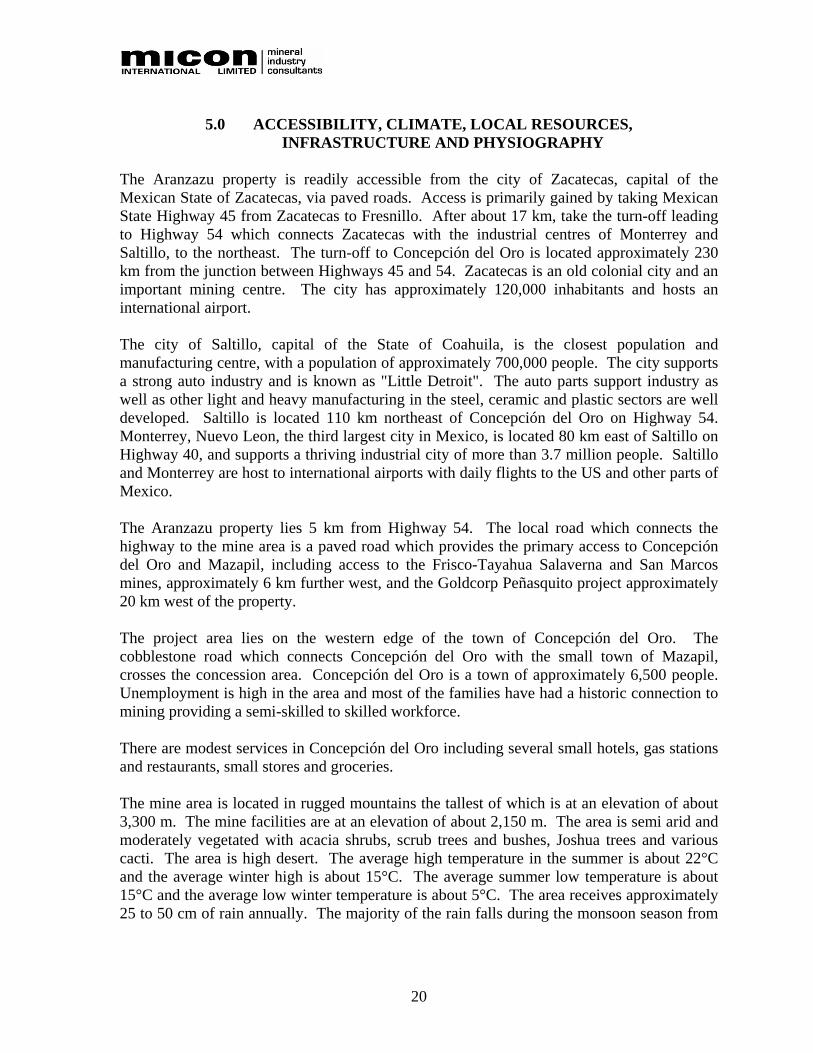
5.0 ACCESSIBILITY, CLIMATE, LOCAL RESOURCES, INFRASTRUCTURE AND PHYSIOGRAPHY
The Aranzazu property is readily accessible from the city of Zacatecas, capital of the Mexican State of Zacatecas, via paved roads. Access is primarily gained by taking Mexican State Highway 45 from Zacatecas to Fresnillo. After about 17 km, take the turn-off leading to Highway 54 which connects Zacatecas with the industrial centres of Monterrey and Saltillo, to the northeast. The turn-off to Concepción del Oro is located approximately 230 km from the junction between Highways 45 and 54. Zacatecas is an old colonial city and an important mining centre. The city has approximately 120,000 inhabitants and hosts an international airport. The city of Saltillo, capital of the State of Coahuila, is the closest population and manufacturing centre, with a population of approximately 700,000 people. The city supports a strong auto industry and is known as "Little Detroit". The auto parts support industry as well as other light and heavy manufacturing in the steel, ceramic and plastic sectors are well developed. Saltillo is located 110 km northeast of Concepción del Oro on Highway 54. Monterrey, Nuevo Leon, the third largest city in Mexico, is located 80 km east of Saltillo on Highway 40, and supports a thriving industrial city of more than 3.7 million people. Saltillo and Monterrey are host to international airports with daily flights to the US and other parts of Mexico. The Aranzazu property lies 5 km from Highway 54. The local road which connects the highway to the mine area is a paved road which provides the primary access to Concepción del Oro and Mazapil, including access to the Frisco-Tayahua Salaverna and San Marcos mines, approximately 6 km further west, and the Goldcorp Peñasquito project approximately 20 km west of the property. The project area lies on the western edge of the town of Concepción del Oro. The cobblestone road which connects Concepción del Oro with the small town of Mazapil, crosses the concession area. Concepción del Oro is a town of approximately 6,500 people. Unemployment is high in the area and most of the families have had a historic connection to mining providing a semi-skilled to skilled workforce. There are modest services in Concepción del Oro including several small hotels, gas stations and restaurants, small stores and groceries. The mine area is located in rugged mountains the tallest of which is at an elevation of about 3,300 m. The mine facilities are at an elevation of about 2,150 m. The area is semi arid and moderately vegetated with acacia shrubs, scrub trees and bushes, Joshua trees and various cacti. The area is high desert. The average high temperature in the summer is about 22°C and the average winter high is about 15°C. The average summer low temperature is about 15°C and the average low winter temperature is about 5°C. The area receives approximately 25 to 50 cm of rain annually. The majority of the rain falls during the monsoon season from

21
June through September. Occasional snow does occur in the area but quickly melts on all but the most protected northern slopes. The climate is mild year round and poses no limitations to the length of the operating season. Freezing temperatures can occur overnight but quickly warm to above freezing during daylight hours. Power is available to the site and a substation is in operation at the mill, sufficient to operate the entire mill, crusher facilities, and the mine equipment and facilities. Excess water for operations is pumped from water sumps within the underground mine workings. The area is a historic mining district with an ample and skilled workforce sufficient for all operations. Aura advises Micon that the existing tailings and waste areas are sufficient for several years of production with additional areas for future tailings disposal and waste dumps acquired by Macocozac in the immediate area. Aura plans to review all potential tailings options including mine backfill and dry-stack tailings disposal. Sufficient property is available at the mine site for any planned mill expansion. Figure 5.1 is a view of the Aranzazu property looking east, with Concepción del Oro located to the left of centre.

22
Figure 5.1
View of the Aranzazu Property

23
6.0 HISTORY 6.1 CONCEPCIÓN DEL ORO MINING DISTRICT AND THE ARANZAZU
PROPERTY Mining has played an important role in Mexico since pre-historic times, but it entered a period of rapid expansion after the Spanish conquest when rich mineral deposits were found. The wealth found in these early mines served as an incentive for the early colonizers to locate to remote and barely accessible portions of the county. In approximately 1546, the long and slow process of colonization started in Zacatecas with the arrival of the Spanish in an area called Cerro de La Bufa. It is believed that the early inhabitants of the district mined native silver but estimates are that the Concepción del Oro mining district was discovered by one of Cortés’ captains, Francisco de Urdiñola, later Marquis of Aguayo. Urdiñola started mining native silver from upper exposed portions of the zinc-lead-silver deposits, thus initiating the exploitation of the deposits contained within the San Eligio and Albarradón mines using native mine workers in 1530. The earliest mining within the district began at Mazapil, located approximately 21 km from Concepción del Oro, where the mineral deposits were discovered during the war fought in the area against the Chichimeca Indians in 1556. The community of Mazapil was founded in 1568 and by 1569 approximately 150 Spaniards inhabited the town. The foundation of the community of Concepción del Oro is believed to have occurred during 1587. The earliest mineral deposits which were worked were mainly silver but by the end of the 16th century gold had been discovered near the present site of Concepción del Oro. The rich copper deposits of Aranzazú were left undisturbed by the Spaniards as they were only interested in the precious metals. While the two mining towns of Mazapil and Concepción del Oro are not well known today, they were of great economic importance in Nueva Vizcaya and indeed in New Spain in the 17th and 18th centuries. Towards the end of the 18th century, many of the great bonanzas of the district were exhausted and a decrease in mining activity began. The peasant uprisings of 1810 to 1821 were disastrous to the mining industry with both the insurgents’ soldiers and royalist troops all but destroying the mining production in Mexico and the Concepción del Oro mining district was not spared during this period. The Concepción del Oro mining district experienced ups and downs during the 1800s and mining was conducted on a minor scale and sporadically. It was not until 1889 that the Mazapil Copper Company Ltd. (Mazapil Copper), from Manchester, England, acquired the old mines and expanded production to include copper and zinc. A large mill facility and smelter were constructed in the community of Concepción del Oro to process ore from the district.

24
Mazapil Copper began operations in 1891 with production from the mines continuing until 1962 when the operations were sold to the American Smelting & Refining Company (ASARCO). From 1962, ASARCO operated the mines until nationalization of mining interests took place in 1982. In 1982, the Comision de Fomento Minero (Federal Mining Commission) (Fomento Minero) took control of the property and operated the mine until 1989. During the period that Fomento Minero operated the mine it constructed a new mill facility and developed the Arroyos Azules open pit. The smelting operations within the community of Concepción del Oro were closed prior to Fomento Minero taking over the operations in 1982. In 1989, Fomento Minero sold the operations and property to Minera Caopas and the new owner Senor Armando Guadiana Tijerina formed Macocozac S.A. de C.V. (Macocozac). Macocozac operated the mine from 1989 until 1998, with the operations becoming erratic from 1992 through 1998 due to fluctuating metal prices. Mining and mill operations at the Aranzazu project ceased in 1999 due to a combination of low metal prices, high taxes and labour disputes. Kennecott, Teck and Phelps Dodge reviewed the district between 1989 and 1998 and surrounded the core property with mineral concessions; however, they were unable to complete successful negotiations with Macocozac or Minera Tayahua S.A. de C.V. (Minera Tayahua) Sand River Resources (Sand River) completed a Letter of Intent to form a JV agreement in 1997 and completed the JV agreement in 1998 with Macocozac. Sand River completed a due diligence data review and a small drilling program but was unable to raise sufficient capital to continue and had to default on the agreement. Minera Frisco S.A. completed a JV with Minera Tayahua in 2002. Operations were expanded from 2,250 t/d to 3,000 t/d and several new working faces were developed in the underground mines. Permit applications were submitted for a large open pit expansion on a porphyry/skarn copper deposit with permitting and engineering studies underway for a smelter complex. Coeur d’Alene Mines (Coeur) completed a Letter of Intent to enter a JV with Macocozac in 2004 and completed a due diligence data review and limited drill program. Coeur did not complete the resource model and withdrew from the project due to other company obligations. The previous operator, Zacoro, acquired the right to explore and develop the Aranzazu property by signing an Option Agreement with Macocozac on December 15, 2006. Zacoro conducted an exploration drilling program, however, it was unable to complete its option and as a result the option expired in March, 2008.
25
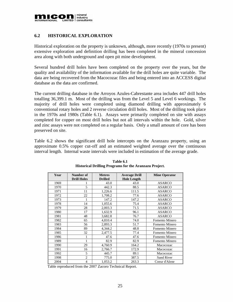
6.2 HISTORICAL EXPLORATION Historical exploration on the property is unknown, although, more recently (1970s to present) extensive exploration and definition drilling has been completed in the mineral concession area along with both underground and open pit mine development. Several hundred drill holes have been completed on the property over the years, but the quality and availability of the information available for the drill holes are quite variable. The data are being recovered from the Macocozac files and being entered into an ACCESS digital database as the data are confirmed. The current drilling database in the Arroyos Azules-Cabrestante area includes 447 drill holes totalling 36,399.1 m. Most of the drilling was from the Level 5 and Level 6 workings. The majority of drill holes were completed using diamond drilling with approximately 6 conventional rotary holes and 2 reverse circulation drill holes. Most of the drilling took place in the 1970s and 1980s (Table 6.1). Assays were primarily completed on site with assays completed for copper on most drill holes but not all intervals within the hole. Gold, silver and zinc assays were not completed on a regular basis. Only a small amount of core has been preserved on site. Table 6.2 shows the significant drill hole intercepts on the Aranzazu property, using an approximate 0.5% copper cut-off and an estimated weighted average over the continuous interval length. Internal waste intervals were included in estimation of the average grade.
Table 6.1 Historical Drilling Programs for the Aranzazu Project.
Year Number of
Drill Holes Metres Drilled
Average Drill Hole Length
Mine Operator
1969 1 43.0 43.0 ASARCO 1970 5 442.3 88.5 ASARCO 1971 11 1,226.6 111.5 ASARCO 1972 22 1,708.2 77.6 ASARCO 1973 1 147.2 147.2 ASARCO 1978 14 1,055.6 75.4 ASARCO 1979 28 2,003.3 71.5 ASARCO 1980 17 1,632.9 96.1 ASARCO 1981 48 3,682.8 76.7 ASARCO 1982 65 4,810.4 74.0 Fomento Minero 1983 56 2,893.3 51.7 Fomento Minero 1984 89 4,344.2 48.8 Fomento Minero 1985 32 2,477.5 77.4 Fomento Minero 1986 1 47.6 47.6 Fomento Minero 1989 1 82.9 82.9 Fomento Minero 1990 29 4,760.9 164.2 Macocozac 1991 16 2,766.7 172.9 Macocozac 1992 5 445.7 89.1 Macocozac 1998 2 775.0 387.5 Sand River 2004 4 1,053.2 263.3 Coeur d'Alene
Table reproduced from the 2007 Zacoro Technical Report.

26
Table 6.2 Summary of the Significant Drill Hole intercepts for the Aranzazu Project.
Drill Hole Intersection (m) Average Assays Year
Drilled Company Drill Hole Type
Drill Hole Name
UTM North-South Section
Old Section Letter From To Interval
Length Copper
(%) Zinc (%) Gold (ppm) Silver (ppm)
1970 ASARCO Core 23 254075 L 18.9 55.4 36.5 2.59 Not Assayed 2.29 Not Assayed
1979 ASARCO Core 1232 254300 P 0.0 42.0 42.0 1.64 Not Assayed 1.42 17.70
1980 ASARCO Core 1288 254225 O to P 16.2 47.7 31.5 1.76 Not Assayed Not Assayed Not Assayed
1981 ASARCO Core 1296 254225 O 0.0 57.1 57.1 2.02 Not Assayed 0.50 16.00
1981 ASARCO Core 1301 254750 Y 63.2 104.0 40.8 4.85 Not Assayed 1.33 131.64
1982 Fomento Minero Core 1359 254725 X 30.4 48.5 18.1 3.04 Not Assayed 1.54 126.74
1983 Fomento Minero Core 1435 253800 G 0.0 36.8 36.8 3.33 Not Assayed Not Assayed Not Assayed
1983 Fomento Minero Core 1438 253775 G 0.0 51.1 51.1 1.84 Not Assayed Not Assayed Not Assayed
1983 Fomento Minero Core 1442 253700 E 5.2 52.5 47.3 0.85 Not Assayed Not Assayed Not Assayed
1983 Fomento Minero Core 1443 253700 E 0.0 33.2 33.2 0.84 Not Assayed Not Assayed Not Assayed
1983 Fomento Minero Core 1444 253675 E 0.0 74.5 74.5 0.99 Not Assayed Not Assayed Not Assayed
1984 Fomento Minero Core 1503 254325 P 3.1 58.8 55.7 1.91 Not Assayed Not Assayed Not Assayed
1984 Fomento Minero Core 1551 254225 P 6.8 16.6 9.8 2.54 Not Assayed Not Assayed Not Assayed
1985 Fomento Minero Core 1609 253575 B 1.5 63.4 61.9 2.93 Not Assayed Not Assayed Not Assayed
1990 Macocozac Core 1663 253500 BW 4.0 88.8 84.8 2.78 0.60 0.38 44.10
1990 Macocozac Core 1665 253475 BW 12.3 56.5 44.3 2.45 0.72 0.29 47.24
1990 Macocozac Core 1667 253475 BW 1.2 56.2 55.0 1.58 0.74 0.22 27.32
1990 Macocozac Core 1672 253475 BW 0.0 46.5 46.5 4.09 1.14 0.20 Not Assayed
1998 Sand River Core SR98-1 254100 L 335.9 353.7 17.8 2.21 < 0.1 1.25 21.83
1998 Sand River Core SR98-2 254100 L 285.8 309.0 23.2 1.98 < 0.1 2.74 26.53
2004 Coeur Core 53850-1 253850 H to I 75.3 269.0 193.7 2.26 0.12 1.15 17.89
2004 Coeur Core 53900-1 253900 H to I 52.2 87.8 35.6 1.88 0.09 1.23 16.10
Table reproduced from the 2007 Zacoro Technical Report.

27
6.3 HISTORICAL MINING
The Concepción del Oro mining district and the Aranzazu property are riddled with mine openings and old workings, in a somewhat haphazard fashion near surface, representing the earliest efforts at extraction, and more systematic at depth, which is indicative of later, better organized and engineered mining. Associated with these openings and workings is a number of ruins, which represent the mine buildings, chapels and residences of the inhabitants and indicate the wealth of the mining district during its past. The vast bulk of the material which has been extracted from underground operations through the tunnels, shafts and winzes as well as the open pit operations is scattered over the hillsides in waste dumps and beneath the foundations of the ruins and modern buildings. Historically, individual veins or deposits had separate owners and in the case of some of the larger veins or deposits had several owners along the strike length which resulted in a surfeit of adits and shafts and very inefficient operations. This changed in 1889 when Mazapil Copper acquired the old mines, consolidated most of the older concessions and expanded production to include copper and zinc. The mines on the Aranzazu property have been developed primarily by using open stope/shrinkage underground mining methods and in one case by open pit mining methods. Ground conditions are good and the deposit geometries tend to favour lower cost, long hole stoping methods. Some areas where the deposit is near surface may be possible to mine with an open pit. Long hole stoping is used by Minera Fresnillo's Proana mine located near the city of Fresnillo to the west of the city of Zacatecas and by Capstone Mining at the Cozamin operation near the city of Zacatecas. Several areas have been developed along the intrusive-limestone contact and in several limestone roof pendants within the large intrusive body. The most important mine developments on the property are the historical Aranzazú area, Catarroyo, Cabrestante, Arroyos Azules and Mexicana. The historical Aranzazú area has at least 13 underground levels developed. Several levels are accessible from the surface but internal ladders have been removed and the headframe on the surface was destroyed by fire several years ago. Level 11 is accessible from the portal in the arroyo above the Mexicana mine. This tunnel is more than one kilometre long and cuts through the main intrusive body to the skarn on the western contact. The 3 m by 3 m tunnel is in good condition. Water for operations and the townsite is pumped from Level 12 and the pipeline passes through the Level 11 tunnel. See Figure 6.1 for a photograph of the ruins of the burned headframe at Aranzazú.

28
Figure 6.1 Ruins of the Burned Headframe at Aranzazú
The Catarroyo mine area hosts 23 levels and was mined as recently as the 1980's. The internal ladders and hoists have been removed and access to multiple levels is very difficult. The portals enter on Levels 1 and 3, providing access to mineralized skarn bodies. The Cabrestante Arroyos Azules and Mexicana areas have been the focus of recent mining. Eight levels and additional sublevels have been developed and a small open pit (at least 2.385 Mt of 0.6% copper and 2.687 Mt of waste) was developed in the Arroyos Azules area. At least 5 km of underground workings were developed and several stoped areas were exploited. Several of the underground workings are accessible in the Mexicana area and limited access is possible in the Cabrestante area. The Cabrestante headframe is in service and provides access to Levels 1 through 5 in a two compartment shaft. The timbers were replaced or repaired in the shaft in 2004 down to Level 6. See Figure 6.2 for a photograph of the Cabrestante headframe located near Concepción del Oro. The most recent exploitation occurred in the Arroyos Azules area from underground stopes accessed from the open pit ramps. See Figure 6.3 for a photograph of the Arroyos Azules open pit and underground access points within the pit. Macocozac operated the mine from 1989 until 1998, with the operations erratic from 1992 through 1998 due to fluctuating metal prices. Mining and mill operations at the Aranzazu project ceased in 1999 due to a combination of low metal prices, high taxes and labour disputes.

29
Figure 6.2 The Cabrestante Headframe
Figure 6.3 Arroyos Azules Open Pit and Underground Access Points within the Pit
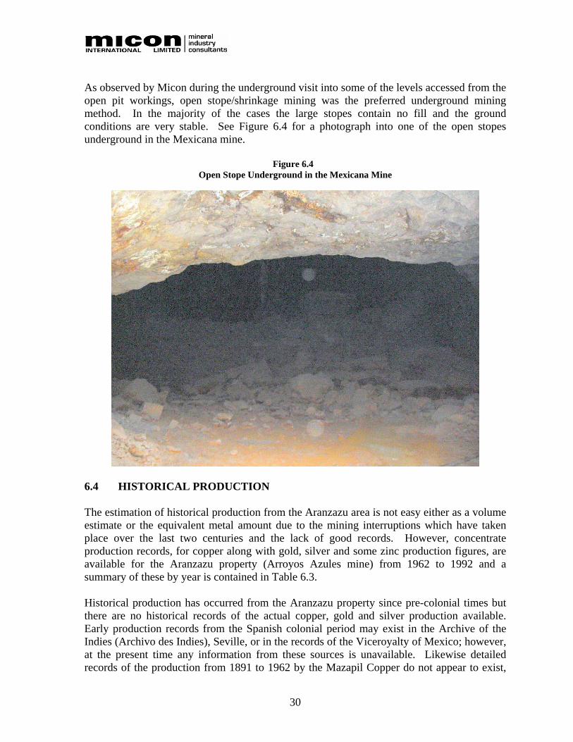
30
As observed by Micon during the underground visit into some of the levels accessed from the open pit workings, open stope/shrinkage mining was the preferred underground mining method. In the majority of the cases the large stopes contain no fill and the ground conditions are very stable. See Figure 6.4 for a photograph into one of the open stopes underground in the Mexicana mine.
Figure 6.4 Open Stope Underground in the Mexicana Mine
6.4 HISTORICAL PRODUCTION The estimation of historical production from the Aranzazu area is not easy either as a volume estimate or the equivalent metal amount due to the mining interruptions which have taken place over the last two centuries and the lack of good records. However, concentrate production records, for copper along with gold, silver and some zinc production figures, are available for the Aranzazu property (Arroyos Azules mine) from 1962 to 1992 and a summary of these by year is contained in Table 6.3. Historical production has occurred from the Aranzazu property since pre-colonial times but there are no historical records of the actual copper, gold and silver production available. Early production records from the Spanish colonial period may exist in the Archive of the Indies (Archivo des Indies), Seville, or in the records of the Viceroyalty of Mexico; however, at the present time any information from these sources is unavailable. Likewise detailed records of the production from 1891 to 1962 by the Mazapil Copper do not appear to exist,

31
although as an English company based in Manchester old records may exist either in Manchester or London. A hint of the production by this company is given in a 1905 volume entitled “The Mines of Mexico” by J.R. Southworth in which he states that the “mines are producing monthly about 6,000 to 7,000 tons of copper ore, 2,500 to 4,000 tons of silver and silver-lead ores and 2,500 tons of flux ores.” “The copper smelter at Concepcion del Oro has a smelting capacity of 15,000 tons monthly.” “All the ore from the copper mines is delivered to the smelter by aerial tramways, while the silver lead ores come by rail from the San Pedro Camp. Eight groups of mines, viz:- Aranzazú group, copper; Cabrestante group, copper; Promontorio group, fluxes: San Eligio group, lead; Naranjoia group silver; Cajon group, lead; San Francisco, lead; and El Potrero, lead; are all owned by the Mazapil Copper Company, Ltd.”
Table 6.3 Summary of the Production for the Aranzazu Property (Arroyos Azules mine 1962 to 1992)
Year Concentrate
Dry Tonnes Copper
(%) Copper (lbs) Gold (g/t)
Gold (ounces)
Silver (g/t)
Silver (ounces)
Zinc (%) Zinc (lbs)
1962 7,528.26 26.49 4,387,482 11.96 2,896 654.41 157,684 2.66 441,520 1963 8,483.51 22.64 4,225,653 9.32 2,542 385.80 105,239 2.96 553,638 1964 11,198.16 22.92 5,647,543 8.97 3,231 412.32 148,464 2.21 544,210 1965 12,281.62 19.16 5,176,948 9.50 3,750 438.09 173,007 4.32 1,168,285 1966 13,767.46 17.88 5,415,265 10.09 4,466 487.77 215,928 1.85 562,568 1967 14,185.98 16.91 5,276,533 10.05 4,582 417.59 190,478 1.81 566,851 1968 12,437.97 21.35 5,841,294 11.74 4,694 481.45 192,548 2.67 731,935 1969 814.21 22.04 394,796 10.47 274 443.57 11,613 1.73 31,099 1970 10,822.89 24.55 5,845,917 15.11 5,258 541.25 188,357 2.16 514,285 1971 10,642.40 23.26 5,446,395 11.89 4,070 456.31 156,148 1.17 273,495 1972 9,422.82 23.65 4,902,694 15.54 4,708 588.00 178,155 1.33 276,213 1973 14,194.37 16.70 5,215,010 14.44 6,591 505.00 230,487 1.18 369,156 1974 15,714.66 15.65 5,410,556 1201 6,069 498.00 251,637 1.20 415,621 1975 13,766.48 19.22 5,821,017 11.10 4,913 417.00 184,586 1.60 485,461 1976 15,944.71 18.27 6,408,817 8.26 4,235 292.00 149,706 5.10 1,792,249 1977 12,112.42 22.18 5,910,377 9.19 3,579 258.00 100,482 4.54 1,211,988 1978 13,136.71 23.28 6,728,095 15.37 6,492 255.00 107,713 4.64 1,343,433 1979 13,528.61 23.53 7,003,222 14.37 6,251 251.00 109,186 3.88 1,156,902 1980 12,485.08 21.75 5,974,109 10.55 4,235 257.00 103,173 4.16 1,144,712 1981 10,280.58 19.70 4,455,601 9.62 3,180 244.90 80,955 4.47 1,012,830 1982 10,509.69 21.53 4,978,018 8.29 2,801 243.30 82,219 4.74 1,097,943 1983 13,176.35 20.53 5,951,230 10.46 4,432 253.80 107,529 NA NA 1984 13,708.63 20.13 6,071,004 12.42 5,475 313.70 138,276 NA NA 1985 14,361.75 19.25 6,082,201 12.62 5,828 339.30 156,686 NA NA 1986 10,748.29 19.36 4,577,910 9.60 3,318 363.80 125,731 NA NA 1987 14,788.62 19.56 6,363,837 9.23 4,389 319.00 151,690 NA NA 1988 13,306.24 24.00 7,025,696 8.73 3,735 250.70 107,263 NA NA 1989 12,430.95 26.61 7,277,329 8.13 3,250 247.80 99,048 NA NA 1990 8,899.16 30.16 5,904,769 8.11 2,321 284.00 81,266 NA NA 1991 10,667.52 30.07 7,056,990 9.75 3,344 295.00 101,187 NA NA 1992 8,797.01 28.31 5,478,954 8.85 2,503 292.00 82,596 NA NA
Total 1962 to 1992 364,143.11 172,255,262 127,411 4,269,036 15,694,393
Average Production 11,746.55 21.96 5,556,621 10.83 4,110 370.45 137,711 2.88 506,271
Note: NA = Not Available Table reproduced from the 2007 Zacoro Technical Report.

32
A number of smaller companies were also active in the area and in 1915 the Compañía Minera de Peloles, S.A., a subsidiary of the American Metals Company, undertook exploitation of the deposits of silver, lead and zinc in the Providencia area. The “Geological-Mining Monograph of the State of Zacatecas” which was published in 1992 by the Mexican government stated the following: “The current mineral production of the Macocozac Company is 50,000 tonnes per month (t/m), with an average grade of 0.65% copper, 10 g/ton of silver, and 0.30 g/ton of gold. Ninety percent (45,000 t) of the mineral comes from the Mexicana mine which is exploited open-pit mine, and the remaining 10% is obtained from the underground Cabrestante mine, which produces 5,000 t with grades of 1.20% of copper, 10 g/ton of silver and 0.30 g/t of gold.” No other figures for either the historic production or production from other areas within the district were given in this volume. 6.5 HISTORICAL RESOURCE AND RESERVE ESTIMATES The discussions related to the resource and reserve estimates contained in this section refer to historical estimates only. The resource and reserve estimates discussed in this section may have been estimated according to the accepted standards for the mining industry for the period to which they refer; however, they do not comply with the current Canadian Institute of Mining, Metallurgy and Petroleum (CIM) standards and definitions for estimating resources and reserves as required by Canadian National Instrument 43-101 (NI 43-101) “Standards of Disclosure for Mineral Projects”. The latest historic reserve estimate conducted on the Aranzazu property was completed as of December 31, 1993. No further resource estimates were conducted after 1993 by Macocozac due to erratic production resulting from fluctuating metal prices. All operations at the Aranzazu project finally ceased in 1999 due to a combination of low metal prices, high taxes and labour disputes. However, with the increase in metal prices beginning in late 2004, limited operations were restarted by the Mexican owners in July, 2007. Micon has reviewed the December, 1993 reserve estimate conducted by Macocozac and the details of the review are discussed below. 6.5.1 Historic December 31, 1993 Arroyos Azules Mine Reserve Estimate. The following details regarding the historic December, 1993 Arroyos Azules mine reserves are taken from the long section showing the location of the estimated reserves blocks. The historic reserve estimate as of December 31, 1993 totalled 15,974,574 t grading 1.3% copper, including 11,797,200 t in the Arroyos Azules area averaging 0.29 g/t gold, 12 g/t silver and 1.14% copper. The December, 1993 numbers were reported as “positive reserves”, “probable reserves” and “possible reserves” (“reservas positivas,” “reservas probables” and “reservas posibles”) and incorporated a 10% mining dilution. The “reserves”, except for an insignificant amount, are made up of sulphide material. See Table 6.4 for the breakdown of the historic December 31, 1993 reserves.

33
As seen in Table 6.4, these “reserves” are distributed over a number of areas, all of which were served by either the Cabrestante headframe or the various underground levels at the Mexicana mine exposed in the Arroyos Azules pit, the Cata Arroyo undergound mine levels, the Promontorio mine underground mine levels, and the Socovon Principal underground mine levels at Aranzazú. All development was conducted primarily in the zones of mineralization and this may hamper extraction of some of the “reserves” during any future operations.
Table 6.4 Summary of the Historic December 31, 1993 “In-situ Reserves” (Diluted) for the Aranzazu Project
Arroyos Azules Area
Grade of Reserves Classification of Reserves Mining Area Diluted Tonnage (tonnes + 10%
dilution) Gold (g/t) Silver (g/t) Copper (%)
Positive (“Positivas”) BWIA 5A 441,400 0.18 20 1.20 Positive (“Positivas”) TAJO – Mexicana 2,798,900 0.23 10 1.03 Positive (“Positivas”) PORFIDO – Cabrestante 1,436,000 0.37 13 1.12 Total Positive Reserves (“Reservas Positivas”) 4,676,300 0.27 12 1.07 Probable (“Probables”) BW 6A 131,800 0.28 ---- 1.40 Probable (“Probables”) TAJO – Mexicana 1,484,700 0.18 9 0.92 Probable (“Probables”) PORFIDO – Cabrestante 880,900 0.39 15 1.41 Total Probable Reserves (“Reservas Probables”) 2,497,400 0.26 12 1.12 Possible (“Posibles”) BW 7A 241,000 0.21 22 1.29 Possible (“Posibles”) TAJO – Mexicana 2,161,200 0.21 11 1.20 Possible (“Posibles”) PORFIDO – Cabrestante 2,221,300 0.44 15 1.25 Total Possible Reserves (“Reservas Posibles”) 4,623,500 0.32 13 1.12 Sub Total Reserves Arroyos Azules Area 11,797,200 0.29 12 1.14
Other Areas Positive (“Positivas”) Cata Arroyo 932,800 NA NA 2.22 Positive (“Positivas”) Aranzazu 713,100 NA NA 1.58 Positive (“Positivas”) Promontorio 223,900 NA - 1.13 Total Positive Reserves (“Reservas Positivas”) 1,869,800 NC NC 1.85 Probable (“Probables”) Cata Arroyo 391,500 NA NA 1.52 Probable (“Probables”) Aranzazu 1,916,074 NA NA 1.72 Total Probable Reserves (“Reservas Probables”) 2,307,574 NC NC 1.69 Sub Total Reserves Other Area 4,177,374 NC NC 1.76
Grand Total Arroyos Azules + Other Areas 15,974,574 NC NC 1.30
Note: NA = Not available and NC = Not Calculated Table reproduced from the 2007 Zacoro Technical Report. As far as can be deduced from the available records, “reserve” blocks were outlined on cross-sections, areas measured (presumably by planimeter), and volumes determined by using the drill information and development information to determine the thickness. Such volumes were then reduced by those areas previously mined, and the result converted to tonnage using a specific gravity of 3.0. The data used for delineating blocks and determining block grades are not known but, judging from the block outlines on the cross-sections, the bulk of the information appears to have been derived from drill hole assay results which were then augmented by information derived from sampling stopes, development headings and other mine openings. Allowance for mining dilution was made by increasing the tonnage as calculated above by 10% which in turn reduced the overall block grade, although the corresponding average grade reduction is not known. It is surmised that these factors reflected the operating

34
experience at the mine. According to the cross-sections and long section reviewed during the site visit the “positive reserves” were blocks of mineralization for which development was well advanced while probable blocks had some development and possible blocks may or may not contain a drill hole. In addition to the in-situ historic reserves Macocozac reports stockpiled material on site. The material consists of mixed copper oxide and sulphide mineralization with undefined gold, silver and zinc concentrations. See Table 6.5 for a summary of the stockpiled material at the Aranzazu project.
Table 6.5 Summary of the Stockpiled Material for the Aranzazu Project
Stockpile Tonnes Copper Grade (%)
High Grade Stockpiles 3,000,000 2.2 Low Grade Stockpiles 8,000,000 0.8
Jaime Stockpile 250,000 2.6 Grand Total 11,250,000 1.21
Table reproduced from the 2007 Zacoro Technical Report. A sample collected by Zacoro from the “high grade stockpile” for metallurgical testing returned a copper grade of 1.28%, 0.8 g/t gold, 12.8 g/t silver and 0.19% zinc. These values cannot be considered as representative of the entire stockpile and further sampling is required to identify the average values of the stockpiles. Micon has not audited the stockpiled material and, in light of the need to conduct further sampling and metallurgical testing to define the grade and recoverability, this material cannot be considered as compliant resources under NI 43-101 regulations and should not be relied upon. The property also contains historic tailings piles of variable grade, some of which may be amenable to further processing. To begin reviewing the economic potential of the Aranzazu property the previous optionor, Zacoro, commenced entering the Macocozac database into a digital format, beginning with the drill hole data. Zacoro then used this drill hole database to conduct a preliminary resource estimate which is CIM compliant for reporting purposes. The results of the 2007 preliminary resource estimate are discussed in Section 17 of this report. Aura is in the process of completing the entry of the Macocozac data into the digital database. Aura is also in the process of reviewing all of Zacoro’s and Macocozac’s exploration data collected during 2007 and 2008.

35
7.0 GEOLOGICAL SETTING 7.1 REGIONAL GEOLOGY The Concepción del Oro area contains Jurassic to Cretaceous limestone, siltstone and shale intruded by Tertiary intrusive rocks (Figure 7.1). A thick sequence of limestone is represented by several formations in the area (Figure 7.2). The oldest of these limestone formations is the Upper Jurassic Zuloaga limestone, a massive clean, white limestone. The Upper Jurassic La Caja Formation conformably overlies the Zuloaga limestone and consists of four units. The basal Unit A is a shale and black limestone. La Caja Unit B is a clayey limestone with distinctive ammonite and pelecypod fossils. Unit C is a cherty phosporite, and Unit D is a calcareous siltstone with chert beds and nodules. The Cretaceous sedimentary rocks are shales and limestones and include the Taraises limestone/shale, the Cupido limestone, the La Peña dirty limestone and the Cuesta del Cura limestone in the Concepción del Oro area. The Cuesta del Cura limestone is the youngest member of the Lower Cretaceous rocks. Upper Cretaceous limestone and shale of the Indidura Formation and shale of the Caracol and Parras Formations overlie the Cuesta del Cura limestone on the north. Stratigraphic units are poorly defined in previous mapping and further stratigraphic work is needed. All limestone units are favourable skarn hosts. The clarification of stratigraphic units may identify favourable host rocks hidden beneath shale units at reasonable depths and may identify the most favourable host rock for skarn formation. The Tertiary intrusive complex is well differentiated and zones from a hornblende rich diorite to a biotite rich granodiorite. Differentiation vectors identifying the most primitive igneous rocks occur on the southern boundary of the concession area near the Sol y Luna iron skarn. The main magmatic body was intruded into a large northwest tending fault zone with northeast cross faults. The fault system allowed the development of staged hydrothermal cells with evolving mineralization, from earliest iron rich skarns to main stage copper-gold skarns to later stage zinc-silver skarns possibly associated with molybdenum. A distal and latest stage gold halo is present in the main northwest trending structure zone and presents a very interesting gold target. The biotite bearing phase of the quartz monzonite to granodiorite appears to be the most important host for porphyry style copper mineralization and copper-gold skarns. This phase of intrusive rock is well developed in the Aranzazu and Arroyos Azules areas. The mineralized skarns occur adjacent to portions of the intrusive complex with intense stockwork veining of quartz and sericite in the Tajo Arroyos Azules area. Skarn mineralization in the Aranzazu area, 2.5 km northwest of Tajo, occurs on the margin of a large, clay altered and iron-stained zone within intrusive rocks. Several other areas of iron-

36
staining, mineralized skarn, or mineralized veins and chimneys occur throughout the area and have not received systematic exploration. See Figure 7.1 for a map of the regional geology in the Concepción del Oro mining district. See Figure 7.2 for a generalized stratigraphic column in the Concepción del Oro mining district.
Figure 7.1 Regional Geology Map for the Concepción del Oro Mining District
Figure reproduced from the 2007 Zacoro Technical Report.

37
Figure 7.2 Generalized Stratigraphic Column in the Concepción del Oro Mining District
Figure reproduced from the 2007 Zacoro Technical Report.

38
7.2 PROPERTY GEOLOGY A Tertiary intrusive complex ranging from diorite to granodiorite intrudes the Jurassic and Cretaceous limestones (Figure 7.3). Skarns, mantos and chimney deposits occur around the main intrusive complex. The mineralized skarns occur adjacent to portions of the intrusive complex with intense stockwork veining of quartz and sericite in the Tajo Arroyos Azules area. Skarn mineralization in the Aranzazu area, 2.5 km northwest of Tajo Azules, occurs on the margin of a large, sericite altered and iron-stained zone. Several other areas of strong iron-staining, mineralized skarn, or mineralized veins and chimneys, occur throughout the area and have not received systematic exploration. Alteration in the intrusive includes secondary biotite which has a long C-axis dimension, indicative of “wet” porphyry systems. The dominant alteration is quartz, sericite and pyrite (QSP), occurring as veins and flooding. The QSP veins on the margin of the pit are numerous, with up to 30 veins per metre. Pyrite, minor chalcopyrite, and chalcocite are common in the stock. Mineralized and unmineralized dikes cut the main intrusive complex and the altered porphyry stock. The mafic minerals in the intrusive rocks are dominantly biotite and hornblende. Skarn alteration is dominated by garnet and the opaque assemblage includes abundant magnetite, pyrite, chalcopyrite and chalcocite. The skarn contains high volumes of sulphide minerals. Surface oxidation and weathering have resulted in the partial destruction of garnet, in skarn, and feldspar, in intrusive rocks, to a quartz-clay-iron oxide assemblage. Retrograde skarn alteration is minimal and consists of epidote and quartz after garnet. Copper grades are as high as 16.4% over 17.1 m in a 2004 drill hole in the skarn, with 2% to 2.5% copper common. Metal zoning is well developed with a copper-gold zone proximal to the intrusive, a medial zinc-copper-silver-gold zone and a distal silver-lead-gold zone. The more distal zones tend to form chimney like replacements focused around structures. Precious metal concentrations are erratic, but values up to 13 g/t gold and 800 g/t silver are reported in drill core. Some skarn and intrusive zones contain high concentrations of molybdenum. Often garnet skarn contains several percent of coarse grained molybdenum and it is also common in veins which cut skarn and intrusive. Very few intervals have been analyzed for molybdenum and it has not been considered in any economic evaluations. Molybdenum appears to occur in early garnet skarn, late garnet skarn and late phases of the intrusive. The skarns on the property contain significant concentrations of arsenic, bismuth and tellurium and have low silver:gold ratios, a feature important to the distinction between copper skarns and poly-metallic gold skarns (Myers, 2002). See Figure 7.3 for the Aranzazu property geology map. 7.2.1 Structure The sediments are thrusted and folded into well defined anticlines and synclines. Cretaceous compression in the Concepción del Oro area was north directed and resulted in east-west anticlinal axes. These axes are often breached by deep-seated structures which form the
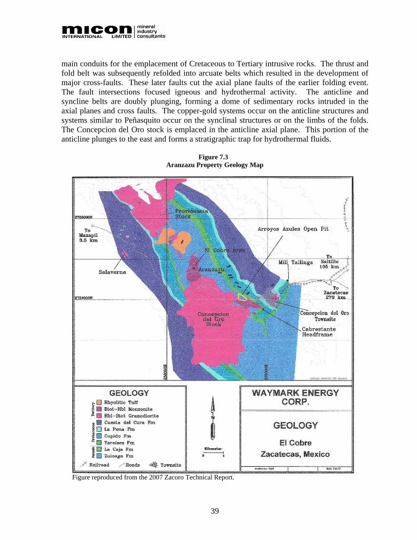
39
main conduits for the emplacement of Cretaceous to Tertiary intrusive rocks. The thrust and fold belt was subsequently refolded into arcuate belts which resulted in the development of major cross-faults. These later faults cut the axial plane faults of the earlier folding event. The fault intersections focused igneous and hydrothermal activity. The anticline and syncline belts are doubly plunging, forming a dome of sedimentary rocks intruded in the axial planes and cross faults. The copper-gold systems occur on the anticline structures and systems similar to Peñasquito occur on the synclinal structures or on the limbs of the folds. The Concepcion del Oro stock is emplaced in the anticline axial plane. This portion of the anticline plunges to the east and forms a stratigraphic trap for hydrothermal fluids.
Figure 7.3 Aranzazu Property Geology Map
Figure reproduced from the 2007 Zacoro Technical Report.
40
8.0 DEPOSIT TYPES Skarn deposits form in calcareous rocks at or near the contact with intrusive rocks and form directly from the interaction of high-temperature magmatic fluids with the surrounding host rocks, forming an assemblage of calc-silicate minerals replacing calcareous sediments. The most common calc-silicate minerals include garnet and pyroxene. Skarn deposits are important sources of iron, copper, gold, lead, zinc, silver and tungsten throughout the world. Seven skarn deposit types, based on metal content, were described by Einaudi et al. (1981) and Meinert (1989); these are copper, lead-zinc, tungsten, iron, molybdenum, tin, and polymetallic-gold bearing skarns. Often the distinction between the skarn groups is not a clear division and an overlap of metal associations is common. Copper skarns are very important economic deposits and are often associated with porphyry copper deposits or calcic to calc-alkalic igneous rocks. Important copper skarn deposits include Tintaya, Peru and Chino, New Mexico, USA. Gold, molybdenum and silver are common by-products of these deposits where they generally occur in low concentrations. Copper skarns generally form in oxidizing conditions and usually contain magnetite or hematite. The metal assemblage associated with copper skarns is generally simple and includes copper, gold, molybdenum and silver with negligible concentrations of arsenic, bismuth or tellurium (Myers, 2002). The calc-silicate mineralogy of copper skarns is andradite dominant with lesser amounts of light green diopsidic pyroxene. Retrograde alteration is generally limited to diopside altering to actinolite or garnet altering to epidote plus quartz. Polymetallic gold skarns are important gold and copper producers and include deposits such as Gratsberg/Ertsberg, Indonesia and Fortitude, Nevada, USA. Polymetallic gold skarns are associated with reduced calc-alkalic igneous rocks, which can form porphyry or non-porphyry bodies. These gold skarns often form in more reducing conditions and pyrrhotite or pyrite is more common than magnetite, and hematite is generally absent. Gold skarns generally contain important concentrations of copper with significant zones of zinc and lead. Associated metals include arsenic, antimony, bismuth, tellurium and selenium (Myers, 1994). The calc-silicate mineralogy associated with gold skarns includes adraditic garnet, but the volume of pyroxene is much greater than iron and copper skarns. Skarns generally host two primary zones of mineralization, one near the causitive intrusive and another near the limit of calc-silicate alteration and the contact front with marble or limestone. Metals zone from copper, proximal to the intrusive, to zinc and lead distal to the intrusive. Kenneth Clark and Luis Melendez in 1994 described Mexican skarn deposits as “replacement deposits, often irregular in nature, strongly disconcordant and usually contain calc-silicate skarns in and around stock, dike, or sill contacts. Occasionally, for example, at Concepción del Oro, ores may occur at some distance from the intrusive contact. The geographic distribution of these deposits is coincident with those of the manto and chimney deposits, and

41
all have been treated as one group of high temperature, carbonate-hosted silver-lead-zinc-copper deposits by Megaw et al, 1988.”

42
9.0 MINERALIZATION The following description of the mineralization at the Aranzazu property is quoted from Myers, 2006 report.
“Mineralization at the Arroyo Azules mine occurs in an area 1.5 km long by 300 m wide and is only partially drill tested. Mineralization is strongly associated with the granodiorite phase of intrusive rocks while the earlier diorite intrusion is weakly mineralized at best in spite of strong garnet skarn alteration. The sediment package in the mine area consists of massive limestone and interbedded limestone/siltstone. The calcareous siltstone was probably altered to massive garnet prior to the main influx of mineralizing fluids. This makes interpretation of the mineralized horizons more difficult and seemingly irregular. Careful logging and mapping will allow the "skarnoid" beds to be identified, delineating the favourable limestone horizons with siltstone caps. These limestone bed targets are host to the high grade skarn. Bedding is very steep in the mine area and is oblique to the intrusive contact. Several mineralized skarn zones distal to the intrusive contact are following these limestone beds between siltstone beds. Copper mineralization demonstrates fair continuity between drill holes, a positive feature in skarn systems. Copper-gold mineralization has better continuity in the proximal zone adjacent to the granodiorite contact with skarn. Mineralized zones distal to the intrusive contact are more discontinuous and form lensoid bodies of variable dimensions.”

43
10.0 EXPLORATION A description of the historical exploration work conducted on the property is provided in Section 6. Prior to Aura acquiring the Aranzazu property, Zacoro conducted an exploration program on the Aranzazu property from January, 2007 to February, 2008. This exploration program consisted of 147 diamond drill holes totalling 41,200 m. Aura is in the process of reviewing this work and undertaking its own QA/QC program. Once Aura has completed this program, the Zacoro drilling will be included in the data set pertaining to the Aranzazu property along with work conducted by Aura. The results of this work will be discussed and added to any further relevant Technical Reports which Aura may undertake as a result of its programs on the Aranzazu project. Aura has begun to outline a 2008 to 2009 exploration program for the Aranzazu property. However, the actual exploration program Aura conducts on the property may vary slightly from the proposed program contained in Section 19 of this report, depending on its review of the Zacoro results. A number of potential exploration targets, previously identified by Macocozac and previous optionors, remain untested on the Aranzazu property. Among the exploration targets are the possibilities that further areas of economic mineralization may occur either laterally along strike of the existing mineralized zones or that they may occur at depth below the previously mined areas and the water table. A summary of the exploration targets identified by Aura is provided in Table 10.1. Aura will use the exploration best practices guidelines prepared by CIM and issued on August 20, 2000 as the basis of its exploration program at the Aranzazu property. Further details regarding the exploration targets in the area of the Aranzazu project are described below. 10.1 EXPLORATION TARGETS AND POTENTIAL Myers (2006) described the exploration targets and potential as follows:
“The northwest area of the concession block hosts a large gold zone along the anticline axial plane structure zone which is a major control for the emplacement and differentiation of the intrusive complex (Figure 10.1). This gold zone is a distal, lower temperature phase of the hydrothermal system with strong silicification (jasperoid zones in limestone). The zone has had minimal exploration. This distal mineralization sits above or laterally from higher temperature skarn mineralization which is undeveloped. Several roof pendants of skarn occur within the main stock and host magnetite skarns with minor gold and copper-magnetite skarns with good gold grades. These pendants have had production but have not been explored further.”

44
Table 10.1 Aranzazu Property Exploration Targets
Area/Targets Geology Resource/Anomalies Comments
Along strike, shallow, and down dip extension of the Arroyos Azules and Cabrestante zones. IP anomaly in the Catarroyo area and skarn extensions along the intrusive contact. Enrichment blanket below leached cap covering the porphyry copper cell in Arroyos Azules area. Along strike, shallow, and down dip extension of the Aranzazú-Aranzazu zone. IP anomaly in the Aranzazú-Aranzazu area and skarn extensions along the intrusive contact. Enrichment blanket below leached cap covering the porphyry copper cell in Aranzazú-Aranzazu area. Low-temperature replacement bodies to the northwest of Aranzazu-Aranzazú and the northeast and east of Arroyos Azules. Distal “Fortitude” type gold skarn zones.
Mapping and geochemical sampling to be completed over the mineral concession area. Expanded IP geophysical surveys in Arroyos Azules and Aranzazu areas. Extensive in-fill and step out drilling program in areas of skarn, porphyry leach cap and possible enrichment zones, and lower temperature replacement bodies.
The 1993 resource/ reserve estimate by Macocozac is discussed in detail in Section 6.4 of this report. The 1993 resource/ reserve estimate is a historical resource/reserve estimate only and does not meet the presently accepted CIM standards for resource and reserve estimates. Updated resource model with new drilling results.
More drilling is needed to evaluate economic potential of the historical 1993 resource/reserve estimate. Perform a geochemical survey and geological mapping to identify other potential near skarns or areas of anomalous mineralization on the property.
Updated table provided by Aura Minerals Inc.

45
Figure 10.1 Exploration Target Concepts in the Concepcion del Oro Area
Figure reproduced from the 2007 Zacoro Technical Report.
“The Arroyos Azules porphyry stock has not been explored along the covered southern contact zone. Mineralized skarn has been found in float and a strong induced polarization (IP) anomaly is coincident with the inferred intrusive-limestone contact area (Figure 10.2). This target is defined by coincident geologic and structural features and geochemical, and geophysical anomalies. The anticlinal fold plunges to the east, exposing younger rocks to the east. The favourable Zuloaga Limestone and the capping

46
siltstone, La Caja Formation are projected to be less than 200 metres below the surface to the southeast of previous exploration and exploitation. The IP chargeability anomaly is coincident with the projected contact zone and forms an area 600 metres in diameter, which is open to the south and east. The favourable Zuloaga-La Caja contact dips steeply to the north, forming a highly favourable trap, getting larger with depth, below the present levels of drilling. Surface sampling in the area of the geophysical anomaly returns strongly elevated values of copper, zinc, gold, silver, arsenic, bismuth, and tellurium, with very low lead and cadmium values. This geochemical signature is very similar to gold zones of large copper-gold skarn systems, such as Copper Canyon-Fortitude, Nevada and Ertsberg-Grasberg in Indonesia. “Aranzazu Area Target Areas” “The Aranzazu target zone is a coincident geochemical and geophysical copper-gold skarn target at the La Caja-Zuloaga contact, 3 km from the Arroyos Azules Pit area. Surface geochemical samples are highly anomalous in the gold skarn suite of elements and minor production has occurred along siltstone-limestone interbeds in the La Caja Formation. Prospect pits and small skarn outcrops are common in the area along strike from the main underground mine zones. The geophysical anomaly on the west of the survey area lies along the intrusive-limestone contact (Figure 10.3). Strong skarn and hornfels alteration is present throughout this zone.” “Aranzazu Area” “The Aranzazu area is comprised of a zone of intense sericitic alteration which covers nearly 1.5 square kilometres and has several zinc-silver-gold replacement chimneys along a granodiorite stock margin. Stockwork quartz-sericite veining ranges from 10 to 40 veins per metre and the original rock textures are nearly destroyed by intense alteration and leaching. This area had lower total sulphides as determined by the higher geothite content in the limonites. The differentiation trend of the magmatic system suggests the porphyry cell may rake to the southeast and a larger area of potential than is indicated on the surface may be present. The chimney style replacements zone downward into large copper-gold skarns which supported extensive underground workings. The skarn potential adjacent to the exposed porphyry copper-gold cell is perceived to be considerable.” “Surface reconnaissance sampling has discovered a continuation of the Aranzazu mineralized hydrothermal system which is 3 km long and up to 1.5 km wide with strongly anomalous copper and gold values. This mineralization is localized along structures northwest of the outcropping porphyry stock. Considerable, untested copper-gold skarn potential exists in this structural zone.” “Arroyos Azules Area” “The Macocozac area hosts quartz monzonite porphyry which is surrounded by garnet-pyrite-chalcopyrite-magnetite skarn. This porphyry stock is adjacent to an un-mineralized granodiorite. The quartz monzonite porphyry is a potentially mineralized porphyry copper cell which covers an area of about 1 square kilometre. Quartz-sericite

47
Figure 10.2 Induced Polarization Survey Results in the Arroyos Azules Area
Figure reproduced from the 2007 Zacoro Technical Report.

48
Figure 10.3 Induced Polarization Survey Results in the Aranzazu Area
Figure reproduced from the 2007 Zacoro Technical Report.

49
veining is in part stockwork, but the stock margins are dominated by parallel veins indicating a strong flow vector of hydrothermal fluids into the skarn zones. The porphyry intrusive rakes to the southwest and the target may be larger than the surface indicates. This cell is surrounded by copper skarns with a resource of about 20 Mt of mineralization grading 1.25% copper, which is open at depth and to the south. In the past, about 10 Mt of ore have been produced from these skarns at similar grades.” “Concepcion East” “Surface alteration in the Concepcion East area consists of strong hornfels alteration in the calcareous siltstone units. Silver, zinc, lead, gold, and copper mineralization is localized along faults and lithologic contacts, similar to the distal expression of mineralization overlying known porphyry copper cells in the area. Considerable “blind” potential may be present in this area. This target may be similar to the mineralization seen in the Peñasquito area.” “Gold Targets” “Highly prospective gold targets exist in the Concepción del Oro area outside of the main copper-gold skarn area, and could host more than 1 million ounces of gold. The largest exposed zone is related to the Aranzazu hydrothermal cell and is localized along an axial plane fault zone. This target trends to the northwest, toward the Providencia stock, is over 3 km long, and up to 200 m wide as indicated by reconnaissance surface sampling. Sampling results have gold values with a range between 250 parts per billion (ppb) to 11 parts per million (ppm) averaging approximately 1.5 ppm. This zone also contains significant copper, zinc, and silver. Mineralization is hosted in intrusive igneous rocks, volcanic tuffs, and limestone.”
The above description of the exploration potential as described by Dr. Myers has not been followed up with an exploration program at this time. In the case of existing mines, there is the potential to find further areas of promising “economic” mineralization along the strike extensions of the deposits and at depth below the old workings. While some of these areas have been tested by drilling locally the true extent of the mineralization remains largely untested and presents a major exploration target. Through its acquisition of the property, Aura will have the benefit of being able to build upon previous operator’s exploration programs and Macocozac’s operating experience and records when outlining its own exploration program. Aura is also be in the unique position of acquiring the greater portion of a major historical copper-gold producing district in Mexico that has not been fully subjected to modern exploration concepts and technology. The property holds the potential for the discovery of copper-gold mineralization of similar character and grade as that exploited in the past.

50
11.0 DRILLING A description of the historical drilling conducted on the property is provided in Section 6. Prior to Aura acquiring the Aranzazu property, Zacoro conducted an exploration program on the Aranzazu property from January, 2007 to February, 2008. This exploration program consisted of 147 diamond drill holes totalling 41,200 m. Aura is in the process of reviewing this work and undertaking its own QA/QC program. Once Aura has completed this program, the Zacoro drilling will be included in the data set pertaining to the Aranzazu property along with work conducted by Aura. The results of this work will be discussed and added to any further relevant Technical Reports which Aura may undertake as a result of its programs on the Aranzazu project. Aura is also in the process of reviewing and completing the compilation of the historical mining and geological data available from Macocozac. Aura has started to conduct its review of the previous exploration programs and its first exploration program on the property will begin in August, 2008. The proposed 2008 to 2009 exploration budget contained in Section 19 of this report is preliminary in nature and maybe altered as Aura completes its review of the Zacoro and Macocozac databases.

51
12.0 SAMPLING METHOD AND APPROACH If known, the descriptions of the historical sampling methods and approaches conducted on the property are provided in Section 6. Zacoro, the previous operator, had implemented a sampling method and approach and a limited QA/QC program which was included in the 2007 Zacoro Technical Report. The following section outlines Zacoro’s preliminary sampling method and approach protocols for the Aranzazu property. 12.1 PRELIMINARY ZACORO SAMPLING METHOD AND APPROACH Zacoro collected samples of geochemical standards and blanks to be included with drilling and exploration samples submitted for geochemical analysis. The following is quoted from the 2007 Zacoro Technical Report:
“A set of standards are being collected and will provide a range of copper grades from the mineralized rocks on site. The standards will be useful for base metal analyses but probably will not be appropriate for gold and silver, due to the coarse grained nature of gold. The standards will be prepared by BSI Laboratories (BSI) of Reno, Nevada. The standards will be pulverized to -200 mesh, homogenized, and subjected to a rigorous round robin analytical procedure to determine the statistical distribution of the analyses. The samples will be individually bagged in 100 gram lots for insertion in drilling and exploration sample groups. A blank will be prepared from barren material, such as calc-silicate hornfels, on site and will be ground to -3/8 inch, similar to drill cuttings. The purpose of the blank is to test for contamination in the fine crushing and grinding stage at the sample preparation laboratories. The blank will also be submitted for round robin geochemical analyses to determine the acceptable range of values.” “Drill core will be sampled at approximately 2 m intervals. Samples will not be less than 1 m and samples will not cross lithologic or alteration changes if possible. The core will be cut or split in half along a plane chosen by the geologist in order to produce representative samples. One split will be bagged and sent to the BSI preparation facilities in Durango, Mexico and the pulps will be sent to the BSI analytical facility in Reno, Nevada.” “Drill sample logging will include complete protolith, alteration, mineralization and geotechnical features. The majority of drilling will be core samples, with reverse circulation drilling used in condemnation areas or as in-fill within groupings of core drill holes.” “Logging Protocol:” “All notation in metres.”

52
“Mark blocks with the depth at end of run with total length of that run.” “Drillers blocks at end of run BLACK Depth, length of run, and recovery.” “Lithologic contact blocks BLUE Depth only.” “Sample blocks RED From-to, hole #, and sample #.” “Mark last block with total depth (TD) or Fin and final depth.” “Sample numbers sequential in hole, hole code first 53825-1-25” “ (53825-1) hole, (25) is the 25th sample in hole.” “Insert assay blanks in sequence while logging.” “Put mark on box of appropriate colour where block is placed.” “Standard samples:” “Insert standard samples every 10-25 samples. Insert the first sample within the first 10 samples of mineralized interval. Select a standard with a copper grade and gangue mineralogy similar to the rock in the sample interval.”
Aura is in the process of reviewing all of these QA/QC programs and protocols prior to releasing any of Zacoro’s drill results or incorporating the data into any future resource estimate. 12.2 AURA SAMPLING METHOD AND APPROACH Aura intends to complete a detailed QA/QC review of the 2007 drill program completed by Zacoro prior to releasing any drill results or including such results within the database and where necessary Aura will complete additional QA/QC work. Aura also intends to implement its own comprehensive QA/QC program for all future drilling which will include check assays, standards and blanks. Aura intends to initially use commercially prepared standards. However, a set of standards will be prepared on site which will provide a range of copper grades representing the variability in the deposit. The standards will be pulverized to -200 mesh, homogenized, and subjected to a rigorous round robin analytical procedure to determine the statistical distribution of the analyses. The samples will be individually bagged in 100 gram lots for insertion in drilling and exploration sample groups. A blank will be prepared from barren material, such as calc-silicate hornfels, on site and will be ground to -3/8 inch, similar to drill cuttings. The purpose of the blank is to test for contamination in the fine crushing and grinding stage at the sample preparation laboratories. The blank will also be submitted for round robin geochemical analyses to determine the acceptable range of values.

53
Drill core will be sampled at 2 m intervals. The core will be cut or split in half along a plane chosen by the geologist in order to produce representative samples. One split will be bagged and sent to an accredited laboratory where pulps will be prepared and assayed. Systematic check assays on pulps will be completed by a separate accredited laboratory. Drill sample logging will include complete protolith, alteration, mineralization and geotechnical features. The majority of drilling will be core samples, with reverse circulation drilling used in condemnation areas or as in-fill within groupings of core drill holes. Once Aura has implemented its own sampling methods and approach protocols these will be discussed and added to any further relevant Technical Reports which Aura may undertake as a result of its programs on the Aranzazu project.

54
13.0 SAMPLE PREPARATION, ANALYSES AND SECURITY If known, the descriptions of the historical sample preparation, analysis and security protocols conducted on the property is provided in Section 6. Zacoro, the previous operator, had implemented preliminary sample preparation, analysis and security protocols which were included in the 2007 Zacoro Technical Report. The following section outlines Zacoro’s preliminary sample preparation, analysis and security protocols for the Aranzazu property. 13.1 ZACORO SAMPLE PREPARATION, ANALYSIS AND SECURITY
PROTOCOLS The following is quoted from the 2007 Zacoro Technical Report:
“Zacoro will not conduct any sample preparation or analysis. All sample preparation and analysis was completed at Certified Laboratories such as BSI. Zacoro will implement a Quality Assurance/Quality Control (QA/QC) program maintaining a system of standards, blanks and duplicates as described in Section 12. Zacoro has a logging facility off the minesite in Concepción del Oro. The building is secure and will limit access to unauthorized persons. Drill core and exploration samples will be logged, cut and bagged within the logging facility. The laboratories will pick up samples at the Zacoro facility and transport them by truck to Durango. Zacoro’s logging facility will also serve as sample storage.” “Drill and exploration samples will be analyzed for gold, silver, copper, lead, zinc, molybdenum, and a trace element suite including arsenic, bismuth, and antimony using ICP or AA procedures. Gold and silver will be analyzed by fire assay with an AA finish. Base metal overlimits will be assayed. The samples will be prepared with a four acid complete digestion.”
Aura is in the process of reviewing Zacoro’s sample preparation, analysis and security protocols on the property. Aura intends to implement its own sample preparation, analysis and security protocols for the Aranzazu property as part of its QA/QC protocols for the project. Once Aura has implemented its own sample preparation, analysis and security protocols these will be discussed and added to any further relevant Technical Reports which Aura may undertake as a result of its programs on the Aranzazu project.

55
14.0 DATA VERIFICATION 14.1 SEPTEMBER, 2006 SITE VISIT While a number reports and physical evidence indicate that there is an extensive mining history in the Concepción del Oro mining district there appears to be a lack of detailed data and sometimes conflicting data regarding dates and mining prior to the mid-1800s. After 1890 the records for Mazapil Copper should provide good detail as to the production and mining conditions; however, these records do not appear to exist and it is only after 1962 that information appears to have survived the passage of time. The Micon site visit to the Aranzazu property was conducted on September 16 and 17, 2006 with the assistance of personnel from Zacoro. Four grab/chip samples were taken during the Aranzazu site visit (one from a surface outcrop and three from underground). These samples were secured by and returned to Toronto in the luggage of the author. See Figure 14.1 for a photograph of the sample site for Micon sample #62101. Micon sample #62101 is a 1 m chip sample taken on the along north wall of the BW stope approximately 3 m from the stope face on the 2100 level.
Figure 14.1 Underground Location of Micon Sample #62101
Figure 14.2 is a photograph of the underground sample location of Micon sample #62102. Micon sample #62102 was a grab sample taken from a stope muck pile in the BW zone on the 2061 level. Figure 14.3 is a photograph of the underground sample location of Micon sample #62103. Micon sample #62103 was a 1.2 m chip sample taken 9.1 m from the entrance to the 2061 level along the south wall.

56
Figure 14.2 Underground Location of Micon Sample #62102
Figure 14.3 Underground Location of Micon Sample #62103
Figure 14.4 is a photograph of the surface sample location of Micon sample #62104. Micon sample #62104 was a 1 m chip sample taken in the high grade zone exposed in the northern pit wall.

57
Figure 14.4 Surface Location of Micon Sample #62104
Micon arranged for all of the grab/chip samples to be analyzed for copper, gold, silver, lead and zinc, using a number of assay procedures on the samples. All samples were subjected to a four acid “near total” digestion analytical procedure, ALS Chemex code ME-ICP61, which uses HF-HNO3-HClO4 acid digestion, an hydrochloric acid (HCl) leach and conventional Inductively Coupled Plasma Atomic Emission Spectrophotometry (ICP-AES) to conduct a 27 element assay analysis of the sample. A portion of the samples were subjected to ALS Chemex analytical procedure code ME-OG62 which was used for analyzing arsenic, copper, lead and zinc. This procedure analyzes the samples by using a four acid digestion, along with ICP-AES analysis. Because the samples potentially contained ore grade copper another portion of the sample was also analyzed using ALS Chemex procedure code Cu-AA62. In this analytical procedure copper is analyzed using HF-HNO3-HClO4 acid digestion, an HCl leach and an atomic absorption spectrometry (AA) finish. This procedure is applicable for grades of copper from 0.01% to 50%. For gold analysis the ALS Chemex analytical procedure code Au-AA24 was selected. This method uses a 50 g nominal sample weight and fire assaying techniques with an AA finish, and is good for gold assaying between 0.005 ppm and 10 ppm. For silver analysis the ALS Chemex analytical procedure code Ag-GRA22 was selected. This method uses a 50 g nominal sample weight and fire assaying techniques with a gravimetric (GRA) finish, and is good for silver assaying between 5 ppm and 10,000 ppm. All assaying of the Micon samples was done by ALS Chemex Laboratories of Vancouver, British Columbia, with the sample preparation conducted in the ALS Chemex preparation laboratory in Sudbury, Ontario. The results of the Micon check sampling are summarized in Table 14.1. Appendix 1 contains the assay certificates from ALS Chemex Laboratories.

58
Micon is satisfied that its sampling of the mineralization both underground and on surface has confirmed the presence of base metal as well as gold and silver mineralization at similar tenor to that reported by Macocozac and other companies for the Aranzazu property. The majority of the drill core from the previous exploration programs has not survived and the little that remains is presently stored in a building near the Arroyos Azules mill. Micon visited the core facility while on site and reviewed the remaining core from the 2004 program against descriptions entered into the drill logs. Micon found that the descriptions contained in the drill logs for this core adequately described the geological units, structure and mineralogy seen in the core and conform to the generally accepted industry standards currently in effect. Micon’s review of the project also consisted of a review of all of the available material on Macocozac’s exploration programs, including all the geophysical and geological data and reports for the project. This information was provided to Micon by Zacoro. 14.2 FEBRUARY/MARCH, 2007 MICON AUDIT OF ZACORO’S PRELIMINARY
RESOURCE ESTIMATE Micon undertook an audit of the existing database for the preliminary resource estimate between February 19 and 23, 2007 with a final review of the results on March 5, 2007. In addition to the GEMS database for the property Zacoro had scanned all of the original drill logs and assays sheets for the drill holes to form a comprehensive drilling database and Micon reviewed these scans. The audit included the following:
• A review of a random sampling of twenty-five scanned copies of the original drill hole logs against the material entered into the GEMS database. The review was conducted to verify the collar elevations, collar coordinates, and dip and azimuth of the drill holes against the original survey information contained in the drill logs.
• A review of a different set of twenty scanned copies of the original drill hole logs
against the material entered into the GEMS database to compare assay intervals and grades.
• A review of the block model in both section and plan view to check for errors and
continuity in the interpretation of the model. Micon randomly checked twenty-five scanned copies of the original drill logs against the corresponding information contained in the GEMS database. The twenty-five drill holes were checked for errors in data of the entry collar elevations, collar coordinates, and dip and azimuth of the drill holes against the original survey information contained in the drill logs. Micon found a total of eight minor errors during this review which consisted of either transposed numbers, missing numbers or truncated numbers due to rounding. These errors were corrected upon discovery and were not significant errors within the database.

59
Table 14.1 Results for Micon’s Aranzazu Check Samples
ALS Chemex Sampling Method
Au-AA24
Ag-GRA22
Cu-AA62 ME-OG62 ME-ICP61
Micon Sample
Sample Type Location
Gold (ppm)
Silver (ppm)
Copper (%)
Arsenic (%)
Copper (%)
Lead (%)
Zinc (%)
Arsenic (ppm)
Copper (ppm)
Iron (%)
Manganese (ppm)
Lead (ppm)
Sulphur (%)
Zinc (ppm)
Comments
62101 Chip Underground 0.354 49 1.74 0.116 1.750 0.012 1.010 919 10,000 25.6 3,330 69 >10.0 9,740
Chip sample 1 m chip sample taken on the along north wall of the BW stope approximately 3 m from the stope face on the 2100 level. Chalcopyrite and pyrite present
62102 Grab Underground 0.749 20 2.59 0.056 2.53 0.007 0.082 410 >10,000 22.2 867 50 >10.0 745
Grab sample taken from a stope muck pile in the BW zone on the 2061 level. Chalcopyrite , pyrite, and sphalerite present
62103 Chip Underground 0.181 <5 ---- 0.058 0.768 0.003 0.127 478 7,890 17.35 2,460 11 6.34 1,150
1.2 m chip sample taken 9.1 m from the entrance to the 2061 level along the south wall. Chalcopyrite , pyrite, and sphalerite present
62104 Chip Surface 1.400 63 8.86 0.350 8.17 0.009 0.117 2360 >10,000 5.08 149 90 5.67 1,130
1 m chip sample taken in the high grade zone exposed in the northern pit wall. Chalcopyrite , pyrite, sphalerite and magnetite present.

60
Micon reviewed an entirely different set of twenty drill holes to compare the assay intervals and grades found in the scanned original drill hole logs against the numbers entered into the GEMS database. During this review, Micon found 5 minor errors in the database which consisted of transposed numbers and were related to typing the information into the database. These errors were corrected upon discovery and did not adversely affect the model. Micon reviewed the block model and both the sectional and plan views upon which the block model was based, as well as the model for the underground workings and the surface topography. Micon observed that all of the drill holes, surface features and underground workings appeared to plot correctly. Micon also reviewed the sectional and plan views and checked the continuity across the sections and along the plan views. In general Micon found that the block model was consistent with the information contained within the database and agrees with the interpretation of the block model used by Zacoro to determine the preliminary resource estimate. 14.3 JUNE, 2008 REVIEW OF AURA ACQUISITION OF THE ARANZAZU
PROPERTY. A site visit for the present report was not conducted because the results of Zacoro’s exploration program conducted on the property since the 2007 Zacoro Technical Report was written are still under review by Aura. Once the internal review of Zacoro’s drilling program is completed and it has conducted its exploration program Aura plans to update the resource estimate conducted by Zacoro. A new site visit will need to be conducted in conjunction with Aura’s plans to update the resource estimate. Aura has also informed Micon that prior to its acquisition of the Aranzazu property, the Mexican owners of the project began to process material from the underground operations. The mining operations restarted on a limited scale in 2007 at approximately 600 t/d. At the current mining rate the current concentrate production rate is estimated to be approximately 8,000 t of concentrates per annum. The current design capacity of the existing mill is approximately 28,000 t/y of concentrate. The mining conducted in 2007 and 2008 was comprised of areas which were being developed at the time of the original site visit and the small amount of mining conducted would not materially impact the preliminary resource estimate at this time. Aura is in the transitional phase in its takeover of the Aranzazu property which is expected to take 2 to 3 months. During the transitional period Aura will review the mining and process plant operations which were restarted in 2007 as well as conduct metallurgical testing programs. Aura will also complete an environmental review and assessment of the property.

61
15.0 ADJACENT PROPERTIES Aura’s property exists within the Concepción del Oro mining district which has hosted a number of past producers. A number of the past producers related to the Mazapil Copper operations are located on the property and these past producers have been located in the skarns or porphyries related to those found on the Aranzazu property. Other adjacent properties which do not directly affect the interpretation or evaluation of the mineralization found on the Aranzazu property, but are related to intrusive rocks of similar age and composition within the mining district, are the Peñasquito property of Goldcorp Inc. (Goldcorp) and the Minera Frisco-Minera Tayahua Salaverna-Zinc West complex of mines. Goldcorp’s Peñasquito property is situated in the western half of the Concepción del Oro mining district approximately 27 km west of the town of Concepción del Oro and the Aranzazu property. Investigations on the property have identified several major zones of sulphide mineralization which contain values of silver, gold, zinc and lead. The present geological and metallurgical investigations have concentrated on the Peñasco and Chile Colorado zones with preliminary investigations performed on the Azul Breccia and El Sotol zones. In addition to the sulphide mineralization the Peñasco and Chile Colorado zones have substantial oxide and mixed ore (oxide/sulphide transition material) caps. Details regarding the Peñasquito property are contained in a report posted to the Canadian Securities Administrators (CSA) System for Electronic Document Analysis and Retrieval (SEDAR) on August 9, 2007 by Goldcorp. Goldcorp announced the first gold pour at the Peñasquito property on May 13, 2008. Goldcorp stated in its press release that “construction of the project remains on schedule and on budget. Once commercial production is achieved, Peñasquito is expected to annually produce over 400,000 oz of gold and 30 Moz of silver. In addition, substantial amounts of zinc and lead will be produced over the 19 year mine life.” The Tayahua underground mine operates in the foothills to the northeast of the Peñasquito property. The mineral deposit being mined at the Tayahua mine is a polymetallic zoned copper-lead-zinc-silver-gold skarn orebody hosted in carbonates adjacent to a quartz monzonite intrusion. Two other mines in the district (Noche Buena and Santa Rosa) are privately held and no information is available on these properties. See Figure 15.1 for the locations of some of the other mineral properties and mines in the region around Concepción del Oro. The geology, nature of the mineralization, historical production over the last two centuries and the limited use of modern exploration concepts and technology on the property to identify new areas of mineralization in the Concepción del Oro mining district, are all considered by Micon to positively affect the prospectivity of the ground contained within the Aranzazu property.

62
Figure 15.1 Adjacent Mineral properties or Mines in the Region surrounding Concepción del Oro
Figure reproduced from the 2007 Zacoro Technical Report.

63
16.0 MINERAL PROCESSING AND METALLURGICAL TESTING The previous operator (Zacoro) contracted LeRoy SU Corporation (LeRoy SU) of New Glasgow, Nova Scotia to complete the crushing plant and mill rehabilitation started by Macocozac on the 2,250 t/d sulphide flotation plant. Macocozac initiated the rehabilitation work on the plant and the mine in early 2006. The rehabilitation work is currently ongoing and Aura plans additional upgrades and mill expansions. Zacoro reported a preliminary mineral resource estimate for the Aranzazu project which was reported in its 2007 Technical Report. In addition, Zacoro contracted Process Research Associates (PRA) of Richmond, B.C. to perform metallurgical testwork on four mineralogical samples. The details of the samples and testwork conducted are reported in the 2007 Zacoro Technical Report and are quoted below.
“Four metallurgical samples were collected for the first round of analyses. One was from a mixed oxide and sulphide stockpile, two were collected from new stockpiled mineralization representing 2 separate mineralized zones, and one was collected from high sulphide material in a previously mined stope on Level 2100 in the Mexicana zone. Table 16.1 is a summary of the characteristics for the metallurgical samples.”
Table 16.1 Metallurgical Sample Descriptions for the Aranzazu Property
Sample Description of Metallurgical Sample Met-1 Sample from stockpile of mineralization from Level 2080 in the 53850 area on the east ramp of
the open pit. The material is an igneous breccia with disseminated sulphide and a sulphide matrix. Sulphides consist of pyrite, chalcocite (primary (steely), and secondary (sooty and as coatings on pyrite), and chalcopyrite. Alteration consists of later clay alteration overprinting strong sericitic alteration of the feldspar minerals and some silicification. The zone is described as a quartz-sericite-pyrite altered breccia pipe.
Met-2 Sample from old stockpile of pyrite and chalcopyrite in garnet skarn. The sulphide minerals are coated by a strong oxide patina. The exact extraction location of this material is unknown but is assumed to be from the upper levels of the massive sulphide body in the Arroyos Azules open pit area.
Met-3 Sample is from newly mined and stockpiled material from the BW body on Level 2100. The rock consists of partially silicified garnet and pyroxene skarn with some chlorite along fracture surfaces. The sulphide mineralogy includes pyrite and chalcopyrite with chalcopyrite and sphalerite.
Met-4 Sample is from the 2100 stope of the D ore zone in the Mexicana area. The material consists of garnet skarn with pyrite, minor chalcopyrite, and minor sphalerite.
Table reproduced from the 2007 Zacoro Technical Report. “Each sample was subjected to apparent specific gravity and solids specific gravity tests to determine these factors which ranged from 2.74 to 3.57 and 3.54 to 3.96, respectively. Initial flotation testing was carried out on the stockpile material, as this would likely be the first material to be treated in the plant. However, after crushing and preparation for grinding it was found that the material required nearly 8 kg of lime to raise the natural pH to 6.0. With these levels of lime required it was apparent that the material was unlikely to be economically treated so testing was suspended.”

64
“The remaining samples were ground to varying sizes in order to roughly determine grind / recovery relationships.” “Following results from the preliminary scoping flotation tests, more work was carried out as indicated below:” “Met - 1 Differential flotation to produce separate copper and zinc concentrates. The
copper flotation results were excellent with an 87.8% recovery; however, the conditions employed did not adequately depress the zinc and different conditions will be employed for future tests.”
“Met - 2 The sample contained a high concentration pyrite and initial tests produced a
highly acidic solution requiring 8 kg of lime per tonne of material. Initial flotation recoveries were very low even with the addition of a frothing agent. Further work on this mixed oxide-sulphide stockpile will be postponed until phase 2 metallurgical testing.”
“Met - 3 Differential flotation produced excellent copper recovery but depression of the
zinc was only partially successful as over 50% reported to the copper concentrate. Future testing will be designed to produce a bulk copper/zinc concentrate which will be followed by differential flotation to separate the minerals.”
Regarding Met – 3, Aura has noted that any future testing will be designed to produce a bulk copper/zinc concentrate followed by differential flotation testwork to determine whether it is feasible and economic to separate the minerals.
“Met - 4 This sample contains very low zinc and flotation was designed to optimize
copper recovery. The results look very encouraging considering that the head was only 0.27% copper. PRA achieved an 82.5% recovery at a 34% copper concentrate grade. The gold and silver assays and recoveries in the concentrate were excellent. The final test for this sample will be a locked cycle test to define more exactly what can be expected under plant conditions. A standardized collector was used for all tests to avoid potential complications in the operation.”
“Table 16.2 is a summary of the comparison of the head assay values for the metallurgical samples from BSI and PRA. Table 16.3 is a summary of the rougher recovery for the metallurgical testing.”

65
Table 16.2 Metallurgical Sample Assays for the Aranzazu Property
Description Metallurgical Sample Assays
Sample # Laboratory 1 Laboratory 2
Copper (%) Gold (g/t)
Silver (g/t)
Zinc (%)
Lead (ppm)
Arsenic (ppm)
Bismuth (ppm)
Tellurium (ppm)
Antimony (ppm)
Met-1 BSI 18.50 3.63 128 0.43 304 6,464 115 39 2.237 PRA 8.79 0.96 56.3 0.27 87 1,399 ---- ---- ---- Met-2 BSI 0.93 0.14 10.9 0.10 54 1,390 231 66 526 PRA 1.26 0.8 12.8 0.19 46 1,118 ---- ---- ---- Met-3 BSI 1.34 0.553 28.4 0.73 58 545 119 49 <2 PRA 2.26 0.46 30.5 1.19 270 236 ---- ---- ---- Met-4 BSI 0.47 0.139 1.1 0.02 23 208 135 30 <2 PRA 0.29 0.25 1.0 0.04 34 90 ---- ---- ----
Table reproduced from the 2007 Zacoro Technical Report.
Table 16.3 Metallurgical Rougher Recovery for the Metallurgical Samples from the Aranzazu Property
Rougher Recovery (%) Sample
Description Gold Silver Copper Lead Zinc Iron Two Rougher’s Stage Recovery Met-1 96.2 96.2 93.5 95.1 98.0 80.1 Met-1 97.2 97.8 95.8 94.3 98.0 61.1 Met-1 98.5 98.5 96.4 93.2 98.5 62.0 Rougher Recovery Met-2 57.6 75.1 58.7 53.6 46.3 42.5 Met-2 56.5 77.1 62.4 54.3 49.4 46.7 Met-2 38.3 77.6 68.1 58.4 54.9 54.7 Rougher Recovery Met-3 97.4 95.7 98.5 93.7 71.8 40.6 Met-3 96.4 96.0 99.1 96.2 73.7 41.2 Met-3 98.6 99.1 99.5 97.7 95.8 50.6 Rougher Recovery Met-4 82.0 83.8 95.4 60.1 60.4 29.2 Met-4 92.6 87.7 96.9 71.4 68.7 40.0 Met-4 92.4 89.6 97.9 87.7 69.6 48.1
Table reproduced from the 2007 Zacoro Technical Report. The Mexican owner of the Aranzazu project restarted mining operations on a limited scale in 2007 at approximately 600 t/d. According to the records the material mined for the period from July, 2007 through May, 2008 had an average head grade was 0.8% copper, 0.28 g/t gold and 12 g/t silver. A total of 5,650 t of copper concentrate were reported shipped to the Trafigura Smelting Company facility in Manzanillo. The copper concentrate averaged 24.3% copper, 4.2 g/t gold and 258 g/t silver. Associated recoveries averaged 84% copper, 40% gold and 61% silver. Aura plans to conduct a very detailed and comprehensive metallurgical testwork program over the next several months. This work will be used to determine optimum copper and precious metal recoveries, reagent suites and associated concentrate grades.

66
17.0 MINERAL RESOURCE AND MINERAL RESERVE ESTIMATES As discussed in Section 6.5, documentation exists for the historical reserve estimates on the Aranzazu property. However, the estimates are historical and as exploration progresses further economic and technical evaluation of the resource potential will need to be performed in accordance with present industry practices and standards as set out in NI 43-101. The latest historic reserve estimate conducted on the Aranzazu property was completed as of December 31, 1993. No further resource estimates were conducted after 1993 by Macocozac due to erratic production resulting from fluctuating metal prices. All operations at the Aranzazu project finally ceased in 1999 due to a combination of low metal prices, high taxes and labour disputes. This historic resource estimate was superseded by Zacoro when it used its access to the original Macocozac paper database to conduct a preliminary resource estimate of the remaining mineralization on the Aranzazu project. Zacoro conducted the preliminary resource estimate on the Aranzazu project from first principles, using both the historical database and the results of drill programs conducted by various companies reviewing the project since 1993. The preliminary estimate was conducted to comply with the current CIM standards and definitions for estimating resources and reserves as required by NI 43-101 “Standards of Disclosure for Mineral Projects”. Micon reviewed and audited Zacoro’s preliminary 2007 resource estimate. While Zacoro did conduct an exploration drilling program on the Aranzazu property after it completed its preliminary resource estimate the results are still in the process of being compiled and reviewed by Aura. Micon therefore believes that for the purpose of this report the initial resource estimate conducted by Zacoro remains valid and Aura is able to rely on the 2007 preliminary resource estimate for its acquisition. The 2007 resource estimate is discussed below. 17.1 ZACORO RESOURCE ESTIMATE 17.1.1 Database Preparation The preparation of the database for the preliminary mineral resource estimate for the various mineralized zones contained within the Aranzazu project involved gathering portions of Macocozac’s paper data and entering it into an electronic ACCESS database. The drill hole data were double entered and then checked a third time log by log to confirm data quality. Drill hole collar coordinates are in local grid values. The collars were converted to UTM coordinates (WGS 84) to make use of GPS technology in future programs. Two types of local coordinates have been utilized in the past and examples of each with the appropriate conversion to UTM coordinates are shown on Table 17.1. This master database was loaded

67
into the Gemcom mining software package (GEMS). Cross-sections and bench interpretations were digitized in Autocad and exported into GEMS. Once the data were entered into the GEMS database they were checked again for accuracy against the original drilling database to ensure that no errors had occurred during the manual entry.
Table 17.1 Drill Hole Collar Conversion Factors from Local to UTM Coordinates
Local Grid Local Conversion Add 10,000 UTM Factor UTM Conversion
Add UTM Factor Easting Northing Easting Northing Easting Northing UTM E. UTM N.
Local Grid 1 8865 10442 244990 2713570 253855 2724012 Local Grid 2 -415 669 9585 10669 244990 2713570 254575 2724239
Table reproduced from the 2007 Zacoro Technical Report. 17.1.2 Resource Estimation Procedure Geological modelling of the Macocozac skarn deposit was carried out in a systematic process, beginning with a review of the previous geological cross-section interpretations constructed at north 20° east, approximately perpendicular to the strike of the mineralized body and spaced 50 m apart. These sections were used as the baseline geology for a re-interpretation of the drilling data on north-south and east-west cross-sections spaced 25 m apart. This work was advanced in conjunction with the interpretation of the geological bench plans on 50 m spacing during the first phase of modelling. The section and bench plans form a rectified geological model and were entered into a three dimensional model in GEMS software. The bench plans were refined on 10 m spacing within the zone of drilling and these bench plans were tied together to make a solid model. The solid model was modified bench by bench and section by section in order to adjust the hard boundaries to include most of the mineralized intervals and exclude weakly mineralized intervals where possible, to define the best estimation of the mineralized skarn body for the solid interpretation at this time. The distribution of drilling data allows for the modelling of a mineralized skarn envelope which includes low grade internal waste that results in a larger volume of mineralized material at a lower overall grade. The skarn is interpreted to form at or near the intrusive contact, which has been confirmed in both the open pit and underground exposures within the mine area. Additional areas of mineralization occur in skarn type deposits at the skarn-marble contact with this zone only minimally tested at the Aranzazu project. These spatial associations are used to interpret the possible location of mineralization in areas with minimal or no drilling. The mineralized skarn envelope forms a relatively sharp contact with the intrusive rocks and marble or unmineralized skarn or hornfels. The mineralized solid volume defines the “ore” rock code and forms the hard boundary used for estimation of the block models. The block models were reviewed to insure agreement with the geologic model and any necessary adjustments were made to the block or geological model. The geological model is a constantly evolving process, updated with new drilling information and

68
interpretation. Aura should conduct its own drilling program to confirm the geological model and expand the skarn bodies. The Arroyos Azules North resource evaluation area is approximately 1,600 metres east-west by 800 metres north-south and includes the BW body, the Arroyos Azules open pit, the Mexicana underground mine, the Glory Hole zone, and the Cabrestante underground mine areas on the northern and eastern intrusive body contact. The southern contact zone of the Arroyos Azules stock is unexplored and is a high priority exploration target. The Arroyos Azules project area and drill hole locations are shown in Figure 17.1.
Figure 17.1 Project Area and Drill Hole Location
Figure reproduced from the 2007 Zacoro Technical Report.
17.1.2.1 Assay and Composite Evaluation The current digital dataset consists of 447 drill holes containing 11,594 assay intervals. None of the drill holes have had down-hole surveys conducted on them. The vast majority of the drill holes completed were diamond drill holes, but conventional rotary (6 estimated) and reverse circulation holes (2 estimated) are included in the database. The minimum and maximum values of assay interval lengths and assay values are shown in Table 17.2. Previous drilling used irregular assay lengths varying from 0.05 m to 22.4 m with an average of 1.78 m (Table 17.3). Copper assays have a range from 0% to a maximum value of

69
35.83%. Gold assays range from a minimum of 0 g/t to a maximum of 28.8 g/t, silver has a range from 0 to 800 g/t, and zinc ranges from 0% to 47.5%.
Table 17.2 Assay File - Minimum and Maximum Assay Intervals and Assay Values
Item Description Minimum Maximum
-AI- Assay length (m) 0.05 22.40 TCU % Total copper 0.00 35.83 ZN % Zinc 0.00 47.50 AU Gold g/t 0.00 28.80 AG Silver g/t 0.00 800.00
Table reproduced from the 2007 Zacoro Technical Report. Table 17.3 illustrates the continuity of data available for each item. The table shows that while copper is assayed for 99.2% of all assay intervals, silver has been analyzed for only 45.6% of the intervals, zinc for 19.1% of the intervals, and gold for only 17.2% of the intervals. The average metal content and standard deviation of the sample populations show the variability of analyses in the raw data.
Table 17.3 Assay File Data Inclusion and Statistics
Assay
Intervals Average Standard
Deviation Population Variance
% of Intervals with Data
Total Intervals 11,565 1.78 m ---- ---- ---- Copper 11,474 0.67% 1.25 1.56 99.2 Zinc 2,207 1.097% 3.33 11.07 19.1 Gold 1,990 0.52 ppm 1.39 1.93 17.2 Silver 5,274 15.72 ppm 31.02 962.20 45.6
Table reproduced from the 2007 Zacoro Technical Report. The composite file is constructed using 5 m fixed length intervals. Composite items include total copper, gold and silver. The maximum values of each metal are lower in the composite samples than in the original assay intervals, providing a smoothed data set for evaluation. The minimum and maximum values for each item in the composite file are shown in Table 17.4. Table 17.5 shows that while copper is assayed in 100% of all composite intervals, silver has been analyzed in 47.8% of the intervals and gold has been analyzed in only 19% of the intervals. A distribution of the composite intervals is very similar to the overall assay distribution. A 2 m and 3 m copper composite was calculated for comparison with the 5 m composite (Table 17.6.). The average and variance is similar to the 5 m composite. The 5 m composite was used for all block modelling as it was more compatible with the 5m by 5m by 12.5 m blocks and provided more smoothing to the data set by averaging out the short, high grade assay intervals. The five metre composites also more accurately reflect a bulk mineable volume.

70
Table 17.4 Composite File – Item Description
Table reproduced from the 2007 Zacoro Technical Report.
Table 17.5 Five Metre Composite File Data Inclusion and Statistics
5 m Composite
Assay Intervals Average Standard
Deviation Population Variance
% of Intervals with Data
Total Intervals 4,723 Copper 4,723 0.605% 0.860 0.74 100 Gold 792 0.473 ppm 0.998 0.70 16.7 Silver 2,261 13.975 ppm 18.782 350.00 47.9
Table reproduced from the 2007 Zacoro Technical Report.
Table 17.6 Two and Three Metre Composite File Data Inclusion and Statistics
Composite Assay
Intervals Average Standard
Deviation Population Variance
% of Intervals with Data
Copper 2 m Composite
18,403 0.614% 0.967 0.93 100
Copper 3 m Composite
7456 0.611 0.914 0.84 100
Table reproduced from the 2007 Zacoro Technical Report. The histograms in Figures 17.2 and 17.3 compare the copper assays and composites for all assayed intervals, the great majority of which are in the mineralized skarn. The mean and standard deviation of the two populations demonstrate the smoothing effect of the compositing, removing the effect of short, high grade copper assay intervals. This smoothing is considered to be more representative of the grades for a bulk-mineable skarn body. Histograms were also plotted for gold (Figures. 17.4 and 17.5) and silver (Figures 17.6 and 17.7). These histograms show the same effect as the copper composites, a smoothing of data removing high grade spikes from short assay sample intervals.
Item Description Minimum Maximum Length Composite length (m) 0.00 5.00 TCU % Total copper 0.00 14.94 AU Gold g/t 0.00 10.24 AG Silver g/t 0.00 303

71
Figure 17.2 Copper Assay Histogram
10083
883
Average 0.67% Std Dev. 1.25 Variance 1.56
Figure reproduced from the 2007 Zacoro Technical Report.
Figure 17.3
Copper Composite Histogram
Figure reproduced from the 2007 Zacoro Technical Report.
Average 0.605% Std Dev. 0.86 Variance 0.74
3067
925

72
Figure 17.4 Gold Assay Histogram
1762
Average 0.52 ppm Std Dev. 1.39 Variance 1.93
Figure reproduced from the 2007 Zacoro Technical Report.
Figure 17.5
Gold Composite Histogram
Average 0.47 Std Dev. 1.00 Variance 0.70
621
Figure reproduced from the 2007 Zacoro Technical Report.

73
Figure 17.6 Silver Assay Histogram
4858
Average 15.72 Std Dev. 31.02 Variance 962
Figure reproduced from the 2007 Zacoro Technical Report.
Figure 17.7
Silver Composite Histogram
Average 13.98 Std Dev. 18.78 Variance 350
946
1075
Figure reproduced from the 2007 Zacoro Technical Report.

74
Figure 17.8 is an oblique view of the Arroyos Azules North skarn area looking to the northwest. The view shows the extent of skarn from the BW body at the top of the figure to the Cabrestante shaft, which is 1.6 km. The mineralized zone outcrops or occurs in subcrop over nearly the entire length of the zone.
Figure 17.8 Oblique View Arroys Azules North Skarn from the BW Body to the Cabrestante Shaft
Figure reproduced from the 2007 Zacoro Technical Report.
17.1.2.2 Block Modelling The block modelling process first created a lithology block model from the geology solid, which identified two lithological rock types: mineralized skarn (rock code 1700) and other (rock code 0). Lithology codes have not been entered for the individual drill holes and thus back coding from the geology solid model was used. The mineralized skarn blocks were

75
compared to the solid bodies created from the sectional and bench interpretations and these agreed well with the geologic model. Block model interpolation was performed using ordinary kriging respecting lithology codes. Abrupt ore-waste contacts do occur at lithological breaks, hence interpolation does not allow composites of a certain lithology code to interpolate model blocks of a different lithology. The significant copper mineralization occurs in the mineralized skarn coded areas. The block model is constructed with a row and a column of blocks and levels of blocks according to elevation. The individual blocks are 5 m in dimension along the column and level directions and 12.5 m along the rows (Table 17.7). The area of interest for the Arroyos Azules North zone is approximately 1.6 km long (east to west) which contains 128, 12.5 m long blocks per row. The width (north-south) distance is approximately 800 m which contains 160, 5 m blocks per column. There are 20,400 blocks in the rows and columns per level. The 110, 5 metre levels which contain the mineralized zone have 2,252,800 blocks in the entire block model. The blocks within this volume which are coded as “ore” (rock code 1700) number 250,000.
Table 17.7 Aranzazu Project Block Model Dimensions
Minimum Maximum Block
Size Number of
Blocks Easting 253300 254700 12.5 128 Northing 2723700 2724500 5 160 Elevation 1650 2200 5 110
Table reproduced from the 2007 Zacoro Technical Report. 17.1.2.3 Variography Three-dimensional semi-variograms for copper, gold and silver were completed in the mineralized skarn lithology. Four variograms were used to asses the variance of grade and assign the interpolation parameters for copper in skarn. The variograms for gold and silver did not produce useable results probably due to the irregular data distribution and the small amount of assay data available for the drill holes Field observations of the mineralized skarn indicate that the general strike of the mineral deposit and the protolith bedding is approximately 110° and the intrusive body contact dip is approximately 80°. The primary mineralization control is parallel to the intrusive contact and the protolith bedding is a strong secondary control. Variation in the grade of mineralization is larger perpendicular to the intrusive contact. As these controls have been established for the continuity of mineralization the following parameters were considered in calculating semi-variogram conditions (Table 17.8 and Table 17.9). Conceptually the range with the least variance should be parallel to the intrusive contact or along the 110o strike of the mineralization and down dip, parallel to the contact zone (Models 1 and 3). The shortest range should be perpendicular to the intrusive contact (Model 2). Model 4 is an omni-directional search and suggests a directional control to the variance of composite grades.

76
Table 17.8 Variogram Model Parameters
Variogram Model Strike Dip Search Cone
1 120 0 15 2 30 0 15 3 30 80 15 4 0 0 180
Table reproduced from the 2007 Zacoro Technical Report.
Table 17.9 Variogram Model Parameters
Copper Composite Model 1 Model 2 Model 3 Model 4
Nugget effect 0.4 0.45 0.26 0.20 Sill (not inc. nugget) 0.34 0.29 0.48 0.54
Range (m) 113 61 129 31 Table reproduced from the 2007 Zacoro Technical Report.
Figures 17.9, 17.10, 17.11 and 17.12 present the copper variograms for Models 1 through 4.
Figure 17.9 Copper Variogram for Model 1
Figure reproduced from the 2007 Zacoro Technical Report.

77
Figure 17.10 Copper Variogram for Model 2
Figure reproduced from the 2007 Zacoro Technical Report.
Figure 17.11
Copper Variogram for Model 3
Figure reproduced from the 2007 Zacoro Technical Report.

78
Figure 17.12 Copper Variogram for Model 4
Figure reproduced from the 2007 Zacoro Technical Report.
Figures 17.13 and 17.14 present the gold variograms for Model 1 and Model 4.
Figure 17.13 Gold Variogram for Model 1
Figure reproduced from the 2007 Zacoro Technical Report.

79
Figure 17.14 Gold Variogram for Model 4
Figure reproduced from the 2007 Zacoro Technical Report.
Figures 17.15 and 17.16 present the silver variograms for Model 1 and Model 4.
Figure 17.15 Silver Variogram for Model 1
Figure reproduced from the 2007 Zacoro Technical Report.

80
Figure 17.16 Silver Variogram for Model 4
Figure reproduced from the 2007 Zacoro Technical Report.
The limited population of gold and silver assays limits the estimation of block model values for these elements. The correlation coefficients for 1,831 samples with copper, gold and silver analyses (Table 17.10), were compared to assess the distribution of the precious metals in relation to the copper distribution. In general, a moderate correlation exists where elevated copper concentrations contain elevated gold and silver values. Silver and gold were compared in 1,951 samples and a moderate correlation exists in the precious metal values. The precious metal distribution varies within the skarn and metal zoning does exist. Gold and silver values are lower in the west end of the deposit in the BW area. Gold values are elevated in the central portion of the system near the east end of the open pit and glory hole areas, and elevated silver and gold occur with high copper in the eastern end of the system. Zinc assays are limited but show elevated values on the west and east ends of the system with lower values in the central portion.
Table 17.10 Correlation Coefficients
Metals Correlation Coefficients
Copper- Gold 0.587 Copper - Silver 0.693 Gold - Silver 0.522
Table reproduced from the 2007 Zacoro Technical Report.

81
17.1.2.4 Topography The topography is based on contours interpreted from satellite imagery after the suspension of operations on January 7, 2002. A 3-dimensional surface was created in GEMS from the topography contours. This surface was then gridded into a surface model and subsequently into the block model to eliminate blocks above topography. The blocks above topography and in previously mined areas were included for the estimation of the grade in the surrounding blocks, but the associated tonnage and grades related to the above topography and previously mined areas were deducted from the total resource. 17.1.2.5 Specific Gravity Specific gravity has been assigned to the blocks in the model assuming most of the rock included in the mineralized bodies is a compact garnet skarn rock type. Initial density determinations completed by PRA on four metallurgical samples of mineralized rock are shown in Table 17.11. A density of 3 was used for tonnage estimations in the mineralization for the block model. The mineralized samples measured ranged from 2.74 to 3.57. The material currently being mined and stockpiled is sample Met-3, which has a density of 3.57. A density value of 3 is considered conservative in sulphide bearing garnet skarn. Further density measurements will be included in all of the next phases of drilling.
Table 17.11 Specific Gravity Measurements from PRA’s Testwork
Sample Density Met-1 2.74 Met-2 2.74 Met-3 3.57 Met-4 3.50
Table reproduced from the 2007 Zacoro Technical Report.
17.2 GENERAL RESOURCE ESTIMATE DISCUSSION 17.2.1 General Discussion Grade confirmation of the historic drilling data was tested during both the 1998 drilling program completed by Sand River Resources and the 2004 drilling program completed by Coeur d’Alene mines. The core from both of these drilling programs was assayed by BSI of Reno, Nevada, an accredited facility. The copper values compared well with the older drill hole results, but no attempt was made to twin historic drill holes for two reasons:
1) The original drill sites are not preserved and it would be impossible to accurately re-occupy the original sites, many of which are underground.
2) The historic drill holes were not surveyed and thus the actual three dimensional
location of the intercept is only approximate.

82
Comparison of composite assay values in the area of the Glory Hole and in the eastern portion of the open pit near section 53850 are tabulated on Table 17.12. The copper assays completed in-house for the 1970, 1972, 1983 and 1985 drill holes in the proximity of the 1998 and 2004 drilling are similar to the assays obtained by BSI for the more recent drilling. Where gold assays are available in the older drilling they are similar to the 1998 gold assays but, more significantly the lack of gold assays in the 53850 zone does not reflect the gold values found in the 2004 drilling. The historic assay database can be considered reasonable for copper results and incomplete for gold and other metals.
Table 17.12 Comparison of the Composited Assay Values for the Drilling
Glory Hole Area Zone Arroyos Azules East Pit near Section 53850
Copper Composite Gold Composite Copper Composite Gold Composite Drill Hole
Date Drilled Length
(m) Grade
(%) Length
(m) Grade (g/t)
Drill Hole
Date Drilled Length
(m) Grade
(%) Length
(m) Grade (g/t)
98-1 1998 20 1.98 35 2.22 53850-1 2004 60 2.30 60 1.93 98-2 1998 25 1.90 15 1.39 53900-1 2004 40 1.87 40 1.25 1607 1985 25 1.44 NA NA 1464 1983 25 1.15 NA NA
29 1972 30 1.19 NA NA 1465 1983 15 0.83 NA NA 30 1972 20 2.04 NA NA 1449 1983 15 1.49 NA NA 23 1970 45 2.43 40 2.11 1472 1983 15 0.51 NA NA
1474 1983 10 0.50 NA NA 1467 1983 10 0.33 NA NA
Table reproduced from the 2007 Zacoro Technical Report. A series of block models were generated using the 5 m copper composite values. The models utilized varying search parameters. The indicated resource estimate used the search distances calculated in the semi-variograms. The copper semi-variograms indicated that a search distance of 125 m along strike and down dip is within acceptable sample variance, with a search distance of 60 m perpendicular to strike. The inferred resource used a search distance that was double that of the indicated search parameter. A distance of 250 m was used along strike and down dip and 120 m was used perpendicular to strike. This longer search distance was used in an attempt to in-fill grades within the conceptual boundaries of the mineralized skarn. Tunnels and mined areas exist in some of these areas but these areas were not filled with blocks in either the indicated or inferred calculations due to the lack of drilling in the immediate area, even though field inspections of some of these zones confirmed the presence of high sulphide skarn mineralization. The kriging parameters were varied (5 m composite ellipse, 5 m composite octant and a 3 m composite ellipse) to compare and determine the effect of the changing the parameters. The search method includes a search ellipse with the same dimensions as the ranges defined by the 3-D semi-variograms, and an octant search which required drill holes in at least 3 octants (Table 17.13). The results between the two search methods were very similar, with a small increase in the number of estimated blocks in the ellipse search. The composite length was also compared and the 3 metre composite ellipse search contained more blocks at a lower grade than the 5 metre ellipse search. All the estimations included all the blocks in the model, even those which had been mined, as a comparison of the entire model. The number

83
of blocks that were assigned a copper value as rock code 1700 is small in comparison to the entire block model.
Table 17.13 Comparison for Varying Kriging Parameters for the Indicated Copper Resources
Indicated Resource Model for Copper
Search Method Cut-off Search Distance Blocks Tonnes Copper Grade Copper Pounds 5 m composite
ellipse no cut-off 125-60-125 70022 65,645,625 0.666% 963,472,751 5 m composite
octant no cut-off 125-60-125 58448 54,795,000 0.682% 824,158,291 3m composite
ellipse no cut-off 125-60-125 72108 67,601,250 0.611% 909,692,607
Table reproduced from the 2007 Zacoro Technical Report. The resource model was estimated from the raw block model and the blocks above topography (blocks which have been mined in the open pit or surface workings) were subtracted from the model. The resource numbers were estimated for the indicated and inferred resources, defined by the search distance parameters. Both the indicated and inferred resources were estimated using a range of block copper cut-off values from 0.01% copper to 0.5% copper (Table 17.14). The pounds of copper contained in this volume of rock were estimated as in-situ pounds without regard for recovery values. Recovery and mining dilution factors will be the subject of future work programs as there is very little in the way of reconciliation data available upon which to make any comparisons.
Table 17.14 Indicated and Inferred Copper Resources at Cut-off Grades ranging from 0.01% to 0.5% Copper
Indicated Resources
Copper Cut-off Grade Tonnes Copper Grade Pounds of Copper 0.01% 50,693,281 0.71% 793,268,738 0.10% 50,224,921 0.72% 797,009,226 0.20% 46,472,926 0.77% 788,682,733 0.30% 41,610,049 0.83% 761,180,948 0.40% 35,244,764 0.91% 706,883,085 0.50% 28,683,154 1.02% 644,820,248
Inferred Resources Copper Cut-off Grade Tonnes Copper Grade Pounds of Copper
0.01% 22,785,052 0.49% 250,625,202 0.10% 21,235,866 0.52% 250,030,692 0.20% 18,146,157 0.56% 230,409,934 0.30% 16,114,781 0.62% 225,319,644 0.40% 12,822,312 0.69% 199,905,192 0.50% 8,787,055 0.81% 162,120,021
Table reproduced from the 2007 Zacoro Technical Report. The > 0.5% copper block model is shown in Figure 17.17, which is a representation of the three-dimensional body. Blocks are colour coded by copper grade with green blocks ranging from 0.5% to 0.75%, magenta blocks ranging from 0.75% to 1.5%, and red block having grades > 1.5%. Figure 17.18 shows the distribution of resource blocks within the conceptual deposit solid. The resource blocks do not fill the solid and in places do not fill areas of known production and mineralization, due to the lack of drill data and other data upon which to build the resource model. Several of the areas which do not contain resource blocks are

84
accessible either within the open pit or in the underground workings and these areas do host strong sulphide mineralization. These areas will be targeted in the upcoming drilling programs to further define the extent of the mineralization.
Figure 17.17 Three Dimensional View of the Indicated Resource Block Model for >0.5% Copper
Figure reproduced from the 2007 Zacoro Technical Report.
Figure 17.18
Distribution of Resource Block Model within the Conceptual Deposit Model
Figure reproduced from the 2007 Zacoro Technical Report.

85
The values for the conceptual deposit solid (volume, tonnage and grade) are presented in Table 17.15 as a comparison with the indicated and inferred resource block models. The deposit solid forms the basis for on-going exploration drilling. Figure 17.19 is a long section view of the Aranzazu project showing the locations of the historical and recent mining versus the drilling.
Figure 17.19 View of the Historical and Recent Mining vs the Drilling
Figure reproduced from the 2007 Zacoro Technical Report.
Table 17.15 Conceptual Mineralized Solid Volume, Tonnage and Average Grade based on Drill Hole Intercepts, for
Comparison with the Preliminary Resource Block Model Only
Solid Intersept Assays Assay Lengths Volume Tonnage Grade Porfido 2.0 9.0 36.5 801,720 2,405,159 0.590 North 3.0 9.0 23.6 5,588,088 16,764,263 1.170 BW 37.0 274.0 1,308.5 2,729,990 8,189,970 1.372 Newmexpl 439.0 2,443.0 10,967.1 26,837.553 80,512,660 0.823 Total 481.0 2,735.0 12,335.7 35,957,351 107,872,052 0.913
Table reproduced from the 2007 Zacoro Technical Report. Gold and silver grades were evaluated with a very limited search distance in order to avoid smearing grades between the data clusters. The interpolation distance used was 50 m along strike and down dip and 25 m perpendicular to strike. The resulting blocks are not used to estimate tonnes or grade in the resource model but are used to illustrate the zoning of precious metals within the area (Figures 17.20 and 17.21). Gold and silver grades are generally low in the western portion of the model. Precious metals increase considerably in the central and eastern portions of the model. Zinc assays are very limited and do not provide a basis for spatial analysis of the distribution (Figure 17.22). In general zinc values are elevated in the western portion of the model in the BW area, and in the eastern portion of the model near the Cabrestante shaft and workings. The western zinc zone was cross-cut in several drill holes going to the west which are outside of the area of the present resource model.

86
Figure 17.20 Gold Block Model Diagram for the Arroys Azules Model Area
Figure reproduced from the 2007 Zacoro Technical Report.
Figure 17.21
Silver Block Model Diagram for the Arroys Azules Model Area
Figure reproduced from the 2007 Zacoro Technical Report.

87
Figure 17.22 Distribution of Drill Holes with Zinc Assays (Red, Grey, and Black Intercepts)
Figure reproduced from the 2007 Zacoro Technical Report.
The skarn mineralization contains important gold, silver and zinc values, but the database is not sufficient to confidently create a block model interpolation for these metals. A simple calculation of the average drill hole grade within the mineralized solids gives an inferred value of 0.7 g/t gold and 19 g/t silver. The simple block model evaluation presented in Figures 17.20 and 17.21 estimated a value of 0.689 g/t gold and 14 g/t silver and these average grade values are consistent with the statistics of the overall assay population. However, no direct application of the gold or silver grades to the copper resource block model is suggested or implied. The precious metal, zinc and molybdenum content of the resources will need to be evaluated during future drilling programs before any statements can be made in relation the resource base of the mineral deposit contained on the Aranzazu property. 17.2.2 Previous Mining The material mined from the surface has been omitted from the resource block models, with the topography based on the most recent topographic maps generated in 2006 and obtained from the property owners. Accurate surveys of the underground excavations are not up to date and thus only estimates of the actual mined volumes are possible. The primary areas of mining include the BW and Mexicana areas on the west side of the open pit, the Glory Hole Area, and the Cabrestante area (Figures 17.23 and 17.24).

88
Figure 17.23 Long Section View of the Various Underground Workings and Stopes, Looking North
Figure reproduced from the 2007 Zacoro Technical Report.
Figure 17.24
Oblique View of the Various Underground Workings and Stopes, Looking North
Figure reproduced from the 2007 Zacoro Technical Report.
17.2.3 Stockpiles Previous mining operations have stockpiled mixed oxide and sulphide ores. The mineralized material consists of 3 main stockpiles in the Arroyos Azules area and one in the Aranzazú area (Jaime). The mineralization in these stockpiles is dominantly sulphide material but significant surface oxidation of the sulphide minerals makes these ores subject to further metallurgical studies in order to determine the amenability to processing in the flotation plant. Sample Met-2 is from one of the stockpiles and is briefly discussed in Section 16. The sample contained 1.28% copper, 0.8 g/t gold, and 12.8 g/t silver. Table 17.16 summarizes the stockpiled mineralization as reported by the original Mexican property owners. A rough volumetric estimation indicates that the tonnage numbers are within reason. No attempt has been made to accurately evaluate the grade values reported. Further metallurgical testing and bulk sampling will be needed to define the grade and recoverability of the mineralization.

89
Table 17.16 Summary of the Material Contained in the Stockpiles on the Aranzazu Property
Stockpile Tonnes Copper Grade (%)
High Grade Stockpile 3,000,000 2.2 Low Grade Stockpile 8,000,000 0.8 Jamie Stockpile 250,000 2.6 Total Stockpile 11,250,000 1.21
Table reproduced from the 2007 Zacoro Technical Report.
Micon has not audited the stockpiled material and, in light of the need to conduct further sampling and metallurgical testing to define the grade and recoverability, this material cannot be considered as compliant resources under NI 43-101 regulations and should not be relied upon. 17.3 RESOURCE SUMMARY The Aranzazu project hosts significant copper resources with undefined concentrations of gold, silver, zinc, molybdenum, and possibly other metals such as iron, bismuth, and sulphur in pyrite which may be recoverable. The present preliminary resource estimate only estimated the copper mineralization due to the erratic distribution and incomplete database for the other metals. Significant gold, silver and zinc values have been intersected in both historic and 2007 drill holes and the drilling and sampling programs conducted by Zacoro were to have further addressed the concentration of the base and precious metal suite contained in the Aranzazu polymetallic skarns and porphyries. However, Aura is currently reviewing the results of this program to determine how well the Zacoro data addressed this point. The estimated copper resources are summarized in Tables 17.17 (0.5% copper cut-off grade) for the in-situ mineralization. The estimate does not include material mined in the open pit and underground workings. The open pit material was removed by eliminating blocks above the present topography in the volumetric calculations in the GEMS software. The underground workings were digitized and a solid was extruded to approximate the shape and volume of the mined bodies and access tunnels. The average grade and volume of these stopes was compared to the available production records. It is believed that 3 Mt averaging 0.8% copper for approximately 53 million pounds of copper is a reasonable estimate of previous production based on reported pounds of copper produced from concentrate and company records of estimated head grades and estimated production. The estimated volume of the stopes was removed from the final resource estimates which are presented in Table 17.17

90
Table 17.17 Preliminary Resource Estimate for the Copper on the Aranzazu Property (0.5% Cut-off Grade)
Resource Category Tonnes Grade
(% copper) Contained Copper
(t) Contained Copper
(lbs)
Indicated 25,683,000 1.02 268,568 591,924,00 Indicated Total 25,683,000 1.02 268,568 591,924,000 Inferred 8,787,000 0.81 70,912 156,248,000 Inferred Total 8,787,000 0.81 70,912 156,248,000
Table reproduced from the 2007 Zacoro Technical Report. Micon recommends that Aura use the preliminary resource estimate contained in Table 17.17 as the stated preliminary resource estimate for the Aranzazu property as this estimate recognizes the use of a 0.5% copper cut-off as the grade at which the mineralization would meet the economic parameters as defined by CIM standards and definition for resources. The figures in Table 17.17 have been rounded to reflect that the mineral resource estimate is an approximation. Micon believes that no environmental, permitting, legal, title, taxation, socio-economic, marketing or political issues exist which would adversely affect the mineral resources estimated above. However, mineral resources that are not mineral reserves do not have demonstrated economic viability. There are currently no mineral reserves on the Aranzazu project or property. Given the widely spaced nature of the drill holes relative to the distribution of the copper mineralization, Micon considers that it is appropriate for Aura to classify the lower portion of the Arroyos Azules mine, below approximately the 1850 level in the Arroyos Azules North zone, as belonging to the Inferred Resources category, according to the definition below:
“An ‘Inferred Mineral Resource’ is that part of a Mineral Resource for which quantity and grade or quality can be estimated on the basis of geological evidence and limited sampling and reasonably assumed, but not verified, geological and grade continuity. The estimate is based on limited information and sampling gathered through appropriate techniques from locations such as outcrops, trenches, pits, workings and drill holes.”
Due to the greater density of drilling and mine workings relative to the distribution of the copper mineralization, Micon considers it appropriate to classify portions of the preliminary mineral resources within the Arroyos Azules mine (Arroyo Azules North zone on the Aranzazu property) as Indicated Resources according to the definition below:
“An ‘Indicated Mineral Resource’ is that part of a Mineral Resource for which quantity, grade or quality, densities, shape and physical characteristics, can be estimated with a level of confidence sufficient to allow the appropriate application of technical and economic parameters, to support mine planning and evaluation of the economic viability of the deposit. The estimate is based on detailed and reliable exploration and testing information gathered through appropriate techniques from locations such as outcrops, trenches, pits, workings and drill holes that are spaced closely enough for geological and grade continuity to be reasonably assumed.”
The resource estimate has been reviewed and audited by Micon and is summarized in Table

91
17.17. It is Micon’s opinion that the 2007 preliminary resource estimate has been compiled in accordance with the CIM standards and definitions for resource estimates and that Aura can use the 2007 preliminary resource estimate as a basis for further exploration and economic evaluation of the Aranzazu property.

92
18.0 OTHER RELEVANT DATA AND INFORMATION At this time, all relevant data and information regarding Aura’s Aranzazu project are included in other sections of this report.

93
19.0 INTERPRETATION AND CONCLUSIONS Along with the Aranzazu property, Aura has acquired all the related technical, geological and geophysical data, as well as any of the remaining diamond drill core on the site (including the 41,200 m of drilling completed by Zacoro). Aura has also begun to organize and transfer the historical Macocozac paper database into an electronic database as the basis upon which to conduct further work on the property. Aura has also began to review the results of Zacoro’s 2007 exploration program and the results of the current mining program reinitiated by the Mexican owner of the property when the property was under option by Zacoro. Aura plans to conduct a Phase 1 exploration program on the Aranzazu property beginning in August, 2008. The program will be comprised of surface and underground mapping and sampling, followed by both surface and underground diamond drilling, and surface reverse circulation drilling. It is estimated that one RC drill rig and two diamond drill rigs will be required (one drill working on surface and one drill working underground). The immediate focus of the drilling will be to better define data in the BW-Mexicana area to bring existing resources into a mine plan, leading to an updated resource estimate, followed by resource definition drilling along strike from the BW zone to Cabrestante. A district wide exploration program will also be implemented. The total expenditure for the Phase 1 exploration program is estimated to be US $5,068,800. In addition to the exploration program, Aura intends to conduct an operations work program. This program will be comprised of a metallurgical testwork program, capital investment in equipment and underground development, a review of the engineering involved to expand the underground mine, certain plant upgrades and a detailed environmental review and assessment of the complete site. The total expenditure for the operations work program is estimated to be US $10,710,000. A Phase 2 exploration program will focus on continued exploration and in-fill drilling and will be dependent on the results of the first exploration phase. This phase will include metallurgical testing depending on the outcome of the drilling to identify further potentially economic zones of mineralization. The total estimated budget for the second phase of the exploration program is US $6,686,000. If the two year exploration program and the operations work program are completed as envisioned in the proposed budget the expenditures on the Aranzazu property will be approximately US $22,464,800. The exact timing of the programs will be dependent on permitting, weather, availability of manpower and drilling equipment, and results of Phase 1 programs. See Table 19.1 and Table 19.2 for a breakdown of the proposed exploration and operational expenditures.

94
Table 19.1 Aranzazu Property Proposed Exploration Budget (2 Years)
(Expenditures in US $)
Exploration Program 2008 Expenditures
2009 Expenditures
Total 2008 and 2009 Expenditures
Geologists/Mapping/Sampling 473,000 500,000 973,000 Travel/Meals/Accommodation 48,000 50,000 98,000 Communications 5,800 6,000 11,800 RC Drilling (25,000m - 2008) 1,474,000 2,054,000 3,528,000 Core Drilling (10,000m - 2008) 1,084,000 1,614,000 2,698,000 Assays 980,000 1,400,000 2,380,000 Drill Permit, Site Prep/Roads 128,000 130,000 258,000 Down Hole Survey 60,000 60,000 120,000 Capital Expenditures 155,000 - 155,000 IVA Tax 661,000 872,000 1,533,000 Total 5,068,800 6,686,000 11,754,800
Table provided by Aura Minerals Inc.
Table 19.2 Aranzazu Property Proposed Operational Work Budget (1 Year)
(Expenditures in US $)
Operations Work Program 2008 Expenditures
Equipment 5,375,000 Mine Development 1,350,000 Plant Upgrades 1,755,000 Facilities 1,200,000 Environmental 980,000 Metallurgical Testing 50,000 Total 10,710,000
Table provided by Aura Minerals Inc. The Aranzazu project hosts significant copper resources with undefined concentrations of gold, silver, zinc, molybdenum, and possibly other metals such as iron, bismuth, and sulphur in pyrite which may be recoverable. The present preliminary resource estimate only estimated the copper mineralization due to the erratic distribution and incomplete database for the other metals. Significant gold, silver and zinc values have been intersected in both historic and more recent drill holes and Aura’s drilling and sampling programs will further address the concentration of the base and precious metal suite contained in the Aranzazu polymetallic skarns and porphyries. The preliminary resource estimate was conducted on the Aranzazu project from first principles, using both the historical database and the results of drill programs conducted by various companies reviewing the project since 1999 when the mine was closed. The preliminary resource estimate complies with the current CIM standards and definitions for estimating resources and reserves as required by NI 43-101 “Standards of Disclosure for Mineral Projects”.

95
The preliminary resource estimate has been reviewed and audited by Micon and is summarized in Table 19.3. It is Micon’s opinion that the resource estimate has been compiled in accordance with the CIM standards and definitions for resource estimates and that Aura can use the resource estimate as a basis for further exploration and economic evaluation of the Aranzazu property.
Table 19.3 Preliminary Resource Estimate for the Copper on the Aranzazu Property (0.5% Cut-off Grade)
Resource Category Tonnes Grade
(% copper) Contained Copper
(t) Contained Copper
(lbs)
Indicated 25,683,000 1.02 268,568 591,924,00 Indicated Total 25,683,000 1.02 268,568 591,924,000 Inferred 8,787,000 0.81 70,912 156,248,000 Inferred Total 8,787,000 0.81 70,912 156,248,000
Table reproduced from the 2007 Zacoro Technical Report. The figures in Table 19.3 have been rounded to reflect that the mineral resource estimate is an approximation. Micon believes that no environmental, permitting, legal, title, taxation, socio-economic, marketing or political issues exist which would adversely affect the mineral resources estimated above. However, mineral resources that are not mineral reserves do not have demonstrated economic viability. There are currently no mineral reserves on the Aranzazu project or property. 19.1 CONCLUSIONS Upon acquiring the Aranzazu property, Aura has acquired a property with an extensive mining history and known copper-gold bearing skarn and porphyry. In the case of the Aranzazu property, although a number of mineralized areas have been exploited during the past two centuries, improvements in mining techniques have allowed mining to be expanded within the boundaries of previously mined areas, so new areas have not necessarily been required to keep the mines in operation. Very little exploration has been conducted on the property to adequately determine the true extent of the mineralization laterally or at depth in the known mineralized areas. Nor has effort been focused on exploring for further “hidden or blind” deposits of mineralization which do not have a surface expression. Aura is also in the position of having acquired a portion of a major historical mining district in Mexico that has not been subjected fully to modern exploration concepts and technology. The property holds the potential for the discovery of mineralized deposits of similar character and grade as those exploited in the past. The Aranzazu property should be considered as a producing Mexican mine with advanced stage exploration. Aura plans to explore the possibility of expanding the existing historical

96
resource base with a surface and underground exploration program in order to convert Indicated and Inferred resources to Measured and Indicated resources and to upgrade the lower confidence resources into the Measured and Indicated classifications. Given the recent sustained increase in metal prices the Aranzazu property has seen a significant enhancement in its economic potential since the previous operation was closed in 1999. It is Micon’s opinion that a program of compilation and analysis of the existing data followed by a focused exploration program to follow-up on the known occurrences and anomalies is both warranted and justified.

97
20.0 RECOMMENDATIONS Through its acquisition of the Aranzazu property, Aura has acquired a property with the potential to yield significant gold and copper mineralization. Micon agrees with the general direction of Aura’s exploration and development program for the property and makes the following additional recommendations:
1) Micon recommends that Aura completes the compilation and conversion of Macocozac’s paper database into a computer database for the Aranzazu property as soon as possible. Conversion of the paper database into a computer database will greatly assist in defining exploration targets and in future resource estimates. The compilation and conversion of the database can be completed in conjunction with surface geochemistry surveys and geological mapping or proposed drilling programs.
2) Micon recommends that Aura applies its company-wide QA/QC program to the
exploration campaigns which it conducts on the Aranzazu property. The company’s QA/QC program should address all aspects of the exploration program from initial project investigation to major drilling programs. This QA/QC program should be added as an appendix to any future exploration reports.
3) Micon recommends that Aura completes its review of the work conducted by
Zacoro on the Aranzazu property and undertakes a QA/QC review on the Zacoro work.
4) Micon recommends that Aura uses the current Macocozac database and the results
of the 2007 Zacoro drill program to identify zonation of the various economic minerals within the deposit and “ore” types. The zonation will be important not only to identify any associations between the various economic minerals which may assist in identifying new areas of mineralization but also to identify any areas where detrimental mineralization to the milling process may be concentrated which will create the need for blending of any production material.
5) Micon recommends that, during the drilling program, Aura twins a number of
historical drill holes to confirm the mineralization contained in the historical underground and surface holes. This drilling may confirm the assay results of the previous drilling as well as assist in confirming both the estimated grades and tonnages for the individual zones contained in the historical 1993 reserve statement and for Zacoro’s 2007 preliminary resource estimate which was based on the historic drilling. Twinning some drill holes will allow Aura to determine if there is a large variability in the assays at the same down-hole location, when comparing the two drill holes. In-fill drilling on the historic reserve blocks will assist in identifying if the historic information used to determine the grade and tonnage of the blocks was adequate or not.

98
6) Micon recommends that during Aura’s drilling program it logs the drill holes to production standard rather than exploration standards. Determinations such as the rock quality designation/designator (RQD), fracture/fault patterns and major fault or gouge zones should be noted and entered into the computer database to assist in future mine planning.
7) Micon recommends that all drill holes have a down-hole survey conducted on them
and that selected holes have a second survey conducted upon them using a second down-hole survey method to check the accuracy of the first test.
8) A blank sample should be generated from the un-mineralized rock formations
within the district. Enough material should be acquired to generate a blank sample for use throughout the QA/QC program for the all future exploration drilling campaigns planned by Aura.
9) Micon recommends that a cavity monitor system (CMS) be used to conduct
surveys of the underground workings in the older portions of the mines which may be opened or compromised by further open pit mining. These surveys will also assist in determining the volume of material removed by previous mining accurately and will assist in creating a 3 dimensional model of the mine workings which, when superimposed over a model of the existing resources, will assist in verifying previous resource or reserve estimates. This model will also assist in future mine planning.
10) Micon recommends that for future resource estimates, Aura incorporates
information derived from the currently planned metallurgical testwork programs into the block model.
Given the amount of historical mining conducted on the Aranzazu property, the extent of the remaining mineralization within the known mining areas, and the lack of a modern comprehensive exploration program covering the entire property in the past, the property has the potential to host further deposits or lenses of copper and gold mineralization, similar in character and grade to that exploited in the past, outside the present resource base. Given the prospective nature of the Aranzazu property and the recent positive changes in metal prices, it is Micon’s opinion that the property is worthy of further exploration work. Micon has reviewed the proposed exploration program for the property and in light of the observations made in the Conclusions and Recommendations Section of this report, supports the concepts as outlined by Aura. It is Micon’s opinion that the property merits further exploration and that Aura’s proposed exploration plans are properly conceived and justified.

99
MICON INTERNATIONAL LIMITED “William J. Lewis” William J. Lewis, B.Sc., P.Geo. Senior Geologist July 15, 2008

100
21.0 REFERENCES Clark, K. F., and Melendez, L.R., (1994), Gold and Silver Deposits in Mexico, paper contained in The Mineral Deposit Research Unit (MDRU) Short Course #16 “Metallogeny of Mexico”, 62 p. Einaudi, M. T., Meinert, L.D., and Newberry, R.J., (1981), Skarn deposits: Econ. Geol., 75th Anniv. Vol., p. 317 391. Lewis, W. J., (2007), NI 43-101 Technical Report and Audit of the Preliminary Resource Estimate on the El Cobre Property, Zacatecas State, Mexico, Internal NI 43-101 Technical Report prepared for Zacoro Metals Corp. by Micon International Ltd., 95 p. Megaw, P. K. M., et al, (1988), High-Temperature, Carbonate Hosted Ag-Pb-Zn-(Cu) Deposits of Northern Mexico, Economic Geology Volume 83, Number 8, 1856 – 1885 p. Meinert, L. D., (1989), Gold skarn deposits-Geology and exploration criteria, in Keays, Reid, Ramsey, Ross, and Groves, David, eds., The geology of gold deposits: The perspective in 1988: New Haven, Conn., Economic Geology Publishing Co., Economic Geology Monograph 6, p. 537-552. Myers, G., (2006), Macocozac Copper-Gold Skarn and Copper-Gold Porphyry Concepción del Oro, Zacatcas, Powerpoint Presentation, 56 p. Myers, G., (2006), Macocozac Gold-Copper Skarn and Porphyry Concepción del Oro, Zacatcas, Mexico, 31 p. Rogers, C. L., (1956), General Geology and Phosphate Deposits of Concepción del Oro District, Zacatecas Mexico, Geological Survey Bulletin 1037-A, 102 p. Salas, G. P., et al, (1991), Economic Geology, Mexico, Volume P-3 of the Geology of North America, in The Decade of North American Geology Project series by The Geological Society of America, Inc., 438 p. Somoza, F. S., (2006) Concepción del Oro and Mazapil, old mining towns in Zacatecas, Article posted on www.mexicodesconocido.com.mx the website for méxico desconocido online, 4 p. Southworth, J. R., (1905), Las Minas de México (Edición Ilustrada) Historia, Geologia, Antigua Mineria y Descipción General de los Estados Mineros de la República Mexicana, En Español é Inglés, 260 p. Vargas J. C., et al, (1992), Geological – Mining Monograph of the State of Zacatecas, M-2e, published by the Consejo de Recursos Minerales, 154 p.

101
CERTIFICATE OF AUTHOR WILLIAM J. LEWIS
As the author of this Technical Report on the Aranzazu project for Aura Minerals Inc., in Zacatecas State, Mexico, I, William J. Lewis do hereby certify that: 1) I am employed by, and carried out this assignment for, Micon International Limited, Suite 900, 390 Bay Street,
Toronto, Ontario M5H 2Y2, tel. (416) 362-5135, fax (416) 362-5763, e-mail [email protected]; 2) I hold the following academic qualifications: B.Sc. (Geology) University of British Columbia 1985 3) I am a registered Professional Geoscientist with the Association of Professional Engineers and Geoscientists of
Manitoba (Membership # 20480); as well, I am a member in good standing of several other technical associations and societies, including:
• Association of Professional Engineers and Geoscientists of British Columbia (Member # 20333) • Association of Professional Engineers, Geologists and Geophysicists of the Northwest Territories
(Member #1450) • Association of Professional Geoscientists of Ontario (Member # 1522) • The Geological Association of Canada (Associate Member # A5975) • The Canadian Institute of Mining, Metallurgy and Petroleum (Member # 94758)
4) I have worked as a geologist in the minerals industry for 23 years; 5) I am familiar with NI 43-101 and, by reason of education, experience and professional registration, I fulfill the
requirements of a Qualified Person as defined in NI 43-101. My work experience includes 4 years as an exploration geologist looking for gold and base metal deposits, more than 11 years as a mine geologist in underground mines and 5 years as a surficial geologist and consulting geologist on precious and base metals and industrial minerals;
6) I visited the Aranzazu property on September 16 and 17, 2006; 7) I have had no prior involvement with the mineral properties in question other than as the author of a previous
Technical Report dated March 30, 2007 and entitled “NI 43-101 Technical Report and Audit of the Preliminary Resource Estimate on the El Cobre Property, Zacatecas State, Mexico”;
8) As of the date of this certificate to the best of my knowledge, information and belief, the technical report contains
all scientific and technical information that is required to be disclosed to make this report not misleading;
9) I am independent of the parties involved in the transaction for which this report is required, other than providing consulting services;
10) I have read the NI 43-101 Instrument and this Technical Report has been prepared in compliance with this Instrument.
11) I am responsible for the preparation all sections of this technical report dated July 15, 2008 and entitled “NI 43-101 Technical Report and Audit of the Preliminary Resource Estimate on the Aranzazu Property, Zacatecas State, Mexico.”
Dated this 15 day of July, 2008 “William J. Lewis” William J. Lewis, B.Sc., P.Geo. Senior Geologist,

102
APPENDIX 1:
ALS CHEMEX LABORATORIES ASSAY CERTIFICATE FOR MICON’S CHIP/GRAB SAMPLES
FROM THE ARANZAZU PROPERTY
ZACATECAS STATE MEXICO

103

104

105

106