australian resources online nrm interoperability in action workshop 23-24 may 2006
TRANSCRIPT

Australian Resources Online
NRM Interoperability in Action Workshop
23-24 May 2006

NRM Interoperability in Action 2
Welcome and Introduction (Peter Wilson)
• Welcome
• Workshop Objectives
• Introductions

NRM Interoperability in Action 3
AgendaTime Activity
08:30 – 9:00 Registration, Tea/Coffee
09:00 – 09:10 Welcome & Introduction
09:10 - 10:20 Background, Context and Guiding Principles
10:20 – 10:50 Morning Tea
10:50– 11:50 Group Work: Users, Use-Cases and Scope
11:50 – 12:30 Plenary - Report Back
12:30 – 13:30 Lunch
13:30 – 15:45 Group Work - Develop Abstract Information Model
15:45– 16:00 Afternoon Tea
16:00 – 17:15 Plenary – Reporting back and Consolidation
Evening: dinner organised by NLWRA - Thai

NRM Interoperability in Action 4
Workshop Approach
• Active participation and contributions from participants
• Intensive group work with regular reporting back• Main workshop components
– Introduction: presentation of context and baseline– Define stakeholders, use-cases and scope– Define abstract information model for NRML– Modelling of information model in UML (using “Hollow
World” jumpstart)

NRM Interoperability in Action 5
Workshop Outcomes
1. An agreed set of use cases for NRML users
2. An agreed scope for NRML
3. Develop “final” application schemas (abstract models) for water quality (based on current AWDIP work) and vegetation extent information
4. Consideration of an “overarching” NRML component to glue the theme based bits together
5. Recommendation of a technical implementation of the above abstract models
6. Harmonisation with Feature Model, O&M, Coverage Model.
7. Initial thoughts about schemas for project/activity and weeds/ferals possibly based on a standard grid reporting framework

NRM Interoperability in Action 6
Guiding Principles1. Theme based application schemas are based on data/information
required for NM&EF reporting in the first instance
2. Schemas should align where possible to existing standards
3. Schemas should allow future extension to cater for additional NRM data and information needs
4. Striking a balance between schemas that are rich enough to support the (high-priority) use-cases, and are lean (and standardised) enough to allow broad take-up and implementation
5. Schemas should be implementable in the short term to allow demonstration of the capability of distributed information management and reporting
6. NRML is focussed on a specific domain & specific usage scope (e.g. reporting) and is not intended to be the overarching schema for “all things NRM”.

NRM Interoperability in Action 7
Context and Baseline (Simon Cox)

NRM Interoperability in Action 8
Questions & Discussion

NRM Interoperability in Action 9
Morning Tea

NRM Interoperability in Action 10
Groupwork:Users, Use-cases and Scope
• Group Allocations– Members– Scribe/Spokesperson
• Instructions– User Groups– Use-Case template and Example
NRM Interoperability in Action 11
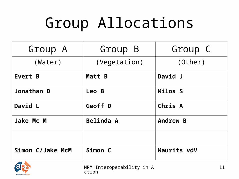
Group Allocations
Group A Group B Group C(Water) (Vegetation) (Other)
Evert B Matt B David J
Jonathan D Leo B Milos S
David L Geoff D Chris A
Jake Mc M Belinda A Andrew B
Simon C/Jake McM Simon C Maurits vdV

NRM Interoperability in Action 12
User GroupsCode Name Role in System Sample Users/ Job
Positions
GU General User Query and display natural resource information (water & vegetation extent)
Novice/Competent/Expert.
[Workshop outcome]
C Custodian Make NR information available in NRML compliant web service
[Workshop outcome]
CA Custodian Administrator
Moderates publication of services from a custodian perspective.
[Workshop outcome]
SA System administrator for NRML central facilities
Manages, moderates and administers NRML Registry (publishing, quality assurance, notification of users, compiling usage and user feedback, management of user profiles)
[Workshop outcome]

Use-Case ExampleUser Name Roger
User Group User
Role Regional GIS Officer in State Government Department
Skill level (Novice, Competent, Expert)
Competent
Narrative Roger has been asked by his local CMA contact (CMA officer) for a map showing salinity and water quality issues in a particular sub-catchment. Using his desktop GIS, he queries the registry to see if one already exists. This is not the case, so he searches for and finds a number of salinity and water quality datasets in that area. He examines the titles, modification dates and data descriptions to choose the most appropriate for his purpose and adds them as layers to his map. When the map is ready, he prints it off and takes it to the CMA staff.
Key Tasks Indicator ReportingMetadata examinationDataset selection (binding)Create Map (data rendering)
Information (Product) Requirements
Water Quality & Salinity, catchment levelParameters: Electrical ConductivityCurrent and historicMetadata
Tool(s) used Desktop GIS
Importance (High, Medium, Low)
Medium
Additional Comments

NRM Interoperability in Action 14
In your groups:
• User Groups:– Confirm profiles, and enter sample users/job
positions
• Use-Cases:– Develop at least one for each user group
(more for general-users)– Identify key tasks and information product
requirements– Indicate importance

NRM Interoperability in Action 15
Reporting Back
• Spokesperson reporting back– User group profiles, sample users– Use cases
• Present• Prioritise

NRM Interoperability in Action 16
LUNCH

NRM Interoperability in Action 17
Plenary: Methodology and Examples (Simon Cox)

NRM Interoperability in Action 18
Groupwork:Develop Abstract Information
Model• Group Allocations
– Members– Scribe/Spokesperson
• Instructions

NRM Interoperability in Action 19
Group Allocations
Group A Group B Group C(Water) (Vegetation) (Other)
Evert B Matt B David J
Jonathan D Leo B Milos S
David L Geoff D Chris A
Jake Mc M Belinda A Andrew B
Simon C/Jake McM Simon C Maurits vdV
NRM Interoperability in Action 20
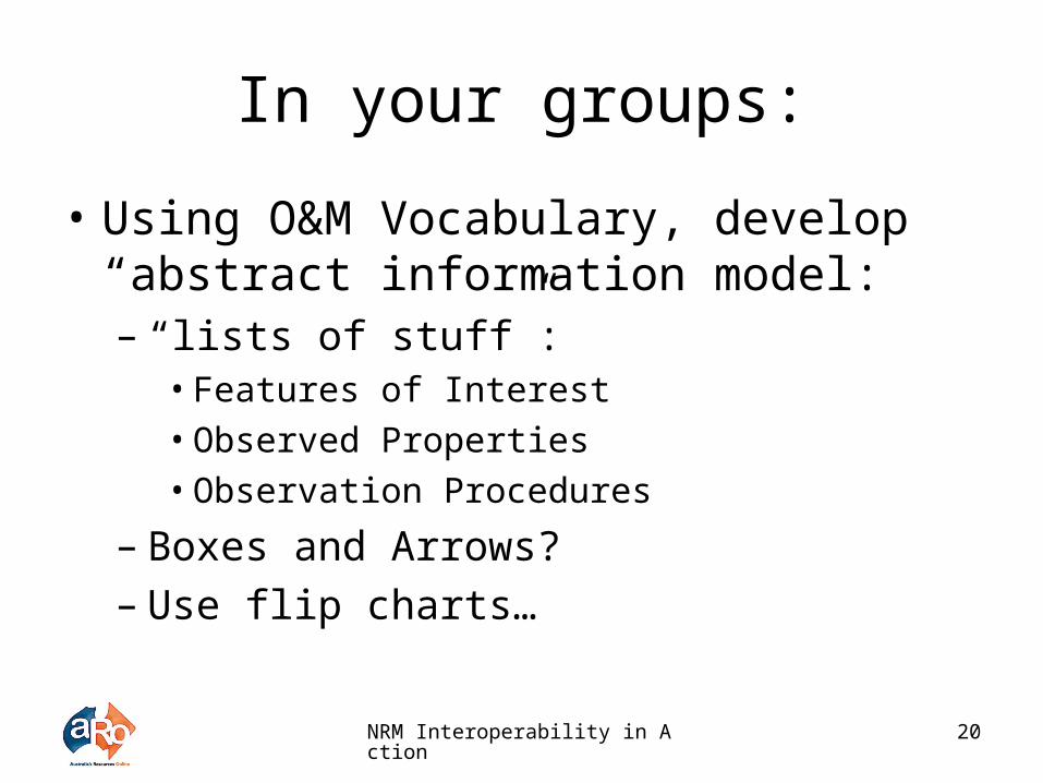
In your groups:
• Using O&M Vocabulary, develop “abstract information model:– “lists of stuff”:
• Features of Interest• Observed Properties• Observation Procedures
– Boxes and Arrows?– Use flip charts…

NRM Interoperability in Action 21
Afternoon Tea

NRM Interoperability in Action 22
Reporting Back
• Spokesperson reporting back– Verification against guiding principles, use-
cases and scope– Consolidation and Harmonisation of
Information Models– Implications for Systems Architecture

NRM Interoperability in Action 23
Discussion and Close