automatic registration of color images to 3d geometrylowkl/publications/liyz_cgi2009.pdf ·...
TRANSCRIPT
Automatic Registration of Color Images to 3D Geometry
Yunzhen Li∗
National University of Singapore
Kok-Lim Low†
National University of Singapore
Abstract
We present an approach to automatically register a large set ofcolor images to a 3D geometric model. The problem arises fromthe modeling of real-world environments, where surface geometryis acquired using range scanners whereas the color information isseparately acquired using untracked and uncalibrated cameras. Ourapproach constructs a sparse 3D model from the color images usinga multiview geometry technique. We project special light patternsonto the scene surfaces to increase the robustness of the multiviewgeometry reconstruction. The sparse model is then approximatelyaligned with the detailed model. Planes found in the detailed modelare exploited to refine the registration. Finally, the registered colorimages are mapped to the detailed model using weighted blending,with careful consideration of occlusion and the preservation of im-age details.
CR Categories: I.4.1 [Image Processing and Computer Vision]:Digitization and Image Capture—Imaging geometry, Scanning;I.4.8 [Image Processing and Computer Vision]: Scene Analysis—Range data, Sensor fusion
Keywords: Image-to-geometry registration 2D-to-3D registrationrange scanning multiview geometry SIFT image blending
1 Introduction
Active range sensing has been used to reconstruct high-quality 3Ddigital models of complex real-world objects and environments,and has found many practical applications in areas ranging frommanufacturing to cultural heritage modeling [Levoy et al. 2000][Stumpfel et al. 2003] and urban scene modeling [Liu and Stamos2005].
Besides the geometric information, photometric properties of theobject or environment surfaces have to be acquired as well in or-der to reconstruct a visually-realistic digital model. Some rangescanners is capable of acquiring color information together withthe range data, while some lack the capability. Nevertheless, forrealistic display of a 3D digital model, view-dependent surface re-flection must be captured. This requires the color of each surfacepoint to be sampled from many directions, and therefore many morecolor images are usually needed than range images. In other appli-cations, very often, the geometric model is to be mapped with verydetailed color images much higher in resolution than that of therange images. In this case, even if the range scanner can capturecolor, the color may not have the required resolution. Many close-up or zoomed-in pictures have to be acquired in order to achieve thesurface coverage as well as the required resolution.
∗[email protected]†[email protected]
Our current work focuses on the modeling of indoor environments.To allow greater maneuverability and flexibility, we use an ordinarydigital color camera that is untracked and uncalibrated to take pho-tographs of the indoor scene. Each color image is acquired withan unknown camera pose and unknown camera intrinsic parame-ters. These images must then be registered with the geometry ofthe 3D model constructed from the range images. Current registra-tion methods require human users to manually identify correspond-ing points on each image with those on the range images or the3D model. This approach is error-prone and becomes extremelytedious when there is a large number of images to register. Thereare automated registration methods [Liu and Stamos 2005] [Sta-mos and Allen 2001], but these methods are designed to exploitspecific features unique to outdoor urban environments. Some ap-proaches avoid, or partially avoid, the registration problem by us-ing tracked calibrated camera or by co-locating the camera and thescanner [Williams et al. 2004].
We present a novel and practical approach to registering a large setof color images to their corresponding 3D geometric model. Theapproach is almost automatic and requires very little manual input.The approach is more general than previous methods, in that it canbe applied not only to most indoor environments, but to other envi-ronments and objects.
Instead of trying to find corresponding features between color im-ages and the 3D model, our method takes the approach of establish-ing correspondences among the color images using a robust imagefeature detection technique, and uses a multiview geometry tech-nique to construct a sparse 3D model from the color images. Toimprove the robustness of the multiview geometry reconstructionfor scenes with large surfaces that lack features, we use light pro-jectors to project special light patterns onto the scene surfaces toartificially introduce image features. The sparse model is then ap-proximately aligned to the 3D detailed model using only a few pairsof corresponding points between one of the color images and the3D detailed model. Our method then extracts planes in the detailedmodel and exploits these to improve the sparse model and refine theregistration.
1.1 Contributions
The main contribution of our work is the idea of taking the approachof establishing correspondences among the color images insteadof directly finding corresponding features between the 2D and 3Dspaces [Liu and Stamos 2005] [Stamos and Allen 2001]. The latterapproach works well only for higher-level features, such as parallelstraight lines, and this imposes assumptions and restrictions on thetypes of scenes the method can handle. For most indoor environ-ments, these higher-level features usually exist, but they are oftentoo few or do not appear in most of the color images due to smallfield of view and short shooting distance. Our approach works formore types of scenes and even for objects.
The main problem of feature correspondence is the lack of featureson large uniform surfaces. This occurs a lot in indoor environ-ments where large plain walls, ceiling and floor are common. Weget around this problem by using light projectors to project speciallight patterns onto the scene surfaces to artificially introduce imagefeatures.

Our method requires the user to manually input only six pairsof correspondences between one of the color images and the 3Dmodel. This allows the sparse model to be approximately alignedwith the detailed model. We detect planes in the detailed model,and by minimizing the distances between some of the points in thesparse model and these planes, we are able to refine the multiviewgeometry and the registration as a whole using sparse bundle adjust-ment (SBA) [Lourakis and Argyros 2004]. This approach is able toachieve better registration accuracy in the face of non-uniform spa-tial distortion in the geometric model.
Our goal here is not to render the completed model with view-dependent reflection. Instead, we assign each point on the surfaceof the 3D model a single color by carefully blending colors frommultiple overlapping color images. Our method takes into consid-eration the different exposures of the color images and the occlu-sion of surfaces in the 3D model. It produces a colored model withvery smooth color transitions and yet preserves fine details. Eventhough we did not demonstrate it, our method of registering a largeset of color images to the geometric model naturally applies to cre-ating models with view-dependent reflection [Chen et al. 2002] andmodels with very high-resolution texture maps.
In the next section, we review related work for similar registrationproblems, and also related work in multiview geometry. Section 3gives a detailed description of the main steps in our method. Wediscuss our experiment results in Section 4 and then conclude thepaper with discussion of some future work in the next section.
2 Related Work
We first review previous work on automatic registration of colorimages to 3D geometric model or range images. Since multiviewgeometry is central to the working of our method, we therefore re-view work related to it, with emphasis on the particular techniqueused in the Photo Tourism work [Snavely et al. 2006], which is verysimilar to our implementation.
2.1 Automatic Image-to-Geometry Registration
There are two major classes of algorithms for automatic registra-tion of color images to 3D geometric model or range images —feature based and statistics based. Feature-based methods attemptto match corresponding features found in both the color images andthe 3D model. For the modeling of buildings and urban scenes,Stamos and Allen [Stamos and Allen 2001], and Liu and Stamos[Liu and Stamos 2005] detect and match line features between theimages and the 3D models. The latter method further exploits lineparallelism and orthogonality that naturally exist in urban scenes.These constraints can greatly improve the reliability of their auto-matic registration. Zhao et al. [Zhao et al. 2005] constructs densepoint-cloud model from video, and uses the ICP (iterative closestpoint) algorithm [Besl and Mckay 1992] to align the point-cloudmodel to a detailed geometric model obtained using range scan-ning. The registration is then used to texture map the video framesonto the geometric model.
Statistics-based algorithms exploit the statistical dependence be-tween color images and 3D models. Some range sensors are ca-pable of recording the intensity of the reflected sensing light ateach range sample, and to reduce noise, the sensing light is oftennot in the visible light spectrum. Williams et al. [Williams et al.2004] and Hantak and Lastra [Hantak and Lastra 2006] use the de-pendence between color and the infra-red intensity at each rangesample, and several similarity measures, such as mutual informa-tion and chi-square statistics, are used to search for the best match.For this approach, good camera pose initialization is crucial to de-
rive the correct camera pose. The registration results of differentinformation-theoretic metrics are compared in [Hantak and Lastra2006]. Also, Pong and Cham [Pong and Cham 2006] have exploredmutual information between image intensity and object surface nor-mals for the alignment of 3D objects to their 2D images.
2.2 Multiview Geometry
The success of a multiview geometry reconstruction relies on therobustness of the detected image features. The Scale Invariant Fea-ture Transform (SIFT) [Lowe 2004], or variants of it, has becomepopular in applications that require robust image features, such asin panorama reconstruction [Brown and Lowe 2007] and in PhotoTourism [Snavely et al. 2006]. SIFT keypoints and descriptors areinvariant to scale and rotational transformations, and to other affinetransformations and perspective transformations to a certain extent.A recent study [Szeliski 2006] shows that SIFT generally providesthe most robust features for most applications.
The Photo Tourism system [Snavely et al. 2006] uses a multiviewgeometry technique to reconstruct sparse 3D point-cloud modelsof tourist locations from a large collection of photographs obtainedfrom the Internet or from personal photo collections. The system al-lows users to explore the location and browse the photo collectionin 3D. The system builds the sparse model by first detecting andmatching SIFT features in the images. Given the feature correspon-dences and the approximate initial camera parameters stored in theEXIF tags of the images, the multiview geometry, which consists ofthe sparse 3D point-cloud model and the intrinsic and extrinsic pa-rameters of each view, is computed using a structure-from-motion(SfM) technique [Hartley and Zisserman 2004]. The multiview ge-ometry computation repeatedly applies a two-view geometry algo-rithm. The geometry expands by adding new views incrementally.To guarantee correctness, after each view is added, sparse bundleadjustment (SBA) [Lourakis and Argyros 2004] is applied to refinethe overall structure.
3 Proposed Method
The following subsections describe our approach in details. Themajor steps are
1. data acquisition,
2. multiview geometry reconstruction,
3. approximate registration of the sparse model to the detailedmodel,
4. registration refinement, and
5. mapping color to the model surfaces.
3.1 Data Acquisition
During data acquisition, range images are captured using a rangescanner, and color images are captured using an untracked and un-calibrated ordinary digital camera. The zoom setting of the camerais not fixed, and auto-focus and auto-exposure are enabled. If theexposure time is too long, we mount the camera on a lightweighttripod.
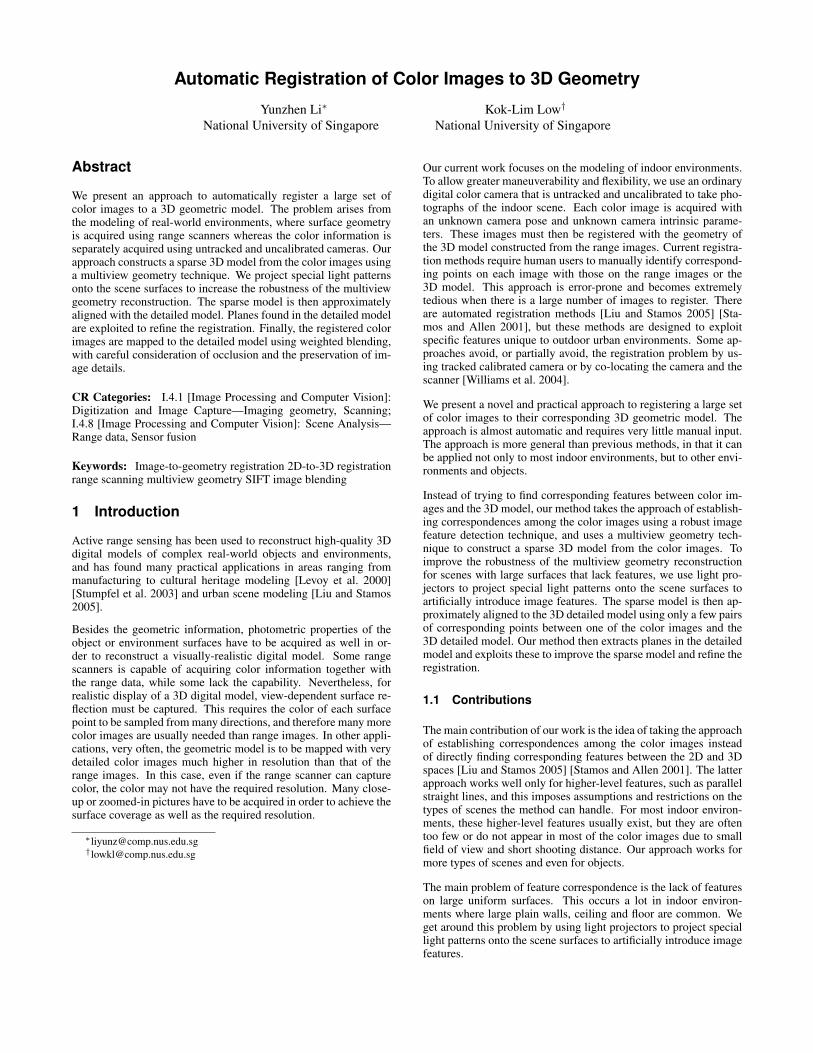
Very often in indoor environment, there are some large surfaces,such as walls and ceiling, that have very few image features re-quired for the multiview geometry reconstruction. For these sur-faces, we use light projectors to project a static light pattern onthem (see Figure 1). For views that can see this light pattern, we
mount the camera on the tripod, lock the focus and the zoom set-ting (but not the exposure), and take one image with and anotherwithout the projected light pattern. We use aperture-priority auto-exposure to ensure that the depth of field does not change. Of eachof these image pairs, only the one with light pattern is used in themultiview geometry reconstruction, and the other one is used forapplying color to the 3D model.
Figure 1: Plain surfaces in the scene are projected with specialstatic light pattern to improve feature detection.
The light pattern actually comes from an ordinary high-resolutionimage. We converted it to a grayscale image, tuned its contrast,uniformly subdivided it into 16 pixels-by-16 pixels blocks, and ran-domly shuffled the blocks to get the final image. The random shuf-fling of the blocks introduces additional high-frequency structuresat the block boundaries, and at the same time increases the unique-ness of the low-frequency structures at each point. We were carefulto choose an original image that has very few large uniform regions(for copyrights reason, we are unable to show the original imagehere). Our experiments have shown that the light pattern can greatlyincrease the number of correctly-matched SIFT keypoints.
3.2 Multiview Geometry Reconstruction
We run the SIFT algorithm [Lowe 2004] to detect SIFT keypointsin the color images. For efficiency, we use the approximate nearestneighbors kd-tree algorithm (ANN) [Arya et al. 1998] to match thedescriptors of the keypoints for every pair of images. Similar to thePhoto Tourism system [Snavely et al. 2006], we remove incorrectmatches (outliers) using the following steps. First, for each im-age pair, we use an RANSAC approach [Fischler and Bolles 1981]to compute a fundamental matrix [Hartley 1995]. Those matchesthat cannot satisfy the fundamental matrix equation are removed.Next, the geometric consistency of each keypoint is checked acrossall images. Matches are connected across multiple images to formtracks. A track is inconsistent if it contains two different keypointsfrom any single image. Matches that form inconsistent tracks areremoved.
The multiview geometry computation starts with the two-view ge-ometry of the image pair that contains the largest number of con-sistent matches. Degenerate cases, where (1) the two images weretaken from the same location, or (2) the matches in the two im-ages are all on a single plane, are detected by first computing ahomography transformation between the matched keypoints in thetwo images using the RANSAC approach. If more than 95% ofthe matched keypoints satisfy the homography transformation, weconsider it a degenerate case. We discard the image pair and useanother pair that contains the next largest number of consistent
matches. Otherwise, we just proceed normally to estimate the es-sential matrix and extract the relative camera pose from the essen-tial matrix. The approximate intrinsic parameters used in the es-sential matrix computation are obtained from the image EXIF tags.There are four possible relative poses, but we choose the one thatmakes the associated reconstructed 3D points appear in front of thetwo cameras. We then apply bundle adjustment to refine the cameraparameters and the 3D point locations.
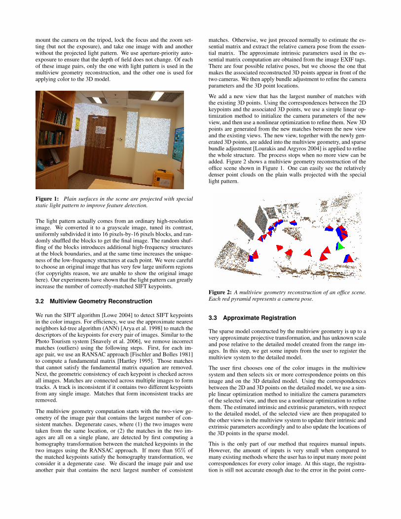
We add a new view that has the largest number of matches withthe existing 3D points. Using the correspondences between the 2Dkeypoints and the associated 3D points, we use a simple linear op-timization method to initialize the camera parameters of the newview, and then use a nonlinear optimization to refine them. New 3Dpoints are generated from the new matches between the new viewand the existing views. The new view, together with the newly gen-erated 3D points, are added into the multiview geometry, and sparsebundle adjustment [Lourakis and Argyros 2004] is applied to refinethe whole structure. The process stops when no more view can beadded. Figure 2 shows a multiview geometry reconstruction of theoffice scene shown in Figure 1. One can easily see the relativelydenser point clouds on the plain walls projected with the speciallight pattern.
Figure 2: A multiview geometry reconstruction of an office scene.Each red pyramid represents a camera pose.
3.3 Approximate Registration
The sparse model constructed by the multiview geometry is up to avery approximate projective transformation, and has unknown scaleand pose relative to the detailed model created from the range im-ages. In this step, we get some inputs from the user to register themultiview system to the detailed model.
The user first chooses one of the color images in the multiviewsystem and then selects six or more correspondence points on thisimage and on the 3D detailed model. Using the correspondencesbetween the 2D and 3D points on the detailed model, we use a sim-ple linear optimization method to initialize the camera parametersof the selected view, and then use a nonlinear optimization to refinethem. The estimated intrinsic and extrinsic parameters, with respectto the detailed model, of the selected view are then propagated tothe other views in the multiview system to update their intrinsic andextrinsic parameters accordingly and to also update the locations ofthe 3D points in the sparse model.
This is the only part of our method that requires manual inputs.However, the amount of inputs is very small when compared tomany existing methods where the user has to input many more pointcorrespondences for every color image. At this stage, the registra-tion is still not accurate enough due to the error in the point corre-
spondences input by the user. The next step describes one approachto refine the registration.
In our implementation, our system actually lets the user select thecorrespondence points between one of the color images and one ofthe range images of the scene. These range images are assumedto have been registered with each other (using technique such as[Pulli 1999]). Therefore, the approximate registration of the sparsemodel with one range image can be automatically propagated to allother range images. In the registration refinement step, our methodmakes use of data in all the range images.
3.4 Registration Refinement
There is a need to further refine the registration. One source oferror is from the point correspondences input by the user, anothersource is the non-uniform spatial distortion in the detailed model,which is mainly caused by calibration errors in the range scanners.We would like to allow the multiview system to be aligned with thedetailed model in a non-rigid manner. For this, we make a smalladdition to our sparse bundle adjustment of the multiview system.
We first detect planes in the detailed model using the PCA method[Pearson 1901]. Next, for each plane, we identify 3D points in themultiview system that are close to it within a threshold and associatethese points to the plane. The sum of the squared distances betweenthe 3D points and their associated planes is added as a new termto the error function of the original sparse bundle adjustment. Aconstant coefficient is multiplied to the new term so that it wouldnot dominate the error function. We then run the sparse bundleadjustment on the new system.
Our registration refinement approach is more appropriate than us-ing the ICP algorithm [Besl and Mckay 1992]. The ICP algorithmtreats the two models as rigid shapes, so it is not able to adjust theregistration to adapt to the distortion in the detailed model. More-over, the intrinsic and extrinsic parameters of the views still needto be further tuned, which cannot be achieved using the ICP algo-rithm. The bundle adjustment approach we are taking is powerfulenough to address all these issues.
Certainly, this approach works well only if planes exist in the scene.Our method can be extended to deal with scenes that have verylittle planar surfaces. The idea is very similar to the ICP algorithm,in which we associate each point in the multiview system with itsnearest point in the detailed model, and use the distance betweenthem as part of the error metric in the bundle adjustment. However,this approach requires more changes to the original sparse bundleadjustment implementation, unlike in the planar case, in which eachplane can be set up as a “view” and the distances between it and theassociated 3D points can be treated as pixel errors in the “view”.
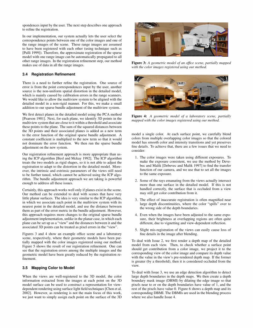
Figures 3 and 4 show an example office scene and a laboratoryscene, respectively, where their geometric models have been par-tially mapped with the color images registered using our method.Figure 5 shows the result of our registration refinement. One cansee that the registration errors among the multiple images and thegeometric model have been greatly reduced by the registration re-finement.
3.5 Mapping Color to Model
When the views are well-registered to the 3D model, the colorinformation extracted from the images at each point on the 3Dmodel surface can be used to construct a representation for view-dependent rendering using surface light field techniques [Chen et al.2002]. However, as rendering is not the main focus of this work,we just want to simply assign each point on the surface of the 3D
Figure 3: A geometric model of an office scene, partially mappedwith the color images registered using our method.
Figure 4: A geometric model of a laboratory scene, partiallymapped with the color images registered using our method.
model a single color. At each surface point, we carefully blendcolors from multiple overlapping color images so that the coloredmodel has smooth color and intensity transitions and yet preservesfine details. To achieve that, there are a few issues that we need toconsider:
1. The color images were taken using different exposures. Tomake the exposure consistent, we use the method by Deve-bec and Malik [Debevec and Malik 1997] to find the transferfunction of our camera, and we use that to set all the imagesto the same exposure.
2. Some of the rays emanating from the views actually intersectmore than one surface in the detailed model. If this is nothandled correctly, the surface that is occluded from a viewmay still get color contribution from it.
3. The effect of inaccurate registration is often magnified nearlarge depth discontinuities, where the color “spills” over tothe wrong side of the depth boundaries.
4. Even when the images have been adjusted to the same expo-sure, their brightness at overlapping regions are often quitedifferent, due to vignetting and view-dependent reflection.
5. Slight mis-registration of the views can easily cause loss offine details in the image after blending.
To deal with Issue 2, we first render a depth map of the detailedmodel from each view. Then, to check whether a surface pointshould get contribution from a color image, we project it to thecorresponding view of the color image and compare its depth valuewith the value in the view’s pre-rendered depth map. If the formeris greater (by a threshold), then it is considered occluded from theview.
To deal with Issue 3, we use an edge detection algorithm to detectlarge depth boundaries in the depth maps. We then create a depthboundary mask image (DBMI) by dilating the edge image so thatpixels near to or on the depth boundaries have value of 1, and therest of the pixels have value 0. Figure 6 shows a depth map and itscorresponding DBMI. The DBMIs are used in the blending processwhere we also handle Issue 4.
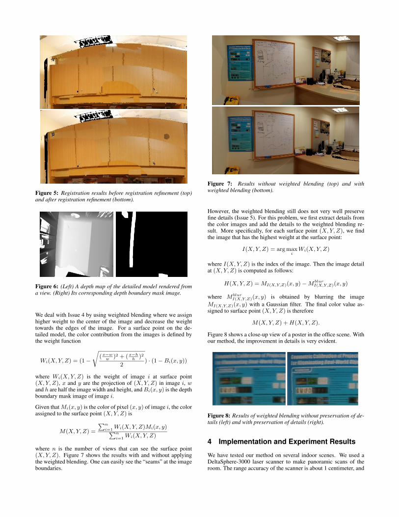
Figure 5: Registration results before registration refinement (top)and after registration refinement (bottom).
Figure 6: (Left) A depth map of the detailed model rendered froma view. (Right) Its corresponding depth boundary mask image.
We deal with Issue 4 by using weighted blending where we assignhigher weight to the center of the image and decrease the weighttowards the edges of the image. For a surface point on the de-tailed model, the color contribution from the images is defined bythe weight function
Wi(X, Y, Z) = (1 −
√
(x−w
w)2 + (x−h
h)2
2) · (1 − Bi(x, y))
where Wi(X, Y, Z) is the weight of image i at surface point(X, Y, Z), x and y are the projection of (X, Y, Z) in image i, wand h are half the image width and height, and Bi(x, y) is the depthboundary mask image of image i.
Given that Mi(x, y) is the color of pixel (x, y) of image i, the colorassigned to the surface point (X, Y, Z) is
M(X, Y, Z) =
∑n
i=1Wi(X, Y, Z)Mi(x, y)
∑n
i=1Wi(X, Y, Z)
where n is the number of views that can see the surface point(X, Y, Z). Figure 7 shows the results with and without applyingthe weighted blending. One can easily see the “seams” at the imageboundaries.
Figure 7: Results without weighted blending (top) and withweighted blending (bottom).
However, the weighted blending still does not very well preservefine details (Issue 5). For this problem, we first extract details fromthe color images and add the details to the weighted blending re-sult. More specifically, for each surface point (X, Y, Z), we findthe image that has the highest weight at the surface point:
I(X, Y, Z) = arg maxi
Wi(X, Y, Z)
where I(X, Y, Z) is the index of the image. Then the image detailat (X, Y, Z) is computed as follows:
H(X, Y, Z) = MI(X,Y,Z)(x, y) − MblurI(X,Y,Z)(x, y)
where MblurI(X,Y,Z)(x, y) is obtained by blurring the image
MI(X,Y,Z)(x, y) with a Gaussian filter. The final color value as-signed to surface point (X, Y, Z) is therefore
M(X, Y, Z) + H(X, Y, Z).
Figure 8 shows a close-up view of a poster in the office scene. Withour method, the improvement in details is very evident.
Figure 8: Results of weighted blending without preservation of de-tails (left) and with preservation of details (right).
4 Implementation and Experiment Results
We have tested our method on several indoor scenes. We used aDeltaSphere-3000 laser scanner to make panoramic scans of theroom. The range accuracy of the scanner is about 1 centimeter, and
the range image resolution is 10 samples per degree. In the case thatthere are not enough features, we also used projectors to project thespecial light pattern on the plain walls in the office.
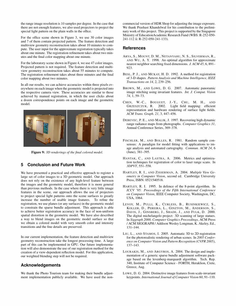
For the office scene shown in Figure 3, we use 30 color imagesand 7 of them contain projected pattern. The feature detection andmultiview geometry reconstruction takes about 10 minutes to com-pute. The user input for the approximate registration typically takesabout one minute. The registration refinement takes about two min-utes and the final color mapping about one minute.
For the laboratory scene shown in Figure 4, we use 47 color images.Projected pattern is not required. The feature detection and multi-view geometry reconstruction takes about 55 minutes to compute.The registration refinement takes about three minutes and the finalcolor mapping about two minutes.
In all our results, we can achieve accuracies within three pixels ev-erywhere on each image when the geometric model is projected intothe respective camera view. These accuracies are similar to thoseachieved by manual registration, in which the user clicks abouta dozen correspondence points on each image and the geometricmodel.
Figure 9: 3D renderings of the final colored model.
5 Conclusion and Future Work
We have presented a practical and effective approach to register alarge set of color images to a 3D geometric model. Our approachdoes not rely on the existence of any high-level feature betweenthe images and the geometric model, therefore it is more generalthan previous methods. In the case where there is very little imagefeatures in the scene, our approach allows the use of projectorsto project special light patterns onto the scene surfaces to greatlyincrease the number of usable image features. To refine theregistration, we use planes (or any surfaces) in the geometric modelto constrain the sparse bundle adjustment. This approach is ableto achieve better registration accuracy in the face of non-uniformspatial distortion in the geometric model. We have also describeda way to blend images on the geometric model surface so thatwe obtain a colored model with very smooth color and intensitytransitions and the fine details are preserved.
In our current implementation, the feature detection and multiviewgeometry reconstruction take the longest processing time. A largepart of this can be implemented in GPU. Our future implementa-tion will also demonstrate the use of our registration method for thecreation of a view-dependent reflection model. For this application,our weighted blending step will not be required.
Acknowledgements
We thank the Photo Tourism team for making their bundle adjust-ment implementation publicly available. We have used the non-
commercial version of HDR Shop for adjusting the image exposure.We thank Prashast Khandelwal for his contribution to the prelimi-nary work of this project. This project is supported by the SingaporeMinistry of EducationAcademic Research Fund (WBS: R-252-050-241-112 & R-252-050-241-133).
References
ARYA, S., MOUNT, D. M., NETANYAHU, N. S., SILVERMAN, R.,AND WU, A. Y. 1998. An optimal algorithm for approximatenearest neighbor searching fixed dimensions. J. ACM 45, 6, 891–923.
BESL, P. J., AND MCKAY, H. D. 1992. A method for registrationof 3-D shapes. Pattern Analysis and Machine Intelligence, IEEETransactions on 14, 2, 239–256.
BROWN, M., AND LOWE, D. G. 2007. Automatic panoramicimage stitching using invariant features. Int. J. Comput. Vision74, 1, 59–73.
CHEN, W.-C., BOUGUET, J.-Y., CHU, M. H., AND
GRZESZCZUK, R. 2002. Light field mapping: efficientrepresentation and hardware rendering of surface light fields.ACM Trans. Graph. 21, 3, 447–456.
DEBEVEC, P. E., AND MALIK, J. 1997. Recovering high dynamicrange radiance maps from photographs. Computer Graphics 31,Annual Conference Series, 369–378.
FISCHLER, M., AND BOLLES, R. 1981. Random sample con-sensus: A paradigm for model fitting with applications to im-age analysis and automated cartography. Commun. ACM 24, 6(June), 381–395.
HANTAK, C., AND LASTRA, A. 2006. Metrics and optimiza-tion techniques for registration of color to laser range scans. In3DPVT, 551–558.
HARTLEY, R. I., AND ZISSERMAN, A. 2004. Multiple View Ge-ometry in Computer Vision, second ed. Cambridge UniversityPress, ISBN: 0521540518.
HARTLEY, R. I. 1995. In defence of the 8-point algorithm. InICCV ’95: Proceedings of the Fifth International Conferenceon Computer Vision, IEEE Computer Society, Washington, DC,USA, 1064.
LEVOY, M., PULLI, K., CURLESS, B., RUSINKIEWICZ, S.,KOLLER, D., PEREIRA, L., GINZTON, M., ANDERSON, S.,DAVIS, J., GINSBERG, J., SHADE, J., AND FULK, D. 2000.The digital michelangelo project: 3D scanning of large statues.In Siggraph 2000, Computer Graphics Proceedings, ACM Press/ ACM SIGGRAPH / Addison Wesley Longman, K. Akeley, Ed.,131–144.
LIU, L., AND STAMOS, I. 2005. Automatic 3D to 2D registrationfor the photorealistic rendering of urban scenes. In 2005 Confer-ence on Computer Vision and Pattern Recognition (CVPR 2005),137–143.
LOURAKIS, M., AND ARGYROS, A. 2004. The design and imple-mentation of a generic sparse bundle adjustment software pack-age based on the levenberg-marquardt algorithm. Tech. Rep.340, Institute of Computer Science - FORTH, Heraklion, Crete,Greece, Aug.
LOWE, D. G. 2004. Distinctive image features from scale-invariantkeypoints. International Journal of Computer Vision 60, 91–110.
PEARSON, K. 1901. On lines and planes of closest fit to systems ofpoints in space. Philosophical Magazine, London, UK, 559–572.
PONG, H., AND CHAM, T. 2006. Alignment of 3D models to im-ages using region-based mutual information and neighborhoodextended gaussian images. In ACCV’06, I:60–69.
PULLI, K. 1999. Multiview registration for large data sets. InInternational Conference on 3D Digital Imaging and Modeling,160–168.
SNAVELY, N., SEITZ, S. M., AND SZELISKI, R. 2006. Phototourism: Exploring photo collections in 3D. ACM Transactionson Graphics (SIGGRAPH Proceedings) 25(3), 835–846.
STAMOS, I., AND ALLEN, P. 2001. Automatic registration of 2-Dwith 3-D imagery in urban environments. In ICCV’01, II: 731–736.
STUMPFEL, J., TCHOU, C., YUN, N., MARTINEZ, P., HAWKINS,T., JONES, A., EMERSON, B., AND DEBEVEC, P. 2003. Dig-ital reunification of the parthenon and its sculptures. In VAST2003: 4th International Symposium on Virtual Reality, Archae-ology and Intelligent Cultural Heritage, 41–50.
SZELISKI, R. 2006. Image alignment and stitching: A tutorial.Foundations and Trends in Computer Graphics and Vision 2, 1.
WILLIAMS, N., LOW, K.-L., HANTAK, C., POLLEFEYS, M.,AND LASTRA, A. 2004. Automatic image alignment for 3D en-vironment modeling. 17th ACM Brazilian Symposium on Com-puter Graphics and Image Processing, 388–395.
ZHAO, W., NISTER, D., AND HSU, S. 2005. Alignment of con-tinuous video onto 3D point clouds. IEEE Trans. Pattern Anal.Mach. Intell. 27, 8, 1305–1318.