available online journal of scientific...
TRANSCRIPT

Available online www.jsaer.com
Journal of Scientific and Engineering Research
202
Journal of Scientific and Engineering Research, 2017, 4(9):202-209
Research Article
ISSN: 2394-2630
CODEN(USA): JSERBR
Relevance of Geophysical Wireline Logs In Hydrocarbon Reservoir Characterization
Aigbedion I., Ilukhor O. M., Atama J.O.
Ambrose Alli University, Ekpoma, Edo State, Nigeria
Abstract Suites of borehole logs comprising gamma-ray, electrical resistivity, neutron and density logs from
four wells in the offshore Niger Delta were evaluated for their hydrocarbon potential. The various lithologic
types penetrated by the wells were differentiated on the basis of the Gamma-Ray log into sand, shale and shaly-
sand beds.
Three (3) sand bodies were delineated and correlated across the (O) field. The three sands were further
identified as potential hydrocarbon reservoirs. The evaluated petrophysical parameters for the reservoir layers
have porosity, range of 24-30 % and hydrocarbon saturation, range of 72–80 %. The logs evaluation indicates
that prolific sands are encountered at depth range of 2920-2978 m.
It is therefore evident that the area under study has a good potential for hydrocarbon exploration and
exploitation. The use of the geophysical well logs have allowed for the evaluation of rock formation properties
such as hydrocarbon saturation, porosity and reservoir thickness that will make drilling and production
decisions a lot easier.
Keywords Rock properties, Niger Delta, Saturation, Porosity, well log
Introduction
Well logging is one of the most fundamental methods for reservoir characterization, in oil and gas industry, it is
an essential method for geoscientist to acquire more knowledge about the condition below the surface by using
physical properties of rocks. This method is very useful to detect hydrocarbon bearing zone, calculate the
hydrocarbon volume, and many others [1, 9].
Formation evaluation is the study of the properties of the rock and their relationship to the fluids they contain in
both static and flowing states using wireline logs [2, 8].
The formation of the Niger Delta- Nigeria consists of sands and shales with the former ranging from fluvial
(channel) to fluviomarine (barrier bar), while the later are generally fluviomarine or lagoonal. These formations
are mostly unconsolidated and it is often not feasible to take core samples or make drill stem tests. Formation
evaluation is consequently based mostly on logs. Petrophysical parameters like the lithology fluid content,
porosity, water saturation and hydrocarbon saturation are derived; from the well log data [3,10].
Petroleum deposits occur as a result of the deposition of plants and animals matter in areas which are slowly
subsidizing. These areas which are usually in the sea or along if margin in the coastal lagoons and occasionally
in lakes or inland swamps. Sediments are deposited along with organic matters and rate of deposition of the
sediments must be sufficiently rapid that at least part of the organic matter is preserved buried before being
destroyed or decayed [7]. As time goes on and the area continue to sink slowly (because of weight of sediments)
the organic materials are buried deeper and hence is exposed to higher temperature and pressure. Eventually,
chemical changes result in the formation of petroleum; a complex highly variable mixture of hydrocarbon,
including liquid and gases.
Sedimentary rocks are porous, porosity being the fractional volume of the rock occupied by cavities or pores.
Petroleum collects these cavities, intermingled with water which are buried with the sediments.

Aigbedion I et al Journal of Scientific and Engineering Research, 2017, 4(9):202-209
Journal of Scientific and Engineering Research
203
When a significant fraction of the pool inter-connected so that is permeable the oil and gas tends to rise and will
eventually reach the surface of the earth and be dissipated unless they encounter a barrier which stops the
upward immigration such as barrier produces a trap.
Since the petroleum deposit is beneath the surface operation of deciding when the drilling should be stopped.
The logs are useful to geophysicists and geologists as they help them make relevant decisions.
Three major litho stratigraphic units have been recognized in the Niger Delta- Nigeria [2,6]. These are the
Akata, Agbada and Benin formations. Details of the geology of the Niger Delta has been discussed by several
authors.
The Benin formation, which is a loose fresh water bearing sand with occasional lignite the clay and going up to
2,286m deep with no pressures. The Agbada formation is made up of alternation sands and shales. The sands are
mostly encountered at the upper parts while shales are found mostly at the lower parts [11,12]. The Agbada
formation is the thickest at the center of the Delta and goes up to 457.2m. This is the seat of most oil reservoirs
and center of over pressures (Figure 1).
Formation evaluation in the area of study within Niger Delta basin will allow an estimate to be made of
porosity, fluid content and type and lithology with geophysical well logs [11, 12]. The physical and chemical
properties of the rock determined in this way are an invaluable aid to describing sub-surface geology [3].
The overall aim of this study is to delineate the reservoir units for correlation and evaluation of rock formation
properties in „O‟ Field in the Niger Delta using well log data”.
Figure 1: Map of the Niger Delta showing the Study Area
Location of the Study Area
The area of study (O Field) is located between longitudes 40
and 90
E and latitudes 40
and 70
N in the Southern
part of Nigeria (Figure 1).
The Niger Delta occupies a land area limited by the Benin flank, the Ameki basin, the Calabar flank and the
present coast line (Fig -1). This land area may be referred to as the subaerial part of the Niger Delta and the
marine area, which corresponds to the subaqueous part of the Niger Delta is limited by the coastline and the
farther side of the continental rise, thus comprising the continental shelf, slope and rise off the subaerial Delta
[7].
Materials and Methods
Materials used for the relevance of geophysical wireline logs in hydrocarbon reservoir characterization are
techlog software, gamma ray log, density and neutron log.

Aigbedion I et al Journal of Scientific and Engineering Research, 2017, 4(9):202-209
Journal of Scientific and Engineering Research
204
Techlog software is a well bore petrophysical application composed of a platform and a suite of ass-on-
application modules.
The techlog platform dynamically incorporates the latest data from the well site for review and detailed analysis.
Data can be streamed directly from the well site for real-time processing and instantaneous analysis aiding
decision making during operations.
The techlog platform enables you to perform both basic and advanced interpretation on all wellbore data types,
including your own petrophysical workflow to generate meaningful quick-look interpretations based on local
expertise and the application of industry standard methods for lithology, porosity, saturation, permeability.
All common data formats are easily loaded through a powerful drag-and-drop interface into the techlog
platform. You can quickly create a log view to visualize, validate and correct data for environmental and signal
noise effects.
Archie developed his famous equation with in clay free reservoirs to calculate, from well log parameters, the
water saturation (Sw) of the uninvaded zone in a formation next to a borehole. The Archie equation can be
expressed as follows:
𝑺𝒘𝒏=
𝑎𝑹𝒘
(𝝓𝒎𝙭𝑹𝒕) (1.1)
where 𝑺𝒘 = water saturation of the uninvaded zone
n = saturation exponent, which varies from 1.8 to 4.0 but normally is 2.0;
𝑹𝒘 = formation water resistivity at formation temperature,
𝜱 = Porosity,
m = cementation exponent, which varies from 1.7 to 3.0 but normally is 1.8 in the Niger Delta;
𝑹𝒕 = true resistivity of the formation, corrected for invasion, borehole, thin bed, and other effects.The formation
factor is,
𝑭 =𝒂
𝝓𝒎, where a =1 (The tortuosity factor)
The Simandoux equation is a good general purpose equation that accounts for the influence of shale with regard
to water saturation. The Simandoux equation is
1
𝑅𝑡=
𝑆𝑤2
𝐹𝘹𝑅𝑤 (1−𝑉𝑆𝐻 )+
𝑉𝑆𝐻 𝘹𝑆𝑤
𝑅𝑆𝐻 [9,13] (Ohm)
-1 (1.2)
where,
(a) 𝑆𝑤= water saturation
(b) 𝐹= formation resistivity factor
(c) 𝑅𝑆𝐻= resistivity of shale
(d) 𝑉𝑆𝐻= volume of shale
(e) 𝑅𝑤= resistivity of formation waters
(f) 𝑅𝑡= true formation resistivity
(g) 𝑛= saturation exponent
(i) Volume of Shale was was derived from the gamma ray log first by determining the gamma ray
index IGR [13]
IGR = (GRlog – GRmin) (1.3)
(GRmax- GRmin)
where IGR = gamma ray index; GRlog = gamma ray reading of the formation; GRmin = minimum
gamma ray reading (sand baseline); GRmax = maximum gamma ray reading (Shale baseline).
For the purpose of this research work, volume of shale for tertiary rocks was used:
Vsh = 0.083 (2(3.7 x IGR)
-1) (1.4)
Porosity Ø was calculated from density porosity log using the equation:
Ø = ρma - ρb (1.5)
ρma - ρf
where,
Aigbedion I et al Journal of Scientific and Engineering Research, 2017, 4(9):202-209
Journal of Scientific and Engineering Research
205
ρma = matrix density = 2.65g/cc for sandstone (reference), ρb = bulk density which is taken to be 1
for gas and 0.87 for oil (reference).
Table 1: Petrolphysical Results
Reservoir GR
(API)
Intervals
(m)
Gross
Thickness (m)
Bulk Density
(g/cc)
Porosity
(Ø %)
Water
Saturation
(%)
Hydrocabon
Saturation
1 48 2920-2928 8 2.19 27 20 0.80
2 22 2944-2952 8 2.23 24 25 0.75
3 18 2966-2978 10 2.33 30 28 0.72
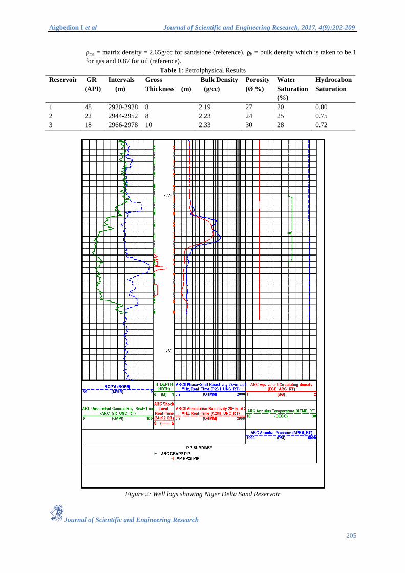
Figure 2: Well logs showing Niger Delta Sand Reservoir
Aigbedion I et al Journal of Scientific and Engineering Research, 2017, 4(9):202-209
Journal of Scientific and Engineering Research
206
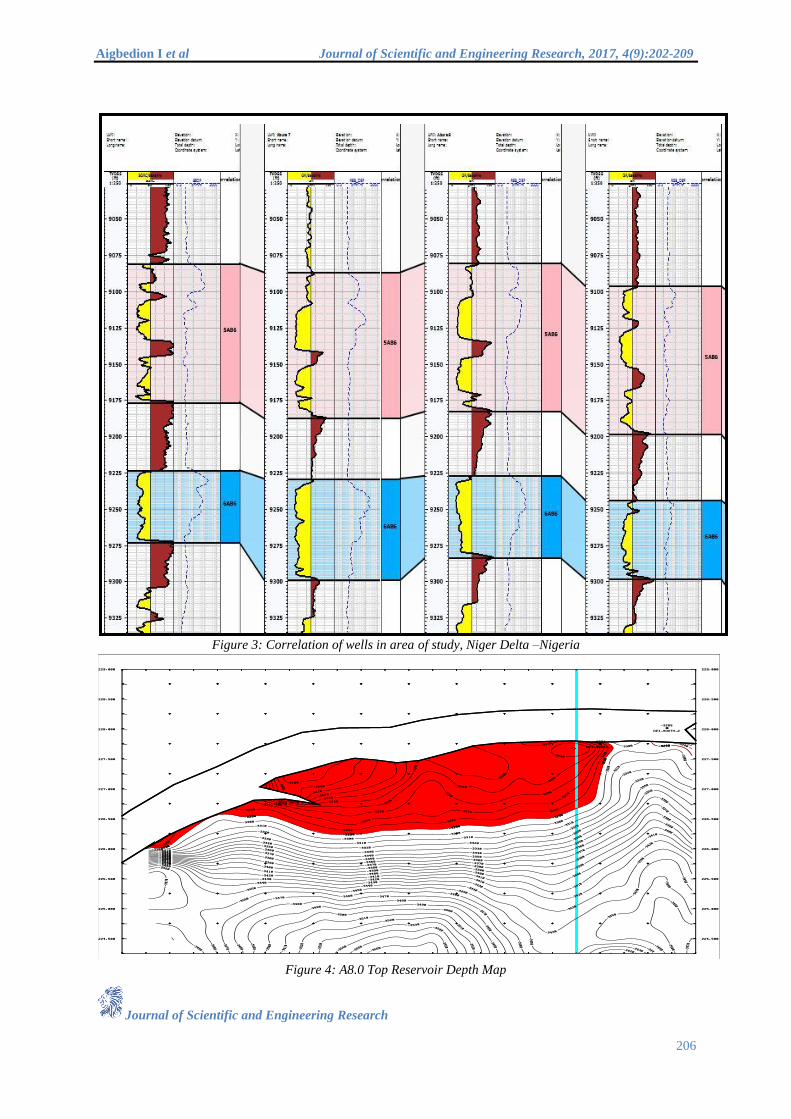
Figure 3: Correlation of wells in area of study, Niger Delta –Nigeria
Figure 4: A8.0 Top Reservoir Depth Map
Aigbedion I et al Journal of Scientific and Engineering Research, 2017, 4(9):202-209
Journal of Scientific and Engineering Research
207
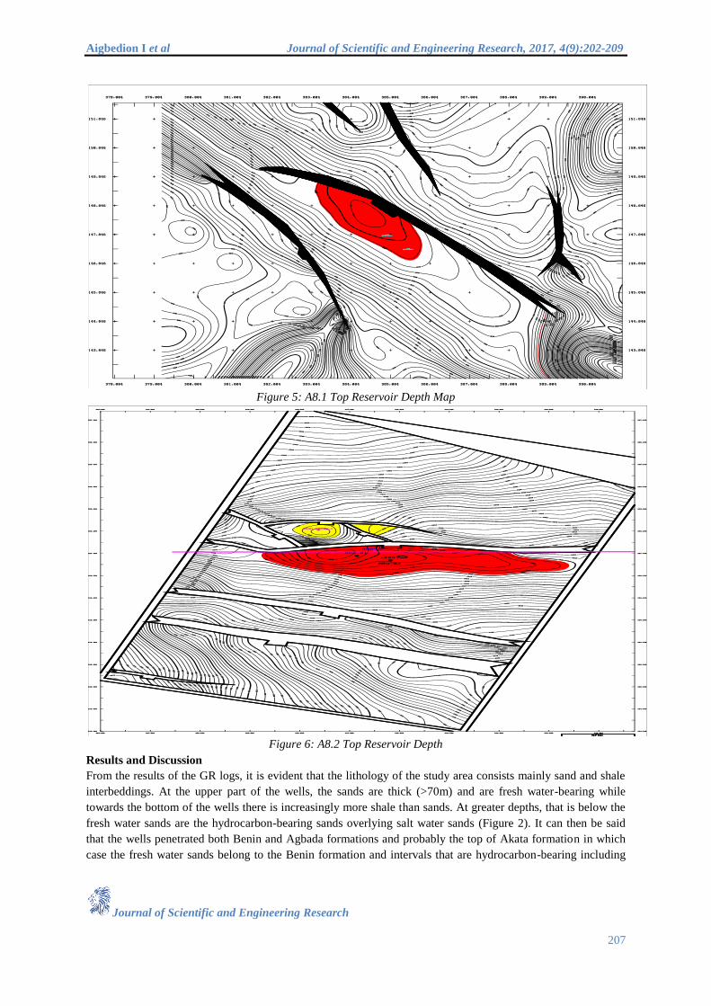
Figure 5: A8.1 Top Reservoir Depth Map
Figure 6: A8.2 Top Reservoir Depth
Results and Discussion
From the results of the GR logs, it is evident that the lithology of the study area consists mainly sand and shale
interbeddings. At the upper part of the wells, the sands are thick (>70m) and are fresh water-bearing while
towards the bottom of the wells there is increasingly more shale than sands. At greater depths, that is below the
fresh water sands are the hydrocarbon-bearing sands overlying salt water sands (Figure 2). It can then be said
that the wells penetrated both Benin and Agbada formations and probably the top of Akata formation in which
case the fresh water sands belong to the Benin formation and intervals that are hydrocarbon-bearing including

Aigbedion I et al Journal of Scientific and Engineering Research, 2017, 4(9):202-209
Journal of Scientific and Engineering Research
208
correlated intervals belong to the Agbada formation (Table1). The top reservoir depth maps Figures 4-6 with the
areas in Square feet indicates area saturated with hydrocarbon.
The combination of both neutron and density porosity values will indicate gaseous formation if the neutron
porosity is less than density porosity, while a low density porosity value and a high neutron porosity values will
indicate shale above water- bearing formations where the neutron and density logs will overlay if recorded on
compatible scales. Good well to well correlation was established in the area of the
Study in Niger Delta- Nigeria as shown in Figure 3.From the comparison of the values of the petrophysical
parameters and the water saturation values of the productive intervals (Table 1), it is observed that the values for
interval I, well A and also those of interval I, well B compare with those of interval I, well C and D. This
confirms the lithological correlation earlier made in figure 3. Gas-Water Contact has been encountered by the
well at 2984 m TVDSS. The use of the geophysical well logs have allowed for the evaluation of rock formation
properties such as hydrocarbon saturation, porosity ,etc that will make drilling and production decisions a lot
easier.
Conclusion
Three (3) sand bodies were delineated and correlated across the (O) field. The three sands were further
identified as potential hydrocarbon reservoirs. The evaluated petrophysical parameters for the reservoir layers
have porosity, range of 24-30 % and hydrocarbon saturation, range of 72-80 %. The logs evaluation indicates
that prolific sands are encountered at depth range of 2920 – 2978 m.
The resistivity log was used in combination with gamma ray log to correlate and determine well boundaries, true
formation resistivity, porosity, presence of hydrocarbon and gas-oil–water contact. While the density and
neutron log was used to calculate rock porosity, matrix density and determined hydrocarbon type (gas or oil).
Gas-Water Contact has been encountered by the well at 2984 m TVDSS. The use of the geophysical well logs
have allowed for the evaluation of rock formation properties such as hydrocarbon saturation, porosity, etc that
will make drilling and production decisions a lot easier. This study has established the relevance of the well logs
method of calculating porosity, thickness of the reservoir, gas-water/oil contact and hydrocarbon saturation and
their correlation with other wells.
References
[1]. Railsback. Characteristics of wireline well logs in the petroleum industry, AAPG, USA. 2011; 3-6.
[2]. Aigbedion, I and Aigbedion, H.O. Hydrocarbon Volumentric Analysis Using Seismic and Borehole
Data over Umoru Field, Niger Delta-Nigeria. International Journal of Geosciences, United State of
America. 2011, 2; 179-183.
[3]. Aigbedion I. Reservoir fluid differentiation case study from Oredo field in the Niger Delta-Nigeria,
International Journal of Physical Sciences 2007, 2 (6);144-148.
[4]. Aigbedion I. An Appraisal of the Abura Field. World Applied Science Journal, 2006 1(2); 20-25.
[5]. Efeotor, E.J.O, Fundamentals of Petroleum Geology. Paragraphics, Portharcourt 1997; 12-22.
[6]. Franky E.J. The Niger Delta Oil Province, Recent Development Onshore/offshore. Geological Society
of America Bulletin 1969; 19(3); 195.
[7]. Hospers J. Gravity Field and Structure of The Niger Delta Nigeria. Geological Society of America
Bulletin. 1971; 76.
[8]. Okeke P.O. Well Planning In Oil and Gas Industry, Enugu- Nigeria, 2006. 24-26.
[9]. Aigbedion I and Hafiz A. Evaluation of Hydrocarbon Prospect of Fareed Field, Western Niger-Delta,
Nigeria. Journal of Geography, Environment and Earth Science International. 2016.
[10]. Ehigiator M .O and Aigbedion, I. Characterisation of reservoir Using Petrotrophysical parameters and
core data, (A case study of Abura field Niger Delta of Nigeria), Geophysics Journal, Russia, 2010; 19-
29:71-75.
[11]. Ola Peter and Alao Peter, “Formation Evaluation and its implication on Hydrocarbon Production in
Imoye Field”, Journal of Environment and Earth Science, 3(1) 2013.

Aigbedion I et al Journal of Scientific and Engineering Research, 2017, 4(9):202-209
Journal of Scientific and Engineering Research
209
[12]. Omoruyi, E.I., “Calculation of Hydrocarbon in-place of X-Y Field by Reservoir Modelling using well
logs and seismic section.” An M.Phil Thesis in Exploration Geophysics of the University of Benin in
2011
[13]. Serra ,O, Fundamental of well log interpretation, Elsevier,1984