avalanche control in the brooks range of alaska an
TRANSCRIPT
AVALANCHE CONTROL IN THE BROOKS RANGE OF ALASKAAN ENVIRONMENT OF EXTREMES
Reid Bahnson*Equipment Operator V, Alaska Department of Transportation, Chandalar Maintenance Camp, Mile 239
Dalton Highway, Alaska: Ak.a. The Avalanche Guy
ABSTRACT: In 1974 the Dalton Highway was built north of Fairbanks to Prudhoe Bay, AK. along theroute of the Trans-Alaska Pipeline being constructed at the time. It passes through the north-centralBrooks Range and crests on the continental divide at Atigun Pass, where more than forty avalanchepaths and half a dozen slushflow gullies threaten the transportation corridor. At 68 degrees north latitudeat an elevation of 1500 meters in the Brooks Range, the climate of the area could be described as ArcticContinental. In winter a relatively shallow snowpack composed of large faceted grains overlain by hardwindslabs predominates. Very low-density new snow is transported across barren ground through thepass by frequent hurricane force winds causing climax hard slab avalanches to occur at temperatures of-30 to -40 degrees C. In contrast, the rapid onset of spring (in May) with more than twenty hours ofpossible sun causes wet avalanches and highly destructive slushflows as temperatures can reach nearly25 degrees C in the starting zones. After a slide in January 1993 buried more than 600 meters of roadand involved several vehicles, the Alaska Department of Transportation decided to institute a pro-activeavalanche forecasting and control program. The extremes of climate in conjunction with working in theArctic at a remote maintenance camp 600 km from the nearest community contribute to uniquechallenges for the development and maintenance of an effective avalanche hazard forecasting andcontrol program.
KEYWORDS: avalanche triggering, slushflows, snow melt and run-off
1. BACKGROUND
The gravel-surfaced Dalton Highway wasbuilt to facilitate construction and maintenanceactivities of the Trans-Alaska pipeline system andserve as the single surface transportation route tothe North Slope oil fields of Alaska. It passesthrough the central Brooks Range and crests onthe continental divide at Atigun Pass, where for8.5 km the roadway climbs over and descends thepass at an average grade of nine percent,
.- exceeding thirteen percent in places. In its course,- over the pass the road traverses through the lower
tracks of more than forty avalanche paths and halfa dozen slushflow gullies before entering theAtigun River valley to the north.
Highway maintenance on the northernDalton was contracted to private firms by thepipeline consortium for the first few years afterconstruction with no provisions for avalanchecontrol. In 1980 the state took over the road; theAlaska Department of Transportation and PublicFacilities being responsible for all maintenance ofthe 800-km long road.
* Corresponding author address: Reid Bahnson,P.O. Box 415, Girdwood, Ak. 99587; tel: 907-7832378; email: [email protected]
Even though it is a state highway, trafficwas restricted by permit to industrial vehiclesservicing the pipeline, the pump stations and theNorth Slope oil fields. Average daily trafficvolumes, although quite low (100 to 200 vehiclesper day), consisted primarily of "18-wheelers"hauling essential items to help keep the fifteen totwenty percent of the nation's domestic oil supplyflowing through the pipeline. Permit restrictionswere lifted in 1995 so that now the Dalton Highwayis open to all travelers, though few motorists drivethe road for pleasure in winter.
Throughout the 1980's and early 1990'smany of the big trucks travelling the road eitherran into or were hit by avalanches and becametrapped on the pass. If they were caught at nightthey would often have to wait until the next day tobe plowed free by D.O.T. personnel from theChandalar maintenance camp several km to thesouth. Usually the vehicles hit by slides were fullyloaded trucks travelling less than 25 km/hr tryingto pull the steep grade of the pass. Those that raninto slides, the more common encounter, weremoving downhill unable to stop on the steepsnow-packed surface before plowing into debris.During these years almost all of the D.O.T.equipment operators working out of Chandalarwere hit or buried in their equipment by slideswhile clearing snow on the pass. Avalanche
8

.~
rescue training was sporadically given to theD.O.T. personnel and in a few instances reactiveavalanche control took place after major eventstrapped vehicles and caused lengthy roadclosures of more than three days. After a slide inJanuary 1993 buried more than 600 meters ofroad and involved several vehicles, carrying onebig truck about 200m downslope below the road,the Alaska Department of Transportation instituteda pro-active avalanche forecasting and controlprogram. A forecaster was hired and a 105-mmrecoilless rifle was based at Chandalar.
2. THE CLIMATE
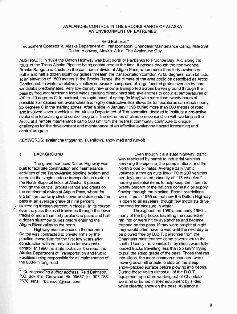
More than 230 km by road north of theArctic Circle at 680 08' north latitude 149030' westlongitude at an elevation of 1500 meters in theBrooks Range, the climate in the area of AtigunPass would best be described as ArcticContinental. Summers are cool and short.Afternoon convective activity can producesnowfalls in mid-summer and below freezingconditions persist from early September throughMay, often into June. Average winter temperaturesare below zero Fahrenheit (_170 C) from Octoberthrough late March, normally staying in the _200 to-400 C range for several weeks around wintersolstice when the sun remains below the horizon.(see figure 1) Conversely long hours of nearlyperpendicular solar radiation on steep south facingslopes in late spring can tum starting zone basinsinto "mountain ovens" with evening temperaturesgreater than 200 C. In summer as the tundra baresand the coastal ice pack recedes under 24 hoursof possible sun, onshore flow and thermallyinduced low pressure dominate, keepingconditions generally cool and cloudy.
ATIGUN PASS AVERAGE DAA.Y lEWERATURE
".------------------,1T 10 H-J....---------------IHI~ 't-AlLlCl'V-.--------------,r;\-;-F+IIp ·1I---4I...-----------.l-.........'-li1ER ..t---~---t--------~ttJ__--'l1AT ·,.I--------IIIl:I-\.----------fttd---HuR ·15 f-------'\:I1..--ir-----Il---;,....--1f-=--------i I
E.", 1-------'-HlI-H'-;-ilrl'"'!'\-f'''i7---_\1c .25I- -l-.L...:.-----"-~__=__ _\1
.,. L- --,,--__---'I~~ ~n ~21 ~n
Figure 1. Average Daily Temperature
Precipitation averages 635 mm (25 in) ayear at the pass, 380 mm (15 in) on the south sideat Chandalar D.O.T. camp and 300 mm (12 in) on
9
the north side. Data has been taken for only 10 to20 years in the area primarily for streamflowprediction. Limited snowfaH data (less than tenyears) from the D.O.T. camp at 1000m elevationaverage 380cm (150 in) per winter with 170 mm(6.75 in) water equivalent. The pass receivessubstantially more snow, around 500 to 750 cm(200 to 300 in). Typical winter snowfall eventsoccur with little wind at low temperatures resultingin many "wild snow" events with densities below020 kg/m3
. The density of all snowfalls fromAugust to June averages 048 kg/m3
.
Due to its orientation and surroundingtopography, Atigun Pass is one of the conduits inthe Brooks Range for the flow of air massesbetween the interior region of Alaska and theNorth Slope/Arctic Coastal region. The DietrichRiver valley approaches the pass from the southfor more than 55 km and the broad Atigun Rivervalley runs for about 40 km north from the pass,opening onto the North Slope. The roadway creststhe pass at 1450 meters (4,750 feet) and thesurrounding peaks are 1850 to 2300 m (6,000 to7,500 feet). This situation makes the pass the"mouth of the balloon" for air flOWing from theinterior to "the slope" and vice versa. During midwinter anticyclones cold air that pools on the NorthSlope side of the pass can cool to _500 C beforespilling over the pass. When advected into lowpressure approaching from the south, torrents ofcold air reach hurricane velocity on the south sideof the pass creating triple digit wind chills (oF)while calm conditions prevail on the north side andelsewhere. The opposite situation occurs whenpowerful highs often greater than 1050 Mb build inthe Alaskan interior and low pressure systemstraverse the Arctic Coast: winds achieving stormforce blow from the south only on the north side.These wind events, locally known as "Blows" canlast up to several days completely obscuringvisibility with blowing snow, drifting the road closedand creating high avalanche potential at severelylow temperatures.
3. THE SNOW
A relatively shallow snowpack composedof large faceted grains at the bottom overlain byhard wind deposited slabs separated by facetedlayers predominates. An average mid-wintersnowpack in the pass at a representative studyplot site is approximately 1.5m in depth. Somewinters the site may be scoured of snow whilegullies in the area can accumulate 5 to 8 meters ofsnowpack. Little settling or creep of the snowpackoccurs during the winter until air temperatures
begin to moderate in May. The major agent forchange in depth is wind deposition and scouring.The major agent for change in crystal type istemperature gradient through the pack.
This is a region of continuous permafrostwhere at the height of summer the tundra usuallythaws about a meter deep. In winter the groundtemperatures at the interface of a one to two meterdeep snowpack average -{50 C on southexposures and _12° C on north exposures in thepass. Extended cold periods can subject the snowto gradients of more than 35° C per meter in winterand a reverse gradient of 15° C per meter hasbeen observed on north aspects in the spring. Thefacets sometimes don't know which way to grow.The very cold temperatures of mid-winter tend tokeep crystal growth slow but over the course ofseveral months fully developed cups and scrollscan grow two to three centimeters in length andjoin to form long columns. Porous fist-hard dep-thhoar with densities averaging 220 to 280 kglm3 isthe result deep in the pack.
Mid-winter snow events typically consist of10 to 25 cm of 015 to 040 kg/m3 density snowfalling from nearly windless skies. The low-densitynew snow is later transported readily across thetundra and barren ground through the pass byhigh winds as the atmospheric pressure patternschange. There is no ground cover to reduce windvelocities so exposed areas are stripped clean andlee gullies and depressions are filled in with deepwind slabs. The wind deposited snow that survivesa couple of trips back and forth through the passconsistently measures 480 to 500 kglm3 and restson thin layers of low density snow. The disparatesnow layers that compose the pack contribute tothe destructive capability of both the dry and wetavalanches that affect the road.
In the spring, precipitation amounts anddensity increase with warmer temperaturesstressing a very weak snowpack. With the risingtemperatures, heat and moisture migrate throughthe dense upper slabs "softening them" andweakening the depth hoar beneath to the point offailure. As small portions of the tundra areexposed by continued melting, the snowpackrecedes very rapidly creating a brief intense periodof meltwater runoff. The water produced flows atthe interface of the snowpack and the frozenground causing a water table to develop in thesnow in low angle gullies: a primary factor in theformation of slushflows in the area.
4. THE AVALANCHE TERRAIN
The paths threatening the road are of twodistinct groups: normal avalanche paths, andslushflow paths. Shallow basin-like starting zonesof 35 to 45 degrees that drop into incised gulliescharacterize the normal paths. The roadwaycrosses many of these paths in the track wherethe average path angle to the road is 30 to 36degrees. Vertical relief from the starting zones tothe road varies from 200 to 650 m (650 to 2100 ft).Gullies that produce slushflows affecting the roadhave starting zones of 3° to 20°, similar averagepath angles to the roadway and may run for morethan 2 km before intersecting the road. Theground surface of the avalanche paths andslushflow gullies is composed chiefly of loosefrost-split rock, is easily entrained in both dry andwet avalanches and comprises a substantialportion of the material involved in slushflows. Thehighway and pipeline right-of-way pass throughnumerous obvious drumlin-like mounds that havelarge boulders strewn on the surface at themouths of the slushflow gullies. These flowdeposits called "whalebacks" extend for severalhundred feet beyond the road in many locationsindicating the occurrence of slushflow events withmagnitudes significantly greater than those seenduring the last few decades.
5. THE AVALANCHES
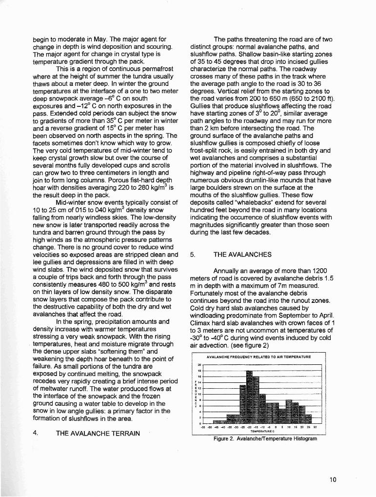
Annually an average of more than 1200meters of road is covered by avalanche debris 1.5m in depth with a maximum of 7m measured.Fortunately most of the avalanche debriscontinues beyond the road into the runout zones.Cold dry hard slab avalanches caused bywindloading predominate from September to April.Climax hard slab avalanches with crown faces of 1to 3 meters are not uncommon at temperatures of_30° to -40° C during wind events induced by coldair advection. (see figure 2)
AVALANCHE FREQUENCY RELATED TO AIR TEMPERATURE
20,-----------------,'e+------,.f-------;'4+-----.,2+----Q
Ul0+-----•Ne+----cy.+------
0.1-- _
.55 -so -4$ -40 -35 -30 -25 -20 -15 -10 -5 0 5 to 15 20 25 30
TEMPERATURE C
Figure 2. Avalancherremperature Histogram
10
Several paths produce slides that hit theroad every few hours during a blow. Typicaldensities of the debris from cold dry avalanchesvary from 650 to over 1000 kg/m3
. In most of theclimax avalanche events observed, a significantpercentage of the debris by volume is rock rubble.Boulders as large as 1.5 m across are oftendislodged by the moving slabs and becomeentrained by the slides bounding across thehighway after the main body of debris has passed.These errant missiles are quite destructive andcan pose considerable hazard to avalanchecontrol personnel.
A spring avalanche cycle occurs in mid tolate May (sometimes June) when twenty-fourhours of sun and rapidly rising temperaturescreate melt water that lubricates and weakens theporous depth hoar in the pack. Climax wet slabswith crown faces of 1.5 to 5 meters that entrainsubstantial amounts of rock result. Measureddensities of typical debris from wet avalanches inthe area span a wide range from less than 700 toover 1500 kg/m3
. Unique methods for measuringboulder-laden debris must often be used. Theclimax wet slide cycle normally precedes theoccurrence of slushflows in the area.
6. THE SLUSHFLOWS
The slushflow season begins late in thespring avalanche cycle when temperaturescontinuously above freezing cause meltwater toaccumulate in the nearly isothermal snowpack inlow angle gullies. Meltwater retained in the base ofthe snowpack migrates toward the surfacesometimes creating visible pools of slush that failcausing slab releases. Crown faces 2 to 5 metersin height are common with one gully consistently
....... releasing almost 7 meters deep. These hybrid·-'7 avalanche/debris torrents are often the most
destructive of the avalanche events in the area asthey carry a significant load of rock, soil and slushonto the roadway. As a consequence of their flowdown active stream courses, the debris oftenblocks culverts and channels beneath bridgescausing the streams to washout the road.Although rarely observed in motion, severalslushflows have been initiated and observedduring avalanche control activities in the AtigunPass area.
Several factors contribute to the formationof these events in the Brooks Range. Rapidintense melting of snow late in the season bycontinuous (24-hour) solar insolation supplies thewater necessary to raise a water table in snowfilled gullies. An impermeable ground surface of
11
ice (permafrost) or bedrock in the area of initiationthat prohibits free water in the snowpack fromdraining into the ground is' prevalent. Porous depthhoar at the base of the snowpack accumulatessignificant amounts of water and the denser smallgrained slabs above likely delay failure. Two ormore days of continuous above-freezingtemperatures (and occasionally rainwater) supplyenough runoff to create a "high tide" that weakensthe basal snow to the point of failure, probably bythe reduction of bond strength and increase inhydrostatic pressure.
The slabs released are commonly manytimes longer than wide, as the width is controlledby the gully walls. A typie;al length to width ratioobserved for slabs in the area is around 7 to 1.After failure the slab overrides an apparentstauchwall at its lower boundary riding on a waveof lUbricating slush and then gouges into the gullybottom entraining snow, rocks, soil and anythingelse which isn't frozen down. The head of thedebris torrent has been observed to retain a lobeshaped form when the flow is confined in a gullyand can travel at speeds of more than 20 m/sec. Itis quite possible that low friction of a runningsurface composed of ice with water on top, thesimultaneous release of such long slabs, and thelubricating slush contribute to the high velocity andlobate fronts of the flows' that have been observedin the area.
Supercritical rates of descent areevidenced by significant super-elevation of themoving mass in the bends of the gullies where itcaroms back and forth off the confining walls.These high speed flows have been observed tojump over hillocks thirty meters high upon exitingthe gullies and resemble the stream of water froma high pressure fire hose in appearance, thoughare composed of slush and rock. Small flowsdisperse or are deflected upon reaching the gullymouth depositing thin layers of unsorted materialand boulders when the upslope sides of thewhaleback forms of previous events areencountered. The larger flows in stream channelsof the area have been observed to travel nearly 4km on grades of less than 2° before dissipating,though moving at slower speeds resembling flashfloods. Several methods of artificial initiation ofslushflows have been attempted with varyinglevels of success.
7. CONTROL METHODS
Conventional avalanche control methodswith some modifications for Arctic conditions areeffective for the artificial release of cold snow hard

slabs in the area. Blind fire from permanentgunmounts with a 105-mm recoilless rifle allowscontrol work to be accomplished during theseveral week period of low light conditions aroundwinter solstice and when visibility is nil duringblows. When temperatures fall below -25°C theammunition must be stored at room temperaturefor several hours before firing to insure reliablemuzzle velocity. Below -35°C weapon use isrestricted to critical situations because of thepropensity for metal parts to fail and the gelling oflubricating fluids. Additionally the hydraulicsystems of equipment used to clear avalanchedebris do not function well below -40oC, so"natural preventive closures" are used untilconditions moderate once slide debris is on theroad or the road is blown shut from drifting snow atvery low temperatures.
Initiation of wet slab avalanches can beaccomplished using the rifle; however, stone-agemethods have proven to be much more costeffective over the last few years. Climbing to thestarting zones of paths above the road and usingrocks or glissading to start small wet loose slideswhich then drop into the gullies and break out fulldepth (1.5 to 5 m crowns) is a proven techniquewith an unlimited supply of "ammunition" availableat no cost.
Slushfiow initiation presents a morecomplex problem because of the presence of freewater in the snowpack. Explosive charges whetherpre-placed in arrays at the base of the pack,placed onlabove the surface, or dropped fromaircraft tend to remove material locally withoutcausing slab failure. The most effective method forrelease found thus far has been to create a minordisturbance in the area of slush accumulation toraise the water table. The saturated snow thenfails removing support for the non-saturated slababove and upslope which releases full depth.Metasediment volume displacers half a meteracross rolled about 50 m vertical down the steepside slopes of the gullies into the slush pools dothe job quite nicely, and are fortuitously perchedabove in unlimited numbers. Refinements in theseartificial release techniques are expected as moreexperience is gained in the springtime Arcticsnowpack.
8. SUMMARY
Avalanche forecasting and snowmanagement in an Arctic environment differsomewhat from that in more temperate climates.Snowfall events seldom supply enough weight tothe snowpack to create slab avalanches. The
transport and deposition of snow by high winds atvery low temperatures is the primary cause formid-winter avalanche releases. Darkness, severecold and blizzard conditions complicate the job ofavalanche mitigation during this period. Snowremains on the ground until late in the spring whenintense solar radiation rapidly degrades thesnowpack causing widespread failure. Slushfiowoccurrences in the area pose a significant hazardto the transportation corridor during this brief butintense period each spring and the artificialrelease of these unusual and complicated hybridavalanches is in its infancy. Scarce monetaryresources, dwindling ammunition supplies andenvironmental constraints on operations requirethe use of unsophisticated but effective avalancheforecasting and control methods. With a keeninterest in resource extraction in the Arctic ofAlaska, the Dalton Highway will continue to playan important role in transportation to the NorthSlope in winter requiring the maintenance of aneffective avalanche safety program at AtigunPass.
REFERENCES
Hamre D. and Stethem C., 1981: Casual paper,Temperature Based Forecasting of a SpringtimeArctic Snowpack. Avalanche Engineering Studyfor Alcan Snow Management Services.
Hestnes E., 1985: A contribution to the predictionof slush avalanches. Annals of Glaciology 6: 1-4.
Mears A., 1982: Observations, Refinements, andRecommendations of the Avalanche EngineeringStudy for Alcan Snow Management Services.
Onesti L., 1985: Meteorological Conditions ThatInitiate Slushfiows In The Central Brooks Range,Alaska. Annals of Glaciology 6: 23-25.
Onesti L., 1986: Slushfiow Release Mechanism: Afirst approximation. Avalanche Formation,Movement and Effects: Proceedings of the DavosSymposium, September 1986.331-336
12