avalanche terrain and conditions in the ......weather in the world" and as -«the most...
TRANSCRIPT

AVALANCHE TERRAIN AND CONDITIONS IN THE PRESIDENTIAL RANGE, NEWHAMPSHIRE, USA
Kai-Uwe Allen, Snow Ranger*US Forest Service, White Mountain National Forest, New Hampshire
ABSTRACT: The Presidential Range in the White Mountains of New Hampshire has thegreatest concentration of avalanche terrain east of the Rocky Mountains in the United States.Mount Washington, the highest summit in the range (1917 m) and the highest peak in thenortheastern United States, is a small mountain with a fierce reputation. Harsh winter weatherand a high accident rate have earned Mount Washington the distinction of having "the worstweather in the world" and as -«the most dangerous small mountain in the world". The highestwind speed ever recorded over land was measuidd on Mount Washington at 371 km/h.Hurricane force winds (>121 km/h) are measured on average of 110 days per year. While thenotoriously severe winter weather of the Presidential Range is commonly acknowledged, muchless is known about the avalanche terrain, snowpack and weather conditions which characterizethis small mountain range. The consistently high winds and their influence upon avalancheconditions are unique to avalanche prone areas in the United States. Winter recreation use of thePresidential Range, including Mount Washington is intense. Since 1954 there have been 10avalanche fatalities and many other avalanche accidents in the Presidential Range. Historicaldata indicate that avalanche accidents have increased in the past decade, mirroring the nationaltrend in recreation related avalanche accidents in the United States.
KEYWORDS: New Hampshire, Presidential Range, Mount Washington
1. INTRODUCTION
Located in northern New Hampshire,the Presidential Range is the highestmountain range in the White Mountains.Mount Washington (1917 m), the apex of thePresidential Range, is the highest peak eastof the Mississippi River and north of theCarolinas. Because of its elevation, the rangeis biologically and ecologically similar to thesubarctic and arctic regions of the world.It hosts 12.1 km2 of true arctic/alpinevegetation, the most extensive area of alpinetundra in the eastern United States and southof Labrador. (Bliss, 1963).
While this small mountain range is ofrelatively low stature in comparison to thegreat mountain ranges of the world, MountWashington has earned the reputation ashaving "the worst weather in the world" andhas the distinction as "the most dangeroussmall mountain in the world". The highestwind speed ever recorded over land wasmeasured from the summit of MountWashington at 371 km/h.
'Correspondence address:Kai-Uwe Allen, USDA Forest Service300 Glen Road, Gorham NH, USA 03581Tel: (603) 466-2713 email: [email protected]
Hurricane force winds (> 121 km/h) aremeasured on average of 110 days per year.The harsh weather conditions are well knownand often acknowledged, yet much less isknown about avalanche conditions in therange. The Presidential Range hosts thegreatest concentration of avalanche terraineast of the Rocky Mountains in the UnitedStates.
The Presidential Range is locatedwithin a day's drive (24 hours) of 80 millionpeople, roughly 1/3 of the population of theUnited States. The area, with its rich culturalhistory, provides great attraction to seekers ofwinter alpine challenge. It offers some of thebest, most accessible and most challengingalpine mountaineering and backcountry skiingin the northeastern United States. Recreationopportunities of this variety are not common inthe region.
Of little surprise, winter recreation useis at a high level. Recreation activity inavalanche prone areas is highly concentratedin Tuckerman and Huntington Ravines on theeastern side of Mount Washington. It is withinthis area that the US Forest Service operatesthe only avalanche forecasting and educationprogram in the eastern United States.
572

Table 1. Major summits of PresidentialRange (N to S)
One of the most dramatic features ofthe range is the presence of large glacialcirques and U-shaped basins, which flank therange. These locally termed "gulfs" and"ravines" serve as the catchment basins forlarge quantities of wind blown snow and arethe location of the majority of avalanche proneterrain (Table 2). Mountain glaciation wasgenerally responsible for the glacial basins onthe south, east and northern sides of therange. The impressive ravines such asTuckerman, Huntington, King Jefferson andthe Great Gulf were formed in this way.These formations contrast with the more Vshaped ravines on the western side of therange, where mountain glaciers did notdevelop. The deep snow accumulationsresponsible for forming such glaciers inadvance of the Wisconsin Ice Sheet, wereless on the west side due to the prevailingwinds in the region (Billings, 1979).
The Wisconsin glacial period,beginning some 50,000 years ago had adramatic effect on the mountain landscape.The massive ice sheet, many thousands offeet thick, spread out over the New Englandarea as far south as Long Island, New York.In New England, the ice sheet was of suchgreat depth that even the summit of MountWashington was buried beneath the ice.There is clear evidence that the last ice sheetbegan retreating from the region about 12,000years ago, leaving the topography of the
Roughly 35 to 40,000 people will visitthe avalanche forecast area on MountWashington each winter (B.Ray pers. com.).Our experience as avalanche forecastersindicate that a very small percentage ofpersons climbing and skiing within theforecast area have the knowledge, skills orrescue equipment to safely evaluate andmitigate avalanche hazards, presenting nosmall challenge to mountain safety personnel.
Several avalanche accidents occur inthe Presidential Range each winter. Ten liveshave been lost in avalanches since 1954.Four fatal avalanche accidents have occurredin the past 4 years. These fatal accidentshave all occurred on the eastern, lee slope ofMount Washington. This small area is themost popular recreation destination in therange (Figure 5.) An examination of historicalaccident data indicate that avalancheaccidents have increased in this area withinthe past 10 years, mirroring a national trend inrecreation related avalanche fatalities in theUnited States.
Figure 1. Satellite image of thePresidential Range.
2. PHYSICAL GEOGRAPHY
Located in northern New HampshireWithin the White Mountain National Forest, thePresidential Range is the highest mountainrange in the White Mountains. The rangeconsists of 11 major peaks, beginning in thenorth with Pine Mountain near Gorham, NHand running in a S-SW direction to MountWebster in Crawford Notch (Bliss, 1963).New England's highest mountains are merefoothills by most standards (Table 1).
573
SUMMIT
Pine Mountain
Madison
Adams
Jefferson
Clay
Washington
Monroe
Franklin
Eisenhower
Pierce
Jackson
Webster
ELEVATION(m)733
1635
1767
1742
1686
1917
1641
1524
1451
1314
1235
1192

Presidential range closely resembling thatwhich we observe today (Billings, 1979).
LOCATIONWebster CliffsMonroe GulfOakes Gulf
Gulf of SlidesTuckerman Ravine area
Lion HeadRaymond CataractHuntington Ravine
Eastern Snowfields ofMount Washington
Great Gulf HeadwallJefferson's KneeJefferson Ravine
King RavineCastle RavineBurt Ravine
Ammonusuc RavineMonroe Brook
Table 2. Major large avalanche areas inthe Presidential Range. Many other smaller, moreisolated avalanche prone areas are present. ..
3. MOUNTAIN WEATHER
The climate of Mount Washington andthe Presidential Range is one of the mostsevere in the world (Figure 2). The severityof winter storms is unequaled by any otherreporting weather station in the continentalUnited States (Gordon, 1980). Arctictemperatures, fog, icing, frequent cloud coverand super-hurricane force winds are socommon in this small mountain range that ithas earned the reputation as "Home of theWorld's Worst Weather" (M1. WashingtonObs.). Hurricane force winds and sUb-freezingtemperatures have been recorded for everymonth·of the year. The climate is similar tothat found in northern Canada and Alaska.True arctic vegetation exists above 1525 m.The closest incidence of this vegetation typein eastern North America would be found bytraveling 645 km north into Canada.
Treeline in the White Mountains isaround 1360 m above sea level, one of thelowest anywhere in the world at this latitude.Treeline in the Rocky Mountains is seldombelow 3050 m (Gordon, 1980).
574
Figure 2 "STOP The area ahead has the worstweather in America. Many have died there fromexposure even in the summer. Tum back now ifthe weather is bad." This sign is posted on all thehiking trails leading to the alpine zone of thePresidential Range.
The regional climate of New Englandis unusual. It is said that no other location inthe northern hemisphere at the same latitudeis as cold as in the northeastern UnitedStates, except in northeastern China andHokkaido, Japan. The average lowlandtemperatures in the northern New Englandregion approach those recorded atAnchorage, AK and Helinski, located 15degrees latitude or 650 km to the north. Thiseffect is compounded by the local climate ofthe mountains (Marchand, 1987).
Several climatic and geographicfactors are responsible for the harsh weatherconditions of this truly arctic mountain range.Low-pressure systems in the NorthernHemisphere converge in the New Englandarea. Major storm tracks from theSouth Atlantic, the Gulf region, and the PacificNorthwest merge along the east coast of theUnited States (Figure 3). These active lowpressure systems track up the northeastcoastline and up the S1. Lawrence Rivervalley. In winter, the eastern part of NorthAmerica is relatively cold and the offshorewaters of the Atlantic Ocean are relativelywarm, creating a natural area for stormdevelopment along the eastern seaboard.Such storms frequently experience theirstrongest development along the Northeastcoast (Abrams, 1978). This constantprogression of low-pressure systems causessudden and often dramatic weather changesin the region.

--
Figure 3. An analysis of 1160 storm tracksacross the US in a 10 year period. The width of thearrows on the map indicate the frequency of stormsalong a given path. This convergence of low .pressure systems explains in large part theweather patterns so characteristic of theNortheastern United States. (Van Cleef, 1908)
Figure 4. The complementary relationship of highand low pressure systems in the NortheasternUnited States (Marchand, 1987)
Following this constant progression oflow-pressure systems are the high-pressurecells that develop over the Hudson Bay regionof the Canadian Arctic. On the backside ofevery low pressure system is this cold arcticair flow from the north, subjecting the regionto frequent outbreaks of polar air massesyear-round (Figure. 4) (Marchand, 1987).The vertical relief of the Presidential rangeand the White Mountain region isconsiderable in comparison to the surroundinglandscape. The Presidential Range rises over
575
1220 m from the surrounding lowlands. Thegenerally north-south orientation of themountain range acts as a natural barrier to theprevailing westerly winds. The combinationof large-scale atmospheric disturbances andthe orographic effect of the mountains havedramatic effects on wind speed, temperature,and precipitation.
3.1 The winds
The Presidential Range is probablymost well known for its winds. Wind velocityon Mount Washington averages 57 km/hyear-round. At nearby lowland stations, theaverage wind velocity generally ranges from6.5-13 km/h. Hurricane force winds (> 121km/h) are observed from the summit of themountain on average of 110 days per year.From November to April, hurricane forcewinds occur on average of 2 out of every 3days. Winds of 161 km/h or greater occurabout every 3rd day from November throughMarch. In January, the windiest month, thewinds reach or exceed hurricane force on 3out of every 4 days (Gordon, 1989). OnJanuary 2no , 1969, the winds averaged 161km/h for 24 hours, with a peak gust of 241km/h. In winter, conditions of this type arefairly common on Mount Washington. Inaddition, Mount Washington holds the world's.record wind speed ever recorded from asurface weather station. In April 1934,observers measured a 371 km/h wind gustbefore the anemometer was destroyed(Gordon, 1980).
3.2 The rain and snow
Snow falls on Mount Washingtonevery month of the year. As one wouldexpect, frequency and amount of precipitationincrease with elevation. Yearly snowfall on thesummit of Mount Washington averages 645cm. Average annual snowfall at lowlandstations in the area is about 287 cm. Onaverage, at least 2.5 cm of snow falls 68 daysa year. The snowiest winter on record was1968-69, when 1438 cm fell on MountWashington. Snow depth measurementsfrom the Mount Washington Observatory onthe summit are somewhat uncertain, as snow.often blows away as soon as it begins toaccumulate, and snowfall is blown over thesummit of Mount Washington from otherareas of the mountain.
The pervasive high winds move largequantities of snow off the upper elevations,resulting in incredible wind loading events forthe avalanche starting zones along the flanksand ravines of the range. Wind-blown snow isa major contributor to large avalanche cyclesin the range. Snow depths on the floor ofTuckerman Ravine on the lee side of MountWashington average 12 to16 m.
The Presidential Range is locatedwithin 160 km of the Atlantic Ocean. Rainevents are not uncommon during the wintermonths. Total average precipitation onMount Washington is 252 cm. Precipitationlevels in the lowlands around the range (610m. elevation) average 117 cm in a year.
On average, Mount Washington isshrouded in dense fog and clouds 315 dayseach year (Gordon, 1980).
3.3 The cold
The commonly low temperaturesrecorded in the Presidential Range oftencatch the unwary visitor by surprise.Exposure is the second highest cause offatalities in the range, overshadowed only byfalls in steep terrain.
The temperature on the summit ofMount Washington is significantly colder thanthe surrounding lowlands. The record high forthe summit is 23 degrees C. The lowesttemperature ever recorded was -45 C. July isthe warmest month of the year with anaverage of only 9 C. February is the coldest,averaging only -15 C. Freezing temperaturesare recorded 243 days during an averageyear. Temperatures drop to below-18 C onan average of 66 days, and reach or exceed15 degrees C on only 19 days a year. One ofthe results of such cold temperatures ispermafrost at 6 m deep year-round.
The high winds and brutally coldtemperatures frequently arrive together. Thecoldest periods on Mount Washington arriveon northwest winds. Temperatures of -35 Cand winds in excess of 160 km/h are notuncommon in winter (Gordon, 1989).
4. AVALANCHE CONDITIONS IN THEPRESIDENTIAL RANGE
The presence of consistently extremewinds and arctic temperatures in a maritimesnow climate is an unusual feature of the
Presidential Range. Avalanche conditionsfound in the Presidential Range of NewHampshire are unique to avalanche forecastareas in the United States.
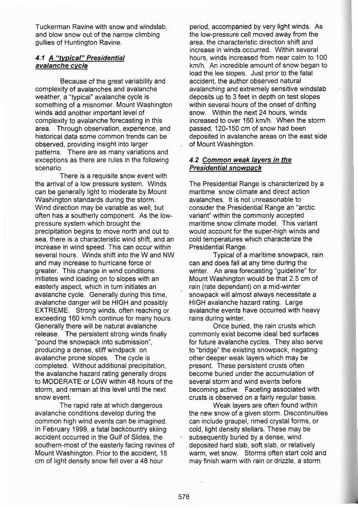
The effect of the strong winds onavalanche conditions can be observed inFigure 6. Large areas of windswept groundare visible on the easterly, lee side of thesummit cone of Mount Washington, as well asabove Tuckerman Ravine. Large snowcollection grounds above a glacial cirque likeTuckerman Ravine are scoured free of snowduring strong wind events. The effect of suchwind scour on avalanche conditions areimpressive. Huge loads of wind-depositedsnow and the concurrent avalanche cyclesare responsible for the great depths of snowwhich fill the floors of the Presidential gulfsand ravines
Given optimal wind velocities anddirection, snowfall totals of 5-10 cm on MountWashington can have an incredible effect onavalanche conditions. It is not unusual for theavalanche danger in Tuckerman Ravine to beCONSIDERABLE after a snowfall of 5-10 cmand westerly winds of 95-130 km/h.
The effects of wind deposition tend tobe highly variable across avalanche proneslopes. The eddy effect of localized terrain
" features are generally considered to beresponsible for this variability. On slopes ofsimilar aspect and elevation, it is notuncommon to encounter 0.6 m of unstablewindslab within 3 m of a hard rain crust,requiring the use of crampons and ice axe.Even the smallest pocket of unstable snowcan have serious consequences for a climberor skier on the steep and committing terrainfound in the ravines of the Presidential Range.
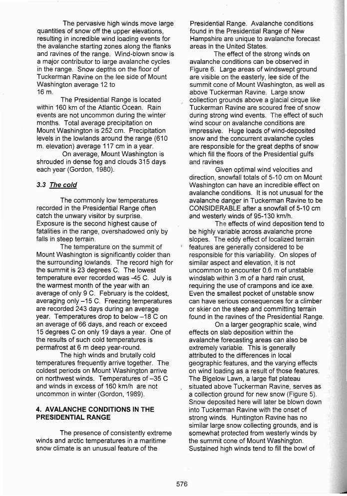
On a larger geographic scale, windeffects on slab deposition within theavalanche forecasting areas can also beextremely variable. This is generallyattributed to the differences in localgeographic features, and the varying effectson wind loading as a result of those features.The Bigelow Lawn, a large flat plateausituated above Tuckerman Ravine, serves asa collection ground for new snow (Figure 5).Snow deposited here will later be blown downinto Tuckerman Ravine with the onset ofstrong winds. Hu'ntington Ravine has nosimilar large snow collecting grounds, and issomewhat protected from westerly winds bythe summit cone of Mount Washington.Sustained high winds tend to fill the bowl of
576

Figure 5 East side (lee side) of Mount Washington, NH with theGulf of Slides (L), Tuckerman Ravine, Mount Washingtonsummit (center), and Huntington Ravine (R)
Figure 6. Tuckerman Ravine, Mount Washington, NHAvalanche forecast area, USFS
Figure 7. Huntington Ravine, Mount Washington, NHAvalanche forecast area, USFS
577
Tuckerman Ravine with snow and windslab,.and blow snow out of the narrow climbinggullies of Huntington Ravine.
4.1 A "typical" Presidentialavalanche cycle
Because of the great variability andcomplexity of avalanches and avalancheweather, a "typical" avalanche cycle issomething of a misnomer. Mount Washingtonwinds add another important level ofcomplexity to avalanche forecasting in thisarea. Through observation, experience, andhistorical data some common trends can beobserved, providing insight into largerpatterns. There are as many variations andexceptions as there are rules in the followingscenario.
There is a requisite snow event withthe arrival of a low pressure system. Windscan be generally light to moderate by MountWashington standards during the storm.Wind direction may be variable as well, butoften has a southerly component. As the lowpressure system which brought theprecipitation begins to move north and out tosea, there is a characteristic wind shift, and anincrease in wind speed. This can occur withinseveral hours. Winds shift into the Wand NWand may increase to hurricane force orgreater. This change in wind conditionsinitiates wind loading on to slopes with aneasterly aspect, which in turn initiates anavalanche cycle. Generally during this time,avalanche danger will be HIGH and possiblyEXTREME. Strong winds, often reaching orexceeding 160 km/h continue for many hours.Generally there will be natural avalancherelease. The persistent strong winds finally"pound the snowpack into submission",producing a dense, stiff windpack onavalanche prone slopes. The cycle iscompleted. Without additional precipitation,the avalanche hazard rating generally dropsto MODERATEor LOW within 48 hours of thestorm, and remain at this level until the nextsnow event.
The rapid rate at which dangerousavalanche conditions develop during thecommon high wind events can be imagined.In February 1999, a fatal backcountry skiingaccident occurred in the Gulf of Slides, thesouthern-most of the easterly facing ravines ofMount Washington. Prior to the accident, 18cm of light density snow fell over a 48 hour
period, accompanied by very light winds. Asthe low-pressure cell moved away from thearea, the characteristic direction shift andincrease in winds occurred. Within severalhours, winds increased from near calm to 100km/h. An incredible amount of snow began toload the lee slopes. Just prior to the fatalaccident, the author observed naturalavalanching and extremely sensitive windslabdeposits up to 3 feet in depth on test slopeswithin several hours of the onset of driftingsnow. Within the next 24 hours, windsincreased to over 160 km/h. When the stormpassed, 120-150 cm of snow had beendeposited in avalanche areas on the east sideof Mount Washington.
4.2 Common weak layers in thePresidential snowpack
The Presidential Range is characterized by amaritime snow climate and direct actionavalanches. It is not unreasonable to
. consider the Presidential Range an "arcticvariant" within the commonly acceptedmaritime snow climate model. This variantwould account for the super-high winds andcold temperatures which characterize thePresidential Range.
Typical of a maritime snowpack, raincan and does fall at any time during thewinter. An area forecasting "guideline" forMount Washington would be that 2.5 cm ofrain (rate dependant) on a mid-wintersnowpack will almost always necessitate a.HIGH avalanche hazard rating. Largeavalanche events have occurred with heavyrains during winter.
Once buried, the rain crusts whichcommonly exist become ideal bed surfacesfor future avalanche cycles. They also serveto "bridge" the existing snowpack, negatingother deeper weak layers which may bepresent. These persistent crusts oftenbecome buried under the accumulation ofseveral storm and wind events beforebecoming active. Faceting associated withcrusts is observed on a fairly regular basis.
Weak layers are often found withinthe new snow of a given storm. Discontinuitiescan include graupel, rimed crystal forms, orcold, light density stellars. These may besubsequently buried by a dense, winddeposited hard slab, soft slab, or relativelywarm, wet snow. Storms often start cold andmay finish warm with rain or drizzle, a storm
578

scenario often resulting in widespreadavalanche activity.
Early in the season, considerableamounts of water ice freeze on the headwallsand gullies of Mount Washington. Weakbonds at the interface of snow and water icehave been observed to cause avalanches withthe addition of new snow or human triggers.This is an especially important considerationin the early season when many ice climbersdescend on the area.
The deposition of surface and depthhoar are not often encounterea at the upperelevations. Due to the persistent winds, it israrely calm enough for the deposition ofsurface hoar. In situations where it has beenproduced, one can imagine that it is quicklydamaged or blown away before becomingburied as a weak layer.
Depth hoar is observed in the area,but rarely becomes a factor in avalancheevents. The distinct lack of problemsassociated with depth hoar is related to thehigh density of the Wind-packed snow, terrainroughness, and the incredible strength anddensity of the overlying snowpack. Depthhoar was the likely weak layer implicated in afatal avalanche accident in 1996 (C. Joosenpers. com.). The avalanche occurred within arecently exposed landslide with no anchors,and is protected from the full effect of thestrong winds of Mount Washington.
5. AVALANCHE ACCIDENTS IN THEPRESIDENTIAL RANGE
5.1 The crowds
The Presidential Range is locatedwithin a 24 hour drive of some 80 millionpeople, nearly 1/3 of the population of theUnited States. Public lands are relativelyscarce in the northeastern United States, andrecreational use of the White MountainNational Forest is intense. Within theavalanche forecast area on MountWashington, some 35-40,0000 people willvisit during the avalanche season alone(8. Ray pers. com.).
The Presidential Range offers someof the most dramatic and accessible alpineterrain in the northeastern United States. Theeastern slopes of Mount Washington are themost popular alpine recreation area in theEast. Tuckerman Ravine, birthplace ofAmerican alpine skiing, is renowned for its
deep snowpack, rich cultural history, andextreme skiing and mountaineering challenge.Huntington Ravine provides some of the best,most accessible alpine climbing and technicalmountaineering routes in the east. Otherareas in the range provide similar recreationopportunities with even greater chances forsolitude. The area is the destination formountaineers and winter climbers in theNortheast. Seekers of winter mountaineeringchallenge in the region will find their way toMount Washington and the PresidentialRange.
There have been 127 fatalities in thePresidential Range since 1849. It can indeedbe a dangerous place, and Mount Washingtonhas earned itself the title "the most dangeroussmall mountain in the world" within themountaineering community. The late PaulPetzoldt referred to Mount Washington as "thegreat booby trap of the East". On a bad dayin the winter, some of the most dangerousmountain terrain in the country is just 3.5 kmfrom the nearest highway, about an hours'walk.
The area receives heavy use fromvisitors residing in eastern Canada, whichpresents particular and peculiar cultural andlanguage barriers to effective avalancheeducation. It seems like the Canadian visitorsare always the first ones to push the terrainduring periods of unstable snow.
Avalanche awareness is very low inthe New England (and eastern Canada) area.Avalanches are not a part of the daily life andculture in this part of the world, presenting nosmall challenge to Snow Rangers, avalancheeducators, and search and rescue personnel.Personal observation and experience amongavalanche forecasters reveal a very smallpercentage of winter visitors recreating inavalanche terrain have the appropriateavalanche awareness skills and/or rescueequipment.
5.2 Avalanche accidents
Table 3 shows accident data from allknown historical accident reports on record atthe US Forest Service in Gorham, NewHampshire. Since 1954, there have been 34avalanche accidents in the Presidential Rangefor which records have been located. For allaccidents (34), one half occurred within theperiod 1954-1990 (36 years). Half of all
579

YEAR #OF # PERSONS NO MINOR MAJOR FATALACCIDENTS INVOLVED INJURY
1954 1 1 11956 1 1 11964 1 2 21967 1 2 11968 1 3 11972 1 2 11973 1 2 1 11980 2 4 2 21981 2 3 1 21982 2 7 5 11985 2 3 1 21989 2 3 2 11991 5 15 11 1 21992 2 2 1 11993 1 7 71996 2 6 2 31997 2 5 41998 1 3 31999 2 6 1 2 32000 2 4 2 1
TOTALS 34 81 37 16 18 10
1954-90 17 33 7 10 11 5
1990-2000 17 48 30 6 7 5
Table 3. Avalanche accidents in the Presidential Range, 1954-2000
accidents occurred between the 10 yearperiod from 1990-2000. Total number ofpersons involved during the time period was81, with 33 persons involved in accidentsfrom 1954-1990 and 48 persons involved in1990-2000. Of the 37 victims involved inaccidents with no injury, 7 were within theyears 1954-1990 and 30 in 1990-2000.
Table 3 and 4 show the accidentfatalities in the Presidential Range from1954-2000. There have been 10 avalanchefatalities in the Presidential Range. One halfof those fatal avalanche accidents haveoccurred within the past 10 years.Avalanches may have been involved inseveral other climbing related fatalities inHuntington Ravine.
Most recently, the Gulf of Slides, apopular backcountry skiing destinationoutside the avalanche forecast area, hasbeen the location of 3 avalanche relatedfatalities within the past 4 years. This areahas great backcounty skiing and tends to beless traveled that the busier Tuckerman andHuntington Ravines. The fact that the areais less traveled has probably contributed toits increased popularity
580
The trend in the average number ofaccidents follows that of the number offatalities, suggesting that there is anincreasing incidence of avalanche accidentsin the Presidential Range. This would not beunexpected, as the number of winterrecreational visits have increased over theyears. The increase in popularity in wintermountaineering, ice climbing, backcountryskiing and winter hiking is a likely contributorto the higher incidence of winter backcountryvisitation. It is interesting to note thesignificant difference in the number ofvictims with no injury appears to haveincreased within the past 10 years. Onemight conclude from the data that althoughthe number of avalanche accidents hasincreased within the past 10 years, morepeople are walking away without injury. Itmay also be a reflection on the level ofaccident reporting over the years.
It is very likely that many moreavalanche accidents occurred than werereported to Snow Rangers in the early yearsof the USFS forecasting program on MountWashington, particularly those whichresulted in no injury.

Date Victim(s) Location Activity
1/31/54 Phillip Longnecker Tuckerman Ravine Hiking4/5/54 Hugo Stadtmuller Huntington Ravine Ice climbing
John Griffin2/19/56 Aaron Leve Tuckerman Ravine Camping1/25/82 Albert Dow Lion Head Hiking1/24/91 Thomas Smith Huntington Ravine Ice climbing1/5/96 Andre Cassan Lion Head Hiking3/24/96 John Wald Gulf of Slides Skiing
Todd Crumbaker2/20/00 David MacPhedran Gulf of Slides Skiing
Table 4. Avalanche fatalities in the Presidential Range, 1954-2000
Skiing and climbing in Tuckerman andHuntington Ravines have a rich history, datingback to the early 1900's. Many peopleclimbed and skied the avalanche prone slopesin the Presidential Range long before any typeof accident data was kept. It is no smallcoincidence that avalanche accidents beganto be reported with the onset of an officialpresence of USFS Snow Rangers in the early1950's.
Improvements in avalanche accidentrecord keeping in the past decade may be inpart responsible for the supposed increase inavalanche accidents. That the trends inavalanche fatalities mirrors that of overallaccident occurrence is reassuring, but maynot be actually representative of the facts. Itis known that there have been avalancheaccidents in Tuckerman Ravine involving overa dozen persons at one time that were neverrecorded (B. Ray pers. com). In addition,avalanche accidents resulting in serious injuryor requiring search and rescue assistance aremore likely to be reported. Also, staffing ofthe Snow Ranger program was reduced to 3days a week for many years, drasticallyreducing the presence on the mountain. Weare certain that countless avalanche accidentsin the Presidential Range have goneunreported over the years.
6. THE USFS SNOW RANGER PROGRAMON MOUNT WASHINGTON, NH.
The avalanche forecasting andeducation program on Mount Washington isthe only US Forest Service avalancheprogram east of the Rocky Mountains in the
581
United States. The first Snow Ranger wasemployed in Tuckerman Ravine in 1952,making it one of the oldest avalancheprograms in the country. By this time,Tuckerman Ravine had already earned quitea reputation. The spectacular glacial cirquerenowned for its steep "extreme" skiing andrich cultural history emerged as the mostpopular backcountry skiing and wintermountaineering destination in the Northeast.Not only was increasing use of the TuckermanRavine creating management issues, but thearea was subject to frequent avalanches,requiring the presence of skilled SnowRangers.
To the north of Tuckerman Ravine,Huntington Ravine offers some of the best,most accessible alpine mountaineering andtechnical climbing routes in the Northeast.Following the avalanche deaths of two worldclass mountaineers in 1964, the ForestService expanded avalanche forecasting toinclude all the popular climbing gullies inHuntington Ravine.
During this time, the Snow Rangerswould close the ravines during periods ofperceived avalanche danger. In 1958, anavalanche control program was initiated inTuckerman Ravine. Originally intended as away to control the dangerous icefalls that buildup on the Headwall each winter, SnowRangers would take aim at the ice in an effortto trigger avalanches. In 1966, the ForestService acquired one of the first prototypeAvalaunchers for use in Tuckerman Ravine.After an accident in which a shell exploded inthe Avalauncher barrel, injuring 2 SnowRangers. This signaled the end of avalanche

control in Tuckerman Ravine. The use offirearms to control the icefall and areaclosures during periods of avalanche hazardwould continue for many years.
In the early 1980's, the Forest Servicebegan to manage people and avalanchesfrom a strictly advisory and educationalperspective. This method and philosophycontinues to the present day. Today, theSnow Rangers educate and warn the publicabout all the major hazards on the mountainthat can include icefall, crevasses, fierceweather, and undermined snow, in addition toavalanches.
With a current staffing level of 3 fulltime and one part time avalanche forecaster,Snow Rangers today issue daily avalancheforecasts for Tuckerman and HuntingtonRavines. This avalanche bulletin is widelyavailable through radio, television, Internet,and local mountain equipment shops.In addition, the US Forest Service SnowRangers are the lead agency for all wintersearch and rescue operations on the east sideof Mount Washington. This is no smallundertaking on a such a malevolent piece ofmountain real estate. The Snow Rangersperform law enforcement, manage a 20person Volunteer Ski Patrol, serve as incidentcommanders and rescue leaders, maintaindownhill ski trails, administer special usepermits, maintain snow tractors, teachavalanche courses and educate and interactwith the public as part of our daily duties.While computer and Internet technology havechanged the way the Snow Rangers dobusiness, the avalanche danger is still postedin a slat board every day, the old-fashionedway. Snow Rangers on Mount Washingtonare "the last of the old time Snow Rangers" asopposed to the solely dedicated avalancheforecasters of today (R. Newcomb, P Lev.pers. com.)
7. CONCLUSION
The Presidential Range of NewHampshire is truly an unusual mountainenvironment within the United States. MountWashington presents the most severecombinations of high winds, cold, icing andstorminess available anywhere in the worldwhere people are on location to make weatherobservations. The Presidential Range lies inthe path of the major storm tracks and airmass routes affecting the northeastern United
States, and it is, because of its elevation,biologically and ecologically similar to thesubarctic and arctic regions of the world.
The Range has the greatestconcentration of avalanche terrain on theeastern seaboard of the United States. Onthe east side of this seemingly barren pile ofjumbled rocks is the only USFS avalanchecenter east of the Rocky mountains. Rarelyconsidered to be avalanche country, it provesto be a bUsy place for avalancheprofessionals. Because the northeasternUnited States has little true alpine recreationopportunities, the Presidential Range holdsgreat attraction and draws the crowds. Agreat many persons are exposed toavalanche danger on a regular basis in pursuitof their chosen sport, with little knOWledge orawareness of the risks involved. The level ofavalanche awareness is remarkably lowamong the majority of visitors. Winterrecreation use is on the increase, andsubsequently, increases in avalancheaccidents can be expected in the future.
Located within a days drive of 80million people and just 2 miles from thenearest highway, the Presidential Range willcontinue to be a dangerous place,commanding great respect among those whoknow it well.
8. ACKNOWLEDGEMENTS
Special thanks to Roger Damon forthe means of flight by which this paper began.Thanks to Brad Ray, Christopher Joosen,Marianne Leberman, Don Muise and theentire Androscoggin Ranger District.Appreciation goes out to Sean Doucette of theMount Washington Observatory for hisassistance with the slide library. Specialthanks to Kori for your patience.
9. REFERENCES
Abrahms, E. 1978. Why MountWashington? Mount WashingtonObservatory News Bulletin. V. 19 no.2. p. 26-29.'
Billings, M.P. Fowler-Billings K, Chapman,C, Chapman, R. and Goldthwait, R.1979. Geology of the MountWashington Quadrangle, NewHampshire. State of New HampshireDepartment of Natural Resources.
582

Bliss, L. C. 1963. Alpine Zone of thePresidential Range.
Gordon, G. 1980. The Home of Boreas:Mount Washington's MeteorologicalPhenomena. Mount WashingtonObservatory News Bulletin. V.21No.2. p. 26-33.
Gordon, G. 1989. The Worst Weather inthe World. Windswept. Vol 30, Fall1989. p 66-69.
Howe, J. 1970. Weather Observations onMount Washington: Problems andSolutions. Windswept, June 1970p.82-90.
Leich, J. 1998. Over the Headwall. NewEngland Ski Museum Newsletter.No.6, Summer 1998.
Leich, J. 1999. Over the Headwall. NewEngland Ski Museum Newsletter.No.7, Winter 1999.
Marchand, P. 1987. North Woods.Appalachian Mountain Club, Boston,MA.
Mount Washington Observatory Publication."The Only Outpost Left".
Van Cleef, 1908. Monthly Weather Review.US Department of Agriculture 36:p.56-58. ill Marchand, P. 1987.North Woods. p. 8.
583