avifaunal and feral mammal field survey
TRANSCRIPT

Appendix F Avifaunal and Feral Mammal Field Survey


Appendix G Marine Biological and Water Quality Baseline Surveys

Marine Biological and Water Quality Baseline Surveys La‘au Point, Moloka‘i
Prepared for: Prepared by: Moloka‘i Properties, Ltd. TEC Inc. 745 Fort Street 1001 Bishop St., Suite 1400 Suite 600 American Saving Bank Tower Honolulu, Hawai‘i 96813 Honolulu, Hawai‘i 96813
May 2006

Marine Biological and Water Quality Baseline Surveys May 2006 La‘au Point, Moloka‘i page i
Table of Contents
1. Marine Biological Baseline ......................................................................................................... 1-1 1.1 Introduction ........................................................................................................................ 1-1 1.2 Methods—Present Study................................................................................................... 1-4
1.2.1 Benthic Habitat Mapping........................................................................................... 1-4 1.2.2 Benthic Methods ....................................................................................................... 1-4 1.2.3 Monitoring Site Locations.......................................................................................... 1-5 1.2.4 Sample Design.......................................................................................................... 1-5 1.2.5 Quantitative Benthic Surveys and Analysis .............................................................. 1-5 1.2.6 Fish Sampling Methodology...................................................................................... 1-5 1.2.7 Statistical Methods.................................................................................................... 1-6
1.3 Results—Present Study..................................................................................................... 1-8 1.3.1 Large-scale Habitat Features.................................................................................... 1-8 1.3.2 Benthic Flora and Fauna........................................................................................... 1-8 1.3.3 Fish Assemblage Characteristics............................................................................ 1-15 1.3.4 Comparisons with Other Locations Around Hawaii ................................................ 1-21 1.3.5 Summary................................................................................................................. 1-22
2. Water Quality Baseline............................................................................................................... 2-1 2.1 Methods ............................................................................................................................. 2-1 2.2 Results ............................................................................................................................... 2-1
3. Post-Storm Event Water Quality ................................................................................................ 3-1 3.1 Background........................................................................................................................ 3-1 3.2 Methods ............................................................................................................................. 3-2 3.3 Results ............................................................................................................................... 3-2
4. References ................................................................................................................................. 4-1
List of Tables Table 1: Site locations and associated meta-data around La‘au Point............................................. 1-7 Table 2: Zone and habitat types within the general study area to a depth of ca. 60 feet. .............. 1-10 Table 3: Percent cover of major benthic groups ............................................................................. 1-10 Table 4: Mean percent cover (sd) at each site around La‘au Point ................................................ 1-11 Table 5: Sea Urchin (Tripneustes gratilla) density......................................................................... 1-11 Table 6: Fish assemblage characteristics. Means (S.D.) ............................................................... 1-15 Table 7: Ranking of fish assemblage characteristics among sampling sites.................................. 1-15 Table 8: Benthic components ......................................................................................................... 1-21 Table 9: Comparison of fish assemblage characteristics between La‘au Point and recent large-scale
surveys conducted around the main Hawaiian Islands.. .................................................. 1-21 Table 10: Baseline Water Quality Data, La‘au Point, Moloka‘i .......................................................... 2-3 Table 11: Post-Storm Water Quality Data, La‘au Point, Moloka‘i ...................................................... 3-5 Table 12: Post-Storm Nutrient Concentrations, La‘au Point, Moloka‘i............................................... 3-6
List of Figures Figure 1: Sampling locations and NOAA benthic habitat map........................................................... 1-9 Figure 2: Percent cover of major benthic groups at the six survey sites around La‘au Point.......... 1-12 Figure 3: Percent live hard coral cover at the six survey sites around La‘au Point. ........................ 1-13 Figure 4: Percent macroalgae cover at the six survey sites around La‘au Point............................. 1-14 Figure 5: Fish species richness at the six survey sites around La‘au Point. ................................... 1-16 Figure 6: Fish numerical abundance at the six survey sites around La‘au Point............................. 1-17 Figure 7: Fish biomass (t ha-1) at the six survey sites around La‘au Point. .................................... 1-18 Figure 8: Mean fish diversity at the six survey sites around La‘au Point. ........................................ 1-19 Figure 9: Fish trophic guilds at the six survey sites around La‘au Point. ......................................... 1-20

Marine Biological and Water Quality Baseline Surveys May 2006 La‘au Point, Moloka‘i page ii
This page intentionally left blank.

Marine Biological and Water Quality Baseline Surveys May 2006 La‘au Point, Moloka‘i page 1-1
1. Marine Biological Baseline
1.1 Introduction These survey results are to be used to support a description of the existing environment in an environmental impact statement being prepared for the La‘au Point residential community proposed by Moloka‘i Properties Limited, and to provide a baseline for comparison with the results of future similar surveys. La‘au Point is on the southwest point of the island of Moloka‘i, 30 km west of Kaunakakai Harbor and 65 km east of Honolulu. Background Information From Moloka‘i Island Coastal Resource Inventory (US Army Corps of Engineers, Pacific Division, unpublished report; 1984):
“Physiography The inshore area consists of irregular basalt formations and boulders of moderate size and relief. A fairly steep profile extends to a depth of 6 m and is cut with deep grooves and channels. Live corals here are diverse, but have less than 10% coverage. A base made up of older dead coral rock encrusts the surfaces of many of the basalt boulders. Extending seaward to depths of 11-12 m and beyond is a wide, gently sloping basalt terrace which exhibits little relief. Occasional platforms, 5 to 8 m wide and 2 m high, break up the otherwise flat substrate and support substantially more coral cover than the surrounding plain. Some cracks and crevices are etched into the basalt floor and oriented perpendicular to the shoreline. Occasional boulders or knolls protrude from the flat surface. Other than a few small sand patches, little sediment is evident. South of La‘au Point – The inshore area near the rocky, lava headlands consists of a steep talus boulder slope at the cliff (shoreline) base that descends to a depth of 6 to 10 feet. Beyond the talus is found a very irregular high relief terrace upon which rests 2-4 m diameter basaltic boulders. The terrace slopes gradually to deeper water seaward. Live coral cover is less than 5%, with occasional small sand patches existing between the large boulders. Approximately 90 m offshore, in 4-5 m of water, the solid basalt substrate is covered with algal turf and some sand channels. Nearshore areas fronting the sandy beaches exhibit sand flats extending from shore to 8 m deep and beyond. Further offshore, in depths of 9-11 m, scoured basalt rock projections form dome-like tables 2 m above wide sand channels. The network of sand channels interconnect and undercut the worn basalt formations.” Marine flora and fauna Inshore Algae are quite diverse in this area. Several species of edible algae found in abundance include limu lipoa (Dictyopteris australis), limu kohu (Asparagopsis taxiformis), and limu alani (Dictyota acutiloba). Live coral coverage is approximately 10% in this area, generally growing atop dead coral on a boulder base. The bottom

Marine Biological and Water Quality Baseline Surveys May 2006 La‘au Point, Moloka‘i page 1-2
profile is quite dramatic with the encrusting coral Pavona varians concentrated on vertical surfaces and the encrusting corals Montipora capitata and M. flabellata growing on the upper surfaces. Twenty meters offshore, the branching reef corals Pocillopora meandrina and P. damicornis and the rounded or encrusting reef coral Porites lobata grow in abundance. The other invertebrates observed during surveys consisted of purple octocoral (Anthelia edmondsoni) and the soft zoanthid coral Palythoa tuberculosa both in large quantities. A variety of mollusks were found including an abundance of top shell (Trochus intexus), an occasionsl leopard cone (Conus leopardus) and the rare humpback cowry (Cypraea mauritiana). A few sea cucumbers, Actinopyga mauritiana and Holothuria atra, and sea urchins, the black rock-boring urchin (Echinometra oblonga), may also be seen in this area. The fish population, in general, is rather diverse and fairly abundant. Surgeonfish are the most abundant group, especially large schools of the Achilles tang (Acanthurus achilles), manini or convict tang (A. triostegus) and maikoiko or Jenkin’s surgeon (A. leucopareius), and also the nenue or rudder fish (Kyphosus sp.). Several species of commonly-caught food fish here consist of uhu or parrotfish (Scaridae), the goatfish weke and moano (Mullidae), and small jack or papio (Carangidae). A few damselfish (Pomacentridae) and wrasses (Labridae) also exist here. Offshore Six species of algae were found in the area, but only edible alga Dictyopteris australis (limu lipoa) and the red alga Liagora sp. are dominant, covering a good portion of the bottom. The sand producing green algae Halimeda opuntia and Neomeris annulata are abundant as well. In waters of 11-12 m depth, very little live coral grows on the gently sloping basalt floor. Small coral heads, 10-15 cm in diameter, of the branching reef corals Pocillopora meandrina and P. damicornis are the most abundant. The only other invertebrates offshore are sponges and hydroids. Since the substrate is mainly flat, the fish population was very small. In general, the surgeonfish and damselfish are the most abundant with a few humuhumu or triggerfish (Balistidae), uhu or parrotfish (Scaridae) and aawa or table boss (Bodianus bilunulatus) inhabiting this area.
Human Uses La‘au Point and the surrounding coastal areas can be accessed only by four-wheel drive vehicle. One-half square mile of the point area was administered by the U.S. Coast Guard which maintains a lighthouse there. The coastal area may occasionally be closed-off to visitors by Moloka‘i Ranch, owners of the adjacent property. Some of the Coast Guard land not required for lighthouse operation at La‘au is in the process of being sold off by the Federal government. Strong rip currents, high waves, and rough conditions persist at La‘au Point throughout the year except on rare occasions when kona conditions prevail. Pole and line fishing is done from the point and adjacent beaches. Fishing boats may troll the waters for aku, ahi, and ulua. Because of rough conditions of the inshore zone, entering the water to dive or spearfish should be considered quite dangerous.”
Marine Biological and Water Quality Baseline Surveys May 2006 La‘au Point, Moloka‘i page 1-3
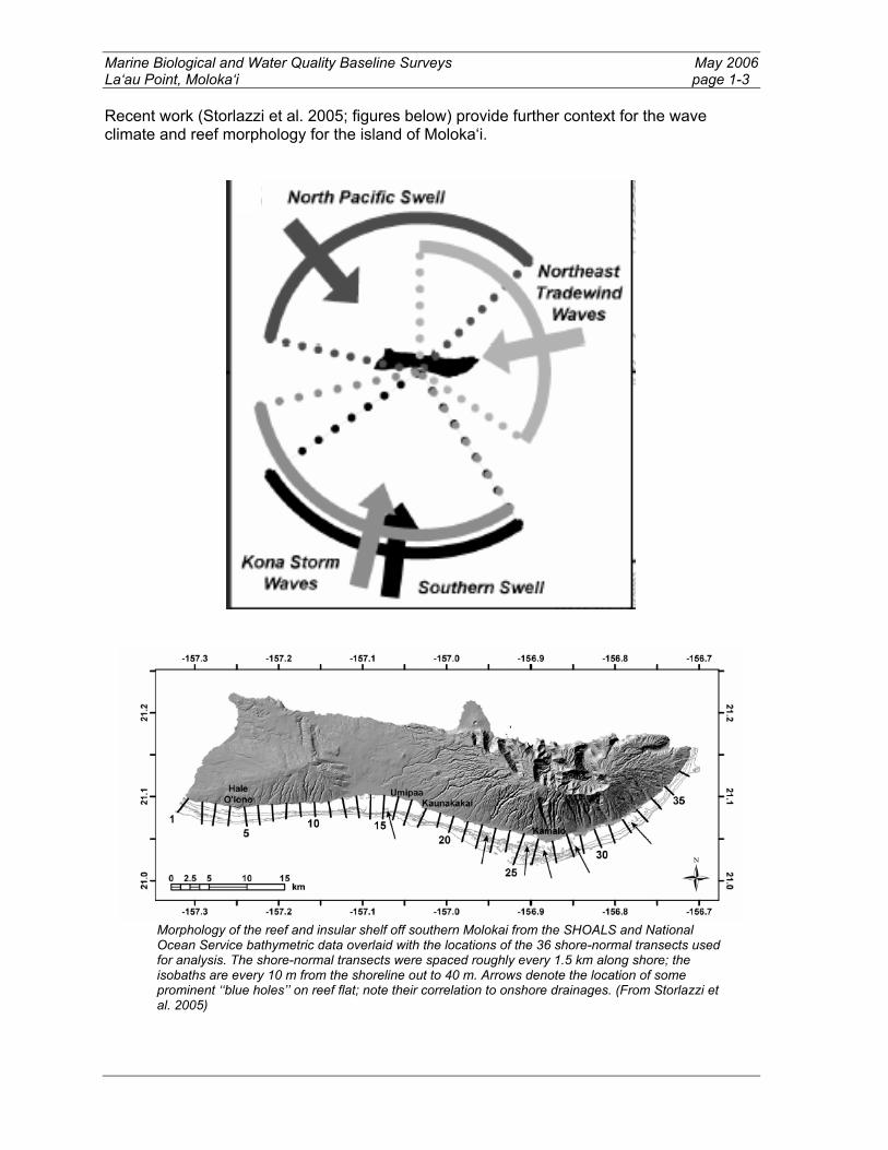
Recent work (Storlazzi et al. 2005; figures below) provide further context for the wave climate and reef morphology for the island of Moloka‘i.
Morphology of the reef and insular shelf off southern Molokai from the SHOALS and National Ocean Service bathymetric data overlaid with the locations of the 36 shore-normal transects used for analysis. The shore-normal transects were spaced roughly every 1.5 km along shore; the isobaths are every 10 m from the shoreline out to 40 m. Arrows denote the location of some prominent ‘‘blue holes’’ on reef flat; note their correlation to onshore drainages. (From Storlazzi et al. 2005)

Marine Biological and Water Quality Baseline Surveys May 2006 La‘au Point, Moloka‘i page 1-4
Selected shore-normal reef profiles showing the variation in the development of the reef complex along shore. The dashed lines are a projection of the slopes of the volcanic cone (dark gray) through the reef profiles to provide some insight to the likely crosssectional area of the reef complex (light gray). Note that the reef is almost nonexistent at the ends of the island (profiles #2 and #36) and extends more than 1500 m offshore of the island’s central portion (profiles #13 though #27). (From Storlazzi et al. 2005)
1.2 Methods—Present Study
1.2.1 Benthic Habitat Mapping The National Oceanic and Atmospheric Administration (NOAA) acquired and visually interpreted orthorectified aerial photography for the near-shore waters (to 25 meters depth) of parts of the main Hawaiian Islands (Coyne et al. 2003, NOAA/NOS 2003). Features visible in the aerial photographs were mapped directly into a geographic information system (GIS). Visual interpretation of the photographs was guided by a hierarchical classification scheme that defined and delineated benthic polygon types based on insular-shelf zones and habitat structures of the benthic community. Zones describe the insular-shelf location (inner lagoon, outer lagoon, bank-shelf), whereas habitat structure (hereafter “structure”) includes the cover type (reef, submerged vegetation, unconsolidated sediments, etc.) of the benthic community. The major product of this effort is a series of GIS-based benthic habitat maps that are characterized by a high degree of spatial and thematic accuracy. The hierarchical spatial structure underlying the habitat classifications were explicitly designed to include ecologically-relevant locational (backreef, forereef, lagoon, etc.) and typological (patch reef, spur and groove, colonized pavement, etc) strata, thereby creating an analytical construct within which nuances of community structure, such as resource distribution, abundance, and habitat utilization can be tested and resolved.
1.2.2 Benthic Methods Monitoring methods for coral reef habitats were based on those of the Global Coral Reef Monitoring Network (GCRMN; http://coral.aoml.noaa.gov) and Green (2002). These methods were aimed at providing a baseline for detection of significant changes in reef habitat as a result of land-based development activities. Assessment methods included:
Line intercept surveys to identify and estimate relative abundance of benthic substratum type (by genus, species, growth form, or other bottom type). Visual censuses of fishes to quantify numerical abundance, biomass, diversity, and species richness).

Marine Biological and Water Quality Baseline Surveys May 2006 La‘au Point, Moloka‘i page 1-5
1.2.3 Monitoring Site Locations Information from the Moloka‘i Island Coastal Resource Inventory and NOAA’s marine benthic habitat maps were used to determine approximate locations for sampling sites. GPS points were generated in ArcView. Six sites, three north and three east of La‘au Point, were surveyed over a 2-day period (Table 1, Figure 1). Sites were identified relative to estimated location for the proposed development. Baseline surveys were conducted on November 19-20, 2005. Transects were located along a depth profile where coral density was highest—approximately 8-11 m--with consideration of adjacent coastline features and reef structure at each site.
1.2.4 Sample Design Three 25 x 5 m transects, each separated by ca. 5 m were conducted at each sampling location. Transects were “permanently” marked using heavy cable ties. Transects were orientated along bathymetry contours and conducted within homogeneous microhabitat types.
1.2.5 Quantitative Benthic Surveys and Analysis Surveys assessed the biological diversity and abundance of algae, coral and other macroinvertebrates at each reef site (Sites 2-5). Surveys were also conducted at control sites (Sites 1 and 6), away from the zone of anticipated impact yet close enough to represent similar reef environments. Three 25 m long transects were surveyed along a single depth gradient (8-11 m depth) parallel to the shoreline at each site, with 1-3 m between the end of one transect and the start of the next. The substratum type (coral, algae, invertebrate, sand, etc) was recorded at one meter intervals directly under the transect tape and at one meter to each side of the tape, giving a total of 225 points per site (3 transects x 25 meters/transect x 3 points/meter interval). The relative percentages of each substratum type were calculated as the mean (± S.E.) of three replicates for the three transects (n=9).
1.2.6 Fish Sampling Methodology Fish assemblages at each location were assessed using standard underwater visual belt transect survey methods (Brock 1954, Brock 1982). A SCUBA diver swam each 25m x 5m transect at a constant speed (~ 15 min/transect) and identified to the lowest possible taxon, all fishes visible within 2.5 m to either side of the centerline (125 m2 transect area). Nomenclature followed Randall (1996). Total length (TL) of fish was estimated to the nearest centimeter. Length estimates of fishes from visual censuses were converted to weight using the following length-weight conversion: W = aSLb - the parameters a and b are constants for the allometric growth equation where SL is standard length in mm and W is weight in grams. Total length was converted to standard length (SL) by multiplying standard length to total length-fitting parameters obtained from FishBase (www.fishbase.org). Length-weight fitting parameters were available for 150 species commonly observed on visual fish transects in Hawaii (Hawaii Cooperative Fishery Research Unit unpublished data). These data were supplemented by information from other published and web-based sources. In the cases where length-weight information did not exist for a given species, the parameters from similar bodied congeners were used. All biomass estimates were converted to metric tons per hectare (t/ha) to facilitate comparisons with other studies in Hawaii. Finally, fish

Marine Biological and Water Quality Baseline Surveys May 2006 La‘au Point, Moloka‘i page 1-6
taxa were categorized into three trophic categories (herbivores, secondary consumers, and apex predators) according to various published sources and FishBase (www.fishbase.org).
1.2.7 Statistical Methods Because transects within sites were spatially autocorrelated, mean values for all transects at each site were used in all analyses. Species diversity was calculated from the Shannon-Weaver Diversity Index (Ludwig and Reynolds 1988): H’=S (pi ln pi), where pi is the proportion of all individuals counted that were of species i. The evenness component of diversity was expressed as: J = H’/ln(S), where S is the total number of species present (Pielow 1977).

Marine Biological and Water Quality Baseline Surveys May 2006 La‘au Point, Moloka‘i page 1-7
Table 1: Site locations and associated meta-data around La‘au Point. Lat. = latitude, Long. = longitude. Latitude and longitude are in WGS 84. X and Y UTM coordinates are for UTM Zone 4.
Date Site Lat. Long. Y X Depth
(ft) Habitat
Descriptions
19-Nov-05 1 21.14 -157.29 2338656 677251 24
Flat reef pavement; scattered P. meandrina, P. lobata, Asparagopsis; abundant branching/encrusting calc. algae; green sponge
19-Nov-05 2 21.13 -157.30 2337355 676511 33
Spur and groove reef pavement; abundant P. meandrina, Asparagopsis; scattered P. lobata, P. evermanni
19-Nov-05 3 21.11 -157.31 2335644 676050 24
Flat reef pavement;scattered small P. lobata, P. meandrina; abundant branching coralline algae
20-Nov-05 4 21.09 -157.30 2333093 676873 36
Flat, sand covered reef pavement; scattered small P. lobata, P. meandrina, P. eydouxi; abundant Halimeda
20-Nov-05 5 21.09 -157.28 2332962 678897 24
Flat reef pavement, spur and groove to south; some sand; scattered P. meandrina, P. lobata, green sponge
20-Nov-05 6 21.09 -157.26 2332748 680444 24
Flat, sand-covered reef pavement; abundant small P. lobata, M. capitata; abundant Asparagopsis, Halimeda

Marine Biological and Water Quality Baseline Surveys May 2006 La‘au Point, Moloka‘i page 1-8
1.3 Results—Present Study
1.3.1 Large-scale Habitat Features The shelf zone accounted for 84% of the total study area (<60 feet), followed by reef flat (8%), forereef (6%), and shoreline intertidal (2%) (Table 2). Large-scale habitat types within the study area (<60 feet) were dominated by uncolonized volcanic rock/boulder (45%), followed by uncolonized pavement (24%), sand (7%), linear reef (7%), colonized pavement (6%), aggregated coral (6%), and macroalgae (5%).
1.3.2 Benthic Flora and Fauna Turf algae dominated benthic cover at all locations, accounting for a grand mean of 57%, followed by sand (22%), and macroalgae (10%) (Tables 2, 3 and Figure 2). Hard coral cover was slightly more than 6% overall (range 3.56-11.56%). Table 4 provides more detail on the relative abundance of the most common taxa and Figures 3 and 4 illustrate the relative percentages of coral and macroalgae at each site. There was an inverse relationship between coral and macroalgae at all sites, as seen in comparison of Figures 3 and 4. Macroalgae were dominant on exposed areas; percent coral and sand cover were more abundant at lee sites, protected from northwest swells. Algae and coral species were qualitatively similar in both the 1975 and 2005 surveys. Octocorals, molluscs and echinoderms noted in a previous study (AECOS 1975) were not seen during the November, 2005 surveys. Rather, the collector urchin, Tripneustes gratilla, was the most abundant macroinvertebrate. Density of this urchin at the six sites is summarized in Table 5.

Marine Biological and Water Quality Baseline Surveys May 2006 La‘au Point, Moloka‘i page 1-9
Figure 1: Sampling locations and NOAA benthic habitat map.

Marine Biological and Water Quality Baseline Surveys May 2006 La‘au Point, Moloka‘i page 1-10
Table 2: Zone and habitat types within the general study area to a depth of ca. 60 feet. Zone and habitat classifications based on NOAA benthic habitat maps (Coyne et al. 2003, NOAA/NOS 2003) Zone Habitat Acres Percent Forereef Hardbottom/Uncolonized Pavement 85.85 1.36% Reef/Colonized Pavement 256.78 4.05% Sand 61.13 0.97% Reef Flat Hardbottom/Uncolonized Pavement 168.10 2.65%
Hardbottom/Uncolonized Volcanic Rock/Boulders 1.08 0.02%
Macroalgae/10-50% 309.78 4.89% Sand 12.75 0.20% Shelf Hardbottom/Uncolonized Pavement 1275.68 20.14%
Hardbottom/Uncolonized Volcanic Rock/Boulders 2726.41 43.05%
Reef/Aggregate Coral 387.97 6.13% Reef/Colonized Pavement 131.33 2.07% Reef/Linear Reef 429.12 6.78% Sand 330.78 5.22% Shoreline Intertidal
Hardbottom/Uncolonized Volcanic Rock/Boulders 96.37 1.52%
Sand 60.18 0.95% Total 6333.31 100.00%
Table 3: Percent cover of major benthic groups.Values are means of three transects with standard deviation of the mean in parentheses. Groups ranked from high to lower grand mean cover.
Groups Site 1 Site 2 Site 3 Site 4 Site 5 Site 6 Grand mean
Turf algae
44.89 (14.64)
53.33 (11.71)
83.56 (24.14)
30.67 (12.23)
75.66 (12.65)
56.00 (9.85)
57.33 (14.21)
Sand
20.00 (8.90)
21.78 (8.55)
0.89 (1.54)
54.22 (15.30)
11.56 (5.39)
22.67 (6.43)
21.85 (7.69)
Macroalgae
14.67 (10.09)
17.33 (13.91)
9.78 (15.86)
6.67 (7.92)
1.33 (1.54)
8.00 (5.89)
9.63 (9.20)
Hard Coral
4.00 (6.16)
4.00 (5.39)
3.56 (6.16)
4.89 (6.62)
9.78 (12.80)
11.56 (12.11)
6.30 (8.21)
Calcareous algae
16.00 (8.88)
3.11 (3.55)
1.33 (2.31)
1.78 (2.31)
1.33 (2.31)
0.89 (1.54)
4.07 (3.48)
Sponge
0.44 (0.77)
0.44 (0.77)
0.89 (1.54)
3.11 (4.62)
1.78 (2.10)
0.89 (0.77)
1.26 (1.76)
Marine Biological and Water Quality Baseline Surveys May 2006 La‘au Point, Moloka‘i page 1-11
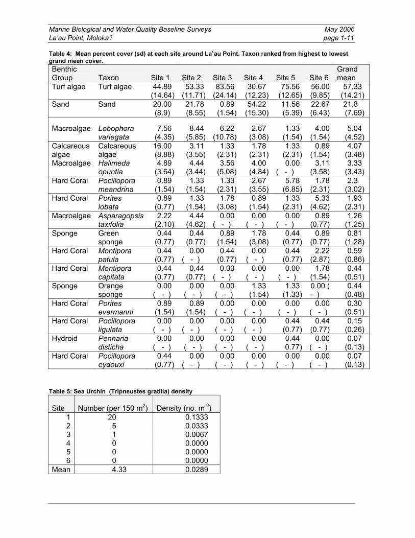
Table 4: Mean percent cover (sd) at each site around La‘au Point. Taxon ranked from highest to lowest grand mean cover. Benthic Group Taxon Site 1 Site 2 Site 3 Site 4 Site 5 Site 6
Grand mean
Turf algae
Turf algae
44.89 (14.64)
53.33 (11.71)
83.56 (24.14)
30.67 (12.23)
75.56 (12.65)
56.00 (9.85)
57.33 (14.21)
Sand
Sand
20.00 (8.9)
21.78 (8.55)
0.89 (1.54)
54.22 (15.30)
11.56 (5.39)
22.67 (6.43)
21.8 (7.69)
Macroalgae
Lobophora variegata
7.56 (4.35)
8.44 (5.85)
6.22 (10.78)
2.67 (3.08)
1.33 (1.54)
4.00 (1.54)
5.04 (4.52)
Calcareous algae
Calcareous algae
16.00 (8.88)
3.11 (3.55)
1.33 (2.31)
1.78 (2.31)
1.33 (2.31)
0.89 (1.54)
4.07 (3.48)
Macroalgae
Halimeda opuntia
4.89 (3.64)
4.44 (3.44)
3.56 (5.08)
4.00 (4.84)
0.00 ( - )
3.11 (3.58)
3.33 (3.43)
Hard Coral
Pocillopora meandrina
0.89 (1.54)
1.33 (1.54)
1.33 (2.31)
2.67 (3.55)
5.78 (6.85)
1.78 (2.31)
2.3 (3.02)
Hard Coral
Porites lobata
0.89 (0.77)
1.33 (1.54)
1.78 (3.08)
0.89 (1.54)
1.33 (2.31)
5.33 (4.62)
1.93 (2.31)
Macroalgae
Asparagopsis taxifolia
2.22 (2.10)
4.44 (4.62)
0.00 ( - )
0.00 ( - )
0.00 ( - )
0.89 (0.77)
1.26 (1.25)
Sponge
Green sponge
0.44 (0.77)
0.44 (0.77)
0.89 (1.54)
1.78 (3.08)
0.44 (0.77)
0.89 (0.77)
0.81 (1.28)
Hard Coral
Montipora patula
0.44 (0.77)
0.00 ( - )
0.44 (0.77)
0.00 ( - )
0.44 (0.77)
2.22 (2.87)
0.59 (0.86)
Hard Coral
Montipora capitata
0.44 (0.77)
0.44 (0.77)
0.00 ( - )
0.00 ( - )
0.00 ( - )
1.78 (1.54)
0.44 (0.51)
Sponge
Orange sponge
0.00 ( - )
0.00 ( - )
0.00 ( - )
1.33 (1.54)
1.33 (1.33)
0.00 ( - )
0.44 (0.48)
Hard Coral
Porites evermanni
0.89 (1.54)
0.89 (1.54)
0.00 ( - )
0.00 ( - )
0.00 ( - )
0.00 ( - )
0.30 (0.51)
Hard Coral
Pocillopora ligulata
0.00 ( - )
0.00 ( - )
0.00 ( - )
0.00 ( - )
0.44 (0.77)
0.44 (0.77)
0.15 (0.26)
Hydroid
Pennaria disticha
0.00 ( - )
0.00 ( - )
0.00 ( - )
0.00 ( - )
0.44 0.77)
0.00 ( - )
0.07 (0.13)
Hard Coral
Pocillopora eydouxi
0.44 (0.77)
0.00 ( - )
0.00 ( - )
0.00 ( - )
0.00 ( - )
0.00 ( - )
0.07 (0.13)
Table 5: Sea Urchin (Tripneustes gratilla) density
Site Number (per 150 m2) Density (no. m-2)
1 20 0.1333 2 5 0.0333 3 1 0.0067 4 0 0.0000 5 0 0.0000 6 0 0.0000
Mean 4.33 0.0289

Marine Biological and Water Quality Baseline Surveys May 2006 La‘au Point, Moloka‘i page 1-12
Figure 2: Percent cover of major benthic groups at the six survey sites around La‘au Point. Mean represents values of three transects at each site.

Marine Biological and Water Quality Baseline Surveys May 2006 La‘au Point, Moloka‘i page 1-13
Figure 3: Percent live hard coral cover at the six survey sites around La‘au Point. Mean represents values of three transects at each site.

Marine Biological and Water Quality Baseline Surveys May 2006 La‘au Point, Moloka‘i page 1-14
Figure 4: Percent macroalgae cover at the six survey sites around La‘au Point. Mean represents values of three transects at each site.

Marine Biological and Water Quality Baseline Surveys May 2006 La‘au Point, Moloka‘i page 1-15
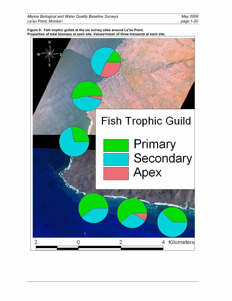
1.3.3 Fish Assemblage Characteristics Numbers of individual fishes per transect were 20% higher north than east of La‘au Point (Table 5, Figure 6). Diversity, evenness, and species richness were 59%, 55%, and 9% higher, respectively, north of the point as well (Table 5, Figure 5). Biomass, however, was more than 130% higher east of La‘au Point (Table 5, Figure 7). Site 3 had the lowest rank for all assemblage characteristics pooled while sites 5, 4, 2, and 1 had similarly high total rankings (Table 6). Overall fish biomass was low. Small schools of surgeonfishes (manini – Acanthurus triostegus, kala lolo – Naso brevirostris, na‘ena‘e – A. olivaceus) comprised much of the weight of the assemblages. Secondary consumers (planktivores and triggerfishes) accounted for 50% of the fish biomass overall, followed by herbivores (43%), and apex predators (7%). Three of the six sites had no apex predators present. More than 30% of the biomass at site 1 consisted of apex predators, primarily a single island jack (ulua – Carangoides orthgrammus) and two individuals of the introduced peacock grouper (roi – Cephalopholis argus). Table 6: Fish assemblage characteristics. Means (S.D.)
Site Species Number ha-1
(÷ 1000) Biomass (t ha-1) Diversity Evenness
1
13.33 (3.79)
4.43 (2.54)
0.11 (0.11)
1.90 (0.61) 0.73 (0.17)
2
15.00 (5.57)
5.92 (2.70)
0.24 (0.18)
1.82 (0.67) 0.67 (0.17)
3
10.00 (1.73)
4.16 (0.56)
0.05 (0.01)
1.58 (0.11) 0.69 (0.02)
4
13.00 (4.00)
3.55 (1.45)
0.20 (0.15)
2.21 (0.27) 0.87 (0.01)
5
13.33 (4.04)
4.72 (2.00)
0.79 (0.50)
1.86 (0.16) 0.73 (0.04)
6
11.00 (2.00)
2.29 (1.17)
0.08 (0.06)
2.02 (0.14) 0.85 (0.12)
Grand mean
12.61 (3.52)
4.18 (1.74)
0.24 (0.17)
1.90 (0.33) 0.76 (0.09)
Table 7: Ranking of fish assemblage characteristics among sampling sites. Highest rank represents highest values for assemblage characteristics.
Site Number Biomass Diversity EvennessSpecies Richness
Total rank
5 5 6 3 3 4 21 4 2 4 6 6 3 21 2 6 5 2 1 6 20 1 4 3 4 4 5 20 6 1 2 5 5 2 15 3 3 1 1 2 1 8

Marine Biological and Water Quality Baseline Surveys May 2006 La‘au Point, Moloka‘i page 1-16
Figure 5: Fish species richness at the six survey sites around La‘au Point. Values = mean of three transects at each site.

Marine Biological and Water Quality Baseline Surveys May 2006 La‘au Point, Moloka‘i page 1-17
Figure 6: Fish numerical abundance at the six survey sites around La‘au Point. Values = mean of three transects at each site. Values are number of individuals (÷ 1000) ha-1.

Marine Biological and Water Quality Baseline Surveys May 2006 La‘au Point, Moloka‘i page 1-18
Figure 7: Fish biomass (t ha-1) at the six survey sites around La‘au Point. Values = mean of three transects at each site. Values are number of individuals (÷ 1000) ha-1.

Marine Biological and Water Quality Baseline Surveys May 2006 La‘au Point, Moloka‘i page 1-19
Figure 8: Mean fish diversity at the six survey sites around La‘au Point. Values = mean of three transects at each site.
Marine Biological and Water Quality Baseline Surveys May 2006 La‘au Point, Moloka‘i page 1-20
Figure 9: Fish trophic guilds at the six survey sites around La‘au Point. Proportion of total biomass at each site. Values=mean of three transects at each site.

Marine Biological and Water Quality Baseline Surveys May 2006 La‘au Point, Moloka‘i page 1-21
1.3.4 Comparisons with Other Locations Around Hawaii Benthic habitat characteristics described a typical wave-exposed, low-relief reef with generally low coral cover. Table 8: Benthic components Site Coral cover (%) Macroalgae cover Source La‘au Point 6.30 (8.21 sd) 9.63 (9.20 sd) This study 60 sites statewide 25.07% (21.8 sd) Jokiel et al. 2004 30 sites in wave exposed habitats
20.67% (16.4 sd0 Jokiel et al. 2004
Fish assemblage characteristics at La‘au Point were generally lower than average values reported from large-scale studies statewide (Table 8). Biomass was more than four times lower at La‘au compared to no-take Marine Life Conservation Districts (MLCDs) and 42% lower than open access areas across multiple habitat types statewide. Diversity and evenness were the only assemblage metrics that showed similar or greater values at La‘au. Anecdotal information from fishermen (including our dive charter boat captain) report that the westernmost tip of La‘au Point harbors lobster populations and serves as productive fishing ground for ulua (giant trevally; Caranx ignobilis). However, strong currents and swell conditions during this baseline survey period precluded our diving in this area. Table 9: Comparison of fish assemblage characteristics between La‘au Point and recent large-scale surveys conducted around the main Hawaiian Islands. Means with standard deviations in parentheses.
Site Species Number ha-1 (÷ 1000)
Biomass (t ha-1) Diversity Evenness
Source
La‘au Point
12.61 (3.52)
4.18 (1.74)
0.24 (0.17)
1.90 (0.33)
0.76 (0.09)
This study
All MLCDs
19.10 (7.44)
9.70 (6.42)
0.87 (0.91)
2.11 (0.50)
0.75 (0.12)
Statewide MLCDs Friedlander et al. 2006
Open areas adjacent to all MLCDs
13.84 (7.94)
7.22 (6.53)
0.34 (0.38)
1.77 (0.68)
0.72 (0.22)
Statewide MLCDs Friedlander et al. 2006
No-take MLCDs
24.98 (4.65)
11.70 (4.81)
1.27 (0.42)
2.52 (0.25)
Friedlander et al. 2003
Open areas
17.60 (4.65)
8.98 (4.68)
0.57 (0.10)
2.15 (0.25)
Friedlander et al. 2003
Wave exposed open areas
17.75 (5.65)
10.73 (5.74) 0.
2.15 (0.35)
Friedlander et al. 2003
Note: Friedlander et al. 2003 = 56 sampling locations (239 transects) on Kauai, O‘ahu, Maui, Moloka‘i, Lanai, Kahoolawe, and Hawai‘i. Friedlander et al. 2006 = 973 transects along the coasts of O‘ahu, Maui, Lanai, and Hawai‘i

Marine Biological and Water Quality Baseline Surveys May 2006 La‘au Point, Moloka‘i page 1-22
1.3.5 Summary Six representative sites offshore of the vicinity of the proposed residential community at La‘au Point, southwest Molokai‘i, were characterized to serve as a baseline for comparison with future surveys. At the time of these surveys (November, 2005), fish diversity and biomass, and coral diversity and cover, were fairly low at the selected sites, reflecting a generally typical, low-relief, wave-structured, shallow water habitat. These sites are exposed to high wave energy, moderate sand movement/scour, and fairly low fishing pressure relative to other nearshore areas in the main Hawaiian Islands.

Marine Biological and Water Quality Baseline Surveys May 2006 La‘au Point, Moloka‘i page 2-1
2. Water Quality Baseline
2.1 Methods Baseline water quality measurements were made on November 19 and 20, 2005 in conjunction with the marine biological surveys at six stations around La‘au Point, three south of the point and three west of the point. In situ measurements were made at five-foot intervals through the water column with a YSI Model 85 water quality meter. Parameters measured included temperature, salinity, dissolved oxygen concentration, percent oxygen saturation, conductivity, and specific conductance. Conductivity and specific conductance were used to post-calibrate the conductivity sensor against a YSI secondary standard solution of 50,000 microsiemens/cm ±1% at 25°C. Salinity values were corrected as necessary, based on the conductivity calibration. At each station, discrete water samples were collected on replicate casts with a horizontal Van Dorn bottle from a depth of approximately 15 feet. The collection depth varied somewhat between stations because variable water currents caused some differences in the line angle at different stations. The lack of vertical stratification in water quality parameters through the water column, however, rendered inconsequential any resulting minor differences in sampling depth. Water samples were stored on ice until delivery to Hawaii Food and Water Testing for analysis of turbidity, pH and total suspended solids concentrations.
2.2 Results The water column at every station was clear; the bottom was visible at our anchorages in 25-35 feet of water. Winds were light and from the south to southwest on both days, with the second day being somewhat calmer. Swells were generally small and the tide was ebbing throughout sampling. Water quality results are shown in Table 10. No significant stratification of the water column was seen in the temperature or salinity data. Water temperature varied over a narrow range from 25.7 °C to 26.4 °C over all stations and depths, with surface temperatures rising slightly over the sampling period. The applicable State standard is that “temperature shall not vary more than one degree Celsius from ambient conditions.” This standard is really intended to limit the thermal impacts of discharges; the natural ambient temperature, whatever that may be, is the standard, so by definition natural baseline conditions cannot be in violation of the standard. Salinity varied even less, generally being in the 34.4 ppt to 35.0 ppt range. With the single exception of Station 1 at the surface, all sampling points were within the very narrow range 34.8 ppt to 35.0 ppt. The applicable State standard is that “salinity shall not vary more than ten percent from natural or seasonal changes considering hydrologic input and oceanographic factors. Like the temperature standard, the salinity standard is defined in terms of natural ambient conditions, and baseline conditions cannot be in violation of the standard, by definition. Dissolved oxygen (DO) concentrations were generally slightly higher at the surface, but sometimes showed a near-bottom maxima, presumably due to algal production. DO concentrations averaged around 90% saturated. The applicable State standard for dissolved oxygen is “not less than seventy-five per cent saturation,” and was not violated at any sampling location.

Marine Biological and Water Quality Baseline Surveys May 2006 La‘au Point, Moloka‘i page 2-2
Total suspended solids concentrations were low, varying between 1.0 and 1.5 mg/l. Turbidity values varied over a narrow range, 0.33-0.39 NTU. The geometric mean of all samples is 0.36 NTU. These values are low, but they would exceed the State standard for “dry” open coastal waters – which is that the geometric mean is not to exceed 0.20 NTU. pH values ranged from 8.1-8.2. The limit of detection of the instrument used is ±0.1 unit, so these values are essentially constant. The applicable State water quality standard is that “pH units shall not deviate more than 0.5 units from a value of 8.1, except at coastal locations where and when freshwater from stream, storm drain or groundwater discharge may depress the pH to a minimum level of 7.0.” Values were thus within the State standard.

Marine Biological and Water Quality Baseline Surveys May 2006 La‘au Point, Moloka‘i page 2-3
Table 10: Baseline Water Quality Data, La‘au Point, Moloka‘i
Station No.
Date Start Time
Depth (ft)
Temperature (°C)
Salinity (ppt)
Dissolved Oxygen (mg/l)
Dissolved Oxygen
(% Saturation)
Total Suspended
Solids (mg/l)
Turbidity (NTU)
pH
1 11/20/05 1020 0 25.8 34.4 5.91 89.2 5 25.8 34.8 5.82 86.5 10 25.7 34.9 5.81 86.0 15 25.7 34.9 5.89 88.1 1.3 0.39 8.2 20 25.7 35.0 5.92 87.7
2 11/20/05 1145 0 25.8 34.9 5.85 89.5 5 25.8 34.9 5.90 88.6 10 25.7 35.0 5.94 88.6 15 25.7 35.0 5.98 88.7 1.0 0.35 8.2 20 25.7 35.0 6.08 88.3
3 11/20/05 1330 0 26.0 34.7 6.65 97.7 5 25.9 35.0 6.09 90.6 10 25.9 35.0 6.21 92.5 15 25.9 35.0 6.22 92.4 1.0 0.33 8.2 20 25.9 35.0 6.27 94.2
4 11/19/05 1030 0 26.0 34.9 6.04 88.7 5 26.1 34.9 5.93 88.9 10 26.1 34.9 5.99 88.6 15 26.1 34.9 6.07 90.3 1.3 0.36 8.2 20 26.1 34.9 6.09 90.4 25 26.1 35.0 6.01 91.3
5 11/19/05 1250 0 26.2 35.0 6.06 92.0 5 26.2 35.0 5.95 88.3 10 26.2 35.0 5.91 87.8 15 26.2 35.0 5.88 87.1 1.5 0.36 8.1 20 26.1 35.0 5.90 87.0
6 11/19/05 1445 0 26.4 34.9 6.20 94.1 5 26.3 35.0 6.16 91.6 10 26.3 35.0 6.10 92.0 15 26.3 35.0 6.08 88.7 1.5 0.37 8.1 20 26.3 35.0 6.09 91.5

Marine Biological and Water Quality Baseline Surveys May 2006 La‘au Point, Moloka‘i page 2-4
This page intentionally left blank.

Marine Biological and Water Quality Baseline Surveys May 2006 La‘au Point, Moloka‘i page 3-1
3. Post-Storm Event Water Quality
3.1 Background The following excerpts from the National Weather Service Forecast Office report entitled “Unprecedented Extended Wet Period Across Hawaii,”1 summarize conditions preceding the post-storm sampling:
Normally during March, Hawaii will see several strong trade wind events and shear line passages with considerable rainfall over the windward, or north- and east-facing slopes of the islands. Instead, March 2006 brought only 5 days of low level winds from a trade direction with the remainder being from the southeast through southwest due to the persistent pattern of low pressure to our west. It was not a single low that persisted for nearly 7 weeks, but rather a series. A particular low would last for a few days and weaken and then give way to a developing new low as a shortwave would drop into the persistent upper level trough and provide additional energy to the system and create another “Kona Storm.” When this occurred, strong southwest winds aloft would extend as far south as 5 degrees north latitude, tap into the deep tropical moisture and transport it over the state. This moisture, combined with the instability in the atmosphere would produce another round of thunderstorms and heavy rains. … March 19. A strong shortwave embedded within the upper level trough swept across the state. This system hit Oahu the hardest with strong thunderstorms dumping 3 to 5 inches of rain, mostly in a 6-hour period between 8 AM and 2 PM. March 21-25. Several more shortwaves. This latest round of unpleasant weather featured strong dynamics and instability, very similar to those found in the Midwestern U.S. during tornado season…heavy rains did continue with flash flood warnings issued daily from March 21 through 24. On the night of March 22, an area of thunderstorms moved over Honolulu from the southwest resulting in flash flooding….Thunderstorm activity shifted eastward and impacted Molokai on the morning of March 23. These storms dropped over 2 inches of rain within a 3-hour period…. Another round of fast-moving thunderstorms swept over Honolulu and east Oahu during the evening of March 23….
Preliminary National Weather Service climatological data for station “Molokai” (21° 8’N; 157° 6’W)2 show 4.52 inches of rain in the five days preceding sampling, with half of that received on the day before sampling. Prior to these events, most of the unusual March rainfall over the state occurred on Kauai and Oahu. With the shift of heavy rain eastward to Moloka‘i, we quickly mobilized to conduct the post-storm sampling event. Subsequent days produced even more rainfall over Moloka‘i, and coastal water quality may have deteriorated further from what is reported here.
1 http://www.prh.noaa.gov/hnl/pages/events/weeksrain/weeksrainsummary.php 2 http//www.nws.noaa.gov/climate/getclimate_nonjs.php?wfo=hnl

Marine Biological and Water Quality Baseline Surveys May 2006 La‘au Point, Moloka‘i page 3-2
3.2 Methods Water quality measurements were made on March 24, 2006 at the same six stations around La‘au Point that were sampled earlier. Once again, in situ measurements were made at five-foot intervals through the water column with a YSI Model 85 water quality meter. Parameters measured included temperature, salinity, dissolved oxygen concentration, percent oxygen saturation, conductivity, and specific conductance. Conductivity and specific conductance were used to post-calibrate the conductivity sensor against a YSI secondary standard solution of 50,000 microsiemens/cm ±1% at 25°C. Salinity values were corrected as necessary, based on the conductivity calibration. At each station, discrete water samples were collected on replicate casts with a horizontal Van Dorn bottle from depths of approximately 5 and 15 feet. The collection depth varied somewhat between stations because variable water currents caused some differences in the line angle at different stations. The somewhat surprising lack of vertical stratification in water quality parameters through the water column, however, rendered inconsequential any resulting minor differences in sampling depth. Water samples were stored on ice until delivery to Hawaii Food and Water Testing for analysis of turbidity, pH and total suspended solids concentrations. Nutrient samples (phosphate, total phosphorus, nitrate plus nitrite nitrogen, ammonia nitrogen and total nitrogen) were processed by Marine Analytical Specialists.
3.3 Results Winds were light and from the southeast. Swells were generally small and the tide was rising to a very low high (~0.5 feet) at about 1 PM. Along the west coast of Moloka‘i, north of La‘au Point, fingers of “red water” extended away from gulch mouths and were interspersed with areas of visibly cleaner water. Nearer to shore the red water was nearly continuous. East of La‘au Point, a fairly narrow (on the order of 100 yards wide) plume of red water was being held against the shore and pushed westward by the southeast winds. The plume was deflected offshore by the Hale o Lono Harbor breakwater, creating a fairly clean area in the wake of the breakwater west of the harbor. Once past the harbor, the plume returned to the shoreline. At Station 5, however, there were two bands of red water, one at the shoreline and one about 200 yards offshore, separated by a band of visibly cleaner water. This general pattern of red water distribution was confirmed from the air on the flight back to Honolulu. Water quality results are shown in Table 11. Despite the influx of runoff through the various gulches along the study area, only a very slight indication of stratification of the water column was seen in the temperature and salinity data, and this was mostly at Station 1. Water temperature varied over a narrow range from 24.4 °C to 25.2 °C over all stations and depths, with surface temperatures rising slightly over the sampling period. As explained in the previous section, the State standard for temperature is “ambient,” so by definition, there were no violations. Salinity throughout the study area varied from 34.1 ppt to 35.0 ppt, with the lowest value again being recorded at the surface at Station 1. The maximum salinity dilution seen at the surface (Station 1) was about 1.5% of the value at depth. The applicable State standard is that “salinity shall not vary more than ten percent from natural or seasonal changes considering hydrologic input and oceanographic factors. Like the temperature standard, the salinity standard is defined in terms of natural ambient conditions, and there were no violations.

Marine Biological and Water Quality Baseline Surveys May 2006 La‘au Point, Moloka‘i page 3-3
Dissolved oxygen (DO) concentrations were generally slightly higher at the surface, but sometimes showed an increase near the bottom, presumably due to algal production. This was especially true at Station 5, where slight super-saturation was observed at depth. DO concentrations ranged from about 91% to about 101% saturated. The applicable State standard for dissolved oxygen is “not less than seventy-five per cent saturation,” and was not violated at any sampling location. Total suspended solids concentrations were on the order of twenty times greater in the post-storm samples than in the baseline samples. Mean values of two samples per depth ranged from 19.4-30.2 mg/l. The highest values were recorded at Station 1, but there were no consistent trends with depth or station location. Turbidity values varied from 0.43 to 1.27 NTU at Stations 2-6, but were more than an order of magnitude greater at Station 1 (29.9-30.2 NTU). The geometric mean (which decreases the influence of extreme values compared with an arithmetic mean) of all samples is 1.19 NTU. These values would exceed all nominal State criteria for “dry” open coastal waters, however, the criteria are presented in terms of the percentage of time the criterion is exceeded. For example, turbidity is not to exceed a value of 1.00 NTU more than two per cent of the time. pH values ranged from 8.1 to 8.3, well within the applicable State water quality standard. Concentrations of nutrients at the six stations for shallow (5 feet) and deep (15 feet) casts are shown in Table 12, along with the applicable water quality criteria. The water quality criteria are based on geometric mean values, and three values are given for each criterion: not to be exceeded by the geometric mean, not to be exceeded more than ten per cent of the time, and not to be exceeded more than two percent of the time. Geometric means were calculated by station and depth, and by parameter using all stations and depths. There is no standard for phosphate-phosphorus in open coastal waters; this parameter is included for reference only. Values for total phosphorus were fairly constant over the study area, ranging from a low of 10.85 µg/l to a high of 12.09 µg/l. There were no apparent trends with depth or station location. These values are within the range expected for open coastal waters in Hawaii. Geometric means by station varied from 11.31 µg/l at Station 6 to 12.09 µg/l at Station 4. The geometric mean for all stations and depths combined was 11.75 µg/l. None of these geometric mean values exceeded the total phosphorus criterion of 16.00 µg/l. Values for nitrate plus nitrite nitrogen were relatively more variable than those for phosphate and there was a consistent pattern of higher values in the shallow sample than the deep sample at every station. The geometric mean value by station was highest at Station 6 and lowest at Station 4, with no consistent trend through the study area. Geometric means exceeded the criterion of 3.50 µg/l at all stations except 4 and 5. The overall combined geometric mean of 3.58 slightly exceeded the criterion. Typical baseline values in open coastal waters around Hawaii are in the range 1.2-1.7 µg/l. Ammonia values were relative high. There was no consistent trend with depth, but there was a geographic trend. The highest geometric mean value was seen at Station 4, and values decreased with distance from this station. The overall geometric mean value of 4.28 µg/l was more than double the criterion of 2.00 µg/l. By station, only Station 6 had a geometric

Marine Biological and Water Quality Baseline Surveys May 2006 La‘au Point, Moloka‘i page 3-4
mean below the criterion. That resulted from a very low value in the shallow sample. Typical baseline values in open coastal waters around Hawaii are in the range 1.8-2.1 µg/l. Total nitrogen concentrations at every station showed the same trend with depth as did the nitrate plus nitrite values, lower concentrations in the deep samples, but no geographic trend was apparent. Geometric means by station and the combined geometric mean all exceeded the criterion of 110.00 µg/l, with the single exception of that at Station 5, which was just 0.12 µg/l below the criterion. However, the absolute concentrations of total nitrogen were not atypical of those found in open coastal waters around Hawaii, which are generally in the range 120-125 µg/l. In summary, the waters around La‘au Point after a period of heavy rainfall showed relatively high concentrations of nitrate plus nitrite nitrogen and ammonia nitrogen. Concentrations of total phosphorus and total nitrogen, however, were not atypically high, although the latter did exceed the applicable state water quality criterion. The following conclusions may be drawn with respect to the potential water quality impacts of the La‘au Point development. The marine waters surrounding La‘au Point experience episodic “red water” events following periods of heavy rainfall. Turbidity, suspended solids and nutrient concentrations may be significantly elevated during these events. Sediment delivery to coastal waters is exacerbated by soil loosened by natural causes, including the effects of deer and livestock transiting and foraging in upland areas. The return to baseline conditions after a storm event is aided by turbulent mixing from waves and advection by currents along this exposed coast. The coastal marine communities are adapted to this periodic influx of runoff as well as to occasional high surf and the resulting scour from moving sand and rocks. Coral cover in particular is low and the low relief of the substratum provides limited fish habitat. It is likely that sediment discharge from runoff to the ocean will be significantly less with the La‘au Point development compared with existing conditions. This is because the Master Plan for the La‘au Point Residential Community contains several elements that will protect nearshore waters from increased degradation of water quality. These include drainage control systems, CC&Rs to regulate the use of fertilizers and pesticides, re-vegetation as a means of permanent erosion control measures throughout the developed areas, and livestock fencing to keep deer and livestock from disturbing the soil near the community. Therefore, it is likely that the long-term water quality in adjacent coastal waters will be improved by these measures. Potential short-term impacts of construction on marine waters can be mitigated by implementation of best management practices to control drainage and mitigate erosion from grading.

Marine Biological and Water Quality Baseline Surveys May 2006 La‘au Point, Moloka‘i page 3-5
Table 11: Post-Storm Water Quality Data, La‘au Point, Moloka‘i
Station No.
Date Start Time Depth (ft)
Temperature (°C)
Salinity (ppt)
Dissolved Oxygen (mg/l)
Dissolved Oxygen
(% Saturation)
Total Suspended
Solids (mg/l)
Turbidity (NTU)
pH
1 3/24/06 0925 0 24.6 34.1 6.44 94.9 5 24.5 34.3 6.34 91.3 29.9 16.4 8.2 10 24.5 34.4 6.35 92.2 15 24.4 34.5 6.35 92.1 30.2 15.3 8.2 20 24.5 34.6 6.27 90.7
2 3/24/06 1015 0 24.5 34.7 6.85 99.4 5 24.5 34.9 6.72 97.5 22.5 1.27 8.3 10 24.5 34.9 6.65 95.5 15 24.5 34.9 6.62 95.1 21.7 1.17 8.3 20 24.5 34.8 6.63 95.5
3 3/24/06 1048 0 24.7 35.0 6.68 97.2 5 24.7 35.0 6.50 94.1 22.2 1.09 8.3 10 24.6 35.0 6.75 98.6 15 24.5 35.0 6.82 98.8 19.4 0.55 8.3
4 3/24/06 1135 0 25.0 34.8 6.96 100.3 5 24.8 34.8 6.87 99.8 19.5 0.43 8.3 10 24.8 34.8 6.85 99.5 15 24.8 34.8 6.84 99.3 19.5 0.48 8.3 20 24.8 34.8 6.86 99.3
5 3/24/06 1210 0 25.2 34.5 6.88 99.5 5 25.1 34.6 6.79 98.4 20.7 0.73 8.3 10 24.9 34.6 6.92 101.3 15 24.9 34.6 6.87 100.8 26.9 0.58 8.3 20 24.9 34.8 6.92 100.9
6 3/24/06 1245 0 25.1 34.5 6.75 99.2 5 25.1 34.5 6.65 97.2 21.4 0.58 8.3 10 25.1 34.5 6.68 97.6 15 25.1 34.7 6.72 98.9 20.9 0.68 8.3 20 24.7 34.9 6.76 99.2

Marine Biological and Water Quality Baseline Surveys May 2006 La‘au Point, Moloka‘i page 3-6
Table 12: Post-Storm Nutrient Concentrations, La‘au Point, Moloka‘i
Station No. Phosphate (µg/L)
Total Phosphorus
(µg/L)
Nitrate+Nitrite Nitrogen
(µg/L)
Ammonia Nitrogen (µg/L)
Total Nitrogen (µg/L)
1S 2.48 11.78 5.04 3.78 124.46 1D 2.17 12.09 3.92 4.48 120.26
Geometric Mean 11.93 4.44 4.12 122.34 2S 2.48 11.78 4.90 5.18 132.44 2D 2.48 11.47 4.34 4.06 121.80
Geometric Mean 11.62 4.61 4.59 127.01 3S 2.48 12.09 4.76 5.88 143.64 3D 1.86 11.47 2.94 3.64 123.48
Geometric Mean 11.78 3.74 4.63 133.18 4S 2.17 12.09 2.52 5.60 126.56 4D 2.17 12.09 1.40 7.00 121.38
Geometric Mean 12.09 1.88 6.26 123.94 5S 2.79 11.47 4.48 5.74 115.92 5D 2.48 12.09 2.10 6.44 104.16
Geometric Mean 11.62 3.07 6.08 109.88 6S 3.10 11.78 5.04 0.84 123.06 6D 2.48 10.85 4.48 4.06 108.08
Geometric Mean 11.31 4.75 1.85 115.33 Combined Geo
Mean 11.75 3.58 4.28 121.71
Criteria 16.00 3.50 2.00 110.00 Shaded values exceed State water quality criteria.

Marine Biological and Water Quality Baseline Surveys May 2006 La‘au Point, Moloka‘i page 4-1
4. References Brock, R.E. 1982. “A critique of the visual census method for assessing coral reef fish
populations.” Bull. Mar Sci. 32:269-276. Brock, V.E. 1954. “A preliminary report on a method of estimating reef fish populations.” J.
Wildl. Manage. 18:297-308. Coyne, M.S., Monaco, M.E., Anderson, M., Smith, W. and Jokiel, P. 2001. “Classification
scheme for benthic habitats: main eight Hawaiian Islands.” Biogeography program. U.S. Department of Commerce, National Oceanic and Atmospheric Administration, National Ocean Service, Silver Spring, Maryland, 16 pp.
Friedlander, A., Brown, E.K. Monaco, M.E. and Clark, A. 2006. “Fish habitat utilization
patterns and evaluation of the efficacy of marine protected areas in Hawaii: integration of NOAA digital benthic mapping and coral reef ecological studies.” NOAA Technical Report. Silver Spring, MD. (in press)
Friedlander, A., Brown, E.K., Jokiel, P.L., Smith, W.R. and Rodgers, S.K. 2003. “Effects of
habitat, wave exposure, and marine protected area status on coral reef fish assemblages in the Hawaiian archipelago.” Coral Reefs 22:291-305
Green, A.L. 2002. “Status of Coral Reef on the Main Volcanic Islands of American Samoa: A
Resurvey of Long-term Monitoring Sites (Benthic Communities, Fish Communities, and Key Macroinvertebrates).” A Report Prepared for the Dept. of Marine and Wildlife Resources. Pago Pago, American Samoa. 96799. 133 pp.
Jokiel, P.L., Brown, E. K., Friedlander, A., Rodgers, S. K. and Smith, W. R.. 2004. “Hawaii Coral Reef Assessment and Monitoring Program: Spatial patterns and temporal dynamics in reef coral communities”. Pacific Science 58 (2): 159-174.
Ludwig, J.A. and Reynolds, J.F. 1988. Statistical Ecology. Wiley, New York. NOAA/NOS. 2003. “Supplemental Atlas derived from NOAA/NOS Benthic Habitats of the
Main Hawaiian Islands-- Interim Product.” National Oceanic and Atmospheric Administration. Silver Spring, MD 103 pp. on www@ http://biogeo.nos.noaa.gov/products/hawaii_cd/
Pielou, E.C. 1977. Mathematical Ecology. Wiley, New York. Storlazzi, C.D., Logan, J.B. and Field, M.E. 2005. “Quantitative morphology of a fringing reef
tract from high-resolution laser bathymetry: Southern Moloka‘i, Hawaii.” GSA Bulletin 115(11): 1344-1355.
US Army Corps of Engineers. 1984. Moloka‘i Island Coastal Resource Inventory.
Unpublished.

Appendix H Archaeological Plans


Papohaku to Hakina, Ahupuaÿa o Kaluakoÿi,Island o Molokaÿi
(Portions of TMK 5-1-02-030, 5-1-08-4 through 15, -19, and -23)
Revised Archaeological Data Recovery Plan
Prepared for Molokai Ranchby
Maurice Major, MA
Cultural Landscapes9712 Overhill Road
Richmond, Virginia, 23229
www.culturallandscapes.net
May, 2006

Revised Southwest Kaluako’i Mitigation Plan Page i
TABLE OF CONTENTSTABLE OF CONTENTS........................................................................................... iLIST OF TABLES.................................................................................................... iiLIST OF FIGURES ................................................................................................. iiLäÿau Archaeological Plan Summary .................................................................... iiiIntroduction ....................................................................................................... I-1
Background ..................................................................................................... I-1Environmental Setting ...................................................................................... I-6History and Archaeology ................................................................................. I-9
Papohaku Ranchlands Section.................................................................... I-15Supplemental Data Collection ....................................................................... I-20
Road Corridor Re-Survey............................................................................ I-21Subdivision Lot and Coastal Zone Re-Survey.............................................. I-22
Proposed Site Mitigation Measures................................................................. I-23Detailed Data Recovery Plan, General.............................................................. D-1
Data Collection at Previously Recorded Sites ................................................. D-1Verification ................................................................................................ D-1Augmentation ............................................................................................ D-1
New Data Collection ..................................................................................... D-2Documentation of Stratigraphic Sequence.................................................. D-2Documentation of Feature Chronology....................................................... D-2Documentation of Site and Feature Assemblages........................................ D-2
Research Questions ....................................................................................... D-3Land Use on the Settlement Margins .......................................................... D-3Traditional Dryland Agricultural Features and Soils .................................... D-4Lithic Production........................................................................................ D-5Mauka-Makai Routes ................................................................................. D-5
Methods ........................................................................................................ D-6Locating Sites ............................................................................................. D-6Excavation ................................................................................................. D-6Sampling Strategy....................................................................................... D-7Archaeological Presence During Construction............................................ D-8Lab Analyses and Collection Treatment...................................................... D-9
Detailed Data Recovery Plan, by Site .............................................................. D-10Site 697 ....................................................................................................... D-10Site 698 ....................................................................................................... D-10Site 743 ....................................................................................................... D-11Site 745 ....................................................................................................... D-11Site 746 ....................................................................................................... D-11Site 749 ....................................................................................................... D-12Site 755 ....................................................................................................... D-12Site 756 ....................................................................................................... D-12Site 758 ....................................................................................................... D-12Site 760 ....................................................................................................... D-13Site 761 ....................................................................................................... D-13Site 762 ....................................................................................................... D-13Site 1118 ..................................................................................................... D-13Site 1121 ..................................................................................................... D-14Site 1124 ..................................................................................................... D-14Site 1125 ..................................................................................................... D-14Site 1130 ..................................................................................................... D-14Site 1131 ..................................................................................................... D-15

Revised Southwest Kaluako’i Mitigation Plan Page ii
Site 1132 ..................................................................................................... D-15Site 1134 ..................................................................................................... D-16Site 1136 ..................................................................................................... D-16Site 1141 ..................................................................................................... D-16Site 1145 ..................................................................................................... D-16
References .......................................................................................................RA-1Appendix A ......................................................................................................RA-4
Site Data ...................................................................................................RA-4
LIST OF TABLESTable I-1. Site Conversions and Mitigation Treatments...................................... I-25Table D-1. Data Recovery Actions, by Site ..................................................... D-10Table RA-1: Site Inventory Data and Significance Summary..............................RA-4
LIST OF FiguresFigure I.1: Läÿau Subdivision Project area, Sites, and Cultural Protection Zones ... I-4Figure I.2: Papohaku Ranchlands portion of Project Area..................................... I-5Figure I.3: Trail marker at North Kamäkaÿipö ....................................................... I-9Figure I.4: Previous archaeological study areas.................................................. I-12Figure I.5: Southwest Molokai Archaeological District sites and areas................ I-13Figure I.6: Site 771, a multi-room enclosure on a ridge above Kamäkaÿipö ........ I-14Site 50-60-01-698 ............................................................................................RA-5Site 50-60-01-743 ............................................................................................RA-5Site 50-60-01-745 ............................................................................................RA-6Site 50-60-01-746 ............................................................................................RA-7Site 50-60-01-749 ............................................................................................RA-8Site 50-60-01-755 ............................................................................................RA-9Site 50-60-01-760 ..........................................................................................RA-10Site 50-60-01-761 ..........................................................................................RA-11Site 50-60-01-762 ..........................................................................................RA-12Site 50-60-01-1118 ........................................................................................RA-13Site 50-60-01-1121 ........................................................................................RA-14Site 50-60-01-1124 ........................................................................................RA-15Site 50-60-01-1125 ........................................................................................RA-16Site 50-60-01-1130 – Features 1 through 5.....................................................RA-17Site 50-60-01-1131 – Feature 1 ......................................................................RA-18Site 50-60-01-1132 ........................................................................................RA-19Site 50-60-01-1134 ........................................................................................RA-20Site 50-60-01-1136 ........................................................................................RA-21Site 50-60-01-1141 ........................................................................................RA-22Site 50-60-01-1145 ........................................................................................RA-23
Revised Southwest Kaluako’i Mitigation Plan Page iii
Läÿau Archaeological Plan SummaryThe archaeological plans for Läÿau include four sections for cultural resource needsthat will arise in relation to 196 sites within the proposed development andpreserves.1 The plans are:
Preservation – Procedures for protecting and preserving 160 cultural sites.Actions range from the immediate to the perpetual, and include sitecondition evaluation, stabilization, short and long-term protection, protocoleducation, periodic field checks, and data collection. The focus is onconservation of cultural landscapes, rather than isolated sites.
Data Recovery – Procedures and research issues for mapping andexcavation of 21-24 sites within the road/infrastructure corridor andproposed subdivision lots. Since the most significant sites are beingpreserved, data recovery sites mostly consist of very simple agriculturalmodifications, lithic scatters, and more recent historical sites. All sites willundergo data recovery or, more likely, preservation, and samples withinsites will be more robust than minimal SHPD requirements.
Monitoring – Procedures and responsibilities for archaeological maka ÿala ofdevelopment activity. In addition to ensuring that preservation areas are notdamaged, monitoring detects previously unknown cultural deposits, andhalts work in an area, to evaluate finds, and if necessary consult with SHPDand interested parties to establish a preservation buffer or recover data.
Burial Treatment – Procedures for dealing with known, suspected, andinadvertently discovered burial sites (with no revisions to the accepted 2001plan). All burials will be preserved in place, and all sites of unknownfunction for which burial is a possibility will be preserved. Newly foundburials trigger consultation with the Molokaÿi Island Burial Council.
Because the plans are interrelated, and important part of the general approach is todefine the process and sequence. The past two years of community meetings canbe considered the first phase, and with ongoing consultation helps define whathappens next. The Ranch has committed to planning for the entire project area, tomaintain or expand upon previous preservation commitments, and to have thisrevision include plans for all of the affected parcels including proposed subdivisionlots, whose future owners must also abide by the plans. The process continues:
Re-survey the road corridor to verify and augment site records, andsearch for new sites. Unexpectedly significant finds may cause re-routing. Also, the Papohaku Ranchlands section of the corridor will bedescribed and reported at inventory level for SHPD review.
Next, short-term preservation measures will be implemented, such asestablishing protective buffers and emergency stabilization.
Next, data recovery will be implemented. At the same time,implementation of long-term preservation measures will begin.
During the course of construction, monitoring will occur.
Final reports for each plan will be submitted for community feedbackand submitted to SHPD for review as required by rules and statutes.
1 197 sites appear in Table I-1 because Sites 53 and 655 refer to the same site. 12 of the 196 lackintegrity and significance and are not included in these plans.

Revised Southwest Kaluako’i Mitigation Plan Page iv
The original version of this plan (Kahaiawa to Hakina, Ahupuaÿa of Kaluakoÿi,Island of Molokaÿi, Major 2001) dealt with the former “Alpha USA” parcel (TMK 5-1-2-030). Since then, changes in the project area and the size and location ofproposed subdivision lots have necessitated some revisions. More fundamentally,the Ranch’s decision to engage the community in master planning has resulted in ascaled-back development with a more conservation-oriented approach, and theproposed land trust, resource management staff, and cultural protection zones haverequired that the preservation and data recovery plans be augmented and revised.For the most part, the archaeological plans closely resemble the 2001 version,which was accepted by SHPD. Changes in the revised version include:
Re-assignment of several Data Recovery sites to Preservation.
Shift from defining buffers around individual or clustered sites to insteadestablishing a confined development corridor.
Increased emphasis on active cultural resource management,anticipating as a neighbor a community land trust employing a culturalresource staff person.
Recommendation to collect some data from preservation sites to provide a betterbaseline for monitoring and help expand our understanding of the chronology andnature of settlement in the area, and specifically to guide environmentalrestoration.

Revised Southwest Kaluako’i Mitigation Plan: Introduction Page I-1
Introduction
BackgroundThe cultural resource management plans contained in this volume represent theculmination of a process that has evolved over several years as the landowner’splans have altered, as the scope of planning has grown to encompass most ofwestern Molokaÿi, and as the community has become more deeply involved in theprocess. Despite this recent history of change, many elements of the plans remainas they were in 2001: preservation continues to be the most common treatment forarchaeological sites, a process of verification and augmentation of existinginventory survey data precedes development activity, and procedures forpreservation, data recovery, monitoring, and burial treatment remain much as theywere in the original plans. And while the landowner and the community haveengaged in far-reaching discussions about land use and resource managementacross a large portion of the island, this document focuses only on the southwestcorner of the island in a portion of the ahupuaÿa of Kaluakoÿi.
A brief history of cultural resource management in this area clarifies some of thechanges that have happened with regard to this set of plans (archaeologicalfindings of previous studies appear in the following History and Archaeologysection). Although information about sites had been reported sporadically duringthe 20th Century, and Catherine Summers (1971) had compiled this informationalong with her own field observations and research, explicit focus on sites as“cultural resources” to be preserved and otherwise managed did not occur until the1980s, when Marshall Weisler (1984) undertook the systematic survey, recording,and evaluation of sites in portions of Kaluakoÿi. This work led to the establishmentof the Southwest Molokaÿi Archaeological District (Site 50-60-01-803, also referredto as the “SMAD”), a series of well-defined areas that were listed on the State andNational Registers of Historic Places, and therefore afforded some protectionagainst future development and alteration.
Several years later (in 1991), after the Japanese real estate company Alpha USA hadpurchased a 6,350-acre section of southwest Kaluakoÿi intending extensivedevelopment there, Bishop Museum performed archaeological survey of the parcel,producing an inventory extending in scope beyond the major sites recorded byWeisler, as well as significance evaluations and treatment recommendations foreach site (Dixon and Major 1993). The majority of the nearly 600 recorded sitesdeserved further investigation or data recovery in the case of development plansthat would have caused damage, a small number (due to more recent origin or verypoor site integrity) were considered not significant, and 46 sites wererecommended for permanent preservation. The inventory, evaluations, andrecommendations were reviewed and accepted by the State Historic PreservationDivision (SHPD) at that time.
A decade after the Bishop Museum survey, Alpha USA had sold the property andCultural Landscapes was retained by the new owner to create a set of managementplans for the property, including a Preservation Plan, a Data Recovery Plan, aMonitoring Plan, and a Burial Treatment Plan (Major 2001). These plans provideddetailed procedures and site treatments for sites covered by the 1993 inventoryreport, and were intended to minimize and mitigate any impacts that a smallersubdivision would have on sites. Although the 1993 report recommendationsserved as the starting point, the new plans emphasized avoiding rather thanmitigating impacts, and so the number of sites slated for preservation grew from 46

Revised Southwest Kaluako’i Mitigation Plan: Introduction Page I-2
to 138, including all of the sites outside the proposed subdivision as well as thosebetween the new lots and the ocean, a large preserve encompassing a settlementsystem from the shore to an inland quarry, and sites within the proposedsubdivision amounting to an estimated 10 – 15% of the area within subdivisionparcels.
Shortly after SHPD had reviewed and accepted the 2001 plan, the landownerdecided to change the subdivision plan by altering the proposed access roadalignment, in response to which Cultural Landscapes produced an addendum tothe plans (Major 2002). Rather than having the road meet up with the existing roadfrom Maunaloa town to Hale o Lono Harbor on the eastern edge of the parcel,there would be a single entry to the subdivision from the north, from an oldsubdivision known as Papohaku Ranchlands. (Of that subdivision, the affected lotswould be TMK 5-1-08-4, -5, and -14). At that time, an archaeologicalreconnaissance had been carried out in the Papohaku subdivision for the Army,since the area had been a target range during and after WW II. Although thisproject produced some good maps and site descriptions (Burtchard and Athens2000), its authors believed it would not meet inventory standards, and the clienthad not released the report or submitted it for SHPD review at the time of the Läÿauaddendum. On the basis of a draft report recording 27 sites, five of which were inor near the proposed Läÿau subdivision access road, the 2002 addendum proposedinventory survey within 30 m of either side of the propose road centerline. Thesesites included one with habitation and agricultural features (Site 50-60-01-520),one habitation (Site 1784), one agricultural site (Site 1758), an isolated lithic artifact(Site 1760), and a possible burial (Site 1761); all except for 1760 had been deemedsignificant for their information content and recommended for inventory survey byBurtchard and Athens (2000). The 2002 addendum to the Läÿau plans suggestedthat all of these sites could be preserved in place, and recommended that fieldworkbe done that would bring the records up to inventory standards, but also beginimplementation of site preservation measures such as establishing protectivebuffers, avoidance, and stabilization (Major 2002). This plan has been integratedinto the current revision.
The most recent period of cultural resource management has witnessed a newwillingness on the part of the landowner to engage in master planning for all oftheir holdings and a greatly increased role for the community. In the past two years,a series of meetings with both the general public and of smaller committeescomposed of Molokai Ranch staff, representatives of various Hawaiianorganizations, and interested members of the public have worked on plans toconserve and manage not just cultural resources, but biological and other naturalresources as well. The Cultural Committee called on Cultural Landscapes toprovide information regarding sites on Ranch lands, archaeological and regulatoryconcerns regarding cultural resources, and planning for a much-expandedpreservation program. Besides further reducing the scope and potential impacts ofdevelopment, this process sought to increase preservation as a cultural resourcemanagement goal by establishing a community land trust tasked with preservingnatural and cultural resources within lands deeded to it, by creating conservationeasements and cultural overlay districts on privately held land, and by writingcodes, covenants, and restrictions for the proposed subdivision that would helppreserve sites therein and establish procedures for a management partnershipbetween the new population of subdivision dwellers and Hawaiians who havebeen on Molokaÿi for generations.

Revised Southwest Kaluako’i Mitigation Plan: Introduction Page I-3
The proposed changes in land use, a reduced footprint for the subdivision, and thenew approach toward managing cultural resources necessitated this revision of the2001 plans and the 2002 addendum. Many elements of the existing plans remainthe same, and this set of plans simply adjusts the plans to fit the current situation.So while most of the procedures for archaeological measures remain the same,reconfigured boundaries make the status of some sites different; for example, themost recent subdivision plan, being smaller than before, changes the status of somesites from data recovery to preservation, and others from the more protection-oriented preservation of sites within subdivision lots to the avoidance-orientedpreservation measures associated with sites outside of development areas.Responsibilities for implementation of some preservation measures have changedwith the advent of greater community participation and the proposed establishmentof a land trust employing a cultural resource staff person.
Given the more robust management program envisioned by the landowner andcommunity, some measures have been added or augmented, such as: re-survey ofdevelopment areas, use of GPS to increase site location accuracy, and an increasedeffort to identify and mark ancient trails. In response to community concerns, thelandowner has committed to additional archaeological fieldwork in advance of theroad corridor construction, leading to a reorganization of the work-flow envisionedin the 2001 plans. Namely, re-survey of the road corridor will be completed priorto fieldwork done strictly in relation to preservation and data recovery plans.Because the 1993 report (Dixon and Major, for TMK 5-1-02-030) completed theinventory, evaluation, and treatment recommendations for the subdivision parcel,and were approved by SHPD, road corridor fieldwork may be best considered as a“supplemental data collection,” a type of archaeological investigation that exceedsthe regulatory requirement, but which serves the landowner’s and community’sdesire that final engineering and construction be based on an enhancedunderstanding of the archaeological sites in the proposed development corridor.Although this does not fit within the usual SHPD review process, a report will beprepared in case of any significant sites located during the new fieldwork, or if newinformation leads to revised significance evaluations or treatmentrecommendations. If, however, a known site is encountered during thesupplemental survey, but the description does not change substantially, and doesnot lead to a re-evaluation of significance or different treatment recommendation,then whatever new information is collected will be reported in the preservation ordata recovery report that follows those phases, depending on the status of the site.
For the parcels north of the parcel being subdivided (TMK 5-1-08-4, -5, and -14),road corridor survey will in fact constitute an inventory survey, and the datacollected from those areas will be prepared as a normal inventory report with sitesignificance evaluations and treatment recommendations, all of which will besubmitted to SHPD for review according to the Hawaii Administrative Rules,section 13-13-276.
Perhaps the most profound change embodied in this revision, though, is change inoutlook from the traditional practice of defining a site and surrounding it with aprotective buffer to defining a development area and enclosing it within what theCultural Committee came to call a “bubble.” By reversing the approach from “Keepout of the fenced sites” to “Do not stray beyond the development corridor,” thecurrent plans should result in two major benefits: reduction of inadvertentarchaeological finds, and increased preservation of cultural landscapes rather thansite “islands” in a sea of development.
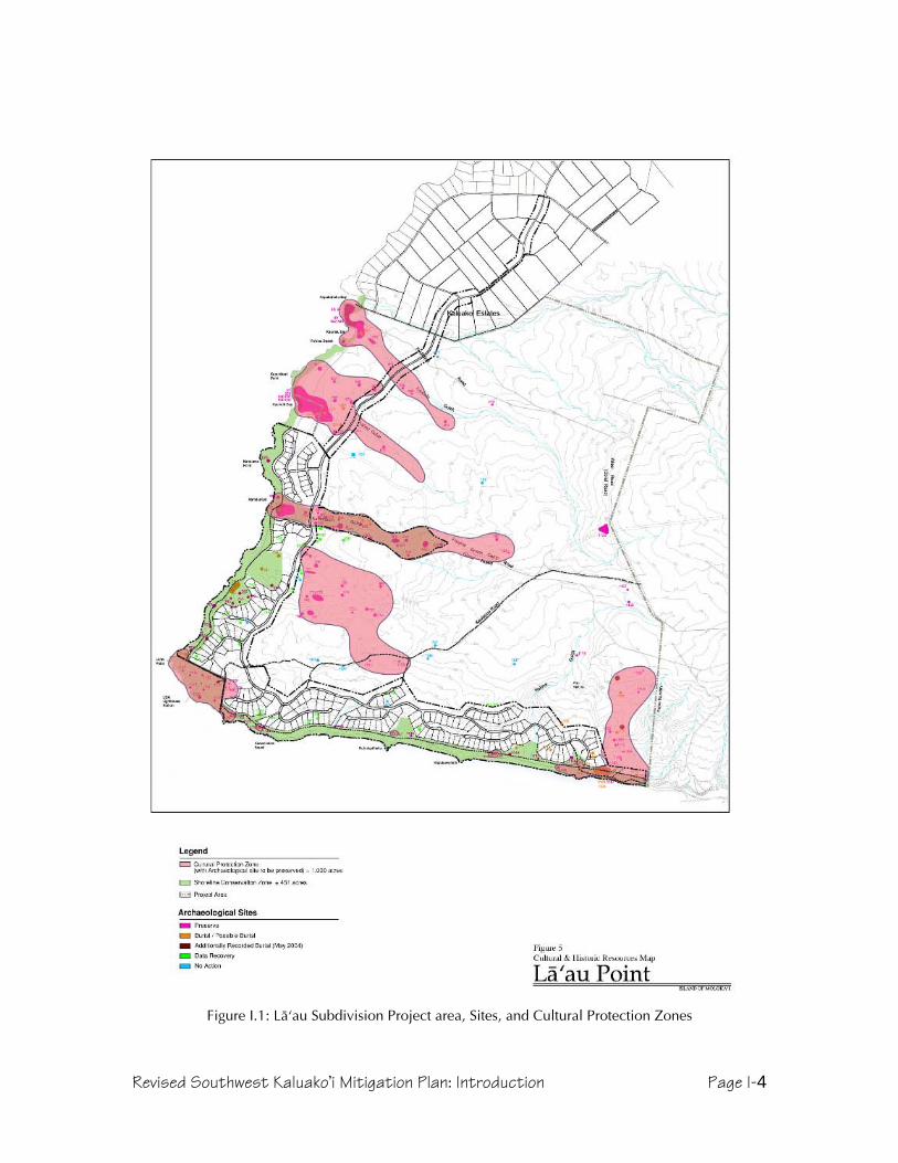
Revised Southwest Kaluako’i Mitigation Plan: Introduction Page I-4
Figure I.1: Läÿau Subdivision Project area, Sites, and Cultural Protection Zones
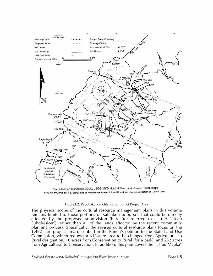
Revised Southwest Kaluako’i Mitigation Plan: Introduction Page I-5
Figure I.2: Papohaku Ranchlands portion of Project Area
The physical scope of the cultural resource management plans in this volumeremains limited to those portions of Kaluakoÿi ahupuaÿa that could be directlyaffected by the proposed subdivision (hereafter referred to as the “LäÿauSubdivision”), rather than all of the lands affected by the recent communityplanning process. Specifically, the revised cultural resource plans focus on the1,492-acre project area described in the Ranch’s petition to the State Land UseCommission, which requests a 613-acre area to be changed from Agricultural toRural designation, 10 acres from Conservation to Rural (for a park), and 252 acresfrom Agricultural to Conservation. In addition, this plan covers the “Läÿau Mauka”

Revised Southwest Kaluako’i Mitigation Plan: Introduction Page I-6
Rural Landscape Reserve, which corresponds to the remainder of the 6,350-acreparcel surveyed in 1991. All of the proposed Läÿau Subdivision lots and most of theinfrastructure derive from that original parcel (TMK 5-1-02-030), althoughdevelopment activity will affect only a limited portion—400 acres of house lots and153 acres of roads, infrastructure and parks, or less than 10% of the original parcelarea. Finally, the total acreage for the road and utility corridor leading into theLäÿau Subdivision includes several lots in the older Papohaku Ranchlandssubdivision. This volume proposes treatments for each of those subdivision lotswhere potential effects could occur (a total of approximately 15 acres), but doesnot encompass the entirety of Papohaku Ranchlands.
Because they concern separate actions in the State Historic Preservation Divisionadministrative rules (the general process being described in Hawaii AdministrativeRules 13-13-275), this volume presents Preservation (detailed in HAR 13-13-277),Data Recovery (HAR 13-13-278), Monitoring (HAR 13-13-279), and BurialTreatment (HAR 13-13-300) plans as separate sections. A single Introduction andset of appendices serve all of these sections to reduce repetition and save paper.
A final note regarding figures. The original and addendum plans includednumerous reproductions of site sketches and maps from the Dixon and Major 1993and Burtchard and Athens 2000 reports. As these are now available in at least twodocuments, paper conservation wins out in this revised plan.
Environmental SettingSouthwest Kaluakoÿi lies on the flanks of Mauna Loa, the extinct shield volcano thatformed the west side of Molokaÿi prior to the eastern (Koÿolau) volcano. MaunaLoa, like most other Hawaiian volcanoes, formed through a series of beddedbasaltic lava flows MacDonald et. al. 1983:412). The project area includes portionsof the western and southern slopes of Mauna Loa, as well as traversing thesouthwest rift zone, a line of greater activity where vents and flows created a ridgebetween the summit and Ka Lae o Läÿau (Läÿau Point, the southwest tip ofMolokaÿi).
Although Mauna Loa is older, the drier conditions have produced less topographicvariation than on the Koÿolau side of Molokaÿi, where heavier rainfall has cutspectacular valleys. The gulches of Mauna Loa are relatively shallow, interspersedwith broad, relatively undissected landscapes. Many of the smaller gullies betweenand feeding into the larger gulches are very young, the result of drought andovergrazing that denuded surface vegetation in the 19th and 20th Centuries, leavingit vulnerable to violent erosion during occasional downpours. Other consequencesof this period of erosion have been exposure of hardpan subsoils on high groundand accumulation of wind and water-borne silt in leeward low areas and gulchbottoms.
Rainfall is concentrated during the winter months, but has amounted to an averageof only 15 inches per year in modern times; on the lower slopes of the southwestregion, that figure is lower (Baker et. al. 1968). One aspect of the local climate notmentioned in rainfall data is the typical cloud cover, which consists of a line ofclouds parallel to and directly above the island. In dry periods, it barely extendspast the high Koÿolau mountains, but often extends past the west coast. Duringwetter periods, this line of clouds brings rainfall that seems to be concentrated overthe gulches of Kamäkaÿipö, Kaheu, and Kaunalä. The tradewinds that cause theseclouds to pile up over the island dominate, but on the south shore there isfrequently little or no wind. When tradewinds are absent, land and sea breezes are

Revised Southwest Kaluako’i Mitigation Plan: Introduction Page I-7
more noticeable, and convection clouds (with occasional rain) may occur ifhumidity is sufficient. A traditional name for a wind of Kaluakoÿi is “Haleolono,”which is also a place name for the land just east of the project area (Nakuina1992:68).
Although there were reportedly a few springs in the past (Summers 1971,Kaimikaua personal communication 1999), there is no reported evidence ofperennial streams that would support typical wetland taro agriculture. Anotherindication of the aridity of the project area is that there are no traces of traditionalcoastal fishponds, which generally were constructed where some fresh water inputfostered plant growth. However, the wetland just behind the dunes at Site 1146shows that at least brackish water is present at some coastal locations.
The general soil types of the project area are low humic latosols interspersed withlithosols (Foote et. al. 1972). Soil series represented in the project area aredominated by very stony eroded soil in the north and the interior, Kapuhikani alongthe southern shore to just south of Kamäkaÿipö, and Mala silty clay in theKamäkaÿipö Gulch bottom (ibid.). Both Baker and Foote mention deep soils on thewest end, but field experience shows that the project area generally has a veryshallow soil cover, with rocky and hardpan areas exposed rather frequently, andsubstantial accumulation of sediments occurring only in the lower reaches ofgulches. The 1991 excavations rarely went more than 50 cm in depth beforereaching extremely hard clay.
The soil classifications interpret the project area as having very low productivityBaker et. al. 1968, Foote et. al. 1972). This may be true for modern forms ofagriculture and animal husbandry, but it is likely that higher rainfall occurred priorto upland deforestation, providing enough moisture and could cover to grow theless thirsty Polynesian crops such as ÿuala (sweet potato, Ipomoea batatas), ÿipu(gourd, Lagenaria siceraria), and the thatching grass pili (Heteropogon contortus).George Cooke (1949), who managed Molokai Ranch in the first half of the 20th
Century, saw Hawaiian kö (sugar cane, Saccharum officinum) growing in an oldhousehold garden at Kamäkaÿipö. Terraces, planting circles, and areas cleared ofstones show that Hawaiians once practiced agriculture within the gulches, and to amore limited extent, on the sloping lands. Monitoring at Kaupoa, then old ranchhouse on the outskirts of an ancient village at Kaheu gulch, revealed deposits ofloamy soil sometimes exceeding 30 cm in depth, soil that appeared to have arelatively high organic content and held onto moisture for weeks afterrainfall—attributes that would have been attractive to ancient farmers.
Currently, vegetation is dominated by kiawe (Prosopis pallida) forest, whichsometimes forms dense thickets, but may also be open. Lantana (Lantana camara)forms an understory in the forested areas, and also occurs in the open areas. Thereare occasional grasslands, with various pasture and weedy species that havebecome naturalized. Chili peppers (Capsicum frutescens), bittermelon (Momordicaspecies), and basil (Ocimum species) are also naturalized, representing historichousehold garden introductions, but possibly from elsewhere on Molokaÿi, sincebirds readily disperse each. The native flora are much diminished, although hardiershrubs that are adapted to dry and disturbed conditions are still present; theseinclude: ÿuhaloa (Waltheria indica), ÿilima (Sida fallax), and maÿo (native cotton,Gossypium sandvicense).
Insects and other arthropods dominate fauna of southwest Kaluakoÿi, and it isbeyond the expertise of the archaeologists to list or evaluate these. Bird lifeincludes game species introduced by Kamehameha V, and later by the territory and

Revised Southwest Kaluako’i Mitigation Plan: Introduction Page I-8
state, as well as exotic songbirds such as cardinals, mockingbirds, and mynahs.Herds of Axis deer, another of the king’s introductions, wander Molokaÿi’s westend, and along with the other introduced ungulates (cattle, sheep, and goats—onlythe former of which is still present) have affected the ecology significantly. Moreimportant to the human inhabitants of old was the marine fauna, from pelagicspecies at the offshore Penguin Banks, to reef fish, to shellfish and echinodermsfound on the coast, and even the turtles that hauled up on shore.
The character of the southwest Molokaÿi shoreline merits attention, not leastbecause this is where ancient and historical people settled. Sand beaches covermost of the coastline, although basaltic ridges do extend to the shore in a fewlocations, with those at Läÿau Point and along the south shore being highest. Lowdunes occur as well, although sand mining depleted those at the eastern end of theproject area’s south coast. Sandstone and limestone underlie the sand and arevisible in many locations. Slabs of this material appear in ancient and historicconstruction, but the more consistently important aspect of such stone is that theshoreline and shallow waters where it occurs are riddled with holes and cracks thatform excellent habitat for fish, lobsters, and other food. Because canoes formed thebackbone of the ancient transportation system, the presence of numerous channelsthrough the reef and sandy beach landings would have been an attractive trait ofthis shoreline in ancient times. The waters of Läÿau Point, however, remainnotorious to this day, as currents traveling down each coast collide in a choppy,swirling mix that makes paddling dangerous.
In the reconnaissance of the gunnery range, Burtchard noted highly eroded areasand charcoal indicative of wildfire (2000). It is no great stretch to infer that live firepractice could have ignited vegetation in this parched landscape, and an aerialphoto from 1965 shows what appears to be a recent burn area in the range. Thereconnaissance also noted several graded and bulldozed areas, piles of stone, andmilitary dumps. In an analysis of Burtchard’s report; Dixon and Major’s 1993report; 1955, 1964, 1965, and 1969 aerial photos; Molokai Ranch color aerialphotos from the 1990s; the publication Detailed Land Classification – Island ofMolokai (Baker et. al., 1968); and USGS quad sheets from 1924 and 1983, CulturalLandscapes has been able to estimate the minimum extent of disturbance in andaround the new corridor.
Between Poÿolau and Wahïlauhue Gulches, only a small, unnamed gulch appearsto have escaped disturbance prior to the mid-1960s. Between about 100 and 250feet in elevation, numerous dirt roads criss-cross the landscape here. Poÿolau Gulchitself appears to have escaped much direct impact, except where roads crossedit—Burtchard’s discovery of intact agricultural sites in the gulch is consistent withthis. (His Site 1760, a single adze preform in “an erosional scar” that may in fact bein a dirt road visible on aerial photographs.) South of Poÿolau Gulch, almosteverything inland of the old coastal road, north of where the south arm of KulawaiLoop meets Pohakuloa Road, and below about 250 feet in elevation has beenheavily disturbed. Grading to clear the target areas, construct roads, and buildobservation towers and bunkers has obliterated nearly everything inside of KulawaiLoop, and as far east as the rock piles recorded as Sites 1683-1687. The singlecontra-indication to this situation may be Site 1788, a concentration of bouldersincluding a slab that was interpreted as a fallen upright from a shrine (Burtchard2000). Low, seasonably wet ground nearby (interpreted as a spring with which theshrine would have been associated) may have saved this area from grading, and isvisible on air photos due to the vegetation.

Revised Southwest Kaluako’i Mitigation Plan: Introduction Page I-9
South of Kulawai Loop, the situation changes markedly, and several sites werepresent beginning between the road and Kapukahehu Gulch. Sites have beenrecorded in and between Kapukahehu and Kaunalu Gulches, with a few mauka-makai roads being the only disturbance to the intervening ridge. The ridge south ofKaunalu Gulch, however, has been disturbed as far down as 100 feet in elevation,and the 1965 aerial photograph shows a series of lines following the contours fromthis elevation up to nearly 200 feet. It is uncertain what these are, although theyappear to have a few intact trees, and may represent grubbing of pasture, anattempt at erosion control, or both. Kaheu Gulch and south appears to be far lessdisturbed, except for the road down the ridge to Kaupoa.
History and ArchaeologyTo achieve a more comprehensible and holistic understanding of southwestKaluakoÿi’s past, this document combines historical and archaeologicalbackground. This discussion summarizes what is currently known about the projectarea, and then offers a brief regional overview as a framework for the researchplan. Site particulars appear with the detailed site mitigation plans below, to avoidredundancy and the need to flip pages constantly. A more developed discussion ofoverall patterns will be included in the final data recovery report.
The name of the ahupuaÿa containing all of these places, Kaluakoÿi, refers to thepits or quarries (“lua”) from which adzes (“koÿi”) were made. Kumu Hula JohnKaimikaua notes that the largest quarries were inland at “Amikopala, Kahinawai,Koholalele, and Kamakahi,” and that the best types of stone were named“Awalau…Awaliÿi, and Awauli” (Kaimikaua 1997:4). He also relates that when theMaui aliÿi (chief) Kiha-a-Piÿilani ruled over Molokaÿi, he stationed his men in all ofthe coastal villages of Kaluakoÿi “to secure the mining rights of the valuable koÿi asan added wealth for the high chief,” and that access to and security over thequarries was the reason he built his famed trail (“KealapüpüoKihaaPiÿilani, SeeSummers 1971:12-13) around the west end (Kaimikaua 1997:4).
Figure I.3: Trail marker at North Kamäkaÿipö

Revised Southwest Kaluako’i Mitigation Plan: Introduction Page I-10
One of the Molokaÿi chiefs who provided labor for the trail, Kamäkaÿipö, wasimmortalized in the name of the gulch and bay north of Läÿau Point. Kamäkaÿipöwas also the name of an owl who lived at the place, and whose droppingsappeared as a type of gray clay found there. Two Kamäkaÿipö places known fromtraditional oral history that may have identifiable archaeological sites associatedwith them are a heiau dedicated to Hina that is supposed to be small and circular,and a hill named Ahoaho, a small hill where chiefs were buried (Kaimikaua 2001,personal communication).
By the time Europeans found the Hawaiian Islands, western Molokaÿi was notheavily populated, although both the Cook and Vancouver expeditions noted that asmall population was present prior to AD 1800 (see Dixon and Major 1993:9).Molokaÿi also became a battleground in the struggles between Maui, Hawaiÿi, andOÿahu, and during the latter 18th Century lost much of its population due towarfare; a Hawaiian told the surgeon of the Vancouver expedition thatKamehameha had decimated the island (Menzies 1920:115, 118). Another sourceindicates that a generation earlier, the Oÿahu chief Peleioholani raided and burnedMolokaÿi in revenge for his daughter being killed on the island (Fornander, cited inSummers 1971:18). Ash exists widely on the west end, observed in buried layersfrom at least Po’olau (Burtchard and Athens 1999) to Kaheu (also known asKaupoa, Major 2000). An older explanation of the barrenness and low populationmay be found in the story of ÿAmiÿikopalä, which said that the wells dug by thatsupernatural crab dried up when he was killed (Kaimikaua, personalcommunication 1999). Another moÿolelo told that other water sources dried upwhen people carelessly, and later maliciously, poisoned springs with pieces of theKälaipähoa gods (Kaimikaua 1988).
Regardless of the causes, the view that Kaluakoÿi was a dry, thinly populated areafound its way into archaeological literature, and is accepted today. Stokes (1909)stated that “inhabitants of the western end of Molokai deserted or were removedfrom their homes nearly half a century ago” (Stokes 1909:30), a period whenKamehameha V had begun ranching operations on the island. Stokes concentratedon religious features, and near the current project area recorded koÿa (fishingshrines) on the coast at Kamäkaipö (Sites 53 and 55), Läÿau (Site 58, destroyed bylighthouse construction before 1909), Keawakalai (probably Keawakalani, Site 59),Kahalepohaku (Site 61), and Puÿu Hakina (Site 62). At the latter place, he alsorecorded Kalalua Heiau (Site 67), which had an unusual reef rock slabconstruction, and was reportedly used for human sacrifice (ibid:31-32). Stokesfurther reported that local people identified Kahalepohaku as the place where Kiha-a-Piÿilani had been raised.
During the 1920s and 1930s, most Molokaÿi archaeology was done by visitingscholars such as Fowke (who wrote a brief paper for the Bureau of AmericanEthnology in 1922), and Phelps (who produced a monograph on Molokaÿiarchaeology in 1941). The Phelps paper is more interesting for its consideration ofenvironmental variables than its site recording. He divided the island intoecological regions, of which the western was the driest; Phelps highlighted thisaspect by repeating a Hawaiian newspaper story about the 18th Century aliÿiKaiakea, who ordered a well dug with adzes near Ka Lae o Läÿau (Phelps 1941:57).He stated that the advantages of Kaluakoÿi were its namesake adze quarries and itsfine fishing grounds (ibid:55-60). He used the ahupuaÿa of Kaluakoÿi to support hisconclusion that land divisions with the greatest area had the least population, andthat the absence of valleys to provide natural divisions was what made Kaluakoÿithe largest ahupuaÿa (ibid:75-76).
Revised Southwest Kaluako’i Mitigation Plan: Introduction Page I-11
Few new sites were recorded prior to the 1950s, when the Bishop Museum andUniversity of Hawaiÿi began working together on Hawaiian archaeology, and oneducating a new generation of scientists. One of these students, William Bonk,reiterated the conventional wisdom in his master thesis, which included the lines,“this was a decidedly marginal land for the inhabitants of Molokai. Fishing and thequest for adze stone brought people into the area, and fighting probably sentrefugees into it, but temporarily” (1954:139). His excavation of a house site atKamäkaÿipö (Site 54) revealed less than 10 inches of midden, leading him toconclude that the intensity of habitation had perhaps increased over time, but thatthe site represented a fisherman’s house, and that the area had little more in theway of permanent habitation (ibid:51-52).
Catherine Summers compiled historical and archaeological documentation overthe next two decades, and published the results in 1971. Few of the sites are withinthe current project area, but the book is notable as the first and last attempt to bringtogether knowledge about sites island-wide. Molokai: A Site Survey includes notesmade by Stokes and other early site recorders, as well as Hawaiian myths and oralhistories, unpublished accounts, and historical documents. Based on all of thisinformation, Summers concurs with the portrayal of Kaluakoÿi as a land blessedwith excellent adze stone and fishing grounds, but also where habitation waslimited by aridity (1971:39-40). Also implicit in her maps and descriptions is asettlement pattern in which the most heavily used areas are clustered at the baysand high in the uplands. The current project area occasionally reaches the marginsof the coastal settlements, but is largely in the “empty” middle elevations. TheStatewide Inventory of historical properties began shortly after the publication ofSummers, but consisted more of an effort to relocate previously recorded sites thanto discover new ones, and added no new information.
The same year that Molokai: A Site Survey was published, a University of Hawaiÿistudent named Hal Strong documented some of the Kamäkaÿipö habitations. Hedescribed and photographed four house sites and a variety of associated features,including: ahu (stone mounds), shrines, koÿa, a stone pile, and scatters of middenand artifacts strewn on the surface (Strong 1971).
In the early 1980s, Marshall Weisler surveyed coastal southwest Moloka`i,relocating and discovering eleven sites (State Sites 50-60-01-53 through –56, -655,1118, and -1134) in or near what has become current project area. He reiteratedan aspect of Phelps’ settlement pattern in which topography was key—sites wereconcentrated in gulches and the bays where they met the sea—and added thatthere was a correlation between the size of the bay and the quantity and diversityof features (Weisler 1984:27). Another pertinent outcome of Weisler's work,creation of the Southwest Moloka`i Archaeological District (hereafter SMAD, Site50-60-01-803) included some sites (53, 54, and 56), in or near the project area.This district is now on the State of Hawaiÿi and National Registers of HistoricPlaces, meaning that sites within it are afforded additional protection.

Revised Southwest Kaluako’i Mitigation Plan: Introduction Page I-12
Figure I.4: Previous archaeological study areas. (Note: Burtchard and Athens project area is north ofthis, and is shown in the Papohaku Ranchland map earlier in this report.)
In 1991, a survey of 6,350 acres of southwest Molokaÿi done by Bishop Museumencountered features throughout southwest Molokaÿi, including the current projectarea (Dixon and Major 1993, referred to in this report as the “1991 inventory” andthe “1993 report”). This survey provided the most complete coverage ofsouthwestern Kaluako`i to date, and the settlement pattern model that emergedfrom the inventory reinforces the main pattern mentioned above, that sites clusteraround bays and gulches (Dixon and Major 1993:337). However, having a surveyarea that extended well inland from the coast, it was possible to refine the model.For example, although the inland margins of sites had the expected agriculturalareas and lithic work stations, they had a surprising number of “temporary andsemi-permanent residential compounds” (ibid:337).
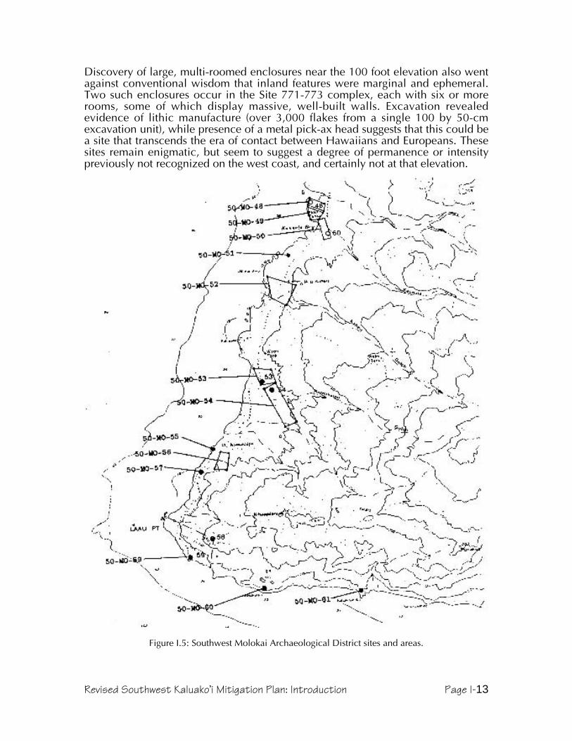
Revised Southwest Kaluako’i Mitigation Plan: Introduction Page I-13
Discovery of large, multi-roomed enclosures near the 100 foot elevation also wentagainst conventional wisdom that inland features were marginal and ephemeral.Two such enclosures occur in the Site 771-773 complex, each with six or morerooms, some of which display massive, well-built walls. Excavation revealedevidence of lithic manufacture (over 3,000 flakes from a single 100 by 50-cmexcavation unit), while presence of a metal pick-ax head suggests that this could bea site that transcends the era of contact between Hawaiians and Europeans. Thesesites remain enigmatic, but seem to suggest a degree of permanence or intensitypreviously not recognized on the west coast, and certainly not at that elevation.
Figure I.5: Southwest Molokai Archaeological District sites and areas.

Revised Southwest Kaluako’i Mitigation Plan: Introduction Page I-14
The 1991 project also documented variation between west coast settlements(where features clustered at the bays and stretched inland to gardening or quarryingareas) and south coast settlements (where habitations were spread laterally alongthe coast), indicating that the causes again related to topography (ibid:337-338).Analyses of subsistence strategies and lithic production, paired with the form anddistribution of features, suggested that rather than a temporarily occupied,culturally peripheral area, southwest Kaluakoÿi was probably permanentlyoccupied late in prehistory, and that its access to fishing grounds and adze quarriesmeant that it was integrated into island-wide society (ibid:240-344). A more recentstudy including part of the north end of the current project area concluded thatcoastal habitations must have been permanent (Burtchard and Athens 1999).Presence of extensive occupations in the uplands (Summers 1971, Major 2000) andof major specialized features such as heiau (temples) and holua (sledding courses)in the lowlands (Summers 1971) provide evidence that the Kaluakoÿi area hadpermanent, perhaps socially stratified, occupants.
Figure I.6: Site 771, a multi-room enclosure on a ridge above Kamäkaÿipö
Traditional wisdom among archaeologists has also concluded that this regionwould have been settled only after sweet potato was available, and after populationdensities had risen in the wetter areas, probably no earlier than about AD 1500(Kirch 1985). Radiocarbon dates suggest somewhat earlier occupation may bepossible, although the limited data make it hard to discern sporadic early use froma stable early habitation. An inland quarry yielded a radiocarbon date of AD 1260-1440, and the south Kamäkaÿipö coastal site was dated between AD1410-1955. Asubsequent, unpublished date from the 1991 excavations at Site 654, in a coastalimu that Weisler originally recommended dating, provided an even earlier date ofAD 1019-1211, confirming the suspicion that coastal areas were used much earlierthan they were permanently settled.
Revised Southwest Kaluako’i Mitigation Plan: Introduction Page I-15
The condition of Site 654, eroding from an exposed dune face, may be a result ofthe 1946 tsunami. The Cookes (1948, 1961) both wrote of the effect that this wavehad on the west coast, impacting Kawakiu heavily and working its way a half mileinland at Päpöhaku beach; it could easily have come well inland at Kamäkaÿipö,where the alluvial flat is severely eroded. Even without tsunami, however, manysites at Kaluakoÿi have been damaged by erosion, itself catalyzed by cattle and deergrazing since the mid-Nineteenth Century and several periods of severe drought.
Because the archaeology of Kaluakoÿi is relatively well known, mitigation plansmay be based not only on particular knowledge of the sites, but on the patternsevident in southwest Kaluakoÿi. Because the current project area mostly runsmauka of the sites, the data that will be recovered will be skewed toward traces ofperipheral activities and agriculture. In the Data Recovery Plan, the effect of this onthe techniques of data recovery and the research issues will be evident.
Papohaku Ranchlands SectionThen Papohaku Ranchland section of the project area is discussed separately herefor two reasons. First, the presence of an aerial gunnery target range had aprofound effects on the environmental setting and on the integrity of archaeologicalsites. Second, the fact that a formal inventory survey has not been reviewed bySHPD means that the preservation process in this portion of the project area is lessadvanced than elsewhere.
In 1998, under contract with the Army Corps of Engineers, archaeologists from theInternational Archaeological Research Institute, Inc, (IARII) attempted an inventorysurvey of the former gunnery range (Burtchard 2000). Unfortunately, funding wasinadequate, and IARII was unable to do more than a reconnaissance of the area,meaning that coverage was not intense enough to guarantee location of all sites,and that excavation to determine age and function of sites was not performed.However, recording of the sites that were located is good, GPS locations makethem easy to relocate, and the report is in fact better than some inventory surveysdone on Molokaÿi in earlier years. Age, function, and significance were estimatedfor all sites located during the reconnaissance, and will form the basis fortreatments proposed in this plan.
Before describing sites in or near the corridor, however, some historicalbackground specific to this new project area deserves attention. The target rangementioned above appeared on maps as early as 1952 (USGS Ilio Point Quad) as a“Bombing Range,” and was apparently leased by the US Government from MolokaiRanch between 1944 and 1965 (Burtchard 2000). Documentation of what exactlyoccurred has not been located, but a combination of physical remains,recollections of residents, and photographs allows some reconstruction. An aerialphotograph taken in 1955 shows that the largest feature of the range, a huge (about600 m in diameter) circular target comprised of three concentric earth and rockrings, had not yet been constructed, although a smaller (about 200 m) one ofsimilar plan was clearly visible. By 1965, facilities included the targets, threecement observation bunkers, a range control tower, a munitions dump, andanother possible communication or observation tower. Grading for target andinfrastructure development, as well as the direct effects of the munitions, havecleared large areas beyond the constructed features themselves, and thearchaeological reconnaissance found several piles of disturbed stone mauka of theactive range. Local residents recall the area being used for ground troop training inthe 1950s and 1960s, and the abundant munitions on the ground confirm thataerial bombardment occurred as well. It is possible that other portions of the

Revised Southwest Kaluako’i Mitigation Plan: Introduction Page I-16
project corridor may have been used for training, since a retired marine recallsparticipating in amphibious and land-based exercises around Kaupoa. Besides theimpacts from thousands of men and heavy machinery being moved around, henoted specifically that they constructed C-shaped shelters (Dixon and Major 1993)
Subsequent to the military training era, the land was not heavily used, although itmay have reverted to cattle pasture until the 1970s and 80s, when subdivision forresidential development was planned. It was during this period that Hal Hammattrecorded four sites in an archaeological reconnaissance of 3,200 acres subsumingthe current project area, and William Barrera recorded five more sites alongproposed roads (Hammatt 1980 and Barerra 1982a, both cited in Burtchard 2000).Development of the subdivision resulted in construction of several roads, whichalso served as corridors for water and electrical infrastructure, which was allinstalled below ground. However, few of the lots have actually been developed.Near the coast (adjacent to the Poÿolau beach access), grading has damagedarchaeological features believed to be part of Site 45, a settlement with habitation,religious, and probably agricultural features. Sand dunes at the south end ofPäpöhaku Beach have also been surreptitiously mined during the 1970s throughthe 1990s. The extent of impacts resulting from development of the residential lotsis undetermined.
The Hawaiian place names near the project area extension shed some light on thecultural landscape. Poÿolau, the name for a gulch and the bay where it terminates,is left un-translated in Place Names of Hawaiÿi, but the word means “leaf base; buttend of a leaf” (Pukui and Elbert 1986). Many of the long time residents ofMaunaloa, however, know it by the name “shit creek,” apparently because it oncereceived waste from the town. However, it should be noted that Poÿolau Gulchterminates well below Maunaloa Town, and instead it is Wahïlauhue Gulch thatdescends from Maunaloa to the coast, where it ends about one-third of the wayfrom the south end of Päpöhaku Beach. It appears that extension of that name tothe entire beach may be a fairly recent phenomenon, since Monsarrat (who madethe first Molokaÿi map in1886) was careful to find knowledgeable Hawaiians, andapplied the name to a structure at the beach; Päpohaku means “stone enclosure.”Another name near the project area that appeared on the 1886 map was Puÿu Koai,which Pukui, Elbert and Moÿokini considered to be Puÿu Koaÿe, or “tropicbird hill”(1974).
South of Poÿolau, Kapukahehu Bay (whose origin and meaning are uncertain) ismore commonly known now as “Dixie,” and does not appear in either form on theold maps. “Dixie Maru,” was a boat that crashed there, and the coastline is knownfor shipwrecks. In a less drastic way, Dixie is also the end of the road for cars, andlocals and tourists alike frequent the sandy bay. Continuing south less than half akilometer, the next gulch and bay are now called Kaunalä (“placing sun” Pukui,Elbert and Moÿokini 1974), although maps until 1924 used Kaunalu, or “placingwave” (ibid). Further south is Kapuhikani, or “sounding eel” (ibid), a point of landthat has appeared on all maps beginning in 1886. Next is Kaheu, a gulch and baywhose name first appeared on the 1924 USGS map, and is thought to mean “thefuzz” (ibid). Kaheu is better known as Kaupoa, a name that first appeared as amapping station on the 1897 map (which was made after the overthrow of themonarchy, and is suspect due to its omission of many Hawaiian place names orreplacement with English names). The name was popularized by the Cooke family,who in 1925 built a house by the bay and named it Kaupoa.

Revised Southwest Kaluako’i Mitigation Plan: Introduction Page I-17
Archaeologically, the action is at the bays, and the current project corridor is in thehinterlands. The general settlement pattern of the west coast is for habitations tocluster around the bays, and for the traces of human presence to diminish rapidlywith increased elevation and distance from the bay. On the coast, koÿa (fishingshrines) and dispersed temporary habitations may occur between bays, and it islikely that dunes contain human burials. Heading inland from the bays, gulchescontain terraces and stone piles indicative of attempts to retain freshet moisture andsoil, and to clear the stony soil for planting, respectively. Aside from theagricultural features and temporary shelters (both C-shapes and pavements)associated with them, stone mounds that appear to be burials are the mostcommon features at the margins of coastal settlements. Of the features occurringabove 50 feet in elevation, few are outside of gulches.
Further inland (generally over 150 feet in elevation), the presence of temporaryhabitations (usually C-shapes) and concentrations of lithic debris present traces oftraditional quarrying and stone tool manufacture sites. Quarries usually occur ongulch margins or ridges where a stratum of fine-grained basalt was accessible, andcould be removed with relative ease. Primary reduction into cores and roughlyformed adzes was done at the quarry, after which finer flaking and polishing at thecoastal habitations resulted in finished tools. Between the quarries and the coastalhabitations, stone cairns mark the trails and occasional concentrations of basaltflakes suggest limited lithic work, although the latter usually represent singleepisodes rather than the sustained or repeated behavior that happened in quarries.
Because it is inland of the coastal settlements, but not far enough in to be a part ofthe quarry activity, the current project corridor has few archaeological features.Only in Poÿolau Gulch, where the corridor will cross an area of stone pilesinterpreted as agricultural clearing piles (Site 1758), does it directly encounter sites.However, a few sites are known to be relatively near the corridor, and will bedescribed here.
Site 520. Located by Kulawai Loop near the beginning of Road T, this site consistsof numerous features on the crest and in the lee of a ridge. Features atop the ridgeinclude three C-shapes, three walls, a pit, and two platforms, forming a probablehabitation site. Barrera (1982) excavated one C-shape, uncovering a large fire pitfeature and cultural deposition extending to 60 cm in depth. Whereas Barrera onlyrecorded five of the habitation features, Burtchard’s crew spotted the additionalfeatures on the ridge, as well as a minimum of 23 small stone mounds extendingdown the southwest slope. He considered the mounds to be agricultural withoutspecifying whether they were clearing or planting features, but wondered whetherthe windswept ridge crest would be an undesirable place for habitation, andsuggested a possible religious function (Burtchard 2000). However, the walls andC-shapes are very typical of windbreak features, and the form of these and theplatform-terrace is commonly associated with habitations in the region. Part of thereligious interpretation appears to rest on the presence of a “rough basalt upright”near the pit, but religious uprights tend to be smooth (often waterworn) or haveworked surfaces, which this apparently did not. Despite the good view from thislocation (an attribute of shrines in Kaluakoÿi), the C-shapes are not open toward thesea, as would be expected, and lack the typical stone platform/pavement interior orcoral offerings. Although it is possible that the free standing platform could be aburial, the overall function of the site appears to have been habitation and

Revised Southwest Kaluako’i Mitigation Plan: Introduction Page I-18
agriculture. Site 520 covers an area of 6,750 m2 at an elevation of about 100 feet. 2Site 520 has been evaluated as significant under Criterion D.
Site 658. This small, isolated stone mound appears to be one of the infrequentagricultural modifications to Kaheu Gulch, along with Site 659. It is significantunder criterion D, and covers 4 m2 at an elevation of 60 feet.
Site 659. About 200 m up Kaheu Gulch from Site 658, this consists of a singlealignment of boulders on the south slope, forming a rough terrace. It is significantunder criterion D, and covers 30 m2 at an elevation of 90 feet.
Site 664. This site consists of five small cobble mounds, apparently associated withagricultural clearing in a small gulch north of Puÿu Kaheu. The site is significantunder criterion D, and covers about 100 m2 at an elevation of 60 feet.
Site 669. This site is on the north slope of Kaheu Gulch inland of the mainsettlement there. The components include a possible burial (a mound), andpossibly areas of temporary habitation associated with agriculture (a C-shape, aterrace, an enclosure alignment, and a possible hearth). The site is unusuallysituated, being in the middle of a small gulch. A test excavation here in theenclosure yielded no cultural materials, and hit hardpan subsoil in only 10 cm(Dixon and Major 1993). The site was listed as significant under criterion D, butwill be treated as possibly significant under criterion E due to the possible burial.The site covers about 2400 m2 at an elevation of 85 feet.
Site 670. This site includes low, oblong mounds interpreted as agriculturalfeatures, a substantial C-shape with a cupboard interpreted as a shrine, and anunusual C-shape open toward the northeast tradewinds. Testing in the latterrevealed a single, shallow layer with cultural materials including ash,hammerstones, basalt flakes, and a grindstone. Presence of a possible shrine amongthe other features led to positive significance evaluations including criteria D and E.The site covers and area of 1500 m2 at an elevation of about 90 feet.
Site 674. This single stone mound was interpreted as a possible burial, and wasassigned significance under criteria D and E. It covers 1m2 at an elevation of 80feet.
Site 675. This site appears to be an agricultural area with associated temporaryhabitation. It consists of an enclosure with a possible hearth, and several smallstone rings interpreted as planting circles, and was listed as significant undercriterion D. The site covers 1000 m2 at an elevation of 70 feet.
Sites 1678-1680. These sites each consist of a single concrete bunker forobservation of the nearby targets. None have been judged significant, and theyprobably do not meet the 50-year age requirement. Site 1680 is not in a potentiallyaffected lot.
Sites 1683-1687. These were recorded by Burtchard (2000) as a series of rock pilesmade by the military. They probably represent stockpiles of stone used for targetconstruction, or surface material pushed aside during construction of the targetrange. None have been judged significant, and they probably do not meet the 50-year age requirement. On the project area map, they are simply marked as “RockPiles (Modern).” 2 Burtchard (2000) reported an elevation of 30 feet, but his map and UTM locations place the sitemuch higher. Apparently due to a GPS error, many sites in the IARII report have this problem. Thisreport estimates elevations based on map and UTM locations, written descriptions, and USGS andMolokai Ranch topographic maps.
Revised Southwest Kaluako’i Mitigation Plan: Introduction Page I-19
Site 1756. This site, well mauka of the corridor, lies on the opposite (south) side ofPoÿolau Gulch about 200 m up from Sites 1757-1759 and just inside Lot 236.Burtchard reported a terrace platform on an outcrop, but noted that more featurescould be expected in the high grass. This feature was described as having two“chambers” (2000). A fence post and 55-gallon drum were interpreted as ranchingactivity, and the overall site area was estimated to be 1500 m2 at an elevation ofabout 200 feet.
Site 1757. Located in Poÿolau Gulch, this site consists of 8 small piles of cobblesplaced on low boulders on the first natural terrace above the gulch bottom.Because they are in a tight cluster and are rather low to the ground, they do notappear to be trail markers, such as those found in Kamäkaÿipö Gulch. Instead, theyhave been interpreted as agricultural clearing mounds (piles of stone removed fromthe soil and put on boulders where nothing could be planted). These differ from so-called “sweet potato mounds,” which were planting features in which soil orcompost was covered with a mantle of cobbles that acted to conserved moisture.Presence of oblong cobbles on one mound caused Burchard to speculate that itcould conceivably have been a shrine. This site covers nearly 6,000 m2 at anelevation of 150 feet, and is mauka of the proposed corridor
Site 1758. This is a larger set of 36 stone mounds like those found in Site 1757.These, too, are stacked on boulders and are interpreted as clearing piles. This siteoccurs in the flood plain of Poÿolau Gulch, covering approximately 3,150 m2 at anelevation of about 140 feet, just down the gulch from Site 1757. Burtchardspeculated that these may actually be part of a single site, and noted that a fewoblong stones were also present here. The proposed corridor traverses this site.
Site 1759. A third cluster of small clearing mounds (11 in number), this site occursin a smaller area, also on the flood plain of Poÿolau Gulch. This site covers about800 m2 at an elevation of approximately 130 feet, and is located down the gulchfrom 1758, and makai of the proposed corridor.
Site 1760. This consists of a single basalt adze preform, broken into two pieces.Because it was visible in an eroded area amid grass, Burchard speculated that itmight be part of a larger deposit. Analysis of aerial photographs shows several dirtroads in the area, and it is possible that the erosional scar is one of these roads.This artifact is about 80 m north of Site 1761 at an elevation of about 150 feet, andis just mauka of the proposed corridor.
Site 1761. The size (2.9 x 2.5 x .55 m and 1.3 x .75 x .35 m), shape (elongate), andstacked edges of these two stone mounds, as well as their placement on a smallknoll, suggests that they are human burials, rather than agricultural features.However, this is rather far inland for burials (which are more often found at theinalnd margin of settlement complexes), and proximity to roads means that thesecould conceivably be historic features. They are located mauka of the northern endof the project corridor. The site covers 100 m2 at an elevation of 150 feet.
Site 1783. This site consisted of some cobbles piled on a boulder. Burtchardspeculated that they may simply have been cleared to provide a sitting area, andthere was no evidence of formal construction. The site reportedly covers 400 m2 atan elevation of 100 feet.
Site 1784. A rectangular platform and a small hearth comprise this site, whichBurtchard (2000) interpreted as a habitation. The platform, measures more than 7m in length, and is raised about 30 cm above the surrounding surface. The hearth,a small ring of stone is described as being 25 m southeast of the platform, but is

Revised Southwest Kaluako’i Mitigation Plan: Introduction Page I-20
shown 25 m northeast on the site map. The site covers an area of 1050 m2 at anelevation of approximately 110 feet.
Site 1785. This site on a flat area up-slope of Kapukahehu bay consists of a possiblehearth, an alignment, and a stone slab interpreted as a shrine based on thepresence of traditionally worked surfaces and its oblong shape. Site covers 300m2
at an elevation of about 125 feet.
Site 1786. This site, north of 1785, occupies a small ridge and consists of a series ofmodifications to an outcrop, atop which appears to be an artificially set boulderupright. The modifications include low walls, alignments, and terraces, as well aswhat appears to be a trail leading up toward the upright. The immediate areaaround the boulder is defined by a rectangular platform incorporating naturalboulders and set cobbles, and is the high point before the ridge descends towardthe sea. Site 1786 covers about 875 m2 at an elevation of about 150 feet.
Site 1787. This site consists of two large boulders, each with a small pile ofcobbles on top. The absence of historical debris led to an estimation that the site ispre-Contact in origin (Burtchard 2000), and the feature type is similar to manyfound in southwest Molokaÿi that have been interpreted as trail markers, based ontheir visibility and distribution in the landscape (Dixon and Major 1993). The site isreported as covering approximately 150 m2 at an elevation of close to 190 feet.
Site 1788. This site is located in a low area near a seasonally wet depressioninterpreted by Burtchard as a possible spring (2000). Because of this proximity andthe presence of an oblong boulder slab, the site was interpreted as a shrine.Although the concentration of stone here suggests that this is indeed a feature, theexisting records are unclear, since the accompanying sketch depicts a smaller,more amorphous feature than the rectangular one described as retaining itsintegrity. Proximity to the heavily disturbed target range area warrantsconsideration that this may be a later feature, and the records fail to note attributes(phallic shape, smooth or worked surface) known to be associated with sacredstones, and the photograph seems to show a fractured, angular stone notcommonly associated with that function. Site 1788 is near the 150 foot contour,and is said to have an area of 100 m2, although the map shows less than 20 m2,even if the spring is included.
Supplemental Data CollectionTwo types of archaeological investigation that are not required by the regulatoryhistoric preservation process will be done in association with the Läÿau subdivision.While elements of each have been part of the plans from the outset, the recentperiod of community consultation have made it clear that they are a priority tomany community members and most Hawaiians on Molokaÿi, and their importanceis highlighted here. First, because construction of a new road and utility corridorrepresents the greatest single potential for impact, and is the initial step inconstruction for the new subdivision, the landowner has committed to re-surveythe corridor, most of which as already been through the official review process.The character and methods for this are described beginning in the followingsection.
The second form of data collection relates to preservation sites within and close toproposed subdivision lots, where the process will amount to a thorough re-surveyof sites that are to be protected within or in close proximity to new house lots.Because this type of work is to be done as part of the Preservation Plan

Revised Southwest Kaluako’i Mitigation Plan: Introduction Page I-21
implementation, it will be described in more detail there, but it is important to notethat it will be done well in advance of any house construction, and therefore anynew or augmented finds may be considered in the design and construction process,so that new houses need not damage old sites. An overview for this process isincluded below.
Road Corridor Re-SurveyAs described in the Introduction, the first fieldwork associated with these plans willbe to re-examine the road corridor and verify descriptions of known sites, gatheradditional data if possible, and search for unrecorded archaeological deposits orfeatures now obervable due to changes in surface visibility. A preliminary plan forthe road corridor has been prepared by engineers, the centerline of which will bestaked on the ground by surveyors prior to commencement of archaeologicalfieldwork. The proposed road begins at the end of Kaluakoi Road, connects to anportion of Kulawai Loop (an existing road in the Papohaku Ranchlandssubdivision), and then runs roughly southwest to a point just south of the KaupoaHouse lot, and then more or less follows the shoreline down the west coast andalong the south coast to the vicinity of Site 1155, south of Puÿu Hakina (see map).Along the way, 12 short spur roads depart from the main corridor, providing accessto subdivision lots. No connections to the Hale-o-Lono harbor road or otherexisting roads are planned, and the old coastal road—a roughly graded, unpavedjeep trail—will be abandoned as part of the development plan due to its alignmentthrough several archaeological sites and erosion-prone environments.
As noted above, the portion of the road corridor north of TMK 5-01-02-030 has notbeen officially inventoried, and a report for that portion of the road corridor surveywill in fact be submitted to SHPD for review as an archaeological inventory withsignificance evaluations and treatment recommendations. Despite this proceduraldifference, survey techniques will remains the same throughout the road corridor.
The area for data collection consists of a 30 m wide swath on either side of thecenterlines for the main and spur roads, and a 50 m radius surrounding each endpoint, where turn-arounds have been planned. The eventual impact of roadconstruction and utility trenching will be less than the resulting 60 m wide corridor,but that width has been chosen both to provide the best archaeologicalunderstanding of the road and its context, and to provide intensive coverage thatmay be used to avoid additional survey or unexpected impacts should presence ofsensitive sites within the corridor cause a need to adjust the alignment.
The survey team will consist of Molokaÿi residents with archaeological experienceand training led by the Principal Investigator, with additional archaeologists hiredfrom off-island if necessary. The corridor will be divided into segments, and thecrew will perform sweeps in each segment with a 5 m interval. Where grass is thickenough to obscure surface visibility, gas-powered string trimmers will be used toexpose the surface within 10 m of the centerline, so that low-relief features such aspavements and lithic scatters will not escape notice. Vegetation will also be clearedaround the periphery of any visible surface features found within the corridor(regardless of distance from the centerline) to allow their accurate documentationand to search for additional features or deposits.
Any finds within the corridor will be documented with scaled surface planviews,cross-sections and profiles as necessary, photographs, and descriptive notes. Wheresediments occur that could contain buried cultural deposits, transects of probes willbe employed to determine site boundaries and characterize site stratigraphy. Each
Revised Southwest Kaluako’i Mitigation Plan: Introduction Page I-22
probe is to be excavated with a shovel, by stratigraphic layer as far as practicable,with the entire volume screened through 1/4-inch mesh. For each probe arepresentative profile will be drawn, referenced to the current ground surface. Anyfeatures encountered will be drawn and photographed in plan and profile andexcavated as a separate stratigraphic context. All cultural materials will becollected, described, and recorded in a project inventory. Probe intervals will rangefrom 1 to 5 m, depending on the area of sediment where buried features couldoccur, as well as the nature and density of the surface features and visible deposits.Probes will begin at the outer edge of surface features and radiate outward in atleast two directions along grids established for each site (the orientation of whichwill be decided in the field by the PI according to topography and localconditions). Where probe intervals are greater than 2 m, follow-up probes will beused at tighter intervals to better determine the horizontal extent of the site.
For each site, a minimum of one datum point will be flagged and marked on siteplanviews to facilitate location on large maps. Initially, a GPS device will be usedat each of these to provide a location; consumer-grade Garmin units used onproperty by Ranch staff have achieved accuracy to within 2-m of the UTMcoordinates provided by survey grade GPS, and will be used during the re-survey toprovide interim site locations. Subsequent to the initial fieldwork and prior toconstruction, these points will be plotted lot surveys to provide accurate, precisecontrol points for site and buffer locations. Each datum point will be integrated intothe engineering consultant’s CADD system, along with either an appropriately-sized point buffer or a polygon derived from the site planview.
Sites that have been previously recorded will be reported in the Data Recovery orPreservation report, according to its status, including any newly-located features orartifacts found within 10 m of the know features. Features not associated withknown sites will be reported in a Supplemental Inventory Survey report, submittedto SHPD along with significance evaluations and treatment recommendations. Thisreport will also cover sites located north of TMK 5-1-02-030 in the PapohakuRanchlands subdivision.
In a few cases where the site is minimal, Data Recovery measures proposed in theaccompanying Data Recovery Plan may be done in conjunction with this phase offieldwork. For example, Site 697 consists of lithic artifacts on a deflated hardpansurface, for which the proposed data recovery method is surface collection; ratherthan draw a planview (for the supplemental data collection) and return later tocollect the artifacts (for data recovery), a single period of fieldwork will be done tosatisfy both phases.
Subdivision Lot and Coastal Zone Re-SurveySites within proposed subdivision lots have reasonably accurate locations due totheir proximity to coastal reference points, and many have been previouslydocumented in detail by archaeologists. In order to ensure that all sites have beenadequately recorded and those slated for preservation receive timely and effectivepreservation, land within and in close proximity to the subdivision lots will be re-surveyed as well. As with the road corridor, the aim is to verify extant site records,augment them as necessary, and search for any previously unrecorded sites.
Methods for investigating and recording sites will be the same as well, although theproject area differs. Rather than a corridor defined by the road centerline, thissurvey area consists of the proposed private lots and the lands makai of them.Inclusion of the coastal land (most of it already zoned Conservation, and the

Revised Southwest Kaluako’i Mitigation Plan: Introduction Page I-23
remainder to be so if the Ranch’s petition to change some near-shore land fromAgriculture is approved) in this phase stems from two facts. First, some sitesstraddle the boundary between Conservation land and lots. Second, as lots areoccupied and coastal parks are opened, foot traffic through coastal sites willincrease, subjecting them to a greater potential for impact than in recent decades.
Because so many sites have been recorded near the shoreline, this phase will beginwith the known and work outward, annotating and augmenting site documentationas necessary, firmly establishing site boundaries. Areas between sites will besurveyed at 5-m intervals to search for any unrecorded features or deposits.
Vegetation clearing in this phase will focus on sites, exposing surface features andvisible deposits to allow for mapping. However, clearing in Conservation lands willbe limited to cutting grasses and vines, and close attention will be paid to anynative plants, preserving them. A sampling of high probability landforms (ridge-tops, natural terraces within gulches, and level ground above slopes) will becleared to check for unrecorded features in the private lots, but not within thecoastal strip. In all cases, clearing will proceed with an awareness of soil, slope,and groundcover, to avoid exacerbating erosion.
In addition to the use of shovel probes to define site boundaries, some excavationwill be done in this phase to help further the general conservation goals of themaster plan and to better understand chronological and functional issues regardingthe sites. Wherever hearths or imu are at risk from erosion, they will be excavatedto reveal the stratigraphic relationship to other site components, and to collectcharcoal for taxonomic identification, providing a basis for future re-vegetationefforts. Likewise, eroding deposits will be cleaned up to provide a representativevertical face for profile illustration, and a charcoal or other materials may becollected at this time.
Proposed Site Mitigation MeasuresSites will be dealt with differently depending on their significance, their position inthe cultural landscape, and their location relative to private parcels, the proposedland trust, and conservation overlays. Options for site treatment includepreservation, data recovery, and no action. Monitoring may be done in addition toother actions, and will also occur throughout the road corridor. Sites for which noaction is planned are those that were deemed not significant in the 1993 inventoryreport, typically because they were recent hunting blinds or had been so badlydamaged as to eliminate the possibility of determining their original form orsalvaging meaningful data. Table I-1 lists the categories of mitigation actionsgenerally; the subsequent Preservation and Data Recovery plans will add moredetailed information regarding specific practices.
The forms of mitigation dealt with in these plans derive from the process outlinedin HAR 13-13-275, which describes the historic preservation review process inHawaiÿi. Preservation, obviously, means avoiding damage to the site, althoughthere are different degrees of this measure that will be described in the appropriatesection. Data Recovery pertains to sites that are significant for their informationonly, and covers actions such as mapping, excavation, and surface collection thatadequately gather that information. The objective is to collect information prior toconstruction, so that any damage during development is offset by gains inknowledge. Once data recovery has occurred and the report approved by SHPD,the site is officially considered “no longer significant,” although the approach inthis project is to monitor any unexcavated portion in hopes of gathering further

Revised Southwest Kaluako’i Mitigation Plan: Introduction Page I-24
data that may be unearthed. Monitoring means having an archaeologist presentduring ground-disturbing activities that could potentially have an adverse impacton a significant site, and to gather data from inadvertently encountered sites. Theobjectives are twofold: to prevent incursion into preservation areas and damage tosites being preserved, and to collect data from any sites or deposits encounteredoutside of preservation areas. In some cases, monitoring may result in discovery ofpreviously unknown features or deposits, leading to an expedited inventory andevaluation, and potentially to data recovery or even preservation. This will occurwherever activity with potential to impact sites occurs, and therefore is not listed atthe site-specific level. Preservation differs from the other treatments in that sites areprotected, and there is no impact to mitigate. Options within this treatment revolvearound the degree and type of protective measures to be implemented, andwhether the preservation is to be passive (avoidance) or active (stabilization,interpretation, and other measures). Burial treatment concerns not only the actionstaken for sites that have documented or possible burial sites, but also measures thatwill be followed should an inadvertent discovery of human remains occur. Likemonitoring, the procedures for burial treatment apply throughout the project area.
Because of uncertainty regarding some site locations and the fact that the finalalignment of the proposed road corridor has not yet been designated, sometreatments may change later pending community and SHPD approval. (All suchchanges will be from Data Recovery to Preservation, and no objections areanticipated.) Any site thought to be near the road or within a proposed subdivisionlot has a detailed mitigation plan. At least 14 sites recommended for data recoveryin the 2001 plan are now slated for preservation due to the road realignment andthe revised approach to subdivision, and as many as 8 more appear likely to do thesame. SHPD will be consulted regarding such changes. As mentioned above, thepreliminary road corridor will be resurveyed prior to finalizing the plan, and everyeffort will be made to realign it around significant sites.
A few sites listed in 1993 lack specific mitigation measures described in this plan.Some of these are sites recorded prior to 1991 that could not be located or weredestroyed by that time (State Sites 55, 653, 1108, and Bishop Museum Sites B5-58and B5-61). However, most consist of recorded sites that lacked cultural orarchaeological significance. Other gaps in the site numbers—653, 1133, 59-638,700-735 and 783-1099—have been assigned to sites elsewhere on Molokaÿi, anddo not actually denote gaps in the 1993 site records.

Revised Southwest Kaluako’i Mitigation Plan: Introduction Page I-25
Table I-1. Site Conversions and Mitigation Treatments
State Number(50-60-01-)
Bishop MuseumNumber(50-Mo-)
Inve
ntor
y
Pres
erve
Dat
aRe
cove
ry
No
Act
ion
48 B6-61 X49 B6-62 X50 B6-63 X50 B6-64 X51 B6-65 X52 B6-66 X53 B6-68 and -97 X54 B6-69 to -73 X56 B6-76 and -77 X57 B6-78 X520 N/A X X639 B6-67 X640 B6-74 X641 B6-83 X642 B6-84 X643 B6-85 X644 B6-86 X645 B6-87 X646 B6-88 X647 B6-89 X648 B6-90 X649 B6-91 X650 B6-92 X651 B6-93 X652 B6-94 X654 B6-96 X655 (aka 53) B6-97 X656 B6-98 X657 B6-107 X658 B6-108 X659 B6-109 X660 B6-110 X661 B6-111 X662 B6-112 X663 B6-113 X664 B6-114 X665 B6-115 X666 B6-116 X667 B6-117 X668 B6-118 X669 B6-119 X670 B6-120 X671 B6-121 X

Revised Southwest Kaluako’i Mitigation Plan: Introduction Page I-26
State Number(50-60-01-)
Bishop MuseumNumber(50-Mo-)
Inve
ntor
y
Pres
erve
Dat
aRe
cove
ry
No
Act
ion
672 B6-122 X673 B6-123 X674 B6-124 X675 B6-125 X676 B6-126 X677 B6-127 X678 B6-128 X679 B6-129 X680 B6-130 X681 B6-131 X682 B6-132 X683 B6-133 X684 B6-134 X685 B6-135 X686 B6-136 X687 B6-137 X688 B6-138 X689 B6-139 X690 B6-140 X691 B6-141 X692 B6-142 XX693 B6-143 X694 B6-144 XX695 B6-145 XX696 B6-146 XX697 B6-147 X698 B6-148 X699 B6-149 X736 B6-150 XX737 B6-151 X738 B6-152 X739 B6-153 X740 B6-154 X741 B6-155 X742 B6-156 XX743 B6-157 X744 B6-158 X745 B6-159 X746 B6-160 X747 B6-161 X748 B6-162 XX749 B6-163 X750 B6-164 X751 B6-165 X

Revised Southwest Kaluako’i Mitigation Plan: Introduction Page I-27
State Number(50-60-01-)
Bishop MuseumNumber(50-Mo-)
Inve
ntor
y
Pres
erve
Dat
aRe
cove
ry
No
Act
ion
752 B6-166 X753 B6-167 XX754 B6-168 X755 B6-169 X756 B6-170 X757 B6-171 X758 B6-172 X759 B6-173 X760 B6-174 X761 B6-175 ? ?762 B6-176 X763 B6-177 XX764 B6-178 X765 B6-179 X766 B6-180 X767 B6-181 X768 B6-182 X769 B6-183 X770 B6-184 X771 B6-185 X772 B6-186 X773 B6-187 X774 B6-188 X775 B6-189 X776 B6-190 X777 B6-191 X778 B6-192 X779 B6-193 X780 B6-194 X781 B6-195 X782 B6-196 X1100 B5-59 X1101 B5-60 X1102 B5-62 X1103 B5-63 X1104 B5-64 X1105 B5-65 X1106 B5-66 X1107 B5-67 X1109 B5-69 X1110 B5-70 X1111 B5-71 X1112 B5-72 X1113 B5-73 X1114 B5-74 X

Revised Southwest Kaluako’i Mitigation Plan: Introduction Page I-28
State Number(50-60-01-)
Bishop MuseumNumber(50-Mo-)
Inve
ntor
y
Pres
erve
Dat
aRe
cove
ry
No
Act
ion
1115 B5-75 X1116 B5-76 X1117 B5-77 X1118 B5-78 XX1119 B5-79 X1120 B5-80 X1121 B5-81 X1122 B5-82 XX1123 B5-83 XX1124 B5-84 X1125 B5-85 ? ?1126 B5-86 X1127 B5-87 X1128 B5-88 X1129 B5-89 X1130 B5-90 X1131 B5-91 X1132 B5-92 X1134 B5-93 X1135 B5-94 X1136 B5-95 ? ?1137 B5-96 X1138 B5-97 X1139 B5-98 XX1140 B5-99 X1141 B5-100 X1142 B5-101 X1143 B5-102 X1144 B5-103 X1145 B5-104 X1146 B5-105 X1147 B5-106 X1148 B5-107 XX1149 B5-108 X1150 B5-109 X1151 B5-110 XX
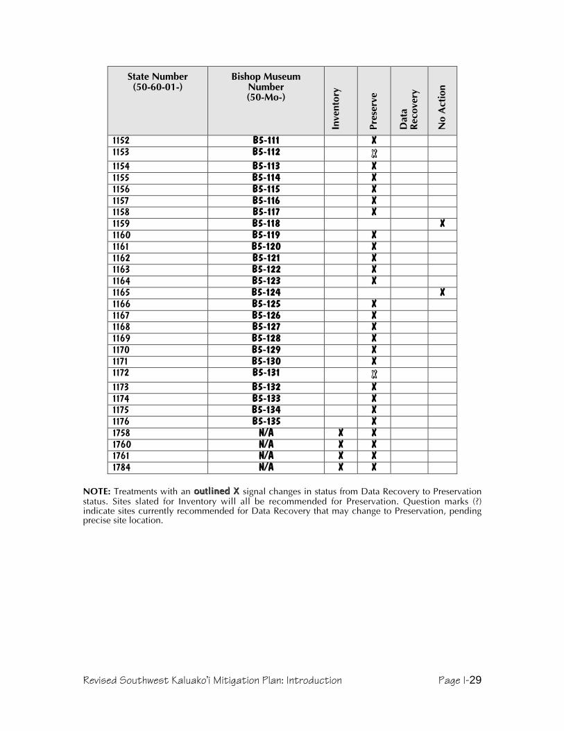
Revised Southwest Kaluako’i Mitigation Plan: Introduction Page I-29
State Number(50-60-01-)
Bishop MuseumNumber(50-Mo-)
Inve
ntor
y
Pres
erve
Dat
aRe
cove
ry
No
Act
ion
1152 B5-111 X1153 B5-112 XX1154 B5-113 X1155 B5-114 X1156 B5-115 X1157 B5-116 X1158 B5-117 X1159 B5-118 X1160 B5-119 X1161 B5-120 X1162 B5-121 X1163 B5-122 X1164 B5-123 X1165 B5-124 X1166 B5-125 X1167 B5-126 X1168 B5-127 X1169 B5-128 X1170 B5-129 X1171 B5-130 X1172 B5-131 XX1173 B5-132 X1174 B5-133 X1175 B5-134 X1176 B5-135 X1758 N/A X X1760 N/A X X1761 N/A X X1784 N/A X X
NOTE: Treatments with an outlined X outlined X signal changes in status from Data Recovery to Preservationstatus. Sites slated for Inventory will all be recommended for Preservation. Question marks (?)indicate sites currently recommended for Data Recovery that may change to Preservation, pendingprecise site location.

Revised Southwest Kaluako’i Mitigation Plan: Data Recovery Plan Page D-1
Detailed Data Recovery Plan, GeneralSite-specific data recovery actions will be presented in a subsequent section, butthere are several aspects of data recovery that will be practiced at all sites. First, allsites near the development corridor (which consists of the road and infrastructureas well as construction in house lots)—including those that will be preserved ratherthan mitigated—will be checked to verify extant data. Second, any gaps in theexisting data will be filled. In several cases, for example, without replacing theexisting sketch maps with tape and compass or plane table maps, most site recordsare inadequate for management purposes. Third, because it is possible that theinventory survey missed some small but significant feature or artifact hiddenbeneath vegetation, vegetation clearing and intensive searches will extend out fromdata recovery site areas prior to construction. These actions augment the road andinfrastructure corridor re-survey described in the Introduction of the revised plans.
Data Collection at Previously Recorded Sites
VerificationThe first step in this phase of investigations will be to verify the existing data forknown sites within the road corridor. This process will consist of examining thesites, comparing dimensions and descriptions to those contained in the 1993report, and either affirming the inventory or adding corrected data. The inventorywas reviewed and accepted by SHPD, but the fact that any site facing datarecovery also faces construction impacts underscores the importance of havingaccurate site records.
AugmentationThe first action in augmentation will be to ensure that all features have beendocumented. It is possible that vegetation obscured smaller features or scatters orisolated artifacts, or that erosion since the survey has exposed additional deposits.Therefore, the road and infrastructure corridor will be resurveyed as described inthe Introduction to search for such instances. Special attention will be focussed onknown sites in or adjacent to the corridor, with intensive survey and clearing of thevicinity to guarantee 100% documentation of features and deposits within the areaof potential impact. Eventually, as lots are sold and houses are planned, thisprocess will be repeated in proposed construction areas within individualsubdivision lots.
The second action will be to accurately place each site in space. Reference pointsfor each site will be marked on the ground and site maps, located using a GPSreceiver, and wherever possible recorded again by surveyors when the roadcorridor is laid out. These points will be identified by their UTM coordinates.
Another aspect of data augmentation is that while sites were documented, not allwere mapped, and many were mapped only approximately. The nature of siteswithin the corridor is that they generally are not complex or large, and thereforetape and compass maps will be adequate to accurately record site plans. If the sizeand complexity of any un-mapped sites merits, plane table and alidade maps willbe produced. Generally, 1:100 metric scale maps will be adequate, although 1:200or higher may be appropriate for agricultural mound complexes, and 1:50 may beused for particularly interesting architecture.

Revised Southwest Kaluako’i Mitigation Plan: Data Recovery Plan Page D-2
Finally, if there is any information to add to that held in the 1993 report, it will berecorded at this time. For example, more detailed descriptions of architecture, listsof species present in midden, and other such details may be added.
New Data CollectionOnce verification and augmentation have been completed, excavations can begin.The most basic goal of excavation will be to document the site stratigraphy,including natural and cultural components. Beyond this basic description andrelative chronology, several research questions will provide the framework forinterpretation of excavated assemblages; these revolve around cultural use of thelands located outside the nuclei of coastal settlements, and integration or contrastsbetween coastal and inland resource use. It is also anticipated that charcoal will berecovered that can be identified to provide environmental data, and dated toimprove the local chronology. Research questions pertaining only to particular sitesmay also be investigated, and will be described later in the section on site-specificdata recovery plans.
Documentation of Stratigraphic SequenceThe first goal of excavation is to establish the stratigraphic history of each site.Therefore excavations will be placed such that the depositional sequence(s) areexposed inside and outside of features. Underlying substrate and post-abandonment deposition will be distinguished from cultural deposits. Stratigraphyof particular features will be placed in the context of their sites, and sites will beplaced within the context of the project area. Based on past work, it is anticipatedthat stratigraphy will be similar and simple throughout most of the project area,with potential for small areas of more complex layering within some heavily usedfeatures.
Documentation of Feature ChronologySites with surface features will be subject to excavation to determine thestratigraphic association of feature foundations, so that at least a relativechronology can be established. Likewise, subsurface features will be placed withinthe stratigraphic sequence. Although the expectation is that most excavations willencounter a lone cultural layer, any more complex stratigraphy will be placed in aHarris matrix system (Harris 1989), which will include all identifiable stages ofsurface feature construction, addition, and dismantling. This work will helpconstruct a relative chronology, and radiocarbon dating will be used on at least asample of features to provide absolute dates.
Documentation of Site and Feature AssemblagesBeginning with each minimum collection provenience (grid units for surfacecollections, and strata within excavation units for subsurface collections), the nextbasic task will be to create an inventory and basic description of cultural materials.Midden will be classified by taxa and weighed. Artifacts will be classified bymaterial and type, measured, and weighed; samples of different types will bephotographed and in some cases illustrated. Lithic debitage will be counted andweighed, the range of dimensions recorded for each lot, classified according to thedegrees of decortication and modification, and finally described in terms ofmaterial, form, and any other salient attributes. Following these descriptive tasks,the assemblages of particular grid or stratigraphic units will be considered in

Revised Southwest Kaluako’i Mitigation Plan: Data Recovery Plan Page D-3
context of features and sites in an attempt to identify any systematic variation orpatterning.
Research QuestionsAlthough SHPD standards state that an inventory survey needs to go no further thandocumenting the resources present, the 1993 report did pose several research-oriented questions regarding southwest Kaluakoÿi, following topics suggested forthe area by Weisler (1984). The nature of the project area forces revision of theresearch questions for this stage of investigation. Work will occur mostly within acorridor running approximately parallel to the coast, mauka of site concentrations.In addition, the project area includes several spurs leading to public beachaccesses and to subdivision parcels; these are planned to avoid site complexes, andtherefore will also relate more to peripheral areas than to core sites. Finally, datarecovery is proposed for a limited number of sites within the subdivision lots, sitesthat mostly represent temporary habitation or workshops areas and are significantfor their information only. Habitation in the data recovery sites is mostly limited tomarginal features, with agriculture and lithic work sites being better represented, sothe unbiased examination of settlement patterns attempted in 1993 will not bepossible. Likewise, distance from the coast vastly reduces the amount of marinemidden present, and therefore consideration of subsistence strategies will focus onagriculture. The earlier focus on lithic resources must be shifted to later stages oftool production, since few, if any sources of stone will occur within the projectcorridor. Finally, the consideration of sociopolitical complexity, difficult enoughwith the inventory data, would be presumptuous given the thin slice of the overallsite spectrum that will be encountered.
The archaeological marginality of the data recovery sites makes them of limited usefor considering the broad questions posed previously, but also creates its ownopportunities. The margins of settlements clustering around the small bays of westand the coastal flats of the south may also be considered as frontiers, somethingakin to the high water mark of the culture that colonized these shores, where themodified and built landscape met the wild country. This kind of area has thepotential to inform on land use in interesting ways, providing data that may reflectthe Hawaiian zoning of the landscape into different types of use and degrees ofhuman permanence (Malo 1951, Kamakau 1992, Handy and Handy 1972). On adifferent level, the sites may inform on central place theory, or core-peripherysystems. As well as being the agricultural outlier of a coastal settlement, however, itis important to consider that the middle elevations also held the access routesbetween the more heavily used coastal and upland zones. The 1993 report showedthat this was the case in Kämakaÿipö, where a specific type of cairn marked mauka-makai trails. It was also evident that activities upon which coastal settlementsdepended, especially agriculture and stone tool manufacture, occurred primarilyon the margins of habitation complexes. The irony of this is that the main roadcorridor, following a more or less unvarying elevation, becomes an important wayof understanding the older mauka-makai trail corridors, since it will cross-cut theold trail networks and highlight patterns of where they occur and where they donot.
Land Use on the Settlement MarginsTo the degree that the project area includes the peripheries of the major coastalsettlements, it is useful in investigating the ways in which ancient residents of

Revised Southwest Kaluako’i Mitigation Plan: Data Recovery Plan Page D-4
Molokaÿi used their frontier. Known sites suggest that agriculture was the dominantuse, but this project will also attempt to evaluate the importance of lithic andtemporary habitation sites by excavating samples at most such sites in the area ofpotential effect. Did these other functions occur independently, or may they bebetter understood as agriculturally related activities? Data recovery may occurprimarily at the margins of coastal settlements, but by no means in inaccessible andremote land, and therefore it will be interesting to see the degree to which artifacts,midden, and feature styles prevalent at the bay settlements are also found here. Inother words, how much does the cultural assemblage of the outlying sites conformto that of the coastal centers? Also, the permanence of the inland margin sites isworth investigation. Do they represent repeated, long-term use of this area, or werethey short-lived frontier sites?
Sites that may be excavated regarding settlement margins will include: 520, 692,694, 698, 743, 745, 746, 749, 753, 755, 756, 758, 1118, 1121, 1122, 1124, 1125,1131, 1132, 1136, 1153, 1172, and 1784. Many of these sites will be outside therefined area of potential effect, and will therefore not be excavated. Unless a largenumber cannot be avoided, it is likely that all sites will at least have sampleexcavations.
Traditional Dryland Agricultural Features and SoilsMoving on from the issue of margins and frontiers, a narrower but crucial focusmay be brought upon the practice of agriculture. This subject seems to havecaptivated archaeologists only where irrigation or vast field systems are involved,but as the basis for survival of Hawaiians it is of the utmost importance. Two typesof features—planting circles and mounds—reflect the primitive state ofarchaeological understanding, since both tend to be interpreted with reference toarchaeological folklore or occasionally to a few indigenous accounts. Excavation ofthese types of features will be directed toward understanding their agronomicbenefits. Do they appear to aid in soil or moisture conservation? Does theirconstruction involve use of organic or sediment fill? In the case of mounds, specificidentification of planting versus clearing mounds will be sought, based on the typesof stone present and the depth of topsoil present beneath the stones. Another classof agricultural features was the modified stone outcrop. These will be mapped anda sample excavated with the goal of understanding why such features may havebeen agriculturally useful.
After features, the second major source of data will be the soils. Traditional drylandagricultural practices by no means required features, and the presence ofagriculturally viable soils will be tracked throughout the corridor, particularly withregard to their association with gulches or ridges. Soil samples from a variety ofcontexts will be sent for analysis to evaluate and compare their mineral nutrients,fertility, and acidity. Where it is available, charcoal will be collected foridentification and dating. This data will inform on flora cleared from cultivationareas, and perhaps on the flora associated with cultivation. This approach is beingused rather than pollen analysis because the scale being considered is moreimmediate (being wind-borne, pollen is more informative of regional than of localflora), and because comparative data are available for upland Kaluakoÿi sites.Erosion will be noted and possible links to agriculture will be considered, andfeatures or modifications will be analyzed as to their potential to promote or retarderosion.

Revised Southwest Kaluako’i Mitigation Plan: Data Recovery Plan Page D-5
Sites that may address this topic include: 694, 736, 742, 745, 1130, and 1148.Many of these sites will be outside the refined area of potential effect, and willtherefore not be excavated. Unless a large number cannot be avoided, it is likelythat all sites will at least have sample excavations.
Lithic ProductionPrevious data have suggested that sources of tool-grade basalt occurred at higherelevations than most of the project area will include, and an obvious goal of thisproject is to verify this conclusion. Should any sources be found, the extent of theiruse will be evaluated, the suspicion being that any sources within the area ofpotential effect were probably relatively poor grade and were used briefly, perhapsonly once, to supply blades rather than adzes or other more formal tools. If sourcesare not found, lithic work areas will be analyzed to determine the type(s) ofmaterials present, type(s) of tools being made, and the stage(s) of productionrepresented. In light of recent work near the Kukui Peak area (Major 2000), whereevidence suggests that workshops were occupied by tool manufacturing specialists,lithics will be evaluated for evidence of the expertise involved, as reflected byregularity of technique, uniformity of production stage, quality of work, presence ofspecialized tools, and diversity of raw material.
Sites likely to address this research topic include: 692, 695-697, 738, 748, 1122,1132, 1134, 1139, 1145, and 1151. Many of these sites will be outside the refinedarea of potential effect, and will therefore not be excavated. Unless a large numbercannot be avoided, it is likely that all sites will at least have sample excavations.
Mauka-Makai RoutesThe possibility that some of the data recovery sites could be nodes along travel ortrade routes between the upland and coastal centers of occupation was raisedearlier, and this presents an alternative to the wholesale conclusion that these sitesare simply outliers to coastal settlements. In order to determine whether sites maybe along mauka-makai trails, other sites beyond the project area must beconsidered first. This reveals mauka-makai oriented strings of sites in gulches(North and South Kamäkaÿipö, as well as Kaheu and Kaunalä outside the area ofpotential effect), and atop ridges at Hakina and the southwest rift ridge extendingnortheast from Läÿau. (Interestingly, all of these converge in and area called“Pookohola” in Emory’s 1922 notebook, itself a ridge on the southwest rift zonethat provides a geologically convenient travel route toward Mauna Loa. This areahas several lithic work areas and shelters—Site 1156-1158—and is also the route ofthe old lighthouse road, suggesting that it has been an important node in mauka-makai travel for centuries. Gentler, less rocky terrain and historical pineapplecultivation above this point make Pookohola the uppermost intact remain of theroute.)
It is proposed that certain types of features—primarily cairns to mark routes andshelters for travelers to rest—are reflective of travel between the coast and themountain, and therefore their locations will be carefully plotted. Assemblages ofcultural materials found during surface collection and excavation may also indicatemauka-makai travel, since lithics from upland quarries or marine midden wouldhave to be introduced. It is anticipated that charcoal identification may also helphere.
Sites that are likely to address this research topic include: 692, 694, 738, 742, 743,745, 748, 749, 756, 758, 760, 1130, 1139, 1141, and 1172. Many of these sites

Revised Southwest Kaluako’i Mitigation Plan: Data Recovery Plan Page D-6
will be outside the refined area of potential effect, and will therefore not beexcavated. Unless a large number cannot be avoided, it is likely that all sites will atleast have sample excavations.
MethodsGenerally accepted archaeological practices and the draft SHPD rules for datarecovery (HAR 13-13-278) will dictate the actions taken during this project. Theinitial step in fieldwork will be the relocation and verification of existing sites andsearch for additional surface sites within the project corridor. The entire areasubject to impact, including the road corridor, turn-arounds, and staging areas, willbe resurveyed to accomplish total documentation of surface sites andconcentrations prior to excavation.
Locating SitesSite locations will be fixed using a declination-adjusted compass in conjunctionwith aerial photographs with a topographic map overlay (using vegetation,landforms, eroded areas, and surveyed points serving for reference). In the case ofartifacts observed without any formal features, the assemblage will be describedand collections made. Artifact concentrations will be located on the topographicmap in the same way as features. A GPS receiver may also be used to suuplementground surveys.
ExcavationExcavation of sites will employ three techniques that accommodate differentpurposes and accomplish varying degrees of control over vertical and horizontalcontrol. What follows is a general discussion of excavation techniques and howthey will be employed to optimize data recovery. Anticipated departures from thesegeneric types will be mentioned in the site-specific data recovery plans later in thisreport; should field conditions dictate a modification of procedures, this will bereflected in the final report.
1 - Trenching (ST-#): Trenches are dug with picks, shovel, and whenthe deposit warrants, by trowel. Excavation is by stratigraphic unit,meaning any perceivable subdivision of the excavated volume, suchas lithostratigraphic layers, depositional units, erosional faces, soilhorizons, and features. Where trenching is used to expose a longprofile in an area where burials or dense cultural deposits areunlikely, a backhoe may be used. Although backdirt is examined forcultural materials, only a limited sample of the matrix is screened inthis type of excavation, since it is to be used primarily in agriculturalfeatures where the goal is to expose the stratigraphy and the feature’sposition within it. Profiles are drawn of all features and of at leastrepresentative portions of each cultural layer. Where features orparticularly dense or complex deposits are encountered, controlledexcavation techniques will be employed, and possible artifacts willbe point provenienced relative to the trench datum.2 - Probing (P-#): Done with shovels and/or trowels, these 30-40 cmcircular units provide quick data regarding stratigraphy and culturalmaterials in known cultural deposits and features. Because of thelikelihood of finding artifacts and midden, all sediment is screenedthrough 1/4 inch mesh. Excavation is by stratigraphic unit, and

Revised Southwest Kaluako’i Mitigation Plan: Data Recovery Plan Page D-7
profiles are drawn of all features and of at least representativeportions of each cultural layer. These will most often be employed intransect or grid formations to establish the boundaries of a culturaldeposit and gain some understanding of its constituents.3 - Controlled Testing (TU-#): Excavation by trowel and brush willbe used in situations where more precise control is warranted, suchas recovery of data from pit features. A combination of stratigraphicunits and arbitrary levels within each are used for vertical control,and all matrix is screened through 1/4 inch mesh, or possibly 1/8inch where conditions merit. Profiles and plan views will be drawn ofeach layer, all features, and of at least representative portions of eachcultural layer. Features, tools and other significant attributes ofstratigraphy or material culture are point-provenienced withreference to the unit datum. For units exceeding 1 m in length,collections for each 1 m portion are recorded and collectedseparately.
Sampling StrategyIn general, the type of excavation done depends on the type of deposits and dataanticipated, as well as the degree of control necessary to interpret the site.Therefore probes will typically be an initial stage of excavation, in which thegeneral stratigraphy is exposed and the vertical and horizontal extent of a site isdefined. Probes may be followed by trenching in agricultural terraces, mounds, orplanting circles so that a longer continuous exposure of stratigraphy can berecorded. If any of these types of features appears more complex, or has anoticeably denser cultural deposit, then a controlled test unit may be excavated torecover data with greater precision. Test units will also be used in C-shapes,enclosures, and pavements. Placement of excavation units will be determined bythe type of feature being investigated, and sometimes by prior knowledge of thecultural deposits in a site.
C-shapes, for example, will be tested with controlled units laid out with a long axisextending from the opening through the back wall, recovering the majority ofinterior deposits and exposing a sectional view of the feature wall and itsstratigraphic association. This placement generally results in discovery of anyassociated fire features within, but units may be extended.
Planting circles and mounds will typically be excavated with a trench or test unitplaced over half of the feature so that a 50% sample of the fill will be screened anda cross-sectional profile will result; if warranted, the other half may then beexcavated.
Terraces will likewise be excavated with trenches or test units, placedperpendicular to the terrace facing to reveal a sectional profile. The perpendicularorientation will show the type of terrace construction, amount of fill, andrelationship between the built and natural strata. If there are relatively abundantcultural deposits indicating something more than agricultural use, probes will beused to determine the extents of the deposits, followed by controlled excavation;the procedure will follow that described below for sampling deposits.
Enclosures and pavements will be excavated using test units of various sizes andarrangements. A 50% sample of the interior of enclosures or the surface ofpavements will be excavated, including central portions where fire features arecommonly found. For features with interior or pavement areas exceeding 10 m2,
Revised Southwest Kaluako’i Mitigation Plan: Data Recovery Plan Page D-8
less than 50% may be excavated. In such cases, 5 m2 of controlled units will befollowed by removal of the contemporary horizon overburden to reveal anysubsurface features, all of which will subsequently be excavated to recover at least50% of their contents. Additional test units or stratigraphic trenches will be used tosection one or more representative portions of any walls to provide a view of thefoundations and its stratigraphic association.
Deposits of midden and lithics are documented or suspected in many of the projectarea sites, and a major task of data recovery is to delineate the boundaries of theseand recover samples adequate for site interpretation. In many cases, completeexcavation would be an immense task, and would go well beyond a point ofdiminishing returns for information. Once the extent and nature of a deposit hasbeen determined, and the distribution of its component materials described andinterpreted adequately, collection of redundant information is not necessary fordata recovery purposes. The approach will be to collect a sample through the useof probes and controlled units.
The first step of this process will be to define the area that may be impacted, andcreate a grid covering it. Using a sample interval of 2 m (1 m where refinement isneeded), the edges of a deposit will be defined, and a sample of the entire depositcollected. If the deposit is no more than 10 m2, then it will be excavated with 1 m2
units in a checkerboard arrangement to provide a minimum 50% sample. If thearea is over 10 m2 and less than 100 m2, any post-abandonment overburden willbe stripped away, and a 5-10% sample of the overall deposit excavated, with thepotential for additional units if more are needed to cover the apparent range ofvariation. Subsurface features revealed will be excavated to provide a minimum50% sample of the fill in each, regardless of whether they fall within a excavatedgrid square. When this has been done, machinery will be used to remove thecultural deposit to its average bottom depth, so that any deeper features penetratingthe substrate may be seen and excavated as well. If machines are not available, afraction of the area will be stripped with the same goal. If the deposit exceeds 100m2, the extra portion will be stripped by machine, to allow recovery of a minimum50% sample from each feature fill.
Because the data recovery features will be impacted by construction, 50%controlled excavation is to be done first, so that a profile can be recorded.Following this, the remainder of the fill may be collected. In such instances, onlythe cultural fill will be recovered and not all materials may be collected.
Archaeological Presence During ConstructionBy definition, data recovery sites have already undergone mitigation, and thereforeno longer retain integrity or significance. However, monitoring may be done in andnear such sites, in part to be aware of any unexpected components to knowndeposits. Because data recovery excavations for this project will involve large,representative samples, it is not considered likely that anomalous or non-redundantinformation will be encountered near data recovery sites. However, sinceconstruction may be the last chance to collect information about sites before theylose integrity, monitoring will be done in many cases. For the most part, monitoringwill consist of watching machine excavation and grading in order to search forundiscovered buried features. Any such features will be recorded and mitigatedthrough controlled excavation. In addition, excavated sediments will be inspectedvisually, and in some cases sifted through quarter-inch mesh. Artifacts will becollected, whereas midden will be described. Discovery of relatively abundant

Revised Southwest Kaluako’i Mitigation Plan: Data Recovery Plan Page D-9
artifacts, midden, or charcoal will trigger a temporary work stoppage to determineif an intact remnant of the source deposit is still present; if so, it will be recordedand mitigated as appropriate. Because the sites where data recovery has beenverified by SHPD are considered no longer significant, judgement of how mucharchaeological recovery to be done will be a matter for the field archaeologist todecide, although guidance of the Küpuna Advisors will be sought in advance todetermine their preference.
Lab Analyses and Collection TreatmentMaterials collected during data recovery will be analyzed in Hawaiÿi. Artifacts andmidden will be sorted by material and function, then measured and weighed, anddescribed. This information will be recorded along with illustrations and/orphotographs of representative specimens to form a complete catalog of culturalmaterials that will be included in the final report.
Charcoal identification will be performed in Honolulu by InternationalArchaeological Institute, Inc., and radiocarbon dating by Beta Analytic in Florida.All collections, except for charcoal consumed during the dating procedure, will bereturned to the landowner for storage on Molokaÿi. Field notes, excavation forms,photographs, negatives, and unpublished documents will be retained by theconsultant. Copies of the final report will be provided to the client, SHPD, and theMolokaÿi Public Library upon acceptance by SHPD.

Revised Southwest Kaluako’i Mitigation Plan: Data Recovery Plan Page D-10
Detailed Data Recovery Plan, by Site
Table D-1. Data Recovery Actions, by Site(For Research Topics: M = Marginal land use, A = Agriculture, L = Lithics, R = Routes Mauka-Makai)
Site Number
Rese
arch
Topi
c
Map
ping
Gri
d Pr
obes
Prob
es
Stra
t. Tr
ench
Test
Uni
t
C-s
hape
Tes
tU
nit
Surf
ace
Col
lect
ion
697 L X X698 M X X X743 M X X X745 AM X X X X746 M X X X749 M X X X755 M X X X X756 M X X758 M760 M X761 M X762 M X X1118 M X X X1121 M X X X1124 AM X X X1125 M X X X1130 A X X X X1131 M X X X1132 ML X X X1134 ML X X X1136 M X X1141 T X X X1145 L X X X
NOTE: Sites in italics (761, 1125, and 1136) are likely to be outside of the subdivision, and if so willbe preserved rather than subjected to data recovery. Their inclusion here covers the possibility thatthey may be within subdivision lots.
Site 697This site consists of a 10 by 20 m area of lithic debris on hardpan. Data recoverywill consist of surface collection.
Site 698This site contains a wooden water tank and a trough, both built on stone platforms,which are probably older than 50 years based on a 1947 map that marks a “well”in this location. However, the main object of data recovery is to explore a stonewall remnant and determine if any intact cultural deposit remains at this location,since midden and lithics were observed on the surface.

Revised Southwest Kaluako’i Mitigation Plan: Data Recovery Plan Page D-11
Data recovery will begin with mapping of the surface features, which should sufficeas data recovery for the historic features. This will be followed by excavation of atrench through the wall remnant to determine its age and stratigraphic association,as well as evaluate the likelihood of an intact cultural deposit. Should such adeposit appear likely, grid probe excavation will be done following the proceduresoutlined in Sampling.
Site 743This site consists of a single stone alignment, where a 1929 bottle was fund duringthe 1991 inventory.
Data recovery will begin with mapping, followed by excavation of a single trenchthrough the feature to explore its stratigraphic association and determine thelikelihood of a buried cultural deposit. If no buried materials are found, there willbe no further data recovery. Otherwise, a grid and shovel probes will be used todetermine the horizontal and vertical extent of any buried deposit and recover datafollowing the procedure outlined in Sampling.
Site 745This site consists of an outcrop with two small enclosures attached, and what wasinterpreted as a fire hearth a few meters away. Together, these minimalmodifications were interpreted as a possible planting area and temporaryhabitation.
Data recovery will begin with mapping the three features and the outcrop. Inaddition, controlled excavation will be done at the three features, so that precisedata regarding their cultural assemblages and their stratigraphic association can begathered. A 1.0 by 1.0 m unit will be placed halfway across Feature 1 (thesuspected hearth), providing a cross-section profile; after this is recorded, anyremaining feature fill will be excavated within a second unit of the same size. Eachof the planting circles will be similarly sectioned along axes perpendicular to therock outcrop; if there are cultural materials suggestive of something more thanplanting soil, the remainder of the feature’s fills will also be excavated. Followingthis, shovel probes along a grid will be used to determine the horizontal andvertical extent of the site, and recover data according to the procedures outlined inSampling.
Site 746This site consists of an outcrop with a stacked stone wall extending outward toform an enclosure, as well as two small stone mounds. Although it was interpretedas a ranching feature in the 1993 report, it is possible that it may have served adifferent function, and further investigation is warranted.
Data recovery will begin with mapping to more accurately record the surfacefeatures. This will be followed by trenches sectioning the mounds and goingthrough part of the enclosure wall. If trenching confirms that the features are ratherrecent and there is no significant cultural deposit associated with them, datarecovery will cease. If, however, trenches reveal a buried deposit, then probes willbe excavated on a grid system, according to the procedures outlined in Sampling.

Revised Southwest Kaluako’i Mitigation Plan: Data Recovery Plan Page D-12
Site 749This site consists of a boulder outcrop with a natural overhang shelter and severalareas of stacked stone creating small enclosed areas. A single test excavation donehere in 1991 demonstrated the presence of a thin cultural layer containing bothtraditional (basalt debitage and shell midden) and historically introduced (ungulatebones and teeth) materials. Although it is possible that a deeper or more discretelystratified cultural deposit exists at this site, it is not likely.
Data recovery will begin with mapping, followed by controlled excavations in eachof the enclosed areas. The controlled units within modified areas are to augmentresults from the earlier (1991) excavations. These units will explore both theinterior deposits and the stratigraphic associations of the walls. It is anticipated thatexcavation of 2 1.0 by 1.0 m units within each enclosed area will result in recoveryof 50% or more of the available deposits, as well as reveal the stratigraphicassociations of the architectural elements. It is also likely, however, that withslightly more effort nearly 100% of the deposits can be recovered, and an attemptwill be made to do a larger excavation covering most or all of the overhangdeposits.
Following controlled excavation, shovel probes will cover the area outside ofdefined features on a 2 m grid, determining the extent of buried deposits andrecovering additional data according to the procedures detailed in Sampling.
Site 755This site is a pair of adjacent enclosure walls utilizing a natural outcrop.
Data recovery will begin with mapping, followed by trenching through the sharedwall and at least one of the enclosures’ outer walls. Matrix will be screened, and ifa rich or complex cultural deposit is found, excavation will proceed as a controlledtest unit. Unless a buried deposit is absent, the next step will be excavation ofprobes along a grid, as described in the procedures for deposits in Sampling.Finally, the stone mortar used in the feature 1 wall will be collected.
Site 756This site consists of a boulder outcrop with modifications that create a largeenclosure, within which are several natural overhang shelters.
Data recovery will begin with mapping, after which the interior will be marked in agrid and probed according to the procedures outlined for deposits in Sampling.
Site 758This site consists of a natural boulder concentration with a piled stone wallextending outward from it and creating an enclosure. Although midden was notobserved, this feature was interpreted as a temporary habitation in the 1993 report.
Data recovery will begin with the production of a map of this site, since none wasincluded in the inventory survey report. One or more trenches will be excavatedthrough the pile stone wall to reveal its stratigraphic association. Subsequently, agrid of shovel probes will be excavated in order to determine the extent and natureof any cultural deposits following the procedures outlined for deposits in Sampling.
Revised Southwest Kaluako’i Mitigation Plan: Data Recovery Plan Page D-13
Site 760This site consists of two enclosure walls attached to a large outcrop, and wasinterpreted in 1993 as a military feature, based on the style of construction andabsence of traditional cultural materials.
Military training occurred on Molokaÿi during WWII and in the mid-1950s, but wasnot well documented, and therefore it is not likely that the age (and thus eligibilityunder NRHP criteria) can be determined historically. Since a major criterion is thatsites be more than 50 years old, the potential significance of WWII sites wouldhave changed since the 1991 survey. This, plus the uncertainty of wall style as anindicator of age, means that at least some testing should occur here. Given theexpectation that the features are in fact temporary historic structures, it is likely thattesting will indicate a lack of significance, and will end in an evaluation of nosignificance, or discovery of poor deposits that can be mitigated immediately. Theplanned treatment for this site will be to excavate it in a way that will satisfy datarecovery requirements.
Shovel probes will be placed on two transects parallel to the southwest walls.Should cultural deposits be encountered, the follow-up will consist of controlledexcavation of all features, and of up to 5 m2 of a general deposit. A trench willsection one of the walls.
Site 761This is another enclosure formed of a stacked wall attached to a boulder outcrop.Like Site 760, it appears to be historic based on the construction style.
Data recovery will consist of mapping and of shovel probes along a northeast-southwest transect, covering the interior and leeward exterior of the feature. In linewith this transect, a small trench will be excavated through the wall to provide across-sectional view of its construction and stratigraphic association. If the probesindicate a buried cultural deposit, excavation of probes on a grid as described inSampling will follow.
Uncertainty about the exact location of this site relative to the proposed subdivisionboundary remains at the time of writing, and it may be that Site 761 is within theShoreline Conservation Zone, in which the site treatment will change topreservation.
Site 762This is another enclosure formed of a stacked wall attached to a boulder outcrop.Like Site 761 and 762, it appears to be historic based on the construction style.
Data recovery will consist of mapping and of shovel probes along a north-southtransect, covering the interior and exterior of the feature. In line with this transect, asmall trench will be excavated through a wall to provide a cross-sectional view ofits construction and stratigraphic association. If the probes indicate a buriedcultural deposit, excavation of probes on a grid as described in Sampling willfollow.
Site 1118This site consists of an outcrop with several natural overhang shelters, three ofwhich have signs of temporary occupation.

Revised Southwest Kaluako’i Mitigation Plan: Data Recovery Plan Page D-14
Data recovery will begin with a more detailed map, followed by excavation ofeach shelter interior. The initial task would be to better document the site’s surfaceattributes, producing a detailed map and defining the boundaries more precisely.Data recovery would focus on Feature 2, doing 100% excavation (approximately1.5 m2) of that shelter. Each remaining shelter would be sectioned to excavate a50% sample of the overall volume (less than 1 m2 each), and reveal thestratigraphic sequence. The remaining cultural deposit would then be recovered toprovide 100% recovery of its contents. Excavation of probes on a grid as describedin Sampling will follow to determine the extent of midden and artifacts beyond theshelters.
Site 1121This site has no constructed features, and instead consists of a small concentrationof cowry shells amid natural boulders.
Data recovery will begin by establishing a grid centered on the shells, andmeasuring 6 to 8 m on a side. This will be used to map the distribution of midden,after which surface collection will be done. Probes will be placed at gridintersections to determine the presence or absence and extent of any subsurfacedeposit, and follow-up excavations may occur according to the proceduresdescribed in Sampling.
Site 1124This site is another boulder outcrop with several small overhangs, one of which hasmidden. A short section of stacked stones at the south end is the only modification,and appears to be a hunting blind.
Data recovery will begin with a map. Next, a controlled excavation unit will beplaced halfway across the overhang shelter, recovering 50% of the deposit andexposing a profile view. After this, the remaining cultural deposit will be recovered.Data recovery will be completed with a grid of shovel probes excavated to test andrecover data from the deposit as described in Sampling.
Site 1125This site is another boulder outcrop, this time with just one small overhang. Severalmarine shells and a 2 by 2-m area of level soil are present.
Data recovery will begin with a map. Next, a controlled excavation unit will beplaced halfway across the overhang shelter, recovering 50% of the deposit andexposing a profile view. After this, the remaining cultural deposit will be recovered.Data recovery will be completed with a grid of shovel probes excavated to test andrecover data from the deposit as described in Sampling.
Uncertainty about the exact location of this site relative to the proposed subdivisionboundary remains at the time of writing, and it may be that Site 1125 is within theShoreline Conservation Zone, in which the site treatment will change topreservation.
Site 1130This site consists of four small enclosures (75-cm diameter) and one 1.5-m partialenclosure built around a concentration of larger boulders and interpreted as a

Revised Southwest Kaluako’i Mitigation Plan: Data Recovery Plan Page D-15
planting area. Features 1-4 are a cluster of similarly sized enclosures at the northend of the concentration, and Feature 5 is alone, but twice the size of the others.
Because of their small size, juxtaposition, and similarity, the Feature 1-4 set will beconsidered as one focus of data recovery excavation. A 1.0 by 1.5 m unit will becentered on Feature 2, exposing the walls dividing Feature 2 from 1, 3, and 4. Theunit will also expose the exterior walls of Features 1-3, and some of the soil outsideof the features for comparison. By excavating all but one wall of this set ofenclosures, this unit will address issues of relative chronology: Do the featuresappear to be contemporaneous, or were some added later? Do the interior divisionsseparating these features appear to have been made originally, or could this haveonce been a larger enclosure (like Feature 5) that was later subdivided? In additionto these questions, sediments, stratigraphy, and cultural materials will be used tocritically evaluate the existing interpretation of these features as planting areas.
Feature 5 will be excavated with a minimum 1.0 by 1.0 m unit, exposing 67% ormore of the internal area. Although the enclosure wall will be at least partiallyexcavated, the issues of relative chronology will not be pertinent to this enclosure,and the research focus will instead be on using data to evaluate the interpretation.
Following the controlled excavation units, a grid of shovel probes will beexcavated to establish whether a cultural deposit is present, and if so, recover datafrom the deposit as described in Sampling.
There were no indications during the inventory survey that Site B5-90 went beyondthe boulder concentration. Shovel probes may be used to test for deposits outsideof features 1-5 should the known features yield assemblages indicating activitybeyond agriculture, or if a field check turns up evidence of additional features ordeposits.
Site 1131This site consists of a small overhang shelter (.5-m wide and 0.75-m deep), outsideof which is a 2-m section of stacked stone wall.
Data recovery will begin with a map, followed by controlled excavation of half ofthe shelter interior. After the resulting profile is recorded, any remaining culturaldeposit within the shelter will be excavated. Depending on the content and extentof the deposit, either a trench or another controlled unit will extend to thesouthwest through the stacked wall, so that its foundation can be exposed in crosssection. Finally, a grid of shovel probes will be excavated to test for and recoverdata from the deposit as described in Sampling.
Site 1132Although this is another small overhang shelter associated with a natural outcrop,the quantity of midden and lithics is greater than at others, and the inventoryreported that a fire pit was present. Cobbles atop the boulder appear to be a markerfor this site.
Data recovery will begin with a map, followed by controlled excavation of half ofthe fire pit; after recording the resulting profile, any remaining cultural fill will beexcavated. It is anticipated that a 1.0 by 1.0 m unit will provide completecoverage. Depending on the contents and density of any cultural deposit outside ofthe pit, controlled excavation will extend outward from the first unit, probablyadding another two or three square meters of excavation. The outer boundaries of
Revised Southwest Kaluako’i Mitigation Plan: Data Recovery Plan Page D-16
the deposit will be established using a grid of shovel probes (and possiblyadditional controlled excavation) as described in Sampling.
Site 1134This is another rock overhang shelter used for temporary habitation, and anadditional modification in the form of a 1-m alignment of stones just outside theoverhang. Basalt flakes and midden are present.
Data recovery will begin with a detailed map. Subsurface data recovery will beginwith a 1.0 by 1.5 m excavation bounded by the back of the shelter on the east andextending through the alignment on the north reveal the stratigraphic associationsof the alignment and the cultural deposit. This will also recover nearly 100% of theoverhang interior as well as some of the exterior; if warranted by the contents andextent of the subsurface deposit, additional 1.0 by 1.0 m units will be excavated tothe south and west. The next step would be to dig shovel probes on a grid todetermine the total extent of the subsurface deposit and recover data as describedin Sampling.
Site 1136This site has a shallow overhang shelter in the lee of natural boulders, with a 3 by3-m area of scattered shell midden. About 20-m to the southeast is a small stonecairn with a metal pole in the center.
Data recovery will consist of a single trench through from the back of the shelter tothe edge of the midden, revealing a cross section profile and testing for thepresence of a buried cultural deposit. If no deposit is present, data recovery willend, but if one if found, a grid of probes as described in Sampling will be used todetermine its extent and recover data. The stone cairn will also be dismantled toconfirm that it is a historic era feature.
Uncertainty about the exact location of this site relative to the proposed subdivisionboundary remains at the time of writing, and it may be that Site 1136 is within theShoreline Conservation Zone, in which the site treatment will change topreservation.
Site 1141Because this site consists of just two boulders with cobble stacking on top and aseemingly natural, unutilized shelter beneath, data recovery will focus on surfaceattributes. A more detailed map will be produced, and the area will be resurveyedto determine if other similar features are present, indicating a traditional trail.Shovel probes will be excavated on a grid to determine if there is a buried culturaldeposit, and if so, recovery will proceed according to the procedures for depositsdescribed in Sampling.
Site 1145This site is another boulder outcrop with a small overhang shelter beneath. Atopone boulder is a small lithic scatter.
Data recovery will begin with a map, followed by excavation of shovel probesalong a grid according to the procedures for deposits described in Sampling. Thegrid will also serve for surface collection of the lithics on top of the boulder. Asingle controlled excavation unit will be placed halfway across the shelter to
Revised Southwest Kaluako’i Mitigation Plan: Data Recovery Plan Page D-17
determine whether there is a cultural deposit within and expose a profile. If culturalmaterials are present, the excavation will be extended to recover additional data;the total area of these excavations is expected to be between 1.0 and 2.0 m.2.

Revised Southwest Kaluako’i Mitigation Plan: Reference and Appendix Page RA-1
References
Bonk,William1954 Archaeological Excavations On West Molokai. Master of Arts
Thesis, Department of Anthropology, University of Hawaii.
Burtchard, Greg and Stephen Athens2000 “Archaeological Reconnaissance of the Päpöhaku Aerial Gunnery Range
Kaluakoÿi Ahupuaÿa, Island of Molokaÿi, Hawaiÿi.” Ms. prepared byInternational Archaeological Research institute, Inc.
Cooke, George P.1949 Mo'olelo O Molokai: A Ranch Story of Molokai. Honolulu Star
Bulletin, Honolulu.
Cooke, Sophie1961 Sincerely, Sophie. Tongg Publishing. Honolulu.
Dixon, Boyd and Maurice Major1993 "Kapukahehu to Pu`uhakina: An Archaeological Inventory Survey of
Southwest Moloka`i." Ms. in Anthropology Department, Bishop Museum.
Dixon, Boyd, Maurice Major, Michael Price, Alan Carpenter, Cary Stine, BruceLongton1994 "Lithic Tool Production and Dryland Planting Adaptations to regional
Agricultural Intensification: Preliminary Evidence from Leeward Moloka`i,Hawai`i." Bishop Museum Occasional Papers No. 39. Bishop MuseumPress: Honolulu.
Dye, Tom, Marshall Weisler, and Mary Riford1985 “Adz Quarries On Moloka`i And Oahu, Hawaiian Islands.” Bernice P.
Bishop Museum, Honolulu.
Fowke, Gerardn.d. Archaeological Work in Hawaii. Bureau of American Ethnology Bulletin No.
76: 174-195
Handy, Edward S. C., Elizabeth Handy and Mary K. Pukui1972 Native Planters of Old Hawaii: Their Life, Lore, and Environment. Bernice
Pauahi Bishop Museum Bulletin No. 233. Bishop Museum Press, Honolulu.
Jenson, P.1988 “Archaeological Resource Assessment, Alpha Hotels 7000-Acre West Molokai
Parcel.” Prepared by Paul H. Rosendahl, Inc. Ms. on file in HistoricPreservation Division, Kapolei.
Kaimikaua, Johnn.d. “Kaluakoÿi—The Adze Quarries” Molokai Dispatch Newspaper. June 26.
Page 41988 Oral History. Interviewed by Philip Spalding III

Revised Southwest Kaluako’i Mitigation Plan: Reference and Appendix Page RA-2
Kamakau, Samuel M.1992 Ruling Chiefs of Hawaiÿi. Revised edition. Kamehameha Schools, Honolulu.
Kirch, Patrick1985 Feathered Gods and Fishhooks. University of Hawaii Press, Honolulu.
Major, Maurice1997 "Preservation Plan for Kaupoa Camp, Kaluako`i, Moloka`i." Ms. prepared for
Molokai Ranch, Ltd. by Cultural Landscapes Hawai`i, Honolulu.2000 “Archaeological Inventory Survey at Kukui Summit, Ahupuaÿa of
Kaluakoÿi, Molokaÿi.” Ms. on File in State Historic Preservation Division,Kapolei.
2001 “Kahaiawa to Hakina, Ahupuaÿa of Kaluakoÿi, Island of Molokaÿi (Portionof TMK 5-1-02-030): Archaeolgical Mitigation Plans” Ms. on File in StateHistoric Preservation Division, Kapolei.
2002 “Southwest Molokaÿi Mitigation Plan Addendum” Ms. on File in StateHistoric Preservation Division, Kapolei.
Major, Maurice and Boyd Dixon1992 "Archaeological Reconnaissance Survey from Haleolono to Kaumanamana
Point, Kaluako`i, Moloka`i, Hawai`i." Ms. in Anthropology Department,Bishop Museum.
Major, Maurice and Tracy Tam Sing
1998 "Supplemental Archaeological Inventory Survey of a Portion of the PublicAccess Trail at Kapukahehu, Kaluako`i, Moloka`i." Ms. on file in StateHistoric Preservation Division, Honolulu.
Malo, David1951 Hawaiian Antiquities. Bishop Museum Press, Honolulu.
Menzies, Archibald1920 Hawaii Nei 120 Years Ago. W. F. Wilson, Honolulu.
Nakuina, Moses (Esther Mookini and Sarah Nakoa, translators)1992 The Wind Gourd of Laÿamaomao: The Hawaiian Story of Pakaÿa and Ku-a-
pakaÿa.Second edition. Kalamaku Press, Honolulu.
Phelps, Southwick1941 "A Regional Study Of Molokai, Hawaii." Ms. in Bishop Museum Archives,
Honolulu.
Stokes, John F. G.1909 "Molokai, Survey of Heiau." Ms. in Bishop Museum Archives, Honolulu.
Strong, Hal1971 “A Preliminary Survey of Kamakaipo Gulch Habitation Area, Molokai.” MS
on file, University of Hawaiÿi

Revised Southwest Kaluako’i Mitigation Plan: Reference and Appendix Page RA-3
Summers, Catherine1971 Molokai: Site Survey. Pacific Anthropological Records No. 14. Department
of Anthropology, Bernice Pauahi Bishop Museum, Honolulu.
Weisler, Marshall1984 “Impressions of Prehistory: An Archaeological Survey of Selected Area ofSouthwest Molokaÿi, Hawaiian Islands.” Department of Anthropology, BishopMuseum, Honolulu.

Revised Southwest Kaluako’i Mitigation Plan: Reference and Appendix Page RA-4
Appendix ASite Data
The following table and maps provide information from the inventory report (Dixonand Major 1993). Summaries of the site descriptions from that report appear in theSite Specific Data Recovery Plans in the body of this document.
Table RA-1: Site Inventory Data and Significance Summary
StateSiteNumber
BPBMSiteNumber50-MO-
Feature Types Site Function SiteArea(meters)
Alt. Signif.
697 B6-147 Lithic scatter Lithic work 20 x 10 50 D698 B6-148 Tank,
Trough,Wall
Ranching, Possiblehabitation
20 x 10 30 D
743 B6-157 Alignment Undetermined 10 x 5 30 D745 B6-159 Alignment
2 enclosure alignmentsAgriculture 30 x 20 60 D
746 B6-160 Enclosure2 Mounds
Temporary Habitation,Historic
40 x 15 70 NS
749 B6-163 Rock shelter Habitation 20 x 10 100 D755 B6-169 2 Enclosures Temporary Habitation 10 x 4 50 D756 B6-170 2 Enclosures Temporary Habitation 14 x 10 110 D758 B6-172 Enclosure Temporary Habitation 10 x 10 110 D760 B6-174 2 Enclosures Military/Hunting 30 x 15 100 NS761 B6-175 Enclosure Temporary Habitation,
Historic10 x 10 50 D
762 B6-176 Enclosure Temporary Habitation,Historic
3 x 3 25 D
1118 B5-78 3 Rock shelters Habitation 45 x 30 40 D1121 B5-81 Midden Historic Temporary Use 2 x 2 30 D1124 B5-84 Rock shelter
WallTemporary Habitation,Hunting
10 x 5 60 D
1125 B5-85 Rock shelter Temporary Habitation 4 x 3 60 D1130 B5-90 5 enclosure alignments Agriculture 10 x 5 190 D1131 B5-91 Modified Rock shelter Temporary Habitation 2 x 2 170 D1132 B5-92 Rock shelter Temporary Habitation 5 x 5 60 D1134 B5-93 Modified Rock shelter Temporary Habitation 4 x 2 85 D1136 B5-95 Rock shelter Temporary Habitation 25 x 4 30 D1141 B5-100 Rock shelter
CairnTemporary Habitation 3 x 3 210 D
1145 B5-104 Rock shelter Temporary Habitation,lithic work
2 x 2 150 D

Revised Southwest Kaluako’i Mitigation Plan: Reference and Appendix Page RA-5
Site 50-60-01-698
Site 50-60-01-743
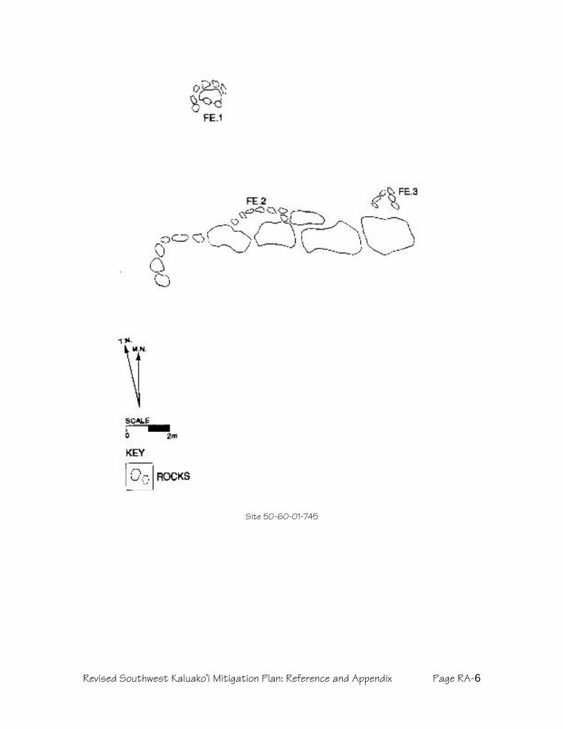
Revised Southwest Kaluako’i Mitigation Plan: Reference and Appendix Page RA-6
Site 50-60-01-745

Revised Southwest Kaluako’i Mitigation Plan: Reference and Appendix Page RA-7
Site 50-60-01-746

Revised Southwest Kaluako’i Mitigation Plan: Reference and Appendix Page RA-8
Site 50-60-01-749

Revised Southwest Kaluako’i Mitigation Plan: Reference and Appendix Page RA-9
Site 50-60-01-755

Revised Southwest Kaluako’i Mitigation Plan: Reference and Appendix Page RA-10
Site 50-60-01-760
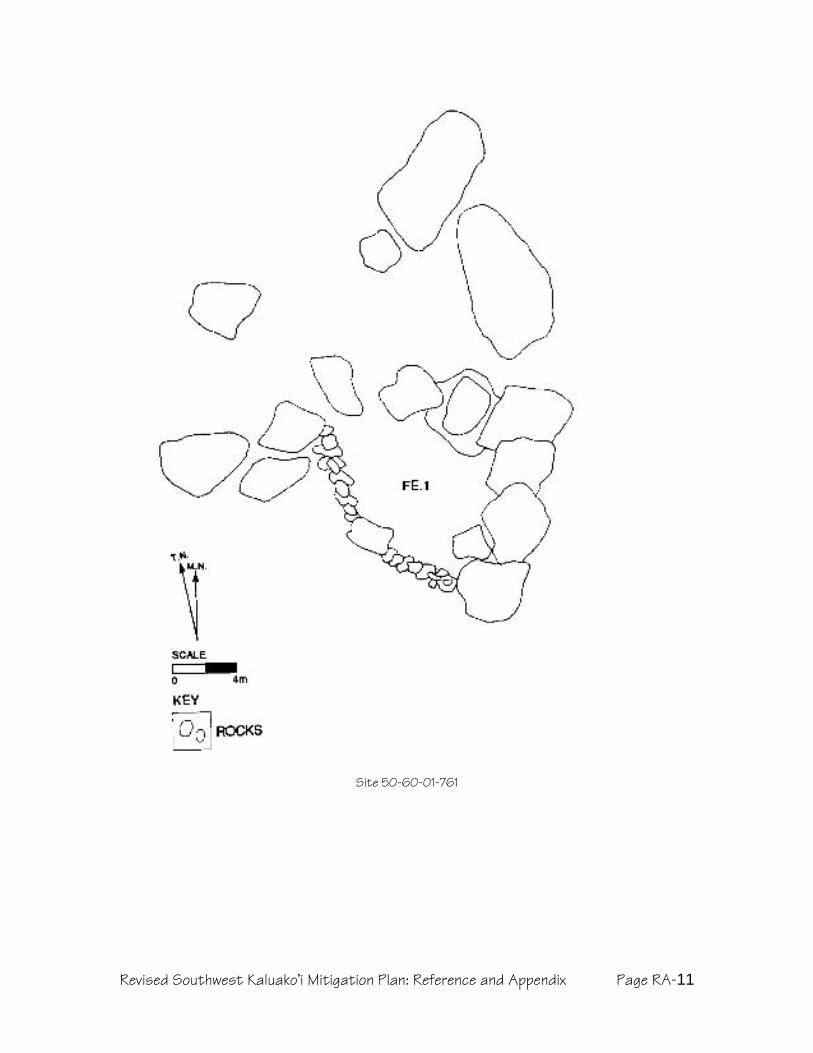
Revised Southwest Kaluako’i Mitigation Plan: Reference and Appendix Page RA-11
Site 50-60-01-761

Revised Southwest Kaluako’i Mitigation Plan: Reference and Appendix Page RA-12
Site 50-60-01-762

Revised Southwest Kaluako’i Mitigation Plan: Reference and Appendix Page RA-13
Site 50-60-01-1118

Revised Southwest Kaluako’i Mitigation Plan: Reference and Appendix Page RA-14
Site 50-60-01-1121

Revised Southwest Kaluako’i Mitigation Plan: Reference and Appendix Page RA-15
Site 50-60-01-1124

Revised Southwest Kaluako’i Mitigation Plan: Reference and Appendix Page RA-16
Site 50-60-01-1125

Revised Southwest Kaluako’i Mitigation Plan: Reference and Appendix Page RA-17
Site 50-60-01-1130 – Features 1 through 5

Revised Southwest Kaluako’i Mitigation Plan: Reference and Appendix Page RA-18
Site 50-60-01-1131 – Feature 1

Revised Southwest Kaluako’i Mitigation Plan: Reference and Appendix Page RA-19
Site 50-60-01-1132
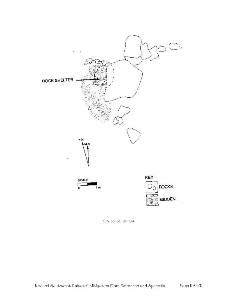
Revised Southwest Kaluako’i Mitigation Plan: Reference and Appendix Page RA-20
Site 50-60-01-1134

Revised Southwest Kaluako’i Mitigation Plan: Reference and Appendix Page RA-21
Site 50-60-01-1136
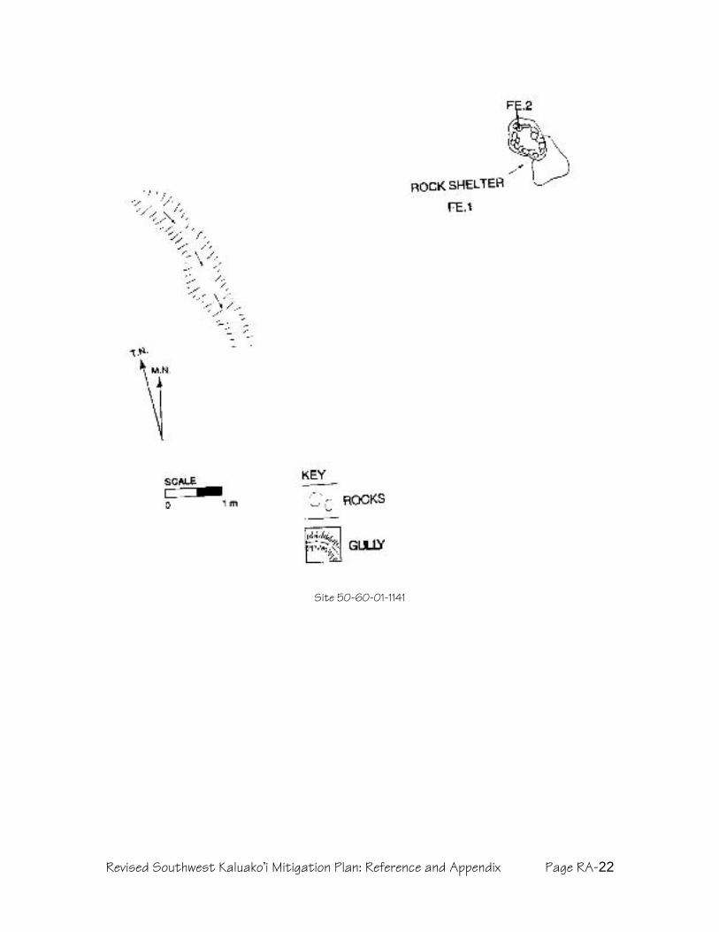
Revised Southwest Kaluako’i Mitigation Plan: Reference and Appendix Page RA-22
Site 50-60-01-1141
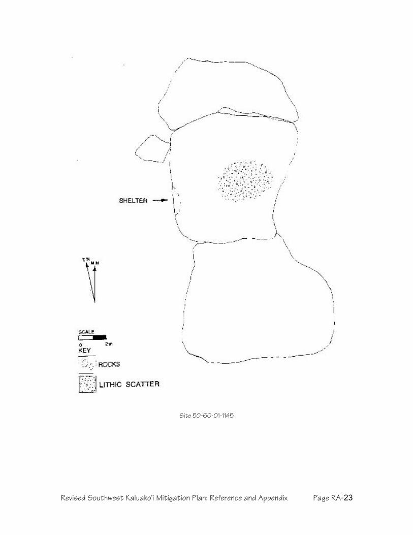
Revised Southwest Kaluako’i Mitigation Plan: Reference and Appendix Page RA-23
Site 50-60-01-1145

Revised Läÿau Subdivision Monitoring Plan Page iCultural Landscapes, July 2007
Kapukahehu to Hakina, Ahupuaÿa o Kaluakoÿi,Island o Molokaÿi(TMK 5-1-02-030)
Revised Monitoring Plan
Prepared for Molokai Properties, Limitedby
Maurice Major, MA
Cultural Landscapes Hawai`i9712 Overhill Road
Richmond, Virginia, 23229
www.culturallandscapes.net
July, 2007

Revised Läÿau Subdivision Monitoring Plan Page iiCultural Landscapes, July 2007
TABLE OF CONTENTS
Table of Contents ..................................................................................... iiList of Tables ................................................................................................ iiList of Figures .............................................................................................. iiOverview OF Läau Archaeological Plans ................................... iiiMonitoring Plan Executive Summary ...........................................vIntroduction .............................................................................................. 2
Project Area Components ................................................................................... 8Likelihood of New Finds ..................................................................................... 10
Monitoring Scope ................................................................................... 12Subdivision Project Area ................................................................................... 12Cultural Protection and Shoreline Conservation Zones ....................................... 13Rural Landscape Reserve .................................................................................. 13
Methodology ............................................................................................ 14Pre-Construction Meeting and Work Stoppage................................................... 14Consultation .................................................................................................... 14Coverage .......................................................................................................... 14Documentation ................................................................................................ 15Laboratory Work ............................................................................................... 15Monitoring Report ............................................................................................ 16Archiving Collections......................................................................................... 16Burials ............................................................................................................. 16
References .................................................................................................... 18
LIST OF TABLES
Table 1. Site Numbers and Mitigation Treatments.................................................. 4Table 2. Project Area Preservation Sites outside of Cultural Protection and ShorelineConservation Zones............................................................................................. 12Table 3. Cultural Protection and Shoreline Conservation Zone Sites within 50meters of development. ....................................................................................... 12
LIST OF FIGURES
Figure 1. Project Area Location ............................................................................. 2Figure 2. Archaeological Inventory Sites in TMK 5-1-02-030. From Dixon andMajor 1993. .......................................................................................................... 3Figure 3: Läÿau Subdivision Project area, Sites, and Cultural Protection Zones ....... 9Figure 4: Cultural Protection and Shoreline Conservation Zones at Läÿau............. 10
Revised Läÿau Subdivision Monitoring Plan Page iiiCultural Landscapes, July 2007
OVERVIEW OF LÄAU ARCHAEOLOGICAL PLANS
The archaeological plans for Läÿau include four sections for cultural resource needsthat will arise in relation to 192 sites within the proposed development andpreserves.1 The plans are:
Preservation – Procedures for protecting and preserving 157 cultural sites.2Actions range from the immediate to the perpetual, and include sitecondition evaluation, stabilization, short and long-term protection, protocoleducation, periodic field checks, and data collection. The focus is onconservation of cultural landscapes, rather than isolated sites.Data Recovery – Procedures and research issues for mapping andexcavation of 21-24 sites within the road/infrastructure corridor andproposed subdivision lots. Since the most significant sites are beingpreserved, data recovery sites mostly consist of very simple agriculturalmodifications, lithic scatters, and more recent historical sites. All sites willundergo data recovery or, more likely, preservation, and samples withinsites will be more robust than minimal SHPD requirements.Monitoring – Procedures and responsibilities for archaeological maka ÿala ofdevelopment activity. In addition to ensuring that preservation areas are notdamaged, monitoring detects previously unknown cultural deposits, andhalts work in an area, to evaluate finds, and if necessary consult with SHPDand interested parties to establish a preservation buffer or recover data.Burial Treatment – Procedures for dealing with known, suspected, andinadvertently discovered burial sites (with no revisions to the accepted 2001plan). All burials will be preserved in place, and all sites of unknownfunction for which burial is a possibility will be preserved. Newly foundburials trigger consultation with the Molokaÿi Island Burial Council.
Because the plans are interrelated, and important part of the general approach is todefine the process and sequence. The past two years of community meetings canbe considered the first phase, and with ongoing consultation helps define whathappens next. The Ranch has committed to planning for the entire project area, tomaintain or expand upon previous preservation commitments, and to have thisrevision include plans for all of the affected parcels including proposed subdivisionlots, whose future owners must also abide by the plans. The process continues:
Supplemental data collection in the road corridor to verify and augmentsite records, and search for new sites. Unexpectedly significant finds maycause re-routing. Also, the Papohaku Ranchlands section of the corridorwill be described and reported at inventory level for SHPD review.
Next, short-term preservation measures will be implemented, such asestablishing protective buffers and emergency stabilization.
Next, data recovery will be implemented. At the same time,implementation of long-term preservation measures will begin.
During the course of construction, monitoring will occur.
1 193 sites appear in Table 1 because Sites 53 and 655 refer to the same site. 12 of the 192 lackintegrity and significance and are not included in these plans.2 Of these 157, only 152 are definitely to be preserved. The remaining 5 currently are slated forData Recovery, but will be preserved if possible, and so Preservation Plans are included here tocover that option.

Revised Läÿau Subdivision Monitoring Plan Page ivCultural Landscapes, July 2007
Final reports for each plan will be submitted for community feedbackand submitted to SHPD for review as required by rules and statutes.
The original version of this plan (Kahaiawa to Hakina, Ahupuaÿa of Kaluakoÿi,Island of Molokaÿi, Major 2001) dealt with a proposed subdivision in the former“Alpha USA” parcel (TMK 5-1-2:030). Since then, a smaller proposed subdivisionhas necessitated some revisions. More fundamentally, the Ranch’s decision toengage the community in master planning has resulted in a scaled-backdevelopment with a more conservation-oriented approach, and the proposed landtrust, resource management staff, and cultural protection zones have required thatthe preservation and data recovery plans be augmented and revised. For the mostpart, the archaeological plans closely resemble the 2001 version, which wasaccepted by SHPD. Changes in the revised version include:
Re-assignment of several Data Recovery sites to Preservation.
Shift from defining buffers around individual or clustered sites to insteadestablishing a confined development corridor and preserving largeCultural Protection Zones and the shoreline.
Increased emphasis on active cultural resource management,anticipating as a neighbor a community land trust employing a culturalresource staff person.
Recommendation to collect data from preservation sites to provide abetter baseline for monitoring and help expand our understanding of thechronology and nature of settlement in the area, and specifically to guideenvironmental restoration.

Revised Läÿau Subdivision Monitoring Plan Page vCultural Landscapes, July 2007
MONITORING PLAN EXECUTIVE SUMMARY
This plan provides the monitoring for 192 sites in TMK 5-1-02:030, a parcelencompassing the southwest corner of the Kaluakoÿi Ahupuaÿa (traditional landdistrict) on the Island of Molokaÿi. State of Hawaii rules for historic monitoring(HAR 13-279) provide a framework for the plan, but community preferences and adesire on the part of the landowner to be a good steward of cultural resources havealso shaped the plan.
Planning for a proposed residential subdivision (hereafter, the “Project Area”) hasalready embodied historic preservation goals and cultural sensitivity, and thus theproject area avoids all but a few sites. The majority of preservation sites occur in six“Cultural Protection Zones,” large areas that encompass numerous individual sitesand preserve them in the context of their natural settings and their neighboringsites. This allows preservation of settlement systems, rather than isolated sites,resulting in protection of entire ancient Hawaiian cultural landscapes. Thisapproach also allows simplification of protective buffers, replacing a tangle of site-specific boundaries with a small number of larger buffers. Similarly, the ShorelineConservation Zone surrounds the entire coastline makai of the project area, andprotects most of the sites not already in one of the Cultural protection Zones.
In keeping with the regulatory requirements for Monitoring Plans (HAR 13-279-4),this document specifies the sites to be protected, the types and locations of culturaldeposits that could be discovered during monitoring, the protection anddocumentation measures to be followed, the monitor’s authority to halt work, apre-construction meeting to ensure that project personnel are informed ofmonitoring protocols, the type of expected laboratory work, report preparation, andarchiving of any collections.
The initial focus of monitoring will be on protection of Preservation sites within oradjacent to the proposed road corridor or subdivision construction. These will bebuffered and fenced as described in the Preservation Plan (Major 2007), andarchaeological monitors will be responsible for maintaining those buffers duringconstruction.
The second monitoring task consists of inspecting any ground-breaking activity inthe Project Area to search for traces of cultural materials, deposits, or features;these will be documented, and in some cases may be protected. Monitors will havethe authority to halt work in the vicinity of any inadvertent find while that find isevaluated, necessary consultations are completed, and a final treatment isspecified.
The final phase consists of site condition monitoring in preservation areas(individual preservation sites, Cultural Protection Zones, and the ShorelineConservation Zone). This does not involve traditional construction monitoring, andinstead will be a process of examining sites to evaluate their stability and integrityrelative to baseline site descriptions put together as the Preservation Plan isimplemented.

Revised Läÿau Subdivision Monitoring Plan Page 1Cultural Landscapes, July 2007

Revised Läÿau Subdivision Monitoring Plan Page 2Cultural Landscapes, July 2007
INTRODUCTION
Figure 1. Project Area Location
This Monitoring Plan comprises one component of a set of integrated mitigationplans for TMK 5-1-02:030, a portion of which is being proposed for residentialsubdivision. The three types of monitoring covered in this plan represent interimand long term activities intended to enhance the preservation programs, complywith state rules for archaeological monitoring (HAR 13-279), and provideimmediate response to inadvertent finds. These types of monitoring activityinclude:
Site protection
Documentation and evaluation of inadvertent finds during construction
Site integrity and condition assessment.
Most sites within the project area will be preserved—152 compared to 138 in the2001 plan and 46 originally recommended in the 1993 inventory report, anincrease of 330%. In addition, eleven sites considered “not significant” in the 1993report will be preserved by default, due to their locations within the ShorelineConservation Zone, Cultural Protection Zones, or the Rural Landscape Reserve.3Finally, five sites (738, 761, 1125, 1136, and 1145) that have been recommendedfor Data Recovery may be preserved once their precise location in relation tosubdivision lots and the road corridor be determined. Conceivably, then, the totalnumber of sites to be preserved may be as high as 167, a 363% increase over the1993 recommendation, and 87% of the total number (192) of sites in the overallparcel.
Perhaps the most profound change embodied in this revision, though, is change inoutlook from the traditional practice of defining a site and surrounding it with aprotective buffer to defining a development area with few or no sites and enclosingit within what the Cultural Committee came to call a “bubble.” By reversing theapproach from “Keep out of the fenced sites” to “Do not stray beyond thedevelopment corridor,” the current plans should result in two major preservationbenefits: reduction of inadvertent archaeological finds, and increased preservationof cultural landscapes rather than site “islands” in a sea of development.Monitoring forms an important component of this overall approach to preservationin a development context, since it is monitoring that will protect these culturallandscapes.
3 These sites include: 677, 740, 759, 766, 767, 781, 1129, 1137, and 1138 in the RLR, 1165 in theHakina CPZ, and 1140 in the SCZ.

Revised Läÿau Subdivision Monitoring Plan Page 3Cultural Landscapes, July 2007
Figure 2. Archaeological Inventory Sites in TMK 5-1-02-030. From Dixon and Major 1993.
Figure 2 (above) depicts the sites located during archaeological inventory of theproperty encompassing the Project Area, using the Bishop Museum site numbersassigned in the early 1990s. Figure 3, a larger folio map attached with this plan,provides the State of Hawaiÿi site numbers, with their locations relative to theProject Area. As that map shows, the large majority of sites within TMK 5-1-02:030are located outside the Project Area, and therefore are not at risk duringdevelopment.

Revised Läÿau Subdivision Monitoring Plan Page 4Cultural Landscapes, July 2007
Table 1. Site Numbers and Mitigation Treatments
State Number(50-60-01-)
Bishop MuseumNumber(50-Mo-)
Pres
erve
Dat
aRe
cove
ry
No
Act
ion
48 B6-61 X49 B6-62 X50 B6-63 X50 B6-64 X51 B6-65 X52 B6-66 X53 B6-68 and -97 X54 B6-69 to -73 X56 B6-76 and -77 X57 B6-78 X639 B6-67 X640 B6-74 X641 B6-83 X642 B6-84 X643 B6-85 X644 B6-86 X645 B6-87 X646 B6-88 X647 B6-89 X648 B6-90 X649 B6-91 X650 B6-92 X651 B6-93 X652 B6-94 X654 B6-96 X655 (aka 53) B6-97 X656 B6-98 X657 B6-107 X658 B6-108 X659 B6-109 X660 B6-110 X661 B6-111 X662 B6-112 X663 B6-113 X664 B6-114 X665 B6-115 X666 B6-116 X667 B6-117 X668 B6-118 X669 B6-119 X670 B6-120 X671 B6-121 X672 B6-122 X

Revised Läÿau Subdivision Monitoring Plan Page 5Cultural Landscapes, July 2007
State Number(50-60-01-)
Bishop MuseumNumber(50-Mo-)
Pres
erve
Dat
aRe
cove
ry
No
Act
ion
673 B6-123 X674 B6-124 X675 B6-125 X676 B6-126 X677 B6-127 X678 B6-128 X679 B6-129 X680 B6-130 X681 B6-131 X682 B6-132 X683 B6-133 X684 B6-134 X685 B6-135 X686 B6-136 X687 B6-137 X688 B6-138 X689 B6-139 X690 B6-140 X691 B6-141 X692 B6-142 XX693 B6-143 X694 B6-144 XX695 B6-145 XX696 B6-146 XX697 B6-147 X698 B6-148 X699 B6-149 X736 B6-150 XX737 B6-151 X738 B6-152 ? ?739 B6-153 X740 B6-154 X741 B6-155 X742 B6-156 XX743 B6-157 X744 B6-158 X745 B6-159 X746 B6-160 X747 B6-161 X748 B6-162 XX749 B6-163 X750 B6-164 X751 B6-165 X752 B6-166 X

Revised Läÿau Subdivision Monitoring Plan Page 6Cultural Landscapes, July 2007
State Number(50-60-01-)
Bishop MuseumNumber(50-Mo-)
Pres
erve
Dat
aRe
cove
ry
No
Act
ion
753 B6-167 XX754 B6-168 X755 B6-169 X756 B6-170 X757 B6-171 X758 B6-172 X759 B6-173 X760 B6-174 X761 B6-175 ? ?762 B6-176 X763 B6-177 XX764 B6-178 X765 B6-179 X766 B6-180 X767 B6-181 X768 B6-182 X769 B6-183 X770 B6-184 X771 B6-185 X772 B6-186 X773 B6-187 X774 B6-188 X775 B6-189 X776 B6-190 X777 B6-191 X778 B6-192 X779 B6-193 X780 B6-194 X781 B6-195 X782 B6-196 X1100 B5-59 X1101 B5-60 X1102 B5-62 X1103 B5-63 X1104 B5-64 X1105 B5-65 X1106 B5-66 X1107 B5-67 X1109 B5-69 X1110 B5-70 X1111 B5-71 X1112 B5-72 X1113 B5-73 X1114 B5-74 X1115 B5-75 X

Revised Läÿau Subdivision Monitoring Plan Page 7Cultural Landscapes, July 2007
State Number(50-60-01-)
Bishop MuseumNumber(50-Mo-)
Pres
erve
Dat
aRe
cove
ry
No
Act
ion
1116 B5-76 X1117 B5-77 X1118 B5-78 X1119 B5-79 X1120 B5-80 X1121 B5-81 X1122 B5-82 XX1123 B5-83 XX1124 B5-84 X1125 B5-85 ? ?1126 B5-86 X1127 B5-87 X1128 B5-88 X1129 B5-89 X1130 B5-90 X1131 B5-91 X1132 B5-92 X1134 B5-93 X1135 B5-94 X1136 B5-95 ? ?1137 B5-96 X1138 B5-97 X1139 B5-98 XX1140 B5-99 X1141 B5-100 X1142 B5-101 X1143 B5-102 X1144 B5-103 X1145 B5-104 ? ?1146 B5-105 X1147 B5-106 X1148 B5-107 XX1149 B5-108 X1150 B5-109 X1151 B5-110 XX1152 B5-111 X1153 B5-112 XX1154 B5-113 X1155 B5-114 X1156 B5-115 X1157 B5-116 X1158 B5-117 X1159 B5-118 X1160 B5-119 X

Revised Läÿau Subdivision Monitoring Plan Page 8Cultural Landscapes, July 2007
State Number(50-60-01-)
Bishop MuseumNumber(50-Mo-)
Pres
erve
Dat
aRe
cove
ry
No
Act
ion
1161 B5-120 X1162 B5-121 X1163 B5-122 X1164 B5-123 X1165 B5-124 X1166 B5-125 X1167 B5-126 X1168 B5-127 X1169 B5-128 X1170 B5-129 X1171 B5-130 X1172 B5-131 XX1173 B5-132 X1174 B5-133 X1175 B5-134 X1176 B5-135 X
NOTE: Treatments with an outlined X outlined X signal post-2002 changes in status from Data Recovery toPreservation status. Sites slated for Inventory will all be recommended for Preservation. Questionmarks (?) indicate sites currently recommended for Data Recovery that may change to Preservation,pending precise site location.
Project Area Components
The physical scope of the cultural resource management plans in this seriesremains limited to those portions of Kaluakoÿi ahupuaÿa that could be directlyaffected by the proposed subdivision (hereafter referred to as the “LäÿauSubdivision”), rather than all lands affected by the recent community planningprocess. Specifically, the revised cultural resource plans focus on the 1,492-acreproject area described in the Ranch’s petition to the State Land Use Commission,which requests a 613-acre area to be changed from Agricultural to Ruraldesignation, 10 acres from Conservation to Rural (for a park), and 252 acres fromAgricultural to Conservation.
In addition, this plan covers a proposed Rural Landscape Reserve, whichcorresponds to the remainder of TMK 5-1-02:030, the 6,350-acre parcel surveyedin 1991. All of the proposed Läÿau Subdivision lots will derive from that originalparcel, although development activity will affect only a limited portion of it—400acres of house lots and 153 acres of roads, infrastructure and parks, or less than10% of the original parcel area.
A combination of official zones and project-specific landscape designations havebeen adopted as a way of managing cultural resources.
The Project Area covers approximately 400 acres, and consists of threecomponents:
Revised Läÿau Subdivision Monitoring Plan Page 9Cultural Landscapes, July 2007
o Road Corridor – All areas potentially affected by construction of theroad and any adjacent utilities. As many as six preservation sites arein or near this corridor, but will be protected.
o Subdivision Lots – All lots designated in the Läÿau Point Subdivision,including any where community-level facilities may be constructed.No preservation sites lie within lots, although some site buffers mayextend into lots, and will be duly protected.
o Undeveloped Land – Areas within the Project Area, but outside of theRoad Corridor and Subdivision Lots. The only preservation sites inthis area that are not dealt with in the SCZ or CPZ categories beloware three suspected burials at the southeastern end of the ProjectArea.
The Shoreline Conservation Zone (SCZ) fringes the entire Project Area andis subject to multiple jurisdictions, rules and statutes within its 465 acres. Itmerits special attention archaeologically because of the richness, diversity,and potential vulnerability of sites there.
Cultural Protection Zones (CPZ) have been devised as a means ofprotecting cultural and archaeological sites by encompassing their largerlandscape settings. This preservation zone overlay will direct immediate andlong-term land use in areas where cultural resources are concentrated. Themajority of sites in TMK 5-1-02-030 are in CPZs, which extend to theProject Area and Shoreline Conservation Zone in several places. The totalarea of these areas will exceed 1,000 acres.
The Rural Landscape Reserve (RLR) comprises the remainder of TMK 5-1-02-030, and therefore is outside of the Project Area. There are 11 significantsites in this area, five of which are being preserved.
SEE ATTACHED FOLIO MAPFigure 3: Läÿau Subdivision Project area, Sites, and Cultural Protection Zones

Revised Läÿau Subdivision Monitoring Plan Page 10Cultural Landscapes, July 2007
Figure 4: Cultural Protection and Shoreline Conservation Zones at Läÿau.
Likelihood of New Finds
Areas where monitoring would have the highest probability of encountering newfinds have been eliminated from the Road Corridor and Subdivision Lots. Allavailable data indicate that these development areas exclude the settings with thehighest opportunity for new finds, such as the coastal flat and dunes, gulchinteriors, and quarried ridges. Settlement patterns and traditional land use has beendiscussed in detail in the Preservation Plan (Major 2007), but can be summarized

Revised Läÿau Subdivision Monitoring Plan Page 11Cultural Landscapes, July 2007
in this way: stable settlement concentrated on the bays of the west coast, in what isnow the Läÿau Point lighthouse parcel (outside the scope of this project), and alongthe south coast at the eastern end of the Project Area. The size, diversity, andquantity of archaeological features decreases rapidly mauka of the coastal flat andthe cliffs and finger ridges immediately above it. The large majority of sites morethan 100-m from the current shoreline are either part of the large Kamäkaÿipöalluvial flat settlement, or are associated with agricultural use of the gulches (wheresoil and water are more abundant) and quarrying activity on selected ridges. Othersites are ancillary to these functions (such as trail markers or temporaryhabitations), or reflect modern hunting activity. The exception to this pattern occursat Sites 1127 and 1128, which appear to be ritual sites associated with birth.
Sites mauka of the immediate coastal settlement zone tend to have extremelylimited cultural materials. Excavations conducted during inventory revealed apattern of very short term occupation for the most part, although the moredeveloped quarry areas showed repeated occupations, and sometimes very largequantities of debitage (Dixon and Major 1993, Dixon et. al, 1995). However, eventhe more abundant deposits did not exhibit much diversity of cultural materials.
Monitoring during construction of an ecotourism camp at Kaheu Bay (commonlyknown as the location of Kaupoa House, a historic Molokai Ranch retreat) revealedthat the features on the southern and mauka periphery of the coastal settlementthere were agricultural in function. Despite constant monitoring of grading anduprooting of hundreds of trees there, almost no cultural materials were found(Major 1998). Along with the surface data from the inventory, this observationprovides evidence that cultural deposits are rare outside of the settlementcomplexes.
Historic over-grazing by livestock and a large naturalized deer population hasfacilitated extensive wind and rainfall-induced erosion in southwest Kaluakoÿi,resulting in large areas that lack intact soil or sediment. No precise estimate on theeroded area is available, but widespread presence of deflated surfaces is evident,and hardpan is frequently exposed. Along with the decrease in feature density asdistance from the coast increases, this factor reduces the likelihood ofarchaeological monitors encountering new finds. Monitoring at Kaupoa revealedfrequent lenses of ash indicative of widlfire, another factor in the de-vegetation anderosion of sediments in the proposed monitoring area.
Expectations for monitoring are that finds will be infrequent and isolated. Thesettings most likely to yield cultural materials will be gulch interiors (where buriedagricultural modifications or sediments may occur), and possible outliers to thequarries, where flakes or other lithic debitage may occur either buried in sedimentsor on deflated surfaces previously obscured by vegetation.
Despite the relatively limited expectations for archaeological finds, monitoring willbe done when ground disturbing activity occurs within all of TMK 5-1-02:030.This was specifically requested by OHA, reflecting a strong preservationistsentiment that is common in the Molokaÿi community.

Revised Läÿau Subdivision Monitoring Plan Page 12Cultural Landscapes, July 2007
MONITORING SCOPE
Subdivision Project Area
Within the Project Area boundary are 26 sites requiring monitoring because theyare designated for Preservation and are within 50 meters of possible constructionareas. An additional three sites (1125, 1136, and 1145) currently slated for DataRecovery that will be preserved if possible, and may be subject to protectivemonitoring as well. Other sites in the Project Area are either Data Recovery sites, orare well outside the area of potential impacts, and do not require protectivemonitoring. Procedures for establishing buffers and other interim protectivemeasures have been specified in the Preservation Plan.
Table 2. Project Area Preservation Sites outside of Cultural Protection andShoreline Conservation Zones.
Site Number 50-60-01-
744 1144 1155
Table 3. Cultural Protection and Shoreline Conservation Zone Sites within 50meters of development.
Site Number 50-60-01-
57 664 739 751 752 754 763 764
765 780 782 1101 1106 1107 1112 1122
1123 1142 1149 1150 1151 1152 1154
Monitoring in the Project Area will also include observation of all ground-breakingactivity regardless of site proximity. Some portions of the Project Area have ahigher likelihood of encountering buried, unrecorded cultural materials, but highlikelihood areas such as the coastal sand flats, settlement peripheries, gulches, andquarries have been eliminated from the Project Area during the design process. Themonitoring scope, therefore, represents an expansion of monitoring commitmentbeyond the minimal requirements, and reflects the property owner’s sensitivity tocommunity concerns, as well as a specific request by OHA that any grounddisturbance be monitored. Monitoring outside of known site areas will focus ondocumentation and evaluation of inadvertent finds, rather than protection of knownresources.
Condition and long term monitoring of sites in the project area is described in thenext section because most of the sites also fall within a Cultural Protection orShoreline Conservation Zone. However, condition monitoring according to thseprocedures will also occur for Sites 744, 1144, and 1155, all of which are outsidesaid zones.

Revised Läÿau Subdivision Monitoring Plan Page 13Cultural Landscapes, July 2007
Cultural Protection and Shoreline Conservation Zones
As mentioned above, some sites within these zones also lie within the boundary ofthe Project Area, but both the Cultural Protection Zones (CPZ) and ShorelineConservation Zone (SCZ) group large numbers of preservation sites within largerlandscapes that extend beyond the Project Area.
Sites within these zones that could be within 50 m of development activity (i.e.,within 50 m of the proposed road or subdivision lot boundaries) have beenincluded in the Project Area section above. Those more than 50 m fromconstruction will not require protective monitoring, and the appropriate protectivemeasures have been addressed in the Preservation Plan.
Monitoring of sites in the Shoreline Conservation Zone will consist entirely ofprotective monitoring, since construction is not being proposed within that zone,and thus the potential for inadvertent finds is absent.
Because existing dirt roads may be improved for emergency access, protectivemonitoring may also be required there. These roads traverse the mauka portion ofthe Kamäkaÿipö North CPZ and the southern tip of the Kamäkaÿipö South – Kiha-a-Piÿilani CPZ (See Figure 3). The Preservation Plan has already specified that roadmaintenance in those areas should not diverge from the existing corridor, butmonitoring will occur during any grading to those roads. Sites subject to protectivemonitoring in those areas include: 678, 1127, and 1128. Additionally, monitoringins those areas will document and evaluate any inadvertent discoveries.
Monitoring will document any inadvertent discoveries within portions of the roadtraversing the Kaunalu, Kaheu, and Kamäkaÿipö North CPZ’s, as well as anygrading of the dirt roads described in the previous paragraph. Any finds will beevaluated in terms of significance, and the appropriate consultations completed asdescribed below under Methodology. Burials are very unlikely to be among thefinds, but if they occur will be subject to the Burial Treatment Plan.
Condition and integrity of sites in the SCZ and CPZ will also occur. This willconsist of periodic examination of the sites in these zones to determine whetherthey are deteriorating or stable. Data from these observations will guide long termand emergency preservation management. The specific actions involved in thistype of monitoring, as well as the intervals between inspections are describedbelow under Methodology.
Rural Landscape Reserve
Very few sites occur within the Rural Landscape Reserve, and as the PreservationPlan specifies, their treatment will consist of passive preservation. Grounddisturbance within this area will not go beyond grading of existing dirt roads, anactivity that will be monitored. The lone site that could potentially be affected byroad maintenance is 1156, a quarry adjacent to a coral-paved road at the maukaedge of TMK 5-1-02:030 (see Figure 3).
Ground disturbance associated with the development of the subdivision andemergency access to it will be monitored in the RLR, and may include protectivemonitoring at 1156. Condition and integrity monitoring is not specified for the RLRin the context of this project.
Revised Läÿau Subdivision Monitoring Plan Page 14Cultural Landscapes, July 2007
METHODOLOGY
Pre-Construction Meeting and Work Stoppage
Prior to construction commencing, the archaeologist will meet with field personneland the project manager to clarify the monitor’s role and responsibility. As theperson on site responsible for maintaining the integrity of protected areas and todocument and evaluate (and if necessary, mitigate) new discoveries, thearchaeological monitor will have the authority to call temporary work stoppages inspecified areas.
If intact cultural deposits or buried features are inadvertently discovered, themonitor will stop work in the vicinity and evaluate the finds. This will includeexamination of both the excavated sediment and the hole or graded surface. Thearchaeological monitor has the authority to propose mitigation measures, includingdata recovery excavation, site recording, or preservation and avoidance. The SHPDwill be called upon discovery of significant sites, and will review site records,significance evaluations, and treatment recommendations.
Consultation
The archaeological monitor will serve as a liaison with SHPD and/or the BurialCouncil if they need to be consulted, and will consult with members of theappropriate ethic group (Native Hawaiians, in the anticipated scenario). Finds thatcould either change the significance of a known site, or that pertain to a previouslyunrecorded site, will lead to consultation with SHPD and the appropriate ethnicgroup. Since OHA has taken a strong interest in the project and has cultural staff onMolokaÿi, they will be the initial contact with the Hawaiian community, althoughthey may ask the monitor to talk with other community members, and the monitormay find that other individuals or groups have an interest and should be consultedas well.
Because of the expedited time frame involved with finds made during construction,deciding on the requirement for mitigation and the specific form it should take willbe the responsibility of SHPD, in accordance with HAR 13-280-3, although thearchaeological monitor will make every effort to aid SHPD with input fromcommunity consultation and the monitor’s own assessment of the find.
Coverage
Should construction activities involve simultaneous ground disturbance in multipleareas having sediments with the potential to contain cultural deposits or features,additional monitors will be brought on site. It is the client’s responsibility to notifythe primary monitor (designated by the consulting archaeologist) with enough lead-time to bring in additional monitors.
If monitored construction activity in a given area has already resulted in removal orcomplete disturbance of sediment capable of containing intact cultural deposits,then subsequent work in that area may not be monitored. Such activities mayinclude excavation or grading of sterile subsoil or bedrock, as well as introductionof outside fill. To ensure that such work does not stray into an area not previouslydisturbed, the monitor may erect flagging or fencing at the outer edge of thepreviously disturbed and monitored area. If the work may involve disturbance ofany sediment capable of containing cultural materials, then monitoring will berequired.

Revised Läÿau Subdivision Monitoring Plan Page 15Cultural Landscapes, July 2007
Documentation
The monitor will examine excavated sediments, as well as the profiles and bases ofexcavated and graded areas. The excavated volume will be sorted through as muchas possible by hand, with trowels and shovels, and (where known deposits arebeing impacted, or the likelihood for undiscovered deposits is particularly high)sifted through one-quarter inch screens. Previous excavations in southwestMolokaÿi this far from the coast have yielded mostly lithic artifacts and occasionalshell, which does not require smaller mesh.
Excavation of remnant or intact features and deposits will consist of controlledhand digging by natural and cultural layers, with screening of all matrix through1/4 inch mesh, until the culturally sterile subsoil had been excavated at least 10cm. In settings where apparently sterile sediment could have been deposited over aburied cultural deposit or surface horizon, a shovel probe will be dug as deep as isrequired to demonstrate that deeper cultural deposits are not present. The total areaof excavation will be determined by the size of the buried feature or deposit.Because such excavation will constitute the final chance for controlled datarecovery, large samples will be preferred, but excavation need not be done for100% of all deposits, and the upper threshold will be determined in terms of theusefulness or redundancy of data.
The monitor will keep a field notebook describing the areas monitored and thenature of the work being monitored in each. When construction results inarchaeological finds, the monitor will document these with written descriptions ofthe types of materials encountered, their vertical and horizontal distribution, theirlocation, and any other pertinent details. All finds will be plotted on a map ofsufficient detail to pinpoint their location later. Where buried features or depositsare found and enough remains intact to do so, profiles will be drawn to scale andphotographed. The sediment matrix containing artifacts, cultural layers, or buriedfeatures will be described according to standard practice in Hawaiian archaeology.Although such finds are not anticipated, those which reveal a horizontal shape willbe mapped to scale in planview.
Laboratory Work
The majority of processing, describing, and analysis of materials collected duringthe project will be done on Molokaÿi. Few specialized analyses are likely to berequired, and the bulk of lab tasks will be to measure, weigh, photograph, anddescribe the materials, which are likely to be dominated by basalt debitage. Thebasic task will be to build a quantitative and qualitative data table for theMonitoring Report.
Because of the desire to have a broader foundation for interpretation, as well as theLand Trust’s desire to re-vegetate areas with native (and possibly Polynesianintroduced) species, charcoal will be of particular importance. It will be separatedfrom non-charcoal, dried, and stored in foil according to each collection context.Once entered in the collections log (see Archiving Collections below), selectedcharcoal samples will be sent to an outside lab for taxonomic identification. Someof these will be sent to another lab for radiometric dating, most likely by theaccelerator mass spectroscopy technique given the anticipated small sample size.The bases for this selection will be: confidence in the recovery context, apreference for feature contexts (or other well-defined events to be dated) ratherthan general layers, short-lived taxa (to avoid in-build “old wood” ages), andrelevance to interpreted areas and themes.
Revised Läÿau Subdivision Monitoring Plan Page 16Cultural Landscapes, July 2007
Basalt flakes and other debitage will form the majority of the collection. Given theknown importance of west Molokaÿi as a lithic resource area, the MonitoringReport will endeavor to draw whatever conclusions it may about the procurementof stone from the area, the degree to which it was worked there, whether anyindications of local use are apparent, and whether our understanding of the processof lithic production can be expanded based on the data. If resources allow, samplesmay be sent to the University of Hawaiÿi at Hilo, which has the facilities to dononinvasive geochemical source analysis on basalt. This has some potential toreveal stone from outside sources, although that is not expected, and instead wouldcontribute to the statewide awareness of lithic quarry distribution.
Monitoring Report
At the conclusion of archaeological monitoring, the project Principal Investigatorwill prepapre a report, to include all of the elements described in HAR 13-279-5.
Archiving Collections
It is not anticipated that a large volume of material will be collected duringarchaeological monitoring. Those that are recovered, however, will be maintainedas a single project collection, and will be kept on the island. The total volume isexpected to be less than 2 cubic feet, and thus can probably be stored in a singlebox. While the exact location has not been determined, it is likely to be in aMolokai Ranch or Molokai Properties office in Maunaloa, the closest securefacilities to the project area. Prior to completion of the monitoring, the collectionsmay be housed in the Molokaÿi office of the archaeological monitoring firm. Inboth cases, the collection shall be kept in a matter that protects the materials fromloss or deterioration.
Collections shall be stored in bags, foil, or other containers bearing basicinformation to include (at a minimum) the site and feature number, a uniquenumber (assigned to individual specimens or lots), the stratigraphic contextdesignation (either “surface,” a layer number, or a feature designation), the name ofthe specimen type, and the date collected. A log of all collected artifacts andsamples must me maintained by the monitor. This will include the fields namedabove, as well as the material type, the collector, and comments. The log will alsoprovide a means to note when objects or samples are removed for analysis,community education, or any other reason, it will specify when and why anythingis removed, and to whom it went. Artifacts should not be removed from the Islandof Molokaÿi.
The exception to this will be any materials that must be sent elsewhere for analysis,such as wood charcoal that must be sent to laboratories on Oÿahu, the mainland,and Hawaiÿi Island for taxonomic identification and radiometric dating of charcoaland geochemical sourcing of stone. It is expected that radiometric dating will bedone on at least a small number of samples, and since the process consumes thecharcoal, it will not be returned to the collection.
Burials
Should human remains be encountered, construction in the vicinity will be stoppedwhile the SHPD Burials Program and the Molokaÿi Island Burial Council arenotified and consulted. The preferred treatment for burials will be to preserve themin place and divert development around them. It is not likely that burials will beencountered during this project, but if they are, the general Burial Treatment Plan

Revised Läÿau Subdivision Monitoring Plan Page 17Cultural Landscapes, July 2007
will be amended to reflect the specifics of each case. Rules for the treatment ofhuman remains (HAR 13-300) are the basis for that plan and for any actions takenin the field.
The landowner and community both have expressed a strong desire to avoidremoval and reinterrment of burials, and the preferred option should any such findoccur will be in situ preservation.

Revised Läÿau Subdivision Monitoring Plan Page 18Cultural Landscapes, July 2007
REFERENCES
Bonk,William1954 Archaeological Excavations On West Molokai. Master of Arts
Thesis, Department of Anthropology, University of Hawaii.
Burtchard, Greg and Stephen Athens2000 “Archaeological Reconnaissance of the Päpöhaku Aerial Gunnery Range
Kaluakoÿi Ahupuaÿa, Island of Molokaÿi, Hawaiÿi.” Ms. prepared byInternational Archaeological Research institute, Inc.
Cooke, George P.1949 Mo'olelo O Molokai: A Ranch Story of Molokai. Honolulu Star
Bulletin, Honolulu.
Cooke, Sophie1961 Sincerely, Sophie. Tongg Publishing. Honolulu.
Dixon, Boyd and Maurice Major1993 "Kapukahehu to Pu`uhakina: An Archaeological Inventory Survey of
Southwest Moloka`i." Ms. in Anthropology Department, Bishop Museum.
Dixon, Boyd, Maurice Major, Michael Price, Alan Carpenter, Cary Stine, BruceLongton1994 "Lithic Tool Production and Dryland Planting Adaptations to regional
Agricultural Intensification: Preliminary Evidence from Leeward Moloka`i,Hawai`i." Bishop Museum Occasional Papers No. 39. Bishop MuseumPress: Honolulu.
Dye, Tom, Marshall Weisler, and Mary Riford1985 “Adz Quarries On Moloka`i And Oahu, Hawaiian Islands.” Bernice P.
Bishop Museum, Honolulu.
Fowke, Gerardn.d. Archaeological Work in Hawaii. Bureau of American Ethnology Bulletin No.
76: 174-195
Handy, Edward S. C., Elizabeth Handy and Mary K. Pukui1972 Native Planters of Old Hawaii: Their Life, Lore, and Environment. Bernice
Pauahi Bishop Museum Bulletin No. 233. Bishop Museum Press, Honolulu.
Jenson, P.1988 “Archaeological Resource Assessment, Alpha Hotels 7000-Acre West Molokai
Parcel.” Prepared by Paul H. Rosendahl, Inc. Ms. on file in HistoricPreservation Division, Kapolei.
Kaimikaua, Johnn.d. “Kaluakoÿi—The Adze Quarries” Molokai Dispatch Newspaper. June 26.
Page 41988 Oral History. Interviewed by Philip Spalding III
Revised Läÿau Subdivision Monitoring Plan Page 19Cultural Landscapes, July 2007
Kamakau, Samuel M.1992 Ruling Chiefs of Hawaiÿi. Revised edition. Kamehameha Schools, Honolulu.
Kirch, Patrick1985 Feathered Gods and Fishhooks. University of Hawaii Press, Honolulu.
Major, Maurice1997 "Preservation Plan for Kaupoa Camp, Kaluako`i, Moloka`i." Ms. prepared for
Molokai Ranch, Ltd. by Cultural Landscapes Hawai`i, Honolulu.2000 “Archaeological Inventory Survey at Kukui Summit, Ahupuaÿa of
Kaluakoÿi, Molokaÿi.” Ms. on File in State Historic Preservation Division,Kapolei.
2001 “Kahaiawa to Hakina, Ahupuaÿa of Kaluakoÿi, Island of Molokaÿi (Portionof TMK 5-1-02-030): Archaeolgical Mitigation Plans” Ms. on File in StateHistoric Preservation Division, Kapolei.
2002 “Southwest Molokaÿi Mitigation Plan Addendum” Ms. on File in StateHistoric Preservation Division, Kapolei.
Major, Maurice and Boyd Dixon1992 "Archaeological Reconnaissance Survey from Haleolono to Kaumanamana
Point, Kaluako`i, Moloka`i, Hawai`i." Ms. in Anthropology Department,Bishop Museum.
Major, Maurice and Tracy Tam Sing
1998 "Supplemental Archaeological Inventory Survey of a Portion of the PublicAccess Trail at Kapukahehu, Kaluako`i, Moloka`i." Ms. on file in StateHistoric Preservation Division, Honolulu.
Malo, David1951 Hawaiian Antiquities. Bishop Museum Press, Honolulu.
Menzies, Archibald1920 Hawaii Nei 120 Years Ago. W. F. Wilson, Honolulu.
Nakuina, Moses (Esther Mookini and Sarah Nakoa, translators)1992 The Wind Gourd of Laÿamaomao: The Hawaiian Story of Pakaÿa and Ku-a-
pakaÿa. Second edition. Kalamaku Press, Honolulu.
Phelps, Southwick1941 "A Regional Study Of Molokai, Hawaii." Ms. in Bishop Museum Archives,
Honolulu.
Stokes, John F. G.1909 "Molokai, Survey of Heiau." Ms. in Bishop Museum Archives, Honolulu.
Strong, Hal1971 “A Preliminary Survey of Kamakaipo Gulch Habitation Area, Molokai.” MS
on file, University of Hawaiÿi
Summers, Catherine1971 Molokai: Site Survey. Pacific Anthropological Records No. 14. Department
of Anthropology, Bernice Pauahi Bishop Museum, Honolulu.

Revised Läÿau Subdivision Monitoring Plan Page 20Cultural Landscapes, July 2007
Weisler, Marshall1984 “Impressions of Prehistory: An Archaeological Survey of Selected Area of
Southwest Molokaÿi, Hawaiian Islands.” Department of Anthropology,Bishop Museum, Honolulu.

Papohaku to Hakina, Ahupuaÿa o Kaluakoÿi,Island o Molokaÿi(TMK 5-1-02-030)
Revised Preservation Plan
Prepared for Molokai Properties, Limitedby
Maurice Major, MA
Cultural Landscapes Hawai`i9712 Overhill Road
Richmond, Virginia, 23229
www.culturallandscapes.net
July, 2007

Table of ContentsTable of Contents .................................................................................................. iiList of Tables ......................................................................................................... iiList of Figures ........................................................................................................ iiOverview OF Läÿau Archaeological Plans............................................................. iiiPreservation Plan Executive Summary ....................................................................vIntroduction .......................................................................................................... 1
Organization of this Plan ................................................................................... 1Historic Preservation Review History ................................................................. 2Project Area Components .................................................................................. 8Environmental Setting ........................................................................................ 9History and Archaeology ................................................................................. 12
Proposed Site Mitigation Measures ...................................................................... 17Consultation........................................................................................................ 23Preservation Goals .............................................................................................. 26Preservation Phases ............................................................................................. 28
Ongoing – Communication and Evaluation...................................................... 28Phase I – Relocate and Verify Archaeological Sites........................................... 28Phase II – Re-evaluate Sites and Prioritize Actions............................................ 29Phase III – Stabilization and Protection ............................................................ 29Phase IV – Data Collection and Permanent Barriers ......................................... 30Phase V – Management Plan and Detailed Interpretive Plan............................. 30
Preservation Actions............................................................................................ 31General Preservation Categories ...................................................................... 31Supplemental Data Collection ......................................................................... 32
Road Corridor .............................................................................................. 32Subdivision Lots and Coastal Zone ............................................................... 34
Establishing Site Buffers ................................................................................... 34Zone Buffers................................................................................................. 35Site-specific Buffers ...................................................................................... 36
Short Term Measures ....................................................................................... 37Temporary Fencing and Protection............................................................... 37Evaluate Stability.......................................................................................... 38Recover Eroded Data ................................................................................... 38
Long Term Measures........................................................................................ 38As-Is Preservation......................................................................................... 38Mapping ...................................................................................................... 38Physical Stabilization ................................................................................... 39Vegetative Stabilization................................................................................ 39Permanent Boundary.................................................................................... 39Interpretation ............................................................................................... 40Protocol Education....................................................................................... 41Management Plan ........................................................................................ 41Appropriate Cultural Use ............................................................................. 41
Site-Specific Plans ............................................................................................... 42Rural Landscape Reserve ................................................................................. 46Sites in the Shoreline Conservation Zone ......................................................... 47Sites in the Proposed Subdivision Project Area................................................. 48Cultural Protection Zones ................................................................................ 50
Kaunalu ....................................................................................................... 52

Revised Läÿau Subdivision Preservation Plan Page iiCultural Landscapes, July 2007
Kaheu .......................................................................................................... 52Kamäkaÿipö North........................................................................................ 53South Kamäkaÿipö – Kiha-a-Piÿilani .............................................................. 54Läÿau Point................................................................................................... 55Puÿu Hakina................................................................................................. 56
References .......................................................................................................... 58Appendices ......................................................................................................... 61
Inventory Data for Preservation Sites................................................................ 61Selected Site Maps........................................................................................... 68Sample Text For Signs.................................................................................... 137
List of TablesTable 1. Site Conversions and Mitigation Treatments .......................................... 18Table 2. Site Preservation Measures..................................................................... 43Table 3. Preservation Sites in the Rural Landscape Reserve.................................. 47Table 4. Preservation Sites within the Shoreline Conservation Zone..................... 47Table 5. Preservation Sites within the Project Area .............................................. 49Table 6. Preservation Sites within Kaunalu CPZ................................................... 52Table 7. Preservation Sites within Kaheu CPZ...................................................... 53Table 8. Preservation Sites within Kamäkaÿipö North CPZ ................................... 53Table 9. Preservation Sites within South Kamäkaÿipö – Kiha-a-Piÿilani CPZ.......... 55Table 10. Preservation Sites within Läÿau Point CPZ ............................................ 56Table 11. Preservation Sites within Puÿu Hakina CPZ........................................... 56Table 12. Archaeological Inventory Site Data ...................................................... 61
List of FiguresFigure 1. Project Area Location ............................................................................. 2Figure 2: Southwest Molokai Archaeological District sites and areas...................... 3Figure 3. Archaeological Inventory Sites in TMK 5-1-02-030.. ............................... 4Figure 4. Sites located in the Papohaku Gunnery Range. ....................................... 6Figure 5: Läÿau Subdivision Project area, Sites, and Cultural Protection Zones ....... 8Figure 6. Trail marker at North Kamäkaÿipö ......................................................... 12Figure 7. Previous archaeological study areas...................................................... 15Figure 8. Site 771, a multi-room enclosure on a ridge above Kamäkaÿipö.. .......... 16Figure 9: Cultural Protection and Shoreline Conservation Zones at Läÿau............. 26
NOTE: Inventory Site Maps in order of site number appear in Appendix B

Revised Läÿau Subdivision Preservation Plan Page iiiCultural Landscapes, July 2007
Overview OF Läÿau Archaeological PlansThe archaeological plans for Läÿau include four sections for cultural resource needsthat will arise in relation to 192 sites within the proposed development andpreserves.1 The plans are:
Preservation – Procedures for protecting and preserving 157 cultural sites.2Actions range from the immediate to the perpetual, and include sitecondition evaluation, stabilization, short and long-term protection, protocoleducation, periodic field checks, and data collection. The focus is onconservation of cultural landscapes, rather than isolated sites.Data Recovery – Procedures and research issues for mapping andexcavation of 21-24 sites within the road/infrastructure corridor andproposed subdivision lots. Since the most significant sites are beingpreserved, data recovery sites mostly consist of very simple agriculturalmodifications, lithic scatters, and more recent historical sites. All sites willundergo data recovery or, more likely, preservation, and samples withinsites will be more robust than minimal SHPD requirements.Monitoring – Procedures and responsibilities for archaeological maka ÿala ofdevelopment activity. In addition to ensuring that preservation areas are notdamaged, monitoring detects previously unknown cultural deposits, andhalts work in an area, to evaluate finds, and if necessary consult with SHPDand interested parties to establish a preservation buffer or recover data.Burial Treatment – Procedures for dealing with known, suspected, andinadvertently discovered burial sites (with no revisions to the accepted 2001plan). All burials will be preserved in place, and all sites of unknownfunction for which burial is a possibility will be preserved. Newly foundburials trigger consultation with the Molokaÿi Island Burial Council.
Because the plans are interrelated, and important part of the general approach is todefine the process and sequence. The past two years of community meetings canbe considered the first phase, and with ongoing consultation helps define whathappens next. The Ranch has committed to planning for the entire project area, tomaintain or expand upon previous preservation commitments, and to have thisrevision include plans for all of the affected parcels including proposed subdivisionlots, whose future owners must also abide by the plans. The process continues:
Re-survey the road corridor to verify and augment site records, andsearch for new sites. Unexpectedly significant finds may cause re-routing. Also, the Papohaku Ranchlands section of the corridor will bedescribed and reported at inventory level for SHPD review.
Next, short-term preservation measures will be implemented, such asestablishing protective buffers and emergency stabilization.
Next, data recovery will be implemented. At the same time,implementation of long-term preservation measures will begin.
During the course of construction, monitoring will occur. Final reports for each plan will be submitted for community feedback
and submitted to SHPD for review as required by rules and statutes. 1 193 sites appear in Table 1 because Sites 53 and 655 refer to the same site. 12 of the 192 lackintegrity and significance and are not included in these plans.2 Of these 157, only 152 are definitely to be preserved. The remaining 5 currently are slated forData Recovery, but will be preserved if possible, and so Preservation Plans are included here tocover that option.

Revised Läÿau Subdivision Preservation Plan Page ivCultural Landscapes, July 2007
The original version of this plan (Kahaiawa to Hakina, Ahupuaÿa of Kaluakoÿi,Island of Molokaÿi, Major 2001) dealt with the former “Alpha USA” parcel (TMK 5-1-2-030). Since then, changes in the project area and the size and location ofproposed subdivision lots have necessitated some revisions. More fundamentally,the Ranch’s decision to engage the community in master planning has resulted in ascaled-back development with a more conservation-oriented approach, and theproposed land trust, resource management staff, and cultural protection zones haverequired that the preservation and data recovery plans be augmented and revised.For the most part, the archaeological plans closely resemble the 2001 version,which was accepted by SHPD. Changes in the revised version include:
Re-assignment of several Data Recovery sites to Preservation.
Shift from defining buffers around individual or clustered sites to insteadestablishing a confined development corridor and preserving largeCultural Protection Zones and the shoreline.
Increased emphasis on active cultural resource management,anticipating as a neighbor a community land trust employing a culturalresource staff person.
Recommendation to collect some data from preservation sites to providea better baseline for monitoring and help expand our understanding ofthe chronology and nature of settlement in the area, and specifically toguide environmental restoration.

Revised Läÿau Subdivision Preservation Plan Page vCultural Landscapes, July 2007
Preservation Plan Executive Summary
This plan provides the preservation treatments for 157 sites in TMK 5-1-02-030, aparcel encompassing the southwest corner of the Ahupuaÿa (traditional landdistrict) on the Island of Molokaÿi. State of Hawaii rules for historic preservation(HAR 13-277) provide a framework for the plan, but community preferences and adesire on the part of the landowner to go beyond mere compliance have alsoshaped the plan.
Planning for a proposed residential subdivision (hereafter, the “Project Area”) hasalready embodied historic preservation goals and cultural sensitivity, and thus theproject area avoids all but a few sites. The majority of preservation sites occur in six“Cultural Protection Zones,” large areas that encompass numerous individual sitesand preserve them in the context of their natural settings and their neighboringsites. This allows preservation of settlement systems, rather than isolated sites,resulting in protection of entire ancient Hawaiian cultural landscapes. Thisapproach also allows simplification of protective buffers, replacing a tangle of site-specific boundaries with a small number of larger buffers. Similarly, the ShorelineConservation Zone surrounds the entire coastline makai of the project area, andprotects most of the sites not already in one of the Cultural protection Zones.
In keeping with the regulatory requirements for Preservation Plans, this documentspecifies the sites to be protected, the scope and results of community consultation,the form of protection, how buffers will be established, interim protectionmeasures, and long term preservation measures. These appear in sections entitleConsultation and Preservation Actions. The requirement for site specificpreservation plans has been detailed in a section by that name, in which site-specific plans are shown in a table, and described in groupings corresponding totheir physical locations and management needs. In addition, the plan includeselements that are not required, but help its users understand the communityfoundations of the plan, the details of implementation, and so on. These appear inthe Introduction and sections entitled Preservation Goals, Preservation Phases,and Supplemental Data Collection.

Revised Läÿau Subdivision Preservation Plan Page 1Cultural Landscapes, July 2007
Introduction
Organization of this PlanThis Preservation Plan represents an expansion upon the minimal elementsrequired by the State of Hawaii Administrative Rules for preservation ofarchaeological and historical sites (HAR 13-277). These elements include thefollowing:
Identify the form of preservation
Specify protective buffers for sites
Specify interim or short-term protective measures
Describe the process and results of public consultation
Specify long-term protective measures
The current plan places most of these elements in the Site Specific Plans (see Tableof Contents). Because the Molokaÿi community has had much to say regardingcultural resources, and the landowner has invested substantial time and effort inseeking their opinions and advice, and because few of the public comments havedealt with specific sites, the Consultation section is presented early in the Plan, at aproject-wide level. Any consultation results specific to a site or area will berepeated in the appropriate site-specific section.
Additional sections of the Preservation Plan are presented at the project-wide levelto avoid redundancy and to provide a high level of certainty with regard to thedefinition and phasing of preservation activities proposed herein. These include thefollowing sections in order of appearance:
Introduction: Synthesizes the archaeological knowledge of the place withhistorical and cultural accounts, as well as the physical environment.Summarizes the history of cultural resource management activity for theparcel.
Consultation: Describes the process and scope of public input regardingcultural resources for the project area and surrounding lands, and presents asummary of the content.
Preservation Goals: Provides a clear statement of objectives that shape thisplan. Although not a required element, this section presents the foundationsof a plan that is shaped not just by the rules, but by community values andthe landowner’s desire to move beyond minimal requirements.
Preservation Phases and Responsibilities: Outlines the process andsequence of implementation of the plan, and states the entity responsible foreach phase.
Preservation Actions: Defines and describes each proposed activity relatedto preservation.
Site-Specific Plans: Groups sites according to geographic and managementcategories, and specifies the Buffers, Interim Measures, and Long-termMeasures for each.
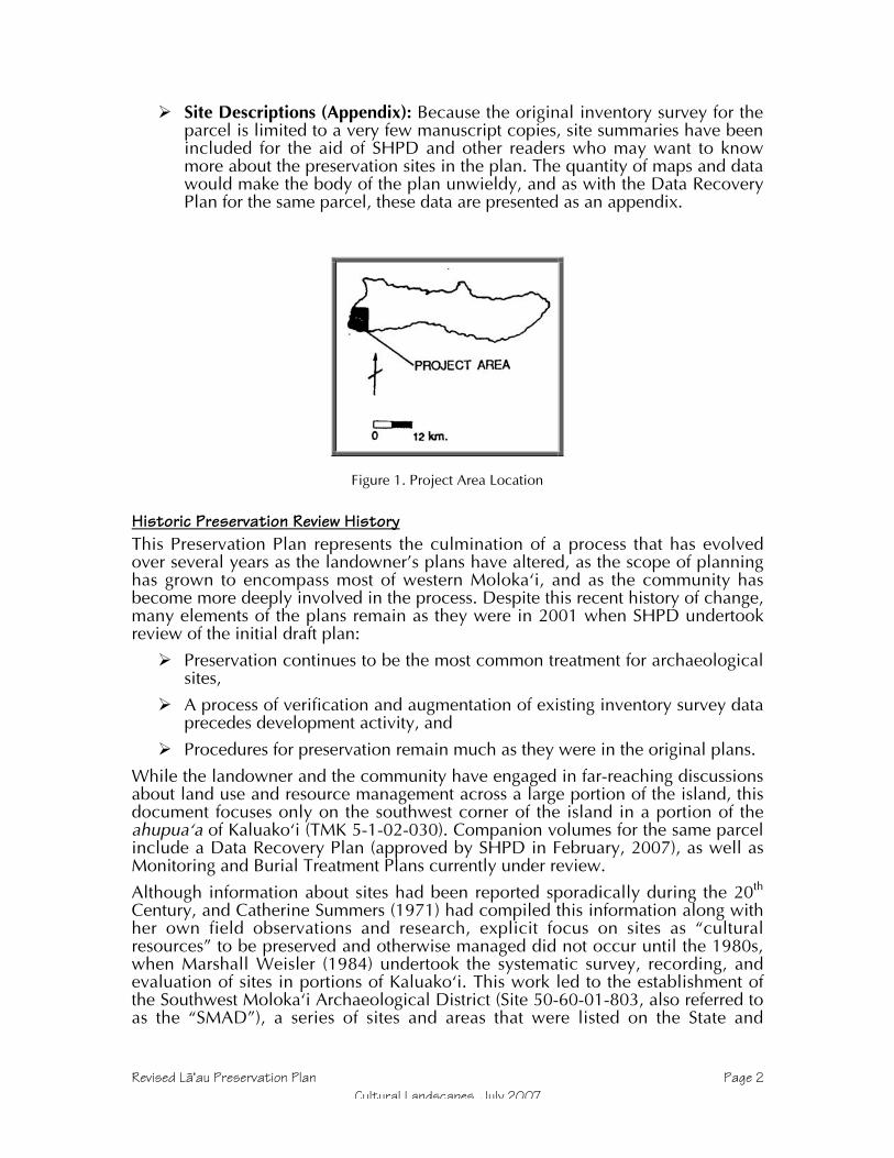
Revised Läÿau Preservation Plan Page 2Cultural Landscapes, July 2007
Site Descriptions (Appendix): Because the original inventory survey for theparcel is limited to a very few manuscript copies, site summaries have beenincluded for the aid of SHPD and other readers who may want to knowmore about the preservation sites in the plan. The quantity of maps and datawould make the body of the plan unwieldy, and as with the Data RecoveryPlan for the same parcel, these data are presented as an appendix.
Figure 1. Project Area Location
Historic Preservation Review HistoryThis Preservation Plan represents the culmination of a process that has evolvedover several years as the landowner’s plans have altered, as the scope of planninghas grown to encompass most of western Molokaÿi, and as the community hasbecome more deeply involved in the process. Despite this recent history of change,many elements of the plans remain as they were in 2001 when SHPD undertookreview of the initial draft plan:
Preservation continues to be the most common treatment for archaeologicalsites,
A process of verification and augmentation of existing inventory survey dataprecedes development activity, and
Procedures for preservation remain much as they were in the original plans.
While the landowner and the community have engaged in far-reaching discussionsabout land use and resource management across a large portion of the island, thisdocument focuses only on the southwest corner of the island in a portion of theahupuaÿa of Kaluakoÿi (TMK 5-1-02-030). Companion volumes for the same parcelinclude a Data Recovery Plan (approved by SHPD in February, 2007), as well asMonitoring and Burial Treatment Plans currently under review.
Although information about sites had been reported sporadically during the 20th
Century, and Catherine Summers (1971) had compiled this information along withher own field observations and research, explicit focus on sites as “culturalresources” to be preserved and otherwise managed did not occur until the 1980s,when Marshall Weisler (1984) undertook the systematic survey, recording, andevaluation of sites in portions of Kaluakoÿi. This work led to the establishment ofthe Southwest Molokaÿi Archaeological District (Site 50-60-01-803, also referred toas the “SMAD”), a series of sites and areas that were listed on the State and

Revised Läÿau Preservation Plan Page 3Cultural Landscapes, July 2007
National Registers of Historic Places, and therefore afforded some protectionagainst future development and alteration.
Figure 2: Southwest Molokai Archaeological District sites and areas. From Weisler 1984.

Revised Läÿau Preservation Plan Page 4Cultural Landscapes, July 2007
Figure 3. Archaeological Inventory Sites in TMK 5-1-02-030. From Dixn and Major 1993.
Several years later (in 1991), after the Japanese real estate company Alpha USA hadpurchased a 6,350-acre section of southwest Kaluakoÿi intending extensivedevelopment there, Bishop Museum’s Applied Research Group performedarchaeological survey of the parcel, describing sites well beyond those recorded byWeisler, as well as providing significance evaluations and treatmentrecommendations for each site (Dixon and Major 1993). The majority of the nearly600 recorded features in 192 sites deserved further investigation or data recovery inthe case of development plans that would have caused damage, a small number(due to more recent origin or very poor site integrity) were considered not

Revised Läÿau Preservation Plan Page 5Cultural Landscapes, July 2007
significant, and 46 sites were recommended for permanent preservation. Theinventory, evaluations, and recommendations were reviewed and accepted by theState Historic Preservation Division (SHPD) in 1994.
A decade after the Bishop Museum survey, Alpha USA had sold the property andCultural Landscapes was retained by the new owner to create a set of managementplans for the property, including a Preservation Plan, a Data Recovery Plan, aMonitoring Plan, and a Burial Treatment Plan (Major 2001). These plans provideddetailed mitigation and protection treatments for sites covered by the 1993inventory report, and were intended to minimizing impacts; meanwhile, thedevelopment plans had downsized from a large resort to a residential subdivision.Although the 1993 report recommendations served as the starting point, the newplans emphasized avoiding rather than mitigating impacts, and so the number ofsites slated for preservation grew from 46 to 138, including all of the sites outsidethe proposed subdivision as well as those between the new lots and the ocean, alarge preserve encompassing a settlement system from the shore to an inlandquarry, and sites within the proposed subdivision amounting to an estimated 10 –15% of the area within subdivision parcels.
Shortly after SHPD had reviewed the 2001 plan (the Molokaÿi Island archaeologisthad provided verbal acceptance, but an official letter had not yet been generated),the landowner decided to change the subdivision plan by altering the proposedaccess road alignment, and Cultural Landscapes produced an addendum to theplans (Major 2002). Rather than having the new road meet up with the existingroad from Maunaloa town to Hale o Lono Harbor on the eastern edge of the parcel,there would be a single entry to the subdivision from the north, from an oldsubdivision known as Papohaku Ranchlands. (Of that subdivision, shown as“Kaluakoi Estates” on some maps, the affected lots would be TMK 5-1-08-4, -5, and-14).
At that time, an archaeological reconnaissance had been carried out in thePapohaku Ranchlands subdivision for the Army, since the area had been a targetrange during and after WW II. The study’s authors believed it would not meetinventory standards, and the client had not released the report or submitted it forSHPD review at the time of the Läÿau addendum. On the basis of a draft reportrecording 27 sites (Burtchard and Athens 2000), five of which were in or near theproposed Läÿau subdivision access road, the 2002 addendum proposed inventorysurvey within 30 m of either side of the proposed road centerline. These sitesincluded one with habitation and agricultural features (Site 50-60-01-520), onehabitation (Site 1784), one agricultural site (Site 1758), an isolated lithic artifact(Site 1760), and a possible burial (Site 1761); all except for 1760 had been deemedsignificant for their information content and recommended for inventory survey(ibid). The 2002 addendum to the Läÿau plans suggested that all of these sites couldbe preserved in place, and recommended that fieldwork be done that would bringthe records up to inventory standards, but also begin implementation of sitepreservation measures such as establishing protective buffers, avoidance, andstabilization (Major 2002). Because the Papohaku Ranchlands subdivision does notyet have an accepted inventory, the current plans do not address this parcel exceptfor its contextual value.

Revised Läÿau Preservation Plan Page 6Cultural Landscapes, July 2007
Figure 4. Sites located in the Papohaku Gunnery Range archaeological reconnaissance. Access roadcorridor proposed for the Läÿau Subdivision follows Roads S, T, and U and the intervening section of
Kulawai Loop Road. Adapted from Burtchard and Athens 2000, USGS 1983 Molokai West, andMolokai Ranch maps.
The most recent period of cultural resource management has witnessed a newwillingness on the part of the landowner to engage in master planning for all oftheir holdings and a greatly increased role for the community. Since 2004, a seriesof meetings with both the general public and of smaller committees composed ofMolokai Ranch staff, representatives of various Hawaiian organizations, andinterested members of the public have worked on plans to conserve and managecultural, biological and other natural resources. The Cultural Committee formedduring this process called on Cultural Landscapes to provide information regardingsites on Ranch lands, archaeological and regulatory concerns regarding culturalresources, and planning for a much-expanded preservation program. Besides
Revised Läÿau Preservation Plan Page 7Cultural Landscapes, July 2007
further reducing the scope and potential impacts of development, this processsought to increase preservation as a cultural resource management goal byestablishing a community land trust tasked with preserving natural and culturalresources within lands deeded to it, by creating conservation easements andcultural overlay districts on privately held land, and by writing codes, covenants,and restrictions for the proposed subdivision that would help preserve sites thereinand establish procedures for a management partnership between the newpopulation of subdivision dwellers and Hawaiians who have been on Molokaÿi forgenerations.
The proposed changes in land use, a reduced footprint for the subdivision, and thenew approach toward managing cultural resources necessitated the 2006 revisionof the 2001 plans and the 2002 addendum. Many elements of the existing plansremain the same, and this set of plans simply adjusts the plans to fit the currentsituation. So while most of the preservation measures remain the same,reconfigured boundaries make the status of some sites different; for example, themost recent subdivision plan, being smaller than before, changes the status of somesites from data recovery to preservation, and others from the more protection-oriented preservation of sites within subdivision lots to the avoidance-orientedpreservation measures associated with sites outside of development areas.Responsibilities for implementation of some preservation measures have changedwith the advent of greater community participation and the proposed establishmentof a land trust employing a cultural resource staff person.
Given the more robust management program envisioned by the landowner andcommunity, some measures have been added or augmented, such as: expandeddata collection to aid preservation management and use of GPS to update sitelocations. In response to community concerns, the landowner has committed toadditional archaeological fieldwork in advance of the road corridor construction,leading to a reorganization of the workflow envisioned in the 2001 plans. Becausethe 1993 report (Dixon and Major, for TMK 5-1-02-030) completed the inventory,evaluation, and treatment recommendations for the subdivision parcel, and wasapproved by SHPD, road corridor fieldwork consists of “supplemental datacollection.” This type of archaeological investigation exceeds regulatoryrequirements, and serves the landowner’s and community’s desire that finalengineering and construction be based on an enhanced understanding of thearchaeological sites in and near the proposed development corridor, as well as theimperative to base preservation measures and interpretation upon more detailedand refined data.
For the parcels north of the parcel being subdivided (TMK 5-1-08-4, -5, and -14),road corridor survey will in fact constitute an inventory survey, and the datacollected from those areas will be prepared as a normal inventory report with sitesignificance evaluations and treatment recommendations, all of which will besubmitted to SHPD for review according to the Hawaii Administrative Rules,section 13-13-276.
Most sites within the project area will be preserved—152 compared to 138 in the2001 plan and 46 originally recommended in the 1993 inventory report, anincrease of 330%. In addition, eleven sites considered “not significant” in the 1993report will be preserved by default, due to their locations within the ShorelineConservation Zone, Cultural Protections Zones, or the Rural Landscape Reserve.3
3 These sites include: 677, 740, 759, 766, 767, 781, 1129, 1137, and 1138 in the RLR, 1165 in theHakina CPZ, and 1140 in the SCZ.

Revised Läÿau Preservation Plan Page 8Cultural Landscapes, July 2007
Finally, five sites (738, 761, 1125, 1136, and 1145) that have been recommendedfor Data Recovery may be preserved once their precise location in relation tosubdivision lots and the road corridor be determined. Conceivably, then, the totalnumber of sites to be preserved may be as high as 167, a 363% increase over the1993 recommendation, and 87% of the total number (192) of sites in the overallparcel.
Perhaps the most profound change embodied in this revision, though, is change inoutlook from the traditional practice of defining a site and surrounding it with aprotective buffer to defining a development area with few or no sites and enclosingit within what the Cultural Committee came to call a “bubble.” By reversing theapproach from “Keep out of the fenced sites” to “Do not stray beyond thedevelopment corridor,” the current plans should result in two major benefits:reduction of inadvertent archaeological finds, and increased preservation ofcultural landscapes rather than site “islands” in a sea of development.
SEE ATTACHED FOLIO MAP
Figure 5: Läÿau Subdivision Project area, Sites, and Cultural Protection Zones
Project Area ComponentsThe physical scope of the cultural resource management plans in this volumeremains limited to those portions of Kaluakoÿi ahupuaÿa that could be directlyaffected by the proposed subdivision (hereafter referred to as the “LäÿauSubdivision”), rather than all lands affected by the recent community planningprocess. Specifically, the revised cultural resource plans focus on the 1,492-acreproject area described in the Ranch’s petition to the State Land Use Commission,which requests a 613-acre area to be changed from Agricultural to Ruraldesignation, 10 acres from Conservation to Rural (for a park), and 252 acres fromAgricultural to Conservation. In addition, this plan covers the “Läÿau Mauka” RuralLandscape Reserve, which corresponds to the remainder of TMK 5-1-02-030, the6,350-acre parcel surveyed in 1991. All of the proposed Läÿau Subdivision lots willderive from that original parcel, although development activity will affect only alimited portion of it—400 acres of house lots and 153 acres of roads, infrastructureand parks, or less than 10% of the original parcel area.
A combination of official zones and project-specific landscape designations havebeen adopted as a way of managing cultural resources.
The Project Area covers approximately 400 acres, and consists of threecomponents:
o Road Corridor – All areas potentially affected by construction of theroad and any adjacent utilities. As many as six preservation sites arein or near this corridor, but will be protected.
o Subdivision Lots – All lots designated in the Läÿau Point Subdivision,including any where community-level facilities may be constructed.No preservation sites lie within lots, although some site buffers mayextend into lots, and will be duly protected.
o Undeveloped Land – Areas within the Project Area, but outside of theRoad Corridor and Subdivision Lots. The only preservation sites inthis area that are not dealt with in the SCZ or CPZ categories below

Revised Läÿau Preservation Plan Page 9Cultural Landscapes, July 2007
are three suspected burials at the southeastern end of the ProjectArea.
The Shoreline Conservation Zone (SCZ) fringes the entire Project Area andis subject to multiple jurisdictions, rules and statutes within its 465 acres. Itmerits special attention archaeologically because of the richness, diversity,and potential vulnerability of sites there.
Cultural Protection Zones (CPZ) have been devised as a means ofprotecting cultural and archaeological sites by encompassing their largerlandscape settings. This preservation zone overlay will direct immediate andlong-term land use in areas where cultural resources are concentrated. Themajority of sites in TMK 5-1-02-030 are in CPZs, which extend to theProject Area and Shoreline Conservation Zone in several places. The totalarea of these areas will exceed 1,000 acres.
The Rural Landscape Reserve (RLR) comprises the remainder of TMK 5-1-02-030, and therefore is outside of the Project Area. There are 11 significantsites in this area, five of which are being preserved.
Environmental SettingSouthwest Kaluakoÿi lies on the flanks of Mauna Loa, the extinct shield volcano thatformed the west side of Molokaÿi prior to the eastern (Koÿolau) volcano. MaunaLoa, like most other Hawaiian volcanoes, formed through a series of beddedbasaltic lava flows MacDonald et. al. 1983:412). The project area includes portionsof the western and southern slopes of Mauna Loa, as well as traversing thesouthwest rift zone, a line of greater activity where vents and flows created a ridgebetween the summit and Ka Lae o Läÿau (Läÿau Point, the southwest tip ofMolokaÿi).
Although Mauna Loa is older, the drier conditions have produced less topographicvariation than on the Koÿolau side of Molokaÿi, where heavier rainfall has cutspectacular valleys. The gulches of Mauna Loa are relatively shallow, interspersedwith broad, relatively undissected landscapes. Many of the smaller gullies betweenand feeding into the larger gulches are very young, the result of drought andovergrazing that denuded surface vegetation in the 19th and 20th Centuries, leavingit vulnerable to violent erosion during occasional downpours. Other consequencesof this period of erosion have been exposure of hardpan subsoils on high groundand accumulation of wind and water-borne silt in leeward low areas and gulchbottoms.
Rainfall is concentrated during the winter months, but has amounted to an averageof only 15 inches per year in modern times; on the lower slopes of the southwestregion, that figure is lower (Baker et. al. 1968). One aspect of the local climate notmentioned in rainfall data is the typical cloud cover, which consists of a line ofclouds parallel to and directly above the island. In dry periods, it barely extendspast the high Koÿolau mountains, but often extends past the west coast. Duringwetter periods, this line of clouds brings rainfall that seems to be concentrated overthe gulches of Kamäkaÿipö, Kaheu, and Kaunalä. The tradewinds that cause theseclouds to pile up over the island dominate, but on the south shore there isfrequently little or no wind. When tradewinds are absent, land and sea breezes aremore noticeable, and convection clouds (with occasional rain) may occur ifhumidity is sufficient. A traditional name for a wind of Kaluakoÿi is “Haleolono,”

Revised Läÿau Preservation Plan Page 10Cultural Landscapes, July 2007
which is also a place name for the land just east of the project area (Nakuina1992:68).
Although there were reportedly a few springs in the past (Summers 1971,Kaimikaua personal communication 1999), there is no reported evidence ofperennial streams that would support typical wetland taro agriculture. Anotherindication of the aridity of the project area is that there are no traces of traditionalcoastal fishponds, which generally were constructed where some fresh water inputfostered plant growth. However, the wetland just behind the dunes at Site 1146shows that at least brackish water is present at some coastal locations.
The general soil types of the project area are low humic latosols interspersed withlithosols (Foote et. al. 1972). Soil series represented in the project area aredominated by very stony eroded soil in the north and the interior, Kapuhikani alongthe southern shore to just south of Kamäkaÿipö, and Mala silty clay in theKamäkaÿipö Gulch bottom (ibid.). Both Baker and Foote mention deep soils on thewest end, but field experience shows that the project area generally has a veryshallow soil cover, with rocky and hardpan areas exposed rather frequently, andsubstantial accumulation of sediments occurring only in the lower reaches ofgulches. The 1991 excavations rarely went more than 50 cm in depth beforereaching extremely hard clay.
The soil classifications interpret the project area as having very low productivityBaker et. al. 1968, Foote et. al. 1972). This may be true for modern forms ofagriculture and animal husbandry, but it is likely that higher rainfall occurred priorto upland deforestation, providing enough moisture and could cover to grow theless thirsty Polynesian crops such as ÿuala (sweet potato, Ipomoea batatas), ÿipu(gourd, Lagenaria siceraria), and the thatching grass pili (Heteropogon contortus).George Cooke (1949), who managed Molokai Ranch in the first half of the 20th
Century, saw Hawaiian kö (sugar cane, Saccharum officinum) growing in an oldhousehold garden at Kamäkaÿipö. Terraces, planting circles, and areas cleared ofstones show that Hawaiians once practiced agriculture within the gulches, and to amore limited extent, on the sloping lands. Monitoring at Kaupoa, then old ranchhouse on the outskirts of an ancient village at Kaheu gulch, revealed deposits ofloamy soil sometimes exceeding 30 cm in depth, soil that appeared to have arelatively high organic content and held onto moisture for weeks afterrainfall—attributes that would have been attractive to ancient farmers.
Currently, vegetation is dominated by kiawe (Prosopis pallida) forest, whichsometimes forms dense thickets, but may also be open. Lantana (Lantana camara)forms an understory in the forested areas, and also occurs in the open areas. Thereare occasional grasslands, with various pasture and weedy species that havebecome naturalized. Chili peppers (Capsicum frutescens), bittermelon (Momordicaspecies), and basil (Ocimum species) are also naturalized, representing historichousehold garden introductions, but possibly from elsewhere on Molokaÿi, sincebirds readily disperse each. The native flora are much diminished, although hardiershrubs that are adapted to dry and disturbed conditions are still present; theseinclude: ÿuhaloa (Waltheria indica), ÿilima (Sida fallax), and maÿo (native cotton,Gossypium sandvicense).
Insects and other arthropods dominate fauna of southwest Kaluakoÿi, and it isbeyond the expertise of the archaeologists to list or evaluate these. Bird lifeincludes game species introduced by Kamehameha V, and later by the territory andstate, as well as exotic songbirds such as cardinals, mockingbirds, and mynahs.Herds of Axis deer, another of the king’s introductions, wander Molokaÿi’s west

Revised Läÿau Preservation Plan Page 11Cultural Landscapes, July 2007
end, and along with the other introduced ungulates (cattle, sheep, and goats—onlythe former of which is still present) have affected the ecology significantly. Moreimportant to the human inhabitants of old was the marine fauna, from pelagicspecies at the offshore Penguin Banks, to reef fish, to shellfish and echinodermsfound on the coast, and even the turtles that hauled up on shore.
The character of the southwest Molokaÿi shoreline merits attention, not leastbecause this is where ancient and historical people settled. Sand beaches covermost of the coastline, although basaltic ridges do extend to the shore in a fewlocations, with those at Läÿau Point and along the south shore being highest. Lowdunes occur as well, although sand mining depleted those at the eastern end of theproject area’s south coast. Sandstone and limestone underlie the sand and arevisible in many locations. Slabs of this material appear in ancient and historicconstruction, but the more consistently important aspect of such stone is that theshoreline and shallow waters where it occurs are riddled with holes and cracks thatform excellent habitat for fish, lobsters, and other food. Because canoes formed thebackbone of the ancient transportation system, the presence of numerous channelsthrough the reef and sandy beach landings would have been an attractive trait ofthis shoreline in ancient times. The waters of Läÿau Point, however, remainnotorious to this day, as currents traveling down each coast collide in a choppy,swirling mix that makes paddling dangerous.
In the reconnaissance of the gunnery range, Burtchard noted highly eroded areasand charcoal indicative of wildfire (2000). It is no great stretch to infer that live firepractice could have ignited vegetation in this parched landscape, and an aerialphoto from 1965 shows what appears to be a recent burn area in the range. Thereconnaissance also noted several graded and bulldozed areas, piles of stone, andmilitary dumps. In an analysis of Burtchard’s report; Dixon and Major’s 1993report; 1955, 1964, 1965, and 1969 aerial photos; Molokai Ranch color aerialphotos from the 1990s; the publication Detailed Land Classification – Island ofMolokai (Baker et. al., 1968); and USGS quad sheets from 1924 and 1983, CulturalLandscapes has been able to estimate the minimum extent of disturbance in andaround the new corridor.
Between Poÿolau and Wahïlauhue Gulches, only a small, unnamed gulch appearsto have escaped disturbance prior to the mid-1960s. Between about 100 and 250feet in elevation, numerous dirt roads criss-cross the landscape here. Poÿolau Gulchitself appears to have escaped much direct impact, except where roads crossedit—Burtchard’s discovery of intact agricultural sites in the gulch is consistent withthis. (His Site 1760 is a single adze preform in “an erosional scar” that may in factbe in a dirt road visible on aerial photographs.) South of Poÿolau Gulch, almosteverything inland of the old coastal road, north of where the south arm of KulawaiLoop meets Pohakuloa Road, and below about 250 feet in elevation has beenheavily disturbed. Grading to clear the target areas, construct roads, and buildobservation towers and bunkers has obliterated nearly everything inside of KulawaiLoop, and as far east as the rock piles recorded as Sites 1683-1687. The singlecontra-indication to this situation may be Site 1788, a concentration of bouldersincluding a slab that was interpreted as a fallen upright from a shrine (Burtchard2000). Low, seasonably wet ground nearby (interpreted as a spring with which theshrine would have been associated) may have saved this area from grading, and isvisible on air photos due to the vegetation.
South of Kulawai Loop, the situation changes markedly, and several sites werepresent beginning between the road and Kapukahehu Gulch. Sites have been
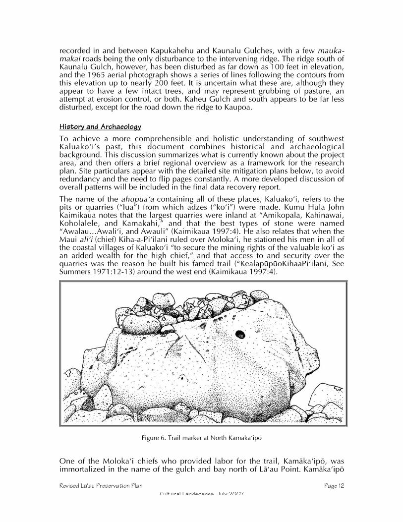
Revised Läÿau Preservation Plan Page 12Cultural Landscapes, July 2007
recorded in and between Kapukahehu and Kaunalu Gulches, with a few mauka-makai roads being the only disturbance to the intervening ridge. The ridge south ofKaunalu Gulch, however, has been disturbed as far down as 100 feet in elevation,and the 1965 aerial photograph shows a series of lines following the contours fromthis elevation up to nearly 200 feet. It is uncertain what these are, although theyappear to have a few intact trees, and may represent grubbing of pasture, anattempt at erosion control, or both. Kaheu Gulch and south appears to be far lessdisturbed, except for the road down the ridge to Kaupoa.
History and ArchaeologyTo achieve a more comprehensible and holistic understanding of southwestKaluakoÿi’s past, this document combines historical and archaeologicalbackground. This discussion summarizes what is currently known about the projectarea, and then offers a brief regional overview as a framework for the researchplan. Site particulars appear with the detailed site mitigation plans below, to avoidredundancy and the need to flip pages constantly. A more developed discussion ofoverall patterns will be included in the final data recovery report.
The name of the ahupuaÿa containing all of these places, Kaluakoÿi, refers to thepits or quarries (“lua”) from which adzes (“koÿi”) were made. Kumu Hula JohnKaimikaua notes that the largest quarries were inland at “Amikopala, Kahinawai,Koholalele, and Kamakahi,” and that the best types of stone were named“Awalau…Awaliÿi, and Awauli” (Kaimikaua 1997:4). He also relates that when theMaui aliÿi (chief) Kiha-a-Piÿilani ruled over Molokaÿi, he stationed his men in all ofthe coastal villages of Kaluakoÿi “to secure the mining rights of the valuable koÿi asan added wealth for the high chief,” and that access to and security over thequarries was the reason he built his famed trail (“KealapüpüoKihaaPiÿilani, SeeSummers 1971:12-13) around the west end (Kaimikaua 1997:4).
Figure 6. Trail marker at North Kamäkaÿipö
One of the Molokaÿi chiefs who provided labor for the trail, Kamäkaÿipö, wasimmortalized in the name of the gulch and bay north of Läÿau Point. Kamäkaÿipö

Revised Läÿau Preservation Plan Page 13Cultural Landscapes, July 2007
was also the name of an owl who lived at the place, and whose droppingsappeared as a type of gray clay found there. Two Kamäkaÿipö places known fromtraditional oral history that may have identifiable archaeological sites associatedwith them are a heiau dedicated to Hina that is supposed to be small and circular,and a hill named Ahoaho, a small hill where chiefs were buried (Kaimikaua 2001,personal communication).
By the time Europeans found the Hawaiian Islands, western Molokaÿi was notheavily populated, although both the Cook and Vancouver expeditions noted that asmall population was present prior to AD 1800 (see Dixon and Major 1993:9).Molokaÿi also became a battleground in the struggles between Maui, Hawaiÿi, andOÿahu, and during the latter 18th Century lost much of its population due towarfare; a Hawaiian told the surgeon of the Vancouver expedition thatKamehameha had decimated the island (Menzies 1920:115, 118). Another sourceindicates that a generation earlier, the Oÿahu chief Peleioholani raided and burnedMolokaÿi in revenge for his daughter being killed on the island (Fornander, cited inSummers 1971:18). Ash exists widely on the west end, observed in buried layersfrom at least Po’olau (Burtchard and Athens 1999) to Kaheu (also known asKaupoa, Major 2000). An older explanation of the barrenness and low populationmay be found in the story of ÿAmiÿikopalä, which said that the wells dug by thatsupernatural crab dried up when he was killed (Kaimikaua, personalcommunication 1999). Another moÿolelo told that other water sources dried upwhen people carelessly, and later maliciously, poisoned springs with pieces of theKälaipähoa gods (Kaimikaua 1988).
Regardless of the causes, the view that Kaluakoÿi was a dry, thinly populated areafound its way into archaeological literature, and is accepted today. Stokes (1909)stated that “inhabitants of the western end of Molokai deserted or were removedfrom their homes nearly half a century ago” (Stokes 1909:30), a period whenKamehameha V had begun ranching operations on the island. Stokes concentratedon religious features, and near the current project area recorded koÿa (fishingshrines) on the coast at Kamäkaipö (Sites 53 and 55), Läÿau (Site 58, destroyed bylighthouse construction before 1909), Keawakalai (probably Keawakalani, Site 59),Kahalepohaku (Site 61), and Puÿu Hakina (Site 62). At the latter place, he alsorecorded Kalalua Heiau (Site 67), which had an unusual reef rock slabconstruction, and was reportedly used for human sacrifice (ibid:31-32). Stokesfurther reported that local people identified Kahalepohaku as the place where Kiha-a-Piÿilani had been raised.
During the 1920s and 1930s, most Molokaÿi archaeology was done by visitingscholars such as Fowke (who wrote a brief paper for the Bureau of AmericanEthnology in 1922), and Phelps (who produced a monograph on Molokaÿiarchaeology in 1941). The Phelps paper is more interesting for its consideration ofenvironmental variables than its site recording. He divided the island intoecological regions, of which the western was the driest; Phelps highlighted thisaspect by repeating a Hawaiian newspaper story about the 18th Century aliÿiKaiakea, who ordered a well dug with adzes near Ka Lae o Läÿau (Phelps 1941:57).He stated that the advantages of Kaluakoÿi were its namesake adze quarries and itsfine fishing grounds (ibid:55-60). He used the ahupuaÿa of Kaluakoÿi to support hisconclusion that land divisions with the greatest area had the least population, andthat the absence of valleys to provide natural divisions was what made Kaluakoÿithe largest ahupuaÿa (ibid:75-76).

Revised Läÿau Preservation Plan Page 14Cultural Landscapes, July 2007
Few new sites were recorded prior to the 1950s, when the Bishop Museum andUniversity of Hawaiÿi began working together on Hawaiian archaeology, and oneducating a new generation of scientists. One of these students, William Bonk,reiterated the conventional wisdom in his master thesis, which included the lines,“this was a decidedly marginal land for the inhabitants of Molokai. Fishing and thequest for adze stone brought people into the area, and fighting probably sentrefugees into it, but temporarily” (1954:139). His excavation of a house site atKamäkaÿipö (Site 54) revealed less than 10 inches of midden, leading him toconclude that the intensity of habitation had perhaps increased over time, but thatthe site represented a fisherman’s house, and that the area had little more in theway of permanent habitation (ibid:51-52).
Catherine Summers compiled historical and archaeological documentation overthe next two decades, and published the results in 1971. Few of the sites are withinthe current project area, but the book is notable as the first and last attempt to bringtogether knowledge about sites island-wide. Molokai: A Site Survey includes notesmade by Stokes and other early site recorders, as well as Hawaiian myths and oralhistories, unpublished accounts, and historical documents. Based on all of thisinformation, Summers concurs with the portrayal of Kaluakoÿi as a land blessedwith excellent adze stone and fishing grounds, but also where habitation waslimited by aridity (1971:39-40). Also implicit in her maps and descriptions is asettlement pattern in which the most heavily used areas are clustered at the baysand high in the uplands. The current project area occasionally reaches the marginsof the coastal settlements, but is largely in the “empty” middle elevations. TheStatewide Inventory of historical properties began shortly after the publication ofSummers, but consisted more of an effort to relocate previously recorded sites thanto discover new ones, and added no new information.
The same year that Molokai: A Site Survey was published, a University of Hawaiÿistudent named Hal Strong documented some of the Kamäkaÿipö habitations. Hedescribed and photographed four house sites and a variety of associated features,including: ahu (stone mounds), shrines, koÿa, a stone pile, and scatters of middenand artifacts strewn on the surface (Strong 1971).
In the early 1980s, Marshall Weisler surveyed coastal southwest Moloka`i,relocating and discovering eleven sites (State Sites 50-60-01-53 through –56, -655,1118, and -1134) in or near what has become current project area. He reiteratedan aspect of Phelps’ settlement pattern in which topography was key—sites wereconcentrated in gulches and the bays where they met the sea—and added thatthere was a correlation between the size of the bay and the quantity and diversityof features (Weisler 1984:27). Another pertinent outcome of Weisler's work,creation of the Southwest Moloka`i Archaeological District (hereafter SMAD, Site50-60-01-803) included some sites (53, 54, and 56), in or near the project area.This district is now on the State of Hawaiÿi and National Registers of HistoricPlaces, meaning that sites within it are afforded additional protection.

Revised Läÿau Preservation Plan Page 15Cultural Landscapes, July 2007
Figure 7. Previous archaeological study areas. (Note: Burtchard and Athens project area is north ofthis, and is shown in the Papohaku Ranchland map earlier in this report.)
In 1991, a survey of 6,350 acres of southwest Molokaÿi done by Bishop Museumencountered features throughout southwest Molokaÿi, including the current projectarea (Dixon and Major 1993, referred to in this report as the “1991 inventory” andthe “1993 report”). This survey provided the most complete coverage ofsouthwestern Kaluako`i to date, and the settlement pattern model that emergedfrom the inventory reinforces the main pattern mentioned above, that sites clusteraround bays and gulches (Dixon and Major 1993:337). However, having a surveyarea that extended well inland from the coast, it was possible to refine the model.For example, although the inland margins of sites had the expected agriculturalareas and lithic work stations, they had a surprising number of “temporary andsemi-permanent residential compounds” (ibid:337).
Discovery of large, multi-roomed enclosures near the 100 foot elevation also wentagainst conventional wisdom that inland features were marginal and ephemeral.
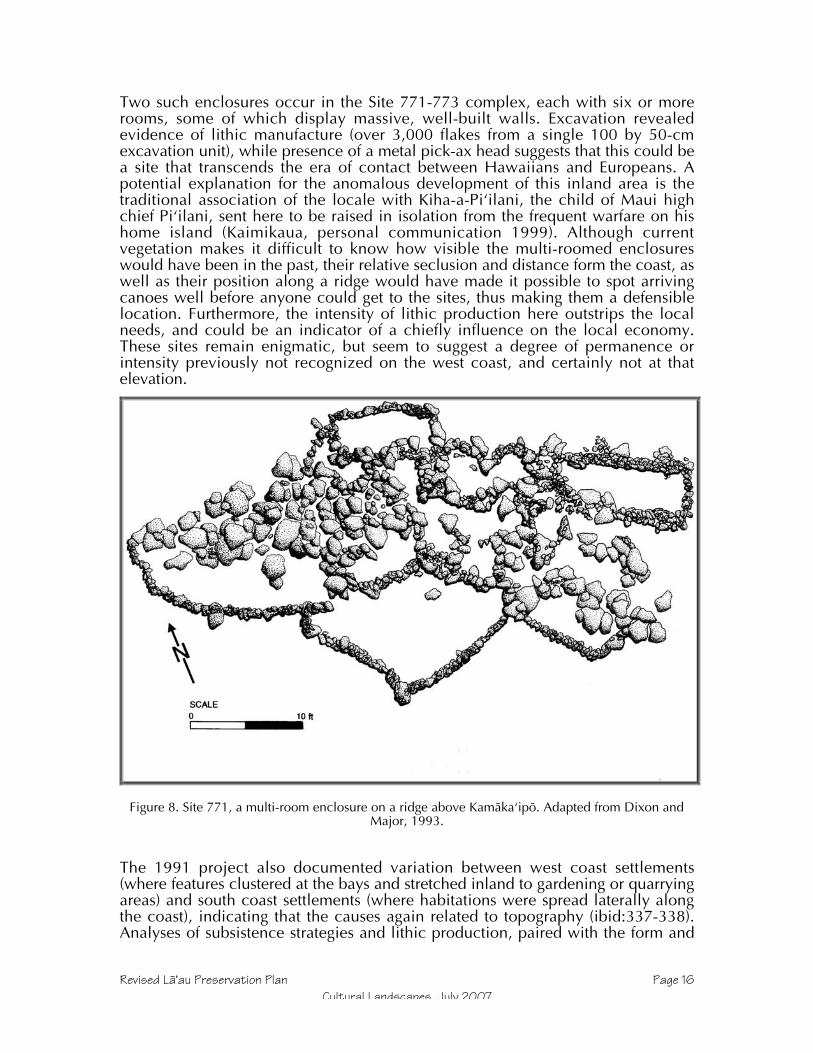
Revised Läÿau Preservation Plan Page 16Cultural Landscapes, July 2007
Two such enclosures occur in the Site 771-773 complex, each with six or morerooms, some of which display massive, well-built walls. Excavation revealedevidence of lithic manufacture (over 3,000 flakes from a single 100 by 50-cmexcavation unit), while presence of a metal pick-ax head suggests that this could bea site that transcends the era of contact between Hawaiians and Europeans. Apotential explanation for the anomalous development of this inland area is thetraditional association of the locale with Kiha-a-Piÿilani, the child of Maui highchief Piÿilani, sent here to be raised in isolation from the frequent warfare on hishome island (Kaimikaua, personal communication 1999). Although currentvegetation makes it difficult to know how visible the multi-roomed enclosureswould have been in the past, their relative seclusion and distance form the coast, aswell as their position along a ridge would have made it possible to spot arrivingcanoes well before anyone could get to the sites, thus making them a defensiblelocation. Furthermore, the intensity of lithic production here outstrips the localneeds, and could be an indicator of a chiefly influence on the local economy.These sites remain enigmatic, but seem to suggest a degree of permanence orintensity previously not recognized on the west coast, and certainly not at thatelevation.
Figure 8. Site 771, a multi-room enclosure on a ridge above Kamäkaÿipö. Adapted from Dixon andMajor, 1993.
The 1991 project also documented variation between west coast settlements(where features clustered at the bays and stretched inland to gardening or quarryingareas) and south coast settlements (where habitations were spread laterally alongthe coast), indicating that the causes again related to topography (ibid:337-338).Analyses of subsistence strategies and lithic production, paired with the form and

Revised Läÿau Preservation Plan Page 17Cultural Landscapes, July 2007
distribution of features, suggested that rather than a temporarily occupied,culturally peripheral area, southwest Kaluakoÿi was probably permanentlyoccupied late in prehistory, and that its access to fishing grounds and adze quarriesmeant that it was integrated into island-wide society (ibid:240-344). A more recentstudy including part of the north end of the current project area concluded thatcoastal habitations must have been permanent (Burtchard and Athens 1999).Presence of extensive occupations in the uplands (Summers 1971, Major 2000) andof major specialized features such as heiau (temples) and holua (sledding courses)in the lowlands (Summers 1971) provide evidence that the Kaluakoÿi area hadpermanent, perhaps socially stratified, occupants.
Traditional wisdom among archaeologists has also concluded that this regionwould have been settled only after sweet potato was available, and after populationdensities had risen in the wetter areas, probably no earlier than about AD 1500(Kirch 1985). Radiocarbon dates suggest somewhat earlier occupation may bepossible, although the limited data make it hard to discern sporadic early use froma stable early habitation. An inland quarry yielded a radiocarbon date of AD 1260-1440, and the south Kamäkaÿipö coastal site was dated between AD1410-1955. Asubsequent, unpublished date from the 1991 excavations at Site 654, in a coastalimu that Weisler originally recommended dating, provided an even earlier date ofAD 1019-1211 (Major and Dixon 1993), confirming the suspicion that coastalareas were used much earlier than they were permanently settled. The materialdated in this instance was charred grass, which eliminates the possibility of an in-built age.
The condition of Site 654, eroding from an exposed dune face, may be a result ofthe 1946 tsunami. The Cookes (1948, 1961) both wrote of the effect that this wavehad on the west coast, impacting Kawakiu heavily and working its way a half mileinland at Päpöhaku beach; it could easily have come well inland at Kamäkaÿipö,where the alluvial flat is severely eroded. Even without tsunami, however, manysites at Kaluakoÿi have been damaged by erosion, itself catalyzed by cattle and deergrazing since the mid-Nineteenth Century and several periods of severe drought.
Because the archaeology of Kaluakoÿi is relatively well known, mitigation plansmay be based not only on particular knowledge of the sites, but on the patternsevident in southwest Kaluakoÿi. Because the current project area mostly runsmauka of the sites, the data that will be recovered will be skewed toward traces ofperipheral activities and agriculture. In the Data Recovery Plan, the effect of this onthe techniques of data recovery and the research issues will be evident.
Proposed Site Mitigation MeasuresThe forms of mitigation dealt with in this and the accompanying Läÿau plans derivefrom the process outlined in HAR 13-13-284, which describes the historicpreservation review process in Hawaiÿi. Data Recovery pertains to sites that aresignificant for their information only, and covers pre-construction actions such asmapping, excavation, and surface collection, so that any damage duringdevelopment is offset by gains in knowledge. Monitoring means having anarchaeologist present during ground-disturbing activities, and the objectives aretwofold: to prevent incursion and impacts to preservation areas and damage tosites, and to document and evaluate any inadvertent finds that may occur duringconstruction. Preservation, the subject of this plan, differs from the other treatmentsin that sites are protected, and there is no impact to mitigate. Options within thistreatment revolve around the degree and type of protective measures to beimplemented, and whether the preservation is to be passive or active. Burial

Revised Läÿau Preservation Plan Page 18Cultural Landscapes, July 2007
treatment concerns not only the actions taken for sites that have documented orpossible burial sites, but also measures that will be followed should an inadvertentdiscovery of human remains occur. Like monitoring, the procedures for burialtreatment apply throughout the project area. Table 1 shows all sites in the projectarea and their disposition relative to these categories.
Because the final alignment of the proposed road corridor has not yet beendesignated, some treatments may change later pending community and SHPDapproval. All such changes will be from Data Recovery to Preservation, and noobjections are anticipated. Any site thought to be near the road or within aproposed subdivision lot has a detailed mitigation plan. At least 14 sitesrecommended for data recovery in the 2001 plan are now slated for preservationdue to the road realignment and the revised approach to subdivision, and as manyas 8 more appear likely to experience the same shift. SHPD has already expressed afavorable attitude regarding changes from Data Recovery to Preservation, and willbe notified of any additional ones as they become final. As mentioned above, thepreliminary road corridor will be resurveyed prior to finalizing the plan, and everyeffort will be made to realign it around significant sites.
A few inventory sites lack specific mitigation measures described in this plan. Someare sites recorded prior to 1991 that could not be located or were destroyed bythen (State Sites 55, 653, 1108, and Bishop Museum Sites B5-58 and B5-61).However, most are sites that lacked cultural or archaeological significance(primarily recent hunting blinds), and a few of which have been too heavilydamaged to retain physical integrity. Other gaps in the site numbers—653, 1133,59-638, 700-735 and 783-1099—have been assigned to sites elsewhere onMolokaÿi, and do not actually denote gaps in the 1993 site records.
Table 1. Site Conversions and Mitigation Treatments
State Number(50-60-01-)
Bishop MuseumNumber(50-Mo-)
Pres
erve
Dat
aRe
cove
ry
No
Act
ion
48 B6-61 X49 B6-62 X50 B6-63 X50 B6-64 X51 B6-65 X52 B6-66 X53 B6-68 and -97 X54 B6-69 to -73 X56 B6-76 and -77 X57 B6-78 X639 B6-67 X640 B6-74 X641 B6-83 X642 B6-84 X643 B6-85 X644 B6-86 X645 B6-87 X

Revised Läÿau Preservation Plan Page 19Cultural Landscapes, July 2007
State Number(50-60-01-)
Bishop MuseumNumber(50-Mo-)
Pres
erve
Dat
aRe
cove
ry
No
Act
ion
646 B6-88 X647 B6-89 X648 B6-90 X649 B6-91 X650 B6-92 X651 B6-93 X652 B6-94 X654 B6-96 X655 (aka 53) B6-97 X656 B6-98 X657 B6-107 X658 B6-108 X659 B6-109 X660 B6-110 X661 B6-111 X662 B6-112 X663 B6-113 X664 B6-114 X665 B6-115 X666 B6-116 X667 B6-117 X668 B6-118 X669 B6-119 X670 B6-120 X671 B6-121 X672 B6-122 X673 B6-123 X674 B6-124 X675 B6-125 X676 B6-126 X677 B6-127 X678 B6-128 X679 B6-129 X680 B6-130 X681 B6-131 X682 B6-132 X683 B6-133 X684 B6-134 X685 B6-135 X686 B6-136 X687 B6-137 X

Revised Läÿau Preservation Plan Page 20Cultural Landscapes, July 2007
State Number(50-60-01-)
Bishop MuseumNumber(50-Mo-)
Pres
erve
Dat
aRe
cove
ry
No
Act
ion
688 B6-138 X689 B6-139 X690 B6-140 X691 B6-141 X692 B6-142 XX693 B6-143 X694 B6-144 XX695 B6-145 XX696 B6-146 XX697 B6-147 X698 B6-148 X699 B6-149 X736 B6-150 XX737 B6-151 X738 B6-152 ? ?739 B6-153 X740 B6-154 X741 B6-155 X742 B6-156 XX743 B6-157 X744 B6-158 X745 B6-159 X746 B6-160 X747 B6-161 X748 B6-162 XX749 B6-163 X750 B6-164 X751 B6-165 X752 B6-166 X753 B6-167 XX754 B6-168 X755 B6-169 X756 B6-170 X757 B6-171 X758 B6-172 X759 B6-173 X760 B6-174 X761 B6-175 ? ?762 B6-176 X763 B6-177 XX764 B6-178 X765 B6-179 X766 B6-180 X

Revised Läÿau Preservation Plan Page 21Cultural Landscapes, July 2007
State Number(50-60-01-)
Bishop MuseumNumber(50-Mo-)
Pres
erve
Dat
aRe
cove
ry
No
Act
ion
767 B6-181 X768 B6-182 X769 B6-183 X770 B6-184 X771 B6-185 X772 B6-186 X773 B6-187 X774 B6-188 X775 B6-189 X776 B6-190 X777 B6-191 X778 B6-192 X779 B6-193 X780 B6-194 X781 B6-195 X782 B6-196 X1100 B5-59 X1101 B5-60 X1102 B5-62 X1103 B5-63 X1104 B5-64 X1105 B5-65 X1106 B5-66 X1107 B5-67 X1109 B5-69 X1110 B5-70 X1111 B5-71 X1112 B5-72 X1113 B5-73 X1114 B5-74 X1115 B5-75 X1116 B5-76 X1117 B5-77 X1118 B5-78 X1119 B5-79 X1120 B5-80 X1121 B5-81 X1122 B5-82 XX1123 B5-83 XX1124 B5-84 X1125 B5-85 ? ?1126 B5-86 X1127 B5-87 X1128 B5-88 X1129 B5-89 X

Revised Läÿau Preservation Plan Page 22Cultural Landscapes, July 2007
State Number(50-60-01-)
Bishop MuseumNumber(50-Mo-)
Pres
erve
Dat
aRe
cove
ry
No
Act
ion
1130 B5-90 X1131 B5-91 X1132 B5-92 X1134 B5-93 X1135 B5-94 X1136 B5-95 ? ?1137 B5-96 X1138 B5-97 X1139 B5-98 XX1140 B5-99 X1141 B5-100 X1142 B5-101 X1143 B5-102 X1144 B5-103 X1145 B5-104 ? ?1146 B5-105 X1147 B5-106 X1148 B5-107 XX1149 B5-108 X1150 B5-109 X1151 B5-110 XX1152 B5-111 X1153 B5-112 XX1154 B5-113 X1155 B5-114 X1156 B5-115 X1157 B5-116 X1158 B5-117 X1159 B5-118 X1160 B5-119 X1161 B5-120 X1162 B5-121 X1163 B5-122 X1164 B5-123 X1165 B5-124 X1166 B5-125 X1167 B5-126 X1168 B5-127 X1169 B5-128 X1170 B5-129 X1171 B5-130 X1172 B5-131 XX1173 B5-132 X1174 B5-133 X

Revised Läÿau Preservation Plan Page 23Cultural Landscapes, July 2007
State Number(50-60-01-)
Bishop MuseumNumber(50-Mo-)
Pres
erve
Dat
aRe
cove
ry
No
Act
ion
1175 B5-134 X1176 B5-135 X
NOTE: Treatments with an outlined X outlined X signal post-2002 changes in status from Data Recovery toPreservation status. Sites slated for Inventory will all be recommended for Preservation. Questionmarks (?) indicate sites currently recommended for Data Recovery that may change to Preservation,pending precise site location.
One clear message from the community has been that prior preservationcommitments must be honored. Both the original and revised plans actuallycommit to more extensive preservation than originally recommended, and no sitepreviously slated for preservation will be removed from that status. Most changesresult from the decisions that possible burial mounds will be preserved, rather thantested, and that many sites will be avoided and preserved rather than undergo datarecovery. The Southwest Molokaÿi Archaeological District (hereafter SMAD, Site50-60-01-803), a discontinuous set of sites listed on the National Register ofHistoric Places (NRHP) in 1986 will continue to be indicated on plats and deeds,and will continue to be preserved within a larger preservation landscape. Beinglisted on the NRHP distinguishes sites with formal recognition of their significance,but does not provide site-specific treatment plans, which are therefore includedhere.
ConsultationAs mentioned previously, the current revised plan reflects priorities expressed inhundreds of hours of community-side meetings, as well as mediated discussionsbetween the landowners and community leaders (some for, and some opposed tothe proposed subdivision) and conclusions of a Cultural Committee chaired byCollette Machado, the Molokaÿi OHA (Office for Hawaiian Affairs) Trustee. Inaddition to the “official” meetings and discussions, the author has solicitedcomments and opinions informally from Native Hawaiian residents of Molokaÿi.This updated plan embodies community preferences regarding preservation, andtherefore contains sections not required or normally included in some PreservationPlans.
As part of its master planning process, Molokai Ranch engaged the ConservationFund (a land conservation organization) to assess natural and cultural resources ontheir land and to mediate a series of community meetings and focused discussiongroups. The Cultural Committee, chaired by OHA Trustee Collette Machadoassisted by Hälona Kaÿopuiki, focused on issues regarding cultural aspects of thelandscape, particularly with regard to the effects of proposed development andconservation areas. In addition to recommending that the Ranch donate large tractsto a community-based land trust, the Committee advised the creation of culturalconservation zones that would overlay lands regardless of their eventual ownershipand land use zoning. After consulting with a wide array of community members,the Cultural Committee advised that the revised preservation plan increase the levelof data collection associated with preservation, leading to the commitment to re-survey the road corridor, to salvage and in some cases excavate data from fire

Revised Läÿau Preservation Plan Page 24Cultural Landscapes, July 2007
features to help learn about former vegetation, and to more clearly identify rolesand responsibilities relative to sites in the Cultural Protection Zones where theyeither overlay or abut the subdivision project area. Similarly, the Committee andcommunity at large recognized a need for this plan to address sites in he ShorelineConservation Zone, which borders many subdivision lots. Community and CulturalCommittee input has already fostered preservation, causing redesign of theinfrastructure corridor and the subdivision boundaries to decrease the number andextent of proposed lots.
Through the Cultural Committee members and meetings, several organizationshave contributed their manaÿo (thoughts) regarding preservation at Läÿau. Theseinclude OHA, the Molokaÿi Archaeological Society, Hui Aloha. The authorapologizes for not having a complete list of organizations that may have beenrepresented officially or informally by members. The original plan was alsosubmitted for review by the Molokaÿi Island Burial Council and a Küpuna AdvisoryCommittee. (None of the Burial Treatment Plan has changed since that time.)
Several individuals living on Molokaÿi have offered opinions, proposed measures,and spoken with the author regarding preservation at Läÿau during the past decade.Most frequent among these has been Hälona Kaÿopuiki, a Molokaÿi kamaÿäina(“child of the land,” born to a family that has been on the island for manygenerations) who has taken a strong, sustained interest in the well-being of culturalsites in central and west Molokaÿi. Members of the Aki ÿohana (Harry, Lawrenceand his wife Catherine) also shared their manaÿo regarding southwest Kaluakoÿi andsupported cautious methodologies such as the use of string trimmers to achievemore thorough survey and preservation of possible burials rather than testing.Another long-term contributor to the discussion of preservation in Läÿau andelsewhere has been Walter Ritte, who spoke with the author directly and indirectly.More recently, a face-to-face talk story session with OHA trustee Collette Machadoand Billy Akutigawa of the Molokai Archaeological Society helped clarify issuesregarding access to sites, coastal preservation, and more. Also at that session wasAlvin Burrows, a descendant of the original lighthouse keeper at Läÿau, whoseopinion about this place holds a unique value. Though not always speakingdirectly to the Läÿau landscape, John Kaimikaua and Opuulani Albino have bothbeen gracious enough to speak with this haole boy regarding the culturalsignificance of land and cultural places. Finally, though not directly commentingon the project, Davianna McGregor reviewed the most recent draft of the plans,and elicited further public opinion.
In addition to the Molokaÿi community, the author sought advice from preservationprofessionals in an effort to ensure that the current plan is at the forefront of culturalpreservation in Hawaiÿi. Mahalo to Myra Tomonari-Tuggle for general advice and amodel of excellence. Sara Collins provided thoughtful review comments on the2001-2002 plans in her capacity as the Molokaÿi Island archaeologist at the Statehistoric Preservation Division and since her departure from that position hasresponded to additional queries on a personal level. Alan Carpenter, anarchaeologist at State Parks and long-time supporter of community-basedpreservation and cultural resource management efforts, offered reactions to theprovisions of this plan and can be credited with “reversing the polarity” andadvocating for circumscribed development areas rather than buffering numerousindividual sites.
In the final analysis, the revised draft has become a more robust outgrowth of theoriginal principals due to consultation with these groups and individuals. Many

Revised Läÿau Preservation Plan Page 25Cultural Landscapes, July 2007
preservation actions far exceed the minimal standards expressed by the state rulesfor preservation (HAR 13-13-277) because of the willingness of MolokaÿiHawaiians to stand up and express their manaÿo. Consultation resulted in a planthat protects places and landscapes rather than site numbers, and which representsa great advance not just in acreage, but in the diversity and intensity of preservationactions proposed relative to the recommendations of 15 years ago, not to mentionother islands to this day. Admittedly, a persistent minority opinion onMolokaÿi—that no development ever occur on this island—could not beaccommodated, but the desire to minimize the effects of development at every stephas been a guiding principle for this plan. Another opinion—that cultural sitesshould be much more fully opened to cash-driven cultural tourism—was rejectedafter the majority objected strongly.

Revised Läÿau Preservation Plan Page 26Cultural Landscapes, July 2007
Figure 9: Cultural Protection and Shoreline Conservation Zones at Läÿau. Creation and expansion ofthese zones resulted from strong community input, and caused many sites to be changed to
Preservation Status. Based on map produced by PBR.
Preservation GoalsOngoing broad-based community consultation and focused Culture Committeemeetings have yielded a consensus that site preservation serves the largercommunity goal of offsetting change with a renewed attention to Molokaÿi heritageand culture. The Hawaiian renaissance of language, arts, agriculture, and culture in

Revised Läÿau Preservation Plan Page 27Cultural Landscapes, July 2007
general has grown for more than a generation now, and to mälama (protect) thesites is to protect a physical link between the modern and ancient culture. At thesame time, a Preservation Plan fits within regulatory and scientific frameworks(HAR 13-13-277), and some goals stem from those aspects as well. Whether anindividual is most interested in preserving a place for its mana (spiritual power) orits data, however, the goals listed here serve the interest of preservation.
Hana Like / Consult the Community – Through the ongoing discussions ofthe past year, the process of consulting with Hawaiians and other interestedparties is already well under way. As events move from generalities andplans to details and implementation of cultural resource preservation,however, it is important that community input be integrated with thearchaeological viewpoint.
Hoÿomau / Perpetuate – Preservation of archaeological sites allows futuregenerations of Hawaiians a link to their forebears. A preserved site may be aplace to feel the mana, to appreciate the heritage, or to learn in ways thatdisembodied awareness and knowledge do not; places are important.
Hoÿopaÿa / Stabilize – For sites subject to erosion, traffic, or other ongoingthreats, stop the immediate damage and avert future impacts.
Kapu / Protect – Protection of sites within or adjacent to development orhigh traffic areas means erecting barriers in the field and clearly markingsites on construction plans and deed maps.
Noho Pono / Behave – Basic rules for what can and cannot be allowedwithin preservation areas need to be established clearly. Although theyshould apply generally, it is especially important that protocols be suppliedto subdivision lot owners and the conservation staff. Protocols should beconsistent with (and perhaps simplified versions of) management plansdevised for the overall conservation areas.
Maka Ala / Monitor – Archaeological monitoring is necessary for ground-disturbing activity adjacent to preserves or in data recovery areas. A secondtype of monitoring is the annual field-check of site conditions in public useareas and for particularly sensitive sites.
Respect Preservation Commitments – The 2001/2002 plans, like the 1991inventory, carry through with the preservation commitment made when theSMAD was listed on the State and National Registers of Historic Places.Additional recommendations made to preserve sites since then, although notformalized through listing on the National Register, should continue to berespected and implemented.
Management-oriented Evaluation – Rather than static site significanceassessments, management evaluation aims to identify old or ongoingpreservation problems such as erosion or damage from animal or humantraffic, as well as to evaluate opportunities for protective measures and datacollection. This mode of evaluation should be continued into the future tomaintain a preservation program that does not fall behind developing issuesand problems.
Data Collection – As opposed to data recovery done in a regulatory context,the preservation process is guided by a desire to not let information aboutthe past disappear. Implementation of the preservation plans will involvesalvage of data during stabilization, as well as mapping or excavation done
Revised Läÿau Preservation Plan Page 28Cultural Landscapes, July 2007
to better interpret sites of interest to the Hawaiian community, to provide re-vegetation plans with information about the ancient environment, or otherbona fide management purposes.
Preservation PhasesPreservation of sites representing the long past of Läÿau itself represents a long-range effort, responding not just to immediate issues, but perpetuating theprotection and mälama for generations. Historic preservation rules acknowledgethis in the requirement to state both short and long-term measures in a PreservationPlan (and as this plan does in the next section), but Molokaÿi residents have movedbeyond this simple two-part approach in cultural resource planning. This sectionpresents a sequence according to which preservation measures will beimplemented.
Ongoing – Communication and EvaluationDuring each of the phases listed below, it is important to continue to keep lines ofcommunication open with Hawaiians and other interested parties in thecommunity. Having Molokaÿi people as resource staff is a major step in thisdirection, as is answering public queries and making the process as transparent aspossible.
Ongoing evaluation is important to good resource management. Inevitably,unforeseen circumstances, field conditions, and other factors lead to situations inwhich strict adherence to plans does not serve preservation goals. Field personnelshould be allowed some flexibility as long as changes or alterations are minor andare reported to supervisors. Should a larger problem arise (such as, operationalchanges that would require a new permit), evaluation and discussion among staffand relevant experts should precede any change in procedures. Periodicmonitoring should also feed into evaluation, so that the preservation andconservation programs continue to achieve their goals over the long run.
At the present time, a Cultural Committee chaired by Collette Machado andHälona Kaÿopuiki has taken the lead role in advising the landowners regardingcultural sites. In previous projects, such as the Kaupoa Camp re-survey andmonitoring, a Küpuna Advisory Council was consulted regarding culturalresources. Both groups have functioned well, providing archaeologists with thecultural perspective and wisdom necessary to protect cultural sites. Experience onKauaÿi involved a combination of the two, a group of people with cultural expertiseto oversee normal operations, and a council of küpuna to consider broader issuesand provide the benefit of experience and wisdom.
Phase I – Relocate and Verify Archaeological SitesA qualified archaeologist should relocate known sites thought to be in proximity toproposed subdivision lots, and if necessary refine site boundaries for preservationpurposes such as marking permanent buffers. Once located, vegetation should becleared 5-m beyond structures and the vicinity examined thoroughly to determinefinal site boundaries. If sediments merit, transects of shovel tests may be done todiscover whether buried deposits or features occur beyond the surface features.(This means digging holes at 1 to 10-meter intervals as appropriate, screening thesoil, and determining whether cultural deposits are present beyond the limit ofsurface features, which typically represent only the most recent phase of activity ata site.) If there are features with maps or records inadequate for preservation

Revised Läÿau Preservation Plan Page 29Cultural Landscapes, July 2007
management purposes, they should be augmented at this time. In addition, allsurface features, visible deposits, and site settings should be photographed. Finally,verified site boundaries will be clearly flagged with their State inventory numbers,and GPS reference points established to update the location.
An additional area of verification will be the examination of the proposed road andutility corridor associated with the subdivision. Archaeological investigation of thecorridor will occur during the planning process, so that any archaeological sites, ifpresent, may be avoided. Because roads and utilities necessitate excavation andgrading, the entire corridor will be covered, rather than just known sites. Whereverthe proposed route enters a site, alternative routes will be investigated as well, toensure the rerouting does not cause other impacts. Methods for verifying sites nearthe road will be the same as those described in the previous paragraph. Should anynew features or artifacts be found during this process, the existence of a previouslyaccepted inventory means that they technically will be classified as inadvertentfinds, but the advantage of an early re-examination of the development corridor isto allow adequate time to assess the potential outcomes of such finds, allowingtime for community and SHPD consultation as necessary, and adjust developmentplans accordingly to minimize any impacts.
Phase II – Re-evaluate Sites and Prioritize ActionsSites in and adjacent to proposed infrastructure corridors and subdivision lotsshould now be evaluated with regard to general mitigation and specific treatments.It should be noted that Significance Evaluations have already been accepted, andthis stage of the process instead focuses on a few cases where treatment maychange from Data Recovery to Preservation, as well as examining sites in detail tomake informed decisions regarding the type, extent, and priority of implementingspecific preservation actions.
The sites proposed for Data Recovery in 2001 mostly consist of 20th Century sites,small areas of basalt flakes, possible planting areas, and modified outcrops; theywere assigned to this category only if they appeared very marginal in importance,suffered diminished integrity due to previous damage or erosion, or were relativelyrecent. This point in the process is when subdivision planners must decide whetherto retain data recovery as the site mitigation, or simply move the site topreservation status. Sites subject to this process are 738, 761, 1125, 1136, and1145.
For Preservation sites, this is the time to assess particular needs in terms ofstabilization, details of establishing permanent barriers, or data collection. Alsosites should be prioritized so that those most at risk of erosion or other impact willbe dealt with first.
Phase III – Stabilization and ProtectionThis is the time to erect fences or other barriers for interim protection of sites, tomark site boundaries and buffers, and to note restrictions to be placed onconstruction plans, parcel maps and deeds. Stabilization measures will beimplemented so that sites at risk do not continue to degrade. Some data collection,such as recovery of eroded data or salvage of unstable deposits may be bestaccomplished in conjunction with these activities.

Revised Läÿau Preservation Plan Page 30Cultural Landscapes, July 2007
Phase IV – Data Collection and Permanent BarriersOnce sites have been verified, stabilized, and protected, further data collectionmay be done. Rather than the salvage of information that may occur duringconstruction of a retaining wall, for example, this phase would consist of controlledexcavations done to recover data from features or deposits not at immediate risk,but subject to long-term degradation (for example, cultural deposits at risk fromunusually high surf).
Limited excavation may be done to support re-establishment of native vegetation oranimals, since fire pits contain identifiable native and Polynesian charcoal andanimal remains in an area dominated by exotic species today, or to gain betterunderstanding of long-term environmental conditions. Interpretive questionsidentified during previous phases can be addressed at this time, such as excavationdone to determine the relative or absolute age of a structure, or the intensity andtiming of lithic production.
Permanent fences or other buffers will be installed during this phase. Whereversuch buffers require ground disturbance, an archaeologist must be present tomonitor the activity, recommend alterations to protect sites, and salvage data asnecessary.
Phase V – Management Plan and Detailed Interpretive PlanBuilding on the experience of the initial phases and the evaluations of thoseinvolved, the Management Plan can now be produced. The two main componentsof this document will be a report of all the findings and activities thus far, and amanual for the continued management of the archaeological preservation areas(North Kamäkaÿipö Gulch, Shoreline, Sites in Subdivision Lots, Sites StraddlingLot/Conservation Boundaries, and Outliers).
Unlike this preservation plan, the Management plan will focus less on regulatorycompliance than on integration of long term processes in the Project Area withpreservation activities undertaken by the neighboring Land Trust, and refinedpolicies regarding maintenance and ongoing evaluation. This document is intendedfor practical application by Land Trust staff, subdivision residents and maintenancepersonnel, and other individuals who may not have a historic preservation orarchaeology background. The Management Plan will not change the measuresproposed in the Preservation Plan, but will help distill and translate thatPreservation Plan in order to facilitate implementation over the long run. A majorelement of the Management Plan will be a set of maps showing the final maps ofpreservation sites, so that any refinements or augmentations can be recorded asbaseline data for future site condition monitoring.
Development of a Detailed Interpretive Plan is being proposed as an addendum orsupplement to the current Preservation Plan for several reasons. First,implementation of the core Preservation Plan will yield additional data andsituational awareness that may alter or augment understanding of thearchaeological and cultural sites to be interpreted. For example, recovery ofcharcoal during Phases III and IV will expand our understanding of settlementchronology and environmental change. Because public accessibility to interpretedsites in North Kamäkaÿipö and Puÿu Hakina will be more intense, the goal is toprovide a richer interpretive program than inventory data allow. Also, as thePreservation Plan is implemented, community attention will be drawn to the area,and elicitation of residents’ memories of the region, oral histories, and communitypreferences regarding the content and style of education and interpretation are sure

Revised Läÿau Preservation Plan Page 31Cultural Landscapes, July 2007
to emerge. While specific interpretations could be proposed at this time, waitinguntil later will result in a more informative, culturally appropriate program.
Interpretive planning is covered by the HAR 13-277 rule for preservation, butSHPD has allowed phased submittal of Detailed Interpretive Plans in the past. Thecurrent plan covers the more immediate site protection and specific preservationplanning commitments that are urgent, and asks that SHPD accept this plan as is,including a commitment to prepare a Detailed Interpretive Plan based oncommunity consultation for future SHPD review.
Preservation ActionsPreservation often means more than simply leaving a site alone. Between simpleavoidance and interpretive restoration lie numerous preservation measures.Choosing which of these to apply requires consideration of the site’s basiccharacteristics, its significance, its physical surroundings, and its context withinlandowner plans. These actions comprise both short and long-term measures thatwill protect sites during the subdivision process and for years to come.
General Preservation CategoriesThe basic division of Preservation treatments distinguished between “Avoidanceand protection” (or “conservation”) from “Active” (HAR 13-277-3-(1)). The latterincludes stabilization, rehabilitation, restoration, reconstruction, interpretation, andappropriate cultural use. Because of the variety of site types and functions, as wellas the large area covered by this plan, treatments vary. Site-specific treatments aregenerally determined by factors such as proximity to development, whether a site isin a Cultural Protection Zone, and whether a site is in an area where significantpublic use or access is anticipated.
Active preservation measures proposed in this Plan include stabilization,interpretation, and appropriate cultural use. The latter category applies to all sitesin Cultural Protection Zones, although current active use is limited to a very smallnumber of koÿa where some fishermen continue to place offerings. As the sites inthe project area become more accessible, it is likely that cultural use will increase.Stabilization needs have been estimated based on current knowledge of siteconditions, and will be limited to measures that halt the deterioration and erosionof sites, without going further and restoring them. Interpretation will focus on theNorth Kamäkaÿipö and Puÿu Hakina Cultural Protection Zones, each of which willbe partially developed as a public beach access and park. A detailed list of activepreservation measures is presented for each site in Table 2.
Sites for which avoidance and protection are the only treatments are primarilylocated away from the subdivision Project Area. These sites appear on Table 2 aswell, with the only applicable treatments consisting of two or more of thefollowing: Avoidance, Mapping, Temporary Buffers, Permanent Boundary, andProtocol Education. Sites in this group include the following: 48-52, 639-652, 657-675, 693- 695, 736, 738, 742, 747, 748, 770-778, 1100, 1102-1111, 1113-1117,1125, 1136,1139, 1146, 1153, and 1155-1174. Of these, Sites 738, 1125, and1136 are currently slated for Data Recovery, although it is possible that they maybe preserved if development activity can avoid their locations.
Revised Läÿau Preservation Plan Page 32Cultural Landscapes, July 2007
Supplemental Data CollectionTwo types of archaeological investigation that are not required by the regulatoryhistoric preservation process will be done in association with the Läÿau subdivision.While elements of each have been part of the plans from the outset, the recentperiod of community consultation have made it clear that they are a priority tomany residents and most Native Hawaiians on Molokaÿi. The function ofsupplemental data collection is to refine and augment site records to a level atwhich they can aid in preservation management, which requires more detail and athorough baseline understanding of sites, sometimes beyond the ability of Inventorylevel data to accommodate
First, because construction of a new road and utility corridor represents the greatestsingle potential for impact, and is the initial step in construction for the newsubdivision, the landowner has committed to re-examine the corridor, which asalready been through the an accepted archaeological inventory.
The second form of data collection relates to preservation sites within and close toproposed subdivision lots, where the process will amount to a thoroughinvestigation of sites that are to be protected within or in close proximity to newhouse lots. Because this type of work is to be done as part of the Preservation Planimplementation, it will be described in more detail there, but it is important to notethat it will be done well in advance of any house construction, and therefore anynew or augmented finds may be considered in the design and construction process,so that new houses need not damage old sites. An overview for this process isincluded below.
Road CorridorAs described in the Introduction, the first fieldwork associated with these plans willbe to re-examine the road corridor and verify descriptions of known sites, gatheradditional data if possible, and search for unrecorded archaeological deposits orfeatures now observable due to changes in surface visibility. A preliminary plan forthe road corridor has been prepared by engineers, the centerline of which will bestaked on the ground by surveyors prior to commencement of archaeologicalfieldwork. The proposed road diverges from Kulawai Loop (an existing road in thePapohaku Ranchlands subdivision), and then runs roughly southwest to a point justsouth of the Kaupoa House lot where the subdivision begins, and then more or lessfollows the shoreline down the west south coasts to the vicinity of Site 1155, southof Puÿu Hakina (see map). Along the way, 12 short spur roads depart from the maincorridor, providing access to subdivision lots. No connections to the Hale-o-Lonoharbor road or other existing roads are planned, and the old coastal road—aroughly graded, unpaved jeep trail—will be abandoned as part of the developmentplan due to its alignment through several archaeological sites and erosion-proneenvironments.
As noted above, the portion of the road corridor north of TMK 5-01-02-030 has notbeen officially inventoried, and a report for that portion of the road corridorinvestigation will in fact be submitted separately to SHPD for review as anarchaeological inventory with significance evaluations and treatmentrecommendations. Despite this procedural difference, techniques will remain thesame throughout the road corridor.
The area for data collection consists of a 30 m wide swath on either side of thecenterlines for the main and spur roads, and a 50 m radius surrounding each endpoint, where turn-arounds have been planned. The impact of road construction and

Revised Läÿau Preservation Plan Page 33Cultural Landscapes, July 2007
utility trenching will be less than the resulting 60 m wide corridor, but that widthhas been chosen both to provide the best archaeological understanding of the roadand its context, and to provide intensive coverage that may be used to avoidadditional survey or unexpected impacts should presence of sensitive sites withinthe corridor cause a need to adjust the alignment.
The survey team will consist of Molokaÿi residents with archaeological experienceand training led by the Principal Investigator, with additional archaeologists hired ifnecessary. The corridor will be divided into segments, and the crew will performsweeps in each segment with a 5 m interval. Where grass is thick enough toobscure surface visibility, gas-powered string trimmers will be used to expose thesurface within 10 m of the centerline, so that low-relief features such as pavementsand lithic scatters will not escape notice. Vegetation will also be cleared aroundthe periphery of any visible surface features found within the corridor (regardless ofdistance from the centerline) to allow their accurately augmented documentation.
Any sites within the corridor will be documented with scaled surface planviews,cross-sections and profiles as necessary, photographs, and descriptive notes. Wheresediments occur that could contain buried cultural deposits, transects of probes willbe employed to determine site boundaries and characterize site stratigraphy. Eachprobe is to be excavated with a shovel, by stratigraphic layer as far as practicable,with the entire volume screened through 1/4-inch mesh. For each probe arepresentative profile will be drawn, referenced to the current ground surface. Anyfeatures encountered will be drawn and photographed in plan and profile andexcavated as a separate stratigraphic context. All cultural materials will becollected, described, and recorded in a project inventory. Probe intervals will rangefrom 1 to 5 m, depending on the area of sediment where buried features couldoccur, as well as the nature and density of the surface features and visible deposits.Probes will begin at the outer edge of surface features and radiate outward in atleast two directions along grids established for each site (the orientation of whichwill be decided in the field by the PI according to topography and localconditions). Where probe intervals are greater than 2 m, follow-up probes will beused at tighter intervals to better determine the horizontal extent of the site.
For each site, a minimum of one datum point will be flagged and marked on siteplanviews to facilitate location on large maps. Initially, a GPS device will be usedat each of these to provide a location; consumer-grade Garmin units used onproperty by Ranch staff have achieved accuracy to within 2-m of the UTMcoordinates provided by survey grade GPS, and will be used during the re-survey toprovide interim site locations. Subsequent to the initial fieldwork and prior toconstruction, these points will be plotted on lot surveys to provide accurate, precisecontrol points for site and buffer locations. Each datum point will be integrated intothe engineering consultant’s CADD system, along with either an appropriatelysized buffer. (Site-specific buffers, it should be noted, may often fall within largerbuffers created for the Shoreline Conservation Zone or Cultural Protection Zones.)
Sites that have been previously recorded will be reported in the PreservationManagement Plan, including any newly located features or artifacts found duringfieldwork. Features not associated with known sites will be reported to SHPD asinadvertent finds, along with significance evaluations and treatmentrecommendations.

Revised Läÿau Preservation Plan Page 34Cultural Landscapes, July 2007
Subdivision Lots and Coastal ZoneSites within proposed subdivision lots have accurate locations due to theirproximity to coastal reference points, and many have been previously documentedin detail by archaeologists. In order to ensure that all sites have been adequatelyrecorded and those slated for preservation receive timely and effectivepreservation, land within and in close proximity to the subdivision lots will be re-examined as well. As with the road corridor, the aim is to verify extant site records,augment them as necessary, and record any previously unrecorded artifacts orfeatures.
Methods for investigating and recording sites will be the same as well, although theproject area differs. Rather than a corridor defined by the road centerline, thissurvey area consists of the proposed private lots and the lands makai of them.Inclusion of the coastal land (most of it already zoned Conservation, and theremainder to be so if the Ranch’s petition to change some near-shore land fromAgriculture to Conservation is approved) in this phase stems from two facts. First,some sites straddle the boundary between Shoreline Conservation land and lots.Second, as lots are occupied and coastal parks are opened, foot traffic throughcoastal sites will increase, subjecting them to a greater potential for impact than inrecent decades.
Because so many sites have been recorded near the shoreline, this phase will beginwith the known and work outward, annotating and augmenting site documentationas necessary, firmly establishing site boundaries. Areas between sites will besurveyed at 5-m intervals to search for any unrecorded features or deposits.
Vegetation clearing in this phase will focus on sites, exposing surface features andvisible deposits to allow for mapping. However, clearing in Conservation lands willbe limited to cutting grasses and vines, and native plants will be preserved. Asampling of high probability landforms (ridge-tops, natural terraces within gulches,and level ground above slopes) will be cleared to check for visually unobtrusivefeatures in the private lots, but not within the coastal strip. In all cases, clearing willproceed with an awareness of soil, slope, and groundcover, to avoid exacerbatingerosion.
In addition to the use of shovel probes to define site boundaries, some excavationwill be done in this phase to help further the general conservation goals of themaster plan and to better understand chronological and functional issues regardingthe sites. Wherever hearths or imu are at risk from erosion, they will be excavatedto reveal the stratigraphic relationship to other site components, and to collectcharcoal for taxonomic identification, providing a basis for future re-vegetationefforts. Likewise, eroding deposits will be cleaned up to provide a representativevertical face for profile illustration, and a charcoal or other materials may becollected at this time.
Establishing Site BuffersCurrently, the boundary of each known site is a perimeter enclosing all of thefeatures and intact cultural deposits, constituting the site as recorded in 1991. StateHistoric Preservation rules (HAR 13-13-277-4) specify that a buffer zone must beestablished to surround and protect significant sites. This will be the initial task ofpreservation, and will be all that is done for sites that are not being interpreted orthat are far from potential impact areas. The folio map (Figure 4) shows the buffersproposed in this plan.
Revised Läÿau Preservation Plan Page 35Cultural Landscapes, July 2007
Zone BuffersBecause wording in the rule describing how Preservation Plans must specify buffersrequires that the report “specify buffer zones around each significant historicproperty” (HAR 13-277-3-(2)), the usual practice is to assign site-specific buffers. Inkeeping with this, site-specific buffers are proposed below based on a series ofsystematic rules. However, this Plan proposes that buffers be recognized on thelevel of larger zones that encompass numerous sites and their buffers. Definingbuffers at the perimeters of the Shoreline Conservation Zone and the six CulturalProtection Zones will result in radically larger buffered areas that protect sites intheir landscape and inter-site contexts. Where these zones abut the Project Area, orwhere individual sites do not fall within the protection of a larger zone, the site-specific zones proposed below will pertain, and in no case will a SCZ or CPZbuffer be less than the minimum 7 meter buffers for typical sites or 9 meters (in thecase of Sites significant under Criterion E).
Because the Shoreline Conservation and Cultural Protection Zones are soexpansive and go well beyond where they would be subject to effects fromsubdivision or road development, placing permanent barriers along their entirelength would be impractical, and likely to trigger more impacts than it wouldprevent. However, these Zones must be identifiable to future landowners, land useplanners, and preservation managers, and markings on the ground and on maps arenecessary.
Locations where sites in the zones lie in close proximity to potential developmentareas may require temporary protective fencing during construction, andpermanent buffer markers after that. These cases have been identified and arereported in the table and text of Plan’s the Site-Specific section.
Marking the buffers for Cultural Protection Zones where development is not apotential cause of impacts will be accomplished through a combination of landsurvey data and maps, marker posts, and signs. An archaeologist will first define theedges on the ground, ensuring that no site receives less than the mandated site-specific protection, and that the overall zone covers the area intended; this will bemarked with highly visible flagging tape. Subsequently, the archaeologist will workwith licensed land surveyors to mark the precise metes and bounds of the CulturalProtection and Shoreline Conservation Zones. These data will be transferred tomaps of individual lots, the Project Area as a whole, and overview maps showingthe Project Area in relation to the Shoreline Conservation Zone, the CulturalProtection Zones, and the Rural Landscape Reserve. The zone-level protectivebuffers will be recorded with the Bureau of Conveyances to ensure that they persistbeyond any change of ownership.
Physical markers will consist of metal T-posts or durable wooden posts placed atintervals sufficient to relocate them on the ground using a map of the zone. In someof the heavily vegetated gulches, the interval may be as close as 10 m, while in themore open uplands they may be 10 times that far apart. Placement will besufficient to mark any turns in the boundary, and an archaeologist will be involvedto ensure that the markers to dot impinge on the visual integrity of sites, and thattheir installation does not cause any adverse impacts. Each post will have a metaltag indelibly marked with the name of the Zone being marked.
Where roads traverse sections of Zones, signs will be installed informing driversand maintenance crews that they are entering Cultural Protection Zones, andnotifying them that they may not drive beyond the extant road or otherwise disturbthe ground or cultural resources. These will be placed along the main subdivision

Revised Läÿau Preservation Plan Page 36Cultural Landscapes, July 2007
access road where it traverses the Kaunalu, Kaheu, and North Kamäkaÿipö CPZs, aswell as where extant dirt road (potential access routes for emergency vehicles)traverse sections of the North Kamäkaÿipö, South Kamäkaÿipö – Kiha-a-Piÿilani, andPuÿu Hakina CPZs. Signs will also be placed at the north edge of the tourist eco-camp at Kaupoa where people could walk into the Kaheu CPZ, as well as at the farextremes of TMK 5-1-02-030, where shoreline pedestrian traffic will enter theKaunalu CPZ at the south end of Kapukahehu Bay (north end of the west coast) andat Puÿu Hakina CPZ (at the east property boundary on the south shore). Signs willalso be posted at the edges of the North Kamäkaÿipö, Läÿau Point, and Puÿu HakinaCPZs where they abut subdivision lots. Test for the signs is shown in Appendix C.
Site-specific BuffersFor some sites (primarily those near the road corridor and those being interpreted),the first action will be to verify site boundaries. This is an extra safeguard to ensurethat site components that may have been hidden by vegetation in 1991 areincluded, and will consist of intensive field checks of site boundaries, and possiblysome additional vegetation clearing.
Once the boundaries have been verified, buffers will be established. For themajority of sites, buffers will consist of a 7 m strip extending radially out from theboundaries. In the case of single-feature sites, the buffer will be a 7 m radiusextending from the feature edges. For burials and shrines, the radius will extend to9 m; in the case of koÿa shrines, an additional aspect of the buffer will be arequirement to keep an open view plane toward the ocean. Another exception isthe Mauka-Makai preserve at Kamäkaÿipö, where the entire area will be a buffer, sothat the overall character of the cultural landscape can be preserved. This preservewill be traversed by the subdivision access road at a single location; archaeologicalsurvey will be done prior to identify a corridor where no features will be impacted,and the corridor will be fenced to prevent any further encroachment into thepreserve; this corridor will be narrower than the 100-m survey corridor. In caseswhere a site buffer radius extends into an old road grade or eroded area which hascut down to the culturally sterile substrate, the buffer may be moved closer to siteboundaries. This will not only avoid the unnecessary “protection” of what hasalready been lost, but will also minimize overall project impacts by allowing use ofexisting roads. However, a minimum 2 m buffer from remaining features will beretained even where damage has reached all the way to site boundaries.Construction plans need to consider all buffers and avoid ground alteration thatcould cause erosion to cut into them.
Generally, no vehicles or ground altering activities will be allowed within buffers.In certain cases, such as developing an interpretive walking trail or stabilizingsediments, it may be useful to enter the buffers for the benefit of site preservation.Installation of signs and/or fencing around buffers will also involve grounddisturbance. For all of these activities, written plans shall be submitted to theKüpuna Advisory Committee and SHPD for review, and an archaeologist shallmonitor implementation. For sites within the subdivision lots (the large common lotexcepted) that are not near any planned construction, buffers will be marked withbright-colored flagging tape on which the site number is included. For sites nearareas of potential impact, temporary fencing will be used as described below andin Table 2. The table also shows which sites will have permanent buffer markingsas described below.
As stated above, most sites fall within the protective buffers of larger CulutralProtection Zones. In keeping with the technical requirements for site-specific

Revised Läÿau Preservation Plan Page 37Cultural Landscapes, July 2007
buffers, the following information is provided for sites that depart from the standard7 m buffers. The exceptions to the standard site buffers are as follows:
48-52 is 10 m excepting previous grading and erosion, with a clear view tothe ocean unless obscured by existing vegetation639 is 7 m north and south, but otherwise goes from the road to the coast641 is 9 m in all directions except makai, where it extends to the coast645 is 7 m north and south, but otherwise goes from the road to the coast648 is 9 m with an open view to the coast (excepting existing vegetation)649 is 9 m with an open view to the coast (excepting existing vegetation)651 is 7 m except for a 9 m radius around the shrine (Feature 18)670 is 7 m except for a 9 m radius around the shrine (Feature 1)671 is 9 m on all sides674 is 9 m on all sides1104 is 9 m to the east and west, and between the road and the coast1105 is 9 m to the east and west, and between the road and the coast1106 is 9 m with an open view to the coast (excepting existing vegetation)1107 is 9 m with an open view to the coast (excepting existing vegetation)1128 is 9 m except where the existing road encroaches within 9 m676 is 9 m with a clear view to the ocean unless obscured by existingvegetation1101 is 9 m with a clear view to the ocean unless obscured by existingvegetation1146 is 9 m east and west, and between the road and the coast1157 is 9 m with a clear view to the ocean unless obscured by existingvegetation56 is 9 m to the north and south, and between the road and 9 m mauka ofthe most inland cairn feature.741 7 m except 9 m from Features 3 and 4764 7 m except 9 m from Feature 21119-1120 7 m (possible shrines present, but not intact)1142 is 9 m with a clear view to the ocean unless obscured by existingvegetation1143-1144 is 9 m in all directions1147 is 9 m in all directions1149-1150 is 9 m with a clear view to the ocean unless obscured byexisting vegetation1154 is 9 m in all directions
Short Term Measures
Temporary Fencing and ProtectionFor sites that are in the area of potential impacts during construction, temporarybuffers will be established. These will consist of brightly-colored constructionfencing erected on the permanent site buffer boundary. Construction personnel willbe alerted to their presence and significance, and will not be allowed to encroach.Once buffer zone markers are placed in the field, field personnel will be alerted totheir presence and their meaning; no construction, ground-disturbing activity,traversing by vehicle, or stockpiling will be allowed within them. Buffers of thistype differ from site boundaries, and extend 7 m or more beyond the outermostfeatures of a site. An archaeologist will be present during ground-disturbing work insuch locations to maintain the protective buffer, and to evaluate any inadvertent
Revised Läÿau Preservation Plan Page 38Cultural Landscapes, July 2007
discoveries that may occur nearby. The archaeologist will follow the proceduresoutlined below in Monitoring: Methods.
Evaluate StabilitySites are part of a changing environment, and in Kaluakoÿi a widespread agent ofenvironmental change is erosion; long dry periods and occasional downpoursmean that many sites are vulnerable to sudden erosion. Generally, sites are at riskeither from soil deflation or by more damaging collapses as gullies advance up-slope; in fact several previously buried cultural deposits were initially recordedbecause erosion had exposed them. More rarely, low-lying sites may be coveredwith silt washed down from above. For these reasons, sites where erosion appearsto be a factor will be evaluated with regard to the damage that has alreadyoccurred and the risk of further adverse impacts from erosion. In addition to thesediments, stone features will be evaluated to determine the degree to whichcollapse has occurred and may be expected to continue. Recommendations forstabilizing sediments and structures will be made.
Recover Eroded DataAs stability is being evaluated, eroded data will be found at some sites. Unless theyappear to be in imminent danger of erosion, intact deposits will not be excavated.Midden, artifacts, and charcoal that have eroded from formerly buried deposits willbe collected for analysis. Because such data have lost their depositional integrity,controlled excavation techniques will not be used, although sediments will bescreened. In cases where findings are limited, or original context cannot bereasonably inferred, data will be recorded in the field without collection. Othercases where data will be recorded but not collected include culturally sensitivefeatures and deflated (but horizontally stable) deposits. Sites where data will berecorded in situ are marked “I” on the Preservation Measures Table 2. A reportsummarizing findings will be produced.
Long Term Measures
As-Is PreservationFor sites that are outside the subdivision, as well as some within that can easily beplanned around, the primary treatment will be simple avoidance. These are sitesthat have no construction or ground-disturbing activities planned nearby. Sitespreserved in this manner will have 7 m buffers unless otherwise noted, but becausethey are usually remote, will not have physical boundary markers. Instead, thesesites will be marked on topographic maps (see attached), and current and futurelandowners will be notified of their presence, and of the buffer zones.
MappingMany sites, especially those where public access or frequent use may be expected,would benefit from accurate mapping. The inventory survey included plane tableand alidade mapping of some sites, but most were only sketched. Mappingtechniques for structural features will conform to those described in DataRecovery: Methods. Maps will become baseline illustrations of sites, allowinglandowners to re-identify them and evaluate their condition in the future, as well asto recognize site buffers, which will be depicted on parcel plats. Copies of eachmap will be submitted to the SHPD office as part of a Preservation Report.

Revised Läÿau Preservation Plan Page 39Cultural Landscapes, July 2007
Physical StabilizationFor sites where erosion or historic development has resulted in an unstable deposit,measures may be taken to prevent further impacts. Physical stabilization refers toactions that replenish eroded sediments or create barriers preventing furthererosion. Soil from upland pineapple fields may be introduced at some locations tocover deflated surfaces or fill in erosional gullies. No fill will be taken fromarchaeological sites. For features, previously toppled stones may be re-stacked torepair collapsed sections, but only to the degree that it prevents furtherdegradation; complete restoration of walls or other features will be done only afterSHPD has reviewed and accepted a site specific restoration plan. In a few cases,imminent damage may require use of retaining structures. These will consist ofalignments or stacked stone facings, and will incorporate natural materials erectedin traditional mortarless construction; to avoid confusion of stabilizing features witholder sites, they will generally make use of a different type of stone so that they canbe readily distinguished. Kiawe or other logs may also be used. Prior toimplementation, specific treatments involving alteration of site landscapes will besubmitted in writing for SHPD review. Subsequent to implementation, all forms ofphysical stabilization will be annotated on site maps, described specifically in aletter to SHPD, and identified in any educational materials that are developed forstabilized sites.
It should be noted that in all instances where Stabilization is specified as atreatment in Table 2 below, this is contingent on the Evaluation of Stability.Although the Site Treatment Table provides the best estimate of stabilization needsbased on existing records, it is conceivable that fieldf checks will reveal that somesites do not need stabilization.
Vegetative StabilizationIn sites where soil and water availability make it possible, plants will be used tostabilize damaged sites and prevent erosion of intact sites. In some cases where it isbeing recommended, it may not be practical to plant vegetation, due to hardpansurfaces or lack of water. In such cases, the approach will be to encourage growthof extant plants, particularly native plants and grasses that have become naturalizedand help bind the soil. The technique will be to allow low-growing varieties tostay, rather than introducing them. Vegetation that is brought in and planted willconsist of native and Polynesian introduced shrubs and groundcovers that are wellsuited to the dry environment. Shrubs may include species common in the projectarea, such as maÿo, ÿilima, and ÿuhaloa, as well as others that would have beenexpected prior to historic changes, such as ÿakoko, ÿauhuhu, ÿäweoweo, maiapilo,naupaka, and ÿülei. Ground covers will also include known and likely formerspecies, such as ÿäkulikuli, hinahina, ÿihi, ÿiliÿeÿe, nanea, pöhuehue, andpöhinahina. Choices of species for particular sites will depend on the availability ofthe varieties, physical environment, and consultation with ethnobotanical andbotanical specialists.
Permanent BoundaryFor some sites where public use is expected to be relatively high, permanentboundaries around site buffers are appropriate. Boundaries will more often bevisual reminders of site preserves than actual fences. At some, openings will allowpublic access, and boundary markers will serve to direct foot traffic rather thanprevent it. Boundaries will be wood post and rail construction, with any postholedigging to be monitored by a qualified archaeologist who will ensure that the

Revised Läÿau Preservation Plan Page 40Cultural Landscapes, July 2007
proper placement is achieved, and who will examine the excavated volume forcultural materials. Stone walls will not be used, to avoid confusion with the sitesthemselves. Access to and around boundaries will be planned on a local basis tominimize the potential for impacts. Signs at buffers will identify sites and advisevisitors regarding protocol. (See Appendix.)
InterpretationBecause it is not immediately obvious to many people what a site is, selected siteswill be interpreted, particularly in the North Kamäkaÿipö and Puÿu Hakina CulturalProtection Zones. To the extent that available data and contextual knowledgeallow, a site will be interpreted regarding its function, age, and culturalsignificance. Representative functional types including households, koÿa, heiau,agricultural areas, and stone tool manufacturing sites will be included among theinterpreted sites. The overall theme will be that ancient Hawaiians developedcultural adaptations to the dry leeward landscape, including a mauka-makaisettlement pattern that made use of ocean, gulch, and ridge environments andresources. Because of the number of sites and the predominance of thornyvegetation between them, only certain accessible sites are being chosen forinterpretation, but an effort has been made to represent the range of site types inthe project area, including several sites in the Southwest Molokaÿi ArchaeologicalDistrict. North Kamäkaÿipö will be the main interpretive area, since it is beingpreserved as a mauka-makai system. Because of its proximity to Hale-o-Lono boatharbor (where an annual canoe race draws hundreds of visitors, and where otherboaters and island residents frequently visit), the landowner has also planned apublic park at Puÿu Hakina, where interpretation will focus on settlement in therelatively broad sandy flat of the south shore.
An important consideration for interpretation is that not all sites should bepresented to the public. Some, such as burials, will not be publicly accessible,although descendants may of course visit their küpuna. Others, such as the ko’amentioned above, are also sensitive, although community input suggested thatHawaiians and perhaps other fishermen should be allowed to visit them freely, andthat a sample should be made known to visitors since they are such a strong aspectof the culture, but that not all should be known to outsiders. The ko’a beinginterpreted will restrict access beyond a respectable distance and include signagethat asks visitors to respect the sanctity of the place.
In addition to brochures and other off-site interpretation, signs will be used at sitesboth for protection and interpretation (See Appendix C for examples), as well as tocommunicate Hawaiian place names to those who may not be familiar with them.The exception is for burials—other than those present in the North Kamäkaÿipöarea, where they are amid other sites being interpreted, they will not be subject tointerpretation. Currently, cultural tours are available on adjacent lands owned byMolokai Ranch. Should organized activities such as this occur in this parcel, tourorganizers must follow the cultural protocol and minimize the potential for adverseeffects. This includes consultation with küpuna and cultural experts regardingproper behavior, not using vehicles (including mountain bikes), and educatingvisitors regarding the importance of appropriate behavior and penalties fordamaging sites.
To protect sites that are publicly accessible (ie., adjacent to roads or in publicareas), signs will be posted at or outside of buffer perimeters identifying sites assignificant and warning that damage to sites is punishable under Hawaii RevisedStatutes Chapter 6E-11. Placement will be determined by accessibility and

Revised Läÿau Preservation Plan Page 41Cultural Landscapes, July 2007
visibility, and may occur at sites not otherwise interpreted. Printed interpretivematerials will also include the legal message.
As stated elsewhere in this Plan, a Detailed Interpretive Plan will be developed ata future date to provide the specific interpretive messages that are to becommunicated. This will be based on community consultation, especially withküpuna familiar with the regional history, as well as archaeological investigationsdone during implementation of the Preservation Plan. In addition to interpretivecontent, the plan will specify the location, appearance, and maintenanceconsiderations for interpretive locales. The interpretive program will not beimplemented until SHPD approval has been received.
Protocol EducationAll sites being preserved have significance at least for the information they can offerto our understanding of Molokaÿi history. In some cases they also represent of aunique function or style, and many are valued for their cultural significance tokanaka maoli (indigenous Hawaiians) and other groups. For these reasons and thefact that they show the last physical traces left by former inhabitants, it is importantto communicate new residents the importance of helping protect and respectancient sites. As interpretive materials are developed, therefore, information onhow to properly behave in sites will be included on printed materials and signs.From an archaeological perspective, this means leaving things as they are andavoiding actions that could damage or destabilize sites. Hawaiian cultural protocolbuilds on this to include other behaviors, especially with regard to koÿa and burialsites, and therefore the Küpuna Advisors and cultural experts will be consulted. It isanticipated that protocol education will consists of two parts: a general notice forpeople to respect sites and leave them as they find them, and more detailedinformation about sites with religious or burial features.
Management PlanFollowing completion of other preservation measures, a Management Plan will beproduced to help lot owners, Land Trust staff, and others with the ongoingmanagement of preservation sites. The primary purpose of this document will be toprovide a smaller, more user-friendly distillation of this compliance-orientedPreservation Plan that will be more suited to practice. In addition to the simplerpresentation of measures described here, the Management Plan will include detailsregarding management of the two proposed parks, which are currently onlyconceptual, and which will require additional preservation measures such asspecification of landscape maintenance procedures as garbage removal. Thesecond purpose will be to provide a set of detailed baseline maps and photos topreservation managers—these will include the refined and augmented mapsproduced during Preservation fieldwork.
Because the Management Plan will describe some measures covered by the HAR13-277 preservation rule, it will be submitted as a Supplemental Preservation Planfor SHPD review.
Appropriate Cultural UseCurrently, the only site known to the author to be actively in use is the koÿa Site676. It is possible that other koÿa are used similarly by fishermen who placeofferings on or in front of them and as landmarks used by people at se locating
Revised Läÿau Preservation Plan Page 42Cultural Landscapes, July 2007
certain fishing grounds. As access becomes easier to the archaeological sites in thearea, it is likely that cultural practice by Native Hawaiians will increase.
The paradox of designating “culturally appropriate use” as a preservation treatmentis that authors of the plans (this one included) are typically not born into theculture, and are not adequate judges of what is appropriate. For that reason,“appropriate” is not strictly defined here, and must remain a matter of communitystandards, especially on the Island of Molokaÿi, where the kanaka maoli populationis grounded by tradition. In the author’s experience, this means that within families,küpuna exercise control over the younger individuals by teaching them how tobehave, and by sanctioning inappropriate behavior. On a community level, küpunaand the more culturally inclined people exercise the same controls on a largersocial scale. It is very likely that these mechanisms will continue to shape theappropriate cultural use of sites.
From a historic preservation standpoint, some activities should not be includedunder blanket permission for cultural use. One is removal of artifacts or stones fromsites—the traditional belief that taking such things is to ÿaihue (to steal), alreadyprovides a check on such behavior, with sanctions that range from communitydisapproval to retribution by the spirits and guardians of the place. Another actionthat is inconsistent with historic preservation is to alter a site. This presents more acontradiction between traditional practice and historic preservation, since manyHawaiians wish to honor a site by repairing and cleaning it. Such activities canamount to a loss of physical integrity or reconfiguration of a site in a way differentthan it was originally built; both effects are adverse impacts from a strictlypreservationist perspective. To allow for the urge to take care of sites and perhapsrebuild them, it is recommended that any such effort be preceded by a RestorationPlan that specifies exactly what is proposed, and is submitted for SHPD review.
Culturally Appropriate Use is not a treatment that can be applied to one site andnot another, since appropriateness is a community (and in this case, NativeHawaiian) parameter.
Site-Specific PlansThis section provides details of preservation actions being recommended for eachsite. The total population of archaeological sites has been broken down into groupsreflecting the categories mentioned in the Introduction to this plan, so that siteswith similar locations and levels of potential for impact may be dealt with together,and needless repetition may be avoided.

Revised Läÿau Preservation Plan Page 43Cultural Landscapes, July 2007
Table 2. Site Preservation Measures(I denotes recording data in the field without collection)
Site
(50-
60-
01-)
Avo
idan
ce
Tem
pora
ryBu
ffer
s
Map
ping
Eval
uate
Stab
ility
Reco
ver E
rode
dDa
ta
Phys
ical
Stab
iliza
tion
Vege
tati
veSt
abili
zati
on
Perm
anen
tBo
unda
ry
Inte
rpre
tati
on
Prot
ocol
Educ
atio
n
48 X X49 X X50 X X51 X X52 X X53 X X X X X X X X X54 X X X X X X X X X56 X X X X X X57 X X X X X639 X X640 X X641 X X642 X X643 X X644 X X645 X X646 X X647 X X648 X X649 X X650 X X651 X X652 X X654 X X X X X X X X X655 X X X X X X X X X656 X X X X X657 X X658 X X X659 X X X660 X X662 X X663 X X664 X X X665 X X666 X X667 X X668 X X669 X X670 X X
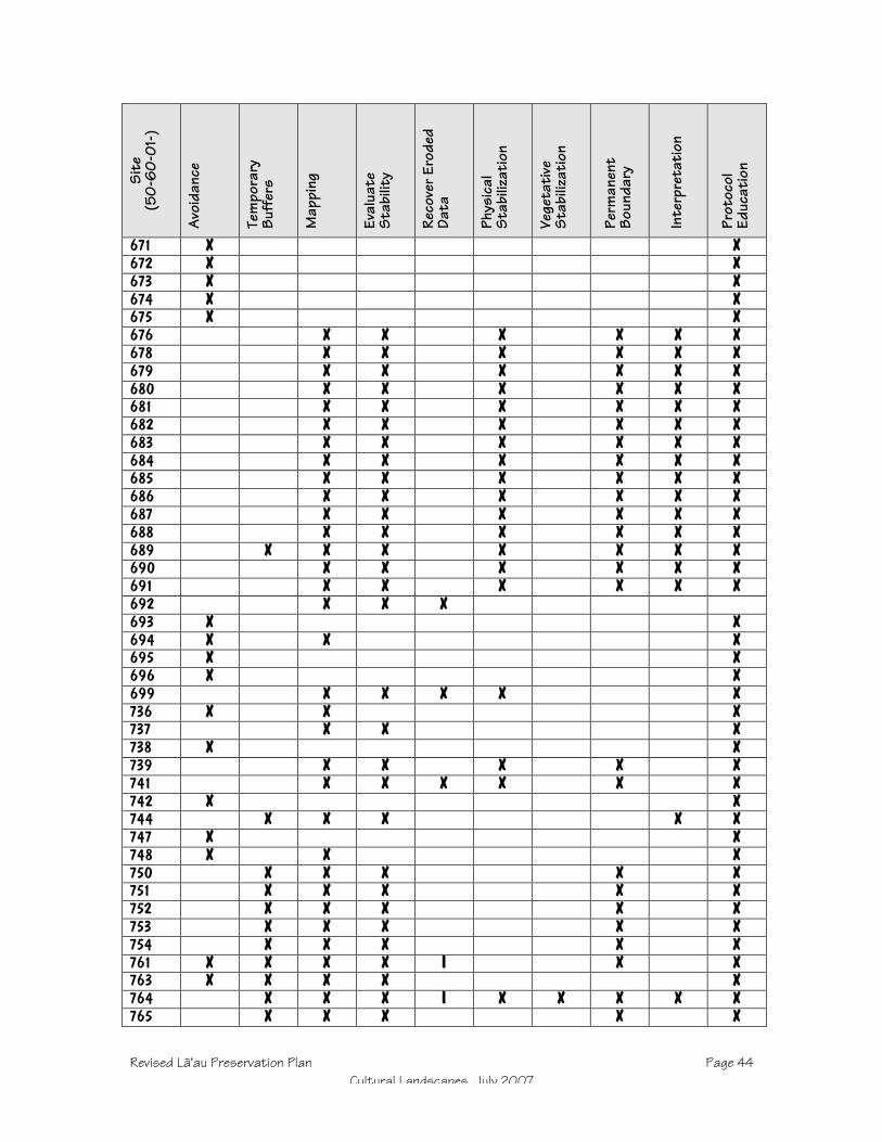
Revised Läÿau Preservation Plan Page 44Cultural Landscapes, July 2007
Site
(50-
60-
01-)
Avo
idan
ce
Tem
pora
ryBu
ffer
s
Map
ping
Eval
uate
Stab
ility
Reco
ver E
rode
dDa
ta
Phys
ical
Stab
iliza
tion
Vege
tati
veSt
abili
zati
on
Perm
anen
tBo
unda
ry
Inte
rpre
tati
on
Prot
ocol
Educ
atio
n
671 X X672 X X673 X X674 X X675 X X676 X X X X X X678 X X X X X X679 X X X X X X680 X X X X X X681 X X X X X X682 X X X X X X683 X X X X X X684 X X X X X X685 X X X X X X686 X X X X X X687 X X X X X X688 X X X X X X689 X X X X X X X690 X X X X X X691 X X X X X X692 X X X693 X X694 X X X695 X X696 X X699 X X X X X736 X X X737 X X X738 X X739 X X X X X741 X X X X X X742 X X744 X X X X X747 X X748 X X X750 X X X X X751 X X X X X752 X X X X X753 X X X X X754 X X X X X761 X X X X I X X763 X X X X X764 X X X I X X X X X765 X X X X X

Revised Läÿau Preservation Plan Page 45Cultural Landscapes, July 2007
Site
(50-
60-
01-)
Avo
idan
ce
Tem
pora
ryBu
ffer
s
Map
ping
Eval
uate
Stab
ility
Reco
ver E
rode
dDa
ta
Phys
ical
Stab
iliza
tion
Vege
tati
veSt
abili
zati
on
Perm
anen
tBo
unda
ry
Inte
rpre
tati
on
Prot
ocol
Educ
atio
n
768 X X X X X X X X769 X X X X X X X X770 X X771 X X772 X X773 X X774 X X775 X X776 X X777 X X778 X X779 X X X X X X X780 X X X X X X X X781 X X X X X X X X782 X X X X X X X X1100 X X1101 X X X I X X X X X1102 X X1103 X X1104 X X1105 X X1106 X X1107 X X1109 X X X1110 X X1111 X X1112 X X X I X1113 X X1114 X X1115 X X1116 X X1117 X X1119 X X I X X1120 X X X1122 X X X X1123 X X X X1125 X X X X1126 X X X X X1127 X X X X X X1128 X X X X X X1136 X X X X1139 X X X1142 X X X I X X X1143 X X X X X

Revised Läÿau Preservation Plan Page 46Cultural Landscapes, July 2007
Site
(50-
60-
01-)
Avo
idan
ce
Tem
pora
ryBu
ffer
s
Map
ping
Eval
uate
Stab
ility
Reco
ver E
rode
dDa
ta
Phys
ical
Stab
iliza
tion
Vege
tati
veSt
abili
zati
on
Perm
anen
tBo
unda
ry
Inte
rpre
tati
on
Prot
ocol
Educ
atio
n
1144 X X X X X X1145 X X X X X1146 X X X1147 X X X I X X X X1148 X X X X X1149 X X I X X X1150 X X X X X X1151 X X X X X1152 X X X X X X1153 X X X1154 X X X I X X1155 X X X X1156 X X1157 X X1158 X X1160 X X1161 X X1162 X X1163 X X1164 X X1166 X X1167 X X1168 X X1169 X X1170 X X1171 X X1172 X X1173 X X1174 X X1176 X X
Rural Landscape ReserveMany of the sites encountered during inventory lie outside the project areaaltogether, in the large mauka portion of the original parcel. Sites are thinlydistributed, consisting mostly of lithic quarries and work sites, temporary camps,and a few agricultural areas in the gulches. Other than a few sites in NorthKamäkaÿipö Gulch, which will be covered in the Cultural Protection Zonedescribed below, these will receive be preserved as is.
This means that vehicles may not traverse sites (unless by existing road) and noground disturbing activities may occur within 7 m of features. The 1993 inventoryrecommendations will not be changed, and these sites will not be reevaluated atthis time. Future activity in site areas should be preceded by data verification andaugmentation to provide more precise information about significant sites. Cautionshould be exercised in planning any ground disturbing activity in the vicinity of
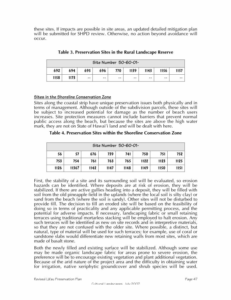
Revised Läÿau Preservation Plan Page 47Cultural Landscapes, July 2007
these sites. If impacts are possible in site areas, an updated detailed mitigation planwill be submitted for SHPD review. Otherwise, no action beyond avoidance willoccur.
Table 3. Preservation Sites in the Rural Landscape Reserve
Site Number 50-60-01-
692 694 695 696 770 1139 1143 1156 1157
1158 1173 -- -- -- -- -- -- --
Sites in the Shoreline Conservation ZoneSites along the coastal strip have unique preservation issues both physically and interms of management. Although outside of the subdivision parcels, these sites willbe subject to increased potential for damage as the number of beach usersincreases. Site protection measures cannot include barriers that prevent normalpublic access along the beach, but because the sites are above the high watermark, they are not on State of Hawai’i land and will be dealt with here.
Table 4. Preservation Sites within the Shoreline Conservation Zone
Site Number 50-60-01-
56 57 676 739 741 750 751 752
753 754 761 763 765 1122 1123 1125
1126 1136? 1142 1147 1148 1149 1150 1151
First, the stability of a site and its surrounding soil will be evaluated, so erosionhazards can be identified. Where deposits are at risk of erosion, they will bestabilized. If there are active gullies heading into a deposit, they will be filled withsoil from the old pineapple field in the uplands (where the local soil is silty clay) orsand from the beach (where the soil is sandy). Other sites will not be disturbed toprovide fill. The decision to fill an eroded site will be based on the feasibility ofdoing so in terms of practicality and any applicable permitting process, and thepotential for adverse impacts. If necessary, landscaping fabric or small retainingterraces using traditional mortarless stacking will be employed to halt erosion. Anysuch terraces will be identified as new on site records and in interpretive materials,so that they are not confused with the older site. Where possible, a distinct, butnatural, type of material will be used for such terraces; for example, use of coral orsandstone slabs would differentiate new retaining walls from most sites, which aremade of basalt stone.
Both the newly filled and existing surface will be stabilized. Although some usemay be made organic landscape fabric for areas prone to severe erosion, thepreference will be to encourage existing vegetation and plant additional vegetation.Because of the arid nature of the project area and the difficulty in obtaining waterfor irrigation, native xeriphytic groundcover and shrub species will be used.

Revised Läÿau Preservation Plan Page 48Cultural Landscapes, July 2007
Choices on which plants to use will depend on their availability, access to water,and consultation with the cultural advisors.
Once the stability of a makai site is not at risk, boundaries of a permanent bufferwill be marked for those where foot traffic is likely, or where the sites are close to aproposed subdivision lot. Unlike buffers used during monitoring, these will berelatively unobtrusive. Wooden post and rail fencing such as that employed at sitesnear Kaupoa Camp (See Appendix B)) may be used, although other options arebeing considered. One is a rail fence of stacked natural logs, and another is asimple perimeter marking of kiawe logs laid on the ground. The advantage of theseover the post and rail form is that no postholes need to be dug, and therefore thepotential to encounter buried deposits is averted. In some cases, existing or newshrubs may also function as part of the buffer. Because many of the coastal sites arereligious in nature and Native Hawaiians’ access to them is protected by law, theywill not be shut off completely. For the typical beach user, however, an accessroute around the site—rather than into it—should be the focus. For the sites that arenot perched at the edge of the rocky shoreline, access routes will go on the makaiside of the sites. This will be the case for Sites 654, 676, 1126, 1146, and 1152.Site 1101, a koÿa on Keawakalani Point, may not have an accessible route on thebeach side. (Site 654 will be dealt with in a subsequent section, but is alsoincluded here due to its accessibility and location on the beach.)
Several sites in the Shoreline Conservation Zone will be within the Project Area aswell. While these do not fall within the actual development area, steps will betaken to protect them when construction occurs in neighboring lots. Highly visibletemporary fencing will be erected along margins of the site buffers or along the lotboundary, whichever provides the greater protected area.
Interpretation will focus on the coastal portion of the North Kamäkaÿipö preserve,showing how the early date of Site 654 likely represents early temporary use of theKaluakoÿi coastline by fishermen, and the habitation and religious sites show a laterintensification to the point that there were several permanent residences. Just to thenorth, Site 676 will be identified as a fishing shrine; because it was in use when itwas recorded in 1991, it will be maintained as an active, accessible site. Anotherfeature in the North Kamäkaÿipö preserve (B6-68, part of Site 53) has beenidentified in previous archaeological studies as a koÿa, but the form is atypical andthat evaluation derives from the presence of coral alone; interpretive materialsdeveloped for this project will identify the feature and communicate thisuncertainty. Site 1101, another koÿa, is close to a planned public access on thesouth coast in the Puÿu Hakina CPZ, and will also be identified as a shrine andcleared for viewing. (Clearing the makai side of koÿa is appropriate regardless ofinterpretive goals because an open line of site to and from the sea was an integralpart of how such shrines functioned. Such clearing will be done for other koÿaunless it is likely to increase exposure to impact, but they will not be identified andmade accessible to the public.) In a more general sense, coastal habitation andreligious sites will figure into interpretive material that covers the project area.
Sites in the Proposed Subdivision Project AreaBecause of the minimum 2-acre lot size and the practical and regulatory limitationsthat will apply to development within any lot, it should not be difficult to planaround sites within the subdivision. In fact, sites in the data recovery category arethere primarily because they are either eroded (hence of limited integrity anddifficult to preserve) or consist of small, temporary use areas (hence difficult for

Revised Läÿau Preservation Plan Page 49Cultural Landscapes, July 2007
non-archaeologists to identify, and most significant for their lithic data). Dataverification and augmentation (See Data Collection) will establish site locationswith greater precision than required for the inventory, presenting the most valuablepreservation tool for subdivision lots, defining an avoidance zone for owners andarchitects. In practice the preservation areas will consist of features plus a buffer.Any future plans that could impinge on sites or their buffers must includenotification of SHPD and, if required by that agency, a revised treatment plan. Evenif direct impacts are not likely, future planners should consider and minimizesources of secondary effects, such as erosion, changes in drainage patterns, andtraffic.
Table 5. Preservation Sites within the Project Area
Site Number 50-60-01-
744 1136? 1144 1155
The following sites are in or near the proposed road construction corridor:
664 1152 1154
In addition to getting a precise location, it will be necessary for most subdivisionsites to produce a more detailed map to aid in preservation management andmonitoring their condition. Mapping will also provide an opportunity to evaluatethe stability of a site, and identify areas damaged by erosion. If warranted, sites maybe stabilized and data collected or recorded at this time.
For sites that are agricultural fields, temporary camps or workshops, and modifiedoutcrops, permanent fencing will not be erected, and their preservation zones willbe identified on maps and with site tags and flagging in the field. For sites with aknown or suspected burial, and for religious features, permanent boundaries willbe marked 9 m from the outer walls or edges. For sites without permanentboundary markers, temporary markers should be placed 7 m from any featureduring any construction activities. As mentioned in the4 Shoreline ConservationZone section, sites adjacent to subdivision lots will also be protected withtemporary fencing during construction, and with permanent buffer fencing if theyare shrines or burials. The form that permanent markers take will consist of awooden fence.
The subdivision project area also includes the road and infrastructure corridor. In afew cases, preservation sites may fall within the 60 m wide data collection corridor,but are far enough from the road alignment to allow preservation. Such sites willhave temporary fencing erected at buffer perimeters during construction; the 150-foot setback from the road in which house construction cannot occur in lots willprevent impacts by lot construction, although fencing may be left in place to avoidimpacts from driveway grading. (This would be a precautionary measure, since allpreservation sites and buffers will be marked on parcel plats and future owners willbe bound to maintain preservation commitments.) If the road encroaches on abuffer in its proposed alignment, it will be realigned unless it is clear that previousdisturbance has compromised the integrity of sediments and potential culturaldeposits, as described previously in this plan.
Details about preservation measures to be implemented where the proposed roadtraverses Cultural Protection Zones are described in the next section.

Revised Läÿau Preservation Plan Page 50Cultural Landscapes, July 2007
Cultural Protection Zones
Preservation Plans in Hawaiÿi typically focus on individual sites, but a convergenceof landowner and community preferences, and the presence of large undevelopedlandscapes offers a different opportunity here. Typical settlements in southwestMolokaÿi consist of a core habitation zone by the shore, clustered around bays andbeaches, with a periphery of temporary shelters and agricultural features. The latterusually decrease in density, size, and diversity as the distance from the coastincreases, and most occur in or near gulches. In some cases, the presence of aquarry for tool-grade stone may result in a settlement system that reaches furthermauka or beyond the confines of a gulch. The 75 to 120-foot elevations of a ridgesouth of Kamäkaÿipö have uncharacteristically large, complex sites, in part due tolithic tool production, but perhaps also because of the presence of the Maui chiefKiha-a-Piÿilani, who according to oral history lived in the vicinity.
By establishing Cultural Protection Zones, sites are protected and preserved in alarger context, so that not only the stone structures are preserved, but also theirsituation within the natural and cultural landscape, as well as their relationships toeach other. By encompassing many sites within CPZs, the diminishment ofpreservation, scientific, and cultural value wrought by the usual approach ofpreserving only fragments is avoided. Future generations will be able to view,study, and experience Hawaiian land use systems as integrated wholes in theCultural Protection Zones. Included within this plan are several such systems basedon the Bay-Gulch landform, as well as one such system augmented by a maukaquarry, as well as another at Läÿau Point itself, another in the southern Kamäkaÿipöuplands where Kiha-a-Piÿilani may have lived, and another on the makai slope ofPuÿu Hakina, where the system focuses more on a broad ridge than gulch.
The ahupuaÿa of Kaluakoÿi appears to be ancient, and is the land unit in the firsthistoric documents that were cognizant of Hawaiian land divisions, such as themid-nineteenth century Mahele land claims. It does include—as far as is possibleon the relatively low and dry mountain of Mauna Loa—the classic cross section ofecological and resource zones from the mountain to the sea, but Kaluakoÿi coversthe entire mountain and is not divided into the pie-shaped wedges associated withahupuaÿa. This anomaly is usually attributed in archaeological literature to theabsence of valleys and the presumed low population density of west Molokaÿi(Kirch 1985, Summers 1971).
However, when looking at the settlement patterns of the west end, it is clear thatKaluakoÿi was divided. Although not recognized historically as distinct land units,the gulches of Kaluakoÿi are the foci of mauka-makai oriented landscape use. Fromnorth to south, the gulches and bays of Kawäkiu, Kakaÿako, Päpöhaku,Wahïlauhue, Poÿolau, Kapukahehu, Kaunalä, Kaheu, and Kamäkaÿipö are wheresites cluster. Between these gulches, the ridges and flat lands have relatively fewtraces of human presence.
Although not all of these gulch systems have been surveyed, there appears to be ageneral pattern, which will provide the basis for interpretation. Beginning at thecoast, there are sites beginning at the high water mark. At least some probablyreflect very early visits by residents of other areas landing during fishing trips, butthe most obvious aspect of coastal sites is that they became fairly well developed.For example, there are often multiple permanent habitations, fishing shrines, andabundant cultural deposits clustering around the bays. Inland of these, the lowergulches have a mixture of agricultural fields, temporary (or perhaps lower status)habitations, and work areas. Further inland, sites become more sporadic, and

Revised Läÿau Preservation Plan Page 51Cultural Landscapes, July 2007
multi-function sites are less common—small planting areas, lithic work areas, andtrail markers are most common. The complete makai-mauka system ends up in thesummit region where there are again rather numerous religious, habitation,agricultural, lithic, and other types of sites, but here the peaks and plateaus providethe foci for settlement, and gulches are less relevant. The mauka end of the gulchsettlement system is often a source of stone quarried to make adzes and other tools.Beyond this there are few sites until the summit, although it is possible that the landwas cultivated or otherwise used so that traces were minimal and easily obscuredby historic pineapple cultivation.
Cultural Protection Zones will be marked on maps, but will also require some formof identification in the field. Metal tags with site numbers will be placed in sites,but boundaries of the area will also be marked. Because of the large size, markerssuch as those discussed in Permanent Boundaries are not feasible, although theymay be used at the makai sites (53-54) near the public access. For the rest of thepreserve, the boundary will be marked with signs located at the north and southedges of the gulch near site areas. Precise locations for these will be determinedafter sites have been visited and mapped, but the north edge will be approximatelyfrom Site 654 to 680 to 678, and the south edge from Site 655 to 690 to 686 to 684to 688 to 678.
Although some of the most impressive sites in the Cultural Protection Zones havebeen mapped in detail, more detailed and precise maps are required for adequatepreservation management of some sites. Mapping will be done with tape andcompass for simple sites, and with plane table and alidade for those which aremore complex. In conjunction with mapping, the condition and stability of eachsite will be evaluated. For some sites (such as 654, 655, 779, 780, and 782), it isalready clear that enough erosion has already occurred that data should becollected as described in Recovering Eroded Data above.
The proposed road traverses Cultural Protection Zones in four locations where itcrosses gulches: Kaunala, Kaheu, and North Kamäkaÿipö. Because each of thesezones extends well inland, rerouting around them would require several miles ofadditional road, the potential environmental impacts of which, not to mention thecertain visual impacts, would exceed carefully planned and monitored traverses ofthe protection zones. Sites which may be in or near the 60 m road survey corridorare 664 (5 small agricultural mounds), 687 (habitation), 689 (L-shaped wall,possible temporary habitation), 780 (lithic tool-manufacture debris), and 782 (lithictool-manufacture debris). Most of these appear to be outside of the 60 m corridor,but lingering uncertainty about their location at this time mean that their relocationwill be an important mission of the re-survey. If they end up within 7m of theproposed road edge, the road will be rerouted.
Where the proposed road cuts through Cultural Protection Zones, several effortswill be made to minimize its physical and visual impacts. First, no turn-arounds,stockpiles, or other construction support features will be allowed within thesezones—the intent is to make the affected area as narrow as possible, limitingimpacts to the road and shoulder. Likewise, utilities buried in these zones shouldbe as close to the road center as possible to avoid having multiple impact corridors.Once project engineers and field personnel have come to an agreement with thearchaeologist on the narrowest possible development corridor, the edges will beclearly marked to prevent encroachment beyond. Because of the preservationintent and the fact that most of the traverses occur in gulches, road design andconstruction shall take into account the potential effects to run-off and drainage.

Revised Läÿau Preservation Plan Page 52Cultural Landscapes, July 2007
Given the past history of erosion, it should be possible to construct roadways thatnot only cause no adverse effects, but actually slow down runoff and stabilizenearby sediments. Finally, design and construction in the Cultural Protection Zonesshall strive to minimize the visual impact of the road by avoiding an unnecessarilyobtrusive roadbed and signs, and above-ground utilities. If roadside landscaping isplanned, historic and modern introductions should be avoided, and viewplanesfrom traditional features should be maintained; in some cases vegetation may beuseful as a visual screen to decrease the sense that a site is near a road. As the roadenters a Cultural Protection Area, a sign should identify the place by its Hawaiianname. Where it crosses the Kamäkaÿipö preserve, the road should provide a meansfor people hiking the interpretive trail to cross safely, preferably with means such asspeed bumps or other signals on the road itself, with a minimum of signs.
KaunaluThis northernmost Cultural Protection Zone extends from Kaunalu Bay up the gulchto about the 175-foot elevation. Most of the makai sites fall within the SMAD, andare concentrated on the north side of the bay below 30 fasl (feet above sea level).Site density and complexity decreases radically above this, although agriculturalmodifications are present in the gulch.
Table 6. Preservation Sites within Kaunalu CPZ
Site Number 50-60-01-
48 49 50 641 642 643 644 645
657 658 659 660 662 663 665 --
Kaunalu CPZ will be an archaeological and cultural reserve, with passivepreservation. Rather than clearing and interpretation, the focus will be onprotecting the area from incursion. Toward that end, the CPZ will be marked onproject maps, and those who buy lots in the proposed Läÿau subdivision will beedicated regarding the need to leave sites there alone.
This CPZ is well to the north of the Project Area, and the only potential effectcaused by the proposed subdivision will be in the area of the road corridor, whichtraverses Kaunalu Gulch about 2200 feet from the coast. This location is aboutmidway between Sites 658 (a single agricultural clearing mound) and 659 (aterrace alignment), sites separated by a gap of approximately 300 meters (1000feet). This area is mauka of the settlement area, and the road will not have anyadverse effect on the cultural landscape. To ensure that no such effects occur, theroad corridor will be re-examined in this area, and may be re-routed if necessary toavoid significant archaeological resources. Should the proposed road pass within100-m of a site, protective fencing will be put in place and the construction crewsinformed of the need to avoid impacts. Any work in or adjacent to the preserve willbe monitored by a qualified archaeologist.
KaheuThe Kaheu CPZ is also located north of the Project Area, with the only area ofpotential effect being where the proposed access road traverses it. The densestportion of the settlement is within the SMAD, although the inventory reported morefeatures than were known when the SMAD was listed on the National Register. As

Revised Läÿau Preservation Plan Page 53Cultural Landscapes, July 2007
with Kaunalu, most of the features are located north of the bay and gulch, althoughit is possible that the early 20th Century construction of Molokai Ranch ownerGeorge Cooke’s “Kaupoa House” south of the bay removed older sites there.Although the overall area of the settlement here exceeds that at Kaunalu, densityand complexity also decreases rapidly away from the shore.
Kaheu CPZ will be an archaeological and cultural reserve, with passivepreservation. Rather than clearing and interpretation, the focus will be onprotecting the area from incursion. Toward that end, the CPZ will be marked onproject maps, and those who buy lots in the proposed Läÿau subdivision will beedicated regarding the need to leave sites there alone.
Table 7. Preservation Sites within Kaheu CPZ
Site Number 50-60-01-
51 52 639 640 646 647 648 649
650 651 652 664 666 667 668 669
670 671 672 673 674 675 -- --
The road is planned to pass just mauka of the northern lobe of the CPZ, where itmay be within 100 m of Site 664, a group of five small agricultural clearingmounds; these will be protected with fencing during construction. At the pointwhere the road crosses Kaheu Gulch, it will traverse a section of the Kaheu CPZ,but not in the vicinity of any sites. South of the gulch, the road data collectioncorridor (30-m on wither side of the proposed road center line) may include part ofSite 675, a temporary habitation and group of planting circles. The location of 675in relation to the road will be verified, and protective measures taken asappropriate.
Kamäkaÿipö NorthNorth Kamäkaÿipö Gulch exemplifies settlement systems on the west coast ofKaluakoÿi; because it has a good array of sites that remain relatively undisturbed,this has been chosen for preservation. By preserving not just obviousarchaeological features, but also the landscape connecting them (approximately130 acres), this mauka-makai area will preserve the overall cultural landscape,valuable not just for study, but for seeing and experiencing a Hawaiian settlement.
Table 8. Preservation Sites within Kamäkaÿipö North CPZ
Site Number 50-60-01-
53 54 654 655 656 678 679 680
681 682 683 684 685 686 687 688
689 690 691 768 769 779 780 781
782 -- -- -- -- -- -- --
It is anticipated that most sites in North Kamäkaÿipö need stabilization of sometype, but for most it should consist of minor re-stacking and setting retaining
Revised Läÿau Preservation Plan Page 54Cultural Landscapes, July 2007
alignments. Because filling all of the deflated and eroded surfaces in sites like 53,54, and 656 would require enormous (and impractical) amounts of fill, stabilizationwill focus more on preventing further damage than repairing past damage. Forexample, eroding banks where artifacts are being washed out may be covered withlandscaping fabric or some other means of preventing further loss of sediment.Should parts of the site be opened for educational purposes, foot traffic would berouted to avoid any areas where it could cause erosion or collapse of features anddeposits.
Interpretation in the North Kamäkaÿipö preserve will consider particular sites withinthe context of the gulch system from the coast (Sites 53, 54, and 654) up to thequarry (Site 656). The coastal sites, being on either side of the public access to thebeach, will be the primary focus of interpretation, with signs identifying variousfeatures and relating what is known of them. Information recovered during thecurrent project will be synthesized with previous archaeological work from theproject area and Kaluako’i, with Hawaiian oral traditions, and with other relevantresearch and information. Existence of a traditional trail up to the quarry providesan opportunity for an interpretive trail that can be used to better explain ancientadaptation to the mauka-makai continuum of habitats and resources.
Pending Küpuna advisor and SHPD approval of a Detailed Interpretive Plan, aninterpretive trail will wend its way through this preserve. Although the preciserouting will depend on field inspections, site boundary verification, andconsultation, the approximate route will go from Site 656 to 679 and 680descending the north slope of the gulch, across to Site 686 and 691, back across toSite 685 and to the coast at Site 54. These sites are a series of basalt tool-makingsites, shelters, and trail markers. The original trail will be followed to the extent thatit can be identified and followed safely and without causing erosion. Features willnot be traversed or breached, vehicles and bicycles will not be allowed, andclearing will be limited to opening sight lines without stripping the landscape.Parking at the top will be north and inland of Site 656 in a disturbed area. Accessand parking at the lower end can occur at multiple locations without causingadverse impacts, since Site 54 is in fact a broad alluvial fan that consists of featureclusters interspersed with heavily eroded areas. Any development will occuroutside of a 7 m buffer from features (9 m for shrines and burials).
Additional vegetation clearing may be done to increase visibility of sites withoutactually walking through features, but complete removal of canopy and surfacevegetation will be avoided so that erosion risk is not increased. Because of the lackof water, plantings will be unfeasible or very limited, and is not anticipated beyondparts of Sites 654, 53, and 54. At other features, string trimmers will be used to getrid of tall grasses and encourage groundcover grasses as described in the KaupoaPreservation Plan (Major 1997). Throughout the preserve, native species will beencouraged to maintain and spread their coverage. Some sites that are not part ofthe interpretive program will not be cleared.
South Kamäkaÿipö – Kiha-a-PiÿilaniThis area extends from about 40-fasl at Site 699, just mauka of the Kamäkaÿipöalluvial flat to 270-fasl at Site 1128, on a hill along the southwest rift zone of theMaunaloa volcano. Most of the sites are widely dispersed, but among them are thebest examples of large-multi-roomed enclosures, a distinctive site type in this non-coastal setting. Oral histories suggest that this vicinity may have been the isolatedoutpost where the son of Maui paramount chief Piÿilani was raised, a refuge from

Revised Läÿau Preservation Plan Page 55Cultural Landscapes, July 2007
the wars of his home island. Archaeological evidence shows that at least some ofthese features in Sites 771 – 773 and 747 were intensive lithic tool productionshops, and fine basalt sources are also present. Furthermore, Site 1128 is known asa “Piko stone,” a boulder with a natural cupboard in it that was used by certainfamilies to place the umbilical cord of newborn children; it is also reported to haveheld fishhooks used by people traveling between Läÿau Point and the uplands. Atthe southeastern end of this CPZ, Site 1127 consists of a crescent-shaped boulderpropped against another larger boulder, forming a seat that aces makai (south). Asimilar feature is described at the Molokaÿi Museum as a birthing stone, and giventhe presence of each of 1127 and 1128 along the same ridge, on an east-west axisabout 300 m apart, it is likely tat the same function pertains to this site. Politically,economically, and culturally, then, this area is more significant than its thin, drysoils would normally allow, and it represents a departure from the normal patternin which the inland portion of settlement systems focused on gulches.
Table 9. Preservation Sites within South Kamäkaÿipö – Kiha-a-Piÿilani CPZ
Site Number 50-60-01-
693 699 736 737 742 747 748 771
772 773 774 775 776 777 778 1127
1128 -- -- -- -- -- -- --
The far northwest extreme of this CPZ extends into the data collection corridor forthe proposed road, although none of the sites themselves do, and it is anticipatedthat no individual site buffer would be encroached upon by that corridor. Neitherdoes this preserve coincide with any subdivision lots. Nevertheless, a primary taskof data collection will be to ensure that the development area does not encroachon site buffers. Site 699 comes closest to the road (approximately 100-m outsidethe data collection corridor, but will be fenced should it turn out to be within thearea of potential effects.
An old dirt road that goes from Läÿau Point to Maunaloa along the southwest riftzone ridge passes through the Kamäkaÿipö – Kiha-a-Piÿilani Cultural ProtectionZone, coming within 50 meters of Sites 1127 and 1128. Known to have been usedat least as far back as the 19th Century, when the lighthouse keeper traveled it, theroad likely follows (more or less) an ancient trail. Although it will not be a roadopen to subdivision or public traffic, the landowner wants to keep this as anemergency vehicle access route. No improvements have been specified, but evenlimited maintenance such as grading will be confined to the extant road corridor.Although any ground disturbing activity is automatically subject to monitoring inthe CPZ, Sites 1127 and 1128 will be further protected by erecting permanentbuffer fencing on the side toward the road, and will be identified as sacred placeswith on-site signs.
Läÿau PointMost of the sites located at Ka Lae o Läÿau (Läÿau Point) are within the U.S. CoastGuard reservation, and therefore are neither part of the project area nor legallysubject to this Preservation Plan. Because the cluster of sites in that parcel iscontiguous with sites in the project area, however, and because the Coast Guard
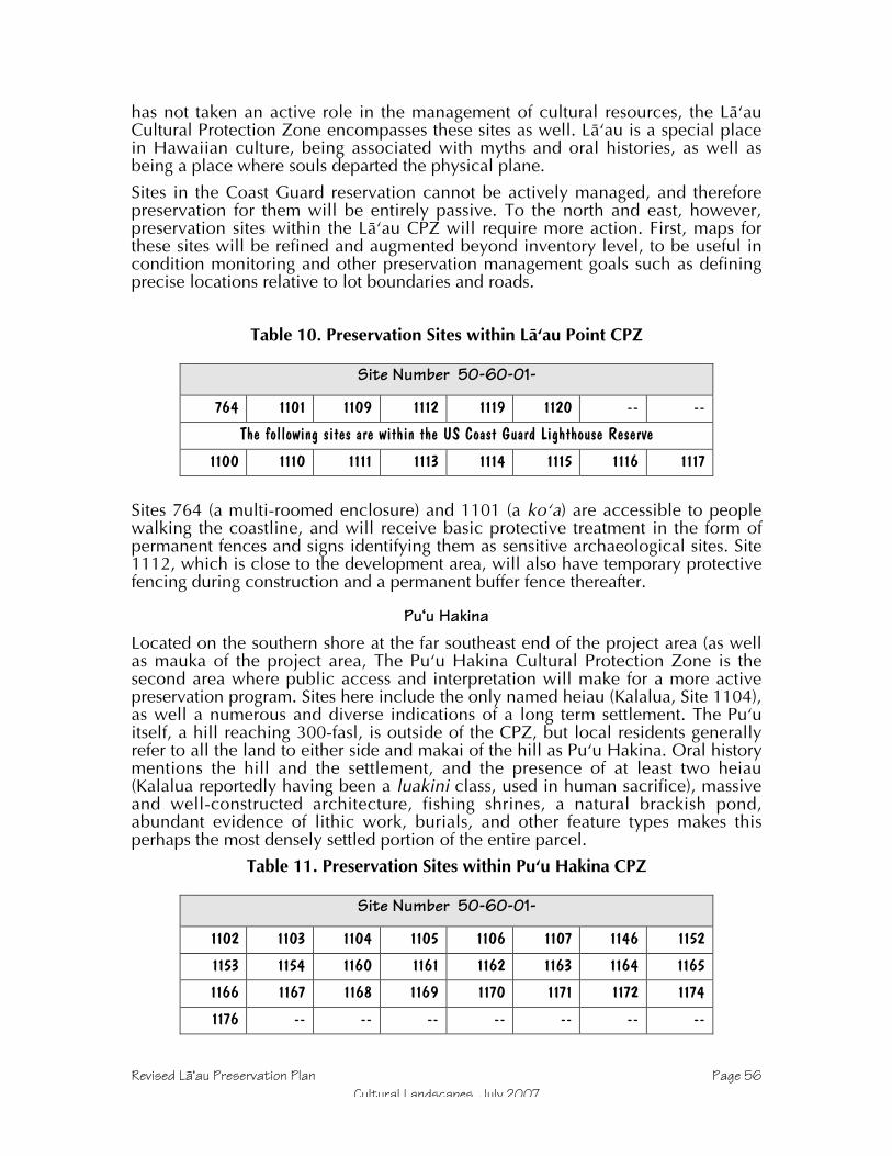
Revised Läÿau Preservation Plan Page 56Cultural Landscapes, July 2007
has not taken an active role in the management of cultural resources, the LäÿauCultural Protection Zone encompasses these sites as well. Läÿau is a special placein Hawaiian culture, being associated with myths and oral histories, as well asbeing a place where souls departed the physical plane.
Sites in the Coast Guard reservation cannot be actively managed, and thereforepreservation for them will be entirely passive. To the north and east, however,preservation sites within the Läÿau CPZ will require more action. First, maps forthese sites will be refined and augmented beyond inventory level, to be useful incondition monitoring and other preservation management goals such as definingprecise locations relative to lot boundaries and roads.
Table 10. Preservation Sites within Läÿau Point CPZ
Site Number 50-60-01-
764 1101 1109 1112 1119 1120 -- --
The following sites are within the US Coast Guard Lighthouse Reserve
1100 1110 1111 1113 1114 1115 1116 1117
Sites 764 (a multi-roomed enclosure) and 1101 (a koÿa) are accessible to peoplewalking the coastline, and will receive basic protective treatment in the form ofpermanent fences and signs identifying them as sensitive archaeological sites. Site1112, which is close to the development area, will also have temporary protectivefencing during construction and a permanent buffer fence thereafter.
Puÿu HakinaLocated on the southern shore at the far southeast end of the project area (as wellas mauka of the project area, The Puÿu Hakina Cultural Protection Zone is thesecond area where public access and interpretation will make for a more activepreservation program. Sites here include the only named heiau (Kalalua, Site 1104),as well a numerous and diverse indications of a long term settlement. The Puÿuitself, a hill reaching 300-fasl, is outside of the CPZ, but local residents generallyrefer to all the land to either side and makai of the hill as Puÿu Hakina. Oral historymentions the hill and the settlement, and the presence of at least two heiau(Kalalua reportedly having been a luakini class, used in human sacrifice), massiveand well-constructed architecture, fishing shrines, a natural brackish pond,abundant evidence of lithic work, burials, and other feature types makes thisperhaps the most densely settled portion of the entire parcel.
Table 11. Preservation Sites within Puÿu Hakina CPZ
Site Number 50-60-01-
1102 1103 1104 1105 1106 1107 1146 1152
1153 1154 1160 1161 1162 1163 1164 1165
1166 1167 1168 1169 1170 1171 1172 1174
1176 -- -- -- -- -- -- --
Revised Läÿau Preservation Plan Page 57Cultural Landscapes, July 2007
Because of the abundant cultural and archaeological sites here, and the fact thatthis will be the location of the southern shoreline park and access point forpedestrians coming from nearby Hale-o-Lono harbor, both protective measures andinterpretive efforts are appropriate here more than in remote preserves. Site-specificactions have been listed in the table at the beginning of the section.
The process will begin by marking a permanent buffer to protect sites fromencroachment. Rather than marking this buffer radially from surface features ofeach individual site, this permanent buffer will correspond with the edges of thedevelopment area as defined by lot boundaries. If the lot boundaries themselvesencroach on any individual site buffer, then the permanent boundary will extendinto the lot. However, design of the subdivision has already anticipated the needfor site protection, and the use of lot boundaries will result in a much larger bufferthan the 7 – 9 meter radial buffers specified for individual sites. A single fence-lineat the edge of the subdivision where it abuts the CPZ will prove less visually andphysically disruptive than a series of individual site buffers, and will accomplish thesite protection function for a continuous cultural landscape, rather than afragmented series of site-specific buffers.
Buffers may also be required along the edges of an existing dirt road that followsthe coastline through part of the CPZ. This road will not be open to vehicle trafficexcept for emergency vehicles, but in order to protect likely burial features at 1152,1154, 1170 and 1176, limited sections of fencing may be installed. Roadmaintenance will be restricted to grading the existing corridor, and will bemonitored.
Sites in the CPZ generally have high quality maps for inventory level reporting, butneed to be upgraded for preservation functions in what is the most accessibleheavily used portion of the coast. In addition to providing greater detail for abaseline used in condition monitoring, the maps will be expanded and integratedwith one another and the local terrain. At the time of mapping, sites will also beevaluated in terms of stability, and both physical and vegetative stabilization willbe employed as appropriate. (These methods have been described in detail in thePreservation Actions section above.)
The detailed maps will also be used in interpretive and educational aspects of theprogram, which will be described in a Detailed Interpretive Plan. This documentwill form a supplement to this plan, and will provide SHPD and interested partieswith details regarding the specific interpretations tat will be made about this andother areas. Information compiled during the Supplemental Data Collection phase,site stability evaluations, and consultation with knowledgeable küpuna will formthe foundation of these interpretive elements.

Revised Läÿau Preservation Plan Page 58Cultural Landscapes, July 2007
References
Bonk,William1954 Archaeological Excavations On West Molokai. Master of Arts
Thesis, Department of Anthropology, University of Hawaii.
Burtchard, Greg and Stephen Athens2000 “Archaeological Reconnaissance of the Päpöhaku Aerial Gunnery Range
Kaluakoÿi Ahupuaÿa, Island of Molokaÿi, Hawaiÿi.” Ms. prepared byInternational Archaeological Research institute, Inc.
Cooke, George P.1949 Mo'olelo O Molokai: A Ranch Story of Molokai. Honolulu Star
Bulletin, Honolulu.
Cooke, Sophie1961 Sincerely, Sophie. Tongg Publishing. Honolulu.
Dixon, Boyd and Maurice Major1993 "Kapukahehu to Pu`uhakina: An Archaeological Inventory Survey of
Southwest Moloka`i." Ms. in Anthropology Department, Bishop Museum.
Dixon, Boyd, Maurice Major, Michael Price, Alan Carpenter, Cary Stine, BruceLongton1994 "Lithic Tool Production and Dryland Planting Adaptations to regional
Agricultural Intensification: Preliminary Evidence from Leeward Moloka`i,Hawai`i." Bishop Museum Occasional Papers No. 39. Bishop MuseumPress: Honolulu.
Dye, Tom, Marshall Weisler, and Mary Riford1985 “Adz Quarries On Moloka`i And Oahu, Hawaiian Islands.” Bernice P.
Bishop Museum, Honolulu.
Fowke, Gerardn.d. Archaeological Work in Hawaii. Bureau of American Ethnology Bulletin No.
76: 174-195
Handy, Edward S. C., Elizabeth Handy and Mary K. Pukui1972 Native Planters of Old Hawaii: Their Life, Lore, and Environment. Bernice
Pauahi Bishop Museum Bulletin No. 233. Bishop Museum Press, Honolulu.
Jenson, P.1988 “Archaeological Resource Assessment, Alpha Hotels 7000-Acre West Molokai
Parcel.” Prepared by Paul H. Rosendahl, Inc. Ms. on file in HistoricPreservation Division, Kapolei.
Kaimikaua, Johnn.d. “Kaluakoÿi—The Adze Quarries” Molokai Dispatch Newspaper. June 26.
Page 41988 Oral History. Interviewed by Philip Spalding III

Revised Läÿau Preservation Plan Page 59Cultural Landscapes, July 2007
Kamakau, Samuel M.1992 Ruling Chiefs of Hawaiÿi. Revised edition. Kamehameha Schools, Honolulu.
Kirch, Patrick1985 Feathered Gods and Fishhooks. University of Hawaii Press, Honolulu.
Major, Maurice1997 "Preservation Plan for Kaupoa Camp, Kaluako`i, Moloka`i." Ms. prepared for
Molokai Ranch, Ltd. by Cultural Landscapes Hawai`i, Honolulu.2000 “Archaeological Inventory Survey at Kukui Summit, Ahupuaÿa of
Kaluakoÿi, Molokaÿi.” Ms. on File in State Historic Preservation Division,Kapolei.
2001 “Kahaiawa to Hakina, Ahupuaÿa of Kaluakoÿi, Island of Molokaÿi (Portionof TMK 5-1-02-030): Archaeolgical Mitigation Plans” Ms. on File in StateHistoric Preservation Division, Kapolei.
2002 “Southwest Molokaÿi Mitigation Plan Addendum” Ms. on File in StateHistoric Preservation Division, Kapolei.
Major, Maurice and Boyd Dixon1992 "Archaeological Reconnaissance Survey from Haleolono to Kaumanamana
Point, Kaluako`i, Moloka`i, Hawai`i." Ms. in Anthropology Department,Bishop Museum.
Major, Maurice and Tracy Tam Sing
1998 "Supplemental Archaeological Inventory Survey of a Portion of the PublicAccess Trail at Kapukahehu, Kaluako`i, Moloka`i." Ms. on file in StateHistoric Preservation Division, Honolulu.
Malo, David1951 Hawaiian Antiquities. Bishop Museum Press, Honolulu.
Menzies, Archibald1920 Hawaii Nei 120 Years Ago. W. F. Wilson, Honolulu.
Nakuina, Moses (Esther Mookini and Sarah Nakoa, translators)1992 The Wind Gourd of Laÿamaomao: The Hawaiian Story of Pakaÿa and Ku-a-
pakaÿa. Second edition. Kalamaku Press, Honolulu.
Phelps, Southwick1941 "A Regional Study Of Molokai, Hawaii." Ms. in Bishop Museum Archives,
Honolulu.
Stokes, John F. G.1909 "Molokai, Survey of Heiau." Ms. in Bishop Museum Archives, Honolulu.
Strong, Hal1971 “A Preliminary Survey of Kamakaipo Gulch Habitation Area, Molokai.” MS
on file, University of Hawaiÿi
Revised Läÿau Preservation Plan Page 60Cultural Landscapes, July 2007
Summers, Catherine1971 Molokai: Site Survey. Pacific Anthropological Records No. 14. Department
of Anthropology, Bernice Pauahi Bishop Museum, Honolulu.
Weisler, Marshall1984 “Impressions of Prehistory: An Archaeological Survey of Selected Area of
Southwest Molokaÿi, Hawaiian Islands.” Department of Anthropology,Bishop Museum, Honolulu.

Revised Läÿau Preservation Plan Page 61Cultural Landscapes, July 2007
1985 Appendices
Inventory Data for Preservation SitesAll sites recorded during inventory of TMK 5-1-03-030 are included in thefollowing table. This is intended as a quick reference, and summarizes site-levelinformation for readers. Individual feature descriptions and more detaileddiscussion of sites can be found in the inventory report (Dixon and Major 1993).
Table 12. Archaeological Inventory Site Data
Stat
e Nu
mber
(50-
60-0
1-)
Bish
op M
useu
mNu
mber
(50-
Mo-
)
Feature TypesSite Function
SiteArea(m2)
Altit
ude
Sign
ifica
nce
48 B6-61 Enclosure Habitation 15 x 15 20 D,E49 B6-62 Platform Religious 5 x 5 20 D,E50 B6-63 Platform Habitation,
Religious15 x 10 20 C,D,E
50 B6-64 6 Alignment4 C-shape3 EnclosurePavementMound
Habitation,Religious
20 x 20 20 C,D,E
51 B6-65 Enclosure Religious 20 x20 20 D,E52 B6-66 Platform
WallReligious,Lithic work
10 x 10 30 D,E
53 B6-68 RemnantPlatformLithic debitage
Lithic work,Religious,Trail
20 x 15 20 C,D,E
54 B6-69 to -73 9 Terrace9 Enclosure6 Mound5 Terrace5 Platform4 C-shape4 Wall3 RemnantCairn
Habitation,Trail, Burial,Men’s HousePoss. burial
275 x 150 45 C,D,E
56 B6-76 and -77 6 Enclosure6 Cairn6 Mound4 C-shape3 Wall2 Platform2 Cupboard
Habitation,Religious,Poss. Burial
120 x 75 20 C,D,E
57 B6-78 Platform Religious 3 x 3 20 D,E639 B6-67 6 Enclosure
6 C-shape3 Platform2 Wall remnantMound
Habitation,Religious,Canoe Shed
90 x 60 20 C,D,E
640 B6-74 Mound Undetermined 1 x 1 35 D641 B6-83 2 Enclosure Religious, 100 x 50 20 D,E
Revised Läÿau Preservation Plan Page 62Cultural Landscapes, July 2007
Stat
e Nu
mber
(50-
60-0
1-)
Bish
op M
useu
mNu
mber
(50-
Mo-
)
Feature TypesSite Function
SiteArea(m2)
Altit
ude
Sign
ifica
nce
Habitation,Lithic work
642 B6-84 Enclosure Habitation 10 x 5 15 D643 B6-85 Lithic debitage Lithic work 5 x 5 15 D644 B6-86 2 C-shape Habitation 10 x 10 25 D645 B6-87 4 C-shape
3 EnclosureCairn
Habitation,Canoe shed,Trail
20 x 10 20 C,D
646 B6-88 Lithic debitage Lithic work,Midden
5 x 5 15 D
647 B6-89 Habitation,Agricultural
40 x 20 40 D
648 B6-90 Habitation,Religious,Poss. burial
50 x 30 30 D,E
649 B6-91 2 MoundC-shapePlatformEnclosure
Habitation,Religious,Poss. burial
20 X 15 35 D,E
650 B6-92 Agricultural,Temp. Hab.
100 x 40 60 D
651 B6-93 9 Enclosure6 C-shape2 MoundPlatform
Agricultural,Temp. Hab.,Religious
80 x 60 60 D,E
652 B6-94 4 C-shapeAnclosureAlignment
Agricultural,Habitation
30x20 60 D
654 B6-96 Midden deposit Habitation 7 x 3 8 D655 (aka 53) B6-97 4 C-shape
EnclosureHabitation 20 x 15 40 D
656 B6-98 4 C-shape Lithic quarry 80 x 50 240 D657 B6-107 4 Alignment
3 Mod. Outcrop3 Terrace
Agricultural,Temp. Hab.
75 x 25 20 D
658 B6-108 Mound Agricultural 2 x 2 60 D659 B6-109 Terrace Undetermined 10 x 3 90 D660 B6-110 C-shape
MoundTemp. Hab. 8 x 5 110 D
662 B6-112 EnclosureBait mortar
Temp. Hab. 30 x 15 10 D
663 B6-113 Enclosure Temp. Hab. 30 x 15 10 D664 B6-114 5 Mound Agricultural 10 x 10 60 D665 B6-115 Lithic debitage Lithic work 4 x 4 160 D666 B6-116 C-shape Temp. Hab. 4 x 3 60 D667 B6-117 Enclosure Habitation 5 x 5 50 D668 B6-118 7 Enclosure
2 C-shapePavement
Agricultural,Temp. Hab.
180 x 75 100 D
669 B6-119 C-shape Agricultural, 60 x 40 120 D

Revised Läÿau Preservation Plan Page 63Cultural Landscapes, July 2007
Stat
e Nu
mber
(50-
60-0
1-)
Bish
op M
useu
mNu
mber
(50-
Mo-
)
Feature TypesSite Function
SiteArea(m2)
Altit
ude
Sign
ifica
nce
EnclosureMoundTerraceAlignment
Temp. Hab.
670 B6-120 3 Mound2 C-shapeCupboardRemnant
Religious,Temp. Hab.
60 x 25 130 D,E
671 B6-121 2 Mound Burial 10 x 5 50 D,E672 B6-122 4 Terrace Soil retention 50 x 30 150 D673 B6-123 Terrace Soil retention 5 x 2 180 D674 B6-124 Mound Burial 1 x 1 80 D,E675 B6-125 5 Enclosure Temp. Hab.,
Agricultural40 x 25 70 D
676 B6-126 Platform Religious 35 x 15 40 D,E678 B6-128 Enclosure Planting circle 2 x 2 245 D679 B6-129 4 Enclosure
3 C-shapeCairn
Temp. Hab.,Agricultural,Poss. Trail
25 x 10 215 D
680 B6-130 2 EnclosureC-shapeWall remnant
Lithic quarry,Lithic work
60 x 40 165 D
681 B6-131 Mound Poss. burial 3 x 2 130 D,E682 B6-132 Mound Poss. burial 2 x 2 130 D,E683 B6-133 Terrace Temp. Hab. 10 x 5 140 D684 B6-134 C-shape Temp. Hab. 3 x 3 155 D685 B6-135 Enclosure Temp. Hab. 3 x 3 80 D686 B6-136 C-shape
CairnTemp. Hab.,Trail
5 x 4 150 D
687 B6-137 2 C-shapeEnclosaureTerraceMound
Habitation 20 x 10 50 D
688 B6-138 Lithic debitage Lithic work N/A 165 D689 B6-139 L-shape Temp. Hab. 5 x 5 60 D690 B6-140 4 Mound
3 Mod. OutcropEnclosurePlatformAlignment
Religious,Habitation,Agrulcultural?
35 x 20 80 D,E
691 B6-141 C-shape Temp. Hab. 4 x 3 120 D692 B6-142 Alignment Lithic work 30 x 10 120 D693 B6-143 Lithic debitage Lithc work 2 x 1 140 D694 B6-144 2 Terrace Agricultural 20 x 5 40 D695 B6-145 Lithic debitage Lithic work 5 x 5 40 D696 B6-146 Lithic debitage Lithic work 20 x 10 60 D699 B6-149 Enclosure
Faced pitAlignment
Habitation,Well, Trail?
70 x 30 30 D
736 B6-150 10 Mod. Outcrop Agricultural 40 x 30 40 D

Revised Läÿau Preservation Plan Page 64Cultural Landscapes, July 2007
Stat
e Nu
mber
(50-
60-0
1-)
Bish
op M
useu
mNu
mber
(50-
Mo-
)
Feature TypesSite Function
SiteArea(m2)
Altit
ude
Sign
ifica
nce
737 B6-151 6 MoundC-shapeAlignmentCairn
Agricultural,Temp. Hab.,Poss. trail
80 x 40 50 D
739 B6-153 Pavement Poss. burial 4 x 3 15 D,E741 B6-155 2 Mound
EnclosureCairn
Habitation,Trail, Burial
50 x 20 35 D,E
742 B6-156 Lithic debitage Lithic work 50 x 15 60 D744 B6-158 2 Cairn Trail marker 8 x 3 60 D747 B6-161 2 Wall
EnclosureLithic quarry,Lithic work
50 x 20 160 D
748 B6-162 EnclosureC-shape
Military,Lithic work
20 x 10 160 D
750 B6-164 Cairn Trail marker 1 x 1 70 D751 B6-165 Cupboard Storage 2 x 1 80 D752 B6-166 Cairn Trail marker 2 x 1 80 D753 B6-167 Enclosure Temp. Hab. 5 x 4 40 D754 B6-168 Cupboard
Mod. OutcropTemp. Hab. 5 x 3 40 D
761 B6-175 Enclosure Temp. Hab. 10 x 10 50 D763 B6-177 C-shape Temp. Hab. 2 x 2 25 D764 B6-178 Enclosure
PlatformHabitation,Poss. burial
30 x 15 30 D,E
765 B6-179 3 Enclosure3 Cairn
Temp. Hab. 60 x 40 30 D
768 B6-182 Lithic debitage Lithic work 5 x 5 280 D769 B6-183 C-shape Temp. Hab. 4 x 4 330 D770 B6-184 C-shape Temp. Hab. 4 x 4 160 D771 B6-185 12 Enclosure
5 PitTerrace
Habitation 30 x 20 90 C,D
772 B6-186 5 Enclosure2 Pit
Habitation 20 x 10 110 C,D
773 B6-187 EnclosureCairn
Habitation 25 x 10 105 C,D
774 B6-188 Lithic debitage Lithic work 20 x 20 180 D775 B6-189 6 Enclosure
C-shapeHabitation 50 x 25 210 C,D
776 B6-190 Lithic debitage Lithic work 10 x 5 80 D777 B6-191 Lithic debitage Lithic work 20 x 20 190 D778 B6-192 Lithic debitage Lithic work 10 x 5 80 D779 B6-193 Lithic debitage Lithic work 10 x 5 60 D780 B6-194 Lithic debitage Lithic work 10 x 5 50 D781 B6-195 Lithic debitage Lithic work 20 x 10 240 D782 B6-196 Lithic debitage Lithic work 10 x 5 60 D1100 B5-59 Lithic debitage Religious 80 x 20 20 D,E1101 B5-60 Platform Religious 15 x 10 70 D,E1102 B5-62 Platform Habitation,
Poss. burial9 x 8 30 D,E

Revised Läÿau Preservation Plan Page 65Cultural Landscapes, July 2007
Stat
e Nu
mber
(50-
60-0
1-)
Bish
op M
useu
mNu
mber
(50-
Mo-
)
Feature TypesSite Function
SiteArea(m2)
Altit
ude
Sign
ifica
nce
1103 B5-63 Enclosure Canoe shed 16 x 4 10 C,D1104 B5-64 Platform
2 AlignmentsReligious 10 x 5 10 C,D,E
1105 B5-65 C-shape Habitation,Poss. religious
5 x 4 10 C,D,E
1106 B5-66 Enclosure2 Cupboards
Religious 20 x 20 40 C,D,E
1107 B5-67 2 Platforms3 Cupboards3 EnclosuresMoundBi-level platform
Habitation,Burial,Poss. religious
250 x 50 45 D,E
1109 B5-69 Wall Lighthouse 10 x 5 110 D1110 B5-70 Enclosure Undetermined 7 x 6 85 D1111 B5-71 Enclosure
Wood railroadLighthouse,Ranching
100 x 70 110 D
1112 B5-72 Overhang4 Terraces
Agricultural,Habitation
50 x 45 90 D
1113 B5-73 4 Mod. Overhang,2 Overhang2 Enclosure
Temp. Hab. 45 x 30 40 D
1114 B5-74 Enclosure Temp. Hab.,Lithic work
30 x 30 30 D
1115 B5-75 2 Enclosure Temp. Hab.,Military
35 x 20 30 D
1116 B5-76 Cairn Trail marker 2 x 2 50 D1117 B5-77 Overhang Temp. Hab. 5 x 5 30 D1118 B5-78 3 Overhang Habitation 45 x 30 40 D1119 B5-79 Wall
2 Cairn2 C-shapeOverhangMound
Religious,Temp. Hab.
25 x 20 50 D,E
1120 B5-80 2 OverhangMound
Religious,Temp. Hab.
20 x 10 80 D,E
1122 B5-82 Mod. Outcrop Temp. Hab. 8 x 5 40 D1123 B5-83 5 Pits Undteremined 60 x 20 35 D1125 B5-85 Overhang Temp. Hab. 4 x 3 60 D1126 B5-86 3 Overhang Temp. Hab. 16 x 12 60 D1127 B5-87 C-shape
CairnAlignmentMound
Poss. boundary 40 x 30 240 D
1128 B5-88 Natural cupboard Piko stone 4 x 4 240 A,C,D,E1136 B5-95 Overhang
CairnTemp. Hab. 25 x 4 30 D
1139 B5-98 Lithic debitage Lithic quarry 2 x 2 250 D1142 B5-101 2 Platforms
Natural cupboardOverhang
Religious 15 x 15 70 D,E

Revised Läÿau Preservation Plan Page 66Cultural Landscapes, July 2007
Stat
e Nu
mber
(50-
60-0
1-)
Bish
op M
useu
mNu
mber
(50-
Mo-
)
Feature TypesSite Function
SiteArea(m2)
Altit
ude
Sign
ifica
nce
Lithic debitage1143 B5-102 Mound Poss. burial 3 x 3 120 D,E1144 B5-103 2 Mound Poss. burial 25 x 5 60 D,E1146 B5-105 Natural Wetland Fishpond 75 x 40 5 D1147 B5-106 Enclosure
2 Terrace2 Mound
Temp. Hab.,Burial
N/A 45 D,E
1148 B5-107 TerraceWall
Agricultural 10 x 8 30 D
1149 B5-108 2 PlatformTerrace
Religious 15 x 10 40 D,E
1150 B5-109 C-shape6 Cairn2 Mound
Burial,Religious
60x 50 45 D,E
1151 B5-110 7 C-shapeAlignmentWall
Lithic work 20 x 20 40 D
1152 B5-111 2 Mound2 Platform
Burial,Religious
20 x 20 60 D,E
1153 B5-112 EnclosureMound
Temp. Hab.,Road
30 x 5 70 D
1154 B5-113 2 Mound BurialLithic work
60 x 60 80 D,E
1155 B5-114 C-shape2 Mound
Burial,Lithic work
20 x 10 80 D,E
1156 B5-115 5 C-shapeLithic debitage
Lithic workLithic quarry
50 x 30 400 D
1157 B5-116 Alignment Temp. Hab. 3 x 3 390 D1158 B5-117 Lithic debitage Lithic work 5 x 3 350 D1160 B5-119 Cement foundation
PavementRanchingPoss. burial
20 x 20 12 D
1161 B5-120 2 Mound Lithic quarry 5 x 3 50 D1162 B5-121 Lithic debitage Lithic work 1 x 1 150 D1163 B5-122 Lithic debitage Lithic work 2 x 1 130 D1164 B5-123 Cairn Lithic work 1 x 1 160 D1166 B5-125 Enclosure
WallLithic work 40 x 30 310 D
1167 B5-126 2 Platform Burial 25 x 10 300 D,E1168 B5-127 L-shape
2 MoundLithic quarry 30 x 15 25 D
1169 B5-128 4 MoundEnclosure
Burial,Lithic work
45 x 25 90 D,E
1170 B5-129 Mound Burial,Lithic work
5 x 5 35 D,E
1171 B5-130 Mound Poss. burial 3 x 3 210 D,E1172 B5-131 2 Terrace Undetermined 25 x 20 350 D1173 B5-132 Cairn Trail marker? 3 x 2 270 D1174 B5-133 5 Terrace
4 Mound3 Platform
Religious,Burial,Habitation
75 x 50 35 C,D,E

Revised Läÿau Preservation Plan Page 67Cultural Landscapes, July 2007
Stat
e Nu
mber
(50-
60-0
1-)
Bish
op M
useu
mNu
mber
(50-
Mo-
)
Feature TypesSite Function
SiteArea(m2)
Altit
ude
Sign
ifica
nce
C-shapeLithic debitageEnclosure
1175 B5-134 Lithic debitage Litchi work 5 x 5 200 D1176 B5-135 5 Terrace
4 Mound2 EnclosureWallC-shapeLithic debitage
Temp. Hab. 5 x 3 70 D

Revised Läÿau Preservation Plan Page 68Cultural Landscapes, July 2007
Selected Site MapsThe following gallery of maps depicts sites in and near the Project Area, as well assome representative samples of other areas in TMK 5-1-02-030, and of the range ofsite types. Sites not included in this gallery are either well away from the areas ofpotential effects (such as the Kaunalu and Kaheu Cultural Protection Zones), or areextremely redundant. Dixon and Major (1993) and Weisler (1984) includeadditional inventory maps not shown here.
Site 54. North Kamakaÿipö Coastal Complex (B6-68, -70, -73). From Dixon and Major 1993.
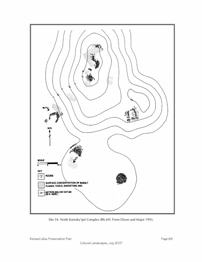
Revised Läÿau Preservation Plan Page 69Cultural Landscapes, July 2007
Site 54. North Kamakaÿipö Complex (B6-69). From Dixon and Major 1993.
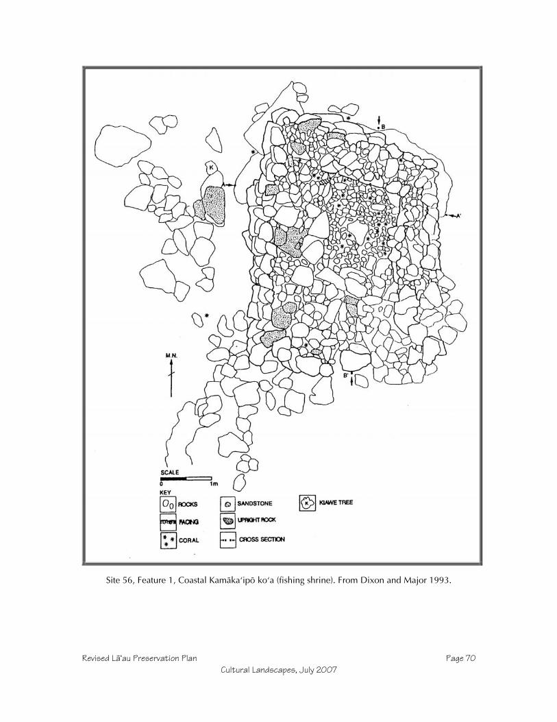
Revised Läÿau Preservation Plan Page 70Cultural Landscapes, July 2007
Site 56, Feature 1, Coastal Kamäkaÿipö koÿa (fishing shrine). From Dixon and Major 1993.

Revised Läÿau Preservation Plan Page 71Cultural Landscapes, July 2007
Site 56, Features 2 and 19, Coastal Kamäkaÿipö. From Dixon and Major 1993.

Revised Läÿau Preservation Plan Page 72Cultural Landscapes, July 2007
Site 56, Feature 3, Coastal Kamäkaÿipö C-shape with tail. From Dixon and Major 1993.

Revised Läÿau Preservation Plan Page 73Cultural Landscapes, July 2007
Site 56, Features 4, 24, and 25 Coastal Kamäkaÿipö. From Dixon and Major 1993.

Revised Läÿau Preservation Plan Page 74Cultural Landscapes, July 2007
Site 56, Feature 5, Coastal Kamäkaÿipö mound. From Dixon and Major 1993.

Revised Läÿau Preservation Plan Page 75Cultural Landscapes, July 2007
Site 56, Features 6 and 12 Coastal Kamäkaÿipö. From Dixon and Major 1993.

Revised Läÿau Preservation Plan Page 76Cultural Landscapes, July 2007
Site 56, Features 7 and 8 Coastal Kamäkaÿipö. From Dixon and Major 1993.

Revised Läÿau Preservation Plan Page 77Cultural Landscapes, July 2007
Site 56, Feature 12, Coastal Kamäkaÿipö burial. From Dixon and Major 1993.

Revised Läÿau Preservation Plan Page 78Cultural Landscapes, July 2007
Site 56, Feature 13, Coastal Kamäkaÿipö enclosure. From Dixon and Major 1993.
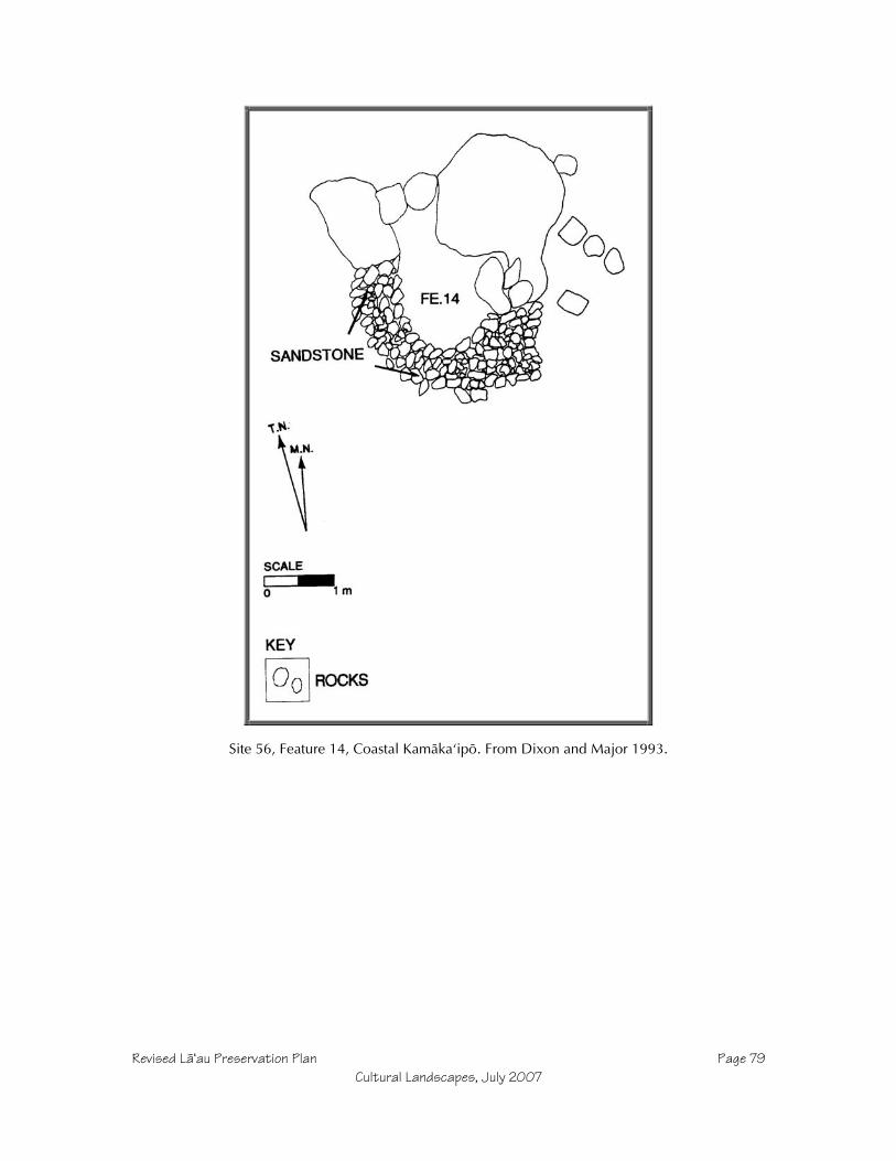
Revised Läÿau Preservation Plan Page 79Cultural Landscapes, July 2007
Site 56, Feature 14, Coastal Kamäkaÿipö. From Dixon and Major 1993.

Revised Läÿau Preservation Plan Page 80Cultural Landscapes, July 2007
Site 56, Feature 15, Coastal Kamäkaÿipö. From Dixon and Major 1993.
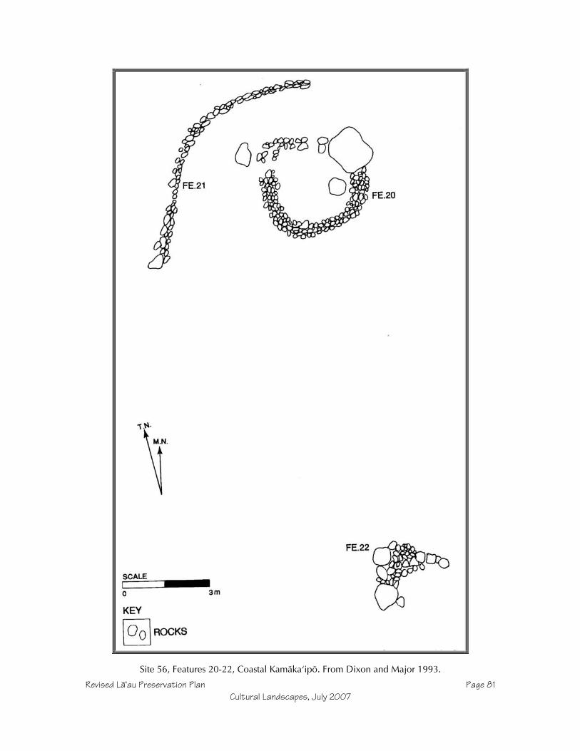
Revised Läÿau Preservation Plan Page 81Cultural Landscapes, July 2007
Site 56, Features 20-22, Coastal Kamäkaÿipö. From Dixon and Major 1993.

Revised Läÿau Preservation Plan Page 82Cultural Landscapes, July 2007
Site 56, Feature 24, Coastal Kamäkaÿipö cupboard. From Dixon and Major 1993.

Revised Läÿau Preservation Plan Page 83Cultural Landscapes, July 2007
Site 56, Feature 25, Coastal Kamäkaÿipö. From Dixon and Major 1993.
Site 679, Feature 1, Upper North Kamäkaÿipö Gulch. From Dixon and Major 1993.

Revised Läÿau Preservation Plan Page 84Cultural Landscapes, July 2007
Site 679, Feature 2, Upper North Kamäkaÿipö Gulch C-shape. From Dixon and Major 1993.

Revised Läÿau Preservation Plan Page 85Cultural Landscapes, July 2007
Site 682, Feature 1, Upper North Kamäkaÿipö Gulch. From Dixon and Major 1993.
Site 685, Feature 1, Upper North Kamäkaÿipö Gulch. From Dixon and Major 1993.

Revised Läÿau Preservation Plan Page 86Cultural Landscapes, July 2007
Site 687, Feature 1, North Kamäkaÿipö Gulch. From Dixon and Major 1993.

Revised Läÿau Preservation Plan Page 87Cultural Landscapes, July 2007
Site 689, Feature 1, North Kamäkaÿipö Gulch. From Dixon and Major 1993.

Revised Läÿau Preservation Plan Page 88Cultural Landscapes, July 2007
Site 739, Feature 1, Coastal Kamäkaÿipö. From Dixon and Major 1993.

Revised Läÿau Preservation Plan Page 89Cultural Landscapes, July 2007
Site 741, Feature 1, Coastal Kamäkaÿipö. From Dixon and Major 1993.
Site 741, Feature 3, Coastal Kamäkaÿipö Trail Marker. From Dixon and Major 1993.

Revised Läÿau Preservation Plan Page 90Cultural Landscapes, July 2007
Site 741, Features 2 and 4 with midden, Coastal Kamäkaÿipö. From Dixon and Major 1993.

Revised Läÿau Preservation Plan Page 91Cultural Landscapes, July 2007
Site 742, Kamäkaÿipö South ridge lithic work area. From Dixon and Major 1993.

Revised Läÿau Preservation Plan Page 92Cultural Landscapes, July 2007
Site 744, Coastal Kamäkaÿipö South. From Dixon and Major 1993.

Revised Läÿau Preservation Plan Page 93Cultural Landscapes, July 2007
Site 750, Kamäkaÿipö South trail marker. From Dixon and Major 1993.

Revised Läÿau Preservation Plan Page 94Cultural Landscapes, July 2007
Site 751, Kamäkaÿipö South cupboard. From Dixon and Major 1993.

Revised Läÿau Preservation Plan Page 95Cultural Landscapes, July 2007
Site 763, Läÿau Point modified outcrop enclosure. From Dixon and Major 1993.
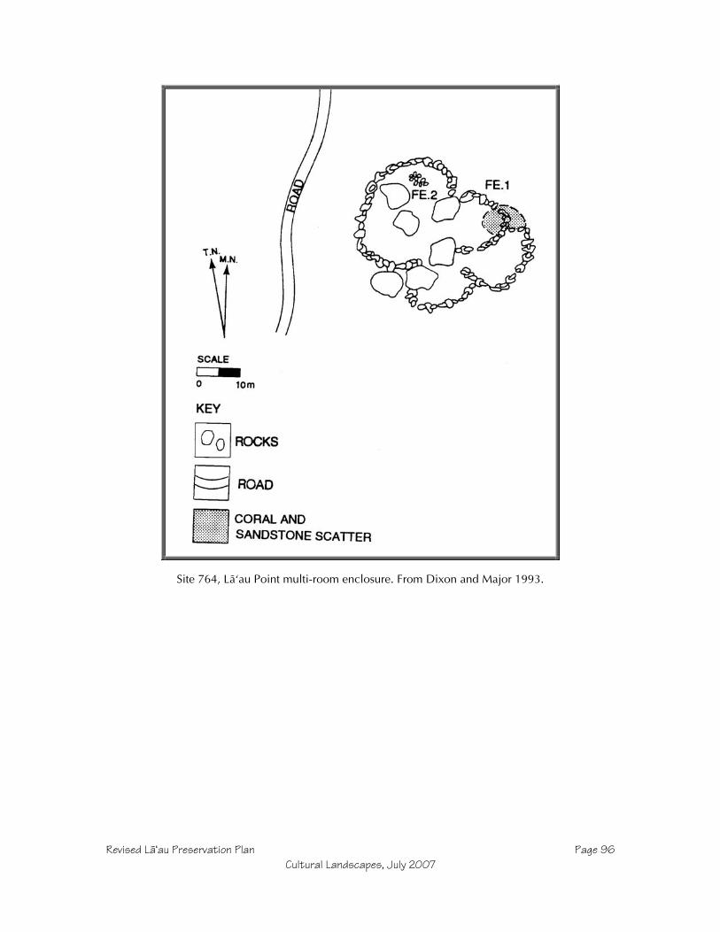
Revised Läÿau Preservation Plan Page 96Cultural Landscapes, July 2007
Site 764, Läÿau Point multi-room enclosure. From Dixon and Major 1993.

Revised Läÿau Preservation Plan Page 97Cultural Landscapes, July 2007
Site 765, Features 1, 3, and 4. Läÿau Point modified outcrop and markers. From Dixon and Major1993.
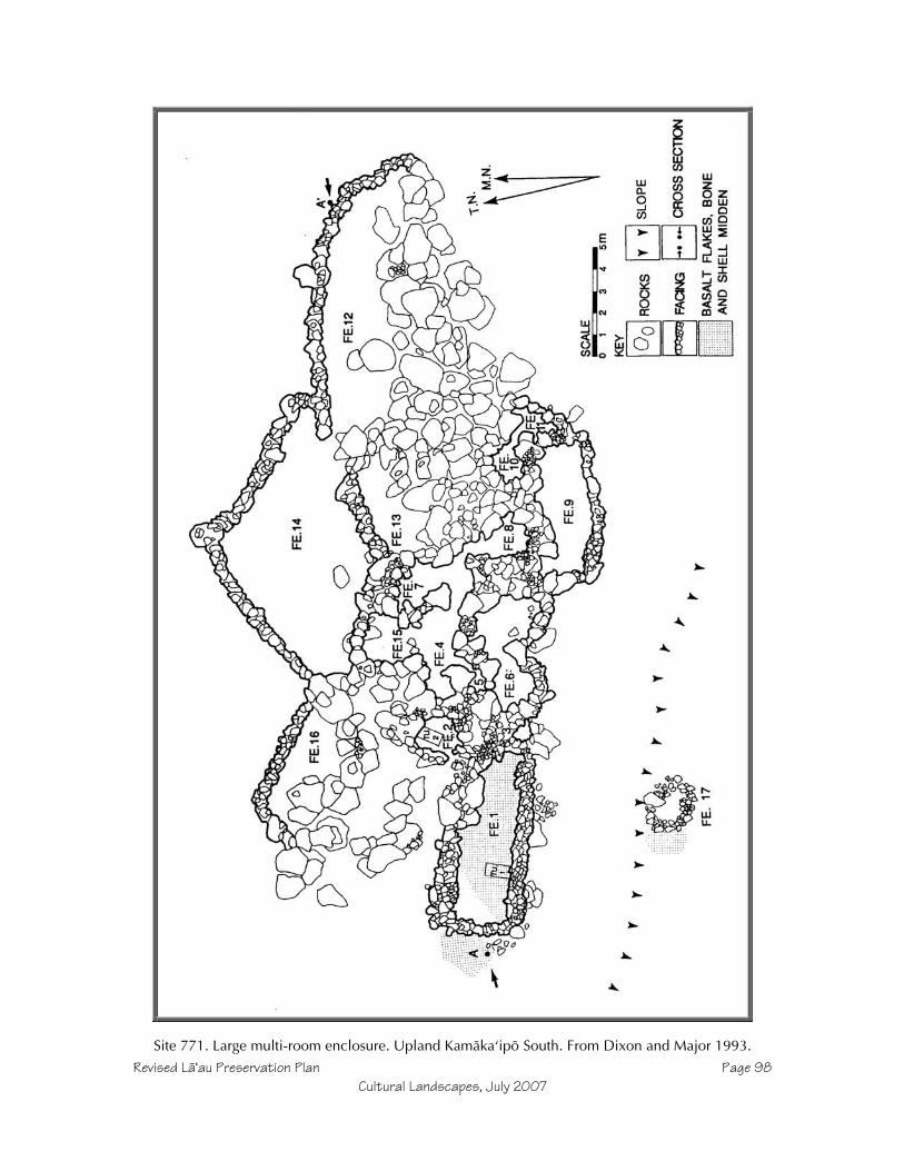
Revised Läÿau Preservation Plan Page 98Cultural Landscapes, July 2007
Site 771. Large multi-room enclosure. Upland Kamäkaÿipö South. From Dixon and Major 1993.

Revised Läÿau Preservation Plan Page 99Cultural Landscapes, July 2007
Site 772. Large multi-room enclosure. Upland Kamäkaÿipö South. From Dixon and Major 1993.

Revised Läÿau Preservation Plan Page 100Cultural Landscapes, July 2007
Site 773. Large single-room enclosure. Upland Kamäkaÿipö South. From Dixon and Major 1993.

Revised Läÿau Preservation Plan Page 101Cultural Landscapes, July 2007
Site 775. Large multi-room enclosure. Upland Kamäkaÿipö South. From Dixon and Major 1993.

Revised Läÿau Preservation Plan Page 102Cultural Landscapes, July 2007
Site 1101. South shore platform koÿa. From Dixon and Major 1993.
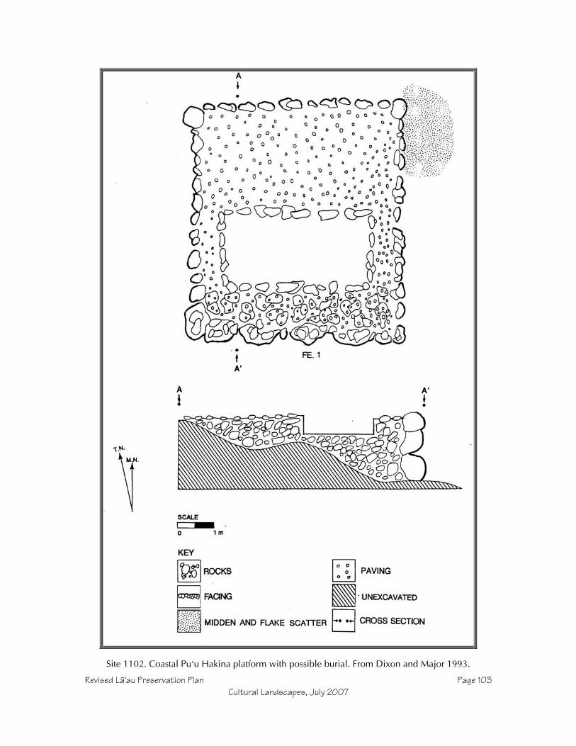
Revised Läÿau Preservation Plan Page 103Cultural Landscapes, July 2007
Site 1102. Coastal Puÿu Hakina platform with possible burial. From Dixon and Major 1993.

Revised Läÿau Preservation Plan Page 104Cultural Landscapes, July 2007
Site 1103. Coastal Puÿu Hakina canoe shed. From Dixon and Major 1993.

Revised Läÿau Preservation Plan Page 105Cultural Landscapes, July 2007
Site 1104. Kalalua Heiau at Coastal Puÿu Hakina. From Dixon and Major 1993.

Revised Läÿau Preservation Plan Page 106Cultural Landscapes, July 2007
Site 1106. Coastal Puÿu Hakina heiau. From Dixon and Major 1993.

Revised Läÿau Preservation Plan Page 107Cultural Landscapes, July 2007
Site 1107, Features 1 and 2. Coastal Puÿu Hakina habitation complex. From Dixon and Major 1993.

Revised Läÿau Preservation Plan Page 108Cultural Landscapes, July 2007
Site 1107, Feature 6 and 7 enclosures. Coastal Puÿu Hakina habitation complex. From Dixon andMajor 1993.
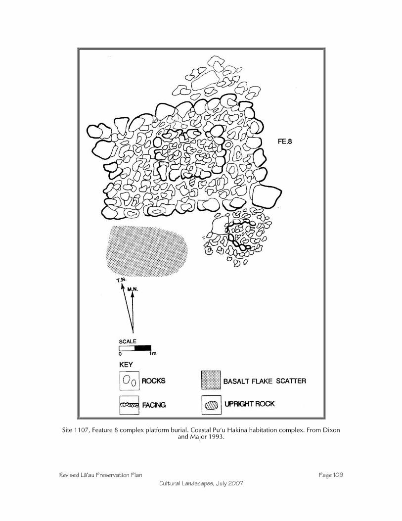
Revised Läÿau Preservation Plan Page 109Cultural Landscapes, July 2007
Site 1107, Feature 8 complex platform burial. Coastal Puÿu Hakina habitation complex. From Dixonand Major 1993.

Revised Läÿau Preservation Plan Page 110Cultural Landscapes, July 2007
Site 1107, Feature 9 enclosure. Coastal Puÿu Hakina habitation complex. From Dixon and Major1993.
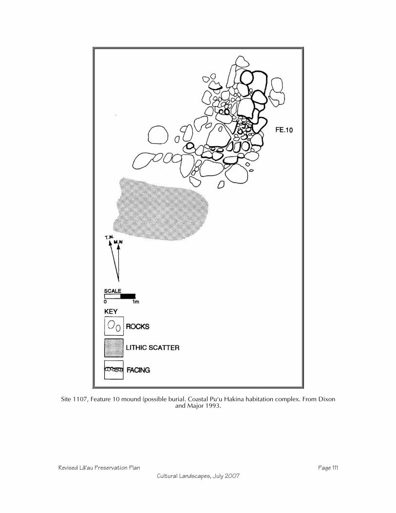
Revised Läÿau Preservation Plan Page 111Cultural Landscapes, July 2007
Site 1107, Feature 10 mound (possible burial. Coastal Puÿu Hakina habitation complex. From Dixonand Major 1993.

Revised Läÿau Preservation Plan Page 112Cultural Landscapes, July 2007
Site 1112. Läÿau Point Modified Outcrops and Overhang shelters. From Dixon and Major 1993.
Site 1119. Läÿau Point Modified Outcrops and Overhang shelters. From Dixon and Major 1993.
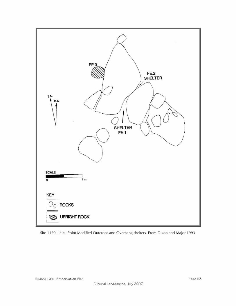
Revised Läÿau Preservation Plan Page 113Cultural Landscapes, July 2007
Site 1120. Läÿau Point Modified Outcrops and Overhang shelters. From Dixon and Major 1993.
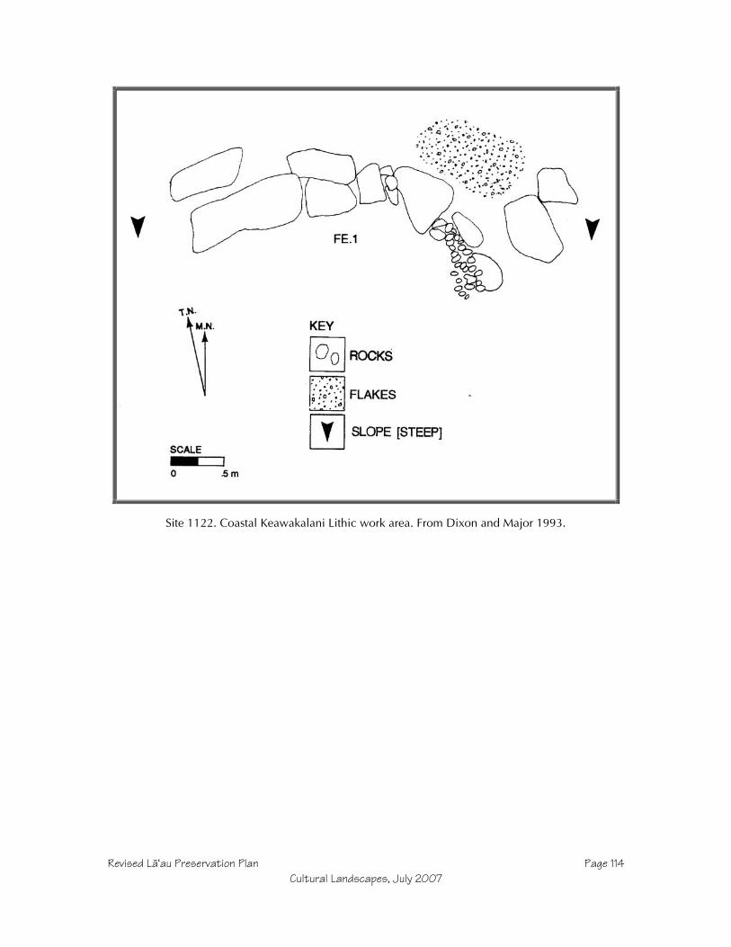
Revised Läÿau Preservation Plan Page 114Cultural Landscapes, July 2007
Site 1122. Coastal Keawakalani Lithic work area. From Dixon and Major 1993.
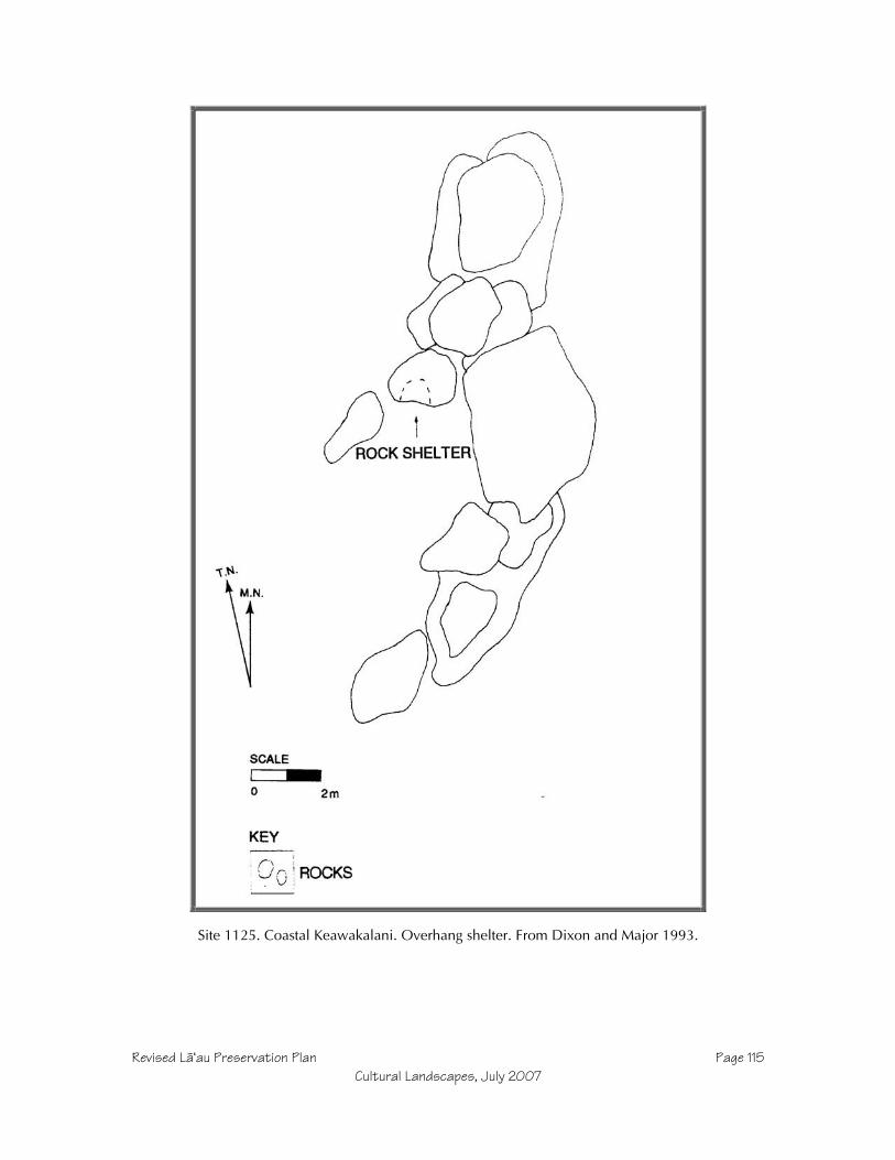
Revised Läÿau Preservation Plan Page 115Cultural Landscapes, July 2007
Site 1125. Coastal Keawakalani. Overhang shelter. From Dixon and Major 1993.

Revised Läÿau Preservation Plan Page 116Cultural Landscapes, July 2007
Site 1126. Coastal Keawakalani. Overhang shelters. From Dixon and Major 1993.
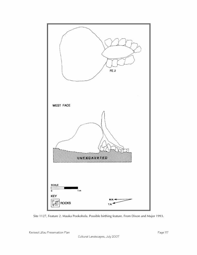
Revised Läÿau Preservation Plan Page 117Cultural Landscapes, July 2007
Site 1127, Feature 2. Mauka Pookohola. Possible birthing feature. From Dixon and Major 1993.
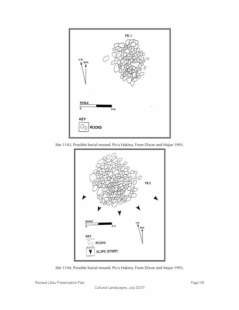
Revised Läÿau Preservation Plan Page 118Cultural Landscapes, July 2007
Site 1143. Possible burial mound. Puÿu Hakina. From Dixon and Major 1993.
Site 1144. Possible burial mound. Puÿu Hakina. From Dixon and Major 1993.
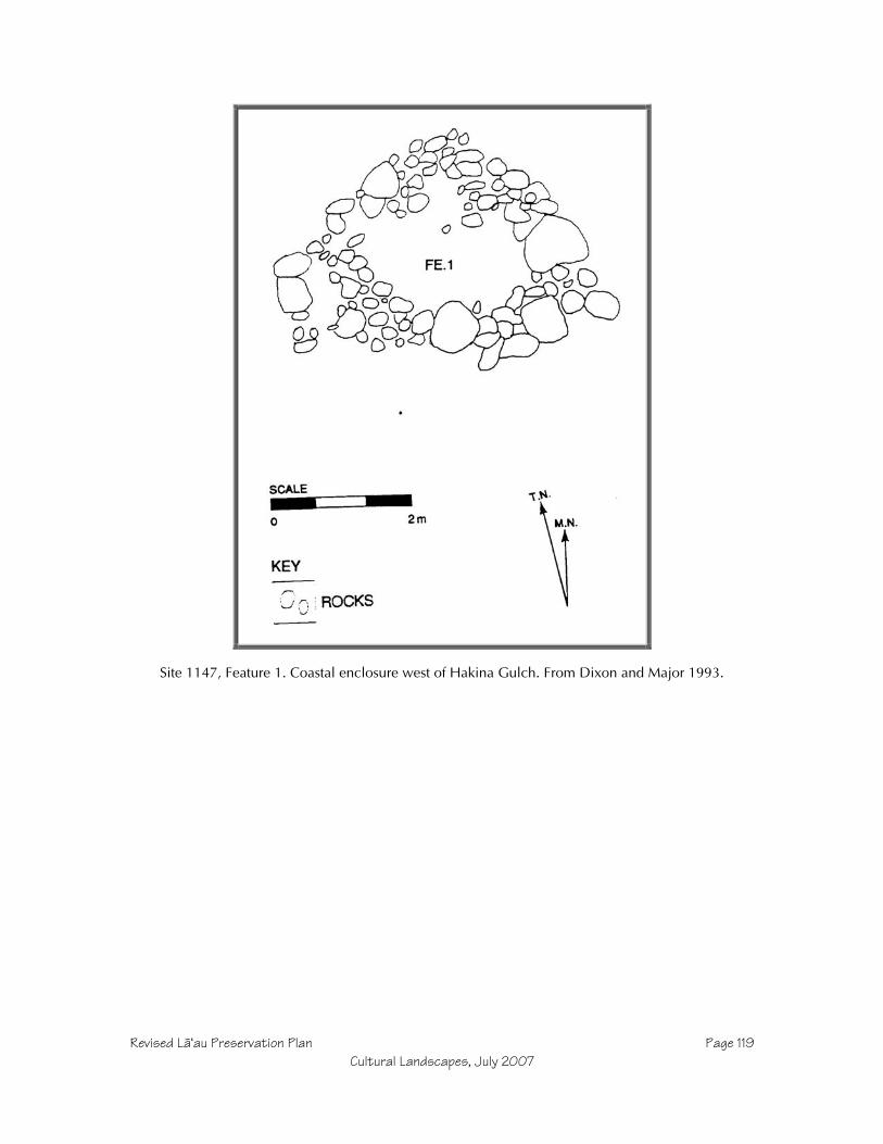
Revised Läÿau Preservation Plan Page 119Cultural Landscapes, July 2007
Site 1147, Feature 1. Coastal enclosure west of Hakina Gulch. From Dixon and Major 1993.
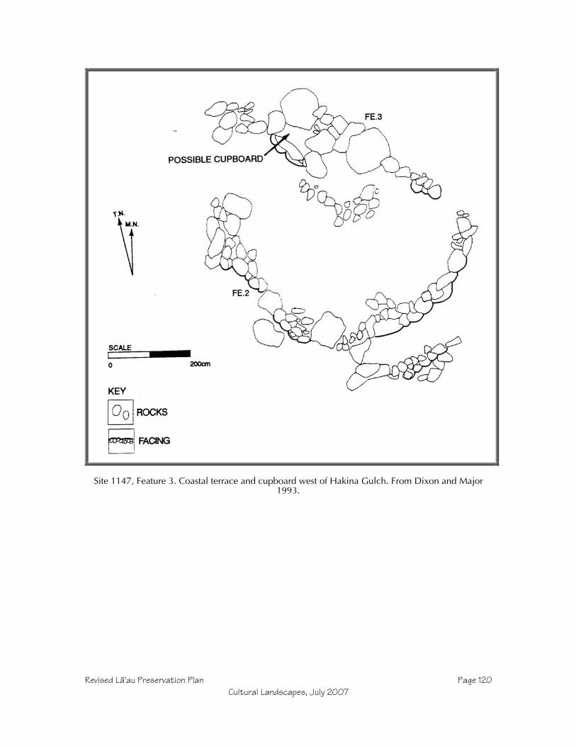
Revised Läÿau Preservation Plan Page 120Cultural Landscapes, July 2007
Site 1147, Feature 3. Coastal terrace and cupboard west of Hakina Gulch. From Dixon and Major1993.

Revised Läÿau Preservation Plan Page 121Cultural Landscapes, July 2007
Site 1147, Feature 4. Coastal mound (possible shrine or burial) and lithic work area west of HakinaGulch. From Dixon and Major 1993.

Revised Läÿau Preservation Plan Page 122Cultural Landscapes, July 2007
Site 1150, Feature 1. Koÿa shrine west of Hakina Gulch. From Dixon and Major 1993.

Revised Läÿau Preservation Plan Page 123Cultural Landscapes, July 2007
Site 1150, Features 2 – 6. Cairns and lithic work area west of Hakina Gulch. From Dixon and Major1993.

Revised Läÿau Preservation Plan Page 124Cultural Landscapes, July 2007
Site 1151, Features 1–6. Coastal ridge lithic work area at Puÿu Hakina. From Dixon and Major 1993.

Revised Läÿau Preservation Plan Page 125Cultural Landscapes, July 2007
Site 1151, Features 7-9. Coastal ridge lithic work area at Puÿu Hakina. From Dixon and Major 1993.
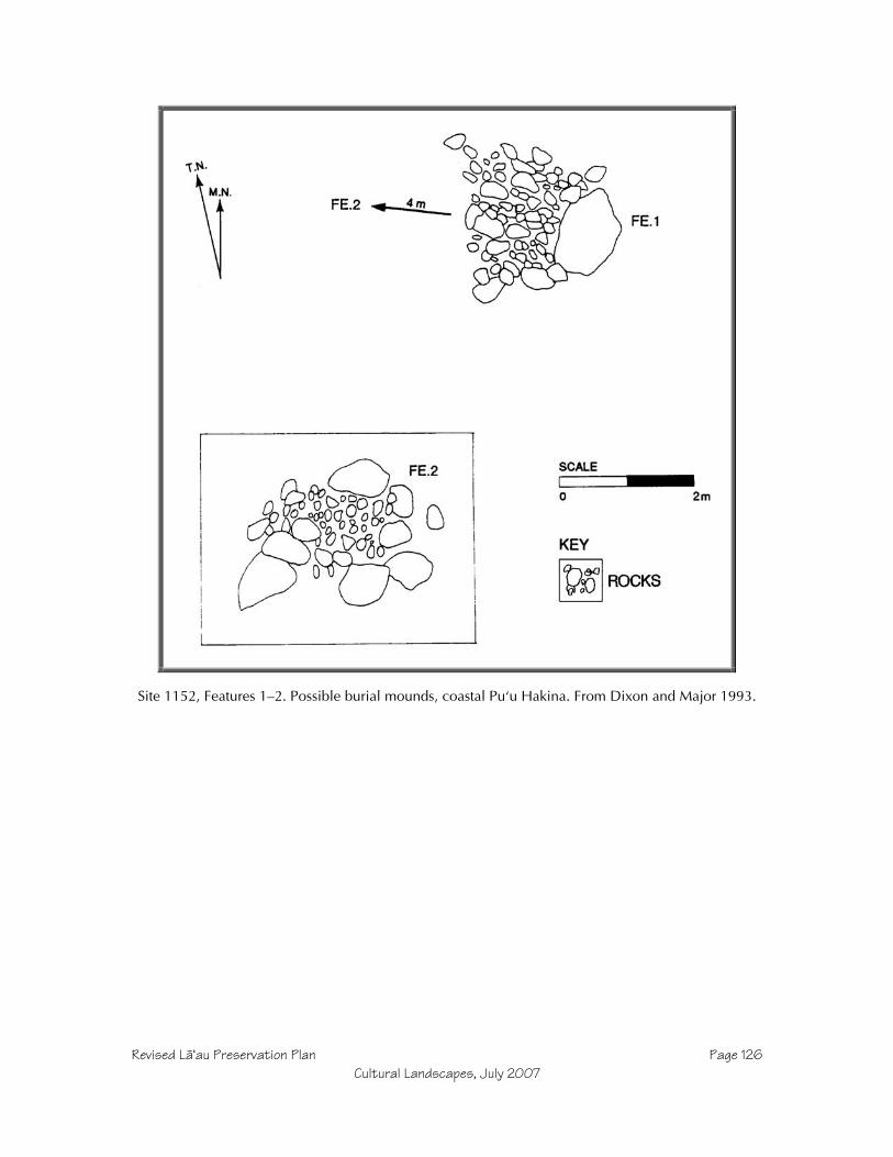
Revised Läÿau Preservation Plan Page 126Cultural Landscapes, July 2007
Site 1152, Features 1–2. Possible burial mounds, coastal Puÿu Hakina. From Dixon and Major 1993.

Revised Läÿau Preservation Plan Page 127Cultural Landscapes, July 2007
Site 1152, Feature 3. Coastal ridge platform burial at Puÿu Hakina. From Dixon and Major 1993.
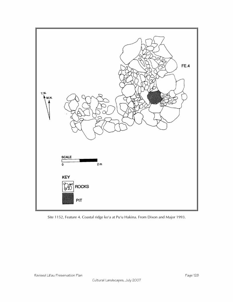
Revised Läÿau Preservation Plan Page 128Cultural Landscapes, July 2007
Site 1152, Feature 4. Coastal ridge koÿa at Puÿu Hakina. From Dixon and Major 1993.
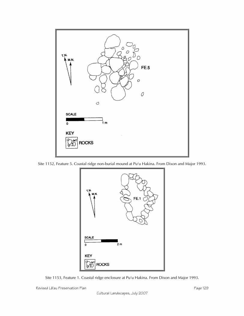
Revised Läÿau Preservation Plan Page 129Cultural Landscapes, July 2007
Site 1152, Feature 5. Coastal ridge non-burial mound at Puÿu Hakina. From Dixon and Major 1993.
Site 1153, Feature 1. Coastal ridge enclosure at Puÿu Hakina. From Dixon and Major 1993.

Revised Läÿau Preservation Plan Page 130Cultural Landscapes, July 2007
Site 1153, Feature 2. Coastal ridge mound at Puÿu Hakina. From Dixon and Major 1993.

Revised Läÿau Preservation Plan Page 131Cultural Landscapes, July 2007
Site 1154. Lithic work area at Puÿu Hakina. From Dixon and Major 1993.

Revised Läÿau Preservation Plan Page 132Cultural Landscapes, July 2007
Site 1155, Feature 1. Lithic work area at Puÿu Hakina. From Dixon and Major 1993.

Revised Läÿau Preservation Plan Page 133Cultural Landscapes, July 2007
Site 1155, Features 2-3. Possible burial mounds at Puÿu Hakina. From Dixon and Major 1993.

Revised Läÿau Preservation Plan Page 134Cultural Landscapes, July 2007
Site 1156. Lithic work area near head of Kaunalu Gulch (400’ elevation). From Dixon and Major1993.

Revised Läÿau Preservation Plan Page 135Cultural Landscapes, July 2007
Site 1160, Feature 1. Historic Ranch structure foundation. From Dixon and Major 1993,

Revised Läÿau Preservation Plan Page 136Cultural Landscapes, July 2007
Site 1160, Feature 2, burial. From Dixon and Major 1993.

Revised Läÿau Preservation Plan Page 137Cultural Landscapes, July 2007
Sample Text For Signs
Example A: Buffer Marker
“This site was built and used centuries ago by Hawaiians. Please help preserve thisplace by staying on marked trails and by not moving rocks. Damage to sites ispunishable under Hawaiÿi law (Chapter 6E-11). Take with you memories andphotos, but please remove no objects from this site. Aloha.”
Example B: Interpretive Sign
Site 656 – Stone Tool QuarryBy about 1400 AD, Hawaiians often ventured inland from their coastal settlementsto quarry dense-grained basalt that was used to make adzes and other tools. Thisbecame so common that the name of the land district in west Molokaÿi came to be“Kaluakoÿi” meaning “the adze pit.”
Hawaiians used other stones to strike this fine basalt, chipping away flakes until therough shape of an adze emerged. Some of this work occurred here, where workerswould camp. Polished adzes are uncommon here, but are more so at the coast,leading archaeologists to believe that final stages of manufacture occurred at themore permanent settlements by the ocean.
[Illustration showing hammerstone and adze preform, and perhaps map of quarrylocation.]
Example C: Photo of Sign and Fencing at Kaupoa Camp.