axe working sites on path renewal schemes, central
TRANSCRIPT
AXE WORKINGSITES ON PATHRENEWALSCHEMES,CENTRAL LAKEDISTRICT
CUMBRIA
ArchaeologicalSurvey Report
Oxford Archaeology North
June 2009
The National Trust andLake District National ParkAuthority
Issue No 2008-2009/903OAN Job No:L10032NGR:
NY 21390 07921NY 21891 08551 NY 27514 02410 NY 23676 08230 NY 36361 11654 (all centred)
Axe Working Sites on Path Renewal Schemes, Cumbria: Archaeological Survey Report 1
For the use of The National Trust and the Lake District National Park Authority © June 2009
CONTENTS
SUMMARY................................................................................................................ 2
ACKNOWLEDGEMENTS ............................................................................................ 3
1. INTRODUCTION ................................................................................................... 41.1 Circumstances of the Project ......................................................................... 41.2 Objectives..................................................................................................... 4
2. METHODOLOGY.................................................................................................. 62.1 Project Design .............................................................................................. 62.2 The Survey ................................................................................................... 62.4 Archive......................................................................................................... 7
3. TOPOGRAPHIC AND HISTORICAL BACKGROUND ................................................ 83.1 Location and Topography ............................................................................ 83.2 Geology and Geomorphology ...................................................................... 83.3 Historical Background ................................................................................. 9
4. SURVEY RESULTS.............................................................................................. 184.1 Introduction ................................................................................................ 184.2 Desk-Based Assessment ............................................................................. 184.3 Field Survey................................................................................................ 19
5. DISCUSSION ....................................................................................................... 225.1 Corridor Route............................................................................................ 225.1 Fairfield ...................................................................................................... 22
6. IMPACTS AND RECOMMENDATIONS.................................................................. 236.1 Impacts ....................................................................................................... 236.2 Management Recommendations.................................................................. 23
7. BIBLIOGRAPHY ................................................................................................. 257.1 Published Cartographic Sources.................................................................. 257.2 Secondary Sources...................................................................................... 25
APPENDIX 1: PROJECT BRIEF ................................................................................ 28
APPENDIX 2: PROJECT DESIGN............................................................................... 33
APPENDIX 3: SITE GAZETTEER.............................................................................. 40
APPENDIX 4: FINDS CATALOGUE........................................................................... 47
ILLUSTRATIONS ..................................................................................................... 48
Axe Working Sites on Path Renewal Schemes, Cumbria: Archaeological Survey Report 2
For the use of The National Trust and the Lake District National Park Authority © June 2009
SUMMARY
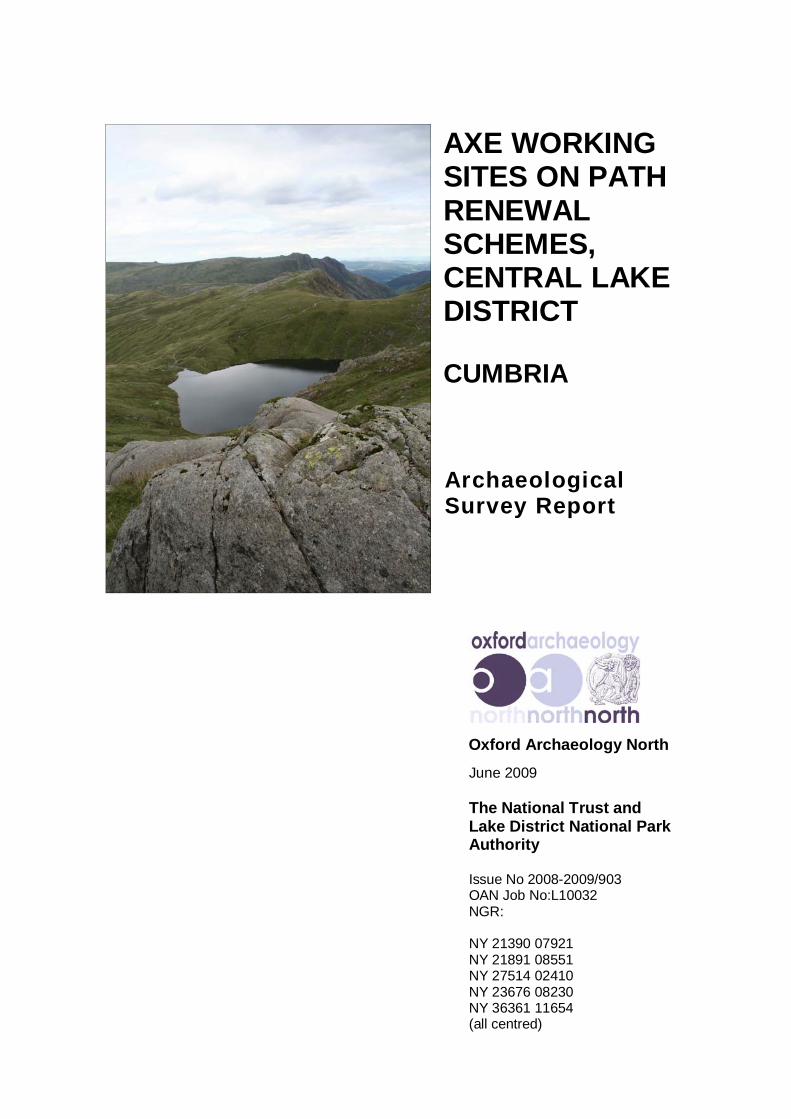
An archaeological landscape survey was undertaken of five areas of footpatherosion/renewal (3100m in length) and associated stone picking areas (0.98km2 in extent)within the central Lake District, at Piers Gill, Wasdale (NY 21390 07921), Greta Gill,Wasdale (NY 21891 08551), Three Shires Stone to Wet Side Edge, Duddon (NY 2751402410), Angle Tarn to Esk Hause, Great Langdale (NY 23676 08230) and FairfieldSummit, Grasmere (NY 36361 11654) by Oxford Archaeology North (OA North) at therequest of the Lake District National Park Authority (LDNPA) and The National Trust.The programme of work was intended to inform and guide forthcoming upland footpathconservation work and, specifically, to ensure that the winning of stone for nearby pathrepair does not affect any archaeological resource. The survey was undertaken as anenhanced identification survey, which entailed checking of existing LDNPA HistoricEnvironment Record (HER) and National Trust Sites and Monument Records (SMR)records. It comprised systematic examination of the upland terrain and the identificationand recording of the monuments using GPS.In total, 21 sites of archaeological interest were identified within the study area. Of these,eleven were already recorded in the LDNPA HER and/or National Trust SMR, and afurther two were recorded as hazard areas within the Lake District National Park HER.One of the principal archaeological resources, were groups of Neolithic axe factories onScafell Pike, Great End, and Fairfield Summit. Most of the sites represent primary workingof naturally detached rock but, significantly, some of the sites were physically removedfrom the source outcrop, and the source rock was probably carried to the site. As such, theywould appear to reflect camp sites, and the presence of one of them on an easterly-orientated access route, would suggest that this was a route used in antiquity.
In addition, one of the sites within the study area, the Roman road running from Hardknottfort to Wrynose Bottom, is presently subject to statutory designation, with the separateupstanding earthworks of the site being defined and protected as Scheduled Monuments(CU 243, CU 247 and CU 264). A further two LDNPA Hazard Areas, located around theaxe flaking site complexes on Scafell Pike and Great End, are defined within the vicinity ofproposed footpath renewal, but are not directly affected by it.
There was also a wealth of features relating to boundary markers, including numerouscairns and/or walker’s cairns, the ‘Three Shires Stone’ marker in Duddon and the putative‘Packhorse Woman’s Grave’ commemorative marker in Great Langdale.It is recommended that a scheme of further mitigative works should be undertaken on andadjacent to, the footpaths where there are axe flaking sites currently exposed on FairfieldSummit. These type of sites in particular should be highlighted as suitable for furtherresearch and investigation. At Fairfield Summit the resource is extremely fragile andsusceptible to erosion and is of extreme importance due to its location isolated from allother axe working areas.

Axe Working Sites on Path Renewal Schemes, Cumbria: Archaeological Survey Report 3
For the use of The National Trust and the Lake District National Park Authority © June 2009
ACKNOWLEDGEMENTS
Oxford Archaeology North would like to thank Richard Fox, the Fix the Fells ProjectOfficer at the Lake District National Park Authority (LDNPA) for commissioning theproject, and for considerable support and advice in the course of the project. We wouldalso like to thank Jamie Lund, archaeologist at The National Trust and Eleanor Kingston,archaeologist at the Lake District National Park Authority (LDNPA) for their valuableinput.The desk-based study was undertaken by Peter Schofield. The field survey was undertakenby Jamie Quartermaine, Peter Schofield, Alastair Vannan and Will Gardner. The reportwas written by Peter Schofield, with contributions for the historical background by VinDavis. The illustrations were produced by Peter Schofield and Ann Stewardson. The reportwas edited by Jamie Quartermaine, who also managed the project.

Axe Working Sites on Path Renewal Schemes, Cumbria: Archaeological Survey Report 4
For the use of The National Trust and the Lake District National Park Authority © June 2009
1. INTRODUCTION
1.1 CIRCUMSTANCES OF THE PROJECT
1.1.1 An archaeological landscape survey was undertaken of five areas of footpatherosion/renewal (3100m in length) and associated stone picking areas (0.98km2 inextent) within the central Lake District, at Piers Gill, Wasdale (NY 21390 07921),Greta Gill, Wasdale (NY 21891 08551), Three Shires Stone to Wet Side Edge,Duddon (NY 27514 02410), Angle Tarn to Esk Hause, Great Langdale (NY 2367608230) and Fairfield Summit, Grasmere (NY 36361 11654) by OxfordArchaeology North (OA North) at the request of the Lake District National ParkAuthority (LDNPA) and The National Trust. The programme of work was intendedto provide information to inform and guide forthcoming upland footpathconservation work and specifically to ensure that the winning of stone for nearbypath repair does not affect the archaeological resource. A further site wasdiscovered within erosion at Martcrag Moor, Great Langdale, however thearchaeological investigation of this site forms the basis of a separate report (OANorth forthcoming a).
1.1.2 The survey was undertaken in accordance with a project design (Appendix 2)prepared by OA North, which was itself based on a project brief (Appendix 1) bythe Lake District National Park Authority (LDNPA).
1.2 OBJECTIVES
1.2.1 The primary purpose of the project is to inform future management decisions withregard to path repair work in six locations: Piers Gill, Greta Gill, Three Shires toWet Side Edge, Angle Tarn to Esk Hause and Fairfield Summit. The proposedstudy is intended as an initial exploration of the archaeological resource, rather thanas a definitive and comprehensive study. The aims of the initial project are broadlyas follows:
• to provide sufficient information to establish the location, extent,character, period, condition, fragility and potential of the survivingarchaeological features;
• to provide an accurate Level 1 survey of all identified monuments;
• to provide a preliminary grading of all recorded sites and features toindicate relative significance (Appendix 3);
• to inform the process of extracting source rock for the maintenance andrepair of the six paths and ensure that archaeological monuments and theirsource geology are not impacted by this process.
1.2.2 The programme of work has been designed to provide an accurate archaeologicalsurvey of the study area, set within its broader landscape context. It is importantthat the individual sites are not viewed simply as isolated points on a map, but thatthe archaeological record reflects their group value and their importance to thehistorical fabric of landscape character areas within the study area.

Axe Working Sites on Path Renewal Schemes, Cumbria: Archaeological Survey Report 5
For the use of The National Trust and the Lake District National Park Authority © June 2009
1.2.3 Implementation: to achieve these objectives a rapid desk-based assessment wasundertaken, followed by an identification survey that covered the entirety of thestudy area. The desk-based assessment, carried out in June 2008, consisted of asearch of both published and unpublished records held by the Lake DistrictNational Park Authority Historic Environment Record (HER), The National TrustSites and Monuments Record (NT SMR) and the library and archives at OANorth’s offices in Lancaster. The identification survey phase followed and wascarried out between June and October 2008.
1.2.4 This report sets out the results of the work, followed by a discussion of thearchaeological significance and potential of the area. In addition, the potentialimpacts of the stone collection and footpath renewal are discussed, together withoverall management recommendations for the study area as a whole.
Axe Working Sites on Path Renewal Schemes, Cumbria: Archaeological Survey Report 6
For the use of The National Trust and the Lake District National Park Authority © June 2009
2. METHODOLOGY
2.1 PROJECT DESIGN
2.1.1 A project design (Appendix 2) was submitted in April 2008 by OA North inresponse to a brief prepared by the LDNPA Fix the Fells Project Officer (Appendix1) for a programme of survey to record the archaeological landscapes within a100m buffer zone around five areas of footpath erosion/renewal and stone pickingareas within the central Lake District Fells (Figs 1 and 2). This was in order toenhance the existing archaeological record, and to enable appropriate managementstrategies to be enacted. The work was carried out in accordance with the projectdesign.
2.2 THE SURVEY
2.2.1 Desk-Based Assessment: a rapid investigation was conducted of pertinent recordsand primary data held within both the LDNPA HER and NT SMR. This includedinformation on all of the previous investigations into the archaeology of the studyarea, including the relevant SMR/HER records and also additional site visit photosand survey information. Historic Ordnance Survey mapping was examined toprovide an indication of later activity within the area. In addition, the OA Northlibrary and archives were consulted for pertinent secondary sources and alsoprimary documentary material from the original axe factory survey undertaken in1985 (Claris and Quartermaine 1989), which included the site catalogues.
2.2.2 Identification Survey: the survey was undertaken as an enhanced Level 1 typesurvey (Appendix 2). Those sites that had already been identified on the NT SMRand the LDNPA HER were checked and recorded at the same level of consistencyas other newly-discovered monuments. The survey involved four elements:Reconnaissance; Mapping; Description; and Photography.
2.2.3 The reconnaissance consisted of close field walking, varying from 10m lineintervals dependent on visibility and safety considerations. The survey aimed toidentify, locate and record archaeological sites and features on the ground. The aimof the survey was predominantly to investigate axe manufacturing sites and thereconnaissance strategy was tailored accordingly. The survey examined all areas ofoutcropping to examine the potential for sources of the fine-grained tuff. Inaddition, all exposures through the turf were examined for lithic material, includingstream cuttings and footpath erosion. Where axe flaking sites were identified, thedensity and size of the flakes were measured and recorded. The flakes werecategorised into small, medium and large, and the numbers of flakes were countedwithin a 0.4m x 0.4m grid. This provides consistency with the strategy employed inthe original axe factory survey (Claris and Quartermaine 1989).
2.2.4 The archaeological sites were mapped using a combination of Leica differentialGPS equipment which used real-time EGNOS corrections from geo-stationarysatellites to achieve an accuracy of ± 0.5m, and Leica differential GPS equipment,using real-time (RTK) corrections and equipped with mobile SmartNet technologyto achieve an accuracy of ± 0.01m for defining the extents of the axe flakingscatters observed on Fairfield Summit. The digital survey data was transferred as

Axe Working Sites on Path Renewal Schemes, Cumbria: Archaeological Survey Report 7
For the use of The National Trust and the Lake District National Park Authority © June 2009
shapefiles into a GIS system (ArcGIS 9.3), and was superimposed onto theembedded digital Ordnance Survey data (Figs 3-7). The descriptive records wereinput on-site into a database on a Psion palm computer. A photographic record ofthe sites was maintained in 35mm black and white print format and also digitalcolour photography (8 megapixel camera), which have been used to accompanythe present report.
2.3 GAZETTEER OF SITES
2.3.1 All of the information concerning archaeological sites within the study area hasbeen collated into a gazetteer (Appendix 3), which provides details of theirlocation, period, character and significance. Locations are given as ten-figureNational Grid References where possible, and the position of each site is indicatedon maps of the study area (Figs 3-7). In addition, a sample of axe working flakeswere catalogued and retained for possible future analysis from both the presentsurvey and initial survey of Fairfield Summit in 2002 (Appendix 4).
2.4 ARCHIVE
2.4.1 A full archive has been produced to a professional standard in accordance withcurrent English Heritage guidelines (Management of Archaeological Projects, 2ndedition, 1991) and is provided in the English Heritage Centre for Archaeologyformat, both as a printed document and digitally. Digital survey data is providedin a suitable format for incorporation into the respective NT HER and LDNPASMR Geographical Information Systems (GIS). A synopsis (normally the index tothe archive and the report) will be deposited in the LDNPA HER.

Axe Working Sites on Path Renewal Schemes, Cumbria: Archaeological Survey Report 8
For the use of The National Trust and the Lake District National Park Authority © June 2009
3. TOPOGRAPHIC AND HISTORICAL BACKGROUND
3.1 LOCATION AND TOPOGRAPHY
3.1.1 The eventual study area comprised five sections of footpath erosion/renewal(3100m in length) and associated stone picking areas (0.98km2 in extent) within thecentral Lake District, at Piers Gill, Wasdale; Greta Gill, Wasdale; Three ShiresStone to Wet Side Edge, Duddon; Angle Tarn to Esk Hause (Plate 1), and FairfieldSummit, Grasmere (Figs 1 and 2). The wider area is one of spectacular mountainscenery comprising a mosaic of high craggy peaks with scree slopes, heaths, mires,peatland, heath moorland, acid grassland, bracken, fast-flowing streams and tarns(Countryside Commission 1998, 31).
3.1.2 The main core of the study area encompassed elevated upland paths with associatedcraggy stone picking areas located on elevated, mountainous land to the west of theLangdale valley. This incorporated areas on the northern flanks of Scafell Pike(Piers and Greta Gill) and Bow Fell (Angle Tarn/ Esk Hause). The study area alsoencompassed two outlying areas; the first incorporating a steep footpath ascendingWet Side Edge and located above the west side of Little Langdale valley on theroute crossing Hardknott Pass, and the second incorporating a footpath and stonepicking area at the extreme top of Fairfield Summit, which is located above the eastside of Grasmere valley.
3.2 GEOLOGY AND GEOMORPHOLOGY
3.2.1 The geology of the area is dominated by the igneous rocks of the Ordovician period(500 to 440 million years ago) known as the Borrowdale Volcanic Group. TheBorrowdale Volcanic Group comprise a series of mainly volcanic rocks, includinglava flows, tuffs and agglomerates (Taylor et al 1971, 12-17). The hard form of thisgeology has contributed to the elevated, and rugged form of the mountainlandscapes in the central Lake District. By contrast, a much gentler landscape hasdeveloped out of the Silurian rocks south of Coniston and Ambleside, whichincludes Windermere and the Howgill Fells. A near complete ‘collar’ ofcarboniferous rock exists around the central fells, only broken on its south-westerncoastal flanks by Upper Permian Triassic rocks. The carboniferous rocks that wereonce present in the central fells have all but eroded away since the central Tertiaryuplift that created the domed structure of the Lake District (Moseley 1978).
3.2.2 The source rock of the axe manufacturing sites is a fine-grained tuff of theSeathwaite Fell Tuffs, itself an upper band of the Borrowdale Volcanic Group(Claris and Quartermaine 1989, 3). The tuff was formed by the deposition ofvolcanic ash under water, and this, and other narrow bands of tuff, are interspersedwith bands of ignimbrite, resultant from the deposition of lava (Taylor et al 1971).Although originally horizontal bands, these now slope down to the north, andoutcrop mainly on the faces of Pike of Stickle and Harrison Stickle in the Langdalearea. They outcrop in a horseshoe-shaped band that extends from Langdale Pikes,via Bowfell, Scafell Pike, Seathwaite Fell and thence to Glaramara.

Axe Working Sites on Path Renewal Schemes, Cumbria: Archaeological Survey Report 9
For the use of The National Trust and the Lake District National Park Authority © June 2009
3.2.3 The fine-grained tuff are formed of bands of rock that are up to 30m thick, with twoof these bands being pertinent to the present study (Claris and Quartermaine 1989).The lowest of these two bands is the most coarse tuff and is the principal source forNeolithic axe manufacture (Group VI). It outcrops on the shoulder of Pike ofStickle, and Harrison Stickle, as well as the lower northern shoulder of Scafell Pikeand near the summit of Glaramara (Hartley 1932). The finer grained tuff is a highband and outcrops on the plateau behind (north) the Langdale Pikes and near thesummit of Scafell Pike. It also outcrops on the summit of Fairfield (Davis andQuartermaine 2007). This rock was only occasionally used for axe manufacture andthere are few working sites exploiting it and few dispersed axes using the rock(Group XI). The bands have been eroded by glacial action and detached blocks ofthe tuff are present within morainal mounds, as well as scattered as scree across theslopes of the Great Langdale valley (Fig 8).
3.2.4 The doming of the central fells played a major role in the development of its radialdrainage pattern. This drainage pattern was enhanced by subsequent glacialactivity, which formed the major glacial lakes and valleys that radiate out from thecentre of the Lake District (Pennington 2003), and includes the Langdale Valley.Due to the high relief and good drainage of the central fells, peat development hasbeen hindered and tends to occur mainly on the gentler slopes of the north and onthe West Cumbrian coastal plain, such as at Black Moss and Williamson Moss(Hodgkinson et al 2000). Therefore, due to the lack of extensive peat in the uplandsmuch of the earlier vegetation history of the central fells has come from lakedeposits (Pennington 1965a; 1965b; 1970; 1975). On present evidence, it appearsthat peat development occurred in the central uplands in the second half of the post-glacial period but, initially, this was confined to shallow basins and areas ofimpeded drainage (ibid). This peat growth was for the most part initiated followinga long period of human activity on the central uplands, which was associated, atleast in part, with the Langdale axe production during the Neolithic period(OA North forthcoming b).
3.3 HISTORICAL BACKGROUND
3.3.1 Introduction: the Great Langdale valley and mountains of the Central massif arecharacterised by some of the most significant archaeological remains in the LakeDistrict, notably well documented axe factory remains around the higher summitsof the Langdale Pikes, Scafell Pike and Glaramara (Claris and Quartermaine 1989);however, there is also an extensive cairnfield at the base of the Mickleden Valley,which, on this scale, is unusual for the Central Lake District. Presented below is abackground to the principal site groups within the environs of the study area.
3.3.2 Axe Factories - history of investigation: the initial identification of axe productionin the area was made at Martcrag Moor Crag by a Professor Watson, between StakePass and Pike of Stickle (Bunch and Fell 1949) and the industry was initiallynamed after Stake Pass. Then in 1948 Clare Fell, along with Brian Bunch,discovered the enormous working deposits in South Scree gully (ibid), and furtherresearch by Clare Fell was able to highlight the very substantial scale of theworkings across Great Langdale, which led to a corresponding change in name tothe Langdale Axe Factories (Fell 1950 and 1954). Dick Plint (1962) and ChrisHoulder (1979) were then able to demonstrate further working around the area ofScafell Pike and Glaramara. An attempt to schedule the monuments in the early
Axe Working Sites on Path Renewal Schemes, Cumbria: Archaeological Survey Report 10
For the use of The National Trust and the Lake District National Park Authority © June 2009
1980s by Tom Clare (then Cumbria County Archaeologist) was thwarted by thelack of reliable mapping for the monuments, and this prompted the establishment ofa detailed survey of the axe remains by The National Trust in conjunction with theCumbria and Lancashire Archaeological Unit (now OA North). This surveyextensively explored the Langdale and Scafell Pike areas, but also examined areasabove and below lines of outcropping of the fine-grained tuff, and this recordednumerous axe-working sites (Claris and Quartermaine 1989) (219 sites in GreatLangdale and 357 from Scafell Pike / Glaramara).
3.3.3 Excavations of axe factory sites are relatively few, the earliest documentedexample being the excavation of an isolated site, between 1969-1970, at ThunacarKnott. This site revealed a single flake layer with associated broken rough-outsbeneath 0.10m to 0.25m of peat and above a natural inorganic or mineral soil(Clough 1973, 21-31). Importantly, this site produced a radiocarbon date of 3350–2923 cal BC (4474 BP; BM 676), and also a tentative posthole. A second trialtrench produced a further scatter of many thousands of small trimming flakes(ibid). More recently Richard Bradley and Mark Edmonds, then at ReadingUniversity, excavated six sites at Stake Beck, Dungeon Gill, Harrison Stickle, twoquarry sites on Top Buttress and one on Loft Crag (Bradley and Edmonds 1993). Afurther quarry at Dungeon Gill was also excavated, as were isolated sites on StakeBeck and on the shoulder of Harrison Stickle (ibid).
3.3.4 A programme of recording was undertaken by Lancaster University ArchaeologyUnit (now OA North) in 1991 in advance of path repair work undertaken by TheNational Trust. This entailed detailed mapping of sites affected by the path repairwork on the face of Pike of Stickle and also the sites on Top Buttress, even thoughthey were not affected by path repair. This also included mitigative excavations ofa site on the shoulder of Harrison Stickle and another on the shoulder of ThornCrag. The most recent excavation to be conducted on the Langdale Pikes wasundertaken by OA North, on behalf of The National Trust, on Site 123 in May 2003again in response to footpath erosion effecting the site. Site 123 is located on theplateau behind the faces of Pike of Stickle and Loft Crag, and is set above theoutcropping band of Group VI bedrock (OA North 2004), but is near to an outcropof Group XI.
3.3.5 A further programme of recording was undertaken by OA North in 2005 again inadvance of path repair work undertaken by The National Trust. This entailed thedetailed mapping of axe flaking sites located in and around the Stickle Tarn andPavey Ark area, which is located on the eastern limit of the main Langdaleproduction areas axe work (OA North 2005). The survey revealed that the band ofSeathwaite Fell Tuff used elsewhere for axe manufacture (Group VI) extendsthrough the face of Pavey Ark crag and then peters out on the western side ofBright Beck. Despite intensive searching of the extensive area of crags to the eastof Bright Beck no outcropping of this or any other of the bands of Seathwaite FellTuff were identified.
3.3.6 In addition to these projects, pollen analysts have done a great deal of work in thearea surrounding the stone source, with the result that the basic vegetational historyof this region is known in greater detail than in most parts of upland Britain(Pennington 1970 and 1975).
3.3.7 In 2003 a programme was initiated to investigate the archaeological potentialbeneath and within the upland peats and to determine the threats to the archaeology
Axe Working Sites on Path Renewal Schemes, Cumbria: Archaeological Survey Report 11
For the use of The National Trust and the Lake District National Park Authority © June 2009
and peatlands (OA North forthcoming b). This entailed detailed investigations infour study areas, of which one was Great Langdale. Langdale was selected becauseit had a well documented archaeological resource beneath peat and because it wasenvisaged that it would allow an assessment of the impact of visitor pressure on thepeats. The programme entailed detailed surveys of the elevated peatland areasbehind the Langdale Pikes looking for artefacts within the peat scars. It alsoentailed an investigation of the peat condition and development of the peats,entailing dating of upper and lower deposits to determine the chronology of thepeats inception and truncation.
3.3.8 The Axe Factories: the ‘Great Langdale’ axe factories were the largest producersof stone axes in Britain with the exploited rock, petrological Group VI and variantGroup XI, being recognised as the most commonly represented raw material ofBritish Neolithic stone axes (Chappell 1987; Clough and Cummins 1988; Annable1987). The ‘Great Langdale’ axe factories comprise a range of Neolithic axeproduction sites grouped at intervals near the Seathwaite Fell Tuff outcrops whichcontinue west from Great Langdale to Scafell Pike and north to Glaramara. The axemaking sites are widely distributed, covering some five square kilometres of fell,and range from places where very small quantities of parent material had beenprised from the ground in order to make a few artefacts to large- scale quarries andassociated major spoil mounds. The largest of these axe production sites, and thesite made famous by the discoveries of Bunch and Fell (1949), is at Great Langdaleitself, hence the name enshrined in archaeological literature. Axes were, however,made at several other locations, in particular at Glaramara and Scafell Pike (Clarisand Quartermaine 1989). Here the tuff, which has the same mechanical propertiesas flint, and can be worked in a regular and controlled manner, was prepared torough-out stage for subsequent polishing away from the mountain zone, notably onthe Cumbrian coastal plain, as represented by the Ehenside Tarn settlement site(Darbishire 1873).
3.3.9 A typology for the axe production sites was defined (Claris and Quartermaine1989) comprising Types A to D. Type A sites are where there is clear evidence ofquarrying. Type B sites are where the production is located on scree slopes or blockfields adjacent to the outcrop of the bedrock and production reflects the working ofnaturally detached blocks. Type C sites reflect the exploitation of scree slopes farbelow from the outcrop of bedrock; and Type D, working floors, are located awayfrom the source material implying that the material was carried to the site, althoughthere also remains the possibility that suitable glacial drift material was used (Clarisand Quartermaine 1989, 5).
3.3.10 Great Langdale: the largest area of working on the Langdale pikes is around thesouth face of Pike O’Stickle (Types A and B), and to a lesser extent the south faceof Harrison Stickle. Here the fine-grained tuff has been quarried directly from therock face, often exploiting natural fissures, leaving clear signs of conchoidalfracturing and, in some cases, creating small artificial caves (eg on South Scree).The Top Buttress sites are located on a series of narrow ledges, situated one abovethe other on the face of Pike O’Stickle. Accompanying these quarries are very largequantities of debitage, ranging in size from angular blocks, which have evidentlybeen detached from the rock face, to the characteristic flake debitage of axemanufacture. This raw material is a major feature of the screes seen on the flanks ofthe mountain. Type C sites are usually located on lower scree slopes, where frost-
Axe Working Sites on Path Renewal Schemes, Cumbria: Archaeological Survey Report 12
For the use of The National Trust and the Lake District National Park Authority © June 2009
fractured blocks have come to rest, and were subsequently worked for axes. Thesesites typically comprise worked flakes but few indications of worked blocks (ibid).
3.3.11 It was found during one recent survey (OA North 2005) that a site previouslydiscovered on the north shore of Stickle Tarn (Site 193) was in fact part of a TypeC axe production site and related to the newly discovered exposure of Group VIrock exposed above the scree of Pavey Ark. Two substantial working floorscomprising medium to large flakes were identified underneath large boulders thathad fallen from Pavey Ark and which had come to rest subsequent to the axeproduction. The local geology is a coarse welded tuff, comprising pyroclasticbreccia and agglomorate which varies in composition from basaltic to andesitic(Millward et al 1978). The source material for these flakes was fine-grained tuffthat had detached from the Pavey Ark crag as a result of frost fracturing and cometo rest on the slopes below.
3.3.12 A limited number of potentially significant sites have been identified away fromthe principal stone sources and are on access routes leading out from the mainworking areas and extend down to the major valley floors (Type D sites). Thesesites represented either the working of glacial erratics or material that wasphysically carried to these locations. These sites occur on the northern flanks of theLangdale Pikes in the area of Harrison Combe and Thunacar Knott, where there isan implied access route that leads out from the Pikes by way of Langstrath intoBorrowdale. There are also sites on the lower shoulder of Harrison Stickle, alongthe main paths leading down into the Great Langdale valley and from where accessis afforded into the southern Lake District and beyond. These sites consist ofchipping floors well beyond the known distribution of the rock used for makingaxes, and imply that they used chance finds of glacially-distributed rock or rockbrought to the sites by human agency. In either instance, the linear spread of thesemonuments are an indication of routeways used in antiquity. It is the sites of thistype that are of most interest to the present study, as the majority of the study areasare remote from the parent geology. A new Type D site (OAN78) was identifiedlocated on the putative high-level route running away to the east of the axefactories and on the east side of Stickle Tarn during a recent survey (OA North2005). OAN78, along with the previously discovered Site 194 (NY 28869 07690),comprised flakes that were typically small in size and reflect the fine working of anaxe, rather than the course reduction of a block. As such, it is possible, indeedprobable, that the source rock was brought to the sites as partly worked rough-outs.Site 194 is on the shore Stickle Tarn and was a logical place for a camp site, beingadjacent to a water supply and relatively sheltered from the elements by the crag ofPavey Ark. Similarly, Site OAN78 was on relatively flat ground, on the top of asmall knoll, and, significantly, is one of the few areas in the very undulating, locallandscape that is both relatively flat and also well drained.
3.3.13 The presence of further Type D sites on the line of a natural communication routethat extends east from Great Langdale is potentially significant. The possibility of anortherly access route to Great Langdale through Borrowdale, Langstrath and Stakebeck has already been mooted (Claris and Quartermaine 1989), as has an easterlyroute that extends down into Langdale Valley along Harrison Path (Blamires 2005,8). This now provides possible evidence for an easterly high level route andreinforces the tentative supposition that the axe factories were in part exploited bypopulations deriving from the eastern side of the working sites (Bradley andEdmonds 1993).
Axe Working Sites on Path Renewal Schemes, Cumbria: Archaeological Survey Report 13
For the use of The National Trust and the Lake District National Park Authority © June 2009
3.3.14 The programme of fieldwalking and peat scar prospecting in the Langdale studyarea of the Upland Peats Project (OA North forthcoming b) identified 101 peatscars and, of these, eight were found to contain archaeological remains (Sites L1,L2, L12, L15, L21, L22, L24 and L28). These find spots were all in the area aroundthe Langdale Pikes and Harrison Combe, in the general area of the Langdale axefactories, and the finds were mainly flakes or rough outs. The distribution of thesites identified in the survey suggested that they were within a relatively localisedarea, typically on the plateau immediately behind the Langdale Pikes or in a lineextending out from the area of Loft Crag towards Stake Beck. The implication isthat these sites defined a broad band of activity that followed a potential route intoBorrowdale. Because the identified sites were in peat scars their distribution wasinevitably biased towards those areas with greatest erosion; however, there was asubstantial number of scars, from which no sites were recorded, on the gentlemoorland of Thunacar Knott and High Raise.
3.3.15 Excavation: intrusive investigation at the axe factory sites are relatively few, theearliest being that of a Type D site excavated between 1969-1970, at ThunacarKnott. This site revealed a single flake layer, or chipping floor, with associatedbroken rough outs beneath 0.10m to 0.25m of peat and above a natural inorganic ormineral soil (Clough 1973, 21-31). The site revealed a tentative posthole,suggesting that this may have been a camp site. A second trial trench produced afurther scatter of many thousand small trimming flakes (ibid).
3.3.16 More recently Richard Bradley and Mark Edmonds excavated six sites at StakeBeck, Dungeon Gill (Site 148), Harrison Stickle, two sites on Top Buttress (Sites95 and 98), and one on Loft Crag (Site 87). Summary results of these excavationsmay be found in Bradley and Edmonds (1993, 105-130) from which thedescriptions below are taken (Sections 3.3.24 to 3.3.26).
3.3.17 The two sites at Top Buttress are both Type A sites. Site 98 is suggested to haveformed reasonably quickly, with clearly defined layers of quarrying by fire settingfollowed by layers of axe production, although the initial layer provides evidencefor both activities. A high degree of control over the working of axes is suggestedby the debitage and rough outs collected, with attempts to correct errors in workingto avoid wasted effort. In contrast, Site 95, which is the extraction of material froma cave, was believed to represent more intermittent activity of quarrying and axeproduction. The initial extraction and working was followed by a period when thecave was used as a dump for stone working waste material. This was succeeded bya return to the cave for in-situ working of stone brought to the site, and reflects aperiod when the cave served as a convenient position for preparing rough outs,presumably during adverse weather conditions.
3.3.18 Dungeon Gill (Site 148) is a Type A site, an extraction pit effectively forming anopen-cast quarry, with no evidence of fire setting, and with blocks simply prisedout of the ground where possible. Two phases of activity were identified, separatedby a thin soil horizon. The initial phase of the site only provides evidence for theearlier stages of axe production, with few flakes recovered associated with the finalstage of the reduction process. There is also little evidence for the development ofunworkable flaking angles, indicative of a high degree of wasted effort when therough out became difficult to finish off. In contrast, the second phase of activity hasall stages of the reduction process with greater effort made to develop flakingangles, including the working of material abandoned in the earlier phase.
Axe Working Sites on Path Renewal Schemes, Cumbria: Archaeological Survey Report 14
For the use of The National Trust and the Lake District National Park Authority © June 2009
3.3.19 Stake Beck and Harrison Stickle are both Type D sites, with the emphasis on thelatter stages of production with material brought to them as large or partiallyworked blocks. Trench 4 of Harrison Stickle shoulder contained flakespredominantly associated with the final finishing of crude rough outs.
3.3.20 The most recent excavation was on a Type D site (Site 123; OA North 2004). Thesite is located on the plateau behind the faces of Pike of Stickle and Loft Crag, andis set above the outcropping band of Group VI bedrock. The flakes from theexcavation appeared to be Group VI but this has not been confirmed by thinsectioning; however, the adjacent outcrop comprises Group XI tuff.
3.3.21 The stratigraphy recorded from within the trench and from the section of theeroded peat hag demonstrates a single layer of fine-grained tuff waste flakesassociated with the preparation of rough out axes; two failed rough outs wererecovered from the excavation of the trench. The archaeological deposits had,however, been substantially impacted upon by footpath erosion, and the workingfloor was evidently more extensive than that recorded in the trench. The recordedsection of peat hag had only occasional waste flakes, suggesting that this locationmay have been near to the eastern limit of the in-situ flakes.
3.3.22 The site was classed as Type D (a rare site type, representing only 0.5% ofLangdale axe production) because it appears to be utilising Group VI, rather thanthe locally available Group XI source material and may reflect a use of the site as acamp. Site 123 is the largest known Type D working site and, by virtue of its rarityand in terms of how it can contribute to an understanding the working practices atLangdale, it is one of the more important Langdale Neolithic axe factory workingsites (OA North 2004).
3.3.23 Chronology: radiocarbon dates from Type A sites have a relatively latechronology. Site 95, a quarry site on Top Buttress close to the summit of PikeO’Stickle produced two dates from within the sequence of debitage build up, theone from lower down giving a date of 3370-3690 Cal BC (BM 2628) and thehigher one giving a date of 3100-3500 Cal BC (BM 2627) (Bradley and Edmonds1993).
3.3.24 Radiocarbon dates have been obtained from several Type D sites at Langdale.Charcoal obtained from the excavated Type D site at Thunacar Knott, located someway from the stone source and probably an ancillary working floor doubling as atemporary camp, has given a radiocarbon date of 3040-3777 Cal BC (BM 281)(Clough 1973, 21-31). A further Type D site on the shoulder of Harrison Stickleproduced a date of 3532-3780 Cal BC (BM 2625) (Bradley and Edmonds 1993).The Reading University project also undertook excavations of a Type D site andputative temporary camp at Stake Beck which produced a date of 3410-3730 CalBC (OXA 2181).
3.3.25 Excavations at Thorn Crag (Site 187) were conducted by Lancaster UniversityArchaeology Unit (now OA North) in 1991, a Type C site. This produced aradiocarbon date from charcoal recovered from directly below a layer of wasteflakes of 4041-3662 BC (OxA-4212; Hedges et al 1994, 360-361). This dateprovides a terminus post quem for Site 187, which coincides with the beginnings offorest clearance identified in the pollen sequence at Blea Tarn (Pennington 1975).
3.3.26 Potentially, one of the most significant dates comes from a Type D site, Site 123,on the plateau behind the faces of Pike of Stickle and Loft Crag (OA North 2004).

Axe Working Sites on Path Renewal Schemes, Cumbria: Archaeological Survey Report 15
For the use of The National Trust and the Lake District National Park Authority © June 2009
It is set above the outcropping band of Group VI bedrock and may exploit aseparate higher band of tuff which is of a distinct petrographic group (probablyGroup XI). The flakes were within a very humified organic soil at the base of thepeat and a radiocarbon date from a sample taken from a charred Empetrum nigrumseed from within the flake deposit produced a date of 5968-5732 cal BC (6965 ±30BP; KIA23485). This suggests a Mesolithic date for this deposit of waste flakesassociated with the preparation of axe rough-outs, and is potentially of considerableimportance, but as only one sample was dated further dates are needed to confirmthe antiquity of the sample.
3.3.27 Peat Development: the results of the palaeoecological survey of the Upland Peatsin the Langdale study area demonstrated that peat initiation occurred at 2470-2200cal BC (3865±35 BP; SUERC-4521/GU-6076) at Site 123 adjacent to the Pike O'Stickle axe factories and later at 1380-1050 cal BC (2980±35 BP; SUERC-4517/GU-6074) at the more distant Sampling Site 2 on the slopes of High Raise(NY 27837 09020) (OA North forthcoming b). Pollen analysis from sites at thesouthern end of the study area suggests that heather had already become establishedprior to peat inception at 2470-2200 cal BC. It would also appear that the landscapehad been subject to burning activity at, and before, this date as evidenced by thecharred Empetrum nigrum seeds from Site 123 (Section 3.3.26). These results,together with those from the programme of radiocarbon dating, suggest that peatformation occurred sometime after the woodland clearance at the site and for themost part axe working post-dated the clearance, but pre-dated peat formation.
3.3.28 Perhaps the most striking feature from Sampling Sites 1 and 4 was the apparentsimilarity in the pollen record in the transition from the mor humus to peat with nomajor changes in the pollen assemblages. The development of the mor humusitself, plus the presence of an iron pan at the very base of the peat at Sampling Site1, suggest that waterlogging and podsolisation would have inhibited verticaldrainage and facilitated the development of blanket mire (Birks 1988). The highvalues of Sphagnum spores within the iron-rich deposit at Sampling Site 1 suggestthat local conditions had become wetter. The evidence suggests that the vegetationand soil conditions on the Langdale Fells underwent a great deal of modification,for a long time prior to the initiation of the peat, and this may have been in part,anthropogenically driven. Peat formation began some time after the main period offorest clearance of the uplands, and represents a period when certain environmentalthresholds had been reached. This goes some way towards explaining the agedifferential between the Mesolithic radiocarbon date for the Site 123 axe flakingdeposit, and the Late Neolithic to Early Bronze Age peat/humus interface justabove it. Evidently, given the elevated character of the terrain, no soil or peatformation developed over the axe debitage for some considerable period followingthe axe production episode. However, peat formation did not post-date axemanufacture in all areas. A few of the flakes located in the Harrison Combe area(Sites L15, L21 and L28; OA North forthcoming b) were embedded within thepeat/mor humus, and not at the interface with the mineral soil, as had previouslybeen expected. The flake layer at Site 123 was also embedded in this organicmaterial, the potential dating of this layer (Section 3.3.32), together with the pollendata from Sampling Sites 1 and 4, suggest that these basal deposits accumulatedvery slowly.
3.3.29 Scafell Pike: the axe production sites on Scafell Pike are closely related to thebands of outcropping tuff. Just below the summit is an almost level natural bench

Axe Working Sites on Path Renewal Schemes, Cumbria: Archaeological Survey Report 16
For the use of The National Trust and the Lake District National Park Authority © June 2009
upon which there were working floors which used the upper band of Group XIrock. Below this bench is a lower, gentle sloped, expansive shoulder, which iscovered in a blockfield, and across this extends the lower band of Group VI tuff.Numerous small working sites extend across this area, each reflecting theproduction of often only one or two axes. Although the sites are extremelynumerous, more so than at Langdale, the scale of production is only a smallfraction of that at Langdale (Claris and Quartermaine 1989). The lower band of tuffwas observed to extend around the north-western side of Scafell Pike,approximately following the line of the Corridor Route. This corridor wasinvestigated during the 1985 survey but no working sites were identified.
3.3.30 Fairfield: Vin Davis has for many years been expounding the belief that the fine-grained tuff used by these axe workings (characterised as Group VI rock) outcropsaround much of the Lake District and not just within the Glaramara, Scafell Pike,Langdale horseshoe (Davis 1985; Fell and Davis 1989) and that there is a potentialthat the distribution of Neolithic axe working may be considerably more extensive.However, it was not until relatively recently that worked material was found awayfrom the central massif, with a casual discovery on the summit of Fairfield (NGRNY 36015 11584); in the eastern Lakeland fells to the south of Helvellyn (Davisand Quartermaine 2007).
3.3.31 It is wrong to assume that the volcanic sequence exposed at Fairfield is simply aneastward extension of the rocks which outcrop in the vicinity of the Great Langdaleaxe factory sites. A good range of the extrusive rock types can be seen along thefootpath between Dunmail Raise and the summit of Fairfield summit. The bulk ofthe rocks exposed around Fairfield are bedded airfall tuffs forming north-facingcliffs. On Fairfield summit, these tuffs are capped by basaltic andesite. Outcroppingslightly below the summit, on the plateau which slopes gently eastwards, is a flowunit of rhyolite which overlies the andesite, and it is this rhyolite that was utilisedfor tool making (ibid). The contact between the andesite and rhyolite is exposedalong the south-eastern flanks of Fairfield, just below the summit, where it formsscatters of small scree deposits. On the eastern part of the summit plateau, wherethe flakes have been discovered, the rock is easily recognised by its distinctivewhite-cream coloured patina, smooth feel and fine-grained texture.
3.3.32 Flakes have been located within four distinct concentrations on either side of thebroad erosion scar caused by the footpath that extends east from the FairfieldSummit (NGR NY 36015 11584; This report Site 3). Two of the concentrationswere within the path erosion scar, and form linear spreads (both c 12m long),reflecting a certain amount of spread from the erosive effects of pedestrian traffic.However, two of the sites were within an area of thin, turf-covered ground that hasnot yet been subject to footpath erosion, and there the scatters were very muchmore localised, being only about 2m across. The density of flakes at eachconcentration was relatively low and no more than c 3 flakes per square metre. Thispart of the summit, with the outcropping fine-grained tuff, extends across an area ofabout 100m x 50m, and within this there were numerous exposures of the groundthrough the thin turf. This was intensively examined for flakes and only the fourflake concentrations were revealed. While it is possible, indeed probable, that thereare further small, low-density scatters that may yet be revealed within this area iffurther disturbance to the thin turf cover occurs, it is extremely unlikely that thereare any large and expansive scatters to be revealed, given the intensity of the searchand the amount of ground presently available for examination.
Axe Working Sites on Path Renewal Schemes, Cumbria: Archaeological Survey Report 17
For the use of The National Trust and the Lake District National Park Authority © June 2009
3.3.33 The flakes were small to medium in size and there was a notable absence of largerflakes. While the flake densities were low, they all fulfilled the standard criteriaemployed in earlier surveys (Claris and Quartermaine 1989) of there being at leasteight flakes located within a 2m radius, which served to discriminate anthropogenicworking from a natural background scatter. The relative flake quantity, using thecriteria defined in the earlier surveys of Neolithic axe factories (op cit, 21), waswithin the lowest category (Code 1) and indicates that the amount of materialrepresented is very low by comparison with sites from Langdale or Scafell Pike.
3.3.34 There is a considerable amount of naturally-fractured tuff in the general area, andso it was important to confirm that the flakes were not a product of naturalconchoidal fracturing. Eight flakes were eventually sampled from the scatters, eachunequivocally of anthropogenic origin; each had been bifacially struck and in somecases had the scars of three conchoidal strikes prior to their removal from the core(three of these flakes are retained within the archive of the present report, seeAppendix 4).
3.3.35 There were no tools found; indeed none would be expected from sites of suchdiminutive size. The source material for the working of the tools is a naturally-fragmented fine-grained tuff and, while there were small blocks of well-jointedrhyolite occurring away from the contact fracture zone that responded well toflaking techniques, their occurrence appears to be limited. There are now no largeblocks on the surface that would be suitable for producing large implements, whichcontrasts with the present day situation at Langdale.
3.3.36 Two of the flakes were thin-sectioned and examined under a microscope. Bothwere found to be similar and were revealed as a fine-grained silicified rhyolitic tuff.Initial indications are that the Fairfield worked stone is not close to Group VI orGroup VIII, but does have similarities to Group XI. Certainly, the microscopicexamination of the two flakes revealed white spotting, which is a characteristic ofGroup XI rock.
3.3.37 In addition, an outcrop of bedded tuff in Raise Beck valley (NY 3359 1197 (c450m AOD)), approximately 415m below the Fairfield summit, was sampled.Macroscopically, the tuff resembles horizons in the Seathwaite Fell Tuff commonlyencountered in and around the Great Langdale axe factory sites and which havepreviously been identified as Group VI.
Axe Working Sites on Path Renewal Schemes, Cumbria: Archaeological Survey Report 18
For the use of The National Trust and the Lake District National Park Authority © June 2009
4. SURVEY RESULTS
4.1 INTRODUCTION
4.1.1 In total, 21 sites of archaeological interest were identified within the study area.Of these eleven had already been recorded in the National Trust SMR (NT SMR),or within the Lake District National Park Historic Environment Record (LDNPAHER). Of the eight axe working sites recorded during the survey, two had beenidentified at Lingmell and Scafell Pike as general findspots from within theLDNPA HER (Sites 4 and 6), three were complexes of axe flaking sites that hadfirst been recorded during the Langdale Axe Factory Survey (CLAU 1985; Clarisand Quartermaine 1989) at Great End and Scafell Pike (Sites 5, 7 and 19). Onesite complex was located on Fairfield Summit (Site 3; Davis and Quartermaine2007) and this was subsequently split into two axe flaking scatters (Sites 14 and15). Summary of the 21 sites identified is presented by monument type in Table 1below (Section 4.3.1), and the sites are shown on Figures 3-7.
4.1.2 One of the sites within the study area, the Roman road running from Hardknottfort to Wrynose Bottom, is presently subject to statutory designation, with theseparate upstanding earthworks of the site being defined and protected asScheduled Monuments (CU 243, CU 247 and CU 264; Fig 4). The site is itselfalso centred within a larger, linear Hazard Area, defined by the LDNPA, which iscrossed by the proposed footpath renewal at Three Shires Stone to Wet Side Edge.A further two LDNPA Hazard Areas located around the axe flaking sitecomplexes on Scafell Pike and Great End are defined within the vicinity ofproposed footpath renewal, but are not directly affected by it (Figs 3 and 5).
4.2 DESK-BASED ASSESSMENT
4.2.1 Previous Archaeological Work: the rapid desk-based assessment identified thelocations of archaeological sites recorded within the study area (from the LDNPAHER and NT SMR). For the most part the sites were identified by a coherentsuccession of archaeological surveys on behalf of the Lake District National ParkAuthority and The National Trust. This reflects that there is an overlap betweenthe present survey and the intensive surveys by The National Trust and theCumbria and Lancashire Archaeological Unit (now OA North) of the Langdaleand Scafell Pike axe factories. The current study aims to incorporate thesedisparate elements and produce a definitive preliminary distribution of all of thesites within the respective study areas. The sites identified by the desk-basedassessment are discussed thematically below.
4.2.2 Axe Flaking Sites: the 1985 axe factory survey (CLAU 1985; Claris andQuartermaine 1989) produced three discrete axe flaking site complexes that werein the vicinity of the individual study areas (Fig 3) (op cit, 23). They were locatedon north side of Scafell Pike (Site 5; CLAU site complex groups VII, VIII and XI)and at Great End (Sites 7 and 19; CLAU sites 400 and 401). A further twopossible sites were identified within the LDNPA HER (Sites 4 and 6) as beinglocated slightly to the north of the Scafell Pike axe factory site complexes.
Axe Working Sites on Path Renewal Schemes, Cumbria: Archaeological Survey Report 19
For the use of The National Trust and the Lake District National Park Authority © June 2009
4.2.3 With the exception of the axe working sites, there were few other types of sitesidentified within the immediate environs of the proposed footpath renewal andstone picking areas. The most notable was the earthwork remains of the Romanroad running between Hardknott and Wrynose Bottom (Site 8; Fig 4). This is astatutorily protected Scheduled Monument (CU 243; CU 247; CU 264), althoughits defined area misses the proposed impact area of the footpath renewal. Othermonuments are limited to four sites, with two of them being marker stones. Thefirst is a county boundary marker stone known at the 'Three Shires Stone' whichmarks the convergence of three counties in the Duddon valley (Site 9; Fig 4), thesecond being a commemorative marker stone, known as the 'packhorse woman'sgrave' located in the Angle Tarn area of Great Langdale (Site 10; Fig 5). The finaltwo sites are both located at the top of Fairfield summit, and consist of the site ofrain gauges (Site 1; Fig 7) and a possible ring cairn/pen-annular structure (Site 2).The latter site would be extremely interesting as one of a new possible type ofpen-annular enclosure monuments, identified by Peter Rodgers in the central LakeDistrict fells (OA North 2005); however, it seems to reflect a mislocated gridreference as the site is apparently located on a steep cliff edge.
4.3 FIELD SURVEY
4.3.1 In addition to identifying new archaeological sites, the field survey checked thelocations of all archaeological sites previously identified, using their respectivegrid reference co-ordinates. NT SMR sites that have been definitively locatedhave been given revised grid co-ordinates within the site gazetteer (Appendix 3).
Site Type Number ofSites
Sites Numbers (those previously identified areitalicised)
Axe Flaking Site 8 3, 4, 5, 6, 7, 14, 15, 19,Boundary/Commemorative Stone 2 9, 10Marker/Walkers Cairn 8 11, 12, 13, 16, 17, 18, 20, 21Rain Gauge 1 1Ring Cairn 1 2Roman Road 1 8
Table 1: Identified Sites by Type
4.3.2 The identified monuments have been grouped by location and these are discussedbelow with further reference to perceived locational groupings of monuments andtheir potential period.
4.3.3 Piers Gill and Greta Gill, Wasdale (Fig 3): no new archaeological sites wereidentified within the buffer zones surrounding the proposed footpath renewal areaor the stone picking areas at this location. None of the five axe flakingsites/complexes identified in the desk-based assessment were within theimmediate environs of the path renewal areas and, as such, were not visited duringthe present project.
4.3.4 Three Shires Stone to Wet Side Edge, Duddon (Fig 4): the two existingarchaeological sites within the general environs of the survey area were located.There was a discrepancy in the given locations between the LDNPA HER and NTSMR of the 'Three Shires Stone' but it was found to be extant and was located onthe north side of the road over Wrynose Pass where the road kinks to the south,just adjacent to the proposed footpath renewal buffer zone. The earthworks of the

Axe Working Sites on Path Renewal Schemes, Cumbria: Archaeological Survey Report 20
For the use of The National Trust and the Lake District National Park Authority © June 2009
Roman Road to Hardknott fort were found to be extant, but a little removed fromboth the west and east sides of the proposed footpath renewal buffer zone. Despiteextensive exploration the line of the road, in the form of upstanding earthworkremains, could not be discerned within the buffer zone. It seems probable that thecurrent paved road follows the alignment of the Roman road at this location, asthis is the only obvious route circumventing two areas of standing water in what isa narrow and elevated raised gap at the highest point of the road in the immediatevicinity. The road may, alternatively, be present as sub-surface archaeologicalremains surviving on the north, or south of the current paved road. A single newarchaeological site, a boundary marker/walker cairn, was identified (Site 11). Thiswas located upon the footpath on Wet Side Edge at a junction of two footpaths,where one continues down Wet Side Edge and onto High End/Rough Crags,whilst the other follows the proposed footpath renewal down towards ThreeShires Stone.
4.3.5 Angle Tarn to Esk Hause, Great Langdale (Fig 5): one documentary site, the'packhorse woman's grave' commemorative stone (Site 10), had been reportedwithin the easternmost stone picking area on the east side of Angle Tarn. Despiteextensive exploration, the site could not be identified at the given NGR co-ordinates. Two new archaeological sites, comprising single substantial boundarymarker/walkers cairns were identified in the study area and were located upon thefootpath running up Esk Hause from the Great Langdale valley. One was locatedto the south-east of Angle Tarn (Site 12) and one was located at the crossroads oftwo footpaths on the north-east side of Esk Hause (Site 13; Plate 2). The latter sitelies within the buffer zone surrounding the proposed footpath renewal area at thislocation.
4.3.6 Fairfield Summit, Grasmere (Figs 6 and 7): two general areas of axe workingflakes were defined as a site complex on the top of Fairfield Summit within theLDNPA HER (Sites 14 and 15; Plate 3). The site had been previously discoveredand reported upon (Davis and Quartermaine 2007). The main site on the path is asubstantial area with well-patinated white fragments of what looks to be Group XImaterial, when fractured. This is a relatively localised area of outcropping rawmaterial which takes the form of dispersed fragments of fine-grained tuff exposedwithin the extensive peat scar. There is no evidence of any comparable tuff withinthe path exposure further than 25m beyond the observed working floor in eitherthe eastern or western directions. The fragments are not particularly big, andwould never have served effectively as cores. The fragments of group XI aremixed with a more conventional geology of welded tuff. A scattering of flakeswas found across the area, which included some diagnostic worked flakes that didnot correspond with natural conchoidal fracturing. During the present survey thecomplex was further refined, with the limits of both axe flaking spreads beingdefined as two separate entities (Sites 14 and 15).
4.3.7 Site 14 (FF1; Plates 3 and 4): the overall dimensions of the flake scatter were58.7m long by 21.4m wide. This is the main scatter on the path and is asubstantial area with well-patinated white fragments of what looks to be Group XImaterial, when fractured. The spread of natural outcropping fragments of fine-grained tuff, approximately corresponded with the smaller area of worked flakes,extending no more than 25m beyond the observed limits of flake scatter. Ascattering of flakes was found across the area comprising 10 diagnostic workedflakes, which were sampled, and a larger number of undiagnostic worked flakes,

Axe Working Sites on Path Renewal Schemes, Cumbria: Archaeological Survey Report 21
For the use of The National Trust and the Lake District National Park Authority © June 2009
that were not. The turf overlying the mineral soil with the flakes was no more than50mm thick, and had eroded back leaving a wide path that was up to 10m wide.The worked flakes were well scattered and for the most part there were no highconcentrations of flakes more than five within a square metre (three within a 0.4mx 0.4m frame (Relative Flake Quantity Code 1 (Claris and Quartermaine 1989,21)). This low density, coupled with the large extent of the scatter, probablyreflects that the material had been dispersed by the footpath erosion. However,most of the flakes sampled could not have been a product of natural conchoidalflaking. Some flakes, recovered from earlier sorties, are larger than the size of rawmaterial that is now presently available, suggesting either that the base stone hasbecome weathered or that the largest stones of Group XI have already beenworked. The survey recorded the location of the diagnostic worked flakes and alsothe extent of the scatter of raw material and undiagnostic flakes (Fig 7).
4.3.8 Site 15 (FF2): the overall dimensions of the site were 22.5m long by 16m wide. Asmall site, within an area of partly turfed ground. There was some group XIunworked rock in the area, but the main characteristic was the finding ofdiagnostic worked flakes within a localised area. This area has not been disturbedby footpath action and, correspondingly, the flakes are all fairly localised, bycontrast with those on the main path. Again, the source rock is small, fragmentary,and frost-fractured; it is generally unsuitable for working.
4.3.9 Two archaeological sites, identified in the desk-based assessment at this locationwere visited. Whilst the rain gauges site was extant (Site 1), the putative ringcairn/pen-annular enclosure (Site 2) could not be located at the given NGR co-ordinates. The present survey did reveal at least five small- to medium-sizedboundary marker/walkers cairns located following the paths up to the top ofFairfield Summit, including the footpath which is proposed for renewal (Sites 16-18, 20 and 21; Plate 5). The recorded cairns had an earthfast base and wereseemingly of greater antiquity than the majority of the walkers cairns.

Axe Working Sites on Path Renewal Schemes, Cumbria: Archaeological Survey Report 22
For the use of The National Trust and the Lake District National Park Authority © June 2009
5. DISCUSSION
5.1 CORRIDOR ROUTE
5.1.1 The Greta Gill and Piers Gill areas, on the line of the Corridor Route to the north-west of Scafell Pike and Great End approximately follows the band ofoutcropping Group VI rock. The 1985 survey (Claris and Quartermaine 1989)examined the Corridor Route, finding no working and the present survey hasreinforced this. In one sense this would seem surprising, but there are other areasof known outcropping which have never been exploited, specifically, the area ofBowfell Links, to the south of Bowfell, where there are extensive screes withlarge boulders of Group VI rock but no evidence of any axe working in theenvirons. Either the geology in this area was not known to the prehistoric workersor possibly vegetation covered the outcropping at that time.
5.1 FAIRFIELD
5.1.1 The source material for axe production on Fairfield was seemingly little used forlarge-scale axe working; the rock is a Group XI type, which was not particularlyfavoured at Langdale, and the available block material was very small andfragmentary, although of course there may have been larger blocks available inantiquity. Given how little material was found here the presumption musttherefore be that this rock source was either used for small axes or even blades.While the presence of four scatters would indicate that at least four implementswere produced, overall the scale is extremely low, and this was more probably atrial working site rather than a full production site. As such, it is closelycomparable to the small workings on Great End, on the Central Massif (Claris andQuartermaine 1989, 23), where there were two small adjacent workings thatexploited an unsuitable friable tuff remote from any other axe production. Despitethe apparent lack of success of this putative trial, it does indicate a prehistoricpresence on the summit of Fairfield, and raises the possibility that there are furtheraxe working sites elsewhere on the Fairfield/Helvellyn range where there iscomparable or superior material outcropping.

Axe Working Sites on Path Renewal Schemes, Cumbria: Archaeological Survey Report 23
For the use of The National Trust and the Lake District National Park Authority © June 2009
6. IMPACTS AND RECOMMENDATIONS
6.1 IMPACTS
6.1.1 Archaeological Impacts: Table 2 below shows the number of sites which maypotentially be impacted by the proposed footpath renewal and stone collectingareas, which are located within the study area (Figs 3-7).
Footpath / Stone Picking Area Number of Sites Sites Potentially Impacted UponPiers Gill 0 -Greta Gill 0 -Angle Tarn to Esk Hause 2 10, 13Three Shires Stone to Wet Side Edge 1 11Fairfield Summit 6 3, 14, 15, 17, 18, 20, 21
Table 2: Sites potentially impacted upon by the proposed footpath renewal and stonecollecting areas.
6.1.2 Axe-Working Sites: the field survey has identified an axe-flaking resource at thetop of Fairfield Summit (Site 3), of which two areas may be directly affected by theproposed development (Sites 14 and 15; Fig 7). To an extent, the identification ofaxe-working sites is a symptom of visibility caused by erosion of the groundsurface; where exposed this type of archaeological resource is extremely fragile andsusceptible to further erosion. When the sites were originally identified, there weretwo further scatters located within turf-covered areas (Davis and Quartermaine2007); these are no longer evident. Although the axe-flaking sites are of a small-scale at this location, it is likely there are further sub-surface deposits within theimmediate vicinity.
6.1.3 Boundary Marker / Walkers Cairns: the field survey identified numerousexamples of these types of cairn, which is not surprising as they generally reside onor are adjacent to footpaths, footpath junctions, hill summits and parish boundaries.The nature of the proposed developments on or adjacent to well-used footpaths inthe central Lake District Fells has meant that these cairns are invariably adjacent tothe paths and are vulnerable to erosion, enhancement and direct impact by pathrepair, there are examples on Esk Hause (Site 13; Fig 5), Wet Side Edge (Site 11;Fig 4) and Fairfield Summit (Sites 16, 17, 18, 20 and 21; Figs 6 and 7). There issome uncertainty as to the date of manufacture of these type of cairns, they areoften overlooked as purely modern constructs, as part of a thrivinghiking/mountaineering tradition; however, the more substantial of these, withearthfast bases, may have served as boundary markers. The final site potentiallyimpacted upon is the putative commemorative stone/marker known as the'packhorse woman's grave' which is located within the stone picking area to the eastof Angle Tarn. The site could not, however, be located during the present survey.
6.2 MANAGEMENT RECOMMENDATIONS
6.2.1 Management for Proposed Footpath Works: it is recommended that, in the firstinstance, members of the footpath team are taken around each of the potential stonecollecting sites by archaeologists immediately prior to the commencement of stonepicking. This would enable the definition of the limits of the archaeological sites for

Axe Working Sites on Path Renewal Schemes, Cumbria: Archaeological Survey Report 24
For the use of The National Trust and the Lake District National Park Authority © June 2009
the benefit of the footpath team so that they may be able to avoid them. In addition,stone picking should be conducted away from the boundary marker/walkers cairnswhich have been defined as potentially impacted upon. Most of these sites areeasily recognisable as monuments and, therefore, are at reduced risk frominadvertent damage by stone-picking.
6.2.2 The northern end of the proposed footpath renewal on the Three Shires Stone toWet Side Edge path (Fig 4) impinges upon the Hazard Area (as defined by theLDNPA) surrounding the Roman Road running through the valley. There are noupstanding earthwork remains recorded at this location and the statutorily protectedScheduled Monument Areas are not crossed by the proposed development. Shouldsub-surface excavation be required in advance of the footpath pitching on thenorthern end of the footpath, this should be undertaken under close archaeologicalsupervision in the form of a watching brief.
6.2.3 There should be a scheme of further mitigative works located on exposed onFairfield Summit (Fig 7), adjacent to, the footpath where there are surviving axe-flaking sites currently exposed. To this end, archaeological recording similar to thatundertaken at Martcrag Moor (OA North forthcoming a), including rectified digitalphotographic planning of the axe flaking scatters and survey of the extents of themain areas of footpath erosion should be undertaken.
6.2.4 Further Management and Research Potential: it is clear from recentarchaeological investigations, with this project being but one, that the nature andextent of the axe-flaking sites making up the Langdale Axe Factory complex arestill being refined (Fig 8). Flaking sites have been identified recently at somedistance from the main outcropping source rock at Fairfield Summit (Davis andQuartermaine 2007) and further new sites recorded at, or adjacent to, the maincomplex at Langdale Pikes, to the north (OA North forthcoming a and b), and to theeast at Stickle Tarn (OA North 2005). These areas should, in particular, behighlighted as suitable for further research and investigation. At Fairfield Summitthe resource is extremely fragile and susceptible to erosion and is of extremeimportance due to its so far unique and removed nature.

Axe Working Sites on Path Renewal Schemes, Cumbria: Archaeological Survey Report 25
For the use of The National Trust and the Lake District National Park Authority © June 2009
7. BIBLIOGRAPHY
7.1 PUBLISHED CARTOGRAPHIC SOURCES
Ordnance Survey c 1982, 1:10000, NY20NW; NY20NE; NY20SE and NY31SEOrdnance Survey 2002, 1:25000 Explorer (OL6) The English Lakes: South Western Area
Ordnance Survey 2002, 1:25000 Explorer (OL7) The English Lakes: South Eastern Area
7.2 SECONDARY SOURCES
Annable, R, 1987 The Later Prehistory of Northern England. Oxford: BritishArchaeological Reports, British Series 160Association of County Archaeological Officers (ACAO), 1993 Model briefs andspecifications for Archaeological Assessments and Field Evaluations, BedfordBirks, HJB, 1988 Long-term ecological change in the British uplands in Usher, MB, andThompson, DBA, (eds) Ecological change in the uplands, British Ecological SocietySpecial publication, 7, 37-56
Blamires, GM, 2005 Guidestones to the Great Langdale Axe Factories: Ancient ways tostone axe working sites in the English Lake District, Carlisle
Bradley, R, and Edmonds, M, 1993 Interpreting the Axe Trade, Production and exchangein Neolithic Britain, Cambridge
Bunch, B, and Fell, C, 1949 A stone axe factory at Pike of Stickle, Great Langdale, ProcPrehist Soc, 15, 1-20
Cumbria and Lancashire Archaeological Unit (CLAU), 1985 Scafell Pike, Axe FactorySurvey Catalogue, unpubl doc
Chappell, S, 1987 Stone Axe Morphology and Distribution in Neolithic Britain. BritishArchaeological Reports, British Series 177, Oxford
Claris, P, and Quartermaine, J, 1989 The Neolithic quarries and axe factory sites of GreatLangdale and Scafell Pike: A new field survey, Proc Prehist Soc, 55, 1-25
Clough, THMck, 1973 Excavations on a Langdale axe chipping site in 1969 and 1970,Trans Cumberland Westmorland Antiq Archaeol Soc, n ser, 73, 25-46
Clough, THMcK, and Cummins, WA, 1988 Stone Axe Studies Vol 2, The petrology ofprehistoric stone implements from the British Isles, CBA Res Rep 67, London
Countryside Commission 1998 Countryside Character Volume 2: North West, WalgraveDarbishire, R, 1873 Notes on Discoveries at Ehenside Tarn, Cumberland, Archaeologia,44, 273-92Davis, RV, 1985 Implement petrology: he state of the art - some problems andpossibilities, in P Phillips (ed), The archaeologist and the laboratory, CBA Res Rep 58,33-5, London
Davis, V and Quartermaine, J, 2007 Widening the Horizons, Recent Discoveries of AxeFactories in the Lakeland Fells, in Cherry, P, (ed) 2007 Studies in Northern Prehistory:
Axe Working Sites on Path Renewal Schemes, Cumbria: Archaeological Survey Report 26
For the use of The National Trust and the Lake District National Park Authority © June 2009
Essays in Memory of Clare Fell, Trans Cumberland Westmorland Antiq Archaeol Soc,Extra ser, 33, 141-151English Heritage, 1991 Management of Archaeological Projects, 2nd edition, London
Fell, CI, 1950 The Great Langdale stone axe factory, Trans Cumberland WestmorlandAntiq Archaeol Soc, n ser, 50, 1-13
Fell, CI, 1954 Further notes on the Great Langdale axe factory, Proc Prehist Soc, 20, 238-39
Fell, CI, and Davis, RV, 1988 The petrological identification of stone implements fromCumbria, in TH Mck, Clough and WA, Cummins (eds) Stone Axe Studies, CBA Res Rep,23, 87-9, LondonHartley, JJ, 1932 The volcanic and other igneous rocks of Great and Little Langdale, ProcGeol Assoc, 43, 32-69Hedges, R, Housely, C, Bronk Ramsey and Van Klinken, G, 1984 Radiocarbon dates fromthe Oxford AMS System: Archaeometry Datalist 18, Archaeometry, 36, 337-374Hodgkinson, D, Huckerby, E, Middleton, R, and Wells, CE, 2000 The Lowland Wetlandsof Cumbria, Lancaster Imprints, 8, LancasterHoulder, CH, 1979 The Langdale and Scafell Pike axe factory sites: a field survey, inTHMcK Clough and WA Cummins (eds) Stone Axe Studies, CBA Research Report 23,London
Milward, D, Moseley, F, and Soper, NJ, 1978 The Eycott and Borrowdale Volcanic rocks,in Moseley, F, (ed) The Geology of the Lake District Yorkshire Geological Society, OccPub 3, 105-20, LeedsMoseley, F, 1978 The Geology of the Lake District, Yorkshire Geological Society, OccPub 3, LeedsOA North, 2004 Site 123, Harrison Coombe, Great Langdale, Cumbria: ArchaeologicalExcavation, unpubl repOA North, 2005 Stickle Tarn, Great Langdale, Cumbria: Archaeological Survey Report,unpubl repOA North forthcoming a Martcrag Moor Axe Factory Sites, Great Langdale, Cumbria:Archaeological Recording Survey Report, unpubl repOA North forthcoming b The results of the North West Upland Peats pilot study, unpublrep
Pennington, W, 1965a Pollen Analyses from the Deposits of Six Upland Tarns in the LakeDistrict, Phil Trans Royal Soc London, Series B, 248, 205-243Pennington, W, 1965b The interpretation of some post-glacial vegetation diversities atdifferent Lake District sites. Proc Royal Soc London, Series B, 161, 310-323.Pennington, W, 1970 Vegetational History in the north-west of England: a regionalsynthesis. In Walker and RG West (eds), Studies in the vegetational History of the BritishIsles, London
Pennington, W, 1975 The effect of Neolithic man on the environment in north-westEngland: the use of absolute pollen diagrams. In JG Evans, S, Limbrey and H, Cleere

Axe Working Sites on Path Renewal Schemes, Cumbria: Archaeological Survey Report 27
For the use of The National Trust and the Lake District National Park Authority © June 2009
(eds), The Effect of Man on the Landscape: The Highland Zone. CBA, Res Rep 11,LondonPennington, W, 2003 Evidence from the tarns of vegetation, soils, climate and humansettlement, in E Haworth, G, de Boer, I, Evans, H, Osmaston, W, Pennington, A, Smith, P,Storey, and B, Ware (eds) 2003 Tarns of the Central Lake District, Brathay ExplorationGroup Trust Ltd, 20-28Plint, RG, 1962 Stone axe factory sites in the Cumbrian Fells, Trans CumberlandWestmorland Antiq Archaeol Soc nser, 62, 1-26Taylor, BJ, Burgess, IC, Land, DH, Mills, DAC, Smith, DB and Warren, PT, 1971 BritishRegional Geology: Northern England, London
Axe Working Sites on Path Renewal Schemes, Cumbria: Archaeological Survey Report 28
For the use of The National Trust and the Lake District National Park Authority © June 2009
APPENDIX 1PROJECT BRIEF

Axe Working Sites on Path Renewal Schemes, Cumbria: Archaeological Survey Report 29
For the use of The National Trust and the Lake District National Park Authority © June 2009
Axe Working Sites on Path Renewal Schemes, Cumbria: Archaeological Survey Report 30
For the use of The National Trust and the Lake District National Park Authority © June 2009

Axe Working Sites on Path Renewal Schemes, Cumbria: Archaeological Survey Report 31
For the use of The National Trust and the Lake District National Park Authority © June 2009
Axe Working Sites on Path Renewal Schemes, Cumbria: Archaeological Survey Report 32
For the use of The National Trust and the Lake District National Park Authority © June 2009
Axe Working Sites on Path Renewal Schemes, Cumbria: Archaeological Survey Report 33
For the use of The National Trust and the Lake District National Park Authority © June 2009
APPENDIX 2PROJECT DESIGN
OxfordArchaeologyNorth
April 2008
AXE WORKING SITESGREAT LANGDALE, WASDALE, AND GRASMERE
CUMBRIA
ARCHAEOLOGICAL SURVEY
PROJECT DESIGN
ProposalsThe following project design is offered in response to a request from the Lake District National Park Authorityin accordance with a brief from LDNPA for a programme of archaeological survey of path sites which havethe potential for axe working material in the central Lake District. The purpose of this is study is to ensure thatthe proposed path work does not impact on archaeological monuments.
Axe Working Sites on Path Renewal Schemes, Cumbria: Archaeological Survey Report 34
For the use of The National Trust and the Lake District National Park Authority © June 2009
1. INTRODUCTION
1.1 CONTRACT BACKGROUND
1.1.1 Richard Fox of Lake District National Park Authority has invited Oxford Archaeology North (OANorth) to submit a project design for a programme of landscape survey on the lines of proposed pathrepair within the central Lake District in areas which have the potential for axe production. Theproposed programme is in accordance with a project brief by LDNPA and is intended to inform theconservation management of the landscape and to ensure that the winning of stone for path repair andthe path repair does not affect the archaeological resource.
1.2 ARCHAEOLOGICAL BACKGROUND
1.2.1 Outcropping in a narrow band around the central lakes is a fine grained volcanic tuff, which wasideally suited for axe production. It had the advantage that it could be easily worked and polishedsufficient to produce some substantial tree felling axes (Claris and Quartermaine 1989). The quality ofthe axes were such that they acquired a value greatly exceeding their functional value and appear tohave been status objects and may have served as a form of currency (Bradley and Edmonds 1993).Considerable work undertaken by OA North (then called Lancaster University Archaeological Unit)entailed extensive surveys around most of the higher fells and specifically traced the outcropping bandof source geology (Claris and Quartermaine 1989). Although this axe factory working is in commonparlance called the Langdale Axe Factories, there are actually small scale workings around many ofthe summits of the central Lake District and consequently an extremely expansive area of the CentralFells is now being proposed for scheduling by English Heritage. In particular recent discoveries onFairfield (Davis and Quartermaine 2007) have highlighted that small scale trial working was takingplace on rocks sources that were remote from the principal horse shoe shaped band of rock, andhighlights that there is potential for axe material across much of the high level summits where thereare outcropping fine grained tuffs. Significantly the lower area of proposed source rock for theFairfield path is near to where an outcrop of the Group VI rock has previously been identified,although no working sites have yet been identified in association with it.
1.2.2 Some of the areas that will be affected by path work or the winning of source stone have previouslybeen examined during the 1984 and 1985 survey seasons, and include Stake Pass, Rossett Ghyll, EskHause and Piers Gill. However, previous experience in Langdale has shown that axe factory sites areconstantly being revealed as a result of erosion exposing the underlying mineral soils, and as a resultsubstantial numbers of axe factory working sites have been recorded subsequent to the originalsurveys, and are usually on the lines of footpaths. Consequently there is nevertheless a need to checkthese areas again to see if any axe working sites have been revealed since the 1985 survey. Otherareas, such as on Wetherlam, Wet Side Edge, Dollywaggon and Helvellyn have never been examined.In the case of Dollywaggon and Helvellyn the same rock that outcrops on Fairfield, has the potentialto outcrop on Dollywaggon. In these areas the emphasis on the survey would be in part be looking foraxe working material, but principally would be to examine the outcropping geology to examine areasthat may have served as a source for axe production.
1.2.3 The area of the Angle Tarn to Esk Hause path is remote from the main band of Group VI rock but ischaracterised by an outcrop of Esk Pike hornstone. This was found to be a generally unsuitable rockbeing for the most part severely frost fractured and a relatively coarse tuff; however, there is thepotential for a trial working using it and there was one such site found on the face of Great End, whichused a similar geology.
1.3 OXFORD ARCHAEOLOGY NORTH
1.3.1 OA North has considerable experience of the evaluation, survey and excavation of sites of all periods,having undertaken a great number of small and large scale projects during the past 19 years. One of itsparticular specialisms is in the sphere of landscape recording and assessment. OA North has theprofessional expertise and resource to undertake the project detailed below to a high level of qualityand efficiency. OA North and all its members of staff operate subject to the Institute of FieldArchaeologists (IFA) Code of Conduct.
1.3.2 OA North has undertaken a large number of upland landscape surveys for a variety of clients (bothprivate and national agencies such as English Heritage and Royal Commission on the HistoricalMonuments of England (RCHM(E)) and employs a qualified surveyor (Jamie Quartermaine, BA,

Axe Working Sites on Path Renewal Schemes, Cumbria: Archaeological Survey Report 35
For the use of The National Trust and the Lake District National Park Authority © June 2009
DipSurv, MIFA) who has many years experience of the identification and survey of uplandlandscapes, having worked closely with the RCHM(E), the Lake District National Park Authority andthe National Trust on a large number of projects. In particular Jamie has undertaken or managed allthe survey and excavation projects on Langdale and Scafell Pike undertaken by OA North (formerlyLancaster University Archaeological Unit) since 1984. Jamie undertook the recent survey of StickleTarn for the National Trust which revealed a number of new axe working sites on Pavey Ark, and alsoundertook the investigations on the summit of Fairfield (Davis and Quartermaine 2007). Jamie hasparticular experience of the recognition and recording of the axe factory monuments and theassociated geology and it is proposed that he has an active role in the implementation of the presentsurvey.
1.3.3 Since 1982 OA North has been undertaking extensive upland landscape surveys throughout NorthernEngland but mainly in the Lake District. Surveys include the Lake District National Park Survey, theTorver Common surveys (Lake District), Haweswater and Thirlmere estate surveys (Lake District),Lyme Park (Peak District), most of the Forest of Bowland AONB, Lancashire, the surveys of the axefactories on Langdale and the Lakeland central massif, and a multitude of smaller landscape projectsin the Lake District National Park. To date OA North has undertaken archaeological field surveys ofover 810sqkm of upland landscapes and has recorded over 21,000 field monuments. On theArnside/Silverdale project, in 1992, OA North was the first archaeological organisation in Britain touse GPS (Global Positioning System) survey techniques and since then has considerably advanced itsskills in this area. OA North can claim to be one of the foremost specialists in the field of uplandlandscape recording.
2. OBJECTIVES
2.1 The primary purpose of the project is to inform future management decisions with regard to pathrepair work in five locations: Piers Gill, Greta Gill, Wet Side Edge, Esk Hause and FairfieldSummit. The proposed study is intended as an initial exploration of the archaeological resource,rather than as a definitive and comprehensive study. The aims of this initial project are broadly asfollows:
• to establish sufficient information to establish the location, extent, character, period,condition, fragility and potential of the surviving archaeological features;
• to provide an accurate level 1 survey of all identified monuments;
• to provide a preliminary grading of all recorded sites and features to indicate relativesignificance.
• to inform the process of extracting source rock for the maintenance and repair of the fivepaths and ensure that archaeological monuments and their source geology are notimpacted by this process.
2.2 The following programme has been designed to provide an accurate archaeological survey of thestudy area, set within its broader landscape context. It is important that the individual sites are notsimply viewed as isolated points on a map, but that the archaeological record reflects their groupvalue and their importance to the historical fabric of landscape character areas within the areas.
3. METHODS STATEMENT
3.1 The following work programme is submitted in line with the objectives of the archaeological worksummarised above. It is divided into two elements: archaeological field survey, and reporting.
3.2 FIELD SURVEY METHODOLOGY
3.2.1 The survey will be undertaken as an enhanced Level 1 type survey (details of OA North's surveylevels are contained in Appendix 1). The survey study area is as defined in the project brief. The sitesalready identified on the National Trust SMR and the LDNPA Historic Environment Record (HER)will be checked and recorded at the same level of consistency as other newly discoveredmonuments. The survey will involve four elements: Reconnaissance, Mapping, Description andPhotography.
3.2.2 Reconnaissance: the reconnaissance will consist of close field walking, varying from 10m lineintervals dependent on visibility and safety considerations. The survey will aim to identify, locateand record archaeological sites and features on the ground and thus all sites noted will be recorded.The extent of any areas where there is no access will be defined on maps and depicted on the CAD
Axe Working Sites on Path Renewal Schemes, Cumbria: Archaeological Survey Report 36
For the use of The National Trust and the Lake District National Park Authority © June 2009
mapping. All sites identified from the National Trust SMR and Lake District HER will be examined.Given that the aim of the survey is to investigate axe manufacture, the reconnaissance strategy willbe tailored accordingly. The survey will examine all areas of outcropping to examine the potentialfor sources of the fine grained tuff. In addition all exposures through the turf will be examined forlithics, and will include stream cuttings. Because of the intensive nature of this reconnaissance itwill be more time consuming than the equivalent survey searching for structural archaeologicalfeatures.
3.2.3 Subject to the results of the survey and the discovery of sites, one day in each area with axe materialwill be spent with members of the ‘Fix the Fells’ project team to discuss the potential stone sourcesand establish the protocols for dissemination of the results to the team.
3.2.4 Survey mapping: a Satellite Global Positioning System (GPS) will be utilised to satisfy the Level 1survey requirements. GPS uses electronic distance measurement along radio frequencies to satellitesto enable a positional fix in latitude and longitude which can be converted mathematically toOrdnance Survey national grid. The GPS is a Leica differential system and uses a base station inconjunction with a roving station to correct the raw data and thereby achieve much greateraccuracies than can be achieved with a hand held GPS. The accuracy of the OA North GPS systemis capable of +- 0.5m and provides for a quick and effective means of recording the position andextent of sites. The GPS techniques will be used to record the extent of the site. Where possible theapproximate extent of the outcropping fine grained tuff will be defined, although it should be born inmind that the present study is an archaeological survey rather than a geological one, andconsequently this can only be in outline.
3.2.5 Site Description and Assessment: the key to economy of survey is being able to compile adescriptive record for each site in a fast and accurate manner, which can be implemented in allweather conditions. It is proposed that the data be directly input on site into a palm computer, whichis within a weatherproof case. The data will be incorporated into an Access 97 compatible database.The data will be backed up daily onto a portable computer running Access 97. The proposed systemhas the advantage that it can be input in adverse weather conditions, unlike conventional pro-formasheets, and saves on the subsequent transcription of the data into the database; however, it is slightlyslower to create the entry in the field by comparison with a conventional pro-forma.
3.2.6 All existing records with the National Trust SMR and the LDNPA HER will be checked, the NGRswill be refined and the entries will be updated. The input into the system will be guided by aproforma to ensure uniformity and consistency of input, and will provide input for the followingfields. A gazetteer of all recorded sites and monuments will be created and will include variousdescription fields to allow easy transference of information to the LDHER and NTSMR. Thegazetteer will be similar to that used on the Stickle Tarn Survey (OA North 2005) and will becompiled using MIDAS standards and include the following list of mandatory fields: Name,Description, NGR, SAM number, Survey number, LDHER ref, NTSMR ref, Site type, Period,Certainty of interpretation, Management issues, Vulnerability, Stability and Condition.
Fields for gazetteer
OA North No NTSMR No
LDHER NAME
EASTING NORTHING
NGR SAM
SITE TYPE SOURCE
PERIOD STABILITY
SURVIVAL VULNERABILITYSIGNIFICANCE
DESCRIPTION CERTAINTY OF
INTERPRETATION
Condition terms area as follows: Good, Medium, Poor, Very Bad or Uncertain
Stability terms are as follows: Stable, Slow deterioration, Rapid deterioration or Unknown,Vulnerability (High. Medium, Low or Unknown) (Low, Medium or High).

Axe Working Sites on Path Renewal Schemes, Cumbria: Archaeological Survey Report 37
For the use of The National Trust and the Lake District National Park Authority © June 2009
Certainty of interpretation:
Grade 1: Archaeological sites of the highest importance, and will include ScheduledAncient Monuments and sites of national importance.
Grade 2: Archaeological Sites of regional significance
Grade 3: Archaeological Sites of local significance
Grade 4: Non extant sites or sites which are not authentic
3.2.7 Where axe factories are identified, the density and size of the flakes will be measured and recorded.The flakes will be categorised into small, medium and large, and the numbers of flakes will becounted within a 0.4m x 0.4m grid. This will provide consistency with the strategy employed in theoriginal survey
3.2.8 The description will incorporate a provisional interpretation of the function and purpose of a site,where possible, and similarly will provide a provisional interpretation of the site's chronology wherepossible.
3.2.9 Photographic Survey: a photographic archive will be generated in the course of the field project,comprising landscape and detailed photography. Detailed photographs will be taken of all sites usinga scale bar. All photography will be recorded on photographic pro-forma sheets which will show thesubject, orientation and date. The photography will be primarily undertaken within black and white35mm format for archival purposes and will be maintained to archival standards. Photography willalso be undertaken within digital formats for presentation purposes. The use of a digital camera(8mega pixels) will allow the incorporation of a digital image of specific sites into the Accessdatabase form, if required. The use of photography in this way considerably enhances the usabilityof a database and greatly assists the analysis of the landscape.
3.2.10 Site Interpretation: at the completion of the field survey a field assessment will be made by theProject Manager (Jamie Quartermaine) to review the archaeological resource identified by thesurvey and to revisit the site interpretation on the basis of the results of the overall survey.
3.3 PROJECT ARCHIVE
3.3.1 Archive: the results of the fieldwork will form the basis of a full archive to professional standards, inaccordance with current English Heritage guidelines (Management of Archaeological Projects, 2ndedition, 1991). The project archive represents the collation and indexing of all the data and materialgathered during the course of the project. This archive will be provided in the English HeritageCentre for Archaeology format, both as a printed document and digitally. Digital survey data will beprovided in a suitable format for incorporation into the MapInfo Geographical Information System(GIS). A synopsis (normally the index to the archive and the report) should be placed in the LakeDistrict HER and National Trust SMR.
3.3.2 Digital Presentation: the survey data will be digitally transferred into a CAD system (AutoCAD)and superimposed with digital 1:10,000 OS data. The dimensioned site drawings will be digitallysuperimposed onto the raw survey data, thereby ensuring a high level of both numeric andrepresentational accuracy. The use of CAD dispenses with the manual production of drawings andconsiderably increases the efficiency of the preparation of completed drawings, as well as enhancingthe flexibility of map output. The final output drawings will be output in MapInfo and Autocadformats. The drawings can be output at any required scale, although the accuracy of generationassumes that the drawings will not be reproduced at scales of greater than 1:2000. The archive willbe passed to the Cumbria Record Office and a digital copy will be passed to the client on completionof the survey alongside the final report. The database will be created in Access and will beundertaken in fields compatible with the Lake District HER and NT SMR.
3.3.3 Photographic Presentation: sets of black and white prints (7" x 5") will be provided and the reportwill incorporate high quality prints of digital images in colour and black and white. The photographswill be numbered with site details, orientation, negative numbers and date. The negatives will bedeposited with the Cumbria Record Office.
3.4 REPORTING
3.4.1 The report will identify areas of defined archaeology and an assessment and statement of the actualand potential archaeological significance of the material, within the broader context of regional andnational archaeological priorities, will be made. The potential for further archaeological fieldwork
Axe Working Sites on Path Renewal Schemes, Cumbria: Archaeological Survey Report 38
For the use of The National Trust and the Lake District National Park Authority © June 2009
will be examined both in relation to individual sites and for the estate as a whole. The report willmake a clear statement of the archaeological potential of the individual sites within the study area.
3.4.2 Content: the full report will consist of an acknowledgements statement, lists of contents, executivesummary, introduction summarising the brief and project design and any agreed departures fromthem, methodology, geomorphological and historical background, interpretative account of remainsfound, conclusions, a gazetteer of sites with grading of significance, assessment of potential forfuture work (in accordance with Management of Archaeological Projects, 2nd edition, 1991), list ofarchive contents and bibliography. Illustrative material will include location maps and plans.
3.4.3 Report: the report will be presented on the basis of the results of the field and documentary study. Itwill examine the factual evidence for all periods of activity and in the absence of any environmentalor absolute dating an attempt will be made to identify the date, character and function of theprincipal monument groups on the basis of local and national typologies.
3.4.4 Illustrative material will include a location map, site map, historic maps, survey plans and alsopertinent photographs. It can be tailored to the specific requests of the client (eg particular scalesetc), subject to discussion.
3.4.5 The report will include a frontispiece showing the planning number and the grid reference. It willhave a summary and a methodological statement, and it will define any variations to the definedprogramme. It will include recommendations for further work.
3.4.6 Assessment of Potential for Further Work: the report will examine the archaeological condition,survival, stability and significance of the archaeological monuments and landscapes. On this basisthe report will make recommendations for further recording or archaeological investigation that willbe compatible with the overall research and management aims for the survey areas. These proposalsmay include selective excavation or more detailed survey works in specific areas of the landscape,geochemical works or environmental analysis, use of GIS and Digital Terrain Models to enhance theunderstanding and perception of the archaeological resource and the landscape.
3.4.7 Output: five bound and one unbound copies of the full report will be submitted to the client, forinclusion in the Lake District HER and National Trust SMR. A digital copy of the data and reportwill also be submitted. Two complete digital copies of the report will also be supplied. The reportwill appear as a locked PDF format and as a Word file that will allow extraction of blocks of text,images and maps etc.
Copies of the digital survey information will also be supplied in a CAD compatible format as a .dwgfile and as a .tab file compatible with MapInfo Version 6
Copies of the digital files from the photographic recording will be supplied as .JPG files).
3.4.8 Publication: a summary report of the results will be submitted to a regional journal, andinformation from the project will be fed into the OASIS project (On-line Access to Index ofArchaeological Investigation). A summary of the results will be prepared for publication in anappropriate journal.
3.5 CONFIDENTIALITY
3.5.1 The report is designed as a document for the specific use of the Client, for the particular purpose asdefined in the project brief and project design, and should be treated as such; it is not suitable forpublication as an academic report, or otherwise, without amendment or revision. Any requirement torevise or reorder the material for submission or presentation to third parties beyond the project briefand project design, or for any other explicit purpose, can be fulfilled, but will require separatediscussion and funding.
4. OTHER MATTERS
4.1 ACCESS
Axe Working Sites on Path Renewal Schemes, Cumbria: Archaeological Survey Report 39
For the use of The National Trust and the Lake District National Park Authority © June 2009
4.1.1 It is assumed that OA North will have unrestricted pedestrian access to the study area for theduration of the survey, and that access will be negotiated with tenants by the National Trust whereappropriate.
4.2 HEALTH AND SAFETY
4.2.1 Full regard will, of course, be given to all constraints (services) during the survey, as well as to allHealth and Safety considerations. The OA North Health and Safety Statement conforms to all theprovisions of the SCAUM (Standing Conference of Unit Managers) Health and Safety manual, aswell as the OA Health and Safety Statement. Risk assessments are undertaken as a matter of coursefor all projects, and will anticipate the potential hazards arising from the project.
4.3 INSURANCE
4.3.1 The insurance in respect of claims for personal injury to or the death of any person under a contractof service with the Unit and arising in the course of such person's employment shall comply with theemployers' liability (Compulsory Insurance) Act 1969 and any statutory orders made there under.For all other claims to cover the liability of OA North in respect of personal injury or damage toproperty by negligence of OA North or any of its employees there applies the insurance cover of£10m for any one occurrence or series of occurrences arising out of one event.
4.4 PROJECT MONITORING
4.4.1 Monitoring meetings will be established with the Fix the Fells manager and Lake District NationalPark and National Trust Archaeologists .at the outset of the project. It is anticipated that these willinvolve a preliminary meeting at the commencement of the project and possibly progress meetingsduring fieldwork.
4.4.2 OA North will inform the client of all significant developments, and any potential departures fromthe agreed programme will be discussed and agreed with them prior to implementation.
5. WORK TIMETABLE
5.1 The phases of work will comprise:
5.1.1 Field Survey
6 days will be required for the field survey
5.1.2 Archive and Reporting
20 days would be required to complete this element
5.1.3 The project can be undertaken at short notice, subject to the requirements of the client and it isproposed that the survey be undertaken in May / June 2008.
6. OUTLINE RESOURCES
6.1 STAFFING
6.1.1 The project will be under the management of and will be directed by Jamie Quartermaine BADipSurv (OA North Project Manager) to whom all correspondence should be addressed. He willmonitor the progress of the project ensuring adherence to all agreed programmes and timetables. Hewill also provide technical back-up, advice, and will have editorial control over the compilation ofthe full report. He has many years experience of surveying upland landscapes, particularly in theLake District and Yorkshire Dales National Parks. Jamie will provide a post-survey assessment ofthe results. It is proposed that he will undertake the field survey of the study areas where there is thepotential for axe factories.
6.1.2 The survey will be assisted by Peter Schofield BA (OA North Project Officer) who hasconsiderable experience of field survey work, including prehistoric landscapes, and has undertakenconsiderable survey work throughout Cumbria and was a team leader on the recent major survey ofthe Northern Welsh Uplands. He undertook part of the survey at Hartley, near Kirkby Stephen, wasinvolved in a recent survey at Ennerdale in West Cumbria, undertook the survey of St Catherine’sWindermere, and Borrowdale.
Axe Working Sites on Path Renewal Schemes, Cumbria: Archaeological Survey Report 40
For the use of The National Trust and the Lake District National Park Authority © June 2009
APPENDIX 3SITE GAZETTEER
OAN Site 1 Name Fairfield Summit, Grasmere, Rain GaugesLDNPA HER 12952 NT SMR NumberSAM NGR NY 35865 11730Monument Type Rain Gauge Period Post-medievalSource LDNPA HER Stability UnknownSurvival UncertainVulnerability Unknown Significance 2 Certainty MediumDescriptionFairfield Rain Gauges. The site of rain gauges (instruments for gauging the amount of rain which has fallenover a stated period) of Post-medieval (Victorian) date.AssessmentThe site lies outside of the proposed footpath renewal and will not be affected by the works.
OAN Site 2 Name Rydal Valley, Ring Bank EnclosureLDNPA HER 32573 NT SMR NumberSAM NGR NY 36210 11740Monument Type Putative Ring Cairn Period NeolithicSource LDNPA HER Stability UnknownSurvival UncertainVulnerability Unknown Significance 4 Certainty LowDescriptionThe site of a ring bank (circular enclosure featuring an enclosing bank with no accompanying ditch) ofPrehistoric date. A ring bank structure, approximately 4-5 metres in diameter (P. Rodgers). OAN Survey2008. The site was not located, possibly reflects a mislocated grid-reference?AssessmentThe site lies outside of the proposed footpath renewal and will not be affected by the works.
OAN Site 3 Name Fairfield Summit, Grasmere, Stone Axe FactoryComplex
LDNPA HER 32737 NT SMR NumberSAM NGR NY 36015 11584Monument Type Stone Axe Factory Period NeolithicSource LDNPA HER; Davis and Quartermaine 2007; OA North Field Survey 2008Stability Slow deterioration Survival GoodVulnerability High Significance 2 Certainty AbsoluteDescriptionAxe Factory (source from which stone utilised for the manufacture of non-flint artefacts such as axes wasobtained) of prehistoric date. The flakes associated with stone axe production at Fairfield have been locatedwithin four distinct concentrations on either side of the broad erosion scar caused by the footpath that extendseast from Fairfield Summit. Two of the concentrations were within the footpath erosion scar and form linearspreads (c 12m long), reflecting a certain amount of spread from the erosive effects of pedestrian traffic.There are two sites within an area of thin turf-covered ground that has not yet been subject to footpatherosion and these scatters are more localised (c 2m across). The density of flakes at each concentration wasrelatively low with no more than c 3 flakes per square metre. The ground was extensively examined forflakes but only the four flake concentrations were revealed. However, it is possible that there may be smallerlow density scatters that have not yet been revealed within the vicinity. The flakes were small to medium insize, with a notable lack of larger flakes. The amount of material is very low by comparison with sites fromLangdale or Scafell Pike. Two of the flakes were thin sectioned and examined under a microscope, whichindicated they were both the similar fine-grained silicified rhyolitic tuff. The analysis suggested that theworked stone was not similar to Group VI or Group VIII but did share similarities with Group XI (Davis andQuartermaine 2007). OA North Survey 2008: two areas of flakes (FF1: Site 14; FF2: Site 15). The main oneon the path is a substantial area with well patinated white fragments of what looks to be Group XI, whenfractured. This is a relatively localised area of outcropping, and there is no evidence in either direction along

Axe Working Sites on Path Renewal Schemes, Cumbria: Archaeological Survey Report 41
For the use of The National Trust and the Lake District National Park Authority © June 2009
the path. The fragments are not particularly big, and would never have served effectively as cores. Thefragments of group XI are mixed with a more conventional geology of welded tuff. A scattering of flakeswere found scattered across the area, all were reasonably diagnostic flakes and did not correspond withnatural conchoidal fracturing. There were 10 flakes over all and non diagnostic flakes were not sampled.There was turf over-lying the mineral soil with the flakesAssessmentPart of the site lies along the proposed footpath renewal route and will be affected by the works.
OAN Site 4 Name Lingmell, Eskdale, Axe Flaking SiteLDNPA HER 1371 NT SMR NumberSAM NGR NY 21300 07500Monument Type Stone Axe Factory Period NeolithicSource LDNPA HER Stability UnknownSurvival UncertainVulnerability Unknown Significance 2 Certainty LowDescriptionRoughout axes, flakes and two hammerstone finds of Neolithic date. There were several broken axe rough-outs, quantities of flakes, and two hammerstones which were found May 1959 beside the track ascendingScafell Pike on the Lingmell side. This was suggested as the possible site of an axe factory. A triangularshaped flake of volcanic tuff with blue-grey core and thick grey white surface skin was found on the surfaceby the footpath (c NY214075). The dorsal exhibits flake scars in one area, while the ventral is smooth. Allthe edges show signs of secondary working. Max. l. 101mm, max. w. 68mm, max. t. 16mm. CarlisleMuseum Acc date August 1983 (CW90).AssessmentThe site lies outside of the proposed footpath renewal and will not be affected by the works.
OAN Site 5 Name Scafell, Eskdale, Axe Flaking SiteLDNPA HER 1355 NT SMR NumberSAM NGR NY 21101 07432Monument Type Stone Axe Factory Period NeolithicSource LDNPA HER, CLAU 1985 Stability UnknownSurvival UncertainVulnerability Unknown Significance 2 Certainty AbsoluteDescriptionA group of two axe factory complexes (Numbers VIII and IX) which were surveyed in the 1980s as part ofthe CLAU axe factory survey. The information was compiled in the Scafell Pike Axe Factory Catalogue(CLAU 1985).
Group Descriptions:Scafell Pike VIII - the sites are on a natural bench at the base of a fine-grained tuff crag, in an extensive areaof scree. There is an adequate supply of raw material within the scree. CLAU individual site survey numbers653-686.
Scafell Pike IX - some of the sites are on a bench adjacent to a small fine-grained tuff outcrop (693-706),while others are within areas of blockfield. There is an adequate supply of raw material within the scree andblockfield. The group is on the line of an access route to the mountain. CLAU individual site survey numbers687-716.AssessmentThe site complexes lie outside of the proposed footpath renewal and will not be affected by the works.
OAN Site 6 Name Scafell, Eskdale, Axe Flaking SiteLDNPA HER 15240 NT SMR NumberSAM NGR NY 21590 07600Monument Type Stone Axe Factory Period NeolithicSource LDNPA HER Stability Unknown SurvivalUncertainVulnerability Unknown Significance 2 Certainty Low

Axe Working Sites on Path Renewal Schemes, Cumbria: Archaeological Survey Report 42
For the use of The National Trust and the Lake District National Park Authority © June 2009
DescriptionA scatter of flakes from stone axe production of Prehistoric date. Four small flakes found by Mr R Balcombin 1993 in a relatively sheltered small grassy valley a few hundred feet below Scafell Pike. According to CTolan-Smith they are waste flakes possibly of Group VI source. The flakes were retained by the finder.Originally described as 'flints' of prehistoric date the description suggests that they are in fact flakes ofvolcanic tuff from stone axe manufacture (JCH 2008).AssessmentThe site lies outside of the proposed footpath renewal and will not be affected by the works.
OAN Site 7 Name Great End, Eskdale, Axe Flaking SiteLDNPA HER 6365 NT SMR NumberSAM NGR NY 22823 08153Monument Type Stone Axe Factory Period NeolithicSource LDNPA HER, CLAU 1985 Stability UnknownSurvival UncertainVulnerability Unknown Significance 2 Certainty AbsoluteDescriptionAn axe flaking site surveyed in the 1980s as part of the CLAU axe factory survey. The information wascompiled in the Scafell Pike Axe Factory Catalogue (CLAU 1985).Site 401: this site is located amongst a loose scatter of small to medium-sized stones, below an area of turf-covered scree. The flakes are mainly medium to large and are concentrated between NY 2281408162 and NY2281808160, although there is also a low concentration spilling downslope from this area. The flakes lie onthe surface of the scree, and also on the matt grass which suggests a recent movement of the debitage. Someof the flakes are earthfast and not patinated. This is a Type B site, the material of the flakes being the same asthat in the nearby outcrops, it is a relatively dark fine-grained tuff and according to R Oliver is Esk Pikehornstone. This site and the dubious site 400 are the only working sites in the area and it is probable that thisworking is exploratory flaking to test the suitability of the rock. To judge by the absence of other sitesaround, the rock must have been unsuitable. Size: 4m x 4m Concentration: 2 (33) Flake size: Medium andlargeTYPE/PERIOD-GEN/PERIOD-SPEC/FORM = Flake site-b/Prehistoric/Neolithic/CLAU SURVEY NO. =401 VISITS = Gale D/3/7/1985 SOURCES = Desc Text//Oliver R L//1961/Quart Journal Geol Soc 117, pp377-417AssessmentThe site lies outside of the proposed footpath renewal and will not be affected by the works.
OAN Site 8 Name Hardknott Fort to Wrynose Bottom, Roman RoadLDNPA HER 3599 NT SMR NumberSAM CU 243; CU 247; CU 264 NGR NY 23500 00940Monument Type Road Period RomanSource LDNPA HER Stability Slow deteriorationSurvival MediumVulnerability Medium Significance 1 Certainty AbsoluteDescriptionA road of Roman date. Scheduled Ancient Monument no. 22902.Also AM no 243, NY271025-278028, AMno 264 (site no 15699), NY278028-288032. It is part of the Roman road from Ambleside to Ravenglasswhich runs through grid squares NY20SW, NY20SE and through Ulpha, Eskdale, Lakes parishes, fromWrynose Bottom to Hardknott Fort.The road was followed and described by IA Richmond and his line is scheduled. In general it is 21 ft wide ona terrace and an agger varies according to the changing nature of the road. In places it underlies modernmetalled road. It enters a guardianship area near Hardknott Fort.It was also recorded by M Davies-Shiel During 2002 part of the Roman road between Hardknott Fort andWrynose Pass. No remains were identified during the survey. The line of the road is actually further to thenorth and in places it partly underlies the present Wrynose Bottom road. Consequently, it would appear thatthe coordinates given in the original SMR are inaccurateDuring a field survey in 2007, prior to footpath repairs, the Roman Road was visible as a low, grass-coveredlinear mound that was clear in the eastern section of the survey area but became less distinct towards thesouth-west of Blackhall Farm. It is suggested that the road was designed to be as level as the terrain permittedwith parts of the road being artificially elevated through terraces in the north-eastern area of the survey.
Axe Working Sites on Path Renewal Schemes, Cumbria: Archaeological Survey Report 43
For the use of The National Trust and the Lake District National Park Authority © June 2009
AssessmentThe site lies adjacent to the proposed footpath renewal route and maybe affected by the works.
OAN Site 9 Name Three Shire Stone, Duddon, Boundary StoneLDNPA HER 14968 NT SMR Number 20106SAM NGR NY 27730 02750Monument Type Boundary Stone Period Post-medievalSource LDNPA HER; National Trust HER Stability StableSurvival Good Vulnerability Low Significance 2Certainty AbsoluteDescriptionSite of a boundary stone called the 'Three Shires Stone' of Post Medieval (Victorian) date. The stone marksthe junction of the boundaries of Westmorland, Cumberland and Lancashire on Wrynose Pass. The ThreeShire Stone was erected c 1870 by John Field, to replace the original Shire Stones, long disappeared, whichmarked the junction of the boundaries of Westmorland, Cumberland and Lancashire on Wrynose Pass. Thesewere mentioned by Fleming (1671) and Nicolson and Burn (1777). The present monolith marks Lancashireonly. It is also known as Threefoot Brandreth. Cumbria HER Entry: The Shire Stone is a conspicuous pillarerected shortly before 1860 by an Ambleside resident who thought that the original Shire Stones were tooinconspicuous. These were three separate stones no more than 6 foot apart, each placed within the counties ofCumberland, Westmorland and a detached portion of Lancashire (Whellan, T. 1860, page 39). The"Shirestones upon Wrenose" are mentioned in 1576, Brandreth was an Old Norse word meaning grate,gridiron or tripod (English Placename Society, 1943-4, 21). Apparently moved or re-erected in the 1970's(pers comm Patrick Watson, 1984).AssessmentThe site lies outside of the proposed footpath renewal and will not be affected by the works.
OAN Site 10 Name Rossett Pike, Great LangdalePackhorse Woman's Grave Monument
LDNPA HER NT SMR Number 28890SAM NGR NY 24947 07770Monument Type Commemorative Monument Period Post-MedievalSource National Trust HER Stability Slow deteriorationSurvival UncertainVulnerability Unknown Significance 2 Certainty LowDescriptionA simple stone arrangement to mark the spot where a packhorse woman was found after being caught out onthe fells. It is not know if her body is buried beneath the stones although this is thought to be unlikely. TheNational Trust was attacked in print for destroying this monument in 2006 although the feature remains intacton the fellside.AssessmentThe site lies within a proposed stone picking area route and may be affected by the works.
OAN Site 11 Name Wet Side Edge, Duddon, Marker CairnLDNPA HER NT SMR NumberSAM NGR NY 27451 02137Monument Type Marker Cairn Period Post-medievalSource OA North Field Survey 2008 Stability Slow deteriorationSurvival MediumVulnerability Low Significance 3 Certainty AbsoluteDescriptionA sub-circular marker/walkers cairn located on the ridge running up Wet Side Edge. It is shown on thecurrent OS mapping and is at the junction of two footpaths. It measures approximately 3m in diameter by upto 1m high.AssessmentThe site lies adjacent to the proposed footpath renewal route and maybe affected by the works.

Axe Working Sites on Path Renewal Schemes, Cumbria: Archaeological Survey Report 44
For the use of The National Trust and the Lake District National Park Authority © June 2009
OAN Site 12 Name Rossett Pike, Great Langdale, Marker CairnLDNPA HER NT SMR NumberSAM NGR NY 24689 07555Monument Type Marker Cairn Period Post-medievalSource OA North Field Survey 2008 Stability Slow deteriorationSurvival MediumVulnerability Low Significance 3 Certainty AbsoluteDescriptionAn oval marker/walkers cairn located on the side of the Rossett Gill/Angle Tarn footpath on the top break ofslope above the steep valley side. It measures approximately 4m long by 3m wide and is up to 1.2m high.AssessmentThe site lies outside of the proposed footpath renewal and will not be affected by the works.
OAN Site 13 Name Esk Hause, Great Langdale, Marker CairnLDNPA HER NT SMR NumberSAM NGR NY 23489 08262Monument Type MARKER CAIRN Period Post-medievalSource OA North Field Survey 2008 Stability Slow deteriorationSurvival MediumVulnerability Low Significance 3 Certainty AbsoluteDescriptionA circular boundary marker/walkers cairn located adjacent to junction of footpaths on the shoulder of landbetween Esk Hause and Allen Crags. It measures approximately 2m in diameter by up to 0.6mAssessmentThe site lies adjacent to the proposed footpath renewal route and maybe affected by the works.
OAN Site 14 Name Fairfield Summit, Grasmere, Axe Flaking SiteLDNPA HER NT SMR NumberSAM NGR NY 36012 11606Monument Type Stone Axe Factory Period NeolithicSource Davis and Quartermaine 2007; OA North Field Survey 2008Stability Slow deterioration Survival Good Vulnerability HighSignificance 2 Certainty AbsoluteDescriptionAn axe flaking site FF1, overall dimensions 58.7m long by 21.4m wide. This is the main scatter on the pathand is a substantial area with well patinated white fragments of what looks to be Group XI, when fractured.This is a relatively localised area of outcropping, and there is no evidence in either direction along the path ofother areas of the material present. The fragments are not particularly big, and would never have servedeffectively as cores. The fragments of group XI are mixed with a more conventional geology of welded tuff.A scattering of flakes were found scattered across the area, all were reasonably diagnostic flakes and did notcorrespond with natural conchoidal fracturing. There were 10 flakes over all, and these were all diagnostic.Non diagnostic flakes were not sampled. The turf over lying the mineral soil with the flakes was no morethan 0.05m thick, and had eroded back leaving a wide path that was up to 10m wide. The location of workedflakes were well scattered and for the most part there were no high concentrations of flakes that is more thanfive within a square metre. This could reflect that they have been dispersed by the footpath erosion. However,most of the flakes sampled could not have been a product of natural conchoidal flaking. Some of the flakes,principally from earlier sorties, are larger than the available size of raw material available, suggesting eitherthat the base stone has become weathered or the largest stones of Group XI have already been worked. Thesurvey recorded the location of the identified flakes and also the extent of the scatter of raw material.AssessmentThe site lies along the proposed footpath renewal route and will be affected by the works.
OAN Site 15 Name Fairfield Summit, Grasmere, Axe Flaking SiteLDNPA HER NT SMR NumberSAM NGR NY 36058 11579Monument Type Stone Axe Factory Period Neolithic
Axe Working Sites on Path Renewal Schemes, Cumbria: Archaeological Survey Report 45
For the use of The National Trust and the Lake District National Park Authority © June 2009
Source Davis and Quartermaine 2007; OA North Field Survey 2008Stability Slow deterioration Survival Good Vulnerability HighSignificance 2 Certainty AbsoluteDescriptionAxe flaking site FF2, with overall dimensions 22.5m long by 16m wide. It is a small site, within an area ofpartly turfed ground. There were some outcropping group XI rock in the area, but the main characteristic wasthe finding of diagnostic worked flakes within a localised area. This area has not been disturbed by foot pathaction, and correspondingly the flakes are all fairly localised, by contrast with those on the main path. Againthe source rock is small and fragmentary, and frost fractured and is generally unsuitable for working.AssessmentThe site lies adjacent to the proposed footpath renewal route and maybe affected by the works.
OAN Site 16 Name Fairfield Summit, Grasmere, Marker/Walkers CairnLDNPA HER NT SMR NumberSAM NGR NY 35866 11565Monument Type Marker Cairn Period Post-medievalSource OA North Field Survey 2008 Stability Slow deteriorationSurvival MediumVulnerability Low Significance 3 Certainty AbsoluteDescriptionA circular boundary/walkers cairn located on the crest of Fairfield Summit. It measures approximately 2m indiameter by up to 0.5m high.AssessmentThe site lies outside of the proposed footpath renewal and will not be affected by the works.
OAN Site 17 Name Fairfield Summit, Grasmere, Marker/Walkers CairnLDNPA HER NT SMR NumberSAM NGR NY 35875 11697Monument Type Marker Cairn Period Post-medievalSource OA North Field Survey 2008 Stability Slow deteriorationSurvival MediumVulnerability Low Significance 3 Certainty AbsoluteDescriptionA circular boundary/walkers cairn located on the crest of Fairfield Summit and immediately adjacent to thefootpath. It measures approximately 2m in diameter by up to 0.5m high.AssessmentThe site lies outside of the proposed footpath renewal and will not be affected by the works.
OAN Site 18 Name Fairfield Summit, Grasmere, Marker/Walkers CairnLDNPA HER NT SMR NumberSAM NGR NY 35927 11637Monument Type Marker Cairn Period Post-medievalSource OA North Field Survey 2008 Stability Slow deteriorationSurvival MediumVulnerability Low Significance 3 Certainty AbsoluteDescriptionA circular boundary/walkers cairn located on the crest of Fairfield Summit and immediately adjacent to thefootpath. It measures approximately 2m in diameter by up to 0.5m high.AssessmentThe site lies adjacent to the proposed footpath renewal route and maybe affected by the works.
OAN Site 19 Name Great End, Eskdale, Axe Flaking SiteLDNPA HER 8639 NT SMR NumberSAM NGR NY 22898 08329Monument Type Stone Axe Factory Period NeolithicSource LDNPA HER, CLAU 1985 Stability Unknown

Axe Working Sites on Path Renewal Schemes, Cumbria: Archaeological Survey Report 46
For the use of The National Trust and the Lake District National Park Authority © June 2009
Survival UncertainVulnerability Unknown Significance 2 Certainty HighDescriptionAn axe flaking site surveyed in the 1980s as part of the CLAU axe factory survey. The information wascompiled in the Scafell Pike Axe Factory Catalogue (CLAU 1985).Site 400Axe Factory Catalogue (CLAU 1985) Site 400. This site has a very low scatter of flakes, mixed with naturalscree in a narrow stream gully that leads down Great End. There is no sign, despite much searching, of apoint where the concentration of flakes is greater and hence indicative of the flaking area. The density offlakes is so low that there is a good possibility that the flakes are the result of natural conchoidal fracturing.The rock is a dark grey, almost black, tuff which is called Esk Pike hornstone by R Oliver <1>. There aresome outcropping patches of the tuff in the area, but as the flaking area has not been traced, it cannot beassigned safely to either Types B or C, though it is most probably of Type B. The stream of flakes spills intoa large area of scree where the concentration is similarly low. Size: c 40m x 2m Concentration: 1 (1) Flakesize: Small and medium.TYPE/PERIOD-GEN/PERIOD-SPEC/FORM = Flake site-bc/Prehistoric/Neolithic/CLAU SURVEY NO. =400 VISITS = Quartermaine J/3/7/1985 SOURCES = <1> Desc. text//Oliver R/1961/Quart Journal GeolSoc 117, pp 377-417AssessmentThe site lies outside of the proposed footpath renewal and will not be affected by the works.
OAN Site 20 Name Fairfield Summit, Grasmere, Marker/Walkers Cairn IVLDNPA HER NT SMR NumberSAM NGR NY 36185 11628Monument Type Marker Cairn Period Post-medievalSource OA North Field Survey 2008 Stability Slow deteriorationSurvival MediumVulnerability Low Significance 3 Certainty AbsoluteDescriptionA circular boundary/walkers cairn located on the crest of Fairfield Summit and immediately adjacent to thefootpath. It measures approximately 2m in diameter by up to 0.5m high.AssessmentThe site lies along the proposed footpath renewal route and will be affected by the works.
OAN Site 21 Name Fairfield Summit, Grasmere, Marker/Walkers Cairn VLDNPA HER NT SMR NumberSAM NGR NY 36166 11624Monument Type Marker Cairn Period Post-medievalSource OA North Field Survey 2008 Stability Slow deteriorationSurvival MediumVulnerability Low Significance 3 Certainty AbsoluteDescriptionA circular boundary/walkers cairn located on the crest of Fairfield Summit and immediately adjacent to thefootpath. It measures approximately 2m in diameter by up to 0.5m high.AssessmentThe site lies along the proposed footpath renewal route and will be affected by the works.
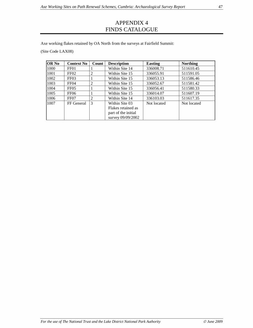
Axe Working Sites on Path Renewal Schemes, Cumbria: Archaeological Survey Report 47
For the use of The National Trust and the Lake District National Park Authority © June 2009
APPENDIX 4FINDS CATALOGUE
Axe working flakes retained by OA North from the surveys at Fairfield Summit:
(Site Code LAX08)
OR No Context No Count Description Easting Northing1000 FF01 1 Within Site 14 336008.71 511610.451001 FF02 2 Within Site 15 336055.91 511591.051002 FF03 1 Within Site 15 336053.13 511586.461003 FF04 2 Within Site 15 336052.67 511581.421004 FF05 1 Within Site 15 336056.41 511580.331005 FF06 1 Within Site 15 336014.07 511607.191006 FF07 2 Within Site 14 336103.03 511617.351007 FF General 3 Within Site 03
Flakes retained aspart of the initialsurvey 09/09/2002
Not located Not located

Axe Working Sites on Path Renewal Schemes, Cumbria: Archaeological Survey Report 48
For the use of The National Trust and the Lake District National Park Authority © June 2009
ILLUSTRATIONS
FIGURES
Fig 1: Location of Survey AreasFig 2: Key plan of site maplets
Fig 3: Footpath renewal and stone picking areas at Piers Gill and Greta Gill, WasdaleFig 4: Footpath renewal from Three Shires Stone to Wet Side Edge, Duddon
Fig 5: Footpath renewal and stone picking areas from Angle Tarn to Esk Hause, GreatLangdale
Fig 6: Footpath renewal and stone picking areas at Fairfield Summit, Grasmere
Fig 7: Exposure of axe working sites at Fairfield Summit, GrasmereFig 8: Updated distribution of fine grained tuff outcrop and the principal axe flaking site
groups (after Claris and Quartermaine 1989)
PLATES
Plate 1: Footpath erosion to the north-west of Angle TarnPlate 2: Marker cairn at Esk Hause (Site 13)
Plate 3: General view of footpath erosion and two exposed axe working sites (FF1: Site 14and FF2: Site 15) on Fairfield Summit
Plate 4: Exposed axe working site (FF1: Site 14) on Fairfield SummitPlate 5: Marker cairn on Fairfield Summit (Site 18)
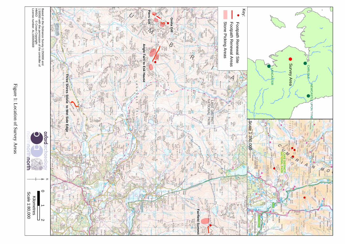
Figure 1: L
ocation of Survey A
reas
01
2
Kilom
etres
Based on the O
rdnance Survey 1:250000 and
1:50000 with the perm
ission of the controller ofH
MS
O ©
Crow
n Copyright
License number: A
L100005569
Scale 1:80,000
!
!
!C
AR
LISLE
LAN
CA
ST
ER N
EW
CA
ST
LE U
PO
N T
YN
E
Survey A
rea
Scale 1:350,000
Footpath R
enewal S
ite
Key:
An
gle T
arn to
Esk H
ause
Greta G
ill
Piers G
ill
Th
ree Sh
ires Sto
ne to
Wet S
ide E
dg
e
Fairfield
Su
mm
it
�-
�-
�-
�-
�-�-
�-
�-
�-
Footpath R
enewal A
reas
Stone P
icking Areas

based on the Ordnance Survey 1:50000 with the permission of the controller of HMSO © Crown Copyright License number: AL100005569
Figure 2: Key plan of site maplets
0 1,000 2,000
Metres
320000 325000 330000 335000
5050
0051
0000
Fig: 3 Fig: 5
Fig: 4
Fig: 6Fig: 7
Legend
Footpath Renewal Areas
Stone Picking Areas
Fine Grained Tuff (Group VI)
Geology Faults

based on the Ordnance Survey 1:10000 with the permission of the controller of HMSO © Crown Copyright License number: AL100005569
Figure 3: Footpath renewal and stone picking areas at Piers Gill and Greta Gill, Wasdale
0 125 250
Metres
321000 321500 322000 322500 323000
5075
0050
8000
5085
00
Piers Gill
Greta Gill
7!
19!
6!
4!
5
Legend
OANorth Sites (Polygon)
Footpath Renewal Areas
Stone Picking Areas
Geology Faults
Fine Grained Tuff (Group VI)
LDNPA Hazard Areas
! OANorth Sites (Point)

Based on the Ordnance Survey 1:10000 with the permission of the controller of HMSO © Crown Copyright Licence No AL 100005569
Figure 4: Footpath renewal from Three Shires Stone to Wet Side Edge, Duddon
0 125 250
Metres
!
!
8
8
8
9
11
327000 327500 328000 328500 329000
5025
0050
3000
Legend
! OANorth Sites (Point)
OANorth Sites (Polygon)
Scheduled Monument Areas
Footpath Renewal Areas
Stone Picking Areas
LDNPA Hazard Areas

Based on the Ordnance Survey 1:10000 with the permission of the controller of HMSO © Crown Copyright Licence No. AL 100005569
Figure 5: Footpath renewal and stone picking areas from Angle Tarn to Esk Hause, Great Langdale
0 125 250
Metres
!
!
!
!
!
323000 323500 324000 324500 325000
5075
0050
8000
5085
00
Legend
! OANorth Sites (Point)
Footpath Renewal Areas
Stone Picking Areas
Geology Faults
Fine Grained Tuff (Group VI)
LDNPA Hazard Areas
7
19
13
10
12

Based on the Ordnance Survey 1:10000 with the permission of the controller of HMSO © Crown Copyright Licence No. AL 100005569
Figure 6: Footpath renewal and stone picking areas at Fairfield Summit, Grasmere
0 100 200
Metres
AAA
AAAA
335500 336000 336500 337000
5115
0051
2000
1415
!
!!
3
12
Fig: 7
!17
!16
18! !20!
21
Legend
! OANorth Sites (Point)
A OANorth Lithic Findspots
OANorth Sites (Polygon)
Footpath Renewal Areas
Stone Picking Areas
!
!

Based on the Ordnance Survey 1:10000 with the permission of the controller of HMSO © Crown Copyright Licence No. AL 100005569
Figure 7: Exposure of axe working sites at Fairfield Summit, Grasmere
0 25 50
Metres
A
AA
AAAA
335800 336000 336200 336400
5116
0051
1800
14
15
!
!
Fairfield Summit Axe Working Complex: Site 3
12
17
18
16
!
!
!
!
21!
20FFI
FFII
Legend
OANorth Sites (Point)!
OANorth Lithic Findspots
OANorth Sites (Polygon)
Footpath Renewal Areas
A
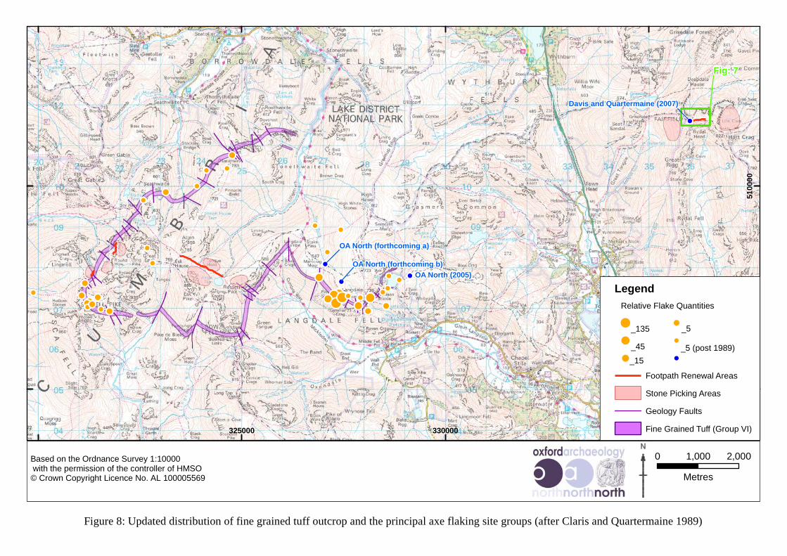
Based on the Ordnance Survey 1:10000 with the permission of the controller of HMSO © Crown Copyright Licence No. AL 100005569
Figure 8: Updated distribution of fine grained tuff outcrop and the principal axe flaking site groups (after Claris and Quartermaine 1989)
0 1,000 2,000
Metres
!
!!
!
!!
!
!
!!
! !!
!!!!
!
!
!
!
!
!!!!!!
!! !
!!
!!
!! !
!
!
!
325000 330000 335000
5050
0051
0000
OA North (forthcoming a)
Davis and Quartermaine (2007)
Fig: 7
Legend
Geology Faults
_135
_45 _5 (post 1989)
_5
Footpath Renewal Areas
Stone Picking Areas
Fine Grained Tuff (Group VI)
!_15
!
!
!
!
!
Relative Flake Quantities
OA North (2005)OA North (forthcoming b)
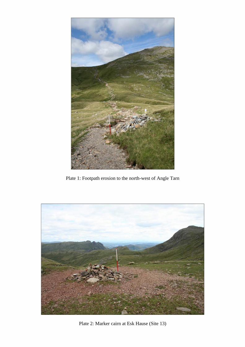
Plate 1: Footpath erosion to the north-west of Angle Tarn
Plate 2: Marker cairn at Esk Hause (Site 13)

Plate 3: General view of footpath erosion and two exposed axe working sites (FF1:Site 14 and FF2: Site 15) on Fairfield Summit
Plate 4: Exposed axe working site (FF1: Site 14) on Fairfield Summit
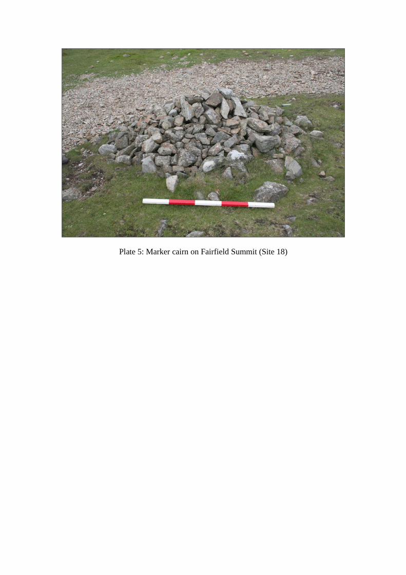
Plate 5: Marker cairn on Fairfield Summit (Site 18)