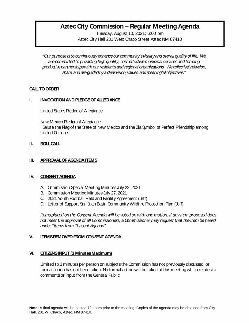
aztec city commission – regular meeting agenda
TRANSCRIPT
Note: A final agenda will be posted 72 hours prior to the meeting. Copies of the agenda may be obtained from City Hall, 201 W. Chaco, Aztec, NM 87410.
“Our purpose is to continuously enhance our community’s vitality and overall quality of life. We are committed to providing high quality, cost-effective municipal services and forming
productive partnerships with our residents and regional organizations. We collectively develop, share, and are guided by a clear vision, values, and meaningful objectives.”
CALL TO ORDER I. INVOCATION AND PLEDGE OF ALLEGIANCE
United States Pledge of Allegiance New Mexico Pledge of Allegiance I Salute the Flag of the State of New Mexico and the Zia Symbol of Perfect Friendship among United Cultures
II. ROLL CALL
III. APPROVAL OF AGENDA ITEMS IV. CONSENT AGENDA
A. Commission Special Meeting Minutes July 22, 2021 B. Commission Meeting Minutes July 27, 2021 C. 2021 Youth Football Field and Facility Agreement (Jeff) D. Letter of Support San Juan Basin Community Wildfire Protection Plan (Jeff)
Items placed on the Consent Agenda will be voted on with one motion. If any item proposed does not meet the approval of all Commissioners, a Commissioner may request that the item be heard under “items from Consent Agenda”
V. ITEMS REMOVED FROM CONSENT AGENDA VI. CITIZENS INPUT (3 Minutes Maximum)
Limited to 3 minutes per person on subjects the Commission has not previously discussed, or formal action has not been taken. No formal action will be taken at this meeting which relates to comments or input from the General Public
Aztec City Commission – Regular Meeting Agenda Tuesday, August 10, 2021; 6:00 pm
Aztec City Hall 201 West Chaco Street Aztec NM 87410
Note: A final agenda will be posted 72 hours prior to the meeting. Copies of the agenda may be obtained from City Hall, 201 W. Chaco, Aztec, NM 87410.
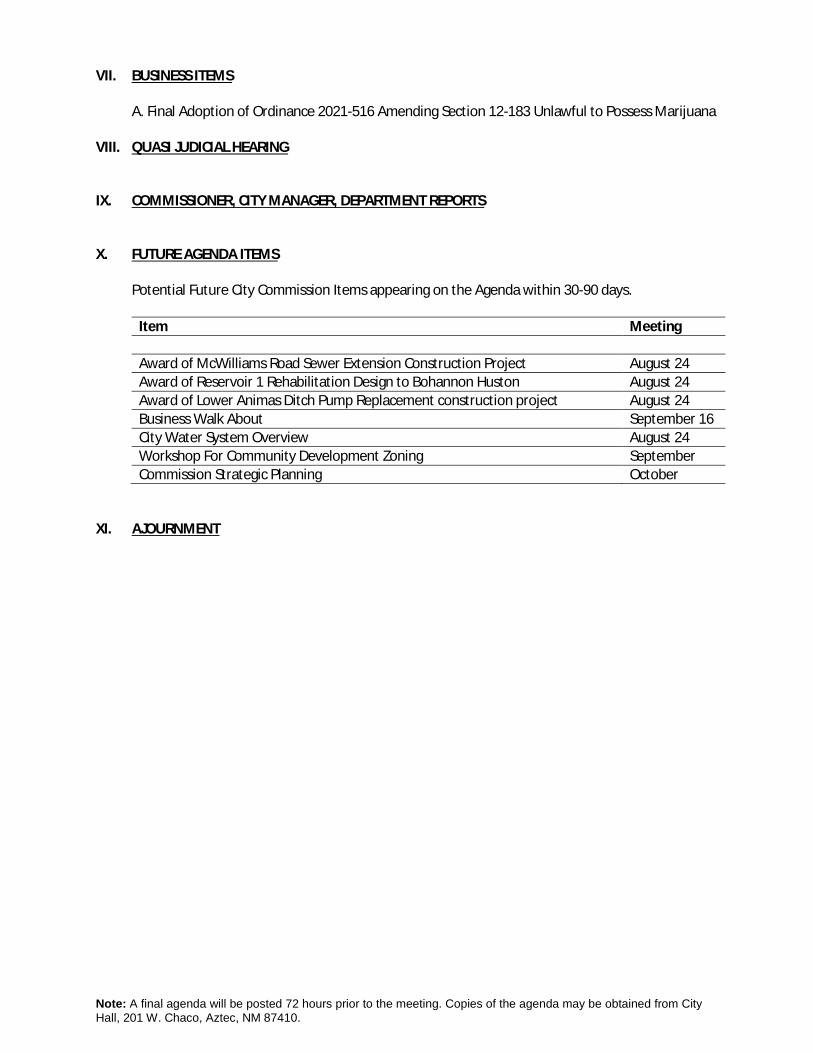
VII. BUSINESS ITEMS A. Final Adoption of Ordinance 2021-516 Amending Section 12-183 Unlawful to Possess Marijuana
VIII. QUASI JUDICIAL HEARING IX. COMMISSIONER, CITY MANAGER, DEPARTMENT REPORTS X. FUTURE AGENDA ITEMS
Potential Future City Commission Items appearing on the Agenda within 30-90 days.
Item Meeting Award of McWilliams Road Sewer Extension Construction Project August 24 Award of Reservoir 1 Rehabilitation Design to Bohannon Huston August 24 Award of Lower Animas Ditch Pump Replacement construction project August 24 Business Walk About September 16 City Water System Overview August 24 Workshop For Community Development Zoning September Commission Strategic Planning October
XI. AJOURNMENT
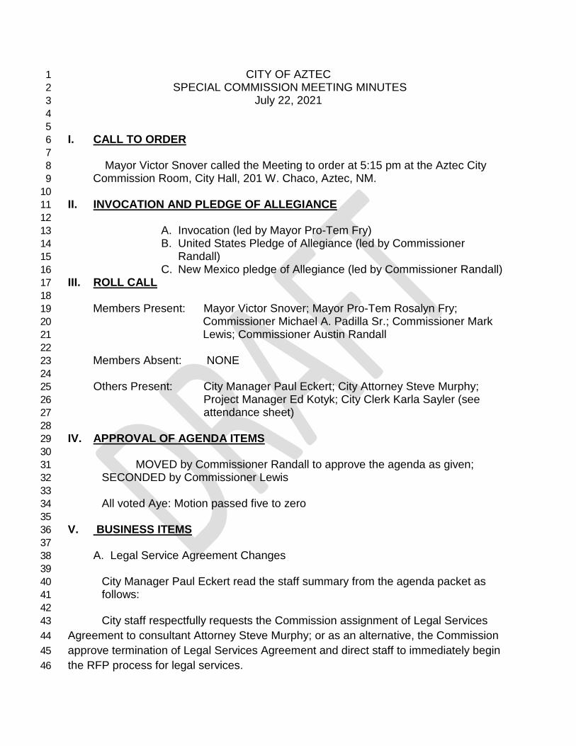
CITY OF AZTEC 1 SPECIAL COMMISSION MEETING MINUTES 2
July 22, 2021 3 4
5 I. CALL TO ORDER 6 7 Mayor Victor Snover called the Meeting to order at 5:15 pm at the Aztec City 8 Commission Room, City Hall, 201 W. Chaco, Aztec, NM. 9
10 II. INVOCATION AND PLEDGE OF ALLEGIANCE 11 12
A. Invocation (led by Mayor Pro-Tem Fry) 13 B. United States Pledge of Allegiance (led by Commissioner 14
Randall) 15 C. New Mexico pledge of Allegiance (led by Commissioner Randall) 16
III. ROLL CALL 17 18
Members Present: Mayor Victor Snover; Mayor Pro-Tem Rosalyn Fry; 19 Commissioner Michael A. Padilla Sr.; Commissioner Mark 20 Lewis; Commissioner Austin Randall 21 22 Members Absent: NONE 23
24 Others Present: City Manager Paul Eckert; City Attorney Steve Murphy; 25
Project Manager Ed Kotyk; City Clerk Karla Sayler (see 26 attendance sheet) 27
28 IV. APPROVAL OF AGENDA ITEMS 29 30
MOVED by Commissioner Randall to approve the agenda as given; 31 SECONDED by Commissioner Lewis 32
33 All voted Aye: Motion passed five to zero 34
35 V. BUSINESS ITEMS 36 37
A. Legal Service Agreement Changes 38 39
City Manager Paul Eckert read the staff summary from the agenda packet as 40 follows: 41 42
City staff respectfully requests the Commission assignment of Legal Services 43 Agreement to consultant Attorney Steve Murphy; or as an alternative, the Commission 44 approve termination of Legal Services Agreement and direct staff to immediately begin 45 the RFP process for legal services. 46
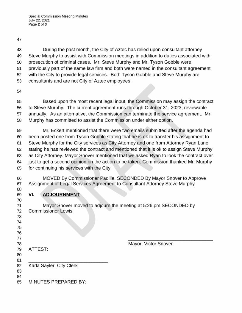
Special Commission Meeting Minutes July 22, 2021 Page 2 of 3
47
During the past month, the City of Aztec has relied upon consultant attorney 48 Steve Murphy to assist with Commission meetings in addition to duties associated with 49 prosecution of criminal cases. Mr. Steve Murphy and Mr. Tyson Gobble were 50 previously part of the same law firm and both were named in the consultant agreement 51 with the City to provide legal services. Both Tyson Gobble and Steve Murphy are 52 consultants and are not City of Aztec employees. 53
54
Based upon the most recent legal input, the Commission may assign the contract 55 to Steve Murphy. The current agreement runs through October 31, 2023, reviewable 56 annually. As an alternative, the Commission can terminate the service agreement. Mr. 57 Murphy has committed to assist the Commission under either option. 58
Mr. Eckert mentioned that there were two emails submitted after the agenda had 59 been posted one from Tyson Gobble stating that he is ok to transfer his assignment to 60 Steve Murphy for the City services as City Attorney and one from Attorney Ryan Lane 61 stating he has reviewed the contract and mentioned that it is ok to assign Steve Murphy 62 as City Attorney. Mayor Snover mentioned that we asked Ryan to look the contract over 63 just to get a second opinion on the action to be taken. Commission thanked Mr. Murphy 64 for continuing his services with the City. 65
MOVED By Commissioner Padilla, SECONDED By Mayor Snover to Approve 66 Assignment of Legal Services Agreement to Consultant Attorney Steve Murphy 67 68 VI. ADJOURNMENT 69
70 Mayor Snover moved to adjourn the meeting at 5:26 pm SECONDED by 71
Commissioner Lewis. 72 73 74 75 76
________________________________ 77 Mayor, Victor Snover 78
ATTEST: 79 80 ______________________________ 81 Karla Sayler, City Clerk 82 83 84 MINUTES PREPARED BY: 85

Special Commission Meeting Minutes July 22, 2021 Page 3 of 3
86 _____________________________ 87 Karla Sayler, City Clerk 88

CITY OF AZTEC 1 COMMISSION MEETING MINUTES 2
Tuesday, July 27, 2021 3 4
CALL TO ORDER 5 6
Mayor Victor Pro-Tem Rosalyn Fry called the meeting to order at 6:00 pm at Aztec City Hall, 201 7 W. Chaco, Aztec NM 87410 8 9 I. INVOCATION AND PLEDGE OF ALLEGIANCE 10 11
A. Invocation led by Chief Mike Heal 12 B. United States Pledge of Allegiance led by Commissioner Mark Lewis 13 C. New Mexico pledge of Allegiance led by Commissioner Mark Lewis 14
II. ROLL CALL 15 16 Members Present: Mayor Pro-Tem Rosalynn Fry; Commissioner Austin Randall; 17
Commissioner Mark Lewis; Commissioner Michael A. Padilla Sr. 18 19 Members Absent: Mayor Victor Snover 20
21 Others Present: City Manager Paul Eckert; City Attorney Steven Murphy; City Clerk Karla 22
Sayler 23 III. APPROVAL OF AGENDA ITEMS 24
25 MOVED by Commissioner Padilla to approve the agenda; SECONDED by Commissioner 26 Lewis 27 All Voted Aye: Motion Passed Four to Zero 28
29 IV. CONSENT AGENDA 30
31 32 A. Commission Meeting Minutes July 13, 2021 33 B. Bid 2021-775 North Main Extension Change Order #1 34 C. Resolution 2021-1235 Fiscal Year 2021 Special Budget Resolution Request 35 D. Resolution 2021-1236 Fiscal Year 2021 4th Quarter Financial Report Approval Request 36 E. Appointment of City Manager to Council of Government 37 F. Appointment of City Manager to 4CED Board 38 39
MOVED by Commissioner Randall to Approve the Consent Agenda SECONDED by 40 Commissioner Padilla 41 42 All Voted Aye: Motion Passed Four To Zero 43 44
V. ITEMS REMOVED FROM CONSENT AGENDA 45 46 None 47 48

Commission Meeting Minutes July 27, 2021 Page 2 of 4
VI. CITIZENS INPUT (3 Minutes Maximum) 49 50 Keith Baker spoke to commission about the ditches that are by his residence on Swire Dr. He was 51 inquiring on who works on cleaning the ditches. He said he has spent quite a bit of money cleaning it out 52 himself and would like to know who to contact to have the responsible persons to come clean them. He 53 was directed to speak to Public Works Director Steve Morse to get the information. 54 55 VII. BUSINESS ITEMS 56 57 A. Resolution 2021-1237 Fiscal Year 2022 Final Budget Approval 58 59 Finance Director Anthony Bolling presented commission with a presentation on the FY22 Final 60
Budget. He reviewed the following information: 61 62
· Cash reserves/revenue forecasting/project updates/fund updates/department updates 63 · Staffing changes/timing issues/budget resource deficit 64 · Cash balances for City funds 65 · Revenue adjustments 66 · Project Updates 67 · Fund Updates 68 · Department Updates 69 Tony gave a final summary to commission stating that the final FY2020 budget is $41,343,783 70 stating that this is a $2,419.731 (6%) increase from the preliminary budget. He mentioned that 71 the major projects scheduled for FY2022 are: The final phase of The East Aztec Arterial and 72 the North Main Corridor and mentioned that he would like to see staffing levels return to pre 73 pandemic levels. Commissioner Padilla had some questions on staffing for Community 74 Development Department position. It was mentioned by CD Director that the position was in 75 the budget already pre pandemic. He mentioned that the new positon of Planning Tech. is one 76 position only and it will take the place of Administrative Assistant. Mike mentioned that he 77 would like to see changes to the budget before changes are made and presented to them. 78 79
MOVED by Commissioner Padilla, SECONDED by Commissioner Lewis to Approve Resolution 80 2021-1237 Fiscal Year 2022 Budget 81
82 All Voted Aye; Motion Passed Four to Zero 83 84 VIII. QUASI JUDICIAL HEARING 85 86 None 87 88 89 VIII. COMMISSIONER, CITY MANAGER, DEPARTMENT REPORTS 90 91
92 City Manager Paul Eckert thanked commission for their contributions to the monthly reports 93 that are now available to the public on our website. 94
Commission Meeting Minutes July 27, 2021 Page 3 of 4
95 Commission Randall mentioned he attended the Lodger’s Tax board and that they approved 96 funding for events coming up in the City. (Octoberfest, Highland Games, Motocross) 97 98 Commissioner Padilla thank Steve Murphy for stepping in as City Attorney. 99 100 Commissioner Lewis mentioned that the Federal Government Bureau of Reclamation has 101 started releasing water from Flaming Gorge Reservoir in Utah, The Blue Mesa Reservoir in 102 Colorado, and Navajo Lake to maintain the hydro lift pool to maintain the electricity for Lake 103 Powell and Lake Mead. 104 105 Mayor Pro Tem mentioned the Pianos in the Park event on July 17 at Minium Park had 106 approximately 600 people that attended the event and they had a meeting to start planning the 107 next event for next year. 108 109 Chief Mike Heal mentioned that there will be a protest at the Ryan Lane Attorney Office on Main 110 Street tomorrow. 111 112 Public Works Director Steve Morse mentioned that the North Main Project started over the 113 weekend. And that the pre-bid for the replacing of Animas ditch pump was today, the Ruins Road 114 project sidewalk project will be moving forward. He mentioned that he received the design for 115 replacing the water line on Hwy173. He also mentioned that they will contract the work out for 116 McWilliams Road. 117 118 119
X. FUTURE AGENDA ITEMS 120 121 There was no discussion on upcoming event list. 122 123 POTENTIAL FUTURE CITY COMMISSION ITEMS- (Appearing on the Agenda within 30-90 days): 124
Item Commission Meeting
Final Budget to DFA July 27 Award of McWilliams Road Sewer Extension Construction Project July 27 Award of Reservoir 1 Rehabilitation Design to Bohannon Huston July/August Award of Lower Animas Ditch Pump Replacement construction project July/August Variance to Animal Unit Code August Business Walkabout August City Water System Overview August 24 Commission Strategic Planning September
125
XI. ADJOURNMENT 126 127

Commission Meeting Minutes July 27, 2021 Page 4 of 4
Mayor Pro-Tem moved to adjourn the meeting at 6:47 pm SECONDED by Commissioner Lewis 128 129 ________________________________ 130
Mayor Pro-Tem Rosalyn Fry 131 ATTEST: 132 133 ______________________________ 134 Karla Sayler, City Clerk 135 136 137 MINUTES PREPARED BY: 138 139 _____________________________ 140 Karla Sayler, City Clerk 141 142
Staff Report
MEETING DATE: August 10, 2021
AGENDA ITEM: IV. CONSENT AGENDA (C)
AGENDA TITLE: Agreement #2021YFB: Aztec Youth Football field and facilities Agreement
ACTION REQUESTED BY: Parks Department
SUMMARY BY: General Services Director
PROJECT DESCRIPTION / FACTS
Staff respectfully requests that the Commission consider and approve Agreement #2021YFB: Aztec Youth Football field and facilities Agreement for use with AZTEC YOUTH SPORTS, for (5) years, August 10, 2021 to August 10, 2026. The following are relevant supporting points:
· AGREEMENT #2021YFB updates and supersedes all other existing Agreements with AZTEC YOUTH SPORTS and others for the use of Aztec Youth Football Field and facilities.
· THIS AGREEMENT, made and entered into this day August 10, 2021 by and between the CITY OF AZTEC, NEW MEXICO, and AZTEC YOUTH SPORTS, pertaining to operation of the Aztec Football field and facilities, for the purpose of storage for ASSOCIATION equipment, concession sales, practice, and games, @ 500 Llano Street, Hartman Park, Youth Football Field.
· AZTEC YOUTH SPORTS shall: One (1) month prior to the start of organized events annual proof of said indemnity in the form of a valid and existing policy of insurance. Such policy will be in accordance with the New Mexico Tort Claims Act and shall be in the amounts of not less than One Million Dollars ($1,000,000) Dollars combined single occurrence limit. The City of Aztec shall be named as an additional insured on the policy. No cancelation of the policy of insurance is valid as to the City without the City receiving 30 days written notice.
· The ASSOCIATION agrees to keep the premises of Aztec City Football Field and Concession Stand in a manner that will conform to all environmental and health regulation, including restrooms at their own expense.
· The ASSOCIATION is responsible to obtain all permits and licenses for food handling and sales. All concessions sold shall have the approval and proper permits from the New Mexico Environment Department, and the proper Business License must be obtained from the City of Aztec
· Annually, on the anniversary of signing, the representatives of the City and Association will do a review to:
· Inspect and document the conditions of the facilities and designated areas of use;
· Determine maintenance requirements; · Identify needs; · Determine funding requirements of each party.
· The agreement is for five (5) years to become effective 8/10/21 and shall expire
on 8/10/26. This agreement shall be reviewed annually by City Staff. The CITY may terminate this agreement at any time for any reason.
PROCUREMENT
Custodial Supplies and striping paint for playing field
FISCAL IMPACTS
Additional Gross Receipts Tax received from participants purchasing supplies and goods during scheduled events, City Athletic Fields Striping Fees per City Code 16-14, and a $500.00 concession use fee per season.
SUPPORT DOCUMENTS: Agreement #2021YFB Agreement for Operation of Hartman Park Football Facilities, between Aztec Youth Sports and the City of Aztec
DEPARTMENT’S RECOMMENDED MOTION: Move to Approve Agreement #2021YFB, Aztec Youth Football field and facilities Agreement for use with AZTEC YOUTH SPORTS, for (5) years, August 10, 2021 to August 10, 2026.

City of Aztec Agreement No.: 2021-YFB
Page 1 of 4
AGREEMENT
AZTEC YOUTH SPORTS THIS AGREEMENT, made and entered into this day August 10th 2021 by and between the CITY OF AZTEC, NEW MEXICO, a municipal corporation, hereinafter referred to as the CITY and AZTEC YOUTH SPORTS, an incorporated Association, Non-profit Organization, hereinafter referred to as ASSOCIATION. This agreement pertains to the use of the Aztec City Football Field, designated practice areas, and associated parking areas located at Hartman Sports Complex 500 W. Llano St., Aztec NM. SECTION 1. Association Responsibilities.
1. The ASSOCIATION agrees to indemnify and hold harmless the City from all perils, at all times and from liability for damages to or caused by its members, employees, agents, representatives, guests, volunteers, vendors, invitees, spectators, players and other persons arising out of or connected to any extent with the use or occupancy of the designated premises or any part thereof. It is the intent of the parties to protect the City from any and all damages, lawsuits, or any cause of action out of the use of city property.
2. The ASSOCIATION agrees to keep the premises of Aztec City Football Field, Concession Stand and associated areas in a manner that will conform to all environmental and health regulation, including restrooms at their own expense. The ASSOCIATION shall clean up all litter and debris in and around the designated area after field usage (i.e. bleachers, concession stand interior and exterior, and parking lot).
3. The ASSOCIATION shall obtain all permits and/or licenses for food handling and sales. All concessions sold shall have the approval and proper permits from the New Mexico Environment Department, and the proper Business License must be obtained from the City of Aztec. A copy of food service permit and the Aztec business license shall be provided to the City Parks and Recreation Director annually prior to use of the facilities. No keys will not be issued until appropriate permits have been received.
4. The ASSOCIATION shall provide to the Parks and Recreation Director:
A. One (1) month prior to the start of organized events a list of all officers, home and work
telephone numbers, e-mails and mailing addresses. This will include a designated primary contact for the ASSOCIATION: AND
B. One (1) month prior to practice or training camps a copy of all schedules: and C. One (1) month prior to Season kickoff provide a game schedule: and D. Two (2) weeks’ notice prior to using any fields or facilities, and proposed hours of operation; and E. One (1) month prior to the start of organized events annual proof of said indemnity in the
form of a valid and existing policy of insurance. Such policy will be in accordance with the New Mexico Tort Claims Act and shall be in the amounts of not less than One Million Dollars ($1,000,000) Dollars combined single occurrence limit. The City of Aztec shall be named as an additional insured on the policy. No cancelation of the policy of insurance is valid as to the City without the City receiving 30 days written notice.

City of Aztec Agreement No.: 2021-YFB
Page 2 of 4
F. NO PERMITS WILL BE ISSUED AND FIELDS SHALL NOT BE ULITIZED UNTIL INSURANCE DOCUMENTATION IS RECEIVED!
G. The ASSOCATION shall maintain all facilities during the league season including, but not limited
to the following: 1) Goals in the end zones of the football field 2) Scoreboard 3) Policing the grounds, bleaches and parking lots for litter after league games and
practices.
H. The ASSOCIATION shall pay the amount designated by the City to cover the costs of labor and materials for all field maintenance and striping for league and tournament play. Such fees are established in Chapter 16 fee schedule of the City Code Book.
I. The ASSOCIATION will have joint use of the Concession facilities with the Aztec Soccer
Association. The ASSOCIATION will receive (2) keys to the concession facility and storage facility. Lost keys shall result in the Association being billed for a locksmith to change the locks. The ASSOCIATION will be responsible for removing all food and drink products from the concession stand at the end of the league season.
SECTION 2. City Responsibilities.
1. The CITY shall provide to the ASSOCIATION use of the facilities during the hours scheduled for use as provide to the Parks and Recreation Director in Section 1 4. The City shall make these facilities available to others when it does not infringe upon the use by ASSOCIATION.
2. The CITY shall maintain the following
1) Regular pick-up and emptying of solid waste dumpster. 2) Cost of water utilities. 3) Restroom facilities while not being utilized by the ASSOCATION. 4) Concession building including the commercial appliances located within (i.e. refrigerator,
freezer and ice maker. 5) Grass areas by watering and mowing as necessary
SECTION 3. Term of Agreement. The agreement is for five (5) years to become effective 8/10/21 and shall expire on 8/10/26. This agreement shall be reviewed annually by City Staff. The CITY may terminate this agreement at any time for any reason. Any and all notices provided for under this Agreement shall be in writing and addressed to the parties at the following address:
City of Aztec Aztec Youth Sports 201 W. Chaco 3204 Blancett Drive Aztec, NM 87410 Aztec, NM 87410

City of Aztec Agreement No.: 2021-YFB
Page 3 of 4
SECTION 4. Inspections of Facilities. 1. At the end of each youth football season, the representatives of the City and Association will do a review to: 1) Inspect and document the conditions of the facilities and designated areas of use; 2) Determine maintenance requirements; 3) Identify needs; and 4) Determine funding requirements of each party. SECTION 5. Maintenance of Facilities in Off Season. After the conclusion of the season of each year, or as soon thereafter that the ASSOCIATION meets all of the obligations in Section 4, the City will assume complete maintenance of the designated areas. All cleaning or maintenance after this date of each year shall become the responsibility of the City. SECTION 6. Facility Improvements or Repairs.
1. The ASSOCIATION shall make no alteration, addition or improvement to the premises without prior written consent of the City of Aztec.
2. In the event that any extra ordinary work is necessary during the term of this Agreement, it is agreed that the ASSOCIATION will submit requests. One copy to the Parks and Recreation Director, and one copy to stay with the ASSOCIATION. The City shall consider, approve, modify or reject any construction or renovating or changes to landscape or grounds before work may proceed.
3. All improvements made by ASSOCIATION are considered as becoming part of the facilities and/or realty and be treated as part of the real estate to be owned by the City without cost.
SECTION 7. Incurred Expenses. The ASSOCIATION shall pay for upkeep expenses for the facilities and/or premises. In addition, the ASSOCIATION further agrees that it will not cause or permit any lien of any kind whatsoever to be levied upon, claimed against or to remain unpaid against the facilities and/or premises owned by the City. SECTION 8. Legal Representation. The ASSOCIATION agrees if the City desires to employ an attorney to represent the CITY in regard to any proceeding or controversy connected with or arising out of this agreement or the performance thereof or the enforcement of any of the provisions hereof, ASSOCIATION shall pay all reasonable attorney fees and costs incurred by the City in addition to the sums otherwise provided for herein. SECTION 9. Termination of Agreement. This agreement may be terminated upon breach of any of the provisions of this Agreement upon thirty (30) days written notice, provide said breach has not been corrected within ten (10) days of receiving notice of said breach.

City of Aztec Agreement No.: 2021-YFB
Page 4 of 4
SECTION 10. Severability.
1. This agreement shall be deemed to supersede all prior written and oral agreements and undertakings of the parties hereto.
2. Except as otherwise provided herein, this agreement shall inure to the benefit of and be binding upon the parties hereto, their successors and assigns through the term of the Agreement.
3. If any portion of this agreement is found to be ineffective by a court of law or by agreement of the
parties, the remaining portions shall remain in effect. SECTIONS 11: Fees 1. Refer to Chapter 16 Fee Schedule (Section 16-14) of the City of Aztec Municipal Code for field preparation charges and player registration fees. 2. The ASSOCIATION shall pay five hundred dollars ($500.00) per year to the City for the use of the concession facilities during the season. The ASSOCIATION shall provide payment to the City within one month after the season ends. FIELDS SHALL NOT BE ULITIZED UNTIL ALL PAST DUE FEES ARE PAID!
Mayor Victor C. Snover
ATTEST:
Karla Sayler, City Clerk CMC
APPROVE AS TO FORM:
City Attorney
AZTEC YOUTH SPORTS
Representative Name
Staff Report
MEETING DATE: August 10, 2021
AGENDA ITEM: IV. CONSENT AGENDA (D)
AGENDA TITLE: Letter of Support for San Juan Basin Community Wildfire Protection Plan for the Cities of Aztec, Bloomfield, Farmington & San Juan County
ACTION REQUESTED BY: Craig Daugherty, Fire Edge Solutions, for the Cities of Aztec, Bloomfield, Farmington & San Juan County.
SUMMARY BY: Staff Summary by Jeff Blackburn
PROJECT DESCRIPTION / FACTS
Staff respectfully requests that the Commission consider and approve the San Juan Basin Community Wildfire Protection Plan for the Cities of Aztec, Bloomfield, Farmington, and San Juan County, updated every five years, dependent on grant funding. The following are relevant supporting points:
· For a community to take full advantage of the opportunities provided in the Healthy Forests Restoration Act (HFRA), it must first prepare a community wildfire protection plan (CWPP); which was originally done in 2006.
· A CWPP developed in accordance with HFRA is the most effective way to acquire funding for wildland fuels mitigation and fire preparedness and planning. San Juan County adopted a CWPP in 2006 to better protect its communities from wildfire risk, to better prepare citizens, and to become eligible to apply for and receive federal and other grant monies to implement projects.
· In July 2013 San Juan County received a $10,000 grant from the New Mexico Association of Counties to update the CWPP plan adopted in 2006.
· In 2020 a grant was obtained by San Juan County from the New Mexico Association of Counties to do an additional update of the CWPP plan.
· This update is required by the New Mexico Forestry Division every five years for the plan to stay viable and allow the communities to be eligible to apply for and receive federal and other grant monies.
· A primary objective of a CWPP is to help local governments, fire departments, and residents identify at-risk public and private lands and develop programs that better protect those lands from severe wildfire threat.
· Additional functions of a CWPP are to improve fire prevention and suppression activities, as well as to identify funding needs and opportunities. Identifying at-risk areas and improving fire protection capabilities help the communities to prioritize areas of high-risk from wildland vegetative fuels and to expedite overall project planning. The SJBCWPP was created to meet these objectives at a local level while integrating with overall federal- and state-level wildfire planning.

SUPPORT DOCUMENTS: San Juan Basin Community Wildfire Protection Plan, and Declaration of Agreement
DEPARTMENT’S RECOMMENDED MOTION: Move to Approve Letter of Support for the San Juan Basin Community Wildfire Protection Plan

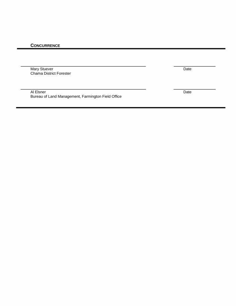
IV. DECLARATION OF AGREEMENT AND CONCURRENCE The following partners in the development of this Community Wildfire Protection Plan have reviewed and do mutually agree or concur with its contents:
AGREEMENT
John Beckstead Date San Juan County Board of County Commissioners
John Mohler Date Chief, San Juan County/Bloomfield Fire Department
Cynthia Atencio Date Mayor, City of Bloomfield
Victor Snover Date Mayor, City of Aztec
Kevin Simpson Date Chief, Aztec Municipal Fire Department
Nate Duckett Date Mayor, City of Farmington
Robert Sterrett Date Acting Chief, Farmington Municipal Fire Department
John Arrington Date San Juan Soil and Water Conservation District
CONCURRENCE
Mary Stuever Date Chama District Forester
Al Elsner Date Bureau of Land Management, Farmington Field Office

San Juan Basin CWPP 2021 i

San Juan Basin CWPP 2021 ii
TABLE OF CONTENTS
Acronyms and Abbreviations ................................................................................................................... iv
Executive Summary ....................................................................................................................................v
I. Introduction ......................................................................................................................................... 1 A. Background ........................................................................................................................................ 2 B. Need for the Community Wildfire Protection Plan ............................................................................... 6 C. Wildland-Urban Interface ................................................................................................................... 6 D. Desired Future Condition and Relevant Fire Policies.......................................................................... 8 E. Grants/Current Projects ................................................................................................................... 13 F. Goals ............................................................................................................................................... 14 G. Planning Process ............................................................................................................................. 14
II. Community Assessment .................................................................................................................. 17 A. Wildland-Urban Interface Delineation Process .................................................................................. 17 B. Wildland-Urban Interface Risk Assessment ...................................................................................... 20 C. Risk of Ignition and Wildfire Occurrence ........................................................................................... 35 D. Community Values at Risk ............................................................................................................... 37
III. Community Mitigation Plan ............................................................................................................. 60 A. Administrative Oversight .................................................................................................................. 60 B. Fuel Reduction Priorities .................................................................................................................. 61 C. Prevention and Loss Mitigation ........................................................................................................ 70
IV. CWPP Priorities: Action Recommendations and Implementation ................................................. 74 A. Administrative Oversight .................................................................................................................. 74 B. Community Priorities for Reduction of Hazardous Fuels ................................................................... 74 C. Community Priorities for Reducing Structural Ignitability .................................................................. 75 D. Priorities for Promoting Community Involvement through Education, Information,
and Outreach .................................................................................................................................. 75 E. Priorities for Enhancing Local Wood-Products Industries .................................................................. 75 F. Performance Measures Update…….………………………………………………………………….…….76 G. San Juan Firebreak Project…………………………………………………………………………….…….78
V. Monitoring Plan ................................................................................................................................ 80 A. Administrative Oversight, Monitoring, and SJBCWPP Reporting ...................................................... 80
VI. Declaration of Agreement and Concurrence ............................................................................ 81-82
VII. References ....................................................................................................................................... 83
VIII. Glossary of Fire Management Terms ............................................................................................. 86
Appendix A: Potential Natural Vegetation Groups .............................................................................. 105
Appendix B: Threatened, Endangered, and Sensitive Species ........................................................... 110
Appendix C: National Fire Danger Rating System Fuel Model Selection Key ..................................... 118
Appendix D: Fire Department Hazard Assessments ........................................................................... 122 Appendix E: Additional Resources ....................................................................................................... 134
Appendix F: Salt cedar/Russian Olive Information .............................................................................. 138

San Juan Basin CWPP 2021 iii
LIST OF TABLES
Table 1.1 Grants submitted for the SJBCWPP planning area, 2006-2021 ................................................. 13 Table 2.1 Fuel model, fire danger ratings, and intensity level on vegetative associations within the WUI............................................................................................................................................ 22 Table 2.2 Fuel hazards .............................................................................................................................. 23 Table 2.3 Fuel hazard components ............................................................................................................ 24 Table 2.4 Ignition history and wildfire occurrence ...................................................................................... 35 Table 2.5 Community values ...................................................................................................................... 38
LIST OF FIGURES
Figure 1.1 Analysis area ............................................................................................................................ 5 Figure 1.2 Process followed to produce the SJBCWPP ........................................................................... 16 Figure 2.1 Fire Response Zones……………………………………………………… ..................................... 18 Figure 2.2 Wildland-urban interface (WUI) ................................................................................................ 19 Figure 2.3 Aspect and slope ..................................................................................................................... 30 Figure 2.4 Vegetative type ....................................................................................................................... 31 Figure 2.5 Vegetative type and density (flammability) ............................................................................... 32 Figure 2.6 Treated and untreated areas ................................................................................................... 33 Figure 2.7 Compilation of fuel hazards by slope, aspect, and vegetative components ............................... 34 Figure 2.8 Natural and human fire starts .................................................................................................. 36 Figure 2.9 Wildfire occurrence (1994–2020) and treatment history (2006-2020) ....................................... 38 Figure 2.10 Structure distribution and abundance within the WUI ............................................................... 40 Figure 2.11 Housing density ....................................................................................................................... 41 Figure 2.12 Developed land, infrastructure, and designated recreational areas ........................................... 42 Figure 2.13 Sensitive wildlife habitat .......................................................................................................... 43 Figure 2.14 Community values ................................................................................................................... 44 Figure 2.15 Watersheds. ............................................................................................................................ 47 Figure 2.16 Fire department boundaries and ISO ratings ........................................................................... 49 Figure 3.1 Treatment Management Areas ................................................................................................... 62 Figure 3.2 Treatment Recommendations……………………………………………………………………….…64
LIST OF PHOTOS
Photo 1.1 Community action group……………………………………..…………………………………………..3 Photo 1.2 Riparian vegetation zone in community………………..……………………………………………….7
Photo 2.1 Grassland vegetation community ............................................................................................. 24 Photo 2.2 Shrubland vegetation community ............................................................................................. 25 Photo 2.3 Riparian vegetation community ................................................................................................ 26 Photo 2.4 Woodland vegetation community ............................................................................................. 26 Photo 2.5 Conifer forest vegetation community ........................................................................................ 27 Photo 2.6 Clearing around oil industry facility to protect community value ................................................. 38 Photo 2.7 Recreation values at Navajo Lake State Park ........................................................................... 38 Photo 3.1. Hazard fuels in proximity to homes .......................................................................................... 65
San Juan Basin CWPP 2021 iv
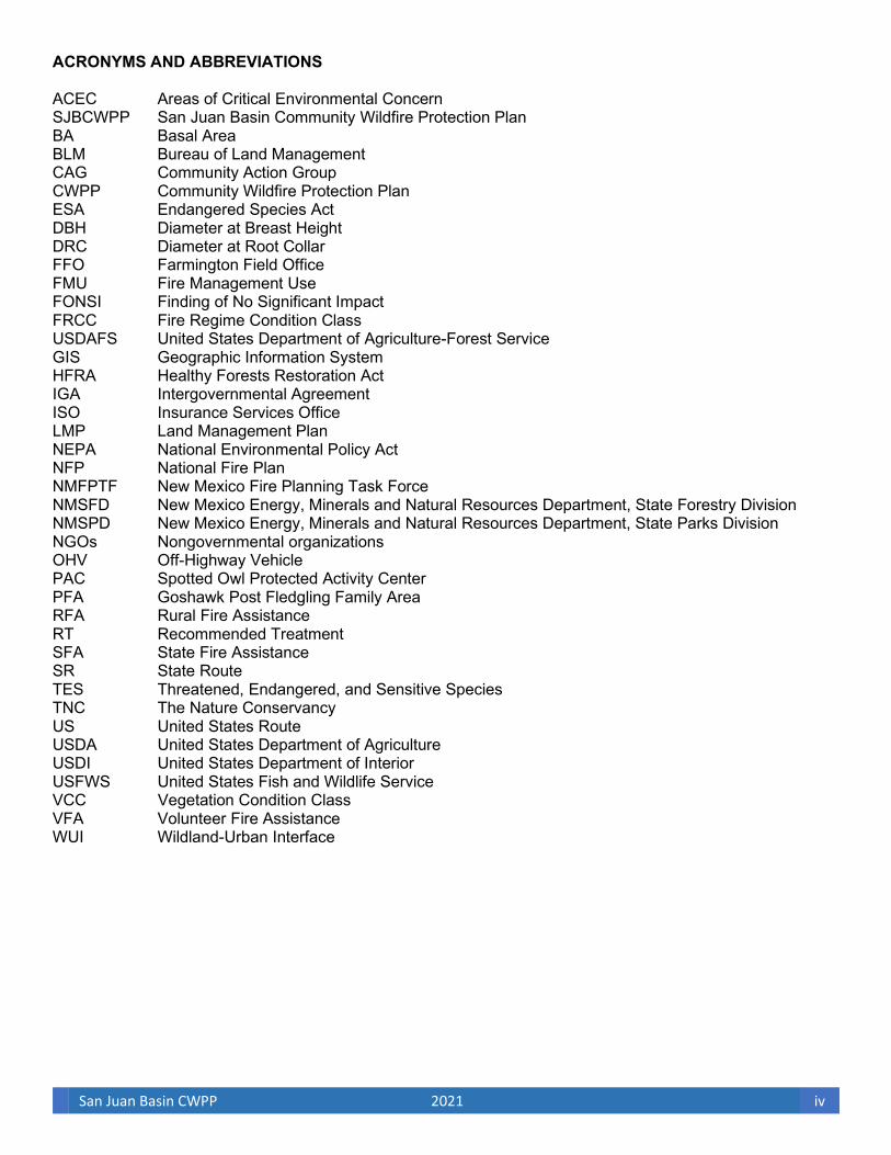
ACRONYMS AND ABBREVIATIONS ACEC Areas of Critical Environmental Concern SJBCWPP San Juan Basin Community Wildfire Protection Plan BA Basal Area BLM Bureau of Land Management CAG Community Action Group CWPP Community Wildfire Protection Plan ESA Endangered Species Act DBH Diameter at Breast Height DRC Diameter at Root Collar FFO Farmington Field Office FMU Fire Management Use FONSI Finding of No Significant Impact FRCC Fire Regime Condition Class USDAFS United States Department of Agriculture-Forest Service GIS Geographic Information System HFRA Healthy Forests Restoration Act IGA Intergovernmental Agreement ISO Insurance Services Office LMP Land Management Plan NEPA National Environmental Policy Act NFP National Fire Plan NMFPTF New Mexico Fire Planning Task Force NMSFD New Mexico Energy, Minerals and Natural Resources Department, State Forestry Division NMSPD New Mexico Energy, Minerals and Natural Resources Department, State Parks Division NGOs Nongovernmental organizations OHV Off-Highway Vehicle PAC Spotted Owl Protected Activity Center PFA Goshawk Post Fledgling Family Area RFA Rural Fire Assistance RT Recommended Treatment SFA State Fire Assistance SR State Route TES Threatened, Endangered, and Sensitive Species TNC The Nature Conservancy US United States Route USDA United States Department of Agriculture USDI United States Department of Interior USFWS United States Fish and Wildlife Service VCC Vegetation Condition Class VFA Volunteer Fire Assistance WUI Wildland-Urban Interface
San Juan Basin CWPP 2021 v
EXECUTIVE SUMMARY: SAN JUAN BASIN COMMUNITY WILDFIRE PROTECTION PLAN
For a community to take full advantage of the opportunities provided in the Healthy Forests Restoration Act (HFRA), it must first prepare a community wildfire protection plan (CWPP); which was originally done in 2006. A CWPP developed in accordance with HFRA is the most effective way to acquire funding for wildland fuels mitigation and fire preparedness and planning. San Juan County adopted a CWPP in 2006 to better protect its communities from wildfire risk, to better prepare citizens, and to become eligible to apply for and receive federal and other grant monies to implement projects. At the state level in 2006, San Juan County adopted a CWPP to help implement The New Mexico Forest and Watershed Health Plan.
In 2005 San Juan County and the Cities of Aztec, Bloomfield, and Farmington were awarded a grant by the New Mexico Association of Counties in cooperation with the Bureau of Land management (BLM) for the purpose of developing a CWPP. In December 2005 San Juan County issued a request for proposal to firms who have experience in developing CWPPs consistent with the guidelines delineated by the New Mexico Energy, Minerals and Natural Resources Department, State Forestry Division and HFRA. In March 2006 San Juan County contracted with Logan Simpson Design Inc. and Nelson Consulting Inc. to assist in the development of the San Juan Basin Community Wildfire Protection Plan (SJBCWPP).
During March 2006, a Community Action Group (CAG) was formed to implement the collaborative process necessary to develop a CWPP compliant with HFRA. The CAG agreed on the process to be followed during the CWPP development (see Figure 1.2).
In July 2013 San Juan County received a $10,000 grant from the New Mexico Association of Counties to update the CWPP plan adopted in 2006. This update was essential to continue to protect communities from wildfire risk and to remain eligible to apply for and receive federal and other grant monies to implement projects. In September of 2013, the Community Action Group was reformed and agreed to use the same process shown in Figure 1.2. Numerous meetings with the CAG were organized and two public CWPP community meetings were held in Bloomfield and Aztec on January 14, 2014 and February 4, 2014 respectively. From these meetings data and information were gathered to update the CWPP. All aspects of the 2006 CWPP were updated.
In 2020 another grant was obtained by San Juan County from the New Mexico Association of Counties to do a second update of the plan. This update is required by the New Mexico Forestry Division every five years for the plan to stay viable and allow the communities to be eligible to apply for and receive federal and other grant monies. A contract was set up and a CAG of stakeholders was identified. Due to the Covid-19 pandemic affecting the world in 2020, the CAG was not able to do face to face meetings, so virtual meetings became the norm. The first meeting of the CAG was conducted in November 2020. Meetings were held monthly with the CAG utilizing Zoom and Microsoft Teams virtual meeting platforms for collaboration and conversations on updates. The CWPP was reviewed in its entirety and where needed updates were made along with additions of information the CAG felt were important to the update. The CAG also recognized the great amount of fuel mitigation work that has been accomplished since the inception of the CWPP, in 2006, and identified areas where the mitigation work has changed the risk rating to communities within the SJBCWPP planning area. Two public meetings were held in conjunction with the Bloomfield City and County’s Commission meetings in May of 2021. Information obtained in these forums was incorporated into the plan.
San Juan Basin CWPP 2021 vi
Section I: Introduction
A primary objective of a CWPP is to help local governments, fire departments, and residents identify at-risk public and private lands and develop programs that better protect those lands from severe wildfire threat. Additional functions of a CWPP are to improve fire prevention and suppression activities, as well as to identify funding needs and opportunities. Identifying at-risk areas and improving fire protection capabilities help the communities to prioritize areas of high-risk from wildland vegetative fuels and to expedite overall project planning. The SJBCWPP was created to meet these objectives at a local level while integrating with overall federal- and state-level wildfire planning.
In an effort to promote community involvement and education, a CAG was formed, comprised of participating government officials, planners, natural resources specialists, and other interested parties from throughout the SJBCWPP area.a The CAG identified natural values at risk, such as watersheds, as well as community values at risk. The CAG also identified strategies that would improve watershed, rangeland, and community health through fuels reduction projects. Economic development and stability, as well as protection of the riparian and rangeland ecosystems, were encouraged. Additional fuels reduction projects that support local industry and economies while improving public and firefighter safety were identified. a For a list of participants in the CAG, see Acknowledgments at the end of this section.
Section II: Community Assessment
Section II identifies and analyzes wildland fire risk within the wildland-urban interface (WUI) and depicts the at-risk areas in a series of maps. Several environmental components, including slope, aspect, vegetative type, vegetative density, ground-fuel loads, and treated areas, were used to make fuel hazard determinations. These environmental factors were coupled with community-based characteristics and values, such as local fire resource preparedness, housing density, infrastructure, evacuation routes, and desired municipal watershed protection. An external element, the Fire Insurance Service Organization ratings, was also used in identifying areas of higher risk within the WUI boundary. These elements were all identified and combined using spatial analysis within a geographic information system (GIS). As a result of the GIS analysis, a hazard area map was created. Hazard areas were divided into groups according to high, moderate, and low risk based on the level of overall risk of wildland fire. The CAG determined the WUI for the at-risk cities, communities, and watersheds and also recommended measures to reduce structural ignitability in the SJBCWPP area to protect natural and community values from catastrophic wildland fire.
The WUI boundary identified by the CAG surrounds the at-risk interface cities of Farmington, Bloomfield, and Aztec; the intermix communities of Fruitland-Kirtland, La Plata, Flora Vista, Cedar Hill, Center Point, Blanco, Lee Acres, Hart Valley, Sullivan Road, Waterflow and Navajo Dam; and the river corridors of the Animas, San Juan, and La Plata rivers. These areas were broken into a total of eight zones, including three incorporated municipalities, which are described further in Section II of the SJBCWPP. Total acreage determined for the WUI is 282,972 acres of private, state, and federal lands. A map of the established WUI is illustrated in Figure 2.2.
At the present time, communities in San Juan County listed as high risk in the 2020 New Mexico Communities
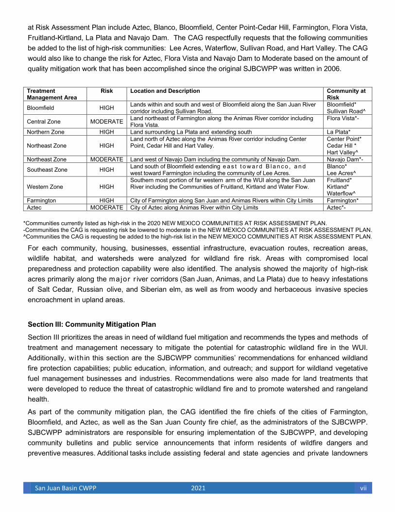
San Juan Basin CWPP 2021 vii
at Risk Assessment Plan include Aztec, Blanco, Bloomfield, Center Point-Cedar Hill, Farmington, Flora Vista, Fruitland-Kirtland, La Plata and Navajo Dam. The CAG respectfully requests that the following communities be added to the list of high-risk communities: Lee Acres, Waterflow, Sullivan Road, and Hart Valley. The CAG would also like to change the risk for Aztec, Flora Vista and Navajo Dam to Moderate based on the amount of quality mitigation work that has been accomplished since the original SJBCWPP was written in 2006.
Treatment Management Area
Risk Location and Description Community at Risk
Bloomfield HIGH Lands within and south and west of Bloomfield along the San Juan River corridor including Sullivan Road.
Bloomfield* Sullivan Road^
Central Zone MODERATE Land northeast of Farmington along the Animas River corridor including Flora Vista.
Flora Vista*-
Northern Zone HIGH Land surrounding La Plata and extending south La Plata*
Northeast Zone HIGH Land north of Aztec along the Animas River corridor including Center Point, Cedar Hill and Hart Valley.
Center Point* Cedar Hill * Hart Valley^
Northeast Zone MODERATE Land west of Navajo Dam including the community of Navajo Dam. Navajo Dam*-
Southeast Zone HIGH Land south of Bloomfield extending e a s t t o w a r d B l a n c o , a n d west toward Farmington including the community of Lee Acres.
Blanco* Lee Acres^
Western Zone HIGH Southern most portion of far western arm of the WUI along the San Juan River including the Communities of Fruitland, Kirtland and Water Flow.
Fruitland* Kirtland* Waterflow^
Farmington HIGH City of Farmington along San Juan and Animas Rivers within City Limits Farmington* Aztec MODERATE City of Aztec along Animas River within City Limits Aztec*-
*Communities currently listed as high-risk in the 2020 NEW MEXICO COMMUNITIES AT RISK ASSESSMENT PLAN. -Communities the CAG is requesting risk be lowered to moderate in the NEW MEXICO COMMUNITIES AT RISK ASSESSMENT PLAN. ^Communities the CAG is requesting be added to the high-risk list in the NEW MEXICO COMMUNITIES AT RISK ASSESSMENT PLAN.
For each community, housing, businesses, essential infrastructure, evacuation routes, recreation areas, wildlife habitat, and watersheds were analyzed for wildland fire risk. Areas with compromised local preparedness and protection capability were also identified. The analysis showed the majority of high-risk acres primarily along the major r iver corridors (San Juan, Animas, and La Plata) due to heavy infestations of Salt Cedar, Russian olive, and Siberian elm, as well as from woody and herbaceous invasive species encroachment in upland areas.
Section III: Community Mitigation Plan
Section III prioritizes the areas in need of wildland fuel mitigation and recommends the types and methods of treatment and management necessary to mitigate the potential for catastrophic wildland fire in the WUI. Additionally, with in this section are the SJBCWPP communities’ recommendations for enhanced wildland fire protection capabilities; public education, information, and outreach; and support for wildland vegetative fuel management businesses and industries. Recommendations were also made for land treatments that were developed to reduce the threat of catastrophic wildland fire and to promote watershed and rangeland health.
As part of the community mitigation plan, the CAG identified the fire chiefs of the cities of Farmington, Bloomfield, and Aztec, as well as the San Juan County fire chief, as the administrators of the SJBCWPP. SJBCWPP administrators are responsible for ensuring implementation of the SJBCWPP, and developing community bulletins and public service announcements that inform residents of wildfire dangers and preventive measures. Additional tasks include assisting federal and state agencies and private landowners
San Juan Basin CWPP 2021 viii
to identify appropriate funding sources to implement action recommendations of the SJBCWPP, as well as continued coordination with communities outside the analysis area. SJBCWPP administrators are also responsible for coordinating effective monitoring efforts. Monitoring and reporting of implementation actions will allow for enhanced coordination of management programs and will reduce the likelihood of unnecessary repetitive treatment and inconsistencies among local, state, and federal agencies.
To prioritize treatments, the WUI has been identified, analyzed, and categorized according to potential risk for wildfire. In the SJBCWPP, site-specific areas were identified and given overall risk values. Treatment management areas are illustrated in Figure 3.1. Treatment recommendations are described and consider commercial opportunities for utilizing small-diameter trees and woody material by-products from the treatments. These treatments are designed to meet the fuel reduction and modification objectives of the SJBCWPP.
Section IV: CWPP Priorities—Action Recommendations and Implementation
During the development of the CWPP, the CAG identified four action recommendations necessary to achieve the goals outlined in the plan. The first action recommendation was to identify priority treatment areas for fuel reduction projects. Treatment areas were identified and prioritized within the WUI to create defensible space and to enhance public and firefighter safety. The objective of a fuel’s reduction project is to create an acceptable vegetation condition class for community and infrastructure protection. Priority treatment management areas were designated in areas identified as high risk.
The second action recommendation identified by the CAG was to reduce structural ignitability. Reduction of structural ignitability is achieved through evaluation; maintenance; and, at times, upgrades to community response facilities, capabilities, and equipment.
The third action recommendation described is the promotion of community involvement. Action items include community education, information, and outreach.
The final action recommendation is to assist in the development of a local wood-products industry. The CAG plans to increase support for the SJBCWPP by seeking opportunities for local contractors to start new businesses or to expand existing businesses in the fire prevention and fuels reduction arena.
Section V. Monitoring Plan
The monitoring plan, outlined in Section V, describes how implementation monitoring of the SJBCWPP will occur and what information is to be collected by the administrators. The SJBCWPP establishes the Aztec, Bloomfield, Farmington, and San Juan County fire chiefs as the administrators who are responsible for implementation monitoring and reporting. Implementation begins by collaborating with partners to secure grants and other funding necessary to execute the action items described in Section IV. A list of potential grant-funding sites can be found in Section V, as well as in Appendix E.
San Juan Basin CWPP 2021 ix
Acknowledgments
The following communities and agencies were involved in the preparation of the SJBCWPP. Signatures of representatives from the agencies involved with the planning and execution of the SJBCWPP can be found in Section VI, Declaration of Agreement and Concurrence.
New Mexico Energy, Minerals and Natural Resources Department, State Forestry Division
San Juan County
Municipal and County Fire Departments
Cities (and communities) of Farmington, Bloomfield, and Aztec
San Juan Watershed Group
San Juan Soil and Water Conservation District
Bureau of Land Management, Farmington Field Office
Invited but not in attendance New Mexico Energy, Minerals and Natural Resources Department, State Parks Division
New Mexico Game and Fish
Navajo Nation Department of Forestry
Navajo Nation BIA Forestry and Fire
Navajo Nation BIA Natural Resources
United States Forest Service, Jicarilla Ranger District
San Juan Basin CWPP 2021 1
I. INTRODUCTION
The San Juan Basin Community Wildfire Protection Plan (SJBCWPP) for the at-risk cities and unincorporated areas located in and around public lands administered by the US Department of the Interior (USDI) Bureau of Land Management (BLM) Farmington Field Office (FFO) in San Juan County, New Mexico, was developed and updated in response to The Healthy Forests Restoration Act of 2003 [As Amended Through P.L. 115–141, Enacted March 23, 2018] (USDA FS and USDI BLM 2018), the 2020 New Mexico Forest Action Plan (NMEMNRD Forestry Division 2020) and the New Mexico Forest and Watershed Health Plan (New Mexico Forest and Watershed Health Planning Committee (2004). These plans establish incentives for communities to develop comprehensive wildfire protection plans in a collaborative, inclusive process. Furthermore, HFRA gives direction to the USDI to address local community priorities in fuel reduction treatments, even on nonfederal lands.
HFRA represents the legislative component of the Healthy Forests Initiative introduced by President Bush in 2003. Congress passed HFRA in November 2003, and the president signed it into law that December. When certain conditions are met, Title I of HFRA authorizes the Secretaries of Agriculture and the Interior to expedite the development and implementation of hazardous fuel reduction projects on lands managed by the US Department of Agriculture Forest Service (USDA FS) and the BLM.
HFRA emphasizes the need for federal agencies to collaborate with communities in developing hazardous fuel reduction projects and places priority on treatment areas identified by communities themselves through the development of a community wildfire protection plan (CWPP). Priority areas include the wildland-urban interface (WUI), municipal watersheds, areas affected by wind throw or insect or disease epidemics, and critical wildlife habitat that would be negatively affected by a catastrophic wildfire.
In compliance with Title 1 of HFRA, the CWPP requires agreement among local governments, local fire departments, and the state agency responsible for forest management. For the SJBCWPP, this agency is the New Mexico Energy, Minerals and Natural Resources Department, State Forestry Division (NMSFD). The CWPP must also be developed in consultation with interested parties and the applicable federal agency managing the land surrounding the at-risk communities. The majority of lands surrounding the at- risk communities of Farmington, Bloomfield, and Aztec, as well as the unincorporated intermixed community zones within San Juan County, are located adjacent to “public lands,” as defined in HFRA Section 3.1.A and B; Navajo Nation Indian lands, as defined in HFRA Section 3.2; and New Mexico state lands.
The SJBCWPP has been developed to assist local governments, fire departments, and residents to identify lands—including federal lands—at-risk from severe wildfire threat and to identify strategies for reducing fuels on wildlands while improving watershed and rangeland health, supporting local industry and local economies, and improving public and firefighter safety and response capabilities. The SJBCWPP is based on the Fire and Fuels Management Plan Amendment and Environmental Assessment for Public Lands in New Mexico and Texas (USDI BLM 2004a), the Farmington District Fire Management Plan (USDI BLM 2020), and The Healthy Forests Restoration Act of 2003 [As Amended Through P.L. 115–141, Enacted March 23, 2018] (USDA FS and USDI BLM 2018). It has also been developed in consultation with the BLM FFO to assist San Juan County and the State of New Mexico to implement the recommendations of The New Mexico Forest and Watershed Health Plan and The Strategy for Long-Term Management of Exotic

San Juan Basin CWPP 2021 2
Trees in Riparian Areas for New Mexico’s Five River Systems, 2005–2014 (USDA FS and NMSFD 2005), as well as the San Juan Basin Watershed Management Plan (San Juan County Watershed Group 2005). General guidance for development of the SJBCWPP is based on Preparing a Community Wildfire Protection Plan: A Handbook for Wildland-Urban Interface Communities (Communities Committee et al. 2004). In addition, a community action group (CAG) was formed to ensure that local, state, and federal management recommendations for wildland fire protection, watershed, and riparian health were addressed in the SJBCWPP (Photo 1.1). As additional guidance documents become available, changes or amendments will be incorporated into the SJBCWPP as necessary.
The following sections detail the background information and process used to develop the SJBCWPP. The following also includes the definition of the WUI in context of the SJBCWPP; the desired future condition of lands covered by the plan; and current fire policies, programs, and projects designed to reduce the risk of wildland fire. Finally, the goals of the SJBCWPP are presented along with an outline of strategic and prescriptive methods that the CAG has identified to achieve those goals.
A. Background
The process for developing and updating this CWPP included evaluation of San Juan County, excluding the Navajo Indian Reservation, to identify communities and remote private lands at risk from catastrophic wildland fire. During this analysis the County solicited federal, state, and local governments; fire chiefs; and interested individuals to participate in a CAG. The CAG was created to define and locate interface and intermix communities in which significant community values and infrastructure are at risk because of the potential of wildland fire.1 To complete this task, the CAG developed a three-tiered approach, which constitutes the SJBCWPP:
Tier 1. Determination of analysis area
• 2,206 square miles of nontribal lands of San Juan County (see Figure 1.1)
Tier 2. Determination of at-risk communities
• Interface communities of Farmington, Bloomfield, and Aztec
• Intermix unincorporated areas of San Juan County within five zones:
• Northeast San Juan County
• Southeast San Juan County
• Central San Juan County
• Northern San Juan County
• Western San Juan County
• Infrastructure and evacuation routes
Tier 3. Determination of at-risk remote private lands
• Areas containing one or more private residences
1Interface communities exist “where structures directly abut wildland fuels”; intermix communities exist “where structures are

San Juan Basin CWPP 2021 3
scattered throughout a wildland area” (Federal Register 2001a:753).
• Areas with risk of wildfire from the following:
• Continuous fuels near structures
• Ineffective firefighting due to lack of sufficient response time
• High vegetative fuel loads and geographic features
The CAG reviewed the Federal Register (2001a) to determine categories of at-risk communities and risk factors to be considered in analyzing the private lands throughout the county. The CAG also reviewed the definition of a WUI in HFRA to help them identify their WUI boundary and better understand that areas requiring hazardous fuel reduction along evacuation routes can also constitute the WUI. Once the CAG had a handle on what could constitute the WUI, they selected the following definition for use in this plan: “the line, area, or zone where structures and other human development meet or intermingle with undeveloped wildland or vegetative fuel” (Glossary of Wildland Fire Terminology 1996; see Section VIII in this CWPP). Any interface community or intermix community that fell within the WUI boundary was analyzed for “risk” in accordance with HFRA and the New Mexico Forest and Watershed Health Plan. Evacuation/resource response routes and significant infrastructures were also identified within the analysis area to provide for firefighter safety and to ensure the protection of life and property. The riparian corridors of the La Plata, Animas, and San Juan rivers were also considered at risk in the SJBCWPP. Inclusion of these river corridors in the analysis assists the County and State of New Mexico in implementing the 2020 New Mexico Forest Action Plan. The SJBCWPP identifies current wildfire at-risk communities, intermix areas, and river corridors. Recommendations for mitigating catastrophic wildland fire potential in these at-risk areas have been developed in this CWPP. The CWPP also provides recommendations for areas outside the WUI that have been identified for further analysis, such as rangeland health or watershed enhancing treatments. Watershed concerns have been a high priority throughout San Juan County since the 74,000-acre Missionary Ridge Fire in 2002, which had significant impacts on the water supplies to the cities of Aztec and Farmington.
Photo 1.1 Community action group Zoom meeting
San Juan Basin CWPP 2021 4
Within the five San Juan County fire response zones, the CAG identified the following at-risk intermix communities and established a WUI boundary that includes these unincorporated communities:
• Northeast San Juan County Zone includes portions of the Animas River and San Juan River corridors and the intermix communities of Cedar Hill, Center Point, and Navajo Dam.
• Southeast San Juan County Zone includes portions of the San Juan River corridor and the intermix communities of Lee Acres, Sullivan Road, and Blanco.
• Central San Juan County Zone consists of significant private lands associated with the Animas River corridor and includes the intermix communities of Flora Vista and Hart Valley.
• Northern San Juan County Zone consists of significant private lands associated with the La Plata River corridor and the intermix community of La Plata.
• Western San Juan County Zone consists of significant private lands within the San Juan River corridor and the intermix communities of Fruitland, Waterflow, and Kirtland.
The Southwest is known for its diverse landscapes and semiarid climates. The frequent occurrence of extreme hot and dry conditions, such as drought, is a normal part of the region’s climate. Following several years of below-average precipitation, northwest New Mexico has been suffering from prolonged drought.
Historically, the majority of serious fires within San Juan County have occurred within the WUI. Although landscape-scale fires have not been prevalent, hundreds of natural and human fire starts do occur and are suppressed and contained each year. Because of the region’s continued drought and fuel conditions, local fire departments and local governments are initiating fire preparedness enhancements and land treatment efforts to recognize and act on the current conditions that result in the accumulation of unacceptable levels and types of wildland fuels significantly threatening the communities with catastrophic wildfire.
Continued extreme weather conditions, dry fuels, and increasing fuel loading on federal and nonfederal lands have contributed to the potential for catastrophic wildland fires in and around the SJBCWPP communities. These communities have developed this CWPP to
• increase preparedness for wildland fire response through training and coordination of firefighting responses;
• reduce structural ignitability throughout the CWPP area;
• increase communication with local, county, state, and federal emergency response personnel by determining areas of high risk from catastrophic wildland fire;
• develop mitigation measures to reduce hazardous wildland fuels in areas of highest risk;
• enhance watershed health through wildfire control and fuel mitigation;
• educate citizens regarding the need for reduction of hazardous wildland fuels.

San Juan Basin CWPP 2021 5
Figure 1.1. Analysis area
San Juan Basin CWPP 2021 6
In addition to the primary objective of developing this CWPP, San Juan County formed the CAG to share information on existing wildfire risk conditions, fire history, and current efforts to mitigate wildfire risk and to recommend strategies needed to mitigate risk to the communities and the watersheds of the county. The CAG meets all criteria of the collaborative guidance established by the Wildland Fire Leadership Council and is the core mechanism of the public involvement process for the SJBCWPP. During deliberations, the CAG reviewed and discussed contributions from technical experts and reviewed pertinent references and guidance documents.
B. Need for the Community Wildfire Protection Plan
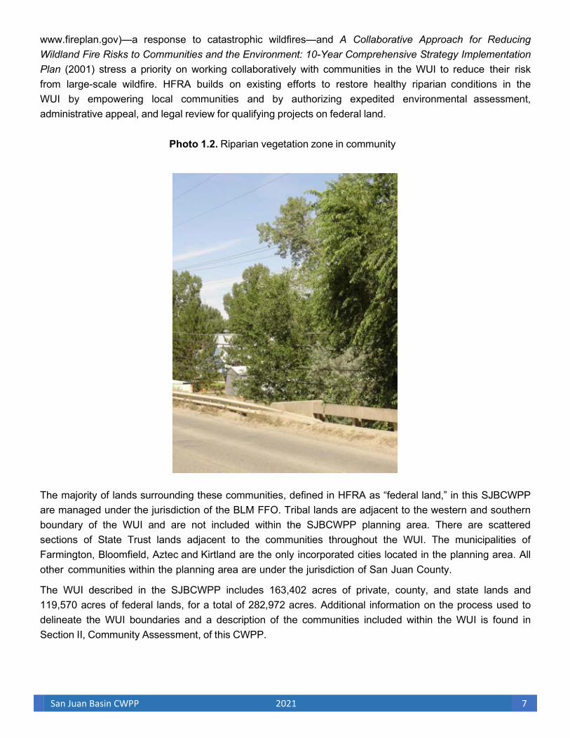
SJBCWPP communities exist adjacent to wildlands, and as growth occurs, more citizens and property will be at risk from wildland fire. The city governments in the WUI, San Juan County, and the BLM FFO recognize that community risk from wildland fuels is not static; the communities will continue to grow and expand into previously undeveloped lands. For community wildfire protection planning and implementation to succeed, hazardous wildland fuel mitigation must reach a balance with community growth and the enhancement of quality-of-life values that exist in the county. However, ecological circumstances may exist within some areas of the WUI that warrant innovative management practices, such as those recommended in the 2020 New Mexico Forest Action Plan. The SJBCWPP intends to implement concepts as described in the New Mexico Forest and Watershed Health Plan through assisting in “expanding the focus of the planning effort to include entire watersheds, from high elevation forested areas to lower elevation rangeland and riparian areas” (Photo 1.2). These areas of “extraordinary circumstances” (USDA FS and USDI BLM 2004) must be individually analyzed and evaluated for specific enhancements that meet all SJBCWPP community objectives, including community wildfire protection and maintenance or enhancement of watersheds, wildlife habitat, and other community values (New Mexico Forest and Watershed Health Planning Committee 2004).
HFRA provides for community-based decision making and empowers local governments to determine the boundaries of the wildland fuels that are found within the WUI of their communities. The communities in the SJBCWPP have compared the costs of restoration treatments; the costs of suppressing catastrophic wildfire; and the accompanying direct property and income losses, as well as the indirect community income loss, from evacuation, closing of transportation routes during wildfires, and other disruptions. Wildland fires, such as the Missionary Ridge Fire, 416 Fire, and the Arena Canyon, have disrupted travel, closed recreation opportunities, disrupted economics, and threatened communities from potential flood and debris flows in the wake of a landscape fire on watersheds above the SJBCWPP communities. In an effort to better prepare and protect their communities and to mitigate the losses associated with large fire incidents, the communities of Farmington, Bloomfield, and Aztec have proposed the development of the SJBCWPP.
C. Wildland-Urban Interface (developed lands near wildlands and forests)
The WUI is commonly described as the zone where structures and other features of human development meet and intermingle with undeveloped wildland or vegetative fuels. Communities in the SJBCWPP WUI face substantial risk to life, property, and infrastructure. Wildland fire in the WUI is one of the most dangerous and complicated situations firefighters face. Both the National Fire Plan (NFP) (see
San Juan Basin CWPP 2021 7
www.fireplan.gov)—a response to catastrophic wildfires—and A Collaborative Approach for Reducing Wildland Fire Risks to Communities and the Environment: 10-Year Comprehensive Strategy Implementation Plan (2001) stress a priority on working collaboratively with communities in the WUI to reduce their risk from large-scale wildfire. HFRA builds on existing efforts to restore healthy riparian conditions in the WUI by empowering local communities and by authorizing expedited environmental assessment, administrative appeal, and legal review for qualifying projects on federal land.
Photo 1.2. Riparian vegetation zone in community
The majority of lands surrounding these communities, defined in HFRA as “federal land,” in this SJBCWPP are managed under the jurisdiction of the BLM FFO. Tribal lands are adjacent to the western and southern boundary of the WUI and are not included within the SJBCWPP planning area. There are scattered sections of State Trust lands adjacent to the communities throughout the WUI. The municipalities of Farmington, Bloomfield, Aztec and Kirtland are the only incorporated cities located in the planning area. All other communities within the planning area are under the jurisdiction of San Juan County.
The WUI described in the SJBCWPP includes 163,402 acres of private, county, and state lands and 119,570 acres of federal lands, for a total of 282,972 acres. Additional information on the process used to delineate the WUI boundaries and a description of the communities included within the WUI is found in Section II, Community Assessment, of this CWPP.

San Juan Basin CWPP 2021 8
D. Desired Future Condition and Relevant Fire Policies
The CAG recommends that the overall desired future conditions for public lands are as follows:
Semidesert grassland and desert scrub communities desired future conditions include perennial grass cover within its historic range of variability, reduction of annual grass cover, and an adequate cover and mix of natural plant species that have good vigor and are dominant. In terms of fire management and fire ecology, the desired future condition is for fire to control or reduce exotic annual weeds, such as cheat grass, and to limit woody vegetation, such as juniper, to nonhazardous levels.
Riparian vegetation community desired future conditions include controlled annual weed cover and density and limited or nonexistent ladder fuels and downed woody debris. Disturbances, such as livestock grazing and mining and off-road vehicle travel that can potentially reduce natural vegetation cover and vigor, are managed to maintain adequate cover and mix of natural plant species.
The desired future condition for each vegetation type on public and private lands within the WUI include the potential natural vegetation groups as described in the Fire Regime Condition Class (FRCC) Potential Natural Vegetation Group (BpS) Descriptions (FRCC Interagency Working Group 2005a), which are recommended within the Fire and Fuels Management Plan Amendment and Environmental Assessment for Public Lands in New Mexico and Texas and can be found in Appendix A.
The New Mexico Forest and Watershed Health Plan was developed “in response to the conclusion that many of New Mexico’s ecosystems are in an unhealthy state, as demonstrated by overly-dense woody vegetation, a degradation of biodiversity, and fragmentation and deterioration of wildlife habitat. As a result, New Mexico faces greater susceptibility to catastrophic wildfire and drought, compromised watersheds, and decreased water supply, accelerated erosion and desertification.” In accordance with the New Mexico Forest and Watershed Health Plan, the CAG also recommends that the desired future conditions for the major riparian corridors in the WUI be restored to exhibit ecological processes that are self-regulating; disturbance regimes that function within their normal range of variation; watersheds that are characterized by recharged aquifers, good water quality, optimum stream flow, and stable soils; and the presence of a high proportion of native species and an infrequent occurrence of exotic species.
The desired future condition of public land is a return to Condition Class I status. Public lands in this condition class can carry wildfire without significant impacts on vegetative components. Once in this condition class, natural processes such as fire can be incorporated into long-term management practices to sustain riparian and rangeland health. The desired future condition of nonfederal lands in the WUI is for private landowners to comply with fire-safe standards recommended by local fire departments and local communities. Residential and other structures that comply with these standards significantly reduce the risk of fire igniting in the community and spreading to the surrounding wildland habitats. Additionally, structures that comply with fire-safe recommendations are much more likely to survive wildland fires that spread into the community.
Local governments, the San Juan Water Commission, San Juan Watershed Group, San Juan Basin Russian Olive Salt Cedar Task Force, San Juan Soil and Water Conservation District, the River Reach Foundation, the governments and fire agencies of San Juan County, BLM FFO, and the New Mexico Energy, Minerals and Natural Resources Department, State Parks Division (NMSPD), along with the

San Juan Basin CWPP 2021 9
NMSFD, have supported innovative and active riparian and rangeland management initiatives. Public education and private property treatment projects in the communities, coupled with planned efforts of local fire departments and state and federal agency programs, will create safer and better-informed communities that are increasingly willing to comply with the intent and spirit of such programs.
1. Federal Policies
Several existing federal wildfire policies have been developed in recent years; one of the more significant is the 1995 Federal Wildland Fire Management Policy. This was the first single comprehensive federal fire policy for the USDI and USDA that, for the first time, formally recognized the essential role of fire in maintaining natural systems. The 1995 Federal Wildland Fire Management Policy was later reviewed and updated by the Interagency Federal Wildland Fire Policy Review Working Group in 2001 (USDI et al. 2001). The Working Group found the 1995 policy to be sound and appropriate; however, it made additional recommendations to address ecosystem sustainability, science, education, and communication and to provide for adequate program evaluation.
Among the most prominent recent national policies is the NFP. The NFP incorporates A Collaborative Approach for Reducing Wildland Fire Risks to Communities and the Environment: 10-Year Comprehensive Strategy Implementation Plan, whose primary goals are to
• improve prevention and suppression,
• reduce hazardous fuels,
• restore fire-adapted ecosystems,
• promote community assistance.
Federal wildfire reduction policy on public lands administered by the BLM is planned and administrated locally through the BLM FFO, which is the governing agency for the federal lands associated with the SJBCWPP planning area. Under the Proposed Action described in the Farmington District Fire Management Plan (2020), BLM administered public lands in FFO have three strategic objectives for fire management: Full Suppression; Use of Wildland Fire Allowed – Stipulations; and Use of Wildland Fire Allowed - No Stipulations. Full suppression strategies can be direct attack, indirect attack, use of manmade and natural features, and monitoring of fire. Use of Wildland Fire Allowed with Stipulations allows unplanned wildland fires to be managed under circumstances that will meet resource benefits. Stipulations may be, but are not limited to, an archeological survey must be conducted before actions take place, reducing fuel loading, or the time of year. These are just examples of some stipulations that are required for a given area. Use of Wildland Fire Allowed- No Stipulations allows unplanned wildland fires to managed for resource benefits. As long as resource objectives are being met an unplanned wildland fire can be considered for this strategy. The delegated BLM agency administrator determines case-by-case, the appropriate management response in the context of ecological and other resource constraints, along with human health and safety factors. Various fuels treatments are planned for the FFO and include the use of prescribed fire, herbicide treatments, thinning, and mechanical vegetation treatments to accomplish resource objectives. The Farmington District fire program maintains a three-year Program of Work (POW) in National Fire Plan Operating and Reporting System NFPORS.
San Juan Basin CWPP 2021 10
Firewise wis a national program that helps communities reduce the risk of wildfires and provides them with information about organizing to protect themselves against catastrophic wildfires and mitigating losses from such fires (see www.firewise.org). Local communities and fire departments in the SJBCWPP analysis area have made this information available to their citizens and have encouraged its application.
2. State Policies
New Mexico has been proactive in assessing wildfire risk on a regional level. The list of wildland interface communities published in the Federal Register (2001a:754–777) on January 4, 2001, was compiled from information by state and local governments and reflects the relationship between federal lands and the WUI problem in the western United States. After an updated list of at-risk communities was published in the Federal Register (2001b:43385–43435) on August 17, 2001, the process by which the states will update the list of at-risk communities was outlined in the Field Guidance: Identifying and Prioritizing Communities at Risk (National Association of State Foresters 2003).
The CAG has also reviewed the 2020 New Mexico Forest Action Plan to ensure consistency with the goals and objectives of the State of New Mexico and with local implementation recommendations made within the SJBCWPP. The CAG affirms that “New Mexico’s ecological and community health depends on the recognition of the inseparability of ecological, social and economic sustainability.” The CAG further concurs with the three-part vision of the New Mexico Forest and Watershed Health Planning Committee (2004), as well as the updated ten strategies set forth in the 2020 New Mexico Forest Action Plan:
• Diverse ecosystems are characterized by integrity and resiliency
• Diverse human communities are sustained by ecologically healthy landscapes that provide resources and amenities
• Economies thrive by using the inherent productivity of healthy ecosystems
The ten strategies set forth in this 2020 plan are: 1. Restore Forests and Watersheds addresses the legacy of fire exclusion and current land conditions to
mitigate catastrophic wildfires burning much hotter than previously experienced with forest management treatments.
2. Fire Management restores the ecological role of fire to foster resilient landscapes and watershed health;
sustains wildfire response on state and private lands; supports regional, state, and national wildfire response on all jurisdictions; and fosters collaboration of postfire response after high severity wildfire.
3. Private Land Stewardship provides strategies to improve and support private land stewardship and
provide services to assist landowners, including both government agencies and non-governmental organizations (NGOs), with tools for resource stewardship that contributes substantial public benefits.
4. Utility Rights of Way addresses the risk of wildfire ignition and threat of damage to utility infrastructure by
increasing vegetation management along right of ways. 5. Rare Plants are addressed by incorporating key actions from the Division’s Rare Plant Conservation
Strategy to ensure protection of New Mexico’s extraordinary plant diversity.

San Juan Basin CWPP 2021 11
6. Reforestation addresses the need to reforest burned areas and bridge the state’s reforestation backlog,
and to do so with seedlings that will mature into trees capable of withstanding the anticipated growing conditions of the future.
7. Urban Forests and Communities addresses the need for trees where 80% of New Mexicans live and
obtain essential benefits such as cooling shade, clean air and stormwater runoff reduction.
8. Restoration Economy is the driving force behind forest management activities and addresses the need to invest in workforce development for all of these strategies, and to 12 rebuild and retool forest industry and wood processing to capture the by-products of restoration and manage forests for resilience in changing climate conditions.
9. Land Conservation provides a statewide blueprint for land conservation to guide the investment of state
and federal funds to provide tax credits for conservation easements or purchase land or easements and increase collaboration among local government agencies, non-governmental organizations, and land trusts.
10. Outdoor Recreation is positioned to become a major economic driver in the state and the strategy identifies the importance of forest management to provide beautiful and safe places for recreation.
The Forest and Watershed Health Planning Committee also developed guiding principles to shape how ecological restoration efforts should take place in New Mexico. These principles embody its three-part vision:
1. Ecological: Promoting ecological integrity, natural processes, and long-term resiliency is the primary goal of the New Mexico Forest and Watershed Health Plan
2. Socio-Cultural: The values of New Mexico’s diverse human communities will be supported
and sustained by ecological restoration
3. Economic: Economic productivity is dependent on healthy ecosystems, and will be leveraged to full advantage in support of long-term ecological health.
The SJBCWPP was originally written to be consistent with the Forest and Watershed Health Plan’s recommendations in the State-Level Action in Support of Local On-the-Ground Efforts (I) section:
I.A. Support Local Collaborative Projects
I.B. Develop Incentives for Ecological Restoration and Long-term maintenance
I.E. Create Comprehensive Information Clearinghouse
I.F. Develop Ecological Restoration Practices
I.G. Develop Ecological Restoration Monitoring
I.H. Develop Public Outreach
The SJBCWPP also indirectly supports the following:
I.C. Promote Sustainable Utilization Businesses and Markets
I.D. Develop Labor Force
The CAG continues to support all the recommendations in the State-Level Strategic Planning and

San Juan Basin CWPP 2021 12
Coordination (II) and State-Level Management and Administration (III) recommendation sections of the Forest and Watershed Health Plan. The CAG also suggests that San Juan County participate in the State Advisory Group by appointing a representative from the SJBCWPP communities to the State Advisory Group.
The CAG also reviewed the 2020 New Mexico Communities at Risk Assessment Plan (NMSFD 2020a) to ensure consistency within the SJBCWPP. The New Mexico Fire Planning Task Force (NMFPTF), created by the 2003 New Mexico Legislature, “annually reviews the Communities at risk list, whether for the inclusion of new communities or the reduction of adjective ratings or the ultimate removal of communities from the list.” After agreement of the SJBCWPP by local governments and fire departments and with concurrence from the BLM FFO, San Juan County will submit the SJBCWPP and a list of at-risk communities within the planning area to the NMFPTF so that those San Juan Basin communities can be added to the state’s revised list of at-risk communities, which will be published in December 2021, and presented to the governor and the New Mexico Legislature. The approved SJBCWPP will assist the State of New Mexico in meeting the primary goals of planning for and implementing wildland fire mitigation treatments within fire-prone areas and in matching complementary projects on private and adjacent federal lands.
3. Local Policies
The SJBCWPP communities are aware that traditional approaches to riparian invasive species exclusion, wildland fire management, and community growth in the WUI have produced extensive areas at high risk from catastrophic wildland fire. These communities aspire to restore self-sustaining, biologically diverse riparian and rangeland habitats, which contribute to a quality of life demanded by local citizens and expected by community visitors. Current riparian and rangeland enhancement and treatment prescriptions that will result in an acceptable mix of managed natural and mechanized processes that will lead to the restoration of natural ecosystems must be developed, accepted by the community, and then implemented. San Juan County residents who participated in the CAG and developed the SJBCWPP recognize that protection from catastrophic wildland fire requires collaboration and implementation through all levels of government by way of an informed and motivated public. The CAG considered ecosystem restoration, community protection, economic development, protection of significant infrastructure, public and firefighter safety, and protection of remote at-risk private lands throughout the San Juan Basin while developing this CWPP.
To enhance public and firefighter safety, the CAG recommends that San Juan County develop a Basic Evacuation Plan under the authority of the County’s All Hazard Risk Analysis and Emergency Operations Center. This basic plan would outline emergency procedures in case of evacuation, essential items to take when evacuating, registration/reception centers, transportation planning, home security, family communication, Homeland Security, and animal and pet evacuation suggestions. The basic plan could then be revised by local fire departments and emergency services personnel within each community for specific evacuation routing and other community-specific needs during a catastrophic wildland fire.
The appearance and health of the riparian systems and rangelands in and around the SJBCWPP communities provide not only an economic base (recreation, agriculture, water supplies) for the communities but also a quality of life that citizens appreciate and expect. The communities recognize the need to inform and educate local citizens and visitors about needed restoration treatments on private

San Juan Basin CWPP 2021 13
properties and to work with the BLM FFO in determining community-based and accepted land management practices that restore and enhance riparian and rangeland habitats while providing protection from wildland fire threats and fire spread within these communities. Community organizations that were involved in the development of the SJBCWPP include the following: the San Juan Watershed Group, a multidisciplinary work group whose mission is to enhance the Animas, La Plata, and San Juan watersheds; and the San Juan Soil and Water Conservation District that works with landowners, ranchers, and farmers to enhance their land use, including watershed restoration and the control of Russian olive and salt cedar, which would assist in the reduction of vegetation fuel loading in riparian areas caused by heavy infestations of Russian olive and salt cedar. These groups, in addition to the local cities and communities, support land treatments that reduce understory fuels; diminish invasive species; increase herbaceous forage production; and enhance riparian, rangeland, and watershed health.
E. Grants/Current Projects
Financial commitments required to reduce the risk of catastrophic wildfire can be extensive for the BLM, as well as for the small rural communities surrounded by federal lands. Since 2001, the NFP includes an annual funding process through which Congress provides grant monies to help reduce the vulnerability of WUI communities and to help fire departments improve their fire protection services for wildland fire suppression. According to the NMSFD (2021), hazard mitigation and WUI hazardous fuel treatment grants awarded for private landowners for the 2006 through 2021 fiscal years was approximately
$10,310,163. Table 1.1 shows grants received for the SJBCWPP planning area.
Table 1.1 Grants received for the SJBCWPP planning area, 2006-2021
Grant Recipient________Project______________Description
San Juan County Hazardous Fuels State Forestry $5,756,444
San Juan Soil and Water Hazardous Fuels State Funding-$4,412,802
Sources: San Juan County, EMNRD State Forestry and San Juan Soil and Water Conservation District 2021
The SJBCWPP communities have been involved with, and supportive of, programs designed to significantly reduce hazardous wildland fuels in the WUI. Communities located in the WUI endorse and support fuel reduction programs that encourage local economic and community-related small business and local industry growth through productive use of wildland treatment by-products. The CAG recognizes that implementing fuel reduction treatments throughout the basin could stimulate private local businesses to perform this work. In accordance with Section 103.d.2.B of HFRA, the CAG also recognizes that in allocating funding “. . . the Secretary should, to the maximum extent practicable, give priority to communities that have adopted a community wildfire protection plan or have taken proactive measures to encourage willing property owners to reduce fire risk on private property.” The combination of enhanced wildland fire response by local fire departments and wildland fuel mitigation treatments by the BLM FFO will continue to reduce fire risk to the communities within the SJBCWPP.

San Juan Basin CWPP 2021 14
F. Goals
The CAG has agreed on 10 primary goals of the SJBCWPP:
• Improve fire prevention and suppression in riparian lowland ecosystems and where appropriate in uplands to promote beneficial fires
• Reduce hazardous riparian and rangeland fuels
• Restore forest and watershed health for long term sustainable resilient lands
• Promote community involvement and education
• Recommend measures to reduce structural ignitability in the SJBCWPP area
• Encourage economic development and stability in the community through protection of the ecosystem and riparian values
• Identify watersheds at-risk and potential impacts on downstream communities
• Identify funding needs and opportunities
• Expedite project planning
• Prioritize high-risk projects
These goals are mostly strategic; however, the action recommendations developed by the CAG to reach these goals are prescriptive, that is, designed to be implemented in specific time frames and with measurable outcomes. In developing this CWPP, it was not intended that each action recommendation meet each goal; some action recommendations are specific to a single or few goals. The CAG believes that the synergistic effect of implementing all action recommendations will achieve the stated goals of the SJBCWPP over time. The SJBCWPP goals were reviewed for consistency in implementing the guiding principles and recommendations of the 2020 New Mexico Forest Action Plan.
The SJBCWPP meets all HFRA criteria, and it has been collaboratively developed and agreed to by the applicable local governments and fire departments, the BLM FFO (the primary relevant federal entity), and other interested parties. The SJBCWPP establishes a coordinated, collaborative, performance-based framework of recommendations to meet its outlined goals.
G. Planning Process
Several county, municipal, and BLM FFO planning documents and studies have incorporated wildfire management guidelines and standards for riparian and rangeland enhancement in the SJBCWPP planning area. The goals, policies, and guidelines outlined in these local documents, in addition to the interagency state and national plans and the public involvement process represented by the CAG, all critically informed the development of the SJBCWPP. The local studies, plans, and documents reviewed by the CAG include the following:
• The Healthy Forests Restoration Act of 2003 [As Amended Through P.L. 115–141, Enacted March 23, 2018]

San Juan Basin CWPP 2021 15
• San Juan Basin Regional Water Plan (2016)
• Lower Animas Watershed Plan (2016)
• San Juan County Multi-Jurisdiction Natural Hazard Mitigation Plan Update (2020)
• San Juan Basin Watershed Management Plan (2005)
• New Mexico Forest Action Plan (2020)
• Farmington Field Office Resource Management Plan (2004)
• Fire and Fuels Management Plan Amendment and Environmental Assessment for Public Lands in New Mexico and Texas (2004a)
• Farmington District Fire Management Plan (2020)
Successful implementation of the SJBCWPP will require a collaborative effort among multiple layers of government and a broad range of special-interest groups. The CAG recognizes that processes and systems which ensure recommended treatments and actions of the SJBCWPP comply with HFRA; the National Environmental Policy Act (NEPA); the Endangered Species Act; the National Historic Preservation Act; and other applicable federal, state, and local environmental regulations must be developed.
Upon approval of this updated SJBCWPP by the Cities of Farmington, Bloomfield, and Aztec; municipal and county fire departments; and San Juan County and after concurrence by the BLM FFO and the NMSFD, it will be submitted to all appropriate agencies for implementation funding of the priority action recommendations.
San Juan County and these cities are committed to the successful implementation of the SJBCWPP and will cooperate in developing any formal agreements necessary to ensure the plan’s timely execution, monitoring, and reporting. It is the intent of San Juan County and the Cities of Farmington, Bloomfield, and Aztec, to develop an administrative oversight procedure to be responsible for the implementation, monitoring, and reporting of this SJBCWPP.
The CAG recommends that the San Juan County Fire Department chief coordinates and monitors the implementation of the SJBCWPP through the County Fire Department for the unincorporated communities within the county and the cities of Bloomfield and Kirtland which the department also protects. The CAG further recommends that the fire chiefs of Farmington and Aztec administer the SJBCWPP within their respective municipalities. Figure 1.2 summarizes the process that the local CAG followed to produce the SJBCWPP. At the far right of each tier is the “product” resulting from the activities in that tier. These tiers correspond to the sections in the SJBCWPP and serve as a process guide for the rest of this document.
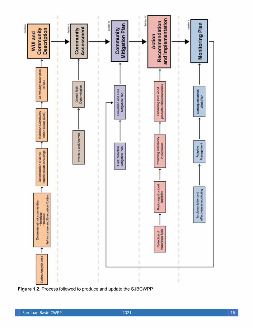
San Juan Basin CWPP 2021 16
Figure 1.2. Process followed to produce and update the SJBCWPP
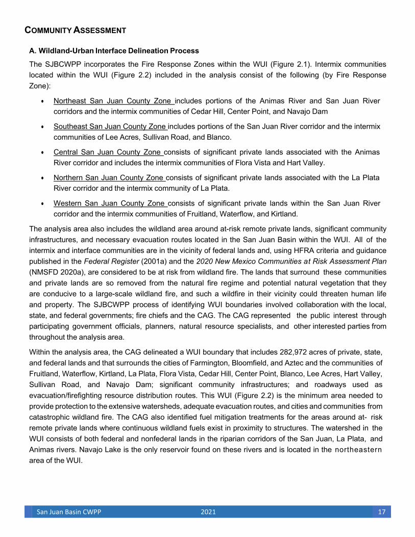
San Juan Basin CWPP 2021 17
COMMUNITY ASSESSMENT
A. Wildland-Urban Interface Delineation Process
The SJBCWPP incorporates the Fire Response Zones within the WUI (Figure 2.1). Intermix communities located within the WUI (Figure 2.2) included in the analysis consist of the following (by Fire Response Zone):
• Northeast San Juan County Zone includes portions of the Animas River and San Juan River corridors and the intermix communities of Cedar Hill, Center Point, and Navajo Dam
• Southeast San Juan County Zone includes portions of the San Juan River corridor and the intermix communities of Lee Acres, Sullivan Road, and Blanco.
• Central San Juan County Zone consists of significant private lands associated with the Animas River corridor and includes the intermix communities of Flora Vista and Hart Valley.
• Northern San Juan County Zone consists of significant private lands associated with the La Plata River corridor and the intermix community of La Plata.
• Western San Juan County Zone consists of significant private lands within the San Juan River corridor and the intermix communities of Fruitland, Waterflow, and Kirtland.
The analysis area also includes the wildland area around at-risk remote private lands, significant community infrastructures, and necessary evacuation routes located in the San Juan Basin within the WUI. All of the intermix and interface communities are in the vicinity of federal lands and, using HFRA criteria and guidance published in the Federal Register (2001a) and the 2020 New Mexico Communities at Risk Assessment Plan (NMSFD 2020a), are considered to be at risk from wildland fire. The lands that surround these communities and private lands are so removed from the natural fire regime and potential natural vegetation that they are conducive to a large-scale wildland fire, and such a wildfire in their vicinity could threaten human life and property. The SJBCWPP process of identifying WUI boundaries involved collaboration with the local, state, and federal governments; fire chiefs and the CAG. The CAG represented the public interest through participating government officials, planners, natural resource specialists, and other interested parties from throughout the analysis area.
Within the analysis area, the CAG delineated a WUI boundary that includes 282,972 acres of private, state, and federal lands and that surrounds the cities of Farmington, Bloomfield, and Aztec and the communities of Fruitland, Waterflow, Kirtland, La Plata, Flora Vista, Cedar Hill, Center Point, Blanco, Lee Acres, Hart Valley, Sullivan Road, and Navajo Dam; significant community infrastructures; and roadways used as evacuation/firefighting resource distribution routes. This WUI (Figure 2.2) is the minimum area needed to provide protection to the extensive watersheds, adequate evacuation routes, and cities and communities from catastrophic wildland fire. The CAG also identified fuel mitigation treatments for the areas around at- risk remote private lands where continuous wildland fuels exist in proximity to structures. The watershed in the WUI consists of both federal and nonfederal lands in the riparian corridors of the San Juan, La Plata, and Animas rivers. Navajo Lake is the only reservoir found on these rivers and is located in the northeastern area of the WUI.
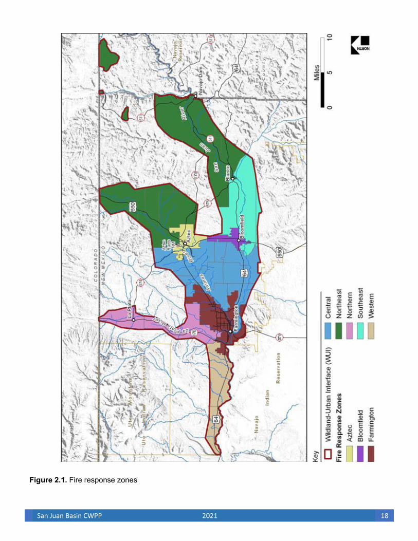
San Juan Basin CWPP 2021 18
Figure 2.1. Fire response zones
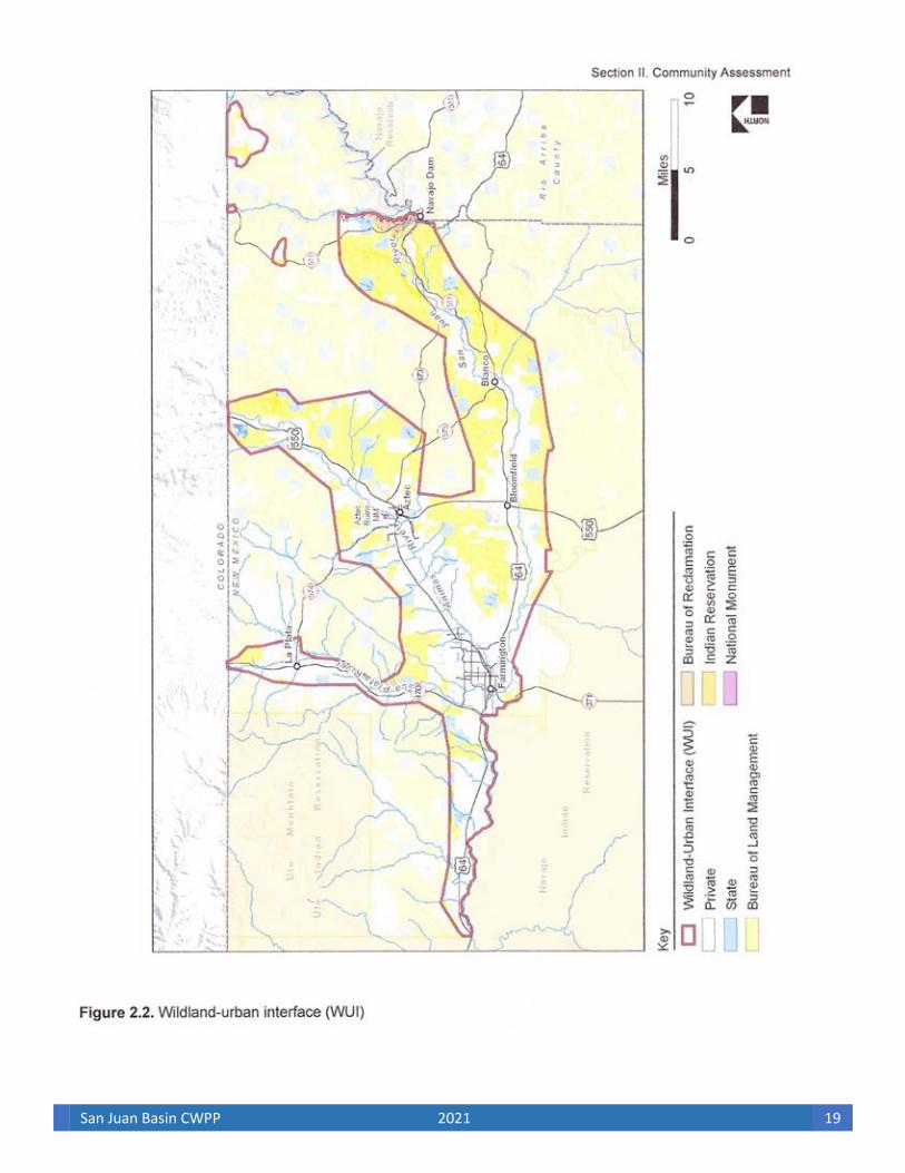
San Juan Basin CWPP 2021 19
San Juan Basin CWPP 2021 20
These river systems, with associated tributaries, are considered critical or suitable habitat for many threatened, endangered, and sensitive species (see Appendix B); have remarkable scenic, recreational, fish and wildlife, historic, and cultural values; and have significant watersheds that provide domestic water supplies to the communities. The WUI also includes the critical local and federal agency communication facilities that are found on Knickerbocker Peak, Nebo Peak and the Bluffs.
General elements used in creating the WUI for the communities include the following:
• Wildland vegetative fuel hazards with consideration of local topography
• Historical fire occurrence
• Community development characteristics
• Local firefighting preparedness by Insurance Services Office (ISO) rating review
• Municipal watershed protection
• Infrastructure and evacuation routes
The communities within the WUI lie in areas where the alignment of vegetation and topography could encourage wildfire to spread so rapidly that, without treatments, facilities and homes might be burned through before suppression measures would be available. Some areas within these communities have poor ingress and egress, limited communication capabilities, and limited effective evacuation/firefighting response access. The CAG reviewed Section 101.16.B.iii of HFRA to determine “an area adjacent to an evacuation route for an at-risk community that the Secretary determines, in cooperation with the at-risk community, requires hazardous fuel reduction to provide safer evacuation from the at-risk community.” The combination of fuel load, topography, poor access, and noneffective communication increases the potential severity of wildland fire to both property and public/firefighter safety in some areas within the WUI. Therefore, the CAG considered it to be increasingly important for private land treatments to be specifically identified and coordinated with fuel mitigation treatments on adjacent federal lands. Such wildland fuel mitigation treatments will also help in meeting watershed/riparian goals as outlined within The New Mexico Forest and Watershed Health Plan.
B. Wildland-Urban Interface Risk Assessment
The community assessment is a risk analysis of potential catastrophic wildland fire to the cities and communities identified in the SJBCWPP. This risk analysis incorporates the current condition class, wildfire fuel hazards, risk of ignition, historical wildfire occurrence, and at-risk community values. Local preparedness and protection capabilities are also factors that contribute to the delineation of areas of concern. The areas of concern for wildfire fuel hazards, risk of ignition and wildfire occurrence, and community values were evaluated and mapped, and then each area was given relative and qualitative ratings of “high,” “moderate,” or “low.” A composite of these ratings, representing the cumulative risk from wildfires for the communities, was then mapped.
1. Fire Regime and Condition Class Fire has always played a natural (historical) role in maintaining landscape vegetative features. HFRA

San Juan Basin CWPP 2021 21
recognizes the role and function of wildland fire across natural landscapes by encouraging authorized projects (see HFRA, Sec. 102.a) in the WUI and in habitats that have been altered from their historic fire regime. A natural fire regime is a general classification of the role a fire would play across a landscape in the absence of human intervention. There are five categories of natural fire regimes that have been defined based on the number of years between fires (fire frequency) combined with the severity of fire on dominant overstory vegetation (Schmidt et al. 2002). The national database (Coarse-scale Spatial Data for Wildland Fire and Fuel Management version 2000, www.fs.fed.us/fire/fuelman) suggests that the majority of WUI lands within the SJBCWPP are included within natural Fire Regime 1 (80%), with 17,000 acres within Fire Regime 2 (6%) and 33,670 acres within Fire Regime 3 (12%). The remainder of the WUI is composed of Fire Regime 4 and open water. The current state of vegetation in the existing wildland fire complex has been further compromised through the total suppression of all fires. As an example, the present composition of plant communities within New Mexico has been influenced by many factors, including climate, drought, insects, disease, wind, domestic livestock grazing, cultivation, browsing by wildlife, and fire. Competition with invasive plant species has also had a profound effect on the naturally occurring influence of fire on the vegetation associations in the San Juan Basin. Within SJBCWPP lands, there has been an extensive advance of juniper into grasslands accompanied by encroaching sagebrush and invasive grasses, converting previous juniper grassland habitats to juniper-sagebrush woodland with a heavy understory of fine fuels. Much of San Juan County today is actually composed of dense brush lands where wildland fires have occurred at a high frequency and burn severity.
In compliance with HFRA, federal lands in the WUI were evaluated for fire regime and current condition class. The condition class of wildland habitats describes the degree to which the current fire regime has been altered from its historic range, the risk of losing key ecosystem components, and the vegetative attribute changes from historical conditions. For example, a habitat in Condition Class 1 is a habitat system in its natural fire range and at low risk for losing ecosystem components from wildland fire. Condition Class 2 habitats are moderately departed from the historic fire-occurrence range with a moderate risk of losing habitat components. Condition Class 3 habitats have significantly departed from their historic fire-regime range, and their risk of losing key habitat components is high.
Because condition class categories are based on coarse-scale data that is intended to support national- level planning, any interpolation of this data for localized conditions may not be valid. Therefore, local agencies were asked to provide data for localized conditions. The amount of Salt-Cedar/Russian olive invasion within the WUI riparian areas, proliferation of nonnative grasses, elimination of historic wildland fire return cycles, and increasing woody species invasion indicate that the riparian areas and upland habitats of the WUI no longer conform to components of Condition Class 1 lands. As a result, local conditions as reported within the Farmington District Fire Management Plan (USDI BLM 2020) and (Landfire 2017) indicate that the riparian areas of the WUI actually fall within Condition Class 3, with most upland areas classified as Condition Class 2.
2. Fuel Hazards
The arrangement of fuel types, fuel models, relative flammability, and fire potential of vegetation varies greatly within the WUI (see Table 2.1). Fuel hazards depend on a specific composition, type, arrangement, and condition of vegetation such that if the fuel were ignited, an at-risk community or its community

San Juan Basin CWPP 2021 22
infrastructure would be threatened. However, in some areas, the existing topography can actually create a natural firebreak that would help to reduce fuel hazards. Delineation of favorable and unfavorable fuel and topographic conditions is essential to community wildland fire planning.
Evaluation of the vegetative fuels on federal and nonfederal land in the WUI was conducted through a spatial analysis using geographic information system (GIS) technology in a series of overlays that helped the CAG to identify high, moderate, and low fuel-hazards risk areas. For each area of the WUI, the fuel and
Fuel type
Table 2.1. Fuel model, fire danger ratings, and intensity level on vegetative associations within the WUI
Vegetative Association Fuel Model
Fire danger rating
modela
Flame length
(ft)
Fire Intensity
Level (FIL)
Rate of spread
ft/hr (ch/hr)
Grassland
Mid-short grass prairie-steppe grasslands
1 L and N 4–7 3 3,950–13,200 (60–200)
types Great Basin grasslands
3 L and N 12–20 6 5,950–16,500 (90–250)
Great Basin
microphyllous desert scrub
3 S 6 4 2,300 (35)
Shrublands Great Basin 1 and 3 T 6 3 2,100 (32) broadleaf deciduous desert scrub
Rocky 2 and 9 E and T 6–19 4–6 400 (6)–4,950 (75) Mountain/Great
Forests Basin closed conifer woodland
Deciduous 9 E and T 6 4 2,300 (35) riparian
Heavily infested 4 G and T 19 6 4950 (75) Deciduous Southwest
salt cedar/Russian Oliveb
riparian Agricultural, 1 E and T 19 6 4,950 (75) urban, and riverine
Rocky 6 F and T 6 5 2,100 (32) Pinyon- Mountain/Great Juniper Basin open Woodlands conifer woodland
Source: The National Fire Danger Rating System—1978 USDA Forest Service GTR INT-39 (USDA 1978). aSee Appendix C for the National Fire Danger Rating System definitions. bAreas identified by San Juan County Extension.

San Juan Basin CWPP 2021 23
vegetation density, type, and distribution, as well as slope and aspect analyses, were conducted to assist in the categorization of areas of highest risk of fire ignition and spread from wildland fuels. Table 2.2 identifies the total amount of lands in the WUI that were evaluated in overall wildland risk because of increased fuel hazards.
Table 2.2. Fuel Hazards
Total Land
Area (Acres) Total Treated (Acres)
Riparian Deciduous (Acres)
Slopes > 20% (Acres)
South and West facing slopes (Acres)
Farmington 23,019 310 333 1,324 7,498
Aztec 8,558 68 469 686 3,110
Bloomfield 4,904 109 1,308 207 1,773
Northeast San Juan County 108,746 16,530 7,950 20,930 35,281
Southeast San Juan County 31,756 1,417 6,048 3,526 8,657
Central San Juan County 58,659 2,052 13,266 5,361 20,127
Northern San Juan County 25,417 2,107 4,240 2,220 7,731
Western San Juan County 21,913 295 6,065 1,679 8,386
Total (Acres) 282,972 22,888 39,679 35,933 92,561
Source: BLM FFO, NM State Forestry, San Juan Soil and Water, San Juan County Extension (2021) a Deciduous Riparian biotic community including areas heavily infested with salt cedar and Russian olive as identified by San Juan County Extension. b When aspect is south, southwest, or west, or when slope is ≥ 20 percent in areas of pinyon-juniper woodland or grassland, the fuel hazards risk rises to high.
Several fuel hazards components, including vegetation type and density, slope and aspect, and treated areas, were analyzed for degree of risk from wildland fire. Table 2.3 identifies the different values given to these various fuel hazards components. Visual representations of these fuel components are mapped in Figures 2.3–2.6. The influences the components carry were then compiled to designate areas of high, moderate, and low fuel hazards. This compilation of fuel hazards is shown in Figure 2.7. The major vegetation types used for analysis are based on the vegetation communities found in the Colorado Plateau Semidesert ecoregion province. These vegetation communities were grouped in the analysis into agriculture, grasslands, desert scrub, open conifer, closed conifer, riverine/lacustrine and forest/scrub. More in-depth descriptions of the different vegetation communities follow Table 2.3.

San Juan Basin CWPP 2021 24
Table 2.3. Fuel hazard components Fuel Hazards Components Influenceª Vegetation type and density
• Deciduous riparian, >100/acre H
• Pinyon-juniper vegetation in fuel model 6, Grasslands M in fuel model 3; Forest vegetation in fuel model 9
• Pinyon-juniper woodland and semidesert vegetation L
Burned areas L
Slopes ≥ 20 percent M
Aspect (south-, southwest-, or west-facing slopes) M
Treated areas L Source: Logan Simpson Design Inc. a H = High, M = Moderate, L = Low
The 5 major vegetation communities and 12 vegetative associations of the Colorado Plateau Semidesert ecoregion province consist of the following:
• Great Basin Desert Grassland (Photo 2.1) dominated by galleta (Hilaria jamesii), Indian ricegrass (Oryzopsis hymenoides), and alkali sacaton (Sporobolus flexuosus):
• Great Basin Foothill-Piedmont Grasslands
• Great Basin Lowland/swale Grasslands
• Short Grass Steppe
• Mid-Grass Prairie
Photo 2.1. Grassland vegetation community

San Juan Basin CWPP 2021 25
• Shrublands including the Great Basin Desert Scrub (Photo 2.2) dominated by big sagebrush (Artemisia tridentata) replacing some historic grasslands and grassland savannas areas with an overstory canopy greater than 25 percent cover:
• Great Basin Broadleaf Deciduous Desert Scrub
Great Basin Microphyllous Desert Scrub
Photo 2.2. Shrubland vegetation community
• Riparian (Photo 2.3) dominated by Fremont cottonwood (Populus fremontii), willows (Salix spp.) and New Mexican Privet (Forestiera neomexicana). Riparian communities are not fire adapted; however, in some areas exotic cover types now dominate including Russian olive (Elaeagnus angustifolia) and salt cedar (Tamarix spp.) An additional component of this vegetation community is the associated upland component, which consists of intermittent and ephemeral washes dominated by deciduous trees and shrubs:
• Southwest and Plains Forested/Shrub Wetlands
• Riverine/Lacustrine
• Agriculture
• Urban Vegetation

San Juan Basin CWPP 2021 26
Photo 2.3. Riparian vegetation community
• Woodlands, including diverse plant communities consisting of trees less than 33 feet tall forming canopies with generally 25 to 50 percent cover, occur primarily in elevations ranging between 4,000 and 7,000 feet. This type includes moderate stands of juniper (Juniperus spp.) with an understory consisting of warm-season grasses and shrub species, such as snakeweed (Gutierrezia sarothe) and rabbitbrush (Chrysothamnus spp.):
• Rocky Mountain Basin Open Conifer Stands (Photo 2.4)
Photo 2.4. Woodland vegetation community
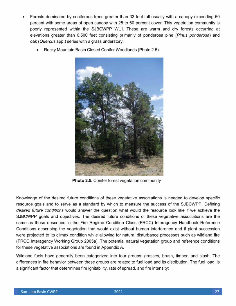
San Juan Basin CWPP 2021 27
• Forests dominated by coniferous trees greater than 33 feet tall usually with a canopy exceeding 60 percent with some areas of open canopy with 25 to 60 percent cover. This vegetation community is poorly represented within the SJBCWPP WUI. These are warm and dry forests occurring at elevations greater than 6,500 feet consisting primarily of ponderosa pine (Pinus ponderosa) and oak (Quercus spp.) series with a grass understory:
• Rocky Mountain Basin Closed Conifer Woodlands (Photo 2.5)
Photo 2.5. Conifer forest vegetation community
Knowledge of the desired future conditions of these vegetative associations is needed to develop specific resource goals and to serve as a standard by which to measure the success of the SJBCWPP. Defining desired future conditions would answer the question what would the resource look like if we achieve the SJBCWPP goals and objectives. The desired future conditions of these vegetative associations are the same as those described in the Fire Regime Condition Class (FRCC) Interagency Handbook Reference Conditions describing the vegetation that would exist without human interference and if plant succession were projected to its climax condition while allowing for natural disturbance processes such as wildland fire (FRCC Interagency Working Group 2005a). The potential natural vegetation group and reference conditions for these vegetative associations are found in Appendix A.
Wildland fuels have generally been categorized into four groups: grasses, brush, timber, and slash. The differences in fire behavior between these groups are related to fuel load and its distribution. The fuel load is a significant factor that determines fire ignitability, rate of spread, and fire intensity:

San Juan Basin CWPP 2021 28
Fuel load and depth are significant fuel properties for predicting whether a fire will be ignited, its rate of spread and intensity . . . Grasses and brush are vertically oriented fuels groups, which rapidly increase in depth with increasing load. Timber litter and slash are horizontally positioned and slowly increase in depth as the load is increased . . . The criteria for choosing a fuel model includes the fact that the fire burns in the fuel stratum best conditioned to support the fire . . . Fuel models are simply tools to help the user realistically estimate fire behavior . . . Therefore, the selection options and modifications for fuel models are limited to maintain a reasonably simple procedure to use with fire behavior nomograms, moisture content adjustment charts and wind reduction procedures. (Anderson 1982:1–3)
Fuels hazards have been correlated with fuel load by vegetative type for this analysis. However, the configuration of live/dead fuels, moisture content, fuel load and type, and drought all influence fire danger and the effect of wildland fire. Semidesert shrub land vegetative types are estimated to support a total fuel load of less than 1 ton per acre of fuels and are mostly in Condition Class 1 (historical fire regime). Pinyon- juniper woodland is estimated to support a total fuel load of 6 tons per acre, while deciduous riparian vegetation associations with densities of 100 trees/acre are estimated to support a minimum total fuel load of 12 tons per acre. Resource damage potential is moderate in pinyon-juniper woodland associations and generally lower in semidesert vegetative types.
Stands of mature shrubs 6 feet or more in height and forming a continuous secondary overstory and containing a significant amount of dead woody material include chaparral, mixed gray oak, mountain mahogany, manzanita, pinyon and juniper vegetative types. Vegetative components of this fuel model are considered moderate risk. However, the most volatile fuel type in the uplands of the analysis area is Gambel’s oak associations. Gambel’s oak is combustible throughout most of the year because of the high amount of leaf litter and the overall configuration of fuels in this association.
Areas of the WUI adjacent to major stream channels are steep and heavily dissected, with many areas having slopes exceeding 20 percent. Slopes greater than or equal to 20 percent and areas with south-, southwest-, or west-facing slopes were identified as having greater risks because of the preheating and fuel ladder-fire effect associated with steep terrain and decreased humidity associated with the microclimates created by exposed aspects. Other untreated or unburned areas that fall under the category of moderate ground fuels and do not overlap areas with steep slopes or with south, southwest, or west aspects are considered moderate risk from fuel hazards. All other areas have a low risk from fuel hazards, including the areas that have been previously treated or burned.
Areas of deciduous riparian vegetation were differentiated from areas of pinyon-juniper woodland associations, and semidesert vegetative zones because of greater associated fire intensity, fire spread, and potential resource loss. Vegetated areas containing deciduous riparian species densities greater than 100 trees per acre create a greater risk for spread and intensity of wildfire because of the potential crown- fire effect, fuel loading, and fuel ladder-fire scenario. The potential for major conflagrations is high in heavily vegetated riparian areas, creating high resource damage potential. An overall estimate of vegetative ground fuels to be removed, ranging from litter to understory fuels consisting of 1-hour to 100-hour fuels and live standing fuels, may average 12 tons per acre across the deciduous riparian vegetative type. This fuel type was considered high in fuels risk due in large part to the invasion of Salt-Cedar and Russian olive. Depending on vertical height, density, and understory components, deciduous riparian areas, including stands of Salt-Cedar and Russian olive, can be classified as Fuel Model 4 or considered a component within the deciduous

San Juan Basin CWPP 2021 29
riparian associations adding to fuel loading because of the amount of dead fuels maintained within the plant column of mature Salt-Cedar. Locations of Russian olive and Salt-Cedar within the WUI were mapped by the San Juan County Extension office and are included in Figure 2.4, vegetative types.
Planned and systematic fuel mitigation by mechanical or mechanical/chemical methods is the primary management tool to reduce vegetative fuel accumulation in the SJBCWPP riparian habitats; prescribed fire management opportunities exist in upland vegetative types within the WUI in areas where there are no conflicts with oil and gas industry structures. When considering wildland fire use or prescribed fire as management actions for each fire will depend on forecasted weather, forecasted fire behavior, hazard and safety concerns, and availability of resources. The wildland fuel hazard components listed in Table 2.3 will increase depending on the predicted fire behavior based on vegetative and geographic conditions and immediate weather conditions at the wildland fire site. Areas with none of these fuel hazard characteristics and areas that have been treated, or are proposed for treatments, are identified as having less risk and will require little to no immediate treatment. See Section II.E for a fuel hazards summary for each community.
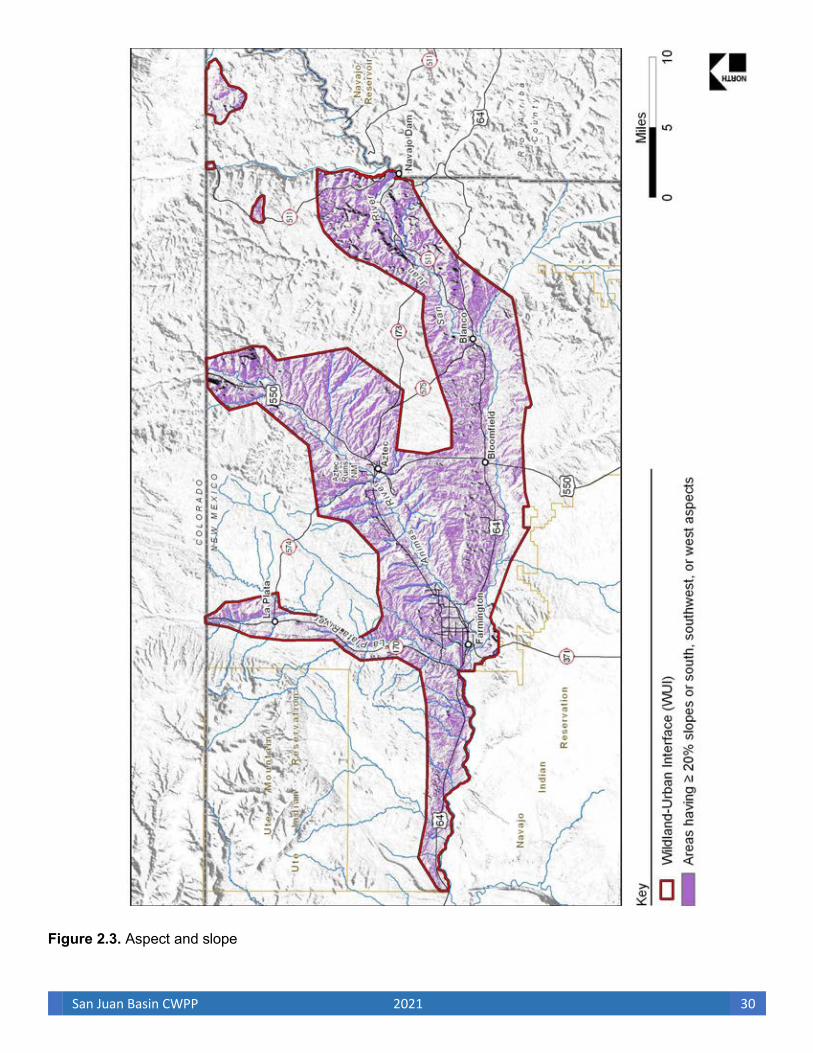
San Juan Basin CWPP 2021 30
Figure 2.3. Aspect and slope
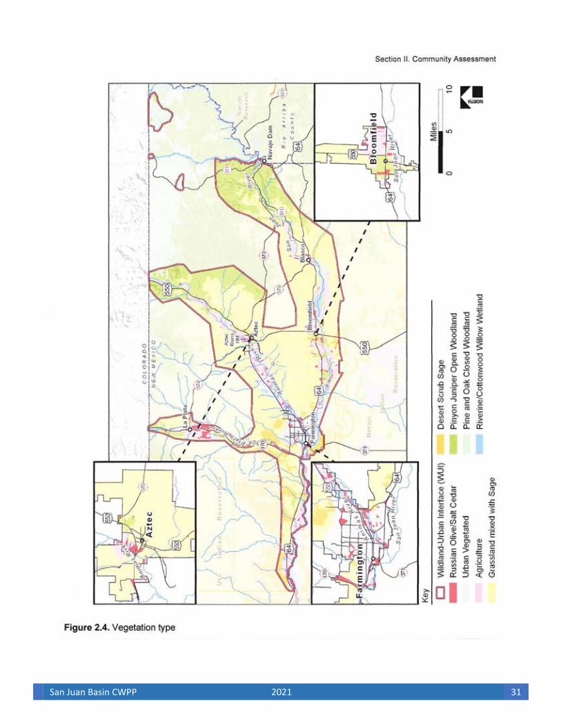
San Juan Basin CWPP 2021 31

San Juan Basin CWPP 2021 32
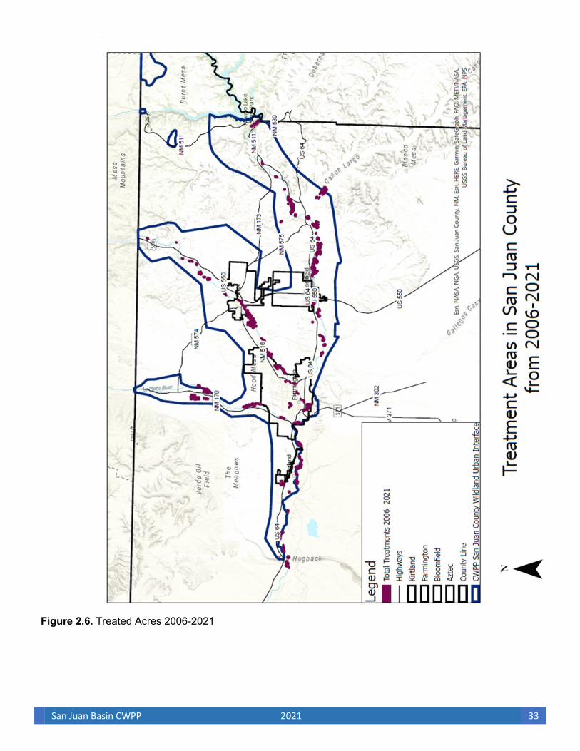
San Juan Basin CWPP 2021 33
Figure 2.6. Treated Acres 2006-2021

San Juan Basin CWPP 2021 34
San Juan Basin CWPP 2021 35
C. Risk of Ignition and Wildfire Occurrence
Because of the combination of current drought conditions, establishment of cheat grass, and heavy accumulations of fuel loading within riparian drainages from Salt Cedar and Russian olive, as well as increasing shrub densities within grassland communities, fires have increased in acreage and intensity within the past decade. Although not common, large wildfires, such as the Missionary Ridge Fire that burned approximately 74,000 acres north of San Juan County in summer 2002, do occur, and the potential for such large conflagrations within San Juan County exist. Several named fires have occurred in San Juan County, including Blanco (4901), Arroyo Fire, 3105 Fire, Arena Canyon, Pump Canyon, Cox Canyon, Road 5793 fire Without the intervention of management, an increase in response capacity and mitigation of hazardous wildland fuels, the current increase in wildland fires within the WUI will continue.
Severe fire weather, high fuel loads, and drought are the common denominators for large, intense stand- replacing fires throughout the region. As reported by the San Juan County Fire Department for the period, there have been natural and human-caused wildfires that were responded to. For this region, the lightning-fire season begins in spring and can continue until fall. The midsummer monsoon storms typically raise the humidity, reducing the risk of large catastrophic fires. However, many wildland fire ignitions within the WUI are human caused and not related to lightning efficiency by season. Human-caused fires occur when fuel conditions are most receptive and conducive to support wildland fire, typically during summer drought periods before the onset of the monsoon season.
Table 2.4 details the high, moderate, and low values assigned to fire start incidents on public lands administered by the BLM FFO. Each fire department has also delineated areas of highest fire history occurrence where applicable in each Fire Response Zone within the WUI. Figure 2.8 illustrates the data in Table 2.4. Fire ignition point data from the BLM FFO,
and local fire history knowledge were used to show areas with higher frequencies of ignition points (Figure 2.8) Areas with a high frequency of ignition are areas of greater concern. These areas of greater concern include concentrated areas of lightning strikes overlaid with high public-use areas. High-risk areas have the greatest number of fire starts per 1,000 acres. Figure 2.8 details the extent of fires that have occurred within the planning area and the combined risk of ignition and wildfire occurrence. See Section II.E for a summary discussion of ignition risk and wildfire occurrence in each community.
Table 2.4. Ignition history and wildfire occurrence
Ignition history and wildfire
occurrence components Value
6.0–9.0 Fire starts/1,000 acres H
3.0–5.0 Fire starts/1,000 acres M
0–2.0 Fire starts/1,000 acres L_ Source: Logan Simpson Design Inc., BLM FFO

San Juan Basin CWPP 2021 36
Figure 2.8. Natural and human fire starts 1994-2020
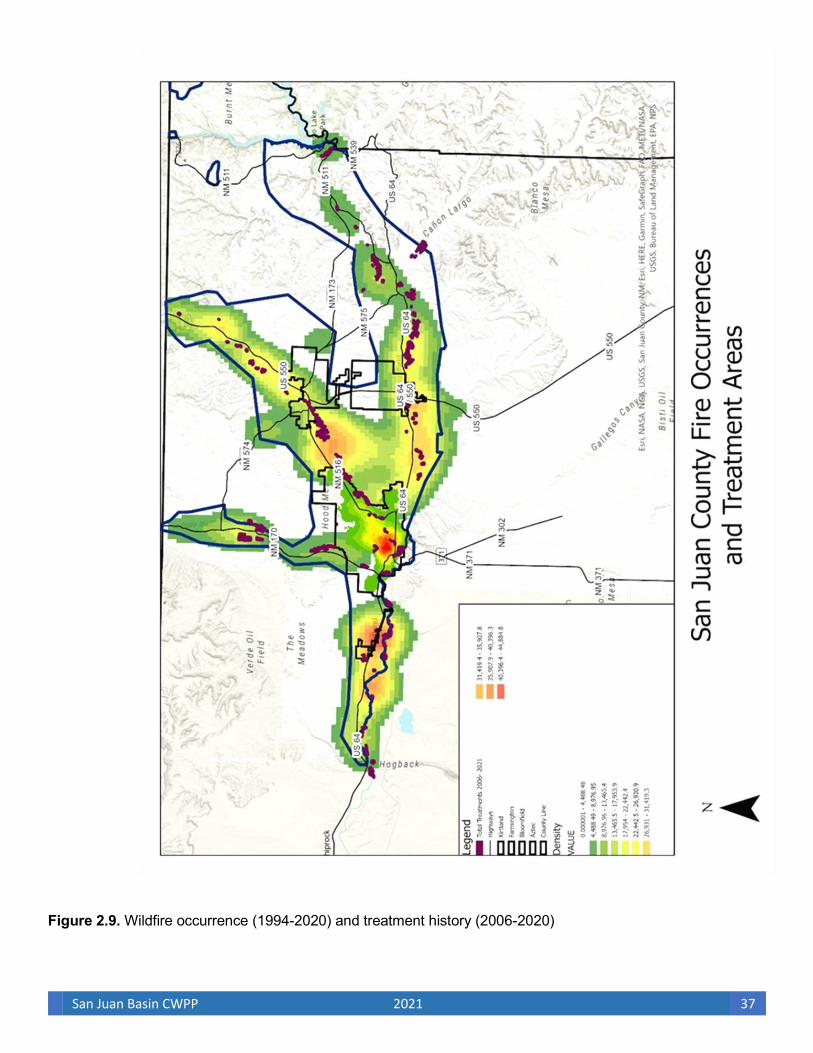
San Juan Basin CWPP 2021 37
Figure 2.9. Wildfire occurrence (1994-2020) and treatment history (2006-2020)
San Juan Basin CWPP 2021 38
D. Community Values at Risk Valued, at-risk community resources include community structures (e.g., schools, hospitals), economic centers, communication facilities, power lines, oil and gas infrastructure, recreation areas, cultural/historic areas, sensitive wildlife habitat, areas of critical environmental concern (ACEC), municipal watersheds, natural resources, and air quality. Community values identified in Table 2.5 are mapped in Figures 2.10 and 2.11 and include housing, business structures, and essential infrastructure. Figure 2.12 shows recreation areas and BLM special management areas. Figure 2.13 shows sensitive wildlife species habitats. Developed land in excess of 8 structures per 10 acres is considered the highest wildland fire risk. Structure density between 2 and 8 is considered medium risk, while structure density of < 2 per 10 acres is considered lower wildfire risk (see Figure 2.12). Developed land, infrastructure, campgrounds, parks and trail systems, ACECs, and wildlife habitat within medium and low wildfire risk areas were given a moderate value. These components were compiled into a single map (Figure 2.14), which identifies high, moderate, and low areas with respect to valued community elements. The following information further describes the community values in the SJBCWPP (see Section II.E for a summary of community values for each community).
1. Housing, Businesses, Essential Infrastructure, and Evacuation Routes
The CAG identified high-risk areas, including the economic corridors that line US 64, US 550, SR 170, SR 173, and SR 574 that have been and continue to be the focus of community development. Structures associated with housing and commercial development (Photo 2.6) located in isolated subdivisions and in more dispersed areas of the county are also at high risk. The CAG has identified significant infrastructures, such as communication facilities within the designated WUI, and recommends fuel modification treatments that will reduce the threat of wildland fire affecting these facilities. Transportation corridors between WUI communities that will serve as evacuation routes and resource distribution corridors during a wildland fire have been identified by the CAG. The CAG also recommends fuel modification treatments for evacuation corridors that will provide safe evacuation from WUI communities in the event of catastrophic wildland fire.
Table 2.5. Community values ____________________________________________________ Community value components Value Housing and businesses structures, infrastructure in high risk >8 per 10 acres H Housing and business structures and infrastructure in medium risk 2.01-8 per 10 acres M Housing and business structures and infrastructure in low risk 0-2 per 10 acres L Recreation areas M Wildlife habitat M All other areas L____ Source: Logan Simpson Design Inc.
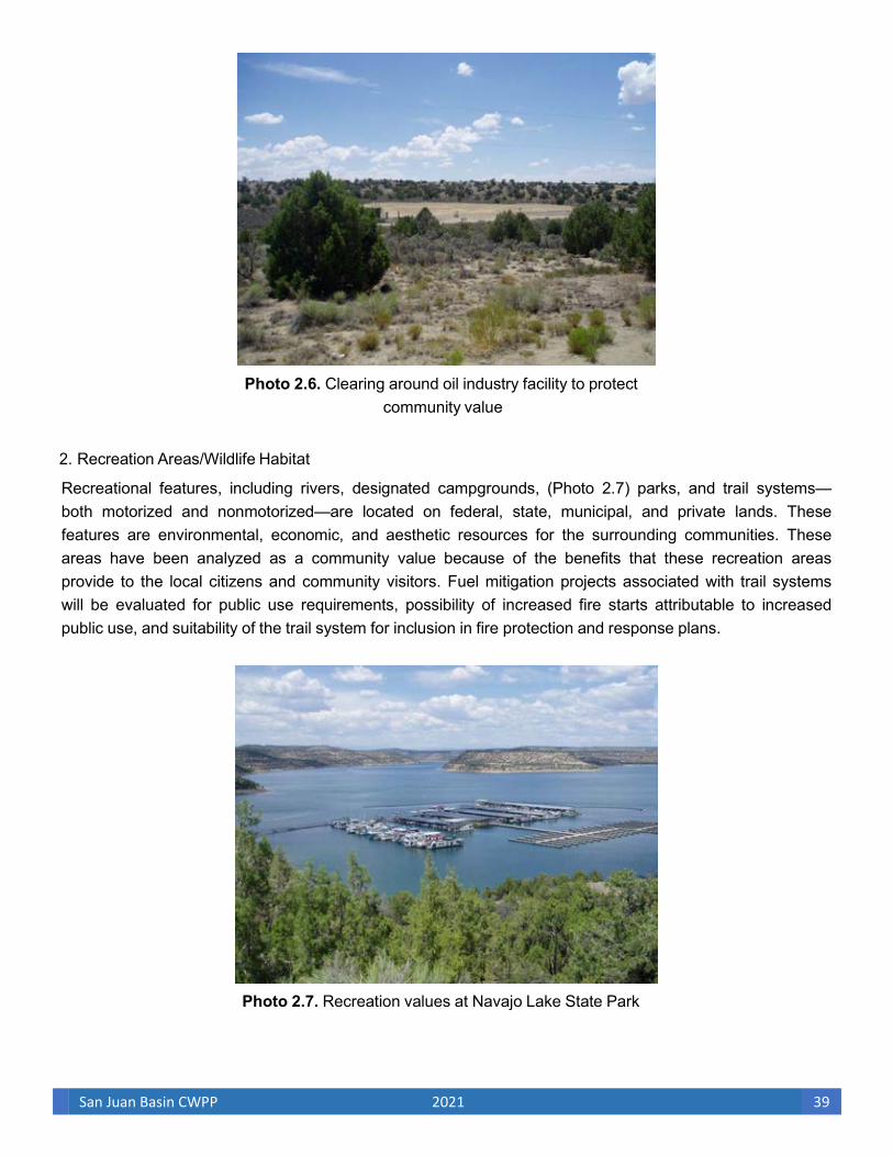
San Juan Basin CWPP 2021 39
Photo 2.6. Clearing around oil industry facility to protect
community value
2. Recreation Areas/Wildlife Habitat
Recreational features, including rivers, designated campgrounds, (Photo 2.7) parks, and trail systems— both motorized and nonmotorized—are located on federal, state, municipal, and private lands. These features are environmental, economic, and aesthetic resources for the surrounding communities. These areas have been analyzed as a community value because of the benefits that these recreation areas provide to the local citizens and community visitors. Fuel mitigation projects associated with trail systems will be evaluated for public use requirements, possibility of increased fire starts attributable to increased public use, and suitability of the trail system for inclusion in fire protection and response plans.
Photo 2.7. Recreation values at Navajo Lake State Park

San Juan Basin CWPP 2021 40
Figure 2.10. Structure distribution and abundance within the WUI

San Juan Basin CWPP 2021 41
Figure 2.11. Housing density
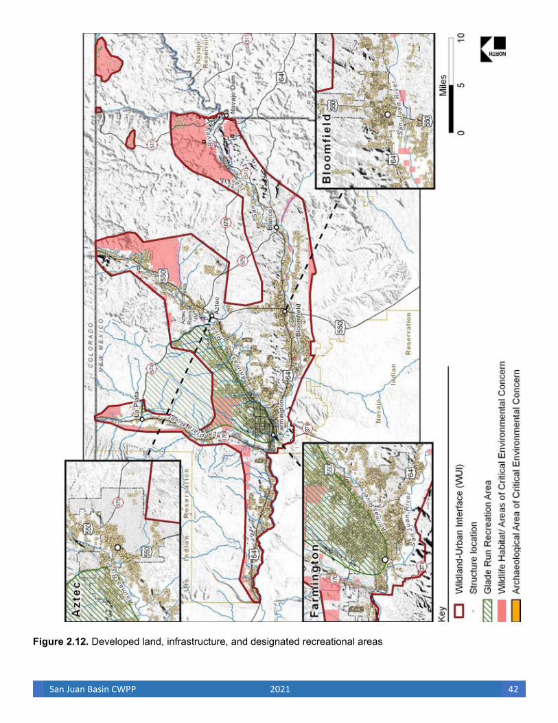
San Juan Basin CWPP 2021 42
Figure 2.12. Developed land, infrastructure, and designated recreational areas

San Juan Basin CWPP 2021 43
Figure 2.13. Sensitive wildlife habitat

San Juan Basin CWPP 2021 44
Figure 2.14. Community values

San Juan Basin CWPP 2021 45
The WUI includes known and potential habitat areas for several wildlife species listed as threatened or endangered under the Endangered Species Act (ESA) and for species designated as sensitive by the BLM and the State of New Mexico (Appendix B). The San Juan, La Plata, and Animas River corridors contain several threatened, endangered, and sensitive (TES) species habitats, such as the Southwestern willow flycatcher and bald eagle, for which species-specific conservation measures have been identified by the BLM (USDI BLM 2004a). The CAG has determined that habitat-enhancing treatments for reducing wildland fuel and lessening the threat of catastrophic wildland fire in the river corridors would help preserve sensitive riparian habitat and wildlife species in accordance with Section 102.a.5.B of HFRA and would also protect recreational values associated with these river systems by local residents and visitors. If a proposed fuel treatment might potentially affect an ESA-listed species, or if other extraordinary circumstances might exist, site-specific consultation with the United States Fish and Wildlife Service (USFWS) would be required. The project may also require more extensive NEPA assessment, depending on the results of a site-specific analysis. Because not all potential occurrence sites for these species within the WUI are known, an evaluation of project-related effects on these species would need to be conducted during the planning of site-specific treatments. Generally, habitat areas for these species were identified in this analysis as having moderate risk because of their association with community values. A 300-foot buffer area was delineated along the riparian areas and habitats associated with special-status species for consistency in planning purposes with Wildland Fire Suppression (Including Wildland Fire Use) and Rehabilitation in Riparian and Aquatic Habitats (RA) (USDI BLM 2004d). In addition, any treatments in riparian habitats during the implementation of Rx or other vegetation manipulations will require further analysis in accordance with the BLM and State of New Mexico for site- and species-specific conservation measures.
1. Watersheds The WUI includes several significant watersheds that supply irrigation and drinking water and that provide substantial outdoor recreation opportunities within and close to the communities. The watersheds in the WUI consist of both federal and nonfederal lands and include portions of the Upper San Juan River (Hydrologic Unit Code [HUC] 14080101), Blanco Canyon (HUC 14080103) Animas River (HUC 14080104), Middle San Juan River (HUC 14080105), and Chaco (HUC 14080106) as delineated by the United States Geologic Survey. In accordance with Section 101.12 and Section 102.a.2 of HFRA, authorized projects should consider protection to municipal watersheds by implementing hazardous fuel reduction projects on federal lands in proximity to municipal water systems and streams feeding those systems that are at risk of catastrophic wildfire. The La Plata, Animas, and San Juan rivers provide approximately 90 percent of the municipal water supply of the WUI communities, as well as significant surface waters to northern New Mexico communities. The majority of watersheds in the WUI, whether located on public lands or private lands, are at some level of risk for catastrophic wildland fire. Large-scale fire disturbance would have an adverse effect on the riparian corridors that support sensitive wildlife and native fish species, their habitats, and recreational sport fisheries in these rivers because of the inflows of sediment and ash. The downstream communities are also at greater risk after a catastrophic wildland fire in the watershed because of potential changes in peak stream flow frequency or magnitude, as well as flood and debris flows that could degrade water quality, reduce sustained quantity, and increase treatment and maintenance costs. A wildland fire that increases erosion and diminishes percolation abilities of the watershed would significantly affect the water supply to each downstream community. Hazardous fuel reduction projects in the WUI would reduce
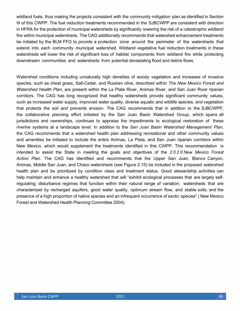
San Juan Basin CWPP 2021 46
wildland fuels, thus making the projects consistent with the community mitigation plan as identified in Section III of this CWPP. The fuel reduction treatments recommended in the SJBCWPP are consistent with direction in HFRA for the protection of municipal watersheds by significantly lowering the risk of a catastrophic wildland fire within municipal watersheds. The CAG additionally recommends that watershed enhancement treatments be initiated by the BLM FFO to provide a protection zone around the perimeter of the watersheds that extend into each community municipal watershed. Wildland vegetative fuel reduction treatments in these watersheds will lower the risk of significant loss of habitat components from wildland fire while protecting downstream communities and watersheds from potential devastating flood and debris flows.
Watershed conditions including unnaturally high densities of woody vegetation and increases of invasive species, such as cheat grass, Salt-Cedar, and Russian olive, described within The New Mexico Forest and Watershed Health Plan, are present within the La Plata River, Animas River, and San Juan River riparian corridors. The CAG has long recognized that healthy watersheds provide significant community values, such as increased water supply, improved water quality, diverse aquatic and wildlife species, and vegetation that protects the soil and prevents erosion. The CAG recommends that in addition to the SJBCWPP, the collaborative planning effort initiated by the San Juan Basin Watershed Group, which spans all jurisdictions and ownerships, continues to appraise the impediments to ecological restoration of these riverine systems at a landscape level. In addition to the San Juan Basin Watershed Management Plan, the CAG recommends that a watershed health plan addressing recreational and other community values and amenities be initiated to include the entire Animas, La Plata, and San Juan riparian corridors within New Mexico, which would supplement the treatments identified in this CWPP. This recommendation is intended to assist the State in meeting the goals and objectives of the 2 0 2 0 New Mexico Forest Action Plan. The CAG has identified and recommends that the Upper San Juan, Blanco Canyon, Animas, Middle San Juan, and Chaco watersheds (see Figure 2.15) be included in the proposed watershed health plan and be prioritized by condition class and treatment status. Good stewardship activities can help maintain and enhance a healthy watershed that will “exhibit ecological processes that are largely self-regulating; disturbance regimes that function within their natural range of variation; watersheds that are characterized by recharged aquifers, good water quality, optimum stream flow, and stable soils; and the presence of a high proportion of native species and an infrequent occurrence of exotic species” ( New Mexico Forest and Watershed Health Planning Committee 2004).
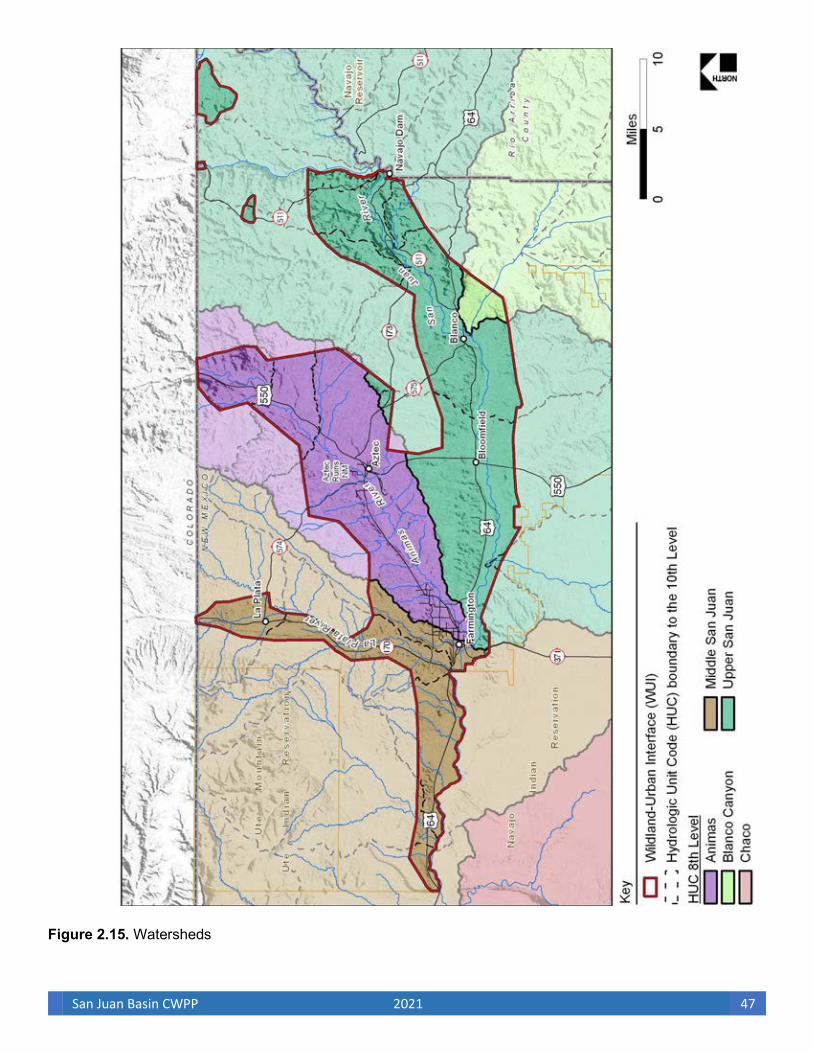
San Juan Basin CWPP 2021 47
Figure 2.15. Watersheds
San Juan Basin CWPP 2021 48
1. Local Preparedness and Protection Capability
For many years the ISO has conducted assessments and rated communities on the basis of available fire protection. The rating process grades each community’s fire protection on a scale from 1 to 10 (1 being ideal and 10 being poor) based on the ISO’s Fire Suppression Rating Schedule. There are five factors that make up the ISO fire rating. Water supply, the most important factor, accounts for 40 percent of the total rating. Type and availability of equipment, personnel, ongoing training, and the community’s alarm and paging system account for the remaining 60 percent of the rating.
The major concern of county and municipal fire departments in the SJBCWPP communities is human- caused fires within the heavily infested Salt-Cedar/Russian olive segments of the riparian corridors. Response can be slow because access to these riparian areas is limited to non-surfaced sandy roadways in some areas. Surface-water supplies and hydrants are not available in all communities, so specific areas of limited water supply for wildfire response have been identified. Additionally, many community subdivisions and areas of denser development in the identified WUI were not designed with adequate ingress/egress or emergency vehicle access. Developments without adequate access and readily available water supplies increase the risk of greater habitat and structural losses from large wildland fires.
The county and municipal fire departments provide protection to over 34,000 housing structures in or close to the identified WUI, as well as adjacent rural areas within the fire department boundaries. Figures 2.16 displays the fire department boundaries and the ISO rating for each municipal and county fire department.

San Juan Basin CWPP 2021 49
Figure: 2.16. Fire Department boundaries and ISO ratings

San Juan Basin CWPP 2021 50
The CAG was asked to identify community characteristics to summarize the overall community values contained within the WUI. All communities identified natural and cultural values as highly important. Of special interest were the river systems and associated tributaries that bisect the county from the north and from east to west, including the San Juan, La Plata, and Animas rivers. All three rivers enter the county from the north (from Colorado). The greatest acreage of private lands and densities of structures occur within these river drainages. These river corridors also contain significant cultural resources and provide TES wildlife species habitats and considerable recreational opportunities. Additional values include the transportation corridors of US 64 that pass through the county from east to west through Farmington and Bloomfield; New Mexico SR 491 and SR 371 and US 550 that traverse the county from north to south; and SR 511 that provides access to the Navajo Lake State Park. Navajo Lake State Park is a popular summer recreational area for hiking, mountain biking, camping, sightseeing, hunting, and fishing. The Navajo Lake area within San Juan County, receives an estimated 500,000 recreational visitors per year. All of these recreational visitors are significant to San Juan County’s economy. In addition to Navajo Lake recreational activities, hunting, fishing, camping, and off-highway vehicle (OHV) recreation are also popular activities of residents and visitors and add significant revenue to the county. Any closure or limited access to public lands within the county because of catastrophic wildland fire would have a major impact on the local businesses that rely on the revenue associated with these recreational activities. In addition to community values, the CAG provided a basic summary of county land distribution, ownership and economic interests. San Juan County encompasses an area measuring approximately 5,516 square miles: 60 percent is Navajo Nation Tribal Trust land, 29 percent is public land administered by the BLM, 5 percent is state land, and nearly 6 percent is individual or corporate-owned land. Major contributors to the county’s economy include agriculture, tourism (mostly outdoor recreation), and oil and gas production activities. There are approximately 19,000 natural gas wells on lands administered by the FFO. San Juan County is a large natural-gas-producing county in New Mexico. The oil and gas industry, agricultural pursuits and more recently tourism, healthcare, and retail are the dominant employers in San Juan County. The numerous gas and oil structures that occur across the planning area pose a threat to firefighters and special considerations must be made when fire operations are being conducted near these sites. The population base for the WUI is located in the larger municipalities as well as in surrounding unincorporated properties. Farmington, Bloomfield, Aztec, and Kirtland are the only incorporated municipalities in the county, and collectively, these cities compose approximately 50 percent (62,513) of the county’s 2019 census population estimate (123,958): Farmington with 38.3 percent (47,552), Bloomfield with 6.2 percent (7,685), Aztec with 5.1 percent (6,369) and Kirtland with .4% (494). Residents residing within San Juan County outside the three municipalities make up the remaining 50 percent (61,085) of the county’s 2019 census population estimate. The challenge facing the municipal and county fire departments is the continued growth in call volumes, with much of the growth occurring within the unincorporated areas of the county. Residential housing continues to grow throughout the WUI. Large agricultural and ranchland parcels are being subdivided into increasingly smaller parcels to meet the demands of a growing community. While the population continues to grow within the WUI, fire departments are challenged with maintaining services, such as recruiting and retaining qualified firefighters, supplying and maintaining fire response equipment, additional fire stations or substations, and providing fire-safe public outreach to a growing population not familiar with wildland fire and rural community risks. Through implementing the action recommendations of the SJBCWPP support for fire response, firefighter and public safety will be enhanced.
A summary of each community’s WUI based on the overall community assessment is presented in the following subsections. General descriptions of the communities include land ownership, jurisdiction,

San Juan Basin CWPP 2021 51
development trends, population, infrastructure (e.g., roads, utilities, power lines, schools, hospitals, and community facilities), and existing emergency services. The WUI described for these communities includes significant watersheds and riparian corridors that provide irrigation and domestic water supplies to the communities; habitat for several threatened, endangered, and sensitive species; and some flood control and substantial outdoor recreational opportunities—all of great economic importance to the communities, county, and the BLM FFO. In addition, Farmington has recently undertaken a program to establish a city river-walk recreational area along the Animas River to promote riparian habitat community education and the significance of having a river within the community, as well as to acknowledge the private and public land managers whose ownership and stewardship have increased public awareness and outdoor recreation. The continued interest and use of these rivers and watersheds ultimately enhance the economic value of these areas for the local communities. Such economic and ecological values are critically dependent on the health of the Animas, La Plata, and San Juan River watersheds. The emphasis in this plan on improving community wildfire protection, and thus improving the health of the three rivers and their associated watersheds, will help maintain these riverine systems and allow them to persist as high-quality wildlife and human habitat.
1. City of Aztec
Located along the Animas River, the interface city of Aztec consists of over 3020 total housing units and increase of 128 housing units since 2010 It has experienced an 9.4% percent resident population decrease over the ten-year period between census data, from 6,763 residents in 2010 to 6,369 residents in 2019. Growth is expected to continue at a declining rate of growth to a possible minimal rate of growth in the near future. Housing units increased .5% from 2892 in 2010 to 2920 in 2019. The slowdown in growth means Aztec has adequate fire protection for resident population. This area of the WUI includes significant community assets, such as the Aztec Ruins, Aztec Municipal Airport, museum, library, and several historic site and districts, as well as commercial businesses. The major areas of employment include education and social service (19.%) retail trade (16.4%); agriculture, fishing , hunting and mining (8.9%) and the service trade (11.9%). Aztec is accessible from SR 516 (east) and SR 173 (west) and from US 550 (north or south).
The CAG considered the threat of wildfire from within riparian and rangeland areas when delineating the extent of the WUI that extends from the community center. Aztec is mostly composed of Condition Class 2 lands, with Condition Class 3 lands associated with the Animas River corridor. Extensive private development associated with the Animas River corridor has complicated fire response to agricultural lands and structures with infestations of Salt-Cedar and Russian olive. The fuel hazard rating is high for most of the deciduous riparian habitat in Aztec. The principal fuel hazard for this portion of the WUI includes thick stands of untreated small-diameter riparian vegetation found along the Animas River consisting of densely infested sites of Salt-Cedar and Russian olive. Significant improvements in fire risk have been accomplished with fuel treatments since the inception of the SJBCWPP.
Because of the riparian vegetation, sensitive watersheds, community values, and high fire start occurrence, a defensible space for community wildfire protection is recommended for compatibility of land use designations of the riparian areas. The WUI includes power lines that supply electrical power to the city and provide power to the municipal water supply system. The CAG recommends wildland fuel reduction treatments adjacent to power-line easements and near critical municipal water-supply structures to ensure protection during a wildland fire. Resource damage potential is high from wildland fire within the watershed where fire has not previously occurred or where wildland fuels have not been mitigated. Mechanical or mechanical/chemical treatments will be the primary tool for wildland fuel mitigation in Aztec, especially for the removal of Salt- Cedar and Russian olive within the river corridor and associated side channels and drainages. The combination of fuel load, topography, and areas of poor access increases the potential severity of wildland
San Juan Basin CWPP 2021 52
fire, as well as the risk to property and public/firefighter safety. The current ISO rating for the Aztec Municipal Fire Department is 4.
2. City of Bloomfield
City of Bloomfield is located along the San Juan River within the central portion of the CWPP analysis. The city has over 3100 in 2010 housing units compared to 2400 in 2000 an increase of over 700 an increase of 29% and has experienced a 5.8% percent resident population decrease from 2010 to 2019, from 8,112 residents in 2010 to 7,685 residents in 2019. Similar to Aztec, Bloomfield must be prepared to provide structural and wildland fire protection to the current residential and commercial population. The major area of employment within Bloomfield is within the private sector. Bloomfield is accessible from US 64 (east or west) and from US 550 (north or south).
The interface city of Bloomfield is located within the riparian corridor of the San Juan River, which serves as a domestic and an irrigation water source. As opposed to the heavier-fueled vegetation communities in the northern portion of the WUI, the CAG is concerned primarily about wildfire threats from the riparian vegetation along the San Juan River, flashy grassland or agricultural fuels, and thick shrub-dominated fuels within associated lateral drainages of the San Juan River. Bloomfield is mostly composed of Condition Class 2 lands, with Condition Class 3 lands associated within riparian areas containing heavy infestations of salt cedar and Russian olive. The fuel hazard rating is high for most of the deciduous riparian habitat in the Bloomfield area. The principal fuel hazard for this portion of the WUI includes thick stands of untreated small-diameter riparian vegetation found along the San Juan River and associated private land structures. Appendix D describes the specific areas of elevated concern for wildland fire as outlined by the Bloomfield Fire Department.
Water diversions and delivery systems transport water from the San Juan River to irrigated fields within private lands. These structures support agriculture within the community by providing both cropland and livestock water sources. The San Juan River also provides the municipal water supply to Bloomfield. The riparian corridors associated with the San Juan River contain habitat for TES species, including potential habitat for the Southwestern willow flycatcher. Bloomfield is known for its scenic beauty and historic, cultural, recreational, and wildlife values, which are significant economic assets to the community, county, and the BLM. Habitat-enhancing treatments for reducing wildland fuel and lessening the threat of catastrophic wildland fire would assist in preserving the sensitive riparian habitat and wildlife species in accordance with Section 102.a.5.B of HFRA, The New Mexico Forest and Watershed Health Plan, the Strategy for Long-Term Management of Exotic Trees in Riparian Areas for New Mexico’s Five River Systems, 2005-2014, the San Juan Basin Watershed Management Plan, and the BLM FFO Fire Management Plan and would also protect the significant community values of Bloomfield and provide for enhanced riparian recreation/education opportunities.
With an estimated year-round population of slightly more than 7,600 residents, Bloomfield experiences seasonal visitation associated with the recreational opportunities located in the region. This includes increases in visitors during the summer months, and during the big and small-game fall hunting seasons. The seasonal increase in visitations heightens the need for communication and rapid-fire suppression response.
The WUI includes power lines supplying electrical power to portions of the city and the municipal water supply. The CAG recommends additional fuel reduction treatments adjacent to power line easements and near critical municipal water supply structures to ensure protection during wildland fire or a prescribed burn. The CAG has also recommended that power lines in Bloomfield be marked or flagged to reduce potential aircraft strikes during aerial firefighting responses within the riparian corridor; however, the San Juan River in Bloomfield is not currently used for aerial firefighting purposes due to human and environmental safety concerns.

San Juan Basin CWPP 2021 53
Wildland fire and structural fire protection is provided to the residents of Bloomfield by the Bloomfield Municipal Fire Department which has entered a cooperative agreement with San Juan County Fire & Rescue. Bloomfield borders the Southeast Fire Response Zone to the east and the Central Fire Response Zone to the west. Most lands in Bloomfield lie where the alignment of vegetation and topography could allow wildland fires to spread so rapidly that, without treatment, facilities and homes might be burned through before any effective suppression measures would be available. Some residents in Bloomfield have poor ingress and egress routes, extremely limited communication capabilities, and limited effective evacuation and firefighting response.
Bloomfield includes a variety of vegetative types, such as grassland and semidesert types and deciduous riparian species, in the San Juan River corridor. Resource damage potential is high from wildland fire within the watershed where fire has not previously occurred or wildland fuels have not been mitigated.
Mechanical or mechanical/chemical treatments will be the primary tool for wildland fuel mitigation in Bloomfield, especially in the removal of salt cedar and Russian olive within the river drainage. The combination of fuel load, topography, and areas of poor access, increases the potential severity of wildland fire, as well as the risk to property and public/firefighter safety. The current ISO rating for the Bloomfield Municipal Fire Department is 2.
3. City of Farmington
Farmington is located at the confluence of the San Juan, Animas, and La Plata rivers and consists of over 17,548 total housing units. The city’s resident population has increased by from 37,844 residents in 2010 to 47,552 residents in 2019. Similar to other communities within San Juan County, the Farmington Municipal Fire Department must provide structural and wildland firefighting response to a growing population. Farmington is mostly composed of Condition Class 2 lands, with Condition Class 3 lands in riparian habitats where heavy infestations of Salt-Cedar and Russian olive can occur. The fuel hazard rating is moderate for most of the deciduous riparian habitat of Farmington. The principal fuel hazard for this portion of the WUI includes thick stands of untreated small-diameter riparian vegetation found along the river corridors. This small-diameter vegetation is associated with heavily infested areas of Salt-Cedar and Russian olive intermixed with associated private agriculture and residential structures.
US 64 passes through Farmington and is the primary business center where most commercial development is located. Farmington provides the major retail center for San Juan County residents. Resident amenities within Farmington include the area hospital, San Juan College, public library, and several archaeological and historic sites and districts. The city has several parks, including the Riverwalk associated with the Animas River. The major areas of employment in Farmington include education and social services (21.5%); retail trade (14.6%); and agriculture, forestry, fishing, hunting, and mining (10.9%).
Fire response to the residents of Farmington is provided by the municipal fire department with assistance from the San Juan County Fire Department. The county fire department and the BLM provide wildland fire response to areas adjacent to the city within the WUI. In addition, the BLM-administered Head Canyon/Dunes and Glade Run Recreation areas are adjacent to the City of Farmington. These management areas are characterized by high numbers of off-highway recreational users and high frequencies of OHV trails. Several hundred visitors use these recreation areas each year, which may require additional emergency services personnel to evacuate visitors if a wildland fire occurs. The CAG considered threats to Farmington from human-caused fire starts within the riparian corridors and associated drainages in proximity to the private lands of the community, as well as within the high-use recreation areas. The Farmington Fire Department has identified 19 areas of concern from existing vegetative fuels, slope, water supplies, ingress/egress/response routes, and structural issues (see Appendix). These are high-priority areas for wildland fuel mitigation and structural ignition planning for the city. The Farmington Fire Department has a current ISO rating of 2.

San Juan Basin CWPP 2021 54
4. Northeast San Juan County Zone The Northeast San Juan County Zone consist of portions of the Animas River and San Juan River corridors and the intermix communities of Cedar Hill, Center Point, and Navajo Dam, including the unnamed private parcels located along the Animas River and San Juan River corridors. The Fire Departments in this response area provide fire protection to over 2,300 housing units. To the north, the WUI extends to the San Juan County–Colorado boundary along US 550 and SR 511. The Northeast San Juan County Fire Response Zone includes the Cedar Hill and Center Point response zones that abut Aztec to the south and the Navajo Dam Response Zone that abuts the Southeast Fire Response Zone to the west. US 550 connects the Northeast Zone to Aztec to the south of Center Point and Cedar Hill; it also connects this zone to the Durango, Colorado, area, with SR 173 leading east to Navajo Dam and SR 511 as the connecting corridor to the San Juan County Central Zone of Blanco and Sullivan Road communities. The communities of Cedar Hill, Center Point, and Navajo Dam are classified as “Category 2 intermix communities” (Federal Register 2001a). The Navajo Dam area provides extensive outdoor recreational opportunities, including Navajo Lake State Park, which receives over 500,000 visitors every year. The Park has developed campground facilities and small businesses to support outdoor tourism, especially the tail water fishery below Navajo Dam and boating on Navajo Lake. The Navajo Lake area also contains some private lands with housing and other structures present. The BLM-administered bald eagle ACEC is located above Navajo Dam and occurs both in San Juan and Rio Arriba counties adjacent to Navajo Lake. The bald eagle ACEC consists of mature ponderosa pine and provides seasonal habitat for bald eagles. The Navajo Lake area of the San Juan County Northeast Zone experiences considerable growth in visitors during the summer vacation and fall hunting and fishing seasons, which creates significant wildland/structural fire response and management considerations. The state and federal highways within this zone not only provide connecting routes for the major outdoor recreational areas but also act as the emergency evacuation routes for wildland fire conflagrations in the Durango, Colorado, area and the campgrounds within the Navajo Lake vicinity.
Land ownership along the riparian corridors of the Animas River and San Juan River, in the Northeast Zone, is a mix of private lands surrounded by BLM, Bureau of Reclamation, and state lands. These river corridors are known for their scenic beauty and historic, cultural, recreational, and wildlife values that are significant to the community, county, and the BLM. The Animas and San Juan rivers support extensive outdoor recreation opportunities and habitat for TES species, such as Southwestern willow flycatcher potential habitat. Habitat-enhancing treatments for reducing wildland fuels and lessening the threat of catastrophic wildland fire would protect the recreational and scenic values of these rivers and help preserve sensitive riparian habitat and wildlife species in accordance with Section 102.a.5.B of HFRA, The New Mexico Forest and Watershed Health Plan, the Strategy for Long-Term Management of Exotic Trees in Riparian Areas for New Mexico’s Five River Systems, 2005-2014, the San Juan Basin Watershed Management Plan, and the BLM FFO Fire Management Plan.
The Northeast Zone encompasses a variety of vegetation types, such as pine forest, pinyon-juniper/oak woodland, grassland and semidesert types, and deciduous riparian species, in the Animas River and San Juan River corridors. Resource damage potential is high from wildland fire within the watershed where fire has not previously occurred, wildland fuels have not been mitigated, and heavy infestations of salt cedar and Russian olive occur. A systematic program of wildfire suppression at minimum cost and acreage burned, with mechanical and chemical fuel-reducing treatments where applicable may be recommended to accomplish management area objectives. Mechanical and mechanical/chemical treatments will be the primary tool for wildland fuel mitigation in the riparian areas, especially for the removal of Salt-Cedar and Russian olive within the river drainage. The combination of fuel load, topography, areas of poor access, and ineffective communication increases the potential severity of wildland fire as well as the risk to property and public/firefighter safety.
San Juan Basin CWPP 2021 55
Structural and wildland fire protection is provided to area residents by the Navajo Dam, Cedar Hill, and Center Point fire districts, and in the Navajo Lake State Park, structural and wildland fire is provided by Navajo Dam Volunteer Fire Department. Navajo Lake State Park personnel are trained to assist as needed. The current ISO ratings for the Northeast Zone are 4/4Y for Cedar Hill, 4/4Y for Center Point, and 5/5Y for Navajo Dam.
5. Southeast San Juan County Zone
The Southeast San Juan County Zone includes portions of the San Juan River corridor and the intermix communities of Sullivan Road, Lee Acres, and Blanco. The San Juan County Southeast Zone lies between Navajo Dam and Bloomfield along SR 511 and consists of over 1,300 housing units. The communities within the San Juan County Southeast Zone are classified as “Category 2 intermix communities” (Federal Register 2001a). Land ownership in the Southeast Zone is a mix of private lands surrounded by BLM and state lands, and this zone contains the riparian area along the San Juan River. The San Juan River is known for its scenic beauty and historic, cultural, recreational, and wildlife values that are significant to the community, county, and the BLM. The San Juan River supports extensive outdoor recreation opportunities and habitat for TES species, including Southwestern willow flycatcher potential habitat. Habitat-enhancing treatments for reducing fuel and lessening the threat of catastrophic wildland fire would protect the recreational and scenic values of the river and would help preserve sensitive riparian habitat and wildlife species in accordance with Section 102.a.5.B of HFRA, The New Mexico Forest and Watershed Health Plan, the Strategy for Long-Term Management of Exotic Trees in Riparian Areas for New Mexico’s Five River Systems, 2005-2014, the San Juan Basin Watershed Management Plan, and the BLM FFO Fire Management Plan.
The communities in this zone were founded as livestock- and agricultural-producing communities and still consist of associated pasture and croplands. Access to private lands is restricted to unimproved, single- lane, dirt-surfaced roads in some areas. These single-lane dirt roads create a situation of a single escape route from some private lands during an evacuation from a catastrophic wildfire. The only response access for ground-based equipment would be from these unimproved roads that can become too soft to carry fire response equipment. This presents a significantly dangerous situation within many areas of the riparian corridor.
The Southeast Zone encompasses a variety of vegetative types primarily grassland and semidesert types, with deciduous riparian associations in the San Juan River corridor. Resource damage potential is high from wildland fire within the watershed where fire has not previously occurred, wildland fuels have not been mitigated, and heavy infestations of Salt-Cedar and Russian olive occur. A systematic program of wildfire suppression at minimum cost and acreage burned, with mechanical and mechanical/chemical fuel-reducing treatments where applicable, may be recommended to accomplish management area objectives. Mechanical and mechanical/chemical treatments will be the primary tool for wildland fuel mitigation in the riparian areas, especially for the removal of Salt-Cedar and Russian olive within the river drainage. The combination of fuel load, topography, areas of poor access, and ineffective communication increases the potential severity of wildland fire as well as the risk to property and public/firefighter safety.
Initial wildland and structural fire response to area residents is provided by the Blanco, Lee Acres, and Sullivan Road County fire districts, with assistance from the Bloomfield City Fire Department and the BLM FFO. The BLM FFO does respond to wildland fire on public lands within the Southeast Zone and plans for complete wildland fire suppression to less than one acre within the riparian corridor. The current ISO ratings for the Southeast Zone are 5/5y for Blanco, 5/10 for Lee Acres, and 4/4x for Sullivan Road. As with Aztec, daytime staffing availability for each of the fire districts is a major response concern.
San Juan Basin CWPP 2021 56
6. Central San Juan County Zone
The Central San Juan County Zone consists of significant private lands associated with the Animas River and San Juan River corridors, including the intermix communities of Flora Vista, and Hart Valley. The communities of Flora Vista and Hart Valley lie between the cities of Aztec and Farmington, connected by SR 516, and consists of approximately 6700 housing units. The community of Lee Acres is located between the cities of Farmington and Bloomfield, connected by US 64. In addition, the BLM-administered Head Canyon/Dunes Recreation area is adjacent to the community of Lee Acres, and the BLM FFO-administered Glade Run Recreation Area is situated between Farmington and Aztec within the Central Zone. High numbers of OHV recreational users and high frequencies of OHV trails characterize these management areas. In addition, the Glade Run Recreation Area receives heavy visitor use in the form of mountain biking, horseback riding, jogging, and hiking. Several hundred visitors use the recreation areas each year, which creates increased potential for wildland fire ignitions and requires additional emergency services personnel to evacuate visitors if a wildland fire occurs.
The communities within the San Juan County Central Zone are classified as “Category 2 intermix communities” (Federal Register 2001a). Land ownership in the Central Zone is a mix of private lands surrounded by BLM and state lands, and this zone contains the riparian area along the San Juan and Animas rivers. The San Juan and Animas rivers and the Head Canyon/Dunes and Glade Run Recreation areas are significant outdoor recreation, scenic, and wildlife values to the community, county, and the BLM. Habitat-enhancing treatments for reducing fuel and lessening the threat of catastrophic wildland fire would protect the recreational and scenic values of these rivers and would help preserve sensitive riparian habitat and wildlife species in accordance with Section 102.a.5.B of HFRA, The New Mexico Forest and Watershed Health Plan, the Strategy for Long-Term Management of Exotic Trees in Riparian Areas for New Mexico’s Five River Systems, 2005-2014, the San Juan Basin Watershed Management Plan, and the BLM FFO Fire Management Plan.
Access to private lands is restricted to unimproved, single-lane, dirt-surfaced roads in some areas. This creates a situation of a single escape route from some private lands. These roads are often soft and cannot support large firefighting equipment. In a large wildland fire, this situation is ineffective for firefighting response and eventual containment of the fire.
The Central Zone encompasses a variety of vegetative types, primarily grassland and semidesert types, open juniper woodlands, and deciduous riparian species in the San Juan River and Animas River corridors. Resource damage potential is high from wildland fire within the watershed where fire has not previously occurred, wildland fuels have not been mitigated, and heavy infestations of Salt-Cedar and Russian olive occur. A systematic program of wildfire suppression at minimum cost and acreage burned, with mechanical and chemical fuel-reducing treatments where applicable, may be recommended to accomplish management area objectives. Mechanical treatment will be the primary tool for wildland fuel mitigation in the riparian areas, especially for the removal of Salt-Cedar and Russian olive within the river drainage. The combination of fuel load, topography, areas of poor access, and ineffective communication increases the potential severity of wildland fire as well as the risk to property and public/firefighter safety.
Initial wildland and structural fire response to area residents is provided by the Lee Acres, Flora Vista, and Hart Valley fire departments, with assistance from the cities of Bloomfield, Aztec, and Farmington fire departments. The BLM FFO responds to wildland fire on public lands within the Central Zone and plans for complete wildland fire suppression to less than one acre within the riparian corridor and within the Head Canyon/Dunes Recreation Area and at less than 10 acres within the Glade Run Recreation Area. Fires will be suppressed to a minimum acreage for public safety, recreation, and oil and gas infrastructure concerns. The current ISO ratings for the

San Juan Basin CWPP 2021 57
Central Zone are 5 for Lee Acres, 5/10 for Flora Vista, and 5/10 for Hart Valley. Consistent with neighboring volunteer fire districts, daytime availability of firefighters is a major response concern.
7. Northern San Juan County Zone
The Northern San Juan County Zone consists of significant private lands associated with the La Plata River corridor and includes the intermix community of La Plata. The community of La Plata lies between the city of Farmington and the New Mexico–Colorado border, connected by SR 170, and connects to the city of Aztec by SR 574. The Northern San Juan Zone contains slightly more than 900 housing units.
The community of La Plata is classified as a “Category 2 intermix community” (Federal Register 2001a). The land ownership in the Northern Zone is a mix of private lands surrounded by BLM and state lands, and this zone contains the riparian area along the La Plata River. The principal wildland fire threat to the community is from heavy riparian vegetation associated with the La Plata riparian corridor, especially where heavy infestations of Salt-Cedar and Russian olive occur. Habitat-enhancing treatments for reducing fuel and lessening the threat of catastrophic wildland fire would also protect the recreational and scenic values of these rivers and would help to preserve sensitive riparian habitat and wildlife species in accordance with Section 102.a.5.B of HFRA, The New Mexico Forest and Watershed Health Plan, the Strategy for Long-Term Management of Exotic Trees in Riparian Areas for New Mexico’s Five River Systems, 2005-2014, the San Juan Basin Watershed Management Plan, and the BLM FFO Fire Management Plan.
Access to private lands is restricted to unimproved, single-lane, dirt-surfaced roads in some areas. This creates a situation of a single escape route from some private lands. These roads are often soft and cannot support large firefighting equipment. In a large wildland fire, this situation is ineffective for firefighting response and eventual containment of the fire.
The Northern Zone encompasses a variety of vegetation types, including areas of dense stands of pinyon- juniper woodlands with a brush understory, grasslands, desert scrub associations, and deciduous riparian species in the La Plata River corridor. Resource damage potential is high from wildland fire within the watershed where fire has not previously occurred, wildland fuels have not been mitigated, and heavy infestations of Salt-Cedar and Russian olive occur. A systematic program of wildfire suppression at minimum cost and acreage burned, with mechanical and chemical fuel-reducing treatments where applicable, may be recommended to accomplish management area objectives. Mechanical treatment will be the primary tool for wildland fuel mitigation in the riparian areas, especially for the removal of Salt-Cedar and Russian olive within the river drainage. Unplanned natural ignitions within public lands will be suppressed to protect private land and oil and gas infrastructure. Where these components are not an issue, unplanned wildfire will be monitored and allowed to burn up between 20 and 50 acres if the fire-danger rating at the time does not exceed a high severity rating. The combination of fuel load, topography, areas of poor access, and ineffective communication increases the potential severity of wildland fire and the risk to property and public/firefighter safety.
Initial wildland and structural fire response to area residents is provided by the La Plata fire department with assistance from the Farmington Fire Department. The BLM FFO responds to wildland fire on public lands within the Central Zone and plans for complete wildland fire suppression to less than one acre within the riparian corridor. The current ISO rating for the La Plata Fire Department in the Northern Zone is 5/5X. As with other communities with volunteer fire departments, the limited daytime availability of firefighters is a major response concern.
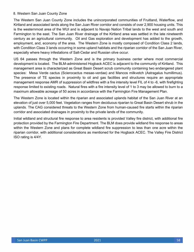
San Juan Basin CWPP 2021 58
8. Western San Juan County Zone
The Western San Juan County Zone includes the unincorporated communities of Fruitland, Waterflow, and Kirtland and associated lands along the San Juan River corridor and consists of over 2,900 housing units. This is the westernmost area of the WUI and is adjacent to Navajo Nation Tribal lands to the west and south and Farmington to the east. The San Juan River drainage of the Kirtland area was settled in the late nineteenth century as an agricultural community. Oil and Gas exploration and development has added to the growth, employment, and, economy of the area. The Western Zone is mostly composed of Condition Class 2 lands, with Condition Class 3 lands occurring in some upland habitats and the riparian corridor of the San Juan River, especially where heavy infestations of Salt-Cedar and Russian olive occur.
US 64 passes through the Western Zone and is the primary business center where most commercial development is located. The BLM-administered Hogback ACEC is adjacent to the community of Kirtland. This management area is characterized as Great Basin Desert scrub community containing two endangered plant species: Mesa Verde cactus (Scierocactus mesae-verdae) and Mancos milkvetch (Astragalus humillimus). The presence of TE species in proximity to oil and gas facilities and structures require an appropriate management response AMR of suppression of wildfires with a fire intensity level FIL of 4 to -6, with firefighting response limited to existing roads. Natural fires with a fire intensity level of 1 to 3 may be allowed to burn to a maximum allowable acreage of 50 acres in accordance with the Farmington Fire Management Plan.
The Western Zone is located within the riparian and associated uplands habitat of the San Juan River at an elevation of just over 5,000 feet. Vegetation ranges from deciduous riparian to Great Basin Desert shrub in the uplands. The CAG considered threats to the Western Zone from human-caused fire starts within the riparian corridor and associated drainages in proximity to the private lands of the community.
Initial wildland and structural fire response to area residents is provided Valley fire district, with additional fire protection provided by the Farmington Fire Department. The BLM does provide wildland fire response to areas within the Western Zone and plans for complete wildland fire suppression to less than one acre within the riparian corridor, with additional considerations as mentioned for the Hogback ACEC. The Valley Fire District ISO rating is 4/4Y.

San Juan Basin CWPP 2021 59
9. Summary of Community Assessment
The major concerns of all fire departments within the SJBCWPP are similar across the WUI:
• Hiring and retaining qualified volunteer and full-time firefighters
• Elevated response time due to availability of volunteer firefighters during daytime working hours
• Vegetative conditions and incidence of human-caused fire within heavily vegetated areas of the riparian corridors
• Expansion of current fire-department-employed wildland fire crews to fuel mitigation crews for vegetative fuel mitigation within the WUI
• Need for additional public outreach, such as fire-safe brochures, included within utility statement mailings to residents
• Coordinated community involvement, such as annual community conference on current wildfire threats, remediation, and outreach
• Annual cross-training with federal, county, and municipal fire departments for structural and wildland fire response
• Continue to improve access to the riparian corridor strategically located throughout the WUI
As previously mentioned, growth has occurred throughout the WUI and is anticipated to continue, especially outside the incorporated municipalities. This will create an increasing area in which “structures and other human development meet or intermingle with undeveloped wildland or vegetative fuel” (A Collaborative Approach for Reducing Wildland Fire Risk to Communities and the Environment: 10-Year Comprehensive Strategy Implementation Plan 2001) and an increased potential for human-caused wildland fire ignitions. As the WUI continues to grow, demands for fire response services must keep pace through aggressive firefighter recruitment efforts, as well as continual appropriate equipment supplies with additional fire stations.
Private land fuel-modification treatments are expected to increase throughout the WUI as landowners continue to introduce fire-safe conditions to their private parcels. Fuel reduction treatments are currently planned for public lands and within most communities within the river corridors. Farmington and Bloomfield have planned public development along the river corridors. The planned trail and linear parks will include outreach and education pertaining to riparian restoration, invasive-species management, and wildland fire within the riparian corridors. As private and public land fuel treatments are implemented within and adjacent to the communities, in conjunction with emergency response improvements, the risk of wildland fire spreading to or within the WUI will be reduced, and suppression will be enhanced during initial attack.
High fuel loads, along with thick riparian stands with heavy infestations of Salt Cedar and Russian olive create a higher risk of wildfire ignition in high-use areas. Historical lightning-caused fire starts in the riparian area are not infrequent; however, the greatest risk to the communities is human-caused fire ignitions within the extensive fuel loads of the riparian areas. Fire risk is increased because of south and southwest prevailing winds associated with slopes and lateral canyons.
The SJBCWPP is intended to help with community wildland fire protection by identifying, prioritizing, and recommending mitigation prescriptions for areas of high risk of wildland fire from vegetative fuels. The CAG

San Juan Basin CWPP 2021 60
recommends increased public awareness of wildland fire threat, effects of invasive-species infestations, and fire-safe private land treatments, and it also encourages business practices that provide for and conduct wildland fuels mitigation or the establishment of a fuels crew that is funded and shared by the county and municipal fire departments. Accomplishing the stated goals of the SJBCWPP will significantly increase public and firefighter safety, protect community values, improve watershed conditions, and enhance the riparian corridors within the WUI through an educated and motivated public, increased agency communication and preparedness, reduced wildland fuels, and reduced structural ignitability.
III. COMMUNITY MITIGATION PLAN
Section III prioritizes the areas in need of wildland fuel mitigation and recommends the types and methods of treatment and management necessary to mitigate the potential for catastrophic wildland fire in the WUI. Also presented in this section are the SJBCWPP communities’ recommendations for enhanced wildland fire protection capabilities; public education, information, and outreach; and support for local wood product, woody biomass, and wildland vegetative fuel management businesses and industries. A. Administrative Oversight
The CAG recognized the importance of implementing and monitoring action recommendations of the SJBCWPP. Such monitoring reports will allow San Juan County; the cities of Farmington, Bloomfield, Aztec and Kirtland; the State of New Mexico; and the BLM FFO to assess movement toward meeting community wildfire protection and watershed restoration. Status assessments, coupled with adaptive management principles for the design and direction of future wildland fire and watershed restoration programs, will allow the Cities and the County and the state, and federal agencies to continue to document achievements in meeting long-term SJBCWPP goals. Monitoring and reporting of implementation actions will allow for enhanced coordination of management programs and will reduce inconsistency among local, state, and federal agencies. Implementation of the SJBCWPP in a manner that ensures timely decision making at all levels of government and that provide for community protection and for watershed and riparian restoration is one of the highest SJBCWPP priorities. Therefore, the primary recommendation of the SJBCWPP is for the San Juan County fire chief to manage the implementation of this SJBCWPP within the areas of jurisdiction of the county fire chief and for the fire chiefs from the municipalities of Farmington, a n d Aztec to manage the implementation of the SJBCWPP within their respective jurisdictions. Collectively, the San Juan County, Farmington, a n d Aztec fire chiefs will be the administrators of the SJBCWPP and will encourage commercial and volunteer activities that promote watershed and rangeland health, reduce the risk of catastrophic wildland fire, and create the appropriate point of contact at the county and city levels for implementing the SJBCWPP. The SJBCWPP administrators should also assist federal and state agencies and private landowners in identifying appropriate grant and other funding mechanisms necessary to implement the action recommendations of the SJBCWPP. Grant information should be routinely searched for updated grant opportunities and application cycles. Homeowner educational and assistance references are included in Appendix E of this CWPP.
The SJBCWPP administrators will also be responsible for the development of community bulletins and other forms of public-service announcements informing residents of wildfire dangers and preventive
San Juan Basin CWPP 2021 61
measures. The SJBCWPP administrators will identify the responsibilities for coordinating, implementing, monitoring, and reporting the status of the current-year priority recommendations to the signatories of the SJBCWPP. Once approved by the participating government entities and fire districts, the SJBCWPP will be presented to the NMSFD and the BLM FFO manager for concurrence and, subsequently, will be submitted for funding through HFRA and other grant or funding agencies.
The CAG also recommends that the SJBCWPP administrators’ responsibilities include continued coordination with those communities outside the analysis area (La Plata and Montezuma counties in Colorado; the Navajo Nation and Rio Arriba County, New Mexico) to ensure that any planning efforts concerning watersheds in those areas address the concerns of the downstream communities in San Juan County.
B. Fuel Reduction Priorities
To prioritize treatments, the WUI has been identified, analyzed, and categorized according to potential risk from wildfire. The analyses of community values, fuel hazards, and fire history were compiled into a single map that depicts areas of low, moderate, and high risk. The risk areas were further identified and categorized into manageable, site-specific areas in the WUI, with an overall risk value determined for each area. In addition, each site-specific area in the WUI has been labeled according to the community or response zone in which the management area is located (Figure 3.1). The CAG recognizes the benefits of landscape-level treatments and suggests that they be implemented when consistent between treatment areas located within the WUI.
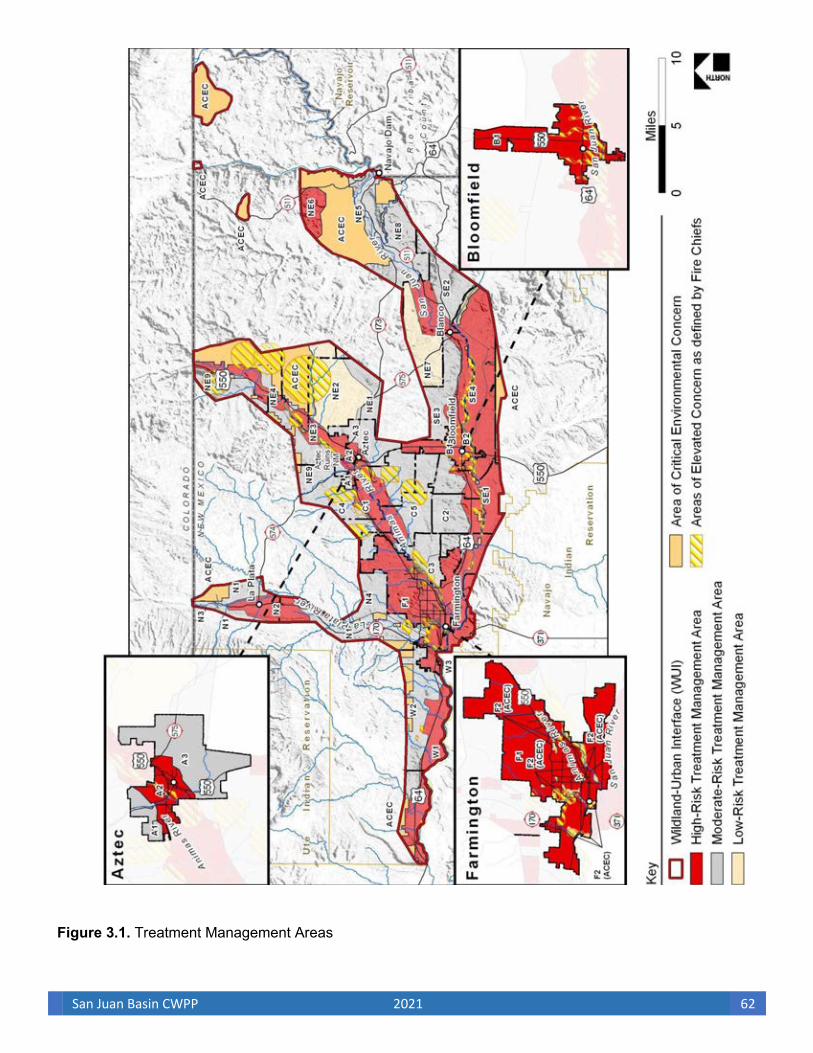
San Juan Basin CWPP 2021 62
Figure 3.1. Treatment Management Areas

San Juan Basin CWPP 2021 63
1. Recommendations for Land Treatments in the WUI to Meet Fuel Reduction or Modification Objectives
In accordance with the 2020 New Mexico Forest Action Plan, fuel reduction and modification treatments
recommended in the SJBCWPP are designed to contribute toward the restoration of the structure and
composition of riparian areas and also to enhance watershed function and protection. In addition, fuel
reduction treatments are designed to be compliant with standards and guidelines established in the Fire and
Fuels Management Plan Amendment and Environmental Assessment for Public Lands in New Mexico and
Texas and the Farmington Field Office Fire Management Plan and to complement recommendations
within the San Juan Basin Watershed Management Plan. Local resource managers will identify recommended
prescriptions for lands located in the treatment management areas shown in Figure 3.1. These treatments are
designed to meet the fuel reduction and modification objectives of the SJBCWPP.
The SJBCWPP also focuses on the treatment and thinning of small-diameter wildland vegetative fuel to
create defensible space (Photo 3.1), fuel breaks, and an acceptable condition class for community and
significant infrastructure protection; to provide safer evacuation routes for communities; and to provide
maximum firefighter and public safety through the development and implementation of a cohesive fuels
treatment and wildland fire response strategy within the WUI. The primary component of SJBCWPP land
treatments is to increase the likelihood that fire behavior will result in minimal flame lengths to maintain fire
on the ground, to reduce ignition of ladder fuels, and, in turn, to minimize fire spread and intensity. The
desired future conditions of the proposed treatment areas will enhance homeowner and firefighter safety,
allow for a higher probability of suppression during the initial attack, and reduce loss of private structures.
These treatment recommendations were also developed with consideration of wildlife biodiversity and
riparian health and restoration, as well as watershed and groundwater enhancement. The CAG recognizes
that in many cases it will be impossible to achieve the desired future conditions in a single entry. Multiple
entries for multiple treatments, including periodic Rx, may be required.
Monitoring of natural wildland fire ignitions will be applied to areas where wildland fire use (WFU) is allowed i.
Historically WFU was not used or recommended in the SJBCWPP area due to high risk to oil and gas
infrastructure. Infrastructure risks and environmental conditions will be closely monitored to determine the
feasibility of using WFU in the future for resource benefit. The CAG further recognizes that resource specialists
will conduct site-specific analysis of proposed treatment areas and identify site-specific mitigation measures
that will determine the actual footprint of fuel modification treatments across the WUI landscape. Within the
WUI, the objectives of this CWPP will be achieved primarily through thinning, piling, and burning; mechanical
and mechanical/chemical riparian treatments; and Rx under the authority of the Farmington Field Office Fire
Management Plan and the municipal and county fire departments.
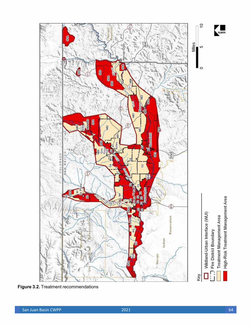
San Juan Basin CWPP 2021 64
Figure 3.2. Treatment recommendations
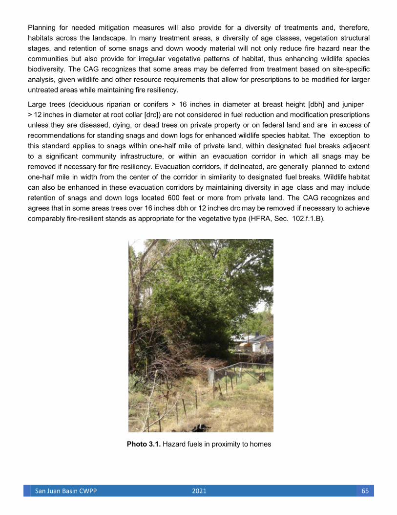
San Juan Basin CWPP 2021 65
Planning for needed mitigation measures will also provide for a diversity of treatments and, therefore, habitats across the landscape. In many treatment areas, a diversity of age classes, vegetation structural stages, and retention of some snags and down woody material will not only reduce fire hazard near the communities but also provide for irregular vegetative patterns of habitat, thus enhancing wildlife species biodiversity. The CAG recognizes that some areas may be deferred from treatment based on site-specific analysis, given wildlife and other resource requirements that allow for prescriptions to be modified for larger untreated areas while maintaining fire resiliency.
Large trees (deciduous riparian or conifers > 16 inches in diameter at breast height [dbh] and juniper > 12 inches in diameter at root collar [drc]) are not considered in fuel reduction and modification prescriptions unless they are diseased, dying, or dead trees on private property or on federal land and are in excess of recommendations for standing snags and down logs for enhanced wildlife species habitat. The exception to this standard applies to snags within one-half mile of private land, within designated fuel breaks adjacent to a significant community infrastructure, or within an evacuation corridor in which all snags may be removed if necessary for fire resiliency. Evacuation corridors, if delineated, are generally planned to extend one-half mile in width from the center of the corridor in similarity to designated fuel breaks. Wildlife habitat can also be enhanced in these evacuation corridors by maintaining diversity in age class and may include retention of snags and down logs located 600 feet or more from private land. The CAG recognizes and agrees that in some areas trees over 16 inches dbh or 12 inches drc may be removed if necessary to achieve comparably fire-resilient stands as appropriate for the vegetative type (HFRA, Sec. 102.f.1.B).
Photo 3.1. Hazard fuels in proximity to homes

San Juan Basin CWPP 2021 66
The CAG recognizes and supports the integrated approach to vegetation management and hazardous fuels treatments put forth in The New Mexico Forest and Watershed Health Plan, the 2020 New Mexico Forest Action Plan and the Farmington Field Office Fire Management Plan. The CAG also recognizes the importance of linking the small-scale urban interface treatments specific to hazardous fuels reduction landscape-level ecosystem treatments. Fuel’s mitigation projects that include areas with small-scale intensive treatments in high-risk areas can be linked to intensive treatments encompassed by larger project areas, where treatments will occur over a period of years to allow for broad-scale ecosystem restoration and landscape-level change in condition class and therefore wildfire behavior.
Wildland fuel treatments may include mechanical or hand thinning, broadcast or pile burning, chemical applications, or any combination of these treatments’ types. Broadcast Rx may be used as slash disposal, as wildland fuel maintenance, and as a habitat restoration tool where feasible and practical. Applicable BLM, New Mexico State, and local fire, fuels, and air quality standards and guidelines will be followed for fire management activities. Conservation measures as outlined in the Fire and Fuels Management Plan Amendment and Environmental Assessment for Public Lands in New Mexico and Texas will be implemented during public land treatments. In addition, best management practices and minimum impacts suppression tactics (MIST) will be implemented during fire management activities within all areas in which known federally protected species or habitats exist.
Treatment of wildland fuels within the WUI is expected to generate considerable slash and vegetative waste material. Private individual use of wood products from fuel reduction treatments within the WUI is primarily for fuel wood. Commercial use of the woody material from fuel reduction treatments is also primarily limited to fuel wood, and any commercial value of treatment by-products will not affect cost of treatments. If silvicultural prescriptions require follow-up pile burning or herbicide application after vegetation treatment, the total cost/acre treated could be as high as $5,000.00/acre on small land parcels consisting mostly of individual plant treatments within the riparian corridor (USDA FS and NMSFD 2005) and as high as $2,000.00/acre in upland areas. Average land treatment costs, considering treatment and handling of slash, is approximately $1,825.00/acre within riparian WUI vegetative types when mechanical and chemical treatments are combined for large-scale treatments.
Moreover, in most land area estimates, not all acres are involved in treatment. As mentioned previously, site-specific analysis may exclude some acres from treatment because of topography, such as slope, and resource issues, such as riparian corridors or a sensitive wildlife area. In areas in which Rx is the proposed tool for fuel management, natural barriers and other existing control features will determine treatment boundaries, leaving some acres within an analysis area untreated. Therefore, for the purpose of estimating treatment costs, the CAG used an average treatment cost/acre from New Mexico Forestry Division consisting of large-scale riparian and upland vegetation fuel modification treatments estimated at $1,998.00/acre for heavy infestations and $1,250.00 for medium infestations and $1,050.00 for light infestations of woody fuel removal, with an estimated footprint covering 80 percent of the management area proposed for fuel modification treatment.
In recent years, the number of diseased, dying, and dead large trees on public and private lands has increased primarily because of prolonged drought and insect infestations. In efforts to treat these areas, private land treatments in the WUI are typically identified on small land parcels and near power lines,

San Juan Basin CWPP 2021 67
structures, and other obstacles. In many cases, the owner of a small residential lot or the fire department will not allow cut trees and slash to be piled and burned on the property. Though in some cases, broadcast
Rx may be used for slash disposal and fuels maintenance and also as a restoration tool. This practice is only used where feasible and practical on private lands in or adjacent to communities in which the applicable fire department standards are followed. Chipping or removal and transportation of slash to a disposal site increases treatment costs but may be preferred within residential areas of the WUI. Treatments necessary to meet these recommendations on private land parcels within the WUI vary in cost from less than $200.00/acre to over $5,000.00/acre. Costs/acre will vary greatly for treatment of private parcels, depending on variables and landowner needs, including any r e - vegetation costs. Site analysis shows that land applications will be appropriate for no more than 60 percent of each acre mapped for treatment. For example, in residential areas, home sites, streets, and other improvements are included within GIS-mapped acreage estimates, but will not require treatment. The CAG decided that for the purpose of estimating private land treatment costs an average cost of $1,825.00/acre is used times .6 or $1,095.00.
The recovery cost of wood products from private parcels are comparable to that achieved with federal treatments; however, the treatment cost is much higher due to limited treatment areas, increasing personnel costs, and equipment transfer costs. Fuel mitigation treatments are also complicated by the proximity of structure and infrastructure (power lines to homes), and the cost of removing fuel from the site. Across all landscapes, the commercial uses of the woody material from fuel reduction treatments are limited and will not affect the cost of effective treatments on public or private land. Cost estimates for treatments in the WUI are based on these estimates for both federal and nonfederal land treatments. The CAG recommends that private landowners who wish to adopt fuel modification plans should have the plan prepared or certified by a professional forester, a certified arborist, or other qualified individuals. Fuel modification plans for federal and state lands within one-half mile of private land may be prepared for wildlife and watershed benefits, including the retention of large snags of high wildlife value, in areas more than 600 feet from private lands where fire resiliency is not impaired and will not compromise public or firefighter safety. A fuel modification plan must identify the actions necessary to promote forest/rangeland or wildlife/watershed health and to help prevent the spread of fire to adjacent property by establishing and maintaining defensible space. The plan should include considerations for wildlife and for surface and groundwater protection. The action identified by the fuel modification plan should be completed before development of the property or identified during project initiation on federal and state lands.
Alternate federal, state, or private land wildland fuel modification plan:
A fuel modification plan for federal and state lands will follow agency procedures, standards, and guides. Fuel modification treatment plans for private land parcels should at least include the following information:
• A copy of the site plan
• Methods and timetables for controlling, changing, or modifying fuels on the properties in a timely and effective manner
• Elements of removal of slash, snags, and vegetation that may grow into overhead electrical lines; the removal of other ground fuels, ladder fuels, and diseased, dying, and dead trees; and the thinning of live trees
• Methods and timetables for control and elimination of diseased or insect-infested vegetation
San Juan Basin CWPP 2021 68
• A plan for the ongoing maintenance of the proposed fuel reduction and control measures for disease and insect infestations
• A proposed vegetation management plan for groupings of parcels under multiple ownership accepted by all individual owners (subject to compliance with this section)
HFRA was designed to expedite administrative procedures for conducting hazardous wildland fuel reduction and restoration projects on federal lands. Regardless of priority treatments selected for federal lands, an environmental assessment must be conducted for riparian health and fuel reduction projects. Although HFRA creates a streamlined and improved process for reviewing fuel reduction and restoration treatments, it still requires that appropriate environmental assessments be conducted and that collaboration be maintained. To meet conditions established by the Healthy Forest Initiative, the USDA and USDI adopted two new categorical exclusions from the normal review steps of an environmental assessment or the issuance of an environmental impact statement. These exclusions are for hazardous fuels reductions and for rehabilitation of resources and infrastructure damaged by wildfire. For a hazardous fuels reduction project on BLM lands to be categorically excluded from documentation of the results of an environmental assessment, the project must meet specific requirements (USDA FS 2000)
• It must have less than 4,500 acres to be treated, with mechanical slash treatment restricted to no more than 1,000 acres.
• Its lands must be within current Condition Classes 2 or 3.
• It must not be in a wilderness or wilderness study area.
• It must not include use of pesticides, herbicides, or new road or infrastructure construction.
• It may include sale of vegetative products if the primary purpose is to reduce hazardous fuels.
For a project to be categorically excluded, the proposal must be satisfactorily reviewed to determine that no “extraordinary circumstances” exist (USDA FS and USDI BLM 2004). Section 104 of HFRA describes procedures for federal agencies to employ when they conclude that an environmental assessment must be prepared because of such extraordinary circumstances. When extraordinary circumstances exist, fuel reduction projects are not categorically excluded from additional environmental analysis, and such analysis must comply with all land management plan requirements. For project proposals in the WUI, the BLM is not required to analyze any alternative to the proposed action if the proposed action implements the CWPP in regard to general location and treatment methods. If the proposed action does not implement treatments or action items identified within the SJBCWPP, the analysis must consider the SJBCWPP proposal as an alternative to be analyzed in addition to the proposed action. The CAG intends the SJBCWPP proposed vegetative treatments to be consistent with and implemented on public lands simultaneously with the BLM FFO proposed action.
For these reasons, the communities in the SJBCWPP have made every effort to identify and recommend treatments that comply with The Fire and Fuels Management Plan Amendment and Environmental Assessment for Public Land in New Mexico and Texas. For example, treatments in the FFO ACEC will be achieved under current authority of the Farmington Field Office Fire Management Plan. In federal land management areas in which an environmental assessment would show that no additional documentation would be warranted, the priority areas identified for treatment in the SJBCWPP and treatments

San Juan Basin CWPP 2021 69
recommended to meet fuel reduction or modification objectives should be considered as the action alternative by the BLM FFO.
2. Watershed/Riparian Treatments
Initially, lands suitable for irrigation and crop production and with access to water promoted settlement along the major streams and rivers of San Juan County. The current condition of these same riparian areas in today’s communities and cities, have changed such that the very area that attracted early settlers is now conducive to major wildland fire. Currently, significant reaches of the San Juan River, Animas River, and La Plata River corridors are in an unhealthy condition. Many areas of these rivers are overly dense; contain near monocultures of invasive woody and herbaceous vegetation species; and provide only fragmented wildlife habitats with decreasing water supplies, accelerated erosion, and impaired water quality (Strategy for Long-Term Management of Exotic Trees in Riparian Areas for New Mexico’s Five River Systems, 2005- 2014; San Juan Basin Watershed Management Plan; and Low-Impact, Selective Herbicide Application for Control of Exotic Trees in Riparian Areas: salt cedar, Russian olive and Siberian Elm: A Preliminary Field Guide by Doug Parker and Max Williamson). Though extensive areas of unhealthy vegetation species and density occur, the overall desired future condition is one of a primarily historical, naturally functioning landscape that provides an abundance of resources and amenities. Healthy river ecosystems are the economic drivers of the SJBCWPP communities through their inherent productivity. Therefore, the CAG has developed and recommends wildland fuel treatments that complement The New Mexico Forest and Watershed Health Plan by
• promoting ecological integrity of riparian systems within the WUI;
• soliciting the experience, knowledge, and needs of all the diverse communities and their diverse values of the communities in the development of this CWPP;
• supporting economic diversity and productive riparian systems within the WUI while maintaining or enhancing social and ecological values of riparian and riverine systems.
Treatments developed and recommended to reverse the downward trend of riparian systems by the CAG are both strategic (e.g., aimed at addressing general environmental conditions such as Salt Cedar and Russian Olive control) and prescriptive (e.g., describing specific treatment methods that could be employed on both private and public lands within the WUI). Throughout the riparian corridors within the WUI, residences and associated structures can be located on several acres of agricultural or mostly undeveloped private land. The CAG recommends that landowners treat their residences to fire-safe standards. The CAG also recommends that landowners treat riparian areas within their private lands. Understory removal of invading Salt Cedar and Russian Olive, as well as limiting fine-fuel accumulation, will decrease wildfire spread and intensity and will protect riparian values during a wildfire event. The CAG recommends that limited riparian treatments, such as fuel breaks, be applied lightly with the use of hand tools and small mechanical equipment. The CAG prefers that treatment includes total slash removal rather than pile and burn to limit the spread of invasive species and the creation of intense heat spots under piles that can retard germination.
Risk to communities from catastrophic wildland fire is present not only in the riparian areas within the WUI but also in the upper watersheds. The CAG supports the recommendation of the 2020 New Mexico Forest Action Plan to “expand the focus of the planning effort to include entire watersheds, from high elevation

San Juan Basin CWPP 2021 70
forested areas to lower elevation rangeland and riparian areas.” The adverse effects of a wildland fire event in or adjacent to the watersheds within the WUI will create changes in peak flows, either by frequency or magnitude. Flood and debris flows resulting from catastrophic wildland fire in the watersheds will affect municipal watersheds and river and stream courses. Such flood and debris flows can degrade water quality and quantity, cause the release of harmful heavy metals, and create other effects from physical damage to property and habitats. The CAG recognizes the need to develop a CWPP necessary to protect and enhance the municipal watersheds. The CAG also recognizes that mitigating risk to the SJBCWPP WUI and adjacent lands must also include the application of fire-mitigating and watershed- enhancing treatments to the upper watersheds. Therefore, the CAG recommends that in addition to the SJBCWPP, a watershed health plan should be initiated to supplement the treatments identified in this CWPP. The CAG has identified and recommends that the watersheds in the WUI consisting of federal and nonfederal lands, including portions of the Upper San Juan (HUC 14080101), Blanco Canyon (HUC 14080103) Animas (HUC 14080104), Middle San Juan (HUC 14080105) and Chaco (HUC 14080106) watersheds as delineated by the United States Geologic Survey, should be included in the watershed health plan and be prioritized by current condition class and treatment status (see Figure 2.15).
3. Salt Cedar/Russian Olive
The CAG understands that exotic tree infestation is one of the most significant impediments to the long- term management of riparian corridors within the Southwest. The riparian corridors within the SJBCWPP are especially affected by Salt Cedar/Russian Olive infestation. The CAG would like to point out the elevated importance and need to treat this condition. Within the main stem of the San Juan, Animas and La Plata rivers, Salt Cedar and Russian Olive infestations continue to degrade native plant communities and are significant concerns to land managers and wildland firefighters. Salt Cedar and Russian Olive infestations reduce recreational use of parks and riparian areas for camping, hunting, fishing, and agriculture and continue to negatively affect community uses and values of the riparian corridors. Appendix F contains the CAG’s recommendations for riparian restoration and wildfire protection by management of Salt Cedar and Russian Olive.
C. Prevention and Loss Mitigation
The SJBCWPP is intended as a resource to help coordinate the long-term interagency mitigation of catastrophic wildfire events in the at-risk communities of the San Juan Basin and federal lands under the jurisdiction of the BLM FFO. The communities in the SJBCWPP area have agreed on 10 primary goals of the SJBCWPP (see Section I.F.) The SJBCWPP should be reviewed and updated as needed. Successful implementation of this plan will require a collaborative process among multiple layers of government, as well as a broad range of special-interest groups. Communities in the SJBCWPP area have established the following action recommendations:
1. Improved Protection Capability and Reduction in Structural Ignitability
The communities take the risks of wildland fire igniting and spreading in the WUI seriously. The performance of municipal fire departments, the BLM FFO, and the San Juan County Fire Department can be leveraged through combined responses. In the wake of a large fire or in the case of multiple fires; however, it may not be possible to protect every home and structure in the WUI. Community leaders as well as private

San Juan Basin CWPP 2021 71
landowners must take actions to reduce fire risks and promote effective responses to wildland fires. The following are recommendations to enhance protection capabilities in the SJBCWPP communities:
a. All communities: Recruit, train, and retain 100 volunteer firefighters for the San Juan County Fire Department. This would be accomplished by using all media avenues (announcements in the local Allen Theaters, newspaper, Web sites, brochures, civic group presentations, and other promotional opportunities). This includes aggressive marketing for the development of the wildfire team. It is recommended that the new-member orientation and academy process be reviewed and enhanced to allow for completion of initial orientation and the basic academy within 18 months, under the supervision of the County Fire Department training coordinator.
b. Specific to Bloomfield: The Fire Department shall strive to recruit, train, and retain additional volunteer firefighters. Furthermore, they shall hire and train sufficient career personnel to staff engine company and other companies as may be required according to National Fire Protection Association 1720, 24 hours per day 7 days a week. Recruitment will follow current practices and shall include recruitment posters/calendars, Web sites, brochures, civic presentations, and other means to meet the staffing need of the department. All training will be in accordance with nationally recognized standards.
c. All communities: Provide for additional comprehensive and frequent training for firefighters. Training should be jointly conducted by the BLM FFO, San Juan County, and the municipal fire departments. Training will focus on firefighters achieving Firefighter I status. In addition, two academies focusing on hazardous materials, basic EMS, and basic wildland fire should be conducted annually. To implement this action recommendation, a cadre of qualified instructors, training materials, and equipment must be developed and maintained.
d. All communities: Conduct a yearly, preseason wildfire-readiness training activity, organized in the region, before entry into the fire season for the purpose of emphasizing tactics of WUI suppression and interagency coordination. Communities should support San Juan College’s training programs, such as Fire Science and Emergency Medical Technology. Continual WUI fire suppression training must be made available to volunteer and full-time firefighters in each fire department.
e. All communities: Expand the role of the wildfire teams through fuels reduction grant programs, to include wildland fuels thinning and management. The wildfire teams would be composed of trained firefighters from the San Juan County Fire Department and Farmington Fire Department. The wildfire team would be contracted to conduct wildland fuel mitigation projects on private and public lands outside the high fire-danger season. The wildfire team would also coordinate with and promote wildland fire safety outreach programs and other private land enhancement programs, such as those funded through the Soil and Water Conservation District. The wildfire team would be shared by the county and municipal fire departments to address wildland fuel mitigation projects as prioritized by county and municipal fire chiefs as funding is available.
f. All communities: Continue and further develop an appropriate incentive system for volunteer firefighters based on performance and qualifications. Such incentives may include additional training for Firefighter II status and attendance at regional- and national-level wildland fire conferences funded by the San Juan County Fire Department. In addition, an annual ceremony shall continue to be conducted to recognize outstanding individual and team service to the community.
g. All communities: Implement and monitor the newly adopted International Fire Code and provide data to Farmington, Bloomfield, Aztec, and San Juan County for use in the adoption of an Urban-Wildland Interface Code or Fire Prevention Code. Such codes would describe specific land standards that apply to vegetation and would describe which conditions are acceptable. These codes would also depend on housing density and

San Juan Basin CWPP 2021 72
community values at-risk within the WUI, such as watersheds, archaeological resources, recreational resources, wildlife, grazing, and other resources. Local land use policies could include incentives for private landowners to address defensible space and fuels management on their properties and to implement fire-sensitive land use planning and subdivision requirements. In addition, Farmington, Bloomfield, Aztec, and San Juan County propose to develop and refine jurisdictional agreements needed for seamless land treatment policies; the development of ordinances and codes designed to reduce ignitability for both structural and wildland points of ignition; and the application and administration of grants and programs needed for the oversight, management, and implementation of the SJBCWPP. Decision making will also include development of systems needed for evacuation, specific exigent circumstances mitigation, and firefighting resource distribution.
h. All communities: The fire departments recommend adoption of a consistent preparedness planning model—one that analyzes cost-effective fire protection within all administrative boundaries, such as the Risk Assessment and Mitigation Strategies (RAMS) or any subsequent models from the National Interagency Fire Center Wildland Fire Management Information (www.nifc.blm.gov). The preparedness model will include mutual aid agreements between federal, state, and municipal fire response agencies. In developing this model, county and local protection needs and resources must be considered. The model must produce refined, common references and coordinated suppression efforts among the county and municipal fire departments, NMSFD, and the BLM FFO.
i. All communities: The CAG recommends that fire departments continue to map specific areas of elevated risk within their jurisdictions (see Appendix D). These maps would depict resource needs and specific firefighting descriptions that narrowly focus on suppressing fires occurring in high-risk areas. For example, within a specific neighborhood, some residents with special needs might be identified (e.g., nursing-home residents or campsite visitors) who would require specialized personnel to be notified during evacuations. Other specialized situations would be a propane distribution center within the high-risk area, inadequate or limited access areas, or a limited firefighting water source requiring the use of specialized equipment. Furthermore, specific subdivisions that currently have only one-way ingress/egress routes would also need to be evaluated for evacuation and fire response.
j. All communities: Communities will incorporate trails, recreational areas, and facilities into fire protection and response plans.
k. All communities: Continue to explore the construction and availability of water systems for fire suppression.
l. All communities: The County and Cities and state, and federal agencies will investigate ways to improve communication to residents of the county. This may include enhanced radio, telephone, and Internet communications to residents and the development and implementation of emergency notification and evacuation systems. The CAG also recommends the development of a communication center for enhanced notification and coordination of emergency response to catastrophic wildland fire.
m. All communities: Complete the multi-hazard mitigation plan for remote at-risk private lands, including removing and maintaining hazardous fuels and identifying and obtaining GIS coordinates for additional safety zones and heli-spots, including lighted areas for emergency medical services night landings.
n. All communities: The CAG further recommends that basic wildland firefighter equipment be acquired and distributed to fire department personnel sufficient to meet the recruiting goals of each district.
2. Promote Community Involvement and Improved Public Education, Information, and Outreach
The County and communities in the SJBCWPP will continue to implement public outreach programs to help

San Juan Basin CWPP 2021 73
create an informed and motivated citizenry. The goal is to have residents support concepts of fire-safe landscaping and naturally functioning riparian systems through restoration management and rapid response to wildland fire. The SJBCWPP is intended to be a long-term strategic instrument containing prescriptive recommendations to address hazardous wildland fuels and to enhance riparian and rangeland health. To effectively achieve these goals, a grassroots collaborative structure of individual citizens, supported by local governments as full partners, will provide the most effective long-term means to maintain community momentum. The components of such a structure include the following recommendations:
a. Expand the use of current public information tools for fire-safe residential treatments as an immediate action step. This will be accomplished through information mailers to homeowners, presentations by local fire departments, and development of specific promotional materials. The SJBCWPP administrators will coordinate outreach throughout the WUI with state and federal cooperators with each community assuming a lead role in Firewise community outreach programs and utilizing the Ready, Set, Go program.
Community bulletins for specific county residential areas and other public service announcements concerning wildfire threat and preparedness should be developed.
b. Fire department personnel will make information readily available through social media.
c. Continue to conduct an open-house approach to community education by conducting tours of both residences that are fire-safe and of federal lands in the WUI that have been treated to meet Condition Class 1 standards.
d. The municipal fire departments and the county fire department will each schedule a series of three community awareness seminars to inform and educate the citizenry regarding the need for fire-safe treatments to public and private lands. These seminars will be scheduled annually to best accommodate year-round and part-time residents.
e. Fire department personnel will act as goodwill ambassadors by passing on wildland fire and residential preparedness information at community activities and events. Information will be made available in both printed and oral formats to explain the need for fire awareness and the benefits of preparing private property for potential fire ignition.
3. Enhance Local Wood-Products Industries
The SJBCWPP communities will continue to support and promote private contractors who perform fire-safe mitigation and fuel extraction work. The communities will support new businesses or expansion of existing businesses involved in the fuel reduction market. The communities are committed to employing all appropriate means to stimulate local small businesses that will utilize all size classes of wood products resulting from hazardous-fuel reduction activities. Recommendations include the following:
a. Support and promote landscape contractors that treat private land parcels.
b. Support the development of markets and industries that extract salable material from fuel reduction management projects (e.g., biomass, pulpwood, firewood, fuel pellets).
c. Support and promote local college programs designed to help businesses develop sound wildland fuel mitigation practices and a diversity of skills and abilities. The SJBCWPP communities would like to support a trained and ready workforce for wildland-fuel-related industries. The communities hope to maintain a private work force and support the local small businesses necessary to complete fuel reduction treatments within the analysis area.
San Juan Basin CWPP 2021 74
IV. CWPP PRIORITIES: ACTION RECOMMENDATIONS AND IMPLEMENTATION
The SJBCWPP communities have developed a community mitigation plan (Section III) necessary to meet the goals of the SJBCWPP. A precise set of land-management prescriptions has been adopted for fuel reduction treatments and restoration of riparian and rangeland health on federal and nonfederal lands. A series of recommendations that will reduce structural ignitability and improve fire prevention and suppression have been developed. The SJBCWPP communities want to support and enhance the local wood-products industries and would like to see additional local wildland fuel mitigation contractors within San Juan County. The SJBCWPP must be implemented to ensure (1) that action is taken on the highest- priority recommendations and (2) that communities can handle the logistical demands of meeting the goals of each recommendation. The SJBCWPP communities recognize the WUI as a wildfire management zone that must be managed through public acceptance based on the best science to promote quality of life for residents and visitors and to reduce the threat of catastrophic wildland fire. Moreover, there must be accountability for measuring and monitoring the performance and outcomes of each action recommendation. In response to monitoring the implementation of each action recommendation in the WUI.
To implement SJBCWPP objectives beginning in fiscal year 2021-2022, the CAG developed and prioritized the following action recommendations. At the end of each fiscal year, projects initiated or completed as outlined within these action recommendations will be monitored for effectiveness of meeting SJBCWPP community mitigation plan objectives. For the life of the SJBCWPP, recommendations for additional projects or completion of ongoing projects will be made for each fiscal year on the basis of project performance in the preceding fiscal year.
A. Administrative Oversight
As stated previously, the communities concur that the most efficient way of implementing the action recommendations of the SJBCWPP is through the delegation of accountability to county and municipal fire chiefs as the administrators of the SJBCWPP. Establishing a unified effort to collaboratively implement the SJBCWPP embraces adaptive management principles that enhance decision making at all levels of government. Therefore, assigning the oversight and responsibility of implementing this CWPP to the San Juan County, Farmington, and Aztec fire chiefs is the primary action recommendation of the SJBCWPP communities. The SJBCWPP administrators will be the point of contact at the municipal and county levels for implementing the SJBCWPP. To meet funding needs and identify possible funding sources, the SJBCWPP administrators will assist federal and state agencies and private landowners in identifying appropriate grant and other funding mechanisms necessary to implement the action recommendations of the SJBCWPP. Grant information from federal, state, and nongovernmental sources should be routinely searched for updated grant application cycles (see Appendix E).
B. Community Priorities for Reduction of Hazardous Fuels
The priority treatment areas and projects recommended by the CAG will decrease hazardous vegetative fuels and thereby reduce wildfire spread and intensity, which, in turn, will reduce the potential impact of wildland fire on the communities and surrounding BLM lands. The recommended projects have high
San Juan Basin CWPP 2021 75
valuations for reducing wildfire risk within riparian and adjacent upland habitats. The identified treatment areas will create fuel breaks adjacent to private property boundaries in the riparian areas. These fuel breaks are necessary to limit wildfire spread and to provide a safe area for back burning by fire management staff. Fuel break locations will be designed to protect private land from rapid-fire spread. Installation of fuel breaks allow for additional response time to help alleviate the lack of timely response from organized wildfire suppression resources. Successfully installed fuel breaks will help preserve riparian values by minimizing habitat component loss.
C. Community Priorities for Reducing Structural Ignitability
The SJBCWPP communities will evaluate, maintain and, where necessary, upgrade community wildfire preparation and response facilities, capabilities, and equipment. The CAG also recommends that San Juan County initiate a dialogue with the BLM for programmatic consultation to implement fuel reduction treatments in areas of high wildland fire risk from thick stands of Salt Cedar and Russian Olive. As previously listed the priority action recommendations to be implemented beginning in fiscal year 2021-2022 that are applicable to all of San Juan County.
D. Priorities for Promoting Community Involvement through Education, Information and Outreach
The SJBCWPP communities will implement public outreach and education programs, for residents and community visitors alike, to heighten awareness and understanding of the threats and other issues that wildland fire and invasive riparian species pose to San Juan County. The members of the CAG support public education of wildland fire danger and preparedness in the SJBCWPP through programs such as Ready, Set, Go program, Fire Science, Defensible Landscaping, Firewise, along with educational information in workshops that focus on Invasive Species, Forest and Riparian Health.
E. Priorities for Enhancing Local Wood-Products Industries
The SJBCWPP communities will continue to support and promote private contractors who perform fire-safe mitigation work (e.g., fuel hazards reduction). The communities will also support and seek opportunities for local contractors to start new businesses or to expand existing businesses in the fire prevention/fuels reduction arena as well as for the use of vegetative material removed during wildland fuel mitigation projects. The development of local businesses to support harvesting, transporting, or processing of woody by-products from wildland fuel mitigation projects is consistent with the goals of the SJBCWPP:
• Support and assist development of biomass opportunities in San Juan County • Support and assist development of transportation of woody by-products from fuels mitigation
products to end users in San Juan County or neighboring New Mexico and Colorado counties • Coordinate and cooperate with neighboring Navajo Nation in the development of a local small-
wood-products market

San Juan Basin CWPP 2021 76
F. Performance Measurements Update for 2020
Fire Prevention and Suppression
Recruitment
The San Juan County Fire Department unitizes various forms of media for the purpose of recruitment of volunteers. While our current volunteers have always been our greatest recruitment tool we also utilize career expos, highway billboards, move theater ads, community outreach, and the San Juan County Fair. Since 2007 515 new firefighters have been recruited by San Juan County Fire Department.
Recruit Training
The San Juan County Fire Department conducts two fire academy’s each year in cooperation with San Juan Community College. Every new firefighter receives International Fire Service Accreditation Congress (IFSAC) Firefighter 1, IFSAC HAZ-MAT Operations, National Wildfire Coordination Group (NWCG) S-130/S-190, L-180, I-100 and Firefighter Emergency Care certification upon graduation. After graduation every firefighter receives continuing education in all disciplines at the district level, including advanced Wildland Fire Training.
Wildland Training
Wildland fire training is conducted in the spring (preseason) and in the fall after fire season has come to end. Training is conducted jointly amongst New Mexico State Forestry, San Juan County Fire Department, Bloomfield Fire Department, Farmington Fire Department, BLM Farmington Field Office, and the US Forest Service. These agencies all contribute to hosting classes, training materials and instructors. By providing quality training locally, departments can reduce the need to send members to training that requires travel to outside areas.
Retention
In 2005 an incentive program was initiated by San Juan County Fire Department as a way to reimburse volunteers for fuel and other costs associated with running calls. The incentive program was a nominal fee-based program where a $5.00 fee was paid for every call and other eligible activities that a volunteer responds on. In 2010 the fee was increased to $10.00. The funds for the nominal fees are generated by the San Juan County Fire Department Wildland Team’s RMP resources being deployed on national fire assignments.
San Juan County Fire Department Wildland Team
San Juan County Fire Department cooperates with New Mexico State Forestry on providing resources to the Resource Mobilization Plan. San Juan County has two Type III Engines and a Fuel Tender dedicated to off district response and can also staff additional apparatus if needed. Members of the San Juan County Wildland Team are county volunteers who staff apparatus on a call when needed basis. The members of the team all receive annual wildland refresher training, and complete the work capacity test to the arduous level. Team members can and have been used to burn piles from fuels mitigation projects. The team maintains an average roster of 15 team members. Wildland Team members receive advanced training in the areas of firing operations, felling operations, WUI Triage, and fuels reductions.
Emergency Response Plan
In 2008 San Juan County in cooperation with City of Farmington, City of Aztec, and the City of Bloomfield developed and put into operation the San Juan County Emergency Response Plan. This plan is an all-hazard plan and serves as an overview of the jurisdictions approach to Emergency Management. This plan will be
San Juan Basin CWPP 2021 77
revised in 2014.
This plan outline actions to be taken by local government officials and cooperating private or volunteer organizations to:
1) Prevent avoidable disasters and reduce the vulnerability of San Juan County residents to any disasters that may strike;
2) Establish capabilities for protecting citizens from the effects of disasters;
3) Respond effectively to the actual occurrence of disasters; and
4) Provide for recovery in the aftermath of any emergency involving extensive damage within the county.
B. It is NOT the intent of the plan to attempt to deal with those events that happen on a daily basis, which do not cause widespread problems and are handled routinely by the city and/or county agencies. It will however, attempt to deal with those occurrences such as tornadoes, hazardous materials incidents, etc., which create needs and cause suffering that the victims cannot alleviate without assistance, and requires an extraordinary commitment of government resources.
C. The plan follows the principles and processes outlined in the National Incident Management System (NIMS). As a result, this plan institutionalizes the concepts and principles of the NIMS and the Incident Command System (ICS) into the response and recovery operations conducted within San Juan County.
D. The City of Farmington, City of Aztec, City of Bloomfield, and San Juan County have adopted the National Incident Management System as the jurisdictions’ All-Hazard Incident Management System. The NIMS will be implemented through the New Mexico Incident Management System curriculum.
E. The NIMS provides a consistent, flexible, and adjustable national framework within which government and private entities at all levels can work together to manage domestic incidents, regardless of their cause, size, location, or complexity. This flexibility applies across all phases of incident management: prevention, preparedness, response, recovery, and mitigation.
F. The San Juan County EOP was developed through the efforts of the San Juan County Emergency Manager. During the development various agencies, organizations, county, and city governments were interviewed to discuss their roles, responsibilities, and capabilities in an emergency. This plan is a result of their input.
G. The San Juan County EOP is an all-hazard, functional plan, broken into three components: (1) a basic plan that serves as an overview of the jurisdictions’ approach to emergency management, (2) annexes that address specific activities critical to emergency response and recovery, and (3) appendices which support each annex and contain technical information, details, and methods for use in emergency operations.
H. The Basic Plan is to be used primarily by the chief executive and public policy officials of a jurisdiction but all individuals / agencies involved in the EOP should be familiar with it. The annexes and appendices are to be used by the Emergency Operations Center Coordinators. The contents of this plan must be understood by those who will implement it or it will not be effective.
I. Each organization / agency with an assigned task in this plan will be responsible for preparing and maintaining current SOG’s, resource lists, and checklists required to support operations. Plan development and maintenance will be done under the direction of the San Juan County Emergency Manager.
San Juan Basin CWPP 2021 78
Community Involvement
The San Juan County Fire Department is committed to educating the public on fire and injury prevention. SJCFD has used several methods to get this life saving information out to the citizens of San Juan County.
San Juan County Fair
The SJCFR has a booth set up every year at the San Juan County Fair. During the fair, firefighters and administrative staff educate everyone from young children to senior citizens about the importance of fire safety, fire safe communities, home ignition zones, smoke detectors, EDITH, and more. While working the booth, personnel also provide EMS support.
One day at the fair is set aside as Public Service Day. This day is used by all facets of Public Service to include fire, law enforcement, fish and game, etc. Children and adults alike learn about fire safety, home protection, safety in the wilderness and much more. It's a fun filled day for all.
Special Request
The SJCFR also provides training/public education per special requests. These sessions consist of the proper use of fire extinguishers, proper placement of smoke and carbon monoxide detectors; triage training for school bus drivers, courtesy home inspections, assisting local industry in the development of emergency action plans, and are available to provide home assessments for hazard fuels reduction.
Fireworks Patrol
Due to the overwhelming number of fireworks complaints received during the duration of firework sales, the San Juan County Fire & Rescue assists local law enforcement in handling the large call volume. Our intention is to free local law enforcement for priority calls while we handle the basic firework complaints, and minimize potential fires being started by fireworks being lit in heavy vegetated areas. Fireworks patrol starts July 1st and ends July 4th. During the 2020 fireworks season we worked approximately 56 hours for a total labor cost of $1,000.00. For the 2013 season we responded to approximately 105 fireworks complaint calls with an average of six calls per shift. San Juan County Fire Department strictly enforces the New Mexico State Statutes and San Juan County Ordinance 15 in regards to the possession and use of fireworks.
Fire Prevention
San Juan County has adopted and enforces both the International Building Code 2015 and the International Fire Code 2015. Fire sprinkler systems must also comply with NFPA 13 and 13R. Fire alarm systems are required to comply with NFPA 72. Updates to the International Fire Code will be completed in 2014.
G. San Juan Fire Break Project The San Juan Firebreak Project was initiated in 2007 with monies from two different sources. The first was a $360,000.00 Collaborative Forestry Restoration Program grant at Shiprock along the San Juan River where over 252 acres of Russian olive and salt cedar were removed for wildfire protection. The second source of funding was appropriated to San Juan County by the State Legislature for non-native phreatophyte control. These funds were marked by the Governor as reoccurring funding for San Juan

San Juan Basin CWPP 2021 79
County. Since 2007, there have been over $10,000,000 put on the ground to remove Russian olive and salt cedar along the San Juan, Animas and La Plata Rivers with these monies. In 2009 a Joint Powers of Agreement was reached between New Mexico Forestry Division and the San Juan Soil and Water Conservation District. Funds have been in the way of grants which include non-federal land grants, ARRA (American Recovery and Reinvestment Act) monies, Wildland Urban Interface (Western Region) funds and Severance Tax monies from the State. The San Juan Firebreak Project is a partnership between San Juan County, San Juan Soil and Water Conservation District, San Juan County Fire Department, the Farmington, Bloomfield, and Aztec Fire Departments and New Mexico Forestry Division. The goal of the San Juan Firebreak Project is multifaceted and includes the following: 1. Identify high risk fire areas along the San Juan, Animas and La Plata Rivers. 2. Remove heavy infestations of Russian olive and salt cedar from these areas. 3. Allow breaks along the river corridor in order to stop fires from spreading. 4. Allow access to the river in order for firefighters to take a stand in fighting fires along the river. The most recent invasive weed survey identified over 47,000 acres of Russian olive and salt cedar in the County with over 90% of these infestations being along or adjacent to the three river system. The majority of the housing structures in San Juan County are located within a mile of either side of the San Juan, Animas and La Plata River. Project Procedure: 1. The San Juan Soil Water Conservation District accepts requests for assistance from private land
owners, city governments and State Land managers on a yearlong basis. 2. Once an application is received it is reviewed and the property visited by the Soil and Water Weed
Coordinator. 3. Priorities are given to properties that have been identified by the various fire departments as high risk
and where fires have continually been a problem in these areas. 4. When monies become available for removal then the priority properties have removal done.
The Soil and Water Conservation District has and continues to put out RFP’s for contractors to perform work as directed. At the present time four contractors are under contract with the District. The project is coordinated by the Soil and Water Conservation Weed Coordinator who works with the contractors, land managers, fire departments and the New Mexico Forestry Division Chama District to fulfill work outlined in the RFP’s. Capacity building by contractors is ongoing and is encouraged by the district to more efficiently do the work at hand. Contractors are continually upgrading equipment and buying larger more effective machines to do the removal process. The removal process is through mastication by large machinery with mulching heads and/or chainsaw crews. The mastication process grinds up the trees and debris is to be no more than 6 inches deep in any one area. Where chainsaw crews are used, trees are cut, de-limbed, and trunks are cut up into 4 foot lengths and stacked for fuel wood use. Slash is then chipped and spread. Within 15 minutes of mulching or cutting the stumps are treated with Imazapyr herbicide at a rate of 12 oz. per gallon of water solution to help prevent re-sprouts. In order to keep the area clear of Russian olive and salt cedar, re-sprouts are treated with a 1% solution of Imazapyr for two years after removal. The land manager or property owner signs a contract to maintain the area for at least ten years after removal.

San Juan Basin CWPP 2021 80
V. MONITORING PLAN
Monitoring is essential to ensure that SJBCWPP goals are met. The fire chiefs of Farmington, Bloomfield, Aztec, and San Juan County will actively monitor the progress of the SJBCWPP community’s action recommendations to determine the effectiveness of ongoing and completed projects in meeting SJBCWPP objectives and to recommend future projects necessary to meet SJBCWPP goals.
In accordance with Section 102.g.5 of HFRA, the SJBCWPP communities will participate in any multi-party monitoring programs established by any interested parties, to assess progress toward meeting SJBCWPP objectives. The authority to participate in multiparty monitoring will be vested in the San Juan County, Farmington, Bloomfield, and Aztec fire chiefs, as the administrators responsible for implementing and monitoring the SJBCWPP. The SJBCWPP communities believe that participation in multiparty monitoring will provide effective and meaningful ecological and socioeconomic feedback on landscape and site-specific fuel reduction projects and watershed enhancements.
This section details the performance measures that will be used to assess the effectiveness of SJBCWPP projects. Monitoring will include assessing and evaluating the success of an individual SJBCWPP project’s implementation and of a given project’s effectiveness in furthering SJBCWPP objectives.
A. Administrative Oversight, Monitoring, and SJBCWPP Reporting
The SJBCWPP administrators will be mutually responsible for implementing and monitoring the SJBCWPP action recommendations. The SJBCWPP administrators should also assist federal and state agencies and private landowners in identifying appropriate grant and other funding mechanisms necessary to implement the action recommendations of the SJBCWPP. Grant information should be routinely searched to identify updated grant application cycles. In addition to Appendix E, the following is a list of federal, state, and nongovernmental Web sites that can be monitored to obtain updated grant application cycle information:
Federal • www.fs.fed.us/r3 • www.fs.fed.us/r3/partnerships • www.fireplan.gov • www.nm.nrcs.usda.gov • www.nm.blm.gov
State • www.emnrd.state.nm.us • www.nmstatelands.org • www.wildlife.state.nm.us
Nongovernmental • www.iwjv.org • www.sonoran.org

San Juan Basin CWPP 2021 81
VI. DECLARATION OF AGREEMENT AND CONCURRENCE The following partners in the development of this Community Wildfire Protection Plan have reviewed and do mutually agree or concur with its contents:
AGREEMENT
John Beckstead Date San Juan County Board of County Commissioners
John Mohler Date Chief, San Juan County/Bloomfield Fire Department
Cynthia Atencio Date Mayor, City of Bloomfield
Victor Snover Date Mayor, City of Aztec
Kevin Simpson Date Chief, Aztec Municipal Fire Department
Nate Duckett Date Mayor, City of Farmington
Robert Sterrett Date Acting Chief, Farmington Municipal Fire Department
John Arrington Date San Juan Soil and Water Conservation District

San Juan Basin CWPP 2021 82
CONCURRENCE
Mary Stuever Date Chama District Forester
Al Elsner Date Bureau of Land Management, Farmington Field Office
San Juan Basin CWPP 2021 83
VII. REFERENCES
Anderson, H. E. 1982. Aids to Determining Fuel Models for Estimating Fire Behavior. INT-122. National Wildlife Coordinating Group, Washington, DC.
City of Aztec. 2002. 2002 Comprehensive Plan,
www.aztecnm.com/government/planning/comprehensive/cp_01.htm.
A Collaborative Approach for Reducing Wildland Fire Risks to the Communities and the Environment: 10- Year Comprehensive Strategy Implementation Plan. 2001. http://www.fireplan.gov/reports/11-23- en.pdf.
Communities Committee of the Seventh American Forest Congress, Society of American Foresters, the
National Association of State Foresters (NASF), the National Association of Counties, and the Western Governors Association (WGA), 2004. Preparing a Community Wildfire Protection Plan: A Handbook for Wildland-Urban Interface Communities.
Federal Register. 2001a. Vol. 66, no. 3, pp. 751–777. January 4.
Federal Register. 2001b. Vol. 66, no. 160, pp. 43383-43435. August 17.
Fire Regime Condition Class (FRCC) Interagency Working Group. 2003. Fire Regime Condition Class
Definition, http://www.frcc.gov/docs/FrccDefinitionsFinal.pdf, accessed April 13, 2004.
Fire Regime Condition Class (FRCC) Interagency Working Group. 2005a. Fire Regime Condition Class (FRCC) Interagency Handbook Reference Conditions. Fire Regime Condition Class (FRCC) Potential Natural Vegetation Group (BpS) Descriptions, http://www.frcc.gov/pnvgSummaries.html.
Fire Regime Condition Class (FRCC) Interagency Working Group. 2005b. Interagency Fire Regime Condition
Class Guidebook. Fire Regime Condition Class Version 1.2, http://www.frcc.gov/docs/1.2.2.2/Complete_Guidebook_V1.2.pdf.
Howard, J. L. 2004. Ailanthus altissima. In Fire Effects Information System, US Department of Agriculture,
Forest Service, Rocky Mountain Research Station, Fire Sciences Laboratory (Producer). http://www.fs.fed.us/database/feis/, accessed April 13, 2004.
Montezuma County Community Fire Plan. 2002. Montezuma County, New Mexico. (revised June 15,
2002).
National Association of State Foresters. 2003. Field Guidance: Identifying and Prioritizing Communities At Risk, http://www.stateforesters.org/reports/COMMUNITIESATRISKFG.pdf.
National Fire Plan La Plata County Community Fire Plan. 2002. Prepared by the Office of Community
Services Fort Lewis College. New Mexico Energy, Minerals and Natural Resources Department, Forestry Division. 2020. 2020 New Mexico
Forest Action Plan: A Collaborative Approach to Landscape Resilience. New Mexico Energy, Minerals and Natural Resources Department, Forestry Division. Santa Fe, NM.
New Mexico Energy, Minerals and Natural Resources Department, Forestry Division. 2005a. 2005 New
Mexico Communities At Risk Assessment Plan.
New Mexico Energy, Minerals and Natural Resources Department, State Forestry Division. 2005b. New Mexico Fire Plan: Hazard Mitigation and Wildland/Land Urban Interface Grants for Private
San Juan Basin CWPP 2021 84
Landowners. April 4.
New Mexico Forest and Watershed Health Planning Committee. 2004. The New Mexico Forest and Watershed Health Plan: An Integrated Collaborative Approach to Ecological Restoration.
San Juan County Interagency Operating Agreement. 2005.
San Juan County Operating Plan. 2005.
San Juan County Strategic Plan. 2005. “Fire Operations Division: Fire Operations–Community
Development.”
San Juan County Watershed Group. 2005. San Juan Basin Watershed Management Plan.
Schmidt, K. M., J. P. Menakis, C. C. Hardy, W. J. Hann, and D. L. Bunnell. 2002. Development of Coarse- Scale Spatial Data for Wildland Fire and Fuel Management. RMRS-87. USDA Forest Service, Washington, DC.
US Department of Agriculture, Forest Service. 2000. USDA Forest Service Handbook 1909. Washington
DC.
US Department of Agriculture, Forest Service, and New Mexico Energy, Minerals and Natural Resources Department, State Forestry Division. 2005. Strategy for Long-Term Management of Exotic Trees in Riparian Areas for New Mexico’s Five River Systems, 2005-2014.
US Department of Agriculture, Forest Service, Southwest Region. 2003. Low-Impact, Selective Herbicide
Application for Exotic Trees in Riparian Areas: Saltcedar, Russian Olive and Siberian Elm; A Preliminary Field Guide by Doug Parker and Max Williamson.
US Department of Agriculture, Forest Service, and US Department of Interior, Bureau of Land
Management. 2004. The Healthy Forests Initiative and Healthy Forests Restoration Act: Interim Field Guide. FS-799. Washington, DC.
US Department of the Interior, Bureau of Land Management. 2003. Farmington Resource Management
Plan with Record of Decision. Farmington Field Office.
US Department of the Interior, Bureau of Land Management. 2004a. Fire and Fuels Management Plan Amendment and Environmental Assessment for Public Lands in New Mexico and Texas. BLM-NM-Pl- 008-2824.
US Department of the Interior, Bureau of Land Management. 2020. Farmington District Fire Management
Plan.
US Department of the Interior, Bureau of Land Management. 2004c. Farmington Field Office Resource Management Plan.
US Department of the Interior, Bureau of Land Management. 2004d. Wildland Fire Suppression (Including
Wildland Fire Use) and Rehabilitation in Riparian and Aquatic Habitats (RA).
US Department of the Interior and US Department of Agriculture, Forest Service. 2006. Protecting People and Natural Resources: A Cohesive Fuels Treatment Strategy.
US Department of the Interior, US Department of Agriculture, et al. 2001. Review and Update of the 1995
Federal Wildland Fire Management Policy.

San Juan Basin CWPP 2021 85
US Department of the Interior, US Department of Agriculture, et al. 2005. Wildland Fire Use Implementation Procedures Reference Guide.
Zouhar, K. 2003 Tamarix spp. In Fire Effects Information System (online). USDA Forest Service, Rocky
Mountain Research Station, Fire Sciences Laboratory, http://www.fs.fed.us/database/feis/.
San Juan Basin CWPP 2021 86
VIII. GLOSSARY OF FIRE MANAGEMENT TERMS
A
Aerial Fuels: All live and dead vegetation in the forest canopy or above surface fuels, including tree branches, twigs and cones, snags, moss, and high brush.
Aerial Ignition: Ignition of fuels by dropping incendiary devices or materials from aircraft.
Air Tanker: A fixed-wing aircraft equipped to drop fire retardants or suppressants.
Agency: Any federal, state, county, or city government organization participating with jurisdictional responsibilities.
Anchor Point: An advantageous location, usually a barrier to fire spread, from which to start building a fire line. An anchor point is used to reduce the chance of firefighters being flanked by fire.
Appropriate Tools: Methods for reducing hazardous fuels including prescribed fire, wildland fire use, and various mechanical methods such as crushing, tractor and hand piling, thinning (to produce commercial or pre-commercial products), and pruning. They are selected on a site-specific case and are ecologically appropriate and cost effective.
Aramid: The generic name for a high-strength, flame-resistant synthetic fabric used in the shirts and jeans of firefighters. Nomex, a brand name for aramid fabric, is the term commonly used by firefighters.
Aspect: Direction toward which a slope faces.
B
Backfire: A fire set along the inner edge of a fireline to consume the fuel in the path of a wildfire and/or change the direction of force of the fire’s convection column.
Backpack Pump: A portable sprayer with hand-pump, fed from a liquid-filled container fitted with straps, used mainly in fire and pest control. (see Bladder Bag)
Bambi Bucket: A collapsible bucket slung below a helicopter. Used to dip water from a variety of sources for fire suppression.
Behave: A system of interactive computer programs for modeling fuel and fire behavior that consists of two systems: BURN and FUEL.
Bladder Bag: A collapsible backpack portable sprayer made of neoprene or high-strength nylon fabric fitted with a pump. (see Backpack Pump)
Blow-up: A sudden increase in fire intensity or rate of spread strong enough to prevent direct control or to upset control plans. Blow-ups are often accompanied by violent convection and may have other characteristics of a fire storm. (see Flare-up)
Glossary adapted from the NIFC’s glossary (see http://www.nifc.gov/fireinfo/glossary.html).

San Juan Basin CWPP 2021 87
Brush: A collective term that refers to stands of vegetation dominated by shrubby, woody plants, or low growing trees, usually of a type undesirable for livestock or timber management.
Brush Fire: A fire burning in vegetation that is predominantly shrubs, brush and scrub growth.
Bucket Drops: The dropping of fire retardants or suppressants from specially designed buckets slung below a helicopter.
Buffer Zones: An area of reduced vegetation that separates wildlands from vulnerable residential or business developments. This barrier is similar to a greenbelt in that it is usually used for another purpose such as agriculture, recreation areas, parks, or golf courses.
Bump-up Method: A progressive method of building a fire line on a wildfire without changing relative positions in the line. Work is begun with a suitable space between workers. Whenever one worker overtakes another, all workers ahead move one space forward and resume work on the uncompleted part of the line. The last worker does not move ahead until completing his or her space.
Burnable Acres: Any vegetative material/type that is susceptible to burning.
Burned Area Rehabilitation: The treatment of an ecosystem following fire disturbance to minimize subsequent effects. (1995 Federal Wildland Fire Policy.)
Burn Out: Setting fire inside a control line to widen it or consume fuel between the edge of the fire and the control line.
Burning Ban: A declared ban on open air burning within a specified area, usually due to sustained high fire danger.
Burning Conditions: The state of the combined factors of the environment that affect fire behavior in a specified fuel type.
Burning Index: An estimate of the potential difficulty of fire containment as it relates to the flame length at the most rapidly spreading portion of a fire’s perimeter.
Burning Period: That part of each 24-hour period when fires spread most rapidly, typically from 10:00 a.m. to sundown.
Burn Intensity: The amount and rate of surface fuel consumption. It is not a good indicator of the degree of chemical, physical and biological changes to the soil or other resources. (see Fire Severity)
C
Campfire: As used to classify the cause of a wildland fire, a fire that was started for cooking or warming that spreads sufficiently from its source to require action by a fire control agency.
Candle or Candling: A single tree or a very small clump of trees that is burning from the bottom up.
Chain: A unit of linear measurement equal to 66 horizontal feet.
Closure: Legal restriction, but not necessarily elimination of specified activities such as smoking, camping, or entry that might cause fires in a given area.

San Juan Basin CWPP 2021 88
Cold Front: The leading edge of a relatively cold air mass that displaces warmer air. The heavier cold air may cause some of the warm air to be lifted. If the lifted air contains enough moisture, the result may be cloudiness, precipitation, and thunderstorms. If both air masses are dry, no clouds may form. Following the passage of a cold front in the Northern Hemisphere, westerly or northwesterly winds of 15 to 30 or more miles per hour often continue for 12 to 24 hours.
Cold Trailing: A method of controlling a partly dead fire edge by carefully inspecting and feeling with the hand for heat to detect any fire, digging out every live spot, and trenching any live edge.
Command Staff: The command staff consists of the information officer, safety officer and liaison officer. They report directly to the incident commander and may have assistants.
Community Impact Zone (CIZ): The zone around a community that may be impacted by wildfire. Similar to Defensible Space, but on a community level.
Complex: Two or more individual incidents located in the same general area, which are assigned to a single incident commander or unified command.
Condition Class: Based on coarse scale national data, Fire Condition Classes measure general wildfire risk as follows:
Condition Class 1. For the most part, fire regimes in this Fire Condition Class are within historical ranges. Vegetation composition and structure are intact. Thus, the risk of losing key ecosystem components from the occurrence of fire remains relatively low.
Condition Class 2. Fire regimes on these lands have been moderately altered from their historical range by either increased or decreased fire frequency. A moderate risk of losing key ecosystem components has been identified on these lands.
Condition Class 3. Fire regimes on these lands have been significantly altered from their historical return interval. The risk of losing key ecosystem components from fire is high. Fire frequencies have departed from historical ranges by multiple return intervals. Vegetation composition, structure and diversity have been significantly altered. Consequently, these lands verge on the greatest risk of ecological collapse. (Cohesive Strategy, 2002, in draft)
Contain a fire: A fuel break around the fire has been completed. This break may include natural barriers or manually and/or mechanically constructed line.
Control a fire: The complete extinguishment of a fire, including spot fires. Fireline has been strengthened so that flare-ups from within the perimeter of the fire will not break through this line.
Control Line: All built or natural fire barriers and treated fire edge used to control a fire.
Cooperating Agency: An agency supplying assistance other than direct suppression, rescue, support, or service functions to the incident control effort; e.g., Red Cross, law enforcement agency, telephone company, etc.
San Juan Basin CWPP 2021 89
Coyote Tactics: A progressive line construction duty involving self-sufficient crews that build fire line until the end of the operational period, remain at or near the point while off duty, and begin building fire line again the next operational period where they left off.
Creeping Fire: Fire burning with a low flame length and spreading slowly.
Crew Boss: A person in supervisory charge of usually 16 to 21 firefighters and responsible for their performance, safety, and welfare.
Critical Ignition Zones: Those areas that are likely to be key in the formation of large wildfires if ignition occurs at that location. These include locations such as at the bottom of a hill, or in fuels that will ignite easily and sustain growth of fire with increasing flame lengths and fire intensity.
Crown Fire (Crowning): The movement of fire through the crowns of trees or shrubs more or less independently of the surface fire.
Curing: Drying and browning of herbaceous vegetation or slash.
D
Dead Fuels: Fuels with no living tissue in which moisture content is governed almost entirely by atmospheric moisture (relative humidity and precipitation), dry-bulb temperature, and solar radiation.
Debris Burning: A fire spreading from any fire originally set for the purpose of clearing land or for rubbish, garbage, range, stubble, or meadow burning.
Defensible Space: An area either natural or manmade where material capable of causing a fire to spread has been treated, cleared, reduced, or changed to act as a barrier between an advancing wildland fire and the loss to life, property, or resources. In practice, “defensible space” is defined as an area a minimum of 30 feet around a structure that is cleared of flammable brush or vegetation. (see Survivable Space)
Deployment: See Fire Shelter Deployment.
Detection: The act or system of discovering and locating fires.
Direct Attack: Any treatment of burning fuel, such as by wetting, smothering, or chemically quenching the fire or by physically separating burning from unburned fuel.
Dispatch: The implementation of a command decision to move a resource or resources from one place to another.
Dispatcher: A person employed who receives reports of discovery and status of fires, confirms their locations, takes action promptly to provide people and equipment likely to be needed for control in first attack, and sends them to the proper place.
Dispatch Center: A facility from which resources are directly assigned to an incident.
Division: Divisions are used to divide an incident into geographical areas of operation. Divisions are established when the number of resources exceeds the span-of-control of the operations chief. A division is located with the Incident Command System organization between the branch and the task force/strike team.
San Juan Basin CWPP 2021 90
Dozer: Any tracked vehicle with a front-mounted blade used for exposing mineral soil.
Dozer Line: Fire line constructed by the front blade of a dozer.
Drip Torch: Hand-held device for igniting fires by dripping flaming liquid fuel on the materials to be burned; consists of a fuel fount, burner arm, and igniter. Fuel used is generally a mixture of diesel and gasoline.
Drop Zone: Target area for air tankers, helitankers, and cargo dropping.
Drought Index: A number representing net effect of evaporation, transpiration, and precipitation in producing cumulative moisture depletion in deep duff or upper soil layers.
Dry Lightning Storm: Thunderstorm in which negligible precipitation reaches the ground. Also called a dry storm.
Duff: The layer of decomposing organic materials lying below the litter layer of freshly fallen twigs, needles, and leaves and immediately above the mineral soil.
E
Ecosystem: A spatially explicit, relative homogeneous unit of the Earth that includes all interacting organisms and components of any part of the natural environment within its boundaries. An ecosystem can be of any size, e.g., a log, pond, field, forest, or the Earth’s biosphere (Society of American Foresters, 1998).
Ecosystem Integrity: The completeness of an ecosystem that at geographic and temporal scales maintains its characteristics diversity of biological and physical components, composition, structure, and function (Cohesive Strategy, 2000).
Energy Release Component (ERC): The computed total heat released per unit area (British thermal units per square foot) within the fire front at the head of a moving fire.
Engine: Any ground vehicle providing specified levels of pumping, water and hose capacity.
Engine Crew: Firefighters assigned to an engine. The Fireline Handbook defines the minimum crew makeup by engine type.
Entrapment: A situation where personnel are unexpectedly caught in a fire behavior-related, life- threatening position where planned escape routes or safety zones are absent, inadequate, or compromised. An entrapment may or may not include deployment of a fire shelter for its intended purpose. These situations may or may not result in injury. They include “near misses.”
Environmental Assessment (EA): EAs were authorized by the National Environmental Policy Act (NEPA) of 1969. They are concise, analytical documents prepared with public participation that determine if an Environmental Impact Statement (EIS) is needed for a particular project or action. If an EA determines an EIS is not needed, the EA becomes the document allowing agency compliance with NEPA requirements.
Environmental Impact Statement (EIS): EISs were authorized by the National Environmental Policy Act (NEPA) of 1969. Prepared with public participation, they assist decision makers by providing information, analysis and an array of action alternatives, allowing managers to see the probable effects of decisions on the environment. Generally, EISs are written for large-scale actions or geographical areas.

San Juan Basin CWPP 2021 91
Equilibrium Moisture Content: Moisture content that a fuel particle will attain if exposed for an infinite period in an environment of specified constant temperature and humidity. When a fuel particle reaches equilibrium moisture content, net exchange of moisture between it and the environment is zero.
Escape Route: A preplanned and understood route firefighters take to move to a safety zone or other low- risk area, such as an already burned area, previously constructed safety area, a meadow that won’t burn, natural rocky area that is large enough to take refuge without being burned. When escape routes deviate from a defined physical path, they should be clearly marked (flagged).
Escaped Fire: A fire that has exceeded or is expected to exceed initial attack capabilities or prescription.
Extended Attack Incident: A wildland fire that has not been contained or controlled by initial attack forces and for which more firefighting resources are arriving, en route, or being ordered by the initial attack incident commander.
Extreme Fire Behavior: “Extreme” implies a level of fire behavior characteristics that ordinarily precludes methods of direct control action. One of more of the following is usually involved: high rate of spread, prolific crowning and/or spotting, presence of fire whirls, strong convection column. Predictability is difficult because such fires often exercise some degree of influence on their environment and behave erratically, sometimes dangerously.
F
Faller: A person who fells trees. Also called a sawyer or cutter.
Field Observer: Person responsible to the Situation Unit Leader for collecting and reporting information about an incident obtained from personal observations and interviews.
Fine (Light) Fuels: Fast-drying fuels, generally with a comparatively high surface area-to-volume ratio, which are less than 1/4-inch in diameter and have a time lag of one hour or less. These fuels readily ignite and are rapidly consumed by fire when dry.
Fingers of a Fire: The long narrow extensions of a fire projecting from the main body.
Fire Behavior: The manner in which a fire reacts to the influences of fuel, weather and topography.
Fire Behavior Forecast: Prediction of probable fire behavior, usually prepared by a Fire Behavior Officer, in support of fire suppression or prescribed burning operations.
Fire Behavior Specialist: A person responsible to the Planning Section Chief for establishing a weather data collection system and for developing fire behavior predictions based on fire history, fuel, weather and topography.
Fire Break: A natural or constructed barrier used to stop or check fires that may occur or to provide a control line from which to work.
Fire Cache: A supply of fire tools and equipment assembled in planned quantities or standard units at a strategic point for exclusive use in fire suppression.
Fire Crew: An organized group of firefighters under the leadership of a crew leader or other designated official.

San Juan Basin CWPP 2021 92
Fire Defense System: The cumulative effect of the fire suppression system of a community, including fuels reduction programs, fire breaks, defensible space, and the response capabilities of emergency personnel.
Fire Frequency: The natural return interval for a particular ecosystem.
Fire Front: The part of a fire within which continuous flaming combustion is taking place. Unless otherwise specified the fire front is assumed to be the leading edge of the fire perimeter. In ground fires, the fire front may be mainly smoldering combustion.
Fire Hazard Reduction Zone: Home ignition zone area, where fuel reduction and home fire resistant projects should take place to reduce the risk of a wildfire damaging a structure.
Fire Intensity: A general term relating to the heat energy released by a fire.
Fire Line: A linear fire barrier that is scraped or dug to mineral soil.
Fire Load: The number and size of fires historically experienced on a specified unit over a specified period (usually one day) at a specified index of fire danger.
Fire Management Plan (FMP): A strategic plan that defines a program to manage wildland and prescribed fires and documents the Fire Management Program in the approved land use plan. The plan is supplemented by operational plans such as preparedness plans, preplanned dispatch plans, prescribed fire plans, and prevention plans.
Fire Management Planning: A generic term referring to all levels and categories of fire management planning, including: preparedness, prevention, hazardous risk assessment, and mitigation planning.
Fire Perimeter: The entire outer edge or boundary of a fire.
Fire-prone ecosystem: Ecosystems that historically burned intensely at low frequencies (stand replacing fires), those that burned with low intensity at a high frequency (understory fires), and those that burned very infrequently historically, but are not subject to much more frequent fires because of changed conditions. These include fire-influenced and fire-adapted ecosystems (Cohesive Strategy, 2000).
Fire Regime: A generalized description of the role fire plays in an ecosystem. It is characterized by fire frequency, predictability, seasonality, intensity, duration, scale (patch size), as well as regularity or variability. Five combinations of fire frequency, expressed as fire return interval in fire severity, are defined:
Groups I and II include fire return intervals in the 0 - 35 year range. Group I includes Ponderosa pine, other long needle pine species, and dry site Douglas fir. Group II includes the drier grassland types, tall grass prairie, and some Pacific chaparral ecosystems.
Groups III and IV include fire return internals in the 35 - 100+ year range. Group III includes interior dry site shrub communities such as sagebrush and chaparral ecosystems. Group IV includes lodgepole pine and jack pine. Group V is the long interval (infrequent), stand replacement fire regime and includes temperate rain forest, boreal forest, and high elevation conifer species.
Fire-Return Interval: The number of years between successive fire events at a specific site or an area of a specified size.
Fire Risk Reduction Zone: A zone targeted for risk reduction, including measures such as fuels reduction, access protection, and construction of structures to minimize the risk of ignition from wildfire.
San Juan Basin CWPP 2021 93
Fire Season: (1) Period(s) of the year during which wildland fires are likely to occur, spread, and affect resource values sufficient to warrant organized fire management activities. (2) A legally enacted time during which burning activities are regulated by state or local authority.
Fire Severity: The amount of heat that is released by a fire and how it affects other resources. It is dependent on the type of fuels and the behavior of the fuels when they are burned. (see Burn Intensity)
Fire Shelter: An aluminized tent offering protection by means of reflecting radiant heat and providing a volume of breathable air in a fire entrapment situation. Fire shelters should only be used in life-threatening situations, as a last resort.
Fire Shelter Deployment: The removing of a fire shelter from its case and using it as protection against fire.
Fire Storm: A fire of great size and intensity that generates and is fed by strong inrushing winds from all sides; the winds add fresh oxygen to the fire, increasing the intensity.
Fire Triangle: Instructional aid in which the sides of a triangle are used to represent the three factors (oxygen, heat, fuel) necessary for combustion and flame production; removal of any of the three factors causes flame production to cease.
Fire Use Module (Prescribed Fire Module): A team of skilled and mobile personnel dedicated primarily to prescribed fire management. These are national and interagency resources, available throughout the prescribed fire season, that can ignite, hold and monitor prescribed fires.
Fire Use: The combination of wildland fire use and prescribed fire application to meet resource objectives.
Fire Weather: Weather conditions that influence fire ignition, behavior and suppression.
Fire Weather Watch: A term used by fire weather forecasters to notify using agencies, usually 24 to 72 hours ahead of the event, that current and developing meteorological conditions may evolve into dangerous fire weather.
Fire Whirl: Spinning vortex column of ascending hot air and gases rising from a fire and carrying aloft smoke, debris, and flame. Fire whirls range in size from less than one foot to more than 500 feet in diameter. Large fire whirls have the intensity of a small tornado.
FIREWISE: A public education program developed by the National Wildland Fire Coordinating Group that assists communities located in proximity to fire-prone lands. (For additional information visit the Web site at
http://www.firewise.org.) Firefighting Resources: All people and major items of equipment that can or potentially could be assigned to fires.
Flame Height: The average maximum vertical extension of flames at the leading edge of the fire front. Occasional flashes that rise above the general level of flames are not considered. This distance is less than the flame length if flames are tilted due to wind or slope.
Flame Length: The distance between the flame tip and the midpoint of the flame depth at the base of the flame (generally the ground surface); an indicator of fire intensity.
Flaming Front: The zone of a moving fire where the combustion is primarily flaming. Behind this flaming zone, combustion is primarily glowing. Light fuels typically have a shallow flaming front, whereas heavy fuels have a deeper front. Also called fire front.

San Juan Basin CWPP 2021 94
Flanks of a Fire: The parts of a fire’s perimeter that are roughly parallel to the main direction of spread.
Flare-up: Any sudden acceleration of fire spread or intensification of a fire. Unlike a blow-up, a flare-up lasts a relatively short time and does not radically change control plans.
Flash Fuels: Fuels such as grass, leaves, draped pine needles, fern, tree moss and some kinds of slash, that ignite readily and are consumed rapidly when dry. Also called fine fuels.
Forb: A plant with a soft, rather than permanent woody stem, that is not a grass or grass-like plant.
Fuel: Combustible material. Includes, vegetation, such as grass, leaves, ground litter, plants, shrubs and trees, that feed a fire. (see Surface Fuels)
Fuel Bed: An array of fuels usually constructed with specific loading, depth and particle size to meet experimental requirements; also, commonly used to describe the fuel composition in natural settings.
Fuel Loading: The amount of fuel present expressed quantitatively in terms of weight of fuel per unit area.
Fuel Model: Simulated fuel complex (or combination of vegetation types) for which all fuel descriptors required for the solution of a mathematical rate of spread model have been specified.
Fuel Moisture (Fuel Moisture Content): The quantity of moisture in fuel expressed as a percentage of the weight when thoroughly dried at 212 degrees Fahrenheit.
Fuel Reduction: Manipulation, including combustion, or removal of fuels to reduce the likelihood of ignition and/or to lessen potential damage and resistance to control. Incorporated within this are treatments to protect, maintain, and restore land health and desired fire cycles.
Fuel Type: An identifiable association of fuel elements of a distinctive plant species, form, size, arrangement, or other characteristics that will cause a predictable rate of fire spread or difficulty of control under specified weather conditions.
Fusee: A colored flare designed as a railway-warning device and widely used to ignite suppression and prescription fires.
G
General Staff: The group of incident management personnel reporting to the incident commander. They may each have a deputy, as needed. Staff consists of operations section chief, planning section chief, logistics section chief, and finance/administration section chief.
Geographic Area: A political boundary designated by the wildland fire protection agencies, where these agencies work together in the coordination and effective utilization of firefighting resources.
Ground Fuel: All combustible materials below the surface litter, including duff, tree or shrub roots, dried out dead wood, peat, and sawdust that normally support a glowing combustion without flame.
H
Haines Index: An atmospheric index used to indicate the potential for wildfire growth by measuring the stability and dryness of the air over a fire.
Hand Line: A fireline built with hand tools.

San Juan Basin CWPP 2021 95
Hazard Reduction: Any treatment of a hazard that reduces the threat of ignition and fire intensity or rate of spread.
Hazardous Fuels Reduction: “Fuel Reduction” is defined as the manipulation or removal of fuels, including combustion, to reduce the likelihood of ignition and/or to lessen potential damage and resistance to control. Incorporated within this are treatments to protect, maintain, and restore land health and desired fire cycles. “Hazard Reduction” is defined as any treatment of a hazard that reduces the threat of ignition and fire intensity or rate of spread.
Head of a Fire: The side of the fire having the fastest rate of spread.
Heavy Fuels: Fuels of large diameter such as snags, logs, large limb wood, that ignite and are consumed more slowly than flash fuels.
Helibase: The main location within the general incident area for parking, fueling, maintaining, and loading helicopters. The helibase is usually located at or near the incident base.
Helispot: A temporary landing spot for helicopters.
Helitack: The use of helicopters to transport crews, equipment, and fire retardants or suppressants to the fire line during the initial stages of a fire.
Helitack Crew: A group of firefighters trained in the technical and logistical use of helicopters for fire suppression.
Holding Actions: Planned actions required to achieve wildland prescribed fire management objectives. These actions have specific implementation timeframes for fire use actions but can have less sensitive implementation demands for suppression actions.
Holding Resources: Firefighting personnel and equipment assigned to do all required fire suppression work following fireline construction but generally not including extensive mop-up.
Home Ignitability: The ignition potential within the Home Ignition Zone.
G
General Staff: The group of incident management personnel reporting to the incident commander. They may each have a deputy, as needed. Staff consists of operations section chief, planning section chief, logistics section chief, and finance/administration section chief.
Geographic Area: A political boundary designated by the wildland fire protection agencies, where these agencies work together in the coordination and effective utilization of firefighting resources.
Ground Fuel: All combustible materials below the surface litter, including duff, tree or shrub roots, dried out dead wood, peat, and sawdust that normally support a glowing combustion without flame.
H
Haines Index: An atmospheric index used to indicate the potential for wildfire growth by measuring the stability and dryness of the air over a fire.
Hand Line: A fireline built with hand tools.

San Juan Basin CWPP 2021 96
Hazard Reduction: Any treatment of a hazard that reduces the threat of ignition and fire intensity or rate of spread.
Hazardous Fuels Reduction: “Fuel Reduction” is defined as the manipulation or removal of fuels, including combustion, to reduce the likelihood of ignition and/or to lessen potential damage and resistance to control. Incorporated within this are treatments to protect, maintain, and restore land health and desired fire cycles. “Hazard Reduction” is defined as any treatment of a hazard that reduces the threat of ignition and fire intensity or rate of spread.
Head of a Fire: The side of the fire having the fastest rate of spread.
Heavy Fuels: Fuels of large diameter such as snags, logs, large limb wood, that ignite and are consumed more slowly than flash fuels.
Helibase: The main location within the general incident area for parking, fueling, maintaining, and loading helicopters. The helibase is usually located at or near the incident base.
Helispot: A temporary landing spot for helicopters.
Helitack: The use of helicopters to transport crews, equipment, and fire retardants or suppressants to the fire line during the initial stages of a fire.
Helitack Crew: A group of firefighters trained in the technical and logistical use of helicopters for fire suppression.
Holding Actions: Planned actions required to achieve wildland prescribed fire management objectives. These actions have specific implementation timeframes for fire use actions but can have less sensitive implementation demands for suppression actions.
Holding Resources: Firefighting personnel and equipment assigned to do all required fire suppression work following fireline construction but generally not including extensive mop-up.
Home Ignitability: The ignition potential within the Home Ignition Zone. Initial Attack: The actions taken by the first resources to arrive at a wildfire to protect lives and property, and prevent further extension of the fire.
J
Job Hazard Analysis: This analysis of a project is completed by staff to identify hazards to employees and the public. It identifies hazards, corrective actions and the required safety equipment to ensure public and employee safety.
Jump Spot: Selected landing area for smokejumpers.
Jump Suit: Approved protection suite work by smokejumpers.
K
Keech Byram Drought Index (KBDI): Commonly used drought index adapted for fire management applications, with a numerical range from 0 (no moisture deficiency) to 800 (maximum drought).
Knock Down: To reduce the flame or heat on the more vigorously burning parts of a fire edge.
San Juan Basin CWPP 2021 97
L
Ladder Fuels: Fuels that provide vertical continuity between strata, thereby allowing fire to carry from surface fuels into the crowns of trees or shrubs with relative ease. They help initiate and assure the continuation of crowning.
Large Fire: (1) For statistical purposes, a fire burning more than a specified area of land, e.g., 300 acres. (2) A fire burning with a size and intensity such that its behavior is determined by interaction between its own convection column and weather conditions above the surface.
Lead Plane: Aircraft with pilot used to make dry runs over the target area to check wing and smoke conditions and topography and to lead air tankers to targets and supervise their drops.
Light (Fine) Fuels: Fast-drying fuels, generally with a comparatively high surface area-to-volume ratio, which are less than 1/4-inch in diameter and have a timelag of one hour or less. These fuels readily ignite and are rapidly consumed by fire when dry.
Lightning Activity Level (LAL): A number on a scale of 1 to 6 that reflects frequency and character of cloud- to ground lightning. The scale is exponential, based on powers of 2 (i.e., LAL 3 indicates twice the lightning of LAL 2).
Line Scout: A firefighter who determines the location of a fire line.
Litter: Top layer of the forest, scrubland, or grassland floor, directly above the fermentation layer, composed of loose debris of dead sticks, branches, twigs, and recently fallen leaves or needles, little altered in structure by decomposition.
Live Fuels: Living plants, such as trees, grasses, and shrubs, in which the seasonal moisture content cycle is controlled largely by internal physiological mechanisms, rather than by external weather influences.
M
Micro-Remote Environmental Monitoring System (Micro-REMS): Mobile weather monitoring station. A Micro-REMS usually accompanies an incident meteorologist and ATMU to an incident.
Mineral Soil: Soil layers below the predominantly organic horizons; soil with little combustible material.
Mobilization: The process and procedures used by all organizations, federal, state and local for activating, assembling, and transporting all resources that have been requested to respond to or support an incident.
Modular Airborne Firefighting System (MAFFS): A manufactured unit consisting of five interconnecting tanks, a control pallet, and a nozzle pallet, with a capacity of 3,000 gallons, designed to be rapidly mounted inside an unmodified C-130 (Hercules) cargo aircraft for use in dropping retardant on wildland fires.
Mop-up: To make a fire safe or reduce residual smoke after the fire has been controlled by extinguishing or removing burning material along or near the control line, felling snags, or moving logs so they won’t roll downhill.
Multi-Agency Coordination (MAC): A generalized term that describes the functions and activities of representatives of involved agencies and/or jurisdictions who come together to make decisions regarding the prioritizing of incidents and the sharing and use of critical resources. The MAC organization is not a
San Juan Basin CWPP 2021 98
part of the on-scene ICS and is not involved in developing incident strategy or tactics.
Mutual Aid Agreement: Written agreement between agencies and/or jurisdictions in which they agree to assist one another upon request, by furnishing personnel and equipment.
N
National Environmental Policy Act (NEPA): NEPA is the basic national law for protection of the environment, passed by Congress in 1969. It sets policy and procedures for environmental protection, and authorizes Environmental Impact Statements and Environmental Assessments to be used as analytical tools to help federal managers make decisions.
National Fire Danger Rating System (NFDRS): A uniform fire danger rating system that focuses on the environmental factors that control the moisture content of fuels.
National Wildfire Coordinating Group (NWCG): A group formed under the direction of the Secretaries of Agriculture and the Interior and comprised of representatives of the US Forest Service, Bureau of Land Management, Bureau of Indian Affairs, National Park Service, US Fish and Wildlife Service, and Association of State Foresters. The group’s purpose is to facilitate coordination and effectiveness of wildland fire activities and provide a forum to discuss, recommend action, or resolve issues and problems of substantive nature. NWCG is the certifying body for all courses in the National Fire Curriculum.
Nomex ®: Trade name for a fire resistant synthetic material used in the manufacturing of flight suits and pants and shirts used by firefighters. (see Aramid)
Normal Fire Season: (1) A season when weather, fire danger, and number and distribution of fires are about average. (2) Period of the year that normally comprises the fire season.
O
Operations Branch Director: Person under the direction of the operations section chief who is responsible for implementing that portion of the incident action plan appropriate to the branch.
Operational Period: The period of time scheduled for execution of a given set of tactical actions as specified in the Incident Action Plan. Operational periods can be of various lengths, although usually not more than 24 hours.
Overhead: People assigned to supervisory positions, including incident commanders, command staff, general staff, directors, supervisors, and unit leaders.
P
Pack Test: Used to determine the aerobic capacity of fire suppression and support personnel and assign physical fitness scores. The test consists of walking a specified distance, with or without a weighted pack, in a predetermined period of time, with altitude corrections.
Paracargo: Anything dropped, or intended for dropping, from an aircraft by parachute, by other retarding devices, or by free fall.
Peak Fire Season: That period of the fire season during which fires are expected to ignite most readily, to burn with greater than average intensity, and to create damages at an unacceptable level.

San Juan Basin CWPP 2021 99
Performance Measures: A quantitative or qualitative characterization of performance (Government Performance and Results Act of 1993).
Personnel Protective Equipment (PPE): All firefighting personnel must be equipped with proper equipment and clothing in order to mitigate the risk of injury from, or exposure to, hazardous conditions encountered while working. PPE includes, but is not limited to, 8-inch high-laced leather boots with lug soles, fire shelter, hard hat with chin strap, goggles, ear plugs, aramid shirts and trousers, leather gloves, and individual first aid kits.
Preparedness: Condition or degree of being ready to cope with a potential fire situation.
Prescribed Fire: Any fire ignited by management actions under certain, predetermined conditions to meet specific objectives related to hazardous fuels or habitat improvement. A written, approved prescribed fire plan must exist, and NEPA requirements must be met, prior to ignition.
Prescribed Fire Plan (Burn Plan): This document provides the prescribed fire burn boss information needed to implement an individual prescribed fire project.
Prescription: Measurable criteria that define conditions under which a prescribed fire may be ignited, guide selection of appropriate management responses, and indicate other required actions. Prescription criteria may include safety, economic, public health, environmental, geographic, administrative, social, or legal considerations.
Prevention: Activities directed at reducing the incidence of fires, including public education, law enforcement, personal contact, and reduction of fuel hazards.
Project Fire: A fire of such size or complexity that a large organization and prolonged activity is required to suppress it.
Pulaski: A combination chopping and trenching tool, which combines a single-bitted axe-blade with a narrow adze-like trenching blade fitted to a straight handle. Useful for grubbing or trenching in duff and matted roots. Well-balanced for chopping.
R
Radiant Burn: A burn received from a radiant heat source.
Radiant Heat Flux: The amount of heat flowing through a given area in a given time, usually expressed as calories/square centimeter/second.
Rappelling: Technique of landing specifically trained firefighters from hovering helicopters; involves sliding down ropes with the aid of friction-producing devices.
Rate of Spread: The relative activity of a fire in extending its horizontal dimensions. It is expressed as a rate of increase of the total perimeter of the fire, as rate of forward spread of the fire front, or as rate of increase in area, depending on the intended use of the information. Usually it is expressed in chains or acres per hour for a specific period in the fire’s history.
Reburn: The burning of an area that has been previously burned but that contains flammable fuel that ignites when burning conditions are more favorable; an area that has reburned.
San Juan Basin CWPP 2021 100
Red Card: Fire qualification card issued to fire rated persons showing their training needs and their qualifications to fill specified fire suppression and support positions in a large fire suppression or incident organization.
Red Flag Warning: Term used by fire weather forecasters to alert forecast users to an ongoing or imminent critical fire weather pattern.
Rehabilitation: The activities necessary to repair damage or disturbance caused by wildland fires or the fire suppression activity.
Relative Humidity (Rh): The ratio of the amount of moisture in the air, to the maximum amount of moisture that air would contain if it were saturated. The ratio of the actual vapor pressure to the saturated vapor pressure.
Remote Automatic Weather Station (RAWS): An apparatus that automatically acquires, processes, and stores local weather data for later transmission to the GOES Satellite, from which the data is re-transmitted to an earth-receiving station for use in the National Fire Danger Rating System.
Resiliency: The capacity of an ecosystem to maintain or regain normal function and development following disturbance (Society of American Foresters, 1998).
Resources: (1) Personnel, equipment, services and supplies available, or potentially available, for assignment to incidents. (2) The natural resources of an area, such as timber, grass, watershed values, recreation values, and wildlife habitat.
Resource Management Plan (RMP): A document prepared by field office staff with public participation and approved by field office managers that provides general guidance and direction for land management activities at a field office. The RMP identifies the need for fire in a particular area and for a specific benefit.
Resource Order: An order placed for firefighting or support resources.
Response Time: The amount of time it takes from when a request for help is received by the emergency dispatch system until emergency personnel arrive at the scene.
Retardant: A substance or chemical agent that reduces the flammability of combustibles.
Restoration: The active or passive management of an ecosystem or habitat toward its original structure, natural compliment of species, and natural functions or ecological processes (Cohesive Strategy, 2000).
Run (of a fire): The rapid advance of the head of a fire with a marked change in fire line intensity and rate of spread from that noted before and after the advance.
Running: A rapidly spreading surface fire with a well-defined head.
Rural Fire Assistance: The Department of the Interior Rural Fire Assistance program is a multi-million dollar program to enhance the fire protection capabilities of rural fire districts. The program will assist with training, equipment purchase, and prevention activities, on a cost-share basis.
S
Safety Zone: An area cleared of flammable materials used for escape in the event the line is outflanked or in case a spot fire causes fuels outside the control line to render the line unsafe. In firing operations, crews

San Juan Basin CWPP 2021 101
progress so as to maintain a safety zone close at hand allowing the fuels inside the control line to be consumed before going ahead. Safety zones may also be constructed as integral parts of fuel breaks; they are greatly enlarged areas, which can be used with relative safety by firefighters and their equipment in the event of a blow-up in the vicinity.
Scratch Line: An unfinished preliminary fire line hastily established or built as an emergency measure to check the spread of fire.
Severe Wildland Fire (catastrophic wildfire): Fire that burns more intensely than the natural or historical range of variability, thereby fundamentally changing the ecosystem, destroying communities and / or rate or threatened species /habitat, or causing unacceptable erosion (GAO / T-RCED-99-79) (Society of American Foresters, 1998).
Severity Funding: Funds provided to increase wildland fire suppression response capability necessitated by abnormal weather patterns, extended drought, or other events causing abnormal increase in the fire potential and/or danger.
Single Resource: An individual, a piece of equipment and its personnel complement, or a crew or team of individuals with an identified work supervisor that can be used on an incident.
Size-up: To evaluate a fire to determine a course of action for fire suppression. Slash: Debris left after logging, pruning, thinning or brush cutting; includes logs, chips, bark, branches, stumps and broken understory trees or brush.
Sling Load: Any cargo carried beneath a helicopter and attached by a lead line and swivel. Slop-
over: A fire edge that crosses a control line or natural barrier intended to contain the fire.
Slurry: A mixture typically of water, red clay and fertilizer dropped from air tankers for fire suppression.
Smokejumper: A firefighter who travels to fires by aircraft and parachute.
Smoke Management: Application of fire intensities and meteorological processes to minimize degradation of air quality during prescribed fires.
Smoldering Fire: A fire burning without flame and barely spreading.
Snag: A standing dead tree or part of a dead tree from which at least the smaller branches have fallen.
Spark Arrester: A device installed in a chimney, flue, or exhaust pipe to stop the emission of sparks and burning fragments.
Spot Fire: A fire ignited outside the perimeter of the main fire by flying sparks or embers.
Spot Weather Forecast: A special forecast issued to fit the time, topography, and weather of each specific fire. These forecasts are issued upon request of the user agency and are more detailed, timely, and specific than zone forecasts.
Spotter: In smokejumping, the person responsible for selecting drop targets and supervising all aspects of dropping smokejumpers.
Spotting: Behavior of a fire producing sparks or embers that are carried by the wind and start new fires beyond the zone of direct ignition by the main fire.

San Juan Basin CWPP 2021 102
Staging Area: Locations set up at an incident where resources can be placed while awaiting a tactical assignment on a three-minute available basis. Staging areas are managed by the operations section.
Strategy: The science and art of command as applied to the overall planning and conduct of an incident.
Strike Team: Specified combinations of the same kind and type of resources, with common communications, and a leader.
Strike Team Leader: Person responsible to a division/group supervisor for performing tactical assignments given to the strike team.
Structure Fire: Fire originating in and burning any part or all of any building, shelter, or other structure.
Suppressant: An agent, such as water or foam, used to extinguish the flaming and glowing phases of combustion when direction applied to burning fuels.
Suppression: All the work of extinguishing or containing a fire, beginning with its discovery. Surface Fuels: Loose surface litter on the soil surface, normally consisting of fallen leaves or needles, twigs, bark, cones, and small branches that have not yet decayed enough to lose their identity; also grasses, forbs, low and medium shrubs, tree seedlings, heavier branchwood, downed logs, and stumps interspersed with or partially replacing the litter.
Survivable Space: The distance between vegetational fuels and a structure necessary to protect the building from radiant heat and its ignition mechanics. The separation distance was formerly called “Defensible Space” due to the implication that the fire department could intercede. The term “Survivable Space” eliminates the dependence on manual suppression and implies that the distance alone provides the protection. (see Defensible Space)
Swamper: (1) A worker who assists fallers and/or sawyers by clearing away brush, limbs and small trees. Carries fuel, oil and tools and watches for dangerous situations. (2) A worker on a dozer crew who pulls winch line, helps maintain equipment, etc., to speed suppression work on a fire.
T
Tactics: Deploying and directing resources on an incident to accomplish the objectives designated by strategy.
Tanker: Either a tank truck used to deliver water from a water source to the scene of a fire, or a fixed wing aircraft used for fire suppression by dropping slurry on the flank or head of a fire.
Temporary Flight Restrictions (TFR): A restriction requested by an agency and put into effect by the Federal Aviation Administration in the vicinity of an incident that restricts the operation of nonessential aircraft in the airspace around that incident.
Terra Torch ®: Device for throwing a stream of flaming liquid, used to facilitate rapid ignition during burn out operations on a wildland fire or during a prescribed fire operation.
Test Fire: A small fire ignited within the planned burn unit to determine the characteristic of the prescribed fire, such as fire behavior, detection performance and control measures.
Timelag: Time needed under specified conditions for a fuel particle to lose about 63 percent of the

San Juan Basin CWPP 2021 103
difference between its initial moisture content and its equilibrium moisture content. If conditions remain unchanged, a fuel will reach 95 percent of its equilibrium moisture content after four timelag periods.
Torching: The ignition and flare-up of a tree or small group of trees, usually from bottom to top.
Two-way Radio: Radio equipment with transmitters in mobile units on the same frequency as the base station, permitting conversation in two directions using the same frequency in turn.
Type: The capability of a firefighting resource in comparison to another type. Type 1 usually means a greater capability due to power, size, or capacity.
U Uncontrolled Fire: Any fire that threatens to destroy life, property, or natural resources, and [definition completed from National Wildfire Coordinating Group, Glossary of Wildland Fire Terminology www.nwcg.gov/pms/pubs/glossary/ (a) is not burning within the confines of firebreaks, or (b) is burning with such intensity that it could not be readily extinguished with ordinary tools commonly available. (see Wildfire)
Underburn: A fire that consumes surface fuels but not trees or shrubs. (see Surface Fuels)
Unplanned and Unwanted Wildland Fires: An unplanned and unwanted fire is one burning outside the parameters as defined in land use plans and fire management plans for that location (including areas where the fire can be expected to spread) under current and expected conditions. Unplanned and unwanted fires include fires burning in areas where fire is specifically excluded; fires that exhibit burning characteristics (intensity, frequency, and seasonality) that are outside prescribed ranges, specifically including fires expected to produce severe fire effects; unauthorized human caused fires (arson, escaped camp fires, equipment fires, etc.); and fires that occur during high fire dangers, or resource shortage, where the resources needed to manage the fire are needed for more critical fire management needs. Unplanned is not the same as unscheduled. The time of a lightning fire ignition is not known; however, a lightning- caused fire could still be used to meet fuels and ecosystem management objectives if that type of fire is expected to burn within the parameters of an approved plan; the fire is burning within the parameters for the area; is not causing, or has the potential to cause, unacceptable effects; and funding and resources to manage the fire are available.
V
Vectors: Directions of fire spread as related to rate of spread calculations (in degrees from upslope).
Volunteer Fire Department (VFD): A fire department of which some or all members are unpaid.
W
Water Tender: A ground vehicle capable of transporting specified quantities of water.
Weather Information and Management System (WIMS): An interactive computer system designed to accommodate the weather information needs of all federal and state natural resource management agencies. Provides timely access to weather forecasts, current and historical weather data, the National Fire Danger Rating System (NFDRS), and the National Interagency Fire Management Integrated Database (NIFMID).
San Juan Basin CWPP 2021 104
Wet Line: A line of water, or water and chemical retardant, sprayed along the ground, that serves as a temporary control line from which to ignite or stop a low-intensity fire.
Wildfire: [definition added from National Wildfire Coordinating Group, Glossary of Wildland Fire Terminology www.nwcg.gov/pms/pubs/glossary/] An unplanned, unwanted wildland fire including unauthorized human-caused fires, escaped wildland fire use events, escaped prescribed fire projects, and all other wildland fire where the objective is to put the fire out. (see Uncontrolled Fire; Wildland Fire)
Wildland: [definition added from Wikipedia.org] wildland is an areas of land where plants and animals exist free of human interference. Ecologists assert that wildlands promote biodiversity, that they preserve historic genetic traits and that they provide habitat for wild flora and fauna.
Wildland Fire: Any nonstructure fire, other than prescribed fire, that occurs in the wildland. Wildland Fire Implementation Plan (WFIP): A progressively developed assessment and operational management plan that documents the analysis and selection of strategies and describes the appropriate management response for a wildland fire being managed for resource benefits.
Wildland Fire Situation Analysis (WFSA): A decision-making process that evaluates alternative suppression strategies against selected environmental, social, political, and economic criteria. Provides a record of decisions.
Wildland Fire Use: The management of naturally ignited wildland fires to accomplish specific, planned resource management objectives in predefined geographic areas outlined in Fire Management Plans. Wildland fire use is not to be confused with “fire use,” which includes prescribed fire.
Wildland Urban Interface (WUI): The line, area or zone where structures and other human development meet or intermingle with undeveloped wildland or vegetative fuels (Glossary of Wildland Fire Terminology 1996).
Wind Vectors: Wind directions used to calculate fire behavior.

San Juan Basin CWPP 2021 105
APPENDIX A: POTENTIAL NATURAL VEGETATION GROUPS
The following is general information about potential natural vegetation groups, also known as Biophysical settings (BpS), as described within the Fire Regime Condition Class (FRCC) Interagency Handbook Reference Conditions. Potential natural vegetation groups (PNVGs) are the primary landscape delineations for determination of the natural fire regime and fire regime condition class. The following includes the potential natural vegetation groups composing the wildland-urban interface of the San Juan Basin Community Wildfire Protection Plan. For additional information, see the FRCC Interagency Handbook (FRCC Interagency Working Group 2005a).
Potential Natural Vegetation Group: Riparian
Geographic Area: Western United States
Description: Bottomlands and montane riparian forests in a wide variety of climates and ecoregions. Includes black cottonwood (Populus trichocarpa), red alder, (Alnus rubra), aspen (Populus tremuloides) and other riparian communities. In general, riparian areas have characteristics that reduce the frequency and severity of fire relative to their surrounding uplands. These characteristics include less steep slopes, surface water, saturated soils, shade, fewer lightning ignitions, cooler air temperatures, lower daily maximum temperatures, higher relative humidity, higher fuel moisture content and lower wind speeds. The fire regimes of forested Potential Natural Vegetation Groups (PNVG) are critical to maintaining adequate large woody debris within embedded riparian areas.
Riparian areas on 1st through 3rd order streams will generally reflect the fire regime of their surrounding PNVG. For riparian areas within any particular PNVG, the percentage of riparian area or length in any vegetation class (A-E) should be similar to its respective surrounding PNVG. Where available moisture or topography create fuel conditions that are substantially moister or less flammable than the surrounding PNVG, these systems will generally have less frequent and less severe fire regimes than the surrounding PNVG. In these cases, the percentage of riparian area or length in early serial or open conditions (classes A, C and D) will likely be less than the surrounding PNVG, and the percentage of riparian area or length in closed conditions (classes B and E) will likely be more than the surrounding PNVG.
Riparian areas on 4th order streams will in general have less frequent and less severe fire regimes than the surrounding PNVG. In these cases, the percentage of riparian area or length in A, C and D will likely be less than the surrounding PNVG, and the percentage of riparian area or length in B and E will likely be more than the surrounding PNVG. Bear in mind the role of other disturbance processes (e.g., flooding) in the maintenance of natural vegetation mosaics and fuels along riparian areas. Reference conditions for riparian areas should be considered within the context of the surrounding upland PNVGs and the width of the riparian area or stream order. Riparian systems within landscapes may cross multiple PNVGs.
Potential Natural Vegetation Group: Desert Grassland with Shrubs
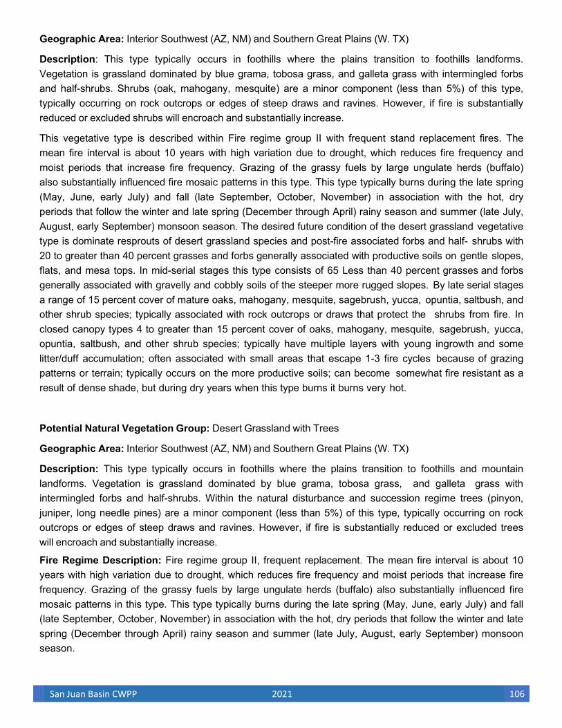
San Juan Basin CWPP 2021 106
Geographic Area: Interior Southwest (AZ, NM) and Southern Great Plains (W. TX)
Description: This type typically occurs in foothills where the plains transition to foothills landforms. Vegetation is grassland dominated by blue grama, tobosa grass, and galleta grass with intermingled forbs and half-shrubs. Shrubs (oak, mahogany, mesquite) are a minor component (less than 5%) of this type, typically occurring on rock outcrops or edges of steep draws and ravines. However, if fire is substantially reduced or excluded shrubs will encroach and substantially increase.
This vegetative type is described within Fire regime group II with frequent stand replacement fires. The mean fire interval is about 10 years with high variation due to drought, which reduces fire frequency and moist periods that increase fire frequency. Grazing of the grassy fuels by large ungulate herds (buffalo) also substantially influenced fire mosaic patterns in this type. This type typically burns during the late spring (May, June, early July) and fall (late September, October, November) in association with the hot, dry periods that follow the winter and late spring (December through April) rainy season and summer (late July, August, early September) monsoon season. The desired future condition of the desert grassland vegetative type is dominate resprouts of desert grassland species and post-fire associated forbs and half- shrubs with 20 to greater than 40 percent grasses and forbs generally associated with productive soils on gentle slopes, flats, and mesa tops. In mid-serial stages this type consists of 65 Less than 40 percent grasses and forbs generally associated with gravelly and cobbly soils of the steeper more rugged slopes. By late serial stages a range of 15 percent cover of mature oaks, mahogany, mesquite, sagebrush, yucca, opuntia, saltbush, and other shrub species; typically associated with rock outcrops or draws that protect the shrubs from fire. In closed canopy types 4 to greater than 15 percent cover of oaks, mahogany, mesquite, sagebrush, yucca, opuntia, saltbush, and other shrub species; typically have multiple layers with young ingrowth and some litter/duff accumulation; often associated with small areas that escape 1-3 fire cycles because of grazing patterns or terrain; typically occurs on the more productive soils; can become somewhat fire resistant as a result of dense shade, but during dry years when this type burns it burns very hot.
Potential Natural Vegetation Group: Desert Grassland with Trees
Geographic Area: Interior Southwest (AZ, NM) and Southern Great Plains (W. TX)
Description: This type typically occurs in foothills where the plains transition to foothills and mountain landforms. Vegetation is grassland dominated by blue grama, tobosa grass, and galleta grass with intermingled forbs and half-shrubs. Within the natural disturbance and succession regime trees (pinyon, juniper, long needle pines) are a minor component (less than 5%) of this type, typically occurring on rock outcrops or edges of steep draws and ravines. However, if fire is substantially reduced or excluded trees will encroach and substantially increase.
Fire Regime Description: Fire regime group II, frequent replacement. The mean fire interval is about 10 years with high variation due to drought, which reduces fire frequency and moist periods that increase fire frequency. Grazing of the grassy fuels by large ungulate herds (buffalo) also substantially influenced fire mosaic patterns in this type. This type typically burns during the late spring (May, June, early July) and fall (late September, October, November) in association with the hot, dry periods that follow the winter and late spring (December through April) rainy season and summer (late July, August, early September) monsoon season.
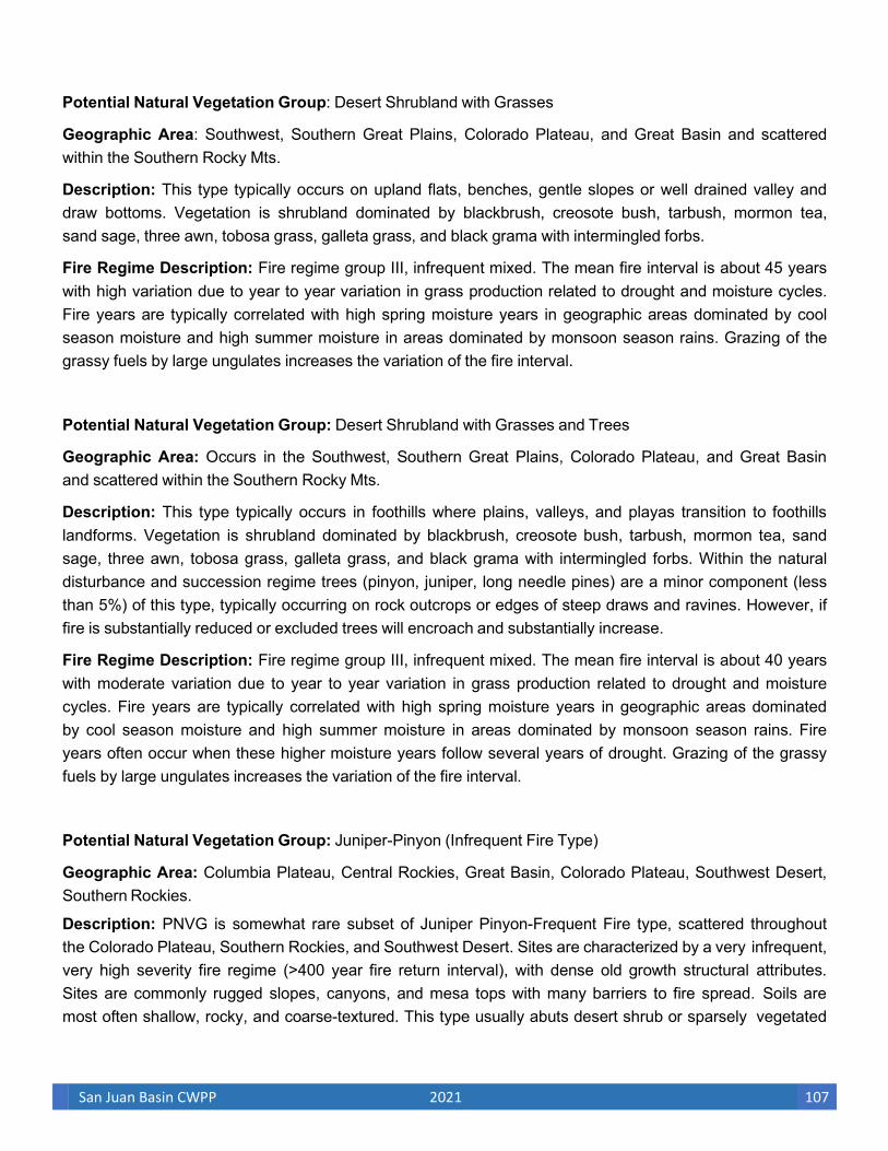
San Juan Basin CWPP 2021 107
Potential Natural Vegetation Group: Desert Shrubland with Grasses
Geographic Area: Southwest, Southern Great Plains, Colorado Plateau, and Great Basin and scattered within the Southern Rocky Mts.
Description: This type typically occurs on upland flats, benches, gentle slopes or well drained valley and draw bottoms. Vegetation is shrubland dominated by blackbrush, creosote bush, tarbush, mormon tea, sand sage, three awn, tobosa grass, galleta grass, and black grama with intermingled forbs.
Fire Regime Description: Fire regime group III, infrequent mixed. The mean fire interval is about 45 years with high variation due to year to year variation in grass production related to drought and moisture cycles. Fire years are typically correlated with high spring moisture years in geographic areas dominated by cool season moisture and high summer moisture in areas dominated by monsoon season rains. Grazing of the grassy fuels by large ungulates increases the variation of the fire interval.
Potential Natural Vegetation Group: Desert Shrubland with Grasses and Trees
Geographic Area: Occurs in the Southwest, Southern Great Plains, Colorado Plateau, and Great Basin and scattered within the Southern Rocky Mts.
Description: This type typically occurs in foothills where plains, valleys, and playas transition to foothills landforms. Vegetation is shrubland dominated by blackbrush, creosote bush, tarbush, mormon tea, sand sage, three awn, tobosa grass, galleta grass, and black grama with intermingled forbs. Within the natural disturbance and succession regime trees (pinyon, juniper, long needle pines) are a minor component (less than 5%) of this type, typically occurring on rock outcrops or edges of steep draws and ravines. However, if fire is substantially reduced or excluded trees will encroach and substantially increase.
Fire Regime Description: Fire regime group III, infrequent mixed. The mean fire interval is about 40 years with moderate variation due to year to year variation in grass production related to drought and moisture cycles. Fire years are typically correlated with high spring moisture years in geographic areas dominated by cool season moisture and high summer moisture in areas dominated by monsoon season rains. Fire years often occur when these higher moisture years follow several years of drought. Grazing of the grassy fuels by large ungulates increases the variation of the fire interval.
Potential Natural Vegetation Group: Juniper-Pinyon (Infrequent Fire Type)
Geographic Area: Columbia Plateau, Central Rockies, Great Basin, Colorado Plateau, Southwest Desert, Southern Rockies.
Description: PNVG is somewhat rare subset of Juniper Pinyon-Frequent Fire type, scattered throughout the Colorado Plateau, Southern Rockies, and Southwest Desert. Sites are characterized by a very infrequent, very high severity fire regime (>400 year fire return interval), with dense old growth structural attributes. Sites are commonly rugged slopes, canyons, and mesa tops with many barriers to fire spread. Soils are most often shallow, rocky, and coarse-textured. This type usually abuts desert shrub or sparsely vegetated

San Juan Basin CWPP 2021 108
sites, and may be referred to as “Pinyon-Juniper Forest.”
Fire Regime Description: Fire Regime V, primarily long-interval (e.g., >200 yr) stand replacement fires.
Potential Natural Vegetation Group: Juniper-Pinyon (Frequent Fire Type)
Geographic Area: Columbia Plateau, Central Rockies, Great Basin, Colorado
Plateau, Southwest Desert, Southern Rockies.
Description: PNVG is widespread across Nevada, Utah, Colorado, New Mexico, and Arizona. Sites range from gently rolling uplands to moderately and very steep slopes. Juniper-Pinyon types occupy dry foothills, plateaus, mesas, and mountain slopes. Soils range from shallow to moderately deep; climate is semi-arid. This type occupies a band above desert shrub/grasslands and below montane forests. This woodland PVT is generally dominated by Colorado or singleleaf pinyon pine and Utah juniper, but also includes Rocky Mountain and one-seed juniper. Understory associates include manzanita spp., sagebrush spp., gambel oak, and a mixture of cool and warm season grasses.
Fire Regime Description: Fire Regimes I and IV; ranging from short- to moderately long interval (e.g., 30- 100 yr) mixed severity- and stand replacement fires.
Potential Natural Vegetation Group: Interior chaparral.
Geographic Area: Great Basin, Central Rockies, Colorado Plateau, Southern Rockies.
Description: PNVG common to mountain foothills and lower slopes from eastern Idaho, east to Wyoming, and south to Arizona and New Mexico. Sites are mixed shrub associations ecotonal to mixed conifer, juniper, pine/oak woodlands, and quaking aspen communities. Co-dominant shrubs are primarily gambel oak, bigtooth maple, ceanothus, manzanita, and scrub oak species. Sites usually transitional to forests as soils and climate allow.
Fire Regime Description: Fire Regime IV, primarily moderately long -interval (e.g., 40-60 yr) stand replacement fires.
Potential Natural Vegetation Group: Ponderosa Pine Southwest
Geographic Area: Southwestern U.S. (Arizona, New Mexico, Utah)
Description: Found in mountains and foothills of Arizona and New Mexico, generally on gentle to steep slopes. Most often found on southerly aspects in montane zone. Large openings with grass and oak can be
found in this PNVG. Other pine species (e.g., Southwestern White Pine), Abies spp., and Pseudotsuga menzesii also may be present.
Fire Regime Description: Very frequent surface fires with occasional mixed and very rare stand replacement fires. Succession is dependent on frequent fire.
Vegetation Type and Structure: Class Percent of Description Landscape:

San Juan Basin CWPP 2021 109
A: post replacement 15 Grass, oak, and shrub following replacement fire or reburn. B: mid-development closed 4 > 30% canopy cover of sapling and pole pine, Douglas-fir, and Abies spp. C: mid- open 20 < 30% canopy cover dominated by ponderosa pine. Other southwest pine species may be present (e.g., Arizona, Chihuahua, Apache). Grass-oak understory. D: late- open 60 <30% canopy cover dominated by ponderosa pine. Other southwest pine species may be present (e.g., Arizona, Chihuahua, Apache). Grass-oak understory. E: late- closed 1 >3 0% canopy cover of ponderosa pine, Southwestern White Pine, Douglas-fir, and Abies spp.
Potential Natural Vegetation Group: Southwest Shrub Steppe with Trees
Geographic Area: Southwest (primarily southeast Arizona and southern New Mexico).
Description: This type typically occurs in the foothills of the desert mountain ranges. Vegetation is open shrubland with grass and scattered pockets of trees. Vegetation is dominated by flourensia, creosote bush, tarbush, mesquite, catclaw, opuntia, yucca, black grama, tobosa grass, blue grama, sideoats grama, and threeawns, with intermingled forbs. Scattered trees include pinyon, juniper, and oaks.
Fire Regime Description: Fire regime group II, frequent replacement. The mean fire interval is about 8 years with moderate variation due to year to year variation in grass production related to drought and moisture cycles. Fire years are typically bimodal occurring in the late spring (May and June) and fall (September and October) correlated with grass production following spring summer monsoon moisture. Grazing of the grassy fuels by large ungulates increases the variation of the fire interval. This type generally occurs in a zone between the shrub steppe and the pinyon juniper zone. Vegetation Type and Structure of Fire Regime Group II.
San Juan Basin CWPP 2021 110
U.S. Fish and Wildlife Service
Trust Resources List
This resource list is to be used for planning purposes only — it is not an official species list.
Endangered Species Act species list information for your project is available online and listed below for the following FWS Field Offices:
Project Name:
Glade
Project Counties:
San Juan, NM
Project Type:
Recreation Construction / Maintenance
Species that should be considered in an effects analysis for your project:
Birds Status Has Critical Habitat Contact
APPENDIX B Threatened, Endangered, and Sensitive Species
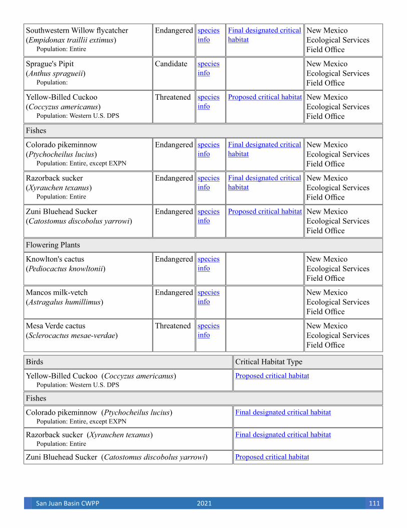
San Juan Basin CWPP 2021 111
Southwestern Willow flycatcher Endangered New Mexico (Empidonax traillii extimus) Ecological Services
Field Office
Sprague's Pipit Candidate New Mexico (Anthus spragueii) Ecological Services
Field Office
Yellow-Billed Cuckoo Threatened New Mexico (Coccyzus americanus) Ecological Services
Field Office
Fishes
Colorado pikeminnow Endangered New Mexico (Ptychocheilus lucius) Ecological Services
Field Office
Razorback sucker Endangered New Mexico (Xyrauchen texanus) Ecological Services
Field Office
Zuni Bluehead Sucker Endangered New Mexico (Catostomus discobolus yarrowi) Ecological Services
Field Office
Flowering Plants
Knowlton's cactus Endangered New Mexico (Pediocactus knowltonii) Ecological Services
Field Office
Mancos milk-vetch Endangered New Mexico (Astragalus humillimus) Ecological Services
Field Office
Mesa Verde cactus Threatened New Mexico (Sclerocactus mesae-verdae) Ecological Services
Field Office
Birds Critical Habitat Type
Yellow-Billed Cuckoo (Coccyzus americanus)
Fishes
Colorado pikeminnow (Ptychocheilus lucius)
Razorback sucker (Xyrauchen texanus)
Zuni Bluehead Sucker (Catostomus discobolus yarrowi)
San Juan Basin CWPP 2021 112
The protection of birds is regulated by the Migratory Bird Treaty Act (MBTA) and the Bald and Golden Eagle Protection Act (BGEPA). Any activity, intentional or unintentional, resulting in take of migratory birds, including eagles, is prohibited unless otherwise permitted by the U.S. Fish and Wildlife Service (50 C.F.R. Sec. 10.12 and 16 U.S.C. Sec. 668(a)). The MBTA has no provision for allowing take of migratory birds that may be unintentionally killed or injured by otherwise lawful activities. For more information regarding these Acts see:
.
All project proponents are responsible for complying with the appropriate regulations protecting birds when planning and developing a project. To meet these conservation obligations, proponents should identify potential or existing project-related impacts to migratory birds and their habitat and develop and implement conservation measures that avoid, minimize, or compensate for these impacts. The Service's Birds of Conservation Concern (2008) report identifies species, subspecies, and populations of all migratory nongame birds that, without additional conservation actions, are likely to become listed under the Endangered Species Act as amended (16 U.S.C 1531 et seq.).
For information about Birds of Conservation Concern, go to: .
To search and view summaries of year-round bird occurrence data within your project area, go to the Avian Knowledge Network Histogram Tool links in the Bird Conservation Tools section at:
.
For information about conservation measures that help avoid or minimize impacts to birds, please visit: .
Migratory birds of concern that may be affected by your project: There are 27 birds on your Migratory birds of concern list. The underlying data layers used to generate the migratory bird list of concern will continue to be updated regularly as new and better information is obtained. User feedback is one method of identifying any needed improvements. Therefore, users are encouraged to submit comments about any questions regarding species ranges (e.g., a bird on the USFWS BCC list you know does not occur in the specified location appears on the list, or a BCC species that you know does occur there is not appearing on the list). Comments should be sent to the ECOS Help Desk.
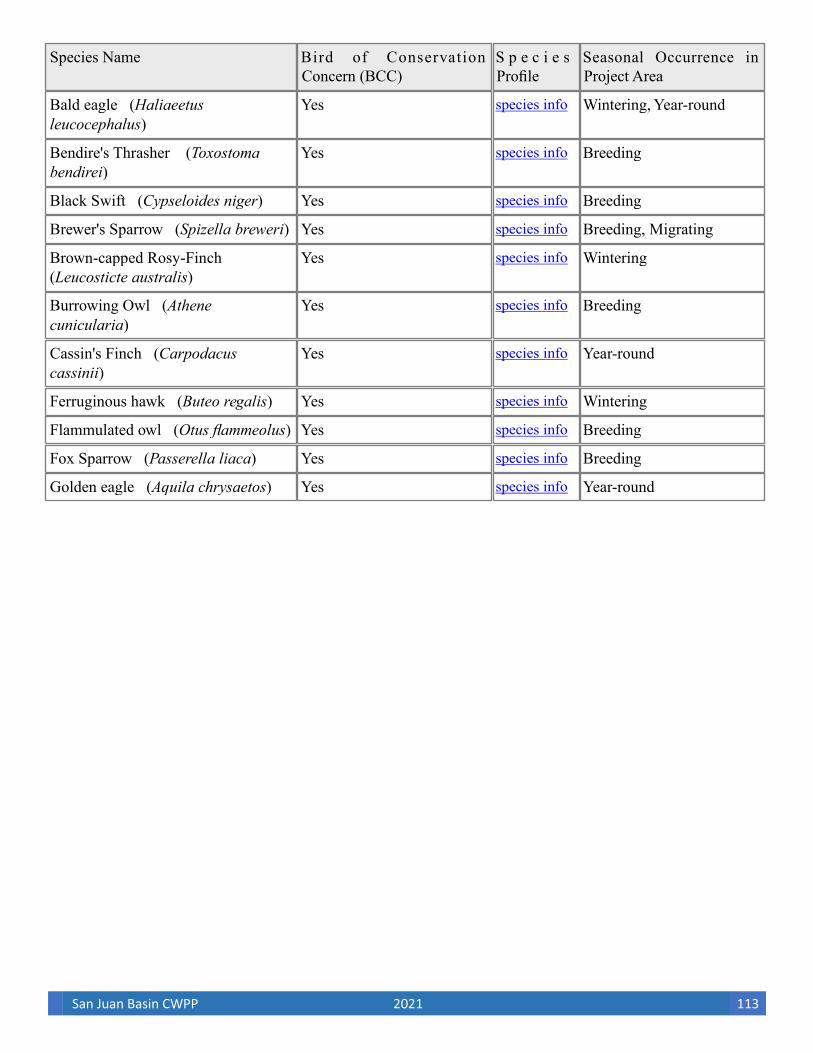
San Juan Basin CWPP 2021 113
Species Name Bird of Conservation S p e c i e s Seasonal Occurrence in Concern (BCC) Profile Project Area
leucocephalus) Bald eagle (Haliaeetus Yes Wintering, Year-round
bendirei) Bendire's Thrasher (Toxostoma Yes Breeding
Black Swift (Cypseloides niger) Yes Breeding
Brewer's Sparrow (Spizella breweri) Yes Breeding, Migrating
(Leucosticte australis) Brown-capped Rosy-Finch Yes Wintering
cunicularia) Burrowing Owl (Athene Yes Breeding
cassinii) Cassin's Finch (Carpodacus Yes Year-round
Ferruginous hawk (Buteo regalis) Yes Wintering
Flammulated owl (Otus flammeolus) Yes Breeding
Fox Sparrow (Passerella liaca) Yes Breeding
Golden eagle (Aquila chrysaetos) Yes Year-round

San Juan Basin CWPP 2021 114
graciae) Grace's Warbler (Dendroica Yes Breeding
Gray vireo (Vireo vicinior) Yes Breeding
ridgwayi) Juniper Titmouse (Baeolophus Yes Year-round
lewis) Lewis's Woodpecker (Melanerpes Yes Year-round
ludovicianus) Loggerhead Shrike (Lanius Yes Year-round
Lucy's warbler (Vermivora luciae) Yes Breeding
montanus) Mountain plover (Charadrius Yes Breeding
cooperi) Olive-Sided flycatcher (Contopus Yes Breeding
Peregrine Falcon (Falco peregrinus) Yes Breeding
cyanocephalus) Pinyon Jay (Gymnorhinus Yes Year-round
Prairie Falcon (Falco mexicanus) Yes Year-round
montanus) Sage Thrasher (Oreoscoptes Yes Breeding
Swainson's hawk (Buteo swainsoni) Yes Breeding
Veery (Catharus fuscescens) Yes Breeding
(Sphyrapicus thyroideus) Williamson's Sapsucker Yes Breeding
traillii) Willow Flycatcher (Empidonax Yes Breeding
San Juan Basin CWPP 2021 115
NWI Wetlands (USFWS National Wetlands Inventory).
The U.S. Fish and Wildlife Service is the principal Federal agency that provides information on the extent and status of wetlands in the U.S., via the National Wetlands Inventory Program (NWI). In addition to impacts to wetlands within your immediate project area, wetlands outside of your project area may need to be considered in any evaluation of project impacts, due to the hydrologic nature of wetlands (for example, project activities may affect local hydrology within, and outside of, your immediate project area). It may be helpful to refer to the USFWS National Wetland Inventory website. The designated FWS office can also assist you. Impacts to wetlands and other aquatic habitats from your project may be subject to regulation under Section 404 of the Clean Water Act, or other State/Federal Statutes. Project Proponents should discuss the relationship of these requirements to their project with the Regulatory Program of the appropriate
.
Data Limitations, Exclusions and Precautions The Service's objective of mapping wetlands and deepwater habitats is to produce reconnaissance level information on the location, type and size of these resources. The maps are prepared from the analysis of high altitude imagery. Wetlands are identified based on vegetation, visible hydrology and geography. A margin of error is inherent in the use of imagery; thus, detailed on-the-ground inspection of any particular site may result in revision of the wetland boundaries or classification established through image analysis.
The accuracy of image interpretation depends on the quality of the imagery, the experience of the image analysts, the amount and quality of the collateral data and the amount of ground truth verification work conducted. Metadata should be consulted to determine the date of the source imagery used and any mapping problems.
Wetlands or other mapped features may have changed since the date of the imagery and/or field work. There may be occasional differences in polygon boundaries or classifications between the information depicted on the map and the actual conditions on site.
Exclusions - Certain wetland habitats are excluded from the National mapping program because of the limitations of aerial imagery as the primary data source used to detect wetlands. These habitats include seagrasses or submerged aquatic vegetation that are found in the intertidal and subtidal zones of estuaries and nearshore coastal waters. Some deepwater reef communities (coral or tuberficid worm reefs) have also been excluded from the inventory. These habitats, because of their depth, go undetected by aerial imagery.
Precautions - Federal, state, and local regulatory agencies with jurisdiction over wetlands may define and describe wetlands in a different manner than that used in this inventory. There is no attempt, in either the design or products of this inventory, to define the limits of proprietary jurisdiction of any Federal, state, or local government or to establish the geographical scope of the regulatory programs of government agencies. Persons intending to engage in activities involving modifications within or adjacent to wetland areas should seek the
The following wetland types intersect your project area in one or more locations:
advice of appropriate federal, state, or local agencies concerning specified agency regulatory programs and proprietary jurisdictions that may affect such activities.

San Juan Basin CWPP 2021 116
Freshwater Forested/Shrub Wetland 10.0276
Freshwater Forested/Shrub Wetland 68.4744
Freshwater Forested/Shrub Wetland 380.3274
Freshwater Forested/Shrub Wetland 159.067
Freshwater Forested/Shrub Wetland 25.6644
Freshwater Forested/Shrub Wetland 1.1795
Freshwater Pond 0.1481
Freshwater Pond 1.3808
Freshwater Pond 0.2787
Freshwater Pond 70.8226
Freshwater Pond 6.7576
Freshwater Pond 0.9532
Freshwater Pond 65.8411
Freshwater Pond 3.5186
Freshwater Pond 6.2471
Lake 533.5083
Lake 12316.2872
Lake 16.7692
Other 6.6952
Other 5.1281
Other 0.6981
Other 0.2197
Other 6.1986
Other 78.2473
Riverine 1420.5645
Riverine 214.4891
Riverine 715.9418
Riverine 28.1118
Riverine 52.6066
Riverine 4.0189

San Juan Basin CWPP 2021 117
Wetland Types NWI Classification Code Total Acres
Freshwater Emergent Wetland 7.6729
Freshwater Emergent Wetland 18.2338
Freshwater Emergent Wetland 7.8886
Freshwater Emergent Wetland 2.4879
Freshwater Emergent Wetland 75.7935
Freshwater Emergent Wetland 1.9342
Freshwater Emergent Wetland 2.401
Freshwater Emergent Wetland 331.662
Freshwater Emergent Wetland 202.0986
Freshwater Emergent Wetland 5.5494
Freshwater Emergent Wetland 24.1822
Freshwater Emergent Wetland 9.8105
Freshwater Forested/Shrub Wetland 24.7836
Freshwater Forested/Shrub Wetland 2.1194
Freshwater Forested/Shrub Wetland 4.3137
Freshwater Forested/Shrub Wetland 264.2611
Freshwater Forested/Shrub Wetland 2.4737
Freshwater Forested/Shrub Wetland 13.1697
Freshwater Forested/Shrub Wetland 10.7753
Freshwater Forested/Shrub Wetland 1.5906
Freshwater Forested/Shrub Wetland 30.8064
Freshwater Forested/Shrub Wetland 13.5871

San Juan Basin CWPP 2021 118
APPENDIX C. NATIONAL FIRE DANGER RATING SYSTEM FUEL MODEL SELECTION KEY
I. Mosses, lichens, and low shrubs predominate ground fuels
A. An overstory of conifers occupies more than one-third of site
Model Q
B. There is no overstory or it occupies less than one-third of the site
Model S
II. Marsh grasses and/or reeds predominate
Model N
III. Grasses and/or forbs predominate
A. There is an open overstory of conifer and/or hardwoods
Model C
B. There is no overstory
1. Woody shrubs occupy more than one-third, but less than two-thirds of the site
Model T
2. Woody shrubs occupy less than two-thirds of the site
a. The grasses and forbs are primarily annuals
Model A
b. The grasses and forbs are primarily perennials
Model L
IV. Brush, shrubs, tree reproduction or dwarf tree species predominate
A. The average height of woody plants is 6 ft or higher
1. Woody plants occupy two-thirds or more of the site
a. One-fourth or more of the woody foliage is dead
1) Mixed California chaparral
Model B
2) Other types of brush
Model F
b. Up to one-fourth of the woody foliage is dead
Model Q

San Juan Basin CWPP 2021 119
c. Little dead foliage
Model O
2. Woody plants occupy less than two-thirds of the site
Model F
B. Average height of woody plants is less than 6 ft
1. Woody plants occupy two-thirds or more of the site
a. Western United States
Model F
b. Eastern United States
Model O
2. Woody plants occupy less than two-thirds but more than one-third of the site
a. Western United States
Model T
b. Eastern United States
Model D
3. Woody plants occupy less than one-third of the site
a. The grasses and forbs are primarily annuals
Model A
b. The grasses and forbs are primarily perennials
Model L
V. Trees predominate
A. Deciduous broadleaf species predominate
1. The area has been thinned or partially cut, leaving slash as the major fuel component
Model K
2. The area has not been thinned or partially cut
a. The overstory is dormant; leaves have fallen
Model E
b. The overstory is in full leaf Model R
B. Conifer species predominate
1. Lichens, mosses, and low shrubs dominate as understory fuels

San Juan Basin CWPP 2021 120
Model Q
2. Grasses and forbs are the primary ground fuel
Model C
3. Woody shrubs and/or reproduction dominate as understory fuels
a. The understory burns readily
1) Western United States
Model T
2) Eastern United States
a) The understory is more than 6 feet tall
Model O
b) The understory is less than 6 feet tall
Model D
b. The understory seldom burns
Model H
4. Duff and litter; branch wood and tree boles are the primary ground fuel
a. The overstory is over mature and decadent; there is a heavy accumulation of dead debris
Model G
b. The overstory is not decadent; there is only a nominal accumulation of debris
1) Needles are 2 inches or more in length (most pines)
a) Eastern United States
Model P
b) Western United States
Model U
2) The needles are less than 2 inches long
Model H
VI. Slash is the predominate fuel type
A. The foliage is still attached; there has been little settling
1. The loading is 25 tons/acre or more
Model I
2. The loading is less than 25 t/ac but more than 15 t/ac

San Juan Basin CWPP 2021 121
Model J
3. The loading is less than 15 tons/acre
Model K
B. Settling is evident; the foliage is falling off; grasses, forbs and shrubs are invading
1. The loading is 25 tons/acre or more
Model J
2. The loading is less than 25 tons per acre
Model K

San Juan Basin CWPP 2021 122
APPENDIX D: FIRE DEPARTMENT HAZARD ASSESSMENTS
Independent hazard assessments were conducted by the fire departments of Bloomfield and Farmington. The city fire department hazard assessments show known areas of elevated concern identified by the fire chiefs within their response zones regardless of hazard-analysis results. In addition to the hazard area assessments by the city fire chiefs, county and local fire chiefs also identified areas of elevated concern due to known areas of high fuel loading or due to high fire response occurrence. These areas collectively are collectively labeled as areas of elevated concern in Figure 2.7. The following appendix is a list of hazard assessments for the cities of Bloomfield and Farmington by area, not by priority ranking.

San Juan Basin CWPP 2021 123
Bloomfield Fire Department High Wildland Fire Hazard Area #1 – BHA1
1. Hazard Area/Location: Bloomfield Arroyo from County Road 4900 to the San Juan River.
2. Roads/Access/Egress issues: Few narrow roads access parts of the arroyo, yet most of the arroyo is inaccessible by fire apparatus.
3. Water Supply: 14 hydrants spread out near the arroyo.
4. Population/Amount/Age other issues: Several homes built on the banks of the arroyo, also the city water treatment plant, the pre-K–Kindergarten public school, and one natural gas well.
5. Fuels type: Cottonwood, Russian olive, sagebrush, and other bushes and grasses.
6. Aspect: East and west drainages sloped to the south.
7. Topography: Structures at the top of the drainage slopes.
8. Population/Exposure Value: Roughly 44 homes average value $175,00 each, one public school, water treatment plant, and a gas well.
Bloomfield Fire Department High Wildland Fire Hazard Area #2 – BHA2
1. Hazard Area/Location: Arroyo that follows Newby Lane to the San Juan River.
2. Roads/Access/Egress issues: One narrow winding road for main access, mostly inaccessible for fire apparatus.
3. Water Supply: 4 hydrants close to the arroyo, limited water supply.
4. Population/Amount/Age other issues: 17 homes very close to vegetation.
5. Fuels type: Cottonwood, Russian olive, elm, sagebrush, and grasses.
6. Aspect: Mostly east facing slopes on the north end with some west facing slopes spread throughout.
7. Topography: Structures scattered along the area on various slopes.
8. Population/Exposure Value: More than 17 homes close to the arroyo also the Jr high school in close proximity.
Bloomfield Fire Department High Wildland Fire Hazard Area #3 – BHA3
1. Hazard Area/Location: Arroyo that runs from Pixley Ln. south past Hwy. 64.
2. Roads/Access/Egress issues: Limited access due to fenced yards.
3. Water Supply: 12 hydrants spread throughout.
4. Population/Amount/Age other issues: 42 single family dwellings.
5. Fuels type: Cottonwood, Russian olive, elm, sagebrush and grasses.
6. Aspect: Mostly Flat, some east and west facing slopes.
7. Topography: Structures at top of hill drainages.
8. Population/Exposure Value: Roughly 42 homes of various price ranges, also several small businesses and a church in close proximity.
San Juan Basin CWPP 2021 124
Bloomfield Fire Department High Wildland Fire Hazard Area #4 – BHA4
1. Hazard Area/Location: Arroyo between Deer Trail and Palomino Lane
2. Roads/Access/Egress issues: Both roads are narrow, dead end, gravel roads.
3. Water Supply: 5 Hydrants with low flow.
4. Population/Amount/Age other issues: 8 homes in the middle of the vegetation with many more nearby.
5. Fuels type: Cottonwood, elm, Russian olive, sagebrush, and grasses.
6. Aspect: East and west facing slopes.
7. Topography: Structures at tops and bottoms of hills.
8. Population/Exposure Value: More than 8 homes and a Circle S gas station.
Bloomfield Fire Department High Wildland Fire Hazard Area #5 – BHA5
1. Hazard Area/Location: Drainage between Dulce Drive and Kirby Lane
2. Roads/Access/Egress issues: Dulce Dr. small residential street, Kirby Ln. winding Gravel Road.
3. Water Supply: 5 hydrants spread throughout.
4. Population/Amount/Age other issues: 14 homes.
5. Fuels type: Cottonwood, Russian olive, sagebrush and other types of brush, and grasses.
6. Aspect: East and west facing drainages.
7. Topography: Structures on top of hills.
8. Population/Exposure Value: 14 homes average value of $175,000 each, city park on the east side of the drainage.
Bloomfield Fire Department High Wildland Fire Hazard Area #6 – BHA6
1. Hazard Area/Location: West Swamp, between South Church Street, West Maple Ave, Calle del Rio, and Hwy 550, extending east past Hwy 550.
2. Roads/Access/Egress issues: No access to the center, Hwy 550 runs through the east side. Fires in this area tend to require closing the highway due to smoke.
3. Water Supply: 17 hydrants.
4. Population/Amount/Age other issues: 37 homes nearby.
5. Fuels type: Russian olive, cattails, and various grasses.
6. Aspect: Flat.
7. Topography: Flat.
8. Population/Exposure Value: 37 homes mostly mobile homes some site built, several businesses, Best Western motel, 2 restaurants, and a gas station. The City waste water treatment plant and municipal operations center are in this area.
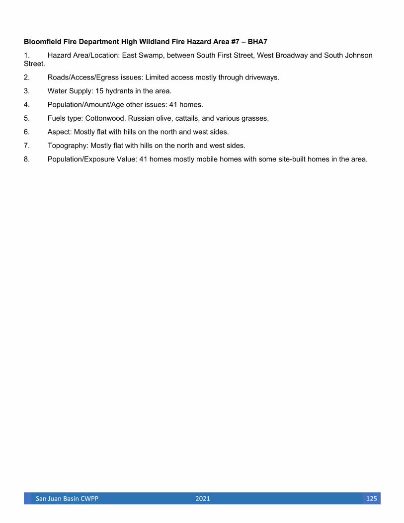
San Juan Basin CWPP 2021 125
Bloomfield Fire Department High Wildland Fire Hazard Area #7 – BHA7
1. Hazard Area/Location: East Swamp, between South First Street, West Broadway and South Johnson Street.
2. Roads/Access/Egress issues: Limited access mostly through driveways.
3. Water Supply: 15 hydrants in the area.
4. Population/Amount/Age other issues: 41 homes.
5. Fuels type: Cottonwood, Russian olive, cattails, and various grasses.
6. Aspect: Mostly flat with hills on the north and west sides.
7. Topography: Mostly flat with hills on the north and west sides.
8. Population/Exposure Value: 41 homes mostly mobile homes with some site-built homes in the area.
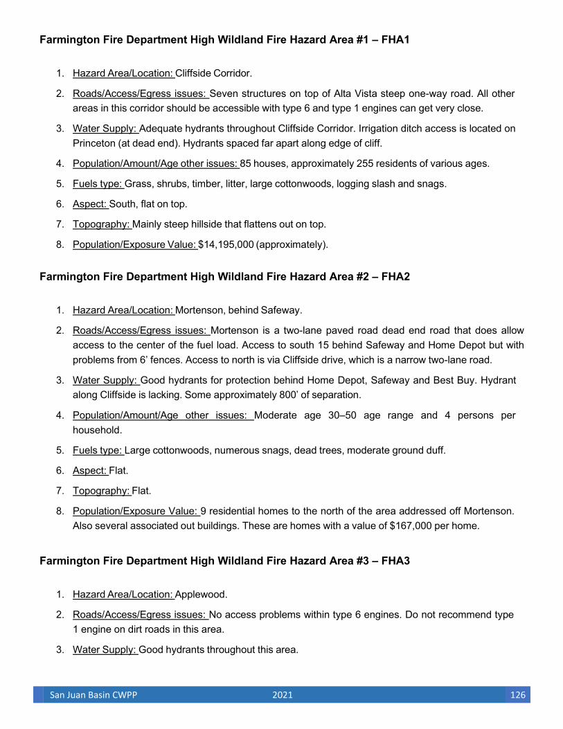
San Juan Basin CWPP 2021 126
Farmington Fire Department High Wildland Fire Hazard Area #1 – FHA1
1. Hazard Area/Location: Cliffside Corridor.
2. Roads/Access/Egress issues: Seven structures on top of Alta Vista steep one-way road. All other areas in this corridor should be accessible with type 6 and type 1 engines can get very close.
3. Water Supply: Adequate hydrants throughout Cliffside Corridor. Irrigation ditch access is located on Princeton (at dead end). Hydrants spaced far apart along edge of cliff.
4. Population/Amount/Age other issues: 85 houses, approximately 255 residents of various ages.
5. Fuels type: Grass, shrubs, timber, litter, large cottonwoods, logging slash and snags.
6. Aspect: South, flat on top.
7. Topography: Mainly steep hillside that flattens out on top.
8. Population/Exposure Value: $14,195,000 (approximately).
Farmington Fire Department High Wildland Fire Hazard Area #2 – FHA2
1. Hazard Area/Location: Mortenson, behind Safeway.
2. Roads/Access/Egress issues: Mortenson is a two-lane paved road dead end road that does allow access to the center of the fuel load. Access to south 15 behind Safeway and Home Depot but with problems from 6’ fences. Access to north is via Cliffside drive, which is a narrow two-lane road.
3. Water Supply: Good hydrants for protection behind Home Depot, Safeway and Best Buy. Hydrant along Cliffside is lacking. Some approximately 800’ of separation.
4. Population/Amount/Age other issues: Moderate age 30–50 age range and 4 persons per household.
5. Fuels type: Large cottonwoods, numerous snags, dead trees, moderate ground duff.
6. Aspect: Flat.
7. Topography: Flat.
8. Population/Exposure Value: 9 residential homes to the north of the area addressed off Mortenson. Also several associated out buildings. These are homes with a value of $167,000 per home.
Farmington Fire Department High Wildland Fire Hazard Area #3 – FHA3
1. Hazard Area/Location: Applewood.
2. Roads/Access/Egress issues: No access problems within type 6 engines. Do not recommend type 1 engine on dirt roads in this area.
3. Water Supply: Good hydrants throughout this area.

San Juan Basin CWPP 2021 127
4. Population/Amount/Age other issues: 11 homes on Applewood, 8 homes on Rowe, 3 commercial structures with minimal threat on Main St. Population is around 57 residents of various ages. One well site east of Applewood and Hubbard intersection.
5. Fuels type: Large cottonwoods, grass, shrubs, timber, litter, logging slash.
6. Aspect: Flat.
7. Topography: Flat.
8. Population/Exposure Value: $3,173,000 in residential value. Hanson Honda, Atoni Corp, Old furniture superstore building and one well site with minimal threat.
Farmington Fire Department High Wildland Fire Hazard Area #4 – FHA4
1. Hazard Area/Location: Railroad/McColnal/English Rd.
2. Roads/Access/Egress issues: Gravel road on Railroad and English.
3. Water Supply: Good hydrants spaced 600–800'.
4. Population/Amount/Age other issues: Medium and older, average household population is 3.
5. Fuels type: Russian olives, ground cover, and cottonwoods. Area from end of railroad rd to Herreara is inaccessible.
6. Aspect: Flat along railroad.
7. Topography: Along railroad bottom is flat. Raises to step grade to west below Kayenta and English.
8. Population/Exposure Value: Seven million dollar houses, 1 well site, and 25 additional structures above area on Highland, English and Kayenta. Total structural value of $11,175,000.
Farmington Fire Department High Wildland Fire Hazard Area #5 – FHA5
1. Hazard Area/Location: 38th/Twlight Dr./Melrose/35th.
2. Roads/Access/Egress issues: Bottom canyon access off Pinion Hills Blvd. via oilfield access. Dead- end roads.
3. Water Supply: Hydrants along streets on top of canyon.
4. Population/Amount/Age other issues: 10–12 older homes with possible retired population.
5. Fuels type: Pinyon/juniper and cottonwoods and nonnative plants.
6. Aspect: West and southwest.
7. Topography: Sandstone canyon surrounding neighborhood.
8. Population/Exposure Value: Residential, $2–2.75 million.

San Juan Basin CWPP 2021 128
Farmington Fire Department High Wildland Fire Hazard Area #6 – FHA6
1. Hazard Area/Location: Suntuoso Ct/Civitan Park.
2. Roads/Access/Egress issues: Cul-de-sac and limited access from golf course.
3. Water Supply: Hydrants in area.
4. Population/Amount/Age other issues: Retired population, 12 duplex condos.
5. Fuels type: Mix of trees and cattail grasses and some shrubs.
6. Aspect: South.
7. Topography: Hillside.
8. Population/Exposure Value: Residential, $1.5–2 million.
Farmington Fire Department High Wildland Fire Hazard Area #7 – FHA7
1. Hazard Area/Location: 20th St./Municipal Dr./Galde Rd.
2. Roads/Access/Egress issues: Densely spaced house on residential streets/lateral ditch road.
3. Water Supply: Hydrants and irrigation ditch.
4. Population/Amount/Age other issues: Moderately populated.
5. Fuels type: Russian olive and cottonwood trees.
6. Aspect: South.
7. Topography: Hillside divided by irrigation ditch.
8. Population/Exposure Value: Residential, $1.75–2.5 million.
Farmington Fire Department High Wildland Fire Hazard Area #8 – FHA8
1. Hazard Area/Location: Santa Barbara St./27th St./Venada St./ 24th St.
2. Roads/Access/Egress issues: 24th St. accesses bottom of canyon.
3. Water Supply: Hydrants in neighborhood, good master stream accesses from Santa Barbara St.
4. Population/Amount/Age other issues: Moderate density, 10–12 new construction and older homes.
5. Fuels type: Saltcedar, cottonwood trees, some pinyon/juniper.
6. Aspect: Southwest.
7. Topography: Small canyon in dense neighborhood.
8. Population/Exposure Value: Residential, $2–3 million

San Juan Basin CWPP 2021 129
Farmington Fire Department High Wildland Fire Hazard Area #9 – FHA9
1. Hazard Area/Location: Berg Park/Northwest side of the Animas River south of San Juan Blvd. and east of Scott Ave.
2. Roads/Access/Egress issues: The main access to Berg Park is from the parking area at the intersection of Scott and San Juan. Access can also be made from the south end of Tucker and through the Reiley Industrial equipment yard. The roads and trails in the park are narrow and in many areas are bridged over by heavy vegetation. This creates issues with access during fire conditions. These roads are also the main egress points for people in the park. This fact creates a problem during festivals due to large crowds that will be walking these roads.
3. Water Supply: 1,000 gpm hydrants at Tucker and River Rd. and Fairview and River Rd. 1,000 gpm hydrant at Service and Electric can be accessed through a locked gate in the Reiley industrial equipment yard. Water can be drafted from the Animas River.
4. Population/Amount/Age other issues: The major populations that will be effected are the businesses that are along San Juan Blvd. These businesses all have defensible space backing to the park. Chain-link fences prevent access to the park from the back of these businesses. During regular use the park is sparsely populated with park users. During festivals the park is populated with several thousand people including many elderly and handicapped park users.
5. Fuels type: Thick ground and ladder fuels and well established canopy extends through most of the park. Open areas are overgrown with grasses and brush.
6. Aspect: Because of the relatively flat topography of the park area, aspect has little effect on this area.
7. Topography: The topography of this area is relatively flat with gentle up-river slopes and some areas that slope gently away from the river.
8. Population/Exposure Value: Business values and park properties.
Farmington Fire Department High Wildland Fire Hazard Area #10 – FHA10
1. Hazard Area/Location: Animas River Park/southeast side of the Animas River south of Browning Parkway and north of Southside River Rd.
2. Roads/Access/Egress issues: The main road access is from the parking area at the north end of the park. From here one road extends into the park to the nature center. A second road extends through the park and along Willet Ditch. These roads are narrow and in many areas are bridged over by heavy vegetation. This creates issues with access and egress during fire conditions. These roads are also the main egress points for people in the park. This fact creates a problem during festivals due to large crowds that will be walking these roads.
3. Water Supply: 1,000 gpm hydrants at MOC, Red Barn and Nature Center. 500 gpm hydrant at Harbor Lane with foot bridge access across Willett Ditch. Drafting from Willett Ditch and Animas
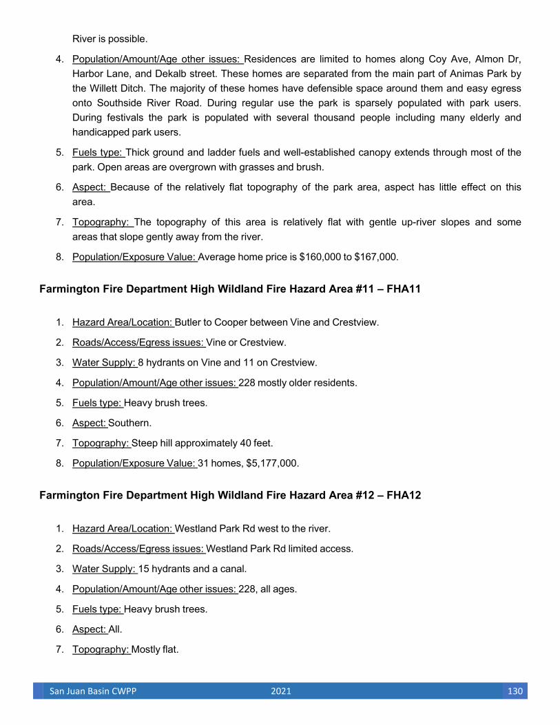
San Juan Basin CWPP 2021 130
River is possible.
4. Population/Amount/Age other issues: Residences are limited to homes along Coy Ave, Almon Dr, Harbor Lane, and Dekalb street. These homes are separated from the main part of Animas Park by the Willett Ditch. The majority of these homes have defensible space around them and easy egress onto Southside River Road. During regular use the park is sparsely populated with park users. During festivals the park is populated with several thousand people including many elderly and handicapped park users.
5. Fuels type: Thick ground and ladder fuels and well-established canopy extends through most of the park. Open areas are overgrown with grasses and brush.
6. Aspect: Because of the relatively flat topography of the park area, aspect has little effect on this area.
7. Topography: The topography of this area is relatively flat with gentle up-river slopes and some areas that slope gently away from the river.
8. Population/Exposure Value: Average home price is $160,000 to $167,000.
Farmington Fire Department High Wildland Fire Hazard Area #11 – FHA11
1. Hazard Area/Location: Butler to Cooper between Vine and Crestview.
2. Roads/Access/Egress issues: Vine or Crestview.
3. Water Supply: 8 hydrants on Vine and 11 on Crestview.
4. Population/Amount/Age other issues: 228 mostly older residents.
5. Fuels type: Heavy brush trees.
6. Aspect: Southern.
7. Topography: Steep hill approximately 40 feet.
8. Population/Exposure Value: 31 homes, $5,177,000.
Farmington Fire Department High Wildland Fire Hazard Area #12 – FHA12
1. Hazard Area/Location: Westland Park Rd west to the river.
2. Roads/Access/Egress issues: Westland Park Rd limited access.
3. Water Supply: 15 hydrants and a canal.
4. Population/Amount/Age other issues: 228, all ages.
5. Fuels type: Heavy brush trees.
6. Aspect: All.
7. Topography: Mostly flat.
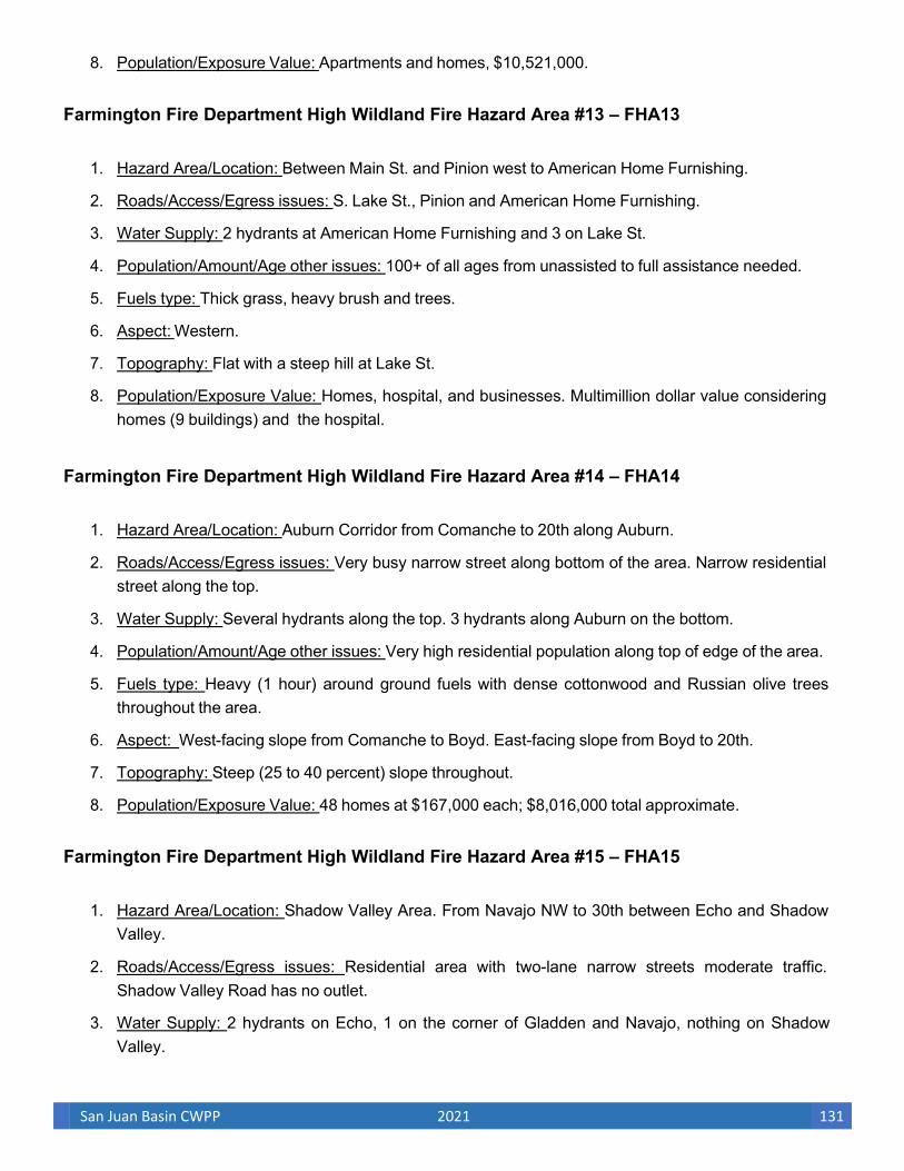
San Juan Basin CWPP 2021 131
8. Population/Exposure Value: Apartments and homes, $10,521,000.
Farmington Fire Department High Wildland Fire Hazard Area #13 – FHA13
1. Hazard Area/Location: Between Main St. and Pinion west to American Home Furnishing.
2. Roads/Access/Egress issues: S. Lake St., Pinion and American Home Furnishing.
3. Water Supply: 2 hydrants at American Home Furnishing and 3 on Lake St.
4. Population/Amount/Age other issues: 100+ of all ages from unassisted to full assistance needed.
5. Fuels type: Thick grass, heavy brush and trees.
6. Aspect: Western.
7. Topography: Flat with a steep hill at Lake St.
8. Population/Exposure Value: Homes, hospital, and businesses. Multimillion dollar value considering homes (9 buildings) and the hospital.
Farmington Fire Department High Wildland Fire Hazard Area #14 – FHA14
1. Hazard Area/Location: Auburn Corridor from Comanche to 20th along Auburn.
2. Roads/Access/Egress issues: Very busy narrow street along bottom of the area. Narrow residential street along the top.
3. Water Supply: Several hydrants along the top. 3 hydrants along Auburn on the bottom.
4. Population/Amount/Age other issues: Very high residential population along top of edge of the area.
5. Fuels type: Heavy (1 hour) around ground fuels with dense cottonwood and Russian olive trees throughout the area.
6. Aspect: West-facing slope from Comanche to Boyd. East-facing slope from Boyd to 20th.
7. Topography: Steep (25 to 40 percent) slope throughout.
8. Population/Exposure Value: 48 homes at $167,000 each; $8,016,000 total approximate.
Farmington Fire Department High Wildland Fire Hazard Area #15 – FHA15
1. Hazard Area/Location: Shadow Valley Area. From Navajo NW to 30th between Echo and Shadow Valley.
2. Roads/Access/Egress issues: Residential area with two-lane narrow streets moderate traffic. Shadow Valley Road has no outlet.
3. Water Supply: 2 hydrants on Echo, 1 on the corner of Gladden and Navajo, nothing on Shadow Valley.
San Juan Basin CWPP 2021 132
4. Population/Amount/Age other issues: Most of the homes affected are on Echo with only 6 homes on Shadow Valley.
5. Fuels type: Heavy (1 hour) around ground fuels and moderately dense cottonwood and Russian olive trees throughout the area.
6. Aspect: Northwest to southeast drainage.
7. Topography: Creek bottom with mild slopes throughout.
8. Population/Exposure Value: 22 homes at $167,000 each; $3,674,000 total approximate
Farmington Fire Department High Wildland Fire Hazard Area #16 – FHA16
1. Hazard Area/Location: The Glade drainage from Apache to Navajo between Auburn and Airport.
2. Roads/Access/Egress issues: Access for brush trucks is a two-track road that runs the length of the area. Access for engines on the east side is dead end trailer park roads with no access on the west side. Egress for residents will be affected by supple lines out of the trailer park going across Auburn.
3. Water Supply: Very limited to a minimal number of hydrants located across Auburn with 1 hydrant on the end of Paralee.
4. Population/Amount/Age other issues: There is an elementary school at the south end of the area and several trailer parks along the east side of the area. There is a walk path from the school to the trailer park used by neighborhood children.
5. Fuels type: Heavy ground (1 hour) fuel and moderately dense cottonwood and Russian olive trees throughout the area.
6. Aspect: North to south drainage.
7. Topography: Creek bottom with moderate slope to the west.
8. Population/Exposure Value: 22 homes at $167,000 each; $3,674,000 total approximate.
Farmington Fire Department High Wildland Fire Hazard Area #17 – FHA17
1. Hazard Area/Location: Deer Trail, from W. Main St. to Inland St.
2. Roads/Access/Egress issues: Narrow dead-end vegetation next to road.
3. Water Supply: Hydrant 1379 east of Deer Trail on Main St. and hydrant 1380 toward the north end of Deer Trail.
4. Population/Amount/Age other issues: Moderate population, approximately 50–75 residents, various ages.
San Juan Basin CWPP 2021 133
5. Fuels type: Mixed fuel type, sparse to very heavy fuel loads of green standing to dead and down, 1-100 hour fuels.
6. Aspect: Northwest to south.
7. Topography: Primarily 0%–20%, La Plata River drainage.
8. Population/Exposure Value: 14 residential structures at $167,000 each with various outbuilding structures around residential units; approximately a $3,000,000 total value.
Farmington Fire Department High Wildland Fire Hazard Area #18 – FHA18
1. South Lake Project – approximately 90 acres
2. Hazard Area/Location: South Lake Street on the North and South side of the river and West to the Bisti Highway.
3. Roads/Access/Egress issues: South Lake Street is the primary access until you reach the Bisti bridge. Most of the access is hampered due to the fenced off water treatment and power plant.
4. Water Supply: Hydrants are located inside the water treatment plant and one located at the intersection of Broadway and Bisti Hwy. GPM amounts are pending.
5. Population/Amount/Age/other issues: There are no residences in the immediate are of the treatment. However on the North side of the river on the West side of the bridge there are approximately 3 homes and 2 large elder care facilities that would be impacted during a fire up and not including evacuations or sheltering in place of over 400 geriatric patients.
6. Fuel Type: Russian Olive, Cotton wood and salt cedar.
7. Aspect: Flat
8. Topography: River Bosque
9. Population/Exposure Value: $300,000 residential, $10 million commercial residential care facilities. The Bisti Bridge is another immediate exposure that could cost in the millions to repair/rebuild in the event of a fire.

San Juan Basin CWPP 2021 134
APPENDIX E. ADDITIONAL RESOURCES
Firewise Information and Web Sites Arizona State Forester. Provides granting and other information sources, http://www.azsf.az.gov/Grants/grants.html.
Bureau of Land Management. Fire Web site, http://www.fire.blm.gov/.
Colorado State Forest Service. Protecting Your Home, Forest and Property From Wildfire, http://csfs.colostate.edu/protecthomeandforest.htm.
Ecological Restoration Institute. Forest Restoration for Homeowners, A Guide for Residents of Southwestern Ponderosa Pine Forests. Information pamphlet covering homeowner strategies for fire safety, http://www.eri.nau.edu/cms/files/General/ERIhomeowners.pdf.
Joint Fire Sciences CWPP Project Team. “Enhancing Collaboration and Building Community Capacity, http://www.jfsp.fortlewis.edu.
Environmental Protection Agency. Catalog of Federal Funding Sources for Watershed Protection, http://cfpub.epa.gov/fedfund.
Federal Emergency Management Agency (FEMA). State Hazard Mitigation Officers, http://www.usfa.fema.gov; http://www.fema.gov/about/contact/shmo.shtm.
FEMA. Kids wildland fire Web site, http://www.fema.gov/kids/wldfire.htm.
FEMA. Pre-disaster Mitigation Program, http://www.fema.gov/government/grant/pdm/index.shtm.
Fire Safe Council. Web site, http://www.FireSafeCouncil.org.
Firewise Communities. Web site, http://www.firewise.org/index.php.
Firewise Communities. USA national recognition program, http://www.firewise.org/usa.
Five-Star Restoration Matching Grants Program. USDA Woody Biomass Grant Program. Provides grant funding for treatments of biomass from fuels and restoration treatments, www.fpl.fs.fed.us/tmu/grant/biomass-grant.html.
Joint Fire Science Program. Wildfire Protection Plans. Provides resource links and information for community wildfire protection planning, http://jfsp.fortlewis.edu/links.asp.
National Association of Fire Chiefs. Information on equipment training and resources, http://www.iafc.org.
National Fire Lab. Web site, http://www.firelab.org.
National Fire Plan Community Assistance. Web site, http://www.fireplan.gov/overview/NationalFirePlanCommunityAssistance2006.htm.
San Juan Basin CWPP 2021 135
National Fire Protection Association (NFPA) NFPA 299 (Standard for Protection of Life and Property from Wildfire); NFPA 295 (Standard for Wildfire Control); NFPA 291 (Recommended Practice for Fire Flow Testing and Marking of Hydrants); NFPA 703 (Standard for Fire Retardant Impregnated Coatings for Building Materials); NFPA 909 (Protection of Cultural Resources); NFPA 1051 (Standard for Wildland Fire Fighter Professional Qualifications); NFPA 1144 (Standard for Protection of Life and Property from Wildfire); NFPA 1977 (Standard on Protective Clothing and Equipment for Wildland Fire Fighting): http://www.nfpa.org; http://www.nfpa.org/Catalog.
National Interagency Fire Center. Web site, http://www.nifc.nps.gov/fire.
National Interagency Fire Center. Wildland Fire- Communicator’s Guide. This is a guide for fire personnel, teachers, community leaders, and media representatives, http://www.nifc.gov/preved/comm_guide/wildfire/pdfs/chapter_4.pdf.
National Park Service. Community Tool Box. Excellent information and materials provided for use in public participation and collaborative projects, http://www.nps.gov/phso/rtcatoolbox/.
National Park Service. Fire and Aviation, http://www.nps.gov/applications/fire/index.cfm.
National Wildfire Coordinating Group. Fire Prevention and Education, Wildland-Urban Interface guides, documents, videos and other resources. http://www.nwcg.gov/pms/prev_ed_wui.htm.
National Wildland Fire Coordinating Group. Home Protection and Firewise- website with many links to fire education, http://www.nwcg.gov/teams/wfewt/biblio/hprotect1.html.
New Mexico Forestry Division. Web site: publications, fire assistance grants, and other state resources, links to additional information sources, http://www.emnrd.state.nm.us/EMNRD/forestry/index.htm information.
Partnership Resource Center. Joint project of the FS and National Forest Foundation for partnerships and collaboration. http://www.partnershipresourcecenter.org.
PBS NOVA—“Fire Wars,” http://www.pbs.org/wgbh/nova/fire.
Red Lodge Clearinghouse. Information on funding sources, grant writing, training opportunities, and links to technical assistance, http://www.redlodgeclearinghouse.org/resources/index.html.
SAFECO Corporation. The Fire Free Program, Reduce Your Risk of Wildfire, http://www.safecoplaza.com/safecoplaza/salesandmarketing/promotions/relations/firefree.pdf.
SAFECO Corporation. The Natural Disaster Safety Guide, http://www.safecoplaza.com/safecoplaza/salesandmarketing/promotions/relations/disaster.pdf.
San Juan Public Lands Center. Fire information clearinghouse Web site, http://www.SouthwestColoradoFires.org.
Slack, P. Sponsored by the Colorado State Forest Service (CSFS) and the Federal Emergency Management Agency (FEMA). Firewise Construction Design and Materials Publication, An excellent publication providing homeowners and builders with design and techniques that offer more protection from wildland fire, http://csfs.colostate.edu/library/pdfs/fire/construction_booklet.pdf.
Southwest Area Forest, Fire, and Community Assistance Grants. This Web site lists grants that are available to communities to reduce the risk of wildfires in the urban interface,

San Juan Basin CWPP 2021 136
http://www.SouthwestAreaGrants.org.
Southwest Community Forestry Caucus. Establishes a coordinated communication network about community forest restoration in the southwestern states of Arizona, Colorado, New Mexico and Utah, http://ocs.fortlewis.edu/SWCommunityForestry/default.asp.
Southwest Coordination Center. Provides incident information, safety, software and training, http://gacc.nifc.gov/swcc/.
The Nature Conservancy, Forest Service and the US Department of the Interior. Global Fire Initiative. Information on training and networking, www.tncfire.org/training_usfln.htm.
University of Arizona. Arizona Wildfire and the Environment Series: Forest Home Fire Safety; Fire- Resistant Landscaping; Creating Wildfire-Defensible Spaces for Your Home and Property; Homeowners’ “Inside and Out” Wildfire Checklist; Firewise Plant Materials for 3000 Feet and Higher Elevations; Soil Erosion Control After a Wildfire; Recovering from Wildfire; A Guide for Arizona’s Forest Owners; Wildfire Hazard Severity Rating Checklist for Arizona Homes and Communities, http://cals.arizona.edu/pubs.
USDA Forest Service. Fire Education Materials, http://www.symbols.gov.
USDA Forest Service. Forest Products Laboratory, 2007 Woody Biomass Grants, http://www.fpl.fs.fed.us/tmu/grant-2007/biomass-grant.html.
USDA Forest Service, Southwest Region Partnerships. Information on national and regional agreements, links for partners. http://www.fs.fed.us/r3/partnerships/.
USDA Forest Service. Stewardship and Landowner Assistance Programs, http://www.fs.fed.us/spf/coop/programs/loa/.
US Department of Homeland Security.Fire Web site, http://www.ready.gov/america/beinformed/fires.html.
US Department of Interior agencies (Bureau of Indian Affairs, Bureau of Land Management, Fish and Wildlife Service, National Park Service), the USDA Forest Service, and state land departments. Living with Fire- A Guide for the Homeowner. This is one of the most detailed pieces of Firewise information for landowners to reference when creating survivable space around their homes, http://www.fs.fed.us/r3/publications/documents/livingwithfire.pdf.
US Fire Administration and Assistance to Firefighters Grant Program, Web site, http://www.usfa.dhs.gov/; http://www.usfa.dhs.gov/grants/.
Western States Wildland Urban Interface Grants. Funds allocated to 17 western states distributed through a competitive process administered by the Western States Fire Managers, a working group established by the Council of Western State Foresters.
CD ROM Arizona Firewise Communities Educator’s Workshop, Payson, AZ, February 18–19, 2003.
Burning Issues, Florida State University and the USDI Bureau of Land Management, 2000. Interactive multimedia program for middle and high school students to learn about the role of fire in the ecosystems and the use of fire management in rural areas.

San Juan Basin CWPP 2021 137
Wildland Fire Communicator’s Guide. This interactive CD-ROM complements the book.
Other Publications It Can’t Happen to My Home! Are You Sure? A publication by the USDA Forest Service, Southwestern Region, 12-page document.
Wildfire Strikes Home! It Could Happen to You, How to Protect Your Home! / Homeowners Handbook, from the USDI Bureau of Land Management, the USDA Forest Service and state foresters (publication nos. NFES 92075 and NFES 92074).
Everyone’s Responsibility: Fire Protection in the Wildland Urban Interface, NFPA, 1994.This National Fire Protection Association book shows how three communities dealt with interface problems.
Is Your Home Protected from Wildfire Disaster? A Homeowner’s Guide to Wildfire Retrofit, Institute for Business and Home Safety, 2001. This book provides homeowners with guidance on ways to retrofit and build homes to reduce losses from wildfire damage.
Road Fire Case Study, NFPA, 1991. Stephen Bridge. Provides information to assist planners, local officials, fire service personnel, and homeowners.
San Juan Basin CWPP 2021 138
APPENDIX F: SALT CEDAR/RUSSIAN OLIVE INFORMATION
The continued degradation of native riparian plant communities from invading tree species is a significant concern to the citizens of New Mexico. The following information is presented by the CAG to assist municipal, state, and federal land managers with basic recommendations for the management of invading salt cedar and Russian olive within the San Juan Basin. Invading tree species information is taken from Kris Zouhar’s (2004) Tamarix spp. description accessed from the online Fire Effects Information System. These recommendations are intended to help implement the recommendations of The New Mexico Forest and Watershed Health Plan (New Mexico Forest and Watershed Health Planning Committee 2004), the Strategy for Long-Term Management of Exotic Trees in Riparian Areas for New Mexico’s Five River Systems, 2005–2014 (USDA FS and NMSFD 2005), and the San Juan Basin Watershed Management Plan (San Juan County Watershed Group 2005).
Salt cedar:
Salt cedar is one of the most widely distributed and troublesome nonnative invasive plants along watercourses in the southwestern United Sates. Saltcedar reduces recreational usage of parks, and riparian areas for camping, hunting, fishing, and agriculture. Since its escape from cultivation, saltcedar has spread primarily in the southwestern United States and northern Mexico although its distribution extends into many parts of North America. It is especially pervasive in New Mexico and has dominated low areas bordering the channel of the most river systems since the 1940s. More than 50 percent of the area covered by floodplain plant communities was dominated by saltcedar by 1970 (<www.fs.fed.us/database/feis/plants>). Saltcedar-dominated communities are often monotypic, though cottonwood and willow are common associates. Several studies in New Mexico suggest that saltcedar communities do not support as high a density of native bird species as do native plant communities; however saltcedar provides habitat for a number of bird species including white-winged and mourning doves, summer tanager, yellow billed cuckoo and the endangered Southwestern willow flycatcher. Saltcedar communities can trap and stabilize alluvial sediments, reducing the width, depth and water- holding capacity of river channels. This can subsequently increase the frequency and severity of overbank flooding. These stands can have extremely high evapotranspiration rates when water tables are high but not necessarily when water tables are low or under drought conditions. Because saltcedar stands tend to extend beyond the boundaries of native phreatophytes and to develop higher leaf area index, water use by saltcedar on a regional scale might be substantially higher than for other riparian species. While the natural flood disturbance regime seems to promote native species and discourage saltcedar, preservation of natural conditions in riparian areas is rarely a factor in the SJBCWPP.
There is little quantitative information on prehistoric frequency, seasonality, severity, and spatial extent of fire in North American riparian ecosystems. Fires in low- to mid-elevation southwestern riparian plant communities dominated by cottonwood, willow, or mesquite are thought to have been infrequent. Increases in fire size or frequency have been reported for New Mexico river systems in recent decades. Fire appears to be less common in riparian ecosystems where saltcedar has not invaded. Increases in fire size and frequency are attributed to a number of factors including an increase in ignition sources, increased fire frequency in surrounding uplands, and increased abundance of fuels. The structure of saltcedar stands

San Juan Basin CWPP 2021 139
may be more conducive to repeated fire than that of native vegetation. Saltcedar can contribute to increased vertical canopy density, creating volatile fuel ladders, thereby increasing the likelihood of negative impacts of wildfire. Saltcedar plants can have many stems and high rates of stem mortality, resulting in a dense accumulation of dead, dry branches vertically within the canopy as well as within the fuel bed. Large quantities of dead branches and leaf litter are caught in salt cedar branches above the ground surface, enhancing the crowns’ flammability. In summary, the likelihood of fire in southwestern riparian ecosystems is greatest with the combination of flood suppression, water stress, and salt cedar presence. The presence of salt cedar in southwestern riparian ecosystems may favor its own propagation by further altering the natural disturbance regime, thereby further decreasing the already limited extent of native cottonwood and willow communities. Additionally, in the absence of flooding, regeneration of native trees is impeded, and organic matter accumulates, thus increasing chances for future fires that may further alter the species composition and structure of southwestern riparian forests and promote the spread of salt cedar and other fire-tolerant species (<www.fs.fed.us/database/fesi/plants/tree/tamspp/fire_ecology>).
Once established in large stands salt cedar can rarely be controlled or eradicated with a single method, and many researchers and managers recommend combining physical, biological, chemical, and cultural control methods. Removing salt cedar must also be accompanied by an ecologically healthy plant community that is weed resistant and meets other land use objectives such as wildlife habitat or recreational use benefits. The best phenological stage to burn and reburn salt cedar to reduce density, canopy, and hazardous fuel loads is during the peak of summer, presumably due to ensuing water stress. Use of fire alone to control salt cedar, however, is generally ineffective, only killing above ground portions of the plant leaving the root crown intact and able to produce vigorous sprouts. Salt cedar stands can burn hot with erratic fire behavior with numerous firebrands transported downwind from the headfire. Prescribe fire set-up requires poorly receptive fuels downwind from the headfire. Salt cedar in dense stands that have not burned in 25–30 years exhibit extreme fire behavior and crowning due to closed canopy at any time of the year. They can have flame lengths exceeding 140 feet, resulting in near complete fuel consumption. Stands reburned after 5 to 6 years show vastly different fire behavior, carrying fire only if there is adequate fine fuel load and continuity. Due to the ability to transport fire brands at least 500 feet downwind, blacklines should be at least 700 feet wide, headfires installed with temperatures 65–95 degrees Fahrenheit, relative humidity of 25–40 percent, and wind speeds less than 15 miles per hour.
Managers must be prepared for extreme fire behavior in old decadent stands. Where high intensity fire is not preferred due to presence of less fire resistant vegetative species, fuel reductions through mechanical and chemical controls are recommended. Ignited prescribed fire can be used to thin dense saltcedar stands to follow-up applications of mechanical and chemical controls (www.fs.fed.us/database/feis/plants/ tree/tamspp/fire_effects). Mechanical and chemical methods are commonly employed for salt cedar control (Low-Impact, Selective Herbicide Application for Control of Exotic Trees: Salt cedar, Russian Olive and Siberian Elm; A preliminary Field Guide by Doug Parker and Max Williamson [USDA FS 2003]). November through January is the most effective time to achieve first time kills of salt cedar by cutting below the root collar, probably because the plants are entering dormancy at that time and translocating resources into their roots. Whole-tree extraction through use of equipment, such as the patented Boss Tree Extractor (<www.bossreclamation.com>), has achieved 90 percent mortality after initial treatment. In areas where
San Juan Basin CWPP 2021 140
native riparian vegetation species or other habitat issues create a need for agile specific treatment designs, whole tree removal may be considered as the preferred treatment. Herbicide application is most effective when applied immediately after cutting. Extraction and mulching of salt cedar will require treatments of re-sprouts by chemical control methods. Changes in nature of disturbance from fire (frequency, intensity, and severity) have been effected by both salt cedar invasion and by other changes in the invaded communities. Fire frequency and fire behavior in salt cedar invaded communities are thought to be different than in native plant communities. In the absence of flooding to remove debris, accumulation of woody material can increase to levels that may have a profound effect on the ecology of the system
Russian Olive:
Russian olive is native to southern Europe and to central and western Asia. Within this region it occurs primarily on coasts, in riparian areas, and in other relatively moist habitats. It is also a component of several forest types, including mixed tamarisk-olive (Tamarix-Elaeagnus) forests, Russian olive–dominated stands, cottonwood (Populus spp.) and Russian olive woodlands. It is unclear when Russian olive was initially introduced to North America, although its introduction as a horticultural plant was certainly intentional. Russian olive has been cultivated for shade, hedges, wind- and snowbreaks, soil stabilization, wildlife habitat, landscaping, and to provide pollen for honeybees both in its native range and in North America. Russian olive is highly invasive in seasonally wet riparian and flood plain habitats, where it has been observed to replace native willow and cottonwood species. It can grow under dense stands of salt cedar, out compete resident plants and eventually dominate riparian sites. (Howard 2004, USDA FS and NMSFD 2005)
Russian olive became prominent outside cultivated areas in the western United States about 2 to 5 decades after it was introduced. Most recommendations for planting are from the early 1900s, and escapes (or naturalization) are reported from the 1930s through 60s in Nevada, Arizona, New Mexico, Colorado, Idaho, Texas, and California. Russian olive is common throughout the Southwest, especially along rivers on the Colorado Plateau and other high elevation sites, including the Rio Grande and San Juan Rivers. It is well established and continues to spread in the Four Corners region. Habitat and plant community information comes primarily from these areas, although individual or scattered occurrences are also indicated in other areas such as in critical desert tortoise habitat in the Mojave and Colorado deserts. In New Mexico, the Russian olive is widely distributed in the middle Rio Grande, Pecos, and San Juan river basins. Russian olive stands are often represented by densely forested thickets, often with greater than 90% total canopy cover, and some scattered mature Rio Grande cottonwood in the canopy.
The Russian olive/redtop community type and is found on lowland river bars on the San Juan River in northwestern New Mexico. Shrubs are usually poorly represented in this community type, and may include sandbar willow or salt cedar. The herbaceous layer is dominated by the nonnative invasive grass redtop, with a wide variety of other mesic forbs and grasses. On some southwestern riparian sites, dense, nearly monotypic stands of tamarisk and/or Russian olive form a nearly continuous, closed canopy with no distinct overstory layer. Canopy height generally averages 16 to 33 feet (5–10 m), with canopy density uniformly high. The lower 6.5 feet (2 m) of vegetation often contains a tangle of dense, often dead, branches. Live foliage density may be relatively low from 0 to 6.5 feet (2 m) aboveground, but it increases higher in the canopy. Russian olive may also grow as scattered individuals or groups under a canopy of mature riparian vegetation or in mixed stands of varying canopy height and density.
San Juan Basin CWPP 2021 141
There is no information in the literature specifically addressing fire adaptations in Russian olive. Several workers report that Russian olive sprouts from the trunk, root crown, and/or roots after top-kill or damage, and some report sprouting from roots and root crown following fire. Information on fire regimes in which Russian olive evolved is lacking. Similarly, there is little quantitative information on prehistoric frequency, seasonality, severity and spatial extent of fire in North American riparian ecosystems, where Russian olive is commonly invasive. The structure of stands supporting nonnative invasive species may carry fire better than that of native vegetation. Salt cedar and Russian olive can contribute to increased vertical canopy density, creating volatile fuel ladders, thereby increasing the likelihood and impacts of wildfire. The spread of highly flammable, nonnative vegetation such as tamarisk, giant reed (Arundo donax), and cheatgrass in these communities, “is due partly to the same changes in flow regimes that render riparian areas more flammable, making it difficult to disentangle the effects of the nonnative species from the effects of the management factors that have enhanced their spread.” There is no experimental evidence regarding the flammability of Russian olive vegetation or the effects of fire on Russian olive plants or seeds. Observational evidence indicates that Russian olive is top-killed by prescribed fire in tallgrass prairie and by wildfire in riparian communities on the Rio Grande. Fire in tall-grass prairie sites generally does not top- kill trees greater than 2 inches (5cm) dbh.
In general, early detection is critical for preventing establishment of large populations of invasive plants. Monitoring in spring, summer, and fall is imperative. Managers should eradicate established Russian olive plants and small patches adjacent to burned areas to prevent or limit postfire dispersal and/or spread into the site. When planning a prescribed burn, managers should preinventory the project area and evaluate cover and phenology of any Russian olive and other invasive plants present on or adjacent to the site, and avoid ignition and burning in areas at high risk for Russian olive establishment or spread due to fire effects. Managers should also avoid creating soil conditions that promote weed germination and establishment. Also, wildfire managers might consider including weed prevention education and providing weed identification aids during fire training; avoiding known weed infestations when locating fire lines; monitoring camps, staging areas, helibases, etc., to be sure they are kept weed free; taking care that equipment is weed free; incorporating weed prevention into fire rehabilitation plans; and acquiring restoration funding. Additional guidelines and specific recommendations and requirements are available
Russian olive has spreading, thorny branches and thicket-forming growth that make excellent wildlife cover. Mourning doves, mockingbirds, roadrunners, and several other kinds of birds are said to use Russian olive for nesting. Some researchers have examined Russian olive's relative usefulness to wildlife as compared with native plant species it replaces, with mixed results. Some studies and reports indicate less certainty about the role and/or impacts of Russian olive on native wildlife species. The threatened Southwestern willow flycatcher, for example, nests in native vegetation where available but also nests in thickets dominated by Russian olive and saltcedar, and individuals of both species are used as nesting substrates.
When planning Russian olive control, integrating several approaches will likely be necessary, depending on the size, age, and extent of the population. Mowing, cutting, burning, excavation, spraying, girdling, and bulldozing have all been used to reduce aboveground Russian olive biomass, with varying degrees of success. Russian olive removal can be labor intensive and expensive, especially in the first year of large- scale removal. Most published accounts of effective Russian olive suppression employ chemical treatment,

San Juan Basin CWPP 2021 142
either alone or combined with mechanical technique. Cultural control, in the sense of managing for natives, is an important consideration.
Physical control techniques alone may be suitable for removal of Russian olive seedlings and saplings, whereas control of larger individuals usually requires application of herbicide or removal of the stump by burning, since cut trees typically sprout from the roots and root crown. Manually removing seedlings and saplings (< 4 inches (10 cm) diameter) and their roots is an effective control method. It is most effective when soil is moist. Any remaining exposed roots should be cut off below ground level and buried.
Control is difficult once Russian olive trees mature and populations are well-established. The most effective control method is the cut-stump herbicide treatment. Girdling and cutting are not effective controls by themselves, as trees are likely to sprout below the girdled or cut areas or along roots.
Techniques such as mowing, cutting, girdling, chaining, and bulldozing can suppress Russian olive on invaded sites, although the disadvantages to such approaches can be substantial, including the necessity for frequent treatment repetition, the indiscriminate removal of other species, and severe soil disturbance. Additionally, these approaches are not effective without long-term monitoring and follow-up removal of sprouts.
Herbicides may be effective in gaining initial control of a new invasion or a severe infestation, but are rarely a complete or long-term solution to weed management. Use of herbicides may be limited in natural areas, and it is suggested that native species large enough to provide "good structure" be present to fill the niche left by removed Russian olive. Herbicides that have been reported as effective at controlling Russian olive to varying degrees include glyphosate, imazapyr, triclopyr, picloram, and 2,4-D.
Foliar spraying of herbicide has provided “successful control” of Russian olive in some cases, although long-term response is unclear. This approach may be neither feasible nor desirable in many riparian settings due to potential effects on nontarget species, and potential for overspray or drift when applied to large stands.
Cut-stump herbicide treatments can be effective if the cut surface is treated with herbicide immediately after cutting. Cuts should be made as close to the ground as possible.
For trees that do not have to be removed or immediately taken down, exposing more than 50 percent of the cambium by cutting into the bark with a saw or ax close to ground level and introducing herbicides into the exposed areas is also effective. Injecting herbicide capsules around the base of the trunk has also been successful for controlling Russian olive. When injecting herbicides into the cambium of a standing tree, monitoring should occur during the same year to ensure that the entire tree is affected. Additional Recommendations:
An integrated vegetation management approach to salt cedar and Russian olive is presented within the Strategy for Long-Term Management of Exotic Trees in Riparian Areas for New Mexico’s Five River Systems, 2005–2014 (USDA FS and NMSFD 2005). This integrated management approach established objectives that vary based on the level of infestation and the location of the site within the river system. The following are varying levels of infestation within a river system and the priorities for their management:
• Headwater and other unfastened areas: The priority is to protect these sites from infestation, prevent upstream seed sources, and maintain or improve the health of existing native plant

San Juan Basin CWPP 2021 143
communities.
• Riparian Site with light infestation: The priority is to remove exotic trees, reduce upstream seed source, and protect and enhance existing native plant communities.
• Areas of Special Concern: The priority is to identify riparian areas or wetlands that have a special focus (recreational uses or habitat for threatened, endangered, or sensitive species) and to preserve, create, or enhance the unique attributes on such sites.
• Densely infested sites: The priority is to remove dense or monotypic stands of exotic trees and restore desirable plant species to achieve specific objectives.

Staff Report
MEETING DATE: August 19, 2021
AGENDA ITEM: VII. Business Item (A)
AGENDA TITLE: Final Adoption of Ordinance 2021-516 Amending Chapter 12-183 Offenses Unlawful to Poses Marijuana
ACTION REQUESTED BY: Municipal Judge
SUMMARY BY: Municipal Judge
PROJECT DESCRIPTION / FACTS
The Municipal Judge respectfully requests the Commission consider and approve the Final Adoption of Ordinance 2021-516 Amending Chapter 12-183 - Offenses Unlawful to Possess Marijuana. New Mexico House Bill 2 legalized possession for recreational use of marijuana which was passed in the legislative special session therefore legalizing possession and use of recreational use of marijuana effective June 29, 2021 which has repealed NMSA 1978 9-7-17.1. The proposed City of Aztec ordinance will be to repeal previous restrictions and reference the New Mexico State Statute regarding controlled substances.
PROCUREMENT
No procurement
FISCAL IMPACTS
No fiscal impacts
SUPPORT DOCUMENTS: Ordinance 2021-516
DEPARTMENT’S RECOMMENDED MOTION: Move to Approve Final Adoption of Ordinance 2021-516 Amending Chapter 12-183 Offenses Unlawful to Possess Marijuana

CITY OF AZTEC
Ordinance 2021-516 An Ordinance Amending Section 12-183 Unlawful to Possess Marijuana
WHEREAS, the State of New Mexico has passed legislation allowing the legal use of
marijuana; and WHEREAS, the City of Aztec Code is in conflict with such legalization; and NOW, THEREFORE, BE IT ORDAINED by the Governing Body of the City of Aztec, New Mexico that Ordinance 2021-516 has amended Section 12-183 to remove any conflict in the use and possession of marijuana. PASSED, APPROVED, SIGNED AND ADOPTED THIS ____ day of _______________, 2021. By the Aztec City Commission, City of Aztec, New Mexico
Mayor Victor C. Snover
ATTEST:
Karla Sayler, City Clerk CMC
APPROVE AS TO FORM:
City Attorney
Advertised Date of Final Adoption:
Effective Date of Ordinance:
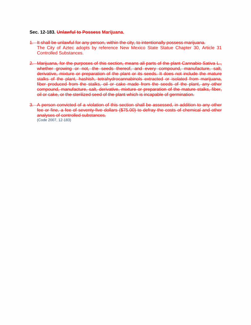
Sec. 12-183. Unlawful to Possess Marijuana. 1. It shall be unlawful for any person, within the city, to intentionally possess marijuana.
The City of Aztec adopts by reference New Mexico State Statue Chapter 30, Article 31 Controlled Substances.
2. Marijuana, for the purposes of this section, means all parts of the plant Cannabio Sativa L., whether growing or not, the seeds thereof, and every compound, manufacture, salt, derivative, mixture or preparation of the plant or its seeds. It does not include the mature stalks of the plant, hashish, tetrahydrocannabinols extracted or isolated from marijuana, fiber produced from the stalks, oil or cake made from the seeds of the plant, any other compound, manufacture, salt, derivative, mixture or preparation of the mature stalks, fiber, oil or cake, or the sterilized seed of the plant which is incapable of germination.
3. A person convicted of a violation of this section shall be assessed, in addition to any other
fee or fine, a fee of seventy-five dollars ($75.00) to defray the costs of chemical and other analyses of controlled substances. (Code 2007, 12-183)